Land use Utilisation du sol. Official Plan Amendment # 150 Modifications du Plan directeur #150. To the Official Plan of the City of Ottawa
|
|
|
- Hollie May
- 6 years ago
- Views:
Transcription
1 Official Plan Amendment # 150 Modifications du Plan directeur #150 To the Official Plan of the City of Ottawa (5-Year Comprehensive Official Plan Review) Land use Utilisation du sol
2 INDEX THE STATEMENT OF COMPONENTS Page PART A THE PREAMBLE Purpose 1 Location 1 Basis. 1 Summary of Changes.. 2 Section 1 3 Section 2 3 Section 3 5 Section 4 6 Section 5 6 Schedules. 6 Annexes and Secondary Plans 9 PART B THE AMENDMENT Introduction Statement.. 10 Details of the Amendment. 10 PART C - IMPLEMENTATION AND INTERPRETATION Implementation 149
3 COMPONENTS PART A THE PREAMBLE does not constitute part of this Amendment. PART B THE AMENDMENT, consisting of the following Table and attached maps designated Schedules C, D, E, F, G, H, I, J, M, S1, S2, S3, S5, S7, S8, S10, S13, S14, S15, S16, S17, S18, S19, S20, S21, S22, S23, S24, S25, S26, S27, S32, S33, S35, S36, S37, S39, S40, S41, S59, S61, S63 and Annex 8D, to Amendment 150, constitute the amendment to the Official Plan of the City of Ottawa including Volume 2A -Secondary Plans and Volume 2C Village Plans. PART A THE PREAMBLE Purpose The purpose of Official Plan Amendment 150 is to make changes to the various parts of the Official Plan based on the comprehensive 5-year review undertaken by the City in 2012 and 2013 and as required by Section 26 of the Planning Act. Location The Amendment applies citywide. Basis This amendment follows from a report to Planning Committee in March 2013 (Report ACS2013-PAI-PGM-0076) that proposed changes to the City s Official Plan in the following policy areas: Urban design and compatibility Intensification and tall buildings Transit-oriented development Employment Lands Mineral aggregate review Rural lots and villages The Official Plan Review is part of Building a Liveable Ottawa 2031, an overarching initiative to update the Official Plan, Transportation Master Plan, Cycling Plan, Pedestrian Plan, and Infrastructure Master Plan. This Official Plan Review was designed to address current planning issues identified by the community, the development industry and Council. The review does not revisit first principles of the Plan but continues the Plan s strategic directions towards more compact, sustainable and affordable growth. Council has confirmed in previous decisions that no additional land is required to meet the City s need for future residential land (Report ACS2012-PAI-PGM-0246) or to meet the City s need for future employment land or land for other purposes (Report ACS2013-PAI-PGM-0096). Summary of Changes In addition to the proposed changes listed below, minor changes were made throughout the plan to ensure consistency of spelling, correct numbering and grammar, but none of these changes were of a substantive nature. (some examples: Village replaced with village, 2
4 Community Design Plan replaced with community design plan, Mixed-Use Centre replaced with Mixed Use Centre). Major changes Section 1 1. Section 1.1. The Role of the Official Plan has been substantially revised to better reference the City s transit objectives and to delete provisions that paraphrase content of the Planning Act 2. Section 1.2 has been re-titled The Role of Ottawa: A Capital City and a Place to Call Home. The text outlines the nature and roles that the city now plays as the Nations Capital and as a community of communities. 3. Section 1.3 has been re-titled The Challenge Ahead. The new section identifies influences such as the global economy, energy costs and consumption, climate change, affordability and health and how the Plan begins to deal with these changes. 4. Section 1.4 has been re-titled Building a Sustainable Capital City and identifies the goals adopted as part of the City s Strategic Plan. How these goals will be achieved through the Official Plan and the other plans such as the Master Plans and the City s responsibilities for development review. 5. Section 1.5 has been re-titled Structure of the Official Plan and the content of the former Section 1.2 has been condensed. 6. Sections 1.6 and 1.7 have been deleted Section 2 7. Section2.1 This Section has been re-titled Patterns of Growth and the introductory summary has been changed to better address the structure, character and role of Ottawa as the Capital and to recognise the changing pattern of growth as the city approaches 1 million population. Text is added to reference the significant investment the City is making in transit and how the pattern of development is tailored to support this investment. 8. Section 2.2 is a preamble to the policy sections dealing with growth. The edits include the outline of the overall approach to growth in the urban and the rural areas that will be found in policy. 9. Section Creates a new subsection dealing with village boundary changes. The changes introduce three categories of villages; provide for the assessment of future land supply in the large and mid-size villages as separate groups rather than an assessment based upon all villages; recognise that small villages will not be assessed for future expansion; and identifies that if more village land is required the priority for expansion will be given to villages with greatest capacity to support the new population and to encourage complete communities. 3
5 10. Section This Section has been re-titled Managing Intensification within the Urban Area and revised to better reflect the focus on intensification in the urban area and to refine policies dealing with how compatible development is achieved. New density requirements have been assigned to target areas and updated current densities have been provided. Policies related to the implementation of these densities have been modified so that secondary plans can provide more detailed distribution of minimum density requirements and identify areas where requirements do not apply. The policies addressing building height have been relocated from Section 4 to this section and the height categories have been expanded. Building heights are dealt with in two ways. Interim heights will be established in designations but secondary planning can establish different building heights. New policies address how existing and planned function of existing communities will guide planning decisions about intensification and urban design. Employment polices establish an employment objective of 0.65 jobs per household in the three largest villages. 11. Section has a revised preamble and updates to targets for sustainable travel. Policies on Transportation Demand Management and Transportation System Management have been deleted and policies on walking, cycling and transit have been vetted for relevance and consolidated under the title of Active Transportation. Cycling policies consider recreational use as well as commuting. A policy defining and promoting complete streets has been introduced. Policies to give priorities to cycling and walking in proximity to Light Rail and Bus Rapid Transit Stations and facilitate maximum as well as minimum parking requirements. Policies relating to a future bridge crossing of the Ottawa River have been updated to reflect updates to the process. Policies related to parking have been consolidated and updated. 12. Section This Section has been re-titled as Designing Ottawa. The preamble is revised and shortened and a new introduction to design Objectives is provided. The seven Design Objectives remain as a list but the Principles associated with each Objective have been removed as these duplicate the City s design guidelines. The text associated with implementing urban design has been replaced with a diagram. The policies associated with implementation have been moved to the locations in the Plan where they would apply such as sections dealing with community design plans and development review. Remaining policies focus on Design Priority Areas and design of City projects and the public realm. This Section also recognises that tall buildings will require design review. 13. Section has been re-titled Collaborative Community Building and Secondary Planning Processes. Details regarding the secondary planning process and how it relates to community design plans, transit-oriented development plans and secondary plans have been included in the preamble. New policies include matters that community design plans are to address including the distribution of density where minimum density requirements have been established and the location and height of High-Rise Buildings. Where a community design plan makes recommendations on density or building heights that differ from the other policies in the Official Plan the recommendations are to be adopted by Council as a secondary plan. 4
6 Section Section General Urban Area New policies that clarify allowable height of buildings in the General Urban Area have been introduced. Maximum Building Height in the General Urban Area is low rise (four storeys or less) except on streets near rapid transit or on transit priority corridors where the plan will permit buildings to a maximum height of six storeys. Added policies also consider infill near rapid transit or transit priority corridors and sites between buildings that already exceed four storeys. Transit priority streets are defined in the policy and shown on Schedule D of the Plan. A site specific exception has been included for Accora Village that incorporates Bayshore Shopping Centre to encourage a secondary planning process. 15. Section Mixed Use Centres has been revised to place greater emphasis on the role of Town Centres. Policies have been added to: provide criteria for consideration of new Mixed Use Centres; limit building heights to mid-rise buildings (up to 12 storeys) where there is no secondary plan; to allow maximum parking provisions for development within 800m walking distance of rapid transit; and to give priority to walking and cycling. 16. Section Mainstreets the preamble has been simplified and reduced and policies added to: provide criteria for consideration of new Mainstreets; clarify the depth of the Mainstreet designation on large lots; allow the Zoning By-law to distribute the building height along these streets to focus development at critical transit nodes. The policies also limit building heights on Traditional Mainstreets to mid-rise (six storeys) and on Arterial Mainstreets to 9 storeys. Buildings up to 12 storeys can be considered on Arterial Mainstreets close to rapid transit and through a zoning amendment. 17. Section Employment Area and Enterprise Area site specific policies have been added for Enterprise Areas in Orleans and Kanata. Building heights will permit up to four storeys as of right in Employment and Enterprise Areas. However, through a Zoning By-law amendment, mid-rise buildings are permitted within 800m of a rapid transit station or 400m of a transit priority corridor, and High-rise buildings are permitted generally within 400m walking distance of a rapid transit station. 18. Section Villages recognises large and mid-size village categories and establishes minimum lots size of 0.4 ha for new lots developed on private wells and septic systems. 19. Section General Rural Modifies policies to no longer permit country estate lot subdivisions except those already in process and those on properties identified in the Plan. The severance policies are amended to permit a second severed lot and to clarify the application of the Infill outside of Historical Settlements policy. 20. Section Mineral Aggregate changes references to: Bedrock resources rather than Limestone resources, encourages recycling of aggregate products, clarifies the submission requirements for new pit or quarry licences including cumulative impact of multiple operations in the same area; removes the reference to the Silica sand deposit in the former City of Kanata and clarifies that there is no restriction on the consideration of applications outside the areas defined as Resource Areas under the Plan. 5
7 Section Section 4.0 Review of Development Applications modified to require the submission of a Planning Rationale as part of a complete application. This document, often submitted as a planning report, will require the applicant to demonstrate how the proposal addresses the requirements of the Official Plan and any applicable secondary plan and /or City adopted community design plan, guideline or standard. 22. Section 4.3 Walking, Cycling, Transit, Roads and Parking Lots modified policies deal with: the requirement for minimum and maximum parking requirements or the removal of parking requirements in areas within transit and intensification areas; the provision of pedestrian facilities in new and reconstructed roadways; policies dealing with improvement of the pedestrian environment through design of off street parking facilities. 23. Section Private Water and Wastewater Servicing is changed to include changes from the Infrastructure Master Plan to: reference the requirements of the Ministry of the Environment and City Guidelines; require a drilled and tested well prior to certificate of consent or occupancy permit for building approval and re-organized and clarified the policies for small water and wastewater works. 24. Section Floodplains has been changed to add a policy that permits the severance of an existing dwelling under certain conditions. 25. Section 4.11 Urban Design and Compatibility has been re-titled Urban Design and Compatible Development ; the preamble has been rewritten and Policies 1-14 replaced. The focus of the new policies is on the submission requirements at the time of application and how different scales of development will be assessed. New design policies for high-rise buildings are included. The reference to building heights are removed and relocated to Section 2. Section Section 5. 4 Interpretation of designations has been clarified such that where a designation follows a road the centreline of the road will constitute the boundary of the designation. Schedules 27. S1. Kanata North Business Park (East) Re-designates part of the land in this business park east of the rail line from Enterprise Area on Schedule B to Employment Area. 28. S2. Kanata Town Centre and Katimavik Re-designates parts of the Kanata Town Centre from Mixed Use Centre Town Centre and part of the General Urban Area on Schedule B to Major Open Space and Urban Natural Feature. 29. S3. Kanata West (Didsbury) Enterprise Area re-designated to Employment Area and adjusts the boundary of the mixed use centre to General Urban and Enterprise Area on Schedule B. 6
8 30. S5 Nortel Site - Moodie Drive re-designate from Enterprise Area to Employment Area on Schedule B. 31. S7 Centrepointe, Makes adjustments to the boundaries of the Mixed Use Centre designation by adding and removing land from the designation on Schedule B. 32. S8. (Carling/ Woodward/Clyde) re- designate lands from General Urban Area to Employment Area on Clyde and Woodward and to Arterial Mainstreet on Carling at Kirkwood on Schedule B. 33. S10. Barrhaven Mixed Use Centre Town Centre re-designate the land east of Long fields from Mixed Use Centre to General Urban Area and Major Open Space to recognise the secondary plan and the developed land uses on Schedule B. 34. S13. Bronson between Riverside and Heron re-designate lands from Major Open Space to Mixed Use Centre on Schedule B. 35. S14. Corner of Cambrian and Greenbank Re-designates land from General Urban Area to Major Open Space on Schedule B. 36. S15. Between Johnston and the Rail line east and west of Conroy Road re-designate existing residential subdivisions from Employment Area to General Urban Area, and 2500 St. Laurent Blvd, re-designate from General Urban Area to Employment Area on Schedule B. 37. S16. Walkey from O-Train to Heron re-designated to Arterial Mainstreet to recognise the current use and intensification potential on Schedule B. 38. S17. St Laurent between Russell Rd and Pleasant Park re-designated to Arterial Mainstreet and land bounded by Industrial, Russell Road and St Laurent Blvd. Redesignated from Employment Area to General Urban Area on Schedule B. 39. S18. Train and Industrial Mixed Use Centres. Re- designation from Mixed Use Centre to Employment Area and General Urban Area, Employment Area to Mixed Use Centre, General Urban Area to Mixed Use Centre, and Major Open Space to Mixed Use Centre on Schedule B. 40. S19. Coventry Road Re-designates land from: Employment Area to Mixed Use Centre and General Urban Area; General Urban Area to Mixed Use Centre; and Major Open Space to General urban Area on Schedule B. 41. S20. Cyrville Road and St Laurent Mixed Use Centres. Re-designation from Employment Area to General Urban Area and Mixed Use Centre, from General Urban Area to Mixed Use Centre and Major Open Space, from Mixed Use Centre to Major Open Space and from Major Open Space to Mixed Use Centre on Schedule B. 42. S21 and S22. Ogilvie and Innes Roads parts of these roads are being re-designated to Arterial Mainstreets on Schedule B. 7
9 43. S23. Mer Bleue and Page Roads re-designated Employment Area to General Urban Area, General Urban area to Mixed Use Centre and Mixed Use Centre to General Urban Area to reflect adjustments to designation boundaries through the approved community design plans on Schedule B. 44. S24. Orleans Town Centre lands re-designated from General Urban to Mixed Use Centre and from Mixed Use Centre to General Urban Area to correct the boundary of the Town Centre on Schedule B. 45. S25. Abbot Street Stittsville re-designates land from General Urban Area to Major Open Space on Schedule B. 46. S26. Stittsville Mainstreet re-designates land from General Urban Area to Major Open Space and Urban Natural Feature on Schedule B. 47. S27. Rahul Street re-designates land from General Urban Area to Major Open Space on Schedule B. 48. S32 Ottawa Macdonald Cartier International Airport Removes the land leased by the Ottawa International Airport Authority from Schedule B of the Official Plan. 49. S33 Ottawa Macdonald Cartier International Airport Corrects the boundary of the lands leased by the Ottawa International Airport Authority as shown on Schedule A 50. S39 North Service Road Orleans Re-designates land in the Employment Area to Enterprise Area on Schedule B. 51. Transportation Schedules C, D, E, F, G, H, I and J are replaced with updated Schedules that incorporate updates from the Transportation Master Plan and the Cycling and Pedestrian Plans 52. Schedules S35- S37and S59 update the Natural Heritage System Schedules L1- L3 to incorporate Landscape Linkages. 53. Schedule S61 amends Schedule B to change land designated Sand and Gravel Resource Area, which is the site of a decommissioned and restored Pit, to Carp Road Corridor Rural Employment Area consistent with adjacent properties. 54. Schedule S63 amends Schedule B to change the land designated Employment Area to Enterprise Area. 55. A new Schedule M Macdonald-Cartier International Airport Plan is added to the Official Plan and incorporates the land leased by the Airport Authority and those land use designations formerly within the National Capital Greenbelt with recently updated boundaries. 8
10 Annexes 56. Annex 1 Table of Road Rights-of-way is amended by adding new sections of roadway and updating existing right of way requirements for some roads. 57. Annex 8D Central Area Maximum Building Heights replaces the former Annex 8D to the Official Plan to add the Canal, Parliamentary Precinct, and LeBreton Flats to the areas subject to secondary plan policies. 58. Annex 15 Urban Expansion Areas Methodology for Determining and Evaluating Candidate Areas is deleted as the provisions applied to the 2009 Review of candidate urban lands only. Secondary Plans Vol. 2A 59. New Secondary Plan for Kanata West Introduces a height schedule for Kanata West Concept Plan. 60. New Secondary Plan: Train, St. Laurent, and Cyrville introduces Building height and density requirements for the three TOD Areas of Tremblay (Train), St. Laurent, and Cyrville Village Secondary Plans Vol. 2C 61. Schedule S40 amends the Vars Secondary Plan Schedule S-1 to re-designate the properties at 5873 Buckland Road and 1820, 1824 and 1826 Farwel Street from" Village Residential Enterprise Zone" to "Village Core." 62. Schedule 41 and Text amend the Richmond Secondary Plan by re-designating land from Industrial area partly to Residential one and two unit ; and partly to Village Commercial and partly to Industrial 1 and adding policy to ensure that at least 18.5 net Ha of Industrial 1 land are retained for employment purposes. 9
11 PART B THE AMENDMENT 1.0 The Introductory Statement All of this part of this document entitled Part B The Amendment, consisting of the following Tables and Schedules, constitutes Amendment 150 to the City of Ottawa Official Plan including Volume 2B Secondary Plans and Volume 2C- Village Plans. 2.0 Details of the Amendment The Official Plan for the City of Ottawa is hereby amended as set out in the Table titled Changes -Official Plan Review 2013 " and as detailed in the Schedules attached hereto as Schedules C, D, E, F, G, H, I, J, M, S1, S2, S3, S5, S7, S8, S10, S13, S14, S15, S16, S17, S18, S19, S20, S21, S22, S23, S24, S25, S26, S27, S32, S33, S35, S36, S37, S39, S40, S41, S59, S61, S63, and Annex 8D. Information about the Table titled Changes -Official Plan Review 2009": All policy changes or groups of changes are numbered in sequential order in the left column for ease of reference. The second column identifies the existing Official Plan Section to which the change applies. The third column identifies the substance of the change to the policy or policies. Changes include additions of new policies, corrections to existing policies or words, moved policies and deletions or replacements of policies. The fourth column identifies the anticipated new policy numbering that would apply when changes take effect. Unless otherwise stated references to a policy number refer to the existing policy as found in the Official Plan that is in force at the time of adoption of this amendment by the City. Wherever possible, cross-references within policies refer to the new or amended policy numbers. Once the Official Plan Amendment is approved and or modified the numbering, including cross-references, will be further updated to reflect the way they will appear in the final Official Plan document. 10
12 Table Changes Official Plan Review 2013 Item Section Details of Amendment Prologue Amend the Prologue by deleting it in its entirety Introduction The Role of the Official Plan Amend Section 1 by deleting the preamble paragraph beginning with the words Section 1, Introduction and ending with the words umbrella of Ottawa 20/20. Amend Section 1.1 by: a) Deleting the first two sentences of the first paragraph in their entirety, and replacing them with the following: The Official Plan provides a vision for the future growth of the city and a policy framework to guide its physical development to the year ; b) Adding the word Canada s following the word Always in the second sentence of the first paragraph; c) Deleting the words the country s prior to the words focal point in the second sentence of the first paragraph; d) Deleting the words the amalgamated City and replacing them with the word Ottawa following the words focal point in the second sentence of the first paragraph; e) Deleting the word now prior to the words among the country s in the second sentence of the first paragraph; f) Adding the words, responsible for providing services to a population of 940,000 in 2013 at the end of the first paragraph; g) Deleting the words Over the next 20 years at the beginning of the second paragraph and replacing them with the words By 2031 ; h) Deleting the word City s before the word population in the first sentence of the second paragraph; i) Adding the words of Ottawa prior to the words will push past in the first sentence of the second paragraph; j) Deleting the numerical reference to 1.2 million in the first sentence and replacing it with a numerical reference to 1.1 ; k) Adding the sentence The Plan also recognizes Ottawa as a capital city, as a meeting place for Canadians and international visitors, and as host to Canada s 11
13 most significant political, cultural, social and economic institutions. at the end of the second paragraph; l) Adding the sentence It recognizes the need to consider the social, economic, environmental and cultural outcomes of land use decisions and how these will affect future generations. to the end of the third paragraph; m) Adding the following text as a new paragraph immediately following the third paragraph: The Official Plan is also a legal document that addresses matters of provincial interest defined by the Provincial Statement and that guides the review of development applications made under the Planning Act. ; and n) Deleting the remainder of the text in the section Structure of the Official Plan Amend Section 1.2 by deleting it in its entirety, and replacing it with the following: 1.2 The Role of Ottawa: A Capital City and a Place to Call Home 2 Ottawa is the largest municipality in Canada s Capital Region, a region of 4715 km comparable in size to Prince Edward Island. The region takes in most of Ottawa, the City of Gatineau and all or part of eight other municipalities in Quebec and Ontario. The National Capital Commission, a federal crown corporation, is responsible for guiding development of federally-owned lands and preserving extensive natural areas owned by the federal government. It works closely with Ottawa, Gatineau and other municipalities in the region on interprovincial travel and sustainable transportation issues. At the centre of Canada s Capital, Ottawa represents Canada to other Canadians and to the rest of the world. The city hosted more than 8 million visitors in 2010, many attracted by national museums, institutions and monuments that express the country s history, culture and values. Ottawa is also the meeting place for federal political leaders, international delegations and national organizations. Parliament Hill and the federal institutions in the central area create the image of Ottawa held by visitors and residents alike. The official residences of Canada s 12
14 leaders, the embassies, and buildings of national importance further define the capital image. In addition, the image of Ottawa is one of water, greenways and open spaces. It is a city built for motorcades as well as Sunday strollers and cyclists. Ottawa overlooks the Ottawa River, a great river forming the border between Ontario and Quebec. But the city is really centred on the Rideau River and Rideau Canal, a UNESCO World Heritage Site which joins the Ottawa River just below Parliament Hill. Access to the Ottawa and Rideau Rivers and Rideau Canal are a legacy of Jacques Gréber s Plan for the National Capital in The legacy of this plan includes federal office complexes as well as parkways along the Ottawa River and the Rideau Canal on rights-of-way cleared by the relocation of rail lines through the central area. The federal plan also created the National Capital Greenbelt, a 20,000 ha greenspace planned to surround and contain urban growth. However, suburban development started outside the Greenbelt in the 1960s and this area is now home to Ottawa s newest communities. The Greenbelt today provides green vistas for cross-town travellers and adjacent neighbourhoods. In some areas it blends seamlessly into the rest of the rural area, which occupies about 90% of the municipality. Like the Greenbelt, the rural area contains extensive agricultural areas as well as a rich mosaic of woodlands, wetlands, creeks and valleylands. Its villages and crossroads hamlets suggest the agricultural history of the region but many rural communities have grown to house families seeking a rural lifestyle. 13

15 Figure 1.1 Canada s Capital Region The Ottawa 20/20 Process and the Guiding Principles Amend Section 1.3 by deleting it in its entirety and replacing it with the following text and Footnotes: 1.3 The Challenge Ahead Ottawa is facing new challenges in the 21 st century that require new responses: A shifting global economy: As part of a global economy, Canada s economic health is tied to events around the world and within the Unites States, its major trading partner. Federal government employment accounts for about one in every five workers 1 in the city and helps buffer widespread downturns. Yet the city is also vulnerable to government down-sizing and diversification is needed to strengthen economic stability. The City needs to continue to provide the infrastructure, employment land and housing that make Ottawa a good place to live and do business. Energy Costs and Consumption. Heating and cooling systems in buildings account 14
16 for the largest share of energy consumption in Ottawa, although automobiles and other forms of transportation are consuming increasing amounts of energy. Concerns about rising energy costs and the long-term environmental effects of energy consumption have increased the desire for more environmentally sustainable forms of housing and transportation. Climate Change. Predictions of the effects of climate change on Ottawa indicate a warmer and drier climate in the future, with more extreme weather events in the form of heavy rain, ice storms, and prolonged heat spells. The city s experience to date has underscored the need to be ready for emergencies and to safeguard the elderly and other vulnerable people. Woodlands and wetlands will continue to be valued as a means to manage the flow of surface water. Population Change. Perhaps the most significant change is the aging of the baby boomers over the next 20 years and a doubling of the population over age 65. Ottawa will also continue to become more diversified through overseas immigration, provided the city continues to maintain a globally competitive position in terms of quality of life and economic opportunities. Affordability. In the past, municipalities focussed their infrastructure investments on providing the infrastructure needed to support urban expansion and rural development. The considerable growth that has occurred since the 1950s has left Ottawa and other municipalities with a legacy of roads, bridges, buildings and other infrastructure that now require significant investment to maintain them in good repair. Faced with a need to substantially increase annual spending on infrastructure renewal in the built-up area over the next 10 years, Ottawa has adopted a Comprehensive Asset Management Program to prioritize investments and ensure best value to taxpayers. The City also needs to pursue a more affordable pattern of growth based on higher densities and increased use of transit. This pattern allows for more efficient use of municipal infrastructure and reduces the need to build and maintain roads over their life-cycle. This pattern is compact and allows for more efficient delivery of municipal services such as solid waste collection and emergency services that are costly to provide over large areas. 15
17 Health. In 2011, half of adults in an Ottawa survey reported that they were either overweight or obese. 2 A lack of physical activity is a key contributor to the incidence of obesity. Physical inactivity and obesity contribute to the risk of developing chronic diseases, such as type 2 diabetes, heart disease, strokes, some cancers, and reduced psychological well-being. Healthy lifestyles and daily physical activity is supported in communities where residents can easily and safely walk or cycle to transit stops, schools, or to local stores and services. These trips also create opportunities to meet neighbours and help build a sense of community. Sustainable, liveable and resilient communities can help Ottawa meet the challenges of the 21st century. They are characterised by opportunities for active transportation including safe walking and cycling facilities, good transit service, well-connected streets and open space, and a mix of housing with convenient access to shops, services and places to work. Attention to urban design creates spaces and buildings that look good and function well. Quality of life is supported by building: A more affordable, compact urban area where walking, cycling and transit are attractive options and there is less reliance on private automobiles; A healthier city where there are everyday opportunities to socialize and safely walk or cycle; Community-based food production into urban areas, through edible landscapes, community gardens and small and mid-scale urban farms; Convenient access to services and facilities that allow seniors to retain their independence in the community and families to raise children in a safe and stimulating environment; More prosperous cities, where efficiency, design excellence, and cultural vitality make Ottawa a good place to work and do business; A greener and cleaner city, with less air pollution from traffic and less consumption of energy for travel and housing; Compact communities that use land efficiently and decrease the pressure to build on farmland and natural areas. 16
18 1. Statistics Canada. Federal Government Employment. Wages and Salaries. September Ottawa Public Health. Healthy Eating, Active Living and Healthy Weights Section 1.4 Ottawa s Growth Management Plans Amend Section 1.4 by deleting it in its entirety, and replacing it with the following: 1.4 Building a Sustainable Capital City Council has adopted this Plan to help achieve its vision of a sustainable, resilient and liveable city. This vision is expressed through goals for the sustainability of Ottawa that are framed in the City s Strategic Plan. These goals ensure that decisions take into account their long-term impacts on Ottawa s economic prosperity, environment, social well-being, and culture and identity. The City s Strategic Plan identifies the goals for the long-term sustainability for Ottawa as: Health and Quality of Life All residents enjoy a high quality of life and contribute to community well-being Economic Prosperity Economic prosperity supports local people, community well-being, and ecological health Culture and Identity Cultural vitality and diversity contribute to the region s strong identity Biodiversity and Ecosystem Health Ecosystems are healthy, protected and support biodiversity Governance and Decision-Making Decision-making is open, informed and inclusive Climate Change 17
19 The region adapts to a changing climate Energy Energy is used efficiently and supplied from green, renewable sources Connectivity and Mobility Walking, cycling, and transit are residents first choices for transportation Materials and Solid Waste Waste is reduced towards zero Water and Wastewater Water resources are cherished, conserved and protected Housing Housing options are green, healthy and meet the needs of the whole community Food and Agriculture The local food system is sustainable and provides residents with healthy and affordable food The Official Plan contributes to the achievement of these goals by setting directions for managing growth, providing infrastructure and protecting the environment. The Plan shows how the City will manage growth so that development is compact and land within the urban boundary is used efficiently. This pattern reduces impacts on agriculture land and local food production and helps preserve the biodiversity and ecosystem health of natural areas. The Plan maps Ottawa s natural heritage system and requires careful analysis and mitigation of potential development impacts on woodlands, wetlands and other natural features. Water runs throughout the natural heritage system and is protected through policies on how the City manages stormwater in urban areas and permits servicing in rural areas. Combined with walking, cycling and transit, compact development reduces energy consumption and impacts on the environment. Together, compact development and 18
20 sustainable transportation result in affordable options for providing municipal services and infrastructure as well as affordable options for housing and travel for many households. The Plan supports sustainable, liveable and resilient communities and the quality of life of all residents. It supports the long-term sustainability of Ottawa in concert with other plans approved by Council. These plans include: Renewed Action Plan for Arts, Heritage and Culture The action plan builds on Ottawa s strengths, and sets out a path aimed at reaping the major economic impacts and the positive social and environmental benefits of cultural activities in Ottawa. Partnerships for Prosperity Ottawa s economic strategy focuses on international competitiveness, brand and market development, and city leadership in shaping economic directions. It seeks to balance business prosperity with social equity, environmental responsibility, and cultural expression. Environmental Strategy The strategy sets the direction and establishes a comprehensive approach to create sound environmental management in City practices and policies. Parks and Recreation Master Plan The plan proposes a set of operating principles and strategic recommendations to guide the development and implementation of parks and recreation services. Older Adult Plan This plan addresses the specific needs of Ottawa s older residents now and in the future, in such strategic areas as transportation, housing, communication and information. Youth Summit Action Plan The City is committed to 31 actions to enhance municipal services for youth in such areas as career advice, volunteering, and youth participation in decision-making. 19
21 Equity and Inclusion Lens The lens is a tool to enable the City to be systematic, consistent and coherent in its efforts to promote equity and inclusion in all areas of municipal activity. Accessibility Design Standards The standards optimize accessibility for new construction or redevelopment of existing facilities owned, leased or operated by the City in order to address the needs of diverse users and ensure an inclusive environment. The Official Plan works in parallel with several supporting plans that take their direction from policies in the Official Plan, particularly its directions on growth and how it will be managed to The main supporting plans are: Transportation Master Plan This plan is a comprehensive plan that sets out the City s approach to managing and meeting the demand for transportation, including priorities for future infrastructure. This plan is supported by the Ottawa Cycling Plan and the Ottawa Pedestrian Plan, which propose infrastructure, policies, and programs to increase sustainable travel. Infrastructure Master Plan An integrated planning and system management document, the Infrastructure Master Plan coordinates the City s efforts in meeting the demand for public water, wastewater, and stormwater services; Greenspace Master Plan All greenspaces in the urban area are characterized and evaluated in this plan as a basis for policies on greenspace protection, acquisition and management. Council implements its Official Plan and supporting plans through its decisions on how land is used and where public funds are invested. These decisions include: Review and approval of development applications from developers and landowners who want to change how their land is used; Amendments to the Zoning By-law for specific sites or types of activities such as parking, that are consistent with the Official Plan; 20
22 Creation and updating of community design plans to guide development in new communities and change in established ones; Approval of detailed guidelines on a range of policy matters such as Environmental Impact Statements and community design; Planning and approval of public works to be carried out by the City to support future growth, including water and wastewater infrastructure, roads and transit facilities, and public parks; Preparation of annual municipal budgets and long-term plans for capital spending. Implementing this Plan will require the cooperation of a wide variety of actors outside the municipal administration, not only because they must respect the Plan, but also because they have the mandate, experience and expertise to implement much of it. The City must partner with the provincial and federal governments, including the National Capital Commission, as well as the City of Gatineau and the Province of Québec, on issues related to transportation infrastructure, management of natural resources, economic development, and more. The private sector, including builders and developers, has an increasing role to play through partnerships with the City. Examples include building and managing facilities and services, economic development, provision of mixed use projects, and more. A host of agencies such as the Conservation Authorities, school boards, and non-profit and cooperative housing associations have responsibilities that contribute to the quality of life in Ottawa. Finally, individuals and community groups do much to define public issues and solutions and their on-going participation is essential to implementing this Plan. 7. Section 1.5 Supporting Plans Amend Section 1.5 by deleting it in its entirety and replacing it with the following: 1.5 Structure of the Official Plan This Plan is organized into five main sections, moving from general planning principles to practical implementation measures. The Plan should be considered as a whole, from the broadest strategic principles through to specific directions for implementation. Section 1: Introduction 21
23 Section 2: The strategic policy directions the City will follow over the coming years. Section 3: Policies for the land use designations in the city, and guidance regarding the types of land uses that are permitted in the land use designations. Section 4: Matters related to the review of development applications. Section 5: Specific issues related to implementation and interpretation of the Plan. Schedules: Land use designations. Annexes: Some of the Annexes for part of this Plan, while most do not. Section 5.4, policy 2 lists those that do. Volume 2: Secondary plans, site-specific policies and Village plans. 8. Section 1.6 How the Guiding Principles are Addressed in the Official Plan 9. Section 1.7 Interpretation and Implementation of the Official Plan 10. Section 2 Strategic Directions, Preamble 11. Section 2.1 The Challenge Ahead Amend Section 1.6 by deleting it in its entirety. Amend Section 1.7 by deleting it in its entirety. Amend Section 2 by deleting the preamble in its entirety. Amend Section 2.1 by: a) deleting the title The Challenge Ahead and replacing it with Patterns of Growth ; b) deleting the first three paragraphs of text, and replacing them with the following: The Geography of Growth 22
24 Ottawa has grown from a pre-confederation lumber town to the Capital of Canada. Ottawa s Parliamentary Precinct with its national institutions, ceremonial spaces, and distinctive boulevards dominates the city s Central Area. South of Parliament lies the city s commercial and employment centre and surrounding areas for shopping, local arts, tourist and convention facilities. The ByWard Market, a historic outdoor market dating to the 1800s, attracts a growing number of residents. A new downtown community is also developing on LeBreton Flats, a federal waterfront area served by rapid transit, that hosts the Canadian War Museum and expansive public spaces as well as housing. th Ottawa s downtown surrounds the Central Area and consists of a grid of early 20 century neighbourhoods that provides much of the area s workforce, covering the short distance to work on foot or by transit. The downtown plays a vital role in the City s growth management strategy and is critical to the economy of the city and the region that surrounds it. The downtown is the primary focus of employment, retail, cultural and day / night entertainment activities. Other employment centres include campus-style federal office areas such as Tunney s Pasture, the Central Experimental Farm and Confederation Heights. Today the Central Area and the older, adjacent communities and employment centres contain about one-third of the jobs in the city. The Greenbelt, the largest structuring element of the city, is a largely rural expanse of federal land containing farms, woodlands, wetlands, and a few employment campuses. A number of communities in the urban area, and located outside the Greenbelt, have long and unique histories. Kanata began in the 1960s with construction of Beaverbrook, planned as a garden community. Established in 1792, the Township of Nepean straddled what later became the Greenbelt in the west. As the township s boundaries changed, its centre shifted over time from Westboro to Centrepointe and followed growth south to Barrhaven. Orléans was initially settled in the mid-1840s. Establishment of the parish of St. Joseph of Orléans in

25 strengthened the growing francophone community there. St. Joseph Boulevard, the community s major commercial street, still provides a direct route to Parliament Hill through connections with other historic main streets. Today these communities are planned around Town Centres that offer an increasing variety of shops, employment, cultural facilities and housing. In the rural area, subdivision patterns largely give way to a mosaic of farms, natural areas, rural homes and villages. Many of Ottawa s 26 villages act as service centres for the surrounding rural area, providing businesses, schools, churches and community facilities. Some villages also attract visitors from all areas to their country markets, rural fairs, heritage buildings and hockey arenas. Growth in Numbers The projected growth to 2031 in population, households and employment (by place of work) is shown in Figure 2.2 for urban areas inside and outside the Greenbelt and for the rural area. [Amendment #76, OMB File # PL100206, September 07, 2011.] ; c) deleting Figure 2.1, and replacing it with the following: 24
26 d) adding the letter s to the word Total in Note 1 of Figure 2.2: Projected Growth in Population, Households and Employment, City of Ottawa 2006 to 2013; e) adding the following text after Figure 2.2: Ottawa s population is projected to grow by up to 30 per cent by 2031 compared to 2006, reaching an estimated 1.1 million people. Growth will largely depend on the city s continuing ability to attract a share of immigration, which accounted for almost three-quarters of net migration to the city in the 2000 to 2010 period. As the population increases, it is expected to become more diverse. Through time, the city s population will also include more seniors. The share of the population that is 65 and over is expected to increase from about 13% in 2011 to over 20% by As the baby-boomers age and their children leave home, both parents and children will form smaller households and create additional demand for housing. Much of the demand for new housing is expected to be for smaller units, such as apartments. Within the Greenbelt, where about one-third of the housing growth is expected to occur, most new housing development will be in the form of apartments. However, almost two-thirds of the added housing stock will be located outside the Greenbelt. Many of the new dwellings there will be in the form of detached homes, but at least 40 per cent will be either townhouses or apartments. The rural area is expected to take about 9 per cent of the new housing, mostly in the form of single-detached dwellings. Employment is expected to grow by about 170,000 jobs by 2031, with job growth in the urban area being slightly higher outside the Greenbelt than inside it. The rural area is anticipated to accommodate up to 6 per cent of the new jobs. The Changing Pattern Patterns of where residents live and work will continue to influence future transportation needs. More people will be living outside the Greenbelt, where the five urban areas are expected to receive 68% of population growth and 50% of 25
27 employment growth to However, the area inside the Greenbelt will continue to contain the greatest concentration of people (52%) and jobs (72%). The need to bring people to jobs in and around the Central Area and elsewhere inside the Greenbelt will continue to create the greatest daily demand for travel in the city. Growth will also bring an increase in travel, with total travel by all means increasing by 32% as the population increases. Travel by transit will need to increase to accommodate growth plus a larger share of overall travel. This Plan supports a transit share of 26 per cent of all travel by 2031, an increase from 23 per cent in Collectively, sustainable modes (walking, cycling, transit and carpooling) will account for at least 50% of all trips in the morning peak period, the balance being vehicular traffic. Achieving this target will help contain the city s need for larger roads to handle more cars, a need that has significant impacts on existing communities, the environment and municipal budgets. Transportation modelling shows that by 2031, most transit trips will continue to converge on the Central Area and area around it. These areas are now the most significant destinations for morning peak travel because they include or are close to many large employment centres, including two universities, Tunney s Pasture and the Ottawa Hospital Civic Campus. The City s plans to improve rapid transit to and through the Central Area respond to this need to increase commuter travel. At the same time, improved service will increase development interest in land along rapid transit routes. New development outside the Central Area along rapid transit will help disperse employment over time, although the central area will remain the single largest employment centre. Managing Change f) adding the words and cycling following the words that encourage walking in the second sentence of the paragraph under the new heading Managing Change ; g) adding the following words to the end of the second paragraph under the new heading Managing Change : The City can secure the greatest returns on its transit investment by building at 26
28 higher densities in nodes around rapid-transit stations and along corridors wellserved by transit. Intensification in these locations increases transit ridership, makes efficient use of existing infrastructure and curbs the need to extend infrastructure and provide municipal services to new suburbs. This pattern of development is the most affordable in terms of the life-cycle costs of constructing, operating, maintaining, and replacing municipal infrastructure over its life span. As well, it supports the affordable provision of municipal services such as solid waste collection and emergency services that are costly to provide over large areas. On the whole, it balances the costs of servicing growth with the cost of maintaining infrastructure and providing a consistent level of services to residents. ; h) adding the words also supports liveable, sustainable communities. It between the words This approach and the words is based on an underlying in the first sentence of the third paragraph under the heading Managing Change ; i) deleting the word four and replacing it with the words the following prior to the words key areas in the fourth paragraph under the heading Managing Change ; j) deleting the fourth bullet under the heading Managing Growth and replacing it with the following: The Central Area, designated Mainstreets, Mixed Use Centres and Town Centres will be compact, liveable, and pedestrian-oriented with a vibrant mix of residential uses, and social, cultural and economic activity. Infill and redevelopment will be compatible with the existing context or planned function of the area and contribute to the diversity of housing, employment, or services in the area. ; k) deleting the words transit, walking and cycling from the first bullet under the heading Providing Infrastructure, and replacing them with the words walking, cycling and transit ; l) adding the words, but in some circumstances municipal services will be provided to remedy environmental problems following the words environmentally sound at the end of the third bullet under the heading Providing Infrastructure ; m) deleting the words transit, walking and cycling from the first bullet under the heading Maintaining Environmental Integrity, and replacing them with the words 27
29 walking, cycling and transit ; n) adding the word approving between the words land use and and the word development in the third bullet under the heading Maintaining Environmental Integrity ; deleting the words in a way and to locations and adding the letter s to the end of the word maintain in the third bullet under the heading Maintaining Environmental Integrity ; o) deleting the word Creating from the heading Creating Liveable Communities and replacing it with the word Building ; p) adding a new first bullet under the heading Building Liveable Communities as follows: Attention to urban design will help create attractive communities where buildings, open space and transportation work well together. q) deleting the words rural and urban areas from the second bullet under the heading Building Liveable Communities and replacing them with the word city ; r) adding a new fourth bullet under the heading Building Liveable Communities as follows: The City will pursue a more affordable pattern of growth that allows for more efficient use of municipal infrastructure and reduces the need to build and maintain new infrastructure throughout its life-cycle. ; s) adding the following words to the end of the fifth bullet under the heading Building Liveable Communities : and will work with the federal government and private sector to provide a balance of jobs and housing both inside and outside the Greenbelt ; t) deleting the words rural and urban prior to the words economic activities from the fifth bullet under the heading Building Liveable Communities ; u) deleting the word maintained from the seventh bullet under the heading Building Liveable Communities and replacing it with the word conserved ; v) deleting the bullet that reads Attention to urban design will help create attractive communities where buildings, open space and transportation work well together. ; w) deleting the words urban and rural area from the tenth bullet under the heading Building Liveable Communities and replacing them with the word city ; 28
30 x) deleting the words for future generations and mineral resources will be protected for extraction from the twelfth bullet under the heading Building Liveable Communities and replacing them with the following: to ensure the economic vitality of Ottawa s farm industry, and access to locally produced food and farm products as the basis on which food security can be promoted in the community ; y) adding a thirteenth bullet under the heading Building Liveable Communities as follows: Mineral aggregate resource areas will be identified, conserved, and protected for long-term use. ; z) adding a fourteenth bullet under the heading Building Liveable Communities as follows: The City will recognize the role of small and medium-scale food production in a sustainable food system and community-based food production will be integrated into urban and rural areas, through edible landscapes, community gardens, and small and mid-scale urban and rural farms, where possible and in keeping with City policy. ; and aa)deleting the final paragraph of text beginning with the words These strategic directions, and ending with the words are to be reviewed Managing Growth Amend the preamble by: a) deleting the words There are 26 villages scattered throughout this countryside in the second sentence of the first paragraph, and replacing them with the following: The rural area contains villages ; b) deleting the preceding period and the words The rural landscape also contains a number of hamlets, subdivisions and in the third sentence of the first paragraph, and replacing them with the words, as well as prior to the words scattered development. ; c) deleting the words urban and rural from the last sentence of the first paragraph; d) deleting the words persona of the city as a whole from the last sentence of the first paragraph and replacing them with the words quality of life in Ottawa. ; e) deleting the words transit, cycling and walking following the words development 29
31 that supports in the second paragraph, and replacing them with the words walking, cycling and transit ; f) adding the word safer, between the words cleaner, and healthier city in the penultimate sentence of the second paragraph; g) adding the following paragraphs of new text after the second paragraph ending in the words municipal services and infrastructure : Growth will be distributed throughout the urban area to strengthen the city s liveable communities through: Intensification and infill Building new communities on vacant land In all areas, the density, mix of uses, and land use pattern will work together to make the most efficient use of transit. This means that pedestrians and cyclists have direct access to transit, since most transit trips are combined with travel on foot or by bicycle. Density is highest adjacent to transit and includes a mix of uses so that residents can meet many of their daily needs within the community or can find them conveniently nearby. This pattern of transit-oriented development results in very liveable communities at any scale, from the central area to the suburbs. Growth will be directed towards the hierarchy of nodes and corridors that help structure the city at different scales. Nodes are activity areas built at a higher density than their surroundings, accommodating a mix of uses or a concentration of community activities. They can occur at a range of scales, from a local shopping plaza serving the surrounding neighbourhood to a dense office and apartment core in a Mixed Use Centre. New urban communities on vacant land are also anticipated to follow a growth pattern that supports this objective. Corridors are linear routes that move people and goods via walking, cycling, transit and vehicles. Again, they are higher density and more active than their surroundings and include a greater mix of uses. The character of these corridors changes along their length, building up to higher-density nodes of activity. Throughout the urban area, linear networks of Mainstreets act as primary transit corridors, meeting places, and shopping streets for adjacent neighbourhoods. These corridors have significant potential for intensification and most are on 30
32 roads where transit has priority over other vehicles. The Central Area is the city s most intense concentration of activity and the centre of its transit system. Access to and through the Central Area will be enhanced in 2018 with completion of the Confederation Line, the first leg of Ottawa s light rail system. Light rail connections within the rapid transit system will link the Central Area to the Town Centres outside the Greenbelt and to the Mixed Use Centres inside the Greenbelt. Each of these centres has a different profile, potential for growth and identity within their community. Improved transit service and investment in infrastructure and services over time has the potential to increase ridership and opportunities for high-density, mixed-use development. The Central Area, Mixed-Use Centres, Town Centres and Mainstreets are all identified in this Plan as design priority areas, where both the public and private sectors will be required to achieve higher standards of design. These areas also have priority for completion of community design plans that show how the density and design requirements for these areas can be achieved. Lands designated General Urban Area will continue to mature and evolve through intensification and infill but at a scale contingent on proximity to major roads and transit, and the area s planned function. Consideration of the character in the surrounding community is a factor in determining compatibility within a community. h) adding a period following the words rural area in the first sentence of the third paragraph, followed by the words This growth will occur prior to the words as a mix of uses ; i) deleting the words Ottawa s rural villages are people oriented communities. They in the third paragraph and replacing them with the words Most villages ; j) deleting the following words from the third paragraph: Many of these villages act as service centres for the surrounding rural area, providing businesses, schools, churches and community facilities. Many urban residents know villages for their country markets, rural fairs, heritage buildings and hockey arenas. Villages also provide for a lifestyle choice that is different from living downtown or in the suburbs 31
33 or on an isolated rural lot. But, as in these other places, village residents and replacing them with the following: As in other communities, residents of villages ; k) deleting the final sentence of the third paragraph, as follows: The character of villages will be cherished and preserved as part of the defining character of the city as a whole. ; l) deleting the final paragraph, as follows: Ottawa will continue to change and to prosper. The urban areas will grow, as will many of the villages. ; and m) adding the following new paragraph at the end: The strategy for growth and development in the rural area is to: Support the role of villages as the focus for employment and housing in the rural area; Direct growth and development to those villages where community facilities and services already exist, or to those villages where community facilities and services can be provided efficiently and there is the strongest potential for the village to evolve into a complete community; and Protect rural character by restricting the type and intensity of development that is permitted outside the Village designation Urban Area and Village Boundaries Amend the preamble by: a) deleting the first sentence of the first paragraph, and replacing it with the following: The Provincial Statement directs growth to settlement areas, which are built-up areas where development is concentrated as well as areas planned for long-term growth. Settlement areas in Ottawa are the urban area and villages. ; b) adding the words needs of the population between the words to meet the and the word projected in the fourth sentence of the first paragraph and by replacing the words needs for 20 years at the end if the fourth sentence by the words by the Plan ; c) moving the word then from after the word will in the second sentence of the second paragraph to before the word will ; and d) adding the words, if additional land is required, between the words boundary extensions and the words within the framework. 32
34 Amend 1 by adding the words or upgraded to the end of the first sentence, following the words efficiently provided Amend 2 by deleting the words 20 year and replacing them with the word projected prior to the word requirement and adding the words, identified in Figure 2.2 following the words and other purposes Amend 3 by: a) deleting the following words from the first sentence: Every five years the City will undertake a comprehensive review to assess the and replacing them with the word The ; b) replacing the word it s from between the words land to meet and requirements with the words the City s ; c) adding the words will be assessed through a comprehensive review following the word requirements ; d) adding the word additional between the words demand for and land and e) adding the words to accommodate the forecasted between the words land and housing and employment in paragraph a.; f) replacing the words 20-year period with the words Figure 2.2 at the end of paragraph a. ; and g) replacing the words 20-year in paragraph d. with the word projected Amend 4 by deleting paragraph e. in its entirety Amend 5 by: a) deleting the words the five year in the first sentence and replacing them with the word an ; and b) adding the words as part of a comprehensive review to the end of the first sentence, following the words urban land supply Amend 6 by: a) deleting the words, and will be designated Developing Community (see Section 3.6.4) where future development is based on, and replacing them with the words. The City will guide the development of additional urban land through ; and
35 b) adding the words or an amendment to an existing community design plan before the words and a subwatershed plan Amend 7, beginning with the words Council shall provide and ending with the words update of this Plan. by deleting it in its entirety and by adding a new heading Village Boundaries Amend 8 by: a) adding a comma following the words commercial facilities ; b) deleting the word and between the words facilities and schools ; c) adding the words and public infrastructure between the words schools and already exist ; d) by adding the words or upgraded following the words efficiently provided at the end of the first sentence; e) deleting the superfluous period at the end of the first sentence; and f) adding the following words at the end of the policy: Most of this development will occur in the large and medium villages identified below Amend 10 by: a) deleting the words Every five years at the beginning of the policy and replacing them with the word When ; b) deleting the word will from between the words City and undertake ; c) adding an s to the end of the word undertake ; d) deleting the word to from between the words comprehensive review and the words the need to expand and replacing it with the words it will ; e) deleting the word its and replacing it with the word the prior to the word requirement ; f) adding the words of policy 8 to the end of the first sentence; g) deleting the word and from paragraph b. and replacing it with the word those prior to the word villages ; and h) adding the words identified in policy 10 to paragraph b. between the words villages and and its potential
36 Amend Section by adding three additional policies, to be numbered 10-12, as follows: 10 The 10-year supply of land will be monitored, and an assessment of future land needs will be undertaken within each group of villages as follows: a. within the largest and fastest growing villages, being: Manotick, Greely, and Richmond, considered as a group; and b. within the medium-sized villages, being: Carp, North Gower, Metcalfe, Cumberland, Vars, Osgoode, Navan, Munster and Constance Bay, considered as a group. 11 Where the comprehensive review determines additional land is necessary to accommodate growth in one of the groups referred to in policy 10, the City will give priority to the expansion of a village or villages where: a. a good balance of facilities and services to meet people s every day needs, including schools, community facilities, parks, a variety of housing and places to work and shop are available; and b. the new land can be connected to municipal water and wastewater services (central or communal) where they already exist or can be efficiently provided. 12 Within the villages not identified in policy 10 new development, renewal and infill will continue to occur on private services and will build out the designated boundaries of these villages. No changes to the current boundaries of these villages will be considered Delete 11, beginning with the words When preparing and ending with the words to the extent possible. in its entirety Amend 12 paragraph b. by: a) deleting the words for agriculture areas that and replacing them with the words where the expansion includes land in an Agricultural Resource Area that demonstrates ; b) deleting the period at the end of the second sentence, and replacing it with a semicolon; and c) deleting the last sentence, beginning with the words The ability of and ending with 13(b) 35
37 the words described in Section 4.4; in its entirety Amend 12 by deleting paragraph c. in its entirety and replacing it with the following: 13(c) & (d) c. The need to demonstrate that the impacts of the village expansion on agricultural operations adjacent to the expansion area can be mitigated; d. The ability of the proposal to meet the rural servicing requirements described in Section 4.4; Amend 12, paragraph e. by deleting the words Village and the provision of municipal services there and replacing them with the following: village and the demand upon the capacity of existing municipal infrastructure and services within the village Amend 13 by: a) deleting the words be guided on the basis of a and replacing them with the words require: an update of the village secondary plan or ; b) deleting the word and prior to the words a subwatershed plan ; c) adding the words and a new or updated master servicing study prior to the words which, among other matters ; d) adding the words protect the environment and between the words will and safeguard ; and e) deleting the words the village character and replacing them with the words drinking water supplies where groundwater is relied upon. 13(e) Amend by adding two new policies, as follows: 15. Applications to expand a village boundary received between comprehensive reviews will be considered premature unless City Council directs that a comprehensive review be initiated. 16. The City shall conduct a comprehensive review in accordance with Section 2.2.1, 9 to determine if there is a need to provide for additional land within large and medium villages, as well as the villages of Sarsfield and Constance Bay. 36
38 The review shall be submitted to City Council as part of the next Comprehensive Official Plan review Managing Growth Within the Urban Area Amend the preamble by deleting it in its entirety and replacing it with the following: Managing Intensification Within the Urban Area This Plan supports intensification throughout the urban area where there are opportunities to accommodate more jobs and housing and increase transit use. Intensification is directed to Target Areas for Intensification which have the potential to develop at moderate to high densities in a compact form Amend 1 by deleting the word intensification prior to the words of a property and replacing it with the words the development Amend 2 by: a) deleting the word intensification prior to the words of a property and replacing it with the words the development ; and b) deleting the words Employment Areas where they occur in paragraph c. and replacing them with the words employment lands Amend Policies 3 and 5 by: a) deleting 3 in its entirety; and b) amending 5 by deleting the outdated requirement being the words 36% in ; and renumbering the policy as policy Amend 4 by: a) deleting the words focused on major elements of the rapid transit network and replacing them with the words the Central Area, Mixed-Use Centres, Mainstreets, and Town Centres defined on Schedule B, and the Community Core in Riverside South. These areas are located on the Rapid Transit and Transit Priority Network as defined on Schedule D. ; and b) deleting paragraphs a. and b
39 Amend 6 by: a) deleting the word targets in the first sentence and replacing it with the word requirements ; b) deleting the words rapid transit network and replacing them with the following: Rapid Transit and Transit Priority Networks ; and c) replacing Figure 2.3 with the following: 5 Figure 2.3- Minimum Density Requirements Designation 2012 Density* Density Requirement* Central Area Mixed Use Centres Tunney s-quad Lees Bayview-Preston Blair Baseline-Woodroffe Hurdman Confederation Heights Billings Bridge Tremblay St. Laurent Cyrville Town Centres Orleans Kanata Barrhaven Arterial Mainstreets Richmond (north of Carling)
40 Carling St. Laurent Bank Merivale (Caldwell to West Hunt Club) Clyde- Baseline Montreal East Ogilvie Walkley Innes (Blackburn) Community Core Riverside South 0 80 Transit-Oriented Development Areas identified on Annex 6 [Amendment #113, November 14, 2012] Amend 7 by deleting it in its entirety and replacing it with the following: 6 6. All new development within the boundaries of the intensification target areas listed in Figure 2.3 will be required to meet the minimum density requirements. Higher or lower densities may be permitted in a secondary plan that reallocates density among sites. The Zoning By-law will convert the requirements in Figure 2.3 from gross density to net density and from people and jobs per hectare to dwelling units and gross floor area Amend 8 by deleting it in its entirety and replacing it with the following: 7 7. At the time of implementation, the Zoning By-law may provide exemptions from the minimum density requirements included in Figure 2.3 for circumstances such as minor additions to and changes in use of existing buildings without the requirement for an amendment to this Plan. 39
41 Item Section Details of Amendment Amend 9 by: a) deleting the words will also and replacing them with the word has ; b) adding ed to the word establish, so it will now read as established ; c) adding the word intensification between the words residential and targets ; d) deleting the word in, where it precedes the word areas and replacing it with the following: (in the Residential Land Strategy or subsequent study) for ; e) adding the words, Traditional Mainstreet between the words Town Centre and Arterial Mainstreet ; f) deleting the semi-colon following the words Figure 2.3 and replacing it with a period; g) adding the following text to the end of the parent policy: These targets are intended to inform the community design plan process, infrastructure planning, growth projections, and other planning processes and policies. ; and h) deleting paragraph b. in its entirety Amend 10 by: a) deleting the following words and punctuation. the City recognizes that from the first sentence; b) adding the words and minimum density requirements following the words intensification targets in the first sentence; c) by deleting the words by the opportunities afforded by the guidelines contained in Council-approved Heritage Conservation District Plans and the provisions of any applicable heritage overlays contained in the Zoning By-law. The scale, profile and density of development permitted will vary, depending on the exact location. When buildings that are out-of-scale, that do not take into account the common characteristics of their setting and the surrounding pattern of development, and do not use suitable materials and finishes in their design they will not be consistent with the relevant guidelines. Such projects will not be recommended for approval under the Ontario Heritage Act. The interpretation of Heritage Conservation District Plans and guidelines cannot be done without a firm understanding that intensification is important to the long-term survival and vitality of the District., and replacing them with the following: 9 40
42 by the requirements of the Ontario Heritage Act. Projects that do not meet the relevant Heritage Conservation District guidelines or plan will not be recommended for approval under the Ontario Heritage Act. ; d) deleting the word weave and replacing it with the word integrate ; e) deleting the word successfully where it occurs between the words proposals and into ; f) adding the word designated between the words into and heritage ; and g) deleting the words streetscapes. As is the case generally concerning development, proposals for intensification within Heritage Conservation Districts will take into consideration all policies of this Plan. and replacing them with the word districts Amend by adding the heading Intensification and Building Height as well as the following new policies, to be numbered as 10 through 15: 10. Intensification may occur in a variety of built forms from low-rise to high-rise provided urban design and compatibility objectives are met. Taller buildings should be located in areas that support the Rapid Transit and Transit Priority network, in areas with a mix of uses, and in areas that can accommodate largescale intensification. Building heights and densities for different areas may be established through this plan or a secondary plan and will be implemented through zoning. A secondary planning process, identified in Section and undertaken for a specific area may recommend a new or changes to an existing secondary plan to establish different building heights. Until more detailed planning is completed in this manner this Plan will include building heights for Target Areas for Intensification. Low-rise intensification will be the predominant form of intensification in the General Urban Area. The distribution of appropriate building heights will be determined by: a. The location in a Target Area for Intensification identified in policy 4 above or by proximity to a Rapid Transit station or Transit Priority corridor, with the tallest building heights generally located closest to the station or corridor; and 41
43 b. The Design and Compatibility of the development with the surrounding existing context and planned function, as detailed in Section 4.11, with buildings clustered with other buildings of similar height. 11. Building heights are classified in Figure 2.4 and will be used for establishing appropriate height limits in community design plans, secondary plans, the Zoning By-law and other policy plans, in land use designations in Section 3 and when considering amendments to this Plan. The corresponding storey height for a residential use is generally three metres, and for other uses is generally four metres, while at-grade uses may have higher storey heights. Where a secondary plan uses the terms high-rise or high profile, the building class will be limited to High-Rise unless otherwise indicated in that plan. An amendment to the Zoning By-law will be required for any increase in height within that height class. Figure 2.4 Classification Maximum Building Height (residential storeys) 4 storeys or less Low-Rise Mid-Rise 5 to 9 storeys High-Rise High-Rise to 30 storeys High-Rise storeys and more 12. Building heights are established in Section 3 and in the following policies. However, secondary plans, including site-specific policies in Volume 2 of this Plan may specify greater or lesser building heights than those established in Section 3 where those heights are consistent with the strategic direction of Section 2. Existing zoning that permits a greater height than set out in this Plan will remain in effect. 13. High-Rise 30+ buildings will only be permitted where they are identified in a secondary plan that addresses the requirements of Section and where the buildings are: 42
44 a. Located in the Central Area, a Mixed Use Centre or Town Centre; and b. Preferably located within 200 metres walking distance of a Rapid Transit Station identified on Schedule D to maximize transit use but will not be considered at a distance beyond 400 metres walking distance; and c. Separated from planned low-rise residential areas by a suitable transition as required by Section 4.11, policies 11 and The location of High-Rise and 30+ buildings is influenced by the need to provide an adequate separation distance from other existing and potential future High-Rise buildings, as detailed in Section The Zoning By-law may establish specific separation distances. Development of a High-Rise Building may require consolidation of two or more lots in order to address separation distance requirements. 15. For Official Plan amendments to increase building heights that are established in Section 3 of this Plan, or in a secondary plan the proponent must demonstrate that the following criteria are met: a. the impacts on the surrounding area (e.g. the community design plan study area) have been assessed comprehensively; b. the direction in policy 10 above is met; c. the requirements of policies 13 through 16 of Section where the proposal involves a High-Rise or a High-Rise 30+ building; and d. an identified community amenity is provided Amend by adding the new heading Implementation of Intensification following Amend 11 by: a) adding the words contribution made by the intensification that occurs within the target areas to the city-wide target identified in Section 2.2.2, policy 3. Progress made in achieving the to the first sentence, following the words intensification and the ; b) deleting the words targets achieved and relate them to the assumptions upon which the citywide and minimum targets associated with the target areas are based. The contribution of the intensification achieved within the intensification target areas to 16 43
45 the city-wide intensification targets will be monitored annually. Adjustments may be considered during the five-year and replacing them with the words requirements identified in Figure 2.3 will be assessed at the time of a comprehensive ; and c) adding the words, at which time adjustments may be considered. to the end of the policy, following the words the Official Plan Amend 12, by: a) deleting the words support of from the first sentence and replacing them with the words order to implement ; b) deleting the words above-noted minimum intensification and and replacing the with the word minimum ; c) deleting the word targets following the word density and replacing it with the word requirements ; d) deleting the word the where it occurs between the words all land in and target ; e) deleting the word designations following the word target and replacing it with the words areas for intensification, the City will ; f) deleting paragraphs a., c., and d. in their entirety, and re-numbering paragraph b. accordingly; g) in paragraph a., adding the words review and may update existing at the beginning of the policy; h) deleting the word and between community design plans and secondary plans in the first sentence and replacing it with a comma; i) deleting the words, related to the target areas will be prepared or reviewed and, if necessary, amended and replacing them with the words and zoning ; j) deleting the word targets following the words achievement of the minimum and replacing it with the words density requirements ; k) deleting the words neighbourhood involved, and replacing them with the words landowners and local community ; l) deleting the words and between community design plans and secondary plans in the third sentence, and replacing it with a comma; m) adding the words or existing zoning provisions prior to the words contain sufficient development ; n) deleting the words intensification and density targets in the time-frame identified by this Official Plan, these targets prior to the words shall not be used and replacing 17 44
46 them with the words minimum density requirements, these requirements ; o) adding the words or to increase the height or density in the current zoning to the end of the paragraph; p) adding a new paragraph, to be numbered as b., following paragraph a., as follows: b. Consider the application of a number of alternative measures to provide capacity, including risk management and/or system upgrades in conjunction with its Asset Management Strategy and other City programs, where opportunities for intensification are limited because of the cumulative impact of intensification projects on infrastructure system capacity Amend 13 by: a) deleting the words and achieve the density targets and replacing them with the words transit-oriented development in intensification target areas ; b) deleting paragraph b, beginning with the words Investigate financial and ending in the words mixed-use projects entirely; c) deleting paragraph c, beginning with the words Strategically review and ending in the words leisure uses in its entirety; d) deleting the words Consider how to from the beginning of paragraph d.; e) deleting paragraph g, beginning with the words negotiate an increase and ending in the words cultural facilities in its entirety; f) deleting the reference to S and inserting the words Section ; g) adding the word and to paragraph i. between the words Town Centres, and Mainstreets and deleting the words and Transit-Oriented Development Areas as community design plans are completed for these areas from the end of the paragraph; h) deleting paragraph j. beginning with the words Implement the and ending in the words of this Plan in its entirety; i) deleting paragraph k. beginning with the words Identify the and ending in the words transit service in its entirety; j) adding the word network between the words condition and and capacity of in the first sentence of paragraph l. and adding the words that reflect the City s Asset Management Strategy and development needs prior to the words for improving capacity in the same sentence; k) deleting the words and plans for Transit-Oriented Development Areas as approved 18 45
47 by City Council set from paragraph m, and replacing them with the words identify phasing ; l) deleting the word Will from the beginning of paragraph n., and capitalise the following word Consider ; m) deleting the words intensification targets from paragraph n., and replacing them with the words density requirements ; n) deleting the words the City will support from paragraph o., and replacing them with the words consider approval of and terminate the paragraph with ;and ; and o) adding a new paragraph, as follows: k. When implementing the intensification objectives of this Plan through the Zoning By-law the City will consider the character of the area reflected in factors such as landscaped patterns; vehicular parking and access to building locations in relation to the street and other buildings Amend by adding a new policy following policy 19, as follows: 19. Where this Plan makes reference to the walking distance from a Rapid Transit station or a Transit Priority corridor, the walking distance shall be measured from the center point of the station using the most direct route along public streets or public pathways. Where there is no existing or planned road network, a radius equal to ¾ of the walking distance will be measured from the centre point of the station Amend 14 by: a) adding the word compatible between the words supports and development ; b) deleting the words throughout the urban area and replacing them with the words within the urban boundary ; c) deleting the words in the following cases, provided that all other policies in the Plan are met: and deleting the remaining paragraphs a through e and replacing them with the following text: in areas determined by the policies in Section Intensification that is compatible with the surrounding context will also be supported on: brownfield sites that have been remediated; on underdeveloped sites such as current or former parking lots; in extensive areas previously used for outside storage; sites that are 20 46
48 no longer viable for the purpose for which they were originally used or intended; and on sites of exhausted pits and quarries in the urban area Amend 15 by: a) deleting the word stable from between the words portions of and low-rise residential and replacing it with the word established ; b) deleting the words Section 4.11, policy 7 and replacing them with the words Figure 2.4 ; c) adding the words desirable character reflected in the between the words complement the area s and the words pattern of built form ; and d) adding the following sentences to the end of the policy: The character of a community may be expressed in its built environment and features such as building height, massing, the setback of buildings from the property line, the use and treatment of lands abutting the front lot line, amenity area, landscaped rear yards, and the location of parking and vehicular access to individual properties. The City will consider these attributes in its assessment of the compatibility of new development within the surrounding community when reviewing development applications or undertaking comprehensive zoning studies Amend by adding a new heading Intensification and Housing before policy 16 and amend 16 by deleting the words within urban areas from the first sentence of the policy, between the words Zoning By-law and to eliminate residential Amend 17 by: a) deleting the word City prior to the word Council ; b) deleting the word concept prior to the word plan ; c) Replacing the word apartment with the word apartments ; d) deleting the words uses in an urban area and replacing them with the words an area; e) adding the words residential apartments are permitted in following the words will ensure that ; and f) deleting the words permits residential apartment uses at the end
49 Amend by deleting policy 19 that reads Policies on where high-rise buildings may be considered are found in Section 4.11 of this Plan. it in its entirety Amend 20 by a) deleting the reference to three urban communities and replacing it with a reference to five ; and b) deleting the reference to Figure 2.4 and replacing it with Figure Amend by adding a new policy, following 20, as follows: 26. The City will also encourage employment in the Villages of Greely, Manotick and Richmond and a ratio of at least 0.65 jobs per household will be reflected in the amount of land designated for employment and residential development in each of these villages Amend 21 by: a) deleting the word jobs, following the words encourages intensification of and replacing it with the word employment ; b) adding the word intensification between the words foregoing policies on and targets set out in Figure 2.3 ; and c) deleting the words set out in Figure 2.3 and replacing them with the words and minimum density requirements Amend 22 by: a) deleting the words with existing or planned higher order transit service, particularly those served by stations on the Light Rail and Bus Rapid Transit corridors rapid transit network and replacing them with the following: adjacent to the Rapid Transit and Transit Priority Network. Except where currently permitted by the Zoning, the ; b) adding the word only between the words City will and permit ; c) adding the word new between the words permit and Major Office Development ; d) adding the words On land fronting to the beginning of paragraph d.; e) replacing the word or between the words Traditional Mainstreets and Arterial Mainstreets in paragraph d. with the word and ;
50 f) deleting the words with access to the rapid transit network as shown on Schedule D of this Plan in paragraph d., and replacing them with the following: that are Transit Priority corridors or where the development is within 800 metres walking distance of an existing or planned Rapid Transit station ; g) adding the words Major Office Development will only be considered in to the beginning of paragraph e.; and h) deleting the balance of paragraph e. beginning the words with access to the rapid transit network as shown on Schedule D of this Plan or which are located adjacent to a 400 series highway and replacing them with the following: where the majority of the site is within 800 metres walking distance of an existing or planned Rapid Transit station or 400 metres walking distance of a Transit Priority corridor. This policy does not apply to the Employment and Enterprise Areas in Kanata North and South, until such time as a secondary plan is adopted for these areas. ; i) deleting paragraph f. and the remaining text at the end of 22 and replacing it with the following new paragraph f.; f. Major Office Development will only be considered in General Urban Areas where: i. The majority of the site is within 800 metres walking distance of a Rapid Transit station or 400 metres walking distance of a Transit Priority Corridor on Schedule D; and ii. The site is on an Arterial Road on Schedules E or F; and iii. The immediate area is characterized by existing or planned commercial development; and iv. The Design Objectives in Section and the Urban Design and Compatible Development policies in Section 4.11 can be satisfied Amend 23 by: a) deleting the word Primary from between the words ridership of the and Rapid Transit ; and b) adding the words and Transit Priority between the words Rapid Transit and Network
51 Amend 24 by: a) deleting the reference to policy 25 and replacing it with a reference to policies 31 and 32 ; b) deleting the word employment prior to the words uses are those described in and replacing it with the following: Industrial Areas that are designated in secondary plans for villages and land designated on Schedule A as the Carp Road Corridor Rural Employment Area. Employment ; c) replacing the cross reference S with the words Section ; and d) deleting the words initiated by the City every five years in the third sentence Amend 25 by: a) deleting paragraphs a and b in their entirety and replacing them with the following: 31 a. Whether the employment lands being proposed for conversion are unsuited for employment purposes and whether there practical means to make them suitable; b. Whether the lands are suitable for the uses being proposed and whether there is a need for those uses; b) deleting the words at strategic locations from paragraph g. and replacing them with the words in areas ; c) deleting the letters s, from the end of the word highways, in paragraph g.; d) deleting the words within 600 metres of an existing or proposed station on the Rapid Transit Network, arterial road frontage, and accessibility to rail and airports from paragraph g., and replacing them with the following: interchanges, or with accessibility to rail and airports is intended to maintain opportunities that recognize the potential for the development of transport and freight handling uses; ; e) deleting the words The deleterious impact that the conversion to non-employment from paragraph k., and replacing them with the following: Whether the proposed ; f) deleting the words have on from paragraph k., and replacing them with the following: 50
52 would enhance or detract from ; and g) adding the words or existing employment uses to paragraph k, following the words remaining employment lands Amend 26 by deleting the reference to 26 and replacing it with a reference to 31, and replacing the cross reference S with the words Section Amend by deleting 27 beginning with the words The City has adopted and ending in the words review of this Plan. in its entirety Amend by deleting 35 beginning with the words 24 above will and ending in the words Zoning By-law by deleting it in its entirety Providing Infrastructure Transportation Amend the preamble by deleting the word centres following the words Mixed Use and replacing it with the words nodes and corridors. Amend the preamble by: a) deleting the first 8 paragraphs, beginning with the words A transportation system should and ending in the words pricing parking appropriately in their entirety; b) by deleting from the ninth paragraph that begins with the words City Council has adopted : the end of the paragraph beginning with the words While the TMP does not establish c) deleting the tenth paragraph beginning with the words In keeping with and ending in the words 30 per cent in 2031 in its entirety; d) deleting Figure 2.5 Projected Transit Modal Splits Screenlines in its entirety; and e) adding the following text following the paragraph now ending in the words capital and operating budgets : Accommodating the movement of people during the morning and afternoon peak period is Ottawa s major transportation challenge. A clear objective of this Plan is a substantial increase in the use of public transit, and where possible reduced dependence upon automobile use throughout the day. Many transit trips begin and 51
53 end on foot or by bicycle. In this case, increasing transit use in many parts of the city will depend in part on providing connections to transit for pedestrians and cyclists that are safe, direct and appealing. Planning for walking, cycling and transit means sharing roads and other public spaces among all users and managing the supply of parking so that enough is provided without negatively affecting transit use. Council has adopted several plans to support walking, cycling and transit: The Ottawa Pedestrian Plan (2013 update) will help Ottawa become one of the most pedestrian active cities in North America; The Ottawa Cycling Plan (2013 update) will help Ottawa achieve one of the highest shares of travel by cycling in Canada. The Municipal Parking Management Strategy (2009) guides the provision and financial management of on-street parking and municipal off-street parking facilities. Through the Zoning Bylaw, the City also regulates the amount of onsite parking provided for vehicles and cyclists. The share of travel by sustainable modes walking, cycling, transit and automobile passenger is targeted at 50 per cent of the total trips in the city projected to 2031, an increase from the 2011 level of 45 per cent. Achieving this target means a substantial increase in travel by transit, since transit will be providing a larger share of trips and trips will increase overall as the population grows. Despite the focus on intensification and increased walking, cycling and transit, there will also be a need for new roads and ongoing improvements to the road infrastructure network identified in the Transportation Master Plan to accommodate projected traffic volumes in Indeed, the share of trips made by drivers in private automobiles is targeted at 50 per cent of total trips to 2031, a decrease from the 2011 level of 55 per cent. Through its Transportation Master Plan, Council has adopted a complete streets policy to guide the design and maintenance of its road infrastructure. As public spaces, roads are used for social encounters, as entryways to businesses and community facilities, and as the backbone of Ottawa s transportation system and economy. Planning for complete streets recognizes these roles and the need to 52
54 offer safety, comfort and convenience to users of all ages and abilities: pedestrians, cyclists, transit riders and motor vehicle drivers and passengers. However, the consideration given to different users varies by location. For example, in target areas for intensification, the needs pedestrians and cyclists are considered first, followed by the needs of transit users and motorists. The City will seek to develop networks of complete streets as opportunities arise through new construction, renewal projects and as part of other capital projects Amend Section by a) deleting the heading Transportation Master Plan and policy 1 beginning with the words The City will implement and ending in the words in the policies below and replacing them with the following Complete Streets, 1. Council has adopted a complete streets policy in order to balance the multiple roles of roads and to offer safety, comfort and convenience to all users. The policy will be implemented in consultation with stakeholder groups through: a. Measuring the level of service and quality of service experienced by all road users in order to assess road designs and allocate right-of-way in a way that maximizes the number of people served; b. Updating its guidelines for transportation impact assessments and road design guidelines, standards, and processes to incorporate best practices in Ottawa and elsewhere, including rules for exempting particular design features from a right-of-way. 1 b) deleting the heading Transportation Demand Management and policies 2-4 in their entirety; c) deleting the heading Transportation System Management and policy 5 in its entirety; d) adding the new heading Active Transportation and a new policy 2 as follows: 2. Communities where people can walk or cycle safely and conveniently very liveable. They are also healthy, supporting a more active lifestyle and more opportunities for socializing. When designing new communities and 53
55 undertaking community design plans, the City will incorporate support for walking and cycling, and plan for direct routes that connect transit and community destinations, and provide off-road pathways and lighting geared towards pedestrians and cyclists. ; e) deleting the heading Walking ; and policies 6 and 7, in their entirety Amend 8 by adding the words and cyclists between the words needs of pedestrians and where feasible Amend by deleting policies 9-14 and the heading Cycling in their entirety Amend 15 by: a) deleting the words and develops between the words corridors for and the network of ; b) deleting the word major prior to the words urban cycling routes and replacing it with the word primary ; c) adding the words and the network of cycling and multi-use pathways in the rural area on Schedule J. following the words identified on Schedule C ; and d) deleting the words As illustrated on Schedule C, at the beginning of the third sentence and creating a new policy 5 from the remainder that will read as follows:: 5. The City will accommodate commuter cycling needs on the road network to the greatest extent possible. However, the network of multi-use pathways, identified on Schedules C and J, may also be used by commuter cyclists Amend by deleting policies 16, 17 and 18, in their entirety. And replacing them with the following policies : 6. Priorities for new and improved cycling facilities will consider recreational cycling as well as commuter travel and other trips by cycling. Projects that yield the greatest increases in cycling trips will be recommended as priorities. 7. The City will develop the network of active transportation facilities shown on Schedules C and J and in the Ottawa Pedestrian Plan through the review of development applications, development of public open space, and as part of
56 capital programs to build new transportation facilities or to maintain or upgrade existing facilities. Where feasible, the City will provide separate multi-use pathways within or adjacent to rapid transit corridors. 8. Priority will be given to pedestrians and cyclists within an 800 metre walking distance of rapid transit stations and within areas 400 metres from the Transit Priority Network. Priority will apply to the allocation of public rights-of-way, waittimes at traffic signals and City investment in pedestrian infrastructure Long-term and short-term parking for bicycles will be provided at rapid transit stations, in secure facilities where feasible Amend 19 by: a) deleting the words Primary and Supplementary prior to the words Rapid Transit Network ; b) deleting the words and transit priority network as shown on Schedule D, following the words Rapid Transit Network, and replacing them with the words of existing and proposed corridors on Schedule D. The network operates on grade-separated, fully exclusive rights-of-way such as light rail corridors, as well as segregated lanes within a road right-of-way. ; c) deleting the word means a following the words Rapid transit and replacing them with the word offers ; d) adding the words is not delayed in general traffic and prior to the words features a high carrying capacity. ; and e) deleting the remainder of the policy, beginning with the words Rapid transit operates, and ending in the words development of a rapid transit network Amend by adding a new policy, following policy 19, as follows: The City will also protect corridors for and develop the Transit Priority Network on Schedule D. The Transit Priority Network is a system of arterial and collector roads where frequent, all day transit service is provided now or in the future. Transit priority measures, such as dedicated bus lanes within a shared right-ofway or advance signals that allow transit to proceed ahead of other vehicles serve to increase the speed and reliability of transit service. Transit priority measures also will be implemented in other, appropriate locations. 55
57 Amend 20 by deleting the word rapid-transit quality and replacing them with the words high-quality Amend 21 by deleting the reference to Schedule 4 Rapid Transit Network and replacing it with a reference to Schedule D Transit Network Amend by deleting policies 22 through 26 in their entirety Amend 28 by: a) adding the words continue to between the words The City will and the words work with the City of Gatineau ; b) deleting the words Pending completion of the Interprovincial Rapid Transit EA study, the, and replacing them with the word The ; and c) deleting the words as may be identified in the environmental assessment. and replacing them with the words that may be recommended by Environmental Assessment studies. In the interim, the City may seek opportunities to enhance active transportation at crossings where feasible Amend by deleting policy 29 beginning with the words At the time of initial in its entirety Amend 33 by adding the word roundabouts prior to the words and the use of easements in the Central Area Amend 35 by: a) deleting the word to from the third sentence between the words The City may give priority and the word lanes, and replacing it with the words use of ; and b) deleting the words used for from the third sentence between the words lanes and high-occupancy vehicles, and replacing them with the words to cyclists or Amend by deleting policy 37 that begins with the words In recognition of the importance in its entirety. 56
58 Amend 38 by: a) deleting the reference to Section from the second sentence and replacing it with 4.3 ; b) deleting the reference to policy 22 from the second sentence and replacing it with 15 ; and c) deleting the words former City of Cumberland Section and replacing them with the words Consolidated Village Plans, policy Amend 39 by: a) adding the words continue to between the words The City will and the words work with the federal in the first sentence; b) deleting the words Pending agreement on the location(s), the City will continue to prohibit development that might hinder the eventual use of potential crossings and approaches, such as those to Kettle Island or from Orleans to Angers, and replacing them with the following: 24 The need to secure an effective truck route is a primary consideration in the planning of a new crossing because restrictions on existing bridges have concentrated trucks on King Edward Avenue and the Macdonald-Cartier Bridge, leading to industry inefficiencies and negative community and environmental impacts. Until a new Ottawa River crossing is built, the City will: a. Continue to prohibit development in locations that could hinder the implementation of a potential crossing; and b. Encourage the federal government to cooperate with municipal and provincial governments in exploring: alternative means of accommodating interprovincial truck travel while minimizing impacts on the Central Area; approaches to implementing transit and transportation demand management strategies; and modifications to bridges and their approaches to better meet transportation needs Amend 41 by adding the words, depending on budgeting and affordability to the end of the first sentence, following the words transportation and utility corridors
59 Amend by adding a new policy following policy 42 that ends in the words water body, as follows: When the City closes and sells an unopened road allowance, it will maintain public access for cyclists and pedestrians in the future where such access supports the policies of this Plan Amend 43 by: a) deleting the words When utilizing the dedication of lands for highway requirements at the beginning of the policy and replacing them with the following: Under the provisions of the Planning Act ; b) deleting the words also include following the words the City may and replacing them with the word require ; c) adding an s to the end of the word right in the phrase right-of-way ; and d) adding the words as a condition of subdivision approval to the end of the policy, following the phrase rights-of-way Amend 44 by: a) adding the words will manage the supply of parking in areas with intensification requirements and other areas served by the Rapid Transit and Transit Priority Networks to achieve to the beginning of the policy, following the words The City ; b) deleting the words maintains, strategic and related to parking from the first sentence; c) deleting the word matters from paragraph b., and replacing it with the word manner ; d) adding the word providing between the words such as and parking in paragraph c.; e) adding the words underground or in between the words parking and structures in paragraph c.; f) adding the words incorporating other uses between the words structures and and arrangements to share in paragraph c.; g) deleting the reference to 800 metres from paragraph d., and replacing it with 600 ;
60 h) deleting the words of existing and proposed rapid transit stations, recognising that the regulations may vary in response to the contextual influences of the geographic location and the stage of rapid transit development. The Zoning By-law parking provisions for lands within 600m of rapid transit stations will be amended to respond to any changes or expansions of the rapid transit network. from paragraph d., and replacing them with the following: walking distance of existing rapid transit stations and future rapid transit stations identified in an Environmental Assessment, or within 400 metres walking distance of the existing Transit Priority Network. Regulations may vary and respond to the requirements of specific sites and areas. ; and i) adding a new paragraph e. as follows: The City may undertake reviews of the Zoning By-law with respect to parking requirements, appropriate to implement the broader goals of this Plan Amend by deleting Policies 45 through 47 beginning with the words The City will ensure through application of the Parking Management Strategy and ending in the words policies for parking lots as outlined in Section 4.3 and replacing them with the following policies, 31. In intensification areas, on-street parking will be pursued to facilitate local shopping and economic activity through such means as reducing the number, location and width of vehicle access routes and by combining access to parking and service areas from side streets or service lanes. 32. In establishing requirements for on-site parking, the City will have regard to the current provision of rapid transit and transit priority measures in the area and to the potential impacts on the use of nearby roads with respect to: a. Increases in demand for on-street parking and the adequacy of the supply; b. The need to facilitate local shopping and economic activity; and c. The ability to provide new cycling facilities as set out in the Ottawa Cycling Plan. 33. In intensification target areas, the City will: a. Establish maximum requirements for on-site parking and reduce or eliminate minimum requirements;
61 b. Pursue on-street parking through such means as reducing the number, location and width of vehicle access routes and by combining access to parking and service areas from side streets or rear service lanes. 34. Outside intensification target areas, the City may establish maximum requirements for on-site parking and reduce or eliminate minimum parking requirements: a. Within 800 metres walking distance of a rapid transit station or within 400 metres walking distance of the Transit Priority Network; or b. Within 400 metres walking distance of a Traditional Mainstreet where the requirement to provide parking, the small size, dimensions and other characteristics of existing lots preclude a change in use or small-scale intensification The City will review the Zoning By-law with respect to parking requirements in different areas of Ottawa in order to implement the policies of this Plan Amend by adding a new policy to the end of the section as follows: 42. The City will preserve strategic locations with superior access to major highways, the airport, railroads and the arterial road network for distribution centres that intercept goods transported long distances by air, rail or truck and transfer them to smaller, more energy efficient vehicles for distribution within the city. The centres reduce the cost and increase the speed of deliveries within the city and divert heavy truck traffic from local roads Section 2.3.2, Water and Wastewater Services Amend Section by: a) deleting the references to the Villages of Manotick and Marionville from the first paragraph of the preamble; and b) adding the letter r to correct the spelling of the Village of Notre-Dame-des- Champs Amend 1 by deleting the references to policies 9 and 10 and replacing them with 10 and
62 Amend 2 by: a) deleting the word targets from the first sentence and replacing it with the word requirements ; b) deleting paragraph d., as follows: Fully integrate infrastructure assessment and system solutions with the development of community design plans and other planning studies for areas inside the Greenbelt, and replacing it with the following: Undertake condition and network capacity assessments to support community design plans in areas of proposed urban intensification, to support the development of comprehensive upgrade and renewal plans for these areas; ; and c) deleting the word phases in paragraph e., and replacing it with the word phased Amend 6 by relocating paragraph 6a. as a new exception policy, following policy 8, as follows: 9 9. Notwithstanding the policies of Section 2.3.2, the properties known municipally as 2075, 2201, 2207, 2217, 2229, 2241, 2255, 2287, 2317, 2331, 2339, and 2347 Trim Road shall be connected to municipal services given the impacts to the private septic systems and wells by the widening of Trim Road. In addition, as per the direction of the Agricultural and Rural Affairs Committee on September 6, 2012, the following properties shall be connected: 5210, 5220, 5330 Innes Road and 2035 Trim Road Amend 7 by: a) deleting the words, as referred to in policy 5(c) above, from the second sentence; and b) deleting the word septage from the second sentence and replacing it with the words private septic system effluent Amend by adding a new heading Exceptions between policies 7 and Amend 11by deleting the words reasonably available from paragraph a., and replacing them with the words financially feasible Section Amend 2 paragraph c by adding the words Urban Natural Features, between the 2c 61
63 Natural words Natural Environment Areas and and Rural Natural Features. Features and Functions Amend 3 by deleting the words an area is identified by the overlay shown in Schedules L1, L2 and L3 of this Plan, and replacing them with the words the features are designated in this Plan Section Groundwater Management 96. Section Greenspaces Amend the preamble by deleting the final sentence of the second paragraph, beginning with the words These plans are, and replacing it with the following: Ministerial approval of these Plans is expected in with implementation to follow. Amend the preamble by: a) deleting the reference to 2021 in the fourth paragraph, and replacing it with 2031 ; b) deleting the last sentence in the fourth paragraph, beginning with the words Through amalgamation in 2001 in its entirety; c) deleting the second sentence in the fifth paragraph, beginning with the words A major accomplishment in its entirety; d) deleting the word create from the third sentence of the final paragraph and replacing it with the word realize ; and e) deleting the words for 2021 from the third sentence of the final paragraph. 97. Section Urban Design and Compatibility Amend Section 2.5.1, Urban Design and Compatibility by deleting the title Urban Design and Compatibility and replacing it with the title Designing Ottawa Amend the preamble by: a) deleting the sub-titles Urban Design and Compatibility ; b) deleting the first sentence of the third paragraph, beginning with the words In support of lively and ending with the words development in Villages in its entirety; c) adding the words and higher densities between the words new development and in existing areas in the third paragraph; d) adding the letters to to the end of the word in where it occurs prior to the words existing areas in the third paragraph; e) adding the words Development of large areas of undeveloped land or 62
64 redevelopment of brownfield sites provides opportunity to create new communities. prior to the words This Plan provides guidance ; f) deleting the word these between the words will mitigate and the words and help achieve and replacing it with the words differences between existing and proposed development ; g) deleting the word it from the first sentence of the fourth paragraph between the words although and is not necessarily the same ; h) deleting the word nonetheless following the words existing buildings in the vicinity, and replacing it with the word can ; i) adding the words through good urban design and innovation to the fourth paragraph prior to the words and coexists with existing development ; j) deleting the words among those functions that surround it from the fourth paragraph and replacing them with the words with the existing and planned function ; k) deleting the word it s from the first sentence of the fifth paragraph and replacing it with the word the prior to the words design, the more compatible it will be; l) deleting the words where a new prior to the words vision for an area and replacing them with the words Planned function refers to a ; m) adding the word which between the words vision for an area and is established through ; n) deleting the word where prior to the words the Zoning By-law ; o) adding a period following the words Zoning By-law to create a new sentence; p) adding the words The planned function may prior to the words permits development ; and q) deleting the s from the word permits prior to the word development Further amend the preamble to Section 2.5.1by: a) adding a new heading Tools for Implementing Urban Design and Achieving Compatibility ; and b) adding a new paragraph following the heading Tools for Implementing Urban Design and Achieving Compatibility as follows: The contribute to the achievement of this Plan s objectives, the City will use a combination of legislative and administrative tools to pursue a comprehensive urban design strategy. This Strategy is multi-faceted in its approach and will 63
65 include initiatives such as the following: Figure 2.8: Implementing Urban Design and Compatibility c) deleting the words and Principles from the heading Design Objectives and Principles ; d) adding the words listed below between the words of this Plan and are qualitative statements from the first sentence of the first paragraph under the heading Design Objectives ; e) deleting the words stated and are to be applied within from the second sentence of the first paragraph and replacing them with the words applicable to plans and development ; f) deleting the words either at the prior to the words city-wide in the second sentence of the first paragraph and replacing them with the words from a ; g) deleting the words level or on from the second sentence of the first paragraph and replacing them with the word to ; h) deleting the third sentence from the first paragraph as it begins with the words 64
66 Design Principles and ends in the words achievable in all cases ; i) adding the following sentence as a second paragraph: Proponents are free to respond in creative ways to the Design Objectives and are not limited only to those approaches suggested in this Plan. ; j) deleting the paragraph beginning with the words Annex 3, to be entitled Design Framework and ending in the words suggested by the Design Considerations in its entirety; k) deleting the heading Design Objectives ; and l) deleting all of the text related to design principles referred to under design objectives one through seven, including the Principles headings, with the result that only design objectives numbered one through seven remain Amend by deleting the heading Ottawa by Design: A Strategy for Implementing Urban Design and the following four paragraphs There are many acceptable ways and ending with the heading Application of Design and Objectives and Principles : Amend by: a) adding a new heading and b) amending 1 by deleting the words the City will apply, and the words and Principles in the first sentence and adding the words will apply, as applicable at the end of that sentence; and c) deleting Policies 2, 3 and 4 in their entirety Amend Section 2.5.1, Designing Ottawa by adding the following as preamble text under the existing heading Design Priority Areas: The objectives of this Plan are to direct growth and intensification to identified rapid transit and transit priority locations and to develop those areas with a mix of uses and a greater focus on active transportation. Good urban design is critical in making these places enjoyable places to live, work and socialize. Many of these areas contain existing communities. New development must enhance the existing character and the way they function. In order to ensure that urban design is not overlooked, as these areas develop and change, the City has identified many as design priority areas. In design priority areas, all public projects, private developments, and community 65
67 partnerships within and adjacent to the public realm will be reviewed for their contribution to an enhanced pedestrian environment and their response to the distinct character and unique opportunities of the area Amend by adding the heading Policies above policy 5 and amending 5 by a) deleting paragraph d. that reads Mainstreets within Villages designated on Schedule A of this Plan; and b) deleting the paragraph g. that reads Transit-Oriented Development Areas as identified on Annex 6; Amend by adding two new policies after policy 5, as follows: 3. The City recognizes that, though not part of the formal list of design priority areas provided in Section 2.5.1, High-Rise Buildings, Major Urban Facilities, and that the portion of Ottawa s downtown bounded by the Rideau River, Queensway and O-Train, are types of development and areas that will be subject to evaluation using the policies of Section The Ottawa Urban Design Review Panel will participate in the enhanced review of the urban design elements of development applications and capital projects within design priority areas Amend by deleting the three paragraphs of text, related to Design Priority Areas that follow policy 5 and that begin with the words The objectives of this Plan are and ending with the words increased social interaction in their entirety and replacing them with the following: Public Realm: The public realm refers to all of those private and publicly-owned spaces and places which are freely available to the public to see and use. Policies in this section regarding the public realm are applicable only to capital projects. Policies dealing with private development within the public realm are found in Section : 66
68 5. As the owner of many public places, infrastructure, buildings, and facilities the City will: a. Integrate site-specific public art into municipal buildings, natural places, public spaces and structures in adherence to the City s Public Art ; 5 b. Provide leadership in urban design through public infrastructure design standards and the quality of public works; c. Ensure that capital projects exemplify urban design excellence in design priority areas, through the strategic application of urban design details and enhanced standards, landscape details, public art, surface treatments, decorative lighting, and the general coordination of fixtures, furniture and finishes within these important areas; d. Partner with development proponents to achieve those elements as identified in item c) above through means such as the coordination and development of capital improvements within the public realm as development and redevelopment activities on adjacent properties proceeds Section Affordable Housing Amend the preamble by: a) deleting the first three sentences of the third paragraph, beginning with the words The lack of choice and ending with the words undersupplied rental market, and replacing them with the following: One-third of Ottawa s households rent their housing (2011 National Household Survey), yet less than 20 per cent of the housing constructed between 2006 and 2011 was purpose built as rental units and this includes units built with senior government financing. The conversion of units from rental to ownership has the potential to tighten up this undersupplied rental market. All housing is potentially threatened by aging and lack of repair and senior government contributions toward residential rehabilitation programs are on the decline. ; and b) deleting the words and demolition control from the end of the fifth paragraph, following the words conversion of rental units. 67
69 Amend 10 by: a) deleting the word and from between the words detached, and semi-detached ; b) adding the words and townhouses following the word semi-detached ; and c) adding the words (existing as of July 17, 2013) following the words duplex buildings Section Amend the Title by deleting the words and Leisure Areas. A Strategy for Parks and Leisure Areas Amend the preamble by deleting it in its entirety and replacing it with the following: Municipal parks are lands specifically dedicated or acquired as parkland by the City and designed for active and passive recreational uses. They provide valuable recreational, social and environmental benefits for the community. In Ottawa there are also a number of federally and provincially-owned parks. The City s Park and Pathway Development Manual establishes the need for a hierarchy of parks that are strategically acquired and located based on the City s approved parkland targets. It ensures the characteristics of parkland adequately support the active and passive recreational needs of the residents and specifies typical amenities found in parks, for example: playgrounds, sportsfields, ice rinks, splash-pads, trails and unstructured open spaces. Park community buildings and parking lots can be integral features. Parks are one component of the Greenspace Network that provide people with their most frequent and immediate contact with greenspace Amend 1 by deleting the words and leisure areas following the word Parks in the first sentence Amend 2 by deleting the words and leisure areas following the words targets for parks in the first sentence. 68
70 Amend 3 by: a) deleting the word new from between the words approving and community design plans in the first sentence; and b) deleting the words or concept plans from between the words design plans and for the development Amend 4 by replacing the words Park and Leisure Areas in the first sentence with the word parks Cultural Heritage Resources Amend 6 by deleting the words, known as the Ottawa Built Heritage Advisory Committee Amend 14, by deleting the words Handbook for the Administration of the Heritage Grant Program and replacing them with Guidelines for the Heritage Grant Program for Building Restoration Section Collaborative Community Building and Community Design Plans Amend the heading of this section by deleting the words Community Design Plans and replacing them with the words Secondary Planning Processes Amend the preamble to Section 2.5.6, Collaborative Community Building and Secondary Planning Processes by deleting it in its entirety and replacing it with the following: Secondary planning processes are used to guide development of large redevelopment sites or whole communities in a manner that implements the policies of this Plan. Secondary planning can yield a community design plan or transitoriented development plan that addresses complex issues within a large area or it can result in a plan that provides direction to a smaller area and addresses only strategic issues within the planning area. A community design plan may not be needed in situations where a plan is needed to: 69
71 Address a limited number of issues and provide for a few types of land uses; Guide development in a small planning area such as a single site or a portion of a mainstreet; Coordinate municipal infrastructure renewal projects with development of adjacent properties; Create a flexible framework for the future development of the planning area, as would be the case around rapid-transit stations. In these situations, the secondary planning process may lead to a plan prepared by the City or property owners in keeping with a Terms of Reference for the project. The requirements for a community design plan in Figure 2.9 will form the basis for all secondary planning processes, although Terms of Reference may be scoped to focus on the objectives of the plan. In all situations the project will include collaboration with the surrounding community and consultation with other interested parties. Secondary planning processes may yield different types of plans and studies for Council approval, including: Community design plans Transit-oriented development plans Secondary plans adopted as an amendment to Volume 2 of this Plan Changes to approved community design plan, transit-oriented development plans and secondary plans Concept plans showing proposed land uses and landscaping Zoning consistency study to ensure that the zoning of a property or group of properties is consistent with the direction of this Plan Secondary planning processes that propose to reallocate density or set building heights that are different from the heights in this Plan require Council approval of a secondary plan adopted as an amendment to Volume 2 of this Plan. An amendment to Volume 1 is always required to change a land-use schedule or to implement a policy that does not conform to this Plan. An amendment to the secondary plan is also required for any change to that plan. 70
72 The City prepares community design plans as a priority for target areas for intensification: the Central Area, Town Centres, Mixed Use Centres and Mainstreets. Additional growth will occur in Employment Areas and in greenfield areas designated as Developing Community, Urban Expansion Study Area and Developing Community (Expansion Area). These areas are also priority areas for completing community design plans. Once Council approves a plan, the plan becomes Council s policy for public and private development in the planning area. Community design plans for intensification target areas have different focus areas compared with plans for undeveloped areas. Community design plans for intensification target areas, for example, are usually led by the City and focus on the density and height of new development and its compatibility with the surrounding area. Community design plans for greenfields assess the need for new roads, water, sanitary sewer and stormwater infrastructure and help apportion responsibility for new infrastructure between property owners and the City. The private sector typically leads and finances plans for such undeveloped greenfields and plans for the redevelopment of large, privately-owned sites, in accordance with City requirements and in collaboration with City staff. In addition to the policies in this section, Section 3 provides direction on planning for greenfields in Urban Expansion Study Areas and Developing Communities (Expansion Areas). All community design plans represent a significant investment by the City, the community, property owners, provincial agencies and others with an interest in the plan. Property owners and communities will be engaged early in the process to explore opportunities for new development that supports the planning area s valued characteristics. As a result of this collaboration, community design plans yield substantial comprehensive changes in the planning area and their implementation requires ongoing, coordinated action by many parties. In anticipation of land development pressure in proximity to rapid-transit stations, Council has established priority areas for the creation of transit-oriented development plans. These plans set the stage for future transit-supportive development by creating opportunities for additional land uses and increased densities. These plans 71
73 provide for an arrangement of density and mix of uses such that pedestrians and cyclists can readily access transit and the transit trip can serve multiple purposes, such employment and shopping. The plans concentrate the greatest density close to the transit station and require close attention to the design of public areas. The planning area is initially defined within a walking distance of rapid transit stations, and adjusted to include additional land suitable for intensification and to exclude areas that are not suitable. Several transit-oriented development plans have been prepared around stations in Mixed Use Centres, but the boundary of the planning area may include several land-use designations, and does not always coincide with designation boundaries. Community design plans and other plans determined through a secondary planning process will be implemented through a variety of measures, such as prioritization of public works in municipal budgets, design guidelines for specific locations, amendments to the Zoning By-law and requirements for subdivision and site plan applications. A secondary plan adopted as an amendment to Volume 2 of this Plan is required in most situations to implement provisions for height, density, and in most other situations to implement land use and other elements. The areas that are subject to secondary plans, community design plans and transitoriented development plans are shown in the Annexes to this Plan Amend 1 by deleting it in its entirety and replacing it with the following: 1. The City s target areas for intensification in Figure 2.3 are priority areas for undertaking community design plans and other secondary planning processes. Planning areas will be established in annual work programs based on the following criteria: a. The potential of the area to accommodate growth and intensification; b. The pressure for growth in the area; c. Opportunities to coordinate the plan with a municipal initiative such as replacement of water and wastewater infrastructure or the redesign of road rights-of-way; and d. Opportunities to capitalize on the City s investment in transit or other 72
74 infrastructure Amend by adding a new policy after policy 1 as follows: 2. Property owners may initiate a community design plan or other studies leading to secondary plans provided that the study and the plan conform to the policies of this section Amend 2 by: a) adding the words and other secondary planning processes between the words Community design plans and will be undertaken in the first sentence; b) adding the word local between the words City departments, and residents ; c) deleting the word land between the words residents, and owners in the first sentence, and replacing it with the word property ; d) deleting the words an open from between the words interested parties in and and public process on the first sentence and replacing them with the words a collaborative ; and e) deleting the second, third, and fourth sentences, beginning with the words They will draw on and ending in the words provisions of Figure and replacing them with the following: 2 3 The City will work with the property owners to resolve issues affecting the development of individual sites or larger parcels, and will provide opportunities for local community members and other interested parties to participate in the planning process Amend by deleting 3 beginning with the words In addition to Community Design Plans and ending in the words the community and other interests in its entirety Amend 4 by: a) adding the words and other area-specific plans between the words Community design plans and will be prepared ; b) deleting the word steps from between the words in accordance with the and the words outlined in and replacing it with the word structure ; c) deleting the reference to Figure and replacing it with 2.9 ; and 4 73
75 d) deleting the sentence However, all community design plans shall include the following: and replacing it with the following: Among other matters, the terms of reference will define the boundary of the planning area, which will be adjusted to include large vacant or underutilized sites, publicly-owned lands, and other land suitable for intensification. A schedule will be included to show the process and when the plan will be completed. Community design plans will be targeted for completion within 12 to 18 months. and e) Inserting the following new policy and policy introduction before the list of plan requirements. 5. Community design plans and other area-specific plans in developed areas will include the following: a. A plan of how the land will develop or re-develop over time, including land uses, open space, public rights-of-way for roads and transit, and connections for walking and cycling; b. Analysis of how the proposed development will achieve the minimum number of jobs and the density and mix of residential units required by policies in this Plan; where applicable, the density requirements in Figure 2.3, may be achieved overall by assigning different levels of density to individual sites; c. Identification of stable areas and areas suitable for intensification, based on proximity to transit and compatibility with the current or planned character of the surrounding area; d. Building heights and minimum densities for development parcels or areas within the planning area; e. Planning and design strategies to support walking and cycling and increased use of transit; f. Measures to improve the natural heritage system and reduce the impact of development on it; g. Requirements for public facilities such as parks, schools, cycling facilities and sidewalk improvements and measures to secure them; h. An assessment of water, wastewater and stormwater infrastructure, 5 74
76 including any planned upgrades or known constraints, and measures to address shortfalls; and i. A section indicating the circumstances under which changes to the plan would need approval of Council. 6 In addition to the requirements in policy 4 above, community design plans for large areas of vacant land in villages will also include: 6 f) relocate the alphanumeric list beginning with a. A master Servicing Study will follow as the balance of 6; and g) deleting paragraph f. of the list containing the words A section indicating the circumstances under which changes to the plan would need approval of Council Amend by adding two new policies after the amended list new policy 6 above as follows: 7. Community design plans and other area-specific plans will implement Council s design guidelines, and the design policies in this Plan, through provisions for development parcels within the planning area. Council s design guidelines will apply in all planning areas and will be referenced but not repeated in the plan. 8. A secondary plan to implement a community design plan is required to apply provisions for building height and density and may include other elements, such as those listed in policy 4 above. This approach will ensure that proposed changes in the plan for individual development parcels are considered within the context of the planning area and the plan s objectives are achieved over time Amend 5 by: a) deleting the first four sentences, beginning with the words Community Design Plan will be and ending with the words will not be required in the following instances: and replacing them with the following: A secondary plan to implement a community design plan or other secondary planning process may not be needed in the following circumstances: ; and b) adding the words or other area-specific plan to paragraph a. between the words A 75
77 community design plan and is undertaken primarily ; c) adding the word and to the end of paragraph a.; d) deleting paragraph b. in its entirety and replacing it with the following: b. The plan is prepared in keeping with the policies in Section 3 for Urban Expansion Study Area and Developing Communities (Expansion Area) and through this process, a secondary plan is not required. ; and e) deleting paragraph c., as follows: The proponent of the plan, the community encompassed by the plan and the City all agree that City Council waive the requirement for a secondary plan. in its entirety Amend 6 by: a) adding the letter s to the end of the word plan in the second sentence between the words community design and will replace many ; and b) deleting the final sentence, beginning with the words For information purposes and ending in the words Annexes to this Plan in its entirety Amend 7 by: a) deleting the word Communities following the word Developing in the first sentence and replacing it with the words Community and Urban Expansion Study Area ; and b) adding the words or area-specific plan following the words absence of a community design plan in the first sentence Amend by adding the following five new policies in numerical order, following policy 11: 12. Community design plans and other area-specific plans are implemented by the City in partnership with property owners, the community, other levels of government and other parties, using a variety of strategies shown in Figure 2.9. Each plan will include an action plan that identifies projects and priorities for all parties and that links proposed municipal actions to City work programs and budgets. A Financial Plan will show the cost of capital investments and the source of funding. Provisions for High-Rise and High-Rise 30+ Buildings
78 13. Secondary plans and community design plans should locate any High-rise and High-rise 30+ buildings within proximity of a rapid transit station with the tallest buildings generally located close to the station. These buildings should be clustered with other buildings of similar height. Building heights should decline as the distance from the transit station increases and transition to surrounding areas of lower building height as per Section In areas where buildings of 30 storeys and more are permitted in a community design plan, the plan will include a public view and skyline analysis, to assess the impact of potential building on significant public view corridors and skyline. Skyline refers to the complete or partial distant view of the city s tallest buildings and structures against the background of the sky. This analysis will: a. Consider any existing studies on public views and skyline; b. Identify significant public view corridors by identifying significant landmarks to which views shall be protected (such as Parliament Buildings, Gatineau Park, and other important national, civic and local landmarks), and significant public vantage points; and c. Identify the existing skyline and determine the impact and appropriateness of the potential High-rise B building The City shall consider the following criteria when determining locations of High- Rise 31+buildings during the community design planning process: a. A prominent location fronting on streets, lanes, public open space and other public land preferably on three sides; b. Potential for negative shadow or microclimate impacts; c. Provision in the plan for a mix of uses within the area or within the building; d. Conservation, retention and renovation of designated heritage buildings and significant heritage resources in their entirety. e. Where a site has good transportation access, and is positioned with appropriate buffers to mitigate impact on established low rise neighbourhoods as per Section The community design plan may include additional provisions to guide the review of development proposals for High-rise 30+ buildings, such as: a. The identification of priority community amenities and the mechanisms by which they will be provided; b. Provision of a public institutional use; 77
79 c. How to encourage architectural excellence and sustainable design; d. Mitigation of shadowing and microclimate impacts; e. Other elements or considerations identified in the community design plan Amend Figure 2.5.6, by: a) deleting the reference to Figure and replace it with 2.9 ; b) deleting the word on from between the words may impact and the words spatial form under B. Existing Conditions ; and c) adding the words, that can positively affect the health and well-being of residents, between the words character of the community and or that set some under B. Existing Conditions Section 3 Designations and Land Use Generally Permitted Uses Amend Section 3 by deleting the word limestone wherever it appears and replacing it with the word bedrock. Amend 1 by deleting it in its entirety and replacing it with the following: 1. Where the Zoning By-law permits a duplex dwelling existing as of June 25, 2008, or a detached, semi-detached, or townhouse dwelling, a secondary dwelling unit within these dwellings will also be permitted. Standards may be established in the Zoning By-law to govern compatibility with the main dwelling and surrounding land uses. The Zoning By-law will determine the conditions under which a secondary dwelling unit may be created in an accessory building Amend 10 by deleting the words Flood Plains and from between the words Bedrock Resource Areas, or and the words Unstable Slopes Amend 13 by deleting the words temporary concrete batching plants and replacing them with the words portable concrete batching plants Greenbelt Amend the preamble by deleting the words,as well as the Ottawa Macdonald-Cartier International Airport. 78
80 Amend the preamble by deleting the words 1996 Master Plan for the National Capital Greenbelt and replacing them with the words Greenbelt Master Plan General Urban Area Amend the first paragraph of the preamble by deleting the text, A broad scale of uses is found within this designation, from ground-oriented single-purpose to multi-storey mixeduse; from corner store to shopping centre and replacing it with the following: A broad scale of uses is found within this designation, from ground-oriented single-purpose buildings to mid-rise buildings with a mix of uses along Mainstreets or Transit Priority Corridors; from a dwelling or a corner store to a shopping centre or office Amend 1, by deleting the words, designation permits all types and densities with the words designation permits many types and densities Amend by adding two new policies, following policy 2, as follows: 3. Except as provided by policy 4 below, or by policy 12 in section 2.2.2, the maximum building height in the General Urban Area will continue to be low-rise, being four stories or less, and within this range changes in height will be evaluated based on compatibility with the existing context and the planned function of the area. The design and compatibility policies in this Plan also apply. The tallest buildings will be encouraged to locate on properties fronting Arterial Roads, or adjacent to existing taller buildings. Existing zoning that permits building heights greater than those in this section will remain in effect. 4. Notwithstanding the building heights specified in policy 3, greater heights may be considered in the following circumstances and where the urban design and compatible development policies in Section 4.11 are met: a. up to six storeys where the property fronts on and has vehicular access to an Arterial Road on Schedules E or F of this Plan and is located: i. within 800 metres walking distance of a Rapid Transit Station an Schedule D of this Plan, or ii. on a Transit Priority Corridor on Schedule D of this Plan. For the purposes of this policy only, the Transit Street defined in the Riverside 79
81 South Community Design Plan is considered an Arterial Road. b. subject to a zoning amendment for infill up to a height that does not exceed the height permitted by adjacent existing development or planned function and where all of the following criteria are met: i. the site is within 800 metre walking distance of a Rapid Transit station or 400 metres walking distance of a Transit Priority corridor; and ii. the site is between two properties within the General Urban Area, and adjacent to or across a public street from at least one property that has existing zoning or a building that exceeds four storeys. c. existing zoning that permits buildings of greater height Amend 3 by: a) adding the following new text at the beginning of the policy: The City supports intensification in the General Urban Area where it will complement the existing pattern and scale of development and planned function of the area. The predominant form of development and intensification will include semi-detached and other ground-oriented multiple unit housing. ; 5 b) deleting the words recognize the importance of at the beginning of paragraph a., and replacing them with the words Assess the compatibility of ; c) adding the words as it to paragraph a., following the words new development ; d) replacing the word relating with the word relates in paragraph a.; e) deleting the word and from between the words established patterns and the words built form, and replacing it with the word of ; f) adding the words open spaces to the end of paragraph a.; g) deleting paragraph b., beginning with the words Apply the policies in its entirety; and h) deleting paragraph d., beginning with the words Assess ground-oriented in its entirety Amend 5 as follows: a) replacing the text, along the rapid transit system with on the Rapid Transit and Transit Priority network ; and b) replacing the text, established residential neighbourhoods. In this regard, existing or 5 80
82 proposed building orientation, massing and design, and the presence of mitigating circumstances such as distance, changes in topography, with the following: residential development or other sensitive uses. In this regard, existing or proposed building orientation massing and design, and the presence of mitigating circumstances such as distance, changes in topography, natural and constructed buffering, Amend 6, paragraph a., by deleting the text,, and can be developed in accordance with Section and Section Amend by adding the heading Site-Specific Exceptions before Amend 11, by replacing the text,, subject to the following policies: with Amend by deleting 12, beginning with the words The City will protect in its entirety, and replacing it with the following new policy: 14. The existing rapid transit station and proposed extension of Light Rail to the Bayshore Shopping Centre and the Accora Village Community create a unique opportunity to encourage infill, redevelopment, and high-rise built form surrounding this station to support the TOD objectives of this plan. The area located generally within 800 metres walking distance of this station is identified as a special study area where a secondary planning process will be undertaken, by either the landowner or the City to determine the future land use, height, density, connectivity, and the overall character of the community and which may be implemented through a secondary plan and amendments to the applicable Zoning By-law. In the interim and notwithstanding the above policies to the contrary, High-rise buildings up to 12 storeys in height will continue to be permitted in these areas where zoning currently permits highrise buildings Mixed- Use Centres Amend by adding the words and Town Centres to the end of the section title. 81
83 Amend the preamble by deleting it in its entirety and replacing it with the following: Town Centres and Mixed Use Centres occupy strategic locations on the Rapid Transit network and act as central nodes of activity within their surrounding communities and the city as a whole. These centres are a critical element in the City s growth management strategy, being areas with potential to achieve high densities and compact and mixed use development oriented to rapid transit. More jobs and housing at these locations will increase transit ridership and draw more commuter travel to these locations. In the long term the centres will become complete, liveable communities that attract people for the jobs, leisure, lifestyle, and business opportunities they provide. The Town Centres are the long-standing cores of the suburban areas outside the Greenbelt. Since the 1970s, centres for employment, shopping, and other activities have been envisioned in Orleans, Kanata and later, Barrhaven. The Town Centres will continue to grow along with the suburbs to ultimately contain the most diverse mix of housing, entertaining, employment and community services to be found in Ottawa outside the Greenbelt. They stand out physically from the surrounding suburbs and connect them by rapid transit to the rest of the city. Compared with the Mixed Use Centres, the Town Centres are more diverse and have a larger role as centres for the communities around them, offering close-to-home opportunities for shopping, leisure and other activities. The Town Centres and Mixed Use Centres will become more transit-supportive destinations through intensification and development of vacant land. The challenge is to preserve this potential as the centres develop to meet today s markets. The retail success of some centres and large office developments in others have required large parking areas to serve surrounding communities where an automobile is needed for many types of trips. In many centres, the mix of uses is incomplete and there is a need for housing or jobs or other uses to achieve the area s potential to become a complete, liveable community. The key to preserving this potential is to maintain a grid pattern of roads and rights-of-way that define walkable blocks and sites for future intensification. 82
84 Transit-oriented development in the centres is more than density and transit. It entails a designed environment where walking and cycling are attractive options within the centre and transit can be accessed easily. Transit-oriented development means: Creating public areas that are visually interesting, well-designed and edged by buildings with doors and windows opening onto pedestrian areas and greenspace that make these attractive places to live; Connecting transit to all locations within the centre along safe, direct and easyto-follow routes for pedestrians and cyclists Directing the highest density close to the station so that transit is the most accessible to the greatest number of people; Encouraging a mix of transit-supportive uses such as offices, shops and services that provide for the needs of residents and workers and reduce the need to travel outside the area for everyday needs; Supporting a mix of multi-unit housing, including affordable housing and housing for those who rely on public transit; Carefully managing traffic and the supply of parking. The City has adopted Transit-Oriented Development Guidelines for use in the Town Centres, Mixed Use Centres and other transit-oriented areas, to assist applicants in submitting well-designed, context-sensitive development applications Amend 1 by deleting it in its entirety and replacing it with the following policies: 1. Town Centres and Mixed Use Centres are designated on Schedule B, with Town Centres shown by the symbol TC. They all meet the following criteria: a. Most of the centre is within an 800m walking distance of one or more rapid transit stations, and contains one or more arterial roads with all day, frequent transit service; b. There is opportunity to achieve high densities of jobs and housing through intensification and redevelopment of older sites and development of vacant land; c. High-Rise Building of 10 storeys and more can be accommodated in a manner 83
85 that provides appropriate transition to the surrounding area; d. Employment targets of at least 5,000 jobs can be achieved in Mixed Use Centres and at least 10,000 jobs can be achieved in Town Centres; e. The area is or can become transit-oriented, as described in this section; f. The area is suitable for a mix of uses and could be linked within the area s greenspace network. 2. The City is committed to maintaining the Town Centres in Kanata, Barrhaven and Orleans as the vital, mixed-use cores of the suburban areas outside the Greenbelt. Plans in some areas are dated and a new vision for each is needed to make sure the centres maintain their central role as they and the communities around them continue to grow. The vision will be prepared in consultation with community groups, property owners and other parties and may lead to amendments to the secondary plans for the centres as needed to achieve the vision. 3. Mixed Use Centres are priority areas for undertaking more detailed secondary planning and adopting or updating community design plans and secondary plans. These plans may: a. Provide for minimum and maximum building heights that are different from those identified in this Section; b. Allocate the minimum density required by this Plan on a site-specific basis, or increase the minimum density, such that not all sites achieve the minimum density but the required density is achieved overall in the area; c. Develop area-specific design considerations. 4. Except where a secondary plan specifies otherwise or existing zoning permits greater heights, building heights are: a. A maximum of 12 storeys, providing transition to adjacent low-rise residential in accordance with Section 4.11; b. A minimum of four storeys for residential and office development. Greater building heights may be considered subject to an amendment to the secondary plan or site-specific policies in Volume 2, and must demonstrate consistency with policy 2.2.2(17) and all other relevant policies in this Plan Amend 2 by: a) deleting the words should be characterized by and replacing them with the words 5 84
86 will permit ; b) deleting the words uses in accordance with 6(a) below. The City will encourage transit-supportive ; and c) Adding the words at transit-supportive densities following the words land uses Amend by deleting 3, beginning with the words Employment targets in its entirety Amend 4 by deleting the words A Community Design Plan will be required for each Mixed-Use Centre based on the criteria contained in this section. and replacing them with the following: 6 Development is generally permitted prior to the approval of a community design plan Amend by adding a new policy, following 4, as follows: 7 7. New Mixed Use Centres or expansions of existing centres may only be identified through a community design plan process and where the following criteria are met: a. The new or expanded centre has achieved or can achieve the criteria in policy 1 above; and b. The community design plan allocates and preserves lands, or includes mechanisms, to achieve the minimum employment requirement within the community design plan area. c. Notwithstanding the designation of the Mixed use Centre on Schedule B, the boundary of the Mixed Use Centre may be expanded at the next Employment Land Review to encompass part of the surrounding Employment Area. This expansion must be supported by the findings of the proposed Employment Lands Study and the secondary planning exercise for the community design plan (CDP) and where it can be demonstrated that the employment targets for the existing employment area and the Mixed Use Centre, respectively will be achieved. 85
87 Amend 7 by: a) deleting the words allow for at the beginning of paragraph a., and replacing them with the words Require employment and housing as part of a larger ; b) adding the words, and permit a mix of uses, to paragraph a., following the words a mix of uses ; c) deleting paragraphs b. through d., beginning with the words Enable the employment and ending in the words or exceed the target density in their entirety; d) deleting paragraph f., beginning with the words Provide a minimum and ending in the words rapid transit development in its entirety; e) deleting the words the majority from paragraph i., and replacing them with the words large areas ; f) deleting the reference to 600 metres from paragraph i., and replacing it with the words an 800 metre walking distance ; g) adding the words in built form to paragraph j., following the words appropriate transition ; and h) adding the word site to the end of the paragraph j Amend 8 by: a) adding the words Plans, public works and development proposals for to the beginning of the first sentence; b) adding the word will to the end of the first sentence, following the words an in particular ; c) deleting paragraphs a. through f. in their entirety, and replacing them with the following: 9 a. Give priority to walking and cycling in public rights-of-way; b. Provide direct, barrier-free connections for pedestrians and cyclists linking transit and other developments in the Mixed Use Centre along public rights-of-way, off-road pathways and open space connections; c. Use public art and the design of public streets and spaces to create attractive public areas; d. Provide adequate, secure, and highly visible bicycle parking at rapid transit stations and throughout the Centre; e. Design transit shelters, seating and other facilities that contribute to 86
88 attractive public areas and that enhance personal security through such measures as described in Section Amend by deleting 9 in its entirety, and replacing it with the following new policy: 10. The City will work, and where appropriate partner, with the private sector to integrate rapid transit stations with building and site development through such means as: a. incorporating the station within the building; b. coordinating the design of the station with the architecture of nearby buildings; c. accommodating pedestrian movement through the building and site, including provision of weather protection for pedestrians between the station and main building entrances; d. integrating waiting areas, directional signage, maps, and transit schedules as part of the building or site; e. incorporating direct access from building interiors to above-grade or belowgrade transit platforms; and f. considering integrated site development including air-rights development over Park and Ride facilities Amend 10 by: a) deleting the word considering at the end of the first sentence; b) deleting the words buildings and following the words relocated municipal in paragraph a.; c) deleting the words, or for leasing space for functions from the end of paragraph a.; d) deleting paragraph c. in its entirety, and replacing it with the following: Increasing the capacity of transit service and water, stormwater and wastewater services to support new development; ; e) adding a new paragraph, following paragraph c., as follows: d. Investing in new facilities for pedestrians and cyclists; ; f) deleting the words The creation of from the beginning of paragraph d.; g) deleting the words and parking strategies from paragraph d., and replacing them with the words management plans and strategies to reduce the need for parking ; 87
89 h) deleting the words The creation of brownfield redevelopment strategies from the beginning of paragraph e., and replacing them with the words Municipal incentives provided through ; i) deleting paragraph f., beginning with the words The use of techniques in its entirety; j) deleting the words The use of from the beginning of paragraph g., and replacing them with the words Partnering to develop ; k) deleting paragraph h., beginning with the words The application of in its entirety; and l) deleting the word exploring from the beginning of paragraph i Amend by deleting 11, beginning with the words Existing developments in its entirety, and replacing it with the following new policy: Preserving a grid pattern of roads and rights-of-way is key to preserving the potential of the centres to intensify and become more transit and pedestrianfriendly over time. Through its planning and development review processes, the City will establish a grid pattern of rights-of-way for public roads within the centres that defines blocks for current and future development. The City will pursue the following policies to achieve this objective: a. The grid pattern will define walkable blocks to support walking, cycling and transit use; b. Rights-of-way that have been secured to date in secondary plans and subdivisions will be retained and opportunities will be sought to extend or intensify the network; c. A secondary network of vehicular and pedestrian routes on a grid pattern will be required within development parcels to increase safety, improve connectivity within and between sites, and define development parcels for future infill or redevelopment; d. Buildings will be located within the grid pattern of public rights-of-way and the secondary network in such a way that they do not preclude future development opportunities; e. A plan will be required as part of a complete application to demonstrate how the site can be developed within the public and secondary networks 88
90 over time to achieve a more dense and transit-supportive form Mainstreets Amend the preamble by deleting it in its entirety and replacing it with the following: The Mainstreet designation identify streets that offer significant opportunities for intensification through medium-density and mixed-use development, along streets that are Transit Priority Corridors or are well-served by transit. Mainstreets are the corridors that traverse long areas of the city, connecting different communities and changing in character along their length. They include nodes of activity at various scales, from high schools and small offices to hospitals and shopping centres. Some segments mark the boundaries of established residential areas, while other segments serve as shopping streets for adjacent communities or larger areas. Focusing intensification on Mainstreets allows for less disruption and more convenient services for adjacent communities and more efficient use of transit. The objective of the Mainstreet designation is to encourage more dense and mixed-use development that supports, and is supported by, increased walking, cycling and transit use. Intensification is most likely to occur over time through the redevelopment of sites such as vacant lots, aging strip malls, and former automobile sales lots, parking lots and gas stations, as well as through additions to existing buildings. Mainstreets are diverse in character and change and renewal that will takes into account the character of the street and adjacent areas. Two general types of Mainstreets are designated in this Plan: Mainstreets having pre-1945 characteristics are designated as Traditional Mainstreets. Typically, they are set within a tightly-knit urban fabric, with buildings that are small-scale, with narrow frontages set close to the street. The development pattern, mix of uses, contiguous storefronts and density create an interesting pedestrian environment and support the use of transit. Residential uses are often located on the upper floors. Traditional Mainstreets generally have on-street parking or the potential to provide it, and limited onsite parking. Mainstreets having post-1945, characteristics are designated as Arterial 89
91 Item Section Details of Amendment Mainstreets. Typically, they are lined by larger lots and buildings, varied setbacks, and lower street-level densities than Traditional Mainstreets. Arterial Mainstreets are more automobile-oriented, built with four or more lanes. They generally do not provide on-street parking. Parking lots are typically located between the buildings and the street, and the predominant land use is singlepurpose commercial. Over time, it is anticipated that these streets will evolve into more transit-supportive, pedestrian-friendly Mainstreets that support the neighbouring community Not all Mainstreets or segments of Mainstreets match these conditions. Some Traditional Mainstreets were built between 1945 and the present, and display a blend of Traditional and Arterial Mainstreet characteristics. For these areas, this Plan promotes redevelopment in a fashion that locates buildings close to the street and is more supportive of walking, cycling and transit. [Amendment #76, August 04, 2010] Within newly developing greenfields areas, or within Town Centres, new models of Traditional Mainstreets are expected to change gradually through redevelopment. This means that, over time, residential and employment uses will be introduced at higher densities, potentially through redevelopment of large parking areas. New development and public infrastructure will be designed to improve walking and cycling as well as access to transit Amend by adding a new policy, following 1, as follows: 2. New Mainstreets will only be considered during a review of this Plan or through a secondary planning process that recommends an amendment to this Plan. The City will evaluate the appropriateness of a new Mainstreet against all of the following requirements: a. It is on a Transit Priority Corridor or within 800 metres walking distance of a Rapid Transit Station on Schedule D (for Arterial Mainstreets only); b. There are substantial opportunities for new development or redevelopment fronting the roadway segment proposed for designation; c. The potential for increased building heights are compatible with adjacent 90
92 development that is not within the Mainstreet designation; d. The street already contains a mix of uses or can introduce a mix of uses in a way that is compatible with adjacent planned development in the case of greenfield areas; and e. It has potential to be converted to a pedestrian and cycling friendly environment Amend 2 by: a) adding the following text to the beginning of the policy: The symbol delineating Traditional and Arterial Mainstreet designations on Schedule B of this Plan is a stand-alone land use designation and not an overlay. ; b) deleting the words boundary of the from the second sentence; c) adding the letter s to the end of the word designation in the second sentence; d) deleting the words is flexible depending on site circumstances and lot configuration, but from the second sentence; e) deleting the word applies from the second sentence, following the words but generally, and replacing it with the word apply ; f) adding the words the whole of prior to the words those properties fronting on ; g) deleting the words so designated. from the second sentence, and replacing them with the words to a maximum depth of 200 metres, for very deep lots. However, the boundary is flexible depending on site circumstance and lot configuration. For instance, ; and h) adding the following words to the end of the policy: A secondary plan may specify a greater or lesser depth Amend 8 by a) deleting the word and following the words the street edge and replacing it with the words with active frontages that ; b) deleting the letter s from the end of the word provides in the first sentence; and c) deleting the remainder of the policy, beginning with the words Any proposal for and ending in the words additional height is appropriate Amend by adding a new policy, following policy 8, as follows: 91
93 11. On Arterial Mainstreets, unless a secondary plan states otherwise, building heights up to 9 storeys will predominate. The tallest buildings will be located at the nodes described below. Subject to a zoning amendment, taller buildings up to a maximum of 12 storeys may be considered, where the development provides a community amenity, where it is demonstrated that the development meets the urban design and compatibility policies in Section 4.11 and where the site is located at one or more of the following nodes: a. within 400 metres walking distance of a Rapid Transit Station on Schedule D of this Plan; or b. directly abutting an intersection of the Mainstreet with another Mainstreet or a Transit Priority Corridor on Schedule D of this Plan; or c. directly abutting a Major Urban Facility. d. The Zoning By-law may establish building heights lower than nine storeys based on site conditions, existing character and compatibility Amend 9 by: a) deleting the words On Traditional Mainstreets the from the beginning of the policy, and replacing them with the following: This Plan supports mid-rise building heights up to six storeys on Traditional Mainstreets, unless a secondary plan states otherwise. Building heights greater than those specified in this Section will only be permitted through a Secondary Plan. The Zoning By-law may establish building heights lower than six storeys based on site conditions, existing character and compatibility. The Zoning By-law will establish a ; b) deleting the words will be the prior to the word equivalent ; c) deleting the word of following the word equivalent and replacing it with the word to ; and d) deleting the reference to policy 6, and replacing it with a reference to policy Amend by adding the title Site-Specific Exceptions between policies 13 and Amend by deleting policy 15, beginning with the words The City will protect the views in its entirety. 92
94 Amend policy 16 by deleting the reference to policy 2 and replacing it with a reference to policy Employment Area and Enterprise Area Amend the preamble by replacing the text, They will have various locational attributes depending on the type of Employment Area such as key locations on 400 series highways and multi-lane arterials; and locations that have good truck or rail or air access. with, Employment Areas will have various locational attributes depending on the type of Employment Area such as key locations on 400 series highways and multi-lane arterials, and locations that have good truck, rail, or air access Amend the preamble by inserting the text, Policies addressing the creation and conversion of employment land and the creation of major office developments are contained in Section of this Plan. after the text, with at least one in each urban community outside the Greenbelt boundary Amend 1 by: a) adding the words, with the exception of the Iber Road Employment Area, will achieve a minimum of 1,000 jobs. Following the words many more jobs than this in the second sentence; amd b) deleting the words They are distributed throughout the urban area to support the potential to achieve a balance of housing and jobs especially in communities outside the Greenbelt. and replacing them with the following: Some Employment Areas may not be contiguous as a result of natural or human-made barriers, or existing land uses Amend 2 by: a) deleting the words the provincial government policy document Land Use Planning Near Airports, 1978, as amended from time to time, published by the Ministry of Municipal Affairs and Housing from paragraph f. and replacing them with the words Transport Canada s Land Use in the Vicinity of Airports document TP1247E; ; b) deleting paragraphs i. And j. beginning with the words Notwithstanding policy 2.c) and ending with the words 525 Coventry Road in their entirety; and c) adding the letters ection following the letter S prior to the numbers 2.1.1, in 93
95 paragraph k. so it will now read Section Amend by adding a new policy following 3, as follows: 4. The maximum building height permitted in an Employment Area and Enterprise Area is a low-rise building up to 4 storeys. Greater building heights may be permitted by a secondary plan, existing zoning or near a rapid transit station or transit priority corridor. Subject to a Zoning By-law amendment and the provision of appropriate transitions to neighbouring low-rise residential areas: a. A Mid rise building up to 9 storeys may be considered within 800 metres walking distance of a rapid transit station or 400 metres walking distance of a transit priority corridor; b. A High-Rise storey building may be considered generally within 400 metres walking distance of a rapid transit station Amend 5, by replacing it with the following: 5. Enterprise Areas are intended to be Employment Areas that are characterized by the presence of a high proportion of office uses developed at higher densities and that potentially offers a positive environment for the integration of some housing without detracting from the area s employment potential Amend 6 by: a) adding the word an between the words Enterprise Area will and the words be considered ; b) deleting the word provided from the second sentence and replacing it with the word once ; c) adding a new paragraph, following paragraph f., as follows: g. The requirements of policy f will be pro-rated on a lot-by-lot basis unless there is a development agreement between two or more landowners which identifies how the residential and employment uses will be distributed and the property parcel(s) where the minimum required employment floor space will be located. ; d) deleting paragraphs h. and i., beginning with the words In the exceptional case and ending with the words density is achieved in their entirety. 94
96 Amend by adding the new heading Site-Specific Exceptions following policy Amend by adding four new policies, following 5, as follows: 7. For the lands known as 8705 North Service Road Orleans, no residential development will be permitted until 10,000 square metres of office floor space has been constructed. 8. In the Enterprise Area located south of Highway 417 at the Huntmar Drive interchange, an area is to be set aside as parkland to be located in the southeast quadrant of the Enterprise Area. The policies in Section shall apply to the remaining amount of the Enterprise Area land at this location. 9. Development of the Enterprise Area located to the north of Highway 417 at the Huntmar Drive interchange is subject to the following: a. retail development is permitted on a maximum of 10.6 net ha of land but the amount of retail shall not exceed the amount of office by more than 8,000 square metres at any time; b. retail in a mixed use building shall be included in the calculation of the 10.6 net ha required by this policy; c. residential development is permitted on a maximum of 1.3 net ha within the remaining Enterprise Area land; and d. development within the remaining Enterprise Area shall provide for a minimum average density of 125 jobs per net ha. 10. The Employment and Enterprise Areas in Kanata North and South, save and except for those areas zoned for residential uses, are not subject to the maximum height limit described in policy 3 above until such time that a secondary plan is in effect, which will detail specific maximum building heights for these areas." Central Amend 2, paragraph e., by replacing the text, Annex 6A Central Area Key Area Views with Annex 8A Central Area Key Views Amend 10, beginning with the words The City will protect the views, by deleting it in its entirety Major Amend the preamble by replacing the text, Scotia Bank Place with the text The 95
97 Urban Facilities Canadian Tire Centre Amend 5, paragraph a., by deleting the words located on the Priority Transit Network shown on Schedule D and replacing them with the words or on a Transit Priority Corridor Amend 12, beginning with the words With the exception by deleting it in its entirety Amend by adding a new policy, following 13 as follows: 13. Unless otherwise stated in a secondary plan or existing zoning, the maximum building height for Major Urban Facilities is the greater of: a. the maximum height permitted in the underlying land use designation; or b. nine storeys, providing transition to adjacent low-rise residential areas in accordance with Section Villages Amend the preamble by replacing the text, Development traditionally occurred on smaller lots serviced by private wells and septic systems. with the text Development in villages traditionally occurred on smaller lots serviced by private wells and septic systems. Today a number of the villages support development on full or partial municipal services Amend the preamble by replacing the text, Smaller Villages may continue to grow at modest levels. with the text Preservation of these villages and their traditional functions is critical to the continued vitality of the rural area. Large and medium scaled villages contain the majority of new housing in the rural area. Development in smaller villages may continue to develop at modest levels Amend 4, paragraph b. by replacing the text, public with the word municipal Amend 7 by replacing the text, gross leasable area with gross leasable floor area. 96
98 Amend 10, by deleting it in its entirety and replacing it with the following: 10. A range of housing forms to meet the needs of the village s population will be permitted in villages. The form and scale of development will be limited by the available servicing methods and subject to the policies of Section 4.4 on water and wastewater servicing. Where new lots are proposed for residential purposes that rely upon private services, the minimum lot size shall be 0.4 ha Amend 12, by adding a new paragraph a., as follows: a. The relevant provisions of the village secondary plan or community design plan; General Rural Area Amend the preamble by replacing the text, The General Rural Area contains a variety of land uses, such as farms, rural housing, wood lots and forests, small industries, golf courses, and in many places, small clusters of residential and commercial development. The intent of this designation is to accommodate a variety of land uses that are appropriate for a rural location and a limited amount of residential development where such development will not preclude continued agricultural and non-residential uses. with, The General Rural Area contains a variety of land uses, such as farms, rural housing, wood lots and forests, small industries, golf courses, and in many places, existing clusters of residential subdivisions and severances and commercial development. The intent of this designation is to accommodate a variety of land uses that are appropriate for a rural location and to limit the amount of residential development such that development will not preclude or restrict continued agricultural and or other rural non-residential uses Amend 1, paragraph b. by adding the words development by severance prior to the words and other rural and tourist service uses Amend 5 by: a) deleting the words or by country lot subdivision as provided for in policy 7 below from paragraph a.; and 97
99 b) adding the word Grandfathered to the beginning of paragraph g Amend 6 by adding the word uses following the words nearby rural residential in paragraph d Amend 8 by deleting it in its entirety and replacing it with the following: 8. Residential subdivisions are not permitted except in the following circumstances: a. Applications lodged prior to December 31, 2009; or b. New applications on the land identified by Parcel Identification Numbers , , , and c. These applications will be assessed by the policies of this Section that were in force and effect on the 26 th of November, 2013 save and except policies 8(d), 11 and 12 to the contrary Amend by deleting policies 9 through 12, beginning with the words Conservation subdivisions are intended and ending in the words for individual sites in their entirety, including the headings Conservation Subdivisions and Moratorium on Country Lot Development Amend 13 by: a) deleting the words a single and replacing them with the words up to two ; b) adding the letter s to the end of the word lot prior to the words for residential purposes ; c) deleting the words Only one lot from paragraph a., and replacing them with the words A maximum of two lots ; d) deleting the words at the date of adoption of this Plan and no from paragraph a., th and replacing them with the words May 14, No ; e) deleting the words either the severed or retained land from the end of paragraph a., and replacing them with the words a severed lot ; f) deleting the reference to policy 10 from paragraph g. and replacing it with a reference to policies 9 and 10 ; and g) deleting the reference to policy 13 from paragraph g. and replacing it with a reference to policy
100 Amend 14 by replacing it with the following: 10. Notwithstanding policy 9b.above, a lot located within a registered plan of subdivision may be severed to create two lots where: a. The minimum size for the severed and retained parcels will be 0.8ha; b. The applicant demonstrates that both the severed and the retained lots can be adequately serviced; c. The subdivision lot was in existence prior to May 13, 2003 and has not been altered in size or shape; and d. The City is satisfied that will consider those matters, related to the consideration of subdivisions, identified in policy 8 above have been addressed Amend 15 by deleting the words Notwithstanding the foregoing, a plan of subdivision is permitted on lands municipally known as 1175 Manotick Station Road. from the end of the policy Amend 19 by deleting the reference to policy 13 and replacing it with a reference to policy Amend 22 by: a) deleting the words lot to be created is from paragraph c., and replacing them with the words proposed severance is a vacant lot ; b) adding the words should be of a similar size to the existing surrounding lots, but prior to the words must be at least in paragraph d Amend 23 by: a) deleting the reference to policy 22 and replacing it with a reference to policy 18 ; b) deleting the word grandfathering and replacing it with the word grandparenting ; and c) adding the letter s to the end of the word lot prior to the words or retained lot Amend 24 by deleting the words official plan and replacing them with the word Plan in the first sentence Amend 25 by deleting the reference to policies 7c, 7d, and 7e and replacing it
101 with a reference to policies 8c, 8d, and 8e Agricultural Resources Amend the preamble by replacing the text, agricultural products with a value in 2001 of over $150 million. The approximately 1300 farmsteads in Ottawa with agricultural products with a value in 2011 of over $200 million. The approximately 1,125 farmsteads in Ottawa Amend 4, paragraph b. by deleting it in its entirety and replacing it with the following: b. Farm-related commercial and farm-related industrial uses that are small scale and are required to be in proximity to and provide services to the farm operations in the area. These uses will require a rezoning and should be located on areas of poor soils wherever possible Amend the title Severances in Areas of Poor Soils by deleting the words in Areas of Poor Soils and replacing them with the words for Agriculture-related uses Amend 10 a) deleting the words and market gardens from the first sentence; and b) deleting the words and 4c from the first sentence Amend by adding a new policy at the end of the Section, as follows: 18. Notwithstanding policies 8 and 9 above regarding the severance of a Surplus Dwelling in Agricultural Resource Areas, the severance of 1886 O Toole Road may be permitted provided that the retained lot consists of the significant woodlot and the existing dwelling and a restrictive covenant is provided to the City at no cost providing for the preservation of the woodlot. The severed lot containing the vacant agricultural land is to be rezoned to prohibit a new dwelling in accordance with policy 9b above Mineral Resources Amend by deleting the title and replacing it with Mineral Aggregate Resources. 100
102 Amend the preamble by: a) adding the words In addition, aggregates can be recovered during demolition, processed and recycled into new aggregate products such as asphalt or concrete. In many cases these recycled aggregate products offer a suitable alternative to primary aggregates while also reducing the need for new aggregates. To the end of the first paragraph; b) adding the word Mineral to the beginning of the second paragraph; c) deleting the word identified prior to the words as Sand and Gravel Resources and replacing it with the word designated ; d) deleting the word and following the words Gravel Resource Area and replacing it with the word or ; e) deleting the words may be viably extracted and replacing them with the words may be available ; f) adding the word land to the third bullet of the second paragraph, following the words most residential ; g) deleting the words will help from the third paragraph following the words local markets and replacing them with the words helps to ; h) deleting the words the resource at reasonable and replacing them with the words mineral aggregate products at lower ; i) deleting the word future from the fourth paragraph, prior to the words supply of aggregate ; j) deleting the word do following the words therefore pits in the fifth paragraph, and replacing it with the word may ; k) adding the word and prior to the words General Rural Area in the fifth paragraph; and l) deleting the following text: and the Agricultural Resource Areas. Whenever reference is made to permitting mineral aggregate extraction elsewhere in this Plan, Section will apply. A deposit of high-grade silica sand has been identified in the former City of Kanata (Lot 20, Concession 3). Silica is a mineral used in the manufacture of glass and artificial abrasives and in foundries and smelters. Silica is also used in the production of skid-resistant asphalt. At present, the need to designate the particular deposit in Ottawa is not clearly established. Nevertheless, any proposed 101
103 development that would preclude the possibility of future extraction of the deposit will be reviewed before deciding whether or not development should proceed Amend 1 by deleting paragraph c. in its entirety and replacing it with the following text: c. Minimize negative effects on communities and the environmental disruptions from mineral aggregate extraction activities and additional related uses. There is no implied restriction to applications for mineral aggregate operations outside of the areas defined as Sand and Gravel Resource Area or Bedrock Resource Area Amend by adding a new policy following 1 as follows: 2. Although an adequate supply of mineral aggregate resources has been identified in the Plan, Council recognizes that the City s growth rate may result in pressures to identify and protect additional areas of mineral aggregate potential, including sand and gravel resources. As such, Council will commit to establishing a stakeholder consultation group comprised jointly of industry and community representatives to assist in identifying resource areas throughout the municipality to ensure their protection for long-term use. It is Council s intent that mineral aggregate resource areas will be reviewed and updated in advance of the next comprehensive review of this Plan Amend 2 by: a) adding the words the operation of sand and gravel prior to the words pits and wayside pits ; b) deleting the words and wayside pits prior to the words as the main land use ; c) deleting the words are also permitted following the words Additional related uses ; d) deleting the word portable prior to the words asphalt plants ; e) adding the words, concrete batching plants following the words asphalt plants ; f) adding the words may also be considered following the words gravel extraction operations ; 3 102
104 g) deleting the words and recycling uses following the words residential uses ; h) deleting the word render following the words preclude or otherwise and replacing it with the word hinder ; i) adding the word aggregate between the words for future mineral and the word extraction ; and j) deleting the word unsuitable prior to the words for mineral extraction Amend 4 by: a) deleting the words, wayside quarries subject to policy 12 in Section 3.1, ; and b) deleting the words Secondary uses directly related to the extraction operation and are also allowed, such as a portable asphalt plant. and replacing them with the words Additional related uses such as asphalt plants, concrete batching plants and other uses associated with quarrying operations may also be permitted Amend 6 by: a) adding the words with the exception of wayside pits and wayside quarries prior to the words be zoned for mineral ; and b) adding the word batching between the words concrete and plants in the third sentence of the policy Amend 7 by: a) deleting the word requires following the words new pit or quarry, the City and replacing it with the words will require ; b) adding the word aggregate between the words mineral and extraction use and other related uses in the second sentence; c) adding the words and other related uses following the words mineral extraction use ; and d) deleting the reference to policy 9 and replacing it with a reference to policy Amend 8, beginning with the words The City requires by deleting it in its entirety Amend the title Establishing New Pits or Quarries by deleting the word New and replacing it with the words or Expanding. 103
105 Amend 9 by a) deleting the words Any new pit or quarry will be licensed and operate in accordance with the Aggregate Resources Act, which is administered by the Ministry of Natural Resources. Studies and replacing them with the words As part of a complete application, studies ; b) deleting the words are reviewed to ensure that the effects on the natural environment and other resources and existing development are fully considered prior to the Ministry approving a license for the establishment of new or expanded pit or quarry and the City approving any required zoning modifications. and replacing them with the words will also be required by the City. ; c) deleting the word and following the words above the water table, and replacing it with a comma; d) adding the words, and the proposed haul route following the words below the water table ; e) deleting the words provide information on: at the end of the first paragraph, and replacing them with the following: may include those identified in the Aggregate Resources Act and will be defined in a pre-consultation process. Studies may include those described elsewhere in this Plan as well as, but are not necessarily limited to additional information on: ; f) adding two rows to the bottom of paragraph e. as follows: vi. Water balance; vii. The cumulative effects of two or more bedrock quarries within 1 km of each other. ; and g) adding the words measures that may be necessary to address the potential impacts of the operation following the word Mitigation in paragraph i is amended by: a) deleting the words Limited types of at the beginning of the policy; b) deleting the word may prior to the words be approved and deleting it with the words will not ; c) deleting the word provided following the words Sand and Gravel Resource Area, and replacing it with the words unless it can be demonstrated that ; d) deleting the word does following the words such development and replacing it with the word will ; 9 104
106 e) deleting the words that will not be considered include the creation of new lots or rezoning to permit dwellings or lodging places (motels, camp grounds, nursing homes, etc.) and farming or small-scale business uses where animals, equipment or employees are affected by pit or quarry activities. Where applicable, the policies for the construction of a detached dwelling on an existing lot of record will continue to apply as per Section 5.3. and replacing them with the following: are new sensitive land uses that conflict with mineral aggregate extraction. These include but are not necessarily limited to: a. the creation of new lots; b. rezoning to permit dwellings or lodging places (motels, campgrounds, nursing homes, etc.); and c. farming or small-scale business uses where animals, equipment or employees are affected by pit or quarry activities Amend by deleting policies 11 and 12 in their entirety, and replacing them with the following three policies: New development may be approved within 500 metres of an existing licensed bedrock quarry or within 300 metres of an existing sand and gravel pit if it can be demonstrated that the existing mineral aggregate operation, and potential future expansion of the operation in depth or extent, will not be affected by the development. 11. The Ministry of Natural Resources will be consulted in review of studies necessary. 12. Where the City approves the development of land in accordance with the policies above, the City may impose conditions to ensure the development provides adequate buffering and/or separation between the new proposed use and the mineral aggregate area/operation Amend 13 by adding the letter e to the end of the word sever, so it now reads severe Amend the title Rehabilitation and New Use of Depleted Sites / Sites Not Suitable for Exploitation by deleting the words / Sites Not Suitable for Exploitation. 105
107 Amend 14 by deleting it in its entirety and replacing it with the following: 14. Where the sand, gravel or bedrock mineral aggregate resources of a property have been fully extracted, the site fully rehabilitated and an aggregate license surrendered, the property may be used for other purposes. Under this circumstance the City will not require the proponent to amend the Official Plan; instead the Plan will be amended to accurately reflect the new use at the time of the next comprehensive Official Plan update or through a general Official Plan amendment Amend by adding the title Sites Not Suitable for Exploitation following policy 14, as well as the following policies: 15. Where lands are designated Sand and Gravel Resource Area or Bedrock Resource Area and alternative uses are proposed through amendment to the Official Plan or Zoning By-law the following will be required as part of a complete application: a. A technical study demonstrating that the Sand and Gravel or Bedrock Resource Area for which the area has been designated is not suitable for exploitation. This study will be prepared by a person qualified to assess the condition and marketability of mineral aggregate resources and to provide an assessment of aggregate resources shall undertake the technical study. b. A planning justification demonstrating that the proposed use will not hinder potential mineral aggregate extraction from other designated or licensed adjacent lands including the future expansion in depth or extent of any current or future licensed pit or quarry, issues of public health, public safety, environment impact and quality of life. This may necessitate the submission of other supporting information such as but not necessarily limited to, geo-technical and groundwater studies, noise, vibration and dust studies and, environmental impact assessment, 16. The City will impose conditions to ensure the development provides adequate buffering, mitigation measures and/or separation between the proposed new 106
108 uses and any mineral aggregate area/operation in addition to warning clauses on title as described in Section Amend 16 by: a) adding the words where it is shown following the words Resource Areas ; and b) adding the word resources prior to the words are depleted or are not suitable Amend 17, beginning with the words Notwithstanding the General Rural Area by deleting it in its entirety, including the title Silica Sand Amend 19 by deleting the reference to policy 10 in the first sentence, and replacing it with a reference to policy Solid Waste Disposal Sites Amend 5 by deleting the word airbourne from between the words surface or and impacts occur at a distance, and replacing it with the word airborne Airports Amend the preamble by: a) adding the word south- prior to the words centrally located from the first sentence of the second paragraph; and b) deleting the words within the National Capital Greenbelt and relative to other Canadian airports, enviably situated from the first sentence of the second paragraph Amend by adding a new policy 1 as follows: 1. The City recognizes the importance and contribution of the airports and air transportation services to the economy and to the community in general. The City will work with the Ottawa Macdonald-Cartier Airport Authority and other airport operators in the development of their land use and servicing plans to ensure sufficient flexibility is provided to respond to market changes in the demand for air travel and services, and to support the role of the airports in the local economy. 107
109 Ottawa Macdonald- Cartier International Airport Amend the preamble by: a) adding the words, 80-year to the third sentence of the first paragraph, between the words long-term and lease with Transport Canada ; b) adding the words Macdonald-Cartier to the fifth sentence of the first paragraph, between the words leased by the Ottawa and International Airport Authority ; c) adding the words Macdonald-Cartier to the first sentence of the third paragraph, between the words The Ottawa and International Airport Authority ; d) deleting the words a Master Plan from the first sentence, following the words has prepared, and replacing them with the following: an Airport Master Plan and a Transport Canada Approved Airport Land Use Plan ; e) deleting the word land prior to the words leased by the Authority and replacing it with the word premises ; f) adding the words and Transport Canada Approved Airport Land Use Plan to the second sentence, following the words Airport Master Plan ; g) adding the words, related operational and ancillary facilities, and airport lands following the words for the future development of the airport ; h) adding the words Transport Canada Approved Airport Land Use to the third sentence of the third paragraph, prior to the words Plan identifies ; i) adding the words the terminal area, existing and future operational areas to the third sentence of the third paragraph, following the words Plan identifies ; j) deleting the words areas, airport operational/terminal areas and replacing them with the words sectors, a Greenbelt linkage, government facilities ; k) deleting the second bullet that reads establish land use, environmental and design guidelines, and replacing it with the words incorporate the principles of the Airport Urban Design Plan ; and l) deleting the last paragraph, beginning with the words Ottawa Macdonald- Cartier and ending in the words experience of the Capital. in its entirety Amend 1 by deleting the reference to Schedule B and replacing it with a reference to Schedule M. 108
110 Amend 4 by: a) deleting the word that: at the end of the first sentence, and replacing it with a period; and b) deleting paragraphs a. and b. in their entirety Urban Amend by adding the title Policies prior to the policies included in the section. Expansion Study Area Amend by deleting policies 2 and 3, beginning with the words Prior to an Official Plan Amendment and ending in the words policies of this section in their entirety Developing Community (Expansion Area) 234. Section 4 Review of Development Applications 235. Section 4 Review of Development Applications Amend by adding the title Policies prior to the policies included in the section. Amend the preamble to Section 4, Review of Development Applications, by: a) deleting the words of Ottawa from between the words City and uses to review in the first sentence of the first paragraph; and b) adding the word application between the words pre- and consultation in the final sentence of the first paragraph. Amend by adding the heading and a new 1, at the end as follows: 1. A planning rationale will be required as part of a complete application, except where identified in the Planning Rationale Terms of Reference. The focus and scope of the planning rationale will be determined at the time of pre-application consultation. The rationale will shall demonstrate how the development proposal is consistent with the policies of this Plan and any secondary plan or community design plan for the area. The scope of the planning rationale will be determined at the time of pre-application consultation and based on the nature of the development. 109
111 236. Section 4.1 Site-Specific Policies and Secondary Plans Amend the preamble by: a) deleting the first sentence, beginning with the words There are a number and ending with the words included in Volume 2 and replacing it with the following: Volume 2 of this Plan contains secondary plans for Villages and urban areas, and includes site-specific policies adopted as amendments to the plan. ; and b) deleting the last two sentences, beginning with the words These plans can be more and ending in the words not permitted in this Plan in their entirety Amend by deleting the heading Policies prior to 1, and replacing it with the heading Amend 1 by: a) adding the letter s to the end of the word village, following the words Secondary plans, in the first sentence; b) deleting the word plans from between the words villages and site-specific policies in the first sentence and replacing it with the words and urban area ; c) adding the words, except where policies in Volume 1 indicate otherwise, following the words in Volume 1 of this Plan ; and d) deleting the words secondary plans, Village plans and site-specific from the last sentence Section 4.2 Adjacent to Land-Use Designations 240. Section 4.3 Walking, Cycling, Transit, Roads and Parking Lots Amend the table in Section 4.2, Adjacent to Land-Use Designations by: a) deleting the word Heritage from the second column of the 8 th row, regarding Section 3.7.2, and replacing it with the word Environmental ; and th b) deleting the word Limestone from the third column of the 10 row, regarding Section 3.7.4, and replacing it with the word Bedrock. Amend by deleting the heading Roads and Parking Lots from directly beneath the main section heading. 110
112 Amend 1 by deleting the word road where it occurs in the first line, and replacing it with the word transportation Amend 2 by deleting the word road where it occurs in the first line, and replacing it with the word transportation Amend 3 by: a) deleting the word close from between the words redevelopment in and proximity to ; b) deleting the words existing and proposed from between the words proximity to and transit, and replacing them with the word rapid ; c) deleting the reference to 600 metres, and replacing it with 800 metres walking distance ; d) adding the word rapid between the words of a and transit station ; and e) deleting the words or major transit stop along the rapid transit network shown on Schedule D Amend by deleting 4 it in its entirety and replacing it with the following: 4. The City may, in keeping with the direction in Section 2.3, establish maximum requirements for on-site parking and reduce or eliminate minimum requirements in: a. intensification target areas; or b. within 800 metres walking distance of a rapid transit station; or c. within 400 metres of the Transit Priority Network, inside the Greenbelt; or d. within 400 metres of a Traditional Mainstreet, inside the Greenbelt; in particular where the small size, dimensions and other characteristics of existing lots preclude the ability to provide on-site parking for a change in use or small-scale intensification Amend 6 by adding the words short-term and long-term between the words require that and parking for bicycles in the first sentence of the policy. 111
113 246. a) 4.3 Amend 9 by: b) deleting the first sentence in its entirety and replacing it with the following: During the review of development applications and as part of road construction and reconstruction projects, the City will require the provision of pedestrian facilities on all existing, new and reconstructed roads, as follows: c) deleting the word arterial from between the words urban area and and in villages in paragraph a.; d) deleting the second sentence in paragraph a., beginning with the words A multi-use pathway and ending in the words appropriate by the City; in its entirety; e) deleting the words A sidewalk or multi-use pathway from the beginning of paragraph b.; f) adding the words arterial or collector roads passing through the Greenbelt following the words On at least one side of all in the first sentence of paragraph b.; g) deleting sub-paragraphs i. through iii. from paragraph b and deleting paragraph c.; h) adding five new paragraphs, in alphanumeric order, following paragraph b. as follows: c. On both sides of all roads that carry transit services in the urban area and Villages; d. On local roads that lead directly to transit stations and bus stops, schools, public parks, recreation centres, public buildings and institutions, neighbourhood and regional commercial, retail or employment centres; e. Within and between neighbourhoods, and from local roads to arterial and collector roads at sufficient intervals to create permeable walkable communities; f. Wherever identified by the Ottawa Pedestrian Plan, a secondary plan or a community design plan; g. In road corridors where the context is appropriate, a multi-use pathway may be used in lieu of a sidewalk and must be maintained year-round Amend by adding a new policy, after 9, as follows: 10. Where parking structures are proposed as a means of accommodating on-site parking, these structures, and the entrances thereto, will be designed to
114 maintain continuity of the street edge and the pedestrian environment, as well as the function of the street. This may be achieved by one or a combination of the following: a. Locating parking structures away from the street; b. Including other uses along the street, at grade, to support pedestrian movement; c. Providing landscaping, art, murals, or decorative street treatments; or d. Reducing the number, and width, of vehicle entrances that interrupt pedestrian movement Amend 13 by deleting the cross-reference to Section policy 38 and replacing it with policy Section Private Water and Wastewater Servicing 250. Section Subdivision Amend by adding a new policy after 2, as follows: 3. Proposals for buildings that do not require approval under the Planning Act, and that will be serviced by a private well, must be supported by a well inspection report, satisfactory to the City, provided in conjunction with the building permit and inspection process. Amend 1, by: a) adding the words Ministry of the Environment and following the words The study must conform to in the second sentence; b) deleting the apostrophe and letter s from the word City s, prior to the word guidelines and the end of the second sentence; c) deleting the words These guidelines require from the beginning of the third sentence, prior to the words An integrated hydro geological ; d) deleting the words analysis to confirm sustainability of the water supply with, and replacing them with the word an prior to the words terrain analysis ; e) deleting the comma following the words terrain analysis and replacing it with the words report is required to confirm sustainability of the water supply and suitability of the terrain. This report will include ; f) deleting the word and prior to the words an impact assessment ; g) deleting the word required prior to the words to confirm sustainability ; and 113
115 h) deleting the word wastewater from between the words sustainability of and the word disposal, and replacing it with the word sewage Amend 3, by: a) adding the words for any lots where a production well does not exist, following the words As a condition of approval, at the beginning of the policy; and b) adding the words and inspection between the words with the building permit and the word process at the end of the policy Amend 4, by: a) adding the words drill and between the words will be required to and the words dedicate a monitoring well ; b) adding the words equipped with water level and barometric dataloggers, to the satisfaction and of and following the words monitoring well, in the first sentence of the policy; and c) adding the word to, following the words at no cost, and prior to the words the City Severances Amend 1 by adding the following sentences to the end of the policy: Where lot creation by severance is proposed on private services, the City requires proof that the lot can be serviced with potable water and an in-ground sewage disposal system. The City will grant provisional consent subject to a condition that a servicing study of sufficient detail to establish evidence of site suitability is undertaken prior to a certificate of consent being issued. The study must conform to the Ministry of the Environment and City guidelines. The study will include the drilling and testing of at least one well and an assessment of the impact of the sewage system on groundwater. The study will also be of sufficient magnitude to consider the impact of the proposal on the operation of existing wells in the vicinity Amend by deleting policy 2 beginning with the words In certain circumstances and ending with the words approval of the severance. in its entirety. 114
116 Amend 3 by: a) adding the words of any lot where a production well does not exist, between the words As a condition of approval and the words development on private ; and b) adding the words and inspection between the words with the building permit and the word process, at the end of the policy Section Small Water and Wastewater Works The preamble to Section , Small Water and Wastewater Works, is amended by deleting the words owned, operated and managed by a single owner, for a single building, or complex of buildings that comprise an institution, through an agreement with the City. and replacing them with the following: servicing systems for small scale development that are operated and managed by a single owner, for a single building or complex of buildings Amend by replacing 1 in its entirety with the following: 1. The City may consider small water and wastewater works for development that comprises commercial or industrial uses that do not contain any residential uses Amend by deleting 2 beginning with the words Small water and wastewater works will and ending in the words protect the water supply in its entirety Amend 3 by deleting the words as described in policy 2, prior to the words provided the development Amend by adding two new policies, in numerical order, as follows: 3. The City may also consider small water and wastewater works to service development that comprises an institution, such as a school or a retirement home only where the owner has entered into a responsibility agreement with the City. The responsibility agreement will contain, but is not limited to, the 115
117 following components: a. A detailed description of the design criteria for the small water and wastewater works that must meet standards agreed to by the City; b. The details of the monitoring, operation and maintenance requirements of the small water and wastewater works; c. The complete financial plan, which provides assurance in the form of a letter of credit or equivalent, equal to the operating and capital reserve fund for the system. 4. The proponent of any development that includes a small water or wastewater works is required to submit the following additional information at the time of application: a. Hydrogeology and terrain analyses that demonstrate the long-term sustainability of water supply and wastewater disposal; b. A vulnerability assessment in accordance with the terms of reference as specified at the time of a pre-application consultation; c. A Reasonable Use Study to determine the impact from the sewage system(s) on the groundwater, as described by the Ministry of the Environment guidelines; and d. The identification of any risk to the water supply and the mitigation necessary to protect that supply Section Housing 262. Section 4.6 Cultural Heritage Resources 263. Section Heritage Amend the preamble to Section 4.5, Housing, by: a) deleting the references to policies 15 and 16 of Section 2.2.2, and replacing them with references to policies 23 and 24 ; and b) deleting the reference to policy 12n in Section 2.2.2, and replacing it with a reference to policy 20(i). Amend Section 4.6, Cultural Heritage Resources, by deleting the reference to Schedules I and J in the third column of the seventh row of the table, referring to Section 4.6.5, and replacing it with a reference to Schedule J. Amend 5 by: a) deleting the word will following the words demolish the property, the City, and 5 116
118 Buildings and Areas 264. Section River and Canal Corridors replacing it with the word may ; and b) deleting the word viable following the words reuse of the property is not, and replacing it with the word feasible. Amend the preamble by inserting the acronym UNESCO prior to the words World Heritage Site in the first sentence of the second paragraph Amend 1 by: a) deleting the word will following the words in Section 4.6.1, in the second sentence of paragraph a., and replacing it with the word may ; and b) deleting the words adjacent to the Rideau River and Canal from the second sentence of paragraph a., and replacing them with the following: under the Planning Act within 30 metres of the Rideau Canal UNESCO World Heritage Site and its landscaped buffer in the urban area Amend 2 by adding the word more between the words include one or and the words dwellings and their accessory buildings Amend 3 by deleting the extraneous letter e. from the text of the policy at the beginning of paragraph e Section Multi-Use Pathways Amend 1 by deleting the reference to Schedules I and J and replacing it with a reference to Schedules C and J Amend 2 by: a) deleting the reference to Schedules I and J and replacing it with a reference to Schedules C and J ; and b) deleting the words and the Schedules should be read in conjunction with the Cycling Network on Schedules C and J Section Integrated Environmental Review to Amend 2, paragraph f. by: a) deleting the words principles of Design Objective 7 (section 2.5.1) to maximize and replacing them with the words proposed development maximises ; and b) deleting the words have been considered from the end of the first sentence. 117
119 Assess Development Applications 271. Section Protection of Vegetation Cover Amend 1 by: a) deleting the words affecting vegetation cover on site, on prior to the words site plan approval and replacing them with the word and ; and b) adding the words, affecting vegetation cover on site, will following the words site plan approval Amend 3, paragraph b., by deleting the word tree prior to the words planting strategies and replacing it with the word vegetation Section Environmental Impact Statement 274. Section Flood Plains 275. Section Land-Use Constraints Due to Airport and Aircraft Operations Amend 8, by adding the word application between the words pre- and consultation with the City. Amend 5 by adding a new paragraph f., following paragraph e., as follows: f. The severance of a lot containing an existing dwelling is permitted provided: i. the severance does not eliminate safe access to the dwelling or the retained parcel during the regulatory flood event; and ii. the designation permits a severance and all relevant policies are complied with. Amend the preamble by: a) adding the words (Ontario Specific) following the words Land Use Planning LU-31 in the first paragraph after the heading Ottawa Macdonald-Cartier International Airport Operational Conditions: ; b) adding the letter E following the reference to TP 1247 in the first paragraph after the heading Ottawa Macdonald-Cartier International Airport Operational Conditions: ; c) adding the words bird and prior to the words wildlife movement at the end of the third paragraph after the heading Ottawa Macdonald-Cartier International Airport Operational Conditions: ; d) adding the letter E following the reference to TP 1247 in the first paragraph after 118
120 the heading a) Aircraft Noise : e) deleting the word four prior to the words categories of restrictive clauses in the first paragraph following the heading b) Airport Zoning Regulations and replacing it with the word three ; and f) deleting the words within the Outer Limitation Surface from the second category of regulations following the heading b) Airport Zoning Regulations Amend 6 by: a) deleting the reference to policy 3 in the first sentence, and replacing it with a reference to policy 4 ; and b) replacing the word impact with the word noise prior to the words study will be required Amend 9 by adding the words limit the attractiveness to wildlife to between the words may be required to and reduce the risk of wildlife conflict Energy Conservation Though Design Greenspace Requirements Amend 1 by: a) adding the word or between the words development applications, and the words community design plans ; and b) deleting the words or concept plans following the words community design plans. Amend the preamble by: a) adding the word, suburban between the words urban and and rural communities ; and b) deleting the words leisure areas following the words and for parks and and replacing them with the words recreation needs Amend 1 by: a) deleting the words or other public recreational prior to the words purposes through the provisions ; and b) deleting the word leisure prior to the words needs of the community and replacing it with the word recreation Amend 7 by: 119
121 a) deleting the words are not the right kind or are not located in the best place, and replacing them with the words are not appropriate for park development ; and b) adding a hyphen between the words city and wide in the last sentence of the policy Amend 13 by: a) deleting the word a and replacing it with the word the prior to the words Zoning By-law in these locations ; and b) deleting the reference to policy 6 and replacing it with a reference to policy Urban Design and Compatibility Amend by deleting the word Compatibility from the title and replacing it with the words Compatible Development Amend the preamble by: a) deleting the words Locational policies are therefore required in order to direct uses that have the potential to generate negative impacts to appropriate locations, most typically at the periphery of residential neighbourhoods. It is recognized that because land use designations such as General Urban Area, Mainstreets and Employment Area contain broad use permissions, it will be necessary for from the first paragraph, and replacing them with the word Further, b) deleting the word to from between the words Zoning By-law and the words establish more specific ; c) adding the letters es to the end of the word establish prior to the words more specific permitted uses ; and d) deleting the last four paragraphs, beginning with the words Infill development may occur virtually and ending in the words influenced by such considerations. And replacing them with the following: The purpose of the policies that follow is to set the stage for requiring high quality urban design in all parts of the city and design excellence in design priority areas. The policies within this Section are the responsibility of the development proponent to implement in the design of their site. The design and compatibility of a development application therefore will be evaluated, at the time of application submission, in the context of this Section, as well as the design 120
122 objectives in Section Amend by deleting policies 1 through 14 in their entirety, and replacing them with the following: 1. A Design Brief will be required as part of a complete application, except where identified in the Design Brief Terms of Reference. The focus of this Brief will vary depending on the nature of the development. The Brief shall evaluate consistency and demonstrate that the following content is considered and/or incorporated into the development proposal with: a. The provisions of this Plan that affect the design of a site or building; b. Design Guideline(s) approved by Council that apply to the area or type of development; and c. The design provisions of a community design plan or secondary plan. Views Depending on its location, the mass or height of new development may enhance or impact the views visible from public view points, such as public monuments, bridges, civic spaces, landforms, and other valued spaces. View corridors can be defined to regulate the height and mass of development within a defined area, so as to protect the public view. 2. Development applications for all High-Rise Buildings will demonstrate how the proposed building will contribute to and enhance the skyline of the city and existing prominent views and vistas or create new vistas. Community design plans or other plans approved by Council may identify prominent important views. Skyline is defined in Section 2.5.6, policy The City will protect the views of the Parliament Buildings from two locations in Beechwood Cemetery. The view area, or viewshed, and the two locations, the Tommy Douglas Memorial and Poet s Hill, are identified as Annex 12. New buildings or structures should be located to compliment or enhance the view of these important landmark buildings. A building or structure is deemed to obstruct the view if it visually blocks the foreground view or visually mars the background silhouette view of the Parliament Buildings. 121
123 For each property in the viewshed, no Zoning By-law amendment or minor variance shall be permitted that would obstruct the view. Site plan control approval, other regulations and City maintenance practices may also be adjusted to ensure that fences, signs, trees and other elements do not obstruct the view. [Amendment #69, November 26, 2008] [Amendment #28, July 13, 2005] 4. Policies to protect views of the Parliament Buildings and other national symbols that apply to development applications in the Central Area are contained in Section Central Area. Building Design Good building design contributes to successful neighbourhood integration and the compatibility of new development with the existing or planned character of its surroundings. The façades of buildings influence the feel and function of public spaces and define the edges of the pedestrian environment. Good building design is required throughout the city. In the City s design priority areas and areas subject to the design priority policies, building design is intended to support the image of Ottawa as a Capital city and contribute to a positive experience for residents and visitors. 5. Compatibility of new buildings with their surroundings will be achieved in part through the design of the portions of the structure adjacent to existing buildings and/or facing the public realm. Proponents of new development will demonstrate, at the time of application, how the design of their development fits with the existing desirable character and planned function of the surrounding area in the context of: a. Setbacks, heights and transition; b. Façade and roofline articulation; c. Colours and materials; d. Architectural elements, including windows, doors and projections; e. Pre- and post-construction grades on site; and f. Incorporating elements and details of common characteristics of the area. 6. The City will require that all applications for new development: a. Orient the principal façade and entrance(s) of main building(s) to the 122
124 street. Where a building abuts more than one street, the building façade and entrances will be oriented in order of priority to the arterial, collector and local street; b. Include windows on the building elevations that are visible from public spaces; c. Use architectural elements, massing, and landscaping to accentuate main building entrances. 7. The intersections of arterial and collector roads can serve as gateways into communities can support high levels of pedestrian and vehicular traffic, the greatest density of housing, and commercial and other land uses and services that are focal points for a community. The City will require that development proposals at such locations include the following: a. Strong architectural design elements that feature the corner or street axis by: locating buildings close to the street edge, and/or orienting the highest and most interesting portion of a building (e.g. the main entrance) to the corner or axis which has a view or terminus; b. Capitalizing on design possibilities for both street façades (by wrapping the materials used on the front façade around the building where any façades are exposed to the public realm); and c. Soft landscaping features, special paving materials, and/or curb extensions to shorten the distance across the street and larger sidewalk area to accommodate sidewalk activity. 8. Developments that include loading facilities, service areas, mechanical equipment (including roof-top), vents and metering devices should incorporate these requirements into the building design in such a way that they cannot be seen from, and their operation does not impact, the public street, pedestrian and cycle pathways or adjacent ground-oriented residences. This may be achieved through: a. Containment, with a preference to using the same architectural detail, style and materials as the proposed development; and/or b. Screening (e.g. trees, landscaped berms, decorative walls and fences). 123
125 Massing and Scale Complementary to building design, the massing and scale of new development also contributes to successful neighbourhood integration and the compatibility of new development with the character of the surrounding community. Massing and scale describes the form of the building, how tall it is, how much of the lot it occupies and how it is positioned in relation to the street and surrounding buildings. 9. Where a secondary planning process establishes criteria for compatibility of new development or redevelopment in terms of the character of the surrounding area, the City will assess the appropriateness of the development using the criteria for massing and scale established in that Plan. Where there are no established criteria provided in an approved Plan, the City will assess the appropriateness of the proposal relying upon its approved Design Guidelines, as applicable, and the following criteria: a. Building height, massing and scale permitted by the planned function of adjacent properties as well as the character established by the prevailing pattern of abutting development and development that is across the street; b. Prevailing patterns of rear and side yard setbacks, building separation and landscaped open spaces and outdoor amenity areas as established by adjacent properties or the planned pattern/function established by existing zoning where that pattern is different from the existing pattern of development; c. The need to provide a transition between areas of different development intensity and scale as set out in policy 12 of this section. 10.The City may require a Shadow Analysis and/or Wind Analysis as part of a complete application, except where identified in the Wind/Shadow Terms of Reference. The study(s) will evaluate the potential impacts of the development on the adjacent properties and pedestrian amenity areas. The intent of each Analysis is to demonstrate how these impacts have been minimized or avoided. 11.Transition refers to the integration of buildings that have greater height or 124
126 massing than their surroundings. Transition is an important building design element to minimize conflicts when development that is higher or has greater massing is proposed abutting established or planned areas of low rise development. Proponents for developments that are taller in height than the existing or planned context or are adjacent to a public open space or street shall demonstrate that an effective transition in height and massing, that respects the surrounding planned context, such as a stepping down or variation in building form has been incorporated into the design. 12. Building height and massing transitions will be accomplished through a variety of means, including: a. Incremental changes in building height (e.g. angular planes or stepping building profile up or down); b. Massing (e.g. inserting ground-oriented housing adjacent to the street as part of a high profile development or incorporating podiums along a Mainstreet); c. Building setbacks and step-backs. High-Rise Buildings High-Rise Buildings are a form of high density development that can contribute to the achievement of intensification, the provision of a range of housing and employment types and a mix of other uses, creation of new landmarks and skylines and the city s varied built form. They also have the potential to impact the surrounding area in ways that include, but are not limited to: influencing the microclimate, shadowing adjacent properties and public spaces, disruption of public views and the character of heritage districts or buildings, and influencing the street environment. 13. To establish a human-scale and pedestrian-oriented street environment, High- Rise Buildings should be designed such that any façade facing a street steps back a distance that is at least equivalent to a storey in height, at a point above the second but generally no higher than the sixth storey. The portion of the building below this step-back is the base, or podium, while the portion above this step-back is the tower. Proposals to reduce or eliminate the step-backs above must demonstrate that the base or podium will establish a human-scale and pedestrian street environment. 125
127 14. It is the City s objective that new High-Rise Buildings should be designed and located to: minimise wind and shadowing impacts and maintain sunlight penetration to public places, maintain privacy, and preserve public views and sky views, among other elements. To achieve these objectives the tower portion of the building which is above the base or podium described in policy 13 above should: a. Be appropriately separated from adjacent towers, either on the same site or an adjacent site. The zoning by-law may establish a minimum separation distance for towers or minimum yard setbacks, and minimum lot sizes for high-rise buildings, that achieve tower separation and accommodate future development on adjacent lots. Proposals for highrise buildings that include separation distances less than 23m shall: i. Demonstrate that the objectives stated above are met through the use of a smaller floor plate, building orientation, and /or building shape; and ii. Demonstrate that the potential for future high-rise buildings on adjacent lots can be developed and meet the separation distance and setback distances above. Where a proposals cannot demonstrate that the above requirements can be met the site is not appropriate for tall buildings or may require lot consolidation. b. Have a floor plate that is limited. Proposals for residential floorplates larger than 750 square metres, or commercial floorplates larger than 1500 square metres shall: i. Demonstrate that the objectives stated above are met through the use of building orientation, and /or building shape; and ii. Outdoor Amenity Areas Provide a greater separation distance between towers on the same lot and greater setbacks to side and rear lot lines; Outdoor amenity areas are the private and communal areas of a property that are designed to accommodate a variety of leisure activities. 126
128 15. Applicants will demonstrate that the development minimizes undesirable impacts on the existing private amenity spaces of adjacent residential units through the siting and design of the new building(s). Design measures include the use of transitions or terracing and the use of screening, lighting, landscaping, or other mitigative design measures. 16. Applications to develop residential or mixed-use buildings incorporating residences will include well-designed, usable amenity areas for the residents that meet the requirements of the Zoning By-law, and are appropriate to the size, location and type of development. These areas may include private amenity areas and communal amenity spaces such as: balconies or terraces, rooftop patios, and communal outdoor at-grade spaces (e.g. plazas, courtyards, squares, yards). The specific requirements for the private amenity areas and the communal amenity spaces shall be determined by the City and implemented through the Zoning By-law and site plan agreement. Public Art 17. Proponents of prominent developments, such as Major Urban Facilities and High-Rise Buildings, are encouraged to include site-specific public art. Public art may be identified as a means to satisfy the policies of Section where proponents of development are seeking an increase in height and density. Where public art is provided as part of a private development proposal, the City will assist by providing consultation services in adherence with the Municipal Public Art policy. Design Priority Areas The City has identified target areas for intensification and other prominent areas which are significant destinations in the city and recognized them as design priority areas in Section of this Plan. Proponents of development within design priority areas must demonstrate, through the design of their building and site, that the following policies have been met. 18. The portion of the building(s) which are adjacent to the public realm will be held 127
129 to the highest building design standards by incorporating specific building design features: a. Design the building(s) first storey to be taller in height to retain flexibility or opportunity for ground floor uses in the future; b. Locate front building façades parallel to the street; however consideration may be given to allow for interruptions of continuous building facades at strategic locations to provide pocket parks, plazas or other open spaces that provide a supportive function to the street activity or enable views and vistas; c. Transparent windows at grade to give views into the building to observe the function of the building and out of the building to enhance natural surveillance; d. Using architectural treatments (e.g. projections from continuous building lines, awnings, canopies, alcoves and bays) to soften the interface between buildings and the public realm; e. Sufficient lighting sources for public uses after dark and to accentuate and animate buildings, natural features, public monuments and public spaces; f. Utilize façade treatments to accentuate the transition between floors and interior spaces to provide visual interest and relief; and g. Signage that contributes to the character of the surrounding area and architectural design of the building through appropriate architectural design elements, materials, and colour. 19. The portion of the development which impacts the public realm will be held to the highest site design standards and should incorporate enhanced public realm improvements, such as: a. weather protection elements, (eg. colonnades, and awnings); b. shade trees, median planting and treatments and other landscaping; c. wider sidewalks and enhanced pedestrian surfaces; d. coordinated furnishings and utilities, transit stops, and decorative lighting; and e. memorials and public art commissioned for the location. f. To achieve these public realm improvements, coordination with the City will be required in accordance with Section 2.5.1, policy 5(d). 20. The massing and scale of development will define and enclose public and 128
130 private spaces (e.g. streets, parks, courtyards, squares) using buildings, structures and landscaping; and relate to the scale and importance of the space they define (e.g. street width to height ratios) General Amend by a) deleting policies 1 and 2 in their entirety, and replacing them with the following: 1. The Province issues Provincial Statements from time to time to provide direction on matters of provincial interest. The City will ensure that the intent of any such policy statements are adequately reflected and implemented through this Plan. [Amendment #76, August 04, 2010] Where Provincial Statements are in effect, the decisions of the City and the Committee of Adjustment shall be consistent with the policies of this Plan and the Provincial Statement that is in effect on the date of the decision. b) deleting the second sentence of policy 3, as follows: The Zoning By-laws of the former municipalities will remain in effect until the new Zoning By-law takes effect. ; and c) deleting the reference to ten from policy 13, and replacing it with the number 20 with regard to the temporary use of garden suites Committee of Adjustment Community Improvement Pre- Application Consultation and Prescribed Information for Planning Amend Section 5.2.4, Committee of Adjustment, by deleting it in its entirety. Amend 3(a) by deleting the reference to 600 metres and replacing it with 800 metres walking distance. Amend the preamble by adding the words and refer the applicant to any Councilapproved terms of reference or guidelines to assist in the preparation of such requirements to the end of the third sentence, following the words time of application submission. 129
131 Applications Amend 1, by deleting the word Branch following the words Planning and Growth Management and replacing it with the word Department Amend 2, by adding the following to the end of the list of submission requirements, in numerical order: xxxiii Shadow Study xxxiv Study Other Implementation Mechanisms Interpretation Amend by deleting the heading Ottawa Urban Design Review Panel and policies 10 and 11 that fall under it in their entirety. Amend Section 5.4, Interpretation, 2 by: a) deleting the reference to Annex L3 and replacing it with M ; and b) by deleting the word and from between the words Annex 1 and Annexes 8A to 8D and replacing it with the words, Annex 12 ; and Amend 5 by adding a sentence between the third and fourth sentences as follows: Where these boundaries coincide with a road the boundary will be considered to follow the centreline of the road Monitoring and Measuring Performance Amend the preamble by deleting it in its entirety and replacing it with the following three paragraphs: The Corporate Planning Framework tracks the performance of the City in achieving the priorities, objectives and long-term sustainability goals approved by Council. At the start of each term of office, Council sets a vision and strategic priorities that move the City towards its long-term goals for a sustainable, resilient and liveable future. The vision and priorities form the basis of the City s Strategic Plan and Corporate Planning Framework, which ties Council s priorities to strategic objectives and strategic initiatives to achieve each objective. A performance measure that states the expected, measurable results or outcome of each objective and initiative is included in the Strategic Plan. The costs of the initiatives are included in the 130
132 annual budget process and long-range financial plan, thus tying Council s priorities and objectives to budget allocations. Council receives regular reports on the City s operational performance plus client satisfaction regarding core services provided to the public by the City, as well as information about internal, corporate services. In addition, Council receives an Annual Development Report to update data on Ottawa s population, economy and development activity and analyse trends in Ottawa and the Greater Ottawa Area. Key indicators are compared with those for five other large Canadian cities to assess Ottawa s relative position and are also used to measure achievement of selected planning policy objectives. These include, for example, achievement of this Plan s target for residential intensification and policies that support development around rapid transit stations. Data collected for the Annual Development Report and other research reports, such as surveys of vacant urban and rural land, also allow the City to compare actual growth with the growth projected in Section 2, as part of a comprehensive review of the Plan Amend 1, by: a) deleting the words implement an Official Plan monitoring program consisting of targets, indicators, surveys and research and replacing them with the word continue ; b) adding the words in Ottawa between the words to assess changing conditions and the words and performance ; and c) adding the words through the Corporate Planning Framework and other research and monitoring activities to the end of the policy, following the words related to the Official Plan Section 6 - Schedules Amend Section 6, Schedules A, B, C, D, E, F, G, H, I, and J as set out below. Where this amendment introduces a designation or item not already contained within the Legend of an amended Schedule, the Legend is hereby amended to incorporate the new designation or item Schedule A Schedule A is hereby amended by correcting the boundary of the lands leased by the 131
133 Rural Plan Ottawa Macdonald-Cartier International Airport Authority, as shown on Schedule S33 to this amendment Schedule A is hereby amended by changing the designation for the lands shown on Schedule S61 from Sand and Gravel Resource Area to Carp Road Corridor Rural Employment Area where indicated on Schedule S Schedule B Urban Plan Schedule B is hereby amended by deleting the reference to the Macdonald-Cartier International Airport designation from the legend Schedule B is hereby amended by changing the designation for the lands shown on Schedule S1 to this amendment: a) from Enterprise Area to Employment Area ; and b) from Employment Area to General Urban Area where indicated on Schedule S Schedule B is hereby amended by changing the designation for the lands shown on Schedule S2 to this amendment: a) from Mixed Use Centre and Town Centre to Major Open Space ; b) from General Urban Area to Major Open Space ; and c) from General Urban Area to Urban Natural Features where indicated on Schedule S Schedule B is hereby amended by changing the designation for the lands shown on Schedule S3 to this amendment: a) from Enterprise Area to Employment Area ; b) from Mixed Use Centre to General Urban Area ; and c) from Mixed Use Centre to Employment Area where indicated on Schedule S Schedule B is hereby amended by changing the designation for the lands shown on Schedule S5 to this amendment from Enterprise Area to Employment Area where indicated on Schedule S5. 132
134 305. Schedule B is hereby amended by changing the designation for the lands shown on Schedule S7 to this amendment: a) from General Urban Area to Mixed Use Centre ; and b) from Mixed Use Centre to General Urban Area where indicated on Schedule S Schedule B is hereby amended by changing the designation for the lands shown on Schedule S8 to this amendment: a) to Arterial Mainstreet ; and b) from General Urban Area to Employment Area where indicated on Schedule S Schedule B is hereby amended by changing the designation for the lands shown on Schedule S10 to this amendment: a) from Mixed Use Centre Town Centre to General Urban Area ; b) from Mixed Use Centre to Major Open Space ; and c) from General Urban Area to Major Open Space where indicated on Schedule S Schedule B is hereby amended by changing the designation for the lands shown on Schedule S13 to this amendment from Major Open Space to Mixed Use Centre where indicated on Schedule S Schedule B is hereby amended by changing the designation for the lands shown on Schedule S14 to this amendment from General Urban Area to Major Open Space where indicated on Schedule S Schedule B is hereby amended by changing the designation for the lands shown on Schedule S15 to this amendment: a) from General Urban Area to Employment Area ; and b) from Employment Area to General Urban Area where indicated on Schedule S Schedule B is hereby amended by changing the designation for the lands shown on 133
135 Schedule S16 to this amendment to Arterial Mainstreet where indicated on Schedule S Schedule B is hereby amended by changing the designation for the lands shown on Schedule S17 to this amendment from Employment Area to General Urban Area and to Arterial Mainstreet where indicated on Schedule S Schedule B is hereby amended by changing the designation for the lands shown on Schedule S18 to this amendment: a) from Employment Area to General Urban Area ; b) from Mixed Use Centre to General Urban Area ; and c) from Mixed Use Centre to Employment Area where indicated on Schedule S Schedule B is hereby amended by changing the designation for the lands shown on Schedule S19 to this amendment: a) from Employment Area to General Urban Area ; b) from General Urban Area to Mixed Use Centre ; c) from Employment Area to Mixed Use Centre ; and d) from Major Open Space to General Urban Area where indicated on Schedule S Schedule B is hereby amended by changing the designation for the lands shown on Schedule S20 to this amendment: a) from Employment Area to Mixed Use Centre ; b) from Employment Area to General Urban Area ; c) from General Urban Area to Mixed Use Centre ; d) from Mixed Use Centre to Major Open Space ; e) from Major Open Space to Mixed Use Centre ; and f) from General Urban Area to Major Open Space where indicated on Schedule S Schedule B is hereby amended by changing the designation for the lands shown on Schedule S21 to this amendment to Arterial Mainstreet where indicated on Schedule 134
136 S Schedule B is hereby amended by changing the designation for the lands shown on Schedule S22 to this amendment to Arterial Mainstreet where indicated on Schedule S Schedule B is hereby amended by changing the designation for the lands shown on Schedule S23 to this amendment: a) from Employment Area to General Urban Area ; b) from General Urban Area to Mixed Use Centre ; and c) from Mixed Use Centre to General Urban Area where indicated on Schedule S Schedule B is hereby amended by changing the designation for the lands shown on Schedule S24 to this amendment: a) from General Urban Area to Mixed Use Centre ; and b) from Mixed Use Centre to General Urban Area where indicated on Schedule S Schedule B is hereby amended by changing the designation for the lands shown on Schedule S25 to this amendment: a) from General Urban Area to Major Open Space ; and b) from General Urban Area to Urban Natural Features where indicated on Schedule S Schedule B is hereby amended by changing the designation for the lands shown on Schedule S26 to this amendment: a) from General Urban Area to Major Open Space ; and b) from General Urban Area to Urban Natural Features where indicated on Schedule S Schedule B is hereby amended by changing the designation for the lands shown on Schedule S27 to this amendment from General Urban Area to Major Open Space where indicated on Schedule S
137 323. Schedule B is hereby amended by removing the lands shown on Schedule S Schedule B is hereby amended by changing the designation for the lands shown on Schedule S39 to this amendment from Employment Area to Enterprise Area where indicated on Schedule S Schedule B is hereby amended by changing the designation for the lands shown on Schedule S63 to this amendment from Employment Area to Enterprise Area where indicated on Schedule S Schedule C Primary Urban Cycling Network 327. Schedule D Rapid Transit and Transit Priority Network 328. Schedule E Urban Road Network 329. Schedule F Central Area / Inner City Road Network 330. Schedule G Rural Road Network 331. Schedule H Road Network Select Villages Schedule C, Primary Urban Cycling Network, is hereby deleted and replaced with a new Schedule C, Primary Urban Cycling Network, attached to this amendment. Schedule D, Rapid Transit Network, is hereby deleted and replaced with a new Schedule D, Rapid Transit and Transit Priority Network, attached to this amendment. Schedule E, Urban Road Network, is hereby deleted and replaced with a new Schedule E, Urban Road Network, attached to this amendment. Schedule F, Central Area/Inner City Road Network, is hereby deleted and replaced with a new Schedule F, Central Area/Inner City Road Network, attached to this amendment. Schedule G, Rural Road Network, is hereby deleted and replaced with a new Schedule G, Rural Road Network, attached to this amendment. Schedule H, Road Network Select Villages, is hereby deleted and replaced with a new Schedule H, Road Network Select Villages, attached to this amendment Schedule I Schedule I, Multi Use Pathways and Scenic-Entry Routes (Urban), is hereby deleted 136
138 Scenic-Entry and replaced with a new Schedule I, Scenic-Entry Routes- Urban, attached to this Routes - Urban 333. Schedule J Cycling, Multi- Use Pathways and Scenic Entry Routes (Rural) 334. Schedule L1 Natural Heritage System Overlay (East) 335. Schedule L1 Natural Heritage System Overlay (East) 336. Schedule L2 Natural Heritage System Overlay (South) 337. Schedule L3 Natural Heritage System Overlay (West) 338. Schedule M Ottawa Macdonald- Cartier International Airport amendment. Schedule J, Cycling, Multi-Use Pathways and Scenic Entry Routes (Rural) is hereby deleted and replaced with a new Schedule J, Cycling, Multi-Use Pathways and Scenic Entry Routes (Rural), attached to this amendment. Schedule L1, is hereby amended by adding the Additions to the Natural Heritage System Overlay as indicated on Schedule S35. Schedule L1, is hereby amended by changing the Natural Heritage System Overlay by adding the Additions to the Natural Heritage System Overlay and removing the Deletions from the Natural Heritage System Overlay as indicated on Schedule S59. Schedule L2, is hereby amended by adding the Additions to the Natural Heritage System Overlay as indicated on Schedule S36. Schedule L3, is hereby amended by adding the Additions to the Natural Heritage System Overlay as indicated on Schedule S37. The new Schedule M, Ottawa Macdonald-Cartier International Airport Plan as attached to the amendment is hereby added to the Official Plan. 137
139 Plan Classification Summary Rights-of- Way Protection Requirements 341. Table 1 Road Right-of-Way Protection Annex 1 Road Classification and Rights-of-Way Protection Amend Section 1.0, Classification Summary, by adding the following to the end of the Section: Lanes A land is a public highway that provides a secondary means of access from a public street to abutting lots. Amend 2.0 Rights-of-Way Protection Requirements, by: a) deleting the word the in the second sentence of 4, between the words In addition to and proposed right-of-way widening and replacing it with the word any ; b) deleting the reference to 3.7 metres from the fourth sentence of 4, following the words will have a height of and replacing it with 4.5 metres; c) deleting the word components from the final sentence of 6, and replacing it with the word features ; and d) adding the words roundabout components, to the final sentence of 6, prior to the words turning lanes,. Amend Table 1 Road Right-of-Way Protection, by adding the following language to the preamble that precedes the table: Lanes in the Urban Area ROW to be protected for lanes where only residential land uses abut is 6 metres unless otherwise indicated. Lanes in the Urban Area ROW to be protected for lanes where commercial or mixed residential commercial uses abut is 8 metres unless otherwise indicated. 138
140 342. Amend Table 1 Road Right-of-Way Protection, by amending the table listing the roads in alphabetical order with the following additions or alterations: Road From To ROW to be Classifica Sector Protected tion Barnsdale Eagleson Prince of Wales 30 collector rural Highway 416 Barnsdale Highway 416 Prince of 40 arterial urban and Wales rural Beechwood Vanier Marier 11.5 north side, arterial urban Parkway 13 south side Beechwood Vanier Parkway Joliette 23 arterial urban Marier Blais Bank Hawthorne 30 collector rural Donald B. Thomas A. Carp River 26 collector rural Munro Dolan Donald B. Carp River Falldown 23 collector village Munro (east leg) Donald B. Falldown Langstaff 16 collector village Munro (east leg) Donald B. Langstaff Farmridge 23 collector village Munro Donald B. Farmridge March 26 collector rural Munro Earl Albion Bank 44.5 arterial rural and Armstrong urban (extension) Greenbank realignment Future Chapman Cambrian 41.5 Note: Subject arterial urban 139
141 Mills to varying widening requirements of Greenbank Road ESR Innes Blackburn Hamlet Bypass Rondel Blackburn Hamlet Bypass (east) major collector urban Kanata Highway 417 Hazledean 37.5 arterial urban North-South Arterial Kanata Hazeldean Fernbank 41.5 arterial urban North-South 44.5 Arterial O Connor Wellington Nepean 20 arterial urban Note: Subject to widening/ease ment policy O`Connor Wellington Nepean Isabella 20 arterial urban Perth Village Eagleson 30 arterial village boundary (west) Queen Lyon Elgin Note: Subject local urban to widening/ease ment policy Renaud 150 m of White 150m of Mer Bleue 24 collector urban West of Future cul de Belcourt sac 140
142 Renaud Belcourt Mer Bleue 30.5 collector urban Riverside South transit street street 4 collector road E 43 collector urban Main Highway 417 Clegg 23 arterial urban 343. Annex 8D Central Area Maximum Building Heights Annex 8D Central Area Maximum Building Heights Annex 8D, Central Area Maximum Building Heights, is hereby deleted and replaced with a new Annex 8D, Central Area Maximum Building Heights, attached to this amendment. Annex 15 - Urban Expansion Areas Methodology for Determining and Evaluating Candidate Areas 344. Annex 15 - Annex 15 - Urban Expansion Areas Methodology for Determining and Evaluating Urban Candidate Areas is hereby deleted in its entirety. Expansion Areas Methodology for Determining and Evaluating Candidate Areas 141
143 Volume 2A: Secondary Plans 345. Kanata West Secondary Plan Volume 2A: Secondary Plans is amended by adding a new secondary plan Kanata West Secondary Plan with a title page and appropriate numbering at the end as follows: 1.0 Introduction The Kanata West Secondary Plan provides direction on maximum building heights within the planning area. This Secondary Plan provides the legal framework that supports the Kanata West Concept Plan, which includes a vision, objectives, and planning and design policies and guidelines. The Concept Plan includes detailed information on existing conditions, context, design issues, vision and the intent of policy direction that is important for interpreting and supplementing this Secondary Plan. This Secondary Plan is to be read and interpreted as City Council s policy direction for municipal actions, particularly in the review of development proposals, zoning changes, and applications to the Committee of Adjustment. 1.1 The Planning Area The Secondary Plan defines the extents of the study area, and includes all of the Mixed Use Centre designation, along with other neighbouring land use designations. The plan area is shown on Schedule A. 1.2 Maximum Building Heights The Secondary Plan defines maximum building heights for lands within the plan area. The maximum building heights are shown on Schedule A. 142
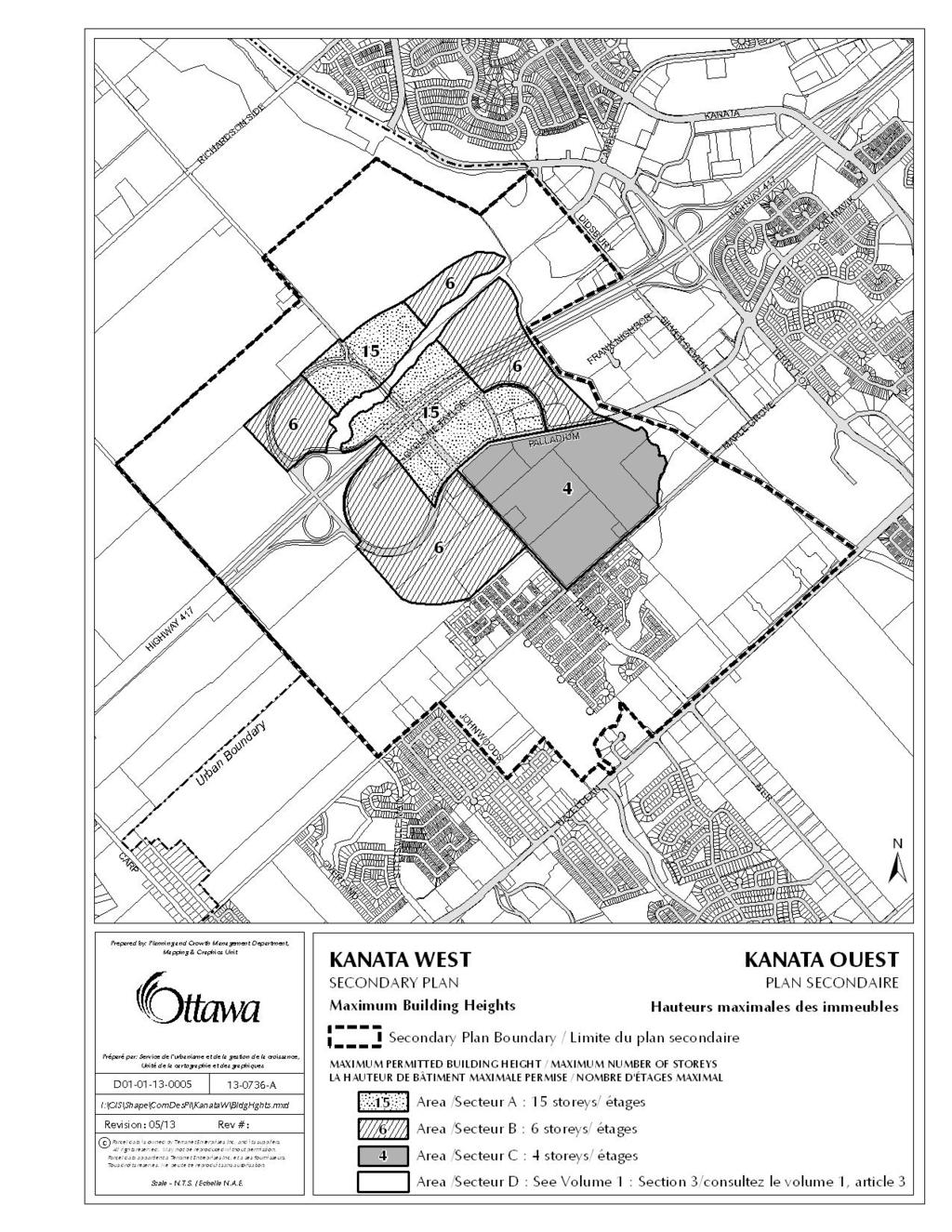
144 143
145 346. Tremblay, St. Laurent and Cyrville Secondary Plan Volume 2A: Secondary Plans is amended by adding a new secondary plan Tremblay, St. Laurent and Cyrville Secondary Plan with a title page and appropriate numbering at the end as follows: 1.0 Introduction The Tremblay, St. Laurent and Cyrville Secondary Plan provides direction on maximum building heights and minimum densities within the planning area identified in the Tremblay, St. Laurent and Cyrville Transit-Oriented Development Plans. 1.1 The Planning Area The Secondary Plan defines the extents of the affected area. The plan area is shown on Schedules A, B and C. 1.2 Maximum Building Heights and Minimum Densities The Secondary Plan defines maximum building heights and minimum densities for lands within the plan area. The maximum building heights and minimum densities are shown as annotations on Schedules A, B and C. 1.3 Implementation The minimum densities set out in this Secondary Plan will result in the achievement of transit-supportive development densities over the long term. The intent of requiring minimum densities is to set the stage for intensification so that development with increased densities can occur in context-sensitive locations at the time market pressures for density exists. In response to this, the implementing zoning will provide flexibility by permitting existing constructed uses of land to be expanded and rebuilt at densities below the minimum densities in this Secondary Plan. Also in response, land estimated to be subject to development intensification pressure beyond 2031 in the TOD Plan for the related station area is permitted to remain in the existing zoning until such time as the owner requests zoning in response to intensification pressure. At that time the property is to be rezoned to the appropriate TD zone in accordance with this Secondary Plan. 144
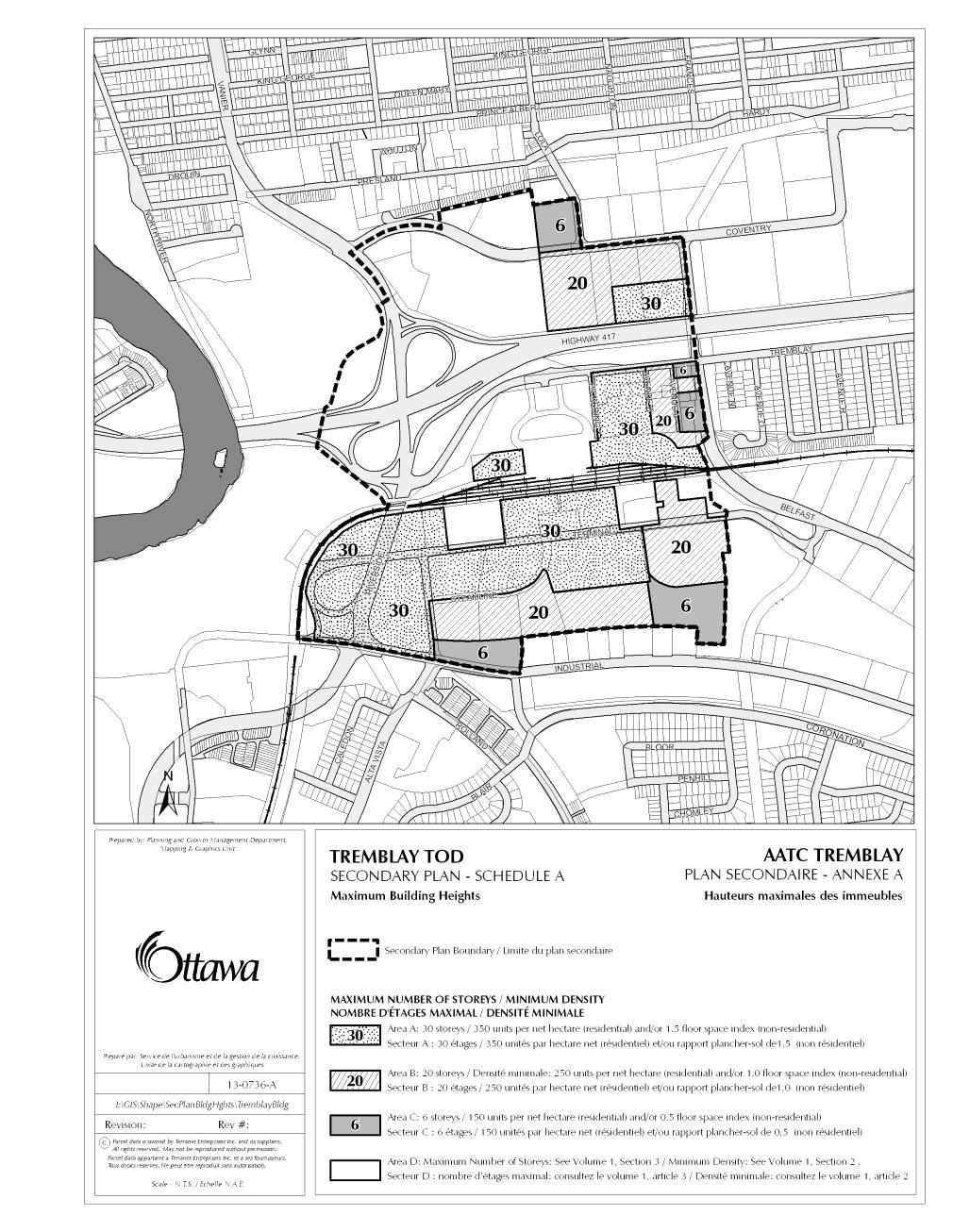
146 145
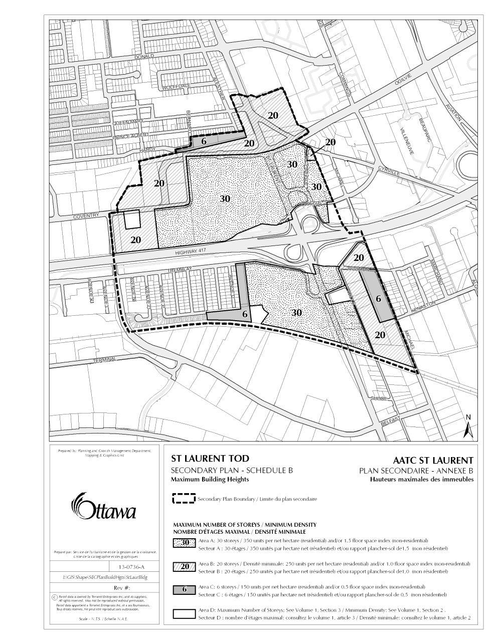
147 146
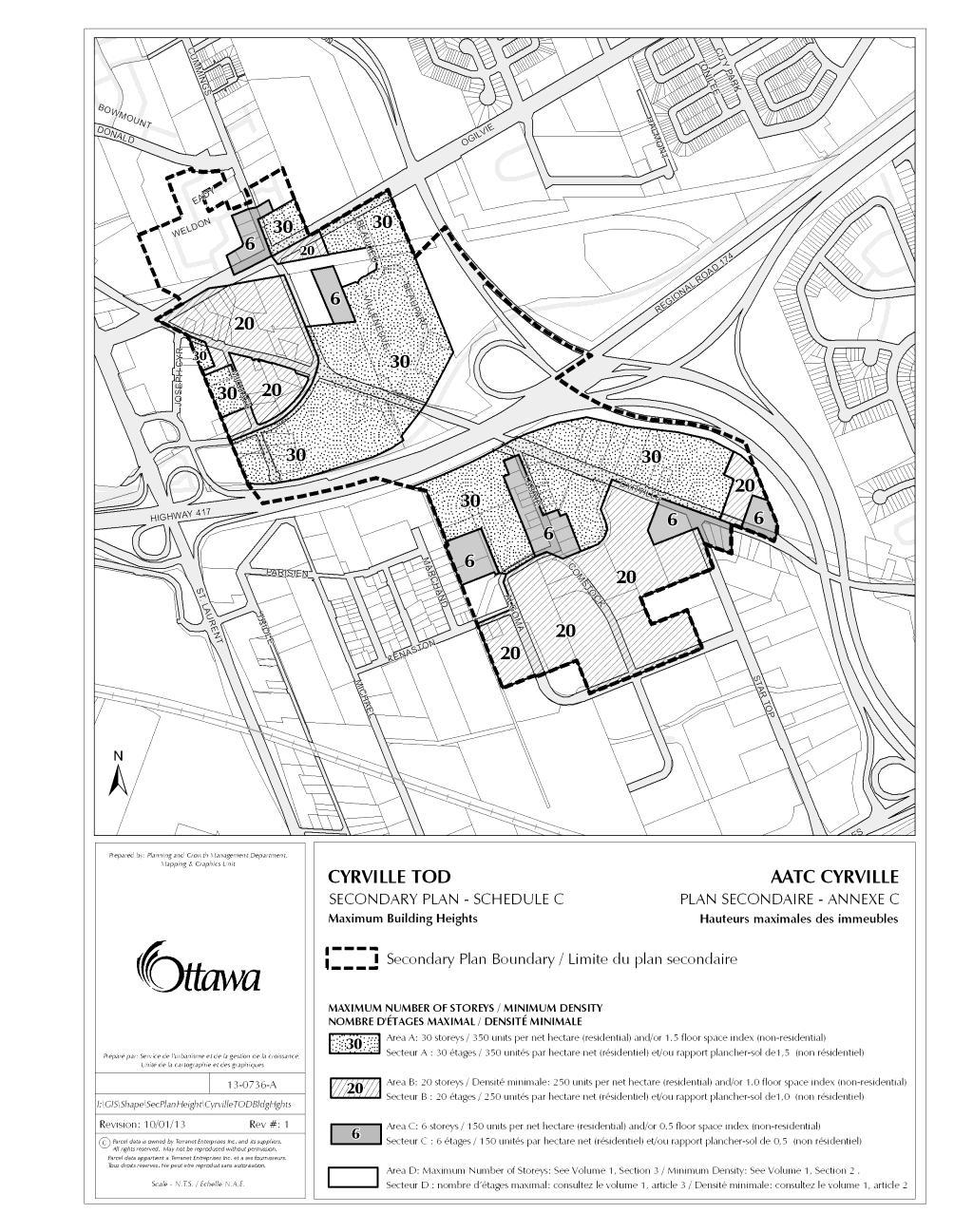
148 147
Section 1 Introduction
 Section 1 Section 1,, describes the role of the Official Plan. The Official Plan is one of five growth management plans that was completed under the umbrella of Ottawa 20/20. 1.1 The Role of the Official
Section 2 - Strategic Directions
 Section 2 - Section 2,, outlines the broad policies that will govern growth and change in Ottawa over the next 20 years. 2.1 Patterns of Growth Figure 2.1 The Geography of Growth Ottawa has grown from
Annotated version of the. including OPA 150. Showing proposed changes as per Amendment No. 150 DRAFT FOR INFORMATION PURPOSES ONLY
 Annotated version of the including OPA 150 Showing proposed changes as per Amendment No. 150 DRAFT FOR INFORMATION PURPOSES ONLY FOR LEGAL PURPOSES REFER TO THE ORIGINAL AMENDMENT ADOPTED BY COUNCIL ottawa.ca
Draft Amendment to the City of Ottawa Official Plan
 Draft Amendment to the City of Ottawa Official Plan showing proposed text changes How to read this document Added or altered text (June 25, 2013) is highlighted Deleted text (June 25) is shown in strike
1 Introduction. Chapter. In this chapter:
 Chapter 1 Introduction In this chapter: 1.1 A Snapshot of the Region 1.2 Towards a Sustainable Region 1.3 The Provincial Context 1.4 Purpose and Organization The Regional Municipality of York Official
Official Plan Review
 Official Plan Review Summary Report - The Built Environment August 2014 Part 1: Introduction Planning for a healthy, prosperous and sustainable community is an important goal for our municipality. From
FORMER CANADIAN FORCES BASE (CFB) ROCKCLIFFE SECONDARY PLAN. Official Plan Amendment XX to the Official Plan for the City of Ottawa
 ROCKCLIFFE SECONDARY PLAN. Official Plan Amendment XX to the Official Plan for the City of Ottawa") FORMER CANADIAN FORCES BASE (CFB) ROCKCLIFFE SECONDARY PLAN Official Plan Amendment XX to the Official Plan for the City of Ottawa 1 INDEX THE STATEMENT OF COMPONENTS PART A THE PREAMBLE PAGE Purpose...
FORMER CANADIAN FORCES BASE (CFB) ROCKCLIFFE SECONDARY PLAN Official Plan Amendment XX to the Official Plan for the City of Ottawa 1 INDEX THE STATEMENT OF COMPONENTS PART A THE PREAMBLE PAGE Purpose...
1.0 PLANNING MARKHAM S FUTURE CONTENTS
 1-1 Planning Markham s Future 1.0 PLANNING MARKHAM S FUTURE CONTENTS 1.1 THE PURPOSE OF THE OFFICIAL PLAN 1.2 THE MARKHAM CONTEXT 1.3 THE REGULATORY CONTEXT 1.3.1 Province of Ontario 1.3.2 York Region
178 Carruthers Properties Inc.
 178 Carruthers Properties Inc. Planning Rationale for 178 Carruthers Avenue Site Plan Control Application June 2014 Table of Contents 1.0 Introduction 2.0 Overview of Subject Property 3.0 Current Zoning
CONTENTS 8.0 LAND USE 8.1 GENERAL LAND USE 8.2 RESIDENTIAL 8.3 MIXED USE 8.4 COMMERCIAL 8.5 EMPLOYMENT LANDS
 8-2 Land Use 8.0 LAND USE CONTENTS 8.1 GENERAL LAND USE 8.1.1 Uses provided for in all Land Use Designations 8.1.2 Uses prohibited in Hazardous Lands, Hazardous Sites and Special Policy Areas 8.1.3 Uses
A Growing Community Rural Settlement Areas
 Town of Huntsville Official Plan Review - POLICY BACKGROUND PAPER A Growing Community Rural Settlement Areas BACKGROUND: In addition to the fully municipally-serviced Urban Settlement Area and the Hidden
2040 LUP is a part of the Comprehensive Plan and carries the same legal authority. Economic Challenges
 1.1. Guiding Anchorage s Growth Where will new residents settle over the next two decades? Where will people work, shop, and play? Will there be enough room to grow? How will Anchorage look? Will growth
BIBLIOGRAPHY DOCUMENT 8
 BIBLIOGRAPHY DOCUMENT 8 Bibliography: Reports, Studies, Monitoring Completed since May 2003 (date of adoption of the first Official Plan by the amalgamated City of Ottawa) 1.0 GENERAL DATA REPORTS 1.1
CONTENTS 2.0 A FRAMEWORK FOR SUSTAINABLE GROWTH 2.1 MANAGING SUSTAINABLE GROWTH THE VISION TO GOALS AND OBJECTIVES 2.3 MARKHAM STRUCTURE
 2 A Framework for Sustainable Growth 2.0 A FRAMEWORK FOR SUSTAINABLE GROWTH CONTENTS 2.1 MANAGING SUSTAINABLE GROWTH THE VISION TO 2031 2.2 GOALS AND OBJECTIVES 2.2.1 Protecting the Natural Environment
2.0 A FRAMEWORK FOR SUSTAINABLE GROWTH CONTENTS
 2-2 A Framework for Sustainable Growth 2.0 A FRAMEWORK FOR SUSTAINABLE GROWTH CONTENTS 2.1 MANAGING SUSTAINABLE GROWTH THE VISION TO 2031 2.2 GOALS AND OBJECTIVES 2.2.1 Protecting the Natural Environment
2.0 A FRAMEWORK FOR SUSTAINABLE GROWTH CONTENTS
 2-2 A Framework for Sustainable Growth 2.0 A FRAMEWORK FOR SUSTAINABLE GROWTH CONTENTS 2.1 MANAGING SUSTAINABLE GROWTH THE VISION TO 2031 2.2 GOALS AND OBJECTIVES 2.2.1 Protecting the Natural Environment
Sustainable Growth. Sustainable Growth
 2 Sustainable Growth Sustainable Growth SUSTAINABLE GROWTH 2.1 COMMUNITY VISION... 2-5 2.2 THE CITY SYSTEM... 2-7 2.2.1 AREAS... 2-7 2.2.2 CITY-WIDE SYSTEMS... 2-8 2.2.3 PROVINCIAL PLAN BOUNDARIES AND
PORT WHITBY COMMUNITY
 PORT WHITBY COMMUNITY SECONDARY PLAN UPDATE COMMUNITY IMPROVEMENT PLAN URBAN DESIGN GUIDELINES September 2015 DRAFT PROPOSED AMENDMENT NUMBER # to the Whitby Official Plan PURPOSE: The intent of this Amendment
[PLANNING RATIONALE] For Site Plan Control and Lifting of Holding Zone By-Law 101 Champagne Avenue. May 23, 2014
![[PLANNING RATIONALE] For Site Plan Control and Lifting of Holding Zone By-Law 101 Champagne Avenue. May 23, 2014](/thumbs/75/71599615.jpg "[PLANNING RATIONALE] For Site Plan Control and Lifting of Holding Zone By-Law 101 Champagne Avenue. May 23, 2014") [PLANNING RATIONALE] For Site Plan Control and Lifting of Holding Zone By-Law 101 Champagne Avenue May 23, 2014 Contents 1.0 Introduction... 2 2.0 Site Context... 2 2.1 Adjacent Uses... 2 Figure 1: Site
[PLANNING RATIONALE] For Site Plan Control and Lifting of Holding Zone By-Law 101 Champagne Avenue May 23, 2014 Contents 1.0 Introduction... 2 2.0 Site Context... 2 2.1 Adjacent Uses... 2 Figure 1: Site
Plano Tomorrow Vision and Policies
 Plano Tomorrow Vision and Policies PLANO TOMORROW PILLARS The Built Environment The Social Environment The Natural Environment The Economic Environment Land Use and Urban Design Transportation Housing
YONGE STEELES CORRIDOR SECONDARY PLAN. Young + Wright / IBI Group Architects Dillon Consulting Ltd. GHK International (Canada) Ltd.
 Ltd.") PART A: PREAMBLE 1.0 PURPOSE The purpose of this Secondary Plan is to provide a development framework for intensification of the Yonge/ Steeles corridor including the north side of Steeles Avenue West
PART A: PREAMBLE 1.0 PURPOSE The purpose of this Secondary Plan is to provide a development framework for intensification of the Yonge/ Steeles corridor including the north side of Steeles Avenue West
Section 3 Designations and Land Use
 Section 3 The previous section of this Plan laid out the City s broad policies that will govern growth and change in Ottawa over the coming decades. This section of the Plan provides more detailed direction
Concord Community Reuse Project Goals and Guiding Principles. Overarching Goals (OG)
") Concord Community Reuse Project Goals and Guiding Principles Overarching Goals (OG) No priority is implied by the order of presentation of the goals and guiding principles. Overarching goals for the Concord
Concord Community Reuse Project Goals and Guiding Principles Overarching Goals (OG) No priority is implied by the order of presentation of the goals and guiding principles. Overarching goals for the Concord
Town of Cobourg Heritage Master Plan. Statutory Public Meeting
 Town of Cobourg Heritage Master Plan Statutory Public Meeting April 25 th 2016 Presentation Overview 1. Introduction 2. Project background and schedule overview 3. Review of strategic direction content
Visioning Statement and Guiding Principles
 Visioning Statement and Guiding Principles Planning for the Future The General Plan The General Plan represents Woodland's shared vision of the future and defines a path to lead the community toward its
This page has been intentionally left blank.
 This page has been intentionally left blank. Chapter 3 3-2 3. Employment 3.A Niagara Economic Gateway 3.A.1 General The Niagara Economic Gateway comprises: a) The Gateway Economic Zone which includes all
Urban Design Manual PLANNING AROUND RAPID TRANSIT STATIONS (PARTS) Introduction. Station Study Areas
 Introduction. Station Study Areas") 111111 PLANNING AROUND RAPID TRANSIT STATIONS (PARTS) Introduction The ION rapid transit system will link Waterloo, Kitchener and Cambridge through a central transit corridor (CTC). There are a number
111111 PLANNING AROUND RAPID TRANSIT STATIONS (PARTS) Introduction The ION rapid transit system will link Waterloo, Kitchener and Cambridge through a central transit corridor (CTC). There are a number
THE CORPORATION OF THE TOWN OF OAKVILLE BY-LAW NUMBER
 THE CORPORATION OF THE TOWN OF OAKVILLE BY-LAW NUMBER 20012-08530 A by-law to adopt an amendment to the Official Plan of the Oakville Planning Area (Official Plan Amendment 198) Land North of Dundas Street.
CITY COUNCIL AGENDA REPORT
 CITY COUNCIL AGENDA REPORT Subject: COUNCIL MOTION LRT ALIGNMENT REMOVAL FROM THE TRANSPORTATION MASTER PLAN On February 10, 2016 Councillor Hughes provided notice in accordance with Section 23 of Procedure
Summary of Changes for the Comprehensive Draft Proposed Official Plan Amendment
 Summary of Changes for the Comprehensive Draft Proposed Official Plan Amendment Note: Due to the broad scope of the Official Plan Review, this list is not exhaustive of the extent of changes in the comprehensive
ELMVALE ACRES SHOPPING CENTRE MASTER PLAN
 ELMVALE ACRES SHOPPING CENTRE MASTER PLAN Contents 1.0 INTRODUCTION... 2 2.0 LOCATION... 2 3.0 EXISTING CONTEXT... 2 4.0 VISION & GUIDING PRINCIPLES... 2 5.0 LAND USE AND BUILT FORM... 4 5.1 St. Laurent
4 Sustainability and Growth Management
 4 Sustainability and Growth Management Introduction Traditionally, has assumed growth and development with limited consideration for the long-term negative social, environmental or economic impacts on
Welcome to the Oakridge Centre Open House
 Welcome to the Oakridge Centre Open House Why is the City hosting this event? This open house is to inform you of a rezoning application submitted to the City of Vancouver to amend the existing CD-1 (Comprehensive
Economy Vision Statements: Social Wellbeing Vision Statements: Natural Environment Vision Statements:
 Economy Vision Statements: 1. Our business environment makes us a region of choice for new employers as we encourage entrepreneurship and have a vibrant, diversified and resilient regional economy. 2.
Transforming Saint John s Urban Heart -
 Transforming Saint John s Urban Heart - How Innovative Community Engagement Inspires a Bold Municipal Plan for a More Sustainable and Compact Saint John 2012 NNECAPA Conference - Brunswick, ME October
Edward R. Sajecki Commissioner of Planning and Building
 Corporate Report Clerk s Files Originator s Files CD.03.POR DATE: TO: FROM: SUBJECT: Chair and Members of Planning and Development Committee Meeting Date: February 27, 2012 Edward R. Sajecki Commissioner
Regional Context Statement
 Regional Context Statement REGIONAL CONTEXT STATEMENT 3. REGIONAL CONTEXT STATEMENT In 1995, the Provincial Government passed into law the Growth Strategies Act. The purpose of this provincial initiative
9 CITY OF VAUGHAN OFFICIAL PLAN AMENDMENT NO BOCA EAST INVESTMENTS LIMITED
 9 CITY OF VAUGHAN OFFICIAL PLAN AMENDMENT NO. 631 - BOCA EAST INVESTMENTS LIMITED The Planning and Economic Development Committee recommends the adoption of the recommendations contained in the following
CITY OF LANGLEY OFFICIAL COMMUNITY PLAN BYLAW, 2005, NO APPENDIX II - REGIONAL CONTEXT MAP
 CITY OF LANGLEY OFFICIAL COMMUNITY PLAN BYLAW, 2005, NO. 2600 APPENDIX II - REGIONAL CONTEXT MAP ± Legend Agricultural Mixed Employment Industrial Conservation & Recreation Regional City Centre Urban Containment
Animating the Rideau Canal December 2013
 Executive Summary Animating the Rideau Canal December 2013 Why study the Rideau Canal? The Rideau Canal has been an important part of Ottawa throughout its history, and has shaped and been shaped by the
Public Open House #1
 Public Open House #1 TONIGHT S AGENDA Welcome Project Overview The Big Picture The Station Area The Analysis Thoughts about Future Change Breakout Group Discussions Summation / Next Steps Project Overview
4- PA - LD - LIVELY DOWNTOWN. LD - Background
 4- PA - LD - LIVELY DOWNTOWN LD - Background The downtown has been the service centre for the community since the city s inception and the area continues to supply people with their personal services,
Official Plan Review: Draft Built Form Policies
 PG.30.1 REPORT FOR ACTION Official Plan Review: Draft Built Form Policies Date: May 15, 2018 To: Planning and Growth Management Committee From: Chief Planner and Executive Director, City Planning Division
THE CORPORATION OF THE TOWN OF OAKVILLE BY-LAW NUMBER
 THE CORPORATION OF THE TOWN OF OAKVILLE BY-LAW NUMBER 2017-120 A by-law to adopt an amendment to the Livable Oakville Plan, Official Plan Amendment Number 20 (Downtown Oakville Growth Area) WHEREAS the
THE STRUCTURE OF THE PLAN...
 TABLE OF CONTENTS THE STRUCTURE OF THE PLAN... 1 A1 THE COMMUNITY VISION... 3 A2 GOALS AND OBJECTIVES... 3 A2.1 THE NATURAL ENVIRONMENT... 3 A2.1.1 Goal... 3 A2.1.2 Objectives... 3 A2.2 GROWTH AND SETTLEMENT...
K. SMART ASSOCIATES LIMITED
 Planning Justification Report Zoning By-Law Amendment 185 King Street North Waterloo, Ontario April 7th, 2017 Project Reference Number 16-245 K. SMART ASSOCIATES LIMITED CONSULTING ENGINEERS AND PLANNERS
SAN RAFAEL GENERAL PLAN 2040 INTRODUCTION AND OVERVIEW
 SAN RAFAEL GENERAL PLAN 2040 INTRODUCTION AND OVERVIEW Steering Committee Presentation February 14, 2018 Purpose of General Plan Guide land use and development decisions Coordinate transportation, infrastructure,
TOWN OF BRUDERHEIM Report to the capital region board
 TOWN OF BRUDERHEIM Report to the capital region board Introduction to the Town of Bruderheim Municipal Development Plan amendment and Relation to the CRB Evaluation Criteria 02 march 2017 1 Introduction
Mark-up of the effect of the proposed Bronte Village Growth Area OPA No.18 on the text of section 24, Bronte Village, of the Livable Oakville Plan
 Mark-up of the effect of the proposed Bronte Village Growth Area OPA No.18 on the text of section 24, Bronte Village, of the Livable Oakville Plan Notes: This document is provided for information purposes
Preliminary Plan Framework: Vision and Goals
 Preliminary Plan Framework: Vision and Goals Draft: May 2015 Introduction Since the Town of Milliken s comprehensive plan was last updated in 2010, the community was heavily impacted by the 2013 flood,
John M. Fleming Managing Director, Planning and City Planner. Old East Village Dundas Street Corridor Secondary Plan Draft Terms of Reference
 Report to Planning and Environment Committee To: From: Subject: Chair and Members Planning & Environment Committee John M. Fleming Managing Director, Planning and City Planner Old East Village Dundas Street
Stakeholder Recommendations Voting Results
 Stakeholder Recommendations Voting Results Public Input Yes No Abstain Total Count 1. On the matters that are of the highest importance to the community, strengthen the related policy statements through
Planning Primer Legislative Background, Policy Documents and Development Review Processes. Presented by: Planning Services Date: April 6, 2017
 Planning Primer Legislative Background, Policy Documents and Development Review Processes Presented by: Planning Services Date: April 6, 2017 Agenda Legislative Background 7:30 to 8:00 pm Questions 8:00
6 Growth Management Challenges and Opportunities
 6 Growth Management Challenges and Opportunities The Town has established a goal of attaining a 50% participation rate with respect to employment opportunities versus residential population. The Town s
Draft Urban Hamilton Official Plan. Amendment No. XX
 1 of 75 The following text, together with: Draft Appendix A Appendix B Volume 1, Schedule E-1 Urban Land Use Designations Appendix C Volume 1, Appendix A Parks Classification Map Appendix D Volume 1, Appendix
13 THORNHILL YONGE STREET STUDY IMPLEMENTATION CITY OF VAUGHAN OPA 669 AND TOWN OF MARKHAM OPA 154
 13 THORNHILL YONGE STREET STUDY IMPLEMENTATION CITY OF VAUGHAN OPA 669 AND TOWN OF MARKHAM OPA 154 The Planning and Economic Development Committee recommends the adoption of the recommendations contained
CITY CLERK. Parkland Acquisition Strategic Directions Report (All Wards)
") CITY CLERK Clause embodied in Report No. 10 of the, as adopted by the Council of the City of Toronto at its meeting held on November 6, 7 and 8, 2001. 10 Parkland Acquisition Strategic Directions Report
CITY CLERK Clause embodied in Report No. 10 of the, as adopted by the Council of the City of Toronto at its meeting held on November 6, 7 and 8, 2001. 10 Parkland Acquisition Strategic Directions Report
CHAPTER 2: PLANNING PRINCIPLES
 CHAPTER 2: PLANNING PRINCIPLES 2 Comprehensive Principles The following overarching Principles provide the basis for the goals and policies included in the Mendocino County General Plan. These Principles
Public Open House. Overview of the Downtown Plan Official Plan Amendment April 23, 2018
 Public Open House Overview of the Downtown Plan Official Plan Amendment April 23, 2018 1 A 25-Year Plan for Downtown To ensure growth contributes positively to Toronto s Downtown as a great place to live,
Municipal Development Plan Update Urban Service Area and Hamlets
 ENCLOSURE 1 Municipal Development Plan Update Urban Service Area and Hamlets Priorities Committee January 24, 2017 MUNICIPAL DEVELOPMENT PLAN UPDATE SHAPING OUR FUTURE MDP Update - Agenda MDP Update Public
5 TOWN OF MARKHAM OFFICIAL PLAN AMENDMENT NO. 144 MILLIKEN MAIN STREET SECONDARY PLAN
 5 TOWN OF MARKHAM OFFICIAL PLAN AMENDMENT NO. 144 MILLIKEN MAIN STREET SECONDARY PLAN The Planning and Economic Development Committee recommends the following: 1. The communication from Brendan O Callaghan,
and services The protection and conservation of environmentally significant and sensitive natural heritage features and functions.
 6. Land Use 6.0 Preamble A healthy and livable city is one in which people can enjoy a vibrant economy and a sustainable healthy environment in safe, caring and diverse neighbourhoods. In order to ensure
Western City District What we heard
 What we heard Vision to 2056 and Priorities Governance and implementation Infrastructure and funding The protection of the natural landscape including biodiversity and the Metropolitan Rural Area for food
Former Rockcliffe Airbase Community Design Plan Guiding Design Vision and Principles December 4, 2013
 APPENDIX 5 - Guiding Design Vision and Principles Former Rockcliffe Airbase Community Design Plan Guiding Design Vision and Principles December 4, 2013 Vision Statement The redevelopment of the former
EXISTING COMPREHENSIVE PLAN
 EXISTING COMPREHENSIVE PLAN Town Center Land Use Element: V. LAND USE POLICIES Town Center Mercer Island's business district vision as described in "Your Mercer Island Citizen-Designed Downtown" was an
PSRC REVIEW REPORT & CERTIFICATION RECOMMENDATION
 PSRC REVIEW REPORT & CERTIFICATION RECOMMENDATION KITSAP COUNTY COUNTYWIDE PLANNING POLICIES July 2, 2012 BACKGROUND A major emphasis of the Washington State Growth Management Act (GMA) is the need to
NEW REGIONAL OFFICIAL PLAN HIGH LEVEL PROCESS & FRAMEWORK
 NEW REGIONAL OFFICIAL PLAN HIGH LEVEL PROCESS & FRAMEWORK Why A New Official Plan Originally the role of Regionally Planning and content of Regional Official Plan (1970s) primarily focused on protecting
Complete Neighbourhood Guidelines Review Tool
 Complete Neighbourhood Guidelines Review Tool Prepared By: City of Regina Planning Department October 2014 Page 1 of 14 Community Development Review Checklist for Secondary Plans and Concept Plans The
Streets for People, Place-Making and Prosperity. #TOcompletestreets
 COMPLETE STREETS FOR TORONTO Streets for People, Place-Making and Prosperity COMPLETE STREETS: A NEW APPROACH A Complete Streets design approach considers the needs of all users people who walk, bicycle,
TREASURE COAST REGIONAL PLANNING COUNCIL M E M O R A N D U M. To: Council Members AGENDA ITEM 5H
 TREASURE COAST REGIONAL PLANNING COUNCIL M E M O R A N D U M To: Council Members AGENDA ITEM 5H From: Date: Subject: Staff October 17, 2008 Council Meeting Local Government Comprehensive Plan Review Draft
Implementation Guide Comprehensive Plan City of Allen
 Implementation Guide 2030 Comprehensive Plan City of Allen DRAFT 2015 Implementation Guide Allen 2030 Comprehensive Plan INTRODUCTION The Comprehensive Plan serves as a guide for the growth and development
2. Shaping Waterloo Region s Urban Communities
 2. Much of the region s growth over the past several decades has occurred in suburban areas that separated where people live from where they work and shop. This pattern of growth has increased the need
WINCHESTER TOWN 3.1 LOCATION, CHARACTERISTICS & SETTING
 WINCHESTER TOWN 3.1 LOCATION, CHARACTERISTICS & SETTING 3.1.1 The area referred to by the City Council, as Winchester Town, consists of the Winchester Wards plus the adjoining built up areas of Badger
New Official Plan Quest November 2013
 City of Markham New Official Plan Quest November 2013 Building Markham s Future Together - 6 Key Strategic Priorities 1. Growth - Managing our Growth 2. Transportation/Transit - Improving transportation
THE GARDEN CITY PLAN. City of St. Catharines Official Plan. City of St. Catharines
 THE GARDEN CITY PLAN City of St. Catharines Official Plan City of St. Catharines August 2010 APPROVAL INFORMATION This Official Plan of the City of St. Catharines Planning Area, known as the Garden City
Our City Centre is a vibrant, creative and welcoming destination, with a modern business, cultural, shopping, leisure and residential offer
 3. Sheffield in 2034 Our City sits at the heart of a strong, distinctive and internationally successful City Region economy which supports innovation and enterprise Our City Centre is a vibrant, creative
The protection of the agricultural resources of the Province;
 PART II INTRODUCTION An Official Plan is a policy document, which is intended to serve as the basis for making land use decisions and managing change in any municipality in Ontario. According to the Planning
1 Introduction. 4 Environmental Integrity. 7 Community Facilities
 2037: A CALL TO ACTION 2017 COMPREHENSIVE PLAN EXECUTIVE SUMMARY is the purpose of the Q: What Comprehensive Plan? The comprehensive plan serves as a guide for the community s physical, social, and economic
CHAPTER 12 IMPLEMENTATION
 CHAPTER 12 IMPLEMENTATION The 2010 Town of Denton Comprehensive Plan is intended to capture a vision of the future of Denton. As such, it provides a basis for a wide variety of public and private actions
10.0 Open Space and Public Realm
 10.0 Open Space and Public Realm 10.0 Open Space and Public Realm The Public Open Space System is comprised of: outdoor spaces available for public use that are either publicly owned (e.g., parks and
PLANNING RATIONALE FOR 1127, 1128 MILL STREET AND 1125 CLAPP LANE CITY OF OTTAWA
 PLANNING RATIONALE FOR 1127, 1128 MILL STREET AND 1125 CLAPP LANE CITY OF OTTAWA Prepared by: Realty Initiatives and Development On behalf of the Manotick Mill Community Lands Development Corporation March
Synopsis of 50 years of Planning in the Greater Golden Horseshoe (GGH), Ontario, Canada. Olusola Olufemi 2015
, Ontario, Canada. Olusola Olufemi 2015") Synopsis of 50 years of Planning in the Greater Golden Horseshoe (GGH), Ontario, Canada Olusola Olufemi 2015 Canada Background Canada s population is 34,834,841 (July 2014 est.) Capital city: Ottawa Canada
Synopsis of 50 years of Planning in the Greater Golden Horseshoe (GGH), Ontario, Canada Olusola Olufemi 2015 Canada Background Canada s population is 34,834,841 (July 2014 est.) Capital city: Ottawa Canada
2.2.1 DOWNTOWN: THE HEART OF TORONTO
 2.2.1 DOWNTOWN: THE HEART OF TORONTO Toronto has only one downtown. It plays a vital role as the city s economic and cultural hub and is critical to the health and prosperity of the entire region that
ELK GROVE GENERAL PLAN VISION
 2-1 CHAPTER 2: 2-2 CREATING OUR The Community Vision for Elk Grove, expressed through a Vision Statement and a series of Supporting Principles, is a declaration of the kind of community that Elk Grove
elbridge Core Strategy
 C elbridge Core Strategy Celbridge is designated as a Moderate Growth Town in the RPGs. The County Development Plan reinforces this designation in its settlement strategy. Moderate Growth Towns within
Commercial, Retail and Tourism Executive Summary December 2018
 Town of Wasaga Beach Official Plan Review, Retail and Executive Summary December 2018 1 An Official Plan directs where and how to grow The preparation of a new Official Plan for Wasaga Beach is an opportunity
1Planning. Approach. Part I Chapter 1: Planning Approach
 1Planning Approach Part I Chapter 1: Planning Approach 1 Planning Approach page 5 1Planning Approach The preparation of the Master Plan constitutes a unique opportunity to reflect collectively on the
SUMMARY. An Attractive, Competitive and Sustainable GREATER MONTREAL. Draft Metropolitan Land Use and Development Plan. April 2011
 April 2011 Draft Metropolitan Land Use and Development Plan GREATER MONTREAL An Attractive, Competitive and Sustainable SUMMARY Message from the Chair I am pleased to introduce this draft of the Metropolitan
Report to: Development Services Committee Report Date: September 11, 2017
 ~RKHAM Report to: Development Services Committee Report Date: September 11, 2017 SUBJECT: PREPARED BY: Conceptual Master Plan for the Future Urban Area - Community Structure Plan and Key Policy Direction
LAND USE AMENDMENT CORNERSTONE (WARD 3) 60 STREET NE AND COUNTRY HILLS BOULEVARD NE MAP 26NE BYLAW 22D2017
 60 STREET NE AND COUNTRY HILLS BOULEVARD NE MAP 26NE BYLAW 22D2017") Page 1 of 14 EXECUTIVE SUMMARY This Land Use Amendment application covers an area of 43.76 hectares ± (108.14 acres ±) located in northeast Calgary, bound by Country Hills Boulevard NE to the south and
Page 1 of 14 EXECUTIVE SUMMARY This Land Use Amendment application covers an area of 43.76 hectares ± (108.14 acres ±) located in northeast Calgary, bound by Country Hills Boulevard NE to the south and
2136 & 2148 Trafalgar Road Town of Oakville Region of Halton
 PLANNING JUSTIFICATION REPORT 2136 & 2148 Trafalgar Road Town of Oakville Region of Halton Zoning By-Law Amendment Application 2500674 Ontario Inc. November 2016 Table of Contents Page 1.0 Location/Summary
1.3 TRANSIT VISION 2040 FROM VISION TO ACTION THEME 1: PUTTING TRANSIT AT THE CENTRE OF COMMUNITIES. Fully integrate transit with community planning
 TRANSIT VISION 2040 FROM VISION TO ACTION TRANSIT VISION 2040 defines a future in which public transit maximizes its contribution to quality of life with benefits that support a vibrant and equitable society,
Further input invited as Colchester Growth Strategy nears final phase
 IUE 3 / NOVEMBER 2015 Further input invited as Colchester Growth trategy nears final phase trathcona County is seeking public feedback as it enters the final phase of work on a Growth Management trategy
BY-LAW NO WHEREAS Planning Committee convened public meetings to consider the adoption of the aforementioned official plan amendment;
 BY-LAW NO. 2017-19 A by-law of the City of Ottawa adopting a comprehensive amendment to the Official Plan in relation to growth projections, employment land review and agricultural land review. WHEREAS
141 GEORGE STREET PLANNING RATIONALE
 141 GEORGE STREET PLANNING RATIONALE MINOR ZONING BY-LAW AMENDMENT NOVEMBER 2, 2016 PLANNING RATIONALE 223 McLeod Street Ottawa, ON K2P 0Z8 613.730.5709 fotenn.com INTRODUCTION FOTENN Consultants is acting
KANATA CENTRUM 255 KANATA AVENUE OFFICIAL PLAN AMENDMENT ZONING BY-LAW AMENDMENT
 KANATA CENTRUM 255 KANATA AVENUE OFFICIAL PLAN AMENDMENT ZONING BY-LAW AMENDMENT JUNE 2015 PREPARED BY: FOTENN Consultants Inc. 223 Mcleod Street Ottawa, ON K2P OZ8 (613) 730-5709 PREPARED FOR: Kanata
Parks Master Plan Implementation: Phase I Waterfront Use and Design REPORT #: September 7, 2016 File #
 0 'O DI Lan-171-14 1 - THE CORPORATION OF THE TOWN OF COBOURG..,. STAFF REPORT TO: FROM: Mayor and Members of Council Dean A. Hustwick, Director of Recreation and Culture DATE OF MEETING: Committee of
DAREBIN PLANNING SCHEME AMENDMENT C137
 Who is the planning authority? Planning and Environment Act 1987 DAREBIN PLANNING SCHEME AMENDMENT C137 EXPLANATORY REPORT This amendment has been prepared by the Darebin City Council, who is the planning
MAYFIELD WEST SECONDARY PLAN PHASE 2
 MAYFIELD WEST SECONDARY PLAN PHASE 2 Public Open House #3 February 25, 2010 Draft Preferred Land Use Scenario TOWN OF CALEDON PLANNING & DEVELOPMENT DEPARTMENT Open House Agenda TOWN OF CALEDON 1. Welcome
DRAFT WESTERN CITY DISTRICT PLAN PLANNING PRIORITIES AND ACTIONS
 Greater Sydney Commission DRAFT WESTERN CITY DISTRICT PLAN PLANNING PRIORITIES AND ACTIONS Issued: 26 OCTOBER 2017 Version: 1 Subject: Greater Sydney Region and District Plans This information note is