CHAPEL HILL GREENWAYS
|
|
|
- Merry Hood
- 6 years ago
- Views:
Transcription
1 CHAPEL HILL GREENWAYS Comprehensive Master Plan A Planning Guide for Future Physical Improvements and Operational Policies Greenways Commission Town of Chapel Hill, North Carolina [[INSERT DATE UPON ADOPTION]]
2 CHAPEL HILL GREENWAYS Comprehensive Master Plan Prepared for: Chapel Hill Town Council Kevin C. Foy, Mayor Edith M. Wiggins, Mayor pro tem Sally Greene Ed Harrison Cam Hill Mark Kleinschmidt Bill Strom Dorothy Verkerk Jim Ward Submitted by: Chapel Hill Greenways Commission Glenn Parks, Chair Bill Bracey, Vice Chair Sarah Bergmann Mary Blake Peter Calingaert Jim Earnhardt Mary Ann Freedman ii Part 1 Introduction
3 TABLE OF CONTENTS SUMMARY... Page vi 1. INTRODUCTION... Page 1 The Term Greenway Defined Benefits of Urban Greenways History of the Greenways Program Purpose of the Master Plan Organization of the Master Plan 2. THE PLANNING PROCESS... Page 9 Assumptions for the Process Goals of the Master Plan Planning Methodology 3. ANALYSIS OF CURRENT CONDITIONS... Page 13 Role of the Greenways Commission Supporting Plans and Ordinances Components of the Greenway System Existing Greenway Trails 4. STRATEGIC PLANNING... Page 25 STREAM CORRIDORS... Page 26 Bolin Creek Watershed Booker Creek Watershed Little Creek Morgan Creek Watershed Dry Creek MAN-MADE CORRIDORS... Page 58 Utility Rights-of Way North Trail (Interstate Trail) Horace Williams Trail Meadowmont Trail CONNECTOR TRAILS... Page 68 Major Connectors Minor Connectors PARK TRAILS... Page 69 Current Capital Renovation Needs Part 1 Introduction iii
4 REGIONAL AND LOCAL COORDINATION... Page 72 Linkage with Regional and Local Trail Systems Connections with Town Alternative Transportation Plans Cooperation with the University of North Carolina at Chapel Hill IMPLEMENTATION POLICIES... Page 78 Meshing of Goals: Land and Trails Land Acquisition Procedures and Policies FINANCING THE GREENWAYS PROGRAM... Page 81 Previous and Current Funding for Greenways No-Cost Preservation of Greenway Corridors No-Cost Trail Construction Low-Cost Trail Construction Funding Land Acquisition and Trail Construction 5. ACTION PLAN... Page 85 Criteria for Land Acquisition and Trail Construction Land Acquisition Priorities Trail Construction Priorities 6. MAINTENANCE AND OPERATIONAL POLICIES... Page 89 Maintenance Neighborhood Trails Program Citizen Participation in the Greenways Program Promotion of Greenways Interagency / Regional Cooperation Security 7. DESIGN STANDARDS & GUIDELINES... Page 93 Corridor Width Guidelines Trail Classifications Special Trail Needs Trail Locations Trail Amenities Parking Areas Accessibility Naming Trails Signage 8. CONCLUSION... Page 101 Adoption of the Plan Review and Update of the Plan iv Part 1 Introduction
5 LIST OF FIGURES FIGURE 1 Primary Streams... Page 20 FIGURE 2 Bolin Creek Watershed... Page 28 FIGURE 3 Bolin Creek Trail... Page 29 FIGURE 4 Booker Creek Watershed... Page 35 FIGURE 5 Upper Booker Creek Trail... Page 36 FIGURE 6 Lower Booker Creek Trail... Page 37 FIGURE 7 Little Creek Watershed... Page 44 FIGURE 8 Little Creek Trail... Page 45 FIGURE 9 Morgan Creek Watershed... Page 47 FIGURE 10 Morgan Creek Trail... Page 48 FIGURE 11 Dry Creek Watershed... Page 54 FIGURE 12 Dry Creek Trail... Page 55 FIGURE 13 North Trail East... Page 60 FIGURE 14 North Trail West... Page 61 FIGURE 15 Horace Williams Tract North... Page 66 Part 1 Introduction v
6 FIGURE 16 Horace Williams Tract South... Page 67 FIGURE 17 Potential Trail Linkage with Regional Systems and Neighboring Communities: Carrboro/Orange County Area... Page 74 FIGURE 18 Potential Trail Linkage with Regional Systems and Neighboring Communities: Durham Area... Page 75 FIGURE 19 UNC-Owned Land... Page 77 LIST OF CHARTS CHART 1 Critical NCDOT and Town Road Intersections.... Page 71 CHART 2 Anticipated Greenways/Open Space Program Funds by Funding Agency ( )... Page 82 CHART 3 Anticipated Greenways/Open Space Program Funds by Project ( )... Page 82 vi Part 1 Introduction
7 SUMMARY On September 8, 2003 the Council authorized the Greenways Commission to explore possible revision of the Greenways Master Plan. In addition the Council authorized the Manager to seek input from Boards and Commissions. This report represents the completion of a study begun in September 2003 to update the 1998 Chapel Hill Greenways Comprehensive Master Plan. A series of five public forums were held from October 2003 through April The input gathered during the forums in addition to other public comments received in various ways was used by the staff to prepare a draft document that was then reviewed and refined by the Greenways Commission. The Plan was further reviewed by the Bicycle and Pedestrian Board, Transportation Board, Planning Board, Parks and Recreation Commission, local environmental organizations, the University of North Carolina at Chapel Hill, adjoining local governments, and Town staff. Goals of the Greenways Program The Chapel Hill Greenways Program has three major goals that were originally identified in the 1998 Report: 1. To establish and maintain a system of linear open spaces that will help protect the environment of Chapel Hill. 2. To establish a system of trails, where appropriate, that will enable citizens to enjoy the recreational benefits of a network of greenways throughout the Chapel Hill community. 3. To develop specific trails which may offer alternatives to automobile transportation. Purpose of the Master Plan This Master Plan provides a foundation for making sound planning and design decisions related to the continued preservation of the Town s greenway corridors. The recommendations provided in the Plan will help to maintain a balance among the goals of the Greenways Program of resource protection, recreational use and transportation opportunities. It also provides the Council with an effective tool to enter into discussion and negotiation regarding regional open space preservation and trail development initiatives and for interacting with State agencies and other regulatory and funding agencies. Changes to the 1998 Report The 2005 Greenways Comprehensive Master Plan is designed to replace the 1998 Greenways Comprehensive Master Plan. The changes reflect current Town conditions and conditions anticipated for the next decade. The major changes found in the Comprehensive Greenways Master Plan are: Addition of recently annexed areas, new schools, planned Town parks, greenway land acquisitions and recent and planned private land developments. Addition of newly-identified trail segments to the greenways program. Recommendations to change the alignments of several trails. New list of high priority trails that could be built in the next seven years. New maps that are based on the adopted 2004 Bicycle and Pedestrian Action Plan. Identification of key trail intersections with NCDOT roads and suggested solutions for allowing pedestrians and bicyclists to cross these roads in a safe manner. Summary vii
8 Current Condition of the Greenways Program Since its first meeting in October 1985, the Greenways Commission has worked to expand the amount of land preserved by the Town and to plan and oversee construction of trails. Current open space holdings total over 716 acres, most of which are within the greenways system. Seven greenway projects have been built to date and account for approximately seven miles of recreational trails. This leaves about 21 miles of trail to be completed in the future in order to complete the trails portion of the master plan. In addition, six park trails that total approximately 4.95 miles have been built. The following greenway trails are now being used: TRAIL SURFACE MILES Battle Branch Natural 1.5 Bolin Creek Paved 1.5 Dry Creek Natural.5 Fan Branch Paved 1.2 Lower Booker Creek Paved.85 Meadowmont Paved 1 Tanyard Branch Natural.4 TOTAL 6.95 The following park trails are now being used: TRAIL SURFACE MILES Cedar Falls Natural 1.2 Jones Park Natural.25 Meadowmont Natural.5 North Forest Hills Natural.5 Pritchard Park Natural 1 Southern Community Pk. Natural 1.5 TOTAL 4.95 Summary of Major Recommendations This report continues to recommend the acquisition of 38 miles of linear open space. The most active recreational use proposed for the greenway corridors identified in this report are bicycle and pedestrian trails. Over 28 miles of the Town s greenway corridors are suitable for development of paved or unpaved trails. A variety of trail types are proposed to suit specific recreational or transportation priorities and specific site conditions. Trails may range from natural surface foot paths and boardwalks utilized to negotiate sensitive or difficult site conditions to paved pedestrian and bicycle trails offering maximum recreational and transportation use. The following six new greenway trails and trail segments could be completed by the year 2012 if anticipated funding continues to be available and needed land is acquired: Bolin Creek, Phase III (Martin Luther King Jr. Blvd. to Estes Drive Extension) Dry Creek (Perry Creek Road to Eastowne) Fan Branch Trail (Scroggs School to southern tip of Southern Community Park) Morgan Creek (Merritt Pasture to Smith Level Road) Upper Booker Creek (Weaver Dairy Road to Homestead Park with a spur to Horace Williams Trail corridor) A Look to the Future The recommendations found in this Master Plan offer the present and future citizens of Chapel Hill a plan for integrating their urban environment with the natural world. The adoption and endorsement of this Comprehensive Greenways Master Plan by the Council and the citizens of Chapel Hill is one step toward ensuring that goal. viii Summary
9 Part 1 INTRODUCTION This Report is a revision of the Greenways Master Plan that was adopted by the Council on May 26, Since that time the Town has identified several changes in the Greenways Master Plan document that would make the document more useful and responsive to the Town s needs. These changes include: The need to address new funding sources that were not anticipated in These are discussed in greater detail on page 81 of this report. Land development has made several trail options available in 1998 impractical today. This report identifies options that respond to changes in land use patterns since It has become clear that special attention must be given to trails that cross NCDOT roads. This Report contains a section dealing with opportunities to move pedestrians and bicycles across NCDOT controlled roads. Neighboring jurisdictions have made changes to their trail and open space plans that affect the Town s plan. These changes are addressed. The underlying assumption and need for this study emerges from three long-term concerns of the Town s governing body and its active citizenry. The first reflects the Town s continuing commitment to provide quality recreational facilities for the community. The second exemplifies the Town s commitment to preserving open space as an integrated component of the Town s urban landscape. The third reflects Chapel Hill s commitment to offer alternatives to automobile transportation. The Comprehensive Greenways Master Plan recommends linking the Town s land use objectives with its environmental, transportation and recreation goals to provide a viable network of pedestrian/bicycle trails and other passive recreation opportunities. As the Town continues to grow, the notion of conserving undeveloped land has become a more pressing matter. Significant population increases and growth are projected over the next several decades in Chapel Hill and surrounding communities. Development pressure will continue to influence the character of the Chapel Hill landscape, inevitably shaping the form and quality of the Town s open space. The Town-wide greenway system proposed within this Master Plan occurs primarily along the Town s streams and watercourses. These open spaces along wooded stream corridors both protect and make accessible many of Chapel Hill s unique and beautiful natural settings. The development of this Comprehensive Greenways Master Plan and its continuing update will contribute to the strategic organization of the Town s open space and greenways. The Master Plan is intended to provide a foundation for making decisions related to the greenways program and the quality of Chapel Hill s physical environment. The Plan s guidelines will help to assure the continuity and coordination of open space conservation, passive recreation and trail facilities for future decades. The Term Greenway Defined The term greenway is used in many communities throughout the United States. However, there is not a single, consistent definition of the term that would fit the needs of each locale. In some communities the word greenway is synonymous with the word trail. In other towns and cities, the public may associate the term with specific types of trails, such as Part 1 Introduction 1
10 paved bicycle accessible paths along streams. Other communities use the words greenbelt or greenway to identify areas which are simply set aside for preservation and/or buffers between non-complimentary uses or between communities. In 1993, the Chapel Hill Greenways Commission adopted the following language to describe Town greenways : Networks of natural spaces which provide corridors connecting areas such as neighborhoods, parks, and schools. These passageways typically include trails for pedestrians and non-motorized vehicles. They are a link to nature for the enjoyment of the community. This definition describes greenways as linear natural areas which sometimes may be suitable for the inclusion of trails. It is an important distinction to note, however, that some greenway areas in Chapel Hill may not be suitable for trail development and may find their highest and best land use by remaining as undeveloped open space, and providing the community with valuable buffers, environmental preserves or wildlife corridors. Benefits of Urban Greenways Greenways can provide economic, environmental, recreation, and transportation-related benefits to the entire community in which they are found. A greenway system, well integrated within the Chapel Hill community, can function to: 1. Preserve the natural environment that makes Chapel Hill a pleasant place to live. 2. Provide recreational opportunities ranging from quiet enjoyment of natural areas to hiking and bicycling. 3. Provide natural laboratories where flora, fauna and ecological relationships can be studied by all Chapel Hill citizens. 4. Influence urban growth patterns by conserving open space, separating and buffering conflicting land uses, and connecting compatible land uses. 5. Provide a network of pedestrian and bicycle trails - a safe and pleasant alternative to the Town s street system - that will connect neighborhoods, schools, shopping areas, and parks. 6. Increase the value of all properties in Chapel Hill by creating an aesthetically pleasing community with greater options for non-motorized vehicle transportation and recreation and open space. 7. Mitigate flooding, soil erosion, and stream siltation by preserving buffers between developed areas and streams. 8. Retard the degradation of air quality by allowing vegetation in the greenways areas to add oxygen, filter dust and air-borne pollutants, and cool the air. 9. Mitigate noise pollution by allowing vegetation in the greenways areas to act as natural noise barriers. 10. Preserve habitat and travel corridors for wildlife within the urban area. 11. Contribute to the aesthetic and visual structuring of the Town, helping to retain and amplify the character of the Town landscape. History of the Greenways Program The Chapel Hill greenways program was established by Council resolution in However, the concept of preserving open space and greenways has been part of Chapel Hill s 2 Part 1 Introduction
11 planning efforts for four decades. The first deliberate efforts toward preserving linear parcels of open space for the purpose of developing a greenways program began in the 1960s and early 1970s. The early movement was led by Planning Board member and later Alderman Alice Welsh who led the effort to acquire easements from landowners along the Bolin Creek corridor. These early efforts resulted in an almost unbroken chain of Town-owned properties and easements that stretched along Bolin Creek from Umstead Park to Franklin Street. The acquisition of these properties and easements contributed greatly toward the Town s goal of preserving Chapel Hill s first and one of its most important greenway corridors the Bolin Creek Greenway. During the 1980s, the Town s greenways planning and development efforts became more formalized. In 1981, the Parks and Recreation Department surveyed the Chapel Hill community to determine user concerns. Eighty-four percent of the respondents thought that greenway development was a high to moderately high priority. These findings were reinforced by the 1982 report, Subcommunities in Chapel Hill: Conditions, Problems, Recommendations. A major concern of citizens outlined in that study was the fear that greenways development would be dropped as a Town priority. As the decade progressed, greenways programs in other North Carolina cities grew, especially in nearby Raleigh and Cary. As the success of the Raleigh and Cary programs grew, other municipalities, including Chapel Hill, became more interested in a greenways program. This interest led to a January 9, 1984 resolution of the Town Council to create an eleven member Greenways Task Force to study whether or not the Town should initiate a greenways program. The members of the task force included Lightning Brown (Chair), Diane Byrne, Valerie Carter, Lynn Cox, Karen Davidson (Vice Chair), Betsy Pringle, Zora Rashkis, Gordon Rutherford, Betty Sanders, Randy Schenck, and Philip Szostak. The group included representatives of the development community, the University, environmental groups, the business community, and various neighborhoods. The group presented their report, Greenways Task Force Final Report to the Council on February 11, The Task Force Report recommended the creation of a Greenways Commission. The Council agreed and on July 8, 1985 adopted a resolution which directed that the Greenways Commission be established and that the Parks and Recreation Department provide staff support for technical and administrative functions. The Council then appointed a seven member Commission which met for the first time in October Since its first meeting in October 1985, the Greenways Commission has worked to expand the amount of land preserved by the Town and to plan and oversee construction of trails. The Greenways Commission has been partially responsible for the Town s purchase of over 100 acres of land and has made recommendations that resulted in many acres of property being dedicated or donated to the Town. The Commission has dedicated seven major trails to date, and has been a vital part of the decision making process of Town government. Historical Highlights 1965 An open space plan was adopted by Town Council. The Council reviewed the Mayor s Ad Hoc Open Space Committee Report. The report urged the development of a greenways system through fee simple purchase of land and easements. The report was not adopted by the Council. Part 1 Introduction 3
12 1969 The Research Triangle Planning Commission recommended in its report, Chapel Hill, NC, Development Alternatives, that the Town undertake extensive linear park development and acquire open space. No formal action was taken on the recommendations The Community Recreation Evaluation recommended that greenways be developed along streams and urged that the findings of the Mayor s Ad Hoc Open Space Committee Report and the Research Triangle Planning Commission Report be adopted. The recommendations of the Reports were not adopted The Chapel Hill, Long Range Policy Plan, recommended greenway development. The plan was not adopted The Comprehensive Plan: Community Facilities Report defined greenways and recommended implementation of a greenways system that would connect parks and recreation areas. The plan was adopted by the Council. The Cedar Falls Trail was completed The Parks & Recreation Department administered, The Townwide Leisure Survey, and found that 84% of the respondents rated the importance of greenways as moderately high to high The results of neighborhood surveys in the report, Subcommunities in Chapel Hill: Conditions, Problems, Recommendations, indicated that greenways were looked upon with great favor. Neighbors were afraid that the greenways program would be dropped by the Town The Council passed a resolution to create a Greenways Task Force. The Greenways Task Force made an interim report to the Council The Greenways Task Force Final Report was presented to the Council. The Council accepted the Report and incorporated it into the Town s Comprehensive Plan. The Chapel Hill Greenways Commission was formed and met for the first time in October The Tanyard Branch Trail was dedicated. A $2.5 million bond for parks and open space passed The Greenways Commission made an extensive evaluation of greenway possibilities along upper Bolin Creek and Battle Branch A master plan for the middle Bolin Creek corridor was completed. The Battle Branch Trail was dedicated. The Council adopted the 1989 Community Facilities Report which recommended greenway development. A $5 million bond for parks and open space was passed Phase I of the Lower Booker Trail was completed Construction of Phase I of the Bolin Creek Greenway Trail started. 4 Part 1 Introduction
13 The Council approved the Bolin Creek Greenway Advisory Committee s recommendations concerning Phase II of the Bolin Creek Trail. Work on the Special Use Permit started Phase I of the Bolin Creek Greenway Trail was dedicated Phase I of the Fan Branch Trail was constructed. The first Greenways Trail Guide was published. $3 million bond for parks and greenways land acquisition was passed with 66% of the voters approving. The Council authorized the expenditure of funds for a Conceptual Plan Study of the Dry Creek and Upper Booker Creek Trails. The Dry Creek Trail Advisory Committee was established by the Council. Hurricane Fran damaged all existing trails and felled numerous trees. The Council dedicated the first phase of the Bolin Creek Trail in honor of former Alderman Alice Welsh The Council adopted the Conceptual Plan for the Dry Creek Trail. A temporary 1.5-mile natural surface trail was constructed at the future site of Southern Community Park The Council dedicated Phase II of the Bolin Creek Trail in honor of Lightning Brown, chair of the Greenways Task Force. On May 26, 1998 the Council adopted the Chapel Hill Greenways Comprehensive Master Plan On March 14, 1999 the Council adopted the Booker Creek Linear Park Advisory Committee s Report to the Town Council The Council adopted the Report of the Merritt Pasture Access Committee report on November 27, The report made recommendations to secure access to the pasture. The second Greenways Brochure was produced The Greenways Commission sponsored the first annual Greenways and Open Space Award. Voters approved Orange County Parks bonds that included $2,000,000 for the Southern Community Park and $1,000,000 for greenway development in Chapel Hill. Phase I of the Dry Creek Trail was completed The Lower Booker Creek Trail was dedicated The Pritchard Park Trail was completed using all volunteer labor. Chapel Hill voters approved $2,000,000 in open space bonds and $5,000,000 in Parks bonds designated for greenways The last sections of the paved Meadowmont Greenway Trail were completed. Work started on the natural surface sections of trail in the low areas The Council adopted the 2005 Chapel Hill Greenways Comprehensive Master Plan. Part 1 Introduction 5
14 UNC renovated its portion of the Battle Branch Trail. Phase II of Dry Creek Trail from Perry Creek Road to Erwin Road completed. Natural surface trails in Meadowmont completed. Purpose of the Master Plan The Chapel Hill Greenways Program has had substantial impact on the community s natural, scenic, and recreational resources during its first eighteen years of existence. The quality and character of specific greenway corridors contribute significantly to the quality, image and livability of the Town. The creation and adoption of this revision to the 1998 Comprehensive Greenways Master Plan are important steps in the process of continued evaluation of the greenways program. Adoption of a Comprehensive Greenways Master Plan is critical in helping to assure the continuity and direction of the program and its coordinated planning over time. Through this current master planning effort, citizens, elected officials, and Town staff have reexamined the direction of the Town s greenway corridor preservation and trail development efforts. Specifically, the Plan will provide an updated evaluation of potential greenway conservation areas and trail opportunities along the Town s primary greenway corridors. Recommendations have been formulated for greenway opportunities in recently annexed areas of Town and for greenways related to new schools and Town parks, recent land acquisitions, as well as to recent private land developments. As an adopted public policy document, the revised Comprehensive Greenways Master Plan would assist the Council in several important ways: The Master Plan would become an important planning tool, articulating a vision of what the greenways system may become, thereby becoming an essential guide for all future planning and decision-making which impacts the system s physical form. The Master Plan would support the Council s legal basis, established in the Land Use Management Ordinance, for requiring the dedication of land for certain recreation areas and easements during the development approval process. The Master Plan would provide the Town with a policy mechanism to enter into discussion and negotiation regarding regional initiatives. The Master Plan would provide a tool for interacting with State agencies and other regulatory bodies. Some agencies, such as the North Carolina Department of Transportation, may not alter their projects to meet local greenways needs without the adoption of a greenways master plan or similar document. Organization of the Master Plan The Master Plan is organized into eight complementary sections: 1. The Introduction provides a historical perspective of the Chapel Hill greenways program and describes the philosophical underpinnings of the Plan and its organization. 2. The Planning Process outlines assumptions for the process, goals for the Plan, a brief summary of the planning methodology especially related to the process of consensus-building within the community. 3. Analysis of Current Conditions is a look at the greenways system as it exists today, including the administration of the program, the role of the Greenways Commission and the role of past planning efforts and supportive Town Ordinances. 6 Part 1 Introduction
15 A summary of current land holdings within the greenways system and existing trail development is also provided. 4. Strategic Planning is divided into four sections that organize the greenway system into identifiable corridors and discuss problems related to major streets and roads: Stream Corridors Man-Made Corridors Connector Trails Key NCDOT Road Intersections These corridor types define the physical framework of the greenways system. Within each corridor type specific greenways are identified and evaluated for potential open space preservation and/or trail use. Recommendations for the development of specific trail segments are given. In addition, the Report discusses recommended solutions for major NCDOT street and road intersections. This chapter also discusses other key strategic issues. Regional and Local Coordination discusses potential connections with neighboring jurisdictions, Town sidewalk and bicycle plans, and other regional and local open space/trail and transportation systems. The potential for cooperative greenway efforts with the University of North Carolina at Chapel Hill, especially at the proposed Carolina North campus, is also addressed. Implementation Policies provides a policy approach for future land acquisition and an outline of potential methods for acquisition. Financing the Greenways Program provides guidelines for funding the acquisition of land and the construction of trails. 5. The Action Plan outlines the criteria and guidelines for priority land acquisition and trail construction to be accomplished during the next 5 years. 6. Maintenance and Operational Policies provides a basis for making decisions related to trail maintenance and security and presents opportunities for citizen participation in the greenways program. 7. Design Standards and Guidelines provide design guidelines for the alignment and construction of trails within greenways corridors and design standards for special trail needs and amenities. 8. The Conclusion provides a synopsis of the master planning process and the future of the greenway program in Chapel Hill. An important goal of the Master Plan is to create a guide for a continuing program of land acquisition, trail development, and open space preservation. Part 1 Introduction 7
16 8 Part 1 Introduction
17 Part 2 THE PLANNING PROCESS Assumptions for the Process Outlined below are the working assumptions for the process of revising the Greenway Master Plan. These assumptions will frame the general direction, focus of the study, and clarify what is to be accomplished through this planning effort. The manner in which the Plan will be developed and presented will reflect the basic assumptions underlying the study. 1. The Greenways Master Planning process is part of a continuing, multi-faceted effort to establish a long-range planning strategy and development policy for the future growth of the Town. The Greenway Master Plan will focus on the physical planning, implementation goals and operational policies of the greenway system. The Plan s recommendations are to be supportive and consistent with the goals, objectives and policies established within the Town s Comprehensive Plan. 2. The Greenway Master Planning process is an opportunity for the Greenways Commission to fulfill its specific charge of establishing a Town-wide system of greenway open spaces and greenway trails. The Greenway Master Plan will exhibit the Town s commitment to continually upgrade and expand the greenway system. The Plan will provide a broad-based framework within which appropriate decisions can be made about the future growth of the greenway system and to encourage positive coordination with other Town programs such as parks and recreation development, sidewalk and bicycle plans, and open space preservation. 3. The process is an opportunity to strengthen important relationships and community perceptions. The Master Plan will foster public input, awareness and participation in the planning process. The planning process will assimilate concerns and ideas from a variety of diverse constituencies, interests, municipalities and other institutions. Goals of the Master Plan The findings and recommendations set forth in this document are to reflect and remain consistent with this statement of goals. The Goals of the Master Plan revision process will serve as criteria against which the progress and direction of the study may be tested at key points in the planning process. 1. Create a Plan that will provide a comprehensive direction for the physical development of the greenway system that is both strategic and action-based. Create a guide for a continuing program of land acquisition, trail development and improvement, and open space preservation. Provide a framework within which future projects can be conceived and remain responsive to changing needs. Prepare a planning foundation from which more detailed analysis and design of individual greenways and trails may be generated. Provide recommendations for immediate and near-term physical improvements that may be realized within realistic and prudent financial parameters. 2. Create a Plan that balances a sense of stewardship for the Town s natural resources and scenic qualities with the need for public use, recreation and alternative transportation. Provide policy and planning guidelines which will Part 2 The Planning Process 9
18 maintain open space systems and natural areas and expand their potential use and aesthetic quality. 3. Provide for the needs of current and potential greenway trail users. Create a guide for greenway trail implementation and greenway corridor preservation that appeals to a broad range of passive recreational pursuits and offers a variety of experience. Determine standards for greenways development, trails functions and amenities. 4. Establish strong operational policies. Provide security policies to help create a safe, enjoyable system for the public that is also respectful of the privacy of adjacent property owners. Outline a maintenance policy to assure the protection of the Town s investment in greenways and to assure the upgrade of the facilities over time. 5. Create a Plan that may serve as a vehicle for acquiring grants and other funding opportunities. A sound master plan is often required to be eligible to receive certain grants. 6. Create a Plan that may serve as a promotional tool. Provide a document that will raise awareness of greenway and open space issues and encourage broad community-based support for greenways. Planning Methodology The original greenways planning document was the 1985 Greenways Task Force Report. This document, which was authored by a citizen task force, laid out the basic framework of a greenways program for Chapel Hill and recommended the formation of a Greenways Commission. As an update to the 1985 Task Force Report the 1998 Chapel Hill Greenways Comprehensive Master Plan, reaffirmed the original goals of the greenways program. In 1989, William Webster, while a Masters of Public Administration student at the University of North Carolina at Chapel Hill, completed an extensive identification of greenway corridors throughout Chapel Hill. Specific trail segments were identified and rated according to recommended levels of development. Corridors were evaluated in terms of their natural features, environmental sensitivity and site conditions favorable for trail development. The 1998 Chapel Hill Greenways Comprehensive Master Plan, provided an expanded study of these greenway corridors, refined the trail classification system and offered updated findings. Prior to preparing the 2005 Report the Greenways Commission held five public forums. Each forum was targeted to review the greenways in certain areas of Town. Prior to each forum the staff mailed notice to everyone living within the targeted areas. Most of these mailings ranged from 800 to 1,200 individual pieces. Approximately 60 citizens attended the meetings and provided input. In addition, numerous telephone and communications were received from citizens who desired to comment but could not attend the meetings. The Commission used the information gathered to develop recommendations for the first draft. The 2005 Report continues the tradition of building on the work of the past. The 2005 Report contains the major goals and themes of both past documents while addressing specific changes that have occurred since the publication of the 1998 Report. Much of the 1998 Report is left intact or little changed. Some sections have been heavily revised to respond to changes. In summary the major changes made to the 2005 document relate to the fast moving and changing financial and physical conditions of the Town and its neighboring jurisdictions. The Master Planning process has followed a logical sequence to ensure that the project s 10 Part 2 The Planning Process
19 decision-making has been consistent with the stated goals for the Master Plan. The process was organized to forge a consensus plan which is technically workable and responds to the full range of community interests. The Greenways Commission actively participated throughout the entire process. Participation by citizens was established as an integral part of this planning process. Public forums and working sessions were conducted to solicit general input and identify issues of concern from the community-at-large. Conservation groups: Triangle Rails to Trails, Triangle Greenways Council, New Hope Creek Corridor Committee, Sierra Club, and Triangle Land Conservancy. It is hoped that the planning methodology used for this update to the Chapel Hill Greenways Comprehensive Master Plan has allowed a balance to be achieved between technical feasibility, input from concerned neighbors and broader community goals. It has been a planning process that attempted to broaden the sense of community ownership of the Town s open space and greenways. The Greenways Commission has sought to solicit and assimilate views and input from a variety of public perspectives. The following agencies, municipalities, institutions and public interest groups were made part of the review process of this Plan and the formulation of recommendations during its draft stages: Chapel Hill Advisory Boards and Commissions: Bicycle and Pedestrian Commission, Parks and Recreation Commission, Planning Board, and Transportation Board. Chapel Hill Town Staff: Town Manager s Office, Long Range Planning, Current Development Planning, Transportation, Engineering, Public Works, and Parks & Recreation. Neighboring governmental bodies: Orange County, City of Durham, Durham County, and Town of Carrboro. Agencies and institutions: Orange Water and Sewer Authority (OWASA), University of North Carolina Department of Facilities Planning and Design, and North Carolina Botanical Garden. During the planning process, the Greenways Commission has sought to solicit and assimilate views and input from a variety of public perspectives. Part 2 The Planning Process 11
20 12 Part 2 The Planning Process
21 Part 3 ANALYSIS OF CURRENT CONDITIONS GREENWAYS PROGRAM ADMINISTRATION The Chapel Hill greenways program has two major goals: to establish and maintain a system of open spaces that will help protect the environment of Chapel Hill, and where possible, to establish a system of trails, that will enable citizens to enjoy the benefits of greenways to the greatest extent possible. Advising the Town Council to implement the goals of the greenways program is the responsibility of the Chapel Hill Greenways Commission. The greenways program is administered by a variety of Town departments under the guidance and coordination of the Parks and Recreation Department. The Parks and Recreation Department staff provides planning and technical support, coordination of design and engineering consultants and provides promotional and liaison services to the community. Role of the Greenways Commission The Chapel Hill Greenways Commission is a seven member body of citizens which is charged with the task of advising the Council in the creation of a town-wide system of greenways and greenway trails. The Town Council appoints members for three-year terms. Sitting members may apply for a second three-year term. The Commission was created in 1985 to perform the following duties: 1. Develop and propose, for the Town Council consideration, a master greenways plan, including a proposed timetable for development and listing of potential greenways properties and extensions. 2. Identify potential property and easements to accomplish the greenway plan with the cooperation of property owners and neighborhood organizations in areas along greenway corridors. 3. Work with neighborhoods to develop specifications for appropriate design, use, maintenance, and security for greenways. 4. Promote awareness of the greenways program among Town residents. For example, publish maps and trail guides for use of greenways. 5. Advise the Town Council regarding the status of needs of the greenway system annually during the consideration of the Capital Improvement Program and annual operating budget. Recommend property to be acquired and trails to be constructed. 6. Work with community groups to encourage the development and maintenance of greenway trails. 7. Work with regional organizations and Greenway Commissions to coordinate regional greenway plans; encourage linkage of greenway systems when beneficial to Chapel Hill citizens. 8. Review proposals for subdivision or development of land in the identified greenway corridors, and make recommendations to the Planning Board or Town Council regarding provision or dedication of property or easements to accomplish the greenway plan. Part 3 Analysis of Current Conditions 13
22 9. Recommend and promote alternative funding sources for acquisition and maintenance of greenways. 10. Recommend naming trails or greenway corridors in honor of individuals to the Town Council Naming Committee. Supporting Plans and Ordinances The movement toward comprehensive greenway planning is demonstrated in the development and evolution of other Town documents and plans of neighboring communities and institutions. The Chapel Hill greenway program is supported by a wide range of Council-adopted plans and reports within the Town s Comprehensive Plan and important sections of the Town s Development Ordinance. As the greenway program develops, it will continue to rely on the reinforcement and mutual support that these plans and policy statements provide. Town Planning Efforts Supportive of Greenways There are a number of current plans and reports that support the efforts of the greenway program, including: 1989 Natural Environment Report 1989 Transportation Report 1991 New Hope Corridor Open Space Master Plan 1993 Regional Bicycle Plan 1994 Pedestrian Plan 2000 Comprehensive Plan 2002 Parks and Recreation Master Plan 2004 Bicycle and Pedestrian Action Plan A brief review of each Report and its recommendations follows Natural Environment Report The 1989 Natural Environment Report identifies critical and sensitive features of the Town s natural environment which include steep slopes, floodplains, bottomland hardwood forests, open space and greenways. The Report recommends the preservation of these natural features and is supportive of open space and stream buffer preservation Transportation Report 1989 Transportation Report identifies the goal of safe and efficient movement of people throughout Town. In addition to a safe road network, sidewalks, pedestrian paths and bicycle routes are noted as integral parts of the Town s transportation system. The Report recognizes the need of the recreational community and supports combining recreational needs with commuter bicycle facilities New Hope Corridor Open Space Master Plan Chapel Hill, Orange County, Durham County, and the City of Durham shared the costs of preparing this Report which made recommendations for preserving the remaining wild land between Chapel Hill and the City of Durham. Most of the studied area lies within Durham County and outside of Chapel Hill s jurisdiction. However, the Dry Creek corridor and the area near Eastowne Drive are included in the study. The study recommends that Chapel Hill work to preserve Dry Creek, acquire land for trail development, and plan for a future trail connection to Durham along Dry Creek. Specific recommendations related to the Chapel Hill greenway system are included in Part 4 of this report Regional Bicycle Plan Chapel Hill, Orange County, Durham County, and the City of Durham shared the costs to develop a Regional Bicycle Plan to study current and future bicycle use patterns and the need for facilities. The Plan identified Phases I and II of the Bolin Creek trail and the planned Booker Creek Trail as components of the Regional Bicycle Plan. 14 Part 3 Analysis of Current Conditions
23 1994 Pedestrian Plan The 1994 Pedestrian Plan was intended to lay the groundwork for development of improved pedestrian facilities in order to promote pedestrian versus automobile transportation. Greenway trail segments are recognized as being important and complementary components of an overall pedestrian system composed mainly of sidewalks along Town streets Comprehensive Plan The stated transportation goal of the Comprehensive Plan (p 92) is to: Develop a balanced, multi-modal transportation system that will enhance mobility for all citizens, reduce automobile dependence, and preserve/enhance the character of Chapel Hill. The Plan states the following general objectives (p 93) for Bikeways: Develop and maintain a system of safe and efficient bikeways (on-street bike lanes and off-street bike paths within greenways) designed to contribute to Town-wide mobility, connecting neighborhoods with activity centers, schools, parks, and other neighborhoods. Pedestrian (facilities): Develop and maintain a pedestrian circulation system, including sidewalks and greenway trails that provide direct, continuous, and safe movement within and between districts of Town. Link neighborhoods to activity centers, transit stops, schools, parks, and other neighborhoods Parks and Recreation Master Plan This plan made a number of recommendations related to greenway development including: Approach UNC to be a partner in trail development Bicycle and Pedestrian Action Plan This draft plan is an extension of the Comprehensive Plan. It identifies and includes existing and proposed greenways as integral parts of a bicycle and pedestrian network. A key plan objective is to identify locations for improved facilities or engineering improvements which: connect neighborhoods to adjacent existing schools, activity centers, recreational facilities and transit stops, close gaps between existing facilities, facilitate travel between residential neighborhoods and key employment, recreation, shopping centers, such as downtown and UNC and, connect Chapel Hill with neighboring communities Specifically the plan includes the following recommended actions related to the Greenways Master Plan: A recommended greenway for use by bicyclists and pedestrians to connect Southern Village to the New High School off Smith Level Road. The provision of a bicycle and pedestrian bridge at Ashe Place. The provision of a trail spur from the Tanbark trail connecting to Broad Street, Carrboro. Other Supporting Plans The Chapel Hill greenway system is supported by the findings and recommendations established in planning documents adopted by neighboring communities and environmental groups. Aggressively pursue the recommendations of the 1998 Greenways Report. Build a minimum of 6-7 miles of trail by Seek funding from a variety of sources. Part 3 Analysis of Current Conditions 15
24 Town of Carrboro Recreation and Parks Comprehensive Master Plan Adopted in 1994 by the Town of Carrboro Board of Aldermen, the Master Plan outlines recommendations for a Town-wide system of community parks, neighborhood parks, mini-parks and greenways. The Plan supports cooperative efforts with the Town of Chapel Hill to deliver recreational services to both communities. Specific recommendations for connections to several of Chapel Hill s greenways are presented. This plan will likely be updated in Inventory of the Natural Areas and Wildlife Habitats of Orange County, North Carolina Sponsored by the Triangle Land Conservancy, and completed in 1988, the Inventory of Natural Areas and Wildlife Habitats of Orange County describes 64 sites representing unique and exemplary natural ecosystems, rare species habitats, special wildlife habitats and scenic areas. Central Campus Open Space Preservation Policy The University of North Carolina at Chapel Hill, Johnson Johnson and Roy, Inc., Study of the University of North Carolina Outlying Properties The University of North Carolina at Chapel Hill, Johnson Johnson and Roy, Inc., November Orange County Bicycle Transportation Plan The Plan is the Bicycle Transportation Component of the Orange County Comprehensive Plan. This is a plan intended to develop transportation facilities and programs for bicyclists. The plan seeks to provide facilities between the urban areas within and adjacent to Orange County and to provide bicycle transportation access from rural areas to adjacent urban areas. The following reports and plans have been adopted by the University of North Carolina Board of Trustees as guides to the future planning and development of UNC properties in Chapel Hill: Summary of the Campus Framework Plan, A Guide to Physical Development The University of North Carolina at Chapel Hill Johnson Johnson and Roy, Inc. March North Carolina Botanical Garden Master Plan, A Guide for Development The University of North Carolina at Chapel Hill, Jones and Jones, and Hunter Reynolds Jewell, March Greenway trail segments are important and complementary components of an overall pedestrian system composed mainly of sidewalks along Town streets. 16 Part 3 Analysis of Current Conditions
25 Town Ordinances The Town s Land Use Management Ordinance (LUMO) has several sections which are of vital importance to the enhancement of the greenways program. The most important of these are the sections which mandate the dedication of recreational land and define the Resource Conservation District (RCD). The mandatory dedication of open space levied on private residential development within the Town is an important mechanism for greenway land acquisition. The Resource Conservation District aids the greenways system in a broader sense, by providing ordinance protection of land associated with stream bottomlands, the primary component of Chapel Hill s greenway corridors. Mandatory Dedication of Recreation Area Most of Chapel Hill s greenway land was acquired through the provisions of the Development Ordinance (which predated the LUMO prior to 2003) that mandated dedication of recreation space with each new major subdivision and some projects developed under Special Use Permits. This process was used continually since mandatory recreation area dedication was added to the Town s development ordinance in The new LUMO continues to require the dedication of recreation areas for almost all residential development projects. The intent of the ordinance is to require a prescribed amount of land which could be used for active recreation purposes. For sites that abut or include areas designated as future greenway corridors, the ordinance allows the developer, with Council approval, to dedicate land for greenway use in lieu of active recreation space. The LUMO also specifies exemptions to required recreation land dedication which include payments in lieu agreements and the substitution of other land areas. These provisions have led to the preservation of greenway corridors, land having steep slopes, environmentally sensitive areas and open space associated with the Town s entranceway corridors. Resource Conservation District (RCD) In 1984, the Town adopted its RCD Ordinance restricting development in and adjacent to the 100-year floodplain of the Town s perennial streams. The RCD is an overlay zoning district which protects this critical area by limiting permitted uses, the amount of impervious surface created by a development, the amount of land that can be disturbed and development density. The greenways program benefits from the RCD in two ways. First, the district protects large areas of fragile and important natural areas without the need to purchase property. Second, the ordinance lists greenway trail development as an allowable and acceptable use within the RCD. The mandatory dedication of open space levied on private residential development within the Town is an important mechanism for greenway land acquisition. Part 3 Analysis of Current Conditions 17
26 THE GREENWAY SYSTEM IN 2005 Chapel Hill s greenway system is best viewed as a network or web of open space and trails that provide many benefits, including an opportunity for people and wildlife to safely travel through the urban environment. In a community with ideally planned greenways, it would be possible to travel inside linear open space corridors to any major destination. Neighborhoods, schools, parks, shopping centers, commercial centers, and office areas would be interconnected so that user contact with automobile traffic would be minimized. The greenway network proposed for Chapel Hill does not reflect the ideal. Although most greenway corridors are at least partially preserved, the transportation aspects of the Town s greenways fall short of providing a complete or continuous system. Portions of the proposed system fit together rather poorly, while other segments have missing pieces. The imperfect plan presented here reflects the reality of trying to implement a greenway trail system in a community which has already been largely developed, contains difficult terrain and has large areas under a single owner, the University of North Carolina at Chapel Hill. Some lands owned by the University and additional portions of some greenway corridors have areas which are biologically sensitive, including federally-regulated wetlands. Many acres within potential greenway corridors have already been developed as single family residential neighborhoods and for commercial uses. This existing development occurs predominantly in the central portion of Town and along Morgan Creek and Booker Creek. The corridors associated with small tributaries are often divided by many individual properties, a condition that could make acquisition of trail corridors a costly and difficult undertaking. Some trail development must wait until such time, perhaps far in the future, when land use patterns change enough to allow acquisition of public greenways. Despite the problems inherent in implementing a greenways system in an urban environment, opportunities abound. Many of the Town s proposed greenways lie in areas not under immediate development pressure; some are located along corridors that the Town controls, while others lie within areas protected by Town ordinances that allow for the preservation of open space and greenways corridors. Components of the Greenway System The Chapel Hill greenway system provides a connective amenity for the community, supplying aesthetic value and ecological continuity at some of its most important natural areas. Its valued role as a functional and recreational part of the Town environment may be further understood by considering three types of greenway corridors: Stream Corridors, Man-Made Corridors and Connector Trails. Stream Corridors Stream Corridors are the primary component of the greenways system. The pattern of the Town s major streams - Bolin Creek, Booker Creek, Morgan Creek, Little Creek and Dry Creek and the open spaces along these streams and their tributaries create the basic structure for the Town s open space and greenway system. Stream Corridors are composed of land directly adjacent to the Town s perennial streams, including both flood plain land and high ground. These linear open spaces may provide trail linkages to generators of pedestrian or recreational activity, such as parks, schools, shopping areas and residential communities. Some Stream Corridors, however, do not include trails and function simply as wildlife corridors and buffers. The majority of the land within the Town s jurisdiction falls roughly equally within the drainage basins, or watersheds, of three 18 Part 3 Analysis of Current Conditions
27 primary streams: Bolin Creek, Booker Creek, and Morgan Creek. Dry Creek, in the northeast corner of Chapel Hill, has a fairly small drainage area within the Town limits, and is part of the New Hope Creek watershed. A fifth perennial stream, Little Creek, located in the eastern portion of Town, is created by the confluence of Bolin and Booker Creeks. Stream Corridors in Chapel Hill vary in width according to the topography of the area, the amount of existing development adjacent to the corridor, the existence of significant biological areas, and patterns of property ownership. Stream Corridors generally straddle the centerline of a stream, although greenway lands are sometimes acquired to include larger parcels of general recreational land and undeveloped land. Some portions of Stream Corridors have already been developed. A large amount of development preceded the enactment of the Town s Resource Conservation District. The planning of these corridors for greenway purposes must take this encroachment into account. Protection of greenways within the Town s stream watersheds is enhanced by a variety of natural factors. The inherent characteristics of the land immediately surrounding streams such as weak and poorly-drained soils, high water table and steep slopes are often limiting to development. Because of these characteristics Stream Corridors, to a large degree, have been left in their natural condition. Within the width of a corridor itself, there is often a variety of land conditions, including dry terraces which sometimes allows for the construction of recreational trails. A diverse combination of alluvial flats, drier floodplains, gradual slopes, steep channels, typical common vegetation, regionally rare plant communities, and fine remnant stands of bottomland forest, enrich these corridors, providing habitat for wildlife and a diverse visual amenity for the community. Man-Made Corridors Man-Made Corridors are greenways which follow man-made features and are identified primarily to provide trails. These corridors typically follow linear elements of the roadway or utility infrastructure or they may follow corridors created by patterns of land development. Man-Made Corridors can make important connections throughout the system by taking advantage of abandoned rail corridors and highway rights-of way. In addition to linear trails, Man-Made Corridors are sometimes created in conjunction with land development projects, often becoming part of the community open space network. The Man-Made Corridors, currently possible in Chapel Hill, such as the Horace Williams Trail and the North Trail may become the most significant recreational trails in the Town greenway system in terms of their length. Occurring at the periphery of the Town limits, these corridors also present excellent opportunities to link the Chapel Hill greenway system with neighboring open space programs and regional trails. Chapel Hill s Greenway System is comprised of the following three types of corridors: Stream Corridors, Man-Made Corridors, and Connector Trails. Part 3 Analysis of Current Conditions 19

28
29 Connector Trails Connector Trails are short segments of greenways which provide important connections among the Stream and Man-Made Corridors of Chapel Hill s greenway system. They increase the general accessibility of the Town s greenway system and provide other valuable community linkages. Connector Trails offer unique opportunities to link greenway corridors with recreational areas and other destination points, such as schools or shopping areas. They may also serve to connect one greenway corridor with another, linking separate greenway segments to help form an integrated system. In many situations, Connector Trails may lie on private property within neighborhoods and residential subdivisions. In these cases, the Connectors may be developed by homeowner associations or may simply become trails by frequent use. Occasionally, Connector Trails may be built and maintained by the Town. Examples of these include the trail connecting Pritchard Park and the Chapel Hill Library with Franklin Street and the trail at Farrell Street connecting Ephesus Park with the Colony Woods subdivision. Connector Trails located along minor tributaries may provide useful natural and recreational links within the community. Connector Trails may also function as complementary systems to the primary greenway corridors by joining the planned open space network with the Town s sidewalk and bicycle path system. By incorporating neighborhood-to-park connectors and neighborhood-to-school connectors utilizing all the Town s possible pedestrian transportation options, the greenway system can be expanded to serve a greater number of Town citizens. Trail Classifications The intent of greenway trail construction is to make open space available without damaging the qualities of the natural environment that are most valued and appreciated. Trail surfacing should be selected to support projected intensities of use and to enable multiple uses. Surfacing should also take into account site topography, surface drainage, frequency of flooding, construction cost and maintenance concerns. The greenway system can provide a variety of trail types from essentially unimproved to very tightly specified and engineered multiple-use trails. Trails can range from primitive woodland paths designed for low intensity pedestrian travel to paved bike paths designed for bicycle and wheelchair use. In the following section, Strategic Planning, specific recommendations for the planning and design of greenway corridors are presented. Each greenway segment discussed in the Strategic Planning section is referenced to a specific trail classification. The hierarchy of proposed greenway improvements and trail classifications are found in Part 7, Design Standards & Guidelines, page 93. Trail classifications are defined in Part 7, Design Standards & Guidelines, on page 93. Part 3 Analysis of Current Conditions 21
30 EXISTING GREENWAY TRAILS Existing Land Suitable for Trails Early in the greenway program s history, the Town had few practical options in its trail development schedule due to the lack of land. The Town s first trail project, the Cedar Falls Trail, was built as part of the construction of Cedar Falls Park. In the mid-to-late 1980 s, Battle Branch and Tanyard Branch, were selected because most of the required land was already under Town control and the projects were relatively inexpensive. Subsequent projects such as the Bolin Creek and Booker Creek greenways had the advantage of more strategic planning, a longer land acquisition history, and eligibility for significant funding by State programs. Through a variety of means, the Town has acquired significant land holdings and easements along many identified greenway corridors. The parcels of land which currently make up the greenway system, are somewhat scattered although land acquisition efforts have resulted in significant gains in open space since Bolin Creek Much of the property needed to create a continuous, unbroken stream corridor along Bolin Creek from Umstead Park to the Community Center Park has been acquired. Two of the major tributaries available for greenway development, Tanyard Branch and Battle Branch, have been improved with natural surface trails. Booker Creek The Town controls all of the land proposed for trails along the Booker Creek corridor. Acquisition of land and easements is needed along the middle segments of the Booker Creek corridor to help assure its preservation as an open space greenway. Dry Creek All needed properties (except one located north of I-40) have been acquired. The Town is now in position to build planned trails south of I-40. Once access has been gained across one property north of I-40 the Town could then build a trail to link with Durham s open space and trail system. Morgan Creek The Town controls most of the land along the Morgan Creek corridor from the Merritt Pasture to the Chapel Hill-Carrboro boundary. Some land has been acquired along the tributaries of Morgan Creek. The lower segments of Morgan Creek are subject to restrictions on property development within the 5-mile radius of Jordan Lake by the Division of Water Quality. Also, Town RCD restrictions apply to lands that must comply with overlay zoning restrictions. Additional protection for the lower segments of Morgan Creek is provided by the NC Botanical Garden, 100-year flood (FEMA) regulations, and the U.S. Army Corps of Engineers property and easement regulations. 22 Part 3 Analysis of Current Conditions
31 Existing Greenway Trails Currently, the Town has seven existing greenway trails, totaling approximately 7 miles. Battle Branch Completed in1989. Located on UNC campus next to Forest Theater within the Bolin Creek corridor. One of the longest protected natural areas in Chapel Hill, the University has maintained this site as an undeveloped park since the late-1800 s. It is an isolated upland forest of approximately 60 acres, recognized in the 1988, Inventory of the Natural Areas and Wildlife Habitats of Orange County, North Carolina. Battle Branch is a combination of half University-owned land and half Town-owned land. Included are the Town-owned Emily Braswell Perry Park and Greendale Park. Trail development is a combination of University controlled footpaths and Town-maintained trails, 1.5 miles long. The Battle Branch Trail is an unpaved Class 3 greenway with some boardwalk sections and a paved sidewalk connection. Connects the Community Center Park, the future Phase II of the Bolin Creek Trail, and the UNC campus. UNC renovated its portion of the Battle Branch Trail in Bolin Creek Phase I completed in 1993, Phase II completed in 1998 Ten-foot wide, paved woodland and meadow trail with few steep slopes, 1.5 miles long. Designed for multi-use, pedestrian and bicycle traffic as a Class 6 greenway. Connects Martin Luther King Jr. Blvd. with Elizabeth Street and Community Center Park. Fourteen acres of adjacent bottomland with steep slopes at the edge offer additional buffering and passive recreation opportunities. Dry Creek Phase I natural surface trail from San Juan Trail to Perry Creek Road completed in Phase II of Dry Creek Trail from Perry Creek Road to Erwin Road copmleted in Fan Branch Phase I completed in Paved Class 6 woodland trail with few steep slopes, 1.2 miles long, along Wilson Creek and Fan Branch, both tributaries of Morgan Creek. Connects Southern Community Park with Culbreth Road. Lower Booker Creek Phase I completed 1991, Phase II completed in Ten-foot wide concrete Class 6 trail, approximately.85 miles long with a bridge crossing of Booker Creek. Connects Franklin Street, Daley Road, Tadley Drive, and Booker Creek Road. Includes pedestrian signalization of Franklin Street to allow safer crossing. Meadowmont Paved trail completed in 2004 and natural surface trail completed Paved Class 6 asphalt trail from west side of High 54 to Rashkis School and Meadowmont Park. Services commercial and residential areas of Meadowmont. Natural surface trails to connect to Lancaster Drive and eastern extension of Meadowmont Drive. Part 3 Analysis of Current Conditions 23
32 Tanyard Branch Completed in1986. Unpaved, Class 3 woodland trail with some steep slopes within the Bolin Creek corridor. Approximately.4 miles in length. Connects Northside neighborhood with Umstead Park. Existing Park Trails Currently, the Town has five existing park trails, totaling approximately 4.25 miles. Cedar Falls Pritchard Loop trail completed Work continues. Unpaved, Class 3 woodland loop trail within Pritchard Park. Approximately 1 mile in length. Southern Community Loop trail completed 1997 Unpaved, Class 3 woodland loop trail within Southern Community Park site. Approximately 1 mile in length. This trail will likely be partially replaced with a paved facility upon construction of the park anticipated for Completed in1979. Unpaved, Class 3 woodland trail with some steep slopes within the 51-acre Cedar Falls Park. Approximately 1.2 miles in length. Cedar Falls Trail joins with the park s internal network of minor unpaved paths including the.6 mile long Jo Peeler Nature Trail. Trail spurs connect the main trail loop with Lake Forest and Cedar Falls neighborhoods, providing access to East Chapel Hill High School. Jones Completion date unknown. Unpaved, Class 3 woodland trail with some steep slopes within Jones Park. Approximately.25 miles in length. North Forest Hills Completed 1994 Unpaved, Class 3 woodland trail with some steep slopes. Approximately.5 miles in length. 24 Part 3 Analysis of Current Conditions
33 Part 4 STRATEGIC PLANNING The proposed Chapel Hill greenway system potentially encompasses over thirty-eight miles of linear open space. See Figures 2, 4, 7, 9, 11. Within the Stream Corridors and Man-Made Corridors, over twenty-eight miles are suitable for trail development. See figures 13, 14, 15, 16. While providing important pedestrian links within the community, a thorough assessment of Connector Trails is not presented within this Master Plan. Stream Corridors have been identified and are arranged according to their location within a specific primary stream watershed. Man-made Corridors are identified according to their specific locale or man-made feature along which they are aligned. this reason, descriptions are given with the reference points of north bank and south bank. The Master Plan recommendations provided for each trail segment offer general planning parameters within which individual trails and plans may be conceived. The recommendations should be used as a basis from which more detailed analysis and design of individual greenways and trails may be prepared. As trails are brought on-line as specific capital projects, the environmental conditions of the corridor, status of surrounding land use, potential for access, location and specific alignment should be revisited and reevaluated at the conceptual design phase of each trail project. Recommendations for individual trail segments comprising the greenway system are formatted to provide the following information and commentary: Resource Protection Potential for Trail Development Summary of Constraints for Potential Trail Development Summary of Factors Favorable for Potential Trail Development Planning Recommendations For purposes of the following recommendations, all proposed greenways centered on streams are described beginning from the point where the stream enters the Town jurisdiction and continuing downstream. Compass point directions are given with the understanding that despite the many meanders a stream will make, the watercourse will tend to travel in a general direction. For example, Bolin Creek runs more west-to-east than north-to-south. For The proposed Chapel Hill greenway system encompasses over 38 miles of linear open space. Over 28 miles are suitable for trail development. Part 4 Strategic Planning 25
34 STREAM CORRIDORS The Bolin Creek Watershed Bolin Creek begins in south-central Orange County and enters Chapel Hill s jurisdiction near Estes Drive Extension. The creek flows approximately 3.8 miles within the Town limits, until it merges with Booker Creek to form Little Creek. If the proposed trail system were fully developed along the entire length of the Bolin Creek corridor, it would connect directly to the following existing and proposed trails: Horace Williams Trail, Tanyard Branch, Battle Branch, Booker Creek, and Little Creek. The Bolin Creek Trail would connect indirectly, through the above mentioned greenways, to the following trails: North Trail and Dry Creek. Bolin Creek Trail Conceptual Plan Study The Town in currently in the process of developing a detailed study of the section of Bolin Creek from Estes Drive Extension to Martin Luther King Jr. Blvd. Once the Council adopts the report its finding will replace the recommendations below. BOLIN CREEK: Estes Drive Extension to Village Drive Bolin Creek enters Chapel Hill near Estes Drive Extension. At the point where the creek crosses under Estes Drive Extension, the land is characterized by steep slopes reaching down from the Estes Drive Extension roadbed. Once on the east side of Estes Drive Extension, the creek flows in a small valley with steep slopes on the south bank and a broad floodplain on the north bank. The steep south bank is forested with mixed hardwoods, but also contains a cleared sewer easement that parallels the creek. Some residential development exists on the north bank. Potential for Trail Development This section has a high potential for development of a natural surface trail. The trail could be important in future connections to any greenways developed within Carrboro s jurisdiction. Trail development would be possible on both banks although there would be problems to overcome with both options. The north bank has existing residential development that could require more than usual mitigation efforts if a trail is located adjacent to developments. The south bank has areas with steep slopes and an OWASA interceptor sewer line. The most difficult area for construction of a trail exists at the west end of this section. The pipe that currently channels Bolin Creek under Estes Drive Extension is too small to allow human passage. This plan recommends that the trail be placed in an underpass at Estes Drive Extension. Without an underpass, the construction of a trail could involve difficult grading of steep slopes or require construction of numerous switchbacks in order to gain access to the current Estes Drive Extension roadbed. Estes Drive Extension is an NCDOT road. Please see the list of NCDOT critical intersections on page 71. Recommendations 1. The Town should pursue the construction of a Class 6 trail. BOLIN CREEK: Village Drive to Umstead Park After passing under Village Drive, Bolin Creek flows in a broad floodplain with considerable development. After a short distance the creek flows through Umstead Park. Potential for Trail Development A trail in this area would provide access from Village Drive to the Tanyard Branch Trail and Umstead Park. The trail could provide a safe pedestrian and non-motorized vehicle alternative to Umstead Drive. 26 Part 4 Strategic Planning
35 Both banks could provide a location for a future trail although some difficulties would be faced with either option. Pre-existing development on the north bank would require special mitigation efforts. The south bank outlet onto Village Drive would place any trail uphill and out of alignment with any upstream trail section. This would likely result pedestrian and bicyclists using a portion of Village Drive. Recommendations 1. The Town should pursue the construction of a Class 6 trail. BOLIN CREEK: Umstead Park to Martin Luther King Jr. Blvd. The Bolin Creek valley just east of Umstead Park has a broad floodplain for a short distance until it passes under Pritchard Avenue Extension. Just east of Pritchard Avenue Extension, Bolin Creek enters a very narrow valley with extremely steep slopes on both banks. The short but dramatic gorge ends at Martin Luther King Jr. Blvd. where the creek enters an area of moderate topography. Other than an intensely developed area along the south bank, between Umstead Park and Pritchard Avenue Extension, the slopes of this gorge are too steep to allow extensive development. Umstead Drive occupies the only flat land along the creek. Potential for Trail Development This short section of trail has the potential to be the most difficult trail section in Town from a construction standpoint. Yet it also has the potential to be one of the most useful and aesthetically pleasing trail segments. A trail along this section could enhance Umstead Park and provide for safe pedestrian and bicycle traffic to Umstead Park. The Tanyard Branch Trail would connect directly to the Bolin Creek Trail in Umstead Park. The trail in this area should be located through an engineering study that carefully analyzes all options in light of FEMA regulations, potential damage to the environment, proximity to utilities, street crossings, flooding, cost, and other factors. Summary of Constraints for Potential Trail Development 1. Trail development from Umstead Park to Martin Luther King Jr. Blvd. would be difficult due to existing development and extremely steep slopes. 2. Trail construction along the narrow sections of the stream corridor will become more difficult over time due to rapidly progressing erosion. 3. Feasibility studies have not yet been undertaken to determine the possibility of crossing under the Umstead Drive and Martin Luther King Jr. Blvd. bridges. These studies will need to investigate the impact and relationships of flooding and trail construction and the regulatory position of the NCDOT on such a proposal. Recommendations 1. The Town should pursue the construction of a Class 5 or 6 trail. BOLIN CREEK: Martin Luther King Jr. Blvd. to Elizabeth Street Completed. Paved 10-foot wide asphalt trail designed as a Class 6 trail,.8 miles in length. Recommendations 1. A sidewalk should be constructed along the east side of Bolinwood Drive from the Bolin Creek Trail to the existing sidewalk on Hillsborough Street. This connection would mitigate current conflicts of pedestrians traveling to the trail with the numerous parked cars along Bolinwood Drive. Part 4 Strategic Planning 27

36

37
38 2. In the event of future widening or replacement of the Bolinwood Drive Bridge, lanes for safe pedestrian and bicycle travel should be accommodated. BOLIN CREEK: Elizabeth Street to Community Center Park Paved 10-foot wide asphalt trail designed as a Class 6 trail,.8 miles in length. Construction completed in July Potential for Trail Development During the planning of this trail segment, it was a Town goal to provide a pedestrian link from the Town Library, Pritchard Park and neighborhoods north of Franklin Street to this portion of the Bolin Creek Trail. A set of stairs joining the trail with the existing sidewalk on Franklin Street was proposed to meet this need. This concept requires a right-of-way encroachment agreement from the North Carolina Department of Transportation (NCDOT). However, because the stairs would not be in compliance with the Americans with Disabilities Act (ADA), the request for an encroachment agreement was denied by the NCDOT. The Greenways Commission still considers this goal to be unmet. BOLIN CREEK: Community Center Park to Fordham Boulevard For 3,000 feet the creek corridor is surrounded by streets, businesses, and homes. Estes Drive is located along the north bank. Residences dominate the south bank. The Community Center Park is also located on the south bank. Potential for Trail Development Once past Community Center Park, there are two opportunities for trail development: as a sidewalk along Estes Drive or a Class 6 trail in front of Brookwood and Camelot condominiums. This section ends at Fordham Boulevard which acts as a barrier that may discourage pedestrian and bicycle transportation. Summary of Constraints for Potential Trail Development 1. The sidewalk option is constrained by the presence of a number of utility poles and street trees within the desired alignment. The feasibility of this option is diminished by these constraints. 2. The Town currently owns no land between the Community Center and Fordham Boulevard. 3. The grade change between the elevation of the trail and Fordham Boulevard would be difficult to negotiate. 4. The trail would need to be extended northward to the Estes Drive intersection where the existing traffic signal would allow safe crossing of Fordham Boulevard. This extension might require a bridge over Bolin Creek. Summary of Factors Favorable for Potential Trail Development 1. A trail located on the south bank could follow the existing sewer easement. Recommendations 1. The Town should explore the possibility of continuing the Bolin Creek Trail as a Class 6 trail along the south bank. BOLIN CREEK: Fordham Boulevard to Booker Creek Once Bolin Creek passes under Franklin Street, the character of the stream banks change from the narrow valleys of the upper stretches, to a very broad floodplain with little topographical relief. As the creek flows under Fordham Boulevard, it enters an area subject to fewer human intrusions. The surroundings become either park like or low density residential. The creek flows along the Rainbow Soccer fields and then continues a short 30 Part 4 Strategic Planning
39 distance downstream where it joins with Booker Creek to form Little Creek. Over 60 acres of Town-owned open space is located at this juncture. Potential for Trail Development Development of a trail along this portion of Bolin Creek is possible although much of this area is prone to flooding. Trails in this area would likely require either extensive boardwalk sections or raised trail beds. Recommendations 1. The Town should build a Class 6 trail with boardwalk sections. 2. Fordham Boulevard should be improved with an underpass and/or a pedestrian refuge in order to allow safer pedestrian and bicycle transportation across this busy NCDOT road. Please see the list of NCDOT critical intersections on page 71. Summary of Constraints for Potential Trail Development 1. This area is generally low-lying and exhibits poorly drained soils. 2. It is likely that there are extensive wetlands in this greenway segment. 3. At least two bridge crossings would be required in addition to extensive boardwalk sections over wet areas. 4. Fordham Boulevard is a major barrier to pedestrian and bicycle use. For the next section downstream, see Little Creek, page 42. Tributaries of Bolin Creek TANYARD BRANCH TRAIL Completed, Class 3 natural surface trail, nearly one-half mile in length, connecting Caldwell Street and Umstead Park. See Figure 3. Potential Improvements to the Existing Trail The trail has a number of highly eroded areas that should be corrected. See the section related to capital renovations, page 70. Potential for Additional Trail Development Although this trail has been in existence for years, recent land acquisition has created the potential to upgrade a portion of the trail as an extension of the future Bolin Creek Trail. This possible expansion would allow a connection to Carrboro and Chapel Hill s Northside neighborhood in the vicinity of Bynum and Broad Streets. A class 6 trail could be extended from Umstead Park about half way up the existing Tanyard Branch Trail. A new trail could then be extended to the area of Bynum and Broad Streets while the existing class 3 Tanyard Branch Trail could remain as it currently exists. Summary of Constraints for Potential Trail Development 1. The land that would allow the extension is steeper than would be ideal. Summary of Factors Favorable for Potential Trail Development 1. A trail could provide a direct bicycle and pedestrian connection from the Bolin Creek Trail to the Northside neighborhood. Recommendations 1. The Town should explore the possibility of continuing the Bolin Creek Trail as a Class 6 trail along a potion of the Tanyard Branch Trail to the Northside neighborhood. Part 4 Strategic Planning 31
40 BATTLE BRANCH TRAIL Completed, Class 3 natural surface trail with some boardwalk and a paved sidewalk connection. The Battle Branch Trail totals 1.5 miles in length and connects Battle Park with the Chapel Hill Community Center. See Figure 3. Potential Improvements to the Existing Trail Most of the trail s bridges and boardwalk section should be replaced soon. See the section relation to capital renovations, page 70. Potential for Trail Upgrade The Battle Branch Trail is one of the Town s oldest trails. Recent discussion has dealt with the possibility of upgrading the trail to a Class 6 facility. This would allow a direct bicycle/pedestrian connection to the UNC campus from the Bolin Creek Trail and the east side of Town. A class 6 trail could be extended from Community Center Park to the UNC campus in the vicinity of Forest Theater. Summary of Constraints for Potential Trail Development 1. The major issue identified at public forums relates to some of the public s view that Battle Park is a special natural area that should be protected. The opinion expressed by a majority of neighbors at a public forum and at several subsequent Greenways Commission meetings was that an improved trail would be out of character with the natural character of Battle Park and that the increase in use would further damage the area. 2. Any improvement would require cooperation by the university. UNC owns half of the corridor and would have to agree to any change in trail classification. At this time we do not know the university s position on this issue. 3. Some steep slopes would be encountered. 4. Soils are generally poor. 5. A number of bridges would be required. Summary of Factors Favorable for Potential Trail Development 1. A trail could provide a direct bicycle and pedestrian connection from the Bolin Creek Trail to UNC. 2. Most slopes are reasonable and the corridor is wide enough in most locations to allow consideration of multiple options for trail development. Recommendation 1. The Town should work with the university to determine a mutually acceptable level of trail improvement. COLE SPRINGS BRANCH The Cole Springs Branch runs in a northwest to southeasterly direction and extends over three-fourths mile to its confluence with Bolin Creek. It is comprised of two major forks one which begins near the intersection of Estes Drive and Martin Luther King Jr. Blvd. and a second which begins at Martin Luther King Jr. Blvd. south of Estes Drive near the YMCA. The two forks join into a single stream channel approximately 2,500 feet above the confluence with Bolin Creek. Potential for Trail Development The south bank of Cole Springs Branch directly above Bolin Creek is characterized by a wide, dry stream terrace which would allow a variety of options for trail alignment. An existing sanitary sewer easement follows the north bank. There are no significant conflicts with existing residential development for the first 2,500 feet of the stream. Above this segment of the stream existing residential development may pose considerable difficulty to trail placement. Coupled with a 32 Part 4 Strategic Planning
41 narrowing of the stream terrace and steep side slopes, trail development may be problematic. Summary of Constraints for Potential Trail Development 1. Extensive land or easement acquisition would be necessary for trail development. 2. There are some existing residential conflicts. 3. Slope conditions may make trail continuity and linkage with adjacent neighborhoods difficult. Summary of Factors Favorable for Potential Trail Development 1. Large portions of Cole Springs Branch are relatively flat and exhibit dry, stable soils. Recommendations 1. The Town should take advantage of any opportunities to acquire easements or land along both banks of Cole Springs Branch and continue to search for linkages to public streets adjacent to the corridor. 2. Any trail should be designed as a Class 3 trail to connect with the Phase II segment of the Bolin Creek Trail. The Battle Branch Trail totals 1.5 miles in length and connects Battle Park with the Chapel Hill Community Center. Part 4 Strategic Planning 33
42 The Booker Creek Watershed Booker Creek begins as two small branches. The south branch rises near Homestead Road east of the existing rail line. The north branch begins near the intersection of Weaver Dairy Road and Martin Luther King Jr. Blvd. and is joined by a smaller tributary midway in its course. The two branches eventually merge just west of Martin Luther King Jr. Blvd.. From the juncture of the two branches, Booker Creek flows generally south and east across areas of Town that include both developed and undeveloped tracts. The creek flows into Lake Ellen and Eastwood Lake. From Eastwood Lake, the creek flows through a wide flood plain, continues under Franklin Street, and then literally flows under the Eastgate shopping area. Once past Fordham Boulevard, the creek flows through very low and wet areas until it merges with Bolin Creek. Both Bolin and Booker Creeks lose their separate identities at this point as they become Little Creek. Booker Creek flows nearly 5.7 miles and has five major segments which may be developed with trails of varied classifications. The central section of the creek has been too heavily developed to practically support a trail program, however trails of Class 6 could be built west of Martin Luther King Jr. Blvd. and east of Eastwood Lake and a Class 3 or Class 6 trail could be included south of Fordham Boulevard. If the proposed Chapel Hill trail system were fully developed the various sections of the Booker Creek Trail would total nearly 3.2 miles and would connect directly to the following trails: Bolin Creek and the Horace Williams Trail. Various segments of the Booker Creek Trail would connect indirectly, through the above mentioned greenways, to the following trails: Battle Branch, Tanyard Branch, Cole Springs Branch, North Trail, and Dry Creek. BOOKER CREEK: Weaver Dairy Road to Homestead Park The north branch of Booker Creek drains primarily flat land to the west of and parallel to Martin Luther King Jr. Blvd.. Resource Protection The Town has built the acre Homestead Park, which includes approximately 1,100 feet of greenway corridor. Potential for Trail Development This section of the proposed trail system has been referred to as the Upper Booker Creek Trail. Trail development would be relatively easy along the east side of the creek. Trails could be constructed to any class with few constraints. Summary of Factors Favorable for Potential Trail Development 1. There are few topographical constraints. 2. There are few conflicts with residences or businesses. Recommendations 1. The Town should pursue the construction of a Class 6 trail from the vicinity of Weaver Dairy Road to Homestead Park. In addition, a Class 6 spur trail should be built from the proposed Upper Booker Creek Trail to the proposed Horace Williams Trail. Booker Creek flows nearly 5.7 miles and has five major segments. 34 Part 4 Strategic Planning

43

44
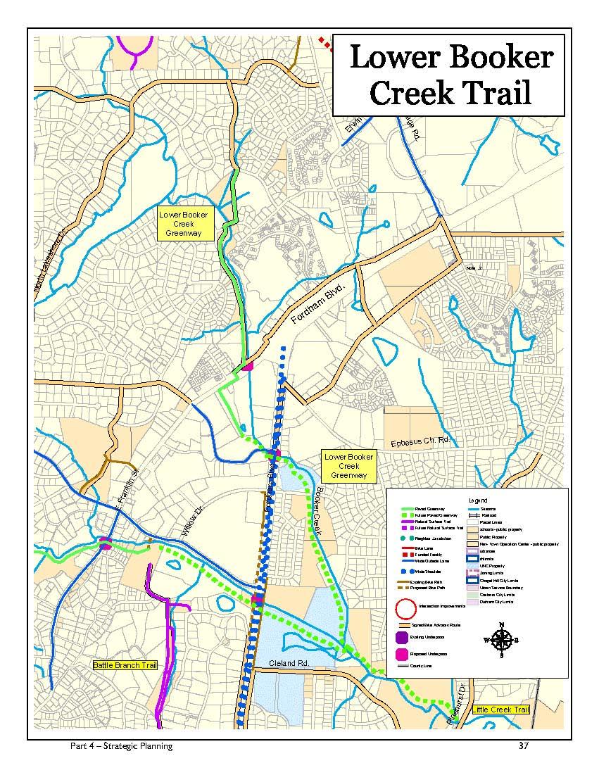
45
46 BOOKER CREEK: Greene Tract to Booker Creek Trail The west branch is a minor tributary which joins the northern branch of Booker Creek at a point north of Homestead Park and the proposed Horace Williams Trail. The creek resembles more of a ditch in its early stage and drains large areas of relatively flat land to the west of Martin Luther King Jr. Blvd.. Potential for Trail Development Trail development would be relatively easy along both sides of the tributary. Trails could be constructed to any class with few constraints and could potentially be extended westward across the rail line to the Greene Tract. The Greene Tract is a acre, currently undeveloped tract that was once jointly owned by the Town of Chapel Hill, the Town of Carrboro and Orange County. In 2002 the three governments agreed to dispose of the tract in the following manner: 60 acres deeded to Orange County 85.9 acres jointly owned by the Town of Chapel Hill, the Town of Carrboro and Orange County for open space with a conservation easement placed over the property 18.1 acres owned by the Town of Chapel Hill, the Town of Carrboro and Orange County for affordable housing Summary of Constraints for Potential Trail Development 1. A crossing of the rail line would be necessary. 2. The local governments would have to agree to a trail building program within the Greene Tract. Summary of Factors Favorable for Potential Trail Development 1. There are few topographical constraints. 2. Currently, there are few existing residential conflicts. 3. The proposed Horace Williams Trail corridor including all Town property and easements lies on the east side of the tracks. Recommendations 1. The Town should work with all Greene property partners to determine a trail program for the property including potential areas to cross the rail corridor. BOOKER CREEK: Martin Luther King Jr. Blvd. to Eastwood Lake Booker Creek crosses under Martin Luther King Jr. Blvd. and flows for a short distance through an area that is mostly wooded. The north shore of the stream corridor becomes highly developed as it parallels Dixie Drive. Booker Creek eventually flows into Lake Ellen, which is surrounded by single-family homes and steep slopes. Below the dam the creek enters a valley which is often steep with extensive areas of exposed rock. Homes are found throughout this section, some quite near the creek, while others are located on bluffs overlooking the stream. The stream passes under Piney Mountain Road. Eventually the creek flows into Eastwood Lake, near Curtis Road and Kensington Drive. Resource Protection The Town has protected some open space downstream of Lake Ellen and at the intersection of Kensington Drive and Curtis Road. Potential for Trail Development Trail development would be extremely difficult along this section of Booker Creek. Although cleared Orange Water and Sewer Authority (OWASA) sanitary sewer easements could provide a good surface for the trail along some 38 Part 4 Strategic Planning
47 sections of the creek, portions of the corridor are steep, rocky, and narrow. The greatest constraint to trail development is the absence of Town controlled rights-of-ways in a densely developed area. In many locations, trails would have to be constructed very close to established homes and in several places would have to cross over maintained lawns. Summary of Constraints for Potential Trail Development 1. Extensive land acquisition would be necessary for trail development. 2. Some bridges may be required. 3. Trail development may be difficult given proximity of existing homes. 4. Steep slopes predominate throughout the section. 5. Feasible access to the Orange Water and Sewer Authority (OWASA) sanitary sewer easement is not apparent in at least two locations. 6. Tree and rock outcroppings would be disturbed by trail construction of Class 5 or greater. 7. Trails in the vicinity of the two lakes would be difficult to locate. Summary of Factors Favorable for Potential Trail Development 1. An Orange Water and Sewer Authority (OWASA) sewer easement would allow for easy construction of trails in some areas. Recommendations 1. The Town should take advantage of any opportunities to acquire easements or land, for resource protection purposes, along both banks of Booker Creek. 2. The Town should not promote a trail in this area unless requested to do so by residents. The corridor should remain undeveloped to a Class 1 or 2 level. BOOKER CREEK: Eastwood Lake to Franklin Street and the Northeast Branch From the spillway of Eastwood Lake, Booker Creek crosses several private lots until it merges with the northeast branch, east of Eastwood Lake. From the juncture with the northeast branch, the creek flows almost due south through a broad vegetated, floodplain until it crosses under Franklin Street near the Eastgate Shopping Center. The northeast branch of the creek begins near Honeysuckle Road and flows south to meet the main branch just south of Booker Creek Road. The trail, which is called the Lower Booker Creek Trail, is complete. It is a 10 wide paved, Class 6 trail, approximately.85 miles long and includes a bridge crossing of Booker Creek that provides a connection between Daley Road and Tadley Drive. Resource Protection The Town has acquired a great deal of land along this section of the Booker Creek greenway, including a majority of the acreage along 5,000 ft. of stream corridor. In addition to fee-simple ownership of land, the Town has established a large recreation area and over 2,000 feet of pedestrian and non-motorized vehicle easements. The Resource Conservation District (RCD) ordinance assists in protecting the remaining portions of the greenway corridor not directly controlled by the Town. Potential for Additional Trail Development Trail development would be extremely difficult from Eastwood Lake to the juncture with the northeast branch due to the private property along the lake. Another issue relates to providing neighborhood access from the Oxford Hills neighborhood to the existing trail. Although the Town owns two potential connectors neighboring Part 4 Strategic Planning 39
48 property owners have expressed concern related to privacy issues if a connector trail is built. Trail safety and use would be greatly enhanced with the addition of an underpass of Franklin Street adjacent to the culvert that carries Booker Creek. Please see the list of NCDOT critical intersections on page 71. Recommendations 1. The Town should continue to work with neighbors to eventually provide direct access from the Oxford Hills neighborhood to the Lower Booker Creek Trail. 2. The Town should pursue the addition of an underpass of Franklin Street to assure a safer and more useful trail crossing of this major road. BOOKER CREEK: Franklin Street to Fordham Boulevard The landscape surrounding Booker Creek changes character once the stream passes under Franklin Street. The entire creek immediately passes beneath the parking lot and main building of Eastgate Shopping Center. From the outflow of the creek on the south side of the Eastgate Shopping Center, the creek resumes a more natural course, although the surroundings are predominantly urban. The creek flows near several commercial buildings and roads until it passes beneath Fordham Boulevard near Willow Drive. Resource Protection The entire corridor is in private ownership and is almost completely developed. Potential for Trail Development The Lower Booker Trail project included a pedestrian activated crossing signal of Franklin Street and the entrance to the Eastgate Shopping Center. Once on the south side of Franklin Street trail users can continue on a class 6 trail through the Staples Shopping Center until its southern tip. The Town has plans and funding to continue the trail to Fordham Boulevard. Construction is anticipated for early 2006, if necessary easements are recorded.. Recommendations 1. The Town should take advantage of any opportunities to acquire easements or land along both banks of Booker Creek. 2. Should the Eastgate Shopping Center property be redesigned or rebuilt, the Town should take advantage of the opportunity to assure an additional trail corridor. 3. Options for safe pedestrian and bicycle crossing of Fordham should be a high priority. The best solution would be an underpass of Fordham Boulevard and a redesigned Elliott Road that would eliminate the Elliott Road culvert. Meanwhile provision of a pedestrian refuge and pedestrian activated crossing signal would improve safety and increase use in this location. BOOKER CREEK: Fordham Boulevard to Little Creek Once past Fordham Boulevard, Booker Creek enters a floodplain that is very flat and poorly drained. The areas surrounding Booker Creek probably contain significant areas of wetlands, as defined by the Army Corps of Engineers. Booker Creek ends as it joins with Bolin Creek to form Little Creek. Resource Protection The Town owns 26 acres of land along this portion of the Booker Creek corridor. Potential for Trail Development Trail development in this area would be challenging although beneficial to the neighborhoods in the southeast portion of Town. A trail could be used to gain access to the 40 Part 4 Strategic Planning
49 shopping and commercial areas near Elliott and East Franklin Streets, and the Bolin Creek Trail. Summary of Constraints for Potential Trail Development 1. Some land acquisition would be necessary for trail development. 2. Engineering would be required to overcome problems associated with trail development in wet areas. 3. Extensive use of boardwalks may be required. 4. The University of North Carolina at Chapel Hill owns a 9.8-acre tract of low-lying land which straddles Booker Creek between Fordham Boulevard and Willow Drive. An agreement with the University would be needed to complete the trail corridor. Summary of Factors Favorable for Potential Trail Development 1. There are few topographical constraints to trail development. 2. The Town controls a significant tract of land along the creek. Recommendations 1. The Town should take advantage of any opportunities to acquire easements or land along both banks of Booker Creek. Tributaries of Booker Creek CEDAR FORK Cedar Fork drains much of the area north of Honeysuckle Road and south of Interstate 40. The creek flows generally southeast, over 1.1 miles, until it empties into Booker Creek near the intersection of Brookview Drive and Cedar Falls Court. The stream flows through an area which is heavily developed by both residential and commercial structures. Potential for Trail Development Trail development would be difficult along Cedar Fork due to the existing development encountered along the stream. A trail currently exists within Cedar Falls Park (see Connector Trails, page 68.) The park trail and this potion of Cedar Fork could provide a natural connector for persons wishing to travel from the proposed North Trail and Dry Creek Trail to the Booker Creek Trail. Although some travel on streets would be required to connect these trails, Cedar Falls Park greatly reduces the need to walk on Town streets. Recommendations 1. The Town should acquire easements and land along Cedar Fork. 2. The Cedar Fork corridor should remain as a Class 1 or 2 greenway. 2. Once the section has become a priority, the Town should pursue construction of a Class 6 trail. 3. The Town should negotiate with the University to gain access across UNC property. For the next section of greenway corridor downstream, see Little Creek, page 42. Part 4 Strategic Planning 41
50 Little Creek The confluence of Bolin Creek and Booker Creek occurs between the Rainbow Soccer fields and 52 acres of Town-owned open space. Beyond the confluence, Little Creek flows for over 1.1 miles within the Town limits, flowing eastward into the Town-owned tract, through the Chapel Hill Country Club property, through the site of the future 72-acre Meadowmont park and then out of the Town s jurisdiction to Jordan Lake. LITTLE CREEK: Confluence to Pinehurst Drive Resource Protection The Town owns a 52-acre tract of land, which includes approximately 2,000 feet of greenway corridor, and 72 acres along the creek in Meadowmont. Potential for Trail Development Most of the required land within this corridor segment is controlled by the Town. Summary of Constraints for Potential Trail Development 1. Extensive wetlands might exist along portions of the trail corridor. Summary of Factors Favorable for Potential Trail Development 1. There are few topographical constraints to trail development. 2. The Town controls a significant tract of land along the creek. Recommendations 1. Trails should be constructed as a Class 6 trail and integrate boardwalks through wet areas. LITTLE CREEK: Pinehurst Drive to Chapel Hill Jurisdictional Limits Resource Protection The Town now owns a 72-acre park site located downstream from the Chapel Hill Country Club property. The park includes soccer fields, a picnic area, trails, and a portion of land along the Little Creek corridor. Potential for Trail Development A major obstacle to the continuity of the Little Creek corridor for recreational and transportation purposes, is the existing Chapel Hill Country Club golf course. Trails from Rashkis School to Lancaster Drive and the eastern end of Meadowmont Drive have been completed. The trails could continue eastward following the edge of the Jordan Lake flood land to the Town limits near NC 54. Summary of Constraints for Potential Trail Development 1. Some land acquisition or easements would be necessary for trail development. 2. A continuous trail across the existing Chapel Hill Country Club golf course may not be feasible. 3. The North Carolina Division of Wildlife manages the Army Corps of Engineers land near NC 54. Cooperation from the Corps and North Carolina Division of Wildlife would be required to achieve limited clearing, required grading and paving of the trail. 4. Some portions of the trail would require acquisition of land to avoid wet areas or steep slope conditions within the existing easement. 42 Part 4 Strategic Planning
51 Summary of Factors Favorable for Potential Trail Development 1. The majority of the Little Creek Trail downstream of the 52-acre Town-owned parcel, would be constructed on land exhibiting somewhat variable slope conditions, but dry and stable soils. 2. The juncture of planned residential uses and development of the trail can be coordinated to minimize potential conflicts. Recommendations 1. Easements and land acquisition should be acquired as opportunities arise. 2. Once preceding greenway segments are completed, the Town should pursue the potential of a street and sidewalk connection to bypass the golf course property. Trail users could be routed on public sidewalks southward on Pinehurst Drive and connect with new roads within the Meadowmont development and eventually connect with the proposed Meadowmont Trail. This link could be marked as part of the Town s greenway system to assist trail users following the route. Trail users could also be routed to Lancaster Drive to the trailhead that will likely be in that location by the end of The Town should make all efforts to work with the Country Club and surrounding neighborhoods to make the connections possible. 4. The Town should pursue a connection with future Durham trail development as it occurs along Little Creek. 5. The Town should coordinate with the Durham Open Space and Trails program to determine the appropriate trail type that should be constructed from the Town limits to Meadowmont Drive. 6. Until such time as joint planning with Durham occurs, the trail should be constructed as a natural surface, Class 3 trail from the Town park to the intersection of the Class 6 Meadowmont Trail. Potential American Tobacco Trail Connection See Highway 54 Trail on page 59 for a recommended class 6 connection. The construction of a class 3 trail connector to the American Tobacco Trail is partially possible along Little Creek although conflicts with the Chapel Hill Country Club golf course would remain. The extent of poorly drained soils and wetland areas may also create significant environmental trade-offs. Recommendations 1. Natural surface trails could be built from Meadowmont to the Durham line. 2. The bicycle transportation component should be addressed in part by the provision of off-road bicycle paths along NC 54. See page 45. The Town now owns a 72-acre park site located downstream from the Chapel Hill Country Club property, which includes a portion of land along the Little Creek corridor. Part 4 Strategic Planning 43

52

53
54 The Morgan Creek Watershed Morgan Creek begins in central Orange County and flows southeast until it becomes a large stream. Near the Carrboro town limits, the creek enters University Lake, an important water source for southern Orange County. From its outflow at the base of the University Lake dam, Morgan Creek flows east through Carrboro s jurisdiction until it flows under Smith Level Road. Once the creek passes under Smith Level Road, it enters Chapel Hill s jurisdiction. Once inside Chapel Hill s town limits the creek flows over 4.5 miles and undergoes several dramatic transformations. From Smith Level Road to its outflow into Jordan Lake, the creek passes through three distinct sections. The watershed is the most isolated of the major streams in Chapel Hill. Natural connections from Morgan Creek to the Town s trails north of Fordham Boulevard are blocked by high ridges and major roads. A class 6 trail has been built along Fan Branch and a short section of Wilson Creek. MORGAN CREEK: Smith Level Road to Merritt Pasture As Morgan Creek enters the Chapel Hill Urban Services District on the east side of Smith Level Road, the stream flows through a broad flood plain, with its greatest relief being on the south bank. The greenway corridor contains an elementary school, a large apartment complex, a large single-family residential area, an extensive series of power line rights-of-way, and several undeveloped tracts of land. Resource Protection The Town has acquired several tracts of land along both banks of Morgan Creek including significant acreage south of Frank Porter Graham School in Although the environmental and aesthetic integrity of much of the property near Highway has been compromised by extensive power line construction, there remain significant tracts of relatively untouched land. Potential for Trail Development The Town is currently in the midst of a major study of the Morgan Creek corridor. The limits of the planning process extend from the western side of Smith Level Road to Merritt Pasture east of Highway The planning process is intended to identify trail location, bridge locations, and needed property/easement acquisitions. Once built, the Morgan Creek Trail would interconnect much of the area south of Fordham Boulevard. Citizens would be provided with safe access to Frank Porter Graham School and with trails proposed to be developed along Wilson Creek and Fan Branch. The partially constructed Fan Branch Trail would eventually lead to the new Southern Community Park at Dogwood Acres Drive, Scroggs School, and to the commercial and residential areas within Southern Village. Summary of Constraints for Potential Trail Development 1. An underpass at Culbreth Road, would be the safest, though most expensive method of crossing. 2. As many as 6 bridges may be required. 3. Access to the trail by persons living north of Fordham Boulevard may be difficult. 4. Land or easement acquisition would be necessary. 5. Construction of the Duke Power transmission lines has negatively impacted the aesthetics of the creek corridor. 6. Future widening of Highway might impact the trail corridor in ways not yet apparent. 46 Part 4 Strategic Planning

55
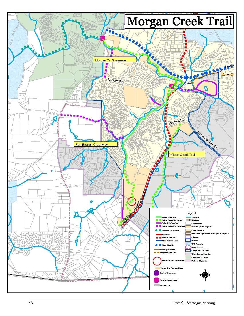
56
57 Summary of Factors Favorable for Potential Trail Development 1. Most of the land acquisition has already occurred. 2. There are few conflicts with established residential neighborhoods. Recommendations 1. The Town should complete the conceptual plan study as soon as possible. 2. The Town should acquire any easements identified in the study. 3. Once all the needed land has been acquired, a Class 6 trail should be constructed from Culbreth Road near the Hwy bridge over Morgan Creek to Smith Level Road and, if possible, to Frank Porter Graham Elementary School. 4. The alignment of the Class 6 trail should be located to align with the Fan Branch Trail. 5. The Town should build a trail underpass of Culbreth Road. MORGAN CREEK: Merritt Pasture to Ashe Place After Morgan Creek passes under the Highway bridge, it enters an area of Chapel Hill that has experienced a great deal of residential development. Specific tracts have also been identified as environmentally sensitive, and are listed in the 1988 Inventory of the Natural Areas and Wildlife Habitats of Orange County, North Carolina, a study prepared by the Triangle Land Conservancy. As the stream flows east it passes into a small valley with a high ridge along the south bank. Occasionally this ridge plunges directly into the creek, forming steep and rocky banks. Residential development on the south bank is generally located on the ridge, well above the creek. However, in several locations homes have been constructed quite near the stream. The north bank of the creek is generally lower and has more residential development near the stream bank. Little undeveloped land remains along this section of Morgan Creek. Resource Protection The 31-acre Merritt Pasture presents 1,500 feet of Town-owned property along this segment of the Morgan Creek corridor. The Town has acquired very little land beyond this section of Morgan Creek. The NC Botanical Garden Foundation has agreed to work with neighbors to acquire conservation easements to help protect this section of stream. Potential for Trail Development An informal trail exists along this section of Morgan Creek; however, it is important to note that most of the trail is in private ownership and is not available for public use. The potential for trail development for public use is limited along this section of Morgan Creek for several reasons: existing residential development has split ownership of the corridor into many small parcels, the corridor is environmentally sensitive, and the banks are typically steep and rocky. The short section of the corridor, from Highway to the foot of the steep slopes beneath Old Bridge Lane and Mallard Road, could potentially be developed for trail use. Summary of Constraints for Potential Trail Development 1. Many bridges could be required. 2. Trail construction would be very difficult due to the sensitive nature of the vegetation and soils. 3. Much land acquisition would be necessary. 4. Steep slopes predominate in this portion of the corridor. Part 4 Strategic Planning 49
58 Recommendations 1. The Town should work to accommodate public access to the Merritt Pasture from the west. 2. No improvements are recommended within the pasture. Trail construction should terminate at the edge of the pasture. 3. The Town should work with the NC Botanical Garden and the residents along this section of Morgan Creek to ensure that the sensitive environment of the creek corridor is preserved. Assistance should be given when negotiating with applicants of future developments as well as with current landowners. 4. This greenway segment should be preserved as an unimproved Class 2 corridor. MORGAN CREEK: Ashe Place to Jordan Lake Residential development exists along the north bank of Morgan Creek downstream of Ashe Place and Arboretum Drive. Beyond Bartram Drive the creek is totally within University property. The creek travels through a broad, wooded, flood plain with little evidence of human activity, except for an Orange Water and Sewer Authority (OWASA) sewer line that parallels the creek. Resource Protection The land along both banks of Morgan Creek is owned by the University. Potential for Trail Development An informal Class 2 trail currently exists along the creek, particularly on the Orange Water and Sewer Authority (OWASA) sewer easement, between Ashe Place and Finley Golf Course. Summary of Constraints for Potential Trail Development 1. Currently the University wishes to preserve the area for education and research. 2. Access is controlled through the NC Botanical Garden. Summary of Factors Favorable for Potential Trail Development 1. Should the University increase land available for trail development, most of the necessary land acquisition would already be in place. 2. The existing OWASA sewer easement would provide a good foundation for trail construction. Recommendations: 1. The Town should continue to collaborate with the University for open space preservation in this area. 2. This greenway segment should be preserved as an unimproved Class 2 corridor. Eventually the creek flows past the OWASA Wastewater Treatment Plant. Shortly after passing the treatment plant, the creek flows into the Finley Golf Course property toward the Town limits. Beyond the Town limits the creek flows through lands controlled by the U.S. Army Corps of Engineers until it empties into Jordan Lake. 50 Part 4 Strategic Planning
59 Tributaries of Morgan Creek WILSON CREEK This creek begins in northern Chatham County and flows north until its confluence with Morgan Creek just west of the Highway bridge. It flows over 2.8 miles within the Town limits, through mostly forested land. Resource Protection The Town controls an insignificant portion of the Wilson Creek corridor except that portions fall under the protection of the RCD ordinance. Potential for Trail Development Sections of the creek would be suitable for trail development. Summary of Constraints for Potential Trail Development 1. The portion of the creek east of Hwy , is low and prone to flooding. 2. Portions of the corridor contain steep slopes. Summary of Factors Favorable for Potential Trail Development 1. Much of the corridor is undeveloped. Recommendations 1. If the area is developed at a fairly low density a Class 3 trail is recommended from the vicinity of the southern fire station southward to Wave Road. 2. If development density is increased portions of the proposed trail could be increased to as high as Class 6. FAN BRANCH Fan Branch is a small stream with two major forks, totaling nearly 1.9 miles in length. One fork begins near Smith Level Road and the other near Dogwood Acres Drive. The forks merge south of Culbreth Road and flow north until they merge with Wilson Creek. Resource Protection The majority of the Fan Branch watershed lies within the Southern Village community. This community was developed to a relatively high density; however the stream corridor was preserved from Culbreth Road to the Southern Community Park. Potential for Trail Development About 1 mile of the Fan Branch greenway has been completed as a Class 6 trail (see Figure 10). The Town is currently planning an extension of the existing paved trail to the southern end of the planned Southern Community Park MEETING OF THE WATERS CREEK This creek flows almost entirely on University lands for a distance of over 1.1 miles. It begins in a ravine that parallels Manning Drive, and then passes under Fordham Boulevard. Once on the south side of the bypass, the creek passes through the NC Botanical Gardens until it empties into Morgan Creek near the Wastewater Treatment Plant. Resource Protection The land along Meeting of the Waters Creek is owned by the University of North Carolina at Chapel Hill and lies almost entirely within areas currently protected for research purposes. See Figure 9. Potential for Trail Development Class 3 trails that are open to the public currently exist within the NC Botanical Garden. NC Botanical Garden trails are limited to pedestrian traffic only. Also, Class 2 trails exist on the north side of Meeting of the Waters Creek, extending northward through the Coker Pinetum. See Figure 9. Summary of Constraints for Potential Trail Development 1. Currently the University wishes to preserve this area for education and research. Part 4 Strategic Planning 51
60 Summary of Factors Favorable for Potential Trail Development 1. Should the University increase land available for trail development, most of the necessary land acquisition would already be in place. Recommendations 1. The Town should continue to collaborate with the University for open space preservation in this area. Summary of Factors Favorable for Potential Trail Development 1. Should the University become interested in trail development, most of the necessary land acquisition would already be in place. Recommendations 1. The Town should maintain ongoing communication with the University to facilitate any cooperative greenway planning or trail development in the future. CHAPEL CREEK Chapel Creek, flows some 1.1 miles from north of St. Thomas More School until it passes under Fordham Boulevard. Once on the south side of the bypass, the creek passes through University of North Carolina property until it empties into Morgan Creek near the Wastewater Treatment Plant. Resource Protection The land along Chapel Creek is owned by the University of North Carolina at Chapel Hill and lies almost entirely within areas currently protected for research purposes or in sites already developed. See Figure 9. Potential for Trail Development The Carolina Adventure Outdoor Education Center is located in this area, providing physical education and campus recreation. Summary of Constraints for Potential Trail Development 1. Currently the University wishes to preserve this area for educational and campus recreation. Specific tracts along Morgan Creek have been identified as environmentally sensitive, and are listed in the 1988 Inventory of the Natural Areas and Wildlife Habitats of Orange County, North Carolina a study prepared by the Triangle Land Conservancy. 52 Part 4 Strategic Planning
61 Dry Creek Dry Creek is a major tributary of New Hope Creek. The creek has several branches that drain much of the area north of Weaver Dairy Road and south of Interstate 40. The creek flows past Erwin Road then under Interstate 40 where it quickly enters Durham County. The name Dry Creek is misleading since the majority of the creek corridor tends to be very wet and swampy even during dry periods. The potential trail, over two and one half miles in length, could serve as a wonderful complement to the proposed North Trail. Portions of the Dry Creek corridor have been identified as environmentally sensitive, and are listed in the Inventory of the Natural Areas and Wildlife Habitats of Orange County, North Carolina, a study prepared in 1988 by the Triangle Land Conservancy. The Conceptual Plan for the Dry Creek Greenway was completed by the Dry Creek Greenway Advisory Committee and adopted by Council in June Because of land acquisitions that occurred after the adoption of the Plan, the Master Plan contains significant revisions of the reports recommendations for trail locations. DRY CREEK: East Chapel Hill High School to Silver Creek Trail The initial segment of the Dry Creek Greenway begins at East Chapel Hill High School and continues 2,300 feet eastward along the southern branch of Dry Creek. This portion of the greenway is essentially of a woodland character, predominantly hardwoods, and offers a variety of rock outcroppings, waterfalls and picturesque forest experiences. Resource Protection The Town has acquired the necessary land to implement this segment of the Dry Creek Greenway. Potential for Trail Development The trail has been completed from San Juan Road to Silver Creek Trail. In addition, a trail location has been identified and roughed in by volunteers from San Juan Trail to the High School property. Erosion control work on the school site completed in The trail is expected to be opened and signed in early Recommendations 1. The Town should coordinate with school officials to determine the location of the trailhead on East Chapel Hill High School property. 2. The Town should complete a narrow natural surface footpath wide enough for travel by one person similar in construction to the Town s existing Battle Branch Trail. 3. Trail signage should be installed as soon as the trail is completed. DRY CREEK: Silver Creek Trail to Perry Creek Drive The second segment of the Dry Creek Greenway corridor changes in physical and visual character. The quality of tree cover is diminished from the initial trail segment, being a mix of fewer hardwoods, modest small pines and other new growth species. The initial 100 feet of the trail corridor is relatively steep due to the existing fill slope at Silver Creek Trail. The remaining portions of this segment are relatively low-lying, flat, and subject to flooding and seasonal ponding. The wet soils here sustain the very thick stand of young pines. This section of the trail has been completed. Part 4 Strategic Planning 53

62

63
64 Recommendations 1. Signs should be erected as soon as the upstream trail segment is completed. DRY CREEK: Perry Creek Drive to Erwin Road This 2,100-foot portion of greenway would be primarily located on a 32-acre parcel of Town-owned open space property acquired in The land is located north of Dry Creek and south of I-40. Resource Protection The Town has acquired the necessary land and easements to implement this segment of the Dry Creek Greenway. Potential for Trail Development The initial trail would be located in and adjacent to an OWASA sewer easement to a crossing of Dry Creek. The trail would then be located on the well-drained Town open space property to Erwin Road. Summary of Constraints for Potential Trail Development 1. The initial 500 ft from Perry Creek Road to Dry Creek would require some landscaping to preserve privacy for nearby homes. 2. Poorly drained soils will dictate location of paved sections of trail in some locations. Summary of Factors Favorable for Potential Trail Development 1. The Town owns all the land required for trail development. 2. Existing utility easements provide land already cleared for trail use. Recommendations 1. The Town should construct a Class 6 trail, from the east side of Perry Creek Drive for some 2,100 feet to Erwin Road. 2. A natural surface trail connection running northeastward along a minor tributary of Dry Creek to the proposed North Trail is possible and should be pursued. 3. A small parking area (8-10 cars) should be built near Erwin Road. 4. A sidewalk should be built to the north to Interstate 40. This would allow a connection between the Dry Creek Trail and the Durham greenways system. DRY CREEK: Erwin Road to Providence Road The Dry Creek basin east of Erwin Road is one of the most extensive wetland areas in Orange County. As described by the Triangle Land Conservancy, it is one of the most significant areas of biological diversity in the southern part of the county. The primary goal for this portion of Dry Creek should be to remain as a nature preserve, supporting activities such as bird and wildlife observation. Resource Protection 1. The Town has acquired significant amounts of property along this section of Dry Creek. Potential for Trail Development The greenway corridor extends 3,300 feet through this segment of Dry Creek. The Town has acquired most of the property adjacent to the creek including a large amount of property between the creek and I-40 that would allow trail development. The major obstacles would be a required crossing of Dry Creek and finding suitable exits onto public streets within Eastowne. A major safety issue relates to a trail crossing of Erwin Road. This plan recommends the addition of a pedestrian crossing and pedestrian refuge. Please see the list of NCDOT critical intersections on page Part 4 Strategic Planning
65 Summary of Constraints for Potential Trail Development 1. Wet soils and wetlands dominate portions of this segment. 2. Erwin Road in its current state would present safety concerns for persons crossing the road. Improvements such as a pedestrian crossing and pedestrian refuge would be needed. 3. Exits onto streets within Eastowne have not yet been identified. Summary of Factors Favorable for Potential Trail Development 1. Tree cover is uniform, relatively mature, with an open understory presenting few constraints to trail alignment. 2. The Town owns most of the potential trail corridor including most of the higher and drier ground. Recommendations 1. The corridor should be developed as a Class 6 greenway with boardwalk sections as needed. 2. The trail should be sensitively placed to avoid fragmenting the wildlife corridor. 3. The Town should continue to explore options for trail connections to the New Hope Corridor and Durham greenway system. DRY CREEK: Erwin Road to Durham County Line This segment of the Dry Creek Greenway would be a joint project with the Durham Open Space and Trails Commission. The portion of the corridor within Chapel Hill s jurisdiction would be approximately 4,600 feet in length. Depending upon location, Durham would extend the trail an additional 1,000 to 2,000 feet to Mt. Moriah Church Road. Durham s long-range plans show a trail extending downstream along Dry Creek to New Hope Creek. The trail surfacing is yet to be determined. Resource Protection The Town now owns all but one property needed to develop a trail along this section of Dry Creek. Potential for Trail Development The corridor is generally gently sloping with well-drained soils. A mixed hardwood tree cover exists with trees of varying age. Summary of Constraints for Potential Trail Development 1. One parcel is still in private ownership. 2. Some pockets of potential wetlands exist. 3. The existing Erwin Road Bridge over I-40 is not suitable for pedestrian traffic. Summary of Factors Favorable for Potential Trail Development 1. Few topographic, vegetative or soil restrictions are present. Recommendations 1. The Town should continue to pursue a joint development effort with Durham in constructing a coordinated trail and open space corridor. 2. A bike lane and sidewalk could continue to north of I-40 along Erwin Road. 3. To the north of I-40 and Erwin Road, a greenway connection would turn east and follow the north side of the Interstate northeast of Dry Creek. The trail would then continue to New Hope Commons shopping center and to New Hope Creek. 4. The Town should work with NCDOT to assure that any expansion and/or replacement of the Erwin Road Bridge over I-40 include sidewalks and bicycle lanes. Part 4 Strategic Planning 57
66 MAN-MADE CORRIDORS This Plan has assessed the potential of six Man-Made Corridors for inclusion in the Chapel Hill greenway system: Public Service of North Carolina gas transmission rights-of-way, Duke Power cross-country transmission rights-of-way, the Norfolk-Southern Railroad, the Interstate 40 corridor, portions of NC 54, and the Meadowmont development. Utility Rights-of-Way Gas Transmission Rights- of-way It is the current policy of Public Service of North Carolina, Inc. to prohibit the shared use of its gas transmission line rights-of-way for recreational or trail purposes. At this time, the use of gas transmission corridors is not a viable option for Town greenways. Power Transmission Rights- of-way Recently, Duke Power has more strictly enforced its prohibition of allowing facilities such as roads and trails to be built within the easements. They generally allow uses that cross easements but not ones that follow the course of an easement. Any use of these easements would require permission from the utility. The Town should explore the feasibility of utilizing these transmission corridors to augment its planned greenways to the greatest extent allowed by Duke Power. Proposed Man-Made Corridors There are four Man-Made Corridors currently proposed or built within the Chapel Hill greenways system - the Horace Williams Trail, North Trail, portions of NC 54, and Meadowmont Trail. These trail corridors have the potential to provide significant trail opportunities as well as potential linkage with planned greenways in neighboring municipalities and regional trails. HIGHWAY 54 Bicycle paths were added to both sides of NC 54 in conjunction with the development of Meadowmont. The paths could be continued both to the east and to the west to increase bicycle and pedestrian use of this important corridor. Westward extensions could serve the UNC campus. Eastward extensions to the Town Limits could provide eventual links to the New Hope Corridor and the American Tobacco Trail. Potential for Trail Development The existing paths could be easily extended eastward to the extent of the Town s jurisdiction and the beginning of Durham s jurisdiction, especially if extensions are completed as part of new development or re-development of property. The paths could also be extended to the west. The trail could be extended relatively easily on the south side of NC 54 to Glenwood Square. The north side of the road presents greater problems due to pre-existing development. Summary of Constraints for Potential Trail Development 1. Pre-existing development would make extensions difficult in some areas west of Meadowmont. 2. The Highway /NC 54 intersection is busy with numerous turning movements by vehicles, often at high speeds. This situation lessens the viability of the corridor as a bicycle/pedestrian corridor to the UNC campus and the downtown area. Summary of Factors Favorable for Potential Trail Development 1. Eastward expansion to Durham s jurisdiction would be relatively easy to accomplish. Recommendations 1. Require extension of the existing paths with each new development or re-development along NC Part 4 Strategic Planning
67 2. When appropriate, the Town and NCDOT should perform a study of the NC 54 corridor to determine if changes can be made to increase safety and bicycle/pedestrian access to the UNC campus and the downtown. See page 76. NORTH TRAIL (INTERSTATE TRAIL) The presence of Interstate 40 in the northern portion of Chapel Hill offers a unique opportunity to preserve an approximately five miles long buffer along the Interstate highway and to construct sections of bicycle and pedestrian-only trails adjacent to the highway right-of way. The greenway corridor is almost entirely free of development at this time, and only one subdivision, Chandler s Green, has constructed dwelling units within the corridor. A greenway corridor could be preserved along the entire length of I-40, from the Town limits to the intersection of I-40 and Highway It is possible to build a trail from the site of the proposed Town Operations Center in the northwest quadrant of Town the to the junction of Interstate 40 and Erwin Road. The greenway corridor could provide additional buffering between the highway and present and future residents and businesses. This corridor could also preserve the wooded appearance of Interstate 40 and benefit travelers using the highway. The corridor is identified in this report as being a 100-foot or wider strip of land adjacent to the south side of the I-40 right-of-way. Development of a trail along most of the Interstate would be relatively easy. Much of the land has reasonable topography with few steep or wet areas to contend with. The trail would not be suited for nature study due to the noise level next to the highway. However, portions would be ideally located for a paved trail to provide bicyclists and pedestrians a safe route to travel across the northern portion of Town. The trail would cross only three major roads: Erwin Road, Sunrise Road, and NC 86 (Martin Luther King Jr. Blvd.). In addition, the trail could connect to several other trails including the trail planned by Durham County as recommended by the New Hope Corridor Master Plan. This trail is discussed in the Dry Creek section, page 53. The Durham trail would also be a paved trail accessible by bicycles. NORTH TRAIL: Millhouse Road (Town Operations Center) to NC 86 This section begins at Millhouse Road and the Town Operation Center. The corridor would follow the Interstate east to NC 86. Resource Protection The Town currently controls the site of the Town Operation Center. Other properties would be required. Potential for Trail Development This section of the trail corridor would present no unusual difficulties to trail development. An opportunity exists to tie the North Trail into the Horace Williams Trail at the Town Operations Center. The primary difficulty would involve crossing NC 86. Summary of Constraints for Potential Trail Development 1. Land acquisition east of the Town Operations Center would be required. 2. It may be difficult for trail users to safely cross NC 86. Summary of Factors Favorable for Potential Trail Development 1. There are few physical constraints to trail construction. Recommendations 1. Easements and land should be acquired as opportunities arise. Part 4 Strategic Planning 59

68

69
70 2. A study should be undertaken to determine the best method for bicyclists and pedestrians to safely cross NC 86. It appears that a crossing utilizing a pedestrian refuge and pedestrian activated signals may be the most likely method of crossing this wide and busy road. 3. Once the land rights are acquired, the Town should build a Class 6 trail. NORTH TRAIL: NC 86 to Sunrise Road This section would stretch from NC 86 at its junction with I-40 to Sunrise Road. There are no current or planned developments within the 100 ft. greenway corridor. Segments of the trail, or spur trails, could be located south of the 100 ft buffer within easements provided by developers. This section of greenway is important as a potential transportation route for pedestrians and bicyclists. The proposed trail could provide safe transport to proposed shopping and business facilities along NC 86, Cedar Falls Park on Weaver Dairy Road, and residential developments that border the corridor. The potential exists for allowing numerous multi-family condominiums and apartment complexes to build private trails that would connect directly into the trail. The Circle-the-Triangle Trail is proposed to connect to Chapel Hill via Sunrise Road, thus providing the North Trail a direct tie-in to a larger regional trail system. Resource Protection Future trails have been provided for at only two locations at this time. The first lies on property owned by the Carol Woods Retirement Community and begins at Sunrise Road. It stretches approximately 2,500 feet to the west along the I-40 corridor. The second is located on the Vilcom Development property. The Town s greatest opportunity for additional land and easement acquisition will come as the corridor is developed. It may be possible that the North Carolina Department of Transportation (NCDOT) would allow the trail to occupy the Interstate right-of-way in areas where land could not be obtained. Potential for Trail Development This section of the trail corridor would present no unusual trail building difficulties. Summary of Constraints for Potential Trail Development 1. Some additional land acquisition would be required. 2. It would be difficult to join the segments of the North Trail that would lie east and west of NC The trail intersection with Sunrise Road is at a very steep fill slope where Sunrise Road crosses over the Interstate. ADA compliance may be difficult. Summary of Factors Favorable for Potential Trail Development 1. Few physical limitations to trail construction exist within the corridor. Recommendations 1. Easements and land should be acquired as opportunities arise. 2. Explore potential acquisition of land or easements beyond the 100 ft. corridor on either side of Sunrise Road in order to negotiate the fill slope. 3. Once the land rights are acquired, the Town should build a Class 6 trail. NORTH TRAIL: Sunrise Road to Erwin Road The proposed corridor and trail would continue in much the same fashion as those sections further west, except that the trail would be built to a Class 3 standard. From Sunrise Road, the trail would continue over easy ground to Erwin Road. 62 Part 4 Strategic Planning
71 The section has few topographic problems; however one major development has already been built within the 100 foot greenway corridor. The trail would allow current and future residents and businesses the opportunity to access Cedar Falls Park and the proposed regional, Circle-the-Triangle Trail. Resource Protection The Town currently controls only the eastern end of the corridor. The Town s greatest opportunity for addition land and easement acquisition will come as the corridor is developed. It may be possible that North Carolina Department of Transportation (NCDOT) would allow the trail to occupy the Interstate right-of-way in areas where land could not be obtained. Potential for Trail Development No unusual trail-building difficulties for trails up to Class 3, exist within the 100 ft. corridor, although this segment is characterized by a long, rather uniform slope. The Chandler s Green subdivision has built units within the 100 ft. corridor. In order to bypass Chandler s Green, it may be necessary to build the trail within the NCDOT right-of-way. The trail could connect into several other trails including a proposed trail along Dry Creek, Durham s proposed trail along Dry Creek on the north side of Interstate 40, the Circle-the-Triangle Trail, and the Horace Williams Trail. Summary of Constraints for Potential Trail Development 1. Over 5,000 feet of land acquisition would be required. 2. It may be difficult to secure a public access along the section controlled by Chandler s Green. 3. The long sustained slope may make ADA compliance difficult. 4. The trail intersection with Sunrise Road is at a very steep fill slope where Sunrise Road crosses over the Interstate. ADA compliance at this crossing may be difficult. Summary of Factors Favorable for Potential Trail Development 1. There are few physical constraints to trail construction if the proposed trail is constructed at a Class 3 level. Recommendations 1. Easements and land should be acquired as opportunities arise. 2. The Town should work with North Carolina Department of Transportation (NCDOT) to acquire rights to develop within the Interstate right-of-way. 3. Explore potential acquisition of land or easements beyond the 100 ft. corridor on either side of Sunrise Road in order to negotiate fill slope. 4. Once the land rights are acquired, the Town should build a Class 3 trail. NORTH TRAIL: Erwin Road to Highway This area is described as part of the Dry Creek Trail. See page 53. MEADOWMONT TRAIL The Meadowmont Trail alignment does not follow a specific natural feature of the land, but was planned as a man-made corridor. The alignment of the corridor is shaped by the urban pattern of roads and lots created within the Meadowmont subdivision. It provides an important transportation and recreational link within Chapel Hill s largest mixed-use business and residential development. The Meadowmont Trail was constructed by the developer of the project. Part 4 Strategic Planning 63
72 Resource Protection The Chapel Hill Town Council approved a greenway corridor as part of the master land use plan for Meadowmont. In addition, the developer dedicated a 69-acre park that is primarily stream bottom and open space with some natural surface trails and a 22 acre school site that is home to the Rashkis Elementary School and two athletic fields operated by the Town. The Town-owned park allows for the protection of extensive wetlands and steep slopes. Potential for Trail Development The trail has been completed. It extends from the Town park site near Little Creek, through the Rashkis school site, southward through the nearly 425-acre planned community and crosses NC 54 to access the remainder of the development. The trail crossing at NC 54 is accomplished via a tunnel. Connections to the Little Creek Trail were also provided. The developer also built bicycle paths along NC 54. These could eventually be part of a connection with future Durham trails, including possible links to the New Hope Corridor and the American Tobacco Trail as well as a segment of an eventual bicycle connection to UNC campus and the Chapel Hill downtown. Recommendations 1. As opportunities arise the Town should pursue extensions of the bicycle paths paralleling both sides of NC 54. These extensions should be encouraged to the east toward the American Tobacco Trail and to the west toward UNC campus. HORACE WILLIAMS TRAIL A spur of the Norfolk Southern Railroad leaves the main rail line near Hillsborough and trends southeast to Chapel Hill. The line serves the needs of the University of North Carolina co-generation plant and extends over 4.1 miles along this potential greenway. HORACE WILLIAMS TRAIL: Estes Drive Extension to Homestead Road This section of the proposed trail would start at the end of Chapel Hill s planned Bolin Creek Trail and the beginning of Carrboro s proposed Bolin Creek Trail. The segment would provide direct access to several neighborhoods and the University s proposed Carolina North Campus. Side trails could serve Seawell Elementary School, Smith Middle School, and Chapel Hill High School. It would end at Homestead Road. Resource Protection The University currently controls most of the land outside of the railroad right-of-way, and may develop the majority of the 1,013-acre Horace Williams Tract at some future date. Over 1.25 miles of the proposed Horace Williams Trail is within the Horace Williams Tract. See Figure 16. The legal status of the railroad right-of-way should be watched carefully. If the Norfolk Southern Railroad ever moves to abandon the spur, the Town should be prepared to move quickly to have the easement banked for future rail use. Banked rail easements can be used for trail purposes until such time as they are required for rail purposes. Potential for Trail Development The physical limitations of trail development are few, but the legal and ownership problems are many. The trail would most likely be developed on the east side of the tracks either on the railroad right-of-way or on land that is owned predominantly by the University. At one or more points, it would cross the tracks to gain access to Seawell Elementary, Smith Middle, and Chapel Hill High schools. Summary of Constraints for Potential Trail Development 1. Over 7,000 feet of land or easement acquisition would be required. Most of the required land is owned by the University. 2. It would likely be necessary to negotiate access with the Norfolk Southern Railroad. 64 Part 4 Strategic Planning
73 Crossings of the tracks might require expensive safety precautions. 3. The best location for an exit onto Homestead Road is uncertain at this time. Summary of Factors Favorable for Potential Trail Development 1. Except for the area immediately adjacent to Estes Drive Extension and the Ironwoods Subdivision, the grade is less than 5%. Recommendations 1. The Town should work with the University to ensure that the University builds its segment of the Horace Williams Trail as part of the construction of the Carolina North campus. 2. In the event that the Norfolk Southern Railroad attempts to abandon the railroad spur, the Town should work to see that it is banked and used for trail purposes until a need for a rail use arises in the future. 3. The Town should be flexible in its approach to locating the best point for accessing Homestead Road. All possible locations should be preserved as properties are developed. One likely location could be through the University s frontage on Homestead Road. Another location could be through lots east of the rail corridor. A third possibility would be via a crossing of the rail line and an extension of the trail trough Town property to Homestead Road. 4. The project should include crosswalks and a pedestrian refuge to allow safe crossings of Homestead Road. HORACE WILLIAMS TRAIL: Chapel Hill High School to Eubanks Road The trail would continue from Homestead Road past a Town owned recreation/open space area, a proposed connector trail to the Upper Booker Creek Trail, the Greene Tract, and several neighborhoods to Eubanks Road. Resource Protection The Town controls almost all of the land along the tracks. Only one parcel is currently missing. The Town can likely preserve a trail corridor on that tract when the property is developed in the future. Potential for Trail Development The physical limitations of trail development in this section are few. Summary of Constraints for Potential Trail Development 1. One parcel of land is in private ownership. 2. It would be necessary to negotiate access with the Norfolk Southern Railroad. Crossings of the tracks to access the Greene Tract might require expensive safety precautions. Summary of Factors Favorable for Potential Trail Development 1. The land has little topographical relief. 2. Most of the corridor is in Town ownership. Recommendations 1. The Town should work with the one remaining owner or developer to acquire the last required easement. 2. In the event that the Norfolk Southern Railroad attempts to abandon the railroad spur, the Town should work to see that it is banked and used for trail purposes until a need for a rail use arises in the future. HORACE WILLIAMS TRAIL: Eubanks Road to Millhouse Road The trail would continue from Eubanks Road through the Town s northern park and ride lot to the Town Operations Center. The trail would terminate at Millhouse Road just south of I-40. Part 4 Strategic Planning 65

74

75
76 Resource Protection The Town controls almost all of the land in this section. Only one parcel is currently missing. The Town can likely preserve a trail corridor on that tract when the property is developed in the future. The Town should be prepared to act swiftly to preserve the rail corridor in the event that the railroad should abandon the line. Potential for Trail Development The physical limitations of trail development in this section are few. An important connection could be made from the Horace Williams Trail to the North Trail in the vicinity of Old Field Creek. Summary of Constraints for Potential Trail Development 1. One parcel of land is in private ownership. 2. It would be necessary to build a portion of the trail on the existing park and ride lot property. 3. It would be necessary to negotiate a crossing access with the Norfolk Southern Railroad to allow trail access to Millhouse Road. Summary of Factors Favorable for Potential Trail Development 1. The land has little topographical relief. 2. Most of the corridor is in Town ownership. Recommendations 1. The Town should work with the one remaining owner or developer to acquire the last required easement. 2. The Town should work with the Norfolk Southern Railroad to acquire rights to cross the railroad right-of-way at Millhouse Road. 3. In the event that the Norfolk Southern Railroad attempts to abandon the railroad spur, the Town should work to see that it is banked and used for trail purposes until a need for a rail use arises in the future. CONNECTOR TRAILS Connector Trails are important components to the Chapel Hill greenway system providing continuity to open space corridors and increasing overall accessibility to Town s trails. Connector Trails may be major trails or minor neighborhood connectors. They may help link the greenway network with other Town recreation areas, public facilities and residential areas. As greenway trails along the primary stream corridors become developed and evolve into major recreational amenities, it will become increasingly important to ensure pedestrian access to neighboring residential areas. Connector trails along minor tributaries, creeks and other linear features may provide such a means. Effective connecting routes may also be made by utilizing abandoned road rights of-way, sidewalks, bridges, pedestrian tunnels or designated bicycle routes to complement the greenway trail system. Efforts to preserve, acquire and develop these important connectors should be given high priority. Future connector trails leading to the major greenway corridors or other Town facilities should be reviewed on the following criteria: The desire of neighborhoods to be connected. The existence of land or sidewalk facilities available for connection. As part of the Town s subdivision approval process, all Connector Trail corridors should be required to be on Town-owned property or be controlled by a homeowners association, rather than on easements crossing private residential lots. Recent history has shown that many easement situations have become unworkable over time and inaccessible to the public. 68 Part 4 Strategic Planning
77 PARK TRAILS Previous greenway related documents did not deal directly with the importance or existence of trails within parks. Park trails provide important resources for neighborhood connectivity and recreation. Following is a list of current and planned trails within parks: CEDAR FALLS PARK Completed, Class 3 natural surface trails located within the 51-acre Cedar Falls Park. The main trail totals approximately 1.2 miles and provides important neighborhood connections to the park s recreational facilities as well as passive recreation opportunities. The main loop trail has some steep slopes and rocky areas and a boardwalk section over a creek tributary. It merges with the park s internal network of unpaved paths and paved accessways. One of these paths is the.6 mile long Jo Peeler Nature Trail. The nature trail was dedicated in 1980 and is jointly maintained by the Town and the Lake Forest Garden Club. Trail spurs to the main Cedar Falls Trail loop connect the Lake Forest neighborhood at Lakeshore Lane and Cedar Falls neighborhood at Roundtree Road, Cedar Fork Trail and Village Lane. The trail and park offer an open space link northward to the campus of East Chapel Hill High School. Recommendations 1. Cedar Falls is criss-crossed with numerous informal, unmarked trails. The large number of these trails coupled with the generally poor soils has produced erosion in several areas and an unattractive look. The Town should close redundant trails and sign those that remain. 2. Erosion and drainage problems should be addressed. JONES PARK Completed. A short Class 3 natural surface trail links the active recreation area of the park to the rear of the adjacent Community Church and Purefoy Road. Recommendations 1. The trail should be re-routed so that it exits onto Purefoy Road at a location that is more acceptable to the church. 2. Problems caused by repeated storms, erosion and poor drainage should be addressed. PRITCHARD PARK Completed. A one mile long Class 3 natural surface trail circles the Library. Volunteers are used on a regular basis to upgrade sections of the trail. The long range plan envisions the trail system to be part of a passive park. The plan also envisions a significant public art component to be included throughout the park including the trail system. Recommendations 1. Continue upgrading the trail as volunteers are available. 2. Complete the trail system and install art as soon as possible. This work would likely be tied to decisions related to expansion of the Chapel Hill Library and the adjacent Siena Hotel. Part 4 Strategic Planning 69
78 SOUTHERN COMMUNITY PARK Completed. Currently a 1.5 mile long Class 3 natural surface loop trail circles the property. When the park is developed some of the old trail system will likely be replaced with a paved greenway trail that will allow park users to access the various park amenities. Recommendations 1. Extend the existing Fan Branch Trail to at least Dogwood Acres Drive as part of Phase I of the park development. 2. Improve the remaining Class 3 trails to eliminate erosion and drainage problems. 3. Add Class 3 trails as need dictates after completion of Phase One of the park. CURRENT CAPITAL RENOVATION NEEDS BOLIN CREEK TRAIL The trail suffers from damage related to several storms. Although not severe in any one place the repair of all erosion areas would constitute a capital renovation project if dealt with in one effort. CEDAR FALLS PARK TRAILS The park requires a complete trail renovation effort including a variety of solutions depending on location that include: relocation, closure, and renovation. After work is complete proper signage would make it easier to walk the trails and manage the property. TANYARD BRANCH TRAIL This trail contains several areas impacted by excessive erosion that could be controlled with proper drainage. The damage is severe in places and has resulted in the loss or near loss of steps. The following existing trails have large enough maintenance needs that they exceed the ability of the Town s Public Works Department to address the issues as part of routine maintenance. Rather the costs would be large enough to fall within the realm of capital expenditures. Most of these trails are natural surface, which tend to have greater maintenance needs than paved trails. BATTLE BRANCH TRAIL Most of the bridges and boardwalk sections on this trail are nearing the limit of their useful life span. Park trails provide important resources for neighborhood connectivity and recreation. 70 Part 4 Strategic Planning
79 Critical NCDOT and Town Road Intersections TRAIL INTERSECTION RECOMMENDED SOLUTION Bolin Creek Martin Luther Underpass- use existing culvert if possible. Install new pedestrian King Jr. Blvd. culvert if necessary Bolin Creek Bolin Creek Bolin Creek Fordham Boulevard Estes Dr. Extension Pritchard Avenue and Umstead Drive Underpass. If underpass is not technically feasible provide pedestrian refuge. New underpass. The potential need for underpasses or other solutions should be determined in the concept plan study anticipated to start in Dry Creek Erwin Road Provide pedestrian crossing and pedestrian refuge at the point the Dry Creek Trail crosses Erwin Road. Dry Creek Lower Booker Creek Lower Booker Creek NC 54 Bicycle Paths North Trail North Trail Erwin Road and I-40 Franklin Street Elliott Road and Fordham Boulevard Fordham Boulevard and NC 54 NC 86 and Eubanks Road I-40 between Sunrise Road and Erwin Road Expand the Erwin Road Bridge over I-40 to include sidewalks and bicycle lanes. Underpass to link WCHL tower property with Eastgate Shopping Center The best solution would be a rebuild that would eliminate the Elliott Road culvert and would provide a pedestrian underpass of Fordham Boulevard. A temporary solution for pedestrian crossing should include a pedestrian refuge. An engineering study should be performed to determine what improvements related to bicycle and pedestrian safety could be made to the intersection and the approaches to the intersection. An engineering study should be performed to determine what improvements could be made to allow safe pedestrian/bicycle crossings of NC 86. An at grade crossing utilizing pedestrian activated signals and a pedestrian refuge may be the most feasible method of crossing the road. Secure permission to build a Class 3 trail within the I-40 ROW to avoid private property of Chandlers Green. North Trail Sunrise Road Pedestrian/bicycle crossing with pedestrian refuge. Horace Williams Trail Horace Williams Trail Horace Williams Trail Seawell School Road Homestead Road Eubanks Road Pedestrian/bicycle crossing with pedestrian refuge. Pedestrian/bicycle crossing with pedestrian refuge. Pedestrian/bicycle crossing with pedestrian refuge. Part 4 Strategic Planning 71
80 REGIONAL AND LOCAL COORDINATION Linkage with Regional and Local Trail Systems The proposed Chapel Hill trail network can be extended beyond the borders of the Town by connecting into regional and statewide trail systems being planned by other agencies and organizations. The major trails being planned include: TOWN OF CARRBORO The Town of Carrboro, in its 1994 Recreation and Parks Comprehensive Master Plan, identifies potential greenway linkages with the Chapel Hill system. In addition, new opportunities have been identified since the adoption of the 1994 Report. Carrboro is currently in the process of revising its master plan. Carrboro s proposed Morgan Creek Greenway is envisioned to extend approximately 3 miles along the banks of Morgan Creek. The Carrboro trail would connect with Chapel Hill s Morgan Creek Greenway at Smith Level Road and present an opportunity to link University Lake with Merritt Pasture. It might be possible to provide a link from the Fan Branch Trail in Southern Village in Chapel Hill to the Chapel Hill/Carrboro City Schools third high school site in Carrboro. The Bolin Creek Greenway is planned to stretch approximately seven miles through Carrboro, connecting various future park sites. The trail would connect with the Town of Chapel Hill Bolin Creek Greenway at two locations: Seawell Elementary School and at Estes Drive Extension. It would be possible to connect the Bolin Creek Trail system to Carrboro via Chapel Hill s Tanyard Branch Trail. Recently acquired Chapel Hill property would allow the Town to extend a portion of the Tanyard Branch Trail into Carrboro s portion of the Northside neighborhood. CHATHAM COUNTY Currently, Chatham County does not have an active greenways plan or program. In the event that Chatham begins such a program the Town should be in a position to discuss options. DURHAM CITY-COUNTY URBAN TRAILS AND GREENWAYS SYSTEM Greenway connections linking Chapel Hill s system with the Durham City-County Urban Trails and Greenways System are possible in two locations: Dry Creek and along Highway 54. Dry Creek Connector: As described in the New Hope Corridor section above it would be possible to link Chapel Hill s trail system with Durham s via Dry Creek. If both jurisdictions make critical linkages it would be possible to access the New Hope Trail which lead toward the Korstian Division of Duke Forest and the proposed Hollow Rock Trail access area. The proposed Mud Creek Greenway would provide a connection with Duke Forest and the proposed Erwin- Cornwallis Regional Park. Sandy Creek Greenway would offer potential connection with the Durham Division of Duke Forest and the Third Fork Greenway, once built, would extend northward to downtown Durham. Highway 54 and the American Tobacco Trail: The American Tobacco Trail is a partially completed off-road bicycle trail that would be located on the abandoned Norfolk Southern railroad corridor. It will eventually run for approximately 30 miles in a north to south direction connecting downtown Durham (at the Durham Athletic Park) to its terminus at the Chatham County Line. Connections are proposed to various parts of the Durham Urban Trail and Greenways system and the New Hope Corridor 72 Part 4 Strategic Planning
81 Trail. We believe the best way to tie Chapel Hill to the American Tobacco Trail would be off-road pedestrian/bicycle paths along Highway 54. The Town has provided the first phase of this facility as part of the Meadowmont development. NEW HOPE CORRIDOR In 1989, the Town of Chapel Hill agreed to share the costs of a study of the New Hope Creek corridor. The intent of the study was to investigate the entire New Hope Creek, Mud Creek and Dry Creek corridors, stretching from Duke Forest north of Chapel Hill and southward along Durham County s western boundary to Jordan Lake. The study made recommendations to preserve certain key portions of the corridor as open space, including the historic Leigh Farm near the intersection of Interstate 40 and NC 54 as well as recommendations for trail development. Proposed is the acquisition of over 1,800 acres of land and the construction of approximately 20 miles of recreational trails The only trail connection identified in the New Hope Open Space Master Plan that was directly relevant to Chapel Hill was along Dry Creek, from its juncture with New Hope Creek to its headwaters in Chapel Hill. A detailed description of the connection is available in the trail descriptions of the Dry Creek Trail and the North Trail. (See pages 53 and 59). completed from San Juan Road to East Chapel Hill High School by A bridge could be installed as early as 2005 that would allow trails to be developed eastward to Erwin Road. TRIANGLE GREENWAY COUNCIL This private, non-profit organization is promoting the concept of a regional trail network throughout the Triangle. The system would link the various trail systems of each governmental jurisdiction in order to have trail interconnectivity through the region. The Council secures land, builds trails, and coordinates its efforts with various greenway agencies. Chapel Hill is an integral part of this proposed trail network. ORANGE COUNTY Orange County has developed an active program of open space acquisition and trail planning since the adoption of the Town s 1998 Greenways Master Plan. The Parks Element of the Orange County Comprehensive Plan was adopted in Revisions to the plan were made in 1999 (Joint Master Recreation and Parks Work Group report) and 2001 (Lands Legacy Action Plan. These plans have identified a possible series of trails that would link to the Town s Horace Williams Trail in Chapel Hill s northwest area and into the Bolin Creek Trail that would serve the County, Carrboro, and Chapel Hill. An update to the Parks Element is scheduled for 2005 as part of the larger Natural and Cultural Systems Element of the Comprehensive Plan. The Town has acquired all land needed to complete the Town s portion of the project except for one tract north of I-40. The Town has purchased or accepted donations over 201 acres of land along Dry Creek. The Town has also started to build trails in the corridor. The Dry Creek Trail is now complete from San Juan Road to Perry Creek Road. The trail is also expected to be Part 4 Strategic Planning 73

82
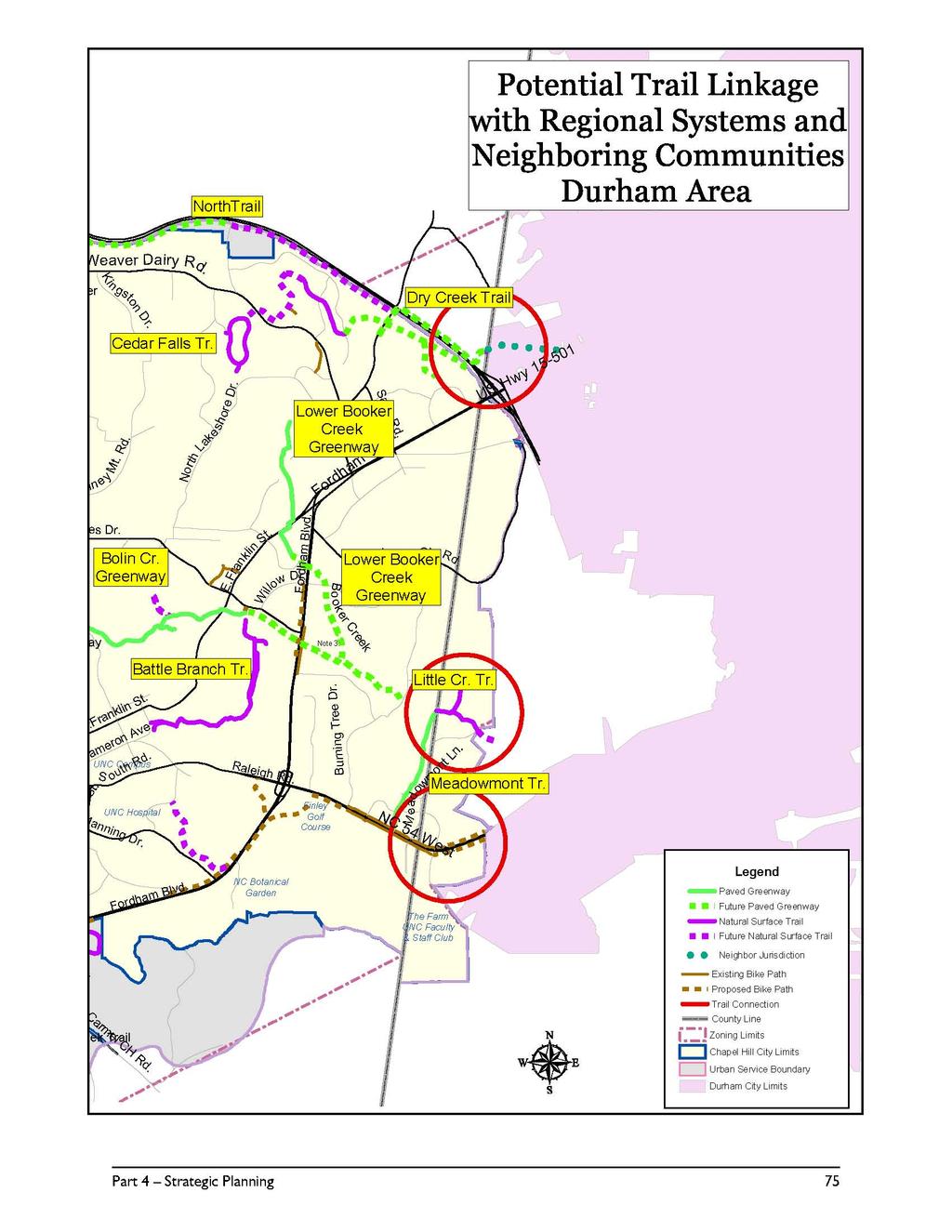
83
84 Connections with Town Alternative Transportation Plans As additional land in Chapel Hill is pressured by residential and commercial growth, transportation rights-of-way expanded to accommodate road widenings and extensions, and formerly leftover tracts of land within subdivisions become developed, the use of sidewalks, bicycle lanes and dedicated paths as part of the overall greenway system will become increasingly important. The role of sidewalks and bikeways as interconnecting routes within the greenway system cannot be overstated. Providing useful links of neighborhoods to parks, other neighborhoods, schools and public buildings, these connectors are fundamental to providing pedestrian and bicycle access throughout Town. The acquisition of greenway easements and construction of sidewalk and other connector paths should be closely coordinated among Town departments. Chapel Hill produced its first Bikeway Plan in 1977 and has since developed roadside bike paths and bike lanes. The first off-road bicycle path in Chapel Hill was built parallel to Fordham Boulevard near the Rainbow Soccer fields. Phase I of the Bolin Creek Greenway, created the first multi-use, combined bicycle and pedestrian greenway in Town. Existing bikeways have been mapped in relationship with the Town s existing and planned greenways. In 1993, Chapel Hill, as part of the Durham-Chapel Hill-Carrboro Metropolitan Planning Organization, adopted The Regional Bicycle Plan for Durham and Orange Counties. The plan presented options for bicycle connector routes throughout the area, including urban and rural bicycle routes. Connections from Chapel Hill to Durham, Research Triangle Park and Hillsborough were proposed utilizing a combination of roadside bicycle lanes and off-road bicycle paths. Several major trails within the Chapel Hill greenways system are planned for pedestrian as well as off-road bicycle use. Potential connections with the planned Booker Creek Greenway as well as the continued development of the Bolin Creek Greenway create the most immediate opportunities for the Town greenway system to link with Town and regional bicycle planning initiatives. There are several specific linkages which may potentially increase connectivity among the Town s greenways and bikeways. Future off-road pedestrian/bike paths along NC 54 could provide valuable connections between the proposed Little Creek Greenway and proposed Durham trails. (See Figure 18). Continued development of Town bikeways could present additional alternative transportation options. The Town adopted a Bicycle and Pedestrian Action Plan that presents a comprehensive look at non-motorized transportation in Town. The plan includes an overview of the greenway system as well as sidewalks and bicycle facilities. It is the Town s chief planning document for non-motorized vehicle transportation. Cooperation with the University of North Carolina The largest single landowner within the Chapel Hill planning district is the University of North Carolina at Chapel Hill. The University controls significant landholdings along the proposed Horace Williams Trail, Bolin Creek, Booker Creek, Morgan Creek, Chapel Creek, and Meeting of the Waters Creek corridors. Because of the tremendous amount of land involved, a complete, town-wide trail system would require cooperation with the University. 76 Part 4 Strategic Planning


85 Eubanks Rd. University of North Carolina Property I-40 University Lake Rogers Rd. Homestead Rd. Horace Williams Tract Note 3: r King Jr. Blvd. Martin Luthe i ng Jr. Blvd. Martin Luther K W.Rosemary St. Weaver Dairy Rd. Ki ngston Dr. Pin ey Mt. Rd. Estes Dr. W.Franklin St. E.Franklin St. S.Columbia St. Cameron Ave. S outh Rd. Main Campus Manning Dr. Fordham Blvd. North Lakeshore Dr. E.Franklin St. Blvd. Willow Dr. Fordham Raleigh Rd. I-40 Erwin Rd. Sage Rd. Fordham Blvd. Cleland Rd. BurningTree Dr. Bo o ker Creek Ephesus Ch. Rd. Pin ehur NC 54 West st M Note : 2 eadowmont Ln. US Hwy Culbreth Rd. US Hwy South Bennett Rd. Mt.Carmel CH Rd. Mason Farm Legend County Line Railroad UNC Property Zoning Limits Chapel Hill City Limits Urban Service Boundary Carrboro City Limits Durham City Limits Part 4 Strategic Planning 77
3. VISION AND GOALS. Vision Statement. Goals, Objectives and Policies
 Vision Statement Queen Creek s interconnected network of parks, trails, open spaces and recreation opportunities provide safe and diverse activities and programs that sustain its unique, small town, equestrian
Carrboro Greenways Commission January 9 th, 2007
 Carrboro Greenways Commission January 9 th, 2007 Statewide The flooding of Crabtree Valley in the early 1970 s (right before Crabtree Valley Mall was set to open) caused city, state, and federal officials
This page intentionally blank.
 This page intentionally blank. Parks, Recreation, and Open Space Chapter Relationship to Vision Vision Parks, Recreation and Open Space Chapter Concepts County Government. County government that is accountable
Status Report for Parks and Recreation Capital Projects
 Attachment #2 Town of Chapel Hill Status Report for Parks and Recreation Capital Projects Prepared by Bill Webster, Assistant Director Chapel Hill Parks & Recreation Department March 19, 2009 1. Athletic
Arlington, Virginia is a worldclass
 EXECUTIVE S U M M A RY Arlington maintains a rich variety of stable neighborhoods, quality schools and enlightened land use policies, and received the Environmental Protection Agency s highest award for
Purpose of the Master Plan
 Purpose of the Master Plan 4 Master Plan Purpose The Master Plan is a policy framework for decisions that affect the physical, social and economic environment of the Town. The Parker 2035: Master Plan
Town of Peru Comprehensive Plan Executive Summary
 Town of Peru Comprehensive Plan Executive Communities that plan grow by choice, not by chance. A plan makes growth thoughtful, understandable, and predictable. A plan shows that a community is managing
City of Mahtomedi Park System Plan Public Hearing Draft: September 13, 2006
 Chapter 6: IMPLEMENTATION INTRODUCTION Earlier chapters of this Plan analyzed existing conditions, identified park and recreation needs, and proposed park, trail, and open space recommendations. This chapter
The transportation system in a community is an
 7 TRANSPORTATION The transportation system in a community is an important factor contributing to the quality of life of the residents. Without a sound transportation system to bring both goods and patrons
Gold Line Bus Rapid Transit Transit Oriented Development (BRTOD) Helmo Station Area Plan
 Helmo Station Area Plan") Appendix F Gold Line Bus Rapid Transit Transit Oriented Development (BRTOD) Helmo Station Area Plan Introduction and Purpose of the Plan The Gold Line Bus Rapid Transit facility is an eleven-mile dedicated
Appendix F Gold Line Bus Rapid Transit Transit Oriented Development (BRTOD) Helmo Station Area Plan Introduction and Purpose of the Plan The Gold Line Bus Rapid Transit facility is an eleven-mile dedicated
Developer s Program. The Station at East 54
 Developer s Program The Station at East 54 Existing Conditions The Station at East 54 is proposed for a 1.12 acre site at the northeast corner of Hamilton Road and Prestwick Road, tucked between the East
RECREATION AND OPEN SPACE ELEMENT GOALS, OBJECTIVES, AND POLICIES
 RECREATION AND OPEN SPACE ELEMENT GOALS, OBJECTIVES, AND POLICIES Goal 7 To provide park facilities, recreation programs, and open space resources that are safe, adequate, and accessible to all City residents,
DRAFT MAP AMENDMENT FLU 04-4
 DRAFT MAP AMENDMENT FLU 04-4 SW 24 TH AVENUE ROADWAY CORRIDOR The University of Florida participates with the Metropolitan Transportation Planning Organization (MTPO) in its responsibilities for the continuing,
The Five Components of the McLoughlin Area Plan
 The Five Components of the McLoughlin Area Plan This documents contains the complete language of the five components of the McLoughlin Area Plan: The Vision Statement The Values The Guiding Principles
PSRC REVIEW REPORT & CERTIFICATION RECOMMENDATION
 PSRC REVIEW REPORT & CERTIFICATION RECOMMENDATION KITSAP COUNTY COUNTYWIDE PLANNING POLICIES July 2, 2012 BACKGROUND A major emphasis of the Washington State Growth Management Act (GMA) is the need to
Purpose of the Master Plan
 Purpose of the Master Plan 4 Master Plan Purpose The Master Plan is a policy framework for decisions that affect the physical, social and economic environment of the Town. The Parker 2035: Master Plan
CHAPTER 12 IMPLEMENTATION
 CHAPTER 12 IMPLEMENTATION The 2010 Town of Denton Comprehensive Plan is intended to capture a vision of the future of Denton. As such, it provides a basis for a wide variety of public and private actions
Introduction. Chapter 1. Purpose of the Comprehensive Plan Plan Organization Planning Process & Community Input 1-1
 Chapter 1 Introduction Lakewood 2025: Moving Forward Together Purpose of the Comprehensive Plan Plan Organization Planning Process & Community Input 1-1 Purpose of the Comprehensive Plan The Comprehensive
CHAPTER 7: VISION AND ACTION STATEMENTS. Noble 2025 Vision Statement
 CHAPTER 7: VISION AND ACTION STATEMENTS This chapter presents the vision, policy and action statements that transform the comprehensive planning study, an analysis of Noble s past, future trends and community
Chapter 2: Vision, Goals and Strategies
 Chapter 2: Vision, Goals and Lake Elmo Today & Tomorrow Comprehensive Plan 2040 2 VISION, GOALS & STRATEGIES - DRAFT 4-6-2018 INTRODUCTION Comprehensive Plan Purpose Perhapse the most important objective
The following principles guide the development of goals and strategies to protect and promote these amenities:
 OPEN SPACE/PARKS/TRAILS/RECREATION GOALS/STRATEGIES Cherry Hills Village is a living environment that offers low density development, open areas, public scenic vistas, public trails and public parks. This
Yadkin River Greenway Feasibility Study Fact Sheet Village of Clemmons, Town of Lewisville, Town of Bermuda Run
 Fact Sheet Village of Clemmons, Town of Lewisville, Town of Bermuda Run Project Background The Yadkin River Greenway Feasibility Study is a joint project with the Village of Clemmons, the Town of Bermuda
I. STAFF POLICY RECOMMENDATIONS. The following RMP policy strategies are proposed by staff in support of a Scenic Resource Protection Program:
 Policy Consideration: Scenic Resource Protection Program Status: For Consideration by the Highlands Council at September 14, 2006 Work session Date: September 12, 2006 I. STAFF POLICY RECOMMENDATIONS The
Port Lavaca Future Land Use
 Port Lavaca Future Land Use Introduction The City of Port Lavaca is beginning to see sustained growth, after many years of relative stable population. New single family homes, apartments, and businesses
G. RECREATION AND OPEN SPACE ELEMENT. The following summarizes the Recreation and Open Space Element:
 G. RECREATION AND OPEN SPACE ELEMENT The purpose of the Element is to provide the framework and direction for a comprehensive system of public and private sites for recreation, including, but not limited
SALISBURY TOMORROW Our Vision
 SALISBURY TOMORROW Our Vision Salisbury is committed to supporting a high quality of life and sense of community for all residents. These commitments need to be reflected in our community programs, services
Section 4 BUILDING THE MASTER PLAN
 The Master Plan 33 Section 4 BUILDING THE MASTER PLAN Figure 4:1. A collaborative effort characterized the two design workshops sponsored by DISC to create hypothetical Master Plans for the Towers Property
Support the implementation of Cape Coral's Comprehensive Plan. Protect and utilize the unique natural resources in the City.
 7.0 OVERVIEW - RECOMMENDATIONS Chapter 7 The preparation of the Cape Coral Parks and Recreation Master Plan spanned a period of approximately 12 months. Plan preparation included the input of a wide range
The Illinois Department of Transportation and Lake County Division of Transportation. Route 173, including the Millburn Bypass
 The Illinois Department of Transportation and Lake County Division of Transportation welcome you to this Public Hearing for U.S. Route 45 from Illinois Route 132 to Illinois Route 173, including the Millburn
2. Would the proposed project comply with the Land Use map? 3. Would the proposed project require a rezoning? 4. What is the proposed zoning district?
 TOWN OF CHAPEL HILL Planning and Sustainability Department 405 Martin Luther King Jr. Blvd. Chapel Hill, NC 27514 www.townofchapelhill.org phone (919) 968 2728 Concept Plans are intended to be an opportunity
Parks, Trails, and Open space Element
 Parks, Trails, and Open space Element Parks, Trails, and Open Space element Parks, Recreation, and Open Space are important components of the quality of life desired by the residents of Elk Grove. This
RESOLUTION NO. R Refining the route, profile and stations for the Downtown Redmond Link Extension
 RESOLUTION NO. R2018-32 Refining the route, profile and stations for the Downtown Redmond Link Extension MEETING: DATE: TYPE OF ACTION: STAFF CONTACT: Capital Committee Board PROPOSED ACTION 09/13/2018
CONCLUSION AND IMPLEMENTATION
 Lisbon s Vision CONCLUSION AND IMPLEMENTATION 7 Lisbon residents clearly appreciate the character, amenities, and opportunities that define our community. This Plan of Conservation and Development identifies
Regional Context Statement
 Regional Context Statement REGIONAL CONTEXT STATEMENT 3. REGIONAL CONTEXT STATEMENT In 1995, the Provincial Government passed into law the Growth Strategies Act. The purpose of this provincial initiative
Implementation Guide Comprehensive Plan City of Allen
 Implementation Guide 2030 Comprehensive Plan City of Allen DRAFT 2015 Implementation Guide Allen 2030 Comprehensive Plan INTRODUCTION The Comprehensive Plan serves as a guide for the growth and development
FOUR MILE RUN VALLEY WORKING GROUP AND CHARGE
 FOUR MILE RUN VALLEY WORKING GROUP AND CHARGE Adopted April 16, 2016 Amended July 19, 2016 Overview of Integrated Effort The overall goal of the Four Mile Run Valley (4MRV) initiative is to develop a comprehensive
SUBJECT: Waterfront Hotel Planning Study Update TO: Planning and Development Committee FROM: Department of City Building. Recommendation: Purpose:
 Page 1 of Report PB-23-18 SUBJECT: Waterfront Hotel Planning Study Update TO: Planning and Development Committee FROM: Department of City Building Report Number: PB-23-18 Wards Affected: 2 File Numbers:
Provide and maintain sufficient public parks, recreation facilities, and open space to meet the recreational needs of County residents and visitors.
 (ROS) Goal Provide and maintain sufficient public parks, recreation facilities, and open space to meet the recreational needs of County residents and visitors. OBJECTIVE ROS.01 The County shall acquire,
Executive Summary. Parks and Recreation Plan. Executive Summary
 Parks and Recreation Plan Executive Summary The Whitemarsh Township Parks and Recreation Plan sets forth a vision for how Whitemarsh Township can provide a premiere parks and recreation system reflective
COMMUNITY SUSTAINABILITY AND ENVIRONMENTAL MASTER PLAN IMPLEMENTATION UPDATE
 Attachment 1 COMMUNITY SUSTAINABILITY AND ENVIRONMENTAL MASTER PLAN IMPLEMENTATION UPDATE Priorities and Key Initiatives Committee May 2013 Page E-1 How we grow Goal 2: To ensure sustainable development
Asbury Chapel Subdivision Sketch Plan
 Asbury Chapel Subdivision Sketch Plan PART 1: PROJECT SUMMARY Applicant: NVR Inc. Project Size: +/- 76.13 acres Parcel Numbers: 02101112,02116101,02116112, 02116113 Current Zoning: Transitional Residential
OPEN SPACE CHAPTER 7: OVERVIEW. Preserve open space to protect natural resources, enhance character and provide passive recreation opportunities
 CHAPTER 7: OPEN SPACE OVERVIEW Ridgefield has made tremendous progress permanently preserving areas of town as open space. Open space preservation can serve many important purposes, including: protect
Cotswolds AONB Landscape Strategy and Guidelines. June 2016
 Cotswolds AONB Landscape Strategy and Guidelines June 2016 Cotswolds AONB Landscape Strategy and Guidelines Introduction The evolution of the landscape of the Cotswolds AONB is a result of the interaction
Small Area Plan. South Gateway
 Small Area Plan Adopted May 12, 2008 South Gateway Purpose. The South Gateway Small Area Plan defines the City s expectations for the future of the southern entrance to the City at Interstate 85 and Highway
Chapter 9 Community Facilities & Services Plan. Introduction. Cooperative Efforts. Monitoring of Needs
 Chapter 9 Community Facilities & Services Plan Introduction The location of key community facilities such as water, sewer, schools, parks, and roads is important to the provision of the necessary services
OPEN SPACE AND RECREATION
 OPEN SPACE AND RECREATION The Town celebrates and maintains the spectacular visual character of our Sonoran Desert setting and we value our open space, mountain views, washes, vegetation, and wildlife.
Chapter Master Planned Communities (MPC) District
 District") Sections 14.53.010 Purpose and Intent 14.53.020 Applicability 14.53.030 Procedure 14.53.040 MPC Standards 14.53.050 Required Findings 14.53.010 Purpose and Intent Chapter 14.53 Master Planned Communities
Sections 14.53.010 Purpose and Intent 14.53.020 Applicability 14.53.030 Procedure 14.53.040 MPC Standards 14.53.050 Required Findings 14.53.010 Purpose and Intent Chapter 14.53 Master Planned Communities
PARTF Scoring System for Grants
 PARTF Scoring System for Grants The members of the N.C. Parks and Recreation Authority use the PARTF scoring system as one of several tools to select grant recipients. Please provide all of the information
TEMPLE MEDICAL & EDUCATION DISTRICT
 City of Temple, Texas TEMPLE MEDICAL & EDUCATION DISTRICT 1 Description. The City of Temple joined in partnership with key public and private entities to jointly promote education and medical activities
CITY COUNCIL AGENDA REPORT
 CITY COUNCIL AGENDA REPORT Subject: COUNCIL MOTION LRT ALIGNMENT REMOVAL FROM THE TRANSPORTATION MASTER PLAN On February 10, 2016 Councillor Hughes provided notice in accordance with Section 23 of Procedure
City of Missoula and Missoula County Open Space Planning Open House
 City of Missoula and Missoula County Open Space Planning Open House FEBRUARY 6, 2018 The following slides contain the display board content from the open house. Please use boards to answer questions in
Executive Summary. The Mebane CLP is not a regulatory document, but is intended to guide land development decisions. The plan includes:
 Executive Summary P URPOSE AND O RGANIZATION OF THE P LAN The City of Mebane, with input from citizens and an appointed CLP Advisory Committee, adopted Mebane by Design, a Comprehensive Land Development
The City shall enhance and improve the accessibility of parks and recreational facilities while protecting their quality. by:
 GOALS, OBJECTIVES AND POLICIES GOAL 1: To provide open space and recreation as an essential element needed for the betterment of the City s character and quality of urban life. The City shall plan for
PARKS AND RECREATION
 PARKS AND RECREATION WHAT YOU WILL FIND IN THIS CHAPTER: Background information on the development of the Park, Recreation, and System Plan (PRSP). General overview of Ellensburg s parks and recreation
V. Vision and Guiding Principles
 V. Vision and Guiding Principles The Master Plan for the Powers Ferry Corridor seeks a foundation in the desires of the community. At times, various elements of the community offered opposing viewpoints,
The Emerald Bracelet Dallas, Texas. October 2005
 The October 2005 TABLE OF CONTENTS: Tab I Project Summary Master Illustrative Plan Tab II Woodall Rodgers Freeway Segment Tab III U.S. Highway 75 Segment Tab IV Interstate Highway 30 Segment Tab V Interstate
Cultural Arts Review of Town of Chapel Hill and UNC Planning Documents
 Cultural Arts Review of Town of Chapel Hill and UNC ning Documents Primary s Chapel Hill 2020 Comprehensive Level of relevance to Stage Year Produced Target Time Geographic Range Responsible Agent High
Draft Stillwater 2030 Comprehensive Plan- Goals and Policies
 Draft Stillwater 2030 Comprehensive Plan- Goals and Policies Instructions- Review each goal and policy and discuss with group any changes, deletions for additions to the list using your groups pen. Keep
Planning Department. Director of Planning. Manager of Planning. Planning Technician/ Sustainability Coordinator. Planner II/ Heritage Coordinator
 Department Director of Manager of Policy Planner Planner II (2) Planner II/ Heritage Coordinator Technician/ Sustainability Coordinator Technician Administrative Clerk March 2017 Department 2018 Business
1.0 Circulation Element
 5/9/18 1.0 Circulation Element 1.1 Introduction As growth and development occur in Apache County, enhancements to its circulation system will be necessary. With time, more roads will be paved and air and
City of Nogales General Plan
 Open Space, Parks, Recreation and Trails City of Nogales General Plan Residents of Nogales place a high priority in the development of a comprehensive system of open space, parks, recreation and trails
City of Tacoma Planning and Development Services
 Agenda Item D-1 City of Tacoma Planning and Development Services To: Planning Commission From: Elliott Barnett, Planning Services Division Subject: Application #2014-08 Open Space Element Update Meeting
COMMUNITY DESIGN. GOAL: Create livable and attractive communities. Intent
 COMMUNITY DESIGN Intent An attractive, well-designed County will attract quality development, instill civic pride, improve the visual character of the community, and create a strong, positive image for
CHAPTER 8 ISSUES, CONCERNS, CONSTRAINTS AND OPPORTUNITIES
 CHAPTER 8 ISSUES, CONCERNS, CONSTRAINTS AND OPPORTUNITIES Introduction This River Conservation Plan was developed during a time of tremendous activity and effort in planning the transformation of the Delaware
LU Encourage schools, institutions, and other community facilities that serve rural residents to locate in neighboring cities and towns.
 Application No. 891627: Comprehensive Plan Text Amendment - Rural School Policies - Amend policies consistent with State Legislation allowing schools in the rural area and extension of sewer service to
38 Queen s University Campus Master Plan Part 1
 38 Queen s University Campus Master Plan Part 1 46 The Campus at the City Scale Chapter 4 The Campus at the City Scale 39 Queen s is an urban University centrally located in Kingston. Decisions made by
3 Vision and Goals. Vision and Goals. Blueprint for Bloomsburg. Vision. Town of Bloomsburg Comprehensive Plan,
 Vision and Goals 3 Vision and Goals Citizens of the Town of Bloomsburg clearly value their natural and cultural heritage, the walkable, mixed use pattern of downtown, the access to education, and the community
Exhibit A. 8:9 Scuffletown Rural Conservation District
 Exhibit A 8:9 Scuffletown Rural Conservation District 8:9.1 Intent and Purpose The Scuffletown Rural Conservation (SRC) District is intended to provide for residential development that supports the development
PUBLIC RIGHT-OF-WAY IN THIS CHAPTER PUBLIC REALM
 PUBLIC RIGHT-OF-WAY This section provides design guidelines for improvements in the public right-of-way. The public right-of-way refers to streets, sidewalks, non-vehicular thoroughfares, parks and greenways
Town Center (part of the Comprehensive Plan)
") Town Center (part of the Comprehensive Plan) Mercer Island Town Center Looking North (2014) In 1994, a year-long process culminated in a set of design guidelines and code requirements for the Town Center
Town Center (part of the Comprehensive Plan) Mercer Island Town Center Looking North (2014) In 1994, a year-long process culminated in a set of design guidelines and code requirements for the Town Center
Corridor Vision. 1Pursue Minnehaha-Hiawatha Community Works Project. Mission of Hennepin County Community Works Program
 1Pursue Minnehaha-Hiawatha Community Works Project Minnehaha-Hiawatha Community Works is a project within the Hennepin Community Works (HCW) program. The mission of the HCW program is to enhance how the
2030 Comprehensive Plan VISION STATEMENT
 RESOURCE DOCUMENT for Steering Committee Meeting #2 July 12, 2017 2030 Comprehensive Plan VISION STATEMENT Steering Committee from 2008 Established the Lauderdale s Vision as: Creating a livable, lovable
Comprehensive Plan. Faribault, Minnesota. Hoisington Koegler Group Inc. Claybaugh Preservation Architecture Inc. Howard R. Green Company Bonz/REA
 Comprehensive Plan Faribault, Minnesota Adopted by the Faribault City Council July 8, 2003 prepared for: prepared by: Hoisington Koegler Group Inc. Claybaugh Preservation Architecture Inc. Howard R. Green
SECTION II SECTION II STATEMENT OF GOALS, OBJECTIVES, PRINCIPLES, ASSUMPTIONS, POLICIES AND STANDARDS
 STATEMENT OF GOALS, OBJECTIVES, PRINCIPLES, ASSUMPTIONS, POLICIES AND STANDARDS 1 2 STATEMENT OF GOALS, OBJECTIVES, PRINCIPLES, ASSUMPTIONS, POLICIES AND STANDARDS INTRODUCTION The New Jersey Municipal
Parks, Trails, and Open Space Element
 P arks, Recreation, and Open Space are important components of the quality of life desired by the residents of Elk Grove. This Element of the General Plan addresses the City s goals, policies, and actions
6.0 Conclusions & Recommendations
 6.0 Conclusions & Recommendations 75 The research, public outreach and feasibility analysis completed for this study indicate that Trail Alternative #2 (South side of Doctors Creek) is the most comprehensive
The West Vaughan Employment Area Secondary Plan Policies
 Part 2: The West Vaughan Employment Area Secondary Plan Policies 2.1 General Policies It is the policy of Council: 2.1.1. That the West Vaughan Employment Area (the WVEA), identified on Schedule 1, will
RECREATION, OPEN SPACE AND GREENWAYS ELEMENT GOALS, OBJECTIVES, AND POLICIES
 RECREATION, OPEN SPACE AND GREENWAYS ELEMENT GOALS, OBJECTIVES, AND POLICIES GOAL R-1: DEVELOP A RECREATION, OPEN SPACE AND GREENWAYS SYSTEM AS AN INTEGRAL COMPONENT OF AN OVERALL, COUNTY-WIDE ECONOMIC
2010 Plan of Conservation and Development
 2010 Plan of Conservation and Development Wilton Planning and Zoning Commission Adopted November 2, 2009 Effective January 1, 2010 WILTON 2010 PLAN OF CONSERVATION & DEVELOPMENT PARTICIPANTS Planning &
D-O LRT Zoning Discussion. Chapel Hill Boards & Commissions October 16, 2017
 D-O LRT Zoning Discussion Chapel Hill Boards & Commissions October 16, 2017 Update on Overall D-O LRT Station Area Initiative Objectives Design and educate on principles of Good Transit-Oriented Development
Chapter 10 IMPLEMENTATION RECOMMENDATIONS
 Chapter 10 IMPLEMENTATION RECOMMENDATIONS The recommended land use plan presented in the previous chapter provides a design for the attainment of the urban and rural development and open space preservation
Executive Summary. NY 7 / NY 2 Corridor
 Executive Summary NY 7 / NY 2 Corridor Transportation and Land Use Study December 2005 Prepared for: Town of Colonie Capital District Transportation Committee Prepared by: Introduction: Land use decisions
Mendota Heights 2040 Comprehensive Plan Draft Vers
 4 Parks and Trails The City of Mendota Heights boasts a variety of recreational and open space opportunities. Few cities can claim access to regional trails, riverside and lakeside parks, scenic bluffs
ADOPTION OF THE REVISED OPEN SPACE AND CONSERVATION ELEMENT OF THE GENERAL PLAN
 TO: FROM: SUBJECT: Honorable Mayor and City Council Planning Department ADOPTION OF THE REVISED OPEN SPACE AND CONSERVATION ELEMENT OF THE GENERAL PLAN RECOMMENDATION: It is recommended that the City Council:
Sheridan Boulevard S TAT I O N A R E A P L A N S H E R I D A N B O U L E VA R D S TAT I O N A R E A P L A N
 Sheridan Boulevard S TAT I O N A R E A P L A N 1 City of Lakewood Adopted November, 2006 S H E R I D A N B O U L E VA R D S TAT I O N A R E A P L A N The Vision The City of Lakewood s overall vision is
Pinellas County Greenways
 Pinellas County Greenways USING GREENWAYS TO LINK OPEN SPACES The Florida Greenways Commission has defined a greenway as...a corridor of protected open space that is managed for conservation and/or recreation.
VILLAGE OF BOLTON HERITAGE CONSERVATION DISTRICT PLAN
 Page 1 1. INTRODUCTION AND BACKGROUND 1.1 THE PROJECT VILLAGE OF BOLTON HERITAGE CONSERVATION DISTRICT PLAN TERMS OF REFERENCE The Town of Caledon (Town) is a large, predominantly rural municipality with
Parks, Open Space and Trails
 Introduction Parks have often been referred as the lungs of our cities, cleansing the air of pollutants and particulate matter. Parks are also gathering places for families and community. They offer spaces
North Fair Oaks Community Plan Summary and Information
 North Fair Oaks Community Plan Summary and Information WHAT IS THE NORTH FAIR OAKS COMMUNITY PLAN? The North Fair Oaks Community Plan is part of the San Mateo County General Plan, and establishes policies
FOUR MILE RUN VALLEY WORKING GROUP AND CHARGE Adopted April 16, 2016 Amended July 19, 2016
 FOUR MILE RUN VALLEY WORKING GROUP AND CHARGE Adopted April 16, 2016 Amended July 19, 2016 Working Group Charge The Working Group is charged by the County Board to collaborate with staff to provide commission,
Goals and Objectives Survey December 4, 2013
 Goals and Objectives Survey December 4, 2013 Process The 2006 Master Plan was based upon a set of 12 goals with various objectives tied to each goal. Goals = High level aspirations that provide general
TRANSPORTATION AND LAND USE
 CHAPTER 10 TRANSPORTATION AND LAND USE Transportation and land use are intimately linked. The expansion of a highway typically spurs housing, employment growth and land development in the communities that
1.0 Introduction. Purpose and Basis for Updating the TMP. Introduction 1
 1.0 Introduction The Town of Castle Rock is situated between the metropolitan areas of Denver and Colorado Springs, amidst a unique terrain of rolling hills, mesas, ravines, and waterways. Like many Front
SECTION FOUR: MISSION STATEMENT, GOALS & OBJECTIVES
 SECTION FOUR: MISSION STATEMENT, GOALS & OBJECTIVES Chapter Summary Chapter Ten: Mission Statement, Goals & Objectives To fulfill its mission, the Parks and Recreation Commission has identified four basic
Town of Portola Valley General Plan. Nathhorst Triangle Area Plan
 Town of Portola Valley General Plan Amended December 10, 1997 Table of Contents Introduction... 1 Planning Area... 1 Objectives... 2 Principles... 2 Standards... 4 Description... 4 Community Commercial...
DRAFT PLAN PRESENTATION
 DRAFT PLAN PRESENTATION 1.23.2018 AGENDA Process Project Schedule Results from Visioning Workshop Draft Plan Highlights Concept Plans Feedback Next Steps PROJECT SCHEDULE KICK-OFF WORKSHOP August 29 th
Planned Development Review Revisions (Project No. PLNPCM )
") Planned Development Review Revisions (Project No. PLNPCM2014-00139) Standard residential development Planned Development Example: Smaller lot sizes than what is allowed to create open space amenity. What
Planned Development Review Revisions (Project No. PLNPCM2014-00139) Standard residential development Planned Development Example: Smaller lot sizes than what is allowed to create open space amenity. What
Parks and Open Space Preservation and Dedication. January 26, 2016 Fort Worth City Council Pre-Council Meeting Randle Harwood and Richard Zavala
 Parks and Open Space Preservation and Dedication January 26, 2016 Fort Worth City Council Pre-Council Meeting Randle Harwood and Richard Zavala Purpose How does the City of Fort Worth preserve and protect
OVERMOUNTAIN VICTORY TRAIL BURKE CALDELL CORRIDOR FEASIBLITY STUDY REQUEST FOR QUALIFICATIONS CALDWELL COUNTY PATHWAYS
 OVERMOUNTAIN VICTORY TRAIL BURKE CALDELL CORRIDOR FEASIBLITY STUDY REQUEST FOR QUALIFICATIONS CALDWELL COUNTY PATHWAYS Caldwell County Pathways along with our co-partners City of Lenoir, Town of Gamewell,
City Center Specific Plan Amendments And Background Report City of Richmond. PLANNING COMMISION FINAL DRAFT January, 2001
 City Center Specific Plan Amendments And Background Report City of Richmond PLANNING COMMISION FINAL DRAFT January, 2001 TABLE OF CONTENTS Page LIST OF TABLES... LIST OF FIGURES... INDEX... OVERVIEW...