Parks and Open Space Preservation and Dedication. January 26, 2016 Fort Worth City Council Pre-Council Meeting Randle Harwood and Richard Zavala
|
|
|
- Stephany Johnson
- 6 years ago
- Views:
Transcription

1 Parks and Open Space Preservation and Dedication January 26, 2016 Fort Worth City Council Pre-Council Meeting Randle Harwood and Richard Zavala


2 Purpose How does the City of Fort Worth preserve and protect open space for future generations? What are the best practices for the preservation of open space as potential parkland? 2
3 Outline Evolution of the Park System History of Park and Open Space Dedication Park Classifications and Inventory Tools: Planning, Partnerships & Policy Future Growth 3
4 Evolution of the Park System Donation Capital Funding Neighborhood & Community Park Dedication Policy To wait any longer will make it exceedingly difficult and costly to accomplish these public improvements which will make the city comfortable to its population and attractive to those not yet a part of your citizenship. George Kessler, Fort Worth s First Park and City Master Plan,
5 History of Park and Open Space Dedication George Kessler Plan 1930 & Comprehensive Parks System for Fort Worth - Hare and Hare Capital Plans with Bond Referendums Strategic Plan 1998/2004/ Park, Recreation and Open Space Master Plan In the competition of cities for new and desirable population, no other element of advertisement is worth so much as an ample and attractive park system, making a pleasant city in which to live comfortably. George Kessler, Fort Worth s First Park and City Master Plan,


6 Evolution of the Park System The Early Years and the Kessler Plan Hyde Park 1873 Botanic Garden & Trinity Park (Rock Springs Park) Marine Park 1894 Forest Park 1910 Botanic Garden Fort Worth Zoo, Forest Park 6


7 Evolution of the Park System Hare and Hare Years: s Foster Park Cobb Park Buck Sansom Park Z. Boaz Parks Marion Sansom Park Carter Park Harmon Field Park Overton Park Overton Park 7


8 Evolution of the Park System 1960s Chisholm Trail Recreation Center Pecan Valley Park Sandy Lane Park Rolling Hills Park Heritage Park Gateway Park Oakmont Park Arcadia Park System s Chisholm Trail Arcadia Park System 8

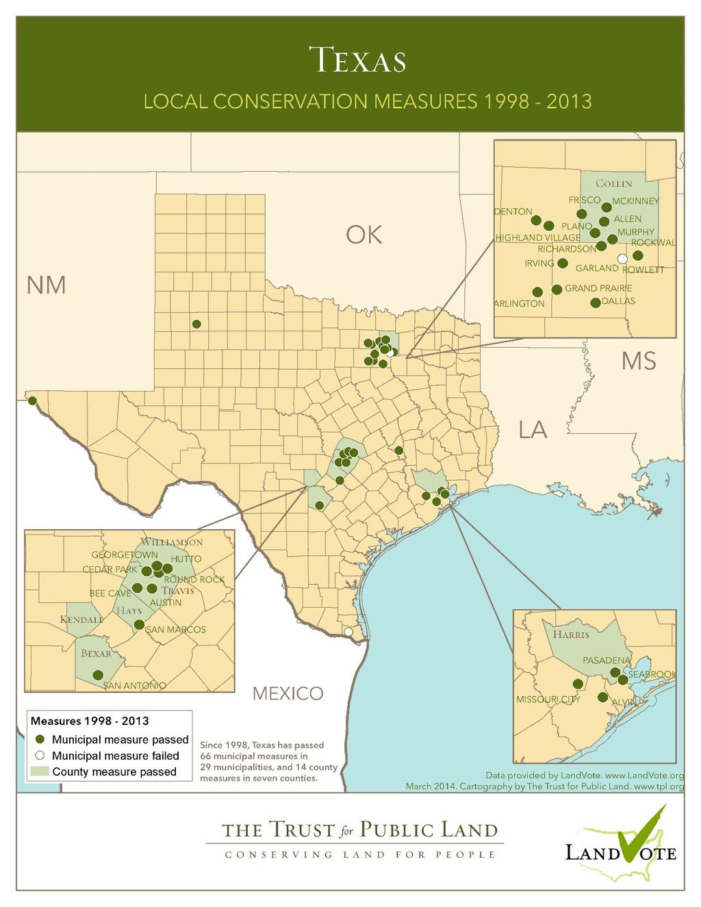
9 Evolution of the Park System 2000 Present 2000 to present, 58 new parks taken in with an overall total of 1,286 acres of land added to the park system 761 acres through Developer dedication 409 acres through direct purchase 116 acres through donations West Park Mallard Cove Marine Creek Ranch Northwest Oak Grove Park System Map 9
10 Park Classifications City Goal = 6.25 acres per 1,000 persons Neighborhood Based Parks Urban, Pocket, Neighborhood Goal acres per 1,000 persons acres per 1,000 persons (underserved) Community Based Parks Community and Metropolitan Goal acres per 1,000 persons acres per 1,000 persons (overserved) Special Use & Nature Based Parks Special Use, Greenbelts, Conservancy Facility and acreage vary substantially depending on the specific special use 10
11 Park Inventory Classification Number Acreage Neighborhood Based Parks Urban Pocket Neighborhood 102 1,328 Community Based Parks Community 61 4,410 Metropolitan Special Use & Nature Based Parks Special Use 11 1,319 Greenbelt Conservancy 8 3,819 Total* ,854 11
12 Tools - Plans City Comprehensive Plan Components Park Recreation and Open Space Master Plan Individual Park Master Plans Botanic Garden Master Plan Gateway Park Master Plan Nature Center and Refuge Master Plan Fort Worth Zoo Master Plan Neighborhood Recreation Enhancement Plan 12


13 Tools - Partnerships Tarrant Regional Water District U.S. Army Corps of Engineers Streams and Valley, Inc. Texas Parks & Wildlife Department General Services Administration Texas Department of Transportation Local County Jurisdictions Independent School Districts Crowley ISD Eagle Mountain Saginaw ISD Fort Worth ISD Keller ISD Northwest ISD 13

14 Tools - Partnerships and Repurposing 14


15 Tools Repurposing Outdated Facilities North Z. Boaz Park 15
16 Tools - Park Dedication History of Subdivision Ordinance - Park Dedication Policy 1977 City Council Approves Policy Adopted April 18, 2000 (M&C G-12893) Revised January 27, 2004 (M&C G-14225) Revised June 9, 2009 (M&C G-16592) Review of current Neighborhood and Community Park Dedication Policy in
17 Tools - Park Dedication Current Park Dedication Policy Pros Functional mechanism for adding parks in new large subdivisions Cons Does not always capture most strategically important land for parks, greenways, or trails Central City fees do not always account for higher land values in the Central City core Process to Update Park Dedication Policy 17


18 Northwest Community Park Acquired in acres $7M 18


19 Alliance Community Based Park Alliance Park acres 19

20 Walsh Ranch 20
21 Future Growth 2040 Population Estimate 1,377,000 (NCTCOG) Maintain Goal at: 6.25 acres per 1,000 persons Neighborhood Based Parks acres per 1,000 persons Need: 3,442 acres Increase of: 1,926 acres Community Based Parks acres per 1,000 persons Need: 5,164 acres Increase of: 119 acres 21


22 Tools - Plans City Comprehensive Plan Components (cont.) Cultural District Master Plan/Cultural Plan Lake Worth Vision Plan Lake Worth Watershed Greenprint Lake Arlington Master Plan Trinity River Vision Master Plan 22


23 Tools - Plans City Comprehensive Plan Components (cont.) Bike Fort Worth Plan Walk Fort Worth Plan Central City Commercial Corridors Revitalization Citywide Historic Preservation Plan Urban Village Master Plans 23


24 Tools- From Other Communities Conservation Easements Conserve open space on private land Protect High Priority Water Quality Zones (i.e. Lake Worth Watershed Greenprint) 24


25 Tools- From Other Communities Open Space Acquisition Expand use of innovative financing tools to acquire open space for hike/bike trail alignments and stream buffers that protect water quality Develop network of open spaces that connect neighborhoods to schools and other destinations 25

26 Tools- From Other Communities Open Space Acquisition Early acquisition can preserve open spaces that provide a healthier framework for development Innovative financing tools to consider can include: Future bond programs Oil and gas lease revenue Expanded parkland dedication/in-lieu fees Other fees (impact fees, user fees, utility fees, etc.) TIF or PID funds State and federal funding 26
27 Voter Support of Conservation Purposes Drinking Water Water Quality/Rivers/Streams Natural Lands/Areas Wildlife 89% 87% 84% 84% Purpose Preserve Historic Lands Public Access (w ater) Farms/Ranchland Park Improvement (General) Scenic View s Open Space 78% 75% 75% 74% 72% 71% Acquisition of Specifically Named Parcel/Area Bike, hike, w alk, ride trails 69% 69% Land for Parks/Brow nfield Redevelopment 61% 50% 60% 70% 80% 90% 100% Percent Support 27

28 28

 Conservation subdivision opportunities")
29 Tools- From Other Communities Development Incentives Density bonuses (i.e. accommodate growth in pods of denser development connected to an open space network) Conservation subdivision opportunities (i.e. encourage integration of open space in new neighborhoods) 29


30 Tools- From Other Communities Development Controls for Community Benefit Develop zoning tools (i.e. stream buffer zones) Green infrastructure for water quality Transfer of development rights (to areas that can better accommodate development) 30
")

31 Tools- From Other Communities US Department of Defense REPI Program (Readiness and Environmental Protection Integration) Funding for military base buffers Protects bases from development encroachment Can also protect land for water quality or habitat 31

32 Urban Streetscapes as Public Open Space Urban Village Plans 32


33 Urban Streetscapes as Public Open Space Urban Village Streetscapes Create higher value places for people Maintenance is essential to retaining value as public open space 33

34 Questions? Comments? 34
RECREATION, OPEN SPACE AND GREENWAYS ELEMENT GOALS, OBJECTIVES, AND POLICIES
 RECREATION, OPEN SPACE AND GREENWAYS ELEMENT GOALS, OBJECTIVES, AND POLICIES GOAL R-1: DEVELOP A RECREATION, OPEN SPACE AND GREENWAYS SYSTEM AS AN INTEGRAL COMPONENT OF AN OVERALL, COUNTY-WIDE ECONOMIC
G. RECREATION AND OPEN SPACE ELEMENT. The following summarizes the Recreation and Open Space Element:
 G. RECREATION AND OPEN SPACE ELEMENT The purpose of the Element is to provide the framework and direction for a comprehensive system of public and private sites for recreation, including, but not limited
Joe Pool Lake Master Plan Revision Public Information Meeting May 23, 2017
 Joe Pool Lake Master Plan Revision Public Information Meeting May 23, 2017 Presented By Jason Owen Lake Manager U.S. Army Corps of Engineers Fort Worth District US Army Corps of Engineers Purpose of this
Lewisville Lake Master Plan Revision Public Information Meeting May 2 & 4, 2017
 Lewisville Lake Master Plan Revision Public Information Meeting May 2 & 4, 2017 Presented By Rob Jordan Lake Manager U.S. Army Corps of Engineers Fort Worth District US Army Corps of Engineers Purpose
Yadkin River Greenway Feasibility Study Fact Sheet Village of Clemmons, Town of Lewisville, Town of Bermuda Run
 Fact Sheet Village of Clemmons, Town of Lewisville, Town of Bermuda Run Project Background The Yadkin River Greenway Feasibility Study is a joint project with the Village of Clemmons, the Town of Bermuda
Lake Arlington Master Plan. Presented by Randle Harwood, Planning and Development Director October 27, 2015
 Lake Arlington Master Plan Presented by Randle Harwood, Planning and Development Director October 27, 2015 1 Land Use Strategy 4 Land Use Strategy Typical Residential Development New residential development
RECREATION AND OPEN SPACE ELEMENT GOALS, OBJECTIVES, AND POLICIES
 RECREATION AND OPEN SPACE ELEMENT GOALS, OBJECTIVES, AND POLICIES Goal 7 To provide park facilities, recreation programs, and open space resources that are safe, adequate, and accessible to all City residents,
City of Nogales General Plan
 Open Space, Parks, Recreation and Trails City of Nogales General Plan Residents of Nogales place a high priority in the development of a comprehensive system of open space, parks, recreation and trails
3. VISION AND GOALS. Vision Statement. Goals, Objectives and Policies
 Vision Statement Queen Creek s interconnected network of parks, trails, open spaces and recreation opportunities provide safe and diverse activities and programs that sustain its unique, small town, equestrian
National Association of Conservation Districts. Kris Hoellen Vice President, Sustainable Programs The Conservation Fund September 19, 2013
 National Association of Conservation Districts Kris Hoellen Vice President, Sustainable Programs The Conservation Fund September 19, 2013 Our Mission The Conservation Fund forges partnerships to conserve
Canyon Lake Master Plan Revision Public Information Meeting March 18, 2016
 Canyon Lake Master Plan Revision Public Information Meeting March 18, 2016 Marcus Schimank Canyon Lake Manager Capital Regional Office U.S. Army Corps of Engineers Fort Worth District US Army Corps of
This page intentionally blank.
 This page intentionally blank. Parks, Recreation, and Open Space Chapter Relationship to Vision Vision Parks, Recreation and Open Space Chapter Concepts County Government. County government that is accountable
Public Information Meeting
 Lavon Lake Master Plan Revision Public Information Meeting March 10, 2015 Presented By Michael Kinard Lake Manager U.S. Army Corps of Engineers Fort Worth District US Army Corps of Engineers Purpose of
PARKS AND RECREATION
 PARKS AND RECREATION WHAT YOU WILL FIND IN THIS CHAPTER: Background information on the development of the Park, Recreation, and System Plan (PRSP). General overview of Ellensburg s parks and recreation
A larger version of this map is located on the last page of this PDF.
 MAP Committee Input McLoughlin Area Draft Vision Map A larger version of this map is located on the last page of this PDF. 1. The map above is intended to portray a vision for the McLoughlin area. It highlights
City of Missoula and Missoula County Open Space Planning Open House
 City of Missoula and Missoula County Open Space Planning Open House FEBRUARY 6, 2018 The following slides contain the display board content from the open house. Please use boards to answer questions in
Lake O the Pines Master Plan Revision Public Information Meeting April 25 & 27, 2017
 Lake O the Pines Master Plan Revision Public Information Meeting April 25 & 27, 2017 Presented By Matthew Like, Lake Manager U.S. Army Corps of Engineers Fort Worth District US Army Corps of Engineers
Sorted citizen input comments in review of Blount County plans July, August, and September 2007
 Sorted citizen input comments in review of Blount County plans July, August, and September 2007 The following presents sorted citizen input comments from three sessions held in July, August and September
Portage County Parks, Trails and Greenways Plan
 Portage County Parks, Trails and Greenways Plan Agenda for Local Planning Meeting Introductory Presentation Why we need a Plan Plan project goals and process Benefits Overview of local planning region
RECREATION AND OPEN SPACE ELEMENT
 RECREATION AND OPEN SPACE ELEMENT Last amended August 19, 2008 Table of Contents Objective Page 5.1 Park system defined... 5-1 5.2 Access to parks and recreational facilities... 5-2 5.3 Recreation and
Silverdale Regional Center
 Silverdale Regional Center Vision for Silverdale Regional Center The Silverdale Regional Center Plan (Plan) will guide the evolution of the Silverdale Regional Center from a collection of strip malls and
BUDGETING FOR OUTCOMES TRINITY RIVER CORRIDOR
 BUDGETING FOR OUTCOMES TRINITY RIVER CORRIDOR Trinity River Corridor Team Members: Kelly High, Streets Department Megan Lam, Office of Financial Services Mike Mikeska, Dallas Water Utilities Diana Ochoa,
City Council March 27, Parks, Recreation, and Trails Master Plan
 City Council March 27, 2018 Parks, Recreation, and Trails Master Plan Planning Process Develop Goals and Objectives Inventory of Areas and Facilities Needs Assessment And Identification Public Participation
1. Executive Summary. SECTION 1 Executive Summary. City of Arlington Lake Arlington Master Plan
 1. In December 2009, the engaged the environmental engineering and science consulting fi rm of Malcolm Pirnie to assist the City in developing a master plan for Lake Arlington (the Project ). Over a period
Town of Peru Comprehensive Plan Executive Summary
 Town of Peru Comprehensive Plan Executive Communities that plan grow by choice, not by chance. A plan makes growth thoughtful, understandable, and predictable. A plan shows that a community is managing
OPEN SPACE CHAPTER 7: OVERVIEW. Preserve open space to protect natural resources, enhance character and provide passive recreation opportunities
 CHAPTER 7: OPEN SPACE OVERVIEW Ridgefield has made tremendous progress permanently preserving areas of town as open space. Open space preservation can serve many important purposes, including: protect
Draft Stillwater 2030 Comprehensive Plan- Goals and Policies
 Draft Stillwater 2030 Comprehensive Plan- Goals and Policies Instructions- Review each goal and policy and discuss with group any changes, deletions for additions to the list using your groups pen. Keep
METROPOLITAN COUNCIL 390 North Robert Street, St. Paul, MN Phone (651) ; TDD (651)
 ; TDD (651)") DATE: December 20, 2011 METROPOLITAN COUNCIL 390 North Robert Street, St. Paul, MN 55101 Phone (651) 602-1000; TDD (651) 291-0904 TO: Metropolitan Parks and Open Space Commission FROM: Tori Dupre, Senior
DATE: December 20, 2011 METROPOLITAN COUNCIL 390 North Robert Street, St. Paul, MN 55101 Phone (651) 602-1000; TDD (651) 291-0904 TO: Metropolitan Parks and Open Space Commission FROM: Tori Dupre, Senior
Provide and maintain sufficient public parks, recreation facilities, and open space to meet the recreational needs of County residents and visitors.
 (ROS) Goal Provide and maintain sufficient public parks, recreation facilities, and open space to meet the recreational needs of County residents and visitors. OBJECTIVE ROS.01 The County shall acquire,
IMPLEMENTING SOMERSET COUNTY S INVESTMENT FRAMEWORK
 IMPLEMENTING SOMERSET COUNTY S INVESTMENT FRAMEWORK SMART CONSERVATION THROUGH SMART GROWTH NJ LAND CONSERVATION RALLY March 22, 2014 Laurette Kratina, PP, AICP, Supervising Planner Somerset County Planning
Master Plan Workshop October 25, 2007 Charlotte Mecklenburg Government Center
 Master Plan Workshop October 25, 2007 Charlotte Mecklenburg Government Center Land Discussion 1. What are the most important land related issues we need to address? Protect natural areas Passive walking
DISCUSSION TOPIC: ST JOHNS RIVER & ITS TRIBUTARIES (BPII) 2030 COMPREHENSIVE PLAN POLICES AND REGULATORY FRAMEWORK
 2030 COMPREHENSIVE PLAN POLICES AND REGULATORY FRAMEWORK") DISCUSSION TOPIC: ST JOHNS RIVER & ITS TRIBUTARIES (BPII) 2030 COMPREHENSIVE PLAN POLICES AND REGULATORY FRAMEWORK St. John s River & Its Tributaries Issue Summary: The St. Johns River is an important
DISCUSSION TOPIC: ST JOHNS RIVER & ITS TRIBUTARIES (BPII) 2030 COMPREHENSIVE PLAN POLICES AND REGULATORY FRAMEWORK St. John s River & Its Tributaries Issue Summary: The St. Johns River is an important
METROPOLITAN COUNCIL 390 North Robert Street, St. Paul, MN Phone (651) ; TDD (651)
 ; TDD (651)") DATE: October 24, 2012 METROPOLITAN COUNCIL 390 North Robert Street, St. Paul, MN 55101 Phone (651) 602-1000; TDD (651) 291-0904 TO: Metropolitan Parks and Open Space Commission FROM: Tori Dupre, Senior
DATE: October 24, 2012 METROPOLITAN COUNCIL 390 North Robert Street, St. Paul, MN 55101 Phone (651) 602-1000; TDD (651) 291-0904 TO: Metropolitan Parks and Open Space Commission FROM: Tori Dupre, Senior
Chapter 5: Recreation
 Chapter 5: Recreation Introduction and Setting Recreational opportunities within Nevada County are varied, ranging from public parks with intensively used active recreational facilities, to vast tracts
Whitemarsh Township Greenway Plan
 Whitemarsh Township Greenway Plan Prepared for: Whitemarsh Township August 16, 2007 Table of Contents Table of Contents... i Introduction... 1 Study Area Setting... 2 Regional Setting... 2 Township Character...
Support the implementation of Cape Coral's Comprehensive Plan. Protect and utilize the unique natural resources in the City.
 7.0 OVERVIEW - RECOMMENDATIONS Chapter 7 The preparation of the Cape Coral Parks and Recreation Master Plan spanned a period of approximately 12 months. Plan preparation included the input of a wide range
Mendota-Lebanon Hills Greenway Master Plan Executive Summary. August draft for more information visit
 Mendota-Lebanon Hills Greenway Master Plan Executive Summary August 2013 draft for more information visit www.hkgi.com/projects/dakota INTRODUCTION The Mendota-Lebanon Hills Greenway Master Plan portrays
Chapter 13: Implementation Plan
 Implementation A. Introduction The Implementation Plan, in table form on the following pages, provides a summary of all the Action Items recommended in Chapters 2 through 12. The table also indicates which
Countywide Green Infrastructure
 Montgomery County s Countywide Green Infrastructure F U N C T I O N A L M A S T E R P L A N The Maryland National Capital Park and Planning Commission INFRASTRUCTURE An underlying base or foundation especially
Parks, Open Space and Trails
 Introduction Parks have often been referred as the lungs of our cities, cleansing the air of pollutants and particulate matter. Parks are also gathering places for families and community. They offer spaces
RESPONSES TO PUBLIC CONCERNS AND QUESTIONS
 RESPONSES TO PUBLIC CONCERNS AND QUESTIONS Stations and Summary Questions for Public Meeting #2 June 23, 2015 General Questions / Concerns: 1. Is there any way this development can raise revenue for the
CHAPTER 13 RECREATION AND OPEN SPACE ELEMENT
 CHAPTER 13 RECREATION AND OPEN SPACE ELEMENT Page 1 of 15 G:\Comp\Adopted Comprehensive Plans\15. Cylce 16-2 and 16-3\Elements not changed\ Rec & Open Space CHAPTER 13 RECREATION AND OPEN SPACE A. OVERVIEW
Parks, Trails, and Open space Element
 Parks, Trails, and Open space Element Parks, Trails, and Open Space element Parks, Recreation, and Open Space are important components of the quality of life desired by the residents of Elk Grove. This
CHAPTER 7: Transportation, Mobility and Circulation
 AGLE AREA COMMUNITY Plan CHAPTER 7 CHAPTER 7: Transportation, Mobility and Circulation Transportation, Mobility and Circulation The purpose of the Transportation, Mobility and Circulation Chapter is to
5.13 RECREATION / OPEN SPACE
 5.13 RECREATION / OPEN SPACE The project includes the development of two 5+ acre public parks, four pocket parks and various trails. This complies with the Board of Supervisors established minimum standard
REGIONAL ACTIVITY CENTER
 DRAFT REGIONAL ACTIVITY CENTER 70 EAST BENCH MASTER PLAN DRAFT 06 Introduction The East Bench Regional Activity center is comprised of large educational, research, medical, and employment centers. These
Gloucester County s Comprehensive Plan. The Community Connection
 Gloucester County s Comprehensive Plan The Community Connection Current Comp Plan Adopted in 1991 with a 20 year planning horizon Updated in 1995 with Part V- Implementation Recommendations and Appendix
Metropolitan Parks and Open Space Commission
 Business Item No. 2013-xxx Metropolitan Parks and Open Space Commission Meeting date: October 1, 2013 For the Community Development Committee meeting of October 7, 2013 Subject: Mendota-Lebanon Hills Greenway
PARKS & RECREATION SUBCOMMITTEE. Oct. 1, 2015
 PARKS & RECREATION SUBCOMMITTEE Oct. 1, 2015 1999 Bond - $22,000,000 Land Acquisition Allen Station Phase II Neighborhood Parks PREVIOUS BOND ELECTIONS 1999 & 2007 2002 Bond - $4,000,000 Allen Senior Recreation
The Trinity River Corridor, offering Dallas areas of natural
 IMPLEMENTATION PLAN FOR THE TRINITY RIVER CORRIDOR The Trinity River Corridor, offering Dallas areas of natural beauty and untapped potential, runs through the heart of the city. Proposed improvements
CHAPTER VIII Implementation
 CHAPTER VIII Implementation VIII. Implementation The vision for the Marlboro Pike Corridor will require that a variety of participants work together to make it a reality. The following action steps outline
Arlington, Virginia is a worldclass
 EXECUTIVE S U M M A RY Arlington maintains a rich variety of stable neighborhoods, quality schools and enlightened land use policies, and received the Environmental Protection Agency s highest award for
Corridor Vision. 1Pursue Minnehaha-Hiawatha Community Works Project. Mission of Hennepin County Community Works Program
 1Pursue Minnehaha-Hiawatha Community Works Project Minnehaha-Hiawatha Community Works is a project within the Hennepin Community Works (HCW) program. The mission of the HCW program is to enhance how the
Executive Summary Purpose of the Plan Defining Open Space and Greenways
 Executive Summary Bucks County possesses a vast array of open space resources including natural areas, parks, farmland and historic and cultural resources that contribute to a high quality of life valued
FY Capital Improvement Program Arroyo Projects
 FY 219-223 Capital Improvement Program FY 218 FY 219 FY 22 FY 221 FY 222 FY 223 1 2 3 4 5 6 7 8 9 1 Hahamongna - Implement Master Plan - Oak Grove Area Improvements (7756) Hahamongna - Implement Master
Carrboro Greenways Commission January 9 th, 2007
 Carrboro Greenways Commission January 9 th, 2007 Statewide The flooding of Crabtree Valley in the early 1970 s (right before Crabtree Valley Mall was set to open) caused city, state, and federal officials
Outlawing Sprawl. Pennsylvania Chapter American Planning Association October 6, 2009
 Outlawing Sprawl Pennsylvania Chapter American Planning Association October 6, 2009 Presented by: Ronald T. Bailey, AICP Executive Director Chester County Planning Commission Location: 2009 PA Chapter
The City shall enhance and improve the accessibility of parks and recreational facilities while protecting their quality. by:
 GOALS, OBJECTIVES AND POLICIES GOAL 1: To provide open space and recreation as an essential element needed for the betterment of the City s character and quality of urban life. The City shall plan for
Town of Castle Rock DRCOG 2013 Annual Growth and Development Report. Introduction. Section 1 Metro Vision 2035
 Town of Castle Rock DRCOG 2013 Annual Growth and Development Report Introduction This is the Town of Castle Rock s sixth annual report to the Denver Regional Council of Governments (DRCOG) reporting on
CHAPTER 8 ISSUES, CONCERNS, CONSTRAINTS AND OPPORTUNITIES
 CHAPTER 8 ISSUES, CONCERNS, CONSTRAINTS AND OPPORTUNITIES Introduction This River Conservation Plan was developed during a time of tremendous activity and effort in planning the transformation of the Delaware
2018 Northampton Township Comprehensive Plan
 2018 BUCKS COUNTY, PENNSYLVANIA What is a? A comprehensive plan is a municipality s main policy document that details the collective vision for the future, the historic, environmental, and cultural facilities
Objectives and Strategies for the Integration of Recreation, Parks and Open Space in Regional Plans
 BULLETIN 2 Objectives and Strategies for the Integration of Recreation, Parks and Open Space in Regional Plans TABLE OF CONTENTS Introduction 3 Land-use Framework Outcomes 1 4-8 Land-use Framework Outcomes
Rosemount Greenway Master Plan Executive Summary. draft. Spring for more information visit
 Rosemount Greenway Master Plan Executive Summary Spring 2012 draft for more information visit www.hkgi.com/projects/dakota INTRODUCTION The Rosemount Greenway Master Plan portrays a vision to establish
Chapter 5: Natural Resources and Environment
 NATURAL RESOURCES AND ENVIRONMENT 5-1 5 Chapter 5: Natural Resources and Environment BACKGROUND AND INTENT Urban expansion represents the greatest risk for the future degradation of existing natural areas,
Joe Pool Lake Lake Master Plan Public Information Meeting Presentation of Final Draft Revision July 31, 2018
 Joe Pool Lake Lake Master Plan Public Information Meeting Presentation of Final Draft Revision July 31, 2018 Presented By Jeremy Spencer Lake Manager U.S. Army Corps of Engineers Fort Worth District US
Asbury Chapel Subdivision Sketch Plan
 Asbury Chapel Subdivision Sketch Plan PART 1: PROJECT SUMMARY Applicant: NVR Inc. Project Size: +/- 76.13 acres Parcel Numbers: 02101112,02116101,02116112, 02116113 Current Zoning: Transitional Residential
TRANSPORTATION ELEMENT GOALS, OBJECTIVES, AND POLICIES
 TRANSPORTATION ELEMENT GOALS, OBJECTIVES, AND POLICIES GOAL 2 The City shall provide a safe, convenient, effective, and energy efficient multimodal transportation system which is coordinated with the Future
Parks, Trails, and Open Space Element
 P arks, Recreation, and Open Space are important components of the quality of life desired by the residents of Elk Grove. This Element of the General Plan addresses the City s goals, policies, and actions
The transportation system in a community is an
 7 TRANSPORTATION The transportation system in a community is an important factor contributing to the quality of life of the residents. Without a sound transportation system to bring both goods and patrons
MOUNT ROSE AND WASHOE VALLEY SCENIC BYWAY CORRIDOR MANAGEMENT PLANS
 MOUNT ROSE AND WASHOE VALLEY SCENIC BYWAY CORRIDOR MANAGEMENT PLANS PARK COMMISSION JANUARY 5, 2016 PREPARED BY Aspen Asheville Austin Chicago Denver Dubai Houston Lake Tahoe Los Angeles CORRIDOR MANAGEMENT
Mendota Heights 2040 Comprehensive Plan Draft Vers
 4 Parks and Trails The City of Mendota Heights boasts a variety of recreational and open space opportunities. Few cities can claim access to regional trails, riverside and lakeside parks, scenic bluffs
Longmeadow Parkway Fox River Bridge Corridor. August 6, 2015
 Longmeadow Parkway Fox River Bridge Corridor August 6, 2015 Longmeadow Parkway Bridge Corridor 5.6 miles from Huntley Road to IL 62 Unique municipal/county/state/federal partnership Links Randall Road
EL DORADO COUNTY GENERAL PLAN PARKS AND RECREATION ELEMENT PRINCIPLE INTRODUCTION STATE AUTHORIZATION
 EL DORADO COUNTY GENERAL PLAN PARKS AND RECREATION ELEMENT PRINCIPLE The General Plan must identify the types of governmental services, including parks and recreation facilities, which are necessary to
{Best Practices. Summary of Tools, Strategies and Best Practices from 11 Michigan Case Study Communities
 Case Studies Michigan Coastal Community Working Waterfronts { Summary of Tools, Strategies and from 11 Michigan Case Study Communities Table of Contents Zoning...2 Community and Stakeholder Collaboration
Oakland County s Green Infrastructure Vision. L. Brooks Patterson Oakland County Executive
 Oakland County s Green Infrastructure Vision L. Brooks Patterson Oakland County Executive Southeast Michigan 20 miles northwest of Detroit Consists of 910 square miles Population of 1.2 million More than
BROOKHILL NEIGHBORHOOD MODEL ZONING MAP AMENDMENT PREFACE TO APPLICATION
 BROOKHILL NEIGHBORHOOD MODEL ZONING MAP AMENDMENT PREFACE TO APPLICATION June 15, 2015 Revised: August 1, 2016 I. VISION Brookhill is a proposed community based upon the principles of Albemarle County
GENERAL PLAN UPDATE ISSUES MEETING. January 21, 2010 City Hall Mitchell Room 6:00 pm 9:00 pm
 GENERAL PLAN UPDATE ISSUES MEETING January 21, 2010 City Hall Mitchell Room 6:00 pm 9:00 pm WELCOME! Introductory Comments Continued Review of Quality of Life Standards, Growth Management, Proposition
City of Tacoma Planning and Development Services
 Agenda Item D-1 City of Tacoma Planning and Development Services To: Planning Commission From: Elliott Barnett, Planning Services Division Subject: Application #2014-08 Open Space Element Update Meeting
Southeast Quadrant Plan
 Southeast Quadrant Plan Southeast Quadrant Distinctive Features Land Use The Southeast Quadrant includes all the area within the planning area that is east of Interstate 5 and south of State Route 44.
SECTION II SECTION II STATEMENT OF GOALS, OBJECTIVES, PRINCIPLES, ASSUMPTIONS, POLICIES AND STANDARDS
 STATEMENT OF GOALS, OBJECTIVES, PRINCIPLES, ASSUMPTIONS, POLICIES AND STANDARDS 1 2 STATEMENT OF GOALS, OBJECTIVES, PRINCIPLES, ASSUMPTIONS, POLICIES AND STANDARDS INTRODUCTION The New Jersey Municipal
Stafford County Strategic Plans
 Stafford County Strategic s Strategic Department Description Date Adopted Board of Supervisors Priorities Fiscal Responsibility Education Public Safety Infrastructure Economic Development Service Excellence
SOUTH NATOMAS COMMUNITY PLAN
 SOUTH NATOMAS Community Plan Part Three : COMMUNITY PLAN AREAS AND SPECIAL STUDY AREAS SACRAMENTO 2030 GENERAL PLAN Contents Community Location... 3-SN-3 Community Vision... 3-SN-4 Community Profile...
GOALS, OBJECTIVES, POLICIES & PROGRAMS
 Chapter 5 GOALS, OBJECTIVES, POLICIES & PROGRAMS 5.1 Goals, Objectives, Policies & Programs This is a joint plan adopted by both the Village of Waunakee and the Town of Westport. Both communities will
Potential Green Infrastructure Strategies May 6, 2015 Workshop
 Potential Green Infrastructure Strategies May 6, 2015 Workshop Background The City of Cortland is developing the Tioughnioga Urban Headwaters Green Infrastructure Action Plan with funding from the National
Chapter 6. Overall Vision RECOMMENDATIONS. More Trail and Trail. Connections. Equal Access to Park. Facilities and Programs. Water Access.
 Overall Vision More Trail and Trail Connections Equal Access to Park Facilities and Programs Water Access Environment Variety Chapter 6 RECOMMENDATIONS Chapter 6 The following recommendations for park,
Joint Meeting City Council and the Plan Commission. September 1st, 2015
 Joint Meeting City Council and the Plan Commission September 1st, 2015 1 The City Plan Commission shall recommend a City Plan for the physical development of the City Article IX Section 2 of the City of
Pungo/Blackwater Planning Area
 Pungo/Blackwater Planning Area Current Reality The Pungo/Blackwater Planning Area represents the rural landscape and lifestyle that encompasses nearly 40% of Virginia Beach. The Agricultural Reserve Program
Plano Tomorrow Vision and Policies
 Plano Tomorrow Vision and Policies PLANO TOMORROW PILLARS The Built Environment The Social Environment The Natural Environment The Economic Environment Land Use and Urban Design Transportation Housing
E X E CU T IV E SUMMARY: OUR FUTURE. Recreation & Conservation Choices for Northern Colorado
 E X E CU T IV E SUMMARY: OUR LANDS OUR FUTURE Recreation & Conservation Choices for Northern Colorado Cover images (clockwise from top): photo by David Coulson; photo by Harry Strharsky; photo by Walt
Transportation. Strategies for Action
 Transportation A major priority for the Overlake Neighborhood is to develop a multimodal transportation system. To achieve this system, a balance has to be found among travel, circulation and access needs;
Commercial Node Plan Devine Street/Jackson Blvd. COLUMBIA, SC
 Commercial Node Plan Devine Street/Jackson Blvd. COLUMBIA, SC 9.17.13 AGENDA 1 Introductions 2 Project Update 3 Concepts 4 Recommendations 5 Next Steps Introductions Project Update Process 5-Phase Process
Executive Summary. Parks and Recreation Plan. Executive Summary
 Parks and Recreation Plan Executive Summary The Whitemarsh Township Parks and Recreation Plan sets forth a vision for how Whitemarsh Township can provide a premiere parks and recreation system reflective
Trail Feasibility and Planning Project for Northern Dutchess County, New York
 for Northern Dutchess County, New York Funded in Part by Grants from the Hudson River Valley Greenway, Land Trust Alliance Conservation Partnership Program and the Thomas Thompson Trust 1 STEERING COMMITTEE
Implementation Guide Comprehensive Plan City of Allen
 Implementation Guide 2030 Comprehensive Plan City of Allen DRAFT 2015 Implementation Guide Allen 2030 Comprehensive Plan INTRODUCTION The Comprehensive Plan serves as a guide for the growth and development
Neuse River Corridor Plan
 The One NC Naturally Initiative will not be a large scale state buyout of land in North Carolina. Over the next 10 years, the Million Acre Initiative will provide incentives and information for voluntary
Port Lavaca Future Land Use
 Port Lavaca Future Land Use Introduction The City of Port Lavaca is beginning to see sustained growth, after many years of relative stable population. New single family homes, apartments, and businesses
OPEN SPACE FORUM SEPTEMBER 28, 2016 THE ARTS CENTER
 OPEN SPACE FORUM SEPTEMBER 28, 2016 THE ARTS CENTER AGENDA: 1. Introductions 2. History of Open Space Committee 3. Saratoga Springs Open Space Purchases 4. Committee Actions and Path Forward 5. Comments
A citizen s guide to the. Comprehensive Plan. City of Lakeville, Minnesota 1
 A citizen s guide to the Comprehensive Plan 2008 City of Lakeville, Minnesota 1 Introduction The City of Lakeville completed an update of its Comprehensive Plan in 2008. A comprehensive plan is a tool
Mark-up of the effect of the proposed Bronte Village Growth Area OPA No.18 on the text of section 24, Bronte Village, of the Livable Oakville Plan
 Mark-up of the effect of the proposed Bronte Village Growth Area OPA No.18 on the text of section 24, Bronte Village, of the Livable Oakville Plan Notes: This document is provided for information purposes
Improve Neighborhood Design and Reduce Non Point Source Water Pollution
 HOW TO Planning Guide Improve Neighborhood Design and Reduce Non Point Source Water Pollution This document was funded by a grant from the New Hampshire Coastal Program with funding from the National Oceanic