Chapter 1: Project Description
|
|
|
- Chester Hawkins
- 6 years ago
- Views:
Transcription
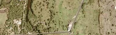
1 Chapter 1: Project Description 1.1 Project Location The proposed undertaking consists in the subdivision of the project site covering an extent of ha into 364 plots (362 residential and 2 recreational/educational/commercial plots). The proposed development is found at Petite Riviere Noire along Black River Savanne Coast Road. The project site stretches some 1700 metres inland and has a mean width of approximately 1200 metres. The proposed site adjoins existing built up areas and morcellement Les Multipliants. The proposed development will consist of the following main features: Large residential plots Services including water, electricity, telephone etc Green spaces and recreational areas 6.00 m wide roads with a minimum of 2.00m reserves The site offers a panoramic view of the mountains towards the east and a spectacular sight of the ocean when looking towards the west and the south-westerly direction. Due to its beautiful scenic qualities and pleasant relaxing environment, the site lends itself naturally to a high quality low density development with beautiful views to the mountains and the ocean. A key feature of the development would be its exclusivity, isolation and tranquility. The site is currently used as hunting grounds and is predominantly covered by pastures. Some mature trees as well as shrubs and bushes are also present on the site under consideration. A context plan has been attached at Figure 1.1 showing the proposed undertaking and surrounding developments. A plan of the proposed morcellement layout is attached at Figure Project Initiator The project site belongs to Société de Palmyre according to title deed transcribed in the Mortgage Office in T.V 589 No 97 and as evidenced by the notary s certificate attached at Annex A. Whilst the site owned by Société de Palmyre covers a total extent of 1210 Arpents, the promoter intends to implement a morcellement on ha only. The site belonging to Société de Palmyre has been predominantly used as hunting grounds and in line with Société de Palmyre s policy of diversification; the promoter intends to implement a unique morcellement with extensive greenspaces and state of the art amenities. 1
2
3
4 For the implementation of the project, Société de Palmyre has sought consultancy services from professionals of the construction industry including engineers, surveyors and planners. 1.3 The project Team Société de Palmyre will be represented by Mr Denis Hardy, manager for the purpose of the EIA. The registered address of the Société de Palmyre is: Société de Palmyre Petite Riviere Noire Tel: (+230) Fax: (+230) Correspondences and queries regarding the present EIA report should be forwarded to the following address: Mr Krishna Dwarka 14 Avenue des longaniers Quatre Bornes Tel: (+230) Mobile: (+230) Fax: (+230) To ensure the successful completion of the proposed residential development, the promoter will be assisted by a team of professionals operating in the following fields: construction, geotechnics, land surveying, planning, civil and structural engineering Project Management The project management services have been entrusted to NOUYA Investments Ltd and KDA Geosystems Ltd of 3 rd Floor, Labama House, Sir William Newton street, Port Louis, who have previously undertaken projects of similar nature. 2
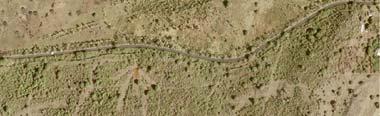
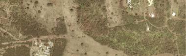
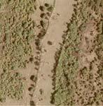
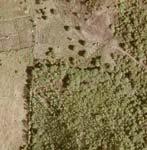
5 1.3.2 Civil and Structural Engineering For the purpose of the EIA including completion of the Engineering report and associated preliminary designs as required by the EIA guideline for proposed residential morcellement projects (2004), the services of Mr Selven Perienen, registered engineer of KASELOR Ltd, 19 Charles de Gaulle Street, Vandermeersch, Rose Hill have been retained Land Surveying The Land surveying services will be provided by KRISHNA DWARKA ASSOCIATES LTD of Office No 24, Stratton Court, Poudriere Street, Port-Louis, Mauritius, and include topographical maps in compliance with Clause 18 (1) (c) (ii) of EPA The proposed morcellement layout meets the general planning policy guidelines in force on the island Planning Planning consultancy services will be provided by Eric Chavoix Architect Ltd holding office at 34, JF Kennedy Street, Floreal. The proposed undertaking has been designed taking into consideration the natural terrain topography while respecting the natural setting of the site Construction and Civil works The civil works including road construction, water reticulation network, storm water drainage network etc will be performed once all necessary permits are gathered and the tender exercise performed. 1.4 Existing Land Use and Design Concept The project site is predominantly covered with pastures and some mature trees as well as areas covered by shrubs and bushes as illustrated in Figure The implementation of the project will take into consideration the location of mature trees. The site is not located within an environmentally sensitive zone but is rather a prime site used seasonally for deer hunting. A monkey breeding compound currently present on site will be moved to Bioculture at Riviere des Anguilles prior to beginning of works. The proposed site for development is crossed by the Petite Riviere Noire rivulet and appropriate buffers will be provided from the watercourses as stipulated by the Forest and Reserves Act. 3

.")

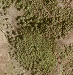
6 Figure 1.4.1: Site covered by shrubs and bushes Figure 1.4.2: Maintaining the natural environment The proposed development will aim at being the least intrusive as possible by generally blending landscaping and architecture to achieve a consistent, unified and unique project character. In terms of thematic design, the use of pebbles and local trees will be used to provide both a sense of enclosure and integration with the existing landscape (see Figure 1.4.2). Planting will also be used to screen substations and other small buildings used by the service providers. High quality materials and furniture, road, footpath and open space surfaces, shade structures, fencing, walls, lighting, bollards and rails will add up to the quality of development (refer to figure 1.4.3). The impact of the street infrastructure offers a clear overview of the quality of a development and may influence upon the overall impression of a project. Much care and attention will therefore be devoted to common areas and the overall appeal of the project. 4


7 Prior to the reconfiguration of the landscape, Société de Palmyre intends to set up a plant nursery to cater for the relocation of mature trees. The latter shall temporarily be fostered in the nursery until the end of the infrastructural works, after which the plants shall be moved from the nursery back into their initial environment. Lighting will be chosen to emphasise moods, themes and create a relaxed atmosphere. Light intrusion and glare can obscure what vision is available. Care is therefore required to ensure the minimum lighting for safety purposes. Light fixtures will be close to the ground to minimise eye level glare. Signage will not dominate or block views and will be effective and simple. Easy to read design will be used and the chosen materials and colours will blend in with the natural setting. Outdoor displays will be a good way to introduce the visitor to the local flora in the area. Figure 1.4.3: Street furniture 1.5 Site Zoning The proposed site for development borders the growth zone as identified by the Development Management Map of the Black River Outline Planning Scheme and adjoins the residential morcellement, Les Multipliants. Owing to the site s potential and in line with a number of policies from the Outline Scheme, the site lends itself to an exclusive residential development. In fact the Outline Schemes make it clear that a new approach should be adopted with emphasis on facilitating rather than restricting development. In particular Policies SD3, SD5, CDT3 and EC5 of the approved Outline Planning Scheme for Black River District Council will apply to the proposed development. Figure (part of the Development Management Map) shows the site earmarked for development in relation to the settlement boundaries and closest built up areas. The site is zoned as mineral resource and mountain slope. However the following policies of the Black River Outline Planning Scheme are relevant to the proposed development: 5

8
9 Policy SD 3 states: Development on the Edge of the Settlement Boundaries There should be a general presumption in favour of development on the edge of but outside defined settlement boundaries providing such development proposals are aimed at: consolidating gaps in an otherwise built up area or in the case of infilling of development where no strategic gap between settlements is proposed, or where land suitable for agriculture has been predetermined to be surplus to future long-term agricultural requirements by the owner(s) of such land, which could otherwise be developed more efficiently than a similar-sized development outside settlement boundaries and which includes uses such as social facilities, and which are capable of connection to existing utility supplies and transport networks which can be connected without unacceptable public expenses. Policy SD 5 states: Design Quality and Sustainable Development New development should conserve and enhance the character and attractiveness of the District so as to foster desirable and accessible living and working areas that provide an improving quality of living. Proposed development should be expected to conform to national Planning Policy Guidance (PPG) on Design Quality of Hotels and Integrated Resorts Development. For all development, relevant design considerations should include: Ensuring an appropriate standard of design including density, height, bulk and scale and improving areas of poor quality environment; Preserving and enhancing historic buildings and townscape and maintaining and strengthening local distinctiveness and sense of place; Protecting and enhancing urban open space green wedges, areas of landscape significance, environmentally sensitive areas and land/water interface areas. Redeveloping vacant and under-used sites and optimizing the use of previously developed built-up areas. 6
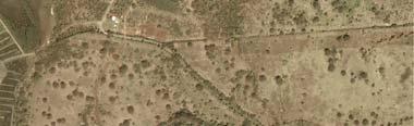
10 Policy EC5 states: Building on Hill Slopes On moderately sloping to steep slopes, there should be a general presumption against forms of development unless: It is designed so as not to reduce nor scar the natural landscape qualities of the hill slopes It does not disturb the natural slope stability It is sited and designed in sympathy rather than dominating the natural character of the hill slopes Mineral Resources Zoning Part of the site earmarked for development is zoned as mineral resources according to the Development Management Map of the Black River Outline Planning Scheme. The area zoned as mineral resources is hatched red on Figure The satellite imagery also shows a 1km buffer from adjacent residential built up areas Mineral Resources Zoning Origin In 2004, SMEC International Pty. Ltd from Australia was commissioned to undertake a Detailed GIS Study for the Estimation of Rock Reserves in Mauritius by the Ministry of Environment. The purpose of the exercise was to determine areas where rock quarrying could eventually be sustainable. While six priority sites were identified following in situ tests namely: St Julien, Cottage, Curepipe Point, Salazie, Belle Rose Clemencia and Mont Choisy, other sites were earmarked based on desktop studies involving use of satellite imagery, aerial photography and Geographic Information System (GIS) studies. In fact, SMEC International Pty. Ltd highlights the limitations of the study and states in the report submitted to the Ministry of Environment: As the extension of built-up areas is of major importance to this project, nonavailability of up-to-date data posed serious problems. Some corrective measures were taken through the incorporation of information on recent Morcellement Sites where critical but this exercise proved difficult as the data was only available at a late stage and was incomplete. 7


11
12 and While many of these errors or edits were not critical to the outcomes of this project, some, such as missing built-up areas were crucial and impacted on buffer zones created around residential areas. Part of the site earmarked for development at Petite Riviere Noire was selected for mineral zoning following such approximate desktop studies. Using the desktop study involved a high degree of uncertainty for the following reasons: - The buffer zone of 1km from sensitive areas including schools and residential areas was not respected. This is in contradiction with policy MR1 of the Black River Outline Planning Scheme - The area earmarked as mineral resources as shown of Figure is opposite of a site defined as scenic landscape area - Surface and groundwater may be affected / polluted given the proximity of the area earmarked as mineral resources to the high water mark. - Soil and geological aspects have not been given due consideration as highlighted in the report undertaken by Water Research Co Ltd - Noise and blasting is likely to have adverse effect on population living in close vicinity of the site earmarked for rock quarrying - Traffic impacts are likely to be significant - Public health will be affected. In fact the Forces vives of Grand Riviere Noire and Petite Riviere Noire have protested against the implementation of a rock quarry at Petite Riviere Noire. A copy of the protest is attached at Annex B. - The implementation of a rock quarry on the site earmarked for development will scar the natural setting given the land profile. A typical example of scarring of mountain relief is the Candos Hill in Quatre Bornes. Figure shows a typical view which would be seen from the beach should rock quarrying be undertaken on the site. It should also be noted that Government approved schemes for hotels and IRS developments are found opposite (some 50 metres) of the site earmarked as mineral resources. 8

13
 1.5.1.2 Appeal against Mineral Resources Zoning In light of the above and following the Notice of Deposit of proposed modifications to the")
14 Figure : Scarring effects of rock quarrying (Candos Hillside) Appeal against Mineral Resources Zoning In light of the above and following the Notice of Deposit of proposed modifications to the Black River District Council Outlline Scheme as published in General Notice No 896 of 2009 in the Government Gazette on 25 April 2009, Société de Palmyre has made representation against zoning of its land as mineral resources to the Town and Country Planning Board (TCPB) and requested instead re-zoning of the site for 9
15 residential/commercial purposes. Furthermore in order to carry out an independent assessment of the quarry potential of the area earmarked as mineral resources, Société de Palmyre has appointed Water Research Co Ltd. Water Research Co Ltd has drilled six boreholes in the zone earmarked for mineral resources and tests carried out by the University of Mauritius and the Ministry of Public Infrastructure. The report confirms the site s inadequacy for rock quarrying a fact that would have been identified earlier should in-situ tests have been undertaken instead of a desktop study. The findings of the report by Water Research Co Ltd are summarized below: - The encountered strata consist 92% of weathered basalt products (from Residual Soils to moderately weathered Basalts) that are considered inadequate for use as quarry. - The minimum overburden thickness on the site is 11.0 m, which is much higher than what is usually considered (6m) as economic for quarry development. - most of the encountered strata were vesicular, thus further reducing their possible use as quarry rock - A rough rule establishes that rock with water absorption of less than 2% will usually produce a good quality aggregate and that those exceeding 4% may not. Three tests were carried out indicating an average value of 6.4%, much higher than the acceptable range - UCS results between 21.9MPa and 60.4Mpa for the three tested samples may indicate that the rock is not strong enough for quarry. - The Magnesium Sulphate Soundness Value (MSSV) for the samples vary between 53.5% and 63.1% with an average of 59.8%. These values are considered low for a good quality aggregate. - Values varying between 30.3% and 36.1%, with an average of 33% indicate that the aggregate can be used for concrete but not for wearing surfaces, therefore limiting the use of the quarry material. - A copy of the technical report submitted is attached at Annex D. Fully aware of the site s potential as well as constraints, the project promoters have conducted relevant technical studies to ensure construction is feasible. Furthermore the proposed development will be governed by a strict cahier de charge whereby the general rule of only one construction per plot of an average of 60 perches will be applied. From the above, it is clear that the proposed site for development not only complies with the 10
16 development strategy of the District but will also assist in stimulating the local economy and contribute to a sustainable future for the local community. Furthermore, the proposed development will attract inward investment and trigger regeneration of the area. The above design philosophy was communicated to the Black River District Council in the form of a development brief. The Black River District Council has provided necessary approval for the proposed development. Copies of correspondence from the Black River District Council are attached at Annex B. The Ministry of Agro Industry has also granted necessary land conversion permit (LCP) for the whole site belonging to Société de Palmyre. A copy of the land conversion permit is attached Annex B. 11
5 PLANNING ANALYSIS 5.1 THE SITE AND ITS DEVELOPMENT CONTEXT
 5 PLANNING ANALYSIS 5.1 THE SITE AND ITS DEVELOPMENT CONTEXT The Azuri IRS River Villa Complex site is situated on the western margin of Azuri Phase 1, inland. The whole site borders Rivière du Rempart
2. PROJECT SITE LOCATION & DESCRIPTION
 2. PROJECT SITE LOCATION & DESCRIPTION 2.1 PROJECT LOCATION/SURROUNDING The subject site consists of a plot of land of 31Ha 1,478.83 m 2 (73A79P 49 /100) at Mont Piton, in the region of The Mount, in the
2. PROJECT SITE LOCATION & DESCRIPTION
 2. PROJECT SITE LOCATION & DESCRIPTION 2.1 PROJECT LOCATION/SURROUNDING The subject site consists of a plot of land of 9ha3,957m 2 at Sainte Croix in the district of Port-Louis and is surrounded by land
PLANNING POLICY GUIDANCE 5
 Mauritius PLANNING POLICY GUIDANCE 5 Port Louis Pailles Reduit Triangle Ebene / Trianon Phoenix / Sodnac La Vigie Rose Belle Development along Motorway April 2008 Ministry of Housing and Lands Development
4 RESIDENTIAL ZONE. 4.1 Background
 4 RESIDENTIAL ZONE 4.1 Background The residential areas within the City are characterised by mainly lowrise dwellings sited on individual allotments. Past architectural styles, settlement patterns and
RURAL ZONE - POLICY. Rural Zone Policy. Issue: Rural Environment. Ruapehu District Plan Page 1 of 8
 Rural Zone Policy RU2 RURAL ZONE - POLICY RU2.1 Introduction The natural resources of the rural environment in the Ruapehu District provide the basis for the existing and potential character, intensity
64 Mineral Extraction Area Rules
 64 Mineral Extraction Area Rules 64.1 Introduction For the purposes of this Chapter: Active Area, in relation to a Mineral Extraction Area (MEA), is that part of the Mineral Extraction Area which is owned
4. INDUSTRIAL 53 CASTLE ROCK DESIGN
 4. INDUSTRIAL 53 CASTLE ROCK DESIGN CASTLE ROCK DESIGN 54 4. INDUSTRIAL Overview Well-designed and attractive industrial centers are the product of blending economic realities with both functional and
I539. Smales 2 Precinct
 I539. Smales 2 Precinct I539.1. Precinct Description The Smales 2 Precinct applies to a 4.8 hectare block of land located on the southern side of Northcote Road and fronting Lake Pupuke, Takapuna. The
2A District-wide Policies
 2A Introduction This Chapter contains policies which are relevant to subdivision, use and development activities occurring across all zones and areas of the District. The policies in this Chapter implement
Derry City and Strabane District Council Planning Committee Report
 Derry City and Strabane District Council Planning Committee Report COMMITTEE DATE: 20.12.2017 APPLICATION No: APPLICATION TYPE: PROPOSAL: LOCATION: APPLICANT: AGENT: A/2014/0495/F Full Construction of
Schedule of Planning Applications Committee Date: 23 May Reference: 06/17/0726/F Parish: Hemsby Officer: Mr J Beck Expiry Date:
 Schedule of Planning Applications Committee Date: 23 May 2018 Reference: 06/17/0726/F Parish: Hemsby Officer: Mr J Beck Expiry Date: 22-05-2018 Applicant: Proposal: Site: Mr Gillett Change of use to the
7.2.9 Eudlo local plan code
 7.2.9 local plan code 7.2.9.1 Application (1) This code applies to assessable development:- (a) within the local plan area as shown on Map ZM29 contained within Schedule 2 (Mapping); and (b) identified
Implementing sustainable water strategy through development industry engagement
 Implementing sustainable water strategy through development industry engagement Ian Director, Organica Engineering, Melbourne, Australia E-mail: iadams@organicaeng.com.au Edward Cotter Sustainability Leader,
GREENFORD HALL & ADJOINING LAND
 GREENFORD HALL & ADJOINING LAND CONTENTS 1. Introduction 1. Introduction 2. Urban Context 2.1 The Site and Surroundings 2.2 Urban Context Map 2.3 Access and Movement 3. Planning Context 3.1 Planning History
Applicant Name Phone / Fax / Address City State Zip Code . Property Owner Phone / Fax / Address City State Zip Code
 Master Development Plan Application Community Development Department City of Redmond 411 SW 9 th Street Redmond, Oregon 97756 541-923-7721 541-548-0706 FAX Master Development Plan Fee $38,862.52 File Number
SCHEDULE THREE TO THE DEVELOPMENT PLAN OVERLAY EASTERN GOLF COURSE KEY REDEVELOPMENT SITE
 DD/MM/YY SCHEDULE THREE TO THE DEVELOPMENT PLAN OVERLAY Shown on the planning scheme map as DPO3 EASTERN GOLF COURSE KEY REDEVELOPMENT SITE 1.0 A permit may be granted before a development plan has been
About 10% of the Borough's population lives in the seven rural parishes. Population figures from the 1991 census are given below:-
 8. THE DISTRICT VILLAGES 8.1 Population About 10% of the Borough's population lives in the seven rural parishes. Population figures from the 1991 census are given below:- Village No. of Persons Cottingham
INCREMENTAL CHANGE AREA REVIEW March 2015 Page 1
 INCREMENTAL CHANGE AREA REVIEW March 2015 Page 1 Table of Contents Introduction... 3 Background to Review... 3 Comparison of the Schedules to the General Residential Zone... 7 Methodology... 7 Policy Context...
Derry City and Strabane District Council Planning Committee Report
 Derry City and Strabane District Council Planning Committee Report COMMITTEE DATE: 23 rd March 2016 APPLICATION No: APPLICATION TYPE: PROPOSAL: LOCATION: APPLICANT: LA11/2015/0395/F Residential Development
Case Officer: Sarah Kay File No: CHE/14/00515/REM Tel. No: (01246) Plot No: 2/6132 Ctte Date: 15 th September 2014 ITEM 1
 Plot No: 2/6132 Ctte Date: 15 th September 2014 ITEM 1") Case Officer: Sarah Kay File No: CHE/14/00515/REM Tel. No: (01246) 345786 Plot No: 2/6132 Ctte Date: 15 th September 2014 ITEM 1 APPROVAL OF RESERVED MATTERS FROM APPLICATION CHE/12/00234/OUT (1) LAYOUT,
Case Officer: Sarah Kay File No: CHE/14/00515/REM Tel. No: (01246) 345786 Plot No: 2/6132 Ctte Date: 15 th September 2014 ITEM 1 APPROVAL OF RESERVED MATTERS FROM APPLICATION CHE/12/00234/OUT (1) LAYOUT,
PLANNING FOR THE SUPPLY OF BUILDING AND ROOFING STONE The Planning Officers Society 2008
 PLANNING FOR THE SUPPLY OF BUILDING AND ROOFING STONE The Planning Officers Society 2008 Extraction of minerals, including building and roofing stone, from the land requires planning permission under the
City of Lafayette Study Session Staff Report Design Review Commission
 City of Lafayette Study Session Staff Report Design Review Commission Meeting Date: April 24, 2017 Staff: Payal Bhagat, Senior Planner Subject: HDP18-15 & HDP31-15 Ramesh Patel & Melcor Development (Owners),
City of Lafayette Study Session Staff Report Design Review Commission
 ++ City of Lafayette Study Session Staff Report Design Review Commission Meeting Date: January 08, 2018 Staff: Subject: Chris Juram, Planning Technician SS12-17 Miramar Homebuilders, R-20 Zoning: Request
K. SMART ASSOCIATES LIMITED
 Planning Justification Report Zoning By-Law Amendment 185 King Street North Waterloo, Ontario April 7th, 2017 Project Reference Number 16-245 K. SMART ASSOCIATES LIMITED CONSULTING ENGINEERS AND PLANNERS
A Growing Community Rural Settlement Areas
 Town of Huntsville Official Plan Review - POLICY BACKGROUND PAPER A Growing Community Rural Settlement Areas BACKGROUND: In addition to the fully municipally-serviced Urban Settlement Area and the Hidden
Northern Territory Compact Urban Growth Policy
 Northern Territory Compact Urban Growth Policy A Reference Policy Document to clause 2.7 (Reference to Policy) of the NT Planning Scheme May 2015 Table of Contents 1 Policy Setting... 3 1.1 Context for
4.3 Dudley Area Plan. Introduction. History and Existing Character. Desired Future Character for Dudley
 4.3 Dudley Area Plan Introduction The suburb of Dudley has developed as a result of various circumstances including its topography, history and mineral resources. Dudley development has been identified
Site Assessment Technical Document Appendix A: Glossary
 Central Bedfordshire Council www.centralbedfordshire.gov.uk Site Assessment Technical Document Appendix A: Glossary July 2017 1.1.11-1 - ii Appendix A: Glossary Term Agricultural Land Classification AONB
Site Development Plan (SDP) Checklist
 Checklist") Development Services Department 100 N. Wilcox Street, Castle Rock CO 80104 303-660-1393 or CRGov.com Site Development Plan (SDP) Checklist A complete Site Development Plan (SDP) submittal will contain
Development Services Department 100 N. Wilcox Street, Castle Rock CO 80104 303-660-1393 or CRGov.com Site Development Plan (SDP) Checklist A complete Site Development Plan (SDP) submittal will contain
East Panorama Ridge Concept Plan Amendment
 Page 1 of 7 L003 : East Panorama Ridge Concept Plan Amendment Corporate NO: L003 Report COUNCIL DATE: March 4, 2002 REGULAR COUNCIL LAND USE TO: Mayor & Council DATE: February 27, 2002 FROM: General Manager,
49 Broughton Avenue London N3 3EN
 Location 49 Broughton Avenue London N3 3EN Reference: 17/3448/RCU Received: 30th May 2017 Accepted: 1st June 2017 Ward: Finchley Church End Expiry 27th July 2017 Applicant: Mr P Atwal Proposal: Erection
City of Lafayette Staff Report
 City of Lafayette Staff Report For: By: Design Review Commission Greg Wolff, Senior Planner Meeting Date: April 27, 2015 Subject: SS03-15 Gundi & Peter Younger (Owners), R-40 Zoning: Request for a Study
Perth and Kinross Council Development Management Committee 8 June Pre-Application Report by Development Quality Manager
 Perth and Kinross Council Development Management Committee 8 June 2016 5(3)(i) 16/259 Pre-Application Report by Development Quality Manager Residential development at St Martins Road, Land 120 metres West
Design Guidance. Introduction, Approach and Design Principles. Mauritius. November Ministry of Housing and Lands. .. a
 sig evelo r D Mauritius s. Utilities.. Individu a s. er itects.to ls chpers.po e Public. T. h rban D Sc U e me Promot e h ners. A Design Guidance o.h Planne rs n w iticians r l useholde National Development
4 Residential and Urban Living Zones
 4 Residential and Urban Living Zones Refer to Chapters 11 to 20 for additional rules that may apply to these zones. 4.1 OBJECTIVES AND POLICIES Objective Res1 Policy 1 Policy 2 Policy 3 Policy 4 Policy
Appendix I. Checklists
 Appendix I Checklists Town of Greenwich Drainage Manual Department of Public Works - Engineering Division Town Hall - 101 Field Point Road, Greenwich, CT 06836-2540 Phone 203-622-7767 - Fax 203-622-7747
7. The Landscape. 7.1 Introduction. Environmental Impact Statement (EIS) Scoping Report
 Scoping Report") 7. The Landscape 7.1 Introduction The purpose of this section of the EIS Scoping Report is to describe the scope of work and methods to be applied in the identification and assessment of landscape and
7. The Landscape 7.1 Introduction The purpose of this section of the EIS Scoping Report is to describe the scope of work and methods to be applied in the identification and assessment of landscape and
RESIDENTIAL ACTIVITY PERFORMANCE STANDARDS
 Preferred Options Consultation Q&A Sheet RESIDENTIAL ACTIVITY PERFORMANCE STANDARDS What are the key goals for managing the design of residential buildings in the Second Generation Plan (2GP)? The key
Development Permit Application Form. Property Owner Information as Registered on Legal Title Property Owner Name: Phone:
 Development Application Requirements 1 1926 Tsawwassen Drive Tel: 604-943-2112 Tsawwassen, BC V4M 4G2 www.tsawwassenfirstnation.com Canada Development Permit Application Form Name of Applicant: Address:
Danvers High Street I-1 District Study
 Danvers High Street I-1 District Study Presentation of Final Recommendations Planning Board Presentation June 26 th, 2018 1 Introductions Metropolitan Area Planning Council Sam Cleaves AICP, Principal
Example Codes. City of Brentwood, Tennessee Brentwood Hillside Protection Overlay District Summary
 Example Codes City of Brentwood, Tennessee Brentwood Hillside Protection Overlay District Summary The City of Brentwood in July 2007 adopted a Hillside Protection (HP) Overlay District to address the problems
Ipswich Issues and Options for the Ipswich Local Plan Review, August 2017, Public Consultation
 Ipswich Issues and Options for the Ipswich Local Plan Review, August 2017, Public Consultation Having reviewed the issues and options documents, the Society has made the following response: Part 1 Strategic
SECTION ONE North East Industrial Zone Design Guide Palmerston North City Council June 2004
 SECTION ONE North East Industrial Zone Design Guide Palmerston North City Council June 2004 young heart easy living 1 Preface Industrial areas are a very important component of the economic well-being
6.0 Land Use Policies for Rural Settlements. 6.1 Rural Settlement Strategy
 6.0 Land Use Policies for Rural Settlements 6.1 Rural Settlement Strategy INTRODUCTION AMENDMENT NO. 131 PURPOSE Designated rural settlements comprise Rural Clusters, Villages and Serviced Villages as
Chapter 5 Urban Design and Public Realm
 5.1 Introduction Public realm is all areas of the urban fabric to which the public have access. It is where physical interaction takes place between people. It therefore, includes buildings and their design,
Overview Report. Proposed Development
 Overview Report Proposed Development the construction of a 1km cycle/pedestrian trail including a new footbridge, new car park and entrance road at Drumshanbo Lock and a new pedestrian/cycle road crossing,
DEVELOPMENT MANAGEMENT REPORT
 ITEM A08-1 DEVELOPMENT MANAGEMENT REPORT TO: BY: DATE: DEVELOPMENT: SITE: WARD: APPLICATION: APPLICANT: Development Management Committee Development Manager Proposed live/work unit in connection with existing
Report Author/Case Officer: Paul Keen Senior Planning Officer (Dev Control) Contact Details:
 Contact Details:") APP 03 Application Number: 17/02060/FUL Description A full planning application for the demolition of an existing bungalow (C3 use class) and associated out buildings and the erection of two, two storey
APP 03 Application Number: 17/02060/FUL Description A full planning application for the demolition of an existing bungalow (C3 use class) and associated out buildings and the erection of two, two storey
University Park, Worcester Non Technical Summary December 2011
 University Park, Worcester Non Technical Summary December 2011 Introduction UW Wrenbridge LLP, a Joint Venture Company of the University of Worcester and Wrenbridge Land Ltd (the Applicants ) intend to
Form to Submit Land for Residential Evidence Gathering Shepway Strategic Housing Land Availability Assessment (SHLAA) Partial Review
 Partial Review") Form to Submit Land for Residential Evidence Gathering Shepway Strategic Housing Land Availability Assessment (SHLAA) Partial Review All organisations and individuals who wish to put forward land for consideration
Form to Submit Land for Residential Evidence Gathering Shepway Strategic Housing Land Availability Assessment (SHLAA) Partial Review All organisations and individuals who wish to put forward land for consideration
Longbridge Town Centre Phase 2 Planning Application
 Longbridge Town Centre Phase 2 Planning Application Non-Technical Summary of the Environmental Statement December 2013 Introduction A full application for Planning Permission has been submitted to Birmingham
Rural (Urban Expansion) Environment
 Environment") RUEE.1 Rural (Urban Expansion) Environment Subsequent to the receipt of appeals, a 'marked up' version of the Proposed District Plan was prepared. The provisions of the Proposed Version of the Plan subject
RUEE.1 Rural (Urban Expansion) Environment Subsequent to the receipt of appeals, a 'marked up' version of the Proposed District Plan was prepared. The provisions of the Proposed Version of the Plan subject
6 PORT SYDNEY SETTLEMENT AREA
 Section 6 Port Sydney Page 61 6 PORT SYDNEY SETTLEMENT AREA 6.1 Basis and Principles Village of Port Sydney Waterfront Community Existing Services 6.1.1 Port Sydney is an historic settlement that has developed
OKEFORD FITZPAINE NEIGHBOURHOOD PLAN
 OKEFORD FITZPAINE NEIGHBOURHOOD PLAN Dear Parishioner, The Neighbourhood Plan Project Team have prepared this leaflet to summarise the full Neighbourhood Plan document. It provides a summary of the Vision,
CORNUBIA RETAIL PARK- PLANNING REPORT REVERT 3
 CORNUBIA RETAIL PARK- PLANNING REPORT 19.04.2013 REVERT 3 1 FOR: BY: 28 DEVONSHIRE AVENUE GLENWOOD DURBAN 4001 P.O. BOX 17390 CONGELLA 4013 T +27 31 202 9550 F +27 31 202 9551 1st FLOOR THE MEDIA MILL
Nelson Residential Street Frontage Guideline
 DRAFT 22-06-2012 Nelson Residential Street Frontage Guideline June 2012 1317273 Contents and purpose Residential s are important Residential s are much more than corridors which move traffic. Streets allow
A. General Plan: Land Use, Growth Management and the Built Environment Element. d. Use visually unobtrusive building materials.
 Chapter 16 Hillside Protection 16.010 Purpose This chapter establishes the regulations for development and alteration of properties in hillside and ridgeline areas in order to preserve the essential scenic
CITY OF KEIZER MASTER PLAN APPLICATION & INFORMATION SHEET
 CITY OF KEIZER MASTER PLAN APPLICATION & INFORMATION SHEET PRE-APPLICATION CONFERENCE Prior to the actual filing of a Master Plan application, it is strongly recommended that the applicant contact Planning
Derry City and Strabane District Council Planning Committee Report
 Derry City and Strabane District Council Planning Committee Report COMMITTEE DATE: 29 th November 2017 APPLICATION No: APPLICATION TYPE: PROPOSAL: LOCATION: APPLICANT: AGENT: LA11/2016/0854/O Outline Shared
REMARKABLES PARK ZONE
 .10 Remarkables Park Zone.10.1 Resources, Activities and Values The Remarkables Park Area comprises approximately 150 hectares of perimeter urban land in the vicinity of Frankton and occupies a strategic
35. Gorteen Mini-Plan
 35. Gorteen Mini-Plan 35. Gorteen Mini-Plan Community facilities Community facilities in Gorteen consist of a crèche, community centre, sports field, church, burial ground and health centre. The former
an Inspector appointed by the Secretary of State for Communities and Local Government
 Appeal Decision Site visit made on 6 November 2017 by Rachel Walmsley BSc MSc MA MRTPI an Inspector appointed by the Secretary of State for Communities and Local Government Decision date: 19 th January
Section 3b: Objectives and Policies Rural Environment Updated 19 November 2010
 Page 1 of Section 3b 3b RURAL ENVIRONMENT 3b.1 Introduction The Rural Environment comprises all the land outside of the Residential, Town Centre and Industrial Environments. Most land within the District
APPENDIX K WINDSOR OFFICIAL PLAN
 CEAA ENVIRONMENTAL ENVIRONMENTAL IMPACT ASSESSMENT AMBASSADOR BRIDGE ENHANCEMENT PROJECT Replacement Span and Plaza Expansion APPENDIX K WINDSOR OFFICIAL PLAN Avalon Consulting Professionals of Ontario,
22.15 OUTDOOR ADVERTISING SIGNAGE POLICY
 22.15 OUTDOOR ADVERTISING SIGNAGE POLICY This policy applies to all land where a planning permit is required to construct or display a sign under the provisions of the Kingston Planning Scheme. 22.15-1
Page 1 of 19 URBAN DESIGN FRAMEWORK FOR BOLTON STREET WATERFORD
 Page 1 of 19 URBAN DESIGN FRAMEWORK FOR BOLTON STREET WATERFORD 1.0 Introduction: The relocation of the City Council stores and depot from Bolton Street creates an exciting opportunity for development
Rannoch 132 / 33 kv Substation Extension
 Who we are Scottish and Southern Energy Power Distribution is part of the SSE plc group of companies. We own, maintain and invest in the networks in the north of Scotland the electricity transmission network
Cotswolds AONB Landscape Strategy and Guidelines. June 2016
 Cotswolds AONB Landscape Strategy and Guidelines June 2016 Cotswolds AONB Landscape Strategy and Guidelines Introduction The evolution of the landscape of the Cotswolds AONB is a result of the interaction
H7 Open Space zones. (a) provide for the needs of the wider community as well as the needs of the community in which they are located;
 provide for the needs of the wider community as well as the needs of the community in which they are located;") H7. Open Space zones H7.1. Background The majority of land zoned as open space is vested in the Council or is owned by the Crown. However some areas zoned open space are privately owned. While the open
H7. Open Space zones H7.1. Background The majority of land zoned as open space is vested in the Council or is owned by the Crown. However some areas zoned open space are privately owned. While the open
Route Alignment Options Summary Report
 Brechfa Forest Connection Project February 2014 Summary report 1. RSK Environment Ltd (RSK) was commissioned by Western Power Distribution (WPD) to provide environmental consultancy support services for
Site Design (Table 2) Fact Sheet & Focus Questions:
 Fact Sheet & Focus Questions:") Site Design (Table 2) Fact Sheet & Focus Questions: BACKGROUND WHAT IS SITE DESIGN? Site design refers to the arrangement of buildings and open spaces on adjacent sites to maximize the shared benefits
Site Design (Table 2) Fact Sheet & Focus Questions: BACKGROUND WHAT IS SITE DESIGN? Site design refers to the arrangement of buildings and open spaces on adjacent sites to maximize the shared benefits
Housing Development at Balloonagh Tralee Co Kerry
 Design Statement Housing Development at Balloonagh Tralee Co Kerry Area of site 10,400m2 24 houses-12no 3 bed, 12no 2 bed and 4 single bed apartments total residential area of 2411m2 Open space provided
CITY OF EDMONTON FIRST PLACE PROGRAM
 CITY OF EDMONTON FIRST PLACE PROGRAM Kirkness (3015 151 Ave NW) Consultation Meeting #2 June 23, 2015 Clareview Community Rec Centre (Rm MP #2) 3804 139 Ave NW AGENDA 1. Opening comments. 2. Firm Up Site
City of Farmington. Downtown Plan. Amendment to the 1998 Master Plan Adopted October 11, 2004
 City of Farmington Amendment to the 1998 Master Plan Adopted October 11, 2004 Introduction Planning Background 1 Scope and Components of the Plan Amendment 2 Concept Introduction 3 Plan Concepts 3 Conceptual
SPG 1. * the northern and western sections which are open fields used for pasture and grazing;
 SPG 1 1.0 INTRODUCTION This development brief is based on the allocation of the Priors Hall site for employment and countryside recreational purposes in the Corby Borough Local Plan. The brief is intended
Living in Albemarle County s Urban Places
 Living in Albemarle County s Urban Places ALBEMARLE COUNTY, VIRGINIA A Closer Look at Albemarle s Approach to Managing Growth and Creating Quality Urban Environments www.albemarle.org Page 2 Living in
Urban Design Guidelines
 Urban Design Guidelines These Urban Design Guidelines comprise the Key Design Objectives below, the Roads Design Guidelines overleaf and Neighbourhood Framework Plans. Together with Section 3: Urban Design
STATEMENT OF OBJECTION TO THE PROPOSED DEVELOPMENT OF LAND AT CHURCH CLIFF DRIVE FILEY
 STATEMENT OF OBJECTION TO THE PROPOSED DEVELOPMENT OF LAND AT CHURCH CLIFF DRIVE FILEY You will be aware that Scarborough borough council have adopted a new local plan that includes land at Church Cliff
Planning and Public Consultation Process for the Preparation of a General Land Use Plan for South Port Kells TERMS OF REFERENCE
 APPENDIX "B" Planning and Public Consultation Process for the Preparation of a General Land Use Plan for South Port Kells TERMS OF REFERENCE PURPOSE South Port Kells is located in the northeastern quadrant
PUBLIC NOTICE UNDER CLAUSE 5 OF SCHEDULE 1 OF THE RESOURCE MANAGEMENT ACT 1991 PLAN CHANGE 12 TO THE OPERATIVE CITY OF NAPIER DISTRICT PLAN
 PUBLIC NOTICE UNDER CLAUSE 5 OF SCHEDULE 1 OF THE RESOURCE MANAGEMENT ACT 1991 PLAN CHANGE 12 TO THE OPERATIVE CITY OF NAPIER DISTRICT PLAN Public notice is given in accordance with Clause 5 of Schedule
14.5 HOPEFIELD: (REFER PLAN 39 AND PLAN 40)
") URBAN DYNAMICS WESTERN CAPE INC. 248 14.5 HOPEFIELD: (REFER PLAN 39 AND PLAN 40) FIGURE 83: LOCALITY - HOPEFIELD Within the context of the Saldanha Bay Municipal area, Hopefield, an historical agricultural
URBAN DYNAMICS WESTERN CAPE INC. 248 14.5 HOPEFIELD: (REFER PLAN 39 AND PLAN 40) FIGURE 83: LOCALITY - HOPEFIELD Within the context of the Saldanha Bay Municipal area, Hopefield, an historical agricultural
PLANNING COMMITTEE. 14 October 2014
 AGENDA ITEM NO 8 PLANNING COMMITTEE 14 October 2014 APPLICATION NUMBER : CA//14/01744/FUL PROPOSAL : Extension and conversion of roof space of an existing detached bungalow together with enhanced parking
building with nature - a new benchmark for green infrastructure
 building with nature - a new benchmark for green infrastructure Danielle Sinnett, Gemma Jerome, Sarah Burgess, Nick Smith and Roger Mortlock outline the aims, development and proposed operation of Building
REZONING APPLICATION MPD SUPPLEMENT
 REZONING APPLICATION MPD SUPPLEMENT For Staff Use Only: DATE/TIMESTAMP: ZA# RECEIVED BY: The intent of the Master Planned District (MPD) designation is to allow flexibility in the design and construction
Planning and Regulatory Committee 20 May Applicant Local Councillor Purpose of Report
 Planning and Regulatory Committee 20 May 2014 7. APPLICATION FOR PLANNING PERMISSION FOR THE CARRYING-OUT OF DEVELOPMENT PURSUANT TO PLANNING PERMISSION REFERENCE NUMBER 603451 DATED 28 FEBRUARY 2007 WITHOUT
APPLICATION BRIEFING Prepared For: Submitted by: Date: Subject:
 Planning & Development APPLICATION BRIEFING Prepared For: Submitted by: Date: Subject: Planning Advisory Committee Jason Fox, Director of Planning & Development Development Agreement application by Godfrey
Planning & Development. Background. Subject Lands
 Planning & Development APPLICATION BRIEFING Prepared For: Planning Advisory Committee Submitted by: Jason Fox, Director of Planning & Development Date: Subject: Development Agreement Application by Brentwood
WINCHESTER TOWN 3.1 LOCATION, CHARACTERISTICS & SETTING
 WINCHESTER TOWN 3.1 LOCATION, CHARACTERISTICS & SETTING 3.1.1 The area referred to by the City Council, as Winchester Town, consists of the Winchester Wards plus the adjoining built up areas of Badger
KHARTOUM GARDEN CITY. Dietmar Kamphans
 KHARTOUM GARDEN CITY Dietmar Kamphans As most cities in the world have been set up at river banks and sea shores, even Khartoum is located at the confluence of the Blue and White Nile. Beside the regular
46 Burley Street, Leeds, LS3 1LB Retail Statement
 , LS3 1LB Retail Statement , LS3 1LB Retail Statement October 2014 Indigo Planning Indigo Planning Limited Toronto Square Leeds LS1 2HJ Tel: 0113 380 0270 Fax: 0113 380 0271 info@indigoplanning.com indigoplanning.com
UPPER GORDON ROAD TO CHURCH HILL, CAMBERLEY CONSERVATION AREA
 Introduction This leaflet explains the purpose of conservation areas and the implication of their designation for residents, property owners and the Council. It provides you with a plan of the area and
Next Steps / Development Process. Structure Plan. June submitted to City of Fremantle. Structure Plan. July supported for advertising
 overview What is today about? In July 0, the City of Fremantle resolved that the be advertised for public comment. Today is about: Understanding the history and context of the site Having your say on the
Site Location Plan. Land on the North West of Epsom Road Waddon Croydon. 1 : A4 September The. Waddon. Waddon.
 138 140 44.3m MP 11.5 El Sub Sta EPSOM ROAD 13 Bank 1 to 5 154 Trough 19to21 1 to 5 156 The Waddon (PH) 23 FB Waddon Station 45.0m Posts 29to31 1 to 9 Stafford Court 39 37 Meridian Court 10 43 to 45 1
Hockessin Community Redevelopment Plan
 Hockessin Community Redevelopment Plan 3.1 Introduction The Community Redevelopment Plan for the Village of Hockessin is the result of the people s vision for a distinct village center that serves as the
SUMMER VILLAGE OF SUNRISE BEACH
 SUMMER VILLAGE OF SUNRISE BEACH Municipal Development Plan Bylaw No. 132-13 ~ 2 ~ Summer Village of Sunrise Beach Municipal Development Plan 1 INTRODUCTION 1.1 SETTING The Summer Village of Sunrise Beach
National Conservation Council AGENDA
 2017-05-03 NCC GM Agenda v1 National Conservation Council Special General Meeting (National Trust Meeting Room Dart Park, Wednesday 3 rd May 3:30pm- 5pm) AGENDA 1. Call to Order a. Attendees, Apologies,
Welcome. Walk Around. Talk to Us. Write Down Your Comments
 Welcome This is an information meeting introducing the applications for proposed redevelopment of the Yorkdale Shopping Centre site at 3401 Dufferin Street and 1 Yorkdale Road over the next 20+ years,
PLANNING COMMITTEE DATE: 07/09/2015 REPORT OF THE SENIOR MANAGER PLANNING AND ENVIRONMENT SERVICE CAERNARFON. Number: 4
 Number: 4 Application Number: C15/0034/37/LL Date Registered: 21/05/2015 Application Type: Full - Planning Community: Llanaelhaearn Ward: Llanaelhaearn Proposal: Location: Summary of the Recommendation:
Chapter 2: OUTLINE PLANNING APPLICATION PROPOSALS. A New Garden Neighbourhood Matford Barton 17
 Chapter 2: OUTLINE PLANNING APPLICATION PROPOSALS A New Garden Neighbourhood Matford Barton 17 2.1. SUMMARY AND STATUS OF THE PROPOSALS 2.1.1. The parameter plans and associated wording in this chapter