ADDENDUM to the Route 29 Corridor Study
|
|
|
- Edwina Johnston
- 6 years ago
- Views:
Transcription
1 ADDENDUM to the Route 29 Corridor Study BACKGROUND The Route 29 Corridor Study (Study) was reviewed and accepted by Resolution of the Commonwealth Transportation Board (CTB) on December 17, However, the CTB expressed concern that the Study did not include specific recommendations on certain issues. The CTB Resolution stated that: this Board does not believe that the Study, and process by which it was developed, produced the template which the Board desires as a Blueprint for future planning for other Corridors of Statewide Significance... Based on their concerns, the CTB directed VDOT and DRPT to work with a CTB subcommittee to address certain issues. The CTB Resolution may be viewed at: n.pdf This Addendum to the Route 29 Corridor Study presents the work of the CTB Subcommittee in response to the CTB Directives in the Resolution of December 17, CTB DIRECTIVES The CTB Resolution of December 17, 2009, directed VDOT & DRPT to work with a Board Subcommittee on the following: 1. A process for studying Corridors of Statewide Significance (CoSS). 2. A prioritized list of intersections to be replaced by grade separated intersections or interchanges. 3. A plan to improve mobility/accessibility north of Charlottesville. 4. A plan to improve mobility/accessibility in the Gainesville, Haymarket, and Buckland area. 5. A plan to minimize the number of traffic control signals in the corridor. CTB SUBCOMMITTEE A CTB Subcommittee (Committee) was appointed by Secretary of Transportation on February 10, 2010, to oversee the additional work on the Route 29 Corridor. 1
2 The Committee developed the following documents to address the CTB s Directives. 1. A process for future studies on Route 29 and other Corridors of Statewide Significance (CoSS) was developed by the Committee and is included in this Addendum as Appendix 1. This Study process was recommended by the Committee and accepted by the CTB on May 19, The Corridor Study Process is shown in Section 1 of this Addendum and the CTB Resolution of acceptance may be viewed at: 2. A prioritized list of intersections based on safety and congestions concerns was compiled and is included in Section 2 of this Addendum. 3. A plan to improve mobility and accessibility north of Charlottesville must begin with dialog with the local leaders. The Committee recommended the initiation of cross-jurisdictional discussions with area leaders. These discussions will be led by a professional facilitator with experience in public dispute resolution. The Committee s recommendation is presented in Section 3 of this Addendum. 4. A plan for improving the mobility/accessibility in the Gainesville, Haymarket and Buckland region must result in a consensus on transportation improvement alternatives. Since there is disagreement on how to address the traffic congestion and safety in this area, any resolution must begin with discussions between local leaders. The Committee recommended cross jurisdictional discussions to begin informally to outline points of contention as well as points of agreement. These discussions should be led by a professional facilitator with experience in resolving public disputes. The Committee s recommendations are shown in Section 4 of this Addendum. 5. A plan/policy for minimizing the number on new traffic control signals on Route 29 and other Corridors of Statewide Significance (CoSS) must acknowledge that most traffic signals are installed to provide safe access for traffic generated by new developments. Safe access to future land development must be planned far in advance of the development proposals. Establishing the locations for access on the CoSS will ensure that the locality, developer and VDOT staff clearly understand how new developments can be served. In most cases, access can be provided without the addition of a traffic signal. The Committee s recommendation for planning and establishing the future access points is shown in Section 5 of this Addendum. 2
3 CTB SUBCOMMITTEE RECOMMENDATIONS SECTION 1 - A process for future studies on Route 29 and other Corridors of Statewide Significance (CoSS) INTRODUCTION Virginia s Statewide Multi-modal Transportation Plan (VTrans2035) identifies certain transportation corridors of statewide significance (CoSS) that form the backbone of the Commonwealth s transportation system. VTrans establishes the purpose of and goals for maintaining the functions of the CoSS. The economic vitality of the Commonwealth depends upon these corridors to provide for the safe, efficient, and effective movement of people and goods. Studies of these corridors must focus primarily on their importance to the State as routes for long distance travel and transport between discrete, functional nodes of economic activity. Because some corridor segments also serve as Main Street for the localities through which they pass, collaborative partnerships between the State, regional planning agencies and local governments are critical to the success of the CoSS studies and to the development and implementation of effective corridor management plans. (See the VTrans2035 Report January 2010) The technical processes, procedures and steps for corridor studies are well-established based on hundreds of studies performed across the United States over many years. Well-defined steps and procedures for the technical process are critical if these studies are to guide future investments. Equally essential to implementation of CoSS study recommendations are how the study will be developed within the general framework of steps and who will be involved in the planning and execution processes. This memorandum focuses on answering how and who. The Process for Studies of Corridors of Statewide Significance The CoSS study process starts with the assumption that major transportation corridors serve as important statewide utilities. Establishing a corridor vision and goals which support the safe, efficient, and effective movement of people and goods is the first step of the process. Segments of these corridors, however, also function as local Main Streets, and most land use decisions remain a function of local governments. Engaging local governments throughout the process, therefore, is critical in two important respects first, to ensure that statewide goals are reflected in local plans 3
4 and actual land use decision-making, and second, to ensure that local objectives regarding access, mobility and aesthetic standards are also respected in a cooperative way that nonetheless furthers statewide goals. The following Corridor Study Flow Diagram on page three highlights the five steps proposed for a corridor study process. The study process should include a professional facilitator as part of the study team to ensure that input is captured from localities and stakeholders, and that all participants are working constructively toward win-win solutions that respect the legitimate goals of all involved. (Detail of these five steps is included in the flowchart at the end of this memorandum). Pre-study activities in Step 1 (a) bring in information from prior statewide planning efforts, such as VTrans 2035 and the Virginia Surface Transportation Plan process, this information should be presented through strong and informative visual displays, (b) focus specific analysis at the broad corridor level and at some key geographic areas within the corridor, and (c) establish the participatory groundwork for the study, including local and stakeholder participation. Step 2 involves the collaborative efforts of State, local and other stakeholders to apply the broader statewide CoSS goals of VTrans to the specific corridor, while simultaneously developing potential strategies that respect local and stakeholder objectives. Alternatives are further developed, analyzed and evaluated in Step 3, with emphasis on creative out-of- the-box design and problem-solving. Step 4 utilizes workshops and meetings with local governments and stakeholders to refine study recommendations for both the statewide and corridor-wide vision and strategies. As stated above, these may be professionally-facilitated discussions to ensure that input is captured from all participants, and that the objectives of all participants are considered and a consensus incorporated into the final recommendations. Many of the implementation activities included in Step 5 will occur after the end of the formal corridor study. These activities include developing and adopting corridor master plans, revising local comprehensive plans, identifying funding, performing detailed location studies, and ultimately, project construction and/or improvements to highway, transit and rail services, and land use decision-making. State implementation may also include nonconstruction recommendations, such as new legislation or policy, rule or procedural changes. 4
5 Corridor Study Process Flow Diagram A key issue illustrated by the flowchart is how to involve local governments and other stakeholders in a process that has substantial effects on localities, but also larger issues reaching beyond individual jurisdictions. Local governments can be engaged and brought into the planning process in a number of ways. The CTB can make clear that there are linkages between successful CoSS studies, the State s transportation planning process and local planning, and future transportation investments. The CTB can issue a policy statement or statements that projects, developed by and through the CoSS study process, will be given a priority for funding and advancement by the CTB. 5
6 Such a linkage will create an incentive for local governments to participate in the process and give them a measurable stake in the outcome of the process. VDOT and DRPT can encourage local governments to include CoSS study recommendations in local comprehensive plans. Day-to-day state agency and department decisions with local governments on access control, safety, connectivity for new developments, etc., can be predicated on local government acknowledgement of the importance of CoSS study recommendations and real action by those governments to include those recommendations which are applicable to the locality in local comprehensive plans and land use decisionmaking. Local officials can collaborate with other stakeholders and one another in facilitated workshops and/or charettes to compare interests, explore alternatives and extend corridor visions. As local governments understand the benefits of collaboration and the risks of not participating, fostering an excellent engagement and participation process becomes critical. The CoSS study team should meet early and informally with elected county, city and town officials both to round out the understanding of corridor interests and to capture local ones within their jurisdictional boundaries and elsewhere. These might be special meetings or regular meetings of board or council committees or subgroups. The process, beginning at the initiation of the study, should encourage cross-jurisdictional communication between elected leaders and collaboration where special issues, such as congestion relief, unique safety needs, historical and cultural resources or specific growth pressures, exist. The study team should use area maps with overlays as well as other displays that may be needed for the participants to clearly understand the issues and impacts. The CTB s goal is to engage local officials throughout the CoSS process, but particularly at the initiation of the study, after certain analyses are completed and before the study team finalizes plans or presents to public hearings. Specific recommendations are likely to be adjusted throughout the study to reflect technical and planning considerations, changing needs and conditions, continuing input from corridor jurisdictions and shifts in state agency resources. In the final analysis, it is important that state agencies and local governments, as stakeholders, find common ground to achieve goals. The process must be designed to maximize the constructive cooperation of all involved in a structured and efficient manner. The enabling authority for this Policy is found in the Code of Virginia, Sections , , and CTB Approval: This process for studying the Corridors of Statewide Significance was accepted by the CTB on May 19, The CTB Resolution may be viewed at: pdf 6

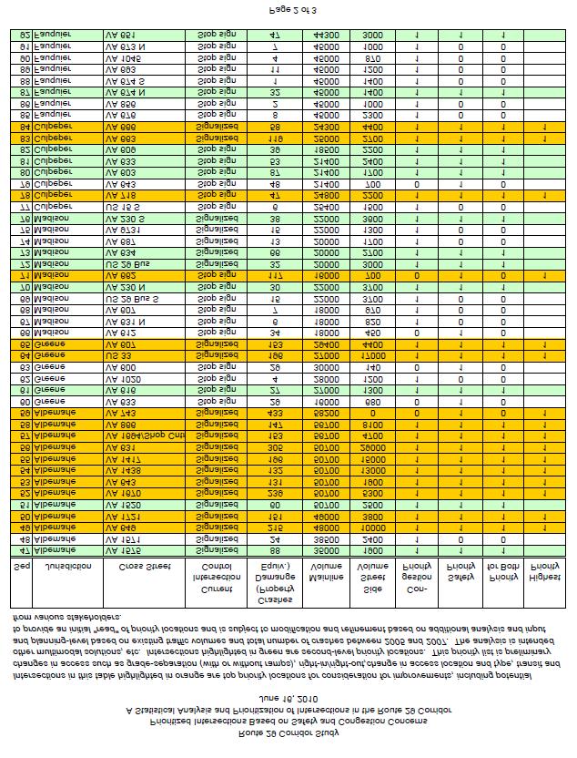
7 SECTION 2 - A prioritized list of intersections based on safety and congestions concerns 7
8 8

9 9
10 SECTION 3 - A plan for improving the mobility and accessibility north of Charlottesville A Proposal for Cross-jurisdictional Discussions on Improving Mobility and Accessibility in the Charlottesville, North Albemarle, and Greene County Areas Accepted by the Commonwealth Transportation Board - June15, 2011 Background and Purpose At its December 17, 2009 meeting, the Commonwealth Transportation Board (CTB), by resolution, accepted the Route 29 Corridor Study, but also directed VDOT and DRPT to work with a Board Subcommittee to develop: A plan to improve mobility and accessibility north of Charlottesville, evaluating various alternatives, and not limited to prior proposals. How to resolve the Route 29 traffic congestion in the Charlottesville area has been an ongoing issue for more than 30 years. For many years, the Charlottesville-Albemarle Metropolitan Transportation Organization s Transportation Plan included a Western Bypass for rerouting Route 29 from the current connection of the Leonard Sandridge Parkway (southern terminus) extending north to a reconnection with Route 29 north of the Rivanna River. Although VDOT pursued a project to build the Western Bypass and purchased a portion of the right of way, due to lack of support of local elected leaders, the MPO removed the Western Bypass from their Transportation Plan. The Route 29 Corridor Study explored the possibility of two options for relieving the congestion by (1) constructing a local road along the proposed alignment of the Western Bypass, from Route 29 (at Leonard Sandridge Parkway) to Earlysville Road, another alternative that connected to Hydraulic Road and (2) an eastern location for a bypass that would extend north from the I-64 - Keswick Interchange to the Route 29 bypass at Culpeper. This proposed alignment would generally follow the CSX to the Town of Gordonsville, overlap Route 15 to the Town of Orange and follow the N/S Railway to Route 29 at Culpeper. These options received significant opposition from citizens and elected leaders at the public meetings that were held on the Route 29 Corridor Study. Due to this opposition, including formal opposition from Albemarle and Orange Counties, the Administration eliminated those options from the final recommendations of the Study. Getting agreement on transportation solutions to relieve the congestion will be a difficult task. However, reaching consensus on any solution must begin with discussions between the local leaders. This is an outline for an approach to initiating the discussions between local leaders. Steps to Develop a Plan for the Route 29 Corridor in the Charlottesville Area The next steps in the process of developing a mobility and accessibility plan for the Charlottesville area include cross-jurisdictional discussions of local concerns in the Corridor, and identifying opportunities or common ground for consensus. The suggested next steps are as follows: 10
11 Step 1: Retain a professional facilitator, with expertise in public sector dispute resolution, to oversee and lead the meeting and cross-jurisdictional discussions. The professional facilitator must be from outside the region (possibly from Virginia Tech, George Mason University or some other leadership institution) in order to ensure neutrality. Step 2: Develop discussion support information including an outline of facts about the Corridor. The support information may include a chronology of the events and decisions that have occurred over the pasts 20+ years as well as the current plans for the Corridor. The outline of facts should include summary text as well as tables, maps, drawings, and photographs that highlight the characteristics of the corridor. Some of the background information that might be used is included in the Appendix to this document. Step 3: The facilitator will plan two regional workshop meetings: one with the elected leaders of the Charlottesville area and one with the elected leaders from the Lynchburg and Danville areas. The Office of the Secretary of Transportation, with help from the facilitator and members of the Route 29 CTB Subcommittee, will identify participants for each of the regional workshops. In the Charlottesville area, local leaders and elected officials from Charlottesville, Albemarle, Nelson and Greene Counties, and the University of Virginia should be invited. In the Lynchburg area, local leaders from Lynchburg and Danville, and the counties of Pittsylvania, Campbell, and Amherst and others as may be determined at the time the meeting is scheduled. The facilitator will develop an agenda for each of these regional workshops to help guide the discussion of Corridor transportation issues. Participation from each of these key entities is crucial, so care must be taken to ensure that those who are invited are able and willing to fully participate in the process. This first workshops, which will be conducted by the professional facilitator, will serve as a precharrette with the purpose of putting key issues on the table, and developing a group outlook so that participants feel like they are both part of the process and generally agree that they want to do something with the results of the process. Other items for discussion should include considering and listing potential outcomes of the process, and reviewing issues and concerns at the broad level. One of the key tasks for this first workshop is to identify a wider group of participants for the primary workshop or charrette (described in Step 4 below). It is anticipated that this next level of participants will include selected members of other jurisdictions along the Corridor and two or three key members of the General Assembly, the MPO, transit agencies, and other stakeholders such as the Chambers of Commerce, other business associations, and civic associations. The goal of identifying the next, wider level of participants will be to ensure that a diversity of points of view is represented, and that those who have particularly strong stakes with respect to various outcomes are part of the process. Step 4: Hold a joint workshop, a charrette, with representatives from the Lynchburg area and the Charlottesville area. This workshop will also to be conducted by the professional facilitator. The second workshop agenda should include a review of the issues raised at the first workshop, as well as a facilitated process whereby new ideas can be developed and explored. The outcome of this second workshop should be the identification and molding of potential solutions and new ideas and 11
12 approaches into outcomes that have cross-jurisdictional support. It is important to allow for the possibility that a follow-on sessions may be needed to further develop and engender consensus. Step 5: Summarize the areas of consensus and potential solutions and document these outcomes in the final Route 29 Corridor Study report. These potential solutions should then be incorporated in a Corridor Master Plan, the local Comprehensive Plans and the MPO Transportation Plans. SECTION 3 - Appendix Regional Issues and Chronology for Route 29 in the Charlottesville, Albemarle, and Greene Areas The absolute importance of Route 29 to the communities through which it passes is clearly evident from the discussions that have taken place over many decades, as well as the passions that these discussions have engendered. The intertwined issues of high growth, congestion and safety have centered most pointedly in the areas on the north side of the City of Charlottesville and extending into Greene County. The discussion below summarizes some of the background with respect to key issues, planning efforts, and a general chronology of events. One of the key items that must be considered in this portion of the corridor is that the Charlottesville area lies within the planning area designated as the Charlottesville-Albemarle Metropolitan Planning Organization (MPO). In designated MPO areas, the CTB must work cooperatively with the localities and the MPO to formulate transportation plans. Since the MPO has worked continuously over the years to evaluate alternatives and develop transportation recommendations along the Route 29 Corridor, many of which are still valid, it is important to recognize those recommendations in any new plan that is developed. The first step in this effort would be to document the facts about key transportation issues in the region to provide the foundation for informed discussions. This document is intended to serve as an outline for compiling the transportation information for cross-jurisdictional discussions. The information is provided in four key areas: 1. A summary of the planning work that has been accomplished jointly by VDOT, DRPT, Albemarle and Greene Counties, the city of Charlottesville, and the Charlottesville-Albemarle Metropolitan Planning Organization (MPO). 2. A listing of transportation improvements in and near the Route 29 Corridor that have already been agreed upon by the local governments. 3. A summary of the evaluations of the Route 29 Corridor Study. 4. Identification of areas along the Route 29 Corridor where additional capacity is needed to accommodate existing and future travel demands. 12
13 Section 1. Summary of Previous Studies on Route 29 Over the years, various studies have concluded with recommendations on the US Route 29 corridor or portions of it. In 1990, the Commonwealth Transportation Board (CTB) adopted a resolution calling for a three-phase sequence of improvements to the Route 29 corridor. Phase one improvements were made which included the widening of Route 29 from Hydraulic Road to the South Fork of the Rivanna River. The second phase improvements called for the construction of grade separated intersections along Route 29 at the Hydraulic Road, Greenbrier Drive, and Rio Road Intersections. Slated for the third-phase of improvements was the Western Bypass, contingent on traffic and economic conditions. Note: Section 1 will provide the sequence of events and plan approvals over the past twenty years to show how the transportation plan evolved to its current status. Section 2. Transportation Improvements That Have Been Agreed Upon by Local Governments While there have been numerous studies performed for the section of Route 29 through Charlottesville and Albemarle and Greene Counties, official agreement across the region for any project is reflected in those projects that are incorporated in to the MPO s Financially Constrained Long-Range Transportation Plan (called UnJAM 2035). UnJAM 2035 was officially approved by the MPO Policy Board in May Note: Section 2 will include Table 2: Summary of Transportation Projects from UnJAM Section 3. Summary of Route 29 Corridor Study Evaluations The primary emphasis of the Route 29 Corridor Study was to identify transportation needs and those aspects of the corridor that should be preserved through transportation and land use planning initiatives, develop an overall planning framework, and identify projects (based on previous studies and/or stakeholder input), and to gain public input for each of these activities. Within the Charlottesville/Albemarle/Greene County area, the study incorporated projects from previous planning efforts including the most recent of the studies, Places29 and the Greene County Route 33 Multimodal Corridor Study. Note: Section 3 will outline the proposals that were evaluated as part of the Route 29 Corridor Study. Section 4. Areas on Route 29 Where Additional Capacity is Needed to Accommodate Existing and Future Travel Demands 13
14 Analysis of existing and projected traffic volumes, levels of congestion, as well as crash data, will provide an initial reading of areas in the corridor where additional capacity should be considered. Tables and maps should be used to highlight these locations for the entire 219-mile corridor. SECTION 4 - A plan for improving the mobility and accessibility in the Gainesville, Haymarket and Buckland region A Proposal for Cross-Jurisdictional Discussions on Improving Mobility and Accessibility in the Gainesville, Haymarket and Buckland Region Accepted by the Commonwealth Transportation Board - June 15, 2011 Purpose On December 17, 2009, the Commonwealth Transportation Board (CTB), by resolution, accepted the Route 29 Corridor Study, but also directed, VDOT and DRPT to work with a Board Subcommittee to develop: A plan to improve mobility and accessibility in the Gainesville, Haymarket and Buckland region, evaluating various alternatives, and not limited to prior proposals. Over the past twenty years, traffic has rapidly increased along the Route 29 Corridor on the segment between the New Baltimore area of Fauquier County and I-66 at Gainesville, in Prince William County. Due to the heavy traffic congestion on Route 29 in Gainesville, a significant portion of the commuter traffic exits Route 29 and uses Route 15 through Haymarket community to connect to I- 66. Also the intersection at Route 215 (Vent Hill Road) was for many years, under consideration for the construction of an interchange, but the interchange would have a significant impact on the historic Buckland battlefield area. Any improvements to the existing facility must mitigate any possible encroachment on the historic and environmentally sensitive areas in Prince William and Fauquier Counties. The most notable is the Buckland Historic area. Located just north of the Fauquier County line, in Prince William County, the historic village of Buckland est. 1798, stands adjacent to west side of Route 29, and the Historic Buckland Overlay District is on both sides of the facility. The Historic District is delineated and identified in Prince William County s Comprehensive Plan. In Fauquier County there are several privately owned parcels that are being considered for designation for historic preservation or conservation easements. These properties are immediately adjacent to Route 29 or they are within the Buckland Historic District and the Buckland Mills Battlefield area. More information on the historic area is provided in Appendix A Reaching consensus on any solution must begin with discussions between the local leaders. This is an outline for initiating the discussions between local leaders. 14
15 Steps to Develop a Plan for the Route 29 Corridor in the Buckland Area The first steps in the process of developing a mobility and accessibility plan for the Buckland/Gainesville area is to initiate cross-jurisdictional discussions of local concerns in the Corridor and identifying opportunities or common ground for consensus. The Route 29 corridor subcommittee has proposed that with the concurrence of the Secretary of Transportation, the CTB members for the Culpeper and NOVA Districts will contact the board of supervisor s members that represent the Buckland/Gainesville/Haymarket areas for Fauquier and Prince William Counties (2 from each County) to seek their participation in these discussions. It is suggested that the members of Fauquier Board of Supervisors that represent the Marshall District and Scott District be invited. From Prince William County it is suggested that an invitation be extended to the Board of Supervisors members that represent the Gainesville and Brentsville Districts. If there is progress in these informal discussions, then the parties may choose to move the discussions to a more formal facilitated process to ensure that any agreements or points of consensus are documented. The suggested formal steps are as follows: Step 1: Retain a professional facilitator, with expertise in public sector dispute resolution, to oversee and lead the meeting and cross-jurisdictional discussions. The professional facilitator must be from outside the region to ensure neutrality. Step 2: Develop discussion support information including facts about the Corridor. The support information may include a chronology of the studies and decisions that have led to the current status of plans for the Corridor. The outline of facts should include a summary document as well as tables, maps, drawings, and photographs that highlight the characteristics of the corridor. Some of the background information that might be used is included in Appendix A of this document. Step 3: The facilitator will plan additional cross-jurisdictional meetings with the elected leaders of Fauquier and Prince William Counties. The participating members of the initial informal meeting(s) will work with the facilitator to determine if others should be invited to the meeting. Participation from these jurisdictional representatives is crucial, so care must be taken to ensure that those who are invited are able and willing to fully participate in the process. This first meeting will be for the purpose of putting key issues on the table, and developing any points of consensus that the participants may agree upon. The facilitator will document and summarize the areas of common ground and any potential solutions that may be identified. This documentation will be used as the basis for any follow-up meetings or discussions that may be needed. Should additional discussions be planned, the participants will identify others that should be involved and the activities in step 4 should be followed. Step 4: The facilitator and the participants will develop an agenda and plan the next meeting, including others who should be invited. At this meeting, the facilitator will review the discussions of the initial meeting and allow this wider group of representatives to discuss any potential solutions that were identified. The facilitator will document the discussions of this meeting, summarize the results and distribute this information to the participants. Based on the outcome of this meeting, the 15
16 facilitator will determine whether there is a need for further discussions or if the participant jurisdictions are at a point of mutual agreement on the proposed solutions. SECTION 4 - Appendix HISTORIC PROPERTIES AND TRANSPORTATION PROJECTS AT BUCKLAND, PRINCE WILLIAM COUNTY The Buckland Historic Site Any future transportation improvements to Route 29 will require detailed studies and evaluations of the impact on historical and archaeological sites. The Buckland Historic District covers approximately 408 acres and straddles Route 29. The Buckland community in Prince William County has a wide range of archaeological and historic architectural resources. Two properties have been identified that have the most prominent relationship to future improvements to Route 29 and which include many of the remaining smaller properties as internal components. These properties, with Department of Historic Resources (DHR) inventory numbers in parentheses, are: Buckland Historic District ( ): This property listed in the Virginia Landmarks Register and National Register of Historic Places includes the surviving building and archaeological components of the town of Buckland Mills, a community dating to the early 19 th -century. Buckland Mills Battlefield ( ): This property is considered eligible for listing in the Virginia Landmarks Register and National Register of Historic Places. It defines the site of the battle of Buckland Mills, an 1863 engagement during which Confederate forces repulsed Federal troops attempting to advance along the Warrenton Turnpike (now Rt. 29). The Buckland Mills Battlefield covers approximately 4,413 acres and straddles Rt. 29. Preservation Easements Historic preservation easements can be held by the Commonwealth s Board of Historic Resources and constitutes the legal interest of the Commonwealth in the preservation of the historic aspects of such properties. Historic preservation easements are voluntary donations by private property owners with terms negotiated on a property-specific basis. According to DHR staff, a total of four properties are presently under consideration for easements, three immediately adjacent to the existing Rt. 29 right-of-way and another some distance to the south. All are within the recognized boundaries of the Buckland Historic District and Buckland Mills Battlefield. Legal and Regulatory Considerations Section 106: The National Historic Preservation Act of 1966, Section 106, requires that Federal agencies take into account the effects that their funded or permitted actions may have on historic properties. This process is administered by the Federal Advisory Council on Historic Preservation 16
17 (ACHP) using procedures described in 36 CFR Part 800. Note that Section 106 is a procedural requirement and does not prescribe a preservation outcome. Section 106 coordination can be time consuming, especially with public controversy; though in most cases historic preservation concerns can be reasonably resolved in Federal projects. Section 4(f): Unlike the procedural, non-prescriptive character of Section 106, Section 4(f) of the Department of Transportation Act of 1966 requires avoidance of use (e.g., acquisition of property) from historic properties, public parks and recreation areas, and wildlife refuges unless it can be demonstrated that there are no feasible or prudent alternatives to such use. Section 4(f) is administered by the Federal Highway Administration (FHWA). While Section 4(f) differs from Section 106 (avoidance vs. consideration of effect), historic properties are the common denominator between the two requirements. It is important to recognize that 4(f) is not merely procedural and could result in the substantive avoidance of historic properties such as the Buckland Historic District and the Buckland Mills Battlefield. Section 6(f): The Land and Water Conservation Fund (LWCF) Act of 1965, Section 6(f), protects properties acquired with those funds from conversion to other purposes (e.g. transportation use) without the approval of the Secretary of the Interior. LWCF monies traditionally have been used for the acquisition or development of park lands for public outdoor recreation. However, the American Battlefield Protection Program (ABPP) of the National Park Service administers LWCF monies to acquire battlefield lands throughout the United States. In 2007 the ABPP awarded a LWCF grant to the Buckland Preservation Society for the acquisition of multiple parcels within the Buckland Mills Battlefield. It is important to recognize that 6(f) may require the substantive avoidance of parcels acquired with LWCF monies, unless approval to use those parcels can be obtained from the Secretary of the Interior. Commitments from Recent Transportation Projects The recent replacement of the bridge deck on the southbound bridge across Broad Run involved significant Section 106 consultation between VDOT, FHWA, DHR, the federal Advisory Council on Historic Preservation, and the Buckland Historical Society. That effort was completed by execution of a Section 106 Memorandum of Agreement (MOA) that stipulated actions to be implemented by the MOA participants to mitigate the effects of that project on the adjacent historic properties. The terms of that MOA constitute legally binding commitments and a copy of that agreement is attached as a specific reference document. There are three substantive (i.e., non-administrative) stipulations in the MOA. Stipulations I, II, and III, respectively, govern bridge design and construction, archaeology, and planning. Stipulations I and II have been satisfactorily completed by VDOT as part of the bridge deck construction project. The planning requirements of Stipulation III, however, are principally the responsibility of the Buckland Preservation Society (BPS). The BPS is required to invite VDOT to participate in its master planning efforts and VDOT is required to participate to the extent practicable. It is important to note that VDOT did not make any commitment regarding the nature of future improvements to Rt. 29, either during development of the Broad Run bridge deck replacement project or through the associated Section 106 MOA. 17
18 Consequences for Transportation Planning and Future Capacity Improvements The presence of the Buckland Historic District and the Buckland Mills Battlefield will influence the development of any transportation improvements in this area. The influence may be significant, especially with regard to 4(f) issues and the existence of historic preservation easements held by the Commonwealth. Section 4(f) will require analysis and possibly implementation - of alternatives to avoid the use of historic properties relative to their macro definition and their constituent, contributing elements. Some of those contributing elements are the discrete parcels subject to historic preservation easements. Consideration of alternatives will also be required for Section 106 consultation. In any case, identifying a full range of alternatives during planning, prior to the initiation of formal project development, is warranted given the known historic property conditions in the Buckland area and the anticipated complexity of the issues. Buckland Bypass In recognition of the historic significance of the Buckland Historic area, VDOT funded a study of the possible alternatives to widening existing Route 29. This study completed in 2007 recommended a bypass of the historic area. All of the recommended alignments for this proposal extended from Route 29 south of the Buckland Historic area (in Fauquier County), to I-66 near Thoroughfare Gap in Prince William County. These alternatives were not acceptable to Fauquier County due to the encroachment on several conservations districts and the impacts on farmland. (See the Buckland Bypass Map below) 18

19 19
20 Route 29 Corridor Study During the development of the Route 29 Corridor Study, the study team met with the Boards of Supervisors (BOS) of Prince William County and Fauquier County to receive input on vital transportation issues. In April 2009, the Prince William County BOS changed their Comprehensive Plan to show a recommendation for four lanes on Route 29 from the Fauquier County line to the Route 15 Intersection. (Previously, the Comp. Plan had recommended six lanes.) Following a meeting with the full Prince William BOS in May 2009, the study team met with the two supervisors (Stirrup and Covington) that represent the Gainesville- Buckland areas of the County. From this meeting a new alignment for a Buckland Bypass was proposed. This connector would extend from Route 29 south of the Buckland area in Fauquier County to Route 15 near the intersection of Thoroughfare Road. While the Fauquier BOS supported many of the proposals in the Route 29 Study, they were opposed to the proposal for a Buckland Bypass due to its impact on their county. SECTION 5 - A plan/policy for minimizing the number on new traffic control signals on Route 29 and other Corridors of Statewide Significance (CoSS) The CTB Committee discussed at length how best to address the proliferation of new entrances on Route 29 and the other CoSS facilities. Their discussions concluded that any plan or policy for minimizing the number on new traffic control signals on Route 29 and other Corridors of Statewide Significance (CoSS) must acknowledge that most traffic signals are installed to provide safe access for traffic generated by new developments. Safe access to future land development sites must be planned far in advance of the development proposals. Establishing the locations for access in a Master Plan on all of the CoSS will ensure that the locality, developer and VDOT staff clearly understand how new developments can be served. In most cases, access can be provided without the addition of a traffic signal. An outline for developing Master Plans for the CoSS follows. 20
21 Master Plans for the Corridors of Statewide Significance Corridors of Statewide Significance The Corridors of Statewide Significance (CoSS) are identified in the Code of Virginia and described in detail in VTrans2035. In general the CoSS applies to a network of facilities that are vital to transportation and commerce within the Commonwealth. These multimodal transportation corridors include all of the Interstate System as well as the following Primary Highway Corridors: Routes 13, 17, 29, 58, 220, and 460. The official definition of the CoSS is: An integrated, multimodal network of transportation facilities that connect major centers of activity within and through the Commonwealth and promote the movement of people and goods essential to the economic prosperity of the state. Purpose and Need for Corridor Master Plans The purpose of a Corridor Master Plan is to identify ways to preserve the capacity and ensure the safety of the Commonwealth s major transportation corridors or CoSS. Transportation facilities represent a major investment in public funds and, given the unclear outlook for financing new transportation improvements on the CoSS, it is critical to develop plans and procedures to better preserve the Commonwealth s existing transportation investments. There will continue to be a need to accommodate new land development along the CoSS, but the access to new sites must be planned in order to minimize the congestion and safety impacts that frequently accompany strip development. The location, spacing, and design of entrances, street intersections, median openings, traffic signals, and transit amenities must be addressed in the Corridor Master Plan to preserve the facility for through travel and to serve future developments. The Corridor Master Plan is needed to help guide localities and the development community in locating and designing the appropriate access for the future development. It is recognized that there are many tools that need to be employed in the preservation and protection of the CoSS including; the Access Management Regulations, Traffic Impact Analysis Regulations, congestion management practices, as well as carpooling, vanpooling and transit alternatives. Authority for the Plan The Code of Virginia requires the Commonwealth Transportation Board (CTB) to conduct a comprehensive review of statewide transportation needs in the Statewide Transportation Plan; setting forth assessment of capacity needs for all CoSS, regional networks, and improvements to promote urban development areas. The Code further states that the assessment shall consider all modes of transportation. Such corridors shall be planned to include multimodal transportation improvements, and the Plan shall consider corridor location in planning for any major transportation infrastructure, including environmental impacts and the comprehensive land use plan of the locality 21
22 in which the corridor is (or would be) located. Per the Code of Virginia, the CTB shall not be constrained by local, district, regional, or modal plans in the designation of such corridors. The Statewide Transportation Plan, VTrans2035, was developed in 2009 and presented to the CTB on December 17, The VTrans2035 Plan identifies the CoSS as including all of the Interstate System as well as the following Primary Highways: Routes 13, 17, 29, 58, 220, and 460. Other Principle Arterials, that meet the appropriate criteria, may also be identified by the CTB and included in the CoSS network. The CTB, in accepting VTrans2035 Plan on December 17, 2009, directed that CoSS master plans be developed to include the following features: o Updates should coincide with Commonwealth Administration and Legislative cycles; o Include plans to address Environmental Quality issues as required by law; o Include the development of regional transportation and land use performance measures and goals for urban regions; and o Include a plan to educate local governments about the greater role the CTB envisions for VDOT and DRPT. In a separate resolution accepting the Route 29 Corridor Study on December 17, 2009, the CTB directed a Subcommittee to oversee additional work by VDOT and DRPT to develop an approach to minimizing the number of traffic signals on Route 29, and to incorporate lessons learned from the Route 29 Corridor Study into the ongoing development of tools and procedures to better manage all of the CoSS. A key concern for the Route 29 Corridor was the proliferation of traffic access points and traffic signals. The following policy statement highlights the concerns that such proliferation has on degrading the major transportation investment that the Commonwealth has in the entire CoSS network. CoSS Access Point and Access Control Policy Statement: In managing the Corridors of Statewide Significance, and to minimize the number of traffic signals, it is the policy of the Commonwealth Transportation Board (CTB) that intersections or new access points to those corridors shall be planned, designed, operated and maintained to ensure minimum delay to through traffic. Access locations under consideration shall be evaluated for the impact to corridor travel time and mitigation strategies, including: land use planning, access management, mode shift, transit enhancements, or aggressive traffic operational strategies. These measures shall be incorporated in a Corridor Master Plan that will guide VDOT, DRPT and Localities in providing access for future growth areas. Exceptions to this policy may only be granted by the Commonwealth Transportation Commissioner after an independent review and documentation justifying the exception. Corridor Master Plans for the Corridors of Statewide Significance Introduction: A primary function of the Corridors of Statewide Significance (CoSS) is to carry long distance traffic. In order for these corridors to serve this function, the ability of travelers and goods 22
23 to move safely and efficiently must be preserved and given priority over other functions that these corridors serve, such as access. The goal of the Corridor Master Plan is to preserve the capacity and operating efficiency of the CoSS. Such preservation is critical due to the Commonwealth s limited ability to provide funds to add new capacity along these corridors. Increasing the number of access points and the number of traffic signals can degrade mobility and operations along a CoSS. The policy delineated in the CoSS Access Point and Access Control Policy Statement included above will be implemented through effective transportation and land use planning, as embodied in locality Corridor Master Plans (CMP) and by the effective allocation of planning, primary highway construction, and transit funds by the CTB. The CMPs will be developed through the cooperative efforts of VDOT, DRPT, local governments, and regional agencies; these documents will inform and guide decisions by each of these entities as well as the CTB. A CTB Subcommittee will provide oversight of the CMP development and will report to the full Board at least quarterly on the progress of developing the CMPs. The CTB Subcommittee may decide to first develop a pilot study before proceeding with the CMPs on the entire CoSS network. Key features of the CMPs: 1. VDOT and DRPT will develop a memorandum of understanding (MOU) with localities along the CoSS. The MOUs will establish a common goal to preserve the corridors, and indicate a dedication by all parties to work together to achieve this goal through the coordinated development of CMPs, as well as an ongoing commitment to support corridor preservation prior to the development and implementation of the CMPs. Such commitments will be important because the process for developing and implementing the CMPs may take time. 2. VDOT and DRPT will then work with the localities along the CoSS to develop local CMPs. With input from both regional agencies and local governments, VDOT and DRPT will jointly develop a format and template for these documents. 3. The local CMP should consider: Overall corridor studies related to each particular CoSS, VDOT s Access Management Regulations for Principal Arterials and DRPT s Transit Service Design Guidelines. Evaluations of the existing Surface Transportation Plan, Statewide Rail Plan, Transit and TDM Development Plans, and the existing and future Comprehensive Plans to determine the potential for increased and/or expanded rail, transit, and TDM solutions. The adopted locality Comprehensive Plan to identify future growth patterns, land use zoning and policies, as well as the designation of Urban Development Areas in localities which have designated them in their Comprehensive Plans. The Comprehensive Plans and the local CMP of the adjoining localities along the corridor. 23
24 Identifying access locations and illustrate design configurations to serve future nodal development. Coordination with land use planning will be of key importance for this aspect of the CMP. Identifying and locating planned access points for future land uses along the corridor along with proposed design concept(s) for the access, as well as the potential to implement multi-modal transportation solutions. An emphasis of this planning effort is the identification of access types that do not require the installation of traffic signals and are sensitive to the surrounding context. Properties fronting on the Corridor that also have access to connecting roadways using the connecting roadway as their primary means of access. Lots subdivided from an existing parcel using the entrance of the parent parcel for access to the Corridor. Providing an opportunity for public input on the draft CMP and addressing concerns before final approval or adoption. 4. Review of the CMP by the locality at least every five years, with updates as necessary, in cooperation with VDOT and DRPT. 5. Implementation of the CMP will take place, at a minimum, through the following actions: a. The execution of MOUs between localities within the CoSS and VDOT and DRPT that include a commitment to work together to preserve the corridors. Following the execution of the MOUs, state transportation planning funding shall be made available for the preparation of a local CMP. b. Locally adopted CMPs that incorporate the considerations contained in item 2 above shall be considered by VDOT in the evaluation of entrance permits. c. Projects that are identified as priorities within the CMPs, and that incorporate all the considerations contained in item 2 above, will be considered as first priorities for funding by the CTB, provided that the CMP has also been adopted in the Comprehensive Plan of the locality in which the project is located. It is the intent of this policy that the CMP be incorporated in locality Comprehensive Plans either directly or by reference. The flow diagram on the following page is included to illustrate the development and application of the CMP process. 24

25 Illustrative Diagram Showing Relationships and Workflows for Development, Adoption, and Implementation of Corridor Management Plans for Corridors of Statewide Significance 25
CITY OF CHARLOTTESVILLE, VIRGINIA CITY COUNCIL AGENDA
 CITY OF CHARLOTTESVILLE, VIRGINIA CITY COUNCIL AGENDA Agenda Date: December 16, 2013 Action Required: Adoption of Resolution Presenter: Staff Contacts: Title: James E. Tolbert, AICP, Director of NDS James
ARLINGTON COUNTY, VIRGINIA. County Board Agenda Item Meeting of January 28, 2017 SUPPLEMENTAL REPORT
 ARLINGTON COUNTY, VIRGINIA County Board Agenda Item Meeting of January 28, 2017 SUPPLEMENTAL REPORT DATE: January 26, 2017 SUBJECT: The Virginia Department of Transportation s Transform I-66 Inside the
TENNESSEE STATE ROUTE 109 CORRIDOR MANAGEMENT AGREEMENT MEMORANDUM OF UNDERSTANDING CORRIDOR MANAGEMENT ALONG STATE ROUTE 109
 TENNESSEE STATE ROUTE 109 CORRIDOR MANAGEMENT AGREEMENT MEMORANDUM OF UNDERSTANDING CORRIDOR MANAGEMENT ALONG STATE ROUTE 109 I. Purpose The purpose of this Agreement is to provide a framework for the
ARLINGTON COUNTY, VIRGINIA. County Board Agenda Item Meeting of January 28, 2017 SUPPLEMENTAL REPORT-2
 ARLINGTON COUNTY, VIRGINIA County Board Agenda Item Meeting of January 28, 2017 SUPPLEMENTAL REPORT-2 DATE: January 27, 2017 SUBJECT: The Virginia Department of Transportation s Transform I-66 Inside the
Rappahannock- Rapidan Regional Commission
 Rappahannock- Rapidan Regional Commission Last Updated July 2008 RAPPAHANNOCK-RAPIDAN REGIONAL TRANSPORTATION PLAN The Virginia Department of Transportation (VDOT) and the Rappahannock-Rapidan are partnering
9 CITY OF VAUGHAN OFFICIAL PLAN AMENDMENT NO BOCA EAST INVESTMENTS LIMITED
 9 CITY OF VAUGHAN OFFICIAL PLAN AMENDMENT NO. 631 - BOCA EAST INVESTMENTS LIMITED The Planning and Economic Development Committee recommends the adoption of the recommendations contained in the following
3. VISION AND GOALS. Vision Statement. Goals, Objectives and Policies
 Vision Statement Queen Creek s interconnected network of parks, trails, open spaces and recreation opportunities provide safe and diverse activities and programs that sustain its unique, small town, equestrian
Town Center (part of the Comprehensive Plan)
") Town Center (part of the Comprehensive Plan) Mercer Island Town Center Looking North (2014) In 1994, a year-long process culminated in a set of design guidelines and code requirements for the Town Center
Town Center (part of the Comprehensive Plan) Mercer Island Town Center Looking North (2014) In 1994, a year-long process culminated in a set of design guidelines and code requirements for the Town Center
Urban Development Area (UDA) Process in Virginia: History & Requirements
 Process in Virginia: History & Requirements") Urban Development Area (UDA) Process in Virginia: History & Requirements J. Kelli Nash Office of Intermodal Planning and Investment VDOT Coordinating Transportation & Land Use Forum Thursday, June 2, 2016
Urban Development Area (UDA) Process in Virginia: History & Requirements J. Kelli Nash Office of Intermodal Planning and Investment VDOT Coordinating Transportation & Land Use Forum Thursday, June 2, 2016
Scope of Services. River Oaks Boulevard (SH 183) Corridor Master Plan
 Corridor Master Plan") Scope of Services River Oaks Boulevard (SH 183) Corridor Master Plan PROJECT AREA The project area consists of the River Oaks Boulevard (SH 183) corridor bounded by SH 199 at the northern end and the Trinity
Scope of Services River Oaks Boulevard (SH 183) Corridor Master Plan PROJECT AREA The project area consists of the River Oaks Boulevard (SH 183) corridor bounded by SH 199 at the northern end and the Trinity
VILLAGE OF BOLTON HERITAGE CONSERVATION DISTRICT PLAN
 Page 1 1. INTRODUCTION AND BACKGROUND 1.1 THE PROJECT VILLAGE OF BOLTON HERITAGE CONSERVATION DISTRICT PLAN TERMS OF REFERENCE The Town of Caledon (Town) is a large, predominantly rural municipality with
SUBJECT: Waterfront Hotel Planning Study Update TO: Planning and Development Committee FROM: Department of City Building. Recommendation: Purpose:
 Page 1 of Report PB-23-18 SUBJECT: Waterfront Hotel Planning Study Update TO: Planning and Development Committee FROM: Department of City Building Report Number: PB-23-18 Wards Affected: 2 File Numbers:
I. INTRODUCTION. Project Background and Study Area
 I. INTRODUCTION Project Background and Study Area Freedom Parkway is a key east-west corridor connecting I-25 on the west to the Town of Kersey on the east, running approximately one to two miles south
1.0 INTRODUCTION 1.1 TH 14 WEST STUDY AREA Project Description Functional Classification Purpose of the Project
 1.0 INTRODUCTION 1.1 TH 14 WEST STUDY AREA 1.1.1 Project Description The Trunk Highway (TH) 14 West Corridor is a two-lane roadway approximately 22 miles in length. Located in Nicollet County, the corridor
Executive Summary. NY 7 / NY 2 Corridor
 Executive Summary NY 7 / NY 2 Corridor Transportation and Land Use Study December 2005 Prepared for: Town of Colonie Capital District Transportation Committee Prepared by: Introduction: Land use decisions
The Village of Sugar Grove, in partnership with Kane County, the Illinois Department of Transportation, and the Illinois Tollway welcomes you to the
 The Village of Sugar Grove, in partnership with Kane County, the Illinois Department of Transportation, and the Illinois Tollway welcomes you to the first Public Meeting for the proposed interchange improvement
NORTH-SOUTH CORRIDOR STUDY EXECUTIVE SUMMARY. Executive Summary
 Executive Summary Background As congestion continues to affect mobility in the region, the Ozarks Transportation Organization (OTO) is particularly concerned with traffic movement. The North-South Corridor
Plan Overview. Manhattan Area 2035 Reflections and Progress. Chapter 1: Introduction. Background
 Plan Overview The Manhattan Urban Area Comprehensive Plan (the Comprehensive Plan) is a joint planning initiative of the City of Manhattan, Pottawatomie County, and Riley County. The 2014 Comprehensive
Arlington, Virginia is a worldclass
 EXECUTIVE S U M M A RY Arlington maintains a rich variety of stable neighborhoods, quality schools and enlightened land use policies, and received the Environmental Protection Agency s highest award for
Issues Requiring Future Study
 Issues Requiring Future Study Transportation planning is an ongoing process that tends to identify new issues as it finds solutions for others. Some issues are so complex that a solution to one problem
DRAFT Subject to Modifications
 TREASURE COAST REGIONAL PLANNING COUNCIL M E M O R A N D U M To: Council Members AGENDA ITEM 8 From: Date: Subject: Staff May 19, 2017 Council Meeting Florida Department of Transportation Complete Streets
Section 1. Executive Summary
 Executive Summary (This page left blank intentionally) Executive Summary Background Economic growth in southern Leavenworth County over the past decade has been strong. As both the number of business and
5.0 IMPLEMENTATION STRATEGIES
 5.0 IMPLEMENTATION STRATEGIES 5.1 Recommended Alternative This chapter discusses the anticipated steps needed to move each project from recommendation to construction. Since full funding for these alternatives
PSRC REVIEW REPORT & CERTIFICATION RECOMMENDATION
 PSRC REVIEW REPORT & CERTIFICATION RECOMMENDATION KITSAP COUNTY COUNTYWIDE PLANNING POLICIES July 2, 2012 BACKGROUND A major emphasis of the Washington State Growth Management Act (GMA) is the need to
Implementation Guide Comprehensive Plan City of Allen
 Implementation Guide 2030 Comprehensive Plan City of Allen DRAFT 2015 Implementation Guide Allen 2030 Comprehensive Plan INTRODUCTION The Comprehensive Plan serves as a guide for the growth and development
This page intentionally blank.
 This page intentionally blank. Parks, Recreation, and Open Space Chapter Relationship to Vision Vision Parks, Recreation and Open Space Chapter Concepts County Government. County government that is accountable
SUMMARY. Support the Southeast Arkansas Regional Intermodal Facility.
 SUMMARY THE I-69 LOCATION STUDY The proposed I-69 Location Study from El Dorado to McGehee, Arkansas, represents one section (Section of Independent Utility No. 13) of the nationally designated I-69 Corridor
Glenborough at Easton Land Use Master Plan
 Implementation 114 9.0 IMPLEMENTATION 9.1 OVERVIEW This chapter summarizes the administrative procedures necessary to implement the proposed land use plan, infrastructure improvements, development standards,
Section 4 BUILDING THE MASTER PLAN
 The Master Plan 33 Section 4 BUILDING THE MASTER PLAN Figure 4:1. A collaborative effort characterized the two design workshops sponsored by DISC to create hypothetical Master Plans for the Towers Property
TRANSPORTATION AND LAND USE
 CHAPTER 10 TRANSPORTATION AND LAND USE Transportation and land use are intimately linked. The expansion of a highway typically spurs housing, employment growth and land development in the communities that
Right-of-Way Acquisitions and Relocations Technical Memorandum
 Right-of-Way Acquisitions and Relocations Technical Memorandum Southeast Extension Project Lincoln Station to RidgeGate Parkway Prepared for: Federal Transit Administration Prepared by: Denver Regional
TRANSPORTATION ELEMENT GOALS, OBJECTIVES, AND POLICIES
 TRANSPORTATION ELEMENT GOALS, OBJECTIVES, AND POLICIES GOAL 2 The City shall provide a safe, convenient, effective, and energy efficient multimodal transportation system which is coordinated with the Future
PREPARED FOR: PLATTEVIEW ROAD CORRIDOR STUDY EXECUTIVE SUMMARY
 PREPARED FOR: PLATTEVIEW ROAD CORRIDOR STUDY EXECUTIVE SUMMARY SEPTEMBER 2016 Introduction The Platteview Road Corridor Study was led by the Metropolitan Area Planning Agency (MAPA) with assistance from
CITY COUNCIL AGENDA REPORT
 CITY COUNCIL AGENDA REPORT Subject: COUNCIL MOTION LRT ALIGNMENT REMOVAL FROM THE TRANSPORTATION MASTER PLAN On February 10, 2016 Councillor Hughes provided notice in accordance with Section 23 of Procedure
C h a p t e r 3 E V A L U A T I O N A N D D E S I G N A T I O N. Background
 Part Two GOALS Part 2: Restoration work at Kingston (Historic Site 79-019-13) Upper Marlboro, 2009 C h a p t e r 3 E V A L U A T I O N A N D D E S I G N A T I O N Background The Inventory of Historic Resources
Intergovermental Coordination
 Intergovermental Coordination CITY OF WINTER PARK CHAPTER 8: INTERGOVERNMENTAL COORDINATION ELEMENT INTERGOVERNMENTAL COORDINATION ELEMENT GOAL 8-1: PROVIDE FOR IMPROVED INTERGOVERNMENTAL COORDINATION
Mississippi Skyway Preliminary Engineering Report
 EXECUTIVE SUMMARY Mississippi Skyway Preliminary Engineering Report CITY OF RAMSEY, MINNESOTA DECEMBER 2014 City of RAMSEY EXECUTIVE SUMMARY Project Need and Intent The Mississippi Skyway pedestrian bridge
Southern Gateway Project and Public Green
 Southern Gateway Project and Public Green Transportation and Trinity River Project Committee May 23, 2016 Purpose of Presentation Provide the history and an overview of the Southern Gateway Project (SGP)
WHEREAS, the current Comprehensive Plan was adopted in 2005; and
 RESOLUTION 2018-06 RESOLUTION TO AMEND THE CITY S COMPREHENSIVE PLAN TO (1) AMEND CHAPTER 4 TO ADD A SPECIAL REVITALIZATION DISTRICT FOR EDUCATION AND ECONOMIC DEVELOPMENT ; (2) DESIGNATE ON THE FUTURE
Town of Peru Comprehensive Plan Executive Summary
 Town of Peru Comprehensive Plan Executive Communities that plan grow by choice, not by chance. A plan makes growth thoughtful, understandable, and predictable. A plan shows that a community is managing
DRAFT PLAN PRESENTATION
 DRAFT PLAN PRESENTATION 1.23.2018 AGENDA Process Project Schedule Results from Visioning Workshop Draft Plan Highlights Concept Plans Feedback Next Steps PROJECT SCHEDULE KICK-OFF WORKSHOP August 29 th
Route 1 Corridor Study
 Route 1 Corridor Study Westbrook, Connecticut A Vision for the Connecticut Shoreline Public Informational Meeting July 28, 2015 Lower Connecticut River Valley Council of Governments Fitzgerald & Halliday,
Review of Opportunity Area C Draft Comprehensive Plan and Draft BOS Follow-On Motions. Special Working Group Meeting March 4, 2015
 Review of Opportunity Area C Draft Comprehensive Plan and Draft BOS Follow-On Motions Special Working Group Meeting March 4, 2015 The slides that follow identify where the draft Comprehensive Plan has
State Highway 121 Southwest Parkway. Fort Worth s Transportation Success Story in Design and Cooperation
 State Highway 121 Southwest Parkway Fort Worth s Transportation Success Story in Design and Cooperation Greater Fort Worth Association of Realtors October 24, 2007 Presented by: Dan Lamers, P.E. North
I. STAFF POLICY RECOMMENDATIONS. The following RMP policy strategies are proposed by staff in support of a Scenic Resource Protection Program:
 Policy Consideration: Scenic Resource Protection Program Status: For Consideration by the Highlands Council at September 14, 2006 Work session Date: September 12, 2006 I. STAFF POLICY RECOMMENDATIONS The
The Rocky Mountain Arsenal and the Northeast Greenway Corridor Project:
 The Rocky Mountain Arsenal and the Northeast Greenway Corridor Project: Contamination to Collaboration Presented by Howard Kenison Overview of Presentation Rocky Mountain Arsenal Contamination Litigation,
2.0 PURPOSE AND NEED. 2.1 Purpose. 2.2 Need Traffic Congestion in and around Downtown Derry
 2.0 PURPOSE AND NEED Taking into consideration agency and public input, the purpose and need for the Project was identified early in Project planning. As noted in Appendix A, for purposes of meeting the
NASSAU COUNTY TOWN HALL NEW YORK & CONNECTICUT SUSTAINABLE COMMUNITIES. A Unique Bi-State Partnership to Improve Jobs, Housing and Transportation
 NASSAU COUNTY TOWN HALL NEW YORK & CONNECTICUT SUSTAINABLE COMMUNITIES A Unique Bi-State Partnership to Improve Jobs, Housing and Transportation Police Headquarters Auditorium Mineola, NY December 9 th,
RESOLUTION NO. R Refining the route, profile and stations for the Downtown Redmond Link Extension
 RESOLUTION NO. R2018-32 Refining the route, profile and stations for the Downtown Redmond Link Extension MEETING: DATE: TYPE OF ACTION: STAFF CONTACT: Capital Committee Board PROPOSED ACTION 09/13/2018
SCARBOROUGH SUBWAY EXTENSION. Scarborough Subway Extension. Final Terms of Reference
 Scarborough Subway Extension Final Terms of Reference 1 1.0 Introduction and Background 1.1 Introduction Toronto City Council recently confirmed support for an extension of the Bloor-Danforth Subway from
Hockessin Community Redevelopment Plan
 Hockessin Community Redevelopment Plan 3.1 Introduction The Community Redevelopment Plan for the Village of Hockessin is the result of the people s vision for a distinct village center that serves as the
Office of Greenways & Trails Providing Statewide Leadership and Coordination. Southeast Greenways and Trails Summit October 1-3, 2017
 Office of Greenways & Trails Providing Statewide Leadership and Coordination Southeast Greenways and Trails Summit October 1-3, 2017 1 Office of Greenways and Trails The Office of Greenways and Trails
Corridor Vision. 1Pursue Minnehaha-Hiawatha Community Works Project. Mission of Hennepin County Community Works Program
 1Pursue Minnehaha-Hiawatha Community Works Project Minnehaha-Hiawatha Community Works is a project within the Hennepin Community Works (HCW) program. The mission of the HCW program is to enhance how the
Overview of Southwestern Pennsylvania Commission s (SPC) 2040 Long Range Transportation Plan (LRTP)
 2040 Long Range Transportation Plan (LRTP)") Overview of Southwestern Pennsylvania Commission s (SPC) 2040 Long Range Transportation Plan (LRTP) Presented to Pennsylvania Agency Coordination Meeting May 27, 2015 Doug Smith & Ryan Gordon 1 Southwestern
Overview of Southwestern Pennsylvania Commission s (SPC) 2040 Long Range Transportation Plan (LRTP) Presented to Pennsylvania Agency Coordination Meeting May 27, 2015 Doug Smith & Ryan Gordon 1 Southwestern
Preparing to Review City-owned Property
 Preparing to Review City-owned Property June 28, 2017 WORKING DRAFT Prepared for: Mayor DeBoer and the Holland City Council Prepared by: Denny Ellens William J. Johnson Soren Wolff Phil Meyer REPORT CONTENTS
The Illinois Department of Transportation and Lake County Division of Transportation. Route 173, including the Millburn Bypass
 The Illinois Department of Transportation and Lake County Division of Transportation welcome you to this Public Hearing for U.S. Route 45 from Illinois Route 132 to Illinois Route 173, including the Millburn
The Corporation of the Town of Milton
 Report To: From: Council Barbara Koopmans, Commissioner, Planning and Development Date: May 7, 2018 Report No: Subject: Making it Possible Positioning the Town s Strategy for Growth and Economic Development
greenprint midtown SUSTAINABILITY ACTION PLAN 2012
 greenprint midtown SUSTAINABILITY ACTION PLAN 2012 MIDTOWN ALLIANCE SOUTHFACE ENERGY INSTITUTE RENAISSANCE PLANNING GROUP SUSTAINABLE ATLANTA PERKINS+WILL 2 GREENPRINT MIDTOWN 1. Introduction Sustainability
Streets for People, Place-Making and Prosperity. #TOcompletestreets
 COMPLETE STREETS FOR TORONTO Streets for People, Place-Making and Prosperity COMPLETE STREETS: A NEW APPROACH A Complete Streets design approach considers the needs of all users people who walk, bicycle,
CHAPTER 12 IMPLEMENTATION
 CHAPTER 12 IMPLEMENTATION The 2010 Town of Denton Comprehensive Plan is intended to capture a vision of the future of Denton. As such, it provides a basis for a wide variety of public and private actions
City of Tacoma Planning and Development Services
 Agenda Item D-1 City of Tacoma Planning and Development Services To: Planning Commission From: Elliott Barnett, Planning Services Division Subject: Application #2014-08 Open Space Element Update Meeting
MAIN STREET ECONOMIC DEVELOPMENT STRATEGY
 MAIN STREET ECONOMIC DEVELOPMENT STRATEGY A PATHWAY TO A BETTER POUGHKEEPSIE DRAFT Working Paper #2: Planning Strategies Submitted December 1 st, 2015 to the City of Poughkeepsie LAND USE LAW CENTER PACE
Working together to leverage limited Funds
 Working together to leverage limited Funds ARAPAHOE COUNTY OPEN SPACES 10 County Budget Conference September 20, 2013 The Power of Partnerships 2013 SORP Conference 5/23/2014 Why Talk About Open Space?
Urban Planning and Land Use
 Urban Planning and Land Use 701 North 7 th Street, Room 423 Phone: (913) 573-5750 Kansas City, Kansas 66101 Fax: (913) 573-5796 Email: planninginfo@wycokck.org www.wycokck.org/planning To: From: City Planning
CHAPTER 7: Transportation, Mobility and Circulation
 AGLE AREA COMMUNITY Plan CHAPTER 7 CHAPTER 7: Transportation, Mobility and Circulation Transportation, Mobility and Circulation The purpose of the Transportation, Mobility and Circulation Chapter is to
COMMUNITY DESIGN. GOAL: Create livable and attractive communities. Intent
 COMMUNITY DESIGN Intent An attractive, well-designed County will attract quality development, instill civic pride, improve the visual character of the community, and create a strong, positive image for
Photo by Carlton Ward Jr. Executive Summary
 Photo by Carlton Ward Jr. Executive Summary The Cooperative Conservation Blueprint (Blueprint) is a multi-partner strategic conservation process developed by the Florida Fish and Wildlife Commission (FWC)
master plan of highways bus rapid transit amendment
 Scope of Work master plan of highways bus rapid transit amendment September 2011 Montgomery County Planning Department M-NCPPC MontgomeryPlanning.org 1 Scope of Work master plan of highways bus rapid transit
DRAFT MAP AMENDMENT FLU 04-4
 DRAFT MAP AMENDMENT FLU 04-4 SW 24 TH AVENUE ROADWAY CORRIDOR The University of Florida participates with the Metropolitan Transportation Planning Organization (MTPO) in its responsibilities for the continuing,
A New Plan For The Calgary Region June calgary.ca call 3-1-1
 A New Plan For The Calgary Region June 2009 calgary.ca call 3-1-1 Introduction Since January 2006, The City of Calgary has been actively participating with the member municipalities of the Calgary Regional
DRAFT SECTION 4(f) EVALUATION INTERSTATE 73 FEIS: I-95 to I-73/I-74 in North Carolina
 EVALUATION INTERSTATE 73 FEIS: I-95 to I-73/I-74 in North Carolina") DRAFT SECTION 4(f) EVALUATION INTERSTATE 73 FEIS: I-95 to I-73/I-74 in North Carolina 1.0 INTRODUCTION Section 4(f) of the Department of Transportation Act of 1966, 49 U.S.C. 303, requires that prior to
DRAFT SECTION 4(f) EVALUATION INTERSTATE 73 FEIS: I-95 to I-73/I-74 in North Carolina 1.0 INTRODUCTION Section 4(f) of the Department of Transportation Act of 1966, 49 U.S.C. 303, requires that prior to
IMPLEMENTING SOMERSET COUNTY S INVESTMENT FRAMEWORK
 IMPLEMENTING SOMERSET COUNTY S INVESTMENT FRAMEWORK SMART CONSERVATION THROUGH SMART GROWTH NJ LAND CONSERVATION RALLY March 22, 2014 Laurette Kratina, PP, AICP, Supervising Planner Somerset County Planning
PROJECT BACKGROUND. Preliminary Design Scope and Tasks
 PROJECT BACKGROUND Preliminary Design Scope and Tasks The purpose of this Study is the development of preliminary designs for intersection improvements for Trunk Highway (TH) 36 at the intersections of
RECREATION AND OPEN SPACE ELEMENT GOALS, OBJECTIVES, AND POLICIES
 RECREATION AND OPEN SPACE ELEMENT GOALS, OBJECTIVES, AND POLICIES Goal 7 To provide park facilities, recreation programs, and open space resources that are safe, adequate, and accessible to all City residents,
Comprehensive Plan ADOPTED APRIL 2014
 Comprehensive Plan ADOPTED APRIL 2014 8 8. Outstanding Recreational & Cultural Opportunities We are proud of our community s parks and recreation system. Our community will ensure that the legacy of our
COUNTY OF SACRAMENTO CALIFORNIA PLANNING COMMISSION REPORT
 COUNTY OF SACRAMENTO CALIFORNIA PLANNING COMMISSION REPORT TO: FROM: SUBJECT: COUNTY PLANNING COMMISSION DEPARTMENT OF COMMUNITY DEVELOPMENT GROWTH AREA PLANS UPDATE CONTACT: Cindy Storelli, Principal
COLVER ROAD INDUSTRIAL CONCEPT PLAN
 COLVER ROAD INDUSTRIAL CONCEPT PLAN A CONCEPTUAL LAND USE AND TRANSPORTATION PLAN FOR TA-4 AN URBAN RESERVE AREA OF THE CITY TALENT City of Talent Adopted by City Council Resolution No., June, 2015 PART
Living in Albemarle County s Urban Places
 Living in Albemarle County s Urban Places ALBEMARLE COUNTY, VIRGINIA A Closer Look at Albemarle s Approach to Managing Growth and Creating Quality Urban Environments www.albemarle.org Page 2 Living in
1 Team Roles and lnvolvement; 2 - Phasing/Schedule;
 City of Bend i Oregon State University - Cascades Memorandum of Understanding Sho( Term 10 - Acre Project (Phase 1) The City of Bend and Oregon State University - Cascades are pleased to further higher
Describing the Integrated Land Management Approach
 Describing the Integrated Land Management Approach ISBN No. 978-0-7785-8902-0 (Online Edition) Pub No. I/422 What is Integrated Land Management? Integrated land management (ILM) is the strategic, planned
Workshop on the Management of Historic Urban Landscapes of the XXth century, December 2007 Chandigarh, India
 Workshop on the Management of Historic Urban Landscapes of the XXth century, 18-21 December 2007 Chandigarh, India INTRODUCTION The participants of the International Workshop on the Management of Historic
Regional Context Statement
 Regional Context Statement REGIONAL CONTEXT STATEMENT 3. REGIONAL CONTEXT STATEMENT In 1995, the Provincial Government passed into law the Growth Strategies Act. The purpose of this provincial initiative
SECTION E. Realizing the Plan
 SECTION E Realizing the Plan 60 DESIGN REGINA - OFFICIAL COMMUNITY PLAN SECTION E Realizing the Plan Design Regina has been an ambitious plan-making exercise, with a high level of community, stakeholder,
Chapter 1.0 Introduction
 Chapter 1.0 Introduction 1.1 Background The North Metro commuter rail line is part of the RTD FasTracks regional transit system expansion program to build more than 100 miles of rail transit throughout
The transportation system in a community is an
 7 TRANSPORTATION The transportation system in a community is an important factor contributing to the quality of life of the residents. Without a sound transportation system to bring both goods and patrons
Lesson 6. Corridor Planning
 Lesson 6 Corridor Planning 1 Learning Outcomes Identify land use strategies and solutions that can be incorporated into multimodal transportation corridor plans Identify land use stakeholders and describe
CONSULTING SERVICES FOR THE WHITEBELT VISIONING EXERCISE ADDENDUM TO THE GTA WEST LAND USE STUDY WORK PROGRAM
 CONSULTING SERVICES FOR THE WHITEBELT VISIONING EXERCISE ADDENDUM TO THE GTA WEST LAND USE STUDY 1. Introduction WORK PROGRAM The Town of Caledon is a large, local municipality located in the Greater Toronto
INTERGOVERNMENTAL COORDINATION ELEMENT
 Goals, Objectives and Policies COORDINATION ELEMENT GOAL 8.1.: ESTABLISH EFFECTIVE COORDINATION MEASURES AMONG ALL PERTINENT PUBLIC AND QUASI-PUBLIC ENTITIES SO TO BEST MAINTAIN PALM BEACH GARDENS' QUALITY
Chapter Master Planned Communities (MPC) District
 District") Sections 14.53.010 Purpose and Intent 14.53.020 Applicability 14.53.030 Procedure 14.53.040 MPC Standards 14.53.050 Required Findings 14.53.010 Purpose and Intent Chapter 14.53 Master Planned Communities
Sections 14.53.010 Purpose and Intent 14.53.020 Applicability 14.53.030 Procedure 14.53.040 MPC Standards 14.53.050 Required Findings 14.53.010 Purpose and Intent Chapter 14.53 Master Planned Communities
Executive Summary. Parks and Recreation Plan. Executive Summary
 Parks and Recreation Plan Executive Summary The Whitemarsh Township Parks and Recreation Plan sets forth a vision for how Whitemarsh Township can provide a premiere parks and recreation system reflective
Appendix A. Planning Processes. Introduction
 1 Planning Processes Introduction This appendix outlines a number of planning processes which are used in the Auckland Region to support the effective management of development in the region s rural and
DRAFT Amsterdam/Churchill Community Plan (4/17/08) Adopted By the Gallatin County Commission
 Adopted By the Gallatin County Commission") DRAFT Amsterdam/Churchill Community Plan (4/17/08) Adopted By the Gallatin County Commission Table of Contents Acknowledgements Chapter 1: Introduction A Brief History What s Next Authority Organization
DRAFT Amsterdam/Churchill Community Plan (4/17/08) Adopted By the Gallatin County Commission Table of Contents Acknowledgements Chapter 1: Introduction A Brief History What s Next Authority Organization
CONCLUSION AND IMPLEMENTATION
 Lisbon s Vision CONCLUSION AND IMPLEMENTATION 7 Lisbon residents clearly appreciate the character, amenities, and opportunities that define our community. This Plan of Conservation and Development identifies
CITY CLERK. Parkland Acquisition Strategic Directions Report (All Wards)
") CITY CLERK Clause embodied in Report No. 10 of the, as adopted by the Council of the City of Toronto at its meeting held on November 6, 7 and 8, 2001. 10 Parkland Acquisition Strategic Directions Report
CITY CLERK Clause embodied in Report No. 10 of the, as adopted by the Council of the City of Toronto at its meeting held on November 6, 7 and 8, 2001. 10 Parkland Acquisition Strategic Directions Report
CITY OF FARGO PARKING RAMP SITE EVALUATION
 CITY OF FARGO PARKING RAMP SITE EVALUATION EXECUTIVE SUMMARY Helenske Design Group (architect) and Carl Walker Inc (Parking Consultant) were retained by the City of Fargo to complete a downtown parking
3. Endorse the LRT vision in transforming Surrey into Connected-Complete-Livable communities, and more specifically, the official vision statement:
 CORPORATE REPORT NO: R038 COUNCIL DATE: February 20, 2017 REGULAR COUNCIL TO: Mayor & Council DATE: February 16, 2017 FROM: General Manager, Engineering FILE: 8740-01 SUBJECT: Surrey Light Rail Transit
PART 1. Background to the Study. Avenue Study. The Danforth
 The Danforth 1.1/ Study Purpose & Key Municipal Goals 1.2/ The Local Advisory Committee 1.3/ The Project Team 1.4/ Study Process/Summary of Method 1.5/ Summary of Consultation 1.1 Study Purpose and Key
CITY OF VAUGHAN EXTRACT FROM COUNCIL MEETING MINUTES OF NOVEMBER 15, 2016
 Item 11, Report No. 38, of the Committee of the Whole, which was adopted without amendment by the Council of the City of Vaughan on November 15, 2016. Regional Councillor Di Biase declared an interest
Public input has been an important part of the plan development process.
 Lakewood s Comprehensive Plan recognizes that transportation helps shape the community, and that the way the community provides for the safe and efficient movement of people affects the character of the
Dwelling Units Max 12 dwelling units per acre/min 8 dwelling units per acre. Development Mix 80% non residential/20% residential
 13. OSTEEN LOCAL PLAN Background: The Osteen Local Plan area is located in southwest Volusia County along the SR 415 corridor between Lemon Bluff Road and Acorn Lake Road and includes 3,990 acres. The