2 Hardman Boulevard, Spinningfields, Manchester
|
|
|
- Austen Howard
- 6 years ago
- Views:
Transcription


1 2 Hardman Boulevard, Spinningfields, Manchester Archaeological Investigation Oxford Archaeology North September 2014 Allied London Properties Ltd Application No: /FO/2013/C1 Issue No: /1535 OA North Job No: L10756 NGR:
2
3 Hardman Boulevard, Spinningfields, Manchester: Archaeological Investigation 1 CONTENTS SUMMARY...2 ACKNOWLEDGEMENTS INTRODUCTION Circumstances of the Project Location and Topography Historical Background METHODOLOGY Watching Brief /Trenching Finds Archive RESULTS Introduction Trial Trenches DISCUSSION...14 BIBLIOGRAPHY...15 APPENDIX 1: WRITTEN SCHEME OF INVESTIGATION...17 ILLUSTRATIONS...28 List of Figures...28 List of Plates...28
4 Hardman Boulevard, Spinningfields, Manchester: Archaeological Investigation 2 SUMMARY Allied London Properties Ltd has obtained planning consent (Application No /FO/2013/C1) for a new development on land in the Spinningfields area of central Manchester (centred on NGR ). The development proposals allow for the erection of a new office building comprising offices, a ground-floor restaurant, a gym, basement car-parking, and associated landscaping and infrastructure works, which will inevitably necessitate considerable earth-moving works. In order to secure archaeological interests, Manchester City Council attached a condition (Condition 9) to planning consent that required an appropriate scheme of archaeological investigation to be implemented prior to development. Following consultation with the Greater Manchester Archaeological Advisory Service, it was recommended in the first instance that an archaeological desk-based assessment of the Application Area was carried out. This was intended to update the conclusions drawn from an archaeological assessment of the area that was carried out in 2003, establish the merits of carrying out further archaeological investigation of the site, and enable an appropriate scheme of investigative works to be formulated. In March 2014, Allied London Properties Ltd commissioned Oxford Archaeology North to carry out the recommended desk-based assessment. This concluded seven heritage assets lay within the Application Area, although most of these were likely to have been damaged or destroyed during the redevelopment of the site during the twentieth century. Only one site, comprising the footprint a row of early nineteenthcentury double-depth workers houses, was considered to have any potential to retain buried remains of archaeological interest, which would merit preservation by record should it survive in-situ. Following on from the desk-based assessment, the Greater Manchester Archaeological Advisory Service recommended that a watching brief was maintained during the initial earth-moving works. The watching brief was carried out in May This involved archaeological monitoring during the mechanical stripping of the existing ground surface, coupled with the excavation of a series of trenches across the footprint of the heritage assets identified in the desk-based assessment. Four trenches were excavated mechanically and revealed that considerable disturbance had occurred, possibly during the initial works for the modern offices in the surrounding area. The natural river terrace sand was observed between 1.42m and 1.58m depth. This disturbance had removed any remains from the area, and it was concluded that the site did not merit further investigation.
5 Hardman Boulevard, Spinningfields, Manchester: Archaeological Investigation 3 ACKNOWLEDGEMENTS Oxford Archaeology North would like to thank Allied London Properties Ltd, and particularly Graham Skinner, for commissioning the project, and Paul Brady of Green Remediation Ltd for his support and advice on site. Oxford Archaeology North would also like to thank Norman Redhead of Greater Manchester Archaeological Advisory Service (GMAAS) for his advice. The archaeological trenching was undertaken by Graham Mottershead. The report was written by Graham Mottershead and Ian Miller, and the drawings were produced by Mark Tidmarsh. The project was managed by Ian Miller.
 for a new development on land in the Spinningfields area of Manchester city centre.")
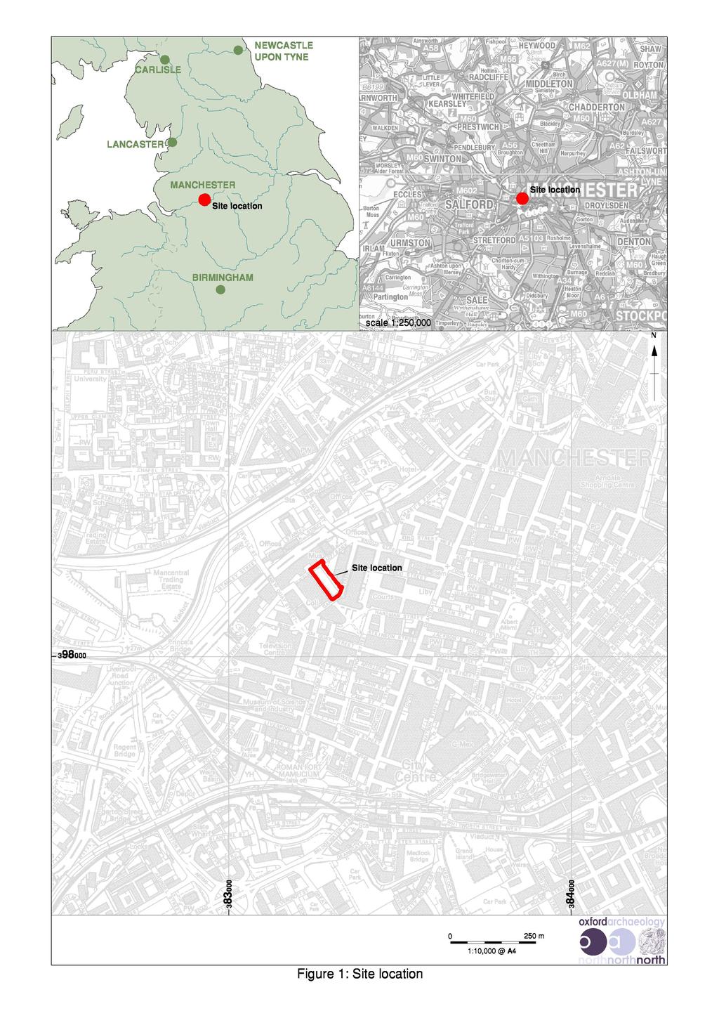
6 Hardman Boulevard, Spinningfields, Manchester: Archaeological Investigation 4 1. INTRODUCTION 1.1 CIRCUMSTANCES OF THE PROJECT Allied London Properties Ltd has obtained planning consent (Application No /FO/2013/C1) for a new development on land in the Spinningfields area of Manchester city centre. The development proposals allow for the erection of a new multi-storey building comprising offices, a ground-floor restaurant, a gym, basement car-parking, and associated landscaping and infrastructure works, which will inevitably necessitate considerable earthmoving works that could potentially damage or destroy any buried archaeological remains within the boundary of the site. 1.2 LOCATION AND TOPOGRAPHY The study area (centred on NGR ) lies on the north-eastern side of Hardman Boulevard, and immediately to the south-west of the Civil Justice Centre on Gartside Street in the Spinningfields area of central Manchester (Fig 1). It occupies a rectangular plot of land of approximately 3300m 2, and presently comprises a well-maintained landscaped open-space that is flanked along its western edge by an avenue of semi-mature trees (Plate 1). Plate 1: Recent aerial view of the study area and its environs Topographically, the area is predominantly flat, lying at a height of 28.5m aod. The north-western side of the Application Area comprises a concrete roadway, whilst the remaining two-thirds are covered with grass.

.")

7 Hardman Boulevard, Spinningfields, Manchester: Archaeological Investigation HISTORICAL BACKGROUND The known development of the study area commenced in the eighteenth century. Casson and Berry s map of Manchester and Salford that was produced in 1755 shows the study area as lying within a group of fields on the south-western edge of the town, bounded on the south by Quay Street and on the west by Water Street (Plate 2). These two thoroughfares converged at the buildings of the Old Quay Company on the Irwell. Under an Act of Parliament of 1721, the company had been empowered to make the River Mersey and River Irwell navigable between Warrington and Manchester (UMAU 2003). The navigation was probably completed in 1736, and by 1740 the company had built a quay and warehousing at the bottom of Quay Street (Hadfield and Biddle 1970, 16-8). Plate 2: Extract from Casson and Berry s map of 1755, with arrow marking the approximate position of the study area The next available map of the area, produced by Tinker in 1772, similarly shows the study area as fields, although the western and eastern ends of Water Street are shown as having been developed. This represented the initial stage in what proved to be the rapid and intense development of this part of Manchester. The extent of development by the end of the eighteenth century is captured on Charles Laurent s map of 1793 (Plate 3), and William Green s detailed map that was published in These accurate surveys show Gartside Street to have been laid out, running southward from New Bridge Street. Between it and Water Street a network of other streets had been laid out, including Irwell Street, which ran through the centre of the study area, together with Back Water Street. Green s map shows two streets leading southward from Irwell Street, of which the most westerly is named on later maps as Young Street, and the more easterly as Potter Street.
, although a few larger structures are")
8 Hardman Boulevard, Spinningfields, Manchester: Archaeological Investigation 6 Plate 3: Extract from Laurent s map of 1793, marking the approximate boundary of the study area Swire s map of 1824 shows the study area to have been largely developed. The arrangement of buildings is more clearly shown on Bancks & Co s map of 1831, which shows that most of this development comprised workers housing (Plate 4), although a few larger structures are likely to have small industrial or commercial buildings. In particular, the form of a large L-shaped building fronting onto Back Water Street, close to its junction with Water Street, is inconsistent with housing. This is corroborated by the detail shown on the Ordnance Survey 60 : 1 mile map of 1849, which identifies the building as a saw mill. Further detail is provided by Adshead s map of 1851, which shows the main body of the building to have been factory premises occupied by Ellis & Co, whilst the range fronting Back Water Street (and within the study area) was used for retail purposes. Several other buildings surveyed by Bancks & Co within the boundary of the study area are marked as retail premises by Adshead, the majority of which fronted onto either Irwell Street or Water Street Bancks & Co s map clearly show that the study area had been almost entirely developed by the early 1830s (Plate 4). The only small plot of land that was seemingly not being used lay along the southern boundary of the present study area, situated between Potter Street and Gartside Street.

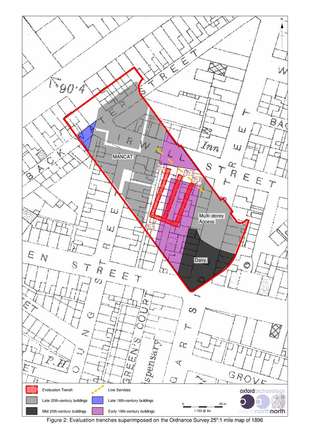
9 Hardman Boulevard, Spinningfields, Manchester: Archaeological Investigation 7 Plate 4: Extract from Extract from Bancks & Co s Plan of Manchester of 1831, marking the boundary of the study area Bancks & Co s map shows various types of workers housing within the boundary of the study area, although more detail is provided by the Ordnance Survey map of These included double-depth houses with outshuts fronting onto Water Street, Young Street and Gartside Street, most of which appear to have incorporated cellar lights, indicating that they had basements. A row of 14 single-depth houses area shown along the north-western side of Potter Street, each with a small back yard containing a privy, and a rear passage running between Cobden Street and Irwell Street. Adshead s map of 1851 shows that the properties forming each end of this row were shops. There is no indication on either of these detailed maps that the single-depth houses had cellars The small plot in the southern part of the study area that was depicted as undeveloped by Bancks & Co is shown to have been in use as a timber yard and saw pit by the mid-nineteenth century. However, this had been subsumed by development before the end of the century, as shown on the Ordnance Survey 1:500 town plan of 1891 (Plate 5), and the 25 : 1 mile map of 1896 (Fig 6). In all other respects, the buildings within the study area appear to have remained largely unchanged from the mid-nineteenth century.
10 Hardman Boulevard, Spinningfields, Manchester: Archaeological Investigation 8 Plate 5: Extract from the Ordnance Survey town plan of 1891, marking the boundary of the study area The arrangement of buildings within the study area depicted by the Ordnance Survey in the 1890s is shown as little changed on mapping of 1908 (Plate 6). By 1909, however, the buildings on the site of the former timber yard between Potter Street and Gartside Street had been demolished and replaced by a single new block (UMAU 2003, 9). The eastern part of Cobden Street is shown on this map to have been renamed Hardman Street Within a few years, Irwell Street had been renamed Cumberland Street, and the housing on the north side of the street had been replaced by a new range, which represented either an extension or rebuilding of the saw mill (ibid). Entries in contemporary trade directories indicate that the site was occupied at this date by the Globe Saw Mills Co, packing-case manufacturers (Slater 1915). The new layout is shown on the Ordnance Survey map of By that date, the western part of Cobden Street had been renamed Hardman Street The next edition of Ordnance Survey mapping, published in 1932, shows the former saw mill that straddles the north-eastern boundary of the study area to have been remodelled and converted for use as a warehouse. The buildings between Gartside Street and Potter Street in the southern part of the study area had all been demolished by this date, and replaced by a large dairy building, occupied by Burgess Dairy Ltd (Kelly 1932).
11 Hardman Boulevard, Spinningfields, Manchester: Archaeological Investigation 9 Plate 6: Extract from the Ordnance Survey map of 1908, marking the boundary of the study area The Ordnance Survey map of shows that the study area had undergone large-scale clearance, involving the demolition of all the earlier properties apart from the dairy on Gartside Street, and a small fragment of the former saw mill, which is annotated as a ruin. By 1963, north-western part of the study area had been redeveloped for the northern wing of the John Unsworth Building, then part of the Manchester College of Building, and known subsequently as MANCAT. This building subsumed the line of Back Water Street, and also the north-western extent of Irwell Street. The footprint of former houses along Irwell Street and Young Street were also subsumed by this new building By 1971, the dairy in the southern part of the study area had been demolished, and the site of the buildings along the north side of Irwell Street was in use as a car park (Plate 7). The Manchester Courts of Justice, situated immediately to the south-east of the study area, are also depicted on this map. A multi-storey car-park was erected immediately to the north-east shortly after the publication of this map in 1971, with the access routes crossing the south-eastern corner o the study area.
12 Hardman Boulevard, Spinningfields, Manchester: Archaeological Investigation METHODOLOGY 2.1 WATCHING BRIEF /TRENCHING Although initially termed a watching brief during surface stripping work it was decided on site to mechanically excavate four trial trenches under archaeological supervision in order to establish whether any remains of archaeological significance had survived. This was undertaken using a tracked excavator with a toothless ditching bucket The archaeological watching brief/trenching recorded the location, extent, and character of all surviving features and deposits of archaeological interest. This was in accordance with the Project Brief (Appendix 1) and also the IfA Standards and Guidance for archaeological excavations (IfA 2008a). 2.2 FINDS The recovery of finds and sampling programmes were carried out in accordance with best practice, following current IfA guidelines (IfA 2008a), and subject to expert advice, in order to minimise deterioration. 2.3 ARCHIVE A full professional archive has been compiled in accordance with the current IfA (IfA 2008b) and English Heritage guidelines (English Heritage 1991). The project archive represents the collation and indexing of all the data and material gathered during the course of the project. A copy of this report will be forwarded to the Greater Manchester Historic Environment Record (HER).

13 Hardman Boulevard, Spinningfields, Manchester: Archaeological Investigation RESULTS 3.1 INTRODUCTION The archaeological investigation comprised monitoring the mechanical stripping of the existing ground surface, coupled with the excavation of four trenches that were targeted across the footprint of heritage assets identified during the desk-based study (Fig 2). Small sections across the north-eastern and south-western parts of the site were not subject to investigation due to a concrete walkway and a live power cable from a nearby electricity sub-station respectively The uppermost layer across the site comprised turf and topsoil, which was up to 0.1m thick with an underlying 0.15m deep bedding layer of mixed loam and cinders. This was underlain with 0.1m of limestone gravel levelling, which in turn lay upon a layer of terram. Below this was a further levelling layer of black cinders and crushed brick, which sealed a thick layer of mixed demolition rubble and sandy loam. No archaeological remains were identified in any of the areas that were subject to mechanical stripping. 3.2 TRENCHES Trench 1: this trench was aligned north-west/south-east, and overlay the former Young Street and workers houses (Fig 2). The trench measured 15 x 1.8m wide, and was excavated to the level of the natural sand and gravels, which were exposed at a depth of 1.42m (Plate 7). Plate 7: Trench 1 during excavation, showing the natural sand and gravel
. The trench measured 23.3 x 1.")
14 Hardman Boulevard, Spinningfields, Manchester: Archaeological Investigation Trench 2: this trench was aligned north-east/south-west, and was placed across the footprint of the former workers houses on Young Street (Fig 2). The trench measured 23.3 x 1.8m, and was excavated south-west from the north-western end of Trench No remains of archaeological significance were present within the trench. Natural river terrace sand and gravel was observed at a depth of 1.42m below the modern ground surface, and were overlain by twentieth-century demolition and levelling deposits (Plate 8). Plate 8: Natural sand exposed at the end of Trench Trench 3: this trench was aligned north-east/south-west, and was placed across the footprint of workers houses on the former Young Street, and part of the former Irwell Street (Fig 2). The trench measured 25 x 1.8m, and continued south-west from the centre of Trench 1. No remains of archaeological significance were present within the trench. Natural river terrace sand and gravel was observed at a depth of 1.58m below the modern ground surface, and were overlain by twentieth-century demolition and levelling deposits (Plate 9) Trench 4: this trench was aligned north-east/south-west, and overlay the former Young Street and Irwell Street. The trench measured 26 x 1.8m, and extended south-west from the south-eastern end of Trench 1. No remains of archaeological significance were present within the trench. Natural river terrace sand and gravel not observed within this trench, excavation of which was stopped at a depth of 1.6m due to instability of the trench sides (Plate 10).


15 Hardman Boulevard, Spinningfields, Manchester: Archaeological Investigation 13 Plate 9: Natural sand observed during excavation of Trench 3 Plate 10: Mixed fill not bottomed at the end of Trench 4
16 Hardman Boulevard, Spinningfields, Manchester: Archaeological Investigation DISCUSSION 4.1 No remains of archaeological significance appear to have survived within the proposed development area. The nature of the excavated material suggest that all buried remains were removed during the extensive remediation works carried out in the area during the early 2000s, and associated with the construction of the office blocks and leisure and retail facilities surrounding the site. 4.2 The desk-based assessment that was compiled at an initial stage in the project concluded that the area with the greatest potential to retain buried remains of archaeological interest was focused along the former Young Street. Trenches placed across this area during the course of the watching brief, however, demonstrated that all buried remains had been destroyed during the previous redevelopment of the site. The area to the immediate south-west of the former Irwell Street was also identified as being of potential archaeological interest in the desk-based assessment, although this could not be subject to trenching due to the presence of a live electricity cable from a nearby substation. The nature of the topography and the below-ground deposits on site indicated that this area would prove to be identical to the trenched area, and that no further investigation was merited.
17 Hardman Boulevard, Spinningfields, Manchester: Archaeological Investigation 15 BIBLIOGRAPHY PRIMARY AND CARTOGRAPHIC SOURCES Map of Manchester and Salford, W Green, Map of Manchester, Swires, 1824 A Map of Manchester and Salford, G Bancks & Co, 1831 Ordnance Survey First Edition 60 :1 mile, surveyed 1848, published 1850 Ordnance Survey First Edition 25 :1 mile, Lancashire, published 1893 Ordnance Survey 25 :1 mile, Lancashire, published 1905 Ordnance Survey 25 :1 mile, Lancashire, published Ordnance Survey 25 :1 mile, Lancashire, revised 1915, published 1922 Ordnance Survey 25 :1 mile, Lancashire, published 1934 Ordnance Survey 25 :1 mile, Lancashire, published Ordnance Survey 1:2500 SJ 8497 and SJ 8599, published 1970 SECONDARY SOURCES Countryside Commission, 1998 Countryside Character Volume 2: North West, Cheltenham English Heritage, 2006 Management of Research Projects in the Historic Environment (MoRPHE), Swindon Farrer, J, and Brownbill, W, (eds) 1908 Victoria County History of Lancashire, 4, London Institute for Archaeologists, 2010 Code of Conduct, Reading Institute for Archaeologists, 2011 Standard and Guidance for Historic Environment Desk-based Assessment, Reading OA North, Hardman Boulevard, Spinningsfields, Manchester: Archaeological Desk-based Assessment, unpubl rep UMAU, 2003 Proposed Civil Justice Centre and Plots , Spinningfields, Manchester: Archaeological Desk-based Assessment, unpubl rep
18 Hardman Boulevard, Spinningfields, Manchester: Archaeological Investigation 16 UMAU, 2008 Plot 104, Crown Square, Spinningfields, Manchester: An Archaeological Excavation, unpubl rep
19 Hardman Boulevard, Spinningfields, Manchester: Archaeological Investigation 17 APPENDIX 1: WRITTEN SCHEME OF INVESTIGATION 2 Hardman Boulevard, Spinningfields, Manchester Archaeological Watching Brief Written Scheme of Investigation Oxford Archaeology North March 2014 Planning Application /FO/2013/C1 Proposals The following Written Scheme of Investigation is offered in response to a request from Mr Graham Skinner, of Allied London Properties Ltd, for an archaeological investigation in advance of a proposed development on Hardman Boulevard in the Spinningfields area of central Manchester.
20 Hardman Boulevard, Spinningfields, Manchester: Archaeological Investigation BACKGROUND 1.1 CIRCUMSTANCES OF PROJECT Allied London Properties Ltd has obtained planning consent (Application No /FO/2013/C1) for a new development on land in the Spinningfields area of central Manchester (centred on NGR ). The development proposals allow for the erection of a new office building comprising offices, a ground-floor restaurant, a gym, basement car-parking, and associated landscaping and infrastructure works, which will inevitably necessitate considerable earth-moving works. In order to secure archaeological interests, Manchester City Council attached a condition (Condition 9) to planning consent that required an appropriate scheme of archaeological investigation to be implemented prior to development Following consultation with the Greater Manchester Archaeological Advisory Service, in their capacity as archaeological advisors to Manchester City Council, it was recommended that an archaeological desk-based assessment of the development area was carried out in the first instance. This was intended to update the conclusions drawn from an archaeological assessment of the area that was carried out in 2003, establish the merits of carrying out further archaeological investigation of the site, and enable an appropriate scheme of investigative works to be formulated The archaeological assessment concluded that the study area contained seven non-designated heritage assets of archaeological interest. Of this total, however, it seems likely that the majority were subject to considerable damage or disturbance during the later nineteenth and twentieth centuries, although there is some potential for buried remains of a row of early nineteenth-century double-depth workers houses to survive in-situ. These remains are likely to be of local interest, and merit some level of archaeological investigation to mitigate their ultimate loss during the course of the proposed development Following consultation with the Greater Manchester Archaeological Advisory Service, it was recommended that an archaeological watching brief is maintained during the earth-moving works required by the development. The watching brief will be focused on the footprint of the row of early nineteenthcentury double-depth houses that lie across the centre of the development area, but will also rapidly examine other parts of the site to confirm that the results obtained from the desk-based assessment are accurate This document provides the required Written Scheme of Investigation for an appropriate scheme of archaeological investigation, as per the wording of the condition attached to planning consent. It has been produced by Oxford Archaeology North (OA North) at the request of Graham Skinner, of Allied London Properties Ltd.
21 Hardman Boulevard, Spinningfields, Manchester: Archaeological Investigation OXFORD ARCHAEOLOGY Oxford Archaeology is an educational charity under the guidance of a board of trustees with over 35 years of experience in archaeology, and can provide a professional and cost-effective service. We are the largest employer of archaeologists in the country (we currently have more than 300 members of staff), and can thus deploy considerable resources with extensive experience to deal with any archaeological obligations you or your clients may have. OA is an Institute for Archaeologists Registered Organisation (No 17). We have offices in Lancaster and Oxford, trading as Oxford Archaeology North (OA North) and Oxford Archaeology South (OA South) respectively, enabling us to provide a truly nationwide service. All work on the project will be undertaken in accordance with relevant professional standards, including: IfA s Code of Conduct (1999); Code of Approved Practice for the Regulation of Contractual Arrangements in Field Archaeology (1999); Standard and Guidance for Archaeological Evaluations (1999); English Heritage s Management of Archaeological Projects, 1991; The European Association of Archaeologists Principles of Conduct for Archaeologists Involved in Contract Archaeological Work (1998) OA North has unrivalled experience in the assessment, evaluation and excavation of former industrial and associated residential sites, particularly in the context of Manchester. We have an extensive portfolio of excavating the buried remains of former workers housing, including numerous sites in the Ancoats, Piccadilly, and Shudehill areas of central Manchester.
22 Hardman Boulevard, Spinningfields, Manchester: Archaeological Investigation AIMS AND OBJECTIVES 2.1 ACADEMIC AIMS The principal aim of the project is to establish the presence or absence of any buried remains of archaeological interest within the proposed development area and, should such remains be proven to survive in-situ, carry out sufficient investigation to provide a detailed record to mitigate their damage or destruction during the proposed development. 2.2 OBJECTIVES The objectives of the project may be summarised as follows: to establish the present or absence of any buried remains of the early nineteenth-century workers housing that occupied the east side of the former Young Street; to confirm that other sites of archaeological interest in the study area have been damaged or destroyed by twentieth-century development; to implement an appropriate programme of more detailed investigation of the Young Street houses where buried archaeological remains are found to survive in-situ; to undertake any post-excavation works required and create an appropriate site archive; to produce a full excavation report that can be passed on in digital format to all stakeholders at the end of the project; to carry out an appropriate level of dissemination of the results.
23 Hardman Boulevard, Spinningfields, Manchester: Archaeological Investigation METHOD STATEMENT 3.1 THE PROPOSED ARCHAEOLOGICAL PROGRAMME The archaeological impact of the proposed construction works will be mitigated by a flexible response that will be appropriate to the nature of the archaeological resource. The programme of archaeological works will be targeted primarily on the footprint of a double-depth cottages along the former Young Street, situated across the centre of the development area (shown in purple on Figure 1). In addition, the site of late eighteenth-century buildings in the north-western part of the study area will be examined briefly to confirm that they were largely destroyed during the construction of the MANCAT Building in the second half of the twentieth century In the first instance, an archaeological watching brief will be maintained during the enabling works that are to be carried out in advance of the main construction programme. This will comprise the stripping of the modern ground surface to a depth of c 600mm, which will then be replaced with stone to create a piling mat. It is anticipated that it may be possible to establish the presence of absence of buried archaeological remains during this initial strip, and thereby inform the requirement and precise scope of further archaeological monitoring during a second stage of ground-reduction works This second stage of works will be implemented once the piled foundations for the new building have been formed, and will comprise the excavation between the piled perimeter to considerable depth, extending several metres into the solid geology. Where any archaeological remains are exposed during the process, more detailed archaeological investigation will be carried out. Following the completion of the fieldwork, a full site report and archive will be produced. The report will include a detailed summary of the results obtained from the work.


24 Hardman Boulevard, Spinningfields, Manchester: Archaeological Investigation 22 Figure 1: Areas targeted for the archaeological watching brief, showing the footprint of twentiethcentury structures that are likely to have destroyed the buried remains of earlier buildings
25 Hardman Boulevard, Spinningfields, Manchester: Archaeological Investigation METHODOLOGY Watching Brief Methodology: all ground-breaking works necessitated by the construction programme will be supervised closely by a suitably experienced archaeologist. All excavation will be carried out using a mechanical excavator of appropriate power and equipped, where possible, with a toothless ditching bucket. The mechanical stripping of the modern ground surface will be followed by the rapid manual cleaning of any exposed remains and archaeological recording. This programme of field observation will accurately record the location, extent, and character of any surviving archaeological structures, features and/or deposits exposed during the construction programme. This work will comprise observation during the excavation for these works, the systematic examination of any subsoil horizons exposed during the course of the groundworks, and the accurate recording of all archaeological structures and features, and any artefacts, identified during observation Putative archaeological structures, features and/or deposits exposed during construction work, together with the immediate vicinity of any such features, will be cleaned by hand, using either hoes, shovel scraping, and/or trowels depending on the ground conditions, and where appropriate sections will be studied and drawn During this phase of work, recording will comprise a full description and preliminary classification of features or materials revealed, and their accurate location (either on plan and/or section, and as grid co-ordinates where appropriate). Features will be planned accurately at appropriate scales and annotated on to a large-scale plan. A photographic record will be undertaken simultaneously. A plan will be produced of the areas of groundworks showing the location and extent of the ground disturbance and one or more dimensioned sections will be produced It is assumed that the archaeological contractor will have the authority to stop the works for a sufficient time period to enable an accurate assessment of important deposits. In the event of these deposits being extensive, then a programme of further detailed archaeological investigation may be anticipated. This would only be implemented following consultation with the Client and the Greater Manchester Archaeological Advisory Service (GMAAS), in their capacity as archaeological advisors to Manchester City Council Detailed Recording Methodology: in the event of buried remains of archaeological interest being exposed during the initial watching brief, further detailed investigation will be undertaken. This will be carried out in accordance with a agreed scope of works that will be devised in close consultation with GMAAS. In broad terms, however, structural remains will be excavated manually to define their extent, nature, form and, where possible, date.
26 Hardman Boulevard, Spinningfields, Manchester: Archaeological Investigation Recording: all information identified in the course of the site works will be recorded stratigraphically, with sufficient pictorial record (plans, sections and colour photographs) to identify and illustrate individual features. Results of all field investigations will be recorded on pro-forma context sheets. The trenches and features will be located by use of high accuracy differential GPS equipment or total station; altitude information will be established with respect to Ordnance Datum. Archaeological features will be planned using manual techniques or by means of a total station Finds policy: artefact and palaeoecology specialists, with appropriate expertise in the investigation, excavation, and finds management of sites of all periods and types, will be readily available for consultation. Finds storage during fieldwork and any site archive preparation will follow professional guidelines (UKIC). Any gold and silver artefacts recovered during the evaluation will be removed to a safe place and reported to the local Coroner according to the procedures relating to the Treasure Act, Human remains are not expected to be present, but if they are found they will, if possible, be left in-situ, covered and protected. The remains will then be subject to a formal appraisal by an appropriate specialist. If removal is necessary, then the relevant Department of Cultural Affairs permission will be sought, and the removal of such remains will be carried out with due care and sensitivity, as required by current legislation Environmental Sampling: a programme of palaeo-environmental sampling will be carried out during the archaeological investigation in accordance with the guidelines provided by English Heritage (2002). Samples will be collected for technological, pedological and chronological analysis as appropriate. The samples taken will be fully assessed and not subject to sub-sampling. The contexts will be sampled as appropriate, subject to palaeo-environmental survival. Bulk (30 litres) samples will be taken from all sealed pit fills, and particularly from any discrete fills within single pits, which may provide evidence for a change in function. 3.3 POST-EXCAVATION WORK, ARCHIVE PRODUCTION AND REPORTING An archive for the project will be prepared during and immediately following the fieldwork programme for deposition in an appropriate repository. The results of the excavation will form the basis of a full archive to professional standards, in accordance with current English Heritage guidelines (Management of Research Projects in the Historic Environment, 2006). The project archive represents the collation and indexing of all the data and material gathered during the course of the project. The deposition of a properly quantified, ordered, and indexed project archive in an appropriate repository is considered an essential and integral element of all archaeological projects by the Institute for Archaeologists in that organisation s Code of Conduct. The project archive will be deposited with the Museum of Science and Industry in Manchester at the end of the project.
27 Hardman Boulevard, Spinningfields, Manchester: Archaeological Investigation An appropriate programme of analysis will be undertaken to prepare a research archive, as detailed in Appendix 6 of Management of Archaeological Projects (English Heritage 1991). A provisional programme of post-excavation analysis is proposed, on the basis of the anticipated recovery of material from the excavation; however, the extent of the programme can only be reliably assessed on completion of the fieldwork. The proposed programme anticipates analysis of the artefactual evidence and of the site stratigraphy, and may also involve palaeo-environmental assessment, leading to the production of a final report The report will present, summarise, and interpret the results of the archaeological work, and will incorporate specialist reports on artefact assemblages and environmental reports, as appropriate. It will include an index of archaeological features identified in the course of the project, with an assessment of the site s development. It will incorporate appropriate illustrations, including copies of the site plans and section drawings, all reduced to an appropriate scale The report will consist of a statement of acknowledgements, lists of contents, executive summary, introduction summarising the brief and project design, methodology, interpretative account of the site and associated structures, gazetteer of features, a complete bibliography of sources from which data has been derived, and a list of further sources identified during the programme of work. Allied London Properties Ltd, Manchester City Council and GMAAS will be supplied with digital copies of the report, with a bound, hard copy prepared for deposition with the Greater Manchester Historic Environment Record (HER) and the receiving museum. All digital survey information will be supplied in a CAD compatible format as a.dwg file, and all digital photographs will also be supplied as individual jpegs At the start of project, an OASIS on-line record will be initiated and key fields completed on Details, Location and Creators forms. All parts of the OASIS online form will be completed for submission to the Greater Manchester Historic Environment Record (HER). This will include an uploaded pdf version of the final report. 3.4 OTHER MATTERS Dissemination: the results obtained from the archaeological investigation will be disseminated commensurate with their significance. In the event of limited archaeological remains being exposed, dissemination will comprise presentation in a final grey literature report, which will be deposited with the Greater Manchester HER. The appropriate means of disseminating the discovery of remains of greater significance will be discussed with GMAAS Timetable: the timetable for the watching brief will be dictated by the principal contractor s programme, although it is anticipated that the initial stripping of the modern ground surface will be carried out in May A report will be submitted within four weeks of the completion of the fieldwork.
28 Hardman Boulevard, Spinningfields, Manchester: Archaeological Investigation Health and Safety: archaeological staff and visitors will respect Health and Safety provisions and site-specific safety regulations. It is the policy of OA North ( the Employer ) to conform fully with the requirements of the Health and Safety at Work Act (1974), and all site procedures will be in accordance with the guidance set out in the Health and Safety Manual compiled by the Standing Conference of Archaeological Unit Managers (2002). Attention will also be paid to the requirements of more recent legislation, including the provision and use of Work Equipment Regulations (1992), the Management of Health and Safety at Work Regulations (1992), and the Construction (Design and Management) Regulations (1994) In furtherance of the duty of care imposed by the Health and Safety at Work Act (1974), the Employer shall make available to his employees whatever reasonable facilities are required by particular circumstances. A written risk assessment will be undertaken in advance of project commencement, and copies will be made available on request Insurance: evidence of Public Liability Insurance to the minimum value of 5m, and Professional Indemnity Insurance to the minimum of 2m, will be provided prior to the commencement of the archaeological works Contingencies: if there are more complex or generally deeper deposits than can be anticipated from the evidence available, there may need to be a corresponding increase in costs, which will be subject to agreement with the Client and the archaeological curator. Similarly, there will be recourse to a contingency if there is any requirement to fully excavate any human remains that may be present. These contingency costs are in accordance with the Institute for Archaeologists guidance Confidentiality: the report is designed as a document for the specific use of the Client, for the particular purpose as defined in the project design, and should be treated as such; it is not suitable for publication as an academic report, or otherwise, without amendment or revision. Any requirement to revise or reorder the material for submission or presentation to third parties beyond the project design, or for any other explicit purpose can be fulfilled, but will require separate discussion and funding.
29 Hardman Boulevard, Spinningfields, Manchester: Archaeological Investigation STAFFING PROPOSALS 4.1 The project will be under the overall charge of Ian Miller BA FSA (OA North Senior Project Manager) to whom all correspondence should be addressed. Ian was appointed as a Senior Project Manager with OA North in 2001, since which time he has been involved almost exclusively with Industrial Archaeology, and acts as an internal consultant for all of OA s industrial projects. A large proportion of the numerous projects that Ian has project managed since 2001 have been in the Manchester area. Amongst the recent large-scale excavations that Ian has been responsible for are those at the site of the Co-operative Group s Headquarter s Building in the Shudehill area of Manchester. Ian is a member of the CBA North West Industrial Archaeology Panel, and the Cumberland and Westmorland Archaeological Society Industrial Archaeology Panel. 4.2 His role will be to ensure that the Written Scheme of Investigation is implemented within the framework of the Project Objectives. He will be responsible for all aspects of staff and resource logistics, ensuring the smooth running of the project programme. He will liaise with the Allied London Properties Ltd and GMAAS with regard to progress, and will maintain relationships with other contractors. 4.3 The watching brief is likely to be undertaken by Graham Mottershead (OA North Project Officer). Graham is an highly experienced field archaeologist, who has a particular interest in the archaeology of the Manchester area. He played a key role in several of the archaeological excavations in the area carried out in Spinningfields previously by the former Manchester University Archaeological Unit. 4.4 It is not possible to provide details of specific technicians that may be involved with the fieldwork at this stage, but all shall be suitably qualified archaeologists with proven relevant experience. 4.5 Assessment of any finds recovered from the evaluation will be undertaken by OA North's in-house finds specialist Christine Howard-Davis BA (OA North Finds Manager). Christine has extensive knowledge of all finds of all periods from archaeological sites in northern England, and is a recognised expert in the analysis of post-medieval artefacts. 5. MONITORING 5.1 Monitoring meetings will be established with the Client and the archaeological curator at the outset of the project. The aims of monitoring are to ensure that the archaeological works are undertaken within the limits set by the Written Scheme of Investigation, and to the satisfaction of the curatorial archaeologist at GMAAS. The curatorial archaeologist will be given at least five days notice of when work is due to commence, and will be free to visit the site by prior arrangement with the project director.
30 Hardman Boulevard, Spinningfields, Manchester: Archaeological Investigation 28 ILLUSTRATIONS LIST OF FIGURES Figure 1: Figure 2: Site location Location of trial trenches LIST OF PLATES Plate 1: Natural sand observed during excavation of Trench 1 Plate 2: Natural sand observed during excavation of Trench 2 Plate 3: Natural sand observed during excavation of Trench 3 Plate 4: Mixed fill exposed at the end of Trench 4
31
32
Archaeological Monitoring of Land at 29 Royal Pier Road, Gravesend, Kent
 Archaeological Monitoring of Land at 29 Royal Pier Road, Gravesend, Kent Site Code ROY/WB/15 Report for Dr Maxted Date of report 06/10/2015 SWAT ARCHAEOLOGY Swale and Thames Archaeological Survey Company
Archaeological Evaluation and Assessment of Land at Kent Cottage, 19 Chapel Street, Hythe, Kent
 Archaeological Evaluation and Assessment of Land at Kent Cottage, 19 Chapel Street, Hythe, Kent Planning Application Y13/0463/SH Date of Report: 29/04/2015 Report for Marc Carney SWAT. ARCHAEOLOGY Swale
Archaeological evaluation at Willowdene, Chelmsford Road, Felsted, Essex
 Archaeological evaluation at Willowdene, Chelmsford Road, Felsted, Essex August 2013 report prepared by Ben Holloway on behalf of Mr Anthony McGurren Planning reference: UTT/13/0235 CAT project ref.: 13/07g
Archaeological Investigation in advance of Development at 2 Palace Cottages, Charing Palace, Charing, Kent
 Archaeological Investigation in advance of Development at 2 Palace Cottages, Charing Palace, Charing, Kent Site Code CHAR-EV-14 NGR 95412 49439 Date of Report 18/12/2014 Swale and Thames Archaeological
Garage Site, Foots Cray High Street, Sidcup, Kent, London Borough of Bexley
 Garage Site, Foots Cray High Street, Sidcup, Kent, London Borough of Bexley An Archaeological Evaluation for Mizen Design Build by Andy Taylor Thames Valley Archaeological Services Ltd FOC 07 September
Archaeological evaluation: land to the rear of Clare Road, Braintree, Essex
 Archaeological evaluation: land to the rear of 41-45 Clare Road, Braintree, Essex March 2014 commissioned by Mr Mark Plummer report prepared by Ben Holloway and Howard Brooks Planning reference: 13/000585/FUL,
Newcombe House & Kensington Church Street
 Newcombe House & Kensington Church Street Archaeological Evaluation September 2017 Summary Site name: Newcombe House, Kensington Church Street, Notting Hill, London Grid reference: TQ 25318 80372 Site
Archaeological Evaluation and Assessment of Land at Minnis Beeches, Canterbury Road, Swingfield, Dover, Kent
 Archaeological Evaluation and Assessment of Land at Minnis Beeches, Canterbury Road, Swingfield, Dover, Kent NGR: TQ 6307 1545 Site Code: MB-EV-10 (Planning Consent Y10/0311/SH) Report for Thorndene Ltd.
WRITTEN SCHEME OF INVESTIGATION
 CANAL COLLEGE 2, ROSEBANK DISTILLERY: WRITTEN SCHEME OF INVESTIGATION 1 2 Contents Background... 4 Introduction... 5 Historical Notes... 6 Methodology... 7 Staff... 9 Products... 9 Timetable... 9 Bibliography...
Archaeology and Planning in Greater London. A Charter for the Greater London Archaeology Advisory Service
 Archaeology and Planning in Greater London A Charter for the Greater London Archaeology Advisory Service THE PURPOSE OF THE CHARTER This Charter sets out how English Heritage will provide archaeological
Meales Farm, Sulhamstead, West Berkshire
 Meales Farm, Sulhamstead, West Berkshire An Archaeological Watching Brief For Mr. Robert Astor by Steve Ford Thames Valley Archaeological Services Ltd Site Code CHH02/29 May 2002 Summary Site name: Meales
Centre for Archaeological Fieldwork Evaluation/Monitoring Report No Monitoring Report No. 201
 Monitoring Report No. 201 Land adjacent to 58 Drumreagh Road Drumreagh Ballygowan Co. Down LICENCE NO.: AE/10/91E BRIAN SLOAN 1 Site Specific Information Site Name: Land adjacent to 58 Drumreagh Road,
High Speed Rail (London- West Midlands)
") High Speed Rail (London- West Midlands) Draft Environmental Minimum Requirements Annex 3: Draft Heritage Memorandum November 2013 ESA 4.4 High Speed Rail (London- West Midlands) Draft Environmental Minimum
High Speed Rail (London- West Midlands) Draft Environmental Minimum Requirements Annex 3: Draft Heritage Memorandum November 2013 ESA 4.4 High Speed Rail (London- West Midlands) Draft Environmental Minimum
Land adjacent to Dingle Dock, Front Street, East Garston
 Land adjacent to Dingle Dock, Front Street, East Garston An Archaeological Watching Brief for Dr J Davies by Jo Pine Thames Valley Archaeological Services Site Code DEG99/82 January 2000 Summary Site name:
Ivol Buildings, Woodcote Road, South Stoke, Oxfordshire
 Ivol Buildings, Woodcote Road, South Stoke, Oxfordshire An Archaeological Watching Brief For Christ Church, Oxford by Pamela Jenkins Thames Valley Archaeological Services Ltd Site Code IBSS 04/03 March
New Media Building, Goldsmiths College, New Cross, London Borough of Lewisham
 New Media Building, Goldsmiths College, New Cross, London Borough of Lewisham An Archaeological Evaluation for Willmott Dixon Construction by Andy Taylor Thames Valley Archaeological Services Ltd Site
Archaeological evaluation at Stables, Hatch Farm, Fen Lane, Bulphan, Essex, RM14 3RL
 Archaeological evaluation at Stables, Hatch Farm, Fen Lane, Bulphan, Essex, RM14 3RL November-December 2016 by Laura Pooley figures by Ben Holloway and Emma Holloway fieldwork by Ben Holloway and Alec
MILLER BRIDGE, KENDAL, CUMBRIA
 MILLER BRIDGE, KENDAL, CUMBRIA Archaeological Watching Brief: Supplementary Report Oxford Archaeology North February 2010 Balfour Beatty Issue No: 2009-10/1006 OAN Job No: L10133 NGR: SD 5175 9269 Miller
Archaeological evaluation on land at Mersea Fleet Way, Chelmer Road, Braintree, Essex, CM7 3PZ
 Archaeological evaluation on land at Mersea Fleet Way, Chelmer Road, Braintree, Essex, CM7 3PZ by Laura Pooley figures by Ben Holloway and Emma Holloway fieldwork by Ben Holloway, Robin Mathieson, Nigel
ARCHAEOLOGICAL EVALUATION AT THE FORMER WATTON GARDEN CENTRE, NORWICH ROAD, WATTON, NORFOLK OCTOBER 2003 (Accession number WAT)
") NORTHAMPTONSHIRE ARCHAEOLOGY NORTHAMPTONSHIRE COUNTY COUNCIL NOVEMBER 2003 (Planning Application No: 3PL/1997/048/0 ARCHAEOLOGICAL EVALUATION AT THE FORMER WATTON GARDEN CENTRE, NORWICH ROAD, WATTON, NORFOLK
NORTHAMPTONSHIRE ARCHAEOLOGY NORTHAMPTONSHIRE COUNTY COUNCIL NOVEMBER 2003 (Planning Application No: 3PL/1997/048/0 ARCHAEOLOGICAL EVALUATION AT THE FORMER WATTON GARDEN CENTRE, NORWICH ROAD, WATTON, NORFOLK
Archaeological monitoring at Clintons, Bury Green, Little Hadham, Hertfordshire April 2008
 Archaeological monitoring at Clintons, Bury Green, Little Hadham, Hertfordshire April 2008 report prepared by Ben Holloway on behalf of Charles Britton Equestrian Construction CAT project ref.: 08/3b NGR:
Archaeological evaluation on land at Unit 1, Waltham Hall, Bambers Green Road, Takeley, Essex, CM22 6PF
 Archaeological evaluation on land at Unit 1, Waltham Hall, Bambers Green Road, Takeley, Essex, CM22 6PF by Laura Pooley figures by Ben Holloway and Emma Holloway fieldwork by Ben Holloway with Jane Roberts
Chitty Farmhouse Extension, Wall Lane, Silchester, Hampshire
 Chitty Farmhouse Extension, Wall Lane, Silchester, Hampshire An Archaeological Watching Brief For In Touch by Andrew Mundin Thames Valley Archaeological Services Ltd Site Code CFS 08/52 May 2008 Summary
An Archaeological Evaluation at Granta Cottages, Newmarket Road, Great Chesterford, Essex. August 2015
 An Archaeological Evaluation at Granta Cottages, Newmarket Road, Great Chesterford, Essex August 2015 by Pip Parmenter and Ben Holloway on behalf of Mr G Elmer and Mrs L King CAT project ref.: 15/06a NGR:
Historic England Advice Report 26 August 2016
 Case Name: Kingsland Castle Case Number: 1435892 Background Historic England has been asked to review the scheduling for Kingsland Castle. The land on which the monument lies is understood to be for sale.
XSW11, Plumstead Portal worksites, Interim Statement for NLBH. 1 Introduction Site Methodology and fieldwork objectives...4
 Contents 1 Introduction...4 2 Site Methodology and fieldwork objectives...4 2.1 NLBH Methodology... 4 2.2 NLBH Fieldwork Objectives... 5 3 Provisional Results...6 3.1 NLBH various features... 6 3.2 Shelter
Northbury Farm, Castle End Road, Ruscombe, Berkshire
 Northbury Farm, Castle End Road, Ruscombe, Berkshire An Archaeological Watching Brief For Sir Colin and Lady Southgate by Danielle Milbank Thames Valley Archaeological Services Ltd Site Code NFR 07/120
Elm Park, Station Road, Ardleigh, Essex, CO7 7RT: archaeological watching brief on installation of new water pipe
 Elm Park, Station Road, Ardleigh, Essex, CO7 7RT: archaeological watching brief on installation of new water pipe November 2015 report prepared by Howard Brooks BA FSA MCIfA on behalf of Partnerships in
Windsor Berkshire. Archaeological Watching Brief. King Edward VII Car Park Extension. Archaeological Watching Brief Report
 King Edward VII Car Park Extension Windsor Berkshire Archaeological Watching Brief Report March 202 Client: Royal Borough of Windsor and Maidenhead Issue No: OA Job No: 5242 NGR: SU 972 779 Archaeological
Centre for Archaeological Fieldwork, School of Archaeology and Palaeoecology, Queen s University Belfast.
 Centre for Archaeological Fieldwork, School of Archaeology and Palaeoecology, Queen s University Belfast. Monitoring Report No. 04 Duneight Motte and Bailey, May 2004. On behalf of Monitoring Report: Duneight
Gryme s Dyke, Stanway Green
 Gryme s Dyke, Stanway Green A short assessment of the archaeological impact of contractor s groundworks at the southern end of the Gryme s Dyke Middle earthwork February 2000 Archive report on behalf of
Archaeological trial-trenching evaluation: New Hall School, The Avenue, Boreham, Essex. July 2015
 Archaeological trial-trenching evaluation: New Hall School, The Avenue, Boreham, Essex report prepared by Ben Holloway on behalf of New Hall School Planning reference: 14/01846/FUL CAT project ref.: 15/04i
ARCHAEOLOGICAL S E R V I C E S. Hurley Manor, High Street, Hurley, Berkshire. Archaeological Evaluation. by James McNicoll-Norbury
 T H A M E S V A L L E Y ARCHAEOLOGICAL S E R V I C E S Hurley Manor, High Street, Hurley, Berkshire Archaeological Evaluation by James McNicoll-Norbury Site Code: HMH14/51 (SU 8252 8378) Hurley Manor,
Pinnocks Wood Equestrian Centre, Burchett s Green, Maidenhead, Berkshire
 Pinnocks Wood Equestrian Centre, Burchett s Green, Maidenhead, Berkshire An Archaeological Watching Brief For Mr David Eyles by Andrew Mundin Thames Valley Archaeological Services Ltd Site Code POB 08/69
European code of good practice: "ARCHAEOLOGY AND THE URBAN PROJECT"
 European code of good practice: "ARCHAEOLOGY AND THE URBAN PROJECT" Introduction The role of public authorities and planners The role of architects and developers The role of archaeologists Introduction
Interim Statement on Archaeological Evaluation on land immediately to the east of the Manor Lodge, Manor Lane, Sheffield, South Yorkshire
 Archaeological Research & Consultancy at the University of Sheffield Research School of Archaeology West Court 2 Mappin Street Sheffield S1 4DT Phone 0114 2225106 Fax 0114 2797158 Interim Statement 1107.2
MONITORING REPORT: No. 289
 MONITORING REPORT: No. 289 21 Ballynarrig Road Ballydarrog Co. Derry AE/14/213E Dermot Redmond Site Specific Information Site Name: 21 Ballynarrig Road, Limavady Townland: Ballydarrog SMR No. : LDY 016:004
Appletree, Thames Street, Sonning Berkshire
 Appletree, Thames Street, Sonning Berkshire An Archaeological Watching Brief for Mr and Mrs A Popham by Sian Anthony Thames Valley Archaeological Services Ltd Site Code ATS 02/83 October 2002 Summary Site
Archaeological monitoring and recording at 20 St Peter's Road, West Mersea, Essex, CO5 8LJ
 Archaeological monitoring and recording at 20 St Peter's Road, West Mersea, Essex, CO5 8LJ November 2016 by Laura Pooley figures by Ben Holloway and Emma Holloway fieldwork by Ben Holloway on behalf of
ARCHAEOLOGICAL S E R V I C E S. Land north of Orchard Close, Hallow, Worcestershire. Archaeological Evaluation. by Kyle Beaverstock
 T H A M E S V A L L E Y ARCHAEOLOGICAL S E R V I C E S Land north of Orchard Close, Hallow, Worcestershire Archaeological Evaluation by Kyle Beaverstock Site Code: OCW15/224 (SO 8285 5848) Land north of
Merrowdene, Earleydene, Sunninghill, Berkshire
 Merrowdene, Earleydene, Sunninghill, Berkshire An Archaeological Watching Brief For Mr and Mrs Jackson by Andy Taylor Thames Valley Archaeological Services Ltd Site Code MES 05/88 January 2006 Summary
Monitoring of invasive groundworks ahead of the installation of a septic tank at 16a, 16b and 16c Donegore Hill Muckamore County Antrim
 Monitoring Report No. 177 Monitoring of invasive groundworks ahead of the installation of a septic tank at 16a, 16b and 16c Donegore Hill Muckamore County Antrim LICENCE NO.: AE/09/48 Brian Sloan 1 Site
Bridge House, Ham Island, Old Windsor, Berkshire
 Bridge House, Ham Island, Old Windsor, Berkshire An Archaeological Watching Brief for Mr A Chadwick by Alan Ford Thames Valley Archaeological Services Site Code BHHI98/55 August 1998 Bridge House, Ham
Examination of South Cambridgeshire Local Plan
 Matter SC6A - Policy SS/5 Waterbeach New Town Historic England( formerly English Heritage) 874 Rep Nos 59748, 60250, 60253 Examination of South Cambridgeshire Local Plan Historic England, Hearing Statement
Proposed Retirement Village Cole Green Way, Hertford. Archaeology Statement
 RETIREMENT LIVING MADE BETTER Proposed Retirement Village Cole Green Way, Hertford Archaeology Statement Woodlands Retirement Village RETIREMENT LIVING MADE BETTER Retirement Living Made Better Archaeology
EVALUATION REPORT No. 300
 EVALUATION REPORT No. 300 Southwest of 2A Cloughey Road, Portaferry, Co. Down Licence No.: AE/135/85E Sapphire Mussen Report Date: 14 th May 2015 Site Specific Information Site Name: [Southwest of 2a]
Archaeological Watching Brief
 Barrack Block Drainage Hampton Court Palace Archaeological Watching Brief Report May 2012 Client: Historic Royal Palces Issue No: 1 OA Job No: 5329 NGR: TQ 15485 168587 Archaeological Watching Brief Archaeological
Archaeological monitoring and recording at 24 St Peter's Road, West Mersea, Essex, CO5 8LJ
 Archaeological monitoring and recording at 24 St Peter's Road, West Mersea, Essex, CO5 8LJ April 2017 by Dr Elliott Hicks figures by S Carter fieldwork by Adam Wightman on behalf of Brett Lord NGR: TM
New horse training area, Manor Farm, Great Kimble, Buckinghamshire
 New horse training area, Manor Farm, Great Kimble, Buckinghamshire An Archaeological Watching Brief For Redwing Structures (Marlow) Limited by Andy Taylor Thames Valley Archaeological Services Ltd Site
Glue Pot Farm, Edwards Lane, Bramfield, Suffolk. BMF 024
 Glue Pot Farm, Edwards Lane, Bramfield, Suffolk. BMF 024 Archaeological Evaluation Report SCCAS Report No. 2013/107 Client: Keith Frost Architectural Design Services Author: Linzi Everett August 2013 SCCAS
Monitoring Report No. 166
 Monitoring Report No. 166 No. 2a Loughadian Road Poyntzpass County Down AE/08/189 Nick Beer Site Specific Information Site Address: 2a Loughadian Road, Poyntzpass. Townland: Loughadian SMR No.: DOW 033:034
Archaeological trial-trenching evaluation: Peldon Village Hall, Church Road, Peldon, Essex, CO5 7PT
 Archaeological trial-trenching evaluation: Peldon Village Hall, Church Road, Peldon, Essex, CO5 7PT December 2015 report prepared by Ben Holloway and Howard Brooks on behalf of Peldon Parish Council Planning
Guidelines for Archaeological Projects in Greater London
 Guidelines for Archaeological Projects in Greater London Greater London Archaeological Advisory Service April 2015 Development should incorporate measures that identify, record, interpret, protect and,
Archaeological monitoring and recording: 20 Irvine Road, Colchester, Essex, CO3 0TR. July 2015
 Archaeological monitoring and recording: 20 Irvine Road, Colchester, Essex, CO3 0TR July 2015 by Pip Parmenter and Chris Lister on behalf of Ms Claire Murphy CAT project ref.: 15/03m NGR: TL 9819 2426
CORRECTIONS WITHIN DESIGN MANUAL FOR ROADS AND BRIDGES AUGUST 2009
 DESIGN MANUAL FOR ROADS AND BRIDGES CORRECTIONS WITHIN DESIGN MANUAL FOR ROADS AND BRIDGES AUGUST 2009 SUMMARY OF CORRECTION HA 200/08 VOLUME 11, SECTION 1, PART 1 AIMS AND OBJECTIVES OF ENVIRONMENTAL
BANKHOUSE PUMPING STATION, MILLOM, CUMBRIA
 BANKHOUSE PUMPING STATION, MILLOM, CUMBRIA Archaeological Watching Brief Oxford Archaeology North May 2006 United Utilities Issue No: 2005-6/508 OA North Job No: L9397 NGR: SD 170 822 Document Title: Document
Land at Downsview Avenue, Storrington, West Sussex
 Land at Downsview Avenue, Storrington, West Sussex An Archaeological Evaluation for Bellwinch Homes Limited by Andy Taylor Thames Valley Archaeological Services Ltd Site Code DAS 04/21 March 2004 Summary
volume 11 environmental assessment section 2 environmental impact assessment Part 7 ha 218/08
 DESIGN MANUAL FOR ROADS AND BRIDGES volume 11 environmental assessment section 2 environmental impact assessment Part 7 ha 218/08 glossary of terms Used in DMRB Volume 11, Sections 1 and 2 SUMMARY This
Heritage Action Zone. Explanatory Notes and Guidance
 Heritage Action Zone Explanatory Notes and Guidance Contents What is a Heritage Action Zone?...2 What support can Historic England offer to a Heritage Action Zone?...2 What could a Heritage Action Zone
MONITORING REPORT: No. 283
 MONITORING REPORT: No. 283 Dunluce Castle Visitor Centre Option Site D Magheracross Co. Antrim AE/14/109E Dermot Redmond List of Contents Site Specific Information 1 Account of the Monitoring 2 Discussion
ROCHFORD LOCAL DEVELOPMENT FRAMEWORK: Sustainability Appraisal/ Strategic Environmental Assessment. Rochford Core Strategy Preferred Options Document
 ROCHFORD LOCAL DEVELOPMENT FRAMEWORK: Sustainability Appraisal/ Strategic Environmental Assessment Non Technical Summary Rochford Core Strategy Preferred Options Document October 2008 SUSTAINABILITY APPRAISAL
Archaeological monitoring and recording at 54 Wellesley Road, Colchester, Essex, CO3 3HF
 Archaeological monitoring and recording at 54 Wellesley Road, Colchester, Essex, CO3 3HF October 2015 by Laura Pooley on behalf of Mr Wright Planning reference: 145409 CAT project ref.: 14/12d NGR: TL
1. Listed Building and Conservation Area considerations 2. Protection of Known Archaeological Remains 3. Parking
 08/01222/FUL ERECTION OF SINGLE STOREY SIDE EXTENSION TO CHURCH TO PROVIDE FOR PARISH HALL (RESUBMISSION OF 08/00206/FUL) AT St Mary And St Giles Church, Church Street, Stony Stratford FOR Rev R Northing
12 TH ANNUAL CHILTERNS AONB PLANNING CONFERENCE ENGLISH HERITAGE: HISTORIC ENVIRONMENT GOOD PRACTICE ADVICE
 12 TH ANNUAL CHILTERNS AONB PLANNING CONFERENCE ENGLISH HERITAGE: HISTORIC ENVIRONMENT GOOD PRACTICE ADVICE MARTIN SMALL HISTORIC ENVIRONMENT PLANNING ADVISER ENGLISH HERITAGE Policy ENGLISH HERITAGE GOOD
DESIGN AND MANAGEMENT PART 1 HA 75/01 TRUNK ROADS AND ARCHAEOLOGICAL MITIGATION SUMMARY
 DESIGN MANUAL FOR ROADS AND BRIDGES VOLUME 10 SECTION 6 ENVIRONMENTAL DESIGN AND MANAGEMENT ARCHAEOLOGY PART 1 HA 75/01 TRUNK ROADS AND ARCHAEOLOGICAL MITIGATION SUMMARY This Advice Note provides guidance
Archaeological monitoring and recording at Priory Street Car Park, Colchester, Essex, CO1 1QA
 Archaeological monitoring and recording at Priory Street Car Park, Colchester, Essex, CO1 1QA October-November 2016 by Laura Pooley figures by Chris Lister and Emma Holloway fieldwork by Sarah Carter,
Monitoring Report No. 168
 Monitoring Report No. 168 Loughgall Presbyterian Church Cloven Eden Loughgall County Armagh AE/08/203 Nick Beer Site Specific Information Site Address: Loughgall Presbyterian Church, 100 Cloven Eden Road,
Old Town Hall, Market Place, Faringdon, Oxfordshire
 Old Town Hall, Market Place, Faringdon, Oxfordshire Building Recording and Archaeological Watching Brief for Great Faringdon War Memorial Trust by Jamie Preston and Steve Ford Thames Valley Archaeological
5. Bankside and The Borough 5.1. Bankside and The Borough Area Vision
 5. 5.1. Area Vision 5.1.1. are: A globally significant central London business district which is home to international business headquarters; At the heart of the commercial and cultural life of the capital
2bPlanning Scheme. Appendix. Conservation - Removal of Structures. Grangegorman
 Appendix 2bPlanning Scheme Grangegorman Conservation - Removal of Structures Innovative Urban Quarter Contemporary Healthcare Facilities Modern Education Hub Accessible Public Spaces Appendix 2b: Purpose
Settlement Boundaries Methodology North Northumberland Coast Neighbourhood Plan (August 2016)
") Introduction This background paper sets out a methodology for the definition of settlement boundaries in the North Northumberland Coast Neighbourhood Plan. The neighbourhood plan is planning positively
Introduction This background paper sets out a methodology for the definition of settlement boundaries in the North Northumberland Coast Neighbourhood Plan. The neighbourhood plan is planning positively
Foreword. Síle de Valera, TD, Minister for Arts, Heritage, Gaeltacht and the Islands
 Foreword This Code of Practice is a significant milestone in the protection of the archaeological heritage. It marks an agreement between my Department and the National Roads Authority, one of the largest
an Inspector appointed by the Secretary of State for Communities and Local Government
 Appeal Decision Site visit made on 11 October 2016 by Mike Hayden BSc DipTP MRTPI an Inspector appointed by the Secretary of State for Communities and Local Government Decision date: 21 November 2016 Appeal
Evaluation/monitoring Report No. 241 KING S CASTLE NURSING HOME ARDGLASS CO. DOWN AE/12/19 SARAH GORMLEY
 Evaluation/monitoring Report No. 241 KING S CASTLE NURSING HOME ARDGLASS CO. DOWN AE/12/19 SARAH GORMLEY 1 Site Specific Information Site Name: Townland: King s Castle Ardglass SMR No. : DOW 045:024 Status:
Public Consultation. Land at Monks Farm, North Grove. Welcome
 Welcome Welcome to our public exhibition for development on Land at Monks Farm, orth Grove. Gallagher Estates and Gleeson Strategic Land are preparing an outline planning application for new homes, open
SPG 1. * the northern and western sections which are open fields used for pasture and grazing;
 SPG 1 1.0 INTRODUCTION This development brief is based on the allocation of the Priors Hall site for employment and countryside recreational purposes in the Corby Borough Local Plan. The brief is intended
PDA SUBMISSION: Queen s Wharf, Brisbane (DEV2017/846)
") PDA SUBMISSION: Queen s Wharf, Brisbane (DEV2017/846) Date:: 17 October 2017 Contact Officer: Jonathon Fisher Chief Executive Officer Email: heritage@nationaltrustqld.org Phone: 07 3223 6666 NATIONAL TRUST
PDA SUBMISSION: Queen s Wharf, Brisbane (DEV2017/846) Date:: 17 October 2017 Contact Officer: Jonathon Fisher Chief Executive Officer Email: heritage@nationaltrustqld.org Phone: 07 3223 6666 NATIONAL TRUST
SOUTH CAMBRIDGESHIRE DISTRICT COUNCIL. Executive Director (Operational Services) Corporate Manager (Planning and New Communities)
 Corporate Manager (Planning and New Communities)") SOUTH CAMBRIDGESHIRE DISTRICT COUNCIL REPORT TO: Planning Committee 12 January 2011 AUTHOR/S: Executive Director (Operational Services) Corporate Manager (Planning and New Communities) Notes: S/1848/10
SOUTH CAMBRIDGESHIRE DISTRICT COUNCIL REPORT TO: Planning Committee 12 January 2011 AUTHOR/S: Executive Director (Operational Services) Corporate Manager (Planning and New Communities) Notes: S/1848/10
University Park, Worcester Non Technical Summary December 2011
 University Park, Worcester Non Technical Summary December 2011 Introduction UW Wrenbridge LLP, a Joint Venture Company of the University of Worcester and Wrenbridge Land Ltd (the Applicants ) intend to
25 Northgate Street, Bury St Edmunds BSE 443
 25 Northgate Street, Bury St Edmunds BSE 443 Archaeological Monitoring Report SCCAS Report No. 2014/065 Commissioned by: John Stebbings Author: Andrew Tester August 2014 Suffolk County Council Archaeological
TRANSPORT & INFRASTRUCTURE
 Pegasus Group PEGASUS GROUP TRANSPORT & INFRASTRUCTURE OUR SERVICES PLANNING DESIGN ENVIRONMENT ECONOMICS Our specialist team of transport planners, traffic engineers and infrastructure designers provide
Former North Works, Lickey Road, Longbridge, Birmingham
 Committee Date: 14/11/2013 Application Number: 2013/06431/PA Accepted: 27/08/2013 Application Type: Full Planning Target Date: 26/11/2013 Ward: Longbridge Former North Works, Lickey Road, Longbridge, Birmingham
MONITORING REPORT: No. 276
 MONITORING REPORT: No. 276 Between 51 and 53 Castor Bay Road Lurgan Co. Armagh AE/13/214 Dermot Redmond Site Specific Information Site Name: Between 51 and 53 Castor Bay Road, Lurgan, Co. Armagh Townland:
Barvills Solar Farm Environmental Statement Non-Technical Summary
 Barvills Solar Farm Environmental Statement Non-Technical Summary 13 March 2015 Produced for Prepared by St John s House Queen Street, Manchester M2 5JB Contents Contents... 2 1 Introduction... 3 1.1 Development
Chapter 8: Cultural Heritage Assessment
 Chapter 8: Cultural Heritage Assessment Cultural Heritage Assessment 8. Cultural Heritage Assessment... 2 8.1 Introduction... 2 8.2 Baseline Assessment... 2 8.3 Results / Assessment Findings... 3 8.4 Mitigation...
Replacement Golf Course Facilities and Residential Development, Churston. Environmental Statement Non-Technical Summary
 Replacement Golf Course Facilities and Residential Development, Churston Environmental Statement Non-Technical Summary July 2011 Reproduced from the Ordnance Survey s map with the permission of the Controller
Newcourt Masterplan. November Exeter Local Development Framework
 Newcourt Masterplan November 2010 Exeter Local Development Framework Background The Exeter Core Strategy Proposed Submission sets out the vision, objectives and strategy for the development of Exeter up
ROYAL MINT COURT SECURES PLANNING CONSENT FOR 600,000 SQ. FT. COMMERCIAL SCHEME FOR OVER 6,000 LONDON WORKERS
 PAGE 1 OF 5 ROYAL MINT COURT SECURES PLANNING CONSENT FOR 600,000 SQ. FT. COMMERCIAL SCHEME FOR OVER 6,000 LONDON WORKERS JULY 2016 Approved plans will transform the historic 5.2 acre central London site
Stowford Mill, Ivybridge Introduction
 Stowford Mill, Ivybridge Introduction 1. What is the purpose of this exhibition? Burrington Estates would like residents and interested parties to have the opportunity to review updated proposals for the
Greater London. Greater London 6/42 (D.01.M001) TQ
 TQ") Authority 6/42 (D.01.M001) TQ 54207390 ST. JAME'S INVESTMENTS, LOWFIELD STREET AND MARKET STREET, DARTFORD Environmental Statement. Archaeology. Volume 9 of 10 AOC Archaeology Group Twickenham : AOC Archaeology
Authority 6/42 (D.01.M001) TQ 54207390 ST. JAME'S INVESTMENTS, LOWFIELD STREET AND MARKET STREET, DARTFORD Environmental Statement. Archaeology. Volume 9 of 10 AOC Archaeology Group Twickenham : AOC Archaeology
6A St John s Road, Wallingford Oxfordshire
 6A St John s Road, Wallingford Oxfordshire An Archaeological Evaluation Stage 2 for Spearcliff Estates Ltd by Steve Ford Thames Valley Archaeological Services Ltd Site SJW03/116 January 2004 Summary Site
PLANNING STATEMENT. Market House Market Place Kingston upon Thames KT1 1JS
 PLANNING STATEMENT To support planning and listed building consent applications for change of use from Class A1 shop and Class A3 cafe to Class A3 restaurant at: Market House Market Place Kingston upon
New Swimming Pool,West Meon House, West Meon, Hampshire
 New Swimming Pool,West Meon House, West Meon, Hampshire An Archaeological watching brief and building recording for Mr and Mrs Younger by Danielle Milbank Thames Valley Archaeological Services Ltd Site
AND STATEMENT OF EVIDENCE OF JOHN LONINK ON BEHALF OF CHRISTCHURCH CITY COUNCIL SPECIFIC PURPOSE (GOLF RESORT) ZONE
 ZONE") Page 1 of 13 BEFORE THE CHRISTCHURCH REPLACEMENT DISTRICT PLAN INDEPENDENT HEARINGS PANEL IN THE MATTER of the Resource Management Act 1991 and the Canterbury Earthquake (Christchurch Replacement District
Page 1 of 13 BEFORE THE CHRISTCHURCH REPLACEMENT DISTRICT PLAN INDEPENDENT HEARINGS PANEL IN THE MATTER of the Resource Management Act 1991 and the Canterbury Earthquake (Christchurch Replacement District
Archaeological evaluation at New Hall School, The Avenue, Boreham, Chelmsford, Essex, CM3 3HS
 Archaeological evaluation at New Hall School, The Avenue, Boreham, Chelmsford, Essex, CM3 3HS December 2016 by Laura Pooley with contributions by Stephen Benfield figures by Ben Holloway and Emma Holloway
WELCOME TO THE NEW WILTON PARK
 WELCOME TO THE NEW WILTON PARK VISION HISTORY OF WILTON PARK TOWARDS A PLANNING APPLICATION Our objective is to create a truly outstanding environment at Wilton Park. At the heart of our proposals is a
Cotswolds AONB Landscape Strategy and Guidelines. June 2016
 Cotswolds AONB Landscape Strategy and Guidelines June 2016 Cotswolds AONB Landscape Strategy and Guidelines Introduction The evolution of the landscape of the Cotswolds AONB is a result of the interaction
Barnes Hospital, Cheadle, Stockport,
 Barnes Hospital, Cheadle, Stockport, Greater Manchester Archaeological Evaluation Oxford Archaeology North September 2015 Reis Construct Ltd Issue No: 2015-16/1682 OA North Job No: L10909 NGR: 385232 388955
SOUTH CAMBRIDGESHIRE DISTRICT COUNCIL. REPORT TO: Planning Committee 1 April 2015 Planning and New Communities Director
 SOUTH CAMBRIDGESHIRE DISTRICT COUNCIL REPORT TO: Planning Committee 1 April 2015 AUTHOR/S: Planning and New Communities Director Application Number: Parish(es): Proposal: Site address: Applicant(s): Recommendation:
Application Recommended for Approval Hapton with Park Ward
 Application Recommended for Approval Hapton with Park Ward APP/2017/0036 Outline Planning Application Outline application for the construction of a new 3 bedroom dwelling (with all matters reserved for