MILLER BRIDGE, KENDAL, CUMBRIA
|
|
|
- Julian Thompson
- 5 years ago
- Views:
Transcription

1 MILLER BRIDGE, KENDAL, CUMBRIA Archaeological Watching Brief: Supplementary Report Oxford Archaeology North February 2010 Balfour Beatty Issue No: /1006 OAN Job No: L10133 NGR: SD
2
3 Miller Bridge, Kendal, Cumbria: Archaeological Watching Brief: Supplementary Report 1 CONTENTS SUMMARY... 2 ACKNOWLEDGEMENTS CIRCUMSTANCES OF THE PROJECT Introduction METHODOLOGY Introduction Watching Brief Archive BACKGROUND Introduction Topography and Geology Miller Bridge WATCHING BRIEF RESULTS Introduction Results Recommendations BIBLIOGRAPHY Primary Sources Secondary Sources ILLUSTRATIONS List of Figures List of Plates... 10
4 Miller Bridge, Kendal, Cumbria: Archaeological Watching Brief: Supplementary Report 2 SUMMARY Following a proposal by Balfour Beatty to undertake further exploratory roadworks for the laying of a service pipe across Miller Bridge, Kendal, Cumbria (SD ), Cumbria County Council Historic Environment Services (CCCHES) recommended that an archaeological presence should be maintained for the duration of the project. The work was undertaken in March The bridge is a Scheduled Monument (443) and is also included within the County Sites and Monuments Record for Cumbria (5454), and dates to the early nineteenth century. The current project was further to rapid historical research and a watching brief that had been undertaken ahead of, and during, exploratory roadworks on the bridge in September 2008 (OA North 2008). The planning, financing, and personnel involved in the construction of the bridge are all well documented, and this research revealed that the predecessors of the present bridge were numerous, due to their timber construction and the periodic flooding of the River Kent. From at least the early seventeenth century, successive timber bridges were built, until a stone replacement was constructed in the mid-eighteenth century. However, the burgeoning industrialisation of Kendal, including the building of paper mills and gunpowder works, several woollen mills, and the construction of the new Lancaster and Kendal Canal meant that a new replacement was required by the early nineteenth century. Subsequently, Kendal Corporation invited Francis Webster, the local architect and Alderman of Kendal, to submit plans and find contractors capable of building the bridge within a narrow time-frame. In local stonemasons, Edward Gibson and James Harrison, Webster found such men, and within only seven months of being proposed, the Kent Bridge was designed, built and opened to traffic. It was only later that the bridge became referred to as Mill Bridge and later still, the now familiar Miller Bridge. In total, three test pits were excavated on the road surface of the northern side of the bridge. The tarmac surface was removed to reveal a surface comprising large, roughly-hewn stones. It is probable that these large stones, present in all three test pits, are part of the original, early nineteenth century, stone construction of the bridge.
5 Miller Bridge, Kendal, Cumbria: Archaeological Watching Brief: Supplementary Report 3 ACKNOWLEDGEMENTS Oxford Archaeology North (OA North) would like to thank Balfour Beatty for commissioning and supporting the project. Additional thanks are also due to the staff of the County Record Office in Kendal. Pascal Eloy and Ailsa Westgarth undertook the watching brief. Vicky Bullock and Chris Ridings compiled the report. Mark Tidmarsh produced the drawings and Alison Plummer, who managed the project, also edited the report.
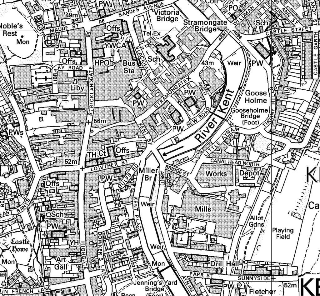
6 Miller Bridge, Kendal, Cumbria: Archaeological Watching Brief: Supplementary Report 4 1. CIRCUMSTANCES OF THE PROJECT 1.1 INTRODUCTION Balfour Beatty have proposed undertaking road works, in order to lay a service pipe across Miller Bridge, which is located in the centre of Kendal, Cumbria (SD ; Fig 1). The bridge, which dates to the early nineteenth century, is a Scheduled Monument (443) and is also included within the County Sites and Monuments Record for Cumbria (5454). In light of its significant historical and social interest, Cumbria County Council Historic Environment Services (CCCHES) requested a programme rapid historical research and that an archaeological presence should be maintained during the course of the road works. The work took place over two phases; initially in July 2008, and finally in March This document presents the results of both phases of the watching brief in the form of a short report.
7 Miller Bridge, Kendal, Cumbria: Archaeological Watching Brief: Supplementary Report 5 2. METHODOLOGY 2.1 INTRODUCTION The watching brief was carried out in accordance with the relevant IFA and English Heritage guidelines (Institute of Field Archaeologists 1999, Standard and guidance for archaeological Desk-based Assessments; English Heritage 2006, Management of Research Projects in the Historic Environment (MoRPHE). 2.2 WATCHING BRIEF This programme of field observation recorded accurately the location, extent, and character of any surviving archaeological features and/or deposits exposed during the course of the excavations of test pits. The work comprised the systematic examination of any structural elements of the bridge exposed during the course of the groundworks, and the accurate recording of all archaeological features and horizons, and any artefacts, identified during observation All groundworks on the site were conducted under constant archaeological supervision and comprised the excavation of three test pits at intervals on the road surface of the bridge. The observation of test pits across Miller Bridge was undertaken at night. Three test pits were excavated at intervals along the road surface of the north side of the bridge (Fig 2), using a pneumatic hammer to remove the tarmac. Subsequently, all three pits were photographed and recorded with measured sketched (with dimensions) drawings (Fig 3) All archaeological features were recorded on OA North s pro-forma sheets, using a system based on that of the English Heritage Centre for Archaeology. A monochrome and colour slide photographic record was maintained throughout. 2.3 ARCHIVE A full professional archive has been compiled in accordance with the project design (Appendix 1), and in accordance with current IFA and English Heritage guidelines. The paper and digital archive will be deposited in County Record Office (Kendal) on completion of the project.
8 Miller Bridge, Kendal, Cumbria: Archaeological Watching Brief: Supplementary Report 6 3. BACKGROUND 3.1 INTRODUCTION While not the oldest of the three stone bridges crossing the River Kent, Miller Bridge dates in some form to at least the early seventeenth century and, as such, is of significant local historical and social interest. In order to highlight this significance, what follows is a brief discussion of local topography and geology in Kendal, and a physical description and brief history of the bridge itself The subject of the watching brief, Miller Bridge (SD ), is one of five road crossings over the river Kent in Kendal. Three of these (Miller Bridge, Stramongate and Nether Bridge) are constructed from stone and constitute the oldest structures, whilst a fourth (Victoria Bridge) is an iron bridge, which, as the name suggests, was constructed for the Jubilee of Queen Victoria in The fifth and final bridge is a modern structure from the twentieth century. 3.2 TOPOGRAPHY AND GEOLOGY Kendal is situated in the River Kent valley within the old county of Westmoreland, now part of modern day Cumbria. The bridge lies in the centre of medieval Kendal (Plate 1), approximately 0.1km to the east of Stricklandgate and 0.5km to the north-west of Kendal Castle. It spans the river at a point west of Lowther Street The solid geology comprises Silurian Slates and Kirby Moor Flags with overlying drift deposits of glacial material, such as gravel and boulder clay, which is known to be varied and convoluted in nature and to contain peat in post-glacial hollows (Countryside Commission 1998). 3.3 MILLER BRIDGE The bridge, which is a Scheduled Monument (443) and which is included within the Cumbrian Sites and Monuments Record (SMR 5454), is constructed using grey limestone with three basket voussoir arches, and sturdy piers featuring rounded cutwaters (Plate 1), whilst a date stone on the centre of the south side records a date of construction as 1818 (MDCCCXVIII) (Plate 2). It is now an integral part of Kendal s one-way system, and provides access over the River Kent to the southbound carriageway of the A Although this version of the bridge was built in 1818, it is known to have had several predecessors, as cartographic sources attest to (Speed 1611). All three of Kendal s stone bridges (Miller Bridge, Stramongate and Nether Bridge) are featured on this seminal mapping, but there are no earlier references to Miller Bridge, suggesting that the latter pair served as the town s only medieval bridging points.
9 Miller Bridge, Kendal, Cumbria: Archaeological Watching Brief: Supplementary Report The earlier wooden versions of the Miller Bridge were probably numerous as a plaque laid by the Kendal Civic Society suggests (Plate 4). It records that severe floods repeatedly destroyed these earlier wooden structures, until a stone replacement was constructed in Certainly, several nineteenth century authors suggest similar events. Britton et al (1813, 197) includes a passage, which states that the Mill Bridge was built of wood before 1688, and this is corroborated by Mannex (1849; 282), who claims that Mill Bridge was built in stone in 1668 and subsequently, rebuilt in 1818 when Kent Lane was widened. However, this is misleading as two stone bridges stood during this period (Nicholson 1861: 148, 294). Nicholson (ibid) asserts that the second stone bridge was indeed built in 1743, but it was very narrow, and ill adapted to the general medium of intercourse with the canal During the early nineteenth century as the burgeoning industrialisation in Kendal reflected wider national trends, new woollen factories were opened at Dockray Hall, Castle and Low Mills. These, along with the paper mills at Burneside and the Gunpowder Mills at Sedgwick, were all powered by water. As the area became the locus for heavy industry, the need for better communications became more pressing and, subsequently, the Lancaster to Kendal Canal was built. By 1818 the Kendal Corporation decided to place canal warehouses at the canal s terminus in the Aynam area of Kendal, thus engendering the need for a new bridge to provide access to Bridge Street and the wharves further east. This goods terminus would remain an integral part of the transportation of goods in Kendal, until the arrival of the local railway line in 1846 (Nicholson 1861, 294) Subsequently, on the 13 th of April, 1818, Kendal Corporation approached local architect, Francis Webster and invited him to not only to submit plans for a replacement bridge, but also to advertise for contractors who could begin work on the building project within one month (by May 4 th 1818) ( Following this, Webster prepared plans for a three-arch, dressed stone bridge with a total span of 130 feet, in under three weeks. Edward Gibson and James Harrison, were awarded the building project with a moderate bid of 888 (Nicholson 1861, 294) Francis Webster laid the foundation stone on May 20 th, 1818, in his capacity as both the bridge designer and as Alderman of Kendal (Nicholson 1861, 294). Thus, within only seven months, the bridge had been designed, built, and was opened to traffic. There does, however, appear to be some confusion over its original name. Apparently the bridge was initially called Kent Bridge, but became known as Mill Bridge by 1833, when John Wood produced his map of the town (OA North 2008). This does seem at variance with nineteenth century writers (Britton et al 1813; Mannex 1849), who refer to the bridge and its predecessors as Mill Bridge, or, as in the case of Nicholson (1861, 148), as Miller s Close Bridge. It may be that Kent Bridge reflects a local colloquial name for the bridge. Within forty years, the name had been altered again to Miller Bridge, which has been retained ever since.
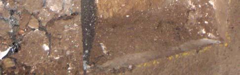
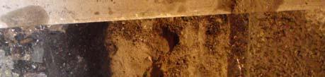
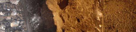
10 Miller Bridge, Kendal, Cumbria: Archaeological Watching Brief: Supplementary Report 8 4. WATCHING BRIEF RESULTS 4.1 INTRODUCTION A programme of permanent presence monitoring, in the form of a watching brief, was conducted in July 2008 and March This monitoring involved observing the excavation of test pits at intervals on the road surface of Miller Bridge, prior to the laying of a service pipe. This work was conducted at night, in order to keep traffic disruption to a minimum. 4.2 RESULTS In total, three test pits were excavated on the northern side of the road surface of Miller Bridge, each approximately 1 x 0.6m (Fig 3; Plates 4-6). The tarmac surface was removed to reveal a layer of hardcore to a maximum depth of 0.20m, which overlay a surface comprising large, roughly-hewn stones. During excavation of the test pit at the eastern end of the bridge (Test Pit 3) a modern metal service pipe and pipe trench was encountered. The pipe trench had been backfilled with pale grey sand and gravel It is possible that the roughly-hewn stones observed to be present in all three test pits, are part of the original, early nineteenth century bridge construction, and any unnecessary damage to the surface should be avoided. 4.3 RECOMMENDATIONS It is recommended that a watching brief should be maintained during any further road works.
11 Miller Bridge, Kendal, Cumbria: Archaeological Watching Brief: Supplementary Report 9 5. BIBLIOGRAPHY 5.1 PRIMARY SOURCES Speed, J, 1611 Plan of Kendal 5.2 SECONDARY SOURCES Britton, J, et al The Beauties of England and Wales, Or, Delineations, Topographical, Historical and Descriptive of Each County, Thomas Maiden Countryside Commission, 1998 Countryside Character, Volume 2: North West, Cheltenham English Heritage, 2006 Management of Research Projects in the Historic Environment (MoRPHE) Institute of Field Archaeologists, 1999 Standard and guidance for archaeological Desk-Based Assessments Mannex, P J, 1849 History, Topography, and directory of Westmorland; and Lonsdale north of the sands, in Lancashire; together with a descriptive and geological view of the whole of the Lake District, Simpkin Nicholson, C, 1861 The Annals of Kendal, Whittaker and Co. OA North 2008 Miller Bridge, Kendal, Cumbria; Watching Brief, unpubl rep
12 Miller Bridge, Kendal, Cumbria: Archaeological Watching Brief: Supplementary Report ILLUSTRATIONS 6.1 LIST OF FIGURES Figure 1: Site Location Figure 2: Location of the Test Pits Figure 3: Test pit plans and sections 6.2 LIST OF PLATES Plate 1: General view of the north side of Miller Bridge Plate 2: Detail of the date stone Plate 3: The commemorative plaque recording the building of the bridge Plate 4: Test pit 1 showing pipe trench Plate 5: Test pit 2 Plate 6: Test pit 3
13
14
15


16 Plate 1: General view of the north side of Miller Bridge Plate 2: Detail of the date stone

17 Plate 3: The commemorative plaque recording the building of the bridge


18 Plate 4: Test pit 1 showing pipe trench Plate 5: Test pit 2


19 Plate 6: Test pit 3
BANKHOUSE PUMPING STATION, MILLOM, CUMBRIA
 BANKHOUSE PUMPING STATION, MILLOM, CUMBRIA Archaeological Watching Brief Oxford Archaeology North May 2006 United Utilities Issue No: 2005-6/508 OA North Job No: L9397 NGR: SD 170 822 Document Title: Document
Archaeological Evaluation and Assessment of Land at Kent Cottage, 19 Chapel Street, Hythe, Kent
 Archaeological Evaluation and Assessment of Land at Kent Cottage, 19 Chapel Street, Hythe, Kent Planning Application Y13/0463/SH Date of Report: 29/04/2015 Report for Marc Carney SWAT. ARCHAEOLOGY Swale
Archaeological Monitoring of Land at 29 Royal Pier Road, Gravesend, Kent
 Archaeological Monitoring of Land at 29 Royal Pier Road, Gravesend, Kent Site Code ROY/WB/15 Report for Dr Maxted Date of report 06/10/2015 SWAT ARCHAEOLOGY Swale and Thames Archaeological Survey Company
Evaluation/monitoring Report No. 241 KING S CASTLE NURSING HOME ARDGLASS CO. DOWN AE/12/19 SARAH GORMLEY
 Evaluation/monitoring Report No. 241 KING S CASTLE NURSING HOME ARDGLASS CO. DOWN AE/12/19 SARAH GORMLEY 1 Site Specific Information Site Name: Townland: King s Castle Ardglass SMR No. : DOW 045:024 Status:
Land adjacent to Dingle Dock, Front Street, East Garston
 Land adjacent to Dingle Dock, Front Street, East Garston An Archaeological Watching Brief for Dr J Davies by Jo Pine Thames Valley Archaeological Services Site Code DEG99/82 January 2000 Summary Site name:
Old Town Hall, Market Place, Faringdon, Oxfordshire
 Old Town Hall, Market Place, Faringdon, Oxfordshire Building Recording and Archaeological Watching Brief for Great Faringdon War Memorial Trust by Jamie Preston and Steve Ford Thames Valley Archaeological
Ivol Buildings, Woodcote Road, South Stoke, Oxfordshire
 Ivol Buildings, Woodcote Road, South Stoke, Oxfordshire An Archaeological Watching Brief For Christ Church, Oxford by Pamela Jenkins Thames Valley Archaeological Services Ltd Site Code IBSS 04/03 March
ARCHAEOLOGICAL EVALUATION AT THE FORMER WATTON GARDEN CENTRE, NORWICH ROAD, WATTON, NORFOLK OCTOBER 2003 (Accession number WAT)
") NORTHAMPTONSHIRE ARCHAEOLOGY NORTHAMPTONSHIRE COUNTY COUNCIL NOVEMBER 2003 (Planning Application No: 3PL/1997/048/0 ARCHAEOLOGICAL EVALUATION AT THE FORMER WATTON GARDEN CENTRE, NORWICH ROAD, WATTON, NORFOLK
NORTHAMPTONSHIRE ARCHAEOLOGY NORTHAMPTONSHIRE COUNTY COUNCIL NOVEMBER 2003 (Planning Application No: 3PL/1997/048/0 ARCHAEOLOGICAL EVALUATION AT THE FORMER WATTON GARDEN CENTRE, NORWICH ROAD, WATTON, NORFOLK
Meales Farm, Sulhamstead, West Berkshire
 Meales Farm, Sulhamstead, West Berkshire An Archaeological Watching Brief For Mr. Robert Astor by Steve Ford Thames Valley Archaeological Services Ltd Site Code CHH02/29 May 2002 Summary Site name: Meales
Northbury Farm, Castle End Road, Ruscombe, Berkshire
 Northbury Farm, Castle End Road, Ruscombe, Berkshire An Archaeological Watching Brief For Sir Colin and Lady Southgate by Danielle Milbank Thames Valley Archaeological Services Ltd Site Code NFR 07/120
Centre for Archaeological Fieldwork Evaluation/Monitoring Report No Monitoring Report No. 201
 Monitoring Report No. 201 Land adjacent to 58 Drumreagh Road Drumreagh Ballygowan Co. Down LICENCE NO.: AE/10/91E BRIAN SLOAN 1 Site Specific Information Site Name: Land adjacent to 58 Drumreagh Road,
Garage Site, Foots Cray High Street, Sidcup, Kent, London Borough of Bexley
 Garage Site, Foots Cray High Street, Sidcup, Kent, London Borough of Bexley An Archaeological Evaluation for Mizen Design Build by Andy Taylor Thames Valley Archaeological Services Ltd FOC 07 September
Bridge House, Ham Island, Old Windsor, Berkshire
 Bridge House, Ham Island, Old Windsor, Berkshire An Archaeological Watching Brief for Mr A Chadwick by Alan Ford Thames Valley Archaeological Services Site Code BHHI98/55 August 1998 Bridge House, Ham
Archaeological evaluation at Willowdene, Chelmsford Road, Felsted, Essex
 Archaeological evaluation at Willowdene, Chelmsford Road, Felsted, Essex August 2013 report prepared by Ben Holloway on behalf of Mr Anthony McGurren Planning reference: UTT/13/0235 CAT project ref.: 13/07g
Archaeological Evaluation and Assessment of Land at Minnis Beeches, Canterbury Road, Swingfield, Dover, Kent
 Archaeological Evaluation and Assessment of Land at Minnis Beeches, Canterbury Road, Swingfield, Dover, Kent NGR: TQ 6307 1545 Site Code: MB-EV-10 (Planning Consent Y10/0311/SH) Report for Thorndene Ltd.
Centre for Archaeological Fieldwork, School of Archaeology and Palaeoecology, Queen s University Belfast.
 Centre for Archaeological Fieldwork, School of Archaeology and Palaeoecology, Queen s University Belfast. Monitoring Report No. 04 Duneight Motte and Bailey, May 2004. On behalf of Monitoring Report: Duneight
Archaeological monitoring at Clintons, Bury Green, Little Hadham, Hertfordshire April 2008
 Archaeological monitoring at Clintons, Bury Green, Little Hadham, Hertfordshire April 2008 report prepared by Ben Holloway on behalf of Charles Britton Equestrian Construction CAT project ref.: 08/3b NGR:
Archaeological Investigation in advance of Development at 2 Palace Cottages, Charing Palace, Charing, Kent
 Archaeological Investigation in advance of Development at 2 Palace Cottages, Charing Palace, Charing, Kent Site Code CHAR-EV-14 NGR 95412 49439 Date of Report 18/12/2014 Swale and Thames Archaeological
Appletree, Thames Street, Sonning Berkshire
 Appletree, Thames Street, Sonning Berkshire An Archaeological Watching Brief for Mr and Mrs A Popham by Sian Anthony Thames Valley Archaeological Services Ltd Site Code ATS 02/83 October 2002 Summary Site
Chitty Farmhouse Extension, Wall Lane, Silchester, Hampshire
 Chitty Farmhouse Extension, Wall Lane, Silchester, Hampshire An Archaeological Watching Brief For In Touch by Andrew Mundin Thames Valley Archaeological Services Ltd Site Code CFS 08/52 May 2008 Summary
Monitoring of invasive groundworks ahead of the installation of a septic tank at 16a, 16b and 16c Donegore Hill Muckamore County Antrim
 Monitoring Report No. 177 Monitoring of invasive groundworks ahead of the installation of a septic tank at 16a, 16b and 16c Donegore Hill Muckamore County Antrim LICENCE NO.: AE/09/48 Brian Sloan 1 Site
Gryme s Dyke, Stanway Green
 Gryme s Dyke, Stanway Green A short assessment of the archaeological impact of contractor s groundworks at the southern end of the Gryme s Dyke Middle earthwork February 2000 Archive report on behalf of
New horse training area, Manor Farm, Great Kimble, Buckinghamshire
 New horse training area, Manor Farm, Great Kimble, Buckinghamshire An Archaeological Watching Brief For Redwing Structures (Marlow) Limited by Andy Taylor Thames Valley Archaeological Services Ltd Site
2 Hardman Boulevard, Spinningfields, Manchester
 2 Hardman Boulevard, Spinningfields, Manchester Archaeological Investigation Oxford Archaeology North September 2014 Allied London Properties Ltd Application No: 103505/FO/2013/C1 Issue No: 2014-15/1535
New Swimming Pool,West Meon House, West Meon, Hampshire
 New Swimming Pool,West Meon House, West Meon, Hampshire An Archaeological watching brief and building recording for Mr and Mrs Younger by Danielle Milbank Thames Valley Archaeological Services Ltd Site
Archaeological evaluation on land at Unit 1, Waltham Hall, Bambers Green Road, Takeley, Essex, CM22 6PF
 Archaeological evaluation on land at Unit 1, Waltham Hall, Bambers Green Road, Takeley, Essex, CM22 6PF by Laura Pooley figures by Ben Holloway and Emma Holloway fieldwork by Ben Holloway with Jane Roberts
Archaeological evaluation: land to the rear of Clare Road, Braintree, Essex
 Archaeological evaluation: land to the rear of 41-45 Clare Road, Braintree, Essex March 2014 commissioned by Mr Mark Plummer report prepared by Ben Holloway and Howard Brooks Planning reference: 13/000585/FUL,
MONITORING REPORT: No. 289
 MONITORING REPORT: No. 289 21 Ballynarrig Road Ballydarrog Co. Derry AE/14/213E Dermot Redmond Site Specific Information Site Name: 21 Ballynarrig Road, Limavady Townland: Ballydarrog SMR No. : LDY 016:004
Merrowdene, Earleydene, Sunninghill, Berkshire
 Merrowdene, Earleydene, Sunninghill, Berkshire An Archaeological Watching Brief For Mr and Mrs Jackson by Andy Taylor Thames Valley Archaeological Services Ltd Site Code MES 05/88 January 2006 Summary
An Archaeological Evaluation at Granta Cottages, Newmarket Road, Great Chesterford, Essex. August 2015
 An Archaeological Evaluation at Granta Cottages, Newmarket Road, Great Chesterford, Essex August 2015 by Pip Parmenter and Ben Holloway on behalf of Mr G Elmer and Mrs L King CAT project ref.: 15/06a NGR:
Evaluation/Monitoring Report No. 243
 60m NORTH OF 64 BALLYGROOBANY ROAD BALLYNAHINCH RICHHILL COUNTY ARMAGH LICENCE NO.: AE/12/91E NAOMI CARVER 1 Site Specific Information Site Name: site 60m north of 64 Ballygroobany Road, Ballynahinch,
Newcombe House & Kensington Church Street
 Newcombe House & Kensington Church Street Archaeological Evaluation September 2017 Summary Site name: Newcombe House, Kensington Church Street, Notting Hill, London Grid reference: TQ 25318 80372 Site
Archaeological Watching Brief
 Barrack Block Drainage Hampton Court Palace Archaeological Watching Brief Report May 2012 Client: Historic Royal Palces Issue No: 1 OA Job No: 5329 NGR: TQ 15485 168587 Archaeological Watching Brief Archaeological
EVALUATION REPORT No. 300
 EVALUATION REPORT No. 300 Southwest of 2A Cloughey Road, Portaferry, Co. Down Licence No.: AE/135/85E Sapphire Mussen Report Date: 14 th May 2015 Site Specific Information Site Name: [Southwest of 2a]
Pinnocks Wood Equestrian Centre, Burchett s Green, Maidenhead, Berkshire
 Pinnocks Wood Equestrian Centre, Burchett s Green, Maidenhead, Berkshire An Archaeological Watching Brief For Mr David Eyles by Andrew Mundin Thames Valley Archaeological Services Ltd Site Code POB 08/69
Archaeological evaluation on land at Mersea Fleet Way, Chelmer Road, Braintree, Essex, CM7 3PZ
 Archaeological evaluation on land at Mersea Fleet Way, Chelmer Road, Braintree, Essex, CM7 3PZ by Laura Pooley figures by Ben Holloway and Emma Holloway fieldwork by Ben Holloway, Robin Mathieson, Nigel
Monitoring Report No. 166
 Monitoring Report No. 166 No. 2a Loughadian Road Poyntzpass County Down AE/08/189 Nick Beer Site Specific Information Site Address: 2a Loughadian Road, Poyntzpass. Townland: Loughadian SMR No.: DOW 033:034
Interim Statement on Archaeological Evaluation on land immediately to the east of the Manor Lodge, Manor Lane, Sheffield, South Yorkshire
 Archaeological Research & Consultancy at the University of Sheffield Research School of Archaeology West Court 2 Mappin Street Sheffield S1 4DT Phone 0114 2225106 Fax 0114 2797158 Interim Statement 1107.2
Archaeological evaluation at Stables, Hatch Farm, Fen Lane, Bulphan, Essex, RM14 3RL
 Archaeological evaluation at Stables, Hatch Farm, Fen Lane, Bulphan, Essex, RM14 3RL November-December 2016 by Laura Pooley figures by Ben Holloway and Emma Holloway fieldwork by Ben Holloway and Alec
Archaeological trial-trenching evaluation: New Hall School, The Avenue, Boreham, Essex. July 2015
 Archaeological trial-trenching evaluation: New Hall School, The Avenue, Boreham, Essex report prepared by Ben Holloway on behalf of New Hall School Planning reference: 14/01846/FUL CAT project ref.: 15/04i
North East Region TYNE & WEAR 1 /315 (B ) NZ
 NZ") TYNE & WEAR Newcastle Upon Tyne 1 /315 (B.05.6311) NZ 28016514 138 FOSSWAY, WALKER An Archaeological Desk-Based Assessment for a Proposed Development at 138 Fossway, Walker GeoQuest Associates Consett
TYNE & WEAR Newcastle Upon Tyne 1 /315 (B.05.6311) NZ 28016514 138 FOSSWAY, WALKER An Archaeological Desk-Based Assessment for a Proposed Development at 138 Fossway, Walker GeoQuest Associates Consett
ARCHAEOLOGICAL S E R V I C E S. Hurley Manor, High Street, Hurley, Berkshire. Archaeological Evaluation. by James McNicoll-Norbury
 T H A M E S V A L L E Y ARCHAEOLOGICAL S E R V I C E S Hurley Manor, High Street, Hurley, Berkshire Archaeological Evaluation by James McNicoll-Norbury Site Code: HMH14/51 (SU 8252 8378) Hurley Manor,
6A St John s Road, Wallingford Oxfordshire
 6A St John s Road, Wallingford Oxfordshire An Archaeological Evaluation Stage 2 for Spearcliff Estates Ltd by Steve Ford Thames Valley Archaeological Services Ltd Site SJW03/116 January 2004 Summary Site
Glue Pot Farm, Edwards Lane, Bramfield, Suffolk. BMF 024
 Glue Pot Farm, Edwards Lane, Bramfield, Suffolk. BMF 024 Archaeological Evaluation Report SCCAS Report No. 2013/107 Client: Keith Frost Architectural Design Services Author: Linzi Everett August 2013 SCCAS
LYTTELTON GRAVING DOCK PUMPHOUSE (M36/327), CYRUS WILLIAMS QUAY, LYTTELTON: REPORT ON ARCHAEOLOGICAL MONITORING
, CYRUS WILLIAMS QUAY, LYTTELTON: REPORT ON ARCHAEOLOGICAL MONITORING") LYTTELTON GRAVING DOCK PUMPHOUSE (M36/327), CYRUS WILLIAMS QUAY, LYTTELTON: REPORT ON ARCHAEOLOGICAL MONITORING HNZ AUTHORITY 2016/248EQ LUKE TREMLETT AND ANNTHALINA GIBSON UNDERGROUND OVERGROUND ARCHAEOLOGY
LYTTELTON GRAVING DOCK PUMPHOUSE (M36/327), CYRUS WILLIAMS QUAY, LYTTELTON: REPORT ON ARCHAEOLOGICAL MONITORING HNZ AUTHORITY 2016/248EQ LUKE TREMLETT AND ANNTHALINA GIBSON UNDERGROUND OVERGROUND ARCHAEOLOGY
MONITORING REPORT: No. 276
 MONITORING REPORT: No. 276 Between 51 and 53 Castor Bay Road Lurgan Co. Armagh AE/13/214 Dermot Redmond Site Specific Information Site Name: Between 51 and 53 Castor Bay Road, Lurgan, Co. Armagh Townland:
Appraisal of proposed alterations to the boundary of Helmsley Conservation Area
 Appraisal of proposed alterations to the boundary of Helmsley Conservation Area Elmslac Road: Elmslac Road was constructed in the early 1950s in two or three stages by the Helmsley Rural District Council.
Windsor Berkshire. Archaeological Watching Brief. King Edward VII Car Park Extension. Archaeological Watching Brief Report
 King Edward VII Car Park Extension Windsor Berkshire Archaeological Watching Brief Report March 202 Client: Royal Borough of Windsor and Maidenhead Issue No: OA Job No: 5242 NGR: SU 972 779 Archaeological
New Media Building, Goldsmiths College, New Cross, London Borough of Lewisham
 New Media Building, Goldsmiths College, New Cross, London Borough of Lewisham An Archaeological Evaluation for Willmott Dixon Construction by Andy Taylor Thames Valley Archaeological Services Ltd Site
MONITORING REPORT: No. 283
 MONITORING REPORT: No. 283 Dunluce Castle Visitor Centre Option Site D Magheracross Co. Antrim AE/14/109E Dermot Redmond List of Contents Site Specific Information 1 Account of the Monitoring 2 Discussion
Monitoring Report No. 168
 Monitoring Report No. 168 Loughgall Presbyterian Church Cloven Eden Loughgall County Armagh AE/08/203 Nick Beer Site Specific Information Site Address: Loughgall Presbyterian Church, 100 Cloven Eden Road,
ARCHAEOLOGICAL S E R V I C E S. Land north of Orchard Close, Hallow, Worcestershire. Archaeological Evaluation. by Kyle Beaverstock
 T H A M E S V A L L E Y ARCHAEOLOGICAL S E R V I C E S Land north of Orchard Close, Hallow, Worcestershire Archaeological Evaluation by Kyle Beaverstock Site Code: OCW15/224 (SO 8285 5848) Land north of
Historic England Advice Report 26 August 2016
 Case Name: Kingsland Castle Case Number: 1435892 Background Historic England has been asked to review the scheduling for Kingsland Castle. The land on which the monument lies is understood to be for sale.
HERITAGE COUNTS 2017 East of England
 HERITAGE COUNTS 2017 East of England Introduction Heritage Counts 2017 is the sixteenth annual survey of the state of England s historic environment. This Regional Report is prepared by Historic England
Land at Downsview Avenue, Storrington, West Sussex
 Land at Downsview Avenue, Storrington, West Sussex An Archaeological Evaluation for Bellwinch Homes Limited by Andy Taylor Thames Valley Archaeological Services Ltd Site Code DAS 04/21 March 2004 Summary
Conistone Keld/Well/Troughs Project
 CONISTONE KELD PROJECT 2018 Conistone Keld/Well/Troughs Project Location Conistone Keld is the local name for an area where a spring feeds into three troughs.(the name derives from the Viking word Kelda
Proposed Retirement Village Cole Green Way, Hertford. Archaeology Statement
 RETIREMENT LIVING MADE BETTER Proposed Retirement Village Cole Green Way, Hertford Archaeology Statement Woodlands Retirement Village RETIREMENT LIVING MADE BETTER Retirement Living Made Better Archaeology
Elm Park, Station Road, Ardleigh, Essex, CO7 7RT: archaeological watching brief on installation of new water pipe
 Elm Park, Station Road, Ardleigh, Essex, CO7 7RT: archaeological watching brief on installation of new water pipe November 2015 report prepared by Howard Brooks BA FSA MCIfA on behalf of Partnerships in
Archaeological Monitoring of Land to the rear of The Ridges, Valley Drive, Gravesend, Kent
 Archaeological Monitoring of Land to the rear of The Ridges, Valley Drive, Gravesend, Kent NGR: 566215 170479 Site Code RIDGE/WB/14 Report for Mr Sall Date of report 27/03/2014 SWAT ARCHAEOLOGY Swale and
Archaeological monitoring and recording at 24 St Peter's Road, West Mersea, Essex, CO5 8LJ
 Archaeological monitoring and recording at 24 St Peter's Road, West Mersea, Essex, CO5 8LJ April 2017 by Dr Elliott Hicks figures by S Carter fieldwork by Adam Wightman on behalf of Brett Lord NGR: TM
PROPOSED DEVELOPMENT AT BRITANNIA PARK, BANGOR
 PROPOSED DEVELOPMENT AT BRITANNIA PARK, BANGOR ARCHAEOLOGICAL MITIGATION WORK Report No. 446 [08] [04] [06] [08] [06] [04] Prepared for Watkins Jones Construction March 2002 By J. Kenney Ymddiriedolaeth
LAND NORTH OF TAMWORTH. Agricultural Land Classification ALC Map and Report April 1998
 LAND NORTH OF TAMWORTH Agricultural Land Classification ALC Map and Report April 1998 A,L Cooke Resource Planning Team RPT Reference: 130/97 & 25/RPT/Ol loa Northern Region FRCA Reference: EL 37/11747
ARCHAEOLOGICAL S E R V I C E S. Manor Farm, Launton, Bicester, Oxfordshire. Archaeological Watching Brief. by Aiji Castle. Site Code: LBO13/220
 T H A M E S V A L L E Y ARCHAEOLOGICAL S E R V I C E S Manor Farm, Launton, Bicester, Oxfordshire Archaeological Watching Brief by Aiji Castle Site Code: LBO13/220 (SP 6035 2285) Manor Farm, Launton, Bicester,
Archaeological evaluation at New Hall School, The Avenue, Boreham, Chelmsford, Essex, CM3 3HS
 Archaeological evaluation at New Hall School, The Avenue, Boreham, Chelmsford, Essex, CM3 3HS December 2016 by Laura Pooley with contributions by Stephen Benfield figures by Ben Holloway and Emma Holloway
Yorkshire Sculpture Park Historic Landscape Management Plan. Volume I. July 2010
 Yorkshire Sculpture Park Historic Landscape Management Plan Volume I July 2010 T: 01904 691630 www.landscapeagency.co.uk enquiries@landscapeagency.co.uk Contents 3 Volume I Historic Landscape Management
24. ARCHAEOLOGY & BUILT HERITAGE
 24. ARCHAEOLOGY & BUILT HERITAGE Overview There are no known archaeological or built heritage sites within or adjacent to the Project designation boundaries. There is a history of both Māori and European
Barvills Solar Farm Environmental Statement Non-Technical Summary
 Barvills Solar Farm Environmental Statement Non-Technical Summary 13 March 2015 Produced for Prepared by St John s House Queen Street, Manchester M2 5JB Contents Contents... 2 1 Introduction... 3 1.1 Development
CHESHIRE HISTORIC TOWNS SURVEY
 CHESHIRE HISTORIC TOWNS SURVEY Frodsham Archaeological Strategy 2003 CHESHIRE HISTORIC TOWNS SURVEY Frodsham Archaeological Strategy 2003 Environmental Planning Cheshire County Council Backford Hall Backford
Friends Meeting House, Broughton. Meeting House Lane, Little Broughton, Cockermouth, CA13 0YQ. National Grid Reference: NY
 Friends Meeting House, Broughton Meeting House Lane, Little Broughton, Cockermouth, CA13 0YQ National Grid Reference: NY 07832 31740 Statement of Significance The modest building has medium significance
XSW11, Plumstead Portal worksites, Interim Statement for NLBH. 1 Introduction Site Methodology and fieldwork objectives...4
 Contents 1 Introduction...4 2 Site Methodology and fieldwork objectives...4 2.1 NLBH Methodology... 4 2.2 NLBH Fieldwork Objectives... 5 3 Provisional Results...6 3.1 NLBH various features... 6 3.2 Shelter
The meeting house is of low-key design typical of the inter-war period. It has an attractive appearance with a spacious interior and good amenities.
 Friends Meeting House, Preston 189 St George s Road, Preston, PR1 6NQ National Grid Reference: SD 54314 30558 Statement of Significance The meeting house is of low-key design typical of the inter-war period.
Archaeological evaluation at Redbank, Bury Water Lane, Newport, Essex, CB11 3TZ
 Archaeological evaluation at Redbank, Bury Water Lane, Newport, Essex, CB11 3TZ March 2017 by Laura Pooley figures by Ben Holloway and Emma Holloway fieldwork by Ben Holloway with Harvey Furniss and Elliott
Submitted: July 23, 2009
 Stage I and II Archaeological Assessment Jock River Estates Phase 2 PML Project No. 0801-01 Client: 773804 Ontario Inc. Lot 21, Concession 2 Geographic Township of Goulbourn City of Ottawa Submitted: July
Land South-West of Mill Co age, Gidding Road, Sawtry, Cambridgeshire Evalua on Report
 Land South-West of Mill Coage, Gidding Road, Sawtry, Cambridgeshire Evaluaon Report August 2017 Client: CgMs Consulng Issue No: 1 OA East Report No: 2080 NGR: TL 1623 8329 Oxford Archaeology Ltd i 3 August
Archaeological Watching Brief Report
 New Playing Fields and Athletics Track Stowe School Buckinghamshire Archaeological Watching Brief o a July 2009 client logo Client: Stowe School Issue N o : 1 OA Job N o : 4167 NGR: SP 679 380 Archaeological
Archaeological monitoring and recording at 26 Beaver Close, Colchester, Essex, CO3 9DZ
 Archaeological monitoring and recording at 26 Beaver Close, Colchester, Essex, CO3 9DZ May 2017 by Adam Tuffey and Laura Pooley figures by Sarah Carter, Chris Lister and Adam Tuffey fieldwork by Alec Wade
Lancaster Conservation Area Appraisal. Character Area 8. Cathedral
 Lancaster Conservation Area Appraisal Character Area 8. Cathedral March 2013 118 3.8 Character Area 8. Cathedral 3.8.1. Definition of Special Interest "This character area is distinctive for the fine group
COMBINED PHASE I ARCHAEOLOGICAL SURVEY BUILDING/LANDSCAPE AND ARCHAEOLOGICAL ASSESSMENT PLAN
 COMBINED PHASE I ARCHAEOLOGICAL SURVEY BUILDING/LANDSCAPE AND ARCHAEOLOGICAL ASSESSMENT PLAN ST. ELIZABETHS HOSPITAL - WEST CAMPUS 2700 MARTIN LUTHER KING, JR. AVENUE, SE DISTRICT OF COLUMBIA [SITE NUMBER
Groby Pool and Bradgate Park. Circular walks around Leicestershire. Lin and John
 Groby Pool and Bradgate Park Bradgate House Lin and John A circular walk from Groby Pool via Anstey Village, Bradgate Park and Newtown Linford Village. Duration - 2 ½ to hours 3½ hours Distance - 9¼ kilometres
Stanwick Neighbourhood Plan
 Stanwick Neighbourhood Plan Heritage Audit Stanwick Neighbourhood Plan Steering Group August 2015 Purpose of the Heritage Audit It is a core planning principle within National Planning Policy Framework
Archaeological monitoring and recording: 20 Irvine Road, Colchester, Essex, CO3 0TR. July 2015
 Archaeological monitoring and recording: 20 Irvine Road, Colchester, Essex, CO3 0TR July 2015 by Pip Parmenter and Chris Lister on behalf of Ms Claire Murphy CAT project ref.: 15/03m NGR: TL 9819 2426
69 DRUMLOUGH ROAD, DRUMGATH, COUNTY DOWN
 MONITORING REPORT NO. 223 69 DRUMLOUGH ROAD, DRUMGATH, COUNTY DOWN LICENCE NO. EMILY MURRAY Report Date: 13 th April 2011 Site Specific Information Site name: Townland: SMR No. : Grid ref.: County: Excavation
WRITTEN SCHEME OF INVESTIGATION
 CANAL COLLEGE 2, ROSEBANK DISTILLERY: WRITTEN SCHEME OF INVESTIGATION 1 2 Contents Background... 4 Introduction... 5 Historical Notes... 6 Methodology... 7 Staff... 9 Products... 9 Timetable... 9 Bibliography...
Greater London. Greater London 6/42 (D.01.M001) TQ
 TQ") Authority 6/42 (D.01.M001) TQ 54207390 ST. JAME'S INVESTMENTS, LOWFIELD STREET AND MARKET STREET, DARTFORD Environmental Statement. Archaeology. Volume 9 of 10 AOC Archaeology Group Twickenham : AOC Archaeology
Authority 6/42 (D.01.M001) TQ 54207390 ST. JAME'S INVESTMENTS, LOWFIELD STREET AND MARKET STREET, DARTFORD Environmental Statement. Archaeology. Volume 9 of 10 AOC Archaeology Group Twickenham : AOC Archaeology
PHASE 1 ARCHAEOLOGICAL IMPACT ASSESSMENT PROPOSED DEVELOPMENT ERF 3 ROBERTSON WESTERN CAPE PROVINCE
 PHASE 1 ARCHAEOLOGICAL IMPACT ASSESSMENT PROPOSED DEVELOPMENT ERF 3 ROBERTSON WESTERN CAPE PROVINCE Prepared for BOLAND ENVIRO Att: Mr Nik Wullschleger PO Box 250 Worcester 6849 Fax: (023) 347 0336 By
T H A M E S V A L L E Y S E R V I C E S. Flood Compensation Area, Riverside Park, Wallingford, Oxfordshire. Archaeological Watching Brief
 T H A M E S V A L L E Y ARCHAEOLOGICAL S E R V I C E S Flood Compensation Area, Riverside Park, Wallingford, Oxfordshire Archaeological Watching Brief by Jacqueline Pitt Site Code: RPW10/72 (SU 6112 8934)
Archaeology and Planning in Greater London. A Charter for the Greater London Archaeology Advisory Service
 Archaeology and Planning in Greater London A Charter for the Greater London Archaeology Advisory Service THE PURPOSE OF THE CHARTER This Charter sets out how English Heritage will provide archaeological
GLEN ROAD PEDESTRIAN BRIDGE ENVIRONMENTAL ASSESSMENT STUDY PUBLIC INFORMATION CENTRE #2 OCTOBER 24, 2017
 GLEN ROAD PEDESTRIAN BRIDGE ENVIRONMENTAL ASSESSMENT STUDY PUBLIC INFORMATION CENTRE #2 OCTOBER 24, 2017 Glen Road Pedestrian Bridge Class Environmental Assessment 1 WELCOME! Welcome to the second Public
Grantham Southern Quadrant Link Road Environmental Statement
 Grantham Southern Quadrant Link Road Environmental Statement Non Technical Summary Introduction Lincolnshire County Council (LCC) is submitting a planning application for the proposed implementation of
STAGE 1 ARCHAEOLOGICAL ASSESSMENT OF RATHBURN ROAD, FROM DUKE OF YORK BOULEVARD TO SHIPP DRIVE, CITY OF MISSISSAUGA. Submitted to:
 STAGE 1 ARCHAEOLOGICAL ASSESSMENT OF RATHBURN ROAD, FROM DUKE OF YORK BOULEVARD TO SHIPP DRIVE, CITY OF MISSISSAUGA Submitted to: McCormick Rankin Corporation 2655 North Sheridan Way, Suite 280 Mississauga,
Epsom Water Works, East Street, Epsom, Surrey
 Epsom Water Works, East Street, Epsom, Surrey An Archaeological Desk-Based Assessment for St James Homes Ltd by Steve Ford Thames Valley Archaeological Services Site Code ESE99/85 December 1999 Epsom Water
Ashton Hall Garden Centre, Ashton Hall, Ashton with Stodday, Lancashire
 Ashton Hall Garden Centre, Ashton Hall, Ashton with Stodday, Lancashire Archaeological Watching Brief Oxford Archaeology North January 2005 John Moore and Partners Architects Ltd Issue No: 2004-05/328
Archaeological monitoring and recording at 20 St Peter's Road, West Mersea, Essex, CO5 8LJ
 Archaeological monitoring and recording at 20 St Peter's Road, West Mersea, Essex, CO5 8LJ November 2016 by Laura Pooley figures by Ben Holloway and Emma Holloway fieldwork by Ben Holloway on behalf of
Archaeological trial-trenching evaluation: Peldon Village Hall, Church Road, Peldon, Essex, CO5 7PT
 Archaeological trial-trenching evaluation: Peldon Village Hall, Church Road, Peldon, Essex, CO5 7PT December 2015 report prepared by Ben Holloway and Howard Brooks on behalf of Peldon Parish Council Planning
BREEDON NORTHERN LIMITED
 Non Technical Summary CONTENTS 1 INTRODUCTION... 1 2 SITE DESCRIPTION... 1 3 DESCRIPTION OF THE DEVELOPMENT... 6 4 NEED FOR THE DEVELOPMENT... 8 5 KEY ISSUES CONSIDERED IN THE ENVIRONMENTAL IMPACT ASSESSMENT...
WANSFORD. Village Design Statement. Supplementary Planning Guidance adopted by Peterborough City Council on 22 nd August 2003
 WANSFORD Village Design Statement 2003 Supplementary Planning Guidance adopted by Peterborough City Council on 22 nd August 2003 Prospect of Wansford Bridge, St. Mary s Church and Bridge End, c.1902 Conceived,
WOKING DFAS TOUR TO SHROPSHIRE 13th to 17th JUNE 2016
 WOKING DFAS TOUR TO SHROPSHIRE 13th to 17th JUNE 2016 (Five days and four nights at the Lord Hill Hotel, Shrewsbury) TOUR LEADER: Malcolm Read We will stay in the beautiful historic town of Shrewsbury
Built in 1984, the meeting house is the third meeting house on a site acquired in 1668 as a burial ground. The building has low heritage significance.
 Friends Meeting House, Reigate 47 Reigate Road, Reigate, Surrey, RH2 0QT National Grid Reference: TQ 26184 50219 Statement of Significance Built in 1984, the meeting house is the third meeting house on
NON-TECHNICAL SUMMARY
 Proposed Sand and Gravel Extraction and Associated Processing Operations with Restoration to a Mixture of Agriculture and Nature Conservation including Areas of Shallow Water at Hedgeley, Northumberland
Site guidance for working in root protection zones
 TreeAZ Information Note 3 (Australia and New Zealand) Preface This Information Note describes emerging best practice for working within root protection zones (RPZs) in Australia and New Zealand. It is