Barnes Hospital, Cheadle, Stockport,
|
|
|
- Nicholas Webb
- 5 years ago
- Views:
Transcription


1 Barnes Hospital, Cheadle, Stockport, Greater Manchester Archaeological Evaluation Oxford Archaeology North September 2015 Reis Construct Ltd Issue No: /1682 OA North Job No: L10909 NGR:
2 Document Title: Document Type: Client: BARNES HOSPITAL, CHEADLE, STOCKPORT, GREATER MANCHESTER Archaeological Evaluation Reis Construct Ltd Issue Number: /1682 OA Job Number: L10909 National Grid Reference: Prepared by: Andy Phelps Position: Project Officer Date: September 2015 Checked by: Ian Miller Position: Senior Project Manager Date: September 2015 Signed. Approved by: Alan Lupton Signed Position: Operations Manager Date: September 2015 Oxford Archaeology North Oxford Archaeology Ltd (2015) Mill 3 Janus House Moor Lane Mills Osney Mead Moor Lane Oxford Lancaster OX2 0EA LA1 1GF t: (0044) t: (0044) f: (0044) f: (0044) w: e: info@oxfordarch.co.uk Oxford Archaeological Unit Limited is a Registered Charity No: Disclaimer: This document has been prepared for the titled project or named part thereof and should not be relied upon or used for any other project without an independent check being carried out as to its suitability and prior written authority of Oxford Archaeology Ltd being obtained. Oxford Archaeology Ltd accepts no responsibility or liability for the consequences of this document being used for a purpose other than the purposes for which it was commissioned. Any person/party using or relying on the document for such other purposes agrees, and will by such use or reliance be taken to confirm their agreement to indemnify Oxford Archaeology Ltd or all loss or damage resulting therefrom. Oxford Archaeology Ltd accepts no responsibility or liability for this document to any party other than the person/party by whom it was commissioned.
3 Barnes Hospital, Cheadle, Stockport: Archaeological Evaluation 1 CONTENTS SUMMARY...2 ACKNOWLEDGEMENTS INTRODUCTION Circumstances of Project Location, Topography and Geology Historical and Archaeological Background METHODOLOGY Introduction Walk-over Survey Evaluation Trenching Archive FIELDWORK RESULTS Introduction Trench Trench Trench Trench Trench Trench Trench Trench Trench Trench Trench Trench CONCLUSION Conclusion...29 APPENDIX 1: WRITTEN SCHEME OF INVESTIGATION...30 BIBLIOGRAPHY...38 ILLUSTRATIONS...40 Figures...40
4 Barnes Hospital, Cheadle, Stockport: Archaeological Evaluation 2 SUMMARY Barnes Village Ltd has obtained planning permission to redevelop the former Barnes Hospital and its associated grounds in Cheadle, near Stockport (NGR , ). The development proposal allows for the refurbishment of the hospital building, which is afforded statutory designation as a Grade II listed building, together with the erection of new housing. The new build will comprise housing within the grounds encompassing the hospital building. The proposed construction works will necessitate considerable earth-moving works, which have some potential to damage or destroy buried archaeological remains. A desk-based study carried out to support the planning application concluded that the site has some potential to contain buried remains of archaeological interest, including the projected line of the Roman road from Cheadle to Buxton, which takes a course across the north-eastern corner of the site. In addition, artefacts of prehistoric, Roman, and early medieval date have been discovered within the immediate vicinity, raising the possibility that other buried artefacts of archaeological interest may survive within the site boundary. In the light of these conclusions, the Greater Manchester Archaeological Advisory Service (GMAAS), which provides archaeological advice to Stockport Council, recommended that a programme of archaeological investigation of the site was merited in advance of development, in accordance with the National Planning Policy Framework, Paragraph 128. In September 2015, Oxford Archaeology North was commissioned by Reis Construction, acting on behalf of Barnes Village Ltd, to undertake the specified programme of archaeological evaluation. In total, 12 trenches were excavated across the study area, coupled with a walk-over survey in the area of the northern field prior to excavations. Although the walk-over survey revealed significant quantities of dispersed later nineteenth- and twentieth-century pottery and ceramic building materials, none of the trenches revealed archaeological features pre-dating the modern period. The survival of a thick layer of subsoil in the northern field suggests human activity in this area has been confined to agriculture. The area to the south of the hospital appears to have been subjected to heavy disturbance and levelling associated with the demolition of later nineteenth- and twentieth-century structures, although the presence of a thin layer of subsoil may have represented the vestiges of an agricultural horizon. The results obtained from the evaluation trenching concluded that there is little potential for significant archaeological remains to survive in-situ, and is thus unlikely that any earth-moving works associated with the proposed development would have a negative impact on the buried archaeological resource. It is considered unlikely that any further intrusive investigation of the site is merited.
5 Barnes Hospital, Cheadle, Stockport: Archaeological Evaluation 3 ACKNOWLEDGEMENTS Oxford Archaeology North (OA North) would like to thank John Connelly and Kevin Watters of Reis Construction for commissioning the project and for facilitating the fieldwork. Thanks are also due to Norman Redhead, the Heritage Management Director at Greater Manchester Archaeological Advisory Service, for his support. The evaluation was directed by Andy Phelps with the assistance of Sarah Mottershead. The report was written by Andy Phelps, and the drawings were produced by Andy Phelps and Mark Tidmarsh. The report was edited by Ian Miller, who was also responsible for project management.
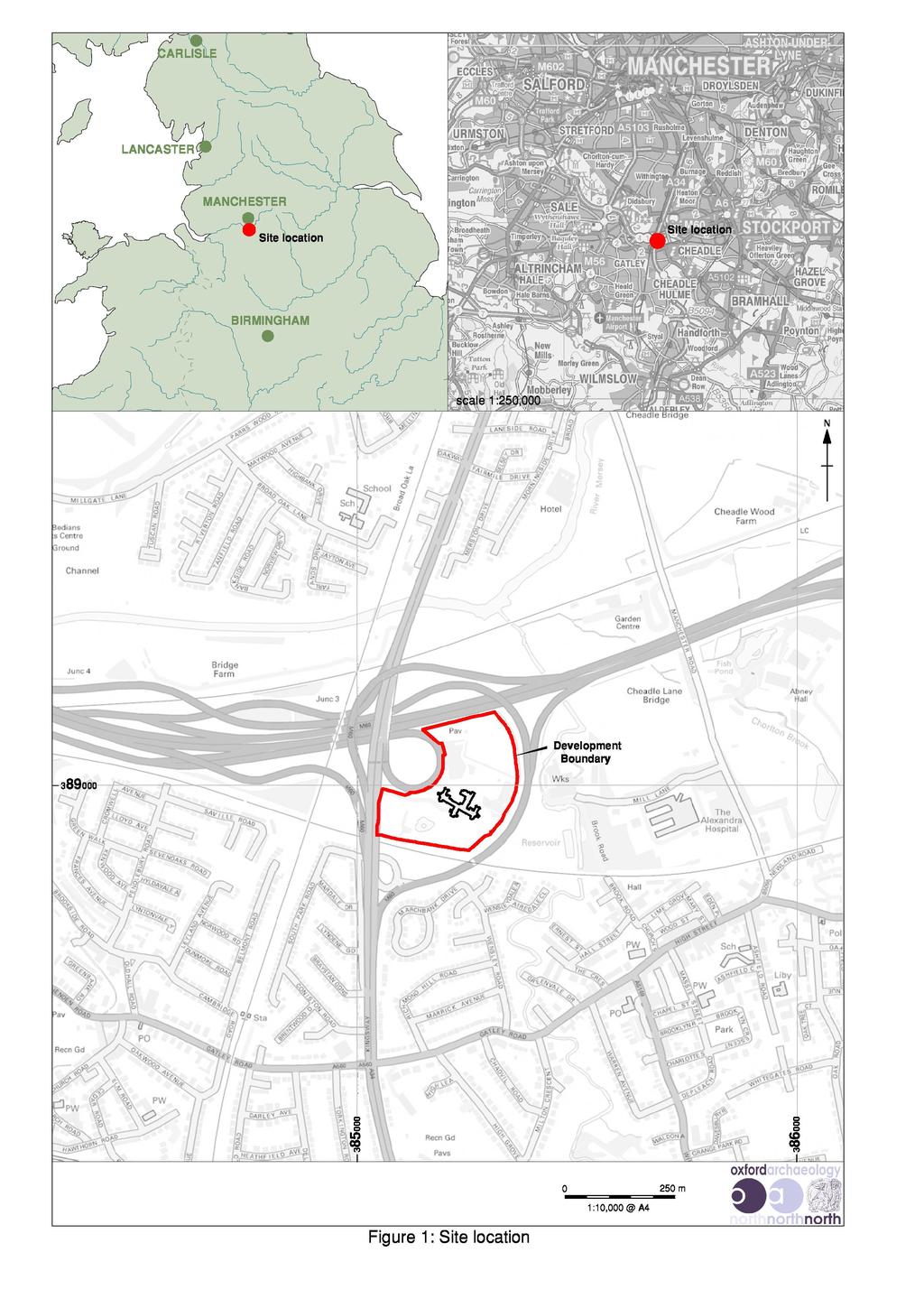
6 Barnes Hospital, Cheadle, Stockport: Archaeological Evaluation 4 1. INTRODUCTION 1.1 CIRCUMSTANCES OF PROJECT Barnes Village Ltd has obtained planning permission to redevelop the former Barnes Hospital and its associated grounds in Cheadle, near Stockport. The development proposal allows for the refurbishment of the hospital building, which is afforded statutory designation as a Grade II listed building, together with the erection of new housing. The new build will comprise housing within the grounds encompassing the hospital building. The proposed construction works will necessitate considerable earth-moving works, which have some potential to damage or destroy buried archaeological remains The archaeological potential of the site has been highlighted by a desk-based assessment produced by Oxford Archaeology North (OA North 2014). This study concluded that the site has some potential to contain buried remains of archaeological interest, including the projected line of the Roman road from Cheadle to Buxton. In addition, artefacts of prehistoric, Roman, and early medieval date have been discovered within the immediate vicinity, raising the possibility that other buried artefacts of archaeological interest may survive within the site boundary. In the light of these conclusions, the Greater Manchester Archaeological Advisory Service (GMAAS), which provides archaeological advice to Stockport Council, recommended that a programme of archaeological investigation of the site was merited in advance of development, in accordance with the National Planning Policy Framework In response to this recommendation Reis Construction, acting on behalf of Barnes Village Ltd, commissioned OA North to carry out a programme of archaeological evaluation. This comprised the mechanical excavation of 12 trenches within the study area, which aimed to establish character, extent, date and significance of the below-ground archaeological resource. The evaluation trenching and walk over survey was carried out in September LOCATION, TOPOGRAPHY AND GEOLOGY The study area (centred on NGR ) lies c 1km to the north-west of Cheadle town centre, and 4km to the west of Stockport (Fig 1). The area forms part of the county of Greater Manchester, although the boundary with the adjacent county of Cheshire lies a short distance to the south. Barnes Hospital is almost entirely encompassed by major transport routes, with Junction 4 of the M60 situated immediately to the south-east, and Junction 3 to the south-west. The southern boundary of the site is formed by a former railway embankment (Plate 1) The study area occupies land at a height of approximately 44m above Ordnance Datum, and lies between the river Mersey and the Micker Brook. The surrounding ground levels fall northwards and eastwards towards these watercourses.
.")
7 Barnes Hospital, Cheadle, Stockport: Archaeological Evaluation 5 Plate 1: Recent aerial view of the study area and its environs The solid geology of the area comprises the Sherwood Sandstone Group, which is overlain by glacial boulder clay (Hall et al 1995, 8). The course of the Micker Brook to the east of the study area is associated with a ribbon of alluvium, whilst river terrace gravel deposits lie within the wider valley of the river Mersey to the north. The drift geology to the west and east of the study area is characterised by a tract of fluvio-glacial gravel, together with glacial sand and gravel. 1.3 HISTORICAL AND ARCHAEOLOGICAL BACKGROUND Roman period: whilst there are tantalising indications of Cheadle having been a focus for Roman activity in the area, firm evidence is lacking and represents an archaeological research objective of high local importance. Physical remains dating to this period comprise clusters of Roman finds that have been discovered in the immediate vicinity of Barnes Hospital. In particular, two Roman coins were found in 1972 at Red Rocks, on the west bank of the Micker Brook. The coins are thought to have dated to the fourth century, and were probably issues of Constantius II. Another two coins were found a short distance to the north-east in These findspots lie close to a shallow point on the Micker Brook, raising the possibility that this had been an ancient ford, or crossing point, adjacent to the projected line of the Roman road. Another Roman coin was discovered to the south of the Barnes Hospital in 1948; this coin was dated to the reign of Galerius (AD ). In addition, three coins were recovered from a building site at the corner of Massie Street and High Street in Cheadle in 1939 (Redhead and Miller 2014).
8 Barnes Hospital, Cheadle, Stockport: Archaeological Evaluation There is also some indication that Cheadle lies on the route of a Roman road to Buxton. The existence of this road was inferred in the nineteenth century from Street Lane, which is known presently as Cheadle Road. Some weight to this interpretation was provided by the discovery in the 1880s of a surface composed of compacted gravel. The surface was discovered on Ack Lane East in Bramhall, situated to the south-east of Cheadle, and on the same alignment as Cheadle Road. Further to the south-east, recent excavation at Walnut Tree Farm in Woodford revealed another section of a gravel road, which had a width of 7.5m and a cambered surface, typical of Roman construction. In addition, it is possible that a second Roman road, running south of the Mersey and perhaps linking with the Manchester to Chester Road, also passed through Cheadle (Arrowsmith 1997, 15) In 2005, two sherds of pottery that were identified provisionally as being of a Roman date were recovered from an archaeological evaluation of land to the rear of the White Hart pub in Cheadle. Whilst the evaluation did not provide any direct evidence for Roman activity in the area, it was concluded that the site may have been used as agricultural land since the Roman period (UMAU 2005, 13) Early Medieval Period: evidence for early medieval activity in north-west England is sparse, perhaps reflecting constant invasion by the Danes after AD 870 (Thomson 1967). Similarly, the character of occupation in Cheadle following the collapse of formal Roman administration in the early fifth century remains entirely obscure, although it has been suggested that St Chad preached in the area during the seventh century (Clarke 1972, 1) Physical remains from this period are best represented in Cheadle by fragments of at least two stone crosses that were discovered in the immediate vicinity of the study area; one of the fragments is displayed currently in a glass case in St Mary s Church Cheadle. There are conflicting accounts of the circumstances of the discovery of the cross fragments. Earwaker (1878, 185) attributes the discovery to some workmen who were excavating a large brickfield opposite Barnes Convalescent Hospital in 1875 and unearthed the remains of one, if not more, stone crosses at a shallow depth. Having left the fragments lying on the ground, they were recovered by Mrs Bangay, the wife of Dr Bangay of Cheadle, who removed them to her house. Earwaker locates the field in which the cross fragments were unearthed as that marked Brickfield No 54 on the 1872 Ordnance Survey map (Bailey 2011) Moss (1894, 7-8) described the site of discovery as the corner of a field perhaps 300 yards west or slightly to the north of west of the tower of the church and on the opposite high bank of the little river. Moss, however, was less positive about Dr Bangay s involvement, asserting that the stones had first been recognised by the well-known local antiquary, Mr Bailey, who made them out to be two crosses and that Bangay had subsequently paid the men and removed the more complete cross; the other and much older cross was imperfect; it also was taken away with what was probably an upright stone shaft (quoted in Bailey 2011). A further account suggests that the cross fragments were discovered during the construction of the Barnes Hospital in 1875 (Squire 1976, 1).
.")
9 Barnes Hospital, Cheadle, Stockport: Archaeological Evaluation The cross in St Mary s Church is thought to date to the later part of the tenth or eleventh century, although it could possibly be even earlier (Redhead and Miller 2014). The cross comprises fan-shaped arms, central bars, and a carved shaft. Plate 2: The cross in St Mary s Church
10 Barnes Hospital, Cheadle, Stockport: Archaeological Evaluation Medieval Period: Cheadle is recorded in the Domesday Survey of 1086 as Cedde, which may be translated as clearing in a wood. The detail of the survey indicates that there were only about ten households in the area. It was held by Gamel, a free Saxon under Hugh d'avranches, First Earl of Chester; it was about three miles long and half as wide, containing both wooded and open land, with areas enclosed for hunting purposes By the mid-twelfth century, the manor of Cheadle was held by a family of that name. By June 1294, Geoffrey de Chedle was lord of the manor, which was valued at about 20 per annum. A church of wooden construction is thought to have been built by that date, on the site on High Street occupied currently by St Mary s Church (Clarke 1972, 5). The estate passed to Matilda de Chedle in the early 1320s, who held it until her death in 1326 (Squire 1976, 1). As there were no male heirs the manor, it was divided between her daughters, Clemence and Agnes. Agnes inherited the northern half (which would later become the modern-day Cheadle), and Clemence inherited the southern half (latterly Cheadle Hulme). The two areas became known as Chedle Bulkeley and Chedle Holme respectively The manor was situated in the Hundred of Macclesfield, and comprised the townships of Cheadle Bulkeley, Cheadle Moseley, and Handforth, incorporating a cumulative total of 6230 acres; the township of Cheadle Bulkeley comprised 2100 acres, whilst Cheadle Moseley occupied 2350 acres (Bagshaw 1850, 168). The medieval economy was based firmly on agriculture, and particularly the raising of beef and dairy cattle, and other livestock including sheep, pigs and poultry (Hilton nd, 127). The earliest reference to a corn mill in Cheadle is provided by a charter dated c (Barraclough 1957, 31) The location of the twelfth-century mill is not entirely certain, although it is believed to have occupied the same site as the later Higher Mill (Arrowsmith 1997, 55). Cheadle Lower Mill was the manorial mill of Cheadle Bulkeley; Lower Mill was doubtless on the site of the old mill of the Bulkeley s mentioned in 1349 as being worth 13s 4d per annum (Moss 1970, ). Whilst this mill was almost certainly situated on the Micker Brook in the immediate vicinity of the present study area, its exact location remains uncertain. The recent excavation of the Cheadle Bleach Works revealed structural remains that could be identified firmly with the documented postmedieval corn mill, although no evidence for its medieval predecessor was encountered (OA North 2008) Physical evidence for medieval activity in close proximity to the study area is provided by a bronze ring of a probable fourteenth-century date, which was discovered in a field on the west side of the Micker Brook at the end of Mill Lane in 1980, and a sherd of medieval pottery recovered from an archaeological excavation to the rear of the White Hart in 2005 (UMAU 2005).
11 Barnes Hospital, Cheadle, Stockport: Archaeological Evaluation Other known archaeological sites of medieval origin within a 500m radius of the study area include a sundial situated to the north-east of St Mary s Church, which may have originated as a medieval stone cross shaft. In addition, ridge and furrow marks can be seen in a field immediately to the south-east of the study area on aerial views. Whilst the ridge and furrow cannot be dated firmly, it could potentially be of later medieval date Post-medieval and Industrial Period: at the beginning of the post-medieval period, the general area remained sparsely populated with isolated halls and farmsteads. Only part of the land was cultivated, the rest mostly moor land, swamp and thicket (Wharfe 1974, 28). Large areas continued to be held as forest, including potentially good agricultural land. The wetlands of the region were for the most part undrained and uncolonised, the land lay unenclosed and settled by only seasonally occupied houses or huts (McNeil and Newman 2004, 4). The main characteristics of the region during this time were undeveloped wastelands and expansion of settlement into them (ibid) The economy of Cheadle continued to be based largely on agriculture through the post-medieval period, although handloom silk weaving emerged as an important industry locally during the eighteenth century (Hilton nd, 129). The parish church of St Mary was largely erected during the early sixteenth century, although it is known to have been situated on a medieval site. The church was largely rebuilt in , with only the chancel from the medieval church surviving (Chivers 1993, 3) After the death of James Viscount Bulkeley, the manor was sold under an Act of Parliament in 1756 to the Rev Thomas Egerton and, in 1806, it was conveyed to John Worthington (Pigot and Co 1828, 13-4). Burdett s Map of Cheshire, published in 1777, shows that Cheadle was the second largest settlement in the borough after Stockport (Section 3.2.1). The detail of the map appears to show a pattern of settlement based largely on scattered farmhouses and hamlets (Arrowsmith 1997) A significant alteration to the landscape in the vicinity of the study area during the nineteenth century was construction of the railway. This line was opened in 1862, taking a route along the southern boundary of the study area. A private siding was laid subsequently to serve Barnes Hospital Barnes Convalescent Hospital: it had been decided in 1865 by the Manchester Infirmary Trustees to build a convalescent home some distance away from the industrial pollution of the city. Robert Barnes heard of this, and donated 10,000, adding a further 16,000 subsequently. A site at Cheadle was bought from the trustees of Sir L Bamford Hesketh for The foundation stone was laid on 29 July 1871 by Hugh Birley MP. The building was finished in 1875, and opened in the October of that year. During the construction programme, a railway siding was laid for use by the contractors. During the construction of this line, a bed of natural fine clay was exposed, which was used to make bricks for the construction of the hospital building. The total cost of the hospital came to 52,000 (Simmonds 1993, 2). A photograph of the hospital shortly after it had been completed was printed in Manchester Faces and Places in 1889 (Plate 3).
12 Barnes Hospital, Cheadle, Stockport: Archaeological Evaluation An account published by JG Hammond in 1898 noted that the Home occupies a pleasant situation in its own grounds at Cheadle the estate comprising about 46 acres of land, part of which, in close proximity to the building, has been tastefully laid out for the use and benefit of the patients, while the remainder is pasture land, and is let for farming purposes (quoted in Simmonds 1993). Plate 3: Photograph of the front (south-east-facing elevation) of Barnes Convalescent Hospital published in Manchester Faces and Places, In 1925, Barnes was used largely as a relief hospital for medical and surgical patients at Manchester Royal Infirmary. During the Second World War, the hospital was used as a convalescent home for wounded soldiers (Redhead and Miller 2014) The hospital closed in September 1999, and it the same year it was afforded statutory designation as a Grade II listed building. The site was sold in 2001 (Stockport Express, 28 February 2001), and was owned for several years by Realty Estates (Stockport Express, 4 December 2002). It was purchased subsequently by Benmore, an Irish property development group, which proposed a residential development around the hospital building. However, these plans did not materialise, and the site was purchased recently by a group of four local businessmen.
13 Barnes Hospital, Cheadle, Stockport: Archaeological Evaluation METHODOLOGY 2.1 INTRODUCTION At the request of Kevin Watters of Reis Construction, a Written Scheme of Investigation (WSI) was prepared by Oxford Archaeology North, in consultation with GMAAS (Appendix 1). The WSI was adhered to in full, and the work was consistent with the relevant Chartered Institute for Archaeologists and Historic England guidelines. 2.2 WALK-OVER SURVEY Prior to the excavation of the evaluation trenches a walk-over survey was conducted across the partially stripped fields to the north of the hospital. The survey involved the visual inspection of the ground surface in 5m transects across the length of the field, noting any artefactual densities that may indicate the location of features, and inform the subsequent positioning of evaluation trenches. 2.3 EVALUATION TRENCHING The topsoil was removed by machine (fitted with a toothless ditching bucket) under archaeological supervision to the surface of the first significant archaeological deposit. This deposit was cleaned by hand, using either hoes, shovel scraping, and/or trowels depending on the subsoil conditions, and inspected for archaeological features. All features of archaeological interest were investigated and recorded All trenches were excavated in a stratigraphical manner. The trench locations were determined on the ground and positioned in areas deemed likely to encounter archaeological deposits. The position of the trenches were located accurately using a differential Global Positioning System (dgps), with topographical altitude information for each area provided by the client and established with respect to Ordnance Survey datum All information identified in the course of the site works was recorded stratigraphically, using a system adapted from that used by the former Centre for Archaeology of English Heritage, with an accompanying pictorial record (plans, sections, and digital photographs). Primary records were available for inspection at all times. 2.4 ARCHIVE A full professional archive has been compiled in accordance with the Written Scheme of Investigation, and in accordance with current CIfA and Historic England guidelines (English Heritage 2006). The paper and digital archive will be deposited in the Greater Manchester Historic Environment Record on completion of the project.
14 Barnes Hospital, Cheadle, Stockport: Archaeological Evaluation FIELDWORK RESULTS 3.1 INTRODUCTION A total of 12 trenches were excavated during the course of the evaluation (Fig 2), in accordance with the approved Written Scheme of Investigation (Appendix 1). Each trench had a length of 20m and a width of 2m, except trenches 5 and 6, which measured 10m and 5m long respectively. A summary of the results obtained from each trench is presented below 3.2 TRENCH Trench 1 was placed on an east/west alignment, to the south of the main entrance to the site in the south-western corner of the site (Fig 2). The undisturbed natural geology was encountered at a depth of 0.4m below the present ground surface, and comprised mid-orangey-yellow heavy clay with patches of gleying The natural geology was overlain by a thin deposit of mid-yellowish-brown clay silt subsoil, up to 0.10m thick, and with rare sub-angular stones a maximum of 10mm in size (Plate 4). At the eastern end of the trench two inter-cutting ceramic field drains had been cut into the natural geology through the subsoil and above this lay a deposit of heavily disturbed loose dark grey brown silt, containing significant quantities of modern demolition rubble. This deposit covered the full length of the trench, and had itself been overlain by a modern layer of gravel and terram matting No features of archaeological significance were cut into any of these deposits, and the only artefacts were of a nineteenth-century date or later. 3.3 TRENCH Trench 2 was placed to the south of Trench 1, within the south-western corner of the site, and was aligned broadly east/west (Fig 2). The natural geology was exposed at a depth of m below the present ground level, and was identical in character to that described in Trench Towards the western end of the trench a modern drain, backfilled with gravel, crossed the width of the trench. A small sub-circular depression or pit was recorded to the west of the drain, measuring 0.37m in diameter. Excavation revealed it to be only 0.04m in depth, and filled with dark greyish-brown silt containing modern demolition rubble. The pit and natural geology were sealed by the same loose dark grey brown silt deposit identified in Trench 1 but, despite the proximity of the two trenches, there was no evidence for a subsoil in this location No archaeological features were encountered


15 Barnes Hospital, Cheadle, Stockport: Archaeological Evaluation 13 Plate 4: Trench 1 looking east, 2m scale Plate 5: Trench 1, south-facing section, 1m scale


16 Barnes Hospital, Cheadle, Stockport: Archaeological Evaluation 14 Plate 6: Trench 2, facing west, 2m scale Plate 7: Trench 2, south-facing sectiont, 1m scale

17 Barnes Hospital, Cheadle, Stockport: Archaeological Evaluation TRENCH Trench 3 was aligned broadly north/south, and lay a short distance to the west of trenches 1 and 2 (Fig 2). Its position was adjusted slightly further to the south than originally intended to avoid the line of a gas main, which once supplied the hospital Deposits of mid-orangey-yellow heavy clays with patches of grey gleying were again encountered just 0.30m below the present ground surface, and a ceramic field drain had been cut into the natural, crossing the northern end of the trench. Both the drain and natural clay were covered by the same loose dark greyish-brown silt that had been recorded in both trenches 1 and 2 and contained significant quantities of modern demolition waste. The soil increased in thickness to the south up to a maximum of 0.60m, reflecting a slight rise in the ground surface in this direction and in places this demolition waste had been pressed into the top of the underlying natural clays No archaeological features were encountered in the trench. Plate 8: Trench 3, looking north
.")
18 Barnes Hospital, Cheadle, Stockport: Archaeological Evaluation 16 Plate 9: Trench 3, west-facing section, 1m scale 3.4 TRENCH Trench 4 was located in the south-eastern corner of the site, on an area of grass land to the east of the original hospital building, and lay upon a broadly east/west alignment (Fig 2). Natural clays were encountered at a depth of 0.30m beneath the present ground surface, and three ceramic field drains were recorded cutting the natural across the centre of the trench. Two of the drains were aligned approximately east/west and, unusually, each cut contained two parallel drains. The third was aligned north/south, and contained just a single drain. All three drains and the natural clays were sealed beneath a layer of mid-yellowish-brown clay silt, containing fragments of modern demolition waste and rare sub-angular stones up to 10mm in size No archaeological features were encountered. 3.5 TRENCH Trench 5 was placed in the south-eastern corner of the site, just a short distance to the south of Trench 4, and west of the footbridge crossing the slip road for the west-bound carriageway of the M60 motorway. It was aligned broadly north/south, and was the only trench with a length of 10m Natural clay was identified at a depth of only 0.40m below the modern ground surface, and was covered by a deposit of mid-yellowish-brown clay silt, identical to that described within Trench No archaeological features were identified within the trench.


19 Barnes Hospital, Cheadle, Stockport: Archaeological Evaluation 17 Plate 10: Trench 4, facing east, 2m scale Plate 11: Trench 4, south-facing section, 1m scale


20 Barnes Hospital, Cheadle, Stockport: Archaeological Evaluation 18 Plate12: Trench 5, facing north, 2m scale Plate 13: Trench 5, west-facing section, 1m scale
.")
21 Barnes Hospital, Cheadle, Stockport: Archaeological Evaluation TRENCH Trench 6 lay within the south-eastern corner of the site to the south-west of trenches 4 and 5, and was located upon a broadly east/west alignment (Fig 2). It was the only trench with a length of 5m, allowing it to be placed in the southern portion of the grassed area, and its excavation revealed natural clays at a depth of 0.36m. The cut of a modern drain was identified at the western end of the trench, backfilled with gravel, and both the drain and natural clay was covered to the present ground surface by a layer of mid-yellowish-brown clay silt, containing fragments of modern demolition waste and rare subangular stones up to 10mm in size No archaeological features were identified within the trench. Plate 14: Trench 6, facing west, 2m scale
.")
22 Barnes Hospital, Cheadle, Stockport: Archaeological Evaluation 20 Plate 15: Trench 6, south-facing section, 1m scale 3.7 TRENCH Trench 7 was located to the north of the hospital building, within the southeastern corner of the area known as the lower field (Fig 2). This area had been partially stripped of topsoil prior to the present survey to an average depth of 0.2m, and was the subject of a walk-over survey prior to the excavation of the trenches Trench 7 was aligned east/west, and its location was moved slightly further to the north than originally designed to avoid an area of rubble spoil, which covered the southern end of the site. Its excavation revealed mid-orangeyyellow coarse sandy clay, with occasional patches of grey gleying and alluvial gravels at a depth of 0.65m The natural geology was sealed beneath a deposit of mid-brownish-yellow clay silt subsoil with very rare sub-angular and sub rounded stone up to 10mm in size. The subsoil reached a maximum thickness of 0.4m, and was overlain by mid-yellowish-brown topsoil to a maximum depth of 0.25m. The topsoil contained occasional sub angular to sub-rounded stones up to 0.20m in size and included fragments of nineteenth century and later pottery and ceramic building material throughout No archaeological features were identified within the trench.


23 Barnes Hospital, Cheadle, Stockport: Archaeological Evaluation 21 Plate 16: Trench 7, facing east, 2m scale Plate 17: Trench 7 north-east-facing section, 1m scale

24 Barnes Hospital, Cheadle, Stockport: Archaeological Evaluation TRENCH Trench 8 was placed a short distance to the north west of Trench 7, and placed on a north-east/south-west alignment (Fig 2). It was located slightly further to the north-east than originally designed to avoid an area of flooding and also to incorporate a linear feature which had been noted during the walk-over survey The excavation of the trench revealed natural clays sands and gravels identical to that recorded in Trench 7 at a depth of 0.68m. The natural was covered by a layer of mid-brownish-yellow clay silt subsoil, identical to that described in Trench 7, to a maximum thickness of 0.5m. A ceramic field drain had been cut into the subsoil on a north-east/south-west alignment, and the cut backfilled with a mixture of subsoil and topsoil. The field drain and subsoil was overlain by the surviving lower portions of the mid-yellowish-brown topsoil to a thickness of up to 0.15m No archaeological features were encountered. Plate 18: Trench 8, facing north-east, 2m scale

25 Barnes Hospital, Cheadle, Stockport: Archaeological Evaluation 23 Plate 19: Trench 8, south-east-facing section, 1m scale 3.9 TRENCH Trench 9 was placed to the north of Trench 8, along the north-eastern boundary of site (Fig 2). It was aligned broadly north/south, and was excavated to a maximum depth of 0.65m, where undisturbed natural soils were encountered. The natural was similar to that described in Trench 7, with midorangey-yellow coarse sandy clays, but in this case included a band of alluvial gravels across the centre of the trench. A sondage excavated into the gravel band showed it to have irregular edges and be entirely sterile of archaeological material, confirming it to be of natural origin. A layer of mid-yellowish-brown clay silt overlay the natural to a depth of 0.45m, which in turn was covered by 0.20m of mid yellow brown clay silt topsoil No archaeological features were encountered TRENCH Trench 10 lay to the west of Trench 8, and was aligned approximately north/south. Its final location was adjusted further to the east to avoid a large spoil heap and area of flooding. Excavation revealed natural coarse sands and gravels at a depth of 0.6m, overlain by a layer of mid-yellowish-brown clay silt subsoil 0.4m thick. A mid-yellowish-brown clay silt topsoil, 0.20m thick covered the trench to the present ground surface No archaeological features were encountered.


26 Barnes Hospital, Cheadle, Stockport: Archaeological Evaluation 24 Plate 20: Trench 9, facing north, 1m scale Plate 21: Trench 9, west-facing section, 1m scale


27 Barnes Hospital, Cheadle, Stockport: Archaeological Evaluation 25 Plate 22: Trench 10, facing south, 2m scale Plate 23: Trench 10, west-facing section, 2m scale

28 Barnes Hospital, Cheadle, Stockport: Archaeological Evaluation TRENCH Trench 11 lay in the north-eastern corner of the study area, and was aligned north-east/south-west (Fig 2). Coarse natural clays were revealed at a depth of between 0.65m and 0.70m below the present ground surface, and were covered by mid-brownish-yellow clay silt subsoil up to 0.50m thick. Midyellowish-brown clay silt topsoil, 0.20m thick, overlay the subsoil to the top of the trench No archaeological features were encountered. Plate 24: Trench 11, facing north-east, 2m scale

29 Barnes Hospital, Cheadle, Stockport: Archaeological Evaluation 27 Plate 25: Trench 11, south-east-facing section, 1m scale 3.12 TRENCH Trench 12 lay a short distance to the north-west of Trench 11, and was moved slightly further to the east of its intended location to avoid an existing spoil heap. It was placed on an east/west alignment, and was excavated to a depth of 0.6m, where undisturbed natural clay was encountered. A sondage, excavated at the western end of the trench, established the continuation of the clays, along with thin bands of fine orange sands and gravels to a depth in excess of 1.1m. The natural geology was overlain by a deposit of mid-brownish-yellow subsoil, 0.50m thick, which in turn was covered by a mid-yellowish-brown clay silt topsoil of between 0.05 and 0.10m thick No archaeological features were encountered.


30 Barnes Hospital, Cheadle, Stockport: Archaeological Evaluation 28 Plate 26: Trench 12, facing west, 2m scale Plate 27: Trench 12, south-west-facing section, 1m scale
31 Barnes Hospital, Cheadle, Stockport: Archaeological Evaluation CONCLUSION 4.1 CONCLUSION The walk-over survey conducted across the northern half of the site identified considerable quantities of dispersed later nineteenth and twentieth century pottery and ceramic building materials, but did not demonstrate any specific densities indicative of features of this date or earlier; none of the fragments of pottery were of archaeological interest, and were thus not retained. Similarly, there was no indication of any topographic features that might indicate early agricultural practices The excavation of trenches 7-12 revealed no archaeological features of any kind, and demonstrated the survival of a significant layer of subsoil across the entire area. Had any intensive human activity taken place within the field to the north of the hospital, physical evidence is likely to have survived in-situ beneath this layer of subsoil. The absence of any such evidence suggests this part of the site had been used for agricultural purposes for a considerable period of time prior to the construction of the Barnes Convalescence Hospital in Trenches 1-6 in the southern half of the site demonstrated significant disturbance to the topsoil, indicative of levelling activity after the demolition of later nineteenth- and twentieth-century structures. The survival of a thin subsoil within Trench 1, however, suggests that archaeological features have not been lost through truncation, and that in all likelihood the area was also used for agriculture prior to the construction of the hospital It should be noted that the natural clays in the southern half of the site and adjacent to the brick fields noted on the nineteenth-century Ordnance Survey mapping are far more suitable for extraction and brick production than those in the northern half of the site The results obtained from the evaluation trenching have concluded that there is little potential for significant archaeological remains to survive in-situ, and is thus unlikely that any earth-moving works associated with the proposed development would have a negative impact on the buried archaeological resource. It is considered unlikely that any further intrusive investigation of the site is merited.

32 Barnes Hospital, Cheadle, Stockport: Archaeological Evaluation 30 APPENDIX 1: WRITTEN SCHEME OF INVESTIGATION September 2015 Oxford Archaeology North BARNES HOSPITAL, CHEADLE, STOCKPORT ARCHAEOLOGICAL EVALUATION WRITTEN SCHEME OF INVESTIGATION Proposals The following Written Scheme of Investigation is offered in response to a request from Kevin Watters of Reis Construct for an archaeological evaluation in advance of a proposed development at Barnes Hospital in Cheadle, Stockport.
33 Barnes Hospital, Cheadle, Stockport: Archaeological Evaluation BACKGROUND 1.1 CIRCUMSTANCES OF PROJECT Barnes Village Ltd has obtained planning permission to redevelop the former Barnes Hospital and its associated grounds in Cheadle, near Stockport. The development proposal allows for the refurbishment of the hospital building, which is afforded statutory designation as a Grade II listed building, together with the erection of new housing. The new build will comprise housing within the grounds encompassing the hospital building. The proposed construction works will necessitate considerable earth-moving works, which have some potential to damage or destroy buried archaeological remains The archaeological potential of the site has been highlighted by a desk-based assessment produced by OA North in This study concluded that the site has some potential to contain buried remains of archaeological interest, including the projected line of the Roman road from Cheadle to Buxton, which takes a course across the north-eastern corner of the site. In addition, artefacts of prehistoric, Roman, and early medieval date have been discovered within the immediate vicinity, raising the possibility that other buried artefacts of archaeological interest may survive within the site boundary. Any such artefacts or associated remains would merit preservation by record where these will be directly affected by development In the light of these conclusions, the Greater Manchester Archaeological Advisory Service (GMAAS), which provides archaeological advice to Stockport Council, recommended that a programme of archaeological investigation of the site is merited in advance of development, in accordance with the National Planning Policy Framework, Paragraph This Written Scheme of Investigation (WSI) has been formulated in consultation with GMAAS, and provides for an appropriate scheme of initial archaeological investigation. It allows for a site walkover survey coupled with the excavation of a series of trial trenches. The trenches will be intended primarily to identify the projected course of the Roman road from Cheadle to Buxton, and any physical evidence for Early Medieval and post-conquest remains. In the event of significant archaeological remains being discovered in the trenches, further archaeological investigation may be required. Any such additional works will be carried out in accordance with an Updated WSI.
34 Barnes Hospital, Cheadle, Stockport: Archaeological Evaluation OXFORD ARCHAEOLOGY Oxford Archaeology is an educational charity under the guidance of a board of trustees with over 35 years of experience in archaeology, and can provide a professional and cost-effective service. We are the largest employer of archaeologists in the country (we currently have more than 300 members of staff), and can thus deploy considerable resources with extensive experience to deal with any archaeological obligations you or your clients may have. OA is an Institute for Archaeologists Registered Organisation (No 17). We have offices in Lancaster and Oxford, trading as Oxford Archaeology North (OA North) and Oxford Archaeology South (OA South) respectively, enabling us to provide a truly nationwide service. All work on the project will be undertaken in accordance with relevant professional standards, including: CIfA s Code of Conduct (2012); Code of Approved Practice for the Regulation of Contractual Arrangements in Field Archaeology (2010); Standard and Guidance for Archaeological Evaluations (2010); English Heritage s Management of Archaeological Projects, 1991; The European Association of Archaeologists Principles of Conduct for Archaeologists Involved in Contract Archaeological Work (1998). 2. AIMS AND OBJECTIVES 2.1 ACADEMIC AIMS The main research aim of the investigation, given the commercial nature of the development, will be to establish the presence or absence of buried archaeological remains on the site and, if present, characterise the level of preservation and significance, and provide a good understanding of their potential. 2.2 OBJECTIVES The objectives of the project may be summarised as follows: to determine the presence, character, and extent of the projected course of the Roman road between Cheadle and Buxton; to determine the presence, character, and extent of any associated activity of Roman date; to determine the presence, character, and extent of any medieval activity on the site; to inform a decision as to whether further archaeological investigation will be required in advance of development ground works; to compile an archival record of any archaeological remains within the development area.
35 Barnes Hospital, Cheadle, Stockport: Archaeological Evaluation METHOD STATEMENT 3.1 INTRODUCTION The northern part of the development area will be investigated initially via a walkover inspection survey. This will be coupled with the excavation of 12 trial trenches, varying in length from 20m to 5m (Figure 1). In the event of significant archaeological remains being discovered in the trenches, it is likely that further archaeological investigation will be required. Any such additional works will be carried out in accordance with an Updated Written Scheme of Investigation, which will be devised in consultation with GMAAS. 3.2 WALKOVER INSPECTION SURVEY The walkover inspection survey will aim to identify and recover any artefacts visible on the existing ground surface. Any scatters of artefacts identified will be plotted on large-scale mapping of the site, and will be targeted subsequently for evaluation trenching. 3.3 EVALUATION General Methodology: it is proposed that the site be investigated initially via 12 trenches. These will be located to provide an adequate sample of the development site, and will be targeted on those areas that do not appear to have been subject to any significant ground disturbance during the construction of the hospital complex in the late nineteenth century. The precise location of the trenches in the northern part of the site will be located in the light of the findings from the walkover inspection survey. In the event of few artefacts being recovered from the walkover survey, then the trenches in the northern part of the site will be placed in the locations shown on Figure Excavation of the modern ground surface to the top of the first significant archaeological level will be undertaken by a machine of appropriate power using a toothless ditching bucket. The work will be supervised closely by a suitably experienced archaeologist. Thereafter, any archaeological layers or structural remains will be cleaned manually to define their extent, nature, form and, where possible, date. If the excavation is to proceed below a depth of 1.2m, then the trenches will be widened sufficiently to allow the sides to be stepped in All information identified in the course of the site works will be recorded stratigraphically, using a system adapted from that used by the Centre for Archaeology Service of English Heritage. Results of the evaluation will be recorded on pro-forma context sheets, and will be accompanied with sufficient pictorial record (plans, sections and both black and white and colour photographs) to identify and illustrate individual features.
36 Barnes Hospital, Cheadle, Stockport: Archaeological Evaluation Context Recording: all contexts will be recorded using pro-forma sheets, and details will be incorporated into a Harris matrix. Similar object record and photographic record pro-formas will be used. All written recording of survey data, contexts, photographs, artefacts and ecofacts will be cross-referenced from pro-forma record sheets using sequential numbering Photography: a full and detailed photographic record of individual contexts will be maintained and similarly general views from standard view points of the overall site at all stages of the evaluation will be generated. Photography will be undertaken using high-resolution digital cameras. All frames will include a visible, graduated metric scale. Photographs records will be maintained on special photographic pro-forma sheets Planning: the precise location of the evaluation trenches, and the position of all archaeological structures encountered, will be surveyed by EDM tacheometry using a total station linked to a pen computer data logger. This process will generate scaled plans within AutoCAD, which will then be subject to manual survey enhancement. The drawings will be generated at an accuracy appropriate for 1:20 scale, but can be output at any scale required. Sections will be manually drafted as appropriate at a scale of 1:10. All information will be tied in to Ordnance Datum Human remains are not expected to be present, but if they are found they will, if possible, be left in situ covered and protected. If removal is necessary, then the relevant Home Office permission will be sought, and the removal of such remains will be carried out with due care and sensitivity as required by the Burials Act Any gold and silver artefacts recovered during the course of the excavation will be removed to a safe place and reported to the local Coroner according to the procedures relating to the Treasure Act, Finds policy: finds recovery and sampling programmes will be in accordance with best practice (following current Institute for Archaeologists guidelines) and subject to expert advice in order to minimise deterioration. OA North employs in-house artefact and palaeoecology specialists, with considerable expertise in the investigation, excavation, and finds management of sites of all periods and types, who are readily available for consultation. Finds storage during fieldwork and any site archive preparation will follow professional guidelines (UKIC). 3.3 HEALTH AND SAFETY Full regard will be given to all constraints during the course of the project. OA North provides a Health and Safety Statement for all projects and maintains a Safety Policy. All site procedures are in accordance with the guidance set out in the Health and Safety Manual compiled by the Standing Conference of Archaeological Unit Managers.
37 Barnes Hospital, Cheadle, Stockport: Archaeological Evaluation OA North undertakes to safeguard, so far as is reasonably practicable, the health, safety and welfare of its staff and of others who may be affected by our work. OA North will also take all reasonable steps to ensure the health and safety of all persons not in their employment, such as volunteers, students, visitors, and members of the public (this includes trespassers) OA North is fully familiar with and will comply with all current and relevant legislation, including, but not limited to: The Health and Safety at Work Act (1974); Management of Health and Safety at Work Regulations (1999); Manual Handling Operations Regulations 1992 (as amended in 2002); The Construction (Design and Management) Regulations (2007); The Control of Asbestos Regulations (2006); The Workplace (Health, Safety and Welfare) Regulations (1992); Construction (Health, Safety and Welfare) Regulations (1996); The Health and Safety (Miscellaneous Amendments) Regulations (2002); The Work at Height Regulations (2005); The Control of Substances Hazardous to Health Regulations (2002); The Health and Safety (First-Aid) Regulations (1981); The Regulatory Reform (Fire Safety) Order (2005); The Provision and Use of Work Equipment Regulations (1998); Lifting Operations and Lifting Equipment Regulations (1998) OA North has professional indemnity to a value of 2,000,000, employer's liability cover to a value of 10,000,000 and public liability to a value of 15,000,000. Written details of insurance cover can be provided if required. 3.4 OTHER MATTERS Project Monitoring: the aims of monitoring are to ensure that the archaeological works are undertaken within the limits set by the Written Scheme of Investigation, and to the satisfaction of the curatorial archaeologist at the Greater Manchester Archaeological Advisory Service (GMAAS). The curatorial archaeologist will be given at least five days notice of when work is due to commence, and it is anticipated that there will be at least one formal monitoring meeting during the course of the archaeological investigation. 3.5 POST-EXCAVATION AND REPORT PRODUCTION Report: a report will be produced within four working weeks of the completion of the fieldwork, and will include: a summary statement of the findings; the background to the evaluation, including location details; an outline of the methodology of the evaluation; a description of the site s setting, including topography and geology; an account of the documented historical background to the site;
38 Barnes Hospital, Cheadle, Stockport: Archaeological Evaluation 36 a summary, assessment, and interpretation of the results; an assessment of any finds and samples recovered from the trenches; a description of the significance of the site in its local and regional context; recommendations for any further archaeological investigation that is considered merited to mitigate the impact of the development works; a catalogue of archive items, and details of the final deposition of the project archive Archive: the results of the archaeological investigation will form the basis of a full archive to professional standards, in accordance with current English Heritage guidelines (The Management of Archaeological Projects, 2nd edition, 1991) and the Guidelines for the Preparation of Excavation Archives for Long Term Storage (UKIC 1990). The project archive represents the collation and indexing of all the data and material gathered during the course of the project. The deposition of a properly ordered and indexed project archive in an appropriate repository is considered an essential and integral element of all archaeological projects by the IfA in that organisation s code of conduct. As part of the archiving process, the on-line OASIS (On-line Access to Index of Archaeological Investigations) form will be completed The paper and finds archive for the archaeological work undertaken at the site will be deposited with the Museum of Science and Industry in Manchester. The archive will be deposited with the museum within six months of the completion of the fieldwork. Except for items subject to the Treasure Act, all artefacts found during the course of the project will be donated to the museum. 4. WORK TIMETABLE 4.1 A one-day period should be allowed to carry out the walkover inspection survey. A further one-week period should be allowed to excavate and record the evaluation trenches. On the first day of the fieldwork, OA North will accurately locate through measured survey the exact position of the trenches to be excavated. The trench locations will then be scanned for live services with a CAT prior to any mechanical excavation. 4.2 In the event of significant archaeological remains being discovered in the evaluation trenches, a programme of further investigation may be anticipated. The time required for any additional investigation cannot be determined until the results of the evaluation are known. 4.3 A report will be submitted within four weeks of the completion of the fieldwork.
39 Barnes Hospital, Cheadle, Stockport: Archaeological Evaluation STAFFING PROPOSALS 5.1 The project will be under the overall charge of Ian Miller BA FSA (OA North Senior Project Manager) to whom all correspondence should be addressed. Ian has over 20 years experience of commercial archaeology, and has a particular interest in the archaeology of the Industrial Period, and particular that of Greater Manchester and Lancashire. His role will be to ensure that the Written Scheme of Investigation is implemented within the framework of the Project Objectives. He will be responsible for all aspects of staff and resource logistics, ensuring the smooth running of the project programme. He will liaise with the Client and GMAAS with regard to progress, and will maintain relationships with other contractors. 5.2 The fieldwork is likely to be undertaken by Graham Mottershead BA (OA North Project Supervisor). Graham is an highly experienced field archaeologist, with over 20 years continuous experience of field archaeology. It is not possible to provide details of specific technicians that will be involved with the fieldwork at this stage, but all shall be suitably qualified archaeologists with proven relevant experience. It is anticipated that up to two technician will be required for the initial stage of the fieldwork. 5.3 Assessment of any finds recovered from the evaluation will be undertaken by OA North's in-house finds specialist Christine Howard-Davis BA (OA North Finds Manager). Christine has extensive knowledge of all finds of all periods from archaeological sites in northern England, and is a recognised expert in the analysis of post-medieval artefacts.
40 Barnes Hospital, Cheadle, Stockport: Archaeological Evaluation 38 BIBLIOGRAPHY CARTOGRAPHIC SOURCES Burdett, P, 1771 Map of Cheshire Greenwood, C, 1819 Map of the County Palatine of Chester Bryant, A, 1831 Map of the County Palatine of Chester Ordnance Survey 6 : 1 mile, Cheshire Sheet XIX, surveyed in 1872, published 1880 Ordnance Survey 25 : 1 mile, Cheshire Sheet XIX.1, surveyed in 1892, published 1898 Ordnance Survey 25 : 1 mile, Cheshire Sheet XIX.1, surveyed in 1907, published 1910 Ordnance Survey 25 : 1 mile, Cheshire Sheet XIX.1, surveyed in 1927, published 1934 Ordnance Survey 1:2500 map, SJ8489/8589 & SJ8488/8588, published Ordnance Survey Geological Survey, 1:63,360 map, Sheet 85, Drift, 1970 PRIMARY SOURCES Manchester Faces and Places: A New Social Magazine, 9, 1889 Stockport Express, 28 February 2001 Stockport Express, 4 December 2002 Cheshire County Record Office EDT/371/1 Stockport Etchells tithe apportionment, 1839 EDT/371/2 Stockport Etchells tithe map, 1839 SECONDARY SOURCES Arrowsmith, P, 1997 Stockport: A History, Stockport Bailey, R, 2011 Corpus of Anglo-Saxon Stone Sculpture, Volume 9, Barraclough, G (ed), 1957 Facsimiles of Early Cheshire Charters, Oxford Chivers, GV, 1993 The Parish Church of St Mary, Cheadle, Cheshire, Cheadle
41 Barnes Hospital, Cheadle, Stockport: Archaeological Evaluation 39 Clarke, H, 1972 Cheadle Through The Ages, Stockport Countryside Commission, 1998 Countryside Character; the Character of England s Natural and Manmade Landscape, vol 2: the North West, Cheltenham Earwaker, JP, 1878 Local Gleanings Relating to Lancashire and Cheshire, Manchester English Heritage, 2006 Standard Guidance for Archaeological Desk-based Assessments, Swindon Hilton, S, nd The Changing Functions of the Village of Cheadle, Didsbury College of Education, unpubl thesis Moss, F, 1970 A History of the Old Parish of Cheadle in Cheshire, Manchester Morris, JH, 1969 The Water-Powered Corn Mills of Cheshire, Trans Lancs Chesh Antiq Soc, reprint, Manchester Nevell, M (ed), 1999 Living on the Edge of Empire: Models, Methodology and Marginality: Late Prehistoric and Romano-British Rural Settlement in North-West England, Archaeol North West, 3, Manchester OA North, 2008 Cheadle Lower Mill, Mill Lane, Cheadle: Archaeological Building Survey and Excavation, unpubl rep OA North, 2009 Hartdale House, Mill Lane, Cheadle: Archaeological Investigation, unpubl rep OA North, 2014 Barnes Hospital, Cheadle, Stockport: Archaeological Desk-based Assessment, unpubl rep Pattison, I, and Goodall, I, 1993 RCHME survey report Redhead, N, and Miller, I, 2014 An Ancient and Historic Place: The Archaeology of Cheadle, Greater Manchester s Past Revealed, 12, Lancaster Reid, TDW (ed), 1979 Cheadle in 1851, Stockport Simmonds, JH, 1993 Conger Hill and Barnes, Cheadle, Cheadle Squire, C, 1976 Cheadle Hulme: A Brief History, Stockport Stockport Metropolitan Borough Council (SMBC), 2006 Cheadle Village: Conservation Area Appraisal, Stockport Taylor, J, Hospital and Asylum Architecture in England, Thomson, WH, 1967 History of Manchester to 1851, Altrincham UMAU, 2005 Stockport Enhancement, Cheadle, unpubl rep
42 Barnes Hospital, Cheadle, Stockport: Archaeological Evaluation 40 ILLUSTRATIONS FIGURES Figure 1: Site Location Map Figure 2: Trench Locations Map PLATES Plate 1: Recent aerial view of the study area and its environs Plate 2: The cross in St Mary s Church Plate 3: Photograph of the front (south-east-facing elevation) of Barnes Convalescent Hospital published in Manchester Faces and Places, 1889 Plate 4: Trench 1 looking east, 2m scale Plate 5: Trench 1, south-facing section, 1m scale Plate 6: Trench 2, facing west, 2m scale Plate 7: Trench 2, south-facing section west, 1m scale Plate 8: Trench 3, looking north Plate 9: Trench 3, west-facing section, 1m scale Plate 10: Trench 4, facing east, 2m scale Plate 11: Trench 4, south-facing section, 1m scale Plate12: Trench 5, facing north, 2m scale Plate 13: Trench 5, west-facing section, 1m scale Plate 14: Trench 6, facing west, 2m scale Plate 15: Trench 6, south-facing section, 1m scale Plate 16: Trench 7, facing east, 2m scale Plate 17: Trench 7 north-east-facing section, 1m scale Plate 18: Trench 8, facing north-east, 2m scale Plate 19: Trench 8 south-east-facing section, 1m scale Plate 20: Trench 9, facing north, 1m scale
43 Barnes Hospital, Cheadle, Stockport: Archaeological Evaluation 41 Plate 21: Trench 9, west-facing section, 1m scale Plate 22: Trench 10, facing south, 2m scale Plate 23: Trench 10, west-facing section, 2m scale Plate 24: Trench 11, facing north-east, 2m scale Plate 25: Trench 11, south-east-facing section, 1m scale Plate 26: Trench 12, facing west, 2m scale Plate 27: Trench 12, south-west-facing section, 1m scale
44
Archaeological Evaluation and Assessment of Land at Kent Cottage, 19 Chapel Street, Hythe, Kent
 Archaeological Evaluation and Assessment of Land at Kent Cottage, 19 Chapel Street, Hythe, Kent Planning Application Y13/0463/SH Date of Report: 29/04/2015 Report for Marc Carney SWAT. ARCHAEOLOGY Swale
ARCHAEOLOGICAL EVALUATION AT THE FORMER WATTON GARDEN CENTRE, NORWICH ROAD, WATTON, NORFOLK OCTOBER 2003 (Accession number WAT)
") NORTHAMPTONSHIRE ARCHAEOLOGY NORTHAMPTONSHIRE COUNTY COUNCIL NOVEMBER 2003 (Planning Application No: 3PL/1997/048/0 ARCHAEOLOGICAL EVALUATION AT THE FORMER WATTON GARDEN CENTRE, NORWICH ROAD, WATTON, NORFOLK
NORTHAMPTONSHIRE ARCHAEOLOGY NORTHAMPTONSHIRE COUNTY COUNCIL NOVEMBER 2003 (Planning Application No: 3PL/1997/048/0 ARCHAEOLOGICAL EVALUATION AT THE FORMER WATTON GARDEN CENTRE, NORWICH ROAD, WATTON, NORFOLK
Archaeological evaluation at Willowdene, Chelmsford Road, Felsted, Essex
 Archaeological evaluation at Willowdene, Chelmsford Road, Felsted, Essex August 2013 report prepared by Ben Holloway on behalf of Mr Anthony McGurren Planning reference: UTT/13/0235 CAT project ref.: 13/07g
Archaeological Investigation in advance of Development at 2 Palace Cottages, Charing Palace, Charing, Kent
 Archaeological Investigation in advance of Development at 2 Palace Cottages, Charing Palace, Charing, Kent Site Code CHAR-EV-14 NGR 95412 49439 Date of Report 18/12/2014 Swale and Thames Archaeological
Meales Farm, Sulhamstead, West Berkshire
 Meales Farm, Sulhamstead, West Berkshire An Archaeological Watching Brief For Mr. Robert Astor by Steve Ford Thames Valley Archaeological Services Ltd Site Code CHH02/29 May 2002 Summary Site name: Meales
Ivol Buildings, Woodcote Road, South Stoke, Oxfordshire
 Ivol Buildings, Woodcote Road, South Stoke, Oxfordshire An Archaeological Watching Brief For Christ Church, Oxford by Pamela Jenkins Thames Valley Archaeological Services Ltd Site Code IBSS 04/03 March
Land adjacent to Dingle Dock, Front Street, East Garston
 Land adjacent to Dingle Dock, Front Street, East Garston An Archaeological Watching Brief for Dr J Davies by Jo Pine Thames Valley Archaeological Services Site Code DEG99/82 January 2000 Summary Site name:
Archaeological Evaluation and Assessment of Land at Minnis Beeches, Canterbury Road, Swingfield, Dover, Kent
 Archaeological Evaluation and Assessment of Land at Minnis Beeches, Canterbury Road, Swingfield, Dover, Kent NGR: TQ 6307 1545 Site Code: MB-EV-10 (Planning Consent Y10/0311/SH) Report for Thorndene Ltd.
Garage Site, Foots Cray High Street, Sidcup, Kent, London Borough of Bexley
 Garage Site, Foots Cray High Street, Sidcup, Kent, London Borough of Bexley An Archaeological Evaluation for Mizen Design Build by Andy Taylor Thames Valley Archaeological Services Ltd FOC 07 September
Archaeological Monitoring of Land at 29 Royal Pier Road, Gravesend, Kent
 Archaeological Monitoring of Land at 29 Royal Pier Road, Gravesend, Kent Site Code ROY/WB/15 Report for Dr Maxted Date of report 06/10/2015 SWAT ARCHAEOLOGY Swale and Thames Archaeological Survey Company
Chitty Farmhouse Extension, Wall Lane, Silchester, Hampshire
 Chitty Farmhouse Extension, Wall Lane, Silchester, Hampshire An Archaeological Watching Brief For In Touch by Andrew Mundin Thames Valley Archaeological Services Ltd Site Code CFS 08/52 May 2008 Summary
Centre for Archaeological Fieldwork Evaluation/Monitoring Report No Monitoring Report No. 201
 Monitoring Report No. 201 Land adjacent to 58 Drumreagh Road Drumreagh Ballygowan Co. Down LICENCE NO.: AE/10/91E BRIAN SLOAN 1 Site Specific Information Site Name: Land adjacent to 58 Drumreagh Road,
An Archaeological Evaluation at Granta Cottages, Newmarket Road, Great Chesterford, Essex. August 2015
 An Archaeological Evaluation at Granta Cottages, Newmarket Road, Great Chesterford, Essex August 2015 by Pip Parmenter and Ben Holloway on behalf of Mr G Elmer and Mrs L King CAT project ref.: 15/06a NGR:
Northbury Farm, Castle End Road, Ruscombe, Berkshire
 Northbury Farm, Castle End Road, Ruscombe, Berkshire An Archaeological Watching Brief For Sir Colin and Lady Southgate by Danielle Milbank Thames Valley Archaeological Services Ltd Site Code NFR 07/120
EVALUATION REPORT No. 300
 EVALUATION REPORT No. 300 Southwest of 2A Cloughey Road, Portaferry, Co. Down Licence No.: AE/135/85E Sapphire Mussen Report Date: 14 th May 2015 Site Specific Information Site Name: [Southwest of 2a]
Historic England Advice Report 26 August 2016
 Case Name: Kingsland Castle Case Number: 1435892 Background Historic England has been asked to review the scheduling for Kingsland Castle. The land on which the monument lies is understood to be for sale.
Glue Pot Farm, Edwards Lane, Bramfield, Suffolk. BMF 024
 Glue Pot Farm, Edwards Lane, Bramfield, Suffolk. BMF 024 Archaeological Evaluation Report SCCAS Report No. 2013/107 Client: Keith Frost Architectural Design Services Author: Linzi Everett August 2013 SCCAS
Centre for Archaeological Fieldwork, School of Archaeology and Palaeoecology, Queen s University Belfast.
 Centre for Archaeological Fieldwork, School of Archaeology and Palaeoecology, Queen s University Belfast. Monitoring Report No. 04 Duneight Motte and Bailey, May 2004. On behalf of Monitoring Report: Duneight
Land at Downsview Avenue, Storrington, West Sussex
 Land at Downsview Avenue, Storrington, West Sussex An Archaeological Evaluation for Bellwinch Homes Limited by Andy Taylor Thames Valley Archaeological Services Ltd Site Code DAS 04/21 March 2004 Summary
Archaeological evaluation at Stables, Hatch Farm, Fen Lane, Bulphan, Essex, RM14 3RL
 Archaeological evaluation at Stables, Hatch Farm, Fen Lane, Bulphan, Essex, RM14 3RL November-December 2016 by Laura Pooley figures by Ben Holloway and Emma Holloway fieldwork by Ben Holloway and Alec
Appletree, Thames Street, Sonning Berkshire
 Appletree, Thames Street, Sonning Berkshire An Archaeological Watching Brief for Mr and Mrs A Popham by Sian Anthony Thames Valley Archaeological Services Ltd Site Code ATS 02/83 October 2002 Summary Site
Newcombe House & Kensington Church Street
 Newcombe House & Kensington Church Street Archaeological Evaluation September 2017 Summary Site name: Newcombe House, Kensington Church Street, Notting Hill, London Grid reference: TQ 25318 80372 Site
Monitoring Report No. 166
 Monitoring Report No. 166 No. 2a Loughadian Road Poyntzpass County Down AE/08/189 Nick Beer Site Specific Information Site Address: 2a Loughadian Road, Poyntzpass. Townland: Loughadian SMR No.: DOW 033:034
Archaeological Watching Brief
 Barrack Block Drainage Hampton Court Palace Archaeological Watching Brief Report May 2012 Client: Historic Royal Palces Issue No: 1 OA Job No: 5329 NGR: TQ 15485 168587 Archaeological Watching Brief Archaeological
BANKHOUSE PUMPING STATION, MILLOM, CUMBRIA
 BANKHOUSE PUMPING STATION, MILLOM, CUMBRIA Archaeological Watching Brief Oxford Archaeology North May 2006 United Utilities Issue No: 2005-6/508 OA North Job No: L9397 NGR: SD 170 822 Document Title: Document
Archaeological evaluation: land to the rear of Clare Road, Braintree, Essex
 Archaeological evaluation: land to the rear of 41-45 Clare Road, Braintree, Essex March 2014 commissioned by Mr Mark Plummer report prepared by Ben Holloway and Howard Brooks Planning reference: 13/000585/FUL,
ARCHAEOLOGICAL S E R V I C E S. Land north of Orchard Close, Hallow, Worcestershire. Archaeological Evaluation. by Kyle Beaverstock
 T H A M E S V A L L E Y ARCHAEOLOGICAL S E R V I C E S Land north of Orchard Close, Hallow, Worcestershire Archaeological Evaluation by Kyle Beaverstock Site Code: OCW15/224 (SO 8285 5848) Land north of
Archaeological monitoring at Clintons, Bury Green, Little Hadham, Hertfordshire April 2008
 Archaeological monitoring at Clintons, Bury Green, Little Hadham, Hertfordshire April 2008 report prepared by Ben Holloway on behalf of Charles Britton Equestrian Construction CAT project ref.: 08/3b NGR:
MONITORING REPORT: No. 283
 MONITORING REPORT: No. 283 Dunluce Castle Visitor Centre Option Site D Magheracross Co. Antrim AE/14/109E Dermot Redmond List of Contents Site Specific Information 1 Account of the Monitoring 2 Discussion
Monitoring Report No. 168
 Monitoring Report No. 168 Loughgall Presbyterian Church Cloven Eden Loughgall County Armagh AE/08/203 Nick Beer Site Specific Information Site Address: Loughgall Presbyterian Church, 100 Cloven Eden Road,
National Character Area 70 Melbourne Parklands
 Summary The are a landscape of rolling farmland, parkland and woodland on the northern flanks of the ridge between Burton upon Trent and Swadlincote. The land slopes down to the River Trent, which borders
Bridge House, Ham Island, Old Windsor, Berkshire
 Bridge House, Ham Island, Old Windsor, Berkshire An Archaeological Watching Brief for Mr A Chadwick by Alan Ford Thames Valley Archaeological Services Site Code BHHI98/55 August 1998 Bridge House, Ham
New Swimming Pool,West Meon House, West Meon, Hampshire
 New Swimming Pool,West Meon House, West Meon, Hampshire An Archaeological watching brief and building recording for Mr and Mrs Younger by Danielle Milbank Thames Valley Archaeological Services Ltd Site
Evaluation/monitoring Report No. 241 KING S CASTLE NURSING HOME ARDGLASS CO. DOWN AE/12/19 SARAH GORMLEY
 Evaluation/monitoring Report No. 241 KING S CASTLE NURSING HOME ARDGLASS CO. DOWN AE/12/19 SARAH GORMLEY 1 Site Specific Information Site Name: Townland: King s Castle Ardglass SMR No. : DOW 045:024 Status:
Archaeological trial-trenching evaluation: New Hall School, The Avenue, Boreham, Essex. July 2015
 Archaeological trial-trenching evaluation: New Hall School, The Avenue, Boreham, Essex report prepared by Ben Holloway on behalf of New Hall School Planning reference: 14/01846/FUL CAT project ref.: 15/04i
Merrowdene, Earleydene, Sunninghill, Berkshire
 Merrowdene, Earleydene, Sunninghill, Berkshire An Archaeological Watching Brief For Mr and Mrs Jackson by Andy Taylor Thames Valley Archaeological Services Ltd Site Code MES 05/88 January 2006 Summary
ARCHAEOLOGICAL S E R V I C E S. Hurley Manor, High Street, Hurley, Berkshire. Archaeological Evaluation. by James McNicoll-Norbury
 T H A M E S V A L L E Y ARCHAEOLOGICAL S E R V I C E S Hurley Manor, High Street, Hurley, Berkshire Archaeological Evaluation by James McNicoll-Norbury Site Code: HMH14/51 (SU 8252 8378) Hurley Manor,
Windsor Berkshire. Archaeological Watching Brief. King Edward VII Car Park Extension. Archaeological Watching Brief Report
 King Edward VII Car Park Extension Windsor Berkshire Archaeological Watching Brief Report March 202 Client: Royal Borough of Windsor and Maidenhead Issue No: OA Job No: 5242 NGR: SU 972 779 Archaeological
2 Hardman Boulevard, Spinningfields, Manchester
 2 Hardman Boulevard, Spinningfields, Manchester Archaeological Investigation Oxford Archaeology North September 2014 Allied London Properties Ltd Application No: 103505/FO/2013/C1 Issue No: 2014-15/1535
New horse training area, Manor Farm, Great Kimble, Buckinghamshire
 New horse training area, Manor Farm, Great Kimble, Buckinghamshire An Archaeological Watching Brief For Redwing Structures (Marlow) Limited by Andy Taylor Thames Valley Archaeological Services Ltd Site
New Media Building, Goldsmiths College, New Cross, London Borough of Lewisham
 New Media Building, Goldsmiths College, New Cross, London Borough of Lewisham An Archaeological Evaluation for Willmott Dixon Construction by Andy Taylor Thames Valley Archaeological Services Ltd Site
Land South-West of Mill Co age, Gidding Road, Sawtry, Cambridgeshire Evalua on Report
 Land South-West of Mill Coage, Gidding Road, Sawtry, Cambridgeshire Evaluaon Report August 2017 Client: CgMs Consulng Issue No: 1 OA East Report No: 2080 NGR: TL 1623 8329 Oxford Archaeology Ltd i 3 August
Pinnocks Wood Equestrian Centre, Burchett s Green, Maidenhead, Berkshire
 Pinnocks Wood Equestrian Centre, Burchett s Green, Maidenhead, Berkshire An Archaeological Watching Brief For Mr David Eyles by Andrew Mundin Thames Valley Archaeological Services Ltd Site Code POB 08/69
Archaeological evaluation on land at Mersea Fleet Way, Chelmer Road, Braintree, Essex, CM7 3PZ
 Archaeological evaluation on land at Mersea Fleet Way, Chelmer Road, Braintree, Essex, CM7 3PZ by Laura Pooley figures by Ben Holloway and Emma Holloway fieldwork by Ben Holloway, Robin Mathieson, Nigel
Evaluation/Monitoring Report No. 243
 60m NORTH OF 64 BALLYGROOBANY ROAD BALLYNAHINCH RICHHILL COUNTY ARMAGH LICENCE NO.: AE/12/91E NAOMI CARVER 1 Site Specific Information Site Name: site 60m north of 64 Ballygroobany Road, Ballynahinch,
Archaeological evaluation at Redbank, Bury Water Lane, Newport, Essex, CB11 3TZ
 Archaeological evaluation at Redbank, Bury Water Lane, Newport, Essex, CB11 3TZ March 2017 by Laura Pooley figures by Ben Holloway and Emma Holloway fieldwork by Ben Holloway with Harvey Furniss and Elliott
ARCHAEOLOGICAL S E R V I C E S. Manor Farm, Launton, Bicester, Oxfordshire. Archaeological Watching Brief. by Aiji Castle. Site Code: LBO13/220
 T H A M E S V A L L E Y ARCHAEOLOGICAL S E R V I C E S Manor Farm, Launton, Bicester, Oxfordshire Archaeological Watching Brief by Aiji Castle Site Code: LBO13/220 (SP 6035 2285) Manor Farm, Launton, Bicester,
6A St John s Road, Wallingford Oxfordshire
 6A St John s Road, Wallingford Oxfordshire An Archaeological Evaluation Stage 2 for Spearcliff Estates Ltd by Steve Ford Thames Valley Archaeological Services Ltd Site SJW03/116 January 2004 Summary Site
Old Town Hall, Market Place, Faringdon, Oxfordshire
 Old Town Hall, Market Place, Faringdon, Oxfordshire Building Recording and Archaeological Watching Brief for Great Faringdon War Memorial Trust by Jamie Preston and Steve Ford Thames Valley Archaeological
What is fieldwalking?
 Cambridge Archaeology Field Group May 2012 What is fieldwalking? Archaeological fieldwalking (or Surface Artefact Collection as it is sometimes known) is the systematic recovery and recording of artefacts
MONITORING REPORT: No. 289
 MONITORING REPORT: No. 289 21 Ballynarrig Road Ballydarrog Co. Derry AE/14/213E Dermot Redmond Site Specific Information Site Name: 21 Ballynarrig Road, Limavady Townland: Ballydarrog SMR No. : LDY 016:004
Archaeological monitoring and recording at 24 St Peter's Road, West Mersea, Essex, CO5 8LJ
 Archaeological monitoring and recording at 24 St Peter's Road, West Mersea, Essex, CO5 8LJ April 2017 by Dr Elliott Hicks figures by S Carter fieldwork by Adam Wightman on behalf of Brett Lord NGR: TM
Epsom Water Works, East Street, Epsom, Surrey
 Epsom Water Works, East Street, Epsom, Surrey An Archaeological Desk-Based Assessment for St James Homes Ltd by Steve Ford Thames Valley Archaeological Services Site Code ESE99/85 December 1999 Epsom Water
Monitoring of invasive groundworks ahead of the installation of a septic tank at 16a, 16b and 16c Donegore Hill Muckamore County Antrim
 Monitoring Report No. 177 Monitoring of invasive groundworks ahead of the installation of a septic tank at 16a, 16b and 16c Donegore Hill Muckamore County Antrim LICENCE NO.: AE/09/48 Brian Sloan 1 Site
MONITORING REPORT: No. 276
 MONITORING REPORT: No. 276 Between 51 and 53 Castor Bay Road Lurgan Co. Armagh AE/13/214 Dermot Redmond Site Specific Information Site Name: Between 51 and 53 Castor Bay Road, Lurgan, Co. Armagh Townland:
High Speed Rail (London- West Midlands)
") High Speed Rail (London- West Midlands) Draft Environmental Minimum Requirements Annex 3: Draft Heritage Memorandum November 2013 ESA 4.4 High Speed Rail (London- West Midlands) Draft Environmental Minimum
High Speed Rail (London- West Midlands) Draft Environmental Minimum Requirements Annex 3: Draft Heritage Memorandum November 2013 ESA 4.4 High Speed Rail (London- West Midlands) Draft Environmental Minimum
Archaeology and Planning in Greater London. A Charter for the Greater London Archaeology Advisory Service
 Archaeology and Planning in Greater London A Charter for the Greater London Archaeology Advisory Service THE PURPOSE OF THE CHARTER This Charter sets out how English Heritage will provide archaeological
Gryme s Dyke, Stanway Green
 Gryme s Dyke, Stanway Green A short assessment of the archaeological impact of contractor s groundworks at the southern end of the Gryme s Dyke Middle earthwork February 2000 Archive report on behalf of
Interim Statement on Archaeological Evaluation on land immediately to the east of the Manor Lodge, Manor Lane, Sheffield, South Yorkshire
 Archaeological Research & Consultancy at the University of Sheffield Research School of Archaeology West Court 2 Mappin Street Sheffield S1 4DT Phone 0114 2225106 Fax 0114 2797158 Interim Statement 1107.2
CHESHIRE HISTORIC TOWNS SURVEY
 CHESHIRE HISTORIC TOWNS SURVEY Frodsham Archaeological Strategy 2003 CHESHIRE HISTORIC TOWNS SURVEY Frodsham Archaeological Strategy 2003 Environmental Planning Cheshire County Council Backford Hall Backford
Archaeological Watching Brief Report
 New Playing Fields and Athletics Track Stowe School Buckinghamshire Archaeological Watching Brief o a July 2009 client logo Client: Stowe School Issue N o : 1 OA Job N o : 4167 NGR: SP 679 380 Archaeological
Archaeological trial-trenching evaluation: Peldon Village Hall, Church Road, Peldon, Essex, CO5 7PT
 Archaeological trial-trenching evaluation: Peldon Village Hall, Church Road, Peldon, Essex, CO5 7PT December 2015 report prepared by Ben Holloway and Howard Brooks on behalf of Peldon Parish Council Planning
ARCHAEOLOGICAL S E R V I C E S. Becks, Park Lane, North Newington, Banbury, Oxfordshire. Archaeological Watching Brief.
 T H A M E S V A L L E Y ARCHAEOLOGICAL S E R V I C E S Becks, Park Lane, North Newington, Banbury, Oxfordshire Archaeological Watching Brief by Andy Mundin Site Code: BPN16/105 (SP 4207 3978) Becks, Park
NON-TECHNICAL SUMMARY
 Proposed Sand and Gravel Extraction and Associated Processing Operations with Restoration to a Mixture of Agriculture and Nature Conservation including Areas of Shallow Water at Hedgeley, Northumberland
MILLER BRIDGE, KENDAL, CUMBRIA
 MILLER BRIDGE, KENDAL, CUMBRIA Archaeological Watching Brief: Supplementary Report Oxford Archaeology North February 2010 Balfour Beatty Issue No: 2009-10/1006 OAN Job No: L10133 NGR: SD 5175 9269 Miller
Archaeological evaluation on land at Unit 1, Waltham Hall, Bambers Green Road, Takeley, Essex, CM22 6PF
 Archaeological evaluation on land at Unit 1, Waltham Hall, Bambers Green Road, Takeley, Essex, CM22 6PF by Laura Pooley figures by Ben Holloway and Emma Holloway fieldwork by Ben Holloway with Jane Roberts
Proposed Retirement Village Cole Green Way, Hertford. Archaeology Statement
 RETIREMENT LIVING MADE BETTER Proposed Retirement Village Cole Green Way, Hertford Archaeology Statement Woodlands Retirement Village RETIREMENT LIVING MADE BETTER Retirement Living Made Better Archaeology
Public Consultation. Land at Monks Farm, North Grove. Welcome
 Welcome Welcome to our public exhibition for development on Land at Monks Farm, orth Grove. Gallagher Estates and Gleeson Strategic Land are preparing an outline planning application for new homes, open
Elm Park, Station Road, Ardleigh, Essex, CO7 7RT: archaeological watching brief on installation of new water pipe
 Elm Park, Station Road, Ardleigh, Essex, CO7 7RT: archaeological watching brief on installation of new water pipe November 2015 report prepared by Howard Brooks BA FSA MCIfA on behalf of Partnerships in
Archaeological monitoring and recording at 20 St Peter's Road, West Mersea, Essex, CO5 8LJ
 Archaeological monitoring and recording at 20 St Peter's Road, West Mersea, Essex, CO5 8LJ November 2016 by Laura Pooley figures by Ben Holloway and Emma Holloway fieldwork by Ben Holloway on behalf of
69 DRUMLOUGH ROAD, DRUMGATH, COUNTY DOWN
 MONITORING REPORT NO. 223 69 DRUMLOUGH ROAD, DRUMGATH, COUNTY DOWN LICENCE NO. EMILY MURRAY Report Date: 13 th April 2011 Site Specific Information Site name: Townland: SMR No. : Grid ref.: County: Excavation
Archaeological monitoring and recording at 54 Wellesley Road, Colchester, Essex, CO3 3HF
 Archaeological monitoring and recording at 54 Wellesley Road, Colchester, Essex, CO3 3HF October 2015 by Laura Pooley on behalf of Mr Wright Planning reference: 145409 CAT project ref.: 14/12d NGR: TL
AGRICULTURAL LAND CLASSIFICATION
 AGRICULTURAL LAND CLASSIFICATION GOOLE/HOOK LOCAL PLAN SITES SURVEYED FOR BOOTHFERRY BOROUGH COUNCIL'S INDUSTRIAL LAND SUITABILITY STUDY ADAS February 1991 Leeds Regional Office 2FCS 5205 CONTENTS 1. Introduction
North East Region TYNE & WEAR 1 /315 (B ) NZ
 NZ") TYNE & WEAR Newcastle Upon Tyne 1 /315 (B.05.6311) NZ 28016514 138 FOSSWAY, WALKER An Archaeological Desk-Based Assessment for a Proposed Development at 138 Fossway, Walker GeoQuest Associates Consett
TYNE & WEAR Newcastle Upon Tyne 1 /315 (B.05.6311) NZ 28016514 138 FOSSWAY, WALKER An Archaeological Desk-Based Assessment for a Proposed Development at 138 Fossway, Walker GeoQuest Associates Consett
Archaeological evaluation at New Hall School, The Avenue, Boreham, Chelmsford, Essex, CM3 3HS
 Archaeological evaluation at New Hall School, The Avenue, Boreham, Chelmsford, Essex, CM3 3HS December 2016 by Laura Pooley with contributions by Stephen Benfield figures by Ben Holloway and Emma Holloway
The entire site supports grass on which sheep had been grazing recently.
 PHYSICAL CHARACTERISTICS REPORT FOR LAND AT HORSEHAY A^ Agricultural Land Classification of approximately 14 hectares of land to the southwest of Horsehay was undertaken in November 1989. The site lies
Archaeological monitoring and recording: 20 Irvine Road, Colchester, Essex, CO3 0TR. July 2015
 Archaeological monitoring and recording: 20 Irvine Road, Colchester, Essex, CO3 0TR July 2015 by Pip Parmenter and Chris Lister on behalf of Ms Claire Murphy CAT project ref.: 15/03m NGR: TL 9819 2426
BREEDON NORTHERN LIMITED
 Non Technical Summary CONTENTS 1 INTRODUCTION... 1 2 SITE DESCRIPTION... 1 3 DESCRIPTION OF THE DEVELOPMENT... 6 4 NEED FOR THE DEVELOPMENT... 8 5 KEY ISSUES CONSIDERED IN THE ENVIRONMENTAL IMPACT ASSESSMENT...
Archaeological trial-trenching evaluation: land adjacent to Hillingdon House, Purdis Farm Lane, Ipswich, Suffolk
 Archaeological trial-trenching evaluation: land adjacent to Hillingdon House, Purdis Farm Lane, Ipswich, Suffolk October 2015 report prepared by Ben Holloway with contributions by Howard Brooks, Emma Holloway
Chapter 8: Cultural Heritage Assessment
 Chapter 8: Cultural Heritage Assessment Cultural Heritage Assessment 8. Cultural Heritage Assessment... 2 8.1 Introduction... 2 8.2 Baseline Assessment... 2 8.3 Results / Assessment Findings... 3 8.4 Mitigation...
ENVIRONMENTAL AND LANDSCAPE MAPPING
 APPENDIX IV : Environmental and Landscape Mapping ENVIRONMENTAL AND LANDSCAPE MAPPING Calveley Neighbourhood Plan November 2016 ENVIRONMENTAL AND LANDSCAPE MAPPING Calveley Neighbourhood Plan Calveley
XSW11, Plumstead Portal worksites, Interim Statement for NLBH. 1 Introduction Site Methodology and fieldwork objectives...4
 Contents 1 Introduction...4 2 Site Methodology and fieldwork objectives...4 2.1 NLBH Methodology... 4 2.2 NLBH Fieldwork Objectives... 5 3 Provisional Results...6 3.1 NLBH various features... 6 3.2 Shelter
Examination of South Cambridgeshire Local Plan
 Matter SC6A - Policy SS/5 Waterbeach New Town Historic England( formerly English Heritage) 874 Rep Nos 59748, 60250, 60253 Examination of South Cambridgeshire Local Plan Historic England, Hearing Statement
Environmental and Landscape Mapping
 Environmental and Landscape Mapping In support of the Calveley Neighbourhood Plan November 2016 Project Name and Number: Calveley Neighbourhood Plan 16-025 Document Name and Revision: Environmental and
WRITTEN SCHEME OF INVESTIGATION
 CANAL COLLEGE 2, ROSEBANK DISTILLERY: WRITTEN SCHEME OF INVESTIGATION 1 2 Contents Background... 4 Introduction... 5 Historical Notes... 6 Methodology... 7 Staff... 9 Products... 9 Timetable... 9 Bibliography...
Aboriginal Heritage Due Diligence Report Proposed Residential Subdivision: Heidelberg Golf Club
 Aboriginal Heritage Due Diligence Report Proposed Residential Subdivision: Heidelberg Golf Club Cultural Heritage Advisor: Luke Falvey Heritage Insight P/L Date: December 03, 2013 Report prepared for Heidelberg
Greater London. Greater London 6/42 (D.01.M001) TQ
 TQ") Authority 6/42 (D.01.M001) TQ 54207390 ST. JAME'S INVESTMENTS, LOWFIELD STREET AND MARKET STREET, DARTFORD Environmental Statement. Archaeology. Volume 9 of 10 AOC Archaeology Group Twickenham : AOC Archaeology
Authority 6/42 (D.01.M001) TQ 54207390 ST. JAME'S INVESTMENTS, LOWFIELD STREET AND MARKET STREET, DARTFORD Environmental Statement. Archaeology. Volume 9 of 10 AOC Archaeology Group Twickenham : AOC Archaeology
PHYSICAL CHAtlACTERISTICS REPORT FOR THE PROPOSED SAND AND GRAVEL SITE AT MANOR FARM, UFFINGTON
 PHYSICAL CHAtlACTERISTICS REPORT FOR THE PROPOSED SAND AND GRAVEL SITE AT MANOR FARM, UFFINGTON Introduction Following the" request for detailed information on the physical characteristics of soil at Manor
STAGE 1 ARCHAEOLOGICAL ASSESSMENT OF RATHBURN ROAD, FROM DUKE OF YORK BOULEVARD TO SHIPP DRIVE, CITY OF MISSISSAUGA. Submitted to:
 STAGE 1 ARCHAEOLOGICAL ASSESSMENT OF RATHBURN ROAD, FROM DUKE OF YORK BOULEVARD TO SHIPP DRIVE, CITY OF MISSISSAUGA Submitted to: McCormick Rankin Corporation 2655 North Sheridan Way, Suite 280 Mississauga,
LANDSCAPE CHARACTER ASSESSMENT
 THE COUNTY DURHAM LANDSCAPE CHARACTER ASSESSMENT FOREWORD The landscape of County Durham is one of great contrast and diversity. From the North Pennines in the west to the Durham Coast in the east it contains
Archaeological monitoring and recording at 26 Beaver Close, Colchester, Essex, CO3 9DZ
 Archaeological monitoring and recording at 26 Beaver Close, Colchester, Essex, CO3 9DZ May 2017 by Adam Tuffey and Laura Pooley figures by Sarah Carter, Chris Lister and Adam Tuffey fieldwork by Alec Wade
Oxford Green Belt Study. Summary of Final Report Prepared by LUC October 2015
 Oxford Green Belt Study Summary of Final Report Prepared by LUC October 2015 Project Title: Oxford Green Belt Study Client: Oxfordshire County Council Version Date Version Details Prepared by Checked by
Plaistow and Ifold Neighbourhood Plan Pre-Submission Consultation Draft
 Mrs Beverley Weddell Clerk to Plaistow And Ifold Parish Council Lock House Lodge Knightons Lane Dunsfold, GU8 4NU. Dear Mrs Weddell, Our ref: Your ref: Telephone Fax HD/P5402/ 01483 252040 18 th October
9 Archaeology & Cultural Heritage
 High Clachaig Wind Farm Scoping Report Page 56 9 Archaeology & Cultural Heritage 9.1 Introduction Cultural heritage in this context means the above- and below-ground archaeological resources, built heritage,
ACRE NOOK EAST QUARRY, CHELFORD, CHESHIRE. Statement of Site Physical Characteristics January 1998
 ACRE NOOK EAST QUARRY, CHELFORD, CHESHIRE Statement of Site Physical Characteristics January 1998 J M LePage Resource Planning Team RPT Reference: 084/97 & 25/RPT/0863 Northern Region FRCA Reference: EL
Conistone Keld/Well/Troughs Project
 CONISTONE KELD PROJECT 2018 Conistone Keld/Well/Troughs Project Location Conistone Keld is the local name for an area where a spring feeds into three troughs.(the name derives from the Viking word Kelda
HERITAGE COUNTS 2017 East of England
 HERITAGE COUNTS 2017 East of England Introduction Heritage Counts 2017 is the sixteenth annual survey of the state of England s historic environment. This Regional Report is prepared by Historic England
SOUTH CAMBRIDGESHIRE DISTRICT COUNCIL. Planning and New Communities Director
 SOUTH CAMBRIDGESHIRE DISTRICT COUNCIL REPORT TO: Planning Committee 9 January 2013 AUTHOR/S: Planning and New Communities Director S/2270/12/FL FEN DRAYTON 850m long flood defence embankment ranging in
AN ARCHAEOLOGICAL SURVEY FOR THE RICHARDS, TEXAS FARM-TO-MARKET ROAD 149 FIBER OPTIC CABLE PROJECT IN MONTGOMERY COUNTY, TEXAS
 AN ARCHAEOLOGICAL SURVEY FOR THE RICHARDS, TEXAS FARM-TO-MARKET ROAD 149 FIBER OPTIC CABLE PROJECT IN MONTGOMERY COUNTY, TEXAS Antiquities Permit 6097 By William E. Moore Brazos Valley Research Associates
Environmental Impact Assessment
 Environmental Impact Assessment Environmental impact assessment (EIA) is the process of systematically drawing together an assessment of the likely significant environmental effects of a development project.