Urban Design Brief Milton Thompson Developments Limited
|
|
|
- Kory Hopkins
- 6 years ago
- Views:
Transcription


1 Urban Design Brief Milton Thompson Developments Limited Mixed Use Node Louis St. Laurent Avenue at Thompson Rd. Milton, Ontario September 11, 2014 Prepared by MSAi Michael Spaziani Architect Inc.
2 1 INTRODUCTION 1.1 Project History This Commercial Design Brief is intended to accompany an Official Plan, Zoning Bylaw Amendment and subsequent Site Plan Application for the subject lands. The subject site is located on the southeast corner of Louis St. Laurent Ave. and Thompson Rd. The lands are designated Secondary Mixed Use Node in the Boyne Survey Secondary Plan, Phase 3, East Tertiary Plan. The developable area of the subject site totals 5.88 hectares or acres. Phase 1 of the Mixed Use Node development consists of the commercial component of the node. The Phase 1 development area is 3.62 ha. or 8.96 acres. The Phase 2 lands within the node are planned for medium to high density residential uses and complete the Mixed Use Node. The proposal for Phase 1 is a neighbourhood commercial centre which services the retail and service needs of the local residential area. The proposed uses include banks, service commercial, various retail uses and a grocery store. The urban design concept for the site has evolved through meetings with City staff. Initially Louis St. Laurent was seen as the primary urban edge. As a result of these meetings the Thompson Rd. frontage has been preferred as the primary built form edge with a view to evolving a more urban streetscape along its extent. In this way the future residential components of the Mixed Use Node can be visually integrated with the Phase 1 buildings, creating a more unified urban main street condition. Page 2

3 2 VISION 2.1 Development Vision and Principles The Subject Site is located within lands designated as a Secondary Mixed Use Node in the Boyne Secondary Plan Phase III East Tertiary Plan. The southwest corner of Louis St. Laurent Blvd. and Thomson Rd. comprises one part of the Node measuring 5.88 hectares in the latest iteration of the Tertiary Plan. Page 3

4 The Mixed Use Nodes were originally seen as having an urban character with residential uses integrated vertically within commercial buildings. In order to facilitate more conventional approaches to commercial and residential built form, a horizontal integration of commercial and residential uses has been acknowledged by the Town as more appropriate for current developments in the Node at this location. To that end city staff have stated the following: "Accordingly, the built form contemplated by the designations is very urban in nature. Staff acknowledges that while Milton is certainly becoming more urban, the market demand for this extent of vertical integration in commercial and mixed use built form is currently limited and it is unlikely that this urban form can be achieved exclusively within the Nodes at this time." Through discussions with staff the horizontal integration of commercial and residential uses has now formed the basis for development of the subject parcel. To that end Phase 1 is planned for commercial uses totalling 8,818 sm (94,932 sf). Phase 2 is illustrated with a multi-storey midrise apartment building suitable for family or senior's housing, and blocks suitable for townhouses, stacked townhouses or 4 storey apartment forms. These are illustrated in this brief as an example of the type of form and density that may be implemented in the future for these lands based on market demand. Page 4
5 With these Secondary and Tertiary Plan intentions in mind the following objectives should be achieved: Provide needed commercial goods and services to the residential areas in close proximity to the development. Provide pedestrian connections to the surrounding residential community including well-defined gateways and a midblock connection to the south to fully integrate this development with existing and planned uses. Provide landscaping at the site edges that screens the parking and enhances its connection to the natural environment. Provide building massing at the corner that establishes a streetscape and gateway at the corner of Louis St. Laurent Ave. and Thompson Rd. and provides consistent building massing and supportive landscaping. Provide high quality street definition on all three fronting streets through sufficient built form and landscaping of the attendant public realm boulevard. The proposed commercial uses for the site include a supermarket, 2 banks, other retail and several service commercial uses which may include restaurants, cafés, salons, convenience stores and other smaller retail uses supporting the neighbourhood within convenient walking, cycling and driving distances. These uses in conjunction with the proposed residential forms and densities in Phase 2 are consistent with the goals of the Boyne Survey Secondary Plan as noted below: "The goal of the Boyne Survey Secondary Plan is, to create a safe, liveable, attractive and healthy community in Boyne Survey which is designed to be integrated with the rest of the Milton Urban Area, and to reflect the engaging, balanced and connected character of the Town of Milton as a whole. The key directions for the Boyne Survey Secondary Plan Area reflect Destiny Milton II, the Town s Strategic Plan, and are consistent with the vision provided in the Official Plan. 1. A Diverse and Sustainable Economy - Provide an attractive economic environment for companies to carry on business and prosper. This includes supporting existing local business as well as attracting new businesses by raising Milton s profile and identity in the wider business community in Ontario. 2. A Safe, Liveable and Healthy Community - Ensure a safe and liveable community, that supports family life and provides leisure opportunities for residents of all ages. Page 5

6 3. Well Managed Growth, Well Planned Spaces- Protect the heritage and community character in both the urban and rural areas, thereby contributing to Milton s unique sense of place and identity. 4. A Thriving Natural Environment that is a Valued Community Asset to be Protected, Maintained and Enjoyed - Recognize the importance of the Niagara Escarpment and its natural areas and the need to protect the air, water and land resources for future generations" 5. A Responsible, Cost Effective and Accountable Local Government - Recognize the importance of sound local government, which is fiscally responsible and service driven. 2.2 Development Context Existing Context Page 6


7 The northeast corner of Louis St. Laurent Ave. at Thompson Rd. includes a landscaped open space with a diagonal walkway leading pedestrians into the site. The retail site includes a drug store, a grocery store and various retail units. Further east along Louis St. Laurent Ave. lies the main driveway access to the retail site adjacent to the Metro grocery store. Page 7


8 Kennedy Circle joins Louis St. Laurent Ave to the west of the Metro store. Kennedy Circle will continue south to border the east edge of the subject site. Retail units backing onto Thompson Rd. north of Louis St. Laurent Ave. Service doors, blanked spandrel glazing and lack of building articulation exemplify what not to do on the subject site. Page 8

9 Thompson Rd. south of Louis St. Laurent Ave. shows the existing agricultural greenfield condition. The subject site is on the left side. To the northwest of the subject site lies a major municipal sports field including soccer pitches, a basketball court and other passive and active play areas. A Tim Horton's restaurant has recently been built adjacent to the intersection Opportunities and Constraints Opportunities The urban design for the subject site presents an opportunity to improve the current standard of building design and character along the major arterial roads that bound the site. Two Banks are proposed to be located on the southeast corner of the intersection of Louis St. Laurent Ave. and Thompson Rd. In conjunction with the retail buildings and landscaped edges proposed for the south side of Louis St. Laurent Ave. the opportunity arises to strongly highlight the intersection as a gateway. Thompson Rd. is identified as a location where a more fully defined urban main street will be possible with the future pairing of the built form proposed for the west side of that street that is also within the Boyne Secondary Mixed Use Node designation. Page 9
10 Constraints The future width and regional traffic role of Louis St. Laurent creates a barrier for casual pedestrian connection across this avenue which will hinder its function as a traditional main street. As a consequence a continuous streetwall definition along this road frontage has been limited to about 35% which is similar to that achieved on the north side. This type of Phase 1 commercial development usually results in only about 24% of the land area covered with built form due to the surface parking required to meet current zoning standards. As a result, it is impossible to fill all road frontages with built form equally. Rather, one has to strategically place built form in the best possible locations that balance the urban design objectives of the City with the functional needs of the proposed uses on site. The buildings that comprise the streetwall must also include vision gaps that ensure that the anchor supermarket and other retailers within the site are seen from the streets. To this end the Thompson Rd. frontage has been selected as the preferred main street edge that is more fully defined by more continuous built form. Where continuous built form is not possible, landscape devices such as low masonry walls and trellis structures combined with planting will be required to achieve the desired definition of the street edges. Another major constraint in creating active built form edges with principal shop entrances along the main streets is the lack of on-street parking planned along these arterial roads, especially near the intersections. It is generally not the intention of the Town or Region to allow such on-street parking that is typical of successful urban main street developments. As a result most businesses opt for blanked out walls and non-functional entrances along these surrounding streets. This will be an ongoing challenge to achieving the Town's preference for predominant glazing and entrances facing the arterial roads. The proposed plan for the Subject Site seeks to place a significant amount of clear glazing and some entrances along the buildings that face the arterial roads. To enhance the usability of the Thompson Rd. frontage as a true main street, lay-by on-street parking is extremely important in ensuring the vitality of this edge Site Analysis The Subject Site is relatively flat and featureless. It is currently used for agricultural purposes and a single residence. Page 10


11 The subject site on the south side of Louis St. Laurent Ave. Page 11

12 Access to the Subject Site from Thompson Rd. Road will align with the driveway entering the future mixed use development on the opposite side of the road. Louis St. Laurent Ave. will be planned with a landscaped median preventing any need for an alignment with the project to the north. The planned driveway will be a right-in/ right-out access only. Page 12

13 2.2.4 Concept Plan The Concept plan below illustrates the features of the proposed site plan. Eight separate building blocks are proposed with a concentration of built form along Thompson Rd. Phase 2 includes medium and high density residential uses on private roads. Page 13

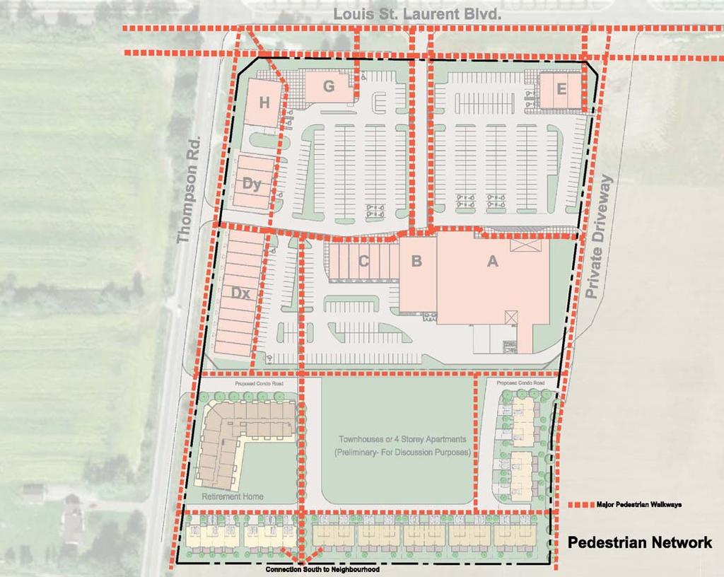
14 The Thompson Rd. building elevations will feature fully glazed storefronts with buildings massed at about 7m height (equivalent to 2 storeys) within the Phase 1 commercial stage of development. Phase 2 will see the introduction of midrise and medium density residential uses to complete the use profile within the Secondary Mixed Use Node. Pedestrian Movement Systems The plan below illustrates the network of pedestrian walkways that are planned to interconnect the site's building entrances as well as to illustrate the connections to the residential areas bordering the site. The plan has evolved through discussions with Town staff to introduce midblock pedestrian connections in a north-south alignment, eventually connecting to a planned crescent within the future residential subdivision planned to the south of the node. Page 14
15 Page 15

16 Street Wall Definition The plan below illustrates the extent of the built form street wall and landscape screening where parking would otherwise be exposed. The aggregate street wall definition achieves about 35% of the Louis St. Laurent Ave. frontage and about 66% of the Thompson Rd. frontage. When garden walls are included these percentages rise to over 70% for both frontages. This degree of urban streetwall definition is appropriate for this land use typology at this location. See the more detailed discussion under Page 16

17 Gateway Locations Boyne Urban Design Guideline Policy Gateway and Entrance Features Gateway locations should be designed as significant entry points to their respective neighbourhoods. "Secondary Mixed Use Nodes: The Secondary Mixed Use Nodes will serve as key entry points into the community. Gateway features are encouraged to mark the significance of the nodes, as well as entry into the community. Taller buildings are recommended in Secondary Mixed Use Nodes (see Section 3.3.2) Community Structure), and where appropriate, can be designed to identify these areas as gateways." A Node Gateway is shown at the corner of Louis St. Laurent Ave. St & Thompson Rd. consisting of 2 bank buildings and a consolidated landscape plan and pedestrian access leading into the site. Page 17

18 The Landscape Plan details a number of masonry piers with iron fencing to assist in defining the urban edge in conjunction with landscape planting and built form. Page 18

19 Neighbourhood gateways will also be framed by built form strongly marking the entrance into the residential precincts. 3 LANDSCAPE GUIDELINES Page 19
20 3.1 Parking The Town of Milton Boyne Survey Urban Design Guidelines contain the following direction on the design and treatment of parking areas in the Mixed Use Nodes. The following text in italics is taken from those guidelines. The text following each guideline indicates how the subject site design responds to the guideline during Phase 1 when surface parking is required. As the Boyne Survey Secondary Plan Area develops, there may be an initial need for surface parking in key locations, such as the Mixed Use Nodes. Ultimately, these surface lots should redevelop into future building sites, and therefore the layout of buildings should consider site access, landscape and site servicing that will permit the long term redevelopment of these sites. In the meantime, surface parking lots should be designed to minimize their visual impact on the public realm. Phase 2 residential development is planned for the lands south of the Phase 1 commercial site as a more realistic alternative to the guideline suggestion that infill development occur within the Phase 1 site. a. Surface parking areas should be located at the rear of, or if not possible, the side of buildings. Surface parking is generally located behind buildings to the greatest degree possible. b. Where parking areas must be situated adjacent to the sidewalk, a landscaped buffer should be located between parked vehicles and the sidewalk. This buffer should be located within the private realm so as not to reduce the total sidewalk width. Where parking areas are exposed to the adjacent roads, buffer planting strips have been provided to conceal the parking areas. 6m wide landscape buffers are proposed along Louis St. Laurent and 3m buffers are provided along the future collector road planned for the east edge of the site. c. Planting strips, landscaped traffic islands and/or paving articulation should be used to define vehicle routes and define smaller parking courts that provide pedestrian walkways, improve edge conditions and minimize the aesthetic impact of surface parking. Several planting islands have been provided within the parking lot areas. The major north-south islands that define pedestrian paths within the site are scaled at an average width of 4.6m to allow for sidewalks plus tree planting. d. The amount of landscaping should be proportionate to the overall parking lot size, but generally, 1 tree for every 8 parking spaces is recommended. Page 20
21 The specific tree count is yet to be determined. The landscaped islands are placed at a frequency that breaks the consolidated asphalt areas to parking pools of fewer than 150 cars each. e. Landscaping, or other parking area screening devices, should not obstruct the primary building façade or total visibility of the parking area. This has been achieved through the north-south alignment of the major planting strips. f. Distinctive pavement and/or markings may be used to indicate pedestrian crossings. Pedestrian crossings over drive lanes will be highlighted with zebra striping or decorative paving. g. Pedestrian-scaled lighting should be provided along pathways to enhance visibility and security. Safe and secure lighting levels will be provided at appropriate scales to suit the pedestrian areas. h. Preferential parking for bicycles, energy efficient vehicles and car-share services are encouraged. Bicycle parking is provided throughout the site as shown on the architectural site plan. i. Service and drop-off area circulation should not interfere with pedestrian circulation. Truck movement and loading areas have been carefully planned to avoid conflict with pedestrian movement. The image below shows a glazed building face along an arterial where terraces and building entrances are possible based on convenient parking access within the site. Page 21

22 3.1.1 Driveway Entrances The primary entrances to parking lots will occur in two locations, one off Louis St. Laurent Ave. and the other off Thompson Rd. These access points should be clearly demarcated as principal points of entry to the site. Where sidewalks cross these driveways, there should be clear markings to indicate to drivers that pedestrians are present and they may safely cross. Additional driveway entrances will be provide of the future extension of Kennedy Circle as it continues south from Louis St. Laurent Drive-thru Lanes Drive-thru lanes where possible and practical will not be visible from public streets. In this case two drive-through facilities are planned for the banks located at Blocks G and H. For Block G the lane is hidden behind the building. For Block H the lane will be screened by low planting and metal fencing similar to the image above. Both facilities are of a low intensity nature with sufficient stacking as typically needed for banking ATM's Page 22

23 3.2 Streetscape Relationship between Site Elements and Streets The Boyne Urban Design Guidelines offer the following guidance; Building Setbacks and Stepbacks Appropriate building setbacks...to create a pedestrian-supportive streetscape. A setback refers to the grade level building location in relation to the front property line. a. Buildings should generally have consistent setbacks to create a continuous streetwall. In the case of the Thompson Rd. frontage buildings are placed at a consistent setback of 6m from the street property line. This results in a curb to building face dimension of about 17m today and about 11m when Thompson Rd. is widened and urbanized. This dimension accommodates the potential for the three distinct zones contemplated by the guidelines, namely; Transition Zone, Sidewalk Zone and, Street Furniture/ Landscape Zone (Guideline Boulevard Design). Similar building setbacks are proposed Page 23
24 for Louis St. Laurent where curb to building face dimensions range from 27m now to 12m after urbanization. b. On corner sites, building setbacks should generally align with their respective street frontages and make necessary transitions to both edges. 2 Banks are proposed for the corner and are set at their respective street setbacks of 6m. The building faces to the intersection should be treated with some window transparency focussed on the garden space located there. c. Variations in setbacks may be used to incorporate public open space, mid-block pedestrian walkways and/or main entrances. An increased setback of an average of 12m is proposed for the food store to allow upgraded planting along this edge without doors or principle windows. d. Where setbacks vary on both sides of a proposed building, the average of the two setbacks should be used. This is not applicable to the subject site. e. Taller buildings should have a minimum 1.5 metre stepback above the building base to reduce the overall building mass and provide a transition to adjacent residential communities. This also creates useable outdoor amenity space (i.e. terraces, green roofs). A stepback is illustrated for the future possible midrise residential building shown in Phase 2. These buildings will be detailed at a later stage. f. Shadow analysis is also recommended on a building-by- building basis to identify impacts. As the Phase 1 buildings are all a single storey but massed at 2 storeys, no adverse shadow impacts are anticipated. Buildings are proposed to line the public street edges to the greatest degree possible. In this way the street edge is visually defined and emphasized while hiding surface parking from public view. Corners such as at Louis St. Laurent Ave. Street and Thompson Rd. Road have been emphasized with greater building mass and enhanced landscaping to visually anchor these orientation points within the district. Page 24

25 Where it is not possible or desirable to locate built form in this way, landscape, planting, masonry piers and iron fencing should be used to define the primary street edges and visually screen parking, drivethough lanes and service areas. Page 25

26 Drive Through lane screened with masonry piers and iron fence. See Landscape Plans Screening of Parking, Utilities and Loading Areas Where parking areas are visible along Louis St. Laurent Ave. or Thompson Rd., landscape buffers parallel to these streets should be designed to provide safe visual screens through planting, masonry piers and iron fencing where appropriate. Waste collection and loading areas should be located in areas that are not visible from major public roads. Where the site abuts residential uses a 2 metre high masonry wall is required to provided visual and acoustic screening from these areas to residential areas. In the case of the grocery store the loading area is hidden from public since it is located behind the primary retail strip, however, because of its close proximity to future residential areas it is important to provide suitable acoustic fencing to separate this area from the adjacent residential area and to provide measures if required to limit the noise transmission to these areas. In this location a minimum landscape buffer of 6m will be provided, with 3m provided in each of the 2 Phases. Utilities such as hydro transformers and gas meters should be located away from public street view or visually screened by landscaping or fencing that blends with the building materials. Page 26


27 3.2.2 Recreational Opportunities There are no recreational amenities in the immediate area but it is important that the site layout allow connection via public walkways with any current or future residential developments. A mid-block pedestrian connection is planned in order to the Phase 2 residential lands with the Phase 1 lands Street Furniture The corner landscape garden should include street furniture such as park benches, safe lighting and landscape planting. Park bench, fence, signage and bollards integrated with sidewalk design Gateway features Signage The corner of Louis St. Laurent Ave. and Thompson Rd. is a gateway into the development s identity and will require high quality landscaping and prominent project identification signage Transit Stops Page 27
28 Where transit stops are proposed at corner of Thompson Rd. and Louis St. Laurent Ave., they should be integrated with the landscape design with appropriate benches and shelters Fencing Decorative fencing is proposed to be of the black metal type between masonry piers along the street edges where shown in the plan. A two metre high masonry wall is proposed along the loading areas to the south and west of the site. 3.3 Pedestrian Systems Internal Paths and Linkages Walkways should be designed and located to provide safe and convenient interconnection of all primary entrances and site destinations. Canopies are proposed as part of the building design to provide protection in inclement weather and wind blocking External Paths and Linkages The walkway systems should connect to the greater movement systems in the district such as municipal sidewalks and trails connecting to future and current residential developments. 3.4 Transition Between Land-uses Protection of Residential Areas Currently only low density residential lies in close proximity to the Subject Site. These will be considered during construction stages to minimize impacts such as noise and mud tracking. Protection of any potential new residential development will be taken into account in the layout by providing fencing as required. Phase 2 will introduce higher density residential forms that will be buffered from the commercial uses through a continuous 6m wide planting buffer. Page 28
29 3.4.2 Noise mitigation Proposed Drive-thru areas are screened from the road by buildings, landscaping and screening elements and are separated by distance across the two main roads so these will not cause any noise issues. The back of the main building where the loading dock for the Supermarket is to be located is an area of particular concern and measures will be taken to mitigate noise to these areas including utilizing fencing and landscaping elements to limit noise transmission. 3.5 Landscape Features Various landscape features are illustrated throughout this document and they include masonry piers, iron fences, gateway identification stone features, and floral displays. 4 ARCHITECTURAL GUIDELINES 4.1 Built Form Building Design The building design is intended to reinforce the presence of the corner of Louis St. Laurent Ave. and Thompson Rd.. The building massing is set at the equivalent height of a 2 storey building, about 6.6m or 22' Façade Design a. On corner or flanking lots, buildings should have dual façades that address both streets (e.g. wraparound porches and balconies, large windows, side entrances, etc.). The pair of banks address the intersection with clear functional glazing and enhanced landscaping. b. The use of various architectural styles is encouraged within the community, but design and construction quality should be consistent and reflect a high level of craftsmanship. Page 29
30 The materials include brick masonry, fabricated stone and glazing to achieve a high quality image. c. Consistent rhythms of similar details and architectural elements should be used to reinforce the continuity of the street and create a strong community character. A consistent approach to the building design has been employed to create a strong community character and identity at this Node. d. The façades of large buildings should be designed to express individual commercial or residential units through variation in materials and distinct architectural detailing, including entrance and window design. The anchor food store building uses distinct architectural detailing. e. Buildings should not have blank façades. Flanking façades should maintain a consistent standard of design and materials equal to that of the front façade. Where buildings are prohibited from using windows (i.e. where future adjacent development is anticipated), the side façades should still incorporate a minimum level of articulation. This may include detailed brick work, ornaments or murals. Blank façades have been minimized on all exposed public edges. The south face of the Phase 1 commercial site will have blank walls and loading areas that will be screened from view. f. A significant amount of the building base façade should be glass to allow views of the indoor uses and create visual interest for pedestrians. Spandrel glass should not be used. Clear vision glazing has been predominantly used on all publicly visible building faces. g. Buildings facing streets and public spaces should incorporate vestibules, building entrances, covered walkways or canopies and awnings to provide weather protection. Canopies are included on all street facing elevations. Entrances are shown on these faces to be used by retailers as they wish. h. Buildings with frontages exceeding 12.0 meters in width should be divided into functionally and visually smaller units through the use of façade articulation, internal courtyards, and networks of connected walkways and landscaping. 8 Separate buildings have been created to achieve this guideline. Each building is further divided into individual storefronts at a frequency of about 6.4m. Page 30

31 i. Functional building elements, such as vents or rainwater leaders within the wall plane, should be integrated into the architectural design. The building massing of the main retail strip within the site is designed to emulate a commercial street with varied massing to the buildings at the edge of the site but can rise to 8m to provide diversity to the look of the block Architectural Style A contemporary design has been adopted for this site. The style reflects main street details such as masonry piers establishing a repetitive vertical pattern and rhythm. The use of masonry base courses will be a unifying element that ties all built form and landscape elements together. Within this unified palette of materials and colours, design variation will be expected as individual tenants are committed for the Page 31

32 site. For example, the bank image above is an example where a standard bank image is adjusted to better match the proposed building designs Roof Lines A variety of roof heights and shapes is proposed to create a sense that the built form has evolved over time. The silhouette created by this combination of roof forms helps to break the potentially long horizontal line of the built form. The walls are capped with a strong projecting cornice forming a visual cap on the buildings Special Features In cases where the built form does not abut the street property line, screening devices are proposed to visually define that edge while screening parking areas. The screens should use the same materials as in the buildings. Other special features include gateway stones that emphasize the pedestrian access locations. Page 32

33 Façade treatment The typical storefront features dominant clear glazing and doors where appropriate. Where possible weather protection canopies will be provided Architectural Detailing Buildings B and C show typical architectural detailing proposed for all buildings. A strong cornice line caps each building, forming a three part facade. The wall base is proposed as stone-like masonry. Masonry is proposed for all facades except the grocery store. Stucco may be used as an accent wall material. The proposed masonry is tiered with fabricated stone at the base near the sidewalk with brick extending up to the cornice. Page 33


34 4.1.2 Building Entrances Building entrances are encouraged along the primary street frontages and the main retail driveways within the site. Page 34
35 4.1.3 Building Materials A combination of fabricated stone, brick and stucco are acceptable materials in this district. Fabric or metal canopies are acceptable Quality, color, texture A combination of fabricated stone, brick and stucco are acceptable materials in this district. Fabric or metal canopies are acceptable. As this site acts as a gateway to the emerging district, the architecture must establish a high quality image that sets the appropriate tone for the area. Colours should be held to a limited palette of colours as illustrated in the demonstration elevations above. Textures should be used to add detail to the elevation elements Compatibility with surrounding community/development Compatible materials and building scale ensure that the project will blend with the adjacent future residential built form while also establishing a contemporary commercial image consistent with the existing retail centre to the north Building Setbacks Building setbacks are set to 6 to 7m along Louis St. Laurent Ave. and Thompson Rd. This is a significant setback that allows accent foreground landscaping that can support the various intentions around the site perimeter. Those intentions include screening of loading and parking, floral accents at corners, and expressing gateways at the identified locations. Where buildings do not meet the street setback line, low masonry walls, piers and planting will be used to define that line Transition Zones Between Land Uses Page 35
36 The transition between land uses is chiefly between the commercial development and future residential to the south. This transition will be accomplished by creating a 6m wide landscaped area to create a green buffer between the two areas as well as a 2m high masonry wall where required for noise mitigation Mechanical Units & Utilities Roof top mechanical units are anticipated as the primary method of heating and cooling for the commercial buildings. The proposed method of screening these units is through the extension of wall parapets as the preferred screening technique. This will allow the single storey buildings to have greater visual prominence, approaching 2 storeys in height while screening the mechanical units Building Signage Coordination with architecture The proposed architectural design has identified specific areas on the facade where signage would be applied. The sign proportions have been carefully integrated with the architectural design. Individual illuminated letters are recommended for all signs Preference for cut-out letters The panels noted above are intended to support individual sign letters that may be individually lit. 5 COMMUNITY IDENTITY FEATURES Community Identity features have been described throughout this document. In particular the architectural and landscape treatments for the corner of Louis St. Laurent Ave. St and Thompson Rd. are of primary importance. The design of Buildings G and H as corner anchors at a 2 storey mass will establish that corner as a primary gateway in conjunction with enhanced landscaping. Page 36
New-Cast Mixed-use Development Proposal King Street West, Newcastle, Ontario
 URBAN DESIGN BRIEF New-Cast Mixed-use Development Proposal King Street West, Newcastle, Ontario TABLE OF CONTENTS: 1.0 Executive Summary 2.0 Creating Vibrant and Sustainable Urban Places: Excerpts from
Clairtrell Area Context Plan
 Clairtrell Area Context Plan March 2005 Urban Development Services City Planning Contents 1. Introduction... 4 2. Development Structure... 6 2.1 Streets... 7 2.1.1 Sheppard Avenue and Bayview Avenue...
Urban Design Brief December 23, 2015 Southside Construction Group Official Plan & Zoning By-Law Amendment
 Urban Design Brief Proposed Official Plan & Zoning By-Law Amendment 3244, 3263 and 3274 Wonderland Road South Southside Group December 23, 2015 TABLE OF CONTENTS Page No. INTRODUCTION... 1 SECTION 1 LAND
URBAN DESIGN BRIEF URBAN DESIGN BRIEF 721 FRANKLIN BLVD, CAMBRIDGE August 2018
 URBAN DESIGN BRIEF URBAN DESIGN BRIEF 721 FRANKLIN BLVD, CAMBRIDGE August 2018 DESIGN BRIEF CONTENTS PART A 1.0 INTRODUCTION 2.0 DESCRIPTION & ANALYSIS OF SITE CONTEXT 3.0 DESIGN CONSTRAINTS AND OPPORTUNITIES
East Bayshore Road Neighbourhood
 East Bayshore Road Neighbourhood Northridge Property Management Urban Design Brief 3195 East Bayshore Road City of Owen Sound January 2016 East Bayshore Road Neighbourhood Northridge Property Management
5.1 Site Plan Guidelines
 5. Community Core Guidelines Development of the Community Core will take place by plan of subdivision and site plan approval. It will occur in a phased manner that will reflect the timing of residential
4.0 Design Guidelines For The Village Centre. South fields Community Architectural Design Guidelines Town of Caledon
 4.0 Design Guidelines For The Village Centre 4.0 Design Guidelines for the Village Centre The Village Centre is the focal point of the entire South Fields Community and is designed as a traditional commercial
DRAFT Northeast Quadrant of Kipling Avenue and Highway 7 DRAFT AUGUST 29, Goals Land Use. The goals of this Plan are to:
 AUGUST 29, 2017 12.15 Northeast Quadrant of Kipling Avenue and Highway 7 12.15.1 Goals 12.15.2 Land Use The goals of this Plan are to: 12.15.2.1 General Provisions: a) Ensure the development of a compact
WEST LOOP DESIGN GUIDELINES CHECKLIST
 WEST LOOP DESIGN GUIDELINES CHECKLIST Section 1.0 General Strategies 1.1 DESIGN EXCELLENCE: ENCOURAGE HIGH QUALITY AND INNOVATIVE DESIGN OF NEW BUILDINGS WITHIN THE WEST LOOP WITHOUT BEING PRESCRIPTIVE
13. New Construction. Context & Character
 13. New Construction Context & Character While historic districts convey a sense of time and place which is retained through the preservation of historic buildings and relationships, these areas continue
Wide asphalt driveway abutting school property. garage built with incompatible materials, too close to park. incompatible fencing materials
 Wide asphalt driveway abutting school property incompatible fencing materials garage built with incompatible materials, too close to park Lack of plantings as a buffer between private property and open
GUIDELINES REPLACEMENT HOUSING GUIDELINES LOCATION INTRODUCTION URBAN DESIGN GUIDELINES
 Replacement housing in the former City of North York will be consistent with the following urban design guidelines. They provide a framework for residential re-development in the former City of North York
Urban Design Brief. Garden Drive Townhouse Development Matas Development Group. Oakville, Ontario
 Garden Drive Townhouse Development Matas Development Group Oakville, Ontario February 8, 2013 Urban Design and Architecture 2 Introduction This Urban Design Brief has been prepared in support of a rezoning
II. SINGLE FAMILY RESIDENTIAL
 II. SINGLE FAMILY RESIDENTIAL Castle Rock is made up of numerous individually built houses and subdivision tracts that have been developed during the past century. Some of the tracts are diverse in architectural
Urban Design Guidelines Townhouse and Apartment Built Form
 Urban Design Guidelines Townhouse and Apartment Built Form Town of Wasaga Beach Table of Contents 1. Introduction 1.1. Purpose 1.2. Urban Design Principles 1.3. Application of Guidelines 2. Site Design,
WINDSOR GLEN DESIGN GUIDELINES
 WINDSOR GLEN DESIGN GUIDELINES Adopted by Council, 2006 WINDSOR GLEN REDEVELOPMENT DESIGN GUIDELINES August 2006 1.0 Master Plan Organization For this area of the Coquitlam Town Centre, a mix of high,
T O W N O F A J A X URBAN DESIGN GUIDELINES FOR MOTOR VEHICLE GAS BARS / SERVICE CENTRES
 T O W N O F A J A X URBAN DESIGN GUIDELINES FOR MOTOR VEHICLE GAS BARS / SERVICE CENTRES June 2006 Table of Contents TABLE OF CONTENTS... 1 1.0 INTRODUCTION... 2 1.1 Purpose... 2 1.2 Organization of the...
Highland Village Green Design Guidelines
 Highland Village Green Design Guidelines Publishing Information Title Highland Village Green Design Guidelins Author The City of Calgary Status DRAFT - Proposed document subject to changes Additional Copies
Site Planning. 1.0 Site Context. 2.0 Pedestrian Circulation Systems. Pag e 2-23
 The following photographs from throughout the country illustrate key urban design principles. Photographs are provided to illustrate the overall urban design concepts described in Chapter 1 of the Downtown
ELMVALE ACRES SHOPPING CENTRE MASTER PLAN
 ELMVALE ACRES SHOPPING CENTRE MASTER PLAN Contents 1.0 INTRODUCTION... 2 2.0 LOCATION... 2 3.0 EXISTING CONTEXT... 2 4.0 VISION & GUIDING PRINCIPLES... 2 5.0 LAND USE AND BUILT FORM... 4 5.1 St. Laurent
lot flankage Y street 16m 6m landscape strip for large site 3m landscape strip for small medium site
 Commercial General Commercial Objectives Create developments compatible with adjacent land uses in scale, function and character Define a consistent and attractive street edge with quality landscaping,
Commercial Development Permit Area
 City of Kamloops KAMPLAN Commercial Development Permit Area PURPOSE The purpose of this Development Permit Area (DPA) is to establish objectives and provide guidelines for the form and character of commercial
Derry Green Corporate Business Park
 Town of Milton Derry Green Corporate Business Park Urban Design Guidelines BMI/Pace - June 2010 Draft 3 Prepared by: Brook McIlroy Planning + Urban Design / Pace Architects Suite 300-51 Camden Street Toronto,
Urban Design Brief to 1557 Gordon Street & 34 Lowes Road West
 Urban Design Brief 1533 to 1557 Gordon Street & 34 Lowes Road West Reid s Heritage Homes Ltd. & 883928 Ontario Ltd. and RHH Property Management Ltd. City of Guelph Zoning By-law Amendment November 2017
appendix and street interface guidelines
 appendix five: building and street interface guidelines appendix 5 building and street interface guidelines BOULEVARDS Boulevards are generally characterized by higher levels of traffic movement at higher
SECTION TWO: Overall Design Guidelines
 SECTION TWO: Overall Design Guidelines This section provides overall design principles and guidelines for the Gardnerville Mixed-use Overlay. They provide criteria for mixed-use places consisting of residential,
Future Five. Design/ Development Guidelines. January 2008 Amended June 08 per City Council motion
 Future Five Design/ Development Guidelines January 2008 Amended June 08 per City Council motion 5-Points Design Guidelines Table of Contents I. Introduction 3 II. Area boundaries 4 III. Review Process
Policies and Code Intent Sections Related to Town Center
 Policies and Code Intent Sections Related to Town Center The Town Center Vision is scattered throughout the Comprehensive Plan, development code and the 1994 Town Center Plan. What follows are sections
The Corporation of the TOWN OF MILTON
 Report to: From: Chair & Members of the Administration & Planning Standing Committee W.F. Mann, Director of Planning and Development Date: April 16, 2012 PD 022-12 (Z19/11) Subject: Technical Report Proposed
URBAN DESIGN BRIEF. 2136&2148 Trafalgar Road. Town of Oakville
 URBAN DESIGN BRIEF 2136&2148 Trafalgar Road Town of Oakville Prepared By: METROPOLITAN CONSULTING INC For 2500674 Ontario Inc November 2016 TABLE OF CONTENTS Page No. 1.0 Introduction/Description of Subject
Urban Design Brief. Watson Parkway North & Watson Road North Guelph, Ontario. Prepared by Coletara Development
 Urban Design Brief Watson Parkway North & Watson Road North Guelph, Ontario Prepared by Coletara Development December, 2013 Urban Design Brief, Coletara Development 1 Introduction This Urban Design Brief
Urban Design Brief Fanshawe Park Road. Competition Toyota
 Urban Design Brief 1300 Fanshawe Park Road Competition Toyota May 2, 2014 TABLE OF CONTENTS Page No. INTRODUCTION... 1 SECTION 1 LAND USE PLANNING CONTEXT... 1 1.1 The Subject Lands... 1 1.2 The Proposal...
CENTERS AND CORRIDORS
 INITIAL DESIGN STANDARDS AND GUIDELINES for CENTERS AND CORRIDORS City of Spokane Planning Services Third Floor, City Hall 808 W. Spokane Falls Blvd. Spokane, WA 99201-3329 (509) 625-6300 www.spokaneplanning.org
FREEWAY/TOURIST DISTRICT
 FREEWAY/TOURIST DISTRICT DESIGN STANDARDS FOR THE CITY OF MOUNTLAKE TERRACE March, 2014 MOUNTLAKE TERRACE FREEWAY/TOURIST DESIGN STANDARDS March, 2014 1 TABLE OF CONTENTS Introduction...1 Design Site Design
Yonge Eglinton Centre Urban Design Guidelines
 Yonge Eglinton Centre Urban Design Guidelines City Planning Urban Design January 2009 YONGE EGLINTON CENTRE INTRODUCTION.................................................... 1 GENERAL SITE PLAN OBJECTIVES......................................
B L A C K D I A M O N D D E S I G N G U I D E L I N E S for Multi-family Development
 B L A C K D I A M O N D D E S I G N G U I D E L I N E S for Multi-family Development Adopted June 18, 2009 This section of the Design and focuses on site planning and design guidance for new multi-family
URBAN DESIGN BRIEF REPORT
 URBAN DESIGN BRIEF REPORT PREPARED FOR 2568401 ONTARIO INC NEW GASBAR, CONVENIENCE STORE & CARWASH DEVELOPMENT @ 1509 FANSHAWE PARK ROAD WEST LONDON, ONTARIO GAMA ENGINEERING INC. PROJECT NUMBER 1669 PREPARED
URBAN DESIGN BRIEF 181 Burloak Drive, Oakville
 URBAN DESIGN BRIEF 181 Burloak Drive, Oakville February 2017 Our File: 1730B 230-7050 WESTON ROAD / WOODBRIDGE / ONTARIO / L4L 8G7 / T: 905 761 5588/ F: 905 761 5589/WWW.MHBCPLAN.COM TABLE OF CONTENTS
BENSON / HUNT TERTIARY PLAN
 BENSON / HUNT TERTIARY PLAN TABLE OF CONTENTS 1.0 INTRODUCTION 1.1 Purpose 2 1.2 How to Read This Plan 3 1.3 Tertiary Plan Context 3 1.4 Vision and Principles 5 1.5 Public Consultation 5 2.0 PLANNING CONTEXT
2.5 Roads. Loading and service areas adjacent to Highway 401 should be screened through architectural walls and/or landscape buffer planting.
 N HIGHWAY OFF RAMP 2.5 Roads A legible road network with a clear hierarchy will help create a connected community, both within and surrounding the Milton Heights. The following section outlines the proposed
AIRPORT BUSINESS PARK
 PIER MAC PETROLEUM INSTALLATION LTD. AIRPORT BUSINESS PARK DEVELOPMENT APPLICATIONS March 2003 4.1 Airport Business Park Development Permit Area 4.1.1 Justification/Design Concept The design concept envisioned
Sierra Springs Regional Commercial Master Site Plan Airdrie, Alberta Hopewell Development Corporation Project No May 26, 2010
 Sierra Springs Regional Commercial Master Site Plan Airdrie, Alberta Hopewell Development Corporation Project No. 205-077 May 26, 2010 TABLE OF CONTENTS Purpose... 2 Master Site Plan Guidelines... 3 Overall
ELK GROVE TOWN CENTER DESIGN GUIDELINES
 ......... ELK GROVE TOWN CENTER DESIGN GUIDELINES LAGUNA RIDGE SPECIFIC PLAN... June 2008 ............ DESIGN GUIDELINES Table of Contents Contents Section A: Town Center Overview...1 A.1. Purpose and
4. INDUSTRIAL 53 CASTLE ROCK DESIGN
 4. INDUSTRIAL 53 CASTLE ROCK DESIGN CASTLE ROCK DESIGN 54 4. INDUSTRIAL Overview Well-designed and attractive industrial centers are the product of blending economic realities with both functional and
Appendix A COMMUNITY IMPROVEMENT PLAN DESIGN GUIDELINES
 Appendix A COMMUNITY IMPROVEMENT PLAN DESIGN GUIDELINES INTRODUCTION The continuous and desirable improvement of Arnprior requires a clear understanding of what is envisioned for the Town. These Design
VILLAGE OF SKOKIE Design Guidelines for Mixed-Use Districts NX Neighborhood Mixed-Use TX Transit Mixed-Use CX Core Mixed-Use
 VILLAGE OF SKOKIE Design Guidelines for Mixed-Use Districts NX Neighborhood Mixed-Use TX Transit Mixed-Use CX Core Mixed-Use TABLE OF CONTENTS CHAPTER 1 SITE DESIGN Purpose 1 CHAPTER 2 SITE DESIGN Streetscape
KEY MAP DEVELOPMENT PERMIT AREA MAP. Sunnymede North Sub-Area Plan
 Richmond Official Community Plan BROADMOOR AREA SUNNYMEDE NORTH SUB-AREA PLAN Bylaw 7100 Schedule 2.6C SUNNYMEDE NORTH SUB-AREA PLAN SUNNYMEDE NORTH SUB-AREA PLAN SUNNYMEDE NORTH SUB-AREA PLAN KEY MAP
Regency Developments. Urban Design Brief. Holyrood DC2 Rezoning
 Regency Developments Urban Design Brief Holyrood DC2 Rezoning Stantec Consulting Ltd. 7-31-2017 1. Overview Regency Developments intends to rezone the lands located at 8510 and 8511 93 Avenue, within the
Mark-up of the effect of the proposed Bronte Village Growth Area OPA No.18 on the text of section 24, Bronte Village, of the Livable Oakville Plan
 Mark-up of the effect of the proposed Bronte Village Growth Area OPA No.18 on the text of section 24, Bronte Village, of the Livable Oakville Plan Notes: This document is provided for information purposes
MAIN STREET DESIGN GUIDELINES CONTEXT
 MAIN STREET DESIGN GUIDELINES CONTEXT VISION The re-imagining of Main Street offers an unparalleled opportunity to strengthen and link Fredericton North through the integration of local neighbourhoods,
Cha p t e r 2: Ge n e r a l De s i g n Gu i d e l i n e s
 Downtown Ann Arbor Design Guidelines Cha p t e r 2: Ge n e r a l De s i g n Gu i d e l i n e s This chapter presents general design guidelines for new site plan or PUD projects in downtown Ann Arbor. The
Tel: (705) Fax: (705)
 Fax: (705)") 521 and 525 Essa Road City of Barrie Tel: (705) 812-3281 Fax: (705) 812-3438 Email: INFO@IPSCONSULTINGINC.com 1 5 0 D U N L O P S T R E E T E A S T, S U I T E 2 0 1, B A R R I E O N T A R I O L 4 M 1 B
521 and 525 Essa Road City of Barrie Tel: (705) 812-3281 Fax: (705) 812-3438 Email: INFO@IPSCONSULTINGINC.com 1 5 0 D U N L O P S T R E E T E A S T, S U I T E 2 0 1, B A R R I E O N T A R I O L 4 M 1 B
built form design guidelines
 built form design guidelines Derry Green Corporate Business Park 17 built form design guidelines.1 Built Form Design Guidelines Section : Built Form Design Guidelines is intended to be used by both developers
(DC1) Direct Development Control Provision DC1 Area 4
 Direct Development Control Provision DC1 Area 4") . General Purpose (DC) Direct Development Control Provision DC Area 4 The purpose of this Provision is to provide for an area of commercial office employment and residential development in support of the
. General Purpose (DC) Direct Development Control Provision DC Area 4 The purpose of this Provision is to provide for an area of commercial office employment and residential development in support of the
TOWN CENTER DESIGN STANDARDS FOR THE CITY OF. August, MOUNTLAKE TERRACE TOWN CENTER DESIGN STANDARDS August,
 TOWN CENTER DESIGN STANDARDS FOR THE CITY OF MOUNTLAKE TERRACE August, 2008 MOUNTLAKE TERRACE TOWN CENTER DESIGN STANDARDS August, 2008 1 TABLE OF CONTENTS Introduction...3 Design Site Design...4 Pedestrian
CONTENTS 8.0 LAND USE 8.1 GENERAL LAND USE 8.2 RESIDENTIAL 8.3 MIXED USE 8.4 COMMERCIAL 8.5 EMPLOYMENT LANDS
 8-2 Land Use 8.0 LAND USE CONTENTS 8.1 GENERAL LAND USE 8.1.1 Uses provided for in all Land Use Designations 8.1.2 Uses prohibited in Hazardous Lands, Hazardous Sites and Special Policy Areas 8.1.3 Uses
Buildings may be set back to create small plazas provided that these setbacks do not substantially disrupt the street wall s continuity.
 6-22 Community Design Street Walls and Street-front Setbacks The siting of buildings will play a critical role in establishing the character and sense of place for the District. Siting buildings at the
URBAN DESIGN BRIEF Gordon Street City of Guelph. Prepared on behalf of Ontario Inc. March 25, Project No. 1507
 URBAN DESIGN BRIEF 1131 Gordon Street City of Guelph Prepared on behalf of 1876698 Ontario Inc. March 25, 2016 Project No. 1507 423 Woolwich Street, Suite 201, Guelph, Ontario, N1H 3X3 Phone (519) 836-7526
Corridor Transformation Strategy
 Corridor Transformation Strategy County Road 22 Special Planning Area Design Guidelines January 2012 D14-06017 Corridor Transformation Strategy County Road 22 Special Planning Area Corridor Design Guidelines
general corridor design guidelines gen-0.0
 general corridor design guidelines gen-0.0 facades gen-1.0 GEN-1.1: TRANSPARENCY GEN-1.1.1: WALL OPENINGS In order to create buildings that are visually interesting for passers-by, blank ground floor
DRAFT DRAFT DRAFT DRAFT
 # 19 EXPAND GREEN AND OPEN SPACES AND COMMUNITY FACILITIES IN TANDEM WITH NEW DEVELOPMENT The role of Eglinton will change in the coming years, along with the intensity of activity and land uses. As more
QUEEN-RIVER SECONDARY PLAN
 34 QUEEN-RIVER SECONDARY PLAN 34. QUEEN RIVER SECONDARY PLAN 1. INTRODUCTION The Queen-River area is approximately 6.4 hectares and is located at the eastern edge of the Downtown as shown on Map 34-1.
DEVELOPMENT DESIGN GUIDELINES
 DEVELOPMENT DESIGN GUIDELINES Approved by Surrey City Council January 26, 2004 Campbell Heights Business Park - Development Design Guidelines TABLE OF CONTENTS 1.0 DEVELOPMENT CONCEPT... 1 2.0 DESIGN OBJECTIVES...
Bel-Air Lexus Automobile Service Station
 Bel-Air Lexus Automobile Service Station Design Brief 443-447 McArthur Avenue Ottawa April 30, 2015 14-1299-MCA Site Details Application: Site Plan Control Legal Description and Municipal Addresses: 443
HIGHLAND VILLAGE GREEN URBAN DESIGN PRINCIPLES/GUIDELINES
 URBAN DESIGN GUIDING PRINCIPLES/GUIDELINES CONTEXT/CHARACTER The City of Calgary s Municipal Development Plan (MDP), Transit-Oriented Development (TOD) Policy Guidelines and Main Street/Corridor policy
PORT WHITBY COMMUNITY
 PORT WHITBY COMMUNITY SECONDARY PLAN UPDATE COMMUNITY IMPROVEMENT PLAN URBAN DESIGN GUIDELINES September 2015 DRAFT PROPOSED AMENDMENT NUMBER # to the Whitby Official Plan PURPOSE: The intent of this Amendment
URBAN DESIGN STUDY and GUIDELINES
 ALTON CENTRAL EAST COMMUNITY CITY OF BURLINGTON URBAN DESIGN STUDY and GUIDELINES Prepared by NAK DESIGN GROUP March 2004 ALTON CENTRAL EAST CITY OF BURLINGTON TABLE OF CONTENTS PART I - Alton Central
New Street Proposed Redevelopment Architecture & Urban Design Brief
 2130 2136 New Street Proposed Redevelopment Architecture & Urban Design Brief Prepared By: Cynthia Zahoruk Architect Inc. 3077 New Street, Burlington, ON, L7N 1M6 TABLE OF CONTENTS Background and Objective
A. Background Summary of Existing Challenges and Potential Possibilities. 1. Summary of Existing Assets and Potential Opportunities
 A. Background 1 A Main Street Master Plan Study was performed and completed in October of 2007. The study was initiated to review current land uses and development patterns along Main Street, from Parrish
Othello Neighborhood Design Guidelines
 Othello Neighborhood Design Guidelines 1 S ORCAS ST S OTHELLO ST 42ND AVE S 2 Note: Design Review does not apply to all zones. See Citywide Guidelines for details. Additionally, zoning areas on this map
Multi family Residential Development Permit Area
 City of Kamloops KAMPLAN Multi family Residential Development Permit Area PURPOSE The purpose of this Development Permit Area (DPA) is to establish objectives and provide guidelines for the form and character
DRAFT. 10% Common Open Space
 % OF CHARLOTTE IS CATEGORIZED AS A. LAND USES : Placeholder map displaying location of Place Type GOALS: Accommodate XX% of future growth. Provide a concentration of primarily commercial and civic activity
PUBLIC RIGHT-OF-WAY IN THIS CHAPTER PUBLIC REALM
 PUBLIC RIGHT-OF-WAY This section provides design guidelines for improvements in the public right-of-way. The public right-of-way refers to streets, sidewalks, non-vehicular thoroughfares, parks and greenways
Community Design Plan
 Gardena General Plan 2006 Authority While the is not a required element of a General Plan, it is included because improving the community appearance and image is paramount to the overall quality of life
B. Blocks, Buildings and Street Networks
 B. Blocks, Buildings and Street Networks Figure IV.4 A rational block pattern with connected streets Introduction The single most important element in the physical and functional integration of mixed use
SUBCHAPTER 4-B GUIDELINES FOR THE B-3 COMMERCIAL CHARACTER AREA
 1 SUBCHAPTER 4-B GUIDELINES FOR THE B-3 COMMERCIAL CHARACTER AREA Downtown Bozeman should be the location of buildings of greatest height and intensity in the community. The following guidelines apply
*** DRAFT 2 FOR PUBLIC REVIEW ***
 6.7 The area is generally bounded by the Red Hill Valley Parkway to the west, Lake Avenue to the east, the Queen Elizabeth Way (QEW) to the north, and by the properties just south of Queenston Road to
DAVENPORT VILLAGE SECONDARY PLAN
 27 DAVENPORT VILLAGE SECONDARY PLAN 27. DAVENPORT VILLAGE SECONDARY PLAN 1. VISION FOR THE DAVENPORT VILLAGE SECONDARY PLAN Davenport Village, municipally known as 830, 940, 980 and 1100 Lansdowne Avenue,
[PLANNING RATIONALE] For Site Plan Control and Lifting of Holding Zone By-Law 101 Champagne Avenue. May 23, 2014
![[PLANNING RATIONALE] For Site Plan Control and Lifting of Holding Zone By-Law 101 Champagne Avenue. May 23, 2014](/thumbs/75/71599615.jpg "[PLANNING RATIONALE] For Site Plan Control and Lifting of Holding Zone By-Law 101 Champagne Avenue. May 23, 2014") [PLANNING RATIONALE] For Site Plan Control and Lifting of Holding Zone By-Law 101 Champagne Avenue May 23, 2014 Contents 1.0 Introduction... 2 2.0 Site Context... 2 2.1 Adjacent Uses... 2 Figure 1: Site
[PLANNING RATIONALE] For Site Plan Control and Lifting of Holding Zone By-Law 101 Champagne Avenue May 23, 2014 Contents 1.0 Introduction... 2 2.0 Site Context... 2 2.1 Adjacent Uses... 2 Figure 1: Site
CHAPTER 3. Design Standards for Business, Commercial, Industrial, Recreational and Institutional Uses
 CHAPTER 3 Design Standards for Business, Commercial, Section Number Title Ordinance Number Date of Ordinance 16-3-1 Applicability 2006-11 2008-04 07-01-08 16-3-2 Uniform Standards for Architectural Design
Cit of Kitchener Ur 6 an Design Manual PARTA. Desi n for _--::
 Cit of Kitchener Ur 6 an Design Manual Date PARTA Year ) Desi n for k Nodes Corridors _--:: Section Page 01 of 12 2 INTRODUCTION Purpose & Application Nodes and Corridors have been identified as key intensification
1. General Purpose. 3. Uses
 1. General Purpose The purpose of this DC1 Provision is to facilitate the development of a pedestrian friendly Community Commercial Centre that may accommodate a range of commercial, residential, office,
Uptown Rideau Street Secondary Plan [Amendment #166, January 12, 2016]
![Uptown Rideau Street Secondary Plan [Amendment #166, January 12, 2016]](/thumbs/76/73760497.jpg "Uptown Rideau Street Secondary Plan [Amendment #166, January 12, 2016]") [Amendment #166, January 12, 2016] The policies of this Secondary Plan are in effect, save and except for the property at 560 Rideau Street, for which there remains a site specific appeal to this Secondary
[Amendment #166, January 12, 2016] The policies of this Secondary Plan are in effect, save and except for the property at 560 Rideau Street, for which there remains a site specific appeal to this Secondary
Urban Design Brief 1576 Richmond Street City of London
 Urban Design Brief City of London Treadstone Developments October 31, 2014 Urban Design Brief October 31, 2014 TABLE OF CONTENTS Page No. INTRODUCTION... 1 SECTION 1 LAND USE PLANNING CONCEPT... 1 1.1
FRUITVALE TRANSIT VILLAGE (Phase 2) Residential Project
 Residential Project") FRUITVALE TRANSIT VILLAGE (Phase 2) Residential Project DEVELOPER: SIGNATURE PROPERTIES ARCHITECT: HKIT ARCHITECTS April 23, 2010 TABLE OF CONTENTS 3 Vision 4 Description of Site 5 Guiding Concepts 6
FRUITVALE TRANSIT VILLAGE (Phase 2) Residential Project DEVELOPER: SIGNATURE PROPERTIES ARCHITECT: HKIT ARCHITECTS April 23, 2010 TABLE OF CONTENTS 3 Vision 4 Description of Site 5 Guiding Concepts 6
4.9 Mendocino Avenue Corridor Plan Design Guidelines
 4.9 Mendocino Avenue Corridor Plan Design Guidelines The Mendocino Avenue Corridor Plan addresses the area between College Avenue and Steele Lane. Mendocino Avenue is a busy arterial that runs parallel
Mixed Use Centres Development Permit Guidelines
 1 Mixed Use Centres Development Permit Guidelines Area Commercial or Mixed Use development occurring in City Centre, Urban Centre, Neighbourhood Centre, or Institutional Complex land use designations is
Urban Design Guidelines for Large-Format Retail
 Urban Design Guidelines for Large-Format Retail May 2006 Compte tenu de la nature de ce document, il n'est disponible qu'en anglais. La Ville pourra, sur demande, traduire ce document au complet ou en
R STREET CORRIDOR NEIGHBORHOOD Site Plan and Design Review Supplemental Guidelines Checklist
 R STREET CORRIDOR NEIGHBORHOOD Site Plan and Design Review Supplemental Guidelines Checklist Applicant s Name: Project Address: Phone: Email: Applicant shall fill out the design guidelines checklist for
Resolution : Exhibit A. Downtown District Design Guidelines March 2003
 Resolution 03-011: Exhibit A Downtown District Design Guidelines March 2003 DOWNTOWN DISTRICT DESIGN GUIDELINES CITY OF SOUTHLAKE, TEXAS Adopted March 2003 1 DOWNTOWN DISTRICT DESIGN GUIDELINES Adopted
URBAN DESIGN BRIEF 305, 309, & 315 SOUTHDALE ROAD WEST LONDON ONTARIO
 URBAN DESIGN BRIEF 305, 309, & 315 SOUTHDALE ROAD WEST LONDON ONTARIO CARVEST PROPERTIES LTD. December 2013 Section 1 - Land Use Planning Context 1.1 Subject Lands The subject lands are located immediately
City of Vaughan Urban Design Guidelines for Infill Development in Established Low-Rise Residential Neighbourhoods
 City of Vaughan Urban Design Guidelines for Infill Development in Established Low-Rise Residential Neighbourhoods DRAFT - September 2016 Contents 1. Introduction 1 2. Policy Context 3 3. Characteristics
Design Guidelines. Roosevelt. Mike Podowski DPD Design Guidelines Ordinance ATT 13 August 13, 2012 Version #1
 Roosevelt Design Guidelines The Roosevelt Neighborhood Design Guidelines apply within the Neighborhood Boundary. Map 1 2 Map 2 3 Map 3 4 CS1 Natural Systems and Site Features Citywide Guideline: Use natural
Greater East Wenatchee Urban Growth Area. Design Standards & Guidelines
 Greater East Wenatchee Urban Growth Area Design Standards & Guidelines November 30, 2006 Table of Contents General Guidelines for All Development Site Design - - - - - - - - - - - - - - - - - - - - - -
Urban Design Manual 2.0 DRIVE-THROUGH FACILITIES. Background. Urban Design Challenges
 222221 2.0 DRIVE-THROUGH FACILITIES Background In recent years, drive-through facilities have grown significantly in popularity with drive-through restaurants, in particular, being established on numerous
599 Kennedy Road - Official Plan Amendment and Zoning Amendment Application - Preliminary Report
 STAFF REPORT ACTION REQUIRED 599 Kennedy Road - Official Plan Amendment and Zoning Amendment Application - Preliminary Report Date: March 7, 2017 To: From: Wards: Reference Number: Scarborough Community
WATERFRONT DISTRICT DESIGN STANDARDS
 WATERFRONT DISTRICT DESIGN STANDARDS 20.25.080 WATERFRONT DISTRICT A. Purpose. This section is intended to implement The Waterfront District Subarea Plan by: 1. Creating a safe, vibrant mixed-use urban
Context Plan and Urban Design Guidelines for the lands west of Provost Drive
 Concord Park Place Context Plan and Urban Design Guidelines for the lands west of Provost Drive Amendment to the Bessarion-Leslie Context Plan October 2013 Concord Park Place Urban Design Guidelines The
Form & Character Development Permit Areas
 Form & Character 1.1. Overview 1.1.1. AREAS Lands designated as Downtown Smithers, Multi-family Residential, and Highway 16 Commercial and identified on Schedule: C. 1.1.2. PURPOSE The Form and Character
Attachment 1 TOWN OF NEW TECUMSETH. Manual for the Preparation of an Urban Design Report
 Attachment 1 TOWN OF NEW TECUMSETH Manual for the Preparation of an Urban Design Report July 2010 TABLE OF CONTENTS Background, Policy Framework and the Preparation of Urban Design Reports 1. Introduction