HS2. Design Principles 1. for Waterway Crossings
|
|
|
- Colleen Jacobs
- 6 years ago
- Views:
Transcription


1 HS2 Design Principles 1 for Waterway Crossings
2 Contents 3 Introduction 38 B13 Planting 5 Purpose of this document 40 B14 Railway Furniture 42 B15 Materials 7 Chapter A What HS2 will affect 44 B16 Detailing 8 A1 Appeal 46 B17 Waterway Elements 9 A2 Views 48 B18 Conclusion 10 A3 Horizon 11 A4 Character 12 A5 Scale 13 A6 Tranquillity 15 Chapter B What HS2 will introduce 16 B1 Quality 17 B2 Relationship 18 B3 Horizontal Alignment 19 B4 Vertical Alignment 20 B5 Visual Scenarios 22 B5.1 Focused Scenarios 24 B5.2 Open Scenarios 28 B5.3 Maintaining Views 29 B6 Waterside Piers 30 B7 Pier Alignment 32 B8 Span 34 B9 Abutments 35 B10 Embankment Edge 36 B11 Parapets 37 B12 Foundations 2
3 Introduction The Canal & River Trust (the Trust) cares for over 2,000 miles of waterways in England and Wales. The Trust believe that the design and construction of the HS2 line should showcase the very best in contemporary architecture and engineering, creating structures that contribute positively to the multiple layers of transport history that are evident throughout the canal corridor. The Design Principles have been developed in conjunction with the IWA, with special thanks to the IWA s HS2 liaison members This document has been produced by Knight Architects and the Canal & River Trust as a general recommended approach to design principles for HS2 bridge and viaduct crossings over Canal & River Trust waterways. It is not intended to serve as a detailed basis of actual design or specification for any particular location, either in the context of HS2 or elsewhere. 3
4 4
5 Purpose of this document Fundamentally, there is a concern that HS2 will have an irrevocable, negative impact upon the waterways in its vicinity. This impact can be broadly defined in two key categories which will form the primary sections of this document: This document includes examples of structures and associated elements that illustrate what is acceptable and what should be avoided in the design of HS2 crossings. These are identified with a green tick or a red cross as appropriate for different waterside environments. 1 - What HS2 will affect 2 - What HS2 will introduce Technical design standards to be applied throughout the United Kingdom are given in the Design Manual of Roads and Bridges (the DMRB). This document describes a series of general design principles that should be adopted by HS2 Ltd. to guide the development of HS2 design within the corridor of the waterways. The section What HS2 will affect outlines the qualities and amenities of the waterways which the Trust is tasked with protecting, which will be removed or otherwise adversely affected. HS2 will have a significant impact on the views, character, environment, scale and tranquillity that the users of the waterways currently enjoy. This section describes the key concerns of how HS2 threatens these amenities, and outlines the Trust s requirements as to how they must be protected. The section What HS2 will introduce addresses the infrastructure that HS2 will introduce to the waterway s environment. The scale, material, quality and character of the new infrastructure will have a crucial relationship with that of the existing waterways. This section outlines the constraints and requirements that HS2 infrastructure must meet, and offers guidance as to how it may best respond to the waterway environment. Each crossing will be subject to careful individual assessment and consideration to establish the suitability of the design response to the locale. The Trust require that individual bridge designs at each crossing; reflect the character of each area, contribute positively to the waterway environment, and meet our expectations for high quality structures and spaces. 5
6 6
7 Chapter A What HS2 will affect 7

8 A1 Appeal The waterways are home to a variety of uses including boating, cycling, walking and fishing, as well as providing a rich habitat for wildlife and plants. Of primary concern is the detrimental impact that HS2 may have on these uses and habitats. 50% of the population live within 5 miles of one of the Trust s waterways, enabling approximately 270 million visits per year. It is therefore essential that the waterways remain attractive, welcoming and beautiful places for leisure users to enjoy, and must not be adversely affected where there are HS2 crossings. It is important to recognise that the HS2 bridges will be primarily experienced by those passing under the structures as opposed to those travelling on them. Passengers on the trains will experience most crossings for a split second through an insulated glass window, yet the users of the waterways travelling slowly by boat, foot or cycle will view them for significantly longer and in a direct and intimate manner, fully experiencing the noise and vibration of passing trains. Those passing under the bridges can appreciate the full form of the structures within their surrounding context. As such, the users of the waterways should be provided with an environment that welcomes them rather than something that appears threatening or disconnected. This is particularly true for pedestrians and cyclists who generally have much more time to take in the structure and view it at close quarters. A successful public realm requires the design to embrace considerations beyond the simple physical connection between two points. How the connection is expressed and presented will either encourage or deter public use. Fig.A1.1 - Characterful locks add to the appeal of the waterways 8

9 A2 Views The waterways are experienced in a dynamic way, by people moving through the landscape as a series of views. HS2 will have an impact on these views throughout its route. In the waterway environment, each crossing must be assessed individually, so as to ensure current views are protected, and the proposed structures are carefully integrated into their setting. Broadly speaking, urban and rural contexts will have different priorities that must be addressed. Throughout the rural settings of the waterways, there are many expansive views and open vistas. HS2 structures must recognise this, and seek to maintain these distant views, with the structure passing through the landscape as lightly as possible. The crossings should be predominantly recessive (they will not be feature bridges ) and measures to reduce their visual impact should be taken. In urban environments distant views are often much more limited. Views are primarily at a relatively short range, and the environment is more enclosed. The structure itself becomes the focus, and must be detailed as such. Whilst in rural settings the HS2 structures will be read against a natural backdrop, in urban settings the scene is likely to already comprise of a tapestry of infrastructure. Here, the focus should be on the visual integration of this layer of infrastructure with that of the existing. Subsequent chapters will outline how HS2 structures may be designed to minimise their impact on the existing views. Fig.A2.1 - High-level views permit vistas outside of the waterway environment 9

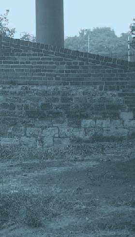
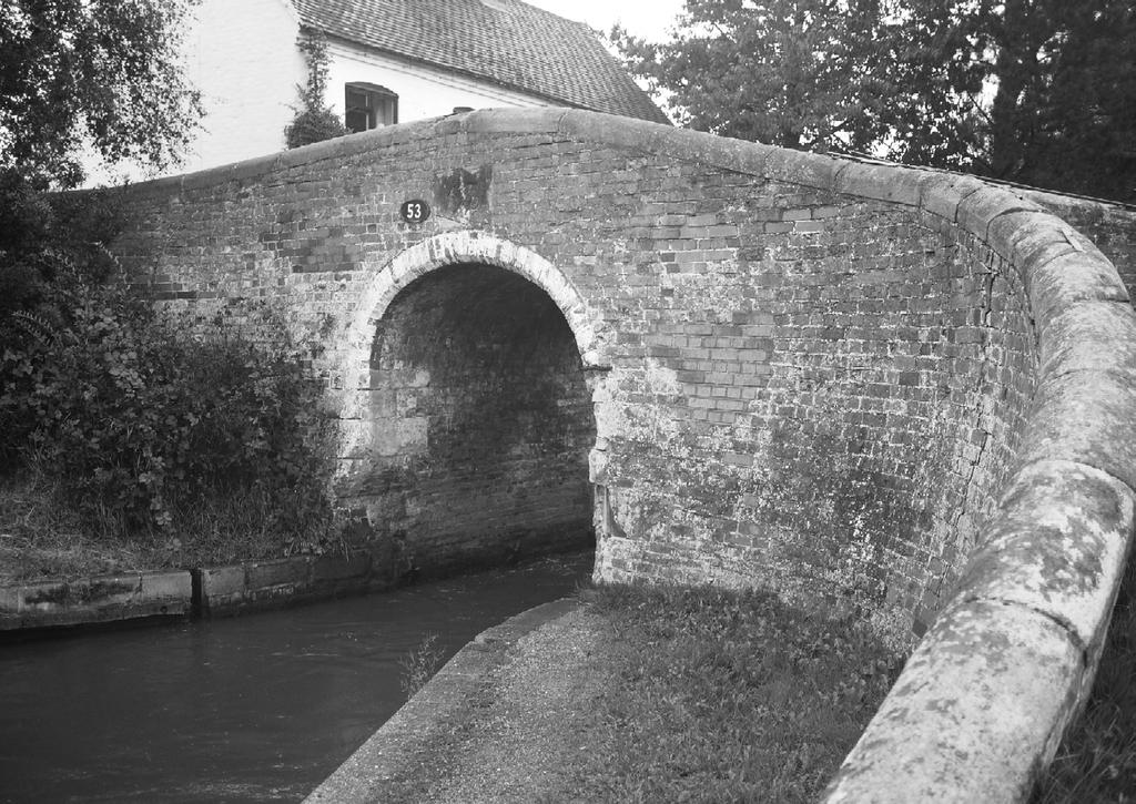
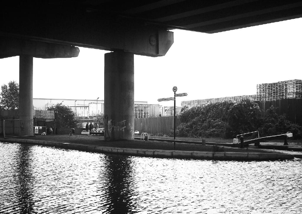
10 A3 Horizon The characteristic slow horizontal animation of the horizon against the canal is occasionally punctuated by the requirements for roads, rail lines and services to pass above. Routes through these structures should be clearly legible - it is important the pedestrian experience begins and ends where they expect it to and the whole route in between is clearly visible. Whilst HS2 is typically kept low to minimise the wider visual impact on the landscape, distant views of the horizon are one of the most important aspects of the relatively narrow, linear waterway environment. They give context to the journey, and the landscape through which the canals and rivers pass. They allow progress along the canal, as well as changes in height to be measured. The impact of screening HS2 from onlookers serves to further narrow the visual envelope of Fig.A3.1 - Crossing obscures views of the horizon the canal. As such, the long views of the horizon must be protected. As you can see from the illustrations opposite, the vertical alignment of the crossing plays a significant role in the composition of the view at that point. By raising the height of the crossing, those on boats and the towpath can see the progression of their route beyond (Fig.A3.2). This helps to draw the focus beyond the rail bridge, and maintains a welcoming environment. This visual deference, framing the landscape rather than breaching the horizon, ensures that the structures will form a part of the canal environment. As you can see from Fig.A3.1, where the horizon is obscured by HS2, the structure of the crossing itself becomes the focus, and the view for the user is greatly compromised - appearing both stunted and even claustrophobic, failing to recognise the character of the waterway. Fig.A3.2 - Crossing permits views of the horizon 10

11 A4 Character A4.01 Sense of Place It is essential that the railway infrastructure of HS2 should respect the urban and rural fabric of the canals and rivers it crosses so that in time it may become an integral part of them. Whilst a consistency of HS2 structures is desirable in order to achieve a uniform quality of materials, detailing, and a clear route aesthetic, the bridges will be crossing unique places of great character. Through the creative and elegant use of elevations, piers, soffits, decks, surfacing and lighting, HS2 crossings can be created that are appropriate for their setting. For example, the characteristics of urban and rural waterway corridors are often different. This distinction needs to be considered and recognised in the HS2 structures with a design philosophy that embraces the distinctiveness of their locale, within the frame of HS2 design. In order to emphasise this, public realm, landscaping improvements, and opportunities for public art may be carefully and selectively employed. This would need to be carried out with the involvement of local community groups, residents, the Canal and River Trust, and key stakeholders, to ensure that the improvements to the area reflect the aspirations of those who will use it the most. Fig.A4.1 - Bridges potentially add to the character of the waterways 11

12 A5 Scale The waterways have a specific scale; a scale of size, speed and detail. Physically the canals are detailed at a human scale - towpaths widths, furniture, signage, boats and materials all address the users, and as such the environment is welcoming. The speed of the waterways is also hospitable. Boats, cyclists and pedestrians all broadly share a common speed, which permits a comfortable environment for all. Where HS2 encroaches upon the canal environment, there will be a stark and severe contrast of speeds. This will have an obvious acoustic impact that must be minimised as outlined in section B In addition to the acoustic effects of contrasting scales, the visual discontinuity must also be addressed. HS2 is detailed for high-speed trains, and as such will likely feel inhospitable to users of the waterways. Structures, material quality, finishes, and detailing that are appropriate for a highspeed rail environment will almost certainly not be appropriate when viewed from a boat or a towpath at 4mph (Fig.A5.1). Wherever HS2 structures impose upon the visual envelope of the waterways, they must be detailed so as to read as part of the waterway environment. Furthermore, care will need to be taken to ensure the proportions of the structures are considered in the context of the waterway corridor, therefore consideration needs to be given to the aesthetics derived from the relationship between span, deck depth, and pier size. Fig.A5.1 - Modern infrastructure is often at a much larger scale than that of the waterways 12

13 A6 Tranquillity The waterways are a peaceful environment. The tranquillity of the canals in rural areas is one of their primary attractions, and HS2 must be designed to ensure that its impact on the aural envelope of the canal is minimised. Planting will do very little to minimise the noise of a train passing by, and so other measures must be used to reduce this impact. Even in areas that have -for example- a close proximity to a road, HS2 will bring sudden and sharp sounds that rise above the comparatively consistent background acoustics of a road. Details of how acoustic screening may be implemented are outlined in section B In addition to the acoustics of HS2 whilst in use, construction noise should be kept to an absolute minimum. At locations with moorings, working hours should be restricted in the same way as when in close proximity to a residential area. Fig.A6.1 - Tranquillity and characteristic noises add to the appeal of the waterways 13
14 14
15 Chapter B What HS2 will introduce 15

16 B1 Quality Issue Good design can be difficult to define and this can be particularly true for utilitarian infrastructure such as roads and bridges, however it is very important to consider visual and build quality for these structures because of the very long life span they enjoy. As described in this chapter, it is paramount that consideration is given to aesthetic quality and character in order to avoid poor design that can become an unwelcome addition to the waterway environment. Response HS2 should aim to achieve a consistent visual quality that enhances either the urban or rural environment and provides a clear waterway identity. To this end the many diverse elements of the design will be standardised, controlled and coordinated from end to end of the Project so as to ensure a high quality visual appearance. This section will describe the approach to appearance for the many elements that will contribute a unifying aesthetic design to the Project. Individual elements will be guided by applicable design standards. However, they will also be considered in relation to one another and to viewers, whether stationary or moving, so as to ensure the overarching aesthetic objective of an integrated and harmonious visual environment is met. A consistent design approach should be taken to all waterway works associated with the project in order to ensure visual coherence. Within the standardised designs approach proposed in HS2 s Draft Planning Memorandum, appropriate designs for open and focused waterway crossings should be developed. Fig.B1.1 - High quality elements stand the test of time 16


17 B2 Relationship Issue HS2 will introduce a relationship between the high speed rail and the waterways, and careful consideration must be taken to ensure that it a positive one. The waterways were once a functional and vital piece of infrastructure. As new modes of transport emerged, these were overlaid on the canal and river network, in a manner that was frequently unsympathetic to the waterways. As the logistical usage of the waterways declined, their recreational usage increased. Today, the waterways are a place of relaxation; people choose their characteristic slow-pace and tranquillity as one of retreat from that of an increasingly speedy world. Response Slow is a quality that must be protected, and the need to do so has never been more apparent Fig.B2.1 - Bridge with a poor relationship with the canal below than with the addition of HS2. The relationship between these two layers of infrastructure must allow both to function as positively as possible. With careful consideration, the relationship between the two layers of infrastructures can be harmonious as seen in Fig.B2.2. Yet where a new layer of infrastructure is built without due deference to the last, an uncomfortable and unsightly relationship results, as seen in Fig.B2.1. Structures that recognise and address the canal corridor will become a successful part of its environment. Fig.B2.2 - Bridge with a positive relationship with the canal below 17


18 B3 Horizontal Alignment Issue One of the design characteristics which will potentially have the largest detrimental impact on the waterways is that of horizontal alignment. Notwithstanding the pre-existing structural and functional constraints that largely dictate the alignment, it must be considered a matter of primary importance. Simply put, heavily skewed crossings will have a significantly greater impact on the waterway environment than perpendicular crossings, and as such will require a higher degree of consideration in order to achieve an acceptable result. Response As shown in Fig.B3.1 and Fig.B3.2 the degree to which HS2 is skewed across the water significantly alters the amount of the waterway environment that is beneath the bridge. A perpendicular arrangement is preferable for the following reasons: Fig.B3.1 - Heavily skewed crossing increases the footprint of the bridge 1 It reduces the area underneath the bridge 2 It minimises the footprint of the bridge in the canal corridor 3 It reduces the amount of soffit seen 4 It reduces the overshadowing of the waterway environment 5 It appears to be a more considered and formal arrangement 6 The span is reduced, which in turn reduces the structural depth 7 Unsightly left over spaces are eliminated 8 More vegetation can remain undisturbed Fig.B3.2 - Perpendicular crossing minimises the footprint of the bridge 18


.")
19 B4 Vertical Alignment Issue Of equal importance to the horizontal alignment is that of the vertical. In addition to the practical considerations of vertical alignment is the aesthetic impact of height. Views along the canal will be greatly impacted by the vertical alignment of HS2 crossings. B4.01 Response Clearances Both the towpaths and the waterways have minimum vertical clearances that are required for the sustainable use of the waterway corridor. Both the canal and the towpath have minimum clearances that must be maintained as defined by the Trust for each individual waterway. Fig.B4.1 - Low vertical alignment creates dark spaces and a disharmony of scales B4.02 Height Each structure must be considered in its own right, as the vertical alignment of narrower, perpendicular crossings will not have as significant an impact on the waterway environment as wide, skewed ones. Generally speaking, however, lower crossings block views and light, and as such will require great attention to reduce their visual impact (Fig.B4.1). Conversely, crossings with a higher vertical alignment will permit more light to penetrate beneath them, and natural vegetation to encroach further underneath the structure (Fig.B4.2). Higher structures also serve to ease the disharmony of scales as discussed in (x.x). Furthermore, whilst the vertical alignment of the tracks will be largely fixed, there may be instances in which reducing the span (and consequently the structural depth of the deck) would have a significant benefit on views through the crossing. In addition, where a vertical alignment introduces a clear view of the bridge soffit on approach along the towpath, its design must be carefully considered so as to ensure that the soffit appears as a high-quality, well thought out element of the waterway environment. Fig.B4.2 - Higher vertical alignment permits light to enter 19
20 B5 Visual Scenarios Issue Each crossing will present a different structural challenge, in terms of alignment, span and Open Scenarios: Viaducts Uniform Viaduct: Standard piers do not address the water and do not suit its requirements. constraints. The supporting structures to HS2 will impact greatly on the visual environment and quality of the waterway environment and as such their careful selection and implementation is essential. Response The following pages look at the various options for supporting the waterway spans, which can broadly be categorised as open scenarios with wide views across the landscape (where either a viaduct or embankment is used) and focused scenarios with narrow, linear views of the canal. Whilst each crossing must be assessed individually, we can identify some broad Waterside Piers: Special piers for the canal crossing identify the span, and address the requirements of the waterways. Open Scenarios: Embankments preferences for each scenario, as highlighted opposite. Abutment and Piers: Single backspan and vertical abutment walls curtail open views Embankment: Maintaining multiple backspans behind canal span ensures views remain open Focused Scenarios Abutment and Piers: Piers and vertical abutment walls create enclosed, dead spaces Embankment: Close, vertical abutments create a picture frame span across the canal. 20


21 Fig.B5.1 - Typical focused scenario with no lateral views Fig.B5.2 - Typical open scenario with lateral views 21


22 B5.1 Focused Scenarios Issue Focused, narrow views are a common characteristic of the waterway environment, and HS2 crossings need to engage with this aesthetic in a positive way. Standard pier arrangements are more suited to open views, and potentially appear cluttered and unresponsive in these closed scenarios. As described previously, analysis of individual crossings needs to be undertaken to determine the most appropriate solution for the landscape. However, generally speaking, where an embankment meets the waterway environment in a focused scenario, sloped abutments with intermediate piers (Fig.B5.3) tend to create negative spaces between the piers and the abutments. These zones are unusable for planting due to the overshadowing, and worse, can appear as dark and dangerous spaces, that detract from the welcoming waterway environment. Fig.B5.3 - Pier and back-span arrangement unsuitable for focused scenarios Response In situations where there is a closed, narrow visual envelope along the canal (usually created by hedgerow and trees) a beam and vertical abutment solution (Fig.B5.4) may be beneficial. Continuing the embankment up to vertical abutment walls creates a frame, which complements the linear, narrow views at that location, and appears as a comfortable and appropriate component of the waterway environment. Fig.B5.4 - Framed structure suitable for focused scenarios 22

23 Fig.B5.5 - Framed structure suits the focused scenario 23
B5.2 Open Scenarios: Viaducts
 B5.2 Open Scenarios: Viaducts As the HS2 line approaches a crossing, it is usually at a height above ground level. In many cases, the most appropriate way to deal with this level difference is with an
8.0 Design and Form of Development 43/
 42/ 8.0 Design and Form of Development 43/ Rothwells Farm, Golborne/ Development Statement Figure 7. Site Constraints Key 44/ Site Boundary 360 Bus Route/Stops Existing Trees Underground Water Pipe Sensitive
97 Lea Bridge Road, Leyton, E10 7QL London Borough of Waltham Forest December 2015
 97 Lea Bridge Road, Leyton, E10 7QL London Borough of Waltham Forest December 2015 Public Realm and Landscape Proposals LEA BRIDGE ROAD, WALTHAMSTOW Public Realm & Landscape Proposals BDP(90)RPT001 December
Cotswolds AONB Landscape Strategy and Guidelines. June 2016
 Cotswolds AONB Landscape Strategy and Guidelines June 2016 Cotswolds AONB Landscape Strategy and Guidelines Introduction The evolution of the landscape of the Cotswolds AONB is a result of the interaction
Design Guidance. Introduction, Approach and Design Principles. Mauritius. November Ministry of Housing and Lands. .. a
 sig evelo r D Mauritius s. Utilities.. Individu a s. er itects.to ls chpers.po e Public. T. h rban D Sc U e me Promot e h ners. A Design Guidance o.h Planne rs n w iticians r l useholde National Development
WELLINGTON HOSPITAL DESIGN GUIDE TABLE OF CONTENTS
 WELLINGTON HOSPITAL DESIGN GUIDE TABLE OF CONTENTS 1.0 Introduction Page 2 The Place of Wellington Hospital 2 The Future of the Hospital 2 2.0 The Intention of the Design Guide 3 3.0 Analysis 4 General
Ipswich Issues and Options for the Ipswich Local Plan Review, August 2017, Public Consultation
 Ipswich Issues and Options for the Ipswich Local Plan Review, August 2017, Public Consultation Having reviewed the issues and options documents, the Society has made the following response: Part 1 Strategic
10.0 Open Space and Public Realm
 10.0 Open Space and Public Realm 10.0 Open Space and Public Realm The Public Open Space System is comprised of: outdoor spaces available for public use that are either publicly owned (e.g., parks and
Canal & River Trust response to the Consultation on the Working Draft Environmental Impact Assessment Report
 High Speed Two Phase 2a: West Midlands to Crewe Response to Working Draft Environmental Impact Assessment Report Please find below the response of the Canal & River Trust. The Trust is the guardian of
Section Three, Appendix 16C Medium Density Housing, Design Assessment Criteria (Residential 8A zone)
") APPENDIX 16C MEDIUM DENSITY HOUSING, DESIGN ASSESSMENT CRITERIA (RESIDENTIAL 8A ZONE) PURPOSE OF APPENDIX 16C (RESIDENTIAL 8A ZONE) In the Residential 8A Zone the following are defined as restricted discretionary
APPENDIX 16C MEDIUM DENSITY HOUSING, DESIGN ASSESSMENT CRITERIA (RESIDENTIAL 8A ZONE) PURPOSE OF APPENDIX 16C (RESIDENTIAL 8A ZONE) In the Residential 8A Zone the following are defined as restricted discretionary
E16: MAINTENANCE OF LANDSCAPED AREAS
 HIGH SPEED TWO INFORMATION PAPER E16: MAINTENANCE OF LANDSCAPED AREAS This paper outlines the proposed approach to the maintenance of landscaped areas created for HS2 Phase One. It will be of particular
General principles for telecommunications development. Mast and site sharing. Installation on existing buildings and structures
 General principles for telecommunications development Mast and site sharing Installation on existing buildings and structures Camouflaging and disguising equipment Using small scale equipment Erecting
Neighbourhood Planning Local Green Spaces
 Neighbourhood Planning Local Green Spaces Introduction... 2 1. Why green space is important... 4 2. Neighbourhood plans and green space... 6 3. Evidence... 8 Statutory designations... 9 Green space audit...
4 RESIDENTIAL ZONE. 4.1 Background
 4 RESIDENTIAL ZONE 4.1 Background The residential areas within the City are characterised by mainly lowrise dwellings sited on individual allotments. Past architectural styles, settlement patterns and
Environmental and Landscape Mapping
 Environmental and Landscape Mapping In support of the Calveley Neighbourhood Plan November 2016 Project Name and Number: Calveley Neighbourhood Plan 16-025 Document Name and Revision: Environmental and
Urban Design Guidelines
 Urban Design Guidelines These Urban Design Guidelines comprise the Key Design Objectives below, the Roads Design Guidelines overleaf and Neighbourhood Framework Plans. Together with Section 3: Urban Design
Design Review Report Llanfoist to Abergavenny Footbridge DCFW Ref: 118 Meeting of 10th August 2016
 Design Review Report Llanfoist to Abergavenny Footbridge DCFW Ref: 118 Meeting of 10 th August 2016 Declarations of Interest Panel members, observers and other relevant parties are required to declare
LONGDEN VILLAGE DEVELOPMENT STATEMENT
 LONGDEN VILLAGE DEVELOPMENT STATEMENT 2017-2027 1 Longden Development Statement 2017-2027 15/01/18 1. Background 1.1 Longden Village Longden village is a very rural and traditional community first mentioned
APPENDIX MATAKANA COMMERCIAL URBAN DESIGN GUIDELINES
 APPENDIX MATAKANA COMMERCIAL URBAN DESIGN GUIDELINES 1.0 INTRODUCTION The following urban design guidelines are to be utilised by landowners, planners and other persons involved in development at early
Response to the London Bridge Area Vision and Site Allocations within the New Southwark Plan
 1 Melior Place London SE1 3SZ 020 7407 4701 teamlondonbridge.co.uk info@teamlondonbridge.co.uk 28 April 2017 Response to the London Bridge Area Vision and Site Allocations within the New Southwark Plan
Visual Impact Rating Form - Instructions
 Visual Impact Rating Form Instructions Project Name: Baron Winds Project EDR Project No: 13039 Date: 05.16.17 Reference: Visual Impact Rating Form - Instructions These instructions are intended to guide
Chapter 13 Residential Areas: Appendices APPENDIX 1 Residential Areas
 Chapter 13 Residential Areas: Appendices Page 1 Chapter 13 Residential Areas: Appendices APPENDIX 1 Residential Areas Design Code for Intensive Housing INTRODUCTION DESIGN ELEMENTS A NEIGHBOURHOOD DESIGN
ENVIRONMENTAL AND LANDSCAPE MAPPING
 APPENDIX IV : Environmental and Landscape Mapping ENVIRONMENTAL AND LANDSCAPE MAPPING Calveley Neighbourhood Plan November 2016 ENVIRONMENTAL AND LANDSCAPE MAPPING Calveley Neighbourhood Plan Calveley
Section 6A 6A Purpose of the Natural Features and Landscapes Provisions
 Section 6A 6A Purpose of the Natural Features and Landscapes Provisions This Chapter addresses the protection and management of natural features and landscapes within the City. The City has a number of
ROCHFORD LOCAL DEVELOPMENT FRAMEWORK: Sustainability Appraisal/ Strategic Environmental Assessment. Rochford Core Strategy Preferred Options Document
 ROCHFORD LOCAL DEVELOPMENT FRAMEWORK: Sustainability Appraisal/ Strategic Environmental Assessment Non Technical Summary Rochford Core Strategy Preferred Options Document October 2008 SUSTAINABILITY APPRAISAL
Views from the Bridge
 Chapter 2 Views from the Bridge Alternative 2A would primarily have adverse visual impacts to views from the Bridge, with the exception of a strongly adverse visual impact from Viewpoint 11 (Car View East)
SUSTAINABLE MANAGEMENT
 . Sustainable Management.1 The Concept of Sustainable Management The concept of sustainable management recognises there are limits to the use of natural and physical resources and there is a need to balance
Draft Eastern District Plan
 Draft Eastern District Plan Submission_id: 31238 Date of Lodgment: 13 Dec 2017 Origin of Submission: Online Organisation name: Turrulla Gardens Pty Ltd C/- Mecone Organisation type: Industry First name:
Everton s Neighbourhood Plan. Site Allocation - Assessment Criteria
 Everton s Neighbourhood Plan Site llocation - ssessment Criteria Introduction 1.1 This report assesses all the sites identified through the emerging Neighbourhood Plan for Everton and their potential for
Fixing the Foundations Statement
 Fixing the Foundations Statement 13 th August 2015 The Heritage Alliance is the largest coalition of non-government heritage interests in England, bringing together 98 national organisations which are
Chapter 5 Urban Design and Public Realm
 5.1 Introduction Public realm is all areas of the urban fabric to which the public have access. It is where physical interaction takes place between people. It therefore, includes buildings and their design,
B - Coalfield River Corridor Landscape Character Type
 B - Coalfield River Corridor Landscape Character Type Landscape Character Type - Coalfield River Corridor The Coalfield River Corridors Landscape Character Type is located in the two converging valleys
Housing Development at Balloonagh Tralee Co Kerry
 Design Statement Housing Development at Balloonagh Tralee Co Kerry Area of site 10,400m2 24 houses-12no 3 bed, 12no 2 bed and 4 single bed apartments total residential area of 2411m2 Open space provided
SECTION ONE North East Industrial Zone Design Guide Palmerston North City Council June 2004
 SECTION ONE North East Industrial Zone Design Guide Palmerston North City Council June 2004 young heart easy living 1 Preface Industrial areas are a very important component of the economic well-being
Design Guidelines General Criteria
 Design Guidelines General Criteria Architectural details should be restored or replaced. Repainting & general repair is usually required. The overall design of the façade should be fully integrated, with
2011 ASLA Design Awards
 2011 ASLA Design Awards Interstate 70 Mountain Corridor Aesthetic Guidance Honor Award Design Workshop, Aspen / THK Associates, Inc. / CH2MHill Planning and Urban Design Project Title: Interstate70 Mountain
Colchester Northern Gateway Master Plan Vision Review Draft. July 2016
 Colchester Northern Gateway Master Plan Vision Review Draft July 2016 Contents Introduction 4 Context 8 Purpose of the Report 8 Strategic Position 9 Overview of the Process 11 2012 Master Plan Vision 12
MATURE SUBURBS RESIDENTIAL DEVELOPMENT GUIDELINES
 MATURE SUBURBS RESIDENTIAL DEVELOPMENT GUIDELINES DRAFT FEBRUARY 2005 BIRMINGHAM CITY COUNCIL 1 Introduction Mature Suburbs Residential Development Guidelines - Interim Supplementary Planning Advice -
REMARKABLES PARK ZONE
 .10 Remarkables Park Zone.10.1 Resources, Activities and Values The Remarkables Park Area comprises approximately 150 hectares of perimeter urban land in the vicinity of Frankton and occupies a strategic
Goals AND Guiding principles
 Historic photo of Eastlake Train Station sign Chapter 2: Goals AND Guiding principles 2-1 The Plan goals includes a desire to bridge present day conditions with a vision of the area s future. A central
Assessment of Landscape, Visual and Natural Character Effects
 Assessment of Landscape, Visual and Natural Character Effects Consent Footprint Amendments Mangamaunu Half Moon Bay Okiwi Bay South Report prepared for: New Zealand Transport Agency and KiwiRail Holdings
HS2 Environment. Protecting the environment
 HS2 Environment Protecting the environment Approach to mitigation EIA Regulations require an ES to include a description of the measures envisaged in order to avoid, reduce and, if possible, remedy significant
Landscape and Heritage A Park landscape that embraces the physical, cultural and social heritage of the area
 80 Park Development Framework Our Aim for Landscape and Heritage A Park landscape that embraces the physical, cultural and social heritage of the area Why do we think it is important? The landscapes of
Animating the Rideau Canal December 2013
 Executive Summary Animating the Rideau Canal December 2013 Why study the Rideau Canal? The Rideau Canal has been an important part of Ottawa throughout its history, and has shaped and been shaped by the
Village Enhancement Scheme Barton under Needwood
 Barton Village Enhancement Scheme Village Enhancement Scheme Barton under Needwood Executive summary May 2014 Village enhancement scheme: executive summary 1 Barton Village Enhancement Scheme Executive
GUIDING PRINCIPLES IN THIS CHAPTER
 GUIDING PRINCIPLES The guiding principles and design concepts in this chapter work together with the Chapel Hill 2020 Comprehensive Plan to support new public places that can be enjoyed by all while also
Great Easton Neighbourhood Plan Statement of Basic Conditions
 Great Easton Neighbourhood Plan 2017-2031 Statement of Basic Conditions OCTOBER 2016 GREAT EASTON PARISH COUNCIL Contents 1.0 Introduction....Page 2 2.0 Summary of Submission Documents and Supporting Evidence..
Interim Advice Note 76 / 06 ASSESSMENT PART 1 AIMS AND OBJECTIVES OF ENVIRONMENTAL ASSESSMENT. Contents
 Interim Advice Note 76 / 06 VOLUME 11 SECTION 1: ENVIRONMENTAL ASSESSMENT INTRODUCTION PART 1 AIMS AND OBJECTIVES OF ENVIRONMENTAL ASSESSMENT Contents 1. Introduction and Application 2. Aims and Objectives
Schedule of Planning Applications Committee Date: 23 May Reference: 06/17/0726/F Parish: Hemsby Officer: Mr J Beck Expiry Date:
 Schedule of Planning Applications Committee Date: 23 May 2018 Reference: 06/17/0726/F Parish: Hemsby Officer: Mr J Beck Expiry Date: 22-05-2018 Applicant: Proposal: Site: Mr Gillett Change of use to the
Suffolk Coastal Local Plan Review Issues and Options, August 2017, Public Consultation
 Suffolk Coastal Local Plan Review Issues and Options, August 2017, Public Consultation Having reviewed the issues and options documents, the Society has made the following response: Part 1 - Strategic
Chapter 2: OUTLINE PLANNING APPLICATION PROPOSALS. A New Garden Neighbourhood Matford Barton 17
 Chapter 2: OUTLINE PLANNING APPLICATION PROPOSALS A New Garden Neighbourhood Matford Barton 17 2.1. SUMMARY AND STATUS OF THE PROPOSALS 2.1.1. The parameter plans and associated wording in this chapter
2A District-wide Policies
 2A Introduction This Chapter contains policies which are relevant to subdivision, use and development activities occurring across all zones and areas of the District. The policies in this Chapter implement
Landscape and Heritage
 86 Park Development Framework Our Aim for A Park landscape that embraces the physical, cultural and social heritage of the area Why do we think it is important? The landscape provides a setting for every
PUBLIC REALM STRATEGY
 CONSULTATION DRAFT PUBLIC REALM STRATEGY Trenchard Street & Frogmore Street City Design Group Place Directorate Public Realm Strategy Trenchard Street & Frogmore Street Contents 1. Introduction 2. Understanding
GREATER CAMBRIDGE CITY DEAL. Urban Design Guidance for Transport Infrastructure Projects
 GREATER CAMBRIDGE CITY DEAL Urban Design Guidance for Transport Infrastructure Projects KEY OBJECTIVES OF CITY DEAL The City Deal aims to help Greater Cambridge maintain and grow its status as a prosperous
Appendix H: Easement cross sections
 Appendix H: Easement cross sections SHARED PATH 1.5m FOOTPATH NATURE STRIP 7.3m CARRIAGEWAY 2.7m NATURE STRIP EXISTING PIPELINE 150mm DIA 5.0m (approx.) LOCAL ACCESS ROAD EXISTING PIPELINE 500mm DIA 2.7m
Reference: 15/06961/RCU Received: 13th November 2015 Accepted: 17th November 2015 Ward: Coppetts Expiry 12th January 2016
 Location 91 Manor Drive London N20 0XD Reference: 15/06961/RCU Received: 13th November 2015 Accepted: 17th November 2015 Ward: Coppetts Expiry 12th January 2016 Applicant: Mr Christos Papadopoulos Proposal:
Public Consultation. Land at Monks Farm, North Grove. Welcome
 Welcome Welcome to our public exhibition for development on Land at Monks Farm, orth Grove. Gallagher Estates and Gleeson Strategic Land are preparing an outline planning application for new homes, open
Parish of Repton NEIGHBOURHOOD DEVELOPMENT PLAN
 Parish of Repton NEIGHBOURHOOD DEVELOPMENT PLAN BASIC CONDITIONS STATEMENT December 2018 CEF 4 Legal Requirements This statement has been produced by the NDP Working Group on behalf of Repton Parish Council
2040 LUP is a part of the Comprehensive Plan and carries the same legal authority. Economic Challenges
 1.1. Guiding Anchorage s Growth Where will new residents settle over the next two decades? Where will people work, shop, and play? Will there be enough room to grow? How will Anchorage look? Will growth
Wind energy development in the South Pennines landscape
 Wind energy development in the South Pennines landscape Programme for today Background Policy context South Pennines landscape Impacts of wind energy development The South Pennines Wind Energy Landscape
SHORELINE, FLOOD AND COASTAL DEFENCE MANAGEMENT PLANS
 These plans may provide opportunities as well as concern for recreational boating. They are currently being revised and consulted on. This document explains how we can engage in the process. Shoreline,
PDA SUBMISSION: Queen s Wharf, Brisbane (DEV2017/846)
") PDA SUBMISSION: Queen s Wharf, Brisbane (DEV2017/846) Date:: 17 October 2017 Contact Officer: Jonathon Fisher Chief Executive Officer Email: heritage@nationaltrustqld.org Phone: 07 3223 6666 NATIONAL TRUST
PDA SUBMISSION: Queen s Wharf, Brisbane (DEV2017/846) Date:: 17 October 2017 Contact Officer: Jonathon Fisher Chief Executive Officer Email: heritage@nationaltrustqld.org Phone: 07 3223 6666 NATIONAL TRUST
New Bolton Woods Cricket Club
 New Bolton Woods Cricket Club 1 1. New Bolton Woods Partnership Area What IS THIS ALL ABOUT? New Bolton Woods Ltd is a development partnership between regeneration company Urbo and Bradford Council. It
3.3. Urban Structure Defining a New Hierarchy of Routes and Spaces >Images
 Section 3.0 I The Masterplan Framework 18 >Images Examples of high quality routes and spaces 3.3. Urban Structure The success of any masterplan lies in a clear definition of the future urban structure
PART AOTEA PRECINCT
 CONTENTS... PAGE AOTEA PRECINCT...4 14.5.1 INTRODUCTION...4 14.5.2 RESOURCE MANAGEMENT ISSUES...4 14.5.3 RESOURCE MANAGEMENT OBJECTIVES AND POLICIES... 4 14.5.4 RESOURCE MANAGEMENT STRATEGY...5 14.5.5
Preface. Erie. Scranton. Allentown. Pittsburgh. Harrisburg. Philadelphia
 The Southern Alleghenies Region The Southern Alleghenies Region spans the Laurel Highlands and Allegheny Front in the west across the Appalachians to the east. It is comprised of Blair, Bedford, Cambria,
CHAPTER 5: GUIDING PRINCIPLES
 CHAPTER 5: GUIDING PRINCIPLES The following 10 principles were developed based on public consultation, planning policy and the background analysis conducted during Phase 1. The Guiding Principles significantly
ELK GROVE GENERAL PLAN VISION
 2-1 CHAPTER 2: 2-2 CREATING OUR The Community Vision for Elk Grove, expressed through a Vision Statement and a series of Supporting Principles, is a declaration of the kind of community that Elk Grove
Appendix A: Retail Planning Assessment
 Rotherham Town Centre Masterplan Appendix A: Retail Planning Assessment 139 Appendix A Rotherham Town Centre Masterplan Retail Planning Background and Policy Context 1. Introduction 1.1 The Masterplan
Garden Bridge Planning Application
 Planning Application Additional Verified photomontages and assessment September 2014 Contents Page 1 Visual assessment 2 1.1 Introduction 2 1.2 Baseline 2 1.3 Potential effects and good environmental
Welcome. Proposals for land at Smug Oak Lane BRICKET WOOD
 Proposals for land at Smug Oak Lane BRICKET WOOD Previous Linden Homes and Wates Developments scheme Welcome Welcome to Linden Homes and Wates Developments public exhibition. Working together as joint
Davis Landscape Architecture. Davis. Landscape Architecture
 23a Iliffe Yard, London, SE17 3QA, UK +44 (0)20 7277 1035 mail@davisla.com www.davisla.com Practice Overview We are a design led London based practice that prides itself on the delivery of schemes that
Section C Bridges and retaining walls
 Section C Bridges and retaining walls Above: This existing bridge on SH2 at Tauranga has a simple tapered column form that is a good precedent for the TEL. The open abutment optimises views along the highway
Section Three, Appendix 17C Multiple Unit Housing Design Assessment Criteria
 APPENDIX 17C MULTIPLE UNIT HOUSING DESIGN ASSESSMENT CRITERIA Purpose of Appendix 17C In the Residential 9 Zone the construction and use of multiple household units located within the Multiple Household
CHAPTER ADDITIONAL REQUIREMENTS IN THE NC, NEIGHBORHOOD COMMERCIAL ZONE
 CITY OF MOSES LAKE MUNICIPAL CODE CHAPTER 18.31 ADDITIONAL REQUIREMENTS IN THE NC, NEIGHBORHOOD COMMERCIAL ZONE Sections: 18.31.010 Purpose 18.31.020 Minimum Lot Area 18.31.030 Setbacks 18.31.040 Maximum
Welcome to this public consultation event for the proposed South Western Relief Road. Thank you for taking the time to come along.
 WELCOME Welcome to this public consultation event for the proposed South Western Relief Road. Thank you for taking the time to come along. The South Western Relief Road (SWRR) route is proposed in Stratford-on-Avon
Town of Oakville Streetscape Strategy
 Town of Oakville Streetscape Strategy Endorsed by PDC on February 10, 2014 (PD-011-14) Town of Oakville Streetscape Strategy [endorsed by PDC February 10, 2014] 0 Town of Oakville Streetscape Strategy
Tāhuhu whakaruruhau ā-taone The sheltering ridge pole
 B2. Tāhuhu whakaruruhau ā-taone - Urban growth and form B2.1. Issues Tāhuhu whakaruruhau ā-taone The sheltering ridge pole Auckland s growing population increases demand for housing, employment, business,
Linden Homes Proposals for land off Ringwood Road, Verwood
 Welcome Welcome to Linden Homes first public exhibition displaying proposals for new homes on land off Ringwood Road in Verwood. Award-winning house builder Linden Homes, part of the Galliford Try Group,
AOTEA SUPERMARKET ZONE. Zone Introduction
 C18 AOTEA SUPERMARKET ZONE Zone Introduction C18.1 Objective This zone identifies a specific area in Aotea for a stand alone supermarket. The zone is site specific and has a range of objectives, policies
To secure a Green Belt around Cambridge whose boundaries are clearly defined and which will endure for the plan period and beyond.
 4. GREEN BELT OBJECTIVES GB/a GB/b GB/c GB/d To secure a Green Belt around Cambridge whose boundaries are clearly defined and which will endure for the plan period and beyond. To maintain the purposes
22.15 OUTDOOR ADVERTISING SIGNAGE POLICY
 22.15 OUTDOOR ADVERTISING SIGNAGE POLICY This policy applies to all land where a planning permit is required to construct or display a sign under the provisions of the Kingston Planning Scheme. 22.15-1
CHAPTER 8 ISSUES, CONCERNS, CONSTRAINTS AND OPPORTUNITIES
 CHAPTER 8 ISSUES, CONCERNS, CONSTRAINTS AND OPPORTUNITIES Introduction This River Conservation Plan was developed during a time of tremendous activity and effort in planning the transformation of the Delaware
3 Urban Design and the State Highway Network
 NZ Transport Agency Page 1 of 14 Urban Design Professional Services Guide 1 Introduction This is a professional services guide on urban design, which provides direction to the NZ Transport Agency (NZTA)
Wildlife and Planning Guidance: Neighbourhood Plans
 Wildlife and Planning Guidance: Neighbourhood Plans This Leaflet is one of a series of 4 Wildlife and Planning Guidance Leaflets and is intended to provide useful information to assist you to campaign
Victoria Street Pedestrian Bridge
 Township of Centre Wellington Victoria Street Pedestrian Bridge Class Environmental Assessment County of Wellington & Township of Centre Wellington Badley Bridge Replacement/Rehabilitation (County of Wellington),
HeritageCollectiveLLP
 Appendix C, Review of Archaeology and Cultural Heritage Assessment Introduction 1. This information (SEI) addresses the likely significant impacts of a six-turbine development in which T6 is removed from
New-Cast Mixed-use Development Proposal King Street West, Newcastle, Ontario
 URBAN DESIGN BRIEF New-Cast Mixed-use Development Proposal King Street West, Newcastle, Ontario TABLE OF CONTENTS: 1.0 Executive Summary 2.0 Creating Vibrant and Sustainable Urban Places: Excerpts from
Elderberry Walk. Developer HAB Housing
 Case studies Elderberry Walk Developer HAB Housing Development of 161 new homes on the former Dunmail Primary School site, focused around a central green street, with retained trees, new multifunctional
URBAN DESIGN BRIEF URBAN DESIGN BRIEF 721 FRANKLIN BLVD, CAMBRIDGE August 2018
 URBAN DESIGN BRIEF URBAN DESIGN BRIEF 721 FRANKLIN BLVD, CAMBRIDGE August 2018 DESIGN BRIEF CONTENTS PART A 1.0 INTRODUCTION 2.0 DESCRIPTION & ANALYSIS OF SITE CONTEXT 3.0 DESIGN CONSTRAINTS AND OPPORTUNITIES
Public realm strategy
 Mayor of London 71 new pedestrian bridge across the river strategic green links to the river Chapter 7 Public realm strategy new linear park improved road environment improved river walk indicative masterplan
Meridian Water Phase 1 Application
 Meridian Water Phase 1 Application MW11 Environmental Statement Non-Technical Summary London Borough of Enfield March 2016 Contents 1 Introduction 1 2 The proposed development 2 3 Evolution of the proposed
13. New Construction. Context & Character
 13. New Construction Context & Character While historic districts convey a sense of time and place which is retained through the preservation of historic buildings and relationships, these areas continue
building with nature - a new benchmark for green infrastructure
 building with nature - a new benchmark for green infrastructure Danielle Sinnett, Gemma Jerome, Sarah Burgess, Nick Smith and Roger Mortlock outline the aims, development and proposed operation of Building
Welcome THE SITE PHASE 1 EXCLUSION ZONE.
 THE SITE PHASE 1 Aerial view of the whole site with Phase 1 indictated Welcome Barratt London and Hyde Group are working with Pollard Thomas Edwards on redevelopment proposals for Harrow View East, part
Huddersfield Urban Design Framework. 3. Framework
 3. Framework The illustrative plan has been used as the basis for developing an urban design framework and strategy in Part 3 of this report. This is based on a series of regulatory plans that code the
DRAFT FOR PUBLIC REVIEW. Game Plan for a Healthy City
 DRAFT FOR PUBLIC REVIEW 2018 Game Plan for a Healthy City 2 Denveright. Parks & Recreation Game Plan Draft for Public Review Draft for Public Review Executive Summary Game Plan Overview Executive Summary
WELCOME TO PUBLIC INFORMATION CENTRE #2. Please Sign In
 WELCOME TO PUBLIC INFORMATION CENTRE #2 Replacement of Oxtongue Lake Narrows Bridge & Oxtongue River Bridge, Highway 60 (G.W.P. 93-89-00 & G.W.P. 5550-04-00) Class Environmental Assessment (Group B) Please
CITY CLERK. Parkland Acquisition Strategic Directions Report (All Wards)
") CITY CLERK Clause embodied in Report No. 10 of the, as adopted by the Council of the City of Toronto at its meeting held on November 6, 7 and 8, 2001. 10 Parkland Acquisition Strategic Directions Report
CITY CLERK Clause embodied in Report No. 10 of the, as adopted by the Council of the City of Toronto at its meeting held on November 6, 7 and 8, 2001. 10 Parkland Acquisition Strategic Directions Report