Subject: Comments - East Lake Sammamish Trail - Segment 2B (SSDP )
|
|
|
- Ginger Watson
- 5 years ago
- Views:
Transcription
1 Lindsey Ozbolt From: Sent: To: Subject: Lindsey Ozbolt Thursday, January 12, 20171:06 PM RE: Comments - East Lake Sammamish Trail - Segment 2B (SSDP ) Dear Mr. Greve, Thank you for contacting the City of Sammamish regarding the current Shoreline Substantial Development Permit Application for East Lake Sammamish Trail Segment 2B (SSDP ). Your comments have been received and will be included in the project record. At the close of the comment period, all comments will be compiled and provided to King County for review and response. You will be included in future notices the City issues for this proposal. Regards, Lindsey Ozbolt Associate Planner City of Sammamish Department of Community Development From: b.greve@comcast.net [mailto:b.greve@comcast.net] Sent: Thursday, January 12, :30 AM To: Lindsey Ozbolt <LOzbolt@sammamish.us> Subject: Comments - East Lake Sammamish Trail - Segment 2B (SSDP ) Good morning Lindsey - Please accept the attached document as a replacement for comments previously submitted in relation to the above project. This document includes comments in relation to the 60% design plan that we previously submitted but includes additional information that we would like to become part of the official file, seek support of by the Sammamish City City Council, and would ultimately like mitigated to our satisfaction by King County. It presents the information in a much more consolidated yet thorough way. Best Regards, William and Kathryn Greve 2417 E Lake Sammamish PL SE Sammamish WA
2 William R Greve & Kathryn A Greve 2417 E Lake Sammamish PL SE, Sammamish WA kbgreve@msn.com January 12, 2016 Ms. Ozbolt Staff Project Planner City of Sammamish th Ave. SE, Sammamish WA lozbolt@sammamish.us Subject: Comments East Lake Sammamish Trail Segment 2B SSDP (60% Plan) Dear Ms. Ozbolt: Please accept the below listed comments, concerns, request for consideration and ultimately relief listed for the record and associated with the East Lake Sammamish Trail Segment 2B project (SSDP ). Comments in Relation to King County s Claims We hereby vehemently disagree with King County s claim that King County acquired fee title, own the land outright, and are able to do anything other than build and maintain a trail not to exceed the existing footprint of the current trail. We disagree with King County s contention that land within the trail corridor is public land. We contend that Federal Courts have indicated that all land within the abandoned rail corridor belongs to the adjacent property owners and the only right granted to King County pertains to the construction and maintenance of a surface only trail within the existing footprint. We contend that any action taken by King County to displace, disrupt, disturb property outside of the current trail footprint is illegal. We contend that any action taken by the city of Sammamish to approve, permit, or otherwise authorize King County to displace, disrupt, or disturb property owned by us or any citizen of Sammamish will subject the city to harm in the form of liability. The city of Sammamish can and will be held liable for any damages. We vehemently disagree and refuse to acknowledge King County s claim that it has the right to restrict property owners from improving their land within the corridor, charge fees for usage, or demand special use permits in relation to the property within the corridor. Because of each of the above comments, concerns, issues and because for the most part the above comments are currently being litigated in court as well as the sheer number comments, concerns, and requests for the city s support coming from the volume of negatively impacted citizens, we respectfully request that the City of Sammamish refrain from acknowledging or approving any permit requests presented by King County in relation to this project; until such time as King County adjusts its request to include only the surface rights to build and maintain a trail on the existing footprint and all citizen comments are addressed to our satisfaction. And further, that the city revoke any and all permits or acknowledgements previously granted in relation to segment 2B.
3 Comments in relation to the Existing Condition section of the 60% plan (EX6 page 14) We contend that the line indicating Trail R/W (trail right of way) in relation to our property (2417 E Lake Sammamish PL SE) is misrepresented and if not corrected will allow King County to either in conjunction with this project or at some point in the future disturb, disrupt, or displace both our real and/or personal property up to the boundary as drawn. We contend that the line indicating Trail R/W as currently drawn on the 60% plan will have a negative impact on the value of our property as it will indicate that King County has right to restrict improvement, charge fees for usage, or disrupt the property either now or in the future. We respectfully request that the City of Sammamish require King County to re-draw the Trail R/W boundary to lie adjacent to both the West and East sides of the existing trail footprint in order to ensure no impact to our property now or in the future. Comments in relation to the Plan and Profile section of the 60% plan (AL10 page 42) We contest the westerly shift of the proposed center line as drawn. This, in conjunction with plans to widen the trail to 18 (12 pavement, 4 gravel, and 2 clear space) will have an unnecessary and yet again devastating impact to both our personal and real property, the value of our property, our security, and to our privacy. In addition, access to and from the concrete driveway on the easterly side of our home will be compromised considering the current driveway design and elevations of the driveway. Although we contend that the updated trail should be bound to the current footprint, there is a far better and more reasonable solution in relation to the proposed center line. o In the event that a broader footprint is required we formally request that the center line be shifted east; not west in order to prevent any impact to our property or its value, and that the west boundary of the current trail NOT be moved. o East of the current trail lies what is referred to as a jurisdictional ditch (#11B on the 60% plan). This is NOT a recognized wetland. This ditch is in place to capture run off in extreme weather conditions. This jurisdictional ditch although dry 90% of the time, does in fact create a liability for both the county and the city in that it floods and produces a hazard for both property owners and trail users during times of extreme weather. o There appears to be no plan to address flood water jurisdictional ditch #11B as part of this o project as presented on the 60% plan, but there needs to be. We formally request that King County or the City address the issue by installing an appropriately designed culvert and/or drainage infrastructure where the jurisdictional ditch lies. This was done to the Abernathy property just north of ours (stake ) years ago, and is the reason the 60% plan shows the proposed center line taking a sharp easterly turn at stake just north of our property. This will allow any expansion of the trail (should it be deemed legal and necessary) and be built on top of the eastern improvement as is the case with the Abernathy property. The above recommendation will also address and prevent the need to build the retaining wall west of the trail as proposed and drawn on the 60% plan. We contest and refuse to allow the clearing and dismantling of our current 6 security fence, rolling driveway gate which currently borders the westerly side of the existing trail and its associated infrastructure; only to subsequently have the county build a chain link fence with no driveway gate. This fence and gate are in place to provide both security to the property, prevent trespass, and to ensure the safety of trail users. The driveway leads downhill directly to a boat launch that must be protected from both incident and use by trail users. We contest the clearing and grading (aka CG) boundary as currently drawn. As drawn the boundary will devastate a row of 20-year-old arborvitae, a substantial amount of landscaping as well as infrastructure to include both irrigation and lighting. We see this boundary as completely unnecessary even if the proposed center line were to move westerly and the trail were to be Page 2
4 widened as indicated on the plan as the arborvitae do not lie within the footprint of even the proposed trail plan. We recommend that traffic crossing the trail be bound by stop signs rather than yield signs in order to both ensure the safety of trail users but also minimize site distance triangle requirements. We contest the location of the driveway stake (not shown on the 60% plan) illegally drilled in our driveway designed to mark the decision point of the sight triangle. We insist that the decision point be measured and located based on: o A stop controlled intersection, and o A trail width no greater and the current footprint of the trail, or o The movement of the center line east instead of west (as described above) Ultimately, we, like a majority of Sammamish property owners are not opposed to the trail or even improving the trail. We simply want recognition of our property rights, to not be harmed by the project, and for King County to respect the spirit and intent of Rails to Trails act let alone use common sense as the process unfolds. We look to you, the Sammamish City Council to use your duly sworn responsibilities to take action, act our behalf and to protect us; your citizens and our property from the harm presented in the proposed 60% plan. We fully expect you, our City Council and associated city staff to take, understand, advocate, and represent us as our dedicated and biased representatives in any and all future discussions with King County in relation to this project; and to NOT simply compile and provide these comments to King County for their review and response. Sincerely, William and Kathryn Greve Page 3
5 Re: ELST - Lindsey Ozbolt 2/10/17, 9)01 AM Re: ELST Ramiro Valderrama-Aramayo Thu 1/12/2017 7:53 PM To:John Rossi <roscoes4@msn.com>; Lindsey Ozbolt <LOzbolt@sammamish.us>; Cc:Tom Odell <todell@sammamish.us>; Bob Keller <BKeller@sammamish.us>; Don Gerend <dgerend@sammamish.us>; Hi John: Thanks for sharing this information with us. I have asked the City Manager to schedule the King County Parks to update the Council and the Citizens on the 60% plan and for citizens to share with us and KC the issues of their properties, trees and lake. I hope that you will attend the meeting once it is scheduled. The members of SHO should also be keeping lake owners informed of meetings dates. Best Regards, Ramiro Valderrama City Council Sammamish From: John Rossi <roscoes4@msn.com> Sent: Thursday, January 12, :37 PM To: Lindsey Ozbolt Cc: Ramiro Valderrama-Aramayo; Tom Odell; Bob Keller; Don Gerend Subject: ELST Hello All, Lindsey, I am sending this to you while cc'ing Ramiro, Tom, Bob, and Don as I have known them/you for many years. I'm writing this to let you know the impact that the Sammamish Trail will have on our property and I'm sorry that you have to go through yet another one! I have lived on my property since 1983 and we have used the easement area since that time. We have had a garden basically from day 1, put in irrigation and planted trees and shrubs along the rail corridor with no objections from Burlington Northern. When we purchased the property from Mr Dargitz who had lived here since 1948 or so and he told us that the easement area was actually our property and it would revert to us if ever abandoned (for what it's worth). Our trees have grown tall (birch are dead though from birch beetle), the rhodies bloom beautifully uszuyq%2buorausaabiphleaaa%3d&isprintview=1&wid=100&ispopout=1 Page 1 of 2
6 Re: ELST - Lindsey Ozbolt 2/10/17, 9)01 AM every year, our garden has provided us with fresh vegies every summer, and our kids have had many parties in that area so needless to say I was shocked to see how much of that space was now going to be inaccessible to us. I tried to take some pictures to show how much of my garden will be lost, basically half, and also how much of our landscaping will be destroyed. It appears that the county has designated our area to have a dispersion area for runoff from the trail as well as the clearing and grubbing area (CG on map) which appears to take 25' from the end of the trail! If you walk the trail from the north, you will not see this 25' designated CG area so I am at a loss to understand why it was placed here. We have a man-made wetland to the east of the trail that should be handling the runoff not creating a new location to the west. Why do that? Also have you seen how nicely the County has maintained their green spaces along the trail. This will now be in our yard! My feeling is that the County is attempting to take this land before all of the legal issues are decided. As I'm sure you are aware there are several lawsuits that are trying to clarify ownership of this easement area and the one in our neighborhood is nearing the finish line in our favor. I know you are not the ones calling the shots on this but I just wanted you to be aware that this has gone beyond just putting a regional trail in place (which of course I love) but instead has amounted to a land grab by the county. Please know that my complaint is not with the original trail footprint of 18' but with the plans for the dispersion area and the not clearly defined clearing and grubbing area. Please hold them to the fire when they try to explain the rationale behind this. I am sending some pictures of my garden area just so you can have an idea what I am talking about. Thanks for all of your service to our city and I know that this is truly a labor of love for all of you. The pictures show the garden with a tape measure on the ground. The end of the tape measure is 25'. As you can see that takes a really big chunk out of our garden and yard as well. Note how far back the trail is when you think about a dispersion area and grub area?? John Rossi uszuyq%2buorausaabiphleaaa%3d&isprintview=1&wid=100&ispopout=1 Page 2 of 2
7 RE: ELST - Lindsey Ozbolt 2/10/17, 9)00 AM RE: ELST Don Gerend Fri 1/13/2017 8:03 AM To:John Rossi <roscoes4@msn.com>; Lindsey Ozbolt <LOzbolt@sammamish.us>; Cc:City Council <citycouncil@sammamish.us>; Lyman Howard <lhoward@sammamish.us>; Jessi Bon <JBon@sammamish.us>; Thanks, John, for the explanation of what is intended for your property. Staff is working to get the County out here to sit down and discuss all of these specific common sense issues. Best regards, Don Gerend, Mayor City of Sammamish From: John Rossi [mailto:roscoes4@msn.com] Sent: Thursday, January 12, :38 PM To: Lindsey Ozbolt <LOzbolt@sammamish.us> Cc: Ramiro Valderrama-Aramayo <RValderrama-Aramayo@sammamish.us>; Tom Odell <todell@sammamish.us>; Bob Keller <BKeller@sammamish.us>; Don Gerend <dgerend@sammamish.us> Subject: ELST Hello All, Lindsey, I am sending this to you while cc'ing Ramiro, Tom, Bob, and Don as I have known them/you for many years. I'm writing this to let you know the impact that the Sammamish Trail will have on our property and I'm sorry that you have to go through yet another one! I have lived on my property since 1983 and we have used the easement area since that time. We have had a garden basically from day 1, put in irrigation and planted trees and shrubs along the rail corridor with no objections from Burlington Northern. When we purchased the property from Mr Dargitz who had lived here since 1948 or so and he told us that the easement area was actually our property and it would revert to us if ever abandoned (for what it's worth). Our trees have grown tall (birch are dead though from birch beetle), the rhodies bloom beautifully every year, our garden has provided us with fresh vegies every summer, and our kids have had many parties in that area so needless to say I was shocked to see how much of that space was now going to be inaccessible to us. I tried to take some pictures to show how much of my garden will be lost, basically half, and also how much of our landscaping will be destroyed. It appears that the county has designated our area to have a dispersion area for runoff from the trail as well as the clearing and grubbing area (CG on map) which appears to take 25' from the end of the trail! If you walk the trail from the north, you will not see this 25' designated CG area so I am at a loss to understand why it was placed here. We have a man-made wetland to the east of the trail that should be handling the runoff not creating a new location to the west. Why do that? Also have you seen how nicely the County has maintained their green spaces along the trail. This will now be in our yard! WhuSZuYq%2BUoraUsAABipHlFAAA%3D&IsPrintView=1&wid=1&ispopout=1 Page 1 of 2
8 RE: ELST - Lindsey Ozbolt 2/10/17, 9)00 AM My feeling is that the County is attempting to take this land before all of the legal issues are decided. As I'm sure you are aware there are several lawsuits that are trying to clarify ownership of this easement area and the one in our neighborhood is nearing the finish line in our favor. I know you are not the ones calling the shots on this but I just wanted you to be aware that this has gone beyond just putting a regional trail in place (which of course I love) but instead has amounted to a land grab by the county. Please know that my complaint is not with the original trail footprint of 18' but with the plans for the dispersion area and the not clearly defined clearing and grubbing area. Please hold them to the fire when they try to explain the rationale behind this. I am sending some pictures of my garden area just so you can have an idea what I am talking about. Thanks for all of your service to our city and I know that this is truly a labor of love for all of you. The pictures show the garden with a tape measure on the ground. The end of the tape measure is 25'. As you can see that takes a really big chunk out of our garden and yard as well. Note how far back the trail is when you think about a dispersion area and grub area?? John Rossi huszuyq%2buorausaabiphlfaaa%3d&isprintview=1&wid=1&ispopout=1 Page 2 of 2

9

10

11
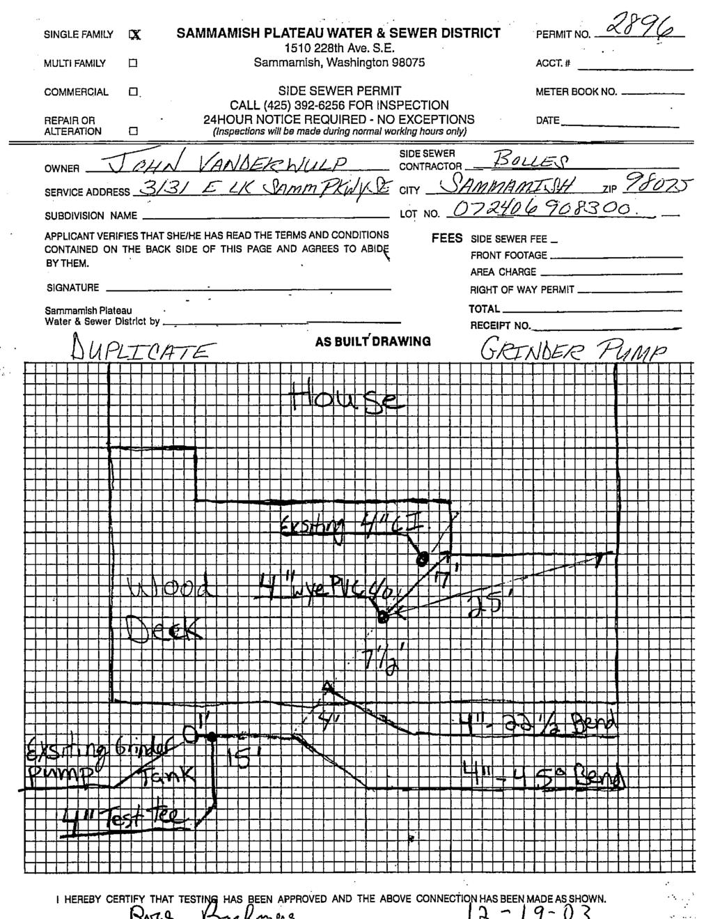
12 RE: ELST Project - Lindsey Ozbolt 2/10/17, 8)55 AM RE: ELST Project Lindsey Ozbolt Tue 1/17/2017 9:02 AM To:John Vanderwulp <john.vanderwulp@gmail.com>; judev54@gmail.com <judev54@gmail.com>; Dear John and Judy, Thank you for contacting the City of Sammamish regarding the current Shoreline Substantial Development Permit Application for East Lake Sammamish Trail Segment 2B (SSDP ). Your comments have been received and will be included in the project record. At the close of the comment period, all comments will be compiled and provided to King County for review and response. You will be included in future notices the City issues for this proposal. Regards, Lindsey Ozbolt Associate Planner City of Sammamish Department of Community Development From: John Vanderwulp [mailto:john.vanderwulp@gmail.com] Sent: Thursday, January 12, :54 PM To: Lindsey Ozbolt <LOzbolt@sammamish.us> Subject: ELST Project Ms. Ozbolt: We are writing to you in regards to the East Lake Sammamish Trail Project (ELST). My wife, Judy, and I met with King County representatives of the ELST at the Sammamish City Hall on January 11, 2017 regarding our home located at 3131 E. Lake Sammamish Parkway SE, Sammamish, WA 98075, Segment B, Station 279. After reviewing the 60% design plan, we are submitting the following for your review and consideration: The design shows that a wall and a fence is to be erected on the hillside facing the lake. The design was not clear whether the wall would be concrete or a soldier wall. Could you please confirm the nature of the materials to be used for the wall and explain the purpose of the chain-link fence? The design was not clear regarding the height of the wall and the fence. Could you please confirm 2FuKY3twkOpC5YzL9hvVgAAAtFJAAAA&IsPrintView=1&wid=1&ispopout=1 Page 1 of 3
13 RE: ELST Project - Lindsey Ozbolt 2/10/17, 8)55 AM the height of the wall and the fence? The design was not clear regarding the distance between the wall and the fence. Could you please clarify the distance between the wall and fence? We have strong concerns regarding the proximity of the wall and the chain-link fence to our home. It appears from the design that the wall and fence will be placed very close, perhaps within 2 or less, of our deck. Can you please confirm the distance? We were informed that the design does not reflect the presence of the sewer line or the grinder pump. They are located on the lake side in front of the deck. We respectively ask that the sewer line and grinder pump be included in the design plans going forward. We have attached drawings from the Sammamish Water and Sewer department showing the location of the pump and sewer line. It should be noted the Sammamish Plateau Water and Sewer department needs to have enough room to maintain the grinder pump and that we, as the homeowner, have room around the sewer line for maintenance purposes, as well. On another matter and since October 2013, we have been in touch with both Mona Davis, former Senior Planner, City of Sammamish and Gina Auld, Capital Project Manager, King County Facilities Management Division, Parks Cip, regarding the impact of the trail design on our home. The purpose of our contacts were to request access to the trail from our property. The design was clear that a wall is to be erected starting at about 200 to the south of our home and extending about 100 to the north and will not have any opening providing access to the trail. Our home is the only developed lot located behind the proposed wall. We are strongly concerned about accessibility to the trail and we respectively ask that a gate or opening of some type and stairs allowing access from our property be included in the wall. Further, we ask that signage be posted, stating No public access as the stairs would most likely lead directly to our property. Our purpose for making this request is because Judy is legally blind and we feel the wall prohibits her safe and secure accessibility to the trail. Driving to a location, finding parking and accessing the trail, possibly crossing E. Lake Sammamish Parkway is not an option. The State of Washington revoked Judy s driver s license in 2008 due to her vision loss. If she were to walk to an access point, there is no other option but to walk on E. Lake Sammamish Parkway SE which, when considering the amount and speed of traffic currently using the road, there would be high risk of being hit by a vehicle or injured in some other manner since Judy would not be able to react quickly enough to avoid injury. We are also strongly concerned with the integrity of the hillside once the construction begins. We are not civil engineers who have knowledge regarding prevention of erosion during construction of the wall and fence. However, we have owned the home since 1981 and over the years have observed how the dirt is loosely packed. We have maintained the hillside using blackberries to prevent erosion which appears to have been effective. 2FuKY3twkOpC5YzL9hvVgAAAtFJAAAA&IsPrintView=1&wid=1&ispopout=1 Page 2 of 3
14 RE: ELST Project - Lindsey Ozbolt 2/10/17, 8)55 AM Has an evaluation been completed regarding the impact of the clearing and grubbing (CG) on potential uncontrolled erosion? Has an evaluation been completed regarding the feasibility, safety, and impact on our home and residents during construction of the wall and fence, possibly due to uncontrolled erosion? In the unlikely event some harm should occur to our home, residents, and/or utilities, what is the resolution process for reimbursement? We very much appreciate the opportunity to review the plan design. Our desire is to help make the trail a successful endeavor. It appears to us that you will be our local contact for questions and concerns. Please respond to both our addresses. Judy s is judev54@gmail.com and mine is john.vanderwulp@gmail.com. We look forward to hearing from you in the near future. Thank you in advance, John and Judy Vanderwulp 2FuKY3twkOpC5YzL9hvVgAAAtFJAAAA&IsPrintView=1&wid=1&ispopout=1 Page 3 of 3
15

16
Bunker Hill Volunteer Fire & Rescue Company, Inc.
 Mayor and City Council City of Mt. Rainier 1 Municipal Place Mt. Rainier, MD 20712 Town of Brentwood 4300 39 th Place Brentwood, MD 20722 Town of North Brentwood 4009 Wallace Road North Brentwood, MD 20722
CITY OF MANHATTAN BEACH DEPARTMENT OF COMMUNITY DEVELOPMENT. TO: Parking and Public Improvements Commission
 Clay Curtin, Management Analyst (I the same walls at a maximum of 1 foot tall. Section 7.36.150 of the Municipal Code permits BY: Eric Haaland, Associate Planner right-of-way) between walkways leading
MINNETONKA PLANNING COMMISSION September 15, Conditional use permits for pedestrian improvements in Minnetonka Mills Park
 MINNETONKA PLANNING COMMISSION September 15, 2011 Brief Description Conditional use permits for pedestrian improvements in Minnetonka Mills Park Recommendation Recommend the city council approve the request
Landscape and fencing requirements of this Chapter shall apply to all new landscaped areas.
 Chapter 19.06. Landscaping and Fencing. Sections: 19.06.01. Purpose. 19.06.02. Required Landscaping Improvements. 19.06.03. General Provisions. 19.06.04. Landscaping Plan. 19.06.05. Completion of Landscape
Site Plan Review Residential Accessory Building
 COMMUNITY DEVELOPMENT DEPARTMENT Planning Division P.O. Box 490 333 Broadalbin Street SW Albany, OR 97321 Phone (541) 917-7550 Fax (541) 917-7598 www.cityofalbany.net Site Plan Review Residential Accessory
Welcome. Date: Thursday March 2, 2017 Time: 6:30 p.m. 9:00 p.m. Location: Woodview School Gym, 69 Flatt Road, Burlington Presentation Time: 7:00 p.m.
 Welcome Public Information Centre No.2 City of Burlington, City of Hamilton, Region of Halton Waterdown Road Widening Detailed Design Craven Avenue to Mountain Brow Road Date: Thursday March 2, 2017 Time:
TOWN OF BRUNSWICK MEETING AGENDA TOWN COUNCIL CHAMBERS TOWN HALL 85 UNION STREET TUESDAY, MAY 13, :00 P.M.
 TOWN OF BRUNSWICK ZONING ORDINANCE REWRITE COMMITTEE 85 Union Street, Brunswick, ME 04011-1583 MEETING AGENDA TOWN COUNCIL CHAMBERS TOWN HALL 85 UNION STREET TUESDAY, MAY 13, 2014 4:00 P.M. 1. Discuss
MUCKLESHOOT INDIAN TRIBE Fisheries Division nd Avenue SE. Auburn, Washington
 MUCKLESHOOT INDIAN TRIBE Fisheries Division 39015-172nd Avenue SE. Auburn, Washington 98092-9763 Phone: (253) 939-3311. Fax: (253) 931-0752 Mr. David Radabaugh Shoreline Planer W A Dept. of Ecology 3190
TOWN OF BURLINGTON Conservation Commission
 TOWN OF BURLINGTON Conservation Commission MINUTES OF Approved October 26, 2017 Members Present: Chair L. Cohen, Vice-Chair W. Boivin, E. LoTurco, A. McNamara, I. Deb, G. Lima Members Absent: Also Present:
SITE PLAN REVIEW APPLICATION
 SITE PLAN REVIEW APPLICATION CITY OF THE DALLES Community Development Department 313 Court Street The Dalles, OR 97058 (541) 296-5481, ext. 1125 Fax (541) 298-5490 www.ci.the-dalles.or.us Date Filed File#
CITY OF KEIZER MASTER PLAN APPLICATION & INFORMATION SHEET
 CITY OF KEIZER MASTER PLAN APPLICATION & INFORMATION SHEET PRE-APPLICATION CONFERENCE Prior to the actual filing of a Master Plan application, it is strongly recommended that the applicant contact Planning
At Your Disposal CUP Amendment, Lot 20, Village Service Commercial, at 128 Bastille Dr. (PLN17-208)
") MEMORANDUM Archuleta County Development Services Planning Department 1122 HWY 84 P. O. Box 1507 Pagosa Springs, Colorado 81147 970-264-1390 Fax 970-264-3338 TO: Archuleta County Planning Commission FROM:
MEMORANDUM Archuleta County Development Services Planning Department 1122 HWY 84 P. O. Box 1507 Pagosa Springs, Colorado 81147 970-264-1390 Fax 970-264-3338 TO: Archuleta County Planning Commission FROM:
Appendix E Section 4(f) Evaluation
 Evaluation") Appendix E Section 4(f) Evaluation Appendix E Draft Section 4(f) Evaluation E.1 Introduction This appendix addresses a federal regulation known as Section 4(f), which protects parks, recreation areas,
Appendix E Section 4(f) Evaluation Appendix E Draft Section 4(f) Evaluation E.1 Introduction This appendix addresses a federal regulation known as Section 4(f), which protects parks, recreation areas,
Construction and Landscaping on Public Property
 Construction and Landscaping on Public Property City of Manhattan Beach Community Development Department 1400 Highland Avenue 310-802-5504 www.citymb.info January, 2004 Construction and Landscaping on
THE CITY OF MOBILE, ALABAMA
 THE CITY OF MOBILE, ALABAMA LETTER OF DECISION Ark of Safety, Inc. Mobile, AL 36617 Re: (Northwest corner of Main Street and First Avenue, extending to the Southwest corner of Esau Avenue and Main Street.)
PLANNED UNIT DEVELOPMENT APPLICATION
 PLANNED UNIT DEVELOPMENT APPLICATION CITY OF THE DALLES Community Development Department 313 Court Street The Dalles, OR 97058 (541) 296-5481, ext. 1125 Fax (541) 298-5490 www.ci.the-dalles.or.us Date
Re: Keeping Special Area D North of Jensen Lane In the Town Of Windsor s Urban Growth Boundary
 Attachment 2a April 15, 2016 Town of Windsor Community Development Department Linda Kelly, Town Manager Toni Bertolero, Interim Community Development Director Town Council Members 9291 Old Redwood Highway
Architectural Review Committee FAQs
 Architectural Review Committee FAQs What kinds of changes to my home require ARC approval? In general all major changes to the exterior of your home require ARC approval. We most commonly receive requests
WELCOME! 8 8:30 6: TH STREET IMPROVEMENTS. Open House. Presentation & Q&A
 WELCOME! 168 TH STREET IMPROVEMENTS 6:30 Open House 7 8 Presentation & Q&A 8 8:30 Open House WELCOME Todd Pfitzer City of Omaha Engineer Bob Stubbe City of Omaha Public Works Director Jon Meyer Project
Project phasing plan (if applicable) 12 copies of site plan
 12 copies of site plan") SITE PLAN REVIEW PERMIT APPLICATION City of Grand Haven, 11 N. Sixth Street, Grand Haven, MI 49417 Phone: (616) 847-3490 Fax: (616) 844-2051 Website: www.grandhaven.org 1. Project Information Address/location
SITE PLAN REVIEW PERMIT APPLICATION City of Grand Haven, 11 N. Sixth Street, Grand Haven, MI 49417 Phone: (616) 847-3490 Fax: (616) 844-2051 Website: www.grandhaven.org 1. Project Information Address/location
East Panorama Ridge Concept Plan Amendment
 Page 1 of 7 L003 : East Panorama Ridge Concept Plan Amendment Corporate NO: L003 Report COUNCIL DATE: March 4, 2002 REGULAR COUNCIL LAND USE TO: Mayor & Council DATE: February 27, 2002 FROM: General Manager,
The City of Boynton Beach
 The City of Boynton Beach presents Kinder-Gentler Stormwater Management Today s Presenters James A. Cherof, City Attorney Paul M. Fleming, Senior Project Manager Dale S. Sugerman, Assistant City Manager
All correspondence between the Metropolitan Police Service and The Sun newspaper regarding CCTV cameras in the Westminster Council area.
 Freedom of Information Request Reference No: I note you seek access to the following information: All correspondence between the Metropolitan Police Service and The Sun newspaper regarding CCTV cameras
Planning Commission March 8, 2017 MINUTES Regular Meeting City of Hagerstown, Maryland
 Douglas S. Wright, Jr., chair, called the meeting to order at 4:04 p.m., on Wednesday, March 8, 2017, in the Conference Room, Fourth Floor, City Hall. Also present were commission members D. Miller, J.
GRAND COUNTY Planning Commission April 27, :00 P.M. Regular Meeting GRAND CENTER North End Meeting Room 182 No. 500 W.
 Type of Meeting: Facilitator: Attendees: Regular Meeting Dave Tubbs, Chair GRAND COUNTY Planning Commission April 27, 2016 6:00 P.M. Regular Meeting GRAND CENTER North End Meeting Room 182 No. 500 W.,
DESIGN PUBLIC HEARING MAY 10, 2018 GRANBY TOWN HALL FIRST FLOOR CONFERENCE ROOM 10 WEST STATE STREET GRANBY, MASSACHUSETTS 7:00 PM FOR THE PROPOSED
 DESIGN PUBLIC HEARING MAY 10, 2018 AT GRANBY TOWN HALL FIRST FLOOR CONFERENCE ROOM 10 WEST STATE STREET GRANBY, MASSACHUSETTS 7:00 PM FOR THE PROPOSED Reconstruction of Granby Road/West State Street (Route
VILLAGE OF SPRING LAKE PLANNING COMMISSION. MINUTES REGULAR MEETING April 28, :00 PM
 Page 1 of 6 VILLAGE OF SPRING LAKE PLANNING COMMISSION MINUTES REGULAR MEETING April 28, 2015 7:00 PM Barber School Community Building 102 West Exchange Street Spring Lake, MI 49456 49456 1. CALL TO ORDER
APPROVED WITH CONDITIONS
 Provo City Planning Commission Report of Action October 26, 2016 ITEM 10 Provo City Parks and Recreation Department requests a variance to the Sensitive Lands Ordinance to grade within a hillside of 30%
BEFORE THE HEARINGS EXAMINER FOR THURSTON COUNTY
 COUNTY COMMISSIONERS Cathy Wolfe District One Diane Oberquell District Two Robert N. Macleod District Three HEARING EXAMINER BEFORE THE HEARINGS EXAMINER FOR THURSTON COUNTY In the Matter of the Application
Chapter 1: General Program Information
 Chapter 1: General Program Information 1.1 Introduction The Montgomery County Stormwater Management Resolution (#03-1-5) was adopted by the County Board of Commissioners on January 22, 2003. The purpose
Architectural and Site Control Commission March 12, 2010 Special Field Meeting, 330 and 340 Golden Hills Drive, Klope
 Architectural and Site Control Commission March 12, 2010 Special Field Meeting, 330 and 340 Golden Hills Drive, Klope Chair Warr called the special field meeting to order at 2:00 p.m. on the terrace of
Roy L. Wickland 15 Belvedere Avenue - Belvedere, CA 94920
 Roy L. Wickland 15 Belvedere Avenue - Belvedere, CA 94920 June 19, Ms. Irene Borba Director of Planning and Building City of Belvedere ~1anning Department 450 San Rafael Avenue Belvedere, CA 94920 JUN.
Marblehead Planning Board. January
 Marblehead Planning Board January 19 2016 Edward Nilsson, Jim Bishop, Bob Schaeffner, Rosanna Ferrante, Barton Hyte. Others present Rebecca Cutting Town Planner, Lisa Mead Town Counsel. A quorum being
CHARLES COUNTY GOVERNMENT RFP NO POPES CREEK RAIL TRAIL DESIGN
 CHARLES COUNTY GOVERNMENT Department of Fiscal and Administrative Services Purchasing Division Telephone: 301-645-0656 July 7, 2015 RFP NO. 16-02 POPES CREEK RAIL TRAIL DESIGN ADDENDUM NUMBER ONE TO: All
COUNCIL PLANNING AGENDA
 COUNCIL PLANNING AGENDA Consolidated as of March 14, 2014 Council Chambers, City Hall, 1 Carden Street DATE March 17, 2014, 7:00 p.m. Please turn off or place on non-audible all cell phones, PDAs, Blackberrys
City Council Agenda Item #10_ Meeting of October 3, 2011
 City Council Agenda Item #10_ Meeting of October 3, 2011 Brief Description Recommendation Resolution approving conditional use permits for pedestrian improvements in Minnetonka Mills Park Adopt the resolution
TOWN OF HOPKINTON PLANNING BOARD
 1 1 1 1 0 3 0 TOWN OF HOPKINTON PLANNING BOARD Wednesday, October 5, 01 7:00 P.M. Hopkinton Town Hall One Town House Road, Hopkinton, Rhode Island 033 CALL TO ORDER: The October 5, 01 meeting of the Hopkinton
TOWN OF BURLINGTON Conservation Commission
 TOWN OF BURLINGTON Conservation Commission MINUTES OF Approved May 26, 2016 Members Present: Members Absent: Also Present: Chair L. Cohen, K. Melanson, I. Deb, A. McNamara Vice-Chair W. Boivin, J. Lynch,
Clackamas County Responses to Questions from Stafford Hamlet Stafford Hamlet Community Meeting March 13, 2017, 7-8 p.m., Stafford Elementary School
 Clackamas County Responses to Questions from Stafford Hamlet Stafford Hamlet Community Meeting March 13, 2017, 7-8 p.m., Stafford Elementary School 1. In 2009 the PAC, Planning Commission, and the BCC
SOUTH CAMBRIDGESHIRE DISTRICT COUNCIL. Planning and New Communities Director
 SOUTH CAMBRIDGESHIRE DISTRICT COUNCIL REPORT TO: Planning Committee 5 June 2013 AUTHOR/S: Planning and New Communities Director S/0747/13/FL HISTON Construction of Car Park at Histon Baptist Church, Station
Yadkin River Greenway Feasibility Study Fact Sheet Village of Clemmons, Town of Lewisville, Town of Bermuda Run
 Fact Sheet Village of Clemmons, Town of Lewisville, Town of Bermuda Run Project Background The Yadkin River Greenway Feasibility Study is a joint project with the Village of Clemmons, the Town of Bermuda
Public Works and Infrastructure Committee Front Yard Parking Regulations. Transportation Services. June 8, 2017
 RE: PW22.5 Public Works and Infrastructure Committee Front Yard Parking Regulations Transportation Services June 8, 2017 1 BACKGROUND 2 HISTORY Providing parking on the boulevard and/or front yard within
City of Mahtomedi Park System Plan Public Hearing Draft: September 13, 2006
 Chapter 6: IMPLEMENTATION INTRODUCTION Earlier chapters of this Plan analyzed existing conditions, identified park and recreation needs, and proposed park, trail, and open space recommendations. This chapter
HILLSIDE BUILDING COMMITTEE PLAN REVIEW DIRECTIONS
 HILLSIDE BUILDING COMMITTEE PLAN REVIEW DIRECTIONS 1 1. Review Hillside Regulations to ensure your design is in conformance with current Town Code. 2. Complete page 3 and contact Paul Mood at 480-348-3573,
Town of Florence Florence County, WI DRIVEWAY ORDINANCE
 Town of Florence Florence County, WI 08-10-09 DRIVEWAY ORDINANCE 1.01 PURPOSE The purpose of this Ordinance is to regulate the establishment, construction, improvement, modification or reworking of a driveway
Staff Report CONDITIONAL USE
 Staff Report PLANNING DIVISION COMMUNITY & ECONOMIC DEVELOPMENT To: From: Salt Lake City Planning Commission Daniel Echeverria, (801) 535-7165, daniel.echeverria@slcgov.com Date: May 21, 2015 Re: PLNPCM2015-00139
PROJECT STATEMENT LOCATION/DESIGN PUBLIC HEARING. 19 th AVENUE NORTH EXTENSION PROJECT FROM SPRINGDALE DRIVE TO NORTH 2 ND STREET/U.S.
 PROJECT STATEMENT LOCATION/DESIGN PUBLIC HEARING 19 th AVENUE NORTH EXTENSION PROJECT FROM SPRINGDALE DRIVE TO NORTH 2 ND STREET/U.S. 67 HEARING LOCATION: ERICKSEN COMMUNITY CENTER 1401 11 TH AVENUE NORTH
Watertown City Council
 City of Watertown Watertown City Council April 14 th, 2015 Agenda Item: City Comment on Sun Share CUP Application Request for Action: Motion to Approve City Comments regarding CUP Application Department:
CITY OF VACAVILLE PLANNING COMMISSION Agenda Item No. G. 1 STAFF REPORT August 4, Staff Contact: Tricia Shortridge (707)
") CITY OF VACAVILLE PLANNING COMMISSION Agenda Item No. G. 1 STAFF REPORT August 4, 2009 Staff Contact: Tricia Shortridge (707) 449-5140 TITLE: REQUEST: LONGS / CVS DRIVE-THRU PHARMACY & REMODEL TIME EXTENSION
CITY OF VACAVILLE PLANNING COMMISSION Agenda Item No. G. 1 STAFF REPORT August 4, 2009 Staff Contact: Tricia Shortridge (707) 449-5140 TITLE: REQUEST: LONGS / CVS DRIVE-THRU PHARMACY & REMODEL TIME EXTENSION
TOWN OF BURLINGTON Conservation Commission
 TOWN OF BURLINGTON Conservation Commission MINUTES OF Approved April 27, 2017 Members Present: Chair L. Cohen, Vice-Chair W. Boivin, E. LoTurco, K. Melanson, G. Lima, I. Deb Members Absent: Also Present:
HISTORIC LANDMARK COMMISSION STAFF REPORT
 HISTORIC LANDMARK COMMISSION STAFF REPORT Park Strip Raised Planter Boxes Minor Alteration PLNHLC2014-00603 163 D Street Meeting Date: November 6, 2014 Planning Division Department of Community and Economic
ORDINANCE NO.:
 ORDINANCE NO.: 2014-044 Granting an encroachment to S. Katherine Presty and Stephen M. Tuel for construction and maintenance of a brick retaining wall, brick columns, aluminum railing, brick pavers, landscaping
DATE: PLANNING COMMISSION MEETING OF FEBRUARY 24, 2016
 DATE: PLANNING COMMISSION MEETING OF FEBRUARY 24, 2016 TO: FROM: SUBJECT: THE PLANNING COMMISSION LISA COSTA SANDERS, TOWN PLANNER REQUEST FOR A SPECIAL STRUCTURES PERMIT FOR A POOL IN THE SIDE YARD AND
R E S O L U T I O N. Designation: Section 2, Block 17, Lot 20.G-1 ( ) R-2A (1-Family, 2-acre Minimum Lot Size) 46 North Greenwich Road
 R-2A (1-Family, 2-acre Minimum Lot Size) 46 North Greenwich Road") PLANNING BOARD Arthur Adelman, Chair TOWN OF NORTH CASTLE WESTCHESTER COUNTY 17 Bedford Road Armonk, New York 10504-1898 R E S O L U T I O N Telephone: (914) 273-3542 Fax: (914) 273-3554 www.northcastleny.com
PLANNING BOARD Arthur Adelman, Chair TOWN OF NORTH CASTLE WESTCHESTER COUNTY 17 Bedford Road Armonk, New York 10504-1898 R E S O L U T I O N Telephone: (914) 273-3542 Fax: (914) 273-3554 www.northcastleny.com
Request for an Exception to the Napa County Road and Street Standards
 F Request for an Exception to the Napa County Road and Street Standards Shed Creek Winery Use Permit P16-327 and Use Permit Exception to the Conservation Regulations P17-178 Planning Commission Hearing
Official Plan Amendment Setbacks from Railway Operations
 Official Plan Amendment Setbacks from Railway Operations August 12, 2015 Send your comments to: Krista Libman, Planner City of Ottawa Planning and Growth Management Tel: 613-580-2424 ext. 27893 E-mail:
Re: Thorncreek Commons Commercial Response to Pre-Application Meeting held September 24, 2014 Comments
 8/20/2015 Jay Ruchti Senior Planner City Development Department City of Thornton 9500 Civic Center Drive Thornton, CO Re: Thorncreek Commons Commercial Response to Pre-Application Meeting held September
ONTARIO MUNICIPAL BOARD
 PL 120483 ONTARIO MUNICIPAL BOARD Applicant/Appellant: 2124123 Ontario Limited Subject: OPA, Rezoning and Draft Plan of Subdivision Municipal Address: 3940 Highway 7 East Municipality: City of Markham
Development Permit for 723 Dogwood (DP ) THAT the staff report regarding Development Permit (DP ) be received;
 THAT the staff report regarding Development Permit (DP ) be received;") STAFF REPORT TO: Committee MEETING DATE: May 3, 2016 FROM: Katie Thomas Planning Assistant FILE NO: 3220-Dogwood-723 SUBJECT: Development Permit for 723 Dogwood (DP-2016-03) RECOMMENDATION( S) THAT the
STAFF REPORT TO: Committee MEETING DATE: May 3, 2016 FROM: Katie Thomas Planning Assistant FILE NO: 3220-Dogwood-723 SUBJECT: Development Permit for 723 Dogwood (DP-2016-03) RECOMMENDATION( S) THAT the
DEPARTMENT OF PLANNING JEFFERSON PARISH, LOUISIANA
 DEPARTMENT OF PLANNING JEFFERSON PARISH, LOUISIANA DESIGN REVIEW REPORT : CPZ-3-1 : (S) Cynthia Lee-Sheng AT LARGE: A Chris Roberts B Elton M. Lagasse ADVERTISING DATES: 06/03/1 06/10/1 06/17/1 PAB PUBLIC
Philipstown Conservation Advisory Committee Town Hall, 238 Main Street, Cold Spring, New York, April 13, 2010
 Philipstown Conservation Advisory Committee Town Hall, 238 Main Street, Cold Spring, New York, 10516 April 13, 2010 The CAC held its regular meeting at the Town Hall on Tuesday April 13, 2010. Mr. Lind
Town of Hamburg Planning Board Meeting August 19, Town of Hamburg Planning Board Meeting August 19, 2015 Minutes
 Town of Hamburg Planning Board Meeting August 19, 2015 Minutes The Town of Hamburg Planning Board met for a Regular Meeting at 7:00 P.M. on Wednesday, August 19, 2015 in Room 7B of Hamburg Town Hall, 6100
PLAN COMMISSION VILLAGE OF DEERFIELD
 APPROVED PLAN COMMISSION VILLAGE OF DEERFIELD The Plan Commission of the Village of Deerfield held a Workshop Meeting at 7:30 P.M. on at the Village Hall, 850 Waukegan Road, Deerfield, Illinois. Present
PLANNED UNIT DEVELOPMENT STAFF REPORT Date: June 2, 2016
 # 9 ZON2016-01032 PLANNED UNIT DEVELOPMENT STAFF REPORT Date: June 2, 2016 DEVELOPMENT NAME JJT Properties LLC LOCATION 1147 & 1151 East I-65 Service Road South and 1180 Sledge Drive (Southeast corner
Tips on Writing to the Planning Commission
 Tips on Writing to the Planning Commission When should I write? The sooner the better. The Commission will hold a hearing on the Environmental Impact Report (EIR) on September 4. They will accept written
MINUTES TOWN OF HORSEHEADS PLANNING BOARD MEETING August 2, 2017
 MINUTES TOWN OF HORSEHEADS PLANNING BOARD MEETING August 2, 2017 A regular meeting of the Planning Board of the Town of Horseheads, County of Chemung, and the State of New York was held at the Town Hall,
SITE PLAN (REVISED 8/13/18) l. Development Data Table
 l. Development Data Table") SITE PLAN (REVISED 8/13/18) l. Development Data Table a. Site Acreage: 9.25 b. Tax Parcels included in rezoning: #108-081-07 and #108-081-23 c. Existing Zoning (including overlays and vesting): R-3 (see
SITE PLAN (REVISED 8/13/18) l. Development Data Table a. Site Acreage: 9.25 b. Tax Parcels included in rezoning: #108-081-07 and #108-081-23 c. Existing Zoning (including overlays and vesting): R-3 (see
Butte Creek Canyon. The New Road Built in April of 2015 by Signalized Intersection West, LLC. Presentation slides from December 2015 through June 2016
 Butte Creek Canyon The New Road Built in April of 2015 by Signalized Intersection West, LLC Presentation slides from December 2015 through June 2016 1 Dry Creek Bed: Because there is no culvert, rainwater
City of Bonney Lake Allan Yorke Park. MASTER PLAN SUMMARY REPORT June 30, 2016
 City of Bonney Lake Allan Yorke Park MASTER PLAN SUMMARY REPORT June 30, 2016 TABLE OF CONTENTS INTRODUCTION PUBLIC INVOLVEMENT PROCESS MASTER PLAN North Park Central Park South Park East Park Field Development
CITY OF ZEELAND PLANNING COMMISSION
 APPLICATION FOR SITE PLAN REVIEW AND SPECIAL LAND USE Date City Official App. Filing Fee Rec'd ($350) NOTE TO APPLICANT: Please submit this application for Site Plan Review along with twenty (20) copies
SITE PLAN REVIEW PROCESS
 BOWNE TOWNSHIP PO Box 35, 8240 Alden Nash Road, Alto, Michigan 49302 Ph. 616-868-6846 Fax 616-868-0110 http://www.bownetwp.org SITE PLAN REVIEW PROCESS 1. Application Form and Fee Schedule Site Plan Review
PRELIMINARY PLAT DESIGN REQUIREMENTS Updated 4/8/2016
 PRELIMINARY PLAT DESIGN REQUIREMENTS Updated 4/8/2016 The following items are required for the preliminary plat. Numbers correspond with those on the example preliminary plat. RENO COUNTY SUBDIVISION REQUIREMENTS
City of Auburn, New York. SEQRA RESOLUTION #46 of 2016
 City of Auburn, New York SEQRA RESOLUTION #46 of 2016 DETERMINING THAT PROPOSED ACTION IS TYPE II ACTION FOR PURPOSES OF THE NEW YORK STATE ENVIRONMENTAL QUALITY REVIEW ACT By Councilor Giannettino April
RESPONSES TO PUBLIC CONCERNS AND QUESTIONS
 RESPONSES TO PUBLIC CONCERNS AND QUESTIONS Stations and Summary Questions for Public Meeting #2 June 23, 2015 General Questions / Concerns: 1. Is there any way this development can raise revenue for the
City of Lafayette Study Session Staff Report Design Review Commission
 City of Lafayette Study Session Staff Report Design Review Commission Meeting Date: April 24, 2017 Staff: Payal Bhagat, Senior Planner Subject: HDP18-15 & HDP31-15 Ramesh Patel & Melcor Development (Owners),
SEPA Modification Application
 SEPA Modification Application 6000 Main St. SW, Lakewood, WA 98499 Application Fee: $200.00 Number of Copies Required: Description of Required Documents: Required: A=always; M=may be 1 SEPA Modification
D EPARTMENT OF W ATER M ANAGEMENT
 September 24, 2012 Dear Neighbor, D EPARTMENT OF W ATER M ANAGEMENT CITY OF CHICAGO CUSTOMER NOTICE INFRASTRUCTURE RENEWAL PROGRAM At Alderman O Connor s (41st Ward) request, I am providing you with information
CHAIR AND MEMBERS PLANNING & ENVIRONMENT COMMITTEE JOHN M. FLEMING MANAGING DIRECTOR, PLANNING AND CITY PLANNER
 TO: FROM: SUBJECT: CHAIR AND MEMBERS PLANNING & ENVIRONMENT COMMITTEE JOHN M. FLEMING MANAGING DIRECTOR, PLANNING AND CITY PLANNER APPLICATION BY: THE CORPORATION OF THE CITY OF LONDON OUTDOOR PATIOS IN
RZC Public View Corridors and Gateways
 RZC 21.42 Public View Corridors and Gateways 21.42.010 Purpose 21.42.020 Scope and Authority 21.42.030 Administration 21.42.040 Gateways Design 21.42.050 Unidentified Public Views 21.42.060 Identification
Decision Notice. Proposed Action
 Decision Notice Paving Weld County Road 105 USDA Forest Service Arapaho and Roosevelt National Forest and Pawnee National Grassland Pawnee National Grassland Ranger District Weld County, Colorado November
CONSENT CALENDAR CITY PLANNING COMMISSION AGENDA ITEM NO: A.1, A.2 STAFF: LARRY LARSEN
 Page 8 CONSENT CALENDAR CITY PLANNING COMMISSION AGENDA ITEM NO: A.1, A.2 STAFF: LARRY LARSEN FILE NO: CPC PUZ 14-00013 - QUASI-JUDICIAL FILE NO: CPC PUD 14-00014 QUASI-JUDICIAL PROJECT: APPLICANT: OWNER:
Lower Meramec Multi-Jurisdictional Floodplain Management Plan Public Involvement (Results of Early Public Engagement) 27 June 2018
 27 June 2018") Lower Meramec Multi-Jurisdictional Floodplain Management Plan Public Involvement (Results of Early Public Engagement) 27 June 2018 Public Involvement Summary: The planning process includes opportunities
Lower Meramec Multi-Jurisdictional Floodplain Management Plan Public Involvement (Results of Early Public Engagement) 27 June 2018 Public Involvement Summary: The planning process includes opportunities
M E M O R A N D U M. Principal Planner. HEARING DATE: March 13, 2018 CASE NUMBER: PC
 M E M O R A N D U M TO: FROM: PREPARED BY: Plan Commission Technical Review Committee Tim Semmann, AICP Principal Planner DATE DISTRIBUTED: March 6, 2018 HEARING DATE: March 13, 2018 CASE NUMBER: PC18-2561
DEPARTMENT OF PLANNING JEFFERSON PARISH, LOUISIANA
 DEPARTMENT OF PLANNING JEFFERSON PARISH, LOUISIANA DESIGN REVIEW REPORT : SUMMAR NO.: 4469 (S) Paul Johnston AT LARGE: A Chris Roberts B Cynthia Lee-Sheng ADVERTISING DATES: PAB PUBLIC HEARING: HEARING:
MEMORANDUM HONORABLE MAYOR AND CITY COUNCIL MEMBERS. SHERI REPP LOADSMAN, DEPUTY CITY MANAGER/ PLANNING & BUILDING DIRECTOR /s/
 MEMORANDUM Agenda Item #: 13 Meeting Date: 9/12/17 TO: THRU: FROM: SUBJECT: HONORABLE MAYOR AND CITY COUNCIL MEMBERS ANTON DAHLERBRUCH, CITY MANAGER /s/ SHERI REPP LOADSMAN, DEPUTY CITY MANAGER/ PLANNING
Plan Policies. Introduction
 Plan Policies Introduction The purpose of the Plan Policies section is to identify the various Governing Body and Planning Commission land use related policy resolutions for use in evaluating development
Town of Malta Planning Board 2540 Route 9 Malta, NY (518) Fax: (518)
 Fax: (518)") William Smith - Chairman Dave Bowman Kyle Kordich Roger Laime Jean Loewenstein John Viola David Wallingford Joseph Lopez (Alt) Town of Malta Planning Board 2540 Route 9 Malta, NY 12020 (518) 899-2685 Fax:
William Smith - Chairman Dave Bowman Kyle Kordich Roger Laime Jean Loewenstein John Viola David Wallingford Joseph Lopez (Alt) Town of Malta Planning Board 2540 Route 9 Malta, NY 12020 (518) 899-2685 Fax:
DEPARTMENT OF PLANNING JEFFERSON PARISH, LOUISIANA
 DEPARTMENT OF PLANNING JEFFERSON PARISH, LOUISIANA DESIGN REVIEW REPORT DOCKET NO: : : : Paul D. Johnston AT LARGE: A: Christopher L. Roberts B: Cynthia Lee-Sheng ADVERTISING DATES: PAB PUBLIC HEARING:
1173 W. University Dr. Request to construct a new Alumni Center.
 John S. Franden, President Mitchell A. Jaurena, Vice President Rebecca W. Arnold, Commissioner Sara M. Baker, Commissioner Jim D. Hansen, Commissioner Date: May 22, 2014 To: Jennifer Wheeler Boise State
TO BE COMPLETED BY APPLICANT
 Planning Division #200-2564 Shaughnessy Street Port Coquitlam BC V3C 3G4 Tel 604.927.5442 Fax 604.927.5404 Email planning@portcoquitlam.ca Application for Watercourse Development Permit Watercourse Development
PLANNING APPROVAL & SIDEWALK WAIVER STAFF REPORT Date: December 1, 2016
 PLANNING APPROVAL & SIDEWALK WAIVER STAFF REPORT Date: December 1, 2016 NAME Dennis P. Wilkins LOCATION. CITY COUNCIL DISTRICT District 6 7078 Bruns Drive (Northeast corner of Bruns Drive and Cody Road)
GENERAL PLAN UPDATE ISSUES MEETING. January 21, 2010 City Hall Mitchell Room 6:00 pm 9:00 pm
 GENERAL PLAN UPDATE ISSUES MEETING January 21, 2010 City Hall Mitchell Room 6:00 pm 9:00 pm WELCOME! Introductory Comments Continued Review of Quality of Life Standards, Growth Management, Proposition
ARTICLE IX SPECIAL PERMIT USES
 ARTICLE IX SPECIAL PERMIT USES All special permit uses cited in Article IX and Attachment A of this Ordinance or any other Section of this Ordinance shall be subject to Site Plan Review. The procedures
Town of Excelsior, Sauk County, Wisconsin DRIVEWAY ORDINANCE
 Town of Excelsior, Sauk County, Wisconsin DRIVEWAY ORDINANCE 1.01 PURPOSE The purpose of this ordinance is to regulate the establishment, construction, improvement, modification or reworking of a driveway
APPENDIX F: EXTERNAL APPROVALS
 1.0 RESPONSIBILITIES When the City is constructing the Park or Open Space Development lands (OPTION I), after the subdivision construction process is completed by the Developer, Open Space Development
R E S O L U T I O N. Designation: R-2A (1-Family, 2-acre Minimum Lot Size)
") PLANNING BOARD Arthur Adelman, Chair TOWN OF NORTH CASTLE WESTCHESTER COUNTY 17 Bedford Road Armonk, New York 10504-1898 R E S O L U T I O N Telephone: (914) 273-3542 Fax: (914) 273-3554 www.northcastleny.com
PLANNING BOARD Arthur Adelman, Chair TOWN OF NORTH CASTLE WESTCHESTER COUNTY 17 Bedford Road Armonk, New York 10504-1898 R E S O L U T I O N Telephone: (914) 273-3542 Fax: (914) 273-3554 www.northcastleny.com
Request for Decision. Recommendation. Presented: Monday, Jul 07, Report Date Friday, Jun 20, Type: Public Hearings
 Presented To: Planning Committee Request for Decision Application for rezoning in order to permit a place of worship on a vacant lot zoned for C1, Local Commercial uses, Cam Street, Sudbury Sitiri Investments
From: personal information
 Wednesday, Jun 4, 207 6:52 PM Re: Gonzales Heritage Area plan Hi Kristina Happy to help. Talk soon. Sent from my iphone On Jun 4, 207, at 5:52 PM,
STORMWATER UTILITY FREQUENTLY ASKED QUESTIONS
 STORMWATER UTILITY FREQUENTLY ASKED QUESTIONS What is Stormwater? Stormwater is water that falls to the ground during a precipitation event. When land is undeveloped or covered with vegetative surface,
SEQR = State Environmental Quality Review PB = (Town of Bolton) Planning Board WCPS = Warren County Planning Board
 Planning Board WCPS = Warren County Planning Board") Town of Bolton SEQR = State Environmental Quality Review PLANNING BOARD PB = (Town of Bolton) Planning Board MINUTES WCPS = Warren County Planning Board Thursday APA = Adirondack Park Agency 6:00 p.m.
Town of Bolton SEQR = State Environmental Quality Review PLANNING BOARD PB = (Town of Bolton) Planning Board MINUTES WCPS = Warren County Planning Board Thursday APA = Adirondack Park Agency 6:00 p.m.