STRUCTURE OF URBAN LAND USE PLANNING SYSTEM...
|
|
|
- Walter Manning
- 5 years ago
- Views:
Transcription
1
2 PREFACE The Urban Land Use Planning System varies from country to country because of the differences in their backgrounds, which makes regulatory systems as they are now. The physical features of cities, perception and business practices in real estate, the stages of developmental economy, and others, which are foundations of regulations, are different from country to country. This booklet is written for planners, city planners, administrators, and researchers in the world to help understand the Japanese Urban Land Use Planning System. It is not intended for business persons who are actually in or attempt to be in the Japanese real estate business. The booklet attempts to explain the characteristics of the Japanese Urban Planning Systems by focusing on Japan s real experiences on establishing various regulations dealing with urban issues and problems. It is not a superficial explanation of regulatory structures and classifications, but it attempts to include an explanation on the background and reasons of regulations in manner that is easy to understand. However, within the scope of this booklet, it is not possible to cover all aspects; major points have been selected and focused. So, the deficiency of this booklet is that it is not a comprehensive guidebook to explain the whole system in detail, although an attempt has been made to explain the background of and reasons for the complex regulatory systems. Also, in order to raise its readability some detailed explanations may have been omitted. Description may sound deterministic, while there may be exceptions. For these reasons, some of the expressions may not be as accurate as they should be. The Japanese Urban Land Use Planning System is very complex as seen in the existence of many zoning systems. The reason is that the government has been dealing with urban problems in the course of economic growth and stagnation by adding and revising regulations. An analogy given is that of an old house that has been repaired, rebuilt, units added whenever problems arose without a clear-cut concept or total plan. The end product would be far away from a unified or proportioned beauty. This is because urban areas have been renewing themselves and changing drastically as a result of modernization, war damages, high-growth economy, and the pursuit of individual quality of life. Despite such complexity of both the system and texture of urban land use in Japan, this booklet tries to clarify the essential reason, ways of thinking, and historical backgrounds on statutory system and administrative operating. We would be grateful, if some of the readers in the world could find some clues to current urban issues and problems in their countries. Lastly, we sincerely hope that this document would facilitate people involved in city planning of the world to develop urban planning technologies and to establish a better urban social environment through the exchange of constructive opinions. March, 2007 Author: Technical Cooperation: Editing Staff: Tatsuo AKASHI (Ph.D) (Director City Planning Research Division, National Institute for Land and Infrastructure Management) Takeo OCHI (Japan International Cooperation Agency (JICA)) Akiko ABE, Motoyo ARAKI (Japan International Cooperation Agency (JICA)) Teruma OKAMIZU, Hiroaki MORITA (Institute for Future Urban Development)
3 Table of Contents 1. STRUCTURE OF URBAN LAND USE PLANNING SYSTEM COMPONENTS OF URBAN LAND USE PLANNING SCOPE OF URBAN LAND USE PLANNING STRUCTURE OF URBAN LAND USE REGULATION SYSTEM ENFORCEMENT OF URBAN LAND USE REGULATIONS WHO DECIDES A PLAN? VISIONARY PART OF URBAN LAND USE PLANNING CHARACTERISTICS OF URBAN LAND USE REGULATIONS CHANGES IN THE URBAN LAND USE REGULATION SYSTEM CONTROLLING URBANIZATION THE PURPOSE OF THE AREA DIVISION S YSTEM ZONING REGULATIONS IN URBAN AREAS THE LAND USE ZONES PROMOTION OF EFFICIENT LAND UTILIZATION THE CONCEPT OF EFFICIENT LAND UTILIZATION BACKGROUND - NEGATIVE IMPACT OF URBAN SPRAWL THE AREA DIVISION SYSTEM DEVELOPMENT PERMIT COORDINATION WITH FARMLAND POLICIES METHOD OF DESIGNATING THE AREA DIVISION THE SUSPENDED POPULATION PROBLEMS RELATED TO FARMLAND IN THE UPAS EVALUATION OF THE AREA DIVISION SYSTEM HISTORY OF LAND USE ZONES SYSTEM METHOD OF DESIGNATING LAND USE ZONES LAND USE ZONES AND THE BUILDING STANDARD LAW OTHER ZONING REGULATIONS SHADOW RESTRICTION INCENTIVE SYSTEM URBAN RENEWAL POLICY STRUCTURE REDEVELOPMENT PROMOTION DISTRICT IN DISTRICT PLAN SPECIAL DISTRICT FOR URBAN RENAISSANCE TRANSFER OF FLOOR AREA RATIO THE DISTRICT PLAN D - A ISTRICT SCALE PPROACH COMPONENTS OF THE DISTRICT PLAN PARTICIPATION FRAMEWORK PROGRESS OF DISTRICT PLAN SYSTEM RECENT TOPICS LANDSCAPING PLANNING PROPOSAL IN THE STATUTORY PROCESS CONTROLLING LARGE-SCALE RETAIL STORES CONCLUSION... 63

4 Figure 1 Map of Policies on Improvement, Development and Conservation in Yokohama City (As of 2003)

5 Figure 2 Map of Land Use District in Yokohama City (As of 2003)
6 1. Structure of Urban Land Use Planning System Characteristics of Japanese Urban Land Use Planning The basic structure of Japanese urban land use planning system is zoning regulations. The categories of zonings are largely divide into four parts; 1) the Area Division 1 into the Urbanization Promotion Area (UPA) 2 and the Urbanization Control Area 3, 2) the Land Use Zones 4 which includes twelve basic use categories, 3) additional zoning categories which overlays upon basic zonings such as the Land Use Zones if necessary, 4) the District Plan 5 which enables detailed regulatory control within specific districts. the Area Division is required in the three metropolitan areas and 17 designated large cities. All categories are selectively used except that The enforcement measures for the urban land use planning are three categories; 1) the Land Development Permission which controls conversion and physical transformation of the land, 2) the Building Confirmation 6 which certificates the compliance to zoning regulations such as use, density, height and so forth of each building, 3) administrative recommendation on filed notification. The Land Development Permission plays an important role in restriction of urban development in the Urbanization Control Area, the Building Confirmation ensures various codes on buildings including the Land Use Zones regulations, and administrative recommendation is used for the District Plan and voluntary local ordinances. The characteristic of land ownership in Japan is unique; each lot is small and formless, there are so many land owners in a district, and most of the access roads are narrow in traditional urban areas. also seen in farmlands. This characteristic is That is why the appearance of original urban areas are so congesting with small buildings, and compulsory land ownership conversion systems such as the Land Readjustment Project and the statutory Urban Redevelopment Project play a great role in urban planning. This point is important to understand the planning issues in Japan. As for land use regulation, urban development and building construction is not originally controlled by the Law, but it may be controlled only to the area where land use zoning is designated through planning procedure. It is contrary to most European countries where development is originally controlled by the Law and planning judges whether to permit or not. Regulatory policy in Japan can be described as No regulation without planning, meanwhile No development without planning in most European countries. It is significant in considering how and why the Japanese land use regulation system is organized Components of Urban Land Use Planning Urban Land Use Planning aims to establish order on land uses in cities. Its purpose is to ensure efficiency of various activities of people and industries, to protect the quality of the natural and living environment, and to create proper townscapes with characteristics by application of regulatory measures on land developments and building constructions. Diverse types of regulatory measures have been provided, corresponding to varied demands of the people and characteristics of areas or places, or transitions of public policies. In general, Urban Land Use Planning System consists of two parts; the visionary part which describes policy directions and strategies, and the regulatory part which is in charge of regulations and enforcements. The first, the visionary part, is commonly called master plan or comprehensive plan, which describes the basic policy of planning, the ideal formation of urban areas and the strategies for its realization. This part is fundamental because the goal, current problems, future prospects, strategies and measures of the planning administration should be in- cluded in the document and decided as a social consensus. However, in the Japanese Urban Land Use Planning, it has been indicated that the visionary part was insufficient compared to that of other developed countries, wherein it lacked 1
7 specific directions in their strategies (See Section 6 of this Chapter for details). This was attributed partly to the lack of a statutory basis for City Planning and partly to the focus of the City Planning System on improving the road net- 7 was enacted in Since the Law has work and parks rather than land use control until the City Planning Law provisions in such matters as municipal master planning, which was introduced in 1992, and city planning area master planning, which was implemented in 2000, the situation has recently been improved. The second, the regulatory part, is called land use regulations or zoning codes, which enforces certain regulations on each land owner and developer to implement the plan. In Japan, this part consists of diverse and complex measures because they have been expanded in order to cope timely with up-to-date urban problems, such as: Prevention of urban sprawl caused by rapid urbanization; Separation and appropriate allocation of residential, commercial, business, and industrial uses in response to indus- trialization and the country s shift to service industry; Promotion of efficient land utilization in city centers due to acute increase in land prices and to prevent fire disaster caused by earthquake; and Formulation of elaborate rules on urban design and landscape in response to the rise in interests in the quality of urban environment as income increases. The system has provided varied solutions to urban problems in each time period in the modern history of Japan Scope of Urban Land Use Planning The Basic Land Use Master Plan 8 based on the National Land Use Planning Law 9 classifies the land in Japan into five areas, namely: urban area, agricultural area, forest area, natural parks, and nature conservation area. City Planning 10 Areas are equivalent to Urban Areas within the National Land Use Planning framework. Some areas may overlap in the Basic Land Use Master Plan: For example, Urbanization Control Areas within a City Planning Area may be categorized as both Urban Area and Agricultural Area. The Law on Promoting Agricultural Development Areas may designate the same area as the Agricultural Promotion Area. Urban land use planning is implemented in the City Planning Area, which accounts for about 100,000km 2 in total land area or approximately a quarter of the country s land area. City Planning Areas include not only the built-up areas but also the surrounding farmlands and forests lands that are to be protected from urbanization. As such, City Planning Areas tend to be four or five times larger than built-up areas. The national land area of Japan includes about 70% of mountains and forests which are unfit for human habitation. Due to this geographical characteristic, most of the areas that are fit for urban land use are included in City Planning Areas except for small villages in the mountains and fishing villages on the rural sea sides. Quasi City Planning Areas 11 may be designated outside of City Planning Areas, when necessary. These areas were introduced by the amendment of the Law in 2000 for the purpose of expanding restriction of large scale urban developments into rural areas in accordance with progressed motorization. Within the Japanese City Planning framework stipulated in the City Planning Law, Land Use Planning mainly deals with lands for buildings. Areas for urban infrastructure, such as roads and parks, are planned differently as the Urban Facility Planning framework and are not within the scope of Land Use Planning Structure of Urban Land Use Regulation System Land use regulation systems by the City Planning have the following types: 2


8 Area Division: Urbanization Promotion Areas (UPAs) and Urbanization Control Areas (UCAs) The division into Urbanization Promotion Areas and Urbanization Control Areas aims at preventing urban sprawl and ensuring efficiency of public investments by controlling expansion pressure of urbanized area. Within the Urbanization Control Area, urban development activities, such as conversion from farmland to urban land uses, are in principle prohibited. The Area Division system is commonly called the line-drawing system 12, since a City Planning Area is divided into only two categories by drawing a line Land Use Zones and Other Additional Zonings Land Use Zones are the most fundamental regulatory measure for controlling use, density, height and shape of buildings. Urbanization Promotion Areas must be classified into 12 categories of the Land Use Zones. Each category has a particular color code drawn on a City Planning Map 13. Additional zoning regulations may be overlaid on this map. There are Special Land Use Districts 14, Fire Protection Zones 15, Scenic Districts 16, Historic Townscape Preservation Districts 17, and so forth. Land Use Zones and other additional zonings are called the Zones and Districts 18 as a general term The District Plan The District Plan is a detailed and comprehensive land use planning system applying to areas with several hectares, for the purpose of promoting quality urban environment in accordance with proper characteristics of each district. It is decided by the municipality and often drafted with initiative by land owners and residents. A District Plan consist of the following components: the vision statement and the district improvement plan, which includes the location of access roads and small parks, and building regulations such as use, density and shapes, setback restriction, minimum lot size and design codes including color and materials of façade, roof and fence. Since the District Plan was enacted in 1980, its statutory system has been amended several times. The reason is partly because it could provide the Diet with such a solution that required amendment of the law on current political issues, such as deregulation policy for stimulating private investments, encouraging housing supply within the central districts of metropolitan areas and improvement of small wooden houses in highly congested areas. Figure 1-1 Structural Process of the City Planning System 3


9 Figure 1-2 Structure of Urban Land Use Regulation System (the principal pattern) 1.4. Enforcement of Urban Land Use Regulations Controlling land use is achieved mainly by two measures: the Land Development Permission, which approves urban development or subdivision for the purpose of construction of buildings, and the Building Confirmation which reviews the design of buildings according to the provisions of relevant laws and certifies the compliance of building applications. Such two measures are prepared because lands and buildings are treated differently in Japan, by common appreciation. In the real estate market, prices of land and building are dealt with separately, and in fact, land without buildings has been widely traded as having large potential possibilities on optimum use for making profit. The land development permission intends to secure certain qualities on development sites and control urban development activities in the UCAs (i.e. conversion from farm and/or forest lands to urban uses). They are in accordance with technical standards prescribed by the City Planning Law, and local governments are responsible for reviewing the admissibility of carrying out the developments. The Building Confirmation enforces use, density, height and shapes of buildings by reviewing compliance of building applications to the regulations stipulated by the City Planning and the Building Standard Law 20. With the amendment of the law in 1998, the authorization body of the Building Confirmation was expanded to involve Private Building Inspectors, who belong to designated private companies, in addition to the Building Officials, who belong to local governments. This fact symbolically tells that the characteristic of the Building Confirmation process is no more than providing compliance certification; in the other words, it does not include planning process at all. Some of the land use regulations within the City Planning system include issues other than on building construction. For example, cutting trees is prohibited within the Greenery Preservation Zone which is designated for natural preservation and conservation Who decides a Plan? A City Plan is decided at two levels of administrative bodies of the government: municipal and prefectural. In general, the prefectures are responsible for regional issues beyond the territory of a municipality as well as major infrastructure or large-scale public facilities. Municipalities handle all the other issues, most of which are relatively small projects 4 19
10 and specific problems of residents. Some prefectural matters are required consent by the Ministry of Land, Infrastructure and Transport to be valid. These matters include issues and projects across the prefectural boundaries, such as City Planning in the Metropolitan Regions, or matters that have serious impact on national interests such as the construction of national highways. As a result of decentralization enforced in the late 1990s, about 75% of these matters is decided by municipalities, about 25% is decided by prefectures, and 15% is consented by the Minister in an ordinary year. The prefectures decide land use regulations relating to matters of regional or national interests. These include the Area Division into the UPAs and the UCAs, the Land Use Zones in the Metropolitan Areas and the Special District for Urban Renaissance. The designation of the Port District 21 and the Cargo Distribution District 22 requires region-wide coordination. Other zoning type, such as the Scenic District and the Greenery Preservation Zone 23 both with no less than 10 hectors and the Special Preservation Districts for Historic Landscape 24 requires preservation from a regional perspective and restrict landowners property rights. Therefore, these fall under the responsibility of prefectures. On the other hand, the District Plan deals with detailed rules regarding issues familiar to residents, so this belongs to the responsibility of a municipality. The Special Land Use District with in a walking distance scaled district, the Efficient Land Utilization District 25, the Fire Protection District, and the Historic Townscape Preservation District is also handled by the municipalities. Even on the Land Use Zones, the deciding body is a municipality except in the three Metropolitan Areas Visionary Part of Urban Land Use Planning The meaning of vision is part of planning that shows the policy direction of city planning, describes the ideal formation of urban areas in the future, and offers strategies for achieving the goal. The vision, often called the Master Plan, does not have the legal power to directly regulate the rights of people; however, the vision provides the basic guideline for administrative bodies to operate regulation and enforcing development projects. The visionary part in the Japanese City Planning System consists of three levels, as described below. 1) Policy on Improvement, Development and Conservation 26 in the City Planning Area Article 6-2 of the City Planning Law This is a master plan document on planning policy which is decided by the prefecture. The document includes subjects on the following: the basic principles on city planning; visions on land use; urban development and redevelopment; transportation systems; conservation of natural environment and public space; development of sewage and river systems; development of other public facilities; urban area improvement programs; prevention of pollution and improvement of environment; urban disaster prevention; housing supply and others. If the Area Division would be ap- plied to the area, the population framework has to be included. Among these, the most active component is the population framework, which provides the basis for the expansion of UPAs. In the process of its decision, coordination with other administrative agencies, especially agricultural and forestry administration, are required. Policies on improvement, development, and conservation were introduced in At that time it was required only for the City Planning Areas that the Area Division was applied to. It was not until 2000 when this requirement was expanded to all the City Planning Areas as a result of amending the application of the Area Division system to be selective by the prefecture s decision. With this historical background, not a few of them still does not prepare adequate master plans with meaningful visions nor workable strategies. 27 2) Municipal Master Plan (Article 18-2 of the City Planning Law) Another type of master plan describes vision formed by municipality. This system was introduced as a statutory document in 1992 upon the amendment of the City Planning Law. So far, most cites have prepared municipal master plans, some of which describe unique characteristics of the city. However, a lot of them do not have sufficient power 5
11 to realize their contents, although they are described with full of attractive phrases. The Government emphasizes that the significance of the municipal master plan is the process of making it with broad and active participation of residents so that municipalities should exert effort on that. 3) Policy directions of District Plan (Article 12-4 of the City Planning Law) District Plans also have a visionary part and are called Policy Directions on improvement, development or conservation which include in general the Goals of the district plan, Direction on land use, Direction on district facilities improvement, and Direction on buildings and structures improvement. They are expected to describe the ideal future image of the districts, which would be acceptable by the residents as a common direction. Visions must be substantial for planners and should declare a certain direction toward a favorable urban formation that can actively handle the physical spaces with the measures of land use regulation and the implementation of development projects with the purpose to realize an ideal form of the future urban areas. In Japanese City Planning, however, visions or master plans are still at an insufficient level compared with other developed countries, especially in the strategic parts. One reason is that the master plans does not bind the actual planning decision such as designation of land use regulation and consent to the municipal draft by prefecture, except for the population framework in case of making decision on the UPA expansion as will mention later. But recently, some improvement has been seen because the authority has been required more accountability than before. The Urban Renewal Program 28 is an example of ambitious trial on the visionary part of the City Planning. It was established in 1980 by amendment of the Urban Renewal Law 29. This program is a special master plan on a specific is- policy document and it is decided as a part of the sue of promoting urban redevelopment strategically as an integrated Policies on Improvement, Development and Conservation. It describes comprehensive strategies on urban renewal in the city including designation of district as the Item (2) District which means the action area under article (2-3) item (2) in the Urban Renewal Law. The Urban Renewal Program is adopted obligatory in 21 major cities by the Cabinet order and contributed for consensus building on public investment into specific districts by implementing the Urban Redevelopment Projects Characteristics of Urban Land Use Regulations The Land Use Zones provide basic regulatory measures for controlling land use with buildings. Specific contents of regulation are, however, not stipulated in the City Planning Law but in the Building Standard Law. The purpose of the Building Standard Law is To safeguard the life, health, and property of people by providing the minimum standards concerning the site, construction, equipment, and the use of buildings, which is stated in Article 1 of the law. This passive nature provision intends to safeguard with minimum standards but does not intend to improve the environmental quality as it is in planning. This fact expresses essential and fundamental legal characteristic of the Land Use Zones System. Another example that indicates such passive nature of the Land Use Zones is also in the provision of the City Planning Law. The City Planning Law stipulates the purpose of Category I Exclusively Low-rise Residential District as To protect quality of living environment concerning low-rise housing instead of making it. In order to understand the meaning of such system, it is necessary to know the fundamental ideas embodied in the Japanese land use regulations. Primarily, the common notion is that the utilization of land is at the disposal of landowners right as the basic right of property. This common notion has strong influence on the regulatory system of land use. However, It is also true that each use of land has external effects. Therefore, individual use of land needs to be regulated and that would not impair the rights of others. Needless to say, even in this case, regulations must be rational and impartial both procedurally and substantially. At the same time, the regulations must be of the minimum so that the landowners right to use their land will not be overly violated. The characteristics of the Land Use Zones system are 1) impartiality, 2) minimum restriction and 3) predictability. Impartiality is attained because regulations on each building lots are on the same rule within the zone. Minimum restriction is attained because the regulatory standards are made for the purpose of only to reduce external impacts. 6
12 In view of predictability, the contents of regulation are clearly presented in advance and a building construction will be automatically approved if the building s design is in compliance with those regulations. Therefore, as long as building development satisfies the conditions stipulated in the Building Standard Law on a particular Land Use Zones, a Building Official or a Private Building Inspector has to confirm the application as valid without discretion. This system is advantageous in the situation that a large quantity of building construction is needed. Under the Land Use Zones system, the City Planning has the primary function of setting minimum standards for built-up areas. Mostly, these relate to nuisance matters. The important thing is that the acceptable levels of nuisance are not equivalent but different by characteristics of each zone. The Building Standard Law provides the regulation code, which concerns prohibited uses, height restriction and so on, as a minimum standard corresponding to each Land Use Zones category. The City Planning designates which minimum standard category should be applied to each area as the premise. In course of that, the City Planning approaches to attain functional and appropriate allocation of land use in the city Changes in the Urban Land Use Regulation System In recent years, even some regulations under the Land Use Zones system which ensure the minimum standards are able to be modified deregulatory in response to the improvement of the District Plan. By specifying more detailed regulations on use of buildings, shapes, site and building design, etc., the District Plan can alter a part of the Land Use Zones regulations. The District Plan is originally modeled from Germany s bebauungs plan. Detailed regulations are provided, on a specific area of several hectares, to guide development in order to realize the district s vision on future urban landscape that is unique to the characteristics of the district. This system is considered as a comprehensive planning control system. Originally, the Land Use Zones regulation set minimum standards of buildings. In the District Plan, more procedural requirements are specified to incorporate the landowners demands and opinions. Moreover, additional provisions were specified into to the Building Standard Law, which modify some of the Land Use Zones requirements upon the legislation as a local ordinance and the approval by the building authority of a local government according to Disthe regulations of the District Plan, trict Plans requirements. That is, the Land Use Zones regulations are replaced by as a minimum standard on the specific district, which identify in detail the quality of urban environment. In addition, the Basic Land Act 30 enacted in 1988 stipulates guiding principles on the utilization of land. Such as the land is required to be used appropriately and rationally in accordance with the land use plans, and should be given priority in public welfare provision. This law was enacted to declare basic principles concerning land as a national consensus of the people, in response to the skyrocketed rise in land prices that caused inflation of capital assets due to speculative trading of land during the period from the late 1980s to the early 1990s which is the so-called bubble 31 economy. Responding to these factors, a new zoning called the Idle Land Utilization Promotion District was established in This zoning is applied to land larger than about 5000m 2 where land within the zone is not utilized for either residential or commercial/office purposes for a long time. With this zoning, it became possible to designate as a part of City Planning underutilized land which needs to be effectively utilized by landowners. This system was epoch-making in legal contexts because it is an active (or positive) mode of regulation that forces landowners to take action in investing and constructing buildings, while other measures of land use regulation are passive (or negative) mode of regulation controlling conditions of building design. However, this system has not worked sufficiently as expected, so far. As described above, land use regulations in Japan have been changing continuously, trying to provide solutions for social issues at different times. 7
13 2. Controlling Urbanization Preventing Disorderly Urbanization The Area Division, delineation of Urbanization Promotion Area (UPA) and Urbanization Control Area (UCA) was introduced in 1968 for the purpose of preventing urban sprawl caused by rapid population increase in urban areas (c.f. figure 2.1 and 2.2). It is applied selectively in principle by prefectures but obligatory in the cities in the three metropolitan areas and in the large cities designated by Cabinet order. In the Urbanization Promotion Area, farmlands may be converted to urban land uses as long as the plan satisfies the technical standards. Public investments on major infrastructures and public facilities are prioritized. The Urban Development Projects based on the City Planning decision are actively promoted by public organizations as well. All areas in the UPA must be covered by the Land Use Zones designation. In Urbanization Control Areas, on the contrary, any urban development is prohibited except for limited cases such as facilities for agriculture, housing for farmer s family and daily shops for neighborhood residents. Public investment on major urban infrastructures does not carry out in principle (c.f. 2.3 and 2.4). The Area Division is periodically reviewed based on the result of the Basic City Planning Surveys 32 and prospects on residential and industrial demand. In the process of changing division boundaries, the coordination with the agricultural and forestry administration is the most important and time-consuming work. If an area of farmland is included in the UPA, regulation on conversion would be loosened as well by the Farmland Law (c.f. 2.4 and 2.5). Suspended Population 33 is a strategic technique on planning to control disorderly development and to promote consensus building among land owners to implementation of a comprehensive development project on the occasion of expansion of the UPAs. This measure has been fairly worked well. It controls new development; however, still problems associated with existing farmlands within Urbanization Promotion Areas remain. (c.f. 2.6 and 2.7) 2.1. The Purpose of the Area Division System The Area Division is a basic land use control system with the following purposes: To avoid public financial burden brought by urban sprawl as well as to control the shapes and sizes of land use allocation. To avoid deterioration of agricultural productivity by scattering urbanization in reflection. To ensure efficiency in public investment through clear prioritization of public investments and urban infrastructure development. For the purpose of it, within a specified time frame, major public investments on development of urban infrastructures and public facilities are concentrated on the Urbanization Promotion Areas (UPA). Secondary urban infrastructures such as access roads are responsible for private developers in principle. On the contrary, large scale public investments are, in principle, not carried out in the Urbanization Control Areas (UCA). To induce private investments such as housing supply, retail and industrial development into the UPAs. For the purpose of it, the Urban Development Projects based on the City Planning decision are actively promoted by local governments and other public organizations in the UPAs. Regulation on conversion from farmland is also loosened in the UPAs. On the contrary, urban developments by private developers are prohibited in the UCAs except for limited cases through the Land Development Permission system and the Farmland Conversion Permission system. 8

14 To create functional urban form and good urban environment in the UPAs. For the purpose of it, the Land Use Zones that regulate use, density and height of buildings must be designated in whole area of the UPAs. On the contrary, the Land Use Zones are not designated in principle in the UCAs as well as the restriction of urban development by the Land Development Permission Background - Negative Impact of Urban Sprawl Urban sprawl causes various problems not only in urban planning, but also in agriculture and natural environment. Urban sprawl demolishes the systematic approach of planning and development of infrastructure and other public facilities such as roads and waterworks which require networking. It prevents public investments from being in efficient. Figure 2-1 Example of Urban Sprawl The expansion of urban sprawl forces continuously the public sector to react to urgent problems of deficiency in public investment after such unplanned development projects implemented by the private sector, although the developed areas may still lack basic urban infrastructure or other public services. Urban sprawl also affects agricultural activities. Investments in agriculture, often using public subsidies, will not be effective unless farmland areas are consolidated to a certain extent. Therefore, it is vital to prevent a fragmented urban development in farmlands. Also, contaminated run-off from urban-use land becomes critical for rice production (the Japanese major agricultural commodity) since irrigated rice paddies need clean water. Furthermore, uncontrolled development affects the natural and living environments as well. Natural environment may easily be invaded by urbanization; the quality of urban landscape may become deteriorated by inappropriate development in slope greenery areas; commuting time may also become longer because of inefficient public transportation, as a result, people depend on private cars in their daily life. As explained earlier, there are no advantages in urban sprawl except in selling farmland as a building site at the landowners disposal. Therefore, City Planning should lead the development, not the other way around. Massive and rapid movement of the population from countryside to urban areas took place mainly during the 1960s to the 1970s in Japan. It caused an explosive increase in the demand for housing development. As a result, farmlands were randomly converted into housing sites as if silkworms would eat leaves. Urban sprawl was widely observed; problems worsened throughout the nation. The system of differentiating the UPA and the UCA was introduced in 1968 to restrain the negative impacts of rapid urbanization that the country experienced in the process of achieving high economic growth. 9

15 2.3. The Area Division System The Area Division System is the system which divides the City Planning Area into the UPAs and the UCAs, and is commonly called line-drawing system. The name is derived for its characteristic of separating an area into two by drawing a line on the City Planning Map. The outline of the Area Division System is as follows: It divides City Planning Areas into UPAs and UCAs. UPAs are defined as areas that are already urbanized and prioritized for development within 10 years or so. Public investments, such as the development of urban infrastructure, are promoted in accordance with the plan. UPAs must be covered with Land Use Zones, which regulate uses, density, shapes of buildings, and so forth. UCAs are defined as areas where urbanization should be restricted. General development activities, such as for residential and commercial uses, are restricted. UCAs are not covered by Land Use Zones and are not a priority for public investments. Figure 2-2 Expansion of Urbanization Areas (Densely Inhabited District) in Tokyo Metropolitan Region -1960, 1975 The Area Division does not cover all the City Planning Areas. Application to the City Planning Areas within the Three Metropolitan Regions and other 17 large cities is obliged by the Law. Until 2000, the City Planning Areas including the New Industrial Cities and other designated cities with a population of 100,000 or more were also obliged to apply the Area Division system by the Law. In fact, most of the prefectural capital cities are adopted the Area Division. About 28% of the City Planning Areas that adopted the Area Division is the UPAs (as of 2005). 10
, according to the Law. The municipalities are involved in the draft making process.")


16 The division into UPAs and UCAs is decided by the prefecture and validated by the MLIT (Ministry of Land, Infrasignificant influence on policies of national interest such as on major infrastructure development, disaster prevention, structure and Transport), according to the Law. The municipalities are involved in the draft making process. The decision belongs to the prefecture because the planning of the Area Division is categorized as a regional issue. The validation by the National Government is required because the planning is recognized as so fundamental that it has a efficient transportation, industrial development, natural environment, and especially agriculture and forestry. The Area Division system has been considered as a major measure to protect productive farmlands against urbanization, thereby ensuring food security and self-sufficiency. The Japanese Area Division system resembles the French Zoning. The French system controls land by dividing urban areas into UA, UB, UC and natural areas into NA, NC, ND, and so on. In Japan, in the process of introducing the Area Division system, various classification methods were discussed to control land use conversion systematically and strategically, and four categories were proposed in the Land Development Council (1967): Existing Urban Area, Urbanization Promotion Area, Urbanization Control Area and Conservation Area. In this proposition, the meaning of the UCAs more closely resembled the French system s NA which was positioned as reserve land for urban expansion. In Japan, however, the final outcome, after serious discussions with the Ministry of Agriculture, Forestry and Fisheries, is the two-type classification system of the UPA and the UCA, which is commonly called the line-drawing system. Fi gure 2-3 Concept of Area Division System 2.4. Development Permit The Area Division system is enforced by the process of issuing a development permit. Prior to land development or subdivision of land for construction of buildings (such act is called development activities ), a person who implements the development must obtain permission except for such projects as public works, development projects based on the City Planning decision, emergency on disaster prevention, and small developments in the Urbanization Promotion Areas. The Development Permit has two purposes; one is to ensure appropriate quality for building site such as safety of ground, road access and circulation, drainage and sewage, preservation of topsoil and existing trees, parks or greeneries 11
 and its enforcement order, according to the size of the development area and residential use or nonresidential use.")
17 larger than 3% of the total development area, public facilities or daily service facilities, and so forth. Such standards are stipulated by the City Planning Law (Article 33) and its enforcement order, according to the size of the development area and residential use or nonresidential use. Detailed design of roads and parks are examined through the consultation process with infrastructure management authorities who usually accept these facilities after the completion of the development. Financial credibility to execute the plan is also examined. Another purpose of the Development Permit is to restrict urban development in the Urbanization Control Areas (Article 34). Within the UCAs, private building developments are not permitted in principle, except in limited cases enumerated in Article 34 of the City Planning Law. Examples of these exception are daily service facilities for nearby resiand dents including small shops and restaurants, mining or tourism facilities, agriculture, forestry or fishery facilities, houses for farmers and their families. Though the purpose of the UCA is to restrict urbanization, some exceptions are established in the Law, and they have been amended according to the policies of the restrictive areas. The most symbolic one is an article on large-scale private development projects of more than 20 hectares in principle executed within UCAs, which had been called the item 10-a permission. These development projects are considered as compatible to the concept of UCAs because such large-scale developments are no longer considered as urban sprawl since they provide sufficient infrastructure public facilities by themselves. Considering that the purpose of the Area Division is to promote urbanization in an orderly way, the purpose does not necessarily prevent the expansion of urban area itself. The efficiency of public investments could be ensured as well if all the infrastructures and public facilities were developed by a private developer. Actually, not a few urban sites had been supplied using the item 10-a permission, and not a few local governments deregulated the requirement to 5 hectares in the late 1980s to the 1990s. However, the system itself was abolished by an amendment of the Law in Since the demographic condition has changed from population increase to decrease after 2004, the national policy had to be changed as well to restrain the expansion of urban areas. Symbolically, snow moving cost for the northern cities would increase if the urbanized area expanded. Infrastructure management cost also would be a burden on the public sector, although the infrastructure development cost was privately funded. Another exception to the development permit requirement in the UCA is the confirmation of original building lots even if there is no building on the lot. This system, commonly called (from the article number of the Law), was established through an amendment of the Law introduced by a Diet member after frustrated landowners lobbied with the ruling party members. As a result, small, disorderly developments became widely seen on the fringes of the UPAs in some prefectures. The system and the item 10-a were abolished through an amendment in 2000 and 2006, respectively. Instead of them, new measures providing development permission in the UCAs were introduced. One is the District Plan system in the UCAs, which is perceived as a substitution for item 10-a. The other is the delegation to local governments of the task to declare certain exceptions from the required permission merely through ordinances, which can be considered in lieu of the system. These amendments seem to be a deregulation of some sort, but the important progress is the decision-making process which had been strengthened from a simple submission approval process to planning decision process or ordinance legislation process. In this context, the success or failure of development control will depend more on each local government s policies. Figure 2-4 Purposes of the Land Development Permission System 12


18 2.5. Coordination with Farmland Policies In 1969, a year after the introduction of the Area Division System, the Law on Improvement of Agricultural Promotion Area was enacted. The objective of the law is to enable the orderly development of agricultural infrastructures in areas where agricultural promotion is deemed appropriate. These areas overlap with the Urbanization Control Areas. The key of the law is that it has the power to designate the Farmland Area 34 within Agricultural Promotion Areas 35, where non-agricultural land use is, in principle, prohibited and infrastructure development for agricultural production is promoted. Such system is similar to the Area Division System on urban planning. These two similar but contrary systems made the administrative coordination process as if a planning harmonization process. However, there still remains the areas where are not designated neither the UPA nor the Farmland Area around agricultural villages. The consequence was the enactment of the Rural Districts improvement Law 36 in Furthermore, the Area Division system is administered in conjunction with the operation of the Farmland Law 37. The Farmland Law, which protects productive farmlands, requires the land owner to undergo the permission process when every piece of farmland is to be converted to other uses. Conversion is restricted according to preserve the quality of farmlands, such as size of farmland group, agricultural productivity, years passed after public investments were made, urbanization conditions in surrounding areas, and so forth. The most strictly restricted areas are those within the Farmland Areas, and the next are farmlands of more than 20 hectares within the UCAs. On the contrary within the UPAs, the procedure is simpler: Only a notification of conversion has to be submitted to the authority, attesting that such conversion will not disturb the progress of urbanization. In this respect, the urban land use planning and agricultural land use planning are consistent with each other. Figure 2-5 Current Land and Population by Area Division and City Planning Area (as of March 2005) 2.6. Method of Designating the Area Division The City Planning Law was amended in 1968 to include the establishment of provisions on the Area Division System. The designation of the Area Division was implemented in the City Planning Areas including cities with more than 100,000 residents within a few years after the amendment. Since then, the Area Division has been periodically reviewed and revised. The City Planning Law stipulates that the prefectures are responsible for carrying out the Basic City Planning Surveys 38 every five years. The Basic City Planning Surveys are basis of the revision of the City Planning including the Area Division. Alternation of city planning such as expansion of UPA and change of Land Use Zones designation will follow the process of revision based on the 13
19 results of the Basic City Planning Surveys. The cycle of such revisions, in practice, usually comes every seven or eight years. The following is the method of determining expansion or reduction of UPAs. First, in a ten-year planning framework, the size of the area necessary for urban area is calculated based on the population trend and on going development plans. Calculation of the required urban area based on demographic analysis is as follows: 1) The ten-year population projection will be conducted within the existing UPA by analyzing demographic factors: the existing population density in the UPA, the trend of population growth and the trend of population increase caused by housing supply within newly development areas. (The calculations of course, will not include those areas whose UPAs status will be changed to UCAs status because of the obscure prospect of development owing to land owners opposition or lack of cooperation.) 2) Calculating the population projected in existing UCAs. The natural growth and housing construction trends on existing housing lots are incorporated in the calculation. 3) Population increase which will not be absorbed in UPAs and UCAs due to their existing conditions will be accommodated as a necessary amount for UPA expansion. The necessary scale of UPA expansion is calculated by multiplying the excess population by a comparable population density. The density applied in the calculation, in principle, is the current population density of an entire residential area in the target City Planning Area. Second, actual locations of UPA expansion areas are selected. Factors to be considered are 1) the policy directions on urban development, 2) areas where conservation of farmland and natural environment is required, 3) the prospect of carrying out the proposed development projects accompanying urban infrastructures developments. An important factor concerning the policy directions on urban development is the selection of the desirable physical form of the UPAs. One choice is a linear and compact urban form, which is suited to mass transit, but may induce auto congestion. Another choice is a dispersed pattern of urban form. If a UPA extends to various directions, the operation of mass transits would be difficult. However, diffusion in the flow of traffic would avoid traffic congestion. These are trade-offs for each policy. Whichever policy the planning authority chooses, it should be consistent. Another important factor is the balance and accordance between agro-forestry policies and urban area expansion policies. In fact, the harmonization with agricultural and forestry administration is a tough and time-consuming work in the process of expanding UPAs. Upon the decision for expansion, Agricultural Promotion Areas must be redefined simultaneously and in accordance with the UPA expansion. 14


20 Figure 2-6 Process of Adjusting Urbanization Promotion Areas Figure 2-7 Concept of Changing Area Divisions 2.7. The Suspended Population The suspended population is an amount of population increase which needs to be allocated through expansion of the Urbanization Promotion Areas, but has not yet decided as the UPA expansion areas corresponding in the population. The necessity of UPA expansion due to population increase is recognized as an agreement among administrative authorities, but the increase is not yet valid as the expansion of the UPA at the time of periodic revision. 15
21 Suspended Population has two types as follows: 1) Allocated Suspended Population 39 It is a portion of the Suspended Population whose spatial allocation has already been determined. For example, a comprehensive development project such as Land Readjustment Project 40 is being formulated. But consensus among land owners is still not sufficient at that time, so the project area is suspended as a UCA. 2) General Suspended Population 41 It is a portion of the Suspended Population whose spatial allocation is still undetermined. The purpose of the Suspended Population is to prevent uncontrolled private development without concurrent infrastructure development and to smoothing the coordination process with the agricultural administration on the inclusion of farmlands to UPAs by waiting for the appropriate time when such sufficient condition would be provided. In other words, it is a sort of a dynamic planning process with flexible operation to pursue a comprehensive development project, where uncontrolled private developments are expected. The project of implementation of comprehensive development projects which accompany urban infrastructures is truly an important aspect of deciding whether to incorporate the areas to the UPAs. The reasons are as follows: In general, land ownership, even of farmlands, is fragmented in Japan. A large field may be owned separately by many people, and the locations of ownership may not be consolidated. In such a situation, if land was randomly urbanized at will by each land owner, the entire urban area would not have adequate infrastructure, sufficient public spaces and efficient urban forms for quality environment. If an area is incorporated into a UPA without the prospect of possible implementation of an appropriate development project, piece-meal development will take place, since it is relatively easy for a land owner or a developer to obtain a development permit within a UPA and it is highly probable that quality urban development would not take place. Therefore, an appropriate development project should be implemented using such measures as Land Readjustment Projects, New Residential Area Development Projects 42 and Industrial Area Development Projects 43 (those projects have comprehensive development measures based on the Laws). The Suspended Population enables the expansion of UPAs whenever appropriate development projects take place without waiting for the next periodic Basic City Planning Surveys. However, it is certain that the available amount of the Suspended Population is limited. As a result, the system may create a sort of competitive circumstance among municipalities and developers in the same City Planning Area, which will facilitate rapid consensus building among land owners as well as smooth and flexible revision process of UPAs Problems Related to Farmland in the UPAs The Urbanization Promotion Areas introduced in the 1970s in many cities have a serious problem caused by including a lot of farmlands within there. The reasons of it were: 1) even within the areas classified into existing urbanized areas, there were a lot of districts affected by uncontrolled, piece-meal development, and 2) the expected population growth was overestimated in most of the cities. Initially, the same rate of real estate tax on farmland and residential use was supposed to be charged if they were located in the similar site in Urbanization Promotion Areas. The taxation scheme was supposed to promote land use change from farmland to residential use. However, because of strong political pressure, the tax rate on agricultural use within the Urbanization Promotion Areas was set very much lower than that for residential use. It was only in 1992, when the shortage of affordable housing in urban areas became serious problem due to skyrocketing land prices, that such tax reduction was basically abolished except for the Productive Greenery Districts 43 designated by farmland owners application through City Planning decision. Currently, a tax reduction is applied only to farmlands approved as Productive Greenery Districts in UPAs. The Productive Greenery District is a category of the land use zoning that was established by the Productive Greenery Land 16
22 Law 44 in The 1991 amendment mandated that a piece of farmlands in the Urbanization Promotion Areas be maintained as farmland for thirty years if these farmlands are decided as the Productive Greenery District by the land owner s application, which can receive tax reduction. The amended law enforced in 1992 became mandatory for land owners of farmlands in UPAs in metropolitan areas to choose either the tax increase for possible conversion for non-agricultural uses or the tax reduction for the Productive Greenery District that is prohibited to make a conversion. As a result, about 10% of the farmland in UPAs was designated as the Productive Greenery District by landowners separking places and rental housings. lection. The rest of the farmland has been converted gradually into However, the Productive Greenery Land Law alone could not solve the problems associated with the farmland within UPAs. Still, urban forms were not ideal, especially on inefficient aspect of circulation on road network, since the size, shape, and location of farmlands prevented an effective and efficient urban planning Evaluation of the Area Division System The Area Division System was introduced in 1968 under the strong leadership of the national government. At that time, Japan experienced drastic migration to the cities in the process of rapid industrialization and amazing economic growth. Facing the fierce urban expansion with sprawling developments, a sensation of crisis was common among the experts of urban matters. The criticism and anxiety for the restriction of land owners rights excessively were also asserted consistently. Critics pointed out that the regulation is too strict and that large gaps of land availability between the UPA and the UCA might induce a sense of unfairness among land owners. The frustration of land owners often turned out to be political pressures. Some loopholes in the provisions such as the confirmation of original building lots were established through an amendment of the Law which was introduced by a Diet member. The initial designated areas of UPAs were often large, covering large farmlands that brought urban sprawl inside the UPAs. Some prefectures were forced to ease up on their development permission criteria in the UCAs. As a result, the landscapes in the suburbs often could hardly be distinguished as part of UPAs or UCAs due to the presence of scattered small housing developments within farmlands. In this respect, the original purpose of the system has not succeeded sufficiently. Originally, not a few local governments enforced the designation of the Area Division System with the strong initiative of the national government from behind because the process often became extremely tough. The designation was meant to divide values of the lands artificially, which enabled some land owners to put a high price to their land in case of selling off, while there were others who cannot do so. Without the national government s initiative, there might have been more prefectures which would not have accomplished the job. Concerning the promotion of comprehensive development projects with an adequate level of urban infrastructures, the Area Division System fairly worked well. Not a few part of newly urbanized areas were developed using the measure of Land Readjustment Projects. The success depended largely on the strategic operation of the Suspended Population, which facilitated land owners consensus to participate in the projects. The future population framework approved in the master plans also worked as a total amount limitation which inspired competition among the municipalities in the same City Planning Area. Recently, however, the pressures of urbanization have been diminishing especially in local city regions, and the national population has begun to decrease as well. Considering the change in social circumstances, there are two controversial arguments; one is the deregulation policy, the other is a sort of environmental management policy. The deregulation policy urges that such strict regulation like UCA should be abolished if the original necessity has gone away. The strong pressure of urbanization as the reason for the regulation no longer exists. On the contrary, the environmental management policy advocates that the importance of natural environments, landscape beauty, or the reduction of greenhouse gases should be considered, because the necessity of urban area expansion has now at last gone away. With the amendment of the Law in 2000, the statutory obligation for prefectures to decide the Area Division was repealed except in the three metropolitan regions and the large cities designated by the Cabinet order. However, al- 17
23 though there were a lot of political frustrations on the UCA regulation, only a few prefectures chose to abolish the Area Division System so far, and more of it, some cities have recently introduced it to their territories. In addition, it had become clear that certain facilities, such as stores, public service establishments, and even huge shopping centers, were continuously getting dispersed to edge and outside of the urban area as motorization progressed, even though in case of the population may keep decreasing. Through the amendment of the Law passed in 2006, the construction of large commercial buildings in the suburbs with floor areas of more than 10,000 square meters has banned in all City Planning Areas and Quasi City Planning Areas except in three categories of Land Use Zones such as Commercial Zone. The amendment also abolished the item 10-a in Article 34 which gave exceptions on the development permission in the UCA for large-scale development. Moreover, as the compact city policy, which advocates urban areas should be made smaller to ensure convenience for residents and efficiency of public service operation, has become prevailing to local city authorities. In such recent movement, the advantages of the Area Division planning have come to be reconsidered. Figure2-8 Population (thou) 140, , ,000 80,000 60,000 40,000 20,000 Population in Urbanization Promotion Areas (Nation) Density (Num/ha) UPA UCA Other in CPA Outside Area Density in UPA Figure2-9 Review of Existing UPAs Urbanization Promothin Areas (ha) Expansion Reducton Balance 1975-'83 55,701 8,234 47, '90 44,271 6,036 38, '96 45,150 2,850 42, '03 22,068 1,740 20,328 18


24 Figure2-10 Development Transition of Urbanization Control Areas Figure2-11 Permitted Number of Large-scale Development in UCAs 19
25 3. Zoning Regulations in Urban Areas Characteristics of the Land Use Zones The Land Use Zones is the most fundamental system of building control in urban areas. There are twelve categories of Land Use Zones within which the use, density, height, or shape of buildings and so on are regulated in accordance with the basic classifications of the built-up area. (c.f. 3.1 and 3.2). It is necessary that the designation of Land Use Zones as primary zoning should ensure impartiality which means any two lands of different location but with the same condition or characteristics should be designated to the same category of restriction. In order to ensure that, the designation should be reviewed periodically, according to the result of the Basic City Planning Survey and certain detailed guidelines including explicit criteria. Partial modifications are often carried out, however. In these cases, how to find the rational reason that justifies a sort of exceptional designation is also important as an implementing technique in planning. (c.f. 3.3). In view of regulation, the Land Use Zones specifies use regulation, density regulation, lot coverage regulation and slant-plane regulation as minimum standards for each building to mitigate negative external impacts. It does not present a positive approach to create desirable land use or townscape. But the minimum standards are not single but diverse according to the categories of Land Use Zones because it is rational that acceptable nuisance level is different by the characteristic of each zone. This logic combines planning and regulation. (c.f. 3.4). The Land Use Zones regulation is supplemented by other overlaying zoning designation and the Shadow-Restriction regulation. (c.f. 3.5 and 3.6) 3.1. The Land Use Zones The Land Use Zones system controls land use in built-up areas as basic zoning. It regulates use, density, height and other restriction items relating to buildings. The Land Use Zones designated areas cover most of major built-up areas in Japan and all the Urbanization Promotion Areas (UPA) must be covered by its designation. It is the most fundamental pillows in the land use regulation system of Japanese urban planning. The Land Use Zones have twelve categories. They are categorized by the characteristics of built-up areas. Seven of them are for dominantly residential areas. Two are commercial, and three are industrial uses. For each district type, acceptable uses of buildings are stipulated according to the level of protection of the residential environment. Four out of the seven categories of the residential Land Use Zones and one out of the three industrial Land Use Zones are with exclusive types of use regulation, in which acceptable uses of buildings are further limited and the possibility of other uses is eliminated. Figure 3-1 illustrates each Zone category. The following are the main objectives of Land Use Zones: To prevent problems caused by mingle of uses and to maintain or promote a favorable environment that accords with the characteristics of the target urban area. To provide guidelines for appropriate allocations and rational density of residential, commercial, industrial and other uses in accordance with the future vision of the entire city and thus ensure efficiency in urban activities. The Land Use Zones designate such regulations as building coverage 45 (the maximum ratio of building area to a site), and floor area ratio 46 (the maximum ratio of the total floor area of a building to a site) which are subject to Land Use Zones categories. Those regulations are selected in the City Planning process. At the same time, the Building Stan- 20
26 dard Law stipulates in principle the maximum height of buildings by setting slant plane restrictions from adjacent roads and neighboring sites for solar lighting and visual nuisance according to categories of the Land Use Zones. The Land Use Zones are designated by area which has common characteristics as a district or a linear unit as an arterial roadside area. On the City Planning Maps, the Land Use Zones are shown as color codes. The common color cod- ing system is applied in all cities in Japan. For example, shades of green are used for exclusive residential uses; shades of yellow to orange are for residential uses; red to pink colors are for commercial uses; and shades of blue are for industrial uses. Figure 3-1 Image of Each Land Use Zones Category 21


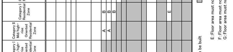

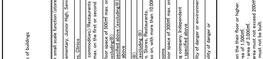
27 Table 3-1 Control of Building Use by Land Use Zones 22


28 Figure 3-2 History of Land Use Zones 23
29 3.2. History of Land Use Zones System The Land Use Zones system was introduced for the first time in 1919 by the enactment of the City Planning Law and the Urban Area Building Law 47. The zoning system started with three categories: Residential Zone, Commercial Zone, and Industrial Zone. The Quasi-Industrial Zone was added after that. In 1970, the categories increased to eight by introducing exclusive types of zones and were further divided into twelve in The historical progress is as follows: When the first zoning was introduced in 1919, the focus of city planning was infrastructure development such as roads and other public facilities. The zoning aimed to ensure that the private development directions would not be separated from the government intention on infrastructure development. The amendment in 1970 emphasized the rational differentiation of residential and industrial land uses to guarantee both quality of living environment and functionality of industrial production in the age of rapid industrialization. The industrial use was further divided into a series of categories of the Land Use Zones by floor area sizes of working space, horse power manufacturing equipment, or amount of hazardous materials in order to protect the residential environment, according to the characteristics of each zone. The use categories were subdivided into a gradation of quality level of residential environment. The amendment in 1992 was intended to separate office and commercial developments from residential uses after land prices skyrocketed in existing residential areas as a result of the huge pressure for office space development which earns higher rents than residential spaces. Office space demand was the result of the process of structural change toward a service-led economy. The strategy of reclassification intended to prevent the hollowing out of residential uses from central areas by introducing floor space limitation to office and commercial uses, as well as to cope with the post industrial age, in the same manner that the horsepower limitation to manufacturing uses was adopted in the industrial age. The density regulation limiting the floor area ratio in built-up areas was introduced step by step after Before introduction of the floor-area ratio, the density was indirectly regulated by the combination of lot coverage-ratio and height regulation. The building height was limited to 31 meters as absolute maximum for a long time until then, since Japan had been an earthquake-prone country. After the technological advancement of high-rise building construction concerning seismic resistance, the concept of floor area ratio was supported as a rational way to control density. The advantage in controlling density directly was giving more flexibility in designing buildings. Another reason was that a rational planning solution was expected in controlling traffic congestion. The floor area ratio as a rational planning approach with linkage to transportation and land use was expected to be a structural solution for increasing urban problems Method of Designating Land Use Zones The review of the Land Use Zones is conducted periodically based on the results of the Basic City Planning Surveys that cover all the City Planning Areas. The important principle is that such primary land use regulation as the Land Use Zones is always required impartiality in its enforcement. Spot reviews targeting particular areas are sometimes done. Such modifications, however, should be justified with fair and rational reasons such as widening of a major arterial road that runs through the area; a particular Land Use Zones needs to be revised because the special planning within the City Planning framework such as the District Plan comes to be formulated. Arbitrary modifications such as those based only on requests from landowners cannot be tolerated, because these actions are against impartiality. Ensuring impartiality is important in designating Land Use Zones. Lands with the same conditions should be regulated equally unless there are good enough reasons not to do so. Land use regulations limit the landowners right to use their own property. Therefore, in amending land use regulations, how to find the special condition or the ra- 24
30 tional reason that justify deregulation become the focus of implementing the planning system, and that is why the District Plan prevailed as will mention lately. The procedure of making the periodic review of Land Use Zones is as follows: 1) Local governments examine current land use in detail and its trend in the Basic City Planning Survey. In practice, a 1/2500-scale base-map is used and colored according to the use and the number of stories of extypes of studies are widely carried out in many cities and the number of cities isting structures. These which provide the result as GIS data has been increasing recently. As for commercial and office uses, in addition to the analysis of current conditions, studies on demand forecast may be conducted. 2) Previous to revision job, making policy on desirable land use allocation. Sometimes the policy is authorized by the City Planning Council 48. This classification includes location of the central business district and sub-core areas to be developed as high density built-up areas. Such policy directions are eventually reflected in Policies on Improvement, Development and Conservation that plays a role as a master plan. 3) Local government compiled detailed Land Use Review Guidelines. This document should contain detailed criteria to judge where should be modify the designation of Land Use Zones. It is expected that descriptions of the criteria are explicit so that combining data from survey described in 3.3.1) and the policies explained in 3.3.2) will automatically lead to the original draft of revision. Impartiality is ensured in these modification procedures. In reality, however, the details of criteria are different in each local government. 4) The draft of revision of the Land Use Zones is formulated through the procedures described above. However, all the original draft of revision need not be implemented immediately merely based on numerical data from the surveys, because land use regulations also have to be stable. The draft may be modified by citizen opinions after it goes through the legal procedure of public review 49 and hearing 50. Sometimes the designation of Land Use Zones is modified other than by the periodic revisions. Such cases of modification must be justified with clear and objective City Planning reasons explaining why a specific spot should be modilot of trouble caused by the deterioration of the environmental quality. Instead, a comprehensive development fied at specific time. Examples of such reasons are widening of major arterial road that runs through the area has been already underway, or in a particular area, specific Zones and Districts ought to be reviewed for consistency of planning because the District Plan is being formulated. Revisions of the Land Use Zones on an on-the-spot basis should be highly exceptional. In recent years, however, this type of modification has often carried out in specific areas within large cities, with the formulation of the District Plans or designated excellent development projects, upon the political movement toward deregulation since mid 1980s. The principle of national government is that merely and uniform deregulation on the floor area ratio should not be carried out, because the accumulation of intensive developments would go beyond the capacity of public infrastructure or raise a project, which could contribute to create a better living environment by improving public infrastructures or by provid- project. When an excellent development pro- ing open public spaces, can be considered an excellent development ject is formulated within the City Planning process such as the District Plan preparation, the Land Use Zones including regulation of floor area ratio could be changed. 25


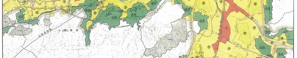
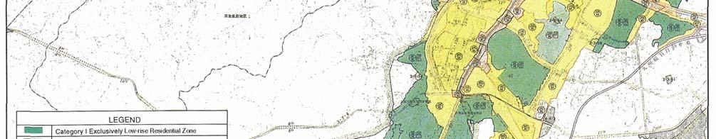
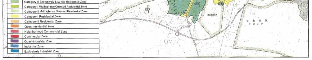
31 Figure 3-3 Map of Land Use Zones in Kita-Kyushu City 26
32 3.4. Land Use Zones and the Building Standard Law The regulation set forth in the Land Use Zones is enforced by the Building Confirmation process for building applications submitted by building owners. The bodies who confirm the application are the Building Officials in the local governments or the Private Building Inspectors in designated private companies. These are carried out based on the provisions of the Building Standard Law. For buildings that violate the Law, the Building Authority in local government may enforce it either by improving the building or by removing it. All the process is stipulated in the Building Standard Law. The Land Use Zones regulation determines the area, category, lot coverage, floor area ratio, and the minimum lot size (if necessary). Detailed subjects such as allowable use of buildings; specific method of height calculation; reduction of the floor area ratio at location where roads adjacent to the lot are narrow; and others are all determined by the provisions in the Building Standard Law. The shadow Restriction (regulations concerning the time when a particular building casts shadows to neighboring lots), also, has its basis in the Building Standard Law. Such regulatory standards are stipulated not in the City Planning Law but in the Building Standard Law, because the characteristics of the regulation are considered as the minimum requirements relating to nuisance. Other technical standards required for individual buildings are included in the Building Standard Law. Therefore, by the City Planning Law, types of the area in view of land use are classified in urban area through the designation of Land Use Zones; the Building Standard Law set each regulation standard in each Land Use Zones. The two laws area called paired laws since they are interrelated. The Building Standard Law is enacted for the purpose of providing minimum standards for buildings. The fact that regulations for Land Use Zones are stipulated in the law inevitably defines the characteristics of the Land Use Zones system. Also, it is the very reason the government may enforce it with using police power. In other words, the essence of building regulation by the Land Use Zones is to ensure minimum acceptable urban environment by avoiding unfavorable land use by each category of the Land Use Zones. In terms of legislation it can be said that the system is not a mechanism intended to lead to a desirable use of land. As the regulations on height of buildings are called slant-plane regulations, the more inner building site is located in the lot, the higher acceptable height of building can be. Buildings only need to be designed within the regulations. There are the regulations applied to ensure certain quality of environment outside the lot. Within the maximum three-dimensional space, which called a birdcage or a building envelope, the shape and design of a building is completely free. This means that a minimum environmental standard can be ensured by all the landowners observance of the same regulations equally applied to all the lands within the Land Use Zones. This is in compliance with the purpose of the Building Standards Law-- To specify minimum standards for buildings. In addition, it is not intended to actively create a beauty of urban landscape. Designation of Land Use Zones on the City Planning Map is the most fundamental job of urban land use planning in Japan. In view of planning, the Land Use Zones allocates uses and densities in the city with positive intentions and defines principle characteristic of each district. In view of regulation, however, the Land Use Zones specifies use regulation, density regulation, lot coverage regulation and slant-plane regulation as minimum standards for each building to avoid negative external impacts. The two administrations, which are the city planning and the building confirmation, are totally different because the purpose of the City Planning Law and the Building Standard Law is entirely different. But the minimum standards are not single but diverse according to the categories of Land Use Zones because it is rational that acceptable nuisance level is different by the characteristic of each zone. This logic combines planning and regulation. 27


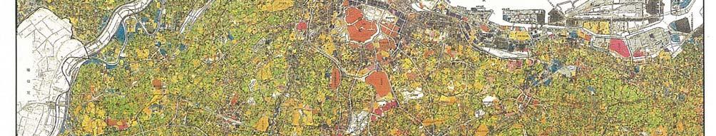
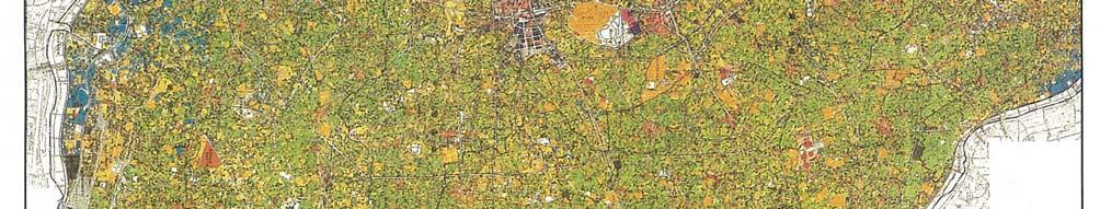
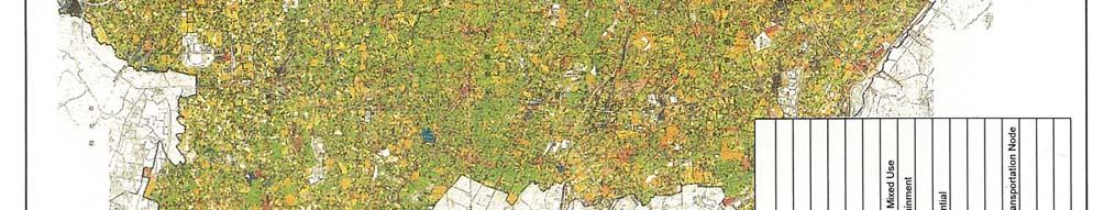

33 Figure 3-4 Existing Land Use Map of Tokyo 23 Wards 28


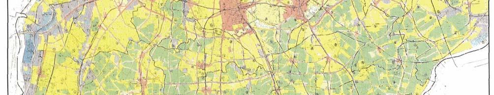
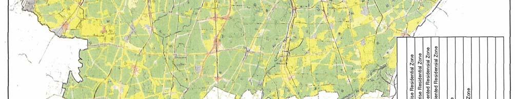

34 Figure 3-5 Land Use Zones Map of Tokyo 23 Wards 29


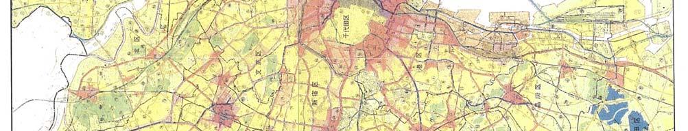
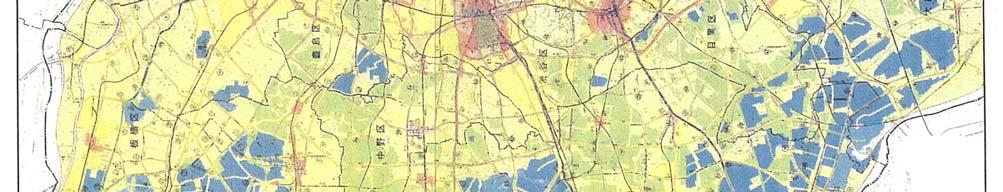

35 Figure 3-6 Floo r Area Ratio Regulation Map of Tokyo 23 Wards 30


36 Figure 3-7 R estrictions on Buildings in the Land Use Zones System Figure 3-8 Floor Area Ratio and Building Coverage Ratio 31
37 Table 3-2 Floor Are a Ratio and Building Coverage Ratio Regulations of Land Use Zones Category of Land Use Zones Maximum Ratio is chosen from the below listed figures Maximum floor area ratio to the site area, (FAR) % Maximum building coverage ratios to the site area, (BCR) % Category I Exclusively Low-rise Residential Zone 50,60,80,100,150,200 30,40,50,60 Category II Exclusively Low-rise Residential Zone 50,60,80,100,150,200 30,40,50,60 Category I Mid/high-rise Oriented Residential 100,150,200,300,400,500 30,40,50,60 Zone Category II Mid/high-rise Oriented Residential 100,150,200,300,400,500 30,40,50,60 Zone Category I Residential Zone 200,300,400,500 50,60,80 Category II Residential Zone 200,300,400,500 50,60,80 Quasi-Residential Zone 200,300,400,500 50,60,80 Neighborhood Commercial Zone 200,300,400,500 60,80 Commercial Zone 200,300,400,500,600,700,800,9 60,80 00,1000,1100, Quasi-Industrial Zone 200,300,400,500 50,60,80 Industrial Zone 100,150,200,300, Exclusively Industrial Zone 100,150,200,300,400 30,40,50,60 Areas where no Land Use Zones is designated 50,80,100,200,300,400 1) 30,40,50,60,70 1) Note1): Designated by the Building Authorities, not by the City Planning approval process. 32
38 Figure 3-9 Slant Plane Restrictions 33
39 3.5. Other Zoning Regulations In the City Planning, other additional zoning regulations are possible in order to supplement the Land Use Zones. The numbers of zoning categories vary and some of those are based on special laws other than the City Planning Law, and each of them is designated for specific purpose. These zonings are selectively applied as appropriate and are not required to cover all the Urbanization Promotion Areas. Some of them are discussed in this section. Special Land Use Districts are adopted to modify the use regulations in the Land Use Zones. For example, the case restricting the conversion of vacant industrial sites into condominium spaces in Industrial Zones prevents conflicts with the remaining industrial spaces. The same applies to deregulating traditional manufacturing shops, such as ceramic arts or weavings, in Exclusive Residential Zones to facilitate the production of traditional handicrafts in the region. The zone named Special Industrial District 51 is applied to these cases. The zone named Educational District 52 is also widely used in areas where colleges or universities are located. Recently, an overlapping designation of a certain kind of Special Land Use District on the Quasi Industrial Zone seemed spreading in local cities to restrain large-scale retail development in these areas for the purpose of protecting viability of the traditional town centers. On the statutory system, the zoning category which expresses the special purpose of the zoning and area is designated by the City Planning process according to the City Planning Law, while the modification of use regulation is legislated as a local ordinance according to the Building Standard Law. Height Control District 53 defines the maximum or minimum height of buildings. Examples include the absolute height limitation for prohibiting high-rises, and the slant-plane regulation concerning the north side of a lot with the purpose of securing sun-light to neighboring lots. Absolute height limitations have not been popular before the early 2000s, but recently it is gradually gathering support. Efficient Land Urbanization District is a type of zoning that promotes high-density land use in city centers by imposing regulations and proving incentives. In this case, the ratio of open space within a lot for the purpose of creating spaces open to the public within a private lot would be increased through the reduction of the Building Coverage Ratio and the setback regulation from front lot lines. In addition, the limitation on floor-area ratio would be increased as incentives. In these target areas, Urban Redevelopment Projects are simultaneously carried out to enforce the construction of sound high-density buildings. The Japanese urban areas traditionally consist of many small wooden structures and their centers are densely populated, so that a large earthquake may trigger simultaneous, extensive fires. Fire Protection Zone 54 and Quasi-fire Protection Zones 55 are special zoning categories designed to mitigate the vulnerability of spread of fire in built-up areas and to secure the safety of major evacuation roads in case of an extensive fire due to big earthquakes. Buildings in the districts must be fully fire-resistant or quasi-fire-resistant. Parking Place Development District 56 requires office or commercial buildings to be equipped with minimum number of parking lots in proportion to their total floor area. Port District 20 has special land use regulation applied based on the Harbor Law. In these districts, port authorities may designate special land use zonings for the purpose of management and operation in the harbor area by local ordinance. In case of the special land use zoning is designated, the regulatory standard of use is replaced to the ordinance instead of the Land Use Zones regulation. Productive Greenery District 43 is designated in the Urbanization Promotion Areas (UPA) to conserve farmlands for a certain period as a kind of open space in urban areas. The minimum size of a Productive Greenery District is 500m 2. In these zones, property tax is significantly reduced in comparison to other areas within the UPA, but the landowners have the responsibility to maintain their lands as farmland at least for thirty years. Historic Townscape Preservation District 16 aims to preserve historically valuable streetscapes. The districts possess many historical old buildings that are not in compliance with limitations based on the current regulation of the Building 34
40 Standard Law. Therefore, by ordinance, on one hand, the modifications of current setting are restricted and on the other hand, general provisions of the Building Standard Law are partly waived Shadow Restriction The Shadow Restriction 57 regulation was introduced in It aims to address the occurrence of frequent conflicts regarding impediment of sunlight by mid-high rise condominiums constructed within existing low-rise residential dis- legally provided option of 3 to 5 hours set in regulations of tricts. The regulation is based on the Building Standard Law. Wooden two-story buildings have traditionally been composing Japanese urban areas. The economic boom witnessed the beginning of the construction of mid to high-rise condominiums, which often caused conflicts with residents of existing low-rise houses. Especially, the Japanese people pay significant consideration to daylight on the southern side of their lots. The mechanism of the Shadow Restriction is as follows: as to the shade caused by medium-high-rise buildings to neighboring lots, the shading time between 8 a.m. and 4 p.m. measured at the height of 4m (in the cases of Category I and II Exclusively Low-rise Residential Zone, the height 1.5m) on the day of the winter solstice must be longer than certain standard in proportion to the distance from the land boundaries. The standard for the shading time, in the case that Category I Mid/high-rise Oriented Residential Zone is exemplified and that the distance from the lot boundaries is between 5 to 10m, the shading time is decided by choosing local governments. Te shadow restriction is applied to areas selected by ordinance of local governments. Commercial, Industrial and Exclusively Industrial Zones, however, are ruled out by Building Standard law. Figure 3-10 Shadow Restriction 35
41 4. Promotion of Efficient Land Utilization Efficient Land Utilization and Urban Renewal Even in the midst of metropolitan areas in Japan, there are areas where small wooden structures congest densely. The areas with such kind of structures are fire hazards and are economically inefficient. To improve this unfavorable situation, the government has promoted a policy so-called Efficient Land Utilization by demolishing the small structures and constructing high-rise buildings, providing effective open spaces in their lots. (c.f. 4.1) In the Efficient Land Utilization policy, incentive systems such as deregulation are implemented for the purpose of inducing forms of high-rise buildings by private investments. Incentives by raising floor-area ratio may be given according to contribution to improvement of the quality of urban environment, such as constructing a plaza or sidewalks in their lots, to provide public amenity. (c.f. 4.2) The Urban Renewal Policy has strategic approach with statutory planning system. It consists of the Urban Renewal Program as a specific master plan focusing on urban renewal, the Efficient Land Utilization District as a regulatory system with incentives, and the Urban Redevelopment Project as an enforcement measure with compulsory execution power by law. All the measures included in the Urban Renewal Policy are subject to City Planning Decision 58 ; however, their legal base is stipulated in the Urban Renewal Law. (c.f. 4.3) The District Plan with the Redevelopment Promotion District 59 (former name is the Special District Plan for Redevelopment 60 ) is a strategic planning system to induce coverting abandoned sites of old factories and railway yards to high-density mixed-use deve lopment areas. Urban infrastructure and urban design items that contribute to improvement of the area are determined in the City Planning as conditions of development. The projects are mainly used as large-scale urban redevelopment projects carried out by the private enterprises. (c.f. 4.4) The Special District for Urban Renaissance was introduced by the Special Law for Urban Renaissance in This system is available only in the specific areas designated by the National Government. Its most significant feature is that the deadline of planning decision was established as a statutory obligation for local governments in response to the planning proposal by private enterprises. (cf.4.5) 4.1. The concept of Efficient Land Utilization Consolidating small lots into a large lot, with fire-resistant high-rise-building and open spaces within the lot, this is a unique concept called Efficient Land Utilization in Japan. It has been promoted by the government since the late 1960s. Low-rise wooden structures have been densely constructed in the inner city areas of metropolitan regions. The reason for such condition is that Japan s traditional construction method has been the wooden frame structure. Buildings with a stone wall, as in European architecture, were rare. In addition, highly dense residential districts in central areas of traditional cities consist of small wooden houses. As a result, residential lots were quite small and the roads were extremely narrow. Such urban form is traditional so that, in the case of Tokyo, for example, it was commonly seen since the Edo Period (between the 17 th and 19 th century). The most hazardous problem of such urban form is its vulnerability to wide-spreading fires. If a fire breaks out in areas where buildings and houses are densely placed, it may spread easily and often cause a terrible disaster. Earthquake-caused fires are highly hazardous because they can happen at the same time in different places, and they may reach uncontrollable proportions as what happened in the Hanshin earthquake. On the other point of view, since the height of wooden buildings is low, the intensity of land use is also limited though the area is densely congesting. 36
42 When the districts located near the central business district, land, as a limited economic resource, is not effectively used to maximize its potentiality. A solution that overcomes these problems is the following urban form: Urban infrastructures, such as roads with sufficient widths, parks and squares, are in a sufficient level. Building sites are effectively used by relatively large buildings with fire-resistant structures Ideal buildings to overcome the weaknesses in Japanese urban centers shall have the following characteristics: Both the site and building are relatively large. Public open spaces, such as plaza and sidewalks with some amenities, are provided within the building lot. Figure 4-1 Land Area Privately Owned per Capita in Tokyo 23 Wards m year Figure 4-2 Land Area Distribution Privately Owned in Tokyo 23 Wards (Jan.2005) 10% 7% 3% 2% 46% 32% Less than 100 m2 100~200 m2 200~300 m2 300~500 m2 500~1,000 m2 1,000 m2 or more 37
43 Figure 4-3 Devastated Areas by Hanshin-Awaji Earthquake JR Takatori Station Area in Kobe City 38


44 Figure 4-4 Concept of Incentive for Efficient Land Utilization Figure 4-5 Image of a Building by the Permission System for Comprehensive Building Design 39
45 4.2. Incentive System The extra floor area ratio may be given if the plan of development project is excellent for improving urban environment with providing public open spaces at a cost of developers. The methodology was initially introduced in New York City as a system called incentive zoning. Such incentive is effective on private developments, especially office development in a central business district, since the more floor area there is, the more profitable the project becomes. There are two major systems to facilitate efficient use: the Specified Block based on the City Planning Law and the Permission System for Comprehensive Building Design based on the Building Standard Law. The Specified Block 61 is a system that defines the maximum floor area ratio, the maximum height, and setback regulations. The extra floor area ratio will be given on condition that the design allocates public open space to improve the urban environment. The Permission System for Comprehensive Building Design 62 targets mainly relatively large lots, not necessarily the whole block. Upon an application by a developer, a proposed building may exceed the maximum floor area ratio designated in the Land Use Zones through the design examination process by a Building Authority of local government to secure open space within the lot to improve urban environment. The system is popular because its application process is relatively simple Other than these systems, the City Planning includes the Efficient Land Utilization District as the Zoning system and the Redevelopment Promotion District as the District Plan System. The District Plan with Floor-area Ratio by Use 63 of buildings is a type of the District Plans with incentives for residential development. The incentive serves to deal with the population hollowing out from the central areas in the metropolitan areas of Tokyo and Osaka. The bonus floor area is given according to the contribution to housing supply which depends on the ratio of residential units of the building. Such measure is prepared on the Living in the Center policy to stimulate interest in residential floors that are not as profitable as office or commercial floors. The increase in density is justified considering the different impacts of residential and office or commercial uses on traffic and other public infrastructure Urban Renewal Policy Structure The Urban Renewal Law is a law for the systematic and practical implementation of policies to renew existing built-up areas of large cities and to promote a rational, sound and efficient use of land. The law contains strategic measures for various levels of planning on urban renewal. The measures are systematically structured that are the Urban Renewal Program as a specific master plan for urban renewal, the Effective Land Utilization District and the District Plan Systems as regulatory incentive measures, and the Urban Redevelopment Project 64 as a measure for execution. 40

46 Figure 4-6 The Scheme of the Urban Renewal Law Urban Renewal Program The Urban Renewal Program is an integrated master plan that promotes urban redevelopment. It indicates and author- strategies to promote them. The Urban Renewal Law izes specific areas for redevelopment with the corresponding requires twenty one remarkably populated cities to decide the Urban Renewal Program as part of the statutory master plan called the Policies on Improvement, Development and Conservation. The program consists of two stages. First, the Urban Area on item (1) is generally required to be designated in areas where some redevelopment actions are needed. Item (1) means that it is stipulated in article (2-3) item 1 in the Urban Renewal Law. In these areas, proper urban problems and corresponding strategies have to be described in the plan. The actions need not necessarily be redevelopment projects, but can be rehabilitation or sequential reconstruction of individual buildings. Next, within the Urban Area on item (1), the District Designated by Item (2) is defined to indicate areas where a redevelopment project should be intensively promoted. These areas are equivalent to the so-called the Action Areas. The Urban Redevelopment Projects, which have execution power to enforce the projects, are expected to be implemented in these areas. The Urban Renewal Program is included within the Master Plan framework. In the process of formulation, problems and ideal visions are presented to residents. The program preparation process facilitates consensus building among residents. Also, the Program is a practical tool for policy implementation Efficient Land Utilization Districts The Efficient Utilization Districts promote high-density land use with incentive as well as regulate low-density utilization of land. Generally, the Efficient Land Utilization Districts are designated within the District on Item (2). 41
47 The functions of the Efficient Land Utilization Districts are as follows: To provide open spaces, such as plazas or sidewalks, by setting a lower building coverage ratio and a setback requirement from the front lot line; To set a minimum floor area ratio and a minimum building area for the purpose of prohibition of non-efficient use of land; To set a higher floor area ratio than the figures specified in the Land Use Zones to motivate a higher density development; and; To allow the implementation of Urban Redevelopment Projects with the power of execution, since the need for redevelopment for public purposes is clearly set in the zoning designation. Generally, the Efficient Land Utilization Districts are areas where small wooden structures are densely built, although there are those in advantageous locations such as being close to major transportation nodes or in town centers. These physical conditions not only serve as fire hazards, but the advantages on location of the area are inefficiently utilized. That is why the promotion of redevelopment projects with regulation and enforcement is reasonable and justified. Table 4-1 Regulation and Incentives in Efficient Land Utilization Districts Item Maximum Floor-Area Ratio Minimum Floor-Area Ratio Maximum Building Coverage Setbacks Minimum Building Area Content Floor Area Ratio more than the Land Use Zones regulation can be designated (incentive) Prohibit low-density uses Create sufficient open spaces Provide plaza or sidewalk that is open to the public Prohibit small-scale buildings Urban Redevelopment Project Urban Redevelopment Projects are an active method of implementing intensive land use. The projects are implemented through the process of the City Planning with the power of execution granted by law. Special tax measures on property right exchange are given and the cost of research and design, demolition of existing buildings, public facility development, and common use structure development are subsidized by the public sector including the national govaddition, an- ernment. However, the Urban Redevelopment Projects are available only in three areas such as the Efficient Land Utilization Districts, the Redevelopment Promotion Districts, and the Special Districts for Urban Renaissance. In other condition is required such as 1) the percentage of wooden structures is so high that the condition impairs spatial health and fire safety, or 2) the actual floor area ratio is too low to optimize potential utilization. The justification for implementing Projects with restricted private property rights is based on the City Planning because the government is responsible for improving the city and making it efficient, functional, and disaster-free. The statutory Urban Redevelopment Projects have two types. Type I projects proceed by exchanging property rights of landowners to part of a floor area of a newly built high-rise building. In this case, the funding for the new building is procured by selling part of the building because its floor area becomes larger due to the increase in density. In Type II projects, a local government or approved specific company as an implementation body of the project can declare buildings as compulsory redevelopment sites. After the construction of new buildings and the improvement of the physical conditions of the area, the property may be retransferred to the original owner. Type II can be applied only in urgent cases to remove hazardous conditions for disaster prevention or to develop major public infrastructures. 42


48 Figure 4-7 Property Right Exchange System Source: Housing in Japan Ministry of Land, Infrastructure and Transport Figure 4-8 Example of Urban Redevelopment Project JR Ashiya Station North District Source: Housing in Japan Ministry of Land, Infrastructure and Transport 43

49 Figure 4-9 Map of Urban Renewal Program : in Yokohama City (As of 2007) 44
50 4.4. Redevelopment Promotion District in District Plan The Redevelopment Promotion District, which was called Special District Plan for Redevelopment until 2000, refers a special planning unit in the District Plan system for the purpose of comprehensive and flexible planning approach on drastic land use conversion. The most typical case which fits the system is a redevelopment project converting large vacant sites, such as former industrial sites or railway yards, to a high-density use area such as offices or mixed-use complexes. In general, large industrial sites are designated with a low floor area ratio on the premise of general industrial uses so that the land use regulation needs to be changed. Existing infrastructures or public open spaces also need to be converted from physical distribution centered style to fitting for attracting large number of people. Therefore, integral planning approach including infrastructure and public open space development and land use deregulation is necessary to make appropriate place for intensive new activities. The Redevelopment Promotion District System has been applied for many redevelopment projects and contributed to the regeneration of abandoned lands into functional and attractive urban places. It was introduced as an advanced planning system to induce urban redevelopment by using private sector vitality, because the system provides a platform for public-private partnership through negotiation between the City Planning authority and private redevelopment bodies. Private developers appeal for deregulating the zoning regulations, especially to increase floor area ratio. The City Planning authority, meanwhile, demands the development of necessary infrastructures and contributions to the public interests in the planning scheme. The negotiation aims for a win-win situation, whereby physical improvement will be carried out by private investments, making the site of the project more attractive. The major public facilities, which generally called the Item II Facilities because it is stipulated in article (12-5) section 4 item 2, are the unique key concept of the Redevelopment Promotion District, which means indispensable infrastructures or public open spaces that secure an adequate and sound condition after project completion through conversion of land use and increased floor area ratio. In other words, the most important condition is that the Item II Facilities are prepared before converting to intensive land use. The location of major public facilities (Item II Facilities) clarifies the placements of urban infrastructures that are necessary for high-density and new use that generates intensive activities of people. Building authority of local government reviews the application of construction. The minimum requirement of processing a Building Authorization is obligatory development of public facilities. In the case of development projects by the private sector, the developers are responsible for bearing the cost of development so that profit derived from their development will be properly redistributed to society. The Redevelopment Promotion District also provides details on the location of the District Facilities such as relatively small roads and pedestrian ways, and on regulations for buildings such as floor-area ratio, height, and site design. Especially, the maximum floor-area ratio is set substantially higher than the ratio specified in the existing Land Use Zones. The Redevelopment Promotion District is viewed as a conditional zoning. It may allow higher-density development in one area where the Land Use Zones regulation specifies lower density. Technically, however, the floor area ratio being specified by the Land Use Zone remains in force even after the Redevelopment Promotion District is adopted. One of the examples is an industrial zone where the maximum floor area ratio is 200%. Without modifications, a Redevelopment Promotion District defines the same area for commercial or office use with a floor area ratio of 600%. A redevelopment project which exceeds 200% floor area ratio will not be permitted unless additional conditions such as the development of Item II Facilities are satisfied. In other words, the developer is required to satisfy the specified conditions by their own bearings in planning framework if they want to get a 600% floor area ratio. This technique is called conditional planning system. 45


51 Figure 4-10 Negotiation in the Process of the Redevelopment Promotion District Making an agreement on public-private partnership through the City Planning process requires innovative approaches. In general, the procedure is as follows: First, a local government and a private developer negotiate with each other, and the developer prepares the planning brief. Based on the brief, the City Planning Decision process takes place. The brief includes an explanation of the positive effects that will benefit the public and the mitigation measures for negative impacts on the surrounding environment. The brief becomes an agreement on the project, and, finally, it is secured to be carried out through the permission process by the Building Authority. The system was introduced through the deregulation policy and private investment utilization policy in the late 1980s. It was during this period that the Japanese economic structure began to shift from heavy industries to service industries including finance and information technology. Such structural change generated idle industrial sites in urbanized areas including near city centers. Moreover, the change in the modes of transportation, such as the use of containers, eliminated the necessity of large railway yards and narrow harbor facilities. At the same time, such large sites were provided cities with precious opportunities to create vital and attractive places for new industries and midtown residences. Rising private developers or real estate companies which have become large competitive industry players became in charge of the private projects. It can be said that the Redevelopment Promotion District system had met the historical demands in the beginning of the post industrial economy. 46
52 4.5. Special District for Urban Renaissance The Special District for Urban Renaissance is a further incentive system introduced through the legislation of the Special Law for Urban Renaissance in This system is available only in Urgent Improvement Areas for Urban Renaissance which are designated by the Cabinet. This system is closely related with national policy initiatives. The Urban Renaissance Policy was introduced as one of the most prioritized policy of the Cabinet in 2001 with the political initiative of then Prime Minister Junichiro Koizumi. The purpose of the policy is to regain the nation s competitiveness by stimulating economic energy as well as creating new attractiveness in urban areas. As soon as the Urban Renaissance Headquarters was organized in the Cabinet, it began to advocate that public investments should focus more on major urban areas where people, industries, and activities concentrate. In fact, during the past administration, the Growth with Balance in the Whole National Land policy, which facilitates public investments in every part of the country, has dominated for a long time. As a result, urban areas, including metropolitan regions, were placed in a relatively disadvantageous position despite their large populations or contributions to the national economy. Therefore, the Urban Renaissance Policy advocates that now is the time to transfer manpower and money to urban areas. It must be one of the structural reforms the Koizumi Cabinet pursued. Considering further the background of the Urban Renaissance policy, it is certain that its short-term goal was to get through a decade of recession after the bubble economy burst, which brought about a huge imbalance in the national economy, that is between the soaring prices of lands and stocks as against sound economic fundamentals. However, seeing it from a longer historical point of view, it is more of a strategy to create a social framework in the post industrialization age. The Urban Renaissance Headquarters recognizes urban areas not only as fundamental sources to maintain economic power, but also as spatial fields where most of the people would find their ideal quality of life. The scheme of the Special District for Urban Renaissance consists of two parts: the planning proposal by private developers and deregulation on planning. In the areas designated previously as the Urgent Improvement Areas for Urban Renaissance by the Cabinet, private developers are allowed to make flexible plans for the Special Districts for Urban Renaissance. In this case, existing planning regulations will not be adopted. After the proposed plan is filed, the local government is required to make their decision in response to the proposal. If the local government agrees with the proposal, the amended regulations as the Special District for Urban Renaissance have to be authorized by the City Planning Decision procedure within six months. Otherwise, the local government, after discussing with the City Planning Council on the decision, notifies the developers that the proposal was rejected with the reasons. On the deregulation part, the difference in the regulatory contents between the Special District for Urban Renaissance and other incentive systems is only in the flexibility of use regulation, which is rather technical, in fact. The essential part of the system is supposed to be the six-month legal deadline. This provision requires a particularly quick agreement with the local authorities, which private developers desire most Transfer of Floor Area Ratio The transfer of floor area ratio between sites is a technical solution to ensure effective land use. It is not used as a common measure but is sometimes used strategically on specific sites or areas, especially in the case of the preservation of landmark buildings and the pursuit of high-density utilization. The theory of transfer may be justified only as an integrated planning approach. The designated floor area ratio is not a legal right of land owners but merely as a regulation to restrict the utilization of building sites. Therefore, the cases wherein the transfer of floor area ratio are allowed should be limited to the following two conditions: one is the case when two or more buildings are regarded as built on the same site, and the other case is when two or more buildings are planned subject to one integrated planning. Based on the statutory system in Japan, the former case deals with the integrated design of buildings in one site which is provided for in Article 86 of the Building Standard Law. 47
, 2) the District Plan for attaining the allocated density within the district (introduced in 1991), and 3) the Special FAR Application Zone which is an exceptional")

53 The latter case evolved step by step, as follows: 1) the Specified Blocks consisting of two adjacent blocks covered by one planning strategy (introduced in 1986 by a Ministry of Construction guidance), 2) the District Plan for attaining the allocated density within the district (introduced in 1991), and 3) the Special FAR Application Zone which is an exceptional measure of the Land Use Zones system (introduced in 2000). They are all provided as detailed planning mechanot commonly used so nisms. The actual implementation is based on preserving traditional landmark buildings in central district so that it is far. Figure 4-11 Image of Special FAR Application District Figure 4-12 Image of Redevelopment Promotion District Seiroka Garden District 48

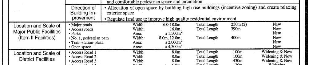
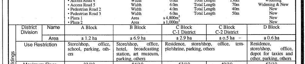
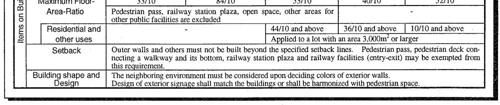
54 Figure 4-13 Example of Redevelopment Promotion District (Planning Document) in Roppongi Hills District 49


")
55 Figure 4-14 Example of Redevelopment Promotion District (Planning Map) in Roppongi Hills District 50
56 5. The District Plan Characteristics of the District Plan The District Plan is a statutory tool for a comprehensive and detailed planning on a district scale. The area of the plan is about 10 hectares on average, but it ranges from 1 to 100 hectares. The progress of the District Plan has been one of the most significant periods for City Planning in Japan, not only for its popularity but also for the progress of the statutory planning system. The District Plan System has two major purposes: one is the pursuit of a comprehensive planning approach focusing on a district scale which covers several hectares. The other is encouraging a participative or collaborative planning process with land owners and residents in community development. The planning body is a municipality, and the decision procedure, including public participation with concerned people, is provided in the municipal ordinance. Some municipalities also include provisions for accommodating planning requests of land owners or residents to facilitate a community-oriented planning process. A District Plan consists of a Policy Direction which means a visionary part, the District Facilities which means locations of relatively small roads, parks and public open spaces, and the Building Regulations on use, density, height, shape, lot coverage, minimum area of the site, setback requirement from lot line, and design codes including color, fence and so forth of buildings. Regulatory items are selectively used according to necessity. The District Plan may approve every area in the City Planning Areas including the Urbanization Control Areas. Building Regulations are secured originally by a recommendation of the municipal authority on building notification file. But in case that they are enacted as the building codes in the municipal ordinance with additional procedure, the enforcement power will be strengthened based on the Building Standard Law. The District Facilities are also enforced in the Land Development Permission process. The District Plan regulations are overlaid on primary zoning regulations such as the Land Use Zones or the Urbanization Control Area. As statutory issues, the legal relationship between the regulations in the District Plan and those in other systems is technically complicated, because in case of two different planning regulations are adopted on the same building site so that statutory provisions for legal adjustment is needed. Ironically, in solving those complicated problems as legislative issues, many special types with special name of District Plan have been created as planning solutions for up to date problems such as land use conversion of former industrial sites, housing supply in the central districts of metropolitan areas, and vitalization of rural settlement in the Urbanization Control Areas, The District Plan system itself has progressed as a result District-scale Approach The District Plan is a statutory tool for a comprehensive and detailed planning on a district scale. It aims to enhance the characteristics of each district with a detailed and deliberate planning. District-scale approach, ranging from several to thirty or forty hectares in general per unit, is the proper identity or characteristic of the planning system. Town-scale approach, such as the Land Use Zones or the Arterial Road Network Planning, is not able to cover detailed planning in these scales in view of ensuring impartiality of regulation on each sites within the same zone or necessity of compulsory purchasing for the town-scale significance, as well as the site planning approach, such as the design of buildings, is not able to control the characteristics of the district. 51


57 Figure 5-1 Structure of District Plan Proposal Actually, the Land Use Zones deals with several hectares as one unit and uniformed regulations have to be applied to every building site in the area with impartiality. As a result, the Building Authority judges the site plan by regulatory codes which represent the town planning approach. It is unable to affect the proper manner or order on each building design without the detailed codes in the district. District means neighborhood size. Actual areas of the District Plans are about 10 hectares on average, but their range varies from 1 to 100 hectares. As to technical standards to adopt a District Plan, the City Planning Law stipulates that: The District Plan shall include provisions on existing conditions and future visions of public facility improvement, building construction and other land use, and shall be prepared to ensure the urban functions concerning disaster prevention, safety, public health and so forth in each block. It shall be prepared in a way the characteristics of the district are enhanced and the rational use of land will be exercised in order to create or preserve the quality of environment by incorporating the district s characteristics. The plan shall be determined to guarantee orderly development activities, building construction, and facility improvement. (Article 13, Section 1, Item 14 in the City Planning Law) Components of the District Plan The District Plan System has two major purposes: one is a comprehensive planning approach on a district scale, and the other is the participation of land owners and residents in planning or community development. On the comprehensive planning approach, the system has two distinguishing characteristics as a planning tool: structure of the document, and variety of the regulatory items. The planning document of the District Plan is classified into two parts: a visionary part called Policy Direction, and a regulatory part called District Improvement Plan. Policy Direction is the visionary part of the plan describing planning policy such as future images or strategies while not affecting legal rights to land uses. The document generally includes goals of the plan, direction of land use, direction of district facilities, and direction of buildings. Goals of the plan describe the purpose of the plan, current issues and future images. District facilities means small roads, parks, and open spaces which contribute to neighborhood service or environment. Direction of buildings describes, for example, setbacks to enlarge spaces for pedestrian and design policy for landscaping. 52
58 District Improvement Plan is the regulatory p art of the plan. It is further divided into two parts: locations of district facilities and regulations on build ing design. Locations of district facilities use documents and maps. The document part describes the widths and lengths of the access roads that should be improved, the area of small parks and greenery spaces that should be located or preserved, and the areas of other public open spaces such as footpaths or plazas in the building sites. The map part shows their location. It affects the actual site plans as a standard on the Land Development Permission and a guideline on the designation of road location by the Building Authority. Regulations on building design are mainly intended to control the design of the buildings in a certain manner based on the proper characteristics of the district. The regulatory items that can be specified in the plan are various kinds, such as limitation of usage, minimum or maximum lot coverage, minimum or maximum floor area ratio, minimum lot size, setback restrictions, minimum or maximum height, shapes or exterior designs such as color, façades, prohibition of brick walls in front of the access road, and so forth. Conservation of existing tree clusters may also be specified. However, it is not necessary to designate all of these regulatory items in one planning. They may be used selectively according to necessity, purpose, or characteristics of each district. It is acceptable even if there are no regulatory items but only the visionary part is included. In these areas, regulations are expected to be approved step by step as consensus among residents is built. A Comprehensive but Flexible approach enables adaptability for every type of districts Participation Framework As for the planning body, a District Plan is decided by a municipality, because spatial planning on such scale should be the responsibility of municipal administration. Drafting of the plan is also its task. Actually, not a few are drafted by municipal administration staff. However, the rest are drafted by developers, land owners or residents. In cases of a plan drafted by residents, the number of municipalities that dispatch planning experts to the resident s group through public expense is increasing to facilitate voluntary actions on community-led planning. The municipal ordinance plays an important role as well on the District Plan system. The drafting procedure including the collection of opinions from relevant people is delegated to municipal ordinances by the Law (Article 16 Section 2 in the City Planning Law). Some municipal ordinances also include provisions on procedure for planning request by land owners or residents (Article 16 Section 3 in the City Planning Law). Regulatory items which are designated in the District Improvement Plan may be issued as municipal ordinances after the plan is determined so that the enforcement power is strengthened (Article 68-2 in the Building Standard Law). Encouraging participation or collaboration in the planning process is another important purpose of the planning system. In this respect, the request procedure (Article 16 Section 3) or the planning proposal procedure (Article 21-2) plays an important role. For instance, another system called the Building Agreement by land owners is also often used for the purpose of preservation of good urban environment. So the Building Agreement is able to use similar purpose as the District Plan. However, there is a significant difference between them from a legal point of view, and both systems have their respective advantages and disadvantages. As for the Building Agreement, it is no more than a private contract among its members. The advantage of the Building Agreement is that it is based on the voluntary will of each land owner. Its disadvantage is that not all land owners in the district may have participated in it and is not binding for nonmember land owners even though their compliance with it is needed just the same. As for the District Plan, it is a public regulation on administration. Its advantage is that it is enforceable on all land owners, whereas disadvantage is that it is not necessarily a voluntary agreement for each land owners. Therefore, providing a procedure framework as an official system is important to encourage bottom-up planning actions. 53
59 5.4. Progress of District Plan System The progress and prevailing of the District Plan is one of the most important epoch making event in the recent history of City Planning in Japan. It was introduced as a statutory system in In the late 1970s, when the Japanese economy had caught up with the industrialized nations in gross amounts, the people s interests moved from quantity to quality of the environment as income level grew. On spatial planning matters, something that enables participative grass rooted approach or design oriented approach was needed. The concept of the District Plan system in Japan was affected largely by the German planning system known as B-Plan (Bebaunungs Plan), which enables planning regulation as if the building shapes were actually built. In fact, the Government, in both the bureaus of City Planning and Building Administration, were interested in the German system as a model. Actually, the District Plan system resembles the B-Plan system, while the Area Division system and the Land Use Zones system resemble the French system. However, the most fundamental difficulty on the legal aspect is the relationship between the District Plan and the Land Use Zones. In view of a planning mechanism, it may be considered that the regulations in District Plan may be a tailor-made rule, while those in the Land Use Zones may be a ready made rule. Accordingly, once a District Plan is approved, it is considered as natural that the regulations in the District Plan should replace the regulations in the Land Use Zones. In view of legal legislation, however, the situation is entirely different. Regulations in the Land Use Zones are the minimum requirement which is absolute, while those in the District Plan are voluntary requirement that should be added to the minimum requirement. Based on this logic, it is not possible that the voluntary requirement replaces or undermines the minimum requirement. As a result, the District Plan was legislated as an additional regulation overlaid on the Land Use Zones regulation and should not undermine the latter. Moreover, the enforceability power of the District Plan was set at a lower level than the Land Use Zones because it requires more than the minimum requirement. The statutory power of the District Plan was only recommendatory from the planning authority unless the regulations of the District Plan is legislated as a building ordinance. The situation changed in the late 1980s. The first breakthrough was the legislation of a technical system called District Plan for Redevelopment in 1988, which was later changed to Redevelopment Promotion District in the District Plan. Within the District Plan for Redevelopment, two different values of floor area ratio limits are designated simultaneously, which are the ratio that suits current situation as the FAR of the Land Use Zones and the ratio that suits after improvement condition of infrastructure such as major access roads as the FAR of the District Plan. The asto high-density, mixed-use developments. surance system depends on the permission granted by the Building Authority instead of a building confirmation. Based on different condition of infrastructures, the regulation of the District Plan could undermine the regulation on the minimum requirement of the Land Use Zones. Another way to undercut the general regulation is the theory of equitable change of regulation. For example, the FAR acceptable for all uses may be loosened up by limiting the uses, which has less impact on infrastructures such as housing. This was realized when the legislation on an Urban Housing Development Promotion-type 65 District Plan was passed in Moreover in 1993, the legislation on a Building Shapes Coordinating-type 66 District Plan was approved, which may repeal the slant line regulation by introducing setback line and height limits. Through these regulatory innovations in the District Plan system, urban planning had got some strategic arms to solve or ease certain kinds of problems that occur in urban areas. Actually, the District Plan for Redevelopment contributed to accelerating effective land use conversion from vacant industrial lands Similar application on the remaining farmlands in the Urbanization Promotion Areas contributed to developing access road networks and preventing a disorderly urban form. Urban Housing Development Promotion-type District Plan contributed to the repopulation of the central areas in the metropolis. 54


60 In the course of innovation of the District Plan system, the strategic measures for urban planning have progressed as well. In summary, it was sort of a deregulation technique that evolved in the process of detailing the regulation and which inspired the planning itself. Deregulation should not be executed uniformly or indiscriminately, but should be implemented with a focus on development with strategic planning. That is one of the most important instructions that could be learned from the experiences of Japan. Figure 5-2 Variations of the District Plan 55


")
61 Figure 5-3 Example of District Plan Document (Planning Document) 56


62 Figure 5-4 Example of District Plan Document (Planning Map) Figure 5-5 Photo of the Honmachi District 57
63 6. Recent Topics 6.1. Landscaping Landscape is one of the most important issues in spatial planning, and it requires regulation. However, the regulatory approaches for landscaping in Japan had been extremely limited. Some statutory regulations, such as designations as Beauty District to preserve excellent townscapes, Historic Townscape Preservation District to conserve traditional townscape as a cultural heritage, Scenic District to preserve the greeneries surrounding the urban areas, and so forth, were provided, however, they were applied mainly to special districts with unique characteristics. It was only in the 21st century that an all-embracing law, the Landscape Law 67, was legislated. The most unique characteristic of the Landscape Law, from the legal viewpoint, is that it subsumes local ordinances. In Japan, political attempts using landscape as catchword emerged in the form of legislations initiated by mayors or governors. This trend has increased since the late 1980s when the long construction boom cooled down and the people began to take interest in affluent environments. Until 2004, 15 percent of municipalities and 57 percent of prefectures had their own ordinances on landscaping. Considering this situation, the national legislation of the Landscape Law made a new departure in legislative technique that focused on the empowerment of existing local ordinances with a great variety of measures and objectives. The Landscape Law was promulgated in By the late 1990s, the number of foreign tourists visiting Japan accounted for only a quarter of Japanese tourists going abroad. The Government promotes tourism with a Visit Japan policy to diminish the imbalance and increase the number of foreigners who are familiar with Japan. Simultaneously, we should pay attention that an attractive townscape is significant not only to tourism, but also to a better quality of life of the residents. Good townscape may be an indicator of good urban environment as a whole Planning Proposal in the Statutory Process City planning makes an administrative plan with regulatory effects. The planning body is a public authority. Originally, the plan was made as a public decision providing land use regulations and authorizing infrastructures that must be developed to realize the most desirable future. In principle, the desirable future is approved in the form of a master plan or a comprehensive plan, which is based on thorough research and due process. After the initial plan is made, the job shifts to the management of the plan, including its amendment. In general, the plan is reviewed periodically based on thorough research and due process. It should be noted, however, that planning does not work well only by the administrative approach. Since the public authority must always consider public interest and impartiality, it cannot easily carry out the task of amending the regulations if there is no obvious public interest in it. As a result, land use regulations tend to be static. To make planning more flexible as well as democratic, it is more effective to encourage private initiative as part of the due process of amending resolutions. The requests of land owners, residents, private developers, and nonprofit organizations should be discussed openly and officially, even if these are not necessarily compatible with the master plan. The important point is making planning more dynamic and participative. In 2002, the City Planning Law of Japan was amended to add the provisions on statutory procedure in the planning proposals of the private sector. The provisions allow the land owners, nonprofit organizations, and private development companies with the concurrence of two-thirds of the land owners to propose amendments to the plan. The planning authority, on the other hand, has to decide promptly on the submitted proposals and whether to begin the amendment procedure or not. If the authority rejects the proposal, it has to ask the opinion of the City Planning Committee before notifying the applicants about the decision and the reasons for it (Figure 6-1). 58


. If they want to locate in these prohibited be required.")
64 Figure 6-1 City Planning Proposal 68 System 6.3. Controlling Large-scale Retail Stores Sprawling of large-scale retail establishments is commonplace in motorized societies, and it is a big problem for urban land use planning. While some advanced countries succeed in controlling them, it is supposed that most countries, including Japan, are unable to handle the problem well. In 2006, Japan amended the City Planning Law and the Building Standard Law to introduce a more effective mecha- areas, then an amendment of the zoning designation will nism to manage the locations of large-scale commercial establishments. Buildings with more than 10,000 square meters in floor area and whose uses attract a large number of people are the target because they have a great influence on large area in the city. Accordingly, the uses of these buildings are prohibited in all the City Planning Areas except in the Commercial Zone, Neighborhood Commercial Zone, and Quasi-Industrial Zone by the amended Building Standard Law (Figure 6-2). If they want to locate in these prohibited be required. The zoning amendment must be discussed through the planning procedure and approved as a social deci- stores was enforced as an industrial pol- sion Background In the past, administrative intervention in the development of large-scale retail icy to protect small shops in the town centers. It was similar to the French policy and system. The intervention, which was introduced in 1974, was strongly enforced until the end of the 1980s. However, the national policy had made a big change toward deregulation since 1990, and finally the law concerning administrative intervention was abolished in One of the reasons was also as to conform to the WTO agreement. In the 1990s, the number of large retail establishments dramatically increased. While most of them were located outside the town centers, some were ultra large that their floor areas are compatible with that of the entire town center itself. Most of these establishments in suburban areas were also low-density buildings with extremely large lots so that the floor area ratio regulation by ordinary zoning designation did not work (Figure 6-3, 6-4). In addition, use regula- 59
65 tions in arterial roadside areas were not strictly enforced because such areas were considered preferable to retail uses than residential uses. In 1998, instead of abolishing the large retail store law, three laws were legislated. These are the Town Center Revitalization Law which mainly related to financial support framework, and the Large Scale Retail Store Location Law which required the implementation of an environmental impact assessment of the areas around the site and covered such matters as the minimum number of parking lots, noise prevention, and garbage storage. The third law was an amendment of the City Planning Law which relates to the land use regulation system to give flexibility to the Special Use District. The problem was considered to be solved because municipal governments come to be able to restrict the development of large retail stores in their areas by their own decision, if needed. However, the number of large retail stores continued to increase even after the implementation of the three laws. This was because only a few municipalities introduced land use regulation to control them. For example, Toyota City designated a Special Use District in arterial roadside areas in 1999, which banned retail stores with more than 3,000 square meters in floor area. But only within three years after that, eight stores with more than 10,000 square meters were established one after the other in the surrounding municipalities where the municipal government did not introduce such regulations (Figure6-5). As a result, the share of Toyota City on retail sales decreased. In fact, most of the cities in Japan had been reluctant to introduce land use regulation to control the construction of large stores. In the beginning, the national government did not recognize it as a serious problem because it simply seemed a result of each local government s decisions. The decentralization policy, which means delegating power to local governments and minimizing intervention by the national government, was one of the most prioritized political issues, on the other hand. But people who were interested in town center revitalization criticized the situation as a failure of the national policy, and it had grown to be a significant political pressure to strengthen the regulations. Therefore, the ruling parpolicy. At the same time, however, there were also other po- ties and the national government started reviewing the litical pressures against the regulations. Finally, the ruling parties decided to strengthen the land use regulation, and the City Planning Law was amended again in Recognition From the experiences of Japan as stated above, the following can be said: Large retail establishments will continue spreading out in the suburbs even with a decrease in the population. This phenomenon leads not only to the hollowing out of town centers but also to inefficient use of public investments and increased infrastructure management costs in the long run. Therefore, the locations of such large establishments that attract many people should be controlled through planning initiatives. It was proven that land use regulations to control large stores cannot be introduced by municipal governments themselves because the commercial domains of these stores are so large that the economic interests of municipalities concerns run into conflict with each other. Development control should be introduced by a national law as a primary condition for spatial planning, at least for certain kinds of land uses such as large retail establishments that attract large numbers of people even from other municipalities. The regulation should be enforced all over the country in principle, although it does seem to contradict the traditional Japanese regulatory policy of No regulation where the necessity for it does not show. The mainstream Japanese national policy since the middle of 1980s has been deregulation and decentralization, which aim to minimize government intervention on business sectors and local communities. But the 2006 amendment of the City Planning Law took a different position, although it concerns only retail establishments with more than 10,000 square meters of floor area. 60
 0% 10% 20% 30% 40% 50% 60% 70% 80% 90% 100% -1980 2 5 1")
66 Moreover, the urban growth policy should be changed because Japan s population has decreased after Urban areas should be made more compact in the long run. Figure 6-2 Regulation for Retail Uses by the Land Use Zones Figure 6-3 Locations of Large Retail Stores (More than 10,000 m2, In Local Cities) 0% 10% 20% 30% 40% 50% 60% 70% 80% 90% 100% '81-' '86-' '91-' '96-' '01-' Category I Exclusively Low-rise Residential Zone Category I Mid/high-rise Oriented Residential Zone Category I Residential Zone Quasi-residential Zone Commercial Zone Industrial Zone Urbanization Control Area Outside City Planning Area Category II Exclusively Low-rise Residential Zone Category II Mid/high-rise Oriented Residential Zone Category II Residential Zone Neighborhood Commercial Zone Quasi-industrial Zone Exclusively Industrial Zone No AreaDivision No Land Use Zone 61

67 Figure6-4 Floor Area Ratio of Large Retail Stores (More than 10,000 m2 ) (%) 0% 20% 40% 60% 80% 100% before 1970's 's 's 's Less than 100% Less than 200% less than 400% Over 400% Figure6-5 Location of Large Retail Stores outside Regulated Cities 62
Urban Land Use Planning System in Japan
 Introduction of Urban Land Use Planning System in Japan Outline of City Planning System Urbanization Promotion/Control Area Land Use Zone and Regulation Building Control Incentive System District Plan
A study on the regional landscape planning framework on the relationships between urban and rural areas: case study of Tokachi region, Hokkaido, Japan
 A study on the regional landscape planning framework on the relationships between urban and rural areas: case study of Tokachi region, Hokkaido, Japan K. Yamagishi & H. Kobayashi Laboratory of Urban Planning
Landscape Act. (Act No. 110 of June 18, 2004)
") Landscape Act (Act No. 110 of June 18, 2004) INDEX Chapter I General Provisions (Articles 1 to 7) Chapter II Landscape Plans and Measures Based on Them Section 1 Formulation, etc. of Landscape Plans (Articles
Landscape Act (Act No. 110 of June 18, 2004) INDEX Chapter I General Provisions (Articles 1 to 7) Chapter II Landscape Plans and Measures Based on Them Section 1 Formulation, etc. of Landscape Plans (Articles
Case Study of Integrated Housing and Railway Development (Kohoku New Town and Yokohama City Metro Development)
") Case Study of Integrated Housing and Railway Development (Kohoku New Town and Yokohama City Metro Development) Project Division, Urban Development Bureau and Development Cooperation Division, International
Case Study of Integrated Housing and Railway Development (Kohoku New Town and Yokohama City Metro Development) Project Division, Urban Development Bureau and Development Cooperation Division, International
CITY CLERK. Parkland Acquisition Strategic Directions Report (All Wards)
") CITY CLERK Clause embodied in Report No. 10 of the, as adopted by the Council of the City of Toronto at its meeting held on November 6, 7 and 8, 2001. 10 Parkland Acquisition Strategic Directions Report
CITY CLERK Clause embodied in Report No. 10 of the, as adopted by the Council of the City of Toronto at its meeting held on November 6, 7 and 8, 2001. 10 Parkland Acquisition Strategic Directions Report
Town of Peru Comprehensive Plan Executive Summary
 Town of Peru Comprehensive Plan Executive Communities that plan grow by choice, not by chance. A plan makes growth thoughtful, understandable, and predictable. A plan shows that a community is managing
CHAPTER 12 IMPLEMENTATION
 CHAPTER 12 IMPLEMENTATION The 2010 Town of Denton Comprehensive Plan is intended to capture a vision of the future of Denton. As such, it provides a basis for a wide variety of public and private actions
SUSTAINABLE CONSERVATION SYSTEMS FOR PRESERVATION OF MONUMENTS, SITES IN THEIR SETTINGS
 SUSTAINABLE CONSERVATION SYSTEMS FOR PRESERVATION OF MONUMENTS, SITES IN THEIR SETTINGS Staneva Hristina / Bulgarian National Correspondent of the HEREIN Project Associated member of the ICVA This paper
Spatial / Land Use Planning System in Slovakia
 SEA and spatial planning in Slovakia: Current practices and lessons for practical application of the EC Directive Szentendre, April 14-16, 2004 Spatial / Land Use Planning System in Slovakia Spatial planning
Land Use Amendment in Southwood (Ward 11) at and Elbow Drive SW, LOC
 at and Elbow Drive SW, LOC") 2018 November 15 Page 1 of 10 EXECUTIVE SUMMARY This land use amendment application was submitted by Rick Balbi Architect on 2017 August 31 on behalf of Sable Developments Ltd, and with authorization from
2018 November 15 Page 1 of 10 EXECUTIVE SUMMARY This land use amendment application was submitted by Rick Balbi Architect on 2017 August 31 on behalf of Sable Developments Ltd, and with authorization from
Ridgefield and the Growth Management Act
 1 2 Ridgefield and the Growth Management Act 3 Why Do We Plan History of Planning in Ridgefield Washington experiences rapid growth in the late 1980 s that began to change the perceived quality of life.
A Growing Community Rural Settlement Areas
 Town of Huntsville Official Plan Review - POLICY BACKGROUND PAPER A Growing Community Rural Settlement Areas BACKGROUND: In addition to the fully municipally-serviced Urban Settlement Area and the Hidden
Glenborough at Easton Land Use Master Plan
 Implementation 114 9.0 IMPLEMENTATION 9.1 OVERVIEW This chapter summarizes the administrative procedures necessary to implement the proposed land use plan, infrastructure improvements, development standards,
1 5 t h I N T E R N A T I O N A L P L A N N I N G H I S T O R Y S O C I E T Y C O N F E R E N C E
 IMPACT OF THE PAST URBAN DEVELOPMENT PROJECTS ON THE ENVİRONMENTAL INFRASTRUCTURE İN LARGE INDUSTRİAL ZONE AND ADJACENT AREAS -A CASE STUDY OF KAWASAKİ SEA- SİDE INDUSTRİAL ZONE- YOSHIKI MISHIMA Address:
EIA process in Malaysia. Approaches and Strategies. Way Forward
 PUBLIC PARTICIPATION APPROACHES AND STRATEGIES UNDER THE EIA PROCESS IN MALAYSIA By Norhayati Mohamad Yusof Principal Assistant Director Department of Environment Malaysia AECEN REGIONAL WORKSHOP Strengthening
Landscape and Community Development through Cooperation
 Chapter Chapte 4 Kyoto s Landscape From Now On Landscape and Community Development through Cooperation The exquisite landscape of Kyoto took shape in early days and has been handed down and continuously
Outlawing Sprawl. Pennsylvania Chapter American Planning Association October 6, 2009
 Outlawing Sprawl Pennsylvania Chapter American Planning Association October 6, 2009 Presented by: Ronald T. Bailey, AICP Executive Director Chester County Planning Commission Location: 2009 PA Chapter
SOCIALIST REPUBLIC OF VIET NAM CONSTRUCTION. Independence - Freedom - Happiness
 THE MINISTRY OF SOCIALIST REPUBLIC OF VIET NAM CONSTRUCTION Independence - Freedom - Happiness -------- ---------- No. 07/2008/TT-BXD Hanoi, April 7, 2008 CIRCULAR GUIDING THE ELABORATION, EVALUATION,
WATERFORD Plan of Preservation, Conservation and Development Supplement Part 1 - Policy Element
 WATERFORD 2012 Plan of Preservation, Conservation and Development 2015 Supplement Part 1 - Policy Element Effective June 11, 2015 2015 Plan Update GOAL To respond to the evolving land use needs and continually
6 Growth Management Challenges and Opportunities
 6 Growth Management Challenges and Opportunities The Town has established a goal of attaining a 50% participation rate with respect to employment opportunities versus residential population. The Town s
CITY VIEW OBJECTIVES
 SECTION 2: CITY VIEW OBJECTIVES CONTENTS 2.1 Introduction 1 2.2 Strategic Direction 1 2.3 The City View Resource Management Issues for the City 1 2.4 The Goal 3 2.5 The City View Objectives 3 Palmerston
STUDY OF URBAN SMART GROWTH APPROACH BASED ON THE PRINCIPLES AND GUIDELINES FOR NEW PLANNING
 www.arpapress.com/volumes/vol23issue2/ijrras_23_2_05.pdf STUDY OF URBAN SMART GROWTH APPROACH BASED ON THE PRINCIPLES AND GUIDELINES FOR NEW PLANNING Abbas Matloubi Technical and constructive assistant,
Strategies to Connect and Integrate Urban Planning and Environmental Planning Through Focusing On Sustainability : Case Study of Cheongju City, Korea.
 Strategies to Connect and Integrate Urban Planning and Environmental Planning Through Focusing On Sustainability : Case Study of Cheongju City, Korea. Assistant Professor, Dept. of Urban Engineering, Chungbuk
SECTION II SECTION II STATEMENT OF GOALS, OBJECTIVES, PRINCIPLES, ASSUMPTIONS, POLICIES AND STANDARDS
 STATEMENT OF GOALS, OBJECTIVES, PRINCIPLES, ASSUMPTIONS, POLICIES AND STANDARDS 1 2 STATEMENT OF GOALS, OBJECTIVES, PRINCIPLES, ASSUMPTIONS, POLICIES AND STANDARDS INTRODUCTION The New Jersey Municipal
NEW REGIONAL OFFICIAL PLAN HIGH LEVEL PROCESS & FRAMEWORK
 NEW REGIONAL OFFICIAL PLAN HIGH LEVEL PROCESS & FRAMEWORK Why A New Official Plan Originally the role of Regionally Planning and content of Regional Official Plan (1970s) primarily focused on protecting
Plan for City Planning Areas) and on this basis provide for detailed individual city plans(see Section 1-1 of Chapter 3 at page 33). Master Plan for C
 and on this basis provide for detailed individual city plans(see Section 1-1 of Chapter 3 at page 33). Master Plan for C") Section 2 City Planning Act The City Planning Act was promulgated in June 1968 and enforced in June 1969 under the basic principles that healthy and cultural urban lifestyles and functional urban activities
Section 2 City Planning Act The City Planning Act was promulgated in June 1968 and enforced in June 1969 under the basic principles that healthy and cultural urban lifestyles and functional urban activities
PSRC REVIEW REPORT & CERTIFICATION RECOMMENDATION
 PSRC REVIEW REPORT & CERTIFICATION RECOMMENDATION KITSAP COUNTY COUNTYWIDE PLANNING POLICIES July 2, 2012 BACKGROUND A major emphasis of the Washington State Growth Management Act (GMA) is the need to
Purpose of the Master Plan
 Purpose of the Master Plan 4 Master Plan Purpose The Master Plan is a policy framework for decisions that affect the physical, social and economic environment of the Town. The Parker 2035: Master Plan
9 CITY OF VAUGHAN OFFICIAL PLAN AMENDMENT NO BOCA EAST INVESTMENTS LIMITED
 9 CITY OF VAUGHAN OFFICIAL PLAN AMENDMENT NO. 631 - BOCA EAST INVESTMENTS LIMITED The Planning and Economic Development Committee recommends the adoption of the recommendations contained in the following
S A C R A M E N T O C O U N T Y JACKSON HIGHWAY & GRANT LINE EAST VISIONING STUDY
 JACKSON HIGHWAY & GRANT LINE EAST S A C R A M E N T O C O U N T Y P L A N N I N G D E P A R T M E N T SUMMARY AND WORKBOOK November 19, 2008 History of the Visioning Study Sacramento County has two growth
Purpose of the Master Plan
 Purpose of the Master Plan 4 Master Plan Purpose The Master Plan is a policy framework for decisions that affect the physical, social and economic environment of the Town. The Parker 2035: Master Plan
ONTARIO MUNICIPAL BOARD
 PL 120483 ONTARIO MUNICIPAL BOARD Applicant/Appellant: 2124123 Ontario Limited Subject: OPA, Rezoning and Draft Plan of Subdivision Municipal Address: 3940 Highway 7 East Municipality: City of Markham
NEW CASTLE COUNTY S ZONING DISTRICTS
 NEW CASTLE COUNTY S ZONING DISTRICTS This is general information about New Castle County s zoning districts. The information included is by no means exhaustive or complete. Before designing plans to develop
Cooperative Research in Water Management
 Proceedings of the 8 th International Conference on Applied Informatics Eger, Hungary, January 27 30, 2010. Vol. 1. pp. 273 281. Cooperative Research in Water Management Margit Horosz-Gulyás, Katalin Katonáné
Local Growth Planning in North Central Green Line Communities
 2018 April 30 Page 1 of 6 EXECUTIVE SUMMARY This report outlines a high-level scope for local growth planning for north central Green Line communities. The catalyst for this review is the significant investments
Site Assessment Technical Document Appendix A: Glossary
 Central Bedfordshire Council www.centralbedfordshire.gov.uk Site Assessment Technical Document Appendix A: Glossary July 2017 1.1.11-1 - ii Appendix A: Glossary Term Agricultural Land Classification AONB
KEY ISSUES W.R.T. URBAN PLANNING GUIDELINES
 Land and Poverty Conference 2017: Responsible Land Governance - Towards an Evidence-Based Approach Source: Javier Mozas, Aurora Fernandez Per (2006), Density: New Collective Housing; UNHabitat 2013 NATIONAL-LEVEL
LU Encourage schools, institutions, and other community facilities that serve rural residents to locate in neighboring cities and towns.
 Application No. 891627: Comprehensive Plan Text Amendment - Rural School Policies - Amend policies consistent with State Legislation allowing schools in the rural area and extension of sewer service to
2040 LUP is a part of the Comprehensive Plan and carries the same legal authority. Economic Challenges
 1.1. Guiding Anchorage s Growth Where will new residents settle over the next two decades? Where will people work, shop, and play? Will there be enough room to grow? How will Anchorage look? Will growth
Goal 14 Urbanization
 Urbanization The residents of Benton County value the rural character that still exists in much of the County, the distinction that has been maintained between settlement areas and resource lands and open
The Master Plan for City Planning Areas made by prefectures. This plan defines the future vision of the city from a long-term perspective and the path
 Section Land Use Plans City Planning Areas Chapter 3 City Planning The city planning area is the bounds of an area subject to city planning, which is to be designated first in the establishment of a city
Evolution of Japan s National Development Plan
 Evolution of Japan s National 1. History of National Japan s National, a fundamental document for the use, development and conservation of the land of Japan, was formulated under the Comprehensive National
SECTION ONE: INTRODUCTION. introduction
 introduction 1 INTRODUCTION Since it was first established in 1843 as a trading post for the Hudson s Bay Company, Victoria has evolved into a Provincial capital city that is recognized across Canada and
City Planning based on Green Space Development in Major Asian Cities
 2008 Conference: Blueprints for Sustainable Infrastructure Auckland, New Zealand December 9-12, 9 2008 City Planning based on Green Space Development in Major Asian Cities Dr. Kayoko YAMAMOTO National
CHRISTELER Stéphane URBAN GROWTH WITHOUT SPRAWL: FOUR EXAMPLES IN THE GENEVESE REGION
 CHRISTELER Stéphane URBAN GROWTH WITHOUT SPRAWL: FOUR EXAMPLES IN THE GENEVESE REGION INDEX 1) Issues of urban densification 2) Perceptions of the urban densification 3) The consequences of urban densification
Nominee Statement for Mr. Wang Aiguo
 Nominee Statement for Mr. Wang Aiguo Since 2010, Mr. Wang Aiguo has been working as the Director General of the Department of Irrigation, Drainage and Rural Water Supply under the Ministry of Water Resources
Tasks and content (under the former Planning Act)
") DENMARK: fact sheet for planning levels REGIONAL, B Danish Town Planning Institute, draft of 19.03.2007 Planning level Type of plan Illustration of the planning level Overview of the plan Facts Facts Legal
DENMARK: fact sheet for planning levels REGIONAL, B Danish Town Planning Institute, draft of 19.03.2007 Planning level Type of plan Illustration of the planning level Overview of the plan Facts Facts Legal
ARTICLE 6: Special and Planned Development Districts
 ARTICLE 6: Special and Planned Development Districts 6-10 Traditional Neighborhood Development (TND) District 6-10.10 Purpose and Intent The Traditional Neighborhood Development (TND) District provides
Port Lavaca Future Land Use
 Port Lavaca Future Land Use Introduction The City of Port Lavaca is beginning to see sustained growth, after many years of relative stable population. New single family homes, apartments, and businesses
K. SMART ASSOCIATES LIMITED
 Planning Justification Report Zoning By-Law Amendment 185 King Street North Waterloo, Ontario April 7th, 2017 Project Reference Number 16-245 K. SMART ASSOCIATES LIMITED CONSULTING ENGINEERS AND PLANNERS
Creating Complete Roadway Corridors:
 Creating Complete Roadway Corridors: The AASHTO Guide to Transportation Landscape Architecture and Environmental Design NCHRP Project 15-33 Status Report AASHTO Standing Committee on Design Technical Committee
St. Lawrence Neighbourhood Focused Area - Official Plan Amendment Status Report
 STAFF REPORT ACTION REQUIRED St. Lawrence Neighbourhood Focused Area - Official Plan Amendment Status Report Date: May 21, 2015 To: From: Wards: Reference Number: Toronto and East York Community Council
John M. Fleming Managing Director, Planning and City Planner. Old East Village Dundas Street Corridor Secondary Plan Draft Terms of Reference
 Report to Planning and Environment Committee To: From: Subject: Chair and Members Planning & Environment Committee John M. Fleming Managing Director, Planning and City Planner Old East Village Dundas Street
The Corporation of the Town of Milton
 Report To: From: Council Barbara Koopmans, Commissioner, Planning and Development Date: May 7, 2018 Report No: Subject: Making it Possible Positioning the Town s Strategy for Growth and Economic Development
Świętokrzyskie region (PL): Modern water supply and sewerage disposal for more effective utilisation of local assets.
: Modern water supply and sewerage disposal for more effective utilisation of local assets.") Świętokrzyskie region (PL): Modern water supply and sewerage disposal for more effective utilisation of local assets. SYNTHESIS The Serwis village project was an infrastructure project in Nowa Słupia commune
Świętokrzyskie region (PL): Modern water supply and sewerage disposal for more effective utilisation of local assets. SYNTHESIS The Serwis village project was an infrastructure project in Nowa Słupia commune
YONGE STEELES CORRIDOR SECONDARY PLAN. Young + Wright / IBI Group Architects Dillon Consulting Ltd. GHK International (Canada) Ltd.
 Ltd.") PART A: PREAMBLE 1.0 PURPOSE The purpose of this Secondary Plan is to provide a development framework for intensification of the Yonge/ Steeles corridor including the north side of Steeles Avenue West
PART A: PREAMBLE 1.0 PURPOSE The purpose of this Secondary Plan is to provide a development framework for intensification of the Yonge/ Steeles corridor including the north side of Steeles Avenue West
COMMUNITY DESIGN. GOAL: Create livable and attractive communities. Intent
 COMMUNITY DESIGN Intent An attractive, well-designed County will attract quality development, instill civic pride, improve the visual character of the community, and create a strong, positive image for
The New EMC Directive 2004/108/EC
 The New EMC Directive 2004/108/EC In the process of the review I have tried to spell out in words what is often referred to as a section number. This helps reduce the need to flip pages as one reads this.
Rural Land Use Designations Kittitas County December 6, 2007 Draft
 KITTITAS COUNTY COMMUNITY DEVELOPMENT SERVICES 411 N. Ruby St., Suite 2, Ellensburg, WA 98926 CDS@CO.KITTITAS.WA.US Office (509) 962-7506 Fax (509) 962-7682 Rural Land Use Designations Kittitas County
EXECUTIVE SUMMARY DRAFT CHAPTER 1 INTRODUCTION EXECUTIVE SUMMARY
 CHAPTER 1 EXECUTIVE SUMMARY INTRODUCTION Through the joint efforts of the City of Tulsa planning staff and the Land Services division of Indian Nations Council of Governments (INCOG), the Berryhill Land
[Unofficial translation by Mo Laidlaw, 3 hours unpaid, not perfect. 26 October 2015.]
![[Unofficial translation by Mo Laidlaw, 3 hours unpaid, not perfect. 26 October 2015.]](/thumbs/82/86076184.jpg "[Unofficial translation by Mo Laidlaw, 3 hours unpaid, not perfect. 26 October 2015.]") [Unofficial translation by Mo Laidlaw, 3 hours unpaid, not perfect. 26 October 2015.] The land use and development plan (schéma d aménagement) is a planning document that sets out the main guidelines and
[Unofficial translation by Mo Laidlaw, 3 hours unpaid, not perfect. 26 October 2015.] The land use and development plan (schéma d aménagement) is a planning document that sets out the main guidelines and
SOUTH MAIN RIVER COMMUNITY REINVESTMENT PROJECT AREA PLAN DATED AUGUST 31, 2018
 SOUTH MAIN RIVER COMMUNITY REINVESTMENT PROJECT AREA PLAN DATED AUGUST 31, 2018 Redevelopment Agency of the City of Logan, Utah South Main River Community Reinvestment Project Area - 1 - INTRODUCTION 1.
URBAN DESIGN POLICY DEVELOPMENT STEP 1: BACKGROUND RESEARCH
 URBAN DESIGN POLICY DEVELOPMENT STEP 1: BACKGROUND RESEARCH Final Report August 2016 P2. A. OVERVIEW, METHODOLOGY & ENGAGEMENT The City of Toronto s Urban Design Policy Development Background Research
City of Mahtomedi Park System Plan Public Hearing Draft: September 13, 2006
 Chapter 6: IMPLEMENTATION INTRODUCTION Earlier chapters of this Plan analyzed existing conditions, identified park and recreation needs, and proposed park, trail, and open space recommendations. This chapter
Improve Neighborhood Design and Reduce Non Point Source Water Pollution
 HOW TO Planning Guide Improve Neighborhood Design and Reduce Non Point Source Water Pollution This document was funded by a grant from the New Hampshire Coastal Program with funding from the National Oceanic
Strategic Environmental Assessment Screening Report. Dublin Port Masterplan Review 2017
 Strategic Environmental Assessment Screening Report Dublin Port Masterplan Review 2017 Table of Contents 1 Introduction... 1 2 Purpose of the Masterplan... 2 3 Task 1.1 Pre-Screening Check... 5 4 Task
1.0 Purpose of a Secondary Plan for the Masonville Transit Village
 Report to Planning and Environment Committee To: Chair and Members Planning & Environment Committee From: John M. Fleming Managing Director, Planning and City Planner Subject: Masonville Transit Village
RIGA LATVIA. KEY FEATURES OF THE CITY Demographic Facts. Urban Figures. Heritage. EXISTING GOVERNANCE MECHANISMS Development and Management Plans
 RIGA LATVIA KEY FEATURES OF THE CITY Demographic Facts around 700.000 inhabitants in the city 1.15 million people in the Riga region Urban Figures the medieval core of the Old Town the 19th century grid
Sorted citizen input comments in review of Blount County plans July, August, and September 2007
 Sorted citizen input comments in review of Blount County plans July, August, and September 2007 The following presents sorted citizen input comments from three sessions held in July, August and September
Official Plan Review: Draft Built Form Policies
 PG.30.1 REPORT FOR ACTION Official Plan Review: Draft Built Form Policies Date: May 15, 2018 To: Planning and Growth Management Committee From: Chief Planner and Executive Director, City Planning Division
Outline of Presentation
 LUSAKA CITY COUNCIL 2 nd Annual IGC Cities Conference Making Cities work for growth London School of Economics (LSE) United Kingdom. 28 th 29 th January 2016 Presenter: Alex Mwansa Town Clerk Lusaka City
Planning & Zoning Commission Staff Report
 Planning & Zoning Commission Staff Report Meeting Date: May 26, 2015 Drafted by: Katherine Harrison-Rogers CASE # Z2886 PROJECT NAME: APPLICANT/ REPRESENTATIVE: Shawna Runyan PROPERTY OWNER: 1840 (previously
EXHIBIT A. Tax Increment Reinvestment Zone No. 1 (Town Center) First Amended Project Plan 1
 First Amended Project Plan 1") EXHIBIT A Tax Increment Reinvestment Zone No. 1 (Town Center) First Amended Project Plan 1 1 As amended by Resolution No. 2008-02-001(TR1R) of the Tax Increment Reinvestment Zone No.1, and approved to
EXHIBIT A Tax Increment Reinvestment Zone No. 1 (Town Center) First Amended Project Plan 1 1 As amended by Resolution No. 2008-02-001(TR1R) of the Tax Increment Reinvestment Zone No.1, and approved to
Fire Sprinklers Working Group Final Report
 Introduction The Building Act received Royal Assent on March 25, 2015. The Act aims to establish more consistent building requirements across British Columbia and create a more robust and modern building
The Dreispitz in Basel / Switzerland: New economy on old sites
 The Dreispitz in Basel / Switzerland: New economy on old sites 1. Introduction At 50.000m 2 Dreispitz is currently the largest and most ambitious development project in Basel, the second biggest town in
2018 Northampton Township Comprehensive Plan
 2018 BUCKS COUNTY, PENNSYLVANIA What is a? A comprehensive plan is a municipality s main policy document that details the collective vision for the future, the historic, environmental, and cultural facilities
Implemented by. Integrated Resource Management in Asian Cities: the Urban NEXUS
 Implemented by Integrated Resource Management in Asian Cities: the Urban NEXUS 10/12/2013 Page 1 The Governance Dimension of the Urban Nexus: Integrated Spatial Planning as Essential Condition for Sound
CONSERVATION PLAN BASED ON THE CONCEPT OF INTEGRITY
 CONSERVATION PLAN BASED ON THE CONCEPT OF INTEGRITY Y. N. Yen a C. F. Cheng a, * a China University of Technology, 56 Sec. 3 Shin Long Rd., 116 Taipei, Taiwan - (alexyen, aabbyy)@ cute.edu.tw KEY WORDS:
Guidelines for Planning Authorities and Part V of the Planning and Development Act 2000: December 2000
 Slide 1 Slide 2 Slide 3 Slide 4 As a planner in practice, whether within the Local Authority, private practice or An Bord Pleanala, due regard must be given to the guidance provided by the Department in
Source: Albemarle County Community Development 2010
 Source: Albemarle County Community Development 2010 GROWTH MANAGEMENT GOAL: Albemarle County s Development Areas will be attractive, vibrant areas for residents and businesses, supported by services, facilities,
Interim Advice Note 76 / 06 ASSESSMENT PART 1 AIMS AND OBJECTIVES OF ENVIRONMENTAL ASSESSMENT. Contents
 Interim Advice Note 76 / 06 VOLUME 11 SECTION 1: ENVIRONMENTAL ASSESSMENT INTRODUCTION PART 1 AIMS AND OBJECTIVES OF ENVIRONMENTAL ASSESSMENT Contents 1. Introduction and Application 2. Aims and Objectives
6 RURAL RESIDENTIAL. 6.1 Rural Use. Rural Use (RU) Goals and Objectives. Policy Goal
 Goals and Objectives. Policy Goal") 6 RURAL RESIDENTIAL The vast majority of East Hants 466,426 acres are considered rural in nature and are characterized by a great diversity of uses. Because of this, land use policies in rural areas of
6 RURAL RESIDENTIAL The vast majority of East Hants 466,426 acres are considered rural in nature and are characterized by a great diversity of uses. Because of this, land use policies in rural areas of
SUBJECT: Waterfront Hotel Planning Study Update TO: Planning and Development Committee FROM: Department of City Building. Recommendation: Purpose:
 Page 1 of Report PB-23-18 SUBJECT: Waterfront Hotel Planning Study Update TO: Planning and Development Committee FROM: Department of City Building Report Number: PB-23-18 Wards Affected: 2 File Numbers:
Executive Summary and Introduction
 Section I Executive Summary and Introduction Introduction Purpose and Implementation Vision Themes and Strategies Description of Plan Methodology and Approach History of Comprehensive Planning Page 1 of
Resolution XII NOTING also that with the increasingly rapid urbanization, wetlands are being threatened in two principle ways:
 12 th Meeting of the Conference of the Parties to the Convention on Wetlands (Ramsar, Iran, 1971) Punta del Este, Uruguay, 1-9 June 2015 Resolution XII.10 Wetland City 1 Accreditation of the Ramsar Convention
Thailand Charter on Cultural Heritage Management
 Thailand Charter on Cultural Heritage Management Principles and Rationale Thailand has a long history that can be traced back to several ten thousand years since prehistoric times to the present, as seen
Securities Dealing Policy
 Securities Dealing Policy INTRODUCTION PURPOSE AND OBJECTIVES As a public company, CSL is bound by laws governing the conduct for buying, selling and otherwise dealing in securities. This document sets
Landscape planning for a safe city
 ANNALS OF GEOPHYSICS, VOL. 45, N. 6, December 2002 Environmental Information, Keio University, Endoh Fujisawa City, Kanagawa, Japan Abstract To create a safe city free from natural disasters has been one
Buffers and Agricultural Protection: The BC Experience
 Buffers and Agricultural Protection: The BC Experience Brooke Marshall RPP, MCIP Halton Region Edge Planning Workshop Friends of the Greenbelt Foundation October 18, 2016 ALR Lands in Metro Vancouver
What s in a Name Sustainability, Smart Growth, New Urbanism
 What s in a Name Sustainability, Smart Growth, New Urbanism Published in the Summer 2011 Issue of APA s The Commissioner Pete Pointner FAICP Planning commissioners frequently hear abstract terms bantered
Official Plan Review
 Official Plan Review Summary Report - The Built Environment August 2014 Part 1: Introduction Planning for a healthy, prosperous and sustainable community is an important goal for our municipality. From
Laberge Group. Town of Coeymans. Draft Comprehensive Plan. Overview of Planning Process
 Draft : Presentation of Goals & Strategies Laberge Group Benjamin H. Syden, A.I.C.P., E.D.P Director in Charge Nicole Allen, A.I.C.P. Senior Planner Anjali Malhotra Planner Presentation Outline Introductions
Municipal Comprehensive and Open Space Plans
 Appendix 13-A Local Historic Policy Municipal Comprehensive and Open Space Plans Oxford Regional Comprehensive Plan (1969) The Oxford Regional Comprehensive Plan serves as the Comprehensive Plan for Oxford
THE CORPORATION OF THE TOWN OF OAKVILLE BY-LAW NUMBER
 THE CORPORATION OF THE TOWN OF OAKVILLE BY-LAW NUMBER 20012-08530 A by-law to adopt an amendment to the Official Plan of the Oakville Planning Area (Official Plan Amendment 198) Land North of Dundas Street.
13 THORNHILL YONGE STREET STUDY IMPLEMENTATION CITY OF VAUGHAN OPA 669 AND TOWN OF MARKHAM OPA 154
 13 THORNHILL YONGE STREET STUDY IMPLEMENTATION CITY OF VAUGHAN OPA 669 AND TOWN OF MARKHAM OPA 154 The Planning and Economic Development Committee recommends the adoption of the recommendations contained
China. City and Regional Planning in. Absorbing 50 Years of ISOCARP. Statutory Planning System In China. Planning Legislation in China
 Absorbing 50 Years of ISOCARP City and Regional Planning in Statutory Planning System In China China By Dr. SHI Nan, SG, UPSC; VP, ISOCARP Prof. Hongyang WANG, Nanjing University Planning Legislation in
CITY OF COLWICH COMPREHENSIVE PLAN LAND USE LAND USE 1
 LAND USE LAND USE 1 WHAT YOU WILL FIND IN THIS CHAPTER: Discussion of today s conditions and tomorrow s projections Discussion of challenges and opportunities Discussion of the environmental quality goals,
City Regions Ireland
 City Regions Ireland 01 CITY REGIONS IRELAND COMPRISES OF CORK CHAMBER, DUBLIN CHAMBER, LIMERICK CHAMBER, WATERFORD CHAMBER AND GALWAY CHAMBER, ALL MEMBERS OF CHAMBERS IRELAND. 5 CITIES 8 PRINCIPLES A
Parish of Repton NEIGHBOURHOOD DEVELOPMENT PLAN
 Parish of Repton NEIGHBOURHOOD DEVELOPMENT PLAN BASIC CONDITIONS STATEMENT December 2018 CEF 4 Legal Requirements This statement has been produced by the NDP Working Group on behalf of Repton Parish Council
CONSULTANT VACANCY ANNOUNCEMENT
 United Nations Human Settlements Programme Future Saudi Cities Programme United Nations, Diplomatic Quarters, Riyadh Telephone: +966 (11) 488 5301 Fax: +966 (11) 488 5309, www.unhabitat.org CONSULTANT