p r o f e s s i o n a l p r e s e n t s t u d e n t residence ibiza, spain
|
|
|
- Jordan Mason
- 5 years ago
- Views:
Transcription
1 l i s a d a y e portfolio 2008
2

3 p r o f e s s i o n a l p r e s e n t s t u d e n t residence ibiza, spain bet figueras gran via barcelona, spain bet figueras caishpa barcelona, spain bet figueras ferrer bobet catalonia, spain bet figueras barcelona port clemson university 5th year exit nadenicek, hewitt healthy parking clemson university 4th year health studio dr. westphall, chamberlain johnstone site clemson university 3rd year chamberlain graphic representation middleton charleston, sc designworks, llc c o m p e t i t i o n quebec 2008 ephemeral gardens submission l i s a d a y e portfolio 2008

4
5 the ibizia residence is located on a sharp cliff overlooking the mediterranean sea. the project consisted of site specifications for a richard serra sculpture that was to be placed on the clients property on the island of ibiza, spain. the sculpture demands a grade fitted carefully to open views over the mediterranean sea and surrounding islands. a number of 3d studies were made to determine the height and distance of the proposed placement of the sculpture. the grass terrace is extended from the residence subtly connecting the sculpture to the outdoor gathering area, continuing the viewing plane to the sea and surrounding cliffs. i b i z a r e s i d e n c e bet figueras
6 the gran via project is located in barcelona, spain a block from the intersecting passeig de grácia and gran via de les corts catalanes. the project proposed an outdoor rooftop garden and interior courtyard. the rooftop garden is intended to be a common outdoor area where the residents of the high rise can enjoy the fresh air without leaving the building. the interior courtyard consists of pendulum planters. These are intended to hang at different levels filling the entire volume of the courtyard.


7 g r a n v i a bet figueras


8

9 caispha is located in the heart of barcelona just outside the old city walls. the roof garden surrounded the top floor of the corporate offices and gave a panoramic view of the surrounding city. visual studies of the proposed garden were made with a 3d study of the interior and exterior views. these photo montages exemplified views but did not obstruct the horizon. low grasses with seasonal color were placed in different areas so that there was year round interest. design team: vania lopes, lisa daye c a i s p h a bet figueras
10 ferrer bobet winery is located in the priorat region in catalonia, spain. the terraces climb the hillsides in neat, curving rows that seem drawn onto the land. on the steepest slopes, they are like enormous staircases rising up the valleys. set into the hillside you will find the modern winery. in this exercise we wanted to isolate the curving contours, existing vegetation, and the man made objects. from this analysis we were able to determine what areas to accentuate with vegetation from outlying roads and distant views. the concept was to have the architecture placed lightly on the landscape by providing natural setting, while creating thresholds to announce certain areas along the sinuous road leading to the destination. team: sara machado, lisa daye

11 f e r r e r b o b e t bet figueras

12 TO SUMMERVILLE W I N T E R F A L L MIDDLETON PLACE ASHLEY RIVER RT 61 TO CHARLE THE BENCH HOME SITE GRAVE SITE HOME SITE MOUND S P R I N G S U M M E R RICE MILL CHIMNEY FOUNDATION SUITABILITY ANALYSIS Most Suitable Area for Settlement Least Suitable Area for Settlement


13 MEAD WESTVACO RHODES WATSON HILL MIDDLETON CARTER MILLBROOK WHITFIELD HWY 61 I-26 middleton woodlands is located 15 miles north of charleston, sc, along the ashley river. the 5,000 + acre site lies adjacent to the middleton place plantation, one of the most prevalent landscapes of our history. the property includes cultural landmarks such as; native american burying grounds, rice chimneys, cypress swamps, ect. our task was to assess these cultural and environmental factors to establish a primary easement line with an additional easement to come. POPLAR GROVE CUTHBERT Glenn McConnell HWY 526 through our evaluation of the land we created a suitability analysis to determine the placement of the first easement line, protecting the grounds from any development. the easement was also to take part in a regional context connecting bordering easements and defying the fast growth in the areas outside of charleston. m i d d l e t o n w o o d l a n d s designworks lc


14

15 barcelona is a city with unusual and distinctive features that contribute to its particular character and personality. the city lies on a coastal plain constrained by the collserola hills and the rivers llobregat and besos. the topographic restraints have produced a dense urban core inhabited by more than four million people, which is configured as one of the richest and most active areas in Europe. the city has consolidated into a dynamic center, one with industrial roots, but progressing toward multinational investments. In the last two decades the city has undergone a transformation more radical than any other city in western europe. one central theme to this transformation was the renewal of neglected areas. barcelona has incorporated past and present within its architecture and its landscape, even at times reverting back to barcelona s first plan, cerda s grid. in 1859 ildefons cerda had devised a plan for the city which holds much precedence today. his central aim was to alleviate overpopulation and encourage social equality by using building controls limiting height as well as a garden in every block. although his plan has been altered many revert back to his rationalist ideas, as they did when designing the 1992 olympic village. culture is also apparent within the landscape and the architecture, both historic and modern, throughout barcelona. the city has always held a strong sense of place, with unique and local characteristics. the goal of this project is to continue this growth and expand the positive interaction of cultures within barcelona. the new port entrance is a part of an expansion of the industrial areas, and rerouting of the Llobregat river. the challenge is to build on Barcelona s liveliness while providing mix-use areas focused on residence, marine area, and a civic center. useing these layers of the urban fabric the design begins to embrace barcelona s distinguishing character and personality. b a r c e l o n a p o r t nadenicek, hewitt

16

17 by extending ildefon cerdas grid over the new port we are enhancing his rationalist ideas of his time by altering the grid to our new social needs and new land uses. by using the void of the street as an area to develop structures we are relieving the density of the grid and are opening the interior areas as the primary area for functions. these open areas are based on a standard size that is pedestrian scale to promote social interaction between visitors and residents of barcelona. also by using the street void as area to build we are motivated to link the adjacent open areas forcing connections between the architecture and the landscape. each open space holds a distinctive characteristic that defines the area and creates a network throughout the new port. the heart of this network exist an organic feature which juxtaposes the uniform grid breaking the regularity. the interaction of the grid and the unrefined has been the distinct quality that barcelona architecture and planning are known for. rchitecture and planning has been known for. b a r c e l o n a p o r t nadenicek, hewitt


18 the new port provides a prime location for residential, hotel, marina and a music venue. the adapted grid and the limited height controls on the residential buildings are intended to make the port more approachable, and less overwhelming to visitors and residents. an innovative approach to architecture would be used for the marina and music venue to extend barcelonas already intriguing collection of modern works. all buildings in the new port will consciously exert awareness for the land and the open space in which they inhabit making connections between the built and the natural. each plaza is broken into a smaller grid in agreement to the social needs, urban land uses, and ecological features that surround the area. variations in the size of parts to a grid starts to define different spaces and what occurs within them. the pedestrian can then identify hierarchy of spaces, changes in movement, and connections to adjacent spaces. the new port also uses the grid to demonstrate its interaction with its natural features, and how the grid merges with the tides of mediterranean sea.

19 b a r c e l o n a p o r t nadenicek, hewitt


20 wind and water are just two natural features that were taken into consideration when studying the port of barcelona. with tide and wind research we were able to combine certain layers of historic and social aspects of barcelona with environmental concerns of specific site by using study models. these study models symbolized the wind patterns of the new port and correlated with the symbolism of gaudi and the manipulations of sculptural form in sagrada familia, the heart of barcelona. barcelona
21 b a r c e l o n a p o r t nadenicek, hewitt

22

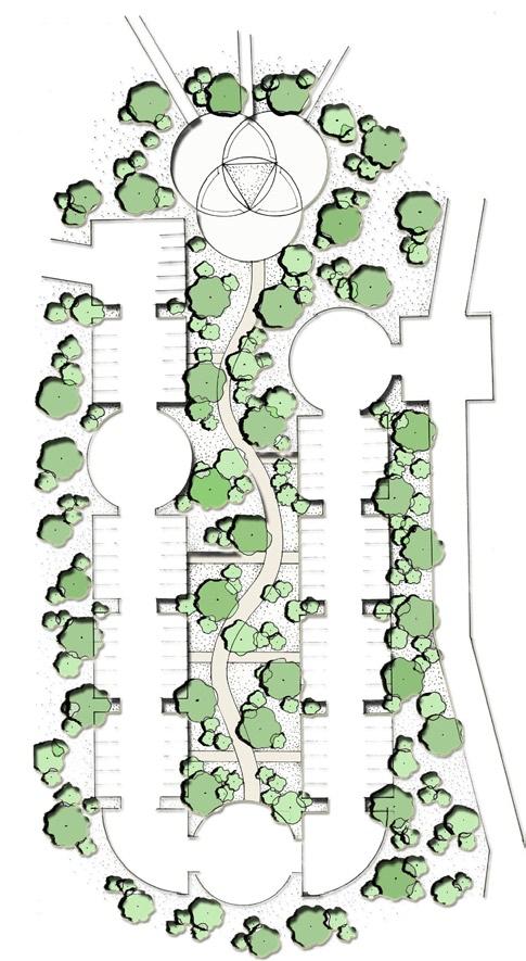
23 healthy, mature trees can provide meaningful canopy cover(j.caldwell, 2003). trees and a well lit area can provide for a buffer between vehicular traffic and pedestrian traffic, making safe travel. pedestrian walkways funnel into the center between the parking rooms. the walkways then proceed in a sinuous curve down to the social gathering area, where teachers, students and faculty have the opportunity to sit, relax, wait, talk, or even escape from the stresses that college can provide. the problem statement consisted of a healthy parking lot behind lee hall, clemson university. earth friendly concepts, relationships to human life, a variety of drawings, and accurate citations are to be included two weeks were allotted. healthy parking would consist of a safe, clean environment in which every student, teacher, and faculty can be healthy and productive within it. the design consists of a series of rooms, made to enhance the everyday burden of parking in a lot which contains nothing more than asphalt and light fixtures. these rooms are designed to connect with one another, making a more personal atmosphere, along with being environmentally conscience. a balance between physical, mental, and spiritual well-being is symbolized with the three circles balanced to form a triangle in the center of a social gathering area. the parking areas provided will consist of pervious surfaces that allow oxygen and water movement into the soil; sub-surface preparations are made in order to allow that movement to occur(j.caldwell,2003). h e a l t h y p a r k i n g dr. westphall, chamberlain


24 the johnstone site is a temporary landscape installment that embraces the foundation of the removed johnstone resident hall. johnstone had been known for its innovative architecture of its time, but is since outdated and run down. the installment radiates from the corner of the johnstone footprint in concentric circles representing a rain drop. the land undulates throughout the site in waves, symbolizing the effects that education, the core, has on the rest of our lives. three main routes are located according to circulation, connecting the adjacent sites. at these three points are educational thresholds informing the pedestrians about the history of clemson and of the removed johnstone residence hall.


25 j o h n s t o n e s i t e chamberlain
26 architectural rendering 2003 prof. harry harritos


27 construction documents 2005 gldi competition rendering 2006 bet figueras g r a p h i c r e p r e s e n t a t i o n black + white

28 landscape rendering 2007 collaboration with walter hood and designworks, lc.

29 landscape/architecture montage study abroad program bcn g r a p h i c r e p r e s e n t a t i o n color


30

31 q u e b e c e p h e m e r a l g a r d e n s s u b m i s s i o n m.leverant, m.bauld, l.daye
32
UNION STUDIO Greater Kennedy Plaza!
 April May 2013 UNION STUDIO Greater Kennedy Plaza! It s time: Providence s civic plaza and transit hub is re-imagined as a vibrant urban gathering place 1 Kennedy Plaza Reborn THE TEAM Client: The City
URBAN PLANNING STUDIO Second semester, first year
 Politecnico di Milano School of Architecture and Society URBAN PLANNING STUDIO 095990 Second semester, first year 1B Prof. Marco Facchine: marco.facchine:@polimi.it 02 2399 5462 www.marcofacchine:.com
THE LANDMARK PROJECT: ST. GEORGE CAMPUS BEFORE AND AFTER
 THE LANDMARK PROJECT: ST. GEORGE CAMPUS BEFORE AND AFTER The Landmark Project will reimagine the historic core of the St. George campus by creating dynamic, open spaces where students, faculty and the
Sign System Recommendations
 4.1 Sign System Recommendations 4.2 Recommended sign types required for a complete wayfinding system on the TCNJ campus are described below. Detailed sign messages and their typical locations are included
A New St Mary s Music School
 A ew St Mary s Music School at the Former Royal High School Landscape Design and Access Statement 150863_OPE_RHS_LDAS-01 December 2015 contents 1 introduction p. 4 site context p. 6 site photography and
lot flankage Y street 16m 6m landscape strip for large site 3m landscape strip for small medium site
 Commercial General Commercial Objectives Create developments compatible with adjacent land uses in scale, function and character Define a consistent and attractive street edge with quality landscaping,
PROGRAM: A mixed-use (retail, residential, commercial) infill project encompassing two blocks and nearly 20 acres of downtown Salt Lake City.
 infill project encompassing two blocks and nearly 20 acres of downtown Salt Lake City.") PROGRAM: A mixed-use (retail, residential, commercial) infill project encompassing two blocks and nearly 20 acres of downtown Salt Lake City. Upon completion in 2012, the site will feature more than 650
PROGRAM: A mixed-use (retail, residential, commercial) infill project encompassing two blocks and nearly 20 acres of downtown Salt Lake City. Upon completion in 2012, the site will feature more than 650
Town Center. Block 5 Existing multifamily residential units are expected to remain.
 Area Guidelines Germantown s districts should be developed as distinct communities with unique features that are supported through the guidelines. The guidelines not only help distinguish these districts
section five BEAUTIFICATION PLAN
 section five BEAUTIFICATION PLAN BEAUTIFICATION PLAN Section Five Beautification Plan The goal of the Beautification Plan is to improve the Route 8-Sunnyland Corridor in terms of aesthetics and to create
Lindsey Beane. Executive Summary
 Executive Summary The purpose of this technical assignment is to compile lighting information and make an analysis about the existing spaces. This report will include a list of the equipment used, required
DRAFT DESIGN GUIDELINES
 IHZ Booklet #7 May 6, 2010 DRAFT DESIGN GUIDELINES CANTERBURY 7 Overview During the recent planning process for the Plan of Conservation and Development community character was identified as an important
design & access statement Proposed Erection of 68 Bedroom Hotel and Restaurant with Associated Landscaping
 Proposed Erection of 68 Bedroom Hotel and Restaurant with Associated Landscaping Promenade, design & access statement lawrencemcphersonassociates 6 new road, ayr, ka8 8ex On Behalf of July 2015 CONTENTS
PUBLIC PARKS AND FACILITIES, SERVING NEIGHBORHOOD RECREATIONAL AND COMMUNITY EVENTS BUILDINGS BUILT TO THE LINE AND ORIENTED TOWARD THE STREET
 BUILDINGS BUILT TO THE LINE AND ORIENTED TOWARD THE STREET PUBLIC PARKS AND FACILITIES, SERVING NEIGHBORHOOD RECREATIONAL AND COMMUNITY EVENTS CONNECTED & COMPLETE STREETS AND STREET GRID VIEW SHEDS GROUND
3.1 Existing Land Use
 3.0 Land Use This strategy has been developed taking into account the position of the Town of Sidney as the economic center of the Saanich Peninsula. It acknowledges existing land use patterns in the downtown
DANIEL RODRIGUEZ SELECTED WORKS
 LIO POR TFO DANIEL RODRIGUEZ SELECTED WORKS 2013-2016 EDUCATION Florida International University - 5 yr. Accelerated Masters Program 2011-2016 AWARDS HELLO. Coral Gables Exhibition For Infill Housing Design
RESIDENTIAL + MIXED USE CONNECTING PEOPLE
 RESIDENTIAL + MIXED USE CONNECTING PEOPLE 2900 On First, Seattle, WA CARDUCCI ASSOCIATES PROFILE Founded in 1976, Carducci Associates is a professional landscape architecture and planning firm based in
Courthouse Square Planning & Urban Design Study. Courthouse Square Working Group #13 October 15, 2014
 Courthouse Square Planning & Urban Design Study Courthouse Square Working Group #13 October 15, 2014 1 Courthouse Square Process Working Group Community Courthouse Square Advisory Groups & Civic Associations
Community Design Plan
 Gardena General Plan 2006 Authority While the is not a required element of a General Plan, it is included because improving the community appearance and image is paramount to the overall quality of life
Public Art Plan. We have elected to submit Public Art Plans before or concurrently with the CSP Submittal per the FDP Manual
 Public Art Plan The intent of the Horizon Uptown Public Arts Program is to create great places that engage the community and leverage the neighborhood development and economic vitality. The Horizon Uptown
1 Introduction. Chapter. In this chapter:
 Chapter 1 Introduction In this chapter: 1.1 A Snapshot of the Region 1.2 Towards a Sustainable Region 1.3 The Provincial Context 1.4 Purpose and Organization The Regional Municipality of York Official
Ivywild On The Creek PRELIMINARY CREEK DISTRICT MASTER PLAN
 Ivywild On The Creek PRELIMINARY CREEK DISTRICT MASTER PLAN Introduction: Rejuvenating an extraordinary Creekside neighborhood THE CREEKSIDE DISTRICT The Ivywild On The Creek Neighborhood District Master
RA1.01. Project Description:
 Project Description: Designed around a philosophy of "healthy building for healthy bodies," the University s recreation center inspires personal health and wellness. As the University s campus continues
Metro. Activity Center Design Guidelines. Recommendations For Developing Focused, Mixed-Use Commercial/Residential Centers
 Metro Activity Center Design Guidelines Recommendations For Developing Focused, Mixed-Use Commercial/Residential Centers Metro Activity Centers What is a MAC? Legacy, the adopted guide for the future growth
ILLUSTRATIVE MASTERPLAN
 ILLUSTRATIVE MASTERPLAN The Development Dairy Crest (Imperial College) The Proposed Development aims to create a new high quality residential neighbourhood, alongside a new public park for White City.
2014 Michael G. Meyers Design Competition
 2014 Michael G. Meyers Design Competition #College2020MGMC HISTORY - CULTURE - ACADEMIA. This year, the design problem for the MGMC is to design a new academic building for Rice University. The University
Official Community Plan Bylaw No. 4360, 2004, Amendment Bylaw No. 4897, 2016 (Sewell s Landing)
") District of West Vancouver Official Community Plan Bylaw No. 4360, 2004, Amendment Bylaw No. 4897, 2016 (Sewell s Landing) Effective Date: 1089612v1 District of West Vancouver Official Community Plan Bylaw
District of West Vancouver Official Community Plan Bylaw No. 4360, 2004, Amendment Bylaw No. 4897, 2016 (Sewell s Landing) Effective Date: 1089612v1 District of West Vancouver Official Community Plan Bylaw
Landscape and Streetscape Design 2.5
 Landscape and Streetscape Design 2.5 2.5.1 Goals 2.5.2 Planting 2.5.3 Sidewalks and Pavement 2.5.4 Furnishings 2.5.5 Walls 2.5.6 Lighting 2.5.7 Stormwater 2.5.8 Street Cross Sections 2.5 LANDSCAPE AND
Assessment of the Extent and Quality of the Landscape Features of the Campus.
 Assessment of the Extent and Quality of the Landscape Features of the Campus. 1. In 2012 the University used geographic information systems to create georeferenced layers for all landscape and hardscape
Design Brief. Proposed housing development, White Horse Lane, Trowse FOR. Norfolk Homes
 Design Brief Proposed housing development, White Horse Lane, Trowse FOR Norfolk Homes JOB NO: 10.2812.030 DATE: September 2010 1 Site The Village of Trowse is situated approximate 2 kilometers South East
LET'S FILL STREETS WITH LIFE Establishing Superblocks in Barcelona
 LET'S FILL STREETS WITH LIFE Establishing Superblocks in Barcelona Barcelona aims to establish a new way of organising the city which reverses the current distribution of public areas between vehicles
SQUAMISH 2010 AND BEYOND COMMUNITY VISION
 Our plan has been imagined and created to be both pragmatic and visionary. At the core of the strategy is a consideration of the highway s role and its impact on the community. First and foremost in creating
B L A C K D I A M O N D D E S I G N G U I D E L I N E S for Multi-family Development
 B L A C K D I A M O N D D E S I G N G U I D E L I N E S for Multi-family Development Adopted June 18, 2009 This section of the Design and focuses on site planning and design guidance for new multi-family
QUESTION 8: What are your Public Realm priorities for implementation? What would you like to see happen first? TELL US WHAT YOU THINK
 Public Realm Plan How will the Public Realm Plan be implemented? The Public Realm Plan document will set out a vision for the next 30 years. Over time, Plan elements and aspects can be implemented as opportunities
C a m p u s I d e n t i t y
 Campus Identity Campus Identity a) Landscape Guidelines i. Materials ii. Components iii. Composition b) Wayfinding i) Entrance Features ii) Vehicular iii) Pedestrian c) Focus Areas i) Green Spine ii) Warriner
FLORIN ROAD CORRIDOR Site Plan and Design Review Guidelines Checklist
 FLORIN ROAD CORRIDOR Site Plan and Design Review Guidelines Checklist Applicant s Name: Project Address: Phone: Email: Applicant shall fill out the design guidelines checklist for all guidelines applicable
Colchester Northern Gateway Master Plan Vision Review Draft. July 2016
 Colchester Northern Gateway Master Plan Vision Review Draft July 2016 Contents Introduction 4 Context 8 Purpose of the Report 8 Strategic Position 9 Overview of the Process 11 2012 Master Plan Vision 12
Neighborhood Districts
 NEIGHBORHOOD DISTRICTS SEVEN MAIN DISTRICTS Neighborhood Districts While the Development Plan provides a broad-scale overview of the neighborhood, this section focuses on uses and relationships at the
V. Gateways GATEWAYS / V-1
 V. GATEWAYS / V-1 Many of Chesapeake s gateways are located on highways and call for bold and attractive designs that motorists can understand, appreciate, and enjoy. can also take the form of natural
WESTERN ILLINOIS UNIVERSITY
 WESTERN ILLINOIS UNIVERSITY Quad Cities Riverfront Campus Preliminary Master Plan Presentation 2 February 1, 2006 Achieving Future Flexibility 1. Monitor space needs as the new buildings come on line and
The Village. Chapter 3. Mixed Use Development Plan SPECIFIC PLAN
 The Village SPECIFIC PLAN Chapter 3 3.1 INTRODUCTION 3.1.1 Purpose This Chapter describes the development regulations applicable to the Mixed-Use and Transit Center Planning Areas. These form-based regulations
Urban Development and Upgrading of Unplanned Districts of Jeddah, Saudi Arabia. Bani-Malek East Al-Boughdadiyah. 10th October 2012
 Urban Development and Upgrading of Unplanned Districts of Jeddah, Saudi Arabia Bani-Malek East Al-Boughdadiyah 10th October 2012 Presentation Overview Introduction Effat Team Principle of Sustainable urbanism
University of Denver Land Use Plan Update I. Executive Summary
 Executive Summary The task of developing a Land Use Plan for the University of Denver has been an exciting collaborative process that engaged a variety of interested people, including members of the University
97 Lea Bridge Road, Leyton, E10 7QL London Borough of Waltham Forest December 2015
 97 Lea Bridge Road, Leyton, E10 7QL London Borough of Waltham Forest December 2015 Public Realm and Landscape Proposals LEA BRIDGE ROAD, WALTHAMSTOW Public Realm & Landscape Proposals BDP(90)RPT001 December
Bourne Downtown Site Planning
 Prepared for: The Town of Bourne, MA In Cooperation with: Bourne Financial Development Corporation Prepared by:, Inc. June 24, 2009 Table of Contents Introduction and Summary... 1 Site Existing Conditions...
page 76 zoogate juvet landscape hotel, Norway. Hotel set in natural surroundings
 page 76 zoogate figure 69. juvet landscape hotel, Norway. Hotel set in natural surroundings Without the recognition that the city is of and within the environment, the wilderness of the wolf and the moose,
EXISTING CONDITIONS 41. Existing Conditions
 EXISTING CONDITIONS 41 Existing Conditions The Existing Analysis phase of the planning process involved a study of the existing conditions on the campus in order to identify key planning issues to be addressed
ARCHITECTURAL ALLIANCE LANDSCAPE WINTER
 ARCHITECTURAL ALLIANCE LANDSCAPE WINTER 2015 COMPANY PROFILE Formed in 1991, Architectural Alliance Landscape is a mid-sized firm in business in South Florida for over 24 years. Our goal is to bring new
RIVERSIDE DESIGN CD-1 GUIDELINES. Adopted by City Council August 9, 1983
 $1 City of Vancouver Land Use and Development Policies and Guidelines Community Services, 453 W. 12th Ave Vancouver, BC V5Y 1V4 F 604.873.7344 fax 873.7060 planning@city.vancouver.bc.ca RIVERSIDE DESIGN
Development Brief Ursuline Convent, Blackrock, Cork
 Development Brief Ursuline Convent, Blackrock, Cork Comhairle Cathrach Chorcaí Cork City Council 2002 URSULINE CONVENT DEVELOPMENT BRIEF 1 INTRODUCTION AND MAIN OBJECTIVES... 3 1.1 The convent estate is
A.9. Cannon River. Campostella Park. Adjacent Industrial & City Facility Uses
 Campostella Park Classification: Nature Area 14 acres Character: This park is an undeveloped, heavily wooded natural open space park located along the Cannon River, just to the southwest of Babcock Park
Building and Site Design Standards
 Commercial Design Standards All Business and Industrial Uses as Described in Section 2234 Requiring Special Permit Review Except Large-Scale Ground Mounted Solar Photovoltaic Installations and Wireless
City of Heath. Town Center Concept
 In the give-and-take of getting projects designed, financed, and approved, the famous refrain from the film Field of Dreams is heard often: if you build it, they will come. From the perspective of the
4.0 Design Guidelines For The Village Centre. South fields Community Architectural Design Guidelines Town of Caledon
 4.0 Design Guidelines For The Village Centre 4.0 Design Guidelines for the Village Centre The Village Centre is the focal point of the entire South Fields Community and is designed as a traditional commercial
E. Natural areas include habitats such as wetlands, tidal marshes, waterways, natural drainage-ways, woodlands and grassland meadows.
 Adopted November 1999 I. Purpose A. The purpose of these guidelines is to assist in the design and layout of open space, as provided on developed lots within the District. The intent of these guidelines
LANGAN LANDSCAPE ARCHITECTURE + PLANNING FOR COLLEGES & UNIVERSITIES
 LANGAN LANDSCAPE ARCHITECTURE + PLANNING FOR COLLEGES & UNIVERSITIES CONTACT Philadelphia Pennsylvania 1818 Market Street Suite 3300 Philadelphia PA 19103 215.845.8900 215.845.8901 ST. JOSEPH'S UNIVERSITY
SYRINGA VALLEY SPECIFIC PLAN NARRATIVE
 SYRINGA VALLEY SPECIFIC PLAN NARRATIVE Introduction With this application, Pleasant Valley South LLC ( Pleasant Valley ) seeks the City of Boise s approval of a new Specific Plan Ordinance to be added
Allegretti Architects & Andrews University
 1 Allegretti Architects & Andrews University Western Michigan University Arts Plaza Design Charrette Team Members: John W. Allegretti, FAIA Carey Carscallen, Director of Architecture, Andrews University
PUBLIC RIGHT-OF-WAY IN THIS CHAPTER PUBLIC REALM
 PUBLIC RIGHT-OF-WAY This section provides design guidelines for improvements in the public right-of-way. The public right-of-way refers to streets, sidewalks, non-vehicular thoroughfares, parks and greenways
242 neighborhoods NEIGHBORHOOD 4: JORDAN AVENUE CORRIDOR
 NEIGHBORHOOD 4: JORDAN AVENUE CORRIDOR Aerial View of Jordan Avenue Corridor EXISTING CHARACTER The Jordan Avenue Corridor is the portion of North Jordan Avenue that extends north from East Third Street
COMMERCIAL DESIGN REVIEW APPLICATION
 CITY OF LACEY Community Development Department 420 College Street Lacey, WA 98503 (360) 491-5642 COMMERCIAL DESIGN REVIEW APPLICATION OFFICIAL USE ONLY Case Number: Date Received: By: Related Case Numbers:
5.1 Site Plan Guidelines
 5. Community Core Guidelines Development of the Community Core will take place by plan of subdivision and site plan approval. It will occur in a phased manner that will reflect the timing of residential
This is the East Carolina University Comprehensive Facilities Master Plan Final Draft Plan Review. This workbook reviews the campus draft master plan
 This is the East Carolina University Comprehensive Facilities Master Plan Final Draft Plan Review. This workbook reviews the campus draft master plan first presented on campus on June 29 and June 30, 2011.
WINDSOR GLEN DESIGN GUIDELINES
 WINDSOR GLEN DESIGN GUIDELINES Adopted by Council, 2006 WINDSOR GLEN REDEVELOPMENT DESIGN GUIDELINES August 2006 1.0 Master Plan Organization For this area of the Coquitlam Town Centre, a mix of high,
VILLAGE OF CHANNAHON COMMERCIAL DESIGN GUIDELINES. Village of Channahon S. Navajo Drive Channahon, IL (815)
") VILLAGE OF CHANNAHON COMMERCIAL DESIGN GUIDELINES Village of Channahon 24555 S. Navajo Drive Channahon, IL 60410 (815) 467-6644 www.channahon.org Adopted March 6, 2006 VILLAGE OF CHANNAHON COMMERCIAL DESIGN
VILLAGE OF CHANNAHON COMMERCIAL DESIGN GUIDELINES Village of Channahon 24555 S. Navajo Drive Channahon, IL 60410 (815) 467-6644 www.channahon.org Adopted March 6, 2006 VILLAGE OF CHANNAHON COMMERCIAL DESIGN
Buildings may be set back to create small plazas provided that these setbacks do not substantially disrupt the street wall s continuity.
 6-22 Community Design Street Walls and Street-front Setbacks The siting of buildings will play a critical role in establishing the character and sense of place for the District. Siting buildings at the
DRAFT. 10% Common Open Space
 % OF CHARLOTTE IS CATEGORIZED AS A. LAND USES : Placeholder map displaying location of Place Type GOALS: Accommodate XX% of future growth. Provide a concentration of primarily commercial and civic activity
Preci nct P l ans Figure 56 Campus Aerial Photo, 2008 CAL STATE EAST BAY, HAYWARD CAMPUS MASTER PLAN
 9 Precinct Plans This section contains a detailed discussion of the planning and design concepts for specific areas or precincts of the Cal State East Bay Hayward campus. The Precinct Plans pertain to
GAMMAGE SQUARE - RECOMMENDATIONS
 GAMMAGE SQUARE - RECOMMENDATIONS We envision an expanded cultural district surrounding the historic ASU Gammage. Creating a cultural district will enhance the existing historic landmark by activating the
Corridor Identity. Section 9. Introduction. Corridor Guiding Principles
 Corridor Identity An attractive and healthy community is a critical element of a quality place, and the design of quality places is a balance between environmental, economic, and social considerations.
2014 Exhibition of School Planning and Architecture. White Hill Middle School Campus Master Plan & Design. Ross Valley School District Fairfax, CA
 2014 Exhibition of School Planning and Architecture White Hill Middle School Campus Master Plan & Design Ross Valley School District Fairfax, CA Main Exterior Image Main Exterior Image Main Site Diagram
U n i v e r s i t y o f S o u t h C a r o l i n a A i k e n. Land Plan Study
 U n i v e r s i t y o f S o u t h a r o l i n a A i k e n Land Plan Study 06.27.2008 Goals ampus Growth Develop a Land Plan that allows for the orderly expansion of the campus over the next ten years and
CENTERS AND CORRIDORS
 INITIAL DESIGN STANDARDS AND GUIDELINES for CENTERS AND CORRIDORS City of Spokane Planning Services Third Floor, City Hall 808 W. Spokane Falls Blvd. Spokane, WA 99201-3329 (509) 625-6300 www.spokaneplanning.org
CAMPUS MASTER PLAN UPDATE
 13 April 2016 CAMPUS MASTER PLAN UPDATE Focus Group Landscape AGENDA What We Heard Review of Campus Observations & Analysis Campus Framework & Open Space Network Table-Top Exercise Landscape Guideline
With the promotions and publicity of green. Moving Towards Sustainable Campus Design. Deciphering Green Architecture
 Deciphering Green Architecture Moving Towards Sustainable Campus Design Projects: NIIT University Campus, Neemrana and Indian Institute of Technology, Gandhinagar Architects: Space Design Consultants,
Town Center (part of the Comprehensive Plan)
") Town Center (part of the Comprehensive Plan) Mercer Island Town Center Looking North (2014) In 1994, a year-long process culminated in a set of design guidelines and code requirements for the Town Center
Town Center (part of the Comprehensive Plan) Mercer Island Town Center Looking North (2014) In 1994, a year-long process culminated in a set of design guidelines and code requirements for the Town Center
CaseStudy Climate-ADAPT. Stuttgart: combating the heat island effect and poor air quality with green ventilation corridors
 CaseStudy Climate-ADAPT Stuttgart: combating the heat island effect and poor air quality with green ventilation corridors Cover design: EEA Cover photo: EEA Layout: EEA Legal notice The contents of this
Mississauga Waterfront. Parks Strategy - Draft
 Potential configuration for river s edge seating. Boating on Credit River: A regatta Boating on Credit River: Active enjoyment 5.2 Port Credit Memorial Park West Priority Park 5.2.1 Site Opportunities
ELK GROVE TOWN CENTER DESIGN GUIDELINES
 ......... ELK GROVE TOWN CENTER DESIGN GUIDELINES LAGUNA RIDGE SPECIFIC PLAN... June 2008 ............ DESIGN GUIDELINES Table of Contents Contents Section A: Town Center Overview...1 A.1. Purpose and
ACADEMY AREA CONCEPT PLAN
 ACADEMY AREA Strip ling C hape l Roa d CONCEPT PLAN 7 S2 U Stripling 52 ROADWAYS AND PARKING: ADVENTURE PLAYGROUND AND SPRAYGROUND: Current roadways follow existing drives. It is recommended that the Folds
Discovering Public Space: An Investigation of Portland s Civic Realm
 Discovering Public Space: An Investigation of Portland s Civic Realm Irie Searcy Architectural Programming Seminar J. Von Bargen, Fall 2008 December 8, 2008 Discovering Public Space: An Investigation of
Lehigh Acres Land Development Regulations Community Planning Project
 Lehigh Acres Land Development Regulations Planning Effort Summary In July, 2010 Commissioner Frank Mann invited the Lehigh Acres community to start discussing how to achieve their recently adopted community
PROPOSED REDEVELOPMENT OF THE GLEN ABBEY GOLF CLUB. STREETSCAPE DESIGN STUDY (excerpt from the Urban Design Brief) TOWN OF OAKVILLE.
 TOWN OF OAKVILLE.") PROPOSED REDEVELOPMENT OF THE GLEN ABBEY GOLF CLUB STREETSCAPE DESIGN STUDY (excerpt from the Urban Design Brief) TOWN OF OAKVILLE OCTOBER, 2016 for 2.4.2 STREETS Streets are the single largest component
PROPOSED REDEVELOPMENT OF THE GLEN ABBEY GOLF CLUB STREETSCAPE DESIGN STUDY (excerpt from the Urban Design Brief) TOWN OF OAKVILLE OCTOBER, 2016 for 2.4.2 STREETS Streets are the single largest component
Project purpose. advise. The purpose of the Beaumaris Lake Open Space Rehabilitation project is to: + Develop a Functional Program Concept
 Project purpose owns Road Beaumaris Road The purpose of the Beaumaris Lake Open Space Rehabilitation project is to: + Develop a Functional Program Concept + Guide Rehabilitation of Landscape and Community
MEETING PURPOSE AND OVERVIEW
 MEETING PURPOSE AND OVERVIEW On February 23, 2012, the City of Elk Grove hosted the first of two community workshops related to the Southeast Policy Area. The workshop was held from 6:00 8:30 p.m. in the
11TH STREET BRIDGE PARK COMPETITION
 11TH STREET BRIDGE PARK COMPETITION DESIGN PRINCIPLES, VALUES AND FACILITIES DESCRIPTION The design principles and list of facilities for a future 11th Street Bridge Park have been gathered through over
FRASER LANDS CD-1 GUIDELINES (BLOCKS 68 AND 69) Adopted by City Council April 1989
 Adopted by City Council April 1989") $1 City of Vancouver Land Use and Development Policies and Guidelines Community Services, 453 W. 12th Ave Vancouver, BC V5Y 1V4 F 604.873.7344 fax 873.7060 planning@city.vancouver.bc.ca FRASER LANDS CD-1
$1 City of Vancouver Land Use and Development Policies and Guidelines Community Services, 453 W. 12th Ave Vancouver, BC V5Y 1V4 F 604.873.7344 fax 873.7060 planning@city.vancouver.bc.ca FRASER LANDS CD-1
PROTOTYPE DESIGN/INTRODUCTION
 PART III: PROTOTYPE DESIGN These concepts and guidelines described earlier were used to develop a prototype design for an emerging suburban area located west of the City of Milwaukee. This was done to
APPENDICES DESIGNING PUBLIC SPACES - ENERGIZED PUBLIC SPACES DESIGN GUIDELINES WORKING DRAFT DECEMBER 2018 A1
 APPENDICES DESIGNING PUBLIC SPACES - ENERGIZED PUBLIC SPACES DESIGN GUIDELINES WORKING DRAFT DECEMBER 2018 A1 App.1 Case Studies by Park Types The upcoming (in-progress) online library will house several
Bylaw A Bylaw to amend Bylaw 12800, as amended, The Edmonton Zoning Bylaw Amendment No. 2239
 Bylaw 17672 A Bylaw to amend Bylaw 12800, as amended, The Edmonton Zoning Bylaw Amendment No. 2239 WHEREAS City Council at its meeting of February 22, 2001, gave third reading to Bylaw 12800, as amended;
Public Workshop 2 December 11, 2014 OLIN
 Public Workshop 2 December 11, 2014 OLIN TRIPLE IMAGE PANORAMA A NEW VISION FOR THE RIVERFRONT PROMENADE Burlington s Riverfront has historically been a defining character of the City s identity. This
Reconnecting to a Forgotten River St. Cloud MN. Aaron Hanson Design Design Thesis LA 572, Thesis, Spring 2012
 Reconnecting to a Forgotten River St. Cloud MN Aaron Hanson Design Design Thesis LA 572, Thesis, Spring 2012 site context 2.5 Miles Sartell St. Cloud to Fargo 170 Miles (2 hrs 45 mins) Hwy 10 infrastructure
Subarea 4 Indian Creek. Vision The combination of park networks and transportation amenities make Subarea 4 the greenest hub in the Corridor.
 indian creek 180 extends south from 101st Street to I-435. The I-435 and Metcalf intersection is one of the primary intersections in the Kansas City Metro Area. The area includes several residential neighborhoods
An Honors Thesis (Arch 402)
") Art + Architecture An application of art and culture from around the world An Honors Thesis (Arch 402) by Kathleen Strigle Thesis Advisor Rod underwood ) BaU State University Muncie, Indiana May 2014 Expected
Art + Architecture An application of art and culture from around the world An Honors Thesis (Arch 402) by Kathleen Strigle Thesis Advisor Rod underwood ) BaU State University Muncie, Indiana May 2014 Expected
ARCHITECTURE PORTFOLIO MANDO MORETI MARCH PART 2 CANDIDATE ARCHITECTURE UNIVERSITY OF NOTTINGHAM UNIVERSITY OF OXFORD BROOKES
 ARCHITECTURE PORTFOLIO MANDO MORETI MARCH PART 2 CANDIDATE - 2015 ARCHITECTURE UNIVERSITY OF NOTTINGHAM UNIVERSITY OF OXFORD BROOKES CONTENTS MANDO MORETI PART 2 CANDIDATE 2015 mandomoreti@hotmail.com
Ramsey Center area - potential BMP sites
 Ramsey Center area - potential BMP sites Lilly Branch Carlton St. 1 2 Joe Frank Harris Commons 3 4 8 5 East Campus Rd. 11 6 12 7 9 East Campus Deck 10 20 16 17 Ramsey Center 13 14 18 19 15 River Road Road
North Oakville East Parks Facilities Distribution Plan. November, 2009
 North Oakville East November, 2009 POLICY CONTEXT 1) Purpose a) The purpose of this document is to be a guide for the location, configuration, design and development of the parks system for the North Oakville
Throughout. square. (Crystal City Vision Plan 2050)
") 1: Terms related to the PSMP document 1 public space (see also public realm, civic space) An open space designated on the regulating plan, accessible to all, including Plazas, Mini Parks, and Neighborhoods
1: Terms related to the PSMP document 1 public space (see also public realm, civic space) An open space designated on the regulating plan, accessible to all, including Plazas, Mini Parks, and Neighborhoods
4 C OMMUNITY D ISTRICTS
 4 C OMMUNITY D ISTRICTS N ew development in the Area will include many different types of land uses, including a destination retail area that attracts people from all over the region; recreation opportunities
HOOVER-UNION TRIANGLE
 HOOVER-UNION TRIANGLE TABLE OF CONTENTS INTRODUCTION Who? What? Why? MEETING #1 RECAP [3/25] Presentation Activities Post-it Boards Photos Generated Schemes MEETING #2 RECAP [4/8] Presentation Schematic
Yesler Terrace Explorations of Ideas 11 March 2009
 Yesler Terrace Explorations of Ideas 11 March 2009 Exploration of Ideas for Yesler Terrace Where are we in the process? Testing the Yesler Terrace Planning Program 1) How does the new Yesler Terrace feel?