U N I V E R S I T Y O F C A L I F O R N I A
|
|
|
- Anna May
- 5 years ago
- Views:
Transcription

1 L O N G R A N G E D E V E L O P M E N T P L A N
2
3 U N I V E R S I T Y O F C A L I F O R N I A BERKELEY DAVIS IRVINE LOS ANGELES MERCED RIVERSIDE SAN DIEGO SAN FRANCISCO SANTA BARBARA SANTA CRUZ OFFICE OF THE CHANCELLOR January 2002 UNIVERSITY OF CALIFORNIA, MERCED 1160 WEST OLIVE AVENUE, SUITE E MERCED, CALIFORNIA (209) To Friends of UC Merced I am pleased to present this Long Range Development Plan (LRDP) for the University of California, Merced, the tenth campus of the University of California and the first to be located in the Central Valley. Almost 40 years have passed since the University of California last planned a new campus. The search for a site for this campus has taken more than a decade and has recently concluded with the selection of a beautiful location on the rolling grasslands east of Lake Yosemite and near the northern edge of the city of Merced. The LRDP incorporates a general blueprint for a campus to last far into the future. It is intended to reflect new technologies, to reach out and welcome students who previously have not had the advantage of a University of California campus in their local region, to set standards for sustainable use of energy and other scarce resources, to be a model of development in the great San Joaquin Valley, and to serve as an economic engine for the region. The final section of the LRDP also provides a detailed plan for the first buildings and infrastructure for the campus when it opens in The LRDP represents more than a year s work by many planners, architects, engineers, and environmental scientists as well as thoughtful discussions with many people both within and without the University. The University also is presenting the associated Final Environmental Impact Report (FEIR) which includes responses to comments submitted during the course of the public review period on the Draft EIR from August 13, 2001 to October 4, The configuration of the campus was developed in collaboration with the County of Merced, which is planning a new community adjacent to the campus. The County intends to release its final plan and accompanying Final Environmental Impact Report in early In January 2002, the UC Merced campus LRDP and associated FEIR will be submitted to the University s governing Board of Regents for approval. We appreciate your interest and participation in our planning process and look forward to welcoming you to our campus in Sincerely, Carol Tomlinson-Keasey Chancellor
4
5 T ABLE OF CONTENTS Letter from Chancellor Tomlinson-Keasey Table of Contents i List of Figures iii Introduction 1-1 Process of Developing this LRDP 1-1 Ongoing and Future Public Participation 1-2 History of Planning for UC Merced 2-1 University of California s Need for New Campuses 2-1 Locating UC in the San Joaquin Valley 2-2 Lake Yosemite Site 2-3 Planning Context and Determinants 3-1 Academic Planning 3-1 Academic Organization 3-2 Enrollment and Population Projections 3-6 Campus Land Area Requirements 3-7 Comparison of Land Area with Other UC Campuses 3-9 Physical Setting 3-12 The Vision for UC Merced 4-1 A Campus for the New Millennium 4-1 Planning Considerations Flexibility and Integration 4-2 Sustainable Planning and Design 4-4 Campus and Community 4-5 Planning Principles The Land 4-10 The Social Heart 4-12 Neighborhoods 4-14 The Meadow and Lake Parks 4-16 Sense of Place 4-17 Connections 4-18 Shadow, Water and Breeze 4-20 Long Range Development Plan 5-1 Resource Conservation and Environmental Stewardship 5-2 Sense of Place 5-8 Land Use 5-10 Circulation and Parking 5-26 Utilities and Infrastructure 5-40 Open Space and Landscaping 5-48 Building Design 5-58 Phasing Concept 5-62 Phase Site Description 6-1 Establishing a Sense of Place 6-2 Program for Phase Circulation and Parking 6-8 Utilities and Infrastructure 6-9 Plan Policies 7-1 Appendices 8-1 A. Derivation of Main Campus Acreage Requirements 8-1 B. Bibliography 8-13 C. Participants 8-15 LONG RANGE DEVELOPMENT PLAN i
6 ii UNIVERSITY OF CALIFORNIA, MERCED
7 LIST OF FIGURES Fig. 1.1 Fig. 1.2 Fig. 1.3 Fig. 1.4 Fig. 2.1 Fig. 2.2 Table 3.1 Fig. 3.1 Table 3.2 Fig. 3.2 Fig. 3.3 Fig. 3.4 Fig. 3.5 Fig. 3.6 Fig. 3.7 Fig. 3.8 Fig. 3.9 Fig Fig Fig Fig Fig Fig Fig Fig Fig Fig Community Workshop Children s ideas for UC Merced Children s ideas for UC Merced Children s ideas for UC Merced UC Merced Location Regional Location Campus Projections of Students, Faculty and Staff Campus Land Use Zones Summary of Campus Land Area Requirements Campus Comparisons UC Merced and the Central Valley Plain and Clouds, Merced County Photograph by Stephen Johnson. California Aqueduct. Photograph by Stephen Johnson. Creek and Moon. Photograph by Stephen Johnson. Fog over the San Joaquin Valley. Photograph by Stephen Johnson. Main Street, City of Merced 1915-Present University Community Plan, Land Use Diagram Lake Yosemite and Adjacent Regional Park Lake Yosemite Regional Park Picnic Areas Vernal Pools with Spring Flowering Displays Vernal Pools. Photograph by Stephen Johnson. The Smith Ranch Barn Smith Ranch Barn and Surrounding Grasslands Campus Site, Looking West to Lake Yosemite Looking East from Merced County to the Sierra Nevada Irrigation Canals in Merced Golf Course Irrigation Canals in the Ranch Grazing Lands Fig. 4.1 City of Merced Grid, circa 1917 Fig. 4.2 Thermalito, 1912 Fig. 4.3 St. John s College, Oxford Fig. 4.4 Emanuel College, Cambridge University, circa 1688 Fig. 4.5 Harvard University, circa 1668 Fig. 4.6 University of Virginia, Charlottesville Fig. 4.7 Proposals for Design of the University of Virginia Fig. 4.8 University of California, Berkeley Plan, circa 1914 Fig. 4.9 Proposed Perspective of UC, Berkeley, circa 1917 Fig University Community Town Center Fig The Land: Site Features Fig The Land: Breezes Fig The Land: Site Drainage Patterns Fig Main Street with a Mixture of Uses in the Campus Social Heart Fig The Social Heart Fig Town Center Adjacency to Main Campus Fig Student Housing Neighborhood Fig Academic Neighborhoods: Social Sciences, Humanities and Arts Fig Academic Neighborhoods: Engineering and Natural Sciences Fig Academic Neighborhoods: Professional Schools and Institutes Fig Residential Neighborhoods Fig View of Campus from University Drive across Meadow Park Fig Athletics and Recreation Area Adjacencies Fig View of Future Campus at Formal Entry Fig Views from University Drive Fig Lakeshore Drive between Academic Core and Adjoining Lake Yosemite Regional Park LONG RANGE DEVELOPMENT PLAN iii
8 LIST OF FIGURES Fig Fig Fig Fig Fig Fig Fig. 5.1 Fig. 5.2 Fig. 5.3 Fig. 5.4 Fig. 5.5 Fig. 5.6 Fig. 5.7 Fig. 5.8 Fig. 5.9 Fig Fig Fig Fig Fig Fig Fig Fig Fig Fig Fig Fig Fig Fig Major Campus Access Roads Restricted Vehicular Access Zones Vehicular Access Zones Informal Landscape along Canal Open Space Shade Tree Plantings Corridors Capture Breezes Off Lake Illustrative Site Plan Campus Land Use Zones Elements Establishing Sense of Place Campus Land Use Concept Academic Core Academic Core Interdisciplinary Zones Academic Core Organizing Factors Academic Core Perspective Main Street Perspective Section of Housing Area Student Housing Neighborhood Faculty, Graduate Student, Affiliate Housing Street Residential Areas Athletics and Recreation Campus Support Shared Pedestrian and Bicycle Circulation Routes Main Street Seating, Plantings and Amenities Pedestrian Circulation Network Bicycle Circulation Network Campus Transit Parking Diagram Vehicular Circulation Network Service Access Fig Central Plant Nodes and Utility Tunnel Fig Open Space Concept Fig Major Formal Landscape Plantings Fig Informal Landscape Plantings Fig Main Street Section Fig Academic Core Street Section Fig Arterial Street Section Fig Residential Street Section Fig Canal Edges are Part of the Open Space System Fig Library Grove, a Place For Gathering and Special Events Fig Canal Open Space with Athletic and Recreational Space Beyond Fig Section of Landscaped Parking Area Fig Landscape Plan Fig Usable Outdoor Space and Wireless Outdoor Technology Fig Use of Outdoor Spaces Fig Shading Elements for Exterior Circulation Fig Sustainable Building Techniques Fig Phase 1 Fig Phase 2 Fig Phase 3 Fig Phase 4 Fig. 6.1 Fig. 6.2 Fig. 6.3 Fig. 6.4 Fig. 6.5 Fig. 6.6 Fig. 6.7 Phase 1: Approach to Academic Core Main Street at Phase 1 Adjacent to Housing Main Street at Transition to Pedestrian Enclave Phase 1 Entry from Lake Road Main Street, Student Housing and Dining Commons Phase 1 Land Use Plan Year 2007/8 Plan iv UNIVERSITY OF CALIFORNIA, MERCED
9 I N T R O D U C T I O N
10
11 INTRODUCTION INTRODUCTION The University of California (UC) is establishing a new campus in the San Joaquin Valley. This Long Range Development Plan (LRDP) is a comprehensive physical development and land use plan that will serve as a guide to future development at the new Merced campus from the initiation of its first facilities and infrastructure improvements. A LRDP identifies the physical development needed to achieve the mission and academic goals and objectives of the campus and provides a map to steer the siting of future campus facilities. The UC Merced LRDP provides this planning framework for such a campus in Merced County. development projects will be approved on a project-by-project basis, and will be accompanied by environmental analysis and public review in accordance with CEQA. This LRDP includes a chapter on the first phase of campus development. Phase 1 is described in more specific detail than other portions of the LRDP. This chapter includes specific footprints of the first buildings, parking areas, landscaping, and roads. It is intended that the EIR for the LRDP will also contain the project analysis and review under CEQA for Phase 1. As the first LRDP for the new campus, this document also establishes a primary vision for the campus, articulating the underlying ideas that have framed its siting, layout and character. It also provides a history of planning for the campus to date, and sets policies and principles to guide future decisions. It is anticipated that, like other UC campuses, UC Merced will revise its LRDP periodically to accommodate future needs. The LRDP is accompanied by a separate Environmental Impact Report (EIR), in compliance with the California Environmental Quality Act (CEQA). The EIR includes a detailed discussion of the environment of the Merced campus, and the potential environmental impacts of implementing this campus. It also presents mitigations to these potential impacts and alternatives to the proposed project. The LRDP is intended to serve as a general guide to the physical development at the campus. Except for Phase 1, as described below, the LRDP does not propose a commitment to any specific project, construction schedule, or funding priority. Individual Process of Developing this LRDP Public input played a critical part in arriving at this LRDP. Beginning in 1998, a Concept Planning Process, jointly sponsored by the University and the County, provided broad public representation and initiated many ideas on the shape of the campus. This process resulted in the concept of an integrated campus and community a concept that continues to guide project planning today. Since that time, UC Merced and County planners have taken many measures to provide information and receive input from a variety of stakeholders and interested parties. For example, UC staff has participated on a regular basis with the Community Plan Advisory Committee and has met extensively with such groups as the Merced County Farm Bureau, the California Audubon Society, golfers of the Merced Hills Golf Course, neighborhood groups, and educational institutions at all levels. Other activities have included regular public meetings and workshops (see Figures 1.1, 1.2, 1.3 and 1.4), UC Regents meetings, appearances before the Board of Supervisors, and ongoing media updates. UC Merced has LONG RANGE DEVELOPMENT PLAN 1-1
12 INTRODUCTION also developed special web sites, a variety of outreach materials, and public repositories of information related to the project. Ongoing and Future Public Participation In summary, communication with the residents of Merced County and other interested parties in California has played an important role to date in this project. UC Merced anticipates working in partnership with the community during the next important phase of development. With publication of this LRDP and the supporting EIR, the public participation process will evolve into a series of activities and initiatives that are part of an ongoing public communications effort. The Environmental Impact Report supporting this LRDP provided for a public comment phase as well as a public hearing on the document. Those comments were incorporated into the final EIR. The University is seeking to create varied methods to facilitate continuing information exchange as the LRDP is put into effect. UC Merced staff are currently exploring ideas to achieve this goal, and will seek public input regarding the organization of the communications effort. Some of the initiatives being proposed include, but are not restricted to, the following: Every effort will be made to continue and improve these points of contact. Web Sites: and Public Repositories: SACRAMENTO LOS BANOS State Clearinghouse Merced County Library Governor s Office of 7th Street Planning and Research Los Banos, CA 1400 Tenth Street, Room 222 Sacramento, CA Creation of a community advisory group to provide ongoing assistance during the process of making the campus a reality. Publication of additional outreach materials to inform the community of key events, issues, and initiatives that arise. Continued public updates through web site postings. Continued briefings to a wide range of area media. MERCED AREA Merced County Library 2100 O Street Merced, CA Contact Us: UC MERCED 1170 West Olive Avenue, Suite I Merced, CA Tel: MERCED COLLEGE Learning Resources Center 3600 M Street Merced, CA 1-2 UNIVERSITY OF CALIFORNIA, MERCED
")

")

13 INTRODUCTION Fig. 1.1 (far right, top) Community Workshop Figures 1.2, 1.3, 1.4 (far right, middle and bottom, near left) Children s ideas for UC Merced campus and community LONG RANGE DEVELOPMENT PLAN 1-3
14 1-4 UNIVERSITY OF CALIFORNIA, MERCED
15 H I S T O R Y O F P L A N N I N G F O R U C M E R C E D
16
17 HISTORY OF PLANNING FOR UC MERCED HISTORY OF PLANNING FOR UC MERCED The 1988 authorization by The Regents of the University of California to initiate planning for additional campuses was the beginning of a lengthy process leading to the identification of the County of Merced and the Lake Yosemite site as the location for the tenth UC campus. This chapter provides the historical context for the decisions that were made, leading up to the choice of locating the campus site. University of California s Need for New Campuses In the late 1980s, The University of California, in conjunction with the California State Department of Finance s Demographic Research Unit (DRU), produced a series of projections for the state that anticipated a dramatic increase in qualified California students seeking admission to the UC system through The analysis projected the need to accommodate 63,100 more students within a 10-year period. The University sought to accommodate this increase by forming the University of California Site Selection Task Force (SSTF). (A recent DRU analysis predicted a growth in enrollment of over 30% between 2000 and 2010.) The projected student population increase is related to several converging demographic factors. The first reflects the increasing population in the United States in general. The second factor is the increase in the number of college age students that need to be accommodated in California. This significant increase is comprised of college-bound youths who are the progeny of the post World War II baby boomers. The third factor for the increase is related to the economic expansion of recent years that has enabled more families to send their children to college. While other American state universities may also feel the effects of these demographic factors, the impact is amplified in California due to the state s growing immigrant population, in particular its Spanish-speakers, for whom the university estimates a dramatic increase in participation. In response to the University of California s internal projections and subsequent demand analysis, policy-makers in Sacramento requested that all universities and colleges in California begin studying the feasibility of assuring space for the projected number of new students interested in higher education. Currently, the nine existing UC campuses would only be able to accommodate 34,000 of the 63,100 total new students projected by the DRU. In the best possible scenario, with all nine UC campuses fulfilling their LRDP enrollment goals, 24,000 more students could be accommodated, leaving 5,000 prospective students unaccounted for beyond The State Master Plan for Higher Education commits the University of California to accommodate all eligible students who meet the admissions standards of being among the top 12.5% of public school graduates in the state. It is from this unequivocal commitment that the decision to build a tenth UC campus emerged as a pivotal decision for the future of public higher education in California. LONG RANGE DEVELOPMENT PLAN 2-1
18 HISTORY OF PLANNING FOR UC MERCED Locating UC in The San Joaquin Valley The Regents further stipulated that the search for a new campus site should focus on a central California location. The existing nine UC campuses cluster in Northern and Southern California, leaving the central portion of the state without the positive impact of a local UC campus (Figure 2.1). In addition, the Regents were keen to acknowledge the University s obligation to improve service to the growing San Joaquin Valley, the state s valuable agricultural region and historical nexus for newly arrived immigrants. That rates of enrollment of San Joaquin Valley students were consistently lower in comparison to other geographic regions in the state was also of concern to The Regents and informed the eventual choice of Merced as the site for the tenth UC campus. The demographic composition of the San Joaquin Valley differs from the rest of California. In the San Joaquin Valley, 40% of the children are Latino. Projections for the state suggest that the Valley may in fact foreshadow California s own future demographic make-up: population projections for the state suggest that the Latino population will increase to 28 million from its current number of 9 million residents. The addition of a UC campus in the San Joaquin Valley was a decision primarily based upon this need. The University of California s Site Selection Task Force (SSTF) saw in Merced County the possibility of tackling existing imbalances in the current nine-campus UC system by establishing an institution of higher learning in this region of the state. By following a basic tenet of the UC mission, that of insuring the widest possible geographic distribution of educational and economic benefit, the University of California would generate a lasting positive impact upon the region. While UC campuses are intended to be state-wide in focus, it has been observed that a large percentage of students enrolled at each campus come from nearby areas. The San Joaquin Valley has the largest population concentration in California that is at a distance of greater than 50 miles from a UC campus. Locating a new campus in the San Joaquin Valley was seen to have potential positive impacts on college participation rates in the region. The selection of the Lake Yosemite site came after a review of more than 85 sites in the San Joaquin Valley. Finalist sites were in Merced, Madera and Fresno Counties. Among the criteria leading to the final selection were available housing, commercial services and cultural amenities, as well as access to metropolitan areas, community support, availability of water, and an estimation of environmental effects associated with the site. The site proposed in Merced County also had the significant advantage of being owned by the Virginia Smith Trust, which funds higher education scholarships for local high school graduates. In May 1995 the Site Selection Task Force identified the need for a 2,000 acre site for the new campus as part of their final report to The Regents. This finding was based on the experience of the University with long term development at various campuses, and most particularly of the experience of the newer campuses Irvine, San Diego, and Santa Cruz which opened in the mid s. 2-2 UNIVERSITY OF CALIFORNIA, MERCED

19 HISTORY OF PLANNING FOR UC MERCED Fig. 2.1 UC Merced Location UC BERKELEY UC SAN FRANCISCO UC SANTA CRUZ UC DAVIS UC MERCED CENTRAL REGION UC SANTA BARBARA UC LOS ANGELES UC RIVERSIDE UC IRVINE UC SAN DIEGO Lake Yosemite Site The original site proposed for the campus was a 2,000 acre parcel identified by the University within the larger Virginia Smith Trust property located to the north and east of Lake Yosemite. In the course of planning for the campus, additional site evaluations and characterizations were conducted. As a result of these additional analyses, the site identified in the Site Selection EIR and approved by The Regents in May 1995 was proposed to be moved from the center of the Trust property to the southwestern corner, closer to the City of Merced and immediately adjacent to Lake Yosemite and the Lake Yosemite Regional Park, as shown in Figure 2.2. The main campus is to be located on the site of the existing Merced Hills Golf Course (owned by the Virginia Smith Trust), on property east of the park owned by the County of Merced, and on adjacent undeveloped lands owned by the Trust. A gift from the David and Lucile Packard Foundation to The Regents of the University of California will enable acquisition of the entire holdings of the Trust, approximately 7,030 acres. The site is approximately 2 miles from the city limits of Merced. The preponderance of the campus site consists of lands that have been historically used for grazing. Outside of the golf course, a barn and corral are the only structures on the site. Two major canals owned by the Merced Irrigation District (MID) run through the campus area. LONG RANGE DEVELOPMENT PLAN 2-3

20 HISTORY OF PLANNING FOR UC MERCED Fig. 2.2 Regional Location 2-4 UNIVERSITY OF CALIFORNIA, MERCED
21 P L A N N I N G C O N T E X T A N D D E T E R M I N A N T S
22
23 PLANNING CONTEXT & DETERMINANTS PLANNING CONTEXT AND DETERMINANTS Many considerations have driven planning for the new Merced campus. This chapter describes the various elements that have individually and in their totality informed the siting, layout, planning and design of the new campus. Five general themes articulated by Chancellor Carol Tomlinson-Keasey have guided the physical development of UC Merced: Academic Planning Goals and Principles Academic planning for UC Merced is based on the long-range goal of developing a distinguished general campus of the University of California and is guided by the following principles: The campus must capture the wonder and majesty of the University of California in that: there is a sense of place; the substance and quality of the University are evident; the campus setting, through its beauty and ambience, promotes a contemplative spirit and the intellectual growth of students and faculty; and top quality faculty and students are attracted to the campus. As the first research university to open in the 21st Century, UC Merced must be at the forefront of technological change. The campus must seek to welcome and accommodate students from throughout the San Joaquin Valley and California, especially those from groups that have historically been underrepresented at UC. The campus must attempt to achieve a high level of resource conservation, such that the materials and energy used to build the campus and maintain it do not deplete resources available to future generations. The campus must set an example for urban growth in the San Joaquin Valley, showing how increases in population can be accommodated while preserving and sustaining the agricultural and environmental basis of its economy and ecosystem. Fulfill the University of California s mission through excellent teaching, research and public service Create strong graduate and undergraduate programs Build an educational network in the Valley Link the campus technologically to the world Cooperate with UC campuses and National Laboratories, and with the California State Universities, California Community Colleges, and the K 12 schools Integrate the University and community Reflect the poetry of the San Joaquin Valley. The Long-Range Development Plan provides for the physical resources to realize these academic goals. Physical development of the campus itself will contribute to another educational goal for UC Merced, an attention to sustainability that infuses the teaching and research mission of the campus, and the co-curricular program for students. LONG RANGE DEVELOPMENT PLAN 3-1
24 PLANNING CONTEXT & DETERMINANTS Academic Organization UC Merced will emphasize links among disciplines and keep the barriers between academic areas as low as possible. Three academic divisions will be formed, each headed by a dean: Engineering, Natural Sciences, and Social Sciences, Humanities and Arts. All three divisions will be full participants in planning and offering the undergraduate general education program as well as undergraduate and graduate degree programs. The divisions will not open with formal departments, though departmentalization will likely evolve. In keeping with the goal of curricular flexibility and collaboration across disciplinary lines, future departments may assume different forms and configurations of disciplines than are common among existing UC campuses. A select number of professional schools and programs will also be added as the campus grows and develops. A school of management will be opened during the first five years, to include undergraduate and/or graduate programming in a group of related fields. Education programming will be offered initially through the currently established UC Merced Division of Professional Studies and will be the basis for a formal academic unit incorporating education in the future. As the campus grows, additional professional schools will be planned. Each of the three academic divisions will develop a small number of areas in depth at the outset, rather than scattering the small number of opening day faculty across a large number of disciplines. This will allow development of early distinction through gathering groups of outstanding faculty in target fields. Areas of strength that have been initially identified for each division are laid out below. However, faculty recruitment will be opportunistic, as the founding deans seek distinguished groups of faculty nationally and internationally, as a strategy for realizing the academic principle of excellence in teaching, research and service from the outset. Hence, other areas of strength will be developed in addition to, or in some cases, in place of, those described below. As the campus grows, additional disciplines will be developed until the campus has built up the full range of natural sciences, engineering, social sciences, humanities, and arts fields that define a University of California general campus. Promising areas for initial developments in the Division of Engineering during the first five years include, but are not limited to, computing and communications, energy/environmental resources engineering, biotechnologies, and nano/microsystems engineering. Biotechnology research across the range of engineering disciplines, environmental monitoring and assessment, and infomatics, including emerging information technologies, will be targets for early research development. The Division will also work aggressively through innovative K 12 outreach programming to diversify the student body in engineering. The Division of Natural Sciences will develop the core areas that need to be in place for a strong science and technology campus: the biological sciences, chemistry, earth sciences, mathematics, and physics. Promising early areas of research excellence that would draw on both natural sciences and engineering include, but are not limited to, biotechnology and structural biology, environmental sciences, and materials sciences. A nano- 3-2 UNIVERSITY OF CALIFORNIA, MERCED
25 PLANNING CONTEXT & DETERMINANTS technology emphasis in engineering holds promise for leading to a collaborative focus on nanoscale issues in physical and inorganic chemistry, biochemistry, and X-ray laser physics. The Division of Social Sciences, Humanities, and Arts will include about half the faculty at opening day. This faculty will be organized in both traditional and innovative ways. A promising approach is a division of disciplines according to whether they depend on quantitative or textual approaches, with expressive studies included among textual fields. Innovative groupings might also include organizations around methodological approaches, including but not limited to the following examples. A political and economic affairs group would include political science, economics, environmental studies, legal studies, sociology, anthropology, philosophy and history. A human interactions and productions group would include politics, anthropology, economics, psychology, sociology, literature, and the arts. Graduate Education and Professional Schools The Dean of Graduate Studies/Vice Chancellor of Research will have lead responsibility for guiding graduate affairs. This will include coordination of graduate program development in both innovative and traditional areas. The first professional school, to be opened within the first five years of campus operation, will be a School of Management. The School will address a range of regional and state needs for undergraduate and graduate training, in a new and integrated way. Emphases could include, but not be limited to, organizational psychology, business administration, economics, public policy, technology entrepreneurship, and educational leadership. A joint management and engineering program will also be offered. Research Individual faculty will be developing a range of areas of research strength for UC Merced, which will be supported by the facilities envisioned in the Long-Range Development Plan. In addition, a series of formal organized research units will focus interdisciplinary faculty research strengths and resources on a select number of critical problems. These research institutes will contribute to realizing the principle of excellence in research from the outset. The Sierra Nevada Research Institute will be a cornerstone of research and education at UC Merced. UC Merced is planning the Sierra Nevada Research Institute to carry out research on critical issues affecting the Sierra Nevada Range and San Joaquin Valley regions of California, including population growth and development, water and watersheds, air quality, fire ecology, biodiversity, climate change, transportation, resource management and policy, and public recreation. Institute faculty will be recruited in a wide range of disciplines: biological sciences, environmental sciences, computational sciences, physical sciences, social sciences, policy studies, and regional planning. Research will be supported by sophisticated technology, including computer databases, remote sensing, and environmental informatics. The research conducted through the Sierra Nevada Research Institute will have applicability to similar natural resource science, planning and policy issues worldwide. A special research focus of the Institute will be sustainability. With the anticipated significant growth in the population of the San Joaquin Valley, a growth of which UC Merced will be a part, natural resources already under pressure will be stretched even further. Thus, the Valley represents an ideal laboratory to study the constituent natural resources and the phenomenon of growth, LONG RANGE DEVELOPMENT PLAN 3-3
26 PLANNING CONTEXT & DETERMINANTS while conducting research on the means of sustaining natural resources. The campus and supporting community will constitute an immediately available laboratory for testing new approaches to sustainability. The Sierra Nevada Research Institute will support faculty recruitment efforts of all three academic divisions while embodying UC Merced s commitment to broad, innovative, multi-disciplinary research and teaching programs. The Sierra Nevada Research Institute will also foster lasting, synergistic relationships between the campus and county, state and federal agencies, as well as the private sector. The World Cultures Institute will bring together humanists, social scientists, and artists to study the movements of peoples and their historical and cultural consequences. As a natural laboratory for research of international import, the San Joaquin Valley is defined by the mobility and migration, and sometimes forced diasporas, of peoples affected by historical events. Migration and immigration studies will address questions of building community among a diverse population. The history of migrations and diasporas will be complemented by studies of the impact of such human and social changes on established peoples and resources. Research themes for the World Cultures Institute include: Regional identity and cultural mobility Religious identity and religious diversity The region s history of immigration from abroad and the history and consequences of indigenous peoples displacement by waves of migration The wilderness and coastal impact of the region The history of agriculture. The Public Policy Institute will act as a partner research entity with the Sierra Nevada Research Institute and World Cultures Institute, assuring a strong policy element in each. Curriculum The academic divisions and research institutes will collaborate and reinforce one another in creating undergraduate and graduate degree programs. UC Merced will offer a select number of graduate and professional programs that meet state and national needs for advanced training. Graduate programs will be offered through graduate groups with flexible structures that allow faculty from a variety of disciplines to participate. In particular, faculty graduate groups based in the research institutes will develop a set of unique doctoral programs. Undergraduate general education will be the responsibility of a campus-based (as opposed to residence-based) undergraduate college system. The three academic divisions will work in concert with the academic leadership of the colleges to create and deliver the general education curriculum. Professional degree programs will be the responsibility of the professional schools, with extensive participation by the academic divisions. While faculty will be organized in a variety of innovative and traditional ways that encourage new forms of collaboration across traditional disciplinary lines, the undergraduate curriculum will be built around core fields, especially fields that are in high demand elsewhere in UC. The following proposed initial list of opening day majors will be expanded rapidly as the campus grows and develops. There has also been a preliminary endorsement of 3-4 UNIVERSITY OF CALIFORNIA, MERCED
27 PLANNING CONTEXT & DETERMINANTS an opening day undergraduate management program, perhaps within the proposed economics program. DIVISION OF ENGINEERING Computer Science Electrical Engineering Environmental Engineering DIVISION OF NATURAL SCIENCES Physical Sciences Biological Sciences Mathematics INTERDISCIPLINARY TRACKS: Environmental Sciences Pre-Health Sciences Program DIVISION OF SOCIAL SCIENCES/HUMANITIES/ARTS World History and Cultures [History and Arts] Comparative Literature and Languages Social Sciences Economics Public Policy General Education The University of California, Merced has set a goal of becoming the 21st century s premiere student-centered research University. Essential service functions will complement outstanding academic offerings in order to transform a collection of buildings into a vital place of learning. The following hallmarks will characterize student life at UC Merced: Integration, flexibility and community Education on a human scale Diversity Fully integrated educational opportunities through UC Merced Centers New concepts of staffing Reliance on technology. The following principles embody the core philosophy of maintaining small interactive groups within a large organization: Students and faculty will engage in general education in small group interactions Faculty will participate in curriculum development and in small teaching groups Students will be given choice within a coherent general education program The faculty structure will stimulate curricular and pedagogical innovation General education will be structured to accommodate growth, and UC Merced will invite collaboration with other public higher education institutions in the region. Achieving these principles may be accomplished through an undergraduate college system, to be planned in detail by the incoming academic leadership. As the campus grows beyond its initial small cohort, UC Merced hopes to create a campus-based college system, designed to engage all students fully, whether they are in residence at UC Merced from the freshman year on, junior- LONG RANGE DEVELOPMENT PLAN 3-5
28 PLANNING CONTEXT & DETERMINANTS YEARS Population 2004/5 2005/6 2006/7 2007/8 2008/9 2009/ / / / / / /28 Full Dev. Undergraduate 900 1,801 2,519 3,238 3,957 4,675 5,394 7,241 11,958 12,430 12,901 13,373 22,250 Graduate ,478 1,536 1,595 1,653 2,750 Subtotal 1,000 2,009 2,810 3,612 4,414 5,214 6,016 8,136 13,436 13,966 14,496 15,026 25,000 Table 3.1 Campus Projections of Students, Faculty and Staff. Student numbers in FTE Faculty ,420 Staff ,112 1,232 1,334 1,617 2,670 2,696 2,798 2,900 4,828 Subtotal ,181 1,397 1,548 1,676 2,079 3,433 3,489 3,621 3,753 6,248 Total 1,500 2,754 3,761 4,793 5,811 6,762 7,692 10,215 16,869 17,455 18,117 18,779 31,248 year transfer students, or students who complete portions of their education at a UC Merced off-campus center. While the campus residence system will reinforce the college system for on-campus students, the locus of college activities will be in the academic buildings on campus. A general education institute, featuring intersegmental collaboration with the California Community Colleges and California State Universities in the San Joaquin Valley, is planned to support joint general education development. This will facilitate transfer of students among the Valley s segments of higher education. This institute will be housed initially in an academic building, with the expectation that it will have a facility of its own as the campus grows. Formal Review of Programs, Degrees, and Units The academic programs and units introduced above will undergo appropriate review by campus and systemwide review bodies, as required by university policies and procedures. Systemwide review bodies vary according to the approval sought. Enrollment and Population Projections UC Merced is planned to open with 1000 students in Fall, 2004: 900 undergraduates and 100 graduate students, 100 faculty and about 300 staff. The campus is expected to grow rapidly, with an addition of about 1,000 students in 2005 and about 800 students per year thereafter. By the campus will have grown to 6,000 Full Time Equivalent (FTE) students. The proportion of graduate students is expected to grow from 10% at opening to 15% by the tenth year of operation. This LRDP defines a campus that can accommodate a total of 25,000 students: 21,500 undergraduates and 3500 graduate students, with a faculty and staff of 6,600. Table 3.1 illustrates projected student, faculty and staff growth at UC Merced. 3-6 UNIVERSITY OF CALIFORNIA, MERCED
29 ' 1000' 1500' PLANNING CONTEXT & DETERMINANTS Campus Land Area Requirements As described in the previous section, a major research university campus is made up of a number of inter-related program components, and includes a core of teaching, research, and administrative buildings, housing for students and faculty, and facilities and fields for sports and recreation. All these elements require extensive service and support areas much like a small city, which a campus in many ways resembles. These include a corporation yard, campus security and possibly fire services, utility services such as transformer stations and wastewater treatment plants, and parking areas. Like a city, as well, a significant part of a campus is taken up with roads and other circulation elements. This section summarizes the acreage requirements for each of the program components and other elements comprising the new UC Merced campus. A variety of sources were used for developing these projections, including studies of research universities throughout the United States and the experience of other UC campuses, particularly those that were established in the 1960s. Main Campus The Main Campus incorporates all the program elements that the University can now foresee being needed for a complete new campus. The Main Campus includes the following uses, the circulation system required to serve them, and related open space: Academic Core Student Support/Service Student Housing Faculty Housing Campus Support (corporation yard, physical plant, etc.) Recreation and Athletics Parking On-Campus Research Fig. 3.1 Campus Land Use Zones CONSERVATION EASEMENTS The 2,000 acre Merced campus is comprised of three primary land use elements: the Main Campus, the Campus Land Reserve, and the Campus Natural Reserve. Each of these land components has an important role in the three key missions of the University: teaching, research and public service. A summary of these areas is included in Table 3.2. CAMPUS LAND RESERVE 340 ACRES MAIN CAMPUS 910 ACRES CAMPUS NATURAL RESERVE 750 ACRES N 0' 1500' LONG RANGE DEVELOPMENT PLAN 3-7
30 PLANNING CONTEXT & DETERMINANTS Campus Land Reserve The Campus Land Reserve covers 340 acres contiguous to the Main Campus Area. The University has determined that, although only 910 acres of land is required for development of the Main Campus Area, an additional 340 acres should be secured contiguous to the Main Campus Area to preserve the opportunity to accommodate additional development beyond the Main Campus which is presently unknown and unforeseeable. Although the University has no present need for this land, because the 340-acre area currently is available and UC Merced may exist well into the next century or beyond, prudence requires that the University secure this land at the present time. Because the campus land reserve contains vernal pools and other biological resources of academic interest, it may be used for certain teaching, research, and outreach purposes. For example, undergraduate field study under faculty supervision and K 12 field science preparation are among contemplated uses. Campus faculty may also do advanced field research to better understand the dynamics of this ecosystem. The Campus Land Reserve will continue to be available for grazing and will be fenced to control access from the Main Campus and to provide a buffer to the Campus Natural Reserve. Campus Natural Reserve The University proposes to set aside approximately 750 acres of land as a Campus Natural Reserve. This area would be maintained permanently in an undeveloped state, and would be dedicated to scientific research and education. The Campus Natural Reserve would be managed in a manner consistent with management practices in the UC Natural Reserve System (NRS). It may be proposed for inclusion in the NRS as a means of making its valuable and unique resources available to the larger research community. At present, there is no NRS site in the San Joaquin Valley. The campus natural reserve would include vernal pool/grassland habitat with not only rare biological resources, but also unique landforms and rare soils of great geological interest. The reserve would be suitable for specialized scientific research and for some teaching uses, especially by advanced undergraduate students or students participating in faculty research projects. However, research would be carefully undertaken to ensure that there would be no impacts to the natural environment. A detailed discussion of the derivation of Main Campus areas is included in Appendix A. 3-8 UNIVERSITY OF CALIFORNIA, MERCED
31 PLANNING CONTEXT & DETERMINANTS Table 3.2 Summary of Campus Land Area Requirements MAIN CAMPUS PROGRAM IN ACRES NET + Site Circulation Academic Core 157 Student Services 23 Student Housing 250 Faculty Housing 90 Campus Support 56 Athletics & Recreation 148 Parking 147 On-Campus Research 39 SUB-TOTAL 910 including roadways CAMPUS LAND RESERVE 340 Unknown future needs; natural science field research, education and outreach; maintained indefinitely in current condition. Total Potentially Developed Land 1250 CAMPUS NATURAL RESERVE 750 Campus undeveloped lands, permanently protected and to be used only for limited research and educational use. TOTAL 2000 Comparison of Land Area with Other UC Campuses As the following diagrams show, the UC Merced main campus is similar in size to other UC campuses, in particular those that are located in less urban areas. The Academic Core of UC Merced, at 157 acres, is comparable to the academic cores of other UC campuses. LONG RANGE DEVELOPMENT PLAN 3-9


32 PLANNING CONTEXT & DETERMINANTS Fig. 3.2 Campus Comparisons APPROXIMATE CAMPUS CORE UC Riverside UC Davis UC Santa Barbara UC Berkeley 3-10 UNIVERSITY OF CALIFORNIA, MERCED


33 PLANNING CONTEXT & DETERMINANTS UC San Diego UC Irvine UC Santa Cruz UC Los Angeles UC Merced LONG RANGE DEVELOPMENT PLAN 3-11

34 PLANNING CONTEXT & DETERMINANTS Physical Setting Regional and Local Setting The setting has had a significant influence on the planning and design of the UC Merced campus. This campus of the University of California occupies a unique niche in the state, not only in terms of the socio-economic and cultural characteristics of its valley location, but also in terms of the form of the land, its physical characteristics, and the pattern of land use and development that has been experienced in the San Joaquin Valley throughout history. Fig. 3.3 UC Merced and the Central Valley California s great Central Valley is 430 miles long and an average of 50 miles wide about the size of England, some 15 million acres and is one of the world s largest valleys. The Central Valley sits at the core of California (Figure 3.3), west of the Sierra Nevada mountains, and east of the Pacific coastal range and drains two major river systems: the Sacramento originating in the north and the San Joaquin from the south. Both rivers eventually pour into San Francisco Bay. The San Joaquin Valley is one of three major subregions encompassing the Central Valley, the other two regions being the Delta and The Sacramento Valley, each distinguished from one another by a low alluvial divide, which leads to a meandering boundary formed by the delta. As the following quotes demonstrate, perceptions of the valley have changed dramatically since American settlement UNIVERSITY OF CALIFORNIA, MERCED


35 PLANNING CONTEXT & DETERMINANTS Fig. 3.4 Plain and Clouds, Merced County Photograph by Stephen Johnson. All rights reserved worldwide. Fig. 3.5 California Aqueduct, Interstate 5, Delta-Mendota Canal, Merced County Photograph by Stephen Johnson. All rights reserved worldwide. Two views of the Central Valley landscape: Making your way through the mazes of the Coast Range to the summit of any of the inner peaks or passes opposite San Francisco, in the clear springtime, the grandest and most telling of all California landscapes is outspread before you. At your feet lies the great Central Valley glowing golden in the sunshine, extending north and south farther than the eye can reach, one smooth, flowery, lake-like bed of fertile soil. Along its eastern margin rises the mighty Sierra, miles in height, reposing like a smooth, cumulous cloud in the sunny sky, and so gloriously colored, and so luminous, it seems to be not clothed with light, but wholly composed of it, like the wall of some celestial city. Along the top, and extending a good way down, you see a pale, pearl-gray belt of snow; and below it a belt of blue and dark purple, marking the extension of the forests; and along the base of the range a broad belt of rose-purple and yellow, where lie the miner s goldfields and the foot-hill gardens. All these colored belts blending smoothly make a wall of light ineffably fine, and as beautiful as a rainbow, yet firm as adamant. John Muir, The Mountains of California, 1894 LONG RANGE DEVELOPMENT PLAN 3-13


36 PLANNING CONTEXT & DETERMINANTS Of all California s blighted regions, the one that man has changed most is the great Central Valley, which extends north and south for almost four hundred miles. The Sacramento Valley, in the northern half, was once a sea of grass parted by rivers; the San Joaquin Valley, adjoining the Sacramento to the south, was a region of shallow lakes and bulrush or tule marshes. Both of these sections of the Central Valley supported innumerable animals and birds, among which waterfowl, antelope, and tule elk were only the most common; there were also significant populations of wolves, grizzlies, cougar, deer, and beaver. To the Spanish, centered in the great mission holdings along the coast, the grasslands of the interior were scarcely known, and their destruction was accomplished almost entirely by the wave of Americans that followed hard upon the Gold Rush. Game slaughter became an industry and the carnivores were poisoned; unrestricted grazing by huge livestock herds destroyed the perennial grasses. Oat grass, June grass, and wild rye gave way to tarweed, cheatgrass, and thistle, which were crowded, in turn, by rank annual weeds escaped from the imported food crops of the settlers. Peter Matthiessen, Profile: Cesar Chavez The New Yorker, June 21,1969 Fig. 3.6 Creek and Moon, San Joaquin County Photograph by Stephen Johnson. All rights reserved worldwide. Fig. 3.7 Fog over the San Joaquin Valley, Highway 140, Photograph by Stephen Johnson. All rights reserved worldwide UNIVERSITY OF CALIFORNIA, MERCED
37 PLANNING CONTEXT & DETERMINANTS Merced County forms a cross section of the San Joaquin Valley from the western boundary with the foothills of the Coast Range across the plane of the valley bisected by the marshlands of the San Joaquin River and rising again to the eastern boundary of the county at the foothills of the Sierra Nevada. The central portion of the county along both sides of the San Joaquin River contains some of the most valuable agricultural land in the state. The Merced River flows from the Yosemite Valley across the eastern foothills of Merced County to the San Joaquin River. In the nineteenth century the Merced River was dammed to provide water to irrigate farms in the valley floor. The water from the river and the valuable farmland soils of the central county form the basis for the county s billion dollar agricultural economy. line as well as the highway. About one-third of all its residents are employed in agriculture, the impacts of which influence virtually every local business. Along with the rest of the San Joaquin Valley, Merced County s population is growing 2.5 times faster that the rest of the state, which has resulted in a recent increase in development. Still, agriculture is king in Merced County: the area yields quantities of dairy products, grapes, chickens, nuts, alfalfa and a great variety of other produce to rival many states in the nation. It also maintains a transportation infrastructure linking the farm to the processing plants, packaging and storage facilities, and shipping hubs. The San Joaquin Valley counties that abut Merced County also share a focus in agriculture. Most of the land has been altered in order to accommodate agricultural purposes. According to the environmental scientist Garrison Sposito, the San Joaquin Valley is a remarkably productive valley the richest agricultural region in the history of the world. (Johnson, Haslam & Dawson, The Great Central Valley) The region as a whole is characterized by annual grasslands, irrigated pasture and croplands, oak woodlands, perennial streams, vernal pool and swale complexes, and riparian forests. The region maintains a rich and diverse setting for plants and wildlife, supporting complex ecosystems for migratory species and transient wildlife, despite the intensive agricultural land uses that dominate the landscape. Agriculture, however, has had a marked impact upon the area s natural landscape. Trees have been removed, native vegetation has been phased out with the introduction of non-native species, and natural watercourses have been modified. Merced County is both physically and economically entwined with farming. It is a major marketing center, on the rail The City of Merced lies near the geographic center of the County of Merced and is the county seat as well as the retail commercial center for the surrounding region. The city is approximately four miles long north to south and four miles at its widest point east to west, its city limits delineated to the south by the Merced Municipal Airport and Childs Avenue, and by State Highway 99 to the southwest. The gently rolling terrain of the eastern part of Merced becomes flat as it slopes to the city s southern edge. It sits 130 miles southeast of San Francisco along the State Highway 99 corridor that connects northern and southern California in the inland regions. Due to the city s proximity to Yosemite National Park (just 80 miles from the city), Merced has been the Gateway to Yosemite where visitors have stopped for over 100 years, first by train (from the late 1800s until 1940 Merced held a station on the Yosemite Valley Railroad), and now by auto. Merced is also a prototypical Central Valley agricultural town, with a grid that aligns to the original railroad tracks and a Main Street commercial corridor with residential neighborhoods at the periphery. As the LONG RANGE DEVELOPMENT PLAN 3-15
38 PLANNING CONTEXT & DETERMINANTS population grew from a few thousand in the late 1800 s to over 60,000 by 2001, Merced has emerged as the county s most urban city, and was the first in the region to boast a community college, shopping mall and golf course. The native people of the Central Valley were peaceful subsistence farmers. Miwok and Maidu tribes, whose communities migrated with the seasons, are known to have camped at the banks of Bear Creek, near what is now Merced. With the arrival of the Spanish conquistadors, however, both the native people and their landscape were forever altered: the former being subsumed into another culture, if they survived the initial confrontation, the latter falling victim to European seeds, replacing most native species of grasses and flora within several decades. It was the fertility of the Central Valley s land that first drew settlers to Merced. The valley s nutrient-rich soil and temperate climate were recognized early on for their agricultural potential. Until the 1850 s, the region was primarily inhabited by ranchers who migrated north from Mexico, buying land and settling colonies of laborers on their vast properties. It was the development of the Central Pacific Railroad in the mid 1860s, however, that served to populate the valley, bringing laborers and immigrants to these early agricultural settlements in search of independence and financial success. Merced was not a city, however, until the arrival of the railroads. At various times, five railroad lines ran through the city. The Yosemite Valley Railroad, built as a link to the Yosemite Valley some 60 miles away, functioned as both passenger rail service for tourists and general freight cargo through the Central Valley and was headquartered in Merced, bringing even more jobs to the city in the years prior to World War I. Of an equally dramatic impact was the construction in 1888 of a privately-funded dam on the Merced River that made possible the irrigation of thousands of acres of formerly arid land. From what were once desert-like conditions now grew acre upon acre of wheat, tomatoes, alfalfa, almonds, walnuts, pistachios, grapes, and grass for grazing. The dam s irrigation system also created a manmade lake, named Lake Yosemite in deference to Merced s neighboring tourist attraction, Yosemite National Park. It was the implementation of a formal irrigation system that had the most dramatic impact on the agricultural landscape of the region, and Merced in particular. The combination of the valley s booming agricultural business, increase in population, and access to San Francisco and other developed areas via the railways, created a Merced landowning elite who envisioned Merced as a model town for the Central Valley. Initial lot sales in the city took place in 1872, and followed a general layout that ran parallel to the Central Pacific Railroad Line. Within months, buildings had been erected, and by the following decade, Merced had been chosen as the county seat. Formerly arid portions of the county by 1890 had gained access to water, and grew increasingly productive agriculturally. Good harvests, in turn, brought more immigration, expanded local services, higher incomes, and further development in Merced. Growth in Merced slowed considerably after In this period, however, Merced s public services and utilities were established: electrical power, streetlights, a sewer system, and a school system. After World War II, Merced experienced a second population surge that lasted over a decade. The city responded accordingly with the adoption of its first general plan, redevelopment, and the expansion of the city further to the east and north. In the 1960s, Merced established its first shopping mall and junior college in time for the 3-16 UNIVERSITY OF CALIFORNIA, MERCED


39 PLANNING CONTEXT & DETERMINANTS Fig. 3.8 Main Street, City of Merced 1915-Present LONG RANGE DEVELOPMENT PLAN 3-17
40 PLANNING CONTEXT & DETERMINANTS significant boom in residential construction activity that followed in the 1980s. The City of Merced s 1990 planning effort, aimed at preparing the community for the significant anticipated population increases forecast by the year 2030, involved the creation of a Conceptual Land Use Plan for the city. Included in the analysis is an examination of the constraints and forces driving local growth, the location and direction of this growth and the appropriate land use patterns to encourage. The UC Merced Campus Site Topographically, the site is relatively flat, and is characterized by a series of small hills and swales trending to the northeast. Throughout the site is an extensive network of mounds associated with the vernal pools commonly found throughout eastern Merced County. Annual grasslands are the dominant habitat type on the campus site. Notably, certain non-native grass species and invasive weeds found elsewhere in the region have not taken hold on the campus site, their absence signifying the relatively undisturbed nature of the grassland community there. The Merced 2030 Plan was a document consisting of different growth scenarios that might occur within the City. The City Council chose a preferred growth scenario which directs Merced s physical expansion to the north toward Lake Yosemite Regional Park. Several urban models were proposed using this paradigm in an effort to address how the City s spatial form may evolve. The following guiding principals were agreed upon: preserving the downtown s economic viability, reducing cross town traffic patterns, and the creation of self contained satellite communities. The concept of villages was encouraged, in order to promote land uses and street patterns that encourage public transport. By 1995, Merced s population stood at 61,700. Projections anticipate Merced s population to grow to 250,000 by However, according to Merced s General Plan, the alteration of the city s historical agricultural character is not anticipated: Agriculture is, and will continue to be, a major contributor to the overall economic health of the City. Most of the campus site is grazed during the winter and spring as it has been for at least the past 100 years. In addition, the southwestern portion of the site has been developed as a public golf course which includes an 18-hole course, a clubhouse, maintenance building, and a parking lot. ADJACENT LAND USES Within the vicinity of the campus site are large areas of undeveloped land and scattered rural residences. While the land between the campus and the City of Merced (two miles to the south) is currently in agricultural use or developed as low density residential, the area is adjacent to the path of growth planned by the City of Merced. The area between the city limits and the campus is currently zoned by the County of Merced for very low density residential development. The areas immediately south of the campus are zoned for agriculture but are under study by the County as the location of a University Community. The concepts for this University Community were originally developed in a joint effort between the University, the City, the County, the Merced Irrigation District, and the trusts which own the campus land and land north of the campus site. While these concepts were developed for a campus and community located in the center of 3-18 UNIVERSITY OF CALIFORNIA, MERCED

41 PLANNING CONTEXT & DETERMINANTS Fig. 3.9 University Community Plan, Land Use Diagram, as of August 2001, Source: EIP Associates LONG RANGE DEVELOPMENT PLAN 3-19
42 PLANNING CONTEXT & DETERMINANTS the Virginia Smith Trust ranch, the basic principles have been applied to the new location, shown in Figure 3.9. The University Community would be sized in anticipation of off campus development generated directly or indirectly by UC Merced. The Town Center of the University Community would be located adjacent to the core of the campus and would provide retail and services to serve both it and the town. The plan for the University Community is being prepared by the County and will be approved as an amendment to the County s General Plan. The County s Community Plan describes the community as encompassing about 2,100 gross acres. Of this acreage, approximately 1,132 acres will be assigned to housing, 45 acres for mixed use and commercial space, 51acres for an office and business park, 539 acres for roads and infrastructure, 256 acres for open space and parks, and 110 acres for schools. The community would house about 31,000 people in single-family and multi-family dwellings and would respond to the demands of the new campus in terms of housing and services. Lake Yosemite lies immediately to the west of the campus site. This lake and its associated park (Figures 3.10 and 3.11) include the recreational resources of the lake, such as grass fields and picnic areas, parking and boating facilities. CLIMATE The weather patterns in the California Central Valley are directly related to its geography: the mountain ranges to the west largely buffer the Valley from the marine weather systems that originate in the Pacific, with the exception of the break at the Carquinez Straits allowing for a moderation of climatic conditions in the northern San Joaquin Valley. In Merced, the influence of this marine climate is felt to a limited degree. Summer temperatures are warm to hot and dry, with clear skies, no rainfall and cool evenings. The winters in Merced are mild, with occasional rains and frequent, heavy fogs: for the period of December and January, 30 days of fog are not uncommon. Winds generally come from the northwest, however, during the winter, cold air from the Sierra Nevada results in easterly winds. BIOLOGICAL RESOURCES The vernal pool and swale complexes of the campus site provide the ideal habitat for certain species that thrive in wetland environments and have proven to be sensitive habitats. Vernal pools are shallow ponds formed by winter rains in depressions over hardpan soils. When the pools are inundated they host very small crustaceans known as fairy shrimp that hatch and breed before the pools dry up UNIVERSITY OF CALIFORNIA, MERCED
 Lake Yosemite and Adjacent Regional")
 Lake Yosemite Regional Park Picnic")
43 PLANNING CONTEXT & DETERMINANTS Fig (left) Lake Yosemite and Adjacent Regional Park Fig (right) Lake Yosemite Regional Park Picnic Areas LONG RANGE DEVELOPMENT PLAN 3-21


44 PLANNING CONTEXT & DETERMINANTS As the waters recede the pools are home to a succession of native plants that form brilliant springtime flower displays, as shown in Figures 3.12 and Fig Vernal Pools With Spring Flowering Displays The vernal pool ecosystems are of great interest to scientists because the flora within the pools has resisted the invasion of European exotics that have largely replaced the surrounding grasslands and because some species of fairy shrimp are extremely rare. Some species of both plants and animals have been listed as rare or endangered under state or federal law. CULTURAL RESOURCES The cultural resources of the site include the land s archaeological and historical artifacts, sites and districts, historic buildings and structures, cultural landscapes and sites or resources that concern local Native Americans and other ethnic groups. Two previous archaeological surveys within the proposed project site have been performed, in total covering about 200 acres of the proposed campus area, all of which falls within the lands developed for the existing golf course. The surveys found neither cultural resources, nor archaeological resources. It remains to be researched whether the remaining, unsurveyed 1,800 acres of the proposed project site may contain buried or surface resources. Fig Vernal Pools, Eastern Merced County Photograph by Stephen Johnson. All Rights Reserved Worldwide. A farm complex exists on the site that contains a Midwestern three-portal barn, wooden corrals and related structures and sites at the north end of the proposed campus site (Figures 3.14 and 3.15). The barn s evaluation by an architectural historian found that although the structure was built in 1913, it does not qualify for eligibility on the California Register of Historic Places. The analysis of the architectural historian concluded that the barn has not been associated with important people or events nor has it been deemed architecturally significant UNIVERSITY OF CALIFORNIA, MERCED
 The Smith Ranch Barn Fig. 3.")

45 PLANNING CONTEXT & DETERMINANTS Fig (left) The Smith Ranch Barn Fig (right) Smith Ranch Barn and Surrounding Grasslands LONG RANGE DEVELOPMENT PLAN 3-23
46 PLANNING CONTEXT & DETERMINANTS An 18-hole golf course has been developed on 197 acres of the southwestern portion of the site. The golf facility also maintains a clubhouse, maintenance shed and parking area. GEOLOGY AND SOILS The foothills of eastern Merced County are formed from ancient alluvium that flowed from the Sierra Nevada. Land holdings are large and many remain in the hands of original families who acquired title to them after American conquest and who still use them for cattle grazing. The gently sloping hills of the eastern edge of this region gradually flatten into an undulating plateau that drops to the almost flat valley floor. At the point where the valley flattens out the soils change to rich well drained loam. Grazing gives way to row crops and orchards. Soils on the campus site generally consist of poorly sorted gravel, sand, silt and clay due to 100 years of moderate to intensive grazing. The soils are largely acidic, gravelly and of low fertility. Clay hardpan is common within three feet of the surface. Much of the land consists of a relatively thin layer of soil above impervious rock. HYDROLOGY AND WATER West of the campus site is Lake Yosemite, a reservoir formed by water diverted from the Merced River. The lake is filled from the Main Canal entering on the northwest that runs more than 20 miles from dams on the Merced River. Two canals leave the lake on its south eastern shore and cut through the campus site. The larger and more northerly, Le Grand Canal, follows land contours to form a mile long loop through the campus site. The smaller Fairfield Canal cuts across the southwestern corner of the campus site. Differences in elevation between the canals have permitted the Merced Irrigation District (MID) to install a small power plant on a pipe connecting the two canals. The entire campus site has limited groundwater recharge potential due to its layer of clay hardpan. There is high runoff potential at the site, due to this condition of the soil. SCENIC AND VISUAL CHARACTER The campus site is on the edge of the grasslands plateau. Within the main campus site the land drops southwesterly over seventyfive feet and within a mile to the south, where the planned University Community would begin, the land continues to drop slowly to the south. These subtle but visible changes in level provide the campus with outlooks down to the future adjacent community, to the existing city of Merced, to Lake Yosemite, as well as up to the Sierra foothills and mountains beyond, as shown in Figure 3.15 and The site is nearly devoid of trees, except one on the original ranch property and those planted on the golf course. Lake Yosemite and the Lake Yosemite Regional Park lie directly west of the campus site. The lake level varies seasonally, and in the summer is used for a variety of recreational uses. The park lies on the eastern side of the lake and has been improved with significant plantings of trees, grass areas, parking and service roads. Views from the campus site itself are varied. On clear days the Sierra Nevada range can be discerned to the east. Gentle ridges of other portions of the Virginia Smith Trust property lie in the 3-24 UNIVERSITY OF CALIFORNIA, MERCED


47 PLANNING CONTEXT & DETERMINANTS Fig Campus Site, Looking West to Lake Yosemite immediate foreground to the northeast. To the south and southeast, the agricultural lands of the valley can be seen, although this view is subtle, due to the lack of major structures and the preponderance of flat, farmed land. To the southwest, portions of the City of Merced can be seen; again, due to the low intensity of development views are subtle but expansive. Views to the north are of the rolling terrain of the site; ridges obscure longer views north to adjoining properties. The predominant views from the campus site are to the lake and surrounding park. This view provides a significant visual focal point from the site, with tall trees and the expanse of water comprising the lake. Fig Looking East from Merced County to the Sierra Nevada The grasslands of the site and surrounding upland areas provide subtle but arresting visual displays as seasons change. From the bleached brown and wheat-colored summer appearance, winter brings intense greens, while in spring the vernal pools host a variety of flowering species that add special interest to the landscape. SITE TOPOGRAPHY AND ASPECT The campus site slopes gently to the southwest. A linear bowl slices through the site from the northeast, between the canals and flows off the site into Cottonwood Creek. Other minor drainages form slight depressions coming toward the center of the site from the eastern edge. The highest point of the site affords views toward Lake Yosemite, up to the ridges of the surrounding property, east to the Sierra, and south across the agricultural lands of Merced County. SITE ACCESS The most immediate access to the campus site is via Lake Road, which runs north and south and leads to Lake Yosemite Regional LONG RANGE DEVELOPMENT PLAN 3-25


48 PLANNING CONTEXT & DETERMINANTS Park. From the City of Merced, a number of routes are available to reach the campus, which lies at a distance of about five miles from the downtown area. Key east/west connectors include Bellevue Road and Yosemite Avenue, both of which intersect Lake Road near the campus site. Regional access is gained from U.S. 99 which bisects the City of Merced. Fig Irrigation Canals in Merced Golf Course IRRIGATION CANALS Two primary irrigation canals, the Le Grand and Fairfield, cut through the site. In so doing they isolate and frame a land area that is at a slightly lower level than most of the surrounding campus land. This area is potentially subject to flooding, but is also well located for water reclamation ponds, in addition to other green and open field uses. Fig Irrigation Canals in the Ranch Grazing Lands 3-26 UNIVERSITY OF CALIFORNIA, MERCED
49 T H E V I S I O N F O R U C M E R C E D
50
51 THE VISION FOR UC MERCED THE VISION FOR UC MERCED A Campus for the New Millennium The new UC campus at Merced will be the first entirely new, major research university campus in the United States, as well as within the University of California, to open its doors in the 21st Century. Like UC Berkeley, which was conceived in the mid 19th Century but came to full form in the early 20th Century, UC Merced has the opportunity to further define the role and form of the University in a time of accelerated change in information access and technology. John Galen Howard was the first Dean of Architecture and Campus Planner at UC Berkeley from 1902 to Writing about planning a campus at the beginning of the last century he noted: Future generations will consider themselves bound by our preparations to the extent, and only to the extent, that we have foreseen their needs and have planned wisely for them. We cannot force them to follow out our schemes if these run contrary to their own inclinations; but we may fairly expect that if we plan wisely and in accordance with the really right and natural thing, our successors will follow out what we arrange, if only because it will accord with reason. Outside of what we actually execute, the most we of today can do is merely to prepare the channels for those who come after us; but if we prepare the channels well and in accordance with irrefutable laws, the flood of future development will find the beds we trench as inevitably as rivers seek the sea by the broadest and most direct channels open to them. In the same way, the planners of UC Merced, at the beginning of another new century, have identified concepts that will positively shape the character and quality of the campus physical setting. These concepts have been inspired by the special qualities of this site and the needs and requirements of academic life in this new century. There is an enormous opportunity to create a truly beautiful and functional 10th campus in Merced; these guiding concepts will set this University off on a successful path. Changes are inevitable and future planners and designers will find ways to enhance and strengthen these concepts that seem so promising as we begin the 21st Century. The LRDP provides a framework that is flexible and adaptable, yet clearly sets a vision for the campus for the new millenium. LONG RANGE DEVELOPMENT PLAN 4-1
52 THE VISION FOR UC MERCED PLANNING CONSIDERATIONS Flexibility and Integration As the history of many of our finest institutions shows, we cannot adequately predict future needs with any specificity. As a consequence, ensuring flexibility for the campus is a critical concern. Flexibility in this regard concerns several components of the campus: The pattern of campus development Interdisciplinary flexibility in the Academic Core Technology and learning The Pattern of Campus Development Over time the UC Merced campus will grow in response to factors that can only be dimly if at all perceived today. Instruction and research will be conducted in areas not yet contemplated, and land and space will be used in ways that cannot be predicted. In the same ways that institutional buildings, which are very long lived, undergo periodic renovation to refit them for contemporary users and uses, the campus will also undergo periodic redevelopment and growth at various times in the future. As a consequence, the campus plan must be flexible and able to accommodate a wide range of uses and activities. This extends to all elements of the campus and its infrastructure; roads, utilities, building sites, and the buildings themselves will need to be designed with flexibility and future change in mind. One of the most relevant models for development for UC Merced lies in its host town itself. The urban town grid, such as characterizes the City of Merced and other Valley towns (Figures 4.1, 4.2), provides an appropriate pattern with several benefits: Easy integration of campus and adjacent town Flexible and efficient movement of pedestrians, bicycles and vehicles Easy subdivision into building blocks of varying sizes Locates utility corridors in easily accessible and predictable locations Legibility and ease of wayfinding Facilitates mixing or segregating uses as needed Ability to close or restrict access to create auto-free zones Facilitates creation of transit corridors for public transportation Interdisciplinary Flexibility in the Academic Core One need only look at any University of California campus today to see the extraordinary degree of change in teaching and research since the earliest years of these institutions. Campuses need to expand to accommodate previously unforeseen uses and users, and to welcome and integrate new modes of learning and instruction. 4-2 UNIVERSITY OF CALIFORNIA, MERCED


53 THE VISION FOR UC MERCED Fig. 4.1 City of Merced Grid, Circa 1917 The teaching and research of the modern campus is increasingly interdisciplinary and commonly may involve multiple topics, departments and faculty. Institutes, such as the Sierra Nevada Research Institute at UC Merced, are organizing to address a range of diverse but related topics: in this case population growth and development, water and watersheds, air quality, fire ecology, biodiversity, climate change, transportation, resource management and policy, and public recreation. In response to these evolving needs, the campus has been planned to foster interaction to encourage these initiatives and to be flexible in the distribution and organization of academic uses. Hard boundaries denoting specific colleges or disciplines are less and less appropriate. A more fully integrated community of professional school education, graduate arts and sciences, undergraduate education, research, and teaching is a preferred model. Fig. 4.2 Thermalito, 1912, California State Library Technology and Learning University functions are being radically transformed by information technologies, allowing much wider, even global, retrieval and storing of information. The transmission of knowledge and culture is one of the other key roles of the university. Despite the growing revolution in digital access to information and predictions of the virtual university and global libraries replacing the traditional campus, the university campus is still the place for face-to-face interaction, for socialization and social integration, and for the making of lifelong connections. LONG RANGE DEVELOPMENT PLAN 4-3
54 THE VISION FOR UC MERCED We all need to learn things we didn t set out to learn. Distribution requirements are the formal way that conventional education provides this for students and for society. But the collective experience of college and what the German sociologist Karl Jaspers described as the creative tension generated by the mingling of people from different fields, different backgrounds, and different expectations makes a critical contribution. Among other things, such experience helps provide not only knowledge and information that people don t know they need, but also the skill to judge the worthwhile from the worthless an increasingly important skill in an age of ubiquitous and often unreliable information. Brown and Duguid, The Social Life of Information, Harvard Business School Press, 2000 The form and organization of all elements of the campus must foster opportunities for this interaction. In addition the campus, like other living and working environments, is increasingly a 24-hour-a-day environment students and faculty demand access to information, conversation and food, at all times. The campus, like cities, can respond by providing places for interaction and by ensuring a safe and active community life. Sustainable Planning and Design As the first UC Campus of the 21st Century, UC Merced has a unique opportunity and obligation to grow as a model of environmental stewardship for both the UC system and the Central Valley. Sustainability is broadly defined as providing for the needs of the present generation without reducing the ability of future generations to meet their own needs. In August 2000 Governor Gray Davis issued an executive order requiring incorporation of sustainable building practices into the planning, operations, policymaking and regulatory functions of state entities, with a similar strong request to the University of California. In this order he said... California is committed to providing leadership on energy, environmental, and public health issues by implementing innovative and resource-efficient public building design practices... and... opportunity exists for the State of California to foster continued economic growth and provide environmental leadership by incorporating sustainable building practices... In consultation with the individual campuses, the University is in the process of formulating systemwide policies on sustainability. This LRDP indicates the comprehensive manner in which the University of California will approach sustainable planning and design of this first campus of the 21st Century. 4-4 UNIVERSITY OF CALIFORNIA, MERCED


55 THE VISION FOR UC MERCED Fig. 4.3 St. John s College, Oxford: The Cloistered Canterbury Quad Campus and Community Historically, considerable thought has been given to the importance of creating a campus that functions well as a community, with the interactions, diversity and sense of place that distinguish our best towns and cities. At the same time, the successful campus, serving a diverse student body with connections around the world, has a mandate to be well integrated into and closely allied with its adjacent community. The core mission of the university to accomplish research, teaching and service all benefit from the co-location of campus and community. The history of campus planning has numerous examples of campuses planned as and in communities. Fig. 4.4 Emanuel College, Cambridge University, Circa 1688 Although John Keats stated: This Oxford, I have no doubt, is the finest city in the world, the colleges and community suffered from an uneasy relationship until relatively modern times. The Oxford colleges are located in the center of this medieval town, and are generally arranged in a cloistered format, with central enclosed quadrangles of green, quiet space. In many ways indistinguishable from the town, the colleges front on High Street, the main shopping street of town, as well as on other streets throughout. While the American colleges founded in colonial times took many of their cues from their European, especially English, counterparts, they brought a unique approach to space, land and building. LONG RANGE DEVELOPMENT PLAN 4-5
![THE VISION FOR UC MERCED As Paul Turner notes: [A] trait that typifies American college planning is its spaciousness and openness to the world.](/docs-images/85/91538476/images/56-0.jpg "From its very beginning, at Harvard in the seventeenth century, the American college has largely rejected the European tradition of cloistering-like structures in favor of separate buildings set in")
56 THE VISION FOR UC MERCED As Paul Turner notes: [A] trait that typifies American college planning is its spaciousness and openness to the world. From its very beginning, at Harvard in the seventeenth century, the American college has largely rejected the European tradition of cloistering-like structures in favor of separate buildings set in open green space. This ideal is so strong in America that even those schools located in cities, where land is scarce, have often gone to considerable expense or inconvenience to simulate a rural spaciousness. Fig. 4.5 Harvard University, Circa 1668 Turner, Campus: An American Planning Tradition, MIT Press, 1984 Built outside Boston in the small community of Cambridge, Harvard at first consisted of a few buildings on a street at the edge of town; it grew organically by adding more buildings and in so doing, framing green open spaces or yards. Eventually the campus and community grew together, merging in places, separate in places. Today, the boundaries of the university in the city of Cambridge are hard to discern. Massachusetts Avenue, the main thoroughfare, is the location for many student and community activities and businesses. Harvard facilities are found on either side of Massachusetts Avenue, and despite its high volumes of traffic it is not seen as a real barrier. Harvard Square, this area immediately adjacent to town and campus, is an extraordinarily vital and active center. 4-6 UNIVERSITY OF CALIFORNIA, MERCED


57 THE VISION FOR UC MERCED Fig. 4.6 University of Virginia, Charlottesville Designed by Thomas Jefferson, 1817 Thomas Jefferson, in his design of the University of Virginia, took the university precedents of Europe, especially of Oxford and Cambridge, and made them uniquely American. Paul Turner notes that Jefferson s plans to encourage variety in the design of the pavilions lining the central green,... underscores the nature of Jefferson s design as literally an academic village an informal group of buildings, each having its own independence and individual character, as in any American town. As Jefferson himself noted, the original plan for the university... forms in fact a regular town, capable of being enlarged to any extent which future circumstances may call for. Jefferson s University of Virginia plan bore many similarities to American villages, with a large village green, surrounded by homes and institutions. Fig. 4.7 Portion of a Letter From Benjamin Henry Latrobe to Thomas Jefferson, July 1817 With proposals for Design of the University of Virginia The College of California, which was to become the University of California in 1868, was sited at Frederick Law Olmstead s direction in a farming community north of the city of Oakland. Olmstead s plan conceived of the college as an integral part of a larger community. He argued that colleges should be located neither in the country nor in the midst of the city, rather in a planned community, close to other urban areas (in this case Oakland and San Francisco). This juxtaposition would facilitate the integration of domestic life and nature. Today one sees the effect of considerable and unanticipated growth of both the University and city. Several city streets, notably Bancroft Avenue and Telegraph Avenue, host studentserving businesses and are typically active throughout the day and evening. University uses are found throughout the area immediately surrounding the formal campus boundary, but the campus is also welcoming to the community at large. Many facilities, especially the museums, performance halls, and sports venues, most of which are located on the campus periphery, are heavily used by the city and regional population. LONG RANGE DEVELOPMENT PLAN 4-7
 University of California, Berkeley Plan Circa 1914,")
 Proposed Perspective of University of California,")
58 THE VISION FOR UC MERCED Fig. 4.8 (far left) University of California, Berkeley Plan Circa 1914, by J.G. Howard Fig. 4.9 (near left) Proposed Perspective of University of California, Berkeley Circa 1917, by Emile Bernard 4-8 UNIVERSITY OF CALIFORNIA, MERCED
 notes: An integrated campus and community environment will be created as a new model of development.")
59 THE VISION FOR UC MERCED Planning for UC Merced has, from its earliest stages, included the consideration of a campus and a community that are immediately adjacent to one another. The University Community Concept Report (1999) notes: An integrated campus and community environment will be created as a new model of development. It will feature a permeable boundary between the campus and community, while maintaining a symbolic identity for the campus. This will advance the idea that the town is invited into the campus and the campus is invited into the town. The plan also describes the character of the future Town Center of the University Community: Fig University Community Town Center The Town Center will be the focal point of the University Community s activity and identity. It will be located immediately adjacent to the core of the campus, providing a place where University students, faculty, and staff can come together with local residents for shopping, dining, entertainment, cultural activity, recreation, civic functions, and socialization. A variety of uses will be accommodated including retail, offices, services, restaurants, entertainment, overnight lodging, and cultural facilities. Housing will be integrated with the commercial and cultural uses to establish a 24-hour, mixed use environment. It will complement those amenities located in downtown Merced and other commercial centers. LONG RANGE DEVELOPMENT PLAN 4-9
60 THE VISION FOR UC MERCED PLANNING PRINCIPLES The Land The UC Merced campus has been located within environmentally sensitive lands and it begins in a time of increasing environmental awareness. The campus will be a laboratory for learning about the preservation of the natural habitat that borders the site to the north and east and the conservation and efficient use of energy and water within the site. It will be a living laboratory that will inform and innovate on environmental matters. As substantial population growth is anticipated for the Central Valley in the coming years, increased environmental problems are expected to face the region. The UC Merced campus, by its planning, architecture, and landscape, will be a model for compact, environmentally responsible development in the Central Valley that permits preservation of agricultural and environmentally sensitive lands. The location of the campus at the edge of Lake Yosemite and the regional park has influenced the form and character of the campus in a number of ways. In early years, when the campus will lack mature landscaping, will have only limited recreational facilities, and will be somewhat isolated from the Merced community, Lake Yosemite Regional Park will provide a visual and physical amenity for the campus. It will also serve as a meaningful bridge between the campus and town communities, until planned growth of the city nears the campus and the University Community grows nearby. The campus has been oriented to capture cooling breezes off the lake to help mitigate the occasionally extreme summer heat of the valley. This orientation of the campus also allows spectacular views from many places on campus to the park and lake. Natural contours of the site, in particular the drainage swales that create a gentle, elongated bowl in the middle of the site, have affected the arrangement of campus uses, with many athletics and recreation uses focused in this location UNIVERSITY OF CALIFORNIA, MERCED
 The Land: Site Features VIEWS OF HILLS AND")
 The Land: Breezes LAKE DAM PARK TREES LE GRAND")

61 THE VISION FOR UC MERCED Fig (left) The Land: Site Features VIEWS OF HILLS AND MOUNTAINS SUMMER AFTERNOON BREEZES Fig (right) The Land: Breezes LAKE DAM PARK TREES LE GRAND CANAL BOWL LAKE AIR COOLED BY LAKE BLUFF FAIRFIELD CANAL GOLF COURSE Fig The Land: Site Drainage Patterns LAKE DRAIN BASIN LONG RANGE DEVELOPMENT PLAN 4-11

62 THE VISION FOR UC MERCED The Social Heart A high degree of collegiality among students, faculty and staff from the earliest years of UC Merced is vitally important to the success of the campus. As a large university with commuting as well as resident students, creating a "heart" of the campus where the campus population can mingle and where special events can occur will be needed. This social heart will be recognized as the center of campus, will be convenient to on campus residents, commuters, and students from the UC Merced Centers throughout the valley, and will be active twenty-four hours a day, seven days a week. The social heart of UC Merced will be achieved through the arrangement of uses on campus as well as through the programming of individual buildings. Main Street, a wide pedestrian "street" extending through the entire academic core zone, will be the focus of campus activity and the social heart. Buildings lining Main Street will have active ground level uses such as cafes and dining, student services, and large classrooms and lecture facilities. In early years, the social heart will focus on Main Street between the Library and Library Grove and will extend to the northeast as the campus grows. Fig Main Street with a Mixture of Uses in the Campus Social Heart At the geographic heart of the campus, the Bowl park or quadrangle will provide the central open space in the social heart of the campus. It will also be the terminus of the Central Mall, connecting to Lake Yosemite and the regional park, the visual terminus of the formal entry to the campus, and will be the centerpiece of Main Street, with links to the Old Barn Park and Library Grove UNIVERSITY OF CALIFORNIA, MERCED
 The Social Heart Fig. 4.")

63 THE VISION FOR UC MERCED Fig (left) The Social Heart Fig (right) Town Center Adjacency to Main Campus LAKE YOSEMITE CENTRAL MALL OLD BARN PARK MAIN STREET LAKE YOSEMITE CAMPUS CORE CAMPUS HOUSING LIBRARY GROVE THE BOWL TOWN CENTER R = 20 MIN. WALK COMMUNITY LONG RANGE DEVELOPMENT PLAN 4-13

64 THE VISION FOR UC MERCED Neighborhoods The campus is composed of identifiable neighborhoods that will promote a sense of community and collegiality within the larger university environment. Most important, the housing areas of campus undergraduate as well as graduate, faculty and affiliate will locate in distinct neighborhoods surrounding the academic center. The residential neighborhoods may each have a special architectural or landscape identity, and will have informal recreation and open space at their centers. Each neighborhood will, however, be closely linked by pedestrian and bicycle pathways with the academic heart of the campus. Academic disciplines at UC Merced will fall within three divisions: social sciences, humanities and arts; engineering; and natural sciences. In addition, there will be a strong emphasis on graduate education, professional schools, and research institutes. Similarities within these categories regarding types of building space needed, relative intensity of service requirements, and level of desired accessibility to the public, suggest that three academic zones or neighborhoods be established: one for the social sciences, humanities and arts; another for engineering and natural sciences; and the third for the professional schools and institutes. However, these academic neighborhoods will not be as clearly defined as those for housing, and opportunities for interdisciplinary interaction will be promoted though the placement of key facilities. The social sciences, humanities and arts, with their high levels of student activity, will be focused in the most central locations on campus near the library. Professional schools will be located most peripheral to the campus academic core. Fig Student Housing Neighborhood 4-14 UNIVERSITY OF CALIFORNIA, MERCED
 Academic Neighborhoods: Social Sciences, Humanities and Arts Fig. 4.")

 Academic Neighborhoods: Professional Schools and Institutes Fig. 4.")

65 THE VISION FOR UC MERCED Fig (left) Academic Neighborhoods: Social Sciences, Humanities and Arts Fig (right) Academic Neighborhoods: Engineering and Natural Sciences LAKE LAKE SCIENCE AND ENGINEERING LIBRARY SOCIAL SCIENCES, HUMANITIES AND ARTS SOCIAL HEART RADIUS = 5 MIN. WALK SOCIAL HEART Fig (left) Academic Neighborhoods: Professional Schools and Institutes Fig (right) Residential Neighborhoods LAKE PROFESSIONAL SCHOOLS AND RESEARCH LAKE UNDER- GRADUATE SOCIAL HEART UNDER- GRADUATE GRADUATE/ AFFILIATED PERFORMING ARTS UNDER- GRADUATE UNDER- GRADUATE FACULTY LONG RANGE DEVELOPMENT PLAN 4-15


66 THE VISION FOR UC MERCED The Meadow and Lake Parks An important consideration in establishing UC Merced s unique sense of place is its location between Lake Yosemite Regional Park and the Meadow Park, a large green open park located in the drainage swale adjacent to the Fairfield and LeGrand Canals. The meadow is a major feature of the plan. Located in the center of the campus, it provides a corridor for site drainage, temporary storage for flood control, recycled water storage for site irrigation and most importantly, sports and recreation play fields. The meadow open space also provides a green foreground for viewing campus buildings from the University s main entrance road. On the lake side, a lakeshore road offers a variety of views to the campus, the park and the lake. These two parks will be connected by the canals that wind through the campus with pedestrian walks and bicycle trails. The lake park, meadow, and canals together establish a powerful and beautiful informal landscape that will give the Merced campus its unique identity and special sense of place. LAKE Fig (above) View of Campus from University Drive across Meadow Park PARK ATHLETICS ACADEMIC CORE MEADOW ATHLETICS Fig (left) Athletics and Recreation Area Adjacencies STADIUM 4-16 UNIVERSITY OF CALIFORNIA, MERCED

 View of Future Campus at Formal Entry Fig. 4.")
67 THE VISION FOR UC MERCED Sense of Place As the newest campus of the University of California, UC Merced inherits a distinguished reputation as part of the world s most prestigious university system. The campus must capture the greatness of the University of California in its physical plan by creating a sense of place from the beginning, and by assuring a sense of beauty which contributes to attracting faculty and students. Fig (above) View of Future Campus at Formal Entry Fig (right) Views From University Drive LAKE VIEWS OF LAKE AND PARK The plan will incorporate these qualities by making the approach to the campus and destinations within it into a sequence of memorable views and spaces. The decision to locate the campus at the edge of the existing park and lakeshore has established an immediate sense of place by anchoring the campus in the landscape and providing views of trees and water. Within the campus there will be comfortable and memorable gathering places and opportunities for sculpture, water features and other landmarks as the campus grows. VIEWS TO CAMPUS ACROSS MEADOW PARK CAMPUS PARKWAY UNIVERSITY DRIVE FORMAL ENTRY LONG RANGE DEVELOPMENT PLAN 4-17

68 THE VISION FOR UC MERCED Connections Clarity of campus layout and the resulting ease of wayfinding is an important consideration. Connections within the academic core are to be made by a continuous grid of movement corridors that are predictable and extendable as the campus grows over time. The grid defines developable sites of 320 by 400 feet, which will accommodate the largest buildings built within the University system today. The grid size also ensures a comfortable framework for walking and bicycling. Within the grid there will be a hierarchy of access: major roads, publicly accessible roads serving housing areas, and restricted access roads within the academic core (Figures 4.27, 4.28, 4.29). The layout of the campus will also take advantage of the scenic qualities of the site. Curving parkways, in dramatic contrast to the grid, weave along the edge of the meadow providing interesting views across the play fields and along the edge of Lake Yosemite offering views to the lake and marking the edge between University and Park. Pathways also follow the curvilinear forms of the two canals, which frame the meadow. The canal walks connect the lake to the campus, the academic areas to the residential and to the larger planned community to the south. Fig Lakeshore Drive Between Academic Core and Adjoining Lake Yosemite Regional Park The grid and the curving pathways will provide a functional, highly memorable way to move around the campus and also contribute to the campus s special sense of place UNIVERSITY OF CALIFORNIA, MERCED
 Restricted Vehicular Access Zones LAKE VIEWS OF LAKE AND")


69 THE VISION FOR UC MERCED Fig (left) Major Campus Access Roads Fig (right) Restricted Vehicular Access Zones LAKE VIEWS OF LAKE AND PARK LAKESHORE DR OLD BARN ROAD LAKE ACADEMIC AREA RESTRICTED VEHICULAR ACCESS MEADOW CROSSING TOWN CENTER DRIVE LAKE ROAD LITTLE LAKE RD UNIVERSITY DR. COMMERCE DR. Fig Vehicular Access Zones LAKE PUBLICLY ACCESSIBLE STREETS CAMPUS PARKWAY TOWN CENTER LONG RANGE DEVELOPMENT PLAN 4-19

70 THE VISION FOR UC MERCED Shadow, Water and Breeze Summer weather in California s Central Valley is hot and dry. A major effort must be undertaken to make campus outdoor life comfortable in these climate extremes. In the tradition of Central Valley towns, the plan proposes large shade trees along the grid of streets that create the framework of the academic core. The formal grid creates corridors that channel the afternoon breeze, cooled by passing over the lake water. The breeze lowers the air temperature as it passes through the campus. There can be many like opportunities for cooling through water because of the low humidity and breeze; UC Merced could become memorable as a place of beautiful fountains. This also could be the focus of a public art program. Trees are typical along the Central Valley s waterways and could also border the canals that weave through the site. This more informal landscape provides a contrast to the grid of streets. Fig Informal Landscape Along Canal Open Space Shadow, water and the afternoon breeze are the best means to create daytime summer outdoor climate comfort. The plan must also provide outdoor lighting adequate for recreation and walking during the summer evenings, but be designed to preserve the dark night sky for stargazing UNIVERSITY OF CALIFORNIA, MERCED
 Shade Tree Plantings COOL SUMMER BREEZES Fig. 4.")

71 THE VISION FOR UC MERCED Fig (left) Shade Tree Plantings COOL SUMMER BREEZES Fig (right) Corridors Capture Breezes Off Lake LAKE SHADE TREES ON WALKS AND STREETS LAKE ACCESS, VIEW, AND BREEZE CORRIDORS PARK ACADEMIC CORE MEADOW LONG RANGE DEVELOPMENT PLAN 4-21
72 4-22 UNIVERSITY OF CALIFORNIA, MERCED
73 L O N G R A N G E D E V E L O P M E N T P L A N E L E M E N T S
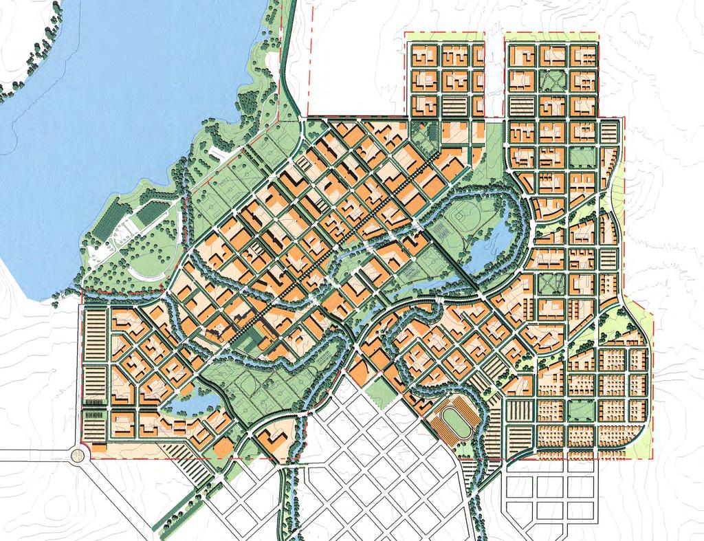
74
75 LONG RANGE DEVELOPMENT PLAN ELEMENTS LONG RANGE DEVELOPMENT PLAN In this section of the Long Range Development Plan each element of the plan is described: policies and plan descriptions provide guidance for future decision-making. Although the plan cannot anticipate all opportunities that may arise in the early years of the campus, it is intended to provide a flexible yet clear direction for the many facilities decisions that will need to be made. The elements of the plan include: Resource Conservation and Environmental Stewardship Sense of Place Land Use Circulation and Parking Utilities and Infrastructure Open Space and Landscaping Building Design Phasing Concept Plan Policies Fig. 5.1 (opposite) The maps in this chapter provide a graphical explanation of the policies of the Regents. The Illustrative Site Plan, opposite, shows how the Main Campus may appear when fully built, and the images are intended as examples of future facilities. LONG RANGE DEVELOPMENT PLAN 5-1
76 LONG RANGE DEVELOPMENT PLAN ELEMENTS Resource Conservation and Environmental Stewardship Land Resources As previously described the campus is characterized by three distinct zones: the Main Campus, the Campus Land Reserve and the Campus Natural Reserve. These zones have been identified based on the need to protect the natural resources of the site, including the drainage swales that host vernal pools, as well as the need to create a viable, successful campus that functions efficiently and has sufficient flexibility and area to thrive for many years. The layout of the three essential elements of the campus property is shown in Figure 5.2. The remainder of the Virginia Smith Trust property will also be acquired by the University, to be preserved in conservation easements. In the foreseeable future the only zone that is to be developed is the Main Campus. At no time will the Campus Natural Reserve area be developed; rather, it will form a link to the much larger natural conservation areas being set aside through the actions of the University and in conjunction with regional habitat conservation plans. This LRDP focuses on the development of the Main Campus area. The Main Campus, comprising 910 acres, is located in the southwest area of the overall 2,000-acre site, adjacent to the planned University Community Town Center and Lake Yosemite and its regional park. The Main Campus includes all of the facilities, infrastructure, roadways and parking, and open space required of a major research university. Major program elements (as described in the Academic Planning section of the LRDP) include: Academic Core Student Support Services Student Housing Faculty Housing Campus Support Athletics and Recreation On Campus Research The Main Campus is adjacent to the Town Center, which will allow mutually supportive uses and activities such as performance and arts facilities, sports, and libraries, as well as restaurants and services to be readily accessible to the public and to the University Community. The Main Campus is characterized by a compact arrangement of the Academic Core surrounded by housing and athletics and recreation. The academic core has been situated to provide convenient access to resident students and faculty, and to be convenient to the nearby Town Center, as noted above. Generally, the academic core can be accessed by no more than a 10 minute walk from anywhere on Main Campus, and will be made even more accessible by the addition of campus transit service. Campus as Living Laboratory UC Merced, as the first major research university built in the 21st Century, has a special opportunity to embody principles of environmental stewardship not only in the physical manifestation of the facilities and grounds of the campus, but in the educational opportunities formal and informal that it offers its students and the community at large. The physical facilities of the campus will be available as a living laboratory for resource conservation and engineering study to enhance the academic program. 5-2 UNIVERSITY OF CALIFORNIA, MERCED
77 LONG RANGE DEVELOPMENT PLAN ELEMENTS Fig. 5.2 Campus Land Use Zones CONSERVATION EASEMENTS CAMPUS NATURAL RESERVE 750 ACRES LAKE YOSEMITE 0 500' 1000' 1500' CAMPUS LAND RESERVE 340 ACRES CONSERVATION EASEMENTS CAMPUS NATURAL RESERVE PARK MAIN CAMPUS 910 ACRES CAMPUS LAND RESERVE MAIN CAMPUS 0' 1500' N TOWN CENTER LONG RANGE DEVELOPMENT PLAN 5-3
78 LONG RANGE DEVELOPMENT PLAN ELEMENTS Environmental Stewardship Environmental stewardship and sustainable planning and design at UC Merced include elements ranging from energy infrastructure planning and site layout, transportation systems planning and road layouts, through the occupancy of individual buildings. The incorporation and integration of these elements will result in environmental, economic, health and community benefits including: ENVIRONMENTAL BENEFITS Enhance and protect natural habitats Protect air and water quality Reduce solid waste Conserve natural resources ECONOMIC BENEFITS Minimize operating costs Enhance asset value Improve employee productivity and satisfaction Optimize life-cycle economic performance HEALTH AND COMMUNITY BENEFITS Improve air, thermal and acoustic environments Enhance occupant comfort and health Contribute to community health, vitality and aesthetics. Sustainable planning and design practices are evident throughout this LRDP. Key actions to be undertaken by the University in the earliest years relate to energy use and building design. Energy Planning Targets have been established for facility maximum power demand and annual energy use as follows: Buildings completed for FY 2005 (summer of 2004) 80% or less of the 1999 UC/CSU average campus benchmark Buildings completed for FY 2006 to FY % or less of the 1999 UC/CSU average campus benchmark Buildings completed for FY 2009 and beyond 50% or less of the 1999 UC/CSU average campus benchmark. Targets are adjusted for the Merced climate, and the overall campus target is adjusted for the density of laboratory buildings. For some systems, these targets are equivalent to the same percentage improvement over the 1999 Title 24 Energy Code. The targets assume that the campus will employ commercially available off-the-shelf energy efficient technology in facility design, including laboratories and other buildings. The goal for 2004 replicates the success and standards attained by some UC campuses, as well as the level of efficiency commonly achieved by public funded design assistance programs and LEED certified buildings. The long term targets can be achieved if: 1) energy performance monitoring equipment installed from the beginning of campus development informs improved designs, 2) new technologies become available, and/or 3) additional resources become available as a result of the Governor s request for sustainably-designed UC/CSU buildings. 5-4 UNIVERSITY OF CALIFORNIA, MERCED
79 LONG RANGE DEVELOPMENT PLAN ELEMENTS Targets for power reduction are in addition to the shifting of virtually all cooling load off of the summer peak demand period. Initially, this will be accomplished by chilled water thermal storage. Depending on trends in the relative costs for gas and electricity and developments with regards to emission controls and cogeneration technology, gas or cogeneration-driven cooling may also be used at some point in campus development. Sustainable Facility Planning, Design and Construction The University of California is utilizing the U.S. Green Building Council s Leadership in Energy and Environmental Design (LEED ) green building rating system as a way to prioritize the sustainable building planning and design strategies for the project. LEED is a self-assessing system designed for rating new and existing commercial, institutional, and high-rise residential buildings. It evaluates environmental performance from a whole building perspective over a building s life cycle, providing a definitive standard for what constitutes a green building. LEED is based on accepted energy and environmental principles and strikes a balance between known effective practices and emerging concepts. The following are among the elements of sustainable planning and design that are being taken into consideration in the long term planning for UC Merced. These elements are excerpted from the LEED V.2 green building rating system: CAMPUS ENVIRONMENT Erosion and sedimentation control Control erosion to reduce negative impacts on water and air quality. Reduced site disturbance Conserve existing natural resources and restore damaged areas to provide habitat and promote biodiversity. Storm water management Limit disruption of natural water flows by minimizing storm water runoff, increasing on-site infiltration and reducing contaminants. Landscape and exterior design to reduce heat island effect- Reduce heat islands (thermal gradient differences between developed and undeveloped areas) to minimize impact on microclimate and human and wildlife habitat. Light pollution reduction Eliminate light trespass from the building site, improve night sky access, and reduce development impact on nocturnal environments. WATER RESOURCES Water efficient landscaping Limit or eliminate the use of potable water for landscape irrigation. Encourage use of drought tolerant plant species. Innovative wastewater technologies Reduce generation of wastewater and potable water demand, while increasing local aquifer recharge. Water use reduction Maximize water efficiency within buildings to reduce the burden on municipal water supply and wastewater systems. LONG RANGE DEVELOPMENT PLAN 5-5
80 LONG RANGE DEVELOPMENT PLAN ELEMENTS ENERGY AND EMISSIONS Building systems commissioning Verify and ensure that the building is designed, installed, and calibrated to operate as intended. CFC reduction in heating, ventilating, air conditioning, and refrigeration (HVAC&R) equipment Reduce ozone depletion. Optimization of energy performance Achieve increasing levels of energy performance above the prerequisite standard to reduce environmental impacts associated with excessive energy use. Renewable energy sources Encourage and recognize increasing levels of self-supply through renewable technologies to reduce environmental impacts associated with fossil fuel energy use. Elimination of HCFC s and halons Reduce ozone depletion and support early compliance with the Montreal Protocol. Measurement and verification Provide for the ongoing accountability and optimization of building energy, water consumption over time. Green power Encourage the development and use of grid-source, renewable energy technologies on a net zero pollution basis. MATERIALS AND RESOURCES Storage and collection of recyclables Facilitate the reduction of waste generated by building occupants that is hauled to and disposed of in landfills. Construction waste management Divert construction, demolition, and land clearing debris from landfill disposal. Redirect recyclable material back to the manufacturing process. Resource reuse Extend the life-cycle of targeted building materials, reducing environmental impacts related to materials manufacturing and transport. Recycled content Increase demand for building products that have incorporated recycled content material, reducing impacts resulting from the extraction of new material. Local/regional materials Increase demand for building products that are manufactured locally, reducing the environmental impacts resulting from transportation, and supporting the local economy. Rapidly renewable materials Reduce the use and depletion of finite raw and long cycle renewable materials by replacing them with rapidly renewable materials (planted and harvested in less than a ten year cycle). Certified wood Encourage environmentally responsible forest management. 5-6 UNIVERSITY OF CALIFORNIA, MERCED
81 LONG RANGE DEVELOPMENT PLAN ELEMENTS INDOOR ENVIRONMENTAL QUALITY Minimum Indoor Air Quality (IAQ) performance Establish minimum IAQ performance to prevent the development of indoor air quality problems in a buildings, maintaining the health and well being of the occupants. Carbon dioxide monitoring Provide capacity for IAQ monitoring to sustain long term occupant health and comfort. Increased ventilation effectiveness Provide for the effective delivery and mixing of fresh air to building occupants to support their health, safety and comfort. Construction IAQ management Prevent IAQ problems resulting from the constructive renovation process, to sustain long-term installer and occupant health and comfort. Low-emitting materials Reduce the quantity of indoor air contaminants that are odorous or potentially irritating to installer and occupant health and comfort. Indoor chemical and pollutant source controls Avoid exposure of building occupants to potentially hazardous chemicals that adversely impact air quality. Controllability of systems Provide a high level of individual occupant comfort of thermal, ventilation, and lighting systems to support optimum health, productivity, and comfort conditions. Thermal comfort Provide for a thermally comfortable environment that support the productive and healthy performance of the building occupants. Daylight and views Provide a connection between the indoor spaces and the outdoor environment through the introduction of sunlight and views into the occupied areas of the building. TRANSPORTATION Alternative transportation Reduce the pollution and land development impacts from automobile use by installing alternative fuel-refueling stations and supporting mass transit. Accessibility Support facilities ECONOMIC Life cycle analysis Integrated system comparisons LONG RANGE DEVELOPMENT PLAN 5-7
82 LONG RANGE DEVELOPMENT PLAN ELEMENTS Sense of Place A sense of place, of beauty, and attractiveness to faculty and students is critical to the plan Elements of the plan which would achieve this are described below and in Figure 5.3. Places of Gathering As described elsewhere, Main Street will be designed as the meeting area for the entire campus community. Main Street will begin as a pedestrian space at the Library/Information Technology Center, at a point marked by changes in landscape and hardscape elements The Library Grove with trees planted in rows to resemble the orchards surrounding Merced will provide a place for informal recreation and for formal and ceremonial gatherings. The Bowl in a curve of the Le Grand Canal at the center of the campus may be used for a major outdoor amphitheater. The future Old Barn Park will provide a terminus to Main Street and an opportunity to acknowledge the history and agricultural heritage of the campus site. Sequential Views and Approaches University Drive, leading from the extension of the Campus Parkway, will eventually form the principal vehicular approach to the campus. Prospective students and their families, those seeking to do business with the campus administration, spectators at performing arts and sports events, and transit vehicles all will use University Drive. The approach from the Campus Parkway will provide a visitor information kiosk. As the drive continues past the kiosk its alignment will gently curve to provide views of the central campus on the brow of the hill over campus athletic fields. The formal entry to the campus will focus across a bridge over the Le Grand Canal to the Central Mall, flanked by a future administrative building. The future Central Mall will form an axial link through the core of the campus to the edge of Lake Yosemite Regional Park. For the opening of Phase 1 a sequence of views is planned as described in Section 6. Landmarks The realities of public funding preclude precise definition of landmarks or monuments, but the history of older campuses suggests that locations for such places should not be ignored. The beginning of the campus pedestrian Main Street is a likely choice for a fountain or similar feature. The edge of the bluff, where a flagpole is initially proposed, offers a significant site for a campanile or similar structure, alone or in combination with a flight of formal stairs linking the Library Grove to the playing fields below. Its position would make it visible from the University Community and Campus Parkway. In addition to a possible large amphitheater at the Bowl, the rear side of the classroom building provides a site for a small outdoor amphitheater, and the courtyards of future buildings may offer similar opportunities. 5-8 UNIVERSITY OF CALIFORNIA, MERCED
83 LONG RANGE DEVELOPMENT PLAN ELEMENTS Fig. 5.3 Plan Elements Establishing a Sense of Place CAMPUS LAND RESERVE LAKE YOSEMITE 3 PLACES OF GATHERING LIBRARY GROVE THE BOWL (AMPHITHEATER) OLD BARN PARK SENSE OF ARRIVAL a b c d e f ENTRY IDENTITY AND LANDSCAPE VISITOR INFORMATION KIOSK SPECIAL VIEW OPPORTUNITY BRIDGE AS ENTRY PORTAL DROP-OFF AND PEDESTRIAN GATE TO CAMPUS CAMPANILE LANDMARK STRUCTURE WITH CAMPUS STEPS TO PLAYFIELDS POTENTIAL LANDMARK MAIN STREET CAMPUS ENTRY PHASE ONE a b c C ANAL PA RK CANAL PARK d e a UNIVERSITY DRIVE CAMPUS ENTRY f 1 c b CENTRAL MALL d MAIN STREET FAIRFIELD CANAL 2 LE GRAND CANAL e d STADIUM N 0 500' 1000' 1500' LONG RANGE DEVELOPMENT PLAN 5-9
84 LONG RANGE DEVELOPMENT PLAN ELEMENTS Land Use Main Campus The Main Campus of UC Merced is the developed portion of the campus. The discussion below describes its layout and character. The Main Campus includes these primary land use zones, as illustrated in Figure 5.4: Academic Core Housing Campus Support Areas Athletics and Recreation Zones Parking On Campus Research Student Support Services The Academic Core comprises the central teaching and research facilities for the campus. It will occupy 157 acres and accommodate over 3.5 million gross square feet of building space, including the following space types: Instructional Research Academic support Administration A mixed use concept which integrates student support services, academic core and student housing is basic to the plan. Parking associated with core uses and campus support (central plant facilities) are also located in this area, but are described in separate sections of this plan. ACADEMIC RELATED USES The Academic Core includes instructional, research, academic support and administrative uses needed to support a comprehensive research university. It is the center of campus activity during a typical day, and supports a diverse population of students, faculty, staff, researchers, and visitors. Eventually the campus population, which is largely focused in the academic core, will reach over 30,000, although this population will seldom be on campus simultaneously. STUDENT SUPPORT SERVICES Student support services (23 acres) include the student union and commons areas, food service, student health, and other services. These facilities will serve both resident and non-resident students of UC Merced. They are located in the center of the campus but easily accessible from campus entries and main roads. ON CAMPUS RESEARCH On campus research areas (39 acres) have been established for research that needs close proximity to the central campus but does not require or desire the contiguity offered by a location in the center of campus. Examples of these uses are large wind tunnels, shaking tables for seismic simulations, or facilities that require special infrastructure support such as high voltage transformers. Some UC campuses host research entities that may be wholly or partially independent of the University and its central research functions but whose location on campus enriches the research environment by offering opportunities for extra-mural research collaborations and graduate student employment. Examples include the Mathematical Sciences Research Institute at Berkeley, and the San Diego Supercomputer Center UNIVERSITY OF CALIFORNIA, MERCED
85 250 LONG RANGE DEVELOPMENT PLAN ELEMENTS Fig. 5.4 Campus Land Use Concept CAMPUS LAND RESERVE OLD BARN ROAD LAKE YOSEMITE LAKESHORE DRIVE MEADOW CROSSING ACADEMIC CORE STUDENT HOUSING LE GRAND CANAL FACULTY, GRADUATE & AFFILIATE HOUSING TOWN CENTER DRIVE CAMPUS SUPPORT ATHLETICS, RECREATION & OPEN SPACE PARKING LITTLE LAKE ROAD MAIN STREET ON-CAMPUS RESEARCH FAIRFIELD CANAL MIXED USE: STUDENT SUPPORT, STUDENT HOUSING MIXED USE: STUDENT SUPPORT, ACADEMIC CORE MIXED USE: STUDENT HOUSING, ACADEMIC CORE BELLEVUE ROAD LAKE ROAD UNIVERSITY DRIVE 0 500' 1000' 1500' N COMMERCE ROAD LONG RANGE DEVELOPMENT PLAN 5-11
86 LONG RANGE DEVELOPMENT PLAN ELEMENTS CONFIGURATION OF THE ACADEMIC CORE In recognition of the importance of the undergraduate teaching mission of the university, as well as the importance of creating an active and vital campus life, the Academic Core is organized to centralize those academic facilities with high daily student use. Thus facilities such as the library, student center, lecture halls and large classrooms, and those academic buildings with a high student to faculty ratio, will be located in a student activity zone. This activity zone focuses along Main Street and within a short walk of it. Anchored by the library and key classroom facilities, Main Street will also accommodate uses that support student life, such as dining halls, informal dining venues (cafes, coffee shops or kiosks), book store, and student service offices. Facilities associated with the Social Sciences, Humanities and Arts characterized predominantly by classrooms and offices, will be more associated with the student activity zone at the heart of the Academic Core, as will science and engineering buildings with a significant number of teaching laboratories. Flanking this instructional core, more research-intensive buildings, professional schools, and institutes will be arrayed. Characterized by a lower population density than core teaching facilities, and having more interaction with visitors and the research or professional communities, these facilities will be peripheral to the academic core. Arts and performance facilities that will attract an off campus audience will be located immediately adjacent to the Town Center at the edge of the Academic Core to ensure accessibility to the Merced community. The Academic Core will also be organized to facilitate interdisciplinary interaction. Strict partitioning of the core into specific academic precincts will be avoided. Instead, the three divisions Engineering, Natural Sciences and Social Sciences, Humanities and Arts will occupy broadly defined zones with opportunities for shared, multidisciplinary facilities throughout. Student Services include the student union and commons, food service, student health, counseling, career center and other services. These uses will be included in the Academic Core, focused along Main Street UNIVERSITY OF CALIFORNIA, MERCED
87 250 LONG RANGE DEVELOPMENT PLAN ELEMENTS Fig. 5.5 Academic Core CAMPUS LAND RESERVE OLD BARN ROAD LAKE YOSEMITE LAKESHORE DRIVE MEADOW CROSSING LE GRAND CANAL TOWN CENTER DRIVE LITTLE LAKE ROAD ACADEMIC CORE ON-CAMPUS RESEARCH MAIN STREET CAMPUS SUPPORT FAIRFIELD CANAL PARKING OPEN SPACE PEDESTRIAN, BICYCLE RESTRICTED VEHICULAR ACCESS BELLEVUE ROAD LAKE ROAD UNIVERSITY DRIVE 0 500' 1000' 1500' N COMMERCE ROAD LONG RANGE DEVELOPMENT PLAN 5-13
88 LONG RANGE DEVELOPMENT PLAN ELEMENTS Fig. 5.6 Academic Core Interdisciplinary Zones CAMPUS LAND RESERVE OLD BARN ROAD LAKE YOSEMITE R = 5 MINUTE WALK LAKESHORE DRIVE PROFESSIONAL SCHOOLS AND RESEARCH SCIENCE AND ENGINEERING STUDENT ACTIVITY ZONE PROFESSIONAL SCHOOLS AND RESEARCH MAIN STREET MEADOW CROSSING PROFESSIONAL SCHOOLS LE GRAND CANAL LITTLE LAKE ROAD MAIN STREET HUMANITIES AND SOCIAL SCIENCES FAIRFIELD CANAL PERFORMING ARTS TOWN CENTER DRIVE BELLEVUE ROAD LAKE ROAD UNIVERSITY DRIVE COMMERCE ROAD N 0 500' 1000' 1500' 5-14 UNIVERSITY OF CALIFORNIA, MERCED
89 LONG RANGE DEVELOPMENT PLAN ELEMENTS Fig. 5.7 Academic Core Organizing Factors CAMPUS LAND RESERVE LAKE YOSEMITE OLD BARN ROAD UTILITY CORRIDOR SCIENCE/ENGINEERING LABORATORY-INTENSIVE DISTRICT THE UTILITIES CORRIDOR SUPPORTS THE LABORATORY DISTRICT R = 5 MINUTE WALK LAKESHORE DRIVE MEADOW CROSSING 250 MAIN STREET LE GRAND CANAL 250 THE CENTRAL LIBRARY IS THE CORE OF THE HUMANITIES AND SOCIAL SCIENCES DISTRICT LITTLE LAKE ROAD LIBRARY HUMANITIES AND SOCIAL SCIENCES DISTRICT TOWN CENTER DRIVE BELLEVUE ROAD LAKE ROAD UNIVERSITY DRIVE FAIRFIELD CANAL 0 500' 1000' 1500' N COMMERCE ROAD LONG RANGE DEVELOPMENT PLAN 5-15

90 LONG RANGE DEVELOPMENT PLAN ELEMENTS RELATIONSHIP TO SURROUNDING USES Town Center The organization of the Main Campus in a grid provides a seamless transition to the adjacent Town Center. Also arranged in a compact grid, Town Center is directly south of the campus core, and an easy walk of less than five minutes. The Town Center will provide many of the goods and services for the University Community, including restaurants, retail, office and other amenities. In addition, elements of the campus are located directly adjacent, including performing arts and sports facilities, assuring a vital linkage between town and gown. It is expected that students, faculty and staff will find amenities in the Town Center just as community residents will find destinations and amenities within the University. Lake Yosemite Regional Park As with the Town Center, the University intends to provide a permeable, friendly edge at the Lake Yosemite Regional Park and campus boundaries. Lakeshore Drive provides access simultaneously to the park and to northern portions of the campus. Campus academic uses as well as campus open space, quads and plazas are accessible from this edge. Fig. 5.8 Academic Core 5-16 UNIVERSITY OF CALIFORNIA, MERCED

91 LONG RANGE DEVELOPMENT PLAN ELEMENTS MAIN STREET With the layout and orientation of the site in a rectangular grid format, Main Street becomes a major orienting element and the focus of campus activity. Beginning at Phase 1 of the campus at the Library Grove, extending through the center of the Academic Core, and ending near the location of the historic barn, Main Street provides a location for the most intensive student activities: food service, student center services, major classrooms, and library. Although in early phases of the campus Main Street will be used for limited service and vehicular access due to site constraints, ultimately Main Street will be a pedestrian mall, accommodating high volumes of pedestrian traffic and activity. Fig. 5.9 Main Street LONG RANGE DEVELOPMENT PLAN 5-17

92 LONG RANGE DEVELOPMENT PLAN ELEMENTS Housing UC Merced s goal is to house 50% of all students on campus. This goal is based on sound principles of educational outcomes and academic community quality, as well as a desire to lessen impacts on the surrounding region. However, as campus housing must be self-supporting, these goals will be reassessed as the campus grows and market factors change. Student housing is basic to the educational mission of the University of California. Provision of housing for freshmen and undergraduate transfer students may be correlated to successful retention rates, and therefore the eight general UC campuses give priority to housing these groups. Campuses offer housing to all freshman, and typically between 70% and 75% actually occupy housing. Residential capacity for graduate students and students with families (referred to as affiliate housing) is important as well. Successful recruitment of graduate students has been found to be correlated with the availability of on campus housing. In addition, student housing for families is important to the University s ability to reach re-entry students, graduate students, and students who have the care of dependents. Of students housed on campus, the distribution among types is expected to follow these guidelines: Undergraduates 75% of total Graduates 15% of total Students with families 10% of total As the leading national public research university, the University of California is in an intensely competitive recruitment environment for quality faculty. The provision of faculty housing on campus reflects one of the most important lessons learned from the experience of planning new UC campuses in the 1950s and 60s. Although faculty housing was initially considered unnecessary at those campuses, today this housing is in high demand due to rising housing costs throughout the state and diminishing supplies in many communities. As a consequence an area is set aside that will accommodate 50% of the ultimate faculty population at UC Merced, in a combination of multi-family and single family units. Fig Section of Housing Area NEIGHBORHOOD STREETS COMMON ROOMS AT STREET LEVEL RESIDENTIAL COURTYARDS 5-18 UNIVERSITY OF CALIFORNIA, MERCED

93 LONG RANGE DEVELOPMENT PLAN ELEMENTS UNDERGRADUATE HOUSING Undergraduate and some graduate student housing is located in neighborhoods arrayed around and immediately adjacent to the Academic Core. Each neighborhood comprising approximately 2,500 students will take on a unique identity and will provide a more intimate venue for student socializing and activities. A range of undergraduate housing types are anticipated, including dormitories, suites, apartments and, potentially, group housing, such as fraternities and sororities. Housing clusters are also expected to include informal recreation space, lounges, dining, study and meeting rooms, and other amenities. West Neighborhood This undergraduate neighborhood is located at the western edge of the campus, and will be the first phase of housing built. It orients around the small lake of the existing golf course and lies directly across the canal from the library, first science and engineering building, and first classroom building. Fig Student Housing Neighborhood This neighborhood also lies adjacent to the westernmost extent of the athletics and recreation areas located in the swale between the canals. It is also conveniently located near the amenities of Lake Yosemite Park. Main Street Neighborhood Located immediately adjacent to the academic core, this neighborhood also lies near the future community town center. Because it fronts on both sides of Main Street, it would contribute to the vitality and activity of this key part of the campus. Uses such as dining, common and recreation rooms, as well as general use classrooms should be located along Main Street. LONG RANGE DEVELOPMENT PLAN 5-19


94 LONG RANGE DEVELOPMENT PLAN ELEMENTS East Neighborhood The third neighborhood is located across the canals from the academic core, and is also convenient to the athletics and recreation zone. It has very good adjacency to the community Town Center and its future amenities, as well as future performance and arts facilities. Fig Typical Street in Faculty, Graduate Student, or Affiliate Housing Area North Neighborhood The fourth neighborhood is located at the north end of Main Street adjacent to Old Barn Road and close to major recreational and athletic fields. FACULTY, GRADUATE STUDENT AND AFFILIATE HOUSING Faculty, graduate student and affiliate housing areas are located slightly further from the academic core than the undergraduate housing neighborhoods, generally to the east and southeast. The character of these housing neighborhoods will take their cue from the wonderful, tree-lined neighborhoods of Merced and other Valley towns. Narrow roadways, shade trees, front porches and garages located at the side or rear or properties will characterize these areas. A range of housing formats is expected including apartments, townhouses, duplexes and attached or detached homes. Faculty, graduate student and affiliate housing are located together due to their probable similarity of unit type, and need for common amenities such as child care. It is not anticipated that there will need to be separate zones for each of these user groups. This housing area, like the undergraduate housing, is comprised of several distinct neighborhoods, which will allow for differentiation in design and site planning. The neighborhoods are delineated by the two gentle drainage swales that trend from the northeast to the southwest UNIVERSITY OF CALIFORNIA, MERCED
95 LONG RANGE DEVELOPMENT PLAN ELEMENTS Fig Residential Areas CAMPUS LAND RESERVE NORTH NEIGHBORHOOD OLD BARN ROAD LAKE YOSEMITE LAKESHORE DRIVE MAIN STREET NEIGHBORHOOD LE GRAND CANAL MEADOW CROSSING TOWN CENTER DRIVE LITTLE LAKE ROAD MAIN STREET EAST NEIGHBORHOOD STUDENT HOUSING WEST NEIGHBORHOOD FAIRFIELD CANAL FACULTY, GRADUATE & AFFILIATE HOUSING OPEN SPACE BELLEVUE ROAD LAKE ROAD UNIVERSITY DRIVE 0 500' 1000' 1500' N COMMERCE ROAD LONG RANGE DEVELOPMENT PLAN 5-21
96 LONG RANGE DEVELOPMENT PLAN ELEMENTS Athletics and Recreation Athletic facilities are essential features of universities and colleges throughout the United States and abroad, and student participation in athletic programs is high. At major research universities, extensive athletic facilities are provided to support a broad array of intramural, intercollegiate, extracurricular, and social activities that are part of the educational and social life of students, faculty, and staff, and which provide an essential interface between the campus and the community at large. Program elements for athletics and recreation are expected to include: CURRICULAR OFFERINGS Like other UC campuses it is expected that UCM will offer an array of recreation coursework. Examples might include classes on aquatic instruction, fitness, sports, dance, martial arts, tennis, swimming, as well as more general health and lifestyle instruction. INTRAMURAL ATHLETICS In additional to curricular offerings, intramural athletics are essential parts of the undergraduate and graduate programs at major research universities. Athletic fields, gymnasiums, tennis and racquetball courts are needed for student use outside the classroom. INTERCOLLEGIATE ATHLETICS Like most major research university campuses, UC Merced will provide facilities for intercollegiate athletics programs, with the eventual potential to accommodate a full range of sports for both men and women at the level of Division I of the National Collegiate Athletic Association (NCAA). FACULTY AND STAFF OPPORTUNITIES Recreational facilities will also be available for the use of faculty and staff, an important amenity that is highly valued at university campuses. Most of the athletics and recreation uses are located in a slightly depressed swale that extends in a southwest/northeast direction through the center of the campus. Additional uses will be located adjacent to Lake Yosemite Regional Park, in facilities that may be shared by the campus and community and would be planned in coordination with the County. Running parallel to the Lake Yosemite Regional Park, the northern extent of the main campus extends in a narrow finger. This area lies immediately adjacent to the Park and consequently is a good location for recreation facilities that can be jointly developed and shared by the campus and community. A site adjacent to the Town Center has been identified for a future stadium or arena. Figure 5.14 illustrates athletic and recreational facilities and the type of fields and courts that may be fitted into the available land areas. Precise configurations and types of facilities may vary depending on actual needs as the campus grows UNIVERSITY OF CALIFORNIA, MERCED
97 250 LONG RANGE DEVELOPMENT PLAN ELEMENTS Fig Athletics and Recreation CAMPUS LAND RESERVE OUTDOOR BASKETBALL OLD BARN ROAD LAKE YOSEMITE COMPETITION PLAYFIELDS OUTDOOR INLINE SKATING CENTER LAKESHORE DRIVE SWIMMING POOL ATHLETIC DEPARTMENT & GOLF PRACTICE TRAINING FACILITIES FACILITIES TURF REPLACEMENT PLAYFIELD FAIRFIELD CANAL MAIN STREET LE GRAND CANAL BASEBALL STADIUM COMPETITION TENNIS COURTS OUTDOOR BASKETBALL OUTDOOR VOLLEYBALL PLAYFIELD MEADOW CROSSING SWIMMING POOL BELLEVUE ROAD LAKE ROAD TENNIS FACILITIES LITTLE LAKE ROAD INDOOR MULTIPURPOSE FACILITY SWIMMING POOL FIELD MAINTENANCE PLAYFIELD FACILITY SOFTBALL PLAYFIELDS OUTDOOR VOLLEYBALL MULTIUSE ARENA TOWN CENTER DRIVE OUTDOOR BASKETBALL UNIVERSITY DRIVE SPORTS ARENA PLAYFIELD 0 500' 1000' 1500' N COMMERCE ROAD LONG RANGE DEVELOPMENT PLAN 5-23
98 LONG RANGE DEVELOPMENT PLAN ELEMENTS Campus Support Services Campus support services include facilities management, materials management, environmental health and safety, police services, central plant nodes and associated corporation yards. These various services will be housed in a number of locations on the campus dependent upon operational adjacency requirements. In an effort to minimize truck traffic in the academic core, the primary campus support facility which houses materials management will be located in the southwest corner of the campus. This location provides easy access to the future Campus Parkway for materials delivery, recycled materials collection, hazardous waste collection and a lay down yard for construction staging. Initially this location will be used for other support services as well, such as environmental health and safety and police. The energy requirements of the campus will be served by a series of central plant nodes built in parallel with the phased growth of the campus and located in areas near the high energy use buildings such as laboratories. A backbone utility tunnel will connect the plant nodes, facilitating maintenance and minimizing disruptions due to campus growth. As additional central plant nodes are added, each can take advantage of the newest energy technologies. Energy performance monitoring equipment will be installed throughout the plants, distribution system, and buildings. In conjunction with similar water monitoring equipment, this monitoring system will allow optimization and continuous improvement in campus operations and provide better information that is normally available for the design of future laboratories and other facilities. The energy performance monitoring system will play a key role in the campus efforts to continuously evaluate and enhance environmental stewardship efforts. The system is also a key part of the academic program as it can be used to provide a database for studies of energy engineering and resource conservation. The energy performance monitoring system can also play a part in instruction as the basis for several teaching experiments in engineering laboratory classes. The system is thus a major part of making the campus a living laboratory for the study of engineering and resource conservation. Campus support areas are also located within a portion of the swale containing open space and recreation. These areas will be used as stormwater retention basins and for possible water reclamation UNIVERSITY OF CALIFORNIA, MERCED
99 250 LONG RANGE DEVELOPMENT PLAN ELEMENTS Fig Campus Support CAMPUS LAND RESERVE OLD BARN ROAD LAKE YOSEMITE LAKESHORE DRIVE MEADOW CROSSING LE GRAND CANAL TOWN CENTER DRIVE LITTLE LAKE ROAD MAIN STREET FAIRFIELD CANAL UTILITY TUNNEL CAMPUS SUPPORT BELLEVUE ROAD LAKE ROAD UNIVERSITY DRIVE 0 500' 1000' 1500' N COMMERCE ROAD LONG RANGE DEVELOPMENT PLAN 5-25
100 LONG RANGE DEVELOPMENT PLAN ELEMENTS Circulation and Parking Transportation Context Presently, the transportation facilities that directly serve the UC Merced campus site are limited to two-lane rural roads: Bellevue Road and Lake Road. These rural roads lead to a number of regional connections between five and seven miles from the campus site, including: Highway 99 a 4-lane freeway that provides access to San Francisco and Sacramento to the north, and Fresno and Bakersfield to the south. Highway 140 a two-lane, east-west highway serving recreational and local traffic, providing access to Yosemite National Park to the east, and extending to Highway 99 and Interstate 5 to the west. Highway 59 a two-lane rural facility connecting to Highway 99 and to Los Banos in western Merced County. Several major arterial streets provide connections to and through the City of Merced, including G Street, Yosemite Avenue, Olive Avenue, and Santa Fe Drive (which connects to the City of Atwater and Castle Aviation and Development Center). Major capacity expansions are planned for many of the above facilities prior to or during the period of development of the LRDP (see below). Local transit service in and around Merced is provided by Merced County Transit. Seventeen buses operate Monday through Friday on 12 fixed routes, supplemented by a dial-a-ride service. Urban transit routes connect downtown Merced, adjacent neighborhoods, and major trip generators such as the Merced Civic Center, hospitals, shopping areas, and Merced College. Rural routes connect outlying cities and communities in Merced County. Inter-county transit service linking the City of Merced with other parts of the state is provided by private entities, including Greyhound Lines, which provides daily and weekend service from Merced to numerous California locations. Amtrak provides daily passenger rail service to the San Francisco Bay Area, the San Joaquin Valley, and Yosemite National Park. The Merced Amtrak station is located at 324 West 24th Street, and the Transportation Center inter-city bus terminal is located on 16th Street between M and P Streets in Merced. The City of Merced has an extensive system of bicycle facilities. Merced s bikeway system consists of Class II striped bicycle lanes along many of the major streets in the City and Class I separated bicycle paths along several of the local creek corridors. Merced County also maintains bike paths along portions of Bear Creek and along Lake Road to Lake Yosemite adjacent to the UC Merced campus site. The Regional Transportation Plan (RTP), developed by the Merced County Association of Governments (MCAG), is the primary document outlining long-range transportation improvement plans 5-26 UNIVERSITY OF CALIFORNIA, MERCED
101 LONG RANGE DEVELOPMENT PLAN ELEMENTS and objectives in the County. Several of the high priority improvements identified in the 1998 RTP would benefit the University campus and adjoining University Community, including: Campus Parkway, a 4- to 6-lane expressway from a new interchange at Highway 99/ Mission Avenue to a point just east of the Lake Road/Yosemite Avenue intersection. Two alternative alignments are currently under study as shown in Figure 2.2 Highway 59, widening to 4 lanes from 16th Street to West Olive Avenue, a new interchange at Thornton Road, and expressway from Highway 99 to Belcher Avenue. Highway 140, widening to 4 lanes from Parsons Avenue to Kibby Road, and an improved Highway 99/140 interchange. Improved Highway 99 interchanges at V and R Streets. Upgraded Highway 99 to freeway from Merced to Madera County. The City of Merced has maintained a strong north-south growth pattern for many years, consistent with its proposed expansion areas. This pattern has contributed to a relative clustering of major destinations in proximity to M Street. M Street has been formally designated a Transitway or transit corridor. The Villages concept for north Merced emphasizes transit-oriented development, supported by the M Street Transitway. This corridor is a logical location for centralized bus service to run along or closely parallel to M Street throughout the entire north-south length of the City. An enhanced M Street transit corridor with connections to Bellevue Road and UC Merced campus and University Community could offer convenient non-auto access to nearly every major destination in Merced. The most recent Short Range Transit Plan from Merced County Transit includes a proposal to purchase ten buses for service to the new UC Merced Campus. Merced County Transit is interested in exploring possible teaming arrangements with the University to support comprehensive transit service for the Campus and the Community. Cycling represents an important transportation opportunity for UC Merced. The extensive system of existing and planned bicycle facilities, the nature of University-related travel, and the opportunity to develop a bicycle-friendly community adjacent to the campus all point toward cycling becoming a significant component of travel. The Regional Bicycle Plan identifies a regional bikeway system for Merced County, and within each community in the County. The highest priority projects identified in the Plan are a regional bicycle safety and education program, and effective connections to the proposed University and University Community. A complete system of Class I and II bikeways is proposed for northern Merced, including Bellevue, Cardella and Yosemite serving east-west travel, and Lake, Parsons/Gardner and G Street serving north-south travel. Improvements and extensions are also proposed to the creekside paths along Bear, Rascal, and Fahrens Creeks, that primarily serve recreational travel. The Merced Vision 2015 General Plan specifically calls for coordinated implementation and planning of bicycle facilities with Merced County and the University of California. LONG RANGE DEVELOPMENT PLAN 5-27
102 LONG RANGE DEVELOPMENT PLAN ELEMENTS LRDP Circulation The UC Merced LRDP circulation element includes policies and planning concepts related to streets and traffic-ways, parking locations and programs, transit routes and services, bicycle and pedestrian systems, service and delivery routes, and the primary elements of a transportation demand management (TDM) plan to encourage non-automobile modes. The overarching goal of this circulation element is to ensure that the campus transportation system allows safe and efficient travel by the full variety of modes listed above and promotes the use of alternatives to the automobile. To that end, a primary element of the campus circulation plan is the accommodation of multiple modes. This can be accomplished directly through circulation policies that give priority to certain transportation modes, or indirectly by providing the flexibility to adapt to changing conditions. Planning for the UC Merced circulation system focuses on integrating land use and transportation to minimize reliance on the automobile and impacts to adjoining land uses, while maintaining high levels of accessibility and personal mobility. There are a number of established policies, trends, and plans that present an opportunity to design and manage the UC Merced campus and adjoining community for less automobile travel than would ordinarily occur. However, success will derive from transportation planning and programming that establishes a non-motorized, transit-oriented culture from the earliest stages of campus development, and preserves that culture throughout the evolution of the campus and community. Creating this culture will depend on early investment in bicycle, pedestrian, and transit systems and amenities, as well as land use plans that ensure the levels of diversity, density, and design normally associated with pedestrianand transit-friendly environments. For the University campus and community as a whole, the diversity of the land use mix will be one of the primary means of minimizing transportation capacity requirements. Imbalances between campus enrollment and the amount of available nearby housing within the campus and adjoining community will translate directly to heightened transportation impacts. The same will be true of any lack of opportunity to develop needed services, amenities, and university-related spin-off activities such as incubator space for new businesses. Therefore, the land use and circulation elements of the LRDP and the Community Plan are mutually important. Keeping in balance with the transportation needs of the campus population as it grows will require thoughtful implementation of a flexible multi-modal system UNIVERSITY OF CALIFORNIA, MERCED
103 LONG RANGE DEVELOPMENT PLAN ELEMENTS A FLEXIBLE, MULTI-MODAL SYSTEM DESIGNED TO ENCOURAGE WALKING, BIKING AND TRANSIT The central transportation theme of the UC Merced LRDP is to provide a full array of transportation options focusing on proven modes which are highly supportive of sustainable development forms. The overall LRDP circulation element prioritizes the individual transportation modes as follows: 1) emergency and handicap access, 2) pedestrian and bicycle circulation, 3) transit service, 4) travel demand management, 5) service and delivery access, and 6) general vehicular access and circulation and parking. The LRDP emphasizes integrating the various transportation modes in the following manner: As an integrated set of facilities and services, the transportation system at UC Merced will allow safe and efficient travel by a variety of modes and promote the use of alternatives to the singleoccupant vehicle, while minimizing impacts on adjoining uses and supporting the LRDP land use goals. The following sections define the specific themes related to each of the individual modes. A later chapter in this document contains a set of transportation policies that will contribute to the realization of the multi-modal themes discussed here. Plan for multiple modes, include accommodations for autos, walking, cycling, and buses. Allow all modes to share access roads, but require most long-term parking to be located on the periphery. Limit parking supply and charge premium prices for parking within the core campus. Cluster activities at moderate to high densities to enhance suitability for walking, transit use, shared delivery/service routes, and shared parking. Invest early in high-quality transit service to the campus core and a comprehensive system for bicycles and pedestrians, and promote a bicycle culture. Maintain flexibility by providing corridors that can accommodate a variety of modes as the campus evolves. LONG RANGE DEVELOPMENT PLAN 5-29
104 LONG RANGE DEVELOPMENT PLAN ELEMENTS PEDESTRIAN AND BICYCLE CIRCULATION An ultimate goal of the UC Merced transportation system is to make it likely that, on any given school day there will be more bicycles on the campus than automobiles. An expansive system of campus bike paths will connect to a well-developed system of bike paths and bike lanes within the neighboring community. Taken together with the relatively flat terrain, mild climate, and nearby housing opportunities, the UC Merced environment will encourage bicycling. In addition, the campus will have an extensive system of pedestrian facilities to encourage walking within the campus core, and between the major residential areas and the core. Several areas in the heart of campus will be designated for pedestrians only, and a large portion of the core will be open only to pedestrians and cyclists. The added security and comfort of auto-free or autorestricted zones will further encourage walking and cycling. transportation program revenues that will allow University affiliates to board transit free of per-trip charges. A transit hub, located directly adjacent to the Academic Core in the University Community town center, will allow access to transit routes serving major destinations in the City of Merced and elsewhere in Merced County, as well as to private transit providers that serve destinations throughout the state. VEHICULAR ACCESS AND PARKING Regional access to the campus will be provided by an extension of Campus Parkway, an expressway designed by Merced County to serve high-growth areas in northern and eastern Merced and to connect to Highway 99 at Mission Avenue. Bellevue Road is anticipated to be widened and improved, to provide access between the campus and points west. Several local street connections will be made between the campus and the neighboring community. TRANSIT SERVICES The campus transit system will play a major role in the circulation network. Routes will serve intra-campus travel, as well as travel through the neighboring University Community. Frequent service on energy-efficient, low-emission buses will link intercept parking facilities to the core campus. Alternative fuel buses will help meet the low pollution goals. A transit pass system will be established, subsidized through student fees and other University Within the campus, a series of local streets allows full vehicular access to the residential areas. Residential parking will be interspersed within the housing areas. Most commuter parking facilities will be located at the perimeter of the Academic Core, or in a location easily accessible from the perimeter via a short internal road. Some faculty and staff parking will be provided in parking areas and eventually structures within the core campus. Regular vehicular access to the Academic Core will be restricted to specified roadways, to preserve the security and comfort of the academic areas for pedestrians and cyclists UNIVERSITY OF CALIFORNIA, MERCED


105 LONG RANGE DEVELOPMENT PLAN ELEMENTS Fig Shared Pedestrian and Bicycle Circulation Routes Provide Access Throughout the Campus All automobile parking on campus will require payment, either through a permit system or through hourly or daily fees. There will be multiple classes of permits, with the higher-priced permits allowing access to parking facilities closer to the center of campus. The parking fee system will be structured to encourage use of the more remote parking lots, in order to minimize automobile penetration of the campus core. The utility infrastructure and parking system will accommodate and foster the increased use of vanpools, car pools, and alternative fuel vehicles. A natural gas refueling station and parking with electric vehicle charging hook-ups will be integrated into the energy infrastructure. Parking location, shade, and fee preference will be used to encourage efficient gasoline hybrid, electric, and natural gas vehicles. The campus service vehicle fleet will lead the way as a model for the use of such low-polluting vehicles. Fig Main Street Includes Seating, Dense Planting of Shade Trees, and Other Amenities SERVICE AND DELIVERY ACCESS Campus access for service and delivery vehicles will be provided as needed. A research university of the size envisioned for UC Merced will receive numerous shipments each day, and service and maintenance vehicles will circulate regularly throughout the campus. Building design and placement will largely determine the preferred access routes for service vehicles, subject to the overall principles of the campus plan. LONG RANGE DEVELOPMENT PLAN 5-31
106 LONG RANGE DEVELOPMENT PLAN ELEMENTS TRANSPORTATION DEMAND MANAGEMENT Transportation demand management (TDM) strategies are intended to make more efficient use of transportation infrastructure and resources by reducing dependence on single-occupant vehicles. The extensive bicycle and pedestrian infrastructure on campus, as well as the restrictions on auto access and parking, will serve to encourage travel by alternate modes. Further measures may also be taken, such as providing financial incentives to students and/or employees for the use of transit or carpools, and offering options for telecommuting and flexible work schedules. REGIONAL COORDINATION While the City of Merced and Merced County do not maintain any formal jurisdiction over University land use, cooperative planning efforts will be undertaken with neighboring agencies on issues of mutual interest. In several aspects of transportation planning, substantial benefits can be realized by coordinating the efforts of the campus and the neighboring jurisdictions. Areas of mutual benefit may include transit service coordination, sharing of parking resources, and coordination of TDM strategies. There will be significant interaction between the campus and the surrounding areas, and such regional effects are best addressed through cooperative planning processes. UC Merced Circulation System Ultimate Form and Function The principal multi-modal access corridors to the campus, consistent with campus planning objectives as well as the objectives of adjacent campus community and regional park activities, will be: University Drive extending northeasterly from the extension of the Campus Parkway to campus entrances at Little Lake Drive, Town Center Drive, and Meadow Crossing; North Lake Road extending north from the Lake/Bellevue intersection to campus entrances at Main Street and Lakeshore Drive; and, Commerce Drive extending northeasterly from the Cardella and the extension of Campus Parkway intersection along the southern edge of the University Community town center to the stadium entrance to campus. Intercept parking will be located along all three access routes, near the intersections of north Lake Road/ Lakeshore, north Lake Road/ Main Street, University Drive/ Little Lake, and Commerce/ Stadium. Eventually the intercept parking areas will contain about 80% to 85% of the campus commuter parking supply, minimizing commuter travel into the campus core and housing areas. Figures 5.18 through 5.23 illustrate the form and function of the planned UC Merced circulation system, showing the primary and secondary vehicular network, parking and transit routing, and primary bike corridors and pedestrian zones. These circulation concepts are defined in a manner that conforms with the circulation themes stated in the previous section and with the circulation policies listed in a later chapter of this LRDP, while accomplishing the following day-to-day functional objectives: 5-32 UNIVERSITY OF CALIFORNIA, MERCED
107 LONG RANGE DEVELOPMENT PLAN ELEMENTS Primary traffic streets direct traffic efficiently to/from planned commuter parking facilities, with dual routes of access provided to reduce on-campus travel by regional access traffic. Minor traffic streets do not travel through the central campus, but provide secondary access via routes that are appropriate for integrated traffic calming. Fifteen percent or less of commuter parking will involve travel to the campus core, and even less will require travel into residential areas of campus. Access to campus service and support areas from off-campus will not involve travel through the core or campus residential areas. Campus support areas are accessible from the campus core without traversing off-campus streets, and from regional access points without traversing campus streets. Within the campus core, each block has at least two edge streets available for service and delivery vehicle access, even for buildings adjoining pedestrian-only zones. Bus routes directly serve all remote commuter parking areas and link them directly to the campus core along a central transit spine. The transit spine runs adjacent to the library and primary student support sites (such as a student union) and along Old Barn Road one block from the Main Street pedestrian zone. A regional transit hub is located at intersection of University Drive and Town Center Drive, adjacent to cultural center and near campus core mixed use and Main Street pedestrian zone. Buses connecting core campus to the University Community would stop at regional transit hub en route. Campus transit runs within two blocks of all Core uses and within approximately three blocks of all campus residential areas. The Central Mall between Lake Yosemite and The Bowl is designated for pedestrians and bicycles only (on separate, protected paths). Bicycles may be permitted to circulate on all streets within the block grid except on the Main Street pedestrian mall. This would encourage class-to-class bicycle riding. Alternatively, a 2-block bicycle grid could be used within portions of the campus core for greater pedestrian protection and cycling efficiency, a concept which creates a number of large (1-by-2-block, or 2-by-2-block) pedestrian precincts within core campus. Bus service will be integrated with regional transit serving the City of Merced, extending city transit corridors to the campus and town. LONG RANGE DEVELOPMENT PLAN 5-33
108 250 LONG RANGE DEVELOPMENT PLAN ELEMENTS Fig Pedestrian Circulation Network CAMPUS LAND RESERVE Circulation elements outside campus boundary are shown for illustrative purposes only. OLD BARN ROAD LAKE YOSEMITE LAKESHORE DRIVE MAIN STREET LE GRAND CANAL MEADOW CROSSING 250 LITTLE LAKE ROAD FAIRFIELD CANAL TOWN CENTER DRIVE PEDESTRIAN MALL BELLEVUE ROAD LAKE ROAD UNIVERSITY DRIVE PEDESTRIAN AND BICYCLE STREETS SIDEWALK RECREATIONAL PATH COMMERCE ROAD N 0 500' 1000' 1500' 5-34 UNIVERSITY OF CALIFORNIA, MERCED
109 LONG RANGE DEVELOPMENT PLAN ELEMENTS Fig Bicycle Circulation Network Circulation elements outside campus boundary are shown for illustrative purposes only CAMPUS LAND RESERVE OLD BARN ROAD LAKE YOSEMITE LAKESHORE DRIVE MEADOW CROSSING LE GRAND CANAL TOWN CENTER DRIVE LITTLE LAKE ROAD MAIN STREET FAIRFIELD CANAL ON-STREET BIKE LANE BICYCLE AND PEDESTRIAN STREET SHARED NEIGHBORHOOD STREET OFF-STREET TRAILS BELLEVUE ROAD LAKE ROAD UNIVERSITY DRIVE PEDESTRIAN MALL 0 500' 1000' 1500' N COMMERCE ROAD LONG RANGE DEVELOPMENT PLAN 5-35
110 250 LONG RANGE DEVELOPMENT PLAN ELEMENTS Fig Campus Transit CAMPUS LAND RESERVE Circulation elements outside campus boundary are shown for illustrative purposes only OLD BARN ROAD LAKE YOSEMITE LAKESHORE DRIVE MEADOW CROSSING LE GRAND CANAL TOWN CENTER DRIVE LITTLE LAKE ROAD MAIN STREET FAIRFIELD CANAL TRANSIT HUB BELLEVUE ROAD LAKE ROAD UNIVERSITY DRIVE TRANSIT ROUTE COMMUTER PARKING COMMERCE ROAD N 0 500' 1000' 1500' 5-36 UNIVERSITY OF CALIFORNIA, MERCED
111 LONG RANGE DEVELOPMENT PLAN ELEMENTS Fig Parking Diagram CAMPUS LAND RESERVE OLD BARN ROAD LAKE YOSEMITE LAKESHORE DRIVE MEADOW CROSSING LE GRAND CANAL TOWN CENTER DRIVE LITTLE LAKE ROAD MAIN STREET PARKING STRUCTURES FAIRFIELD CANAL REMOTE PARKING RESIDENTIAL PARKING ON-STREET AND/OR ON SITE BELLEVUE ROAD LAKE ROAD UNIVERSITY DRIVE 0 500' 1000' 1500' N COMMERCE ROAD LONG RANGE DEVELOPMENT PLAN 5-37
112 250 LONG RANGE DEVELOPMENT PLAN ELEMENTS Fig Vehicular Circulation Network CAMPUS LAND RESERVE Circulation elements outside campus boundary are shown for illustrative purposes only OLD BARN ROAD LAKE YOSEMITE LAKESHORE DRIVE MEADOW CROSSING LE GRAND CANAL TOWN CENTER DRIVE LITTLE LAKE ROAD MAIN STREET FAIRFIELD CANAL REGIONAL ACCESS BELLEVUE ROAD LAKE ROAD UNIVERSITY DRIVE PRIMARY STREETS SECONDARY STREETS PEDESTRIAN / BICYCLE & RESTRICTED VEHICULAR ACCESS COMMERCE ROAD N 0 500' 1000' 1500' 5-38 UNIVERSITY OF CALIFORNIA, MERCED
113 250 LONG RANGE DEVELOPMENT PLAN ELEMENTS Fig Service Access CAMPUS LAND RESERVE OLD BARN ROAD LAKE YOSEMITE LAKESHORE DRIVE MEADOW CROSSING LE GRAND CANAL TOWN CENTER DRIVE LITTLE LAKE ROAD MAIN STREET FAIRFIELD CANAL LOADING DOCK ACCESS SERVICE ROUTE LIMITED SERVICE ACCESS BELLEVUE ROAD LAKE ROAD UNIVERSITY DRIVE 0 500' 1000' 1500' N COMMERCE ROAD LONG RANGE DEVELOPMENT PLAN 5-39
114 LONG RANGE DEVELOPMENT PLAN ELEMENTS Utilities and Infrastructure The following infrastructure and utility systems will be needed for the Merced campus: Water Water Supply and Distribution Wastewater Collection and Treatment Recycled Water Supply and Distribution Stormwater Management Water and wastewater monitoring equipment Power and Fuel Electric Power Supply, Control and Distribution Natural Gas Supply, Control and Distribution Emergency Power Systems Photovoltaic Systems (when feasible on buildings or shade structures to augment electricity supplies) Communication and Information Services Communication Systems Voice and Data Energy Use Monitoring, Control and Data Acquisition Plant Nodes Central Heating and Cooling Systems Underground Utility Tunnels Chilled Water Supply and Distribution Hot Water Supply and Distribution Laboratory Gases Supply and Distribution Chilled Water Thermal Energy Storage (to shift power demand for cooling off of the summer peak demand periods) Low-Emission Cogeneration Systems (as future circumstances dictate) Solid Waste Solid Waste Management Hazardous Waste Management Emergency Services: Fire Alarm System(s) for Campus and Buildings Security Alarm System(s) for Campus and Buildings Fire Suppression Services Police Services Planning Concepts and Principles In proceeding with the planning of the infrastructure systems for the UC Merced campus, several guiding concepts and principles have been followed. These should be carried through and incorporated into the actual design of the campus infrastructure systems as the campus develops. These are: The principles of sustainable design as they apply to the campus infrastructure systems will be followed throughout the course of development. The use of renewable and emerging technology energy systems, use of energy efficient designs for buildings, use of central plants with thermal storage and interconnecting utility tunnels, use of energy monitoring systems and use of recycled water for landscape irrigation and other non-potable campus water uses are examples of the sustainable design concepts that will be incorporated into the infrastructure systems. Life cycle costing will be used in lieu of initial costs in the planning and design of utility systems for specific projects to the extent feasible, practicable, or within budgetary constraints UNIVERSITY OF CALIFORNIA, MERCED
115 LONG RANGE DEVELOPMENT PLAN ELEMENTS Utility corridors will be utilized where justified by demand throughout the campus (see Figure 5.24). Corridors and direct buried utility lines wherever possible will be located beneath paved roadways and walkways for ease of access for utility replacements and repairs. The campus will have a municipal type potable water distribution system. It will consist of an interconnected network of underground potable water mains fed from one or more of the water supply sources discussed above. It will be sized to provide the expected domestic and fire flows of the campus with the high degree of reliability expected at a major research university. The development of each infrastructure system will be coordinated with the others so that planned utility corridors are established throughout the campus under streets or street rights-of-way and will be phased. Water SUPPLY AND DISTRIBUTION The use of groundwater to supply the campus water needs is considered viable from either on campus or off campus wells or from the City of Merced. This source may be supplemented in the future by use of recycled water generated on-campus or supplied by a municipal/regional water reclamation facility. These supplemental water supplies would be used for non-potable uses such as toilet flushing, cooling tower use or landscape irrigation. The sources of groundwater will be either from the City s municipal system or from new wells developed, likely owned and operated by the City or UC Merced. The development of the groundwater supply will be phased to meet the needs of the developing campus. Adequate leadtime in its development will be provided to insure that this source would be available when needed by the campus. If the campus does develop its own groundwater supply, then it would require coordination with the groundwater management recommendations of the Merced Water Supply Plan, which was developed in collaboration with the City of Merced, MID, and UC Merced. Service to all facilities will be metered to help manage campus supplies and inform the design of future facilities. Metering will augment the energy performance monitoring system in making the campus physical facilities a living laboratory for study of engineering and resource conservation. WASTEWATER COLLECTION AND TREATMENT The campus wastewater will initially be conveyed to and treated by the City of Merced s Wastewater Treatment Facility. This facility has adequate available permitted capacity to treat the wastewater generated at the campus, and the City has indicated that it is interested in providing this service on a long-term basis to the campus. This treatment option may be modified in the future by the addition of an on-site or off-site recycled water treatment facility that benefits both the campus and the University Community. It is anticipated that this facility would become necessary if the campus needs a source of recycled water to augment its other water supplies or if it needs a source of recycled water to use in future environmental science and engineering research programs. The size, siting and process design for this facility would be determined as part of a future phase of campus development. LONG RANGE DEVELOPMENT PLAN 5-41
116 LONG RANGE DEVELOPMENT PLAN ELEMENTS The campus will have a gravity sewer wastewater collection system. It will consist of a branched network of underground gravity flow sewer laterals on the secondary streets of the campus that discharge into a main gravity sewer on one of the main east to west streets of the campus. The wastewater flow will be by gravity from east to west in this sewer. Wastewater flows will also be monitored to help manage campus operations, and inform the design of future facilities. Metering will augment the energy and water supply monitoring in making the campus physical facilities a living laboratory for study of engineering and resource conservation. RECYCLED WATER SUPPLY AND DISTRIBUTION There will be significant water demands for interior irrigation uses on the campus. This and other non-potable water demands may be met by the addition of an on-site recycled water treatment facility. Recycled water mains and laterals will be installed concurrently with other underground utility systems to distribute recycled water through out the campus. Storage facilities may be located in conjunction with stormwater detention facilities. The recycled water distribution system s development will be phased to meet the needs of the developing campus. STORMWATER MANAGEMENT The stormwater management system will be designed to mimic the natural hydrologic regime to the extent practical. It will consist of a branched network of underground gravity flow drain lines on secondary streets that discharge to one of the detention basins located throughout the campus. Wherever possible, grass swales, filter strips and other Best Management Practices will be used upstream (on a block by block basis) or in conjunction with the gravity drain lines to reduce times of concentration and to improve stormwater quality. The requirements of the MID for discharge to its canals will be met, so that they can be used in the overall drainage plan. The storage and non-potable reuse of stormwater will also be considered. Stormwater conveyance and detention facilities will be designed based on post-development runoff from a 10-year, 24-hour storm event. However, due to Merced Irrigation District (MID) discharge restrictions on Le Grand and Fairfield Canals, detention basins will be designed to handle runoff from a 100-year, 24-hour storm event. Controlled discharges to canals will take place over a minimum 48-hour period. Stormwater treatment methodologies will be employed to satisfy MID, state and federal water quality requirements UNIVERSITY OF CALIFORNIA, MERCED
117 LONG RANGE DEVELOPMENT PLAN ELEMENTS Power ELECTRIC POWER SUPPLY AND DISTRIBUTION Power will be supplied from both off-site and on-site sources. In order to meet the desired level of power supply reliability one or more of the following supply scenarios will be implemented at various times during the development of the campus. Supply Scenario 1: Power will be provided solely from the off-site power grid at either 12 kv from PG&E or 21 kv from Merced Irrigation District. This will require two redundant power feeds (separate power lines of equal capacity from independent sources (substations). Supply Scenario 2: Power will be provided from the off-site power grid and one or more on-site power sources. On-site power sources will be developed when prudent in consideration of several issues. To augment power reliability, on-site power must have stand-alone capability and the campus must have good control over the electric distribution system and/or good load management capability. On-site power must have low pollutant emissions. The existence of significant cogeneration opportunities is desirable for gas-fired systems to achieve a net environmental benefit. It is undesirable to install systems that will preclude the adoption of more efficient or lower polluting technologies as they become available during later stages of campus development. Potential systems must be manageable with respect to economic risk associated with volatility in fuel or electricity prices or regulatory hurdles. Opportunities to develop appropriate on-site renewable forms of power will be explored. This could include photovoltaic (PV) systems installed on campus buildings or other structures. Lowemission and high-efficiency gas-fired cogeneration systems including fuel cells will also be continuously evaluated for application on the campus. The Fairfield Hydroelectric Plant (FHP) owned by Merced Irrigation District and Merced County may also become a direct part of the campus power supply. It is also anticipated that certain specialized research facilities and critical communications systems may be provided with their own source of emergency back-up power in the form of local, engine-driven generator sets. The campus will be fed power from the sources described previously by means of an underground system of power cables installed in a network of underground duct banks, utility tunnels, electric manholes and possibly a substation. This duct bank network will be located under roadways and pedestrian paths. The power will be distributed at 12 kv from the on-site and PG&E power supplies. If the MID s 21 kv power supply is used, then step-down transformers, converting the 21 kv source to 12 kv will be needed at the point of connection to the MID system. Dual, redundant transformers and related switchgear will be required for this type of connection. Redundant metering and switchgear will also be needed at the point of connection to each power supply for both on-site and off-site sources. LONG RANGE DEVELOPMENT PLAN 5-43
118 LONG RANGE DEVELOPMENT PLAN ELEMENTS Redundant 12 kv power cables will extend from these points of connection so that each facility will have two separate 12 kv power feeds either of which can meet its power needs. These redundant cables will travel in separate underground duct banks (or utility tunnel where available) following different paths through the campus so that the accidental damaging of one duct bank will not interrupt power service. routed through the 12 kv duct banks and that the energy management system remote monitoring and control facilities will be housed with the central plant facilities. The 12 kv power distribution system s development will be phased to meet the needs of the developing campus. Electric vehicle charging hook-ups will be provided at appropriate parking locations, including at campus support fleet parking. Each building or facility will have dual, redundant transformers and related switchgear that connect the building to the 12 kv power distribution system. Building transformers will step down the 12 kv voltage to the 480 volts used in the buildings. Power consumption in each building will be monitored as a part of the extensive energy performance monitoring system. This monitoring system will allow optimization and continuous improvement in campus operations and provide better information that is normally available for the design of future laboratories and other facilities. The energy performance monitoring system will play a key role in the campus efforts to continuously evaluate and enhance environmental stewardship efforts. The system is also a key part of the academic program as it can be used to provide a database for studies of energy engineering and resource conservation. The energy performance monitoring system can also play a part in instruction as the basis for several teaching experiments in engineering laboratory classes. The system is thus a major part of making the campus a living laboratory for the study of engineering and resource conservation. The development of the underground 12 kv power distribution duct bank system will be coordinated with the development of the other underground utility systems so that planned utility corridors are established throughout the campus. It is anticipated that the energy management system fiber optic data cables will be NATURAL GAS SUPPLY AND DISTRIBUTION The campus will be supplied with natural gas from the metering and pressure regulating station at the terminus of PG&E s gas transmission pipeline. The metering and regulating station will be located in the campus support area adjacent to the intersection of Lake Road and Bellevue Road. PG&E s transmission pipeline will be sized to meet the immediate and future gas needs of the campus. The campus natural gas distribution system will consist of an interconnected network of underground gas mains fed from the PG&E metering and regulating station discussed previously. The natural gas distribution system will be sized to provide the needs of the central plant nodes, heating loads in the housing areas, and minor gas usage in community, recreation, academic and research buildings. Gas main sizing will be based on gas quantities and pressures needed to meet the major central plant demands. Pressure regulators will be needed to reduce pressures entering other facilities. Gas usage will be metered at all connected campus facilities as part of the energy monitoring system. Buried line valves will also be installed throughout the system so that system performance can be maintained when a pipe segment must be taken out of service for maintenance or repair. A natural gas charging station will be provided to serve both the vehicle fleet and personal vehicles UNIVERSITY OF CALIFORNIA, MERCED
119 LONG RANGE DEVELOPMENT PLAN ELEMENTS Communication and Information Services Campus communication and information services include infrastructure support for: Data Networking Systems Telephony Cable and Satellite Systems (CATV/MATV/SMATV) Distributed Learning Systems Energy Management Systems Supervisory Control and Data Acquisition Public Safety Radio Public Safety Answering Point/911 Dispatch Security and Access Control Systems Point of Sale Systems Irrigation Control Systems The technologies employed in these services are changing rapidly. The selection and design of equipment for communication and information services will, therefore, be performed towards the end of the construction phase for each phase of campus development. This will allow the campus to select the most up-to-date equipment and benefit from the most recent advances in the technology. From the communication vaults, the service provider(s) will extend redundant communication cable in on-site underground duct banks to the Phase 1 Central Plant. The Central Plant will serve as the initial point of concentration for the Campus and communication systems. Additional points of concentration will be added as the Campus expands. Redundant communication cables connecting each campus structure will run through an interconnected network of underground communication duct banks, utility tunnels and communication vaults to form a ring around the campus. Lateral duct banks and communication manholes will be used to connect each structure at a minimum of two points to the ring. The duct banks will be located under roadways and pedestrian paths. Vaults and manholes will be located so that access to them does not block traffic. Each campus structure will have sufficient equipment rooms, closets and/or cable pathways to meet its existing and future communication needs. Several communications providers have existing communication carrier infrastructure located along the US Highway 99 corridor. One or more communications providers will serve the campus. A minimum of two separate service routes to the campus will be required. It is anticipated that the separate service routes will be in underground duct banks that terminate at communication vaults. The development of the underground communication duct bank system will be coordinated with the development of the other underground utility systems so that planned utility corridors are established throughout the Campus. The development of this system would be phased to meet the needs of the developing Campus. LONG RANGE DEVELOPMENT PLAN 5-45
120 LONG RANGE DEVELOPMENT PLAN ELEMENTS Central Plant A series of Central Plant nodes are sited evenly throughout the campus, and will be constructed only when the campus expansion requires additional plant capacity. The first node serves the area immediately adjacent to Phase 1, and extends over the canal to connect to the second node. As the area served by each node is optimized, distribution pipe sizes are reduced. Maintenance requirements are similar to a single large central plant, and large efficient equipment can still be used. Solid Waste SOLID WASTE MANAGEMENT Although the current Merced County region does not yet have a solid waste recycling program, under the state law governing all state facilities, UC Merced will establish a viable recycling and solid waste program. Solid waste management can be integrated with future wastewater treatment facilities with co-composting capability. Alliances with nearby counties employing recycling programs will be sought, until such time that the County of Merced develops a local program in which UC Merced can participate. UC Merced will seek an agreement with Merced County for all other refuse material disposal at the county landfill. HAZARDOUS WASTE MANAGEMENT The distribution, use and collection for disposal of hazardous materials will be under the supervision of the university Office of Environmental Health and Safety. All Federal and State requirements will be met for the safe transport, use, collection, and storage of hazardous materials for research and educational purposes. The amounts of hazardous materials can be managed through coordinated procurement and inventory management of research supplies. An on-site collection and holding area will be located at the logistics support services building. Emergency Services FIRE SUPPRESSION SERVICES The Main Campus area is currently within the jurisdiction of the County of Merced s Fire Protection District, which in turn contracts with the California Department of Forestry. This district is organized to provide fire protection to rural and unincorporated suburban areas of the County. The City of Merced s Fire Department has fire protection responsibilities within the City s boundaries. It is organized and staffed to provide fire protection in an urban and suburban setting. The City has indicated that it is willing to provide fire protection services for UC Merced on a contract basis without annexation of the campus to the city. The University will initially contract for its fire protection services with the City of Merced s Fire Department or California Department of Forestry. The creation of a campus Fire Department may be considered in a future phase of development. POLICE SERVICES The Main Campus area is currently within the jurisdiction of the Sheriff s Department of the County of Merced. The City of Merced Police Department serves the City of Merced. The City has indicated that that it is willing to provide police services for UC Merced on a contract basis without annexation of the campus to the City. The University will initially contract for its police services with the County Sheriff s Office or the Merced Police Department. The University will create its own police department in a future phase of development UNIVERSITY OF CALIFORNIA, MERCED
121 LONG RANGE DEVELOPMENT PLAN ELEMENTS Fig Central Plant Nodes and Utility Tunnel CAMPUS LAND RESERVE OLD BARN ROAD LAKE YOSEMITE LAKESHORE DRIVE MEADOW CROSSING LE GRAND CANAL TOWN CENTER DRIVE LITTLE LAKE ROAD MAIN STREET FAIRFIELD CANAL CENTRAL PLANT NODES UNDERGROUND SERVICE TUNNEL BELLEVUE ROAD LAKE ROAD UNIVERSITY DRIVE 0 500' 1000' 1500' N COMMERCE ROAD LONG RANGE DEVELOPMENT PLAN 5-47
122 LONG RANGE DEVELOPMENT PLAN ELEMENTS Open Space and Landscaping The campus open space system consists of components that together create a comfortable environment while fulfilling the need for a wide range of usable outdoor spaces. The open space of a university campus often provides a key element of the image of the educational institution. In the case of UC Merced, the open space system has been designed to support the campus goals of sustainability, outreach, and a model for growth. In so doing, the open space will create a unique and enduring character for this new UC campus. In terms of sustainability, campus plantings will provide a landscape setting that will complement the Campus Land Reserve and Campus Natural Reserve in providing a "living laboratory" for resource conservation and environmental stewardship. Plantings will emphasize regional natives, avoiding invasive species. The landscape will provide an example of sustainable development: plantings will be compatible with integrated pest management practices, with minimal need for pesticides and herbicides; selections of plants for disease resistance will be derived from the experience of the surrounding communities; and allergenic species will be avoided. Campus open space will also provide an important connection and means of outreach to the adjoining community. Major campus spaces will be readily accessible to visitors, and the likely shared use of portions of Lake Yosemite Regional Park will allow campus and community to benefit from the amenities of this regional resource UNIVERSITY OF CALIFORNIA, MERCED
123 LONG RANGE DEVELOPMENT PLAN ELEMENTS Fig Open Space Concept CAMPUS LAND RESERVE OLD BARN ROAD LAKE YOSEMITE LAKESHORE DRIVE MEADOW CROSSING LE GRAND CANAL TOWN CENTER DRIVE LITTLE LAKE ROAD MAIN STREET FAIRFIELD CANAL BELLEVUE ROAD LAKE ROAD UNIVERSITY DRIVE 0 500' 1000' 1500' N COMMERCE ROAD LONG RANGE DEVELOPMENT PLAN 5-49


124 LONG RANGE DEVELOPMENT PLAN ELEMENTS The campus open space components include: Streets and Pathways: Main Street Other streets Canal Edges Pathways and trails Places of Gathering Building plazas Building courtyards Parks and Recreation Larger park spaces Athletics and recreational space Natural Landscapes Campus Land Reserve Drainage Corridors Other Landscapes Parking lots LIBRARY GROVE THE MALL HEDGEROWS BOWL HEDGEROWS OLD BARN PARK FORMAL LANDSCAPE Fig Major Formal Landscape Plantings Fig Informal Landscape Plantings LAKE YOSEMITE PARK LE GRAND CANAL MEADOW RECYCLED WATER LAKE FAIRFIELD CANAL INFORMAL LANDSCAPE UNIVERSITY DRIVE 5-50 UNIVERSITY OF CALIFORNIA, MERCED


125 LONG RANGE DEVELOPMENT PLAN ELEMENTS Fig Main Street Section Streets and Pathways MAIN STREET Main Street is an 80-foot wide corridor that is intended to become one of the primary social gathering spaces within the campus. It is anchored on either end by large parks, over one block in size. Main Street will serve as a major pedestrian way and will be one of the most recognized streets on campus, with special paving, planters and a heavy planting of trees. The paving will be designed to allow for greater infiltration of rainwater and accommodate the necessary repairs to the street or to the utilities under it. Large shade trees will be grouped in planters on each side of the street. Fig Academic Core Street Section 28 PLANTING AND SIDEWALK CLR 80 ROW 28 PLANTING AND SIDEWALK Planter bases will provide seating for informal gathering spaces between classes. Seating areas will have pedestrian-scale lighting. Ultimately, Main Street will be used for service and emergency access only, as it is intended to be a primarily pedestrian environment. Bikes will be required to be walked on Main Street after Phase 1, due to anticipated concentrations of pedestrians, but ample bicycle parking will be available nearby. 8 SIDEWALK CLR 15 STREET 8 SIDEWALK 70 ROW LONG RANGE DEVELOPMENT PLAN 5-51


126 LONG RANGE DEVELOPMENT PLAN ELEMENTS OTHER STREETS All of the streets on campus will be developed with generous tree planting bands on either side to maximize the amount of shading provided for adjacent buildings. In the Academic Core, streets other than the main thoroughfares will have a 70-foot right-ofway. The streets running northeast to southwest, parallel to the Lake Yosemite shoreline, will be planted with a row of large shade trees on either side of the street. Service access to buildings is intended to be from these streets. The streets running northwest to southeast, perpendicular to the Lake Yosemite shoreline, will be planted with more upright trees along each edge to preserve an open view to the Lake. Streets within the housing areas will have a 70-foot right-of-way. Groundcovers will be low-water-consuming species. All streets will be well lighted and will have ADAaccessible pedestrian paths on both sides of the road. 15 SETBACK TURN 44 CLR 80 ROW SETBACK Fig Arterial Street Section Fig Residential Street Section 15 SETBACK PKG. PKG CLR 6 15 SETBACK 80 ROW 5-52 UNIVERSITY OF CALIFORNIA, MERCED
.")
127 LONG RANGE DEVELOPMENT PLAN ELEMENTS CANAL EDGES The zones adjacent to the Fairfield and Le Grand Canals offer an opportunity to develop linear open space such as pedestrian or jogging trails and bike routes, subject to negotiations with the Merced Irrigation District (MID). While proper clearance for MID s maintenance vehicles will need to be maintained, there is a natural conjunction of uses with pedestrian paths within this clearance area. Low plantings, and potentially trees, may be planted along the outer edges of the MID s 150-foot-wide easement. There is the possibility of creating a connection at the Le Grand Canal that would cut off the upper loop, effectively leaving this area open to redesign by the campus. In this upper loop area it may be possible to create an amenity that has the sense of a riparian corridor, with winding paths and trees planted closer to the actual channel. Fig Canal Edges are Part of the Open Space System PATHWAYS AND TRAILS In addition to the sidewalks along campus streets and the potential trails along the canals, there will be a smaller-grained system of pedestrian paths throughout the campus. Depending on the density of any particular block in the academic core, there will be greater or lesser amounts of open space within each block. Building courtyards and other related open spaces will include a pathway system that will provide a variety of alternate ways of moving through the campus. There may also be defined, controlled trails incorporated into the Campus Reserve area. For bicycles, the primary path system will be accommodated within campus streets, with the possible inclusion of a more recreational path system along the canals. Routes through and around athletic and recreational areas will be included. LONG RANGE DEVELOPMENT PLAN 5-53
.")
128 LONG RANGE DEVELOPMENT PLAN ELEMENTS Places of Gathering BUILDING PLAZAS Dependent upon program and budget constraints, each building will have a paved area adjacent to some part of its facade that accommodates functions that may be directly related to that building. Plazas are conceived of as semi-public and outward looking (as compared to courtyards). The plazas will be highly individual, depending in large part upon the configuration and needs of the building as well as the budget available for construction. Special unitized paving materials such as concrete or asphalt pavers, will be used if possible. These spaces will be required to contain significant areas that are shaded, either by vegetation or architectural structures. BUILDING COURTYARDS Where possible, buildings will be configured so that intimate courtyard spaces are created. These spaces may have uses that are particular to the building or buildings that create them, but they should also be publicly accessible to provide internal, shady areas for individuals throughout the campus to sit or for small groups to meet. There will likely be small-scale pedestrian paths through the courtyards that will create an informal circulation network through the campus. The courtyards will be a varying mix of paved and planted areas, but all should emphasize the creation of shady areas. Planting in the courtyards may be some of the most ornamental and relatively water-intensive on campus since they are the furthest removed from the surrounding natural environment. Fig Library Grove, a Place For Gathering and Special Events 5-54 UNIVERSITY OF CALIFORNIA, MERCED

129 LONG RANGE DEVELOPMENT PLAN ELEMENTS LARGER PARK SPACES The campus will have a system of larger park spaces distributed throughout both the Academic Core and the housing areas. While these spaces will differ in character depending on their particular surroundings, the emphasis will be on planting rather than paving. Trees will create a canopy to provide a shady atmosphere. Although groundcovers will emphasize low-water-consuming material, areas of turf grass may be used in areas where people will be sitting or playing. In the Academic Core each of these spaces, starting with the Library Grove in Phase 1, will have a distinctive image to create recognizable open space icons for the campus. These are the special places that might host graduations or other large gatherings. They may be subdivided to create smaller gathering spaces within the overall larger composition, and water features may be introduced to emphasize the special quality of these spaces. Within the housing area, the spaces will likely be more conventional parks, with recreation and seating areas as well as substantial areas of shady cover. Recreation Fig Canal Open Space with Athletic and Recreational Space Beyond ATHLETIC AND RECREATIONAL SPACE Large areas of the campus will be devoted to athletic and recreational space. Much of this development will happen in the broad, shallow swale that runs through campus to take advantage of the relatively flat topography. Sports fields and courts will be installed, as well as open space that can be used in a more informal programmed way. Much of the area will, of necessity, be turf grass. This should be the most concentrated area of water consumption on the campus. Although much of the area will be open, there will be bosques or hedgerows of trees interspersed to help visually structure the large expanse of open field, and provide shady cover for respite from the sun. Moreover, there will be small lakes created in these spaces, both as a visual amenity and as stormwater retention ponds. LONG RANGE DEVELOPMENT PLAN 5-55

130 LONG RANGE DEVELOPMENT PLAN ELEMENTS Natural Landscapes Other Landscapes CAMPUS LAND RESERVE The developed campus will be surrounded on the north and east by open space that will constitute the Campus Land Reserve. This area will be fenced off from the campus, both to discourage people from entering the reserve in an uncontrolled way, as well as to contain the cattle that will continue to graze the land in the reserve. Since it will be maintained indefinitely in the same condition it is found in today open grazed grassland the Campus Land Reserve will provide a valuable resource regarding environmental issues. The reserve will not be irrigated, and every effort will be made to keep from introducing invasive or exotic plant materials. DRAINAGE CORRIDORS The natural site terrain includes many subtle drainage patterns and systems. The overall objective for the campus open space is to respect and reinforce these systems and alignments by focusing larger open space uses within these natural corridors. Those areas may include grass swales, small seasonal ponds, play fields, and other landscape treatments that are appropriate to the conditions of a drainage corridor. PARKING LOTS The landscape treatment of parking lots will vary depending on the prominence and permanence of the lot. Temporary surface lots, on the low end of treatment, will be organized as efficiently as possible, with very little interior vegetation and a thick buffer of planting, and possibly berming, around the perimeter. The perimeter planting will be hedge-like in character, created possibly with a tightly planted upright tree such as a poplar. Permanent surface lots, on the other hand, will include this intensive buffer treatment as well as interior tree planting to provide shade for cars as well as for pedestrians moving through the lots. These trees will be large shade trees of a variety that does well in the Valley and does not require a high amount of irrigation. At the highest end, there will be a series of visitor parking lots that will be more plaza-like in character. The lot in front of the Phase 1 library is an example of this type. These lots will be heavily planted; although they will accommodate car parking, they will be more pedestrian-friendly in character and may include special paving. Fig Section of Landscaped Parking Area STREET VISUAL BUFFER INFORMAL LANDSCAPE SURFACE PARKING ORCHARD LANDSCAPE TRANSIT CORRIDOR 5-56 UNIVERSITY OF CALIFORNIA, MERCED

131 LONG RANGE DEVELOPMENT PLAN ELEMENTS Fig Landscape Plan PLACES OF GATHERING FORMAL/INFORMAL LANDSCAPE NATURAL LANDSCAPE N 0 500' 1000' 1500' LONG RANGE DEVELOPMENT PLAN 5-57
132 LONG RANGE DEVELOPMENT PLAN ELEMENTS Building Design The design of buildings at UC Merced will be guided by the same four themes that underlie the entire plan: technology in the 21st Century, outreach, sustainability and environmental stewardship, and establishing a model for growth in the Central Valley. The following examples indicate how these four themes may influence the form of buildings. Technology: Buildings will be designed to respond to new technologies. For example, wireless connections to computers may blur the traditional boundaries between indoor and outdoor in areas such as the library courtyard and entry reading room. Outreach: The campus will reach out to the larger community by being about its place, its climate, its views, and being a town in the valley. It will capitalize on the lure of the local, which is even more important in the era of digital communications. The campus will develop life in the public realm of streets, plazas, and outdoor rooms so that UC Merced does not become a collection of hermetically sealed and isolated buildings that people dart between. Pedestrian circulation routes will be shaded by colonnades, canopies, and trellises. Buildings and landscape will be treated as equal and inseparable partners. Sustainability: Building design will be guided by response to the theme issues of sustainability, which have strong implications for building form. Climate appropriateness will affect the spatial configuration of a building and its relation to outdoor areas. Buildings should provide summer shade and winter sun through their size and shape and the way in which walls adapt to a particular solar orientation. Colonnades, recessed windows, and sun screening are all elements suggested by this principle that will lead to a common design vocabulary. The use of local materials will stimulate the regional economy and increase competitive bidding possibilities and will also reduce the larger environmental impact of hauling materials. Use of local aggregates and crushed stone will provide another means to reinforce a commonality of building facades UNIVERSITY OF CALIFORNIA, MERCED
133 LONG RANGE DEVELOPMENT PLAN ELEMENTS Thermally high performing walls of masonry or concrete provide a way to thermally dampen the impact of harsh summers by using building mass that cools during the night and absorbs heat during the day. Masonry and pre-cast and pourin-place concrete are both locally available materials and trades. Maximizing use of daylight and natural ventilation will be provided through buildings shaped to bring as many inhabited building spaces close to windows as possible. Model for growth: While avoiding the cost surcharges associated with highrise construction, campus buildings will be mostly three or more stories to reduce the campus footprint and limit its impact on the land. This compact campus plan coupled with the use of strategies to encourage pedestrian circulation should encourage bicycle and transit use and decrease reliance on private cars. The figures that follow illustrate examples of various architectural solutions that address a number of the themes noted above. Overall evaluation of sustainability will be provided by obtaining the national standard for green building and site design: Leadership in Energy and Environmental Design (LEED ) certification for each building. The LEED Rating System provides a building industry standard for gauging the environmental stewardship quotient of a project. LONG RANGE DEVELOPMENT PLAN 5-59


 Use of Outdoor")
 Shading")
134 LONG RANGE DEVELOPMENT PLAN ELEMENTS Fig (top left) Usable Outdoor Space and Wireless Outdoor Technology Fig (top right) Use of Outdoor Spaces Fig (bottom left & right) Shading Elements for Exterior Circulation 5-60 UNIVERSITY OF CALIFORNIA, MERCED


 Window and Ceiling")
 Trellis and Plant")
135 LONG RANGE DEVELOPMENT PLAN ELEMENTS Fig Sustainable Building Techniques (top left and lower right) Window Shading Technique (upper right) Window and Ceiling Design to Maximize Daylight (lower left) Trellis and Plant Shading LONG RANGE DEVELOPMENT PLAN 5-61
136 LONG RANGE DEVELOPMENT PLAN ELEMENTS Phasing Concept Like the other UC campuses, UC Merced will take many years to grow and, in fact, will never be complete, since facilities will continue to be renovated and areas redeveloped far into the future as instructional and research initiatives evolve and change. It is important to describe a rational approach to phasing of campus growth. A project of the scope of a major university campus involves the shaping of large land areas and the construction of many buildings and support facilities. Careful phasing will allow the campus to: Minimize the disturbance to the occupants of the earliest buildings and facilities that may be caused by the construction of subsequent facilities Minimize disturbance to the adjacent park and the surrounding natural areas Ensure that the campus appears complete at every stage Allow the rational and efficient extension of infrastructure, such as utility tunnels and roads Minimize infrastructure costs to serve each phase Support and be complementary to the growth of the adjacent Town Center and University Community The following four diagrams illustrate the phasing concept. For illustrative purposes growth of the campus has been divided into four phases. While the timing of the phases cannot be entirely predicted except in the earliest years, the diagrams indicate key growth concepts that should guide locational decisions for facilities and for extensions of roads and infrastructure. Phase 1. As described in a later section, Phase 1 includes the development that will accommodate the campus on opening day in 2004 and through Included are initial academic buildings, student housing and dining, and the first athletics fields and facilities. (Figure 5.41) Phase 2. In Phase 2 the campus will extend northwest and southeast from the irregular boundary of Phase 1, toward Lake Yosemite and the future Town Center. (Figure 5.42) 5-62 UNIVERSITY OF CALIFORNIA, MERCED
137 LONG RANGE DEVELOPMENT PLAN ELEMENTS Phase 3. In Phase 3 it is expected that the Town Center will begin, and campus growth should be oriented to provide the first linkage between the Town Center and the Academic Core of the campus. University Drive will be built to serve the Town Center and provide the principal campus entry. The Meadow Area within the loop of the Le Grand Canal will be developed for recreation, and the Lake Edge will be established. Housing areas may be developed on the southern campus edge. Campus facilities will begin to extend to the north and northeast, with the concomitant infrastructure extensions. (Figure 5.43) As a general rule, new buildings will be built as near as possible to completed buildings. This principle will maintain compact, pedestrian-friendly districts and avoid wasteful and expensive leapfrog development patterns. Also, development patterns should connect the campus to Lake Yosemite Regional Park, the Meadow playfields, and Main Street as quickly as possible. This principle will reinforce the special qualities of the site and its environment. Phase 4. Phase 4 continues the extension of the campus to the northeast. A major new student residential neighborhood will be added immediately adjacent to the Academic Core along Main Street, which will allow Main Street to be realized as a vital student activity zone. Major roadway additions include extensions of University Drive, Meadow Crossing, and Lake Road. At the same time it is expected that Town Center will expand significantly, resulting in opportunities for increased campus and community interaction. The Academic Core will expand to Old Barn Road and housing will continue to be added in the most eastern areas of the Main Campus area. The LRDP phasing plan does not include any growth into the Campus Land Reserve. (Figure 5.44). LONG RANGE DEVELOPMENT PLAN 5-63

 Phase")

138 LONG RANGE DEVELOPMENT PLAN ELEMENTS Fig (top left) Phase 1 Fig (top right) Phase 2 1 2A 2B Fig (bottom left) Phase 3 4C 4C Fig (bottom right) Phase 4 3C 3B 3A 3A 3D 4A 4B 3C 3C 5-64 UNIVERSITY OF CALIFORNIA, MERCED
139 P H A S E 1
140

141 PHASE 1 PHASE 1 The land use and circulation plans described in the previous pages establish a framework for the full development of the UC Merced campus. This chapter describes the first phase of development. The character of the campus and its circulation and utilities networks will be established by the layout of Phase 1. Site Description Fig. 6.1 Phase 1: Approach to Academic Core, with the Library and Library Grove Beyond The site of Phase 1 is a portion of an existing golf course that was built at the southwest corner of the Virginia Smith Trust lands in The Phase 1 project has been designed on the existing golf course site to avoid wetlands and special status species. The site is bounded on the north by the fence enclosing the undeveloped grazing lands of the Trust and County land, and on the south by an irregular line, which is located outside of the watershed of existing vernal pools and swales. This creates a buffer between the Phase 1 development and wetlands resources. Approximately half of the existing golf course is available for development in Phase 1. The Fairfield Canal bisects the site and demarcates a change in elevation of about 30 feet between the south and north portions of the site. The lower portion contains a small lake that serves as a water feature in the existing golf course. LONG RANGE DEVELOPMENT PLAN 6-1
142 PHASE 1 Establishing a Sense of Place While the constraints of Phase 1 require that the campus begin in one corner of the Main Campus site, its layout provides for the creation of a sense of place and completeness on opening day. The location of streets and major buildings is intended to make a seamless transition to subsequent phases as the campus grows. The primary access to the campus in the future will be on University Drive from the extension of the Campus Parkway (See Figure 4.22). Initial access to the campus will be from Lake Road. Visitors, cyclists, and commuting students will enter on Main Street. A second entry, corresponding to the existing golf course entry, will be used by construction and service vehicles and access to faculty parking. The visitor entry will be clearly marked at Lake Road, and commuter parking near the entry will be screened by berms and heavy landscaping (Figure 6.4). Landscaping selected for spring and fall color will highlight the curve of Main Street as a visitor passes the first campus housing and turns toward the Academic Core (Figure 6.2). Main Street will continue past the small existing lake (Figure 6.5) and across the Fairfield Canal (Figure 6.1). Visitors in cars will park to the left of the library. Main Street will continue as a pedestrian enclave at this point (Figure 6.3). The character of Main Street will be established from the beginning by distinctive planters and groupings of trees. (Compare Figure 5.7 which shows Main Street in front of the Phase 1 Classroom Building with Figure 5.8, which shows the future Main Street at the social heart ). As part of Phase 1, the Library Grove will anchor this end of Main Street (See Figure 5.31) just as the Old Barn Park will eventually anchor the other end at some point in the future. 6-2 UNIVERSITY OF CALIFORNIA, MERCED
 Main Street at Phase 1")


143 PHASE 1 Fig. 6.2 (left) Main Street at Phase 1 Adjacent to Housing Looking East Fig. 6.3 (right) Main Street at Beginning of Pedestrian Zone Fig. 6.4 Phase 1 Entry from Lake Road LONG RANGE DEVELOPMENT PLAN 6-3

144 PHASE 1 Program for Phase 1 Phase 1 will accommodate all the buildings needed for the campus from opening day in 2004 to the 2007/08 school year. It is anticipated that permits for development outside the Phase 1 area will become available no later than Thus parking and construction of most complex building facilities needed after 2007/08 will be outside the Phase 1 site. On opening day 2004, the campus will consist of the following elements (square footage figures are approximate and subject to final design): A library/information technology center of 120,000 assignable square feet. This facility will also include campus administrative offices and student services. A science and engineering building of 100,000 assignable square feet. This facility will accommodate the Divisions of Engineering and Natural Sciences and will incorporate teaching and research laboratories and faculty offices for both divisions. A classroom building of 60,000 assignable square feet. This facility will accommodate the Division of Social Sciences, Humanities and Arts and will include small and large classrooms for the entire campus and faculty offices. Fig. 6.5 Main Street at Student Housing and Dining Commons Facing Lake and Meadows 6-4 UNIVERSITY OF CALIFORNIA, MERCED
145 PHASE 1 A central plant of 20,000 gross square feet which will provide heating for all academic buildings and chilling for the entire campus and will include a thermal energy storage tank for maximum energy cost savings and one-quarter reduction of the campus load on the state energy infrastructure. An energy performance monitoring system to optimize campus operations, inform the design of future buildings and infrastructure, and make the campus physical facilities part of a living laboratory for the study of energy engineering and resource conservation. Housing for approximately 600 students in buildings of up to three-stories with a variety of units, including apartments and suites. Food service facilities to serve the student housing and for daytime use by commuter students, faculty, staff and visitors. Recreational and athletic facilities to meet the needs of students in the first years of campus operation. By 2007/08, when Phase 1 construction will be complete, the following additional facilities will have been built. A second science and engineering building of around 67,000 assignable square feet. A social sciences building of about 60,000 assignable square feet. A campus logistical/support services facilities building of 20,000 assignable square feet for environmental health and safety, police and fire, physical plant, facilities and grounds maintenance, mail services, purchasing and material management. Additional playing fields and recreational facilities. Additional housing for approximately 1600 students to be built in phases as is feasible to maintain the campus goal of 50% of students housed. Additional permanent parking in landscaped surface lots. Parking in surface lots. To the extent feasible initial lots will be developed on permanent sites with a heavy canopy of trees. Temporary parking will be provided on some future building sites in the initial campus core. Roads, bridges and utilities systems connecting all facilities including a utilities tunnel connecting the central plant and science and engineering building. LONG RANGE DEVELOPMENT PLAN 6-5
146 PHASE 1 Fig. 6.6 Phase 1 Land Use Plan ACADEMIC CORE STUDENT HOUSING CAMPUS SUPPORT ATHLETICS, RECREATION & OPEN SPACE PARKING N 0 500' 1000' 1500' 6-6 UNIVERSITY OF CALIFORNIA, MERCED
147 PHASE 1 Fig. 6.7 Year 2007/8 Plan COUNTY PARK PARKING 90 CARS W 6th Street LIBRARY CLASSROOM 1 W 7th Street W 8th Street SCIENCE + ENG.1 CLASSROOM 2 (Social Science+ Management) under construction TEMPORARY PARKING 242 cars W 9th Street TEMPORARY PARKING 321 cars Detention Pond CENTRAL PLANT PARKING 100 cars Library Grove future 100' R.O.W. 30' setback RECREATION SPORTS E Street SCIENCE + ENG units Little Lake Road LAKE ROAD 78 units W 4th Street ~36 cars~ STUDENT HOUSING 78 units PERMANENT PARKING 101 cars TEMPORARY PARKING 256 cars (future housing) 30' setback 61 units 59 units FOOD SERVICE CAMPUS SUPPORT ATHLETICS, RECREATION PARKING 30' setback PERMANENT PARKING 362 cars W 1st Street Main Street TEMPORARY PARKING 374 cars (future housing) W 2nd Street 65 units 41 units 35 units 45 units ACADEMIC CORE E Street 73 units 29 units STUDENT HOUSING LOGISTICS/ SUPPORT SERVICES TEMPORARY PARKING 1033 cars N ' 800' LONG RANGE DEVELOPMENT PLAN 6-7
148 PHASE 1 Circulation and Parking Only the initial stages of the ultimate transportation plan will be implemented on the Phase 1 campus. During Phase 1, access to the campus will consist of the north Lake Road/Main Street route and the existing golf course road. Approximately 25% of the commuter parking supply will be located in areas that require travel through the campus core and housing areas. However, as the University grows, access to the campus core will be distributed among the full array of significant routes, and intercept parking and campus support will be accessed via peripheral routes. Bicycle access to campus during Phase 1 will be provided primarily via the existing Lake Road off-street bike path connecting to Main Street. Bike lanes will be provided along the full length of Main Street. Secure bicycle parking will be provided adjacent to the Phase 1 academic buildings and within the student housing areas. Because Main Street will serve as the primary access to campus core parking during Phase 1, an off-street multi-use trail will also be considered for the Phase 1 campus, traveling parallel to Main Street to connect the campus core with student housing. It is anticipated that County Transit will provide service to the Phase 1 campus core from various parts of the county. Bus schedules should be designed such that bus arrivals and departures at the campus core coincide with class-change times. UC Merced will work with the County to design and coordinate transit schedules. All buses (whether their routes extend beyond campus or not) should stop at the Lake Road intercept parking lots and at the student housing area to provide frequent parking-to-campus and housing-to-campus transit service. It is also anticipated that negotiations will soon be underway between the County and University concerning a discounted or student-fee-subsidized transit pass program. The Phase 1 enrollment level and campus layout does not implement all of the long-range policies nor achieve all of the long-range transportation goals (such as protecting the core from auto traffic through maximum intercept parking or full implementation of effective TDM programs). However, the Phase 1 campus configuration does not preclude implementation of all of the recommended LRDP transportation policies and achievement of the full set of LRDP transportation goals during further evolution of the campus. Furthermore, it does attempt to promote key elements of the UC Merced cycling and transit cultures early in campus development. Fueling for natural gas and electric vehicles will be integrated into the energy infrastructure and parking. Parking preference will be used to encourage efficient gasoline hybrid, electric, and natural gas vehicles. The campus service vehicle fleet will lead the way as a model for the use of such low-polluting vehicles. 6-8 UNIVERSITY OF CALIFORNIA, MERCED
149 PHASE 1 Utilities and Infrastructure Water Supply and Distribution Phase 1 will obtain water from the City of Merced s municipal water system. The point of connection will be at the intersection of Lake Road and the Phase 1 entrance. A backup line will be provided. A master metering station and dual backflow preventers will be installed at this point of entry in accordance with the City s design requirements. From this point of connection, a water transmission main will feed a water storage tank and booster pump station located in the Campus Support area. An interconnected network of water pipelines that are fed by the booster pump station will be installed under the roads. The network will provide potable and fire protection with service to each of the Phase 1 buildings. The network will have required line valves, fire hydrants, backflow preventers, water meters and other appurtenances needed to meet the operational requirements of the campus water distribution system. Wastewater Collection and Treatment The wastewater from Phase 1 will be conveyed to and treated by the City s Municipal Wastewater Treatment Facility. The point of connection to the City s municipal sewer system will be at the intersection of Lake Road and Bellevue Road. From this point the likely off-site connection will be along Bellevue and G Street to the existing City line. This gravity flow sewer will have capacity to convey the sewer flows of Phase 1 and future phased additions of the campus. This main sewer will be extended beyond Phase 1 as part of future phased campus additions. Smaller diameter gravity sewers will be installed in the secondary roads. The sewers will collect wastewater from the buildings and convey it to the main sewer. Manholes, clean-outs and other appurtenances will be installed to meet the operational requirements of the campus wastewater collection system. Wastewater meters will complement potable and reclaimed water supply meters to help inform design of future on-site treatment and reclamation facilities, as well as contribute to the use of the campus facilities as a living laboratory for environmental engineering and resource conservation. Recycled Water Supply and Distribution Phase 1 will not have a source of recycled water, but it is anticipated that one will be available in a future phase of campus development. Recycled water mains and laterals, therefore, will be installed for Phase 1 concurrently with the other underground utilities. Recycled water will be metered to complement the potable and wastewater systems, adding to the capability to use the campus facilities as a living laboratory for environmental stewardship. In the interim, irrigation water could be supplied from the City of Merced or from the existing sources used by the golf course until recycled water treatment facilities are installed. The golf course meets its irrigation needs through a combination of MID surface water and groundwater that feeds the golf course storage pond. An existing irrigation pump station takes water from the pond and distributes it to the existing golf course irrigation system. The recycled water system would be fed from this pump station. The pump station would be modified to feed the new recycled water distribution system installed to serve the various landscaped areas and athletic areas. LONG RANGE DEVELOPMENT PLAN 6-9
150 PHASE 1 Stormwater Management Stormwater will be conveyed to the existing golf course pond and to an on-site detention basin. Stormwater going to the pond would be available for irrigation reuse. Stormwater going to the detention basin would be then released to the Fairfield Canal at a controlled rate in accordance with MID requirements. A network of drain inlets and underground pipelines will compose the bulk of the stormwater system and will be sized to convey a 10-year storm. Stormwater drains will primarily be located in secondary streets. Wherever possible, grassy swales, filter strips and natural drainage paths will be utilized to reduce times of concentration and to improve storm water quality. The sizing of the detention basin system is based on the post-development runoff from a 100- year, 24-hour storm event. However, the maximum discharge rate to Fairfield Canal is still limited to the rate for a 10-year, 24-hour storm released over a 48-hour period. Natural Gas Supply and Distribution Phase 1 will be supplied natural gas from the metering and pressure regulating station at the terminus of the PG&E transmission main in the Campus Support area. From this point of connection, a natural gas pipeline will feed an interconnected network of gas mains installed under the roads. These mains will be located to serve the Phase 1 Central Plant and other buildings needing natural gas service. The gas main network will have capacity to meet Phase 1 needs and the needs of future phased campus additions. This network of gas mains will be extended beyond the Phase 1 as part of future phased campus additions. The gas main network will have the required line valves, pressure regulators, meters and other appurtenances needed to meet the operational requirement of the campus natural gas distribution system. Communication Systems Voice and Data Phase 1 will be served by one or more communication providers via independent fiber optic cable lines connecting the campus with the carrier infrastructure in the Highway 99 corridor. A minimum of two independent service lines will be required. It is anticipated that these off-site fiber optic lines will be carried in underground duct banks that terminate at communication vaults located in the Campus Support area or in the Central Plant. These lines will be sized to meet the existing and future needs of the campus. From the vaults at the Campus Support area, the service provider(s) will extend fiber optic cable in on-site underground duct banks to the Minimum Point of Entry (MPOE) in the communication room (Telecom Building) at the Phase 1 Central Plant. It will serve as the initial point of concentration for the Campus off-site and on-site communication systems. Additional points of concentration will be added as the campus expands. The two independent service cables will be carried in separate duct banks routed along different streets in Phase 1 to the MPOE. The communication cables connecting Phase 1 buildings to the outside services and each other will run through an interconnected network of underground communication duct banks, the Central Plant utility tunnel and communication vaults. Redundant cables will be provided to each Phase 1 building or facility. The duct banks, utility tunnel and vaults will form a ring around Phase 1. Lateral duct banks and communication manholes will be used to connect each building to the ring. The duct banks will be located under roadways and pedestrian paths. Vaults and manholes will be located so that access to them does not block traffic UNIVERSITY OF CALIFORNIA, MERCED
151 PHASE 1 An important feature of the Phase 1 communication system is the network services that are to be provided for the campus. Network services entail the approach that the campus will take to supplying voice and data communications within and between campus buildings and facilities. The technology employed in these services is rapidly changing. The selection and design of technology based communication equipment will, therefore, be performed towards the end of the construction phase of the Phase 1 development. This will allow UC Merced to select the most up-to-date equipment and take advantage of the most recent advances in the technology. For voice communications, however, it appears that the currently viable alternatives are the use of a campus-owned traditional PBX system or the selection of a voice communication service provider that will furnish, install, maintain and service a voice communication system. Central Plant The first central plant node will be located near the Science and Engineering Building. This node will deliver chilled water and heating hot water to these core buildings, and chilled water to the student residence and other support buildings. Remote and widely distributed heating loads like housing, recreation, and support buildings can usually be served more efficiently by local systems. The plant node equipment will be expandable to service approximately twice the 2008 load. After this first plant node is at full capacity, a second plant node will be initiated to the north-east, adjacent to the main research buildings. The utility tunnel will connect the two plant nodes. The concept is to keep chilled water generation and other centrally supplied laboratory services close to the high-load buildings, to reduce distribution costs. Utilities to each building will be metered. This will allow central monitoring of energy usage, to provide baselines for future projects as well as to monitor the overall health of the building systems. Energy performance monitoring will contribute to the academic program as a part of a living laboratory for the study of energy engineering and resource conservation. The energy performance monitoring system can also allow engineering laboratory courses to utilize data from campus operations. A backcharge rate may also be introduced in the future. Chilled Water An advantage of centralizing chilled water generation is that thermal energy storage can be incorporated with relative ease. An approximately 85 foot tall, 30,000 ton-hour stratified chilled water storage tank will be incorporated into the initial phase of this project. Combined with efficient building design, the tank will provide complete coverage of peak chilled water demand through Estimated chilled water peak demand for 2008 at the central plant is 2,000 tons. However, the chillers will not generally be used to directly meet the high daytime demand. Instead, they will charge the chilled water thermal energy storage (TES) tank at night, with the required off-peak charging demand being as high as 2,500 tons. The Node I Central plant will have 3 chillers of 1,250 tons each which along with the TES tank will provide both a margin of safety in firm capacity and redundancy in the event of equipment failure. Space will be provided to add two additional 1,250 ton chillers to meet the eventual peak demand on the first plant node. LONG RANGE DEVELOPMENT PLAN 6-11
152 PHASE 1 The chiller plant will be designed for high efficiency, utilizing all economic options for effective heat exchange and heat rejection. Stratospheric ozone-depleting refrigerants (HCFCs) will not be used. To maximize the thermal capacity and performance of the tank, the system will generate chilled water at 40 F. Building design standards will require that coils be selected to return water at roughly 75 F on the peak summer design day. This large temperature difference between supply and return will assist stratification within the tank, while reducing the chilled water flow rate, saving pump energy and piping costs. Heating Water Gas fired boilers located in the central plant will deliver hot water to the core academic buildings. Expected demand for all campus facilities is 14 million Btu per hour in 2004 (FY 2005) and 23 million Btu per hour in FY Because of concerns for regional air quality, campus environmental stewardship goals may require that all heating boilers exceed current emission requirements. Other Central Plant Utilities Certain utilities funded by the science building budget will be located in the central plant because of the building s proximity to the Central Plant. These include a steam system sized to meet the process steam requirements, a central nitrogen storage tank, and laboratory air compressor. If laboratory emergency generators are required, they will also be located at the Central Plant. Site Electrical Generation Options Several environmentally-preferred electric generation systems that have the potential for use at the campus are described below. Some of these are not yet ready for deployment but may be by the time development occurs. The options and the potential timing for their use are described. These options are not mutually exclusive and may be used in combination or with off-campus providers. Current estimate of electricity base load for 2008 is 1.6 MW and the peak load is 3.5 MW. Options under consideration are as follows: 1.5 MW gas turbine 5 MW combined cycle gas turbine 200kW Phosphoric Acid Fuel Cells (PAFC) added incrementally 2004 through Thereafter 1 MW increments of Solid Oxide Fuel Cell/Gas Turbine Hybrid units UNIVERSITY OF CALIFORNIA, MERCED
153 PHASE 1 The gas turbine options have significantly lower first cost but increase the emissions on site. Larger gas turbine units may be more efficient and/or have lower emissions, but could preclude the eventual adoption of better technology. Also, the thermal load will likely be better matched to smaller cogeneration units, with higher overall system efficiency. Fuel cell options have inherently low emissions and do not need special emission reduction equipment. Photo-voltaic (PV) panels may be cost-effective in many applications with current subsidies. They will become even more desirable as power costs rise and production costs decline. In later buildings photo-voltaic panels may be integrated into the buildings thereby offsetting some of the cost with displaced building components. Electric Power Supply and Distribution The maximum electric demand on campus opening day is projected to be 2.1 megawatts (MW) that is projected to grow to about 3.5 MW by Electric service reliability will be provided either by multiple independent grid connections or by a grid connection and a reliable stand-alone cogeneration system with sophisticated campus switching capability. Photovoltaic systems and smaller cogeneration systems may also contribute to the campus electricity supply. In addition, the Merced Irrigation District Fairfield Hydroelectric Plant (FHP) may directly serve part of the campus needs. The science and engineering buildings will also be provided with their own source of emergency backup power in the form of an engine-driven generator set(s) to be housed in the Central Plant or within the building. The point of connection to the off-site power grid feed(s) will be a metering and switching station to be located in the Campus Support area. Fire Suppression Services The Phase 1 campus will contract with either the City of Merced s fire Department or the California Department of Forestry for its fire protection services. Police Services Phase 1 will contract for its police services with the County Sheriff s Office or the Merced Police Department. The University will create its own police department in a future phase of development. LONG RANGE DEVELOPMENT PLAN 6-13
154 6-14 UNIVERSITY OF CALIFORNIA, MERCED
155 P L A N P O L I C I E S
156
157 PLAN POLICIES PLAN POLICIES Conservation and Development The following shall be the policies of The Regents of the University of California, as regards the physical planning of the University of California, Merced. These policies shall be implemented as appropriate during the development of the campus: CONS-1: Provide for development of a university campus while minimizing the impact of long term development on wetland and vernal pool habitats to the maximum extent feasible. Based on comprehensive plant and animal surveys conducted during the course of campus planning, the campus has been sited to minimize impacts on natural resources, including annual grassland habitat known to support resident special-status species, wetlands, and drainages supporting vernal pools. CONS-2: Within the overall 2,000-acre UC Merced campus, provide for establishment of permanent Campus Natural Reserve area of 750 acres where resources such as vernal pools, wetlands and other biological resources are permanently protected from development. Any faculty and graduate level research would be carefully undertaken to ensure that there would be no impacts to the natural environment and its resources. CONS-3: Set aside an area of 340 acres to accommodate unknown and unforeseeable future campus needs that are as yet undefined. This area will be maintained indefinitely as a natural area, generally undisturbed by activities or collateral development. LONG RANGE DEVELOPMENT PLAN 7-1
158 PLAN POLICIES CONS-4: Prepare and implement a management plan for those areas of the campus that will remain undeveloped in the long term, or that will remain in agricultural use (grazing) in the short or mid-term. CONS-5: Continue to work with federal, state, regional and local governments in the development of regional conservation plans for the purpose of preserving special status species that would be affected by the potential cumulative impacts of regional development. CONS-6: Use campus open space areas as buffers and greenbelts to separate campus buildings and activity centers from adjacent public recreational, agricultural and grazing operations in production. CONS-7: Comply with all applicable laws, regulations and campus policies in the development and operation of the campus. Sustainable Planning and Design Policies SUST-1: Recognize principles of sustainable development, and incorporate them into the overall plan form, layout, infrastructure, operations, and into the design and construction of facilities. SUST-2: Adhere to principles of environmental stewardship, conservation and sustainability in the design and construction of the campus. SUST-3: Model new, cost-effective ways to reduce consumption of water and energy, minimize resource consumption and pollution from transportation systems, and otherwise minimize waste of resources through careful use and reuse. SUST-4: Design buildings to meet energy targets that represent approximately a 20% improvement on existing energy codes. By 2008, design campus facilities to provide all necessary energy services while using 50% or less power and energy than equivalent 1999 benchmark campuses, adjusted for climate and laboratory density. Shift most remaining electricity from cooling load (approximately 25% of total) away from peak electricity demand periods through chilled water thermal storage or possibly gas or cogeneration-driven cooling. SUST-5: Install an energy performance monitoring system and other monitoring equipment to foster continuous improvement in environmental stewardship. These systems will enable optimization of campus operations, inform improved design of future phases of the campus, and make the campus a living laboratory for study of engineering and resource conservation. 7-2 UNIVERSITY OF CALIFORNIA, MERCED
159 PLAN POLICIES SUST-6: Design buildings to maximize daylighting, occupant control over the interior environment, indoor air quality, and general indoor environmental quality. SUST-7: Plan for water resource conservation, including provisions for future on-site or nearby wastewater treatment to be added in future phases. SUST-8: Design landscapes to minimize the use of irrigation water after the initial growing phase. SUST-9: Utilize tree plantings and other methods to shade buildings and walking areas. SUST-10: Institute a recycling program as a formula for source reduction. SUST-11: Design campus landscaping to emphasize regional natives, avoid invasive or allergenic species, and select plantings that are compatible with campus infrastructure. SUST-12: Develop the campus landscape with integrated pest management principles, avoiding plantings that require pesticide and herbicide use. SUST-13: Eliminate of stratospheric ozone depleting chemicals including hydrochlorofluorocarbons (HCFCs) and halons in air conditioning, refrigeration, and other campus systems. Campus Land Use CLU-1: Provide adequate land area for instruction and research space for the projected campus population. CLU-2: Provide for adequate flexibility in plan and land allocation for unanticipated needs of a long-lived institution, including new research initiatives or academic endeavors. CLU-3: Provide an undergraduate instructional core area that will centralize student activities and enhance student life. CLU-4: Encourage the development of a mixed use Main Street as the central activity area of the Academic Core, with academic uses, especially large lecture halls and classrooms, dining, student services and convenience goods; and areas to relax and socialize. CLU-5: Integrate campus land use patterns, transportation and circulation systems, and open space systems with those of the adjoining community, particularly in the area of the Town Center. CLU-6: Locate uses that may attract community use, such as performance, arts and spectator sports facilities, near or adjacent to the Town Center to assure ease of access to the Merced community, and coordinate with the community in support of uses may be of joint use, such as conference centers. CLU-7: Develop the campus in a compact fashion to minimize impacts on the land, cost of infrastructure, and to ensure a pedestrian and bicycle-friendly environment. LONG RANGE DEVELOPMENT PLAN 7-3
160 PLAN POLICIES CLU-8: Encourage the incorporation of a mix of uses in university facilities, especially in the Main Street area, to promote an active, 24-hour community. CLU-9: Provide ample open space to support the high level of activity in the Academic Core, including plazas and parks, generous sidewalks, and ample plantings of shade trees. CLU-10: Develop streetscapes within the campus with ample amenities such as landscaping and shade trees, street furniture, signage, lighting, and art to promote and make attractive the pedestrian movement corridors in the campus. CLU-11: Phase development generally to the northwest and east from the initial phase, avoiding leapfrog patterns. CLU-12: Locate uses to respect the site s natural drainage to the extent feasible. CLU-17: Provide adequate land to house 50% of all faculty on campus in a range of residential unit types. CLU-18: Encourage residential building types that support activity on streets, with entries, gateways and public areas fronting on the public right-of-way. CLU-19: Provide for indoor and outdoor facilities for intercollegiate competition, intramural use and general recreation by students, faculty and staff. CLU-20: Provide childcare facilities consistent with University policies. CLU-21: Integrate the Le Grand and Fairfield canals into the open space system of the campus, working with MID to ensure their ongoing viability for agricultural irrigation, while using landscaping and other elements to assure visual quality. CLU-13: Designate adequate areas for student housing for up to 50% of the student population (FTE). CLU-22: Design landscaping, trails, and other improvements adjacent to the canals to ensure their physical integrity. CLU-14: Allocate a range of housing types to accommodate undergraduate students, graduate students, and students with families or dependents. CLU-15: Prepare detailed design standards to guide urban design and master planning issues, building design and landscape design. CLU-16: Ensure a supply of housing adequate to offer housing to 100% of all freshmen and transfer students. CLU-23: Collaborate with MID to determine the need for barriers such as fencing and other methods to ensure public safety. CLU-24: Develop and maintain an open space system in and around the periphery of the developed portions of the campus, that will protect the campus from natural hazards, will respect natural resources, and will provide a natural amenity. CLU-25: Collaborate with the County of Merced Parks Department to develop a master plan for recreation facilities at the joint edge of park and campus for mutual benefit of the community and campus. 7-4 UNIVERSITY OF CALIFORNIA, MERCED
161 PLAN POLICIES Aesthetics Agricultural Resources AES-1: To the extent feasible, ensure that development of the campus, its buildings and landscaping, are compatible with surrounding developed and undeveloped environment of Merced County, including: AG-1: Phase development of the campus incrementally, consistent with availability of services and infrastructure, retaining economically viable agricultural uses (grazing) until development of campus uses is necessary. Design structures and landscaping to complement the natural features of the surrounding area, including the rolling hills, open space and grasslands. Minimize change to site topography. Minimize the visual impacts of the campus and its buildings, including glare, through the appropriate use of color and materials, the sensitive design and massing of structures, and the shielding of exterior lights on the periphery. AES-2: To the extent feasible, protect views from the vicinity of the site to the Sierra Nevada from Lake Yosemite Regional Park. AES-3: Visually buffer views of the campus from its edges, in particular from Lake Yosemite Regional Park, by stepping building massing, decreases in building density, and with landscape screening. AES-4: Preserve the dark night sky through design of interior and exterior lighting and time control of lighting for athletic and other outdoor events. LONG RANGE DEVELOPMENT PLAN 7-5
162 PLAN POLICIES Biological Resources Wetlands BIO-1: Ensure no-net-loss of wetlands functions and values by avoiding, minimizing and compensating for impacts to wetlands. BIO-2: Update, extend and/or re-verify, in accordance with appropriate requirements, the formal wetland delineation of the Main Campus, that was conducted prior to site design and has been verified by the U.S. Army Corps of Engineers. Annual Grassland Habitat BIO-3: Avoid and minimize impacts to areas within annual grassland habitats known to support resident special status species, to the extent feasible. Seasonal visitors or migratory species and the wide-ranging golden eagle are not considered resident special status species for purposes of this policy. BIO- 4: Maintain grassland habitats to the north and east of the campus site to the extent feasible. Special Status Species BIO-5: Update as appropriate the already completed comprehensive plant and animal surveys for the Main Campus site to determine the presence and/or absence of special status species and their associated habitats within the campus area. BIO-7: Avoid and minimize impacts to special status species, to the extent feasible. BIO-8: Manage mitigation areas including the Campus Natural Reserve to maintain the existing habitat for special status species to the extent feasible. BIO-9: Where direct impacts to special status species cannot be avoided completely, compensate for such impacts through a combination of preserving occupied and potentially occupied habitat and creating or restoring and enhancing additional habitat in accordance and through consultation with California Department of Fish and Game and U.S. Fish and Wildlife Service standards. BIO-10: Prior to commencing Project construction in areas that may result in the potential for take of listed species, complete consultation with the U.S. Fish and Wildlife Service and California Department of Fish and Game to obtain federal and state authorizations for the take of listed species, as necessary. Raptors BIO-11: Take appropriate measures in connection with construction in the vicinity of raptor nesting areas during the nesting season for raptor species nesting in or near development sites. BIO-6: Continue to consider the special status species survey results in the detailed design and build out of the Main Campus. 7-6 UNIVERSITY OF CALIFORNIA, MERCED
163 PLAN POLICIES Cultural Resources Hydrology and Water Quality CUL-1: Conduct site specific surface and subsurface investigations as appropriate in connection with the development of specific facilities. CUL-2: Develop procedures for protecting discovered significant archeological resources. Hazards and Hazardous Materials HAZ-1: Comply with all applicable federal and state regulations and campus policies regarding hazardous materials and hazardous waste. HAZ-2: Develop and establish a Biosafety Program using applicable federal and state guidelines as needed. HAZ-3: Maintain grassy and landscaped areas surrounding campus buildings so as to minimize the risk of wildland fires. HAZ-4: Minimize amounts of hazardous materials through coordinated procurement and inventory management of research supplies. HYD-1: Comply with all applicable permit requirements established as part of the municipal storm water permit program for small municipalities or any other applicable state and federal stormwater quality requirements, to manage stormwater runoff. HYD-2: Ensure to the extent feasible maximum percolation and infiltration of precipitation into the underlying groundwater by the use of the following, or equally effective, measures: Clustering of structures Use of single project or multi-project detention or retention basins Preservation and use of natural drainage areas Public Services PS-1: Provide sufficient access for emergency vehicles to buildings on campus by allowing pathways of adequate configuration. PS-2: Prepare emergency preparedness plans as needed for campus safety and in coordination with appropriate local agencies. PS-3: Cooperate with the local school districts to negotiate fair share payments for public school facilities needed for K-12 students living on campus in faculty or family housing. LONG RANGE DEVELOPMENT PLAN 7-7
164 PLAN POLICIES Traffic, Circulation and Parking Multi-Modal System CIRC-1: Designate a functionally-classified system of principal transportation facilities that represents the circulation system needed to serve the campus at acceptable levels of service. CIRC-2: Ensure that the transportation infrastructure will adequately serve campus circulation needs, and provide appropriate connectivity to adjacent areas while minimizing impacts to those areas. CIRC-3: Accommodate multiple modes, including walking, cycling, and riding transit, as well as driving. CIRC-4: Design attractive transportation corridors that are compatible with adjoining land uses and with expected modal usage patterns. CIRC-5: Develop individual but coordinated master plans to guide design and implementation of the principal circulation infrastructure, including plans that address streets, bikeways, pedestrian ways, transit, and parking. CIRC-6: Reserve adequate rights-of-way to implement the designated circulation systems and designate access management restrictions for adjoining properties. CIRC-7: Maintain flexibility by designing early stages of the campus in a way that does not preclude later changes in modal priorities. CIRC-8: Promote the timely development of the principal circulation system, through phases coordinated with implementation of the land use element. CIRC-9: Design the secondary campus circulation system in a grid pattern, to disperse traffic and provide multiple connections to most destinations for all travel modes. Pedestrian and Bicycle Circulation CIRC-10: Create a comprehensive, interconnected bicycle and pedestrian circulation system that provides access to major campus destinations. The design of the bicycle and pedestrian system should be consistent with the following principles: Design all campus vehicular streets (transit, service, and general traffic) as bike-friendly streets, with calmed traffic speeds, wide curb lanes or adequate bike lanes, no parking or parallel parking only, and roundabouts rather than stop signs at intersections. Minimize bike paths paralleling roadways, unless they can be designed in a manner that offers significant safety or circulation directness advantages over bike-friendly streets. Separate pedestrians from cyclists, either in different corridors (or block grids) or, when using the same corridor, on a bikeway with a parallel but separate walkway. Minimize number of pedestrian/bicycle crossing points. Where bicycle and pedestrian paths cross, emphasize proven safe and efficient design treatments such as roundabouts and pedestrian refuges. Design bike paths and lanes for 7-8 UNIVERSITY OF CALIFORNIA, MERCED
165 PLAN POLICIES moderate but safe speeds at pedestrian and vehicular crossings (8 to 10 mph). In the most dense areas of the campus core, design the bike grid to be at least two square blocks in scale, to avoid having each building surrounded by bike streets, and promote a more protected pedestrian realm and more efficient bike realm. Design integrated and secure bicycle parking at residences, lecture halls, research facilities and student service buildings. CIRC-11: Accompany each new building on campus with appropriate additions to the bicycle and pedestrian systems, to ensure that the bicycle/pedestrian system expands to keep pace with campus development. CIRC-12: Install amenities to serve bicyclists and pedestrians, such as water fountains, campus maps, and showers and changing rooms. CIRC-13: Link the campus bicycle system with regional bikeways to encourage utilitarian and recreational travel by bicycle. Prime candidates for campus-regional linkages include existing and planned paths along Lake Road and Bellevue Road. CIRC-14: Work cooperatively with the transit provider to encourage transit-bicycle transfers by installing bike racks on all buses. CIRC-15: Provide secure bicycle parking within convenient walking distance of all destinations in the campus core. CIRC-16: Develop a comprehensive public information strategy to publicize bicycle- and pedestrian-related rules, regulations, and helpful hints. Transit Services CIRC-17: Provide high-frequency, safe, and convenient transit services that seamlessly connect major activity centers on campus and in the neighboring Community. Primary transit destinations would include the campus core, the Town Center, outlying commuter parking facilities, and key locations within campus and off-campus housing areas. Each building in the campus core should be within a 6-minute walk of a transit stop. CIRC-18: Work with local and regional transit providers to coordinate transit service, and establish convenient transfers between transit and other modes of travel. Integrate transit corridors with the City of Merced transit corridors. CIRC-19: Contribute to development of a transit hub at the interface between the Town Center and campus core, for timed transfers between local and regional transit connections. CIRC-20: Develop a transit fare policy and transit pass system that provides maximum incentives for transit ridership among University students and employees. CIRC-21: Ensure that campus transit services are accessible to the disabled. Choose transit technologies that have been tested and proven in similar operating environments. Vehicular Access and Parking CIRC-22: Design the secondary campus circulation system in a grid pattern, to disperse traffic and provide multiple connections to most destinations for all travel modes. LONG RANGE DEVELOPMENT PLAN 7-9
166 PLAN POLICIES CIRC-23: Protect the quality of campus core and residential areas by reducing or controlling traffic routing, volumes, and speeds on local streets. CIRC-24: Develop major parking reservoirs on the periphery of the campus core, at strategic intercept points along regional access routes. CIRC-25: Investigate the development of shared parking facilities to minimize the total amount of parking required and encourage walking between nearby activities. Promising locations for shared parking include the interface area between the campus and Town Center, as well as the area between the campus and Lake Yosemite Regional Park, where shared parking resources could take advantage of the different peak demand patterns of the two institutions. CIRC-26: Provide priority parking for vanpools, carpools, and energy-efficient and low-pollution vehicles, including recharge stations for electric vehicles and provide a natural gas vehicle charging station. Provide leadership by using alternative fuel or other low-emission vehicles in the campus service fleet. CIRC-27: Install intelligent parking technologies, such as message signs indicating parking location and availability, to encourage efficient use of parking resources. CIRC-28: Charge users the full cost of providing parking facilities. Assign premium prices to the close-in parking and limit the supply of such spaces, in order to maximize use of remote parking, limit the amount of traffic in and near the campus core, and encourage intra-campus walking and transit use. CIRC-29: Enforce all parking rules and restrictions, and cooperate with community efforts to establish and enforce permit parking and parking time-restrictions in areas surrounding the campus. CIRC-30: Apply street standards in the campus core that account for service access needs. Transportation Demand Management CIRC-31: Actively promote alternatives to solo vehicle travel. CIRC-32: Develop a system of financial incentives for alternate mode use. CIRC-33: Establish a joint City/County/University transportation clearinghouse and website that provide information on local transit services and alternative travel options, including rideshare matching. CIRC-34: Develop a comprehensive public information strategy to publicize alternative travel options. CIRC-35: Invest in telecommunications infrastructure to enable alternate work arrangements UNIVERSITY OF CALIFORNIA, MERCED
167 PLAN POLICIES Regional Coordination CIRC-36: Encourage establishment of a joint City/County/ University transportation committee, to suggest and oversee transportation improvement and incentive programs of mutual benefit. CIRC-37: Coordinate parking development, restrictions, and enforcement with the appropriate Community representatives at the interface area between the campus core and the Town Center. CIRC-38: Work with local and regional transit providers to coordinate transit service, and establish convenient transfers between transit and other modes of travel. CIRC-39: Circulate transportation planning studies and reports to neighboring jurisdictions that may be affected by the proposed changes. Utilities and Infrastructure UTIL-1: Design underground utility systems for long term use. Capacity and service lives of 20 to 50 years should be required. UTIL-2: Consider the use of life cycle costs in lieu of initial costs in the planning and design of utility systems for specific projects. UTIL-3: Utilize utility corridors throughout the development of the campus, locating them beneath roadways or other easily accessed, low impact areas. UTIL-4: Provide for the short and long term collection and treatment of campus wastewater, initially by the City of Merced s Wastewater Treatment Facility, with possible long term addition of a recycled water treatment facility either on site or in the University Community, that will allow the campus to augment its other water supplies and create a source for recycled water. LONG RANGE DEVELOPMENT PLAN 7-11
168 7-12 UNIVERSITY OF CALIFORNIA, MERCED

169 A P P E N D I C E S
170
171 APPENDICES APPENDIX A Derivation of Main Campus Acreage Requirements Academic Core The Academic Core consists of the following space types: instructional, research, academic support, and administrative uses. UC Merced is planned to be a comprehensive research university. The characteristics of such institutions are the primary drivers in determining the space and land requirements of the new campus. While the total planned enrollment for the campus (25,000 students) is important for understanding the nature and size of the campus population, the number of students will not necessarily be a primary determinant for the amount of space required for the core academic campus. Space requirements for instruction and research space on the campus also will be determined by the numbers and types of faculty and staff and the nature of their work. Distributed learning the delivery of instruction in a variety of modalities, including satellite locations, distance or on-line learning will be inherent to the educational process for UC Merced as well as most 21st century colleges and universities. This means that the numbers of students alone will not be determinants of the amount or sizes of instructional space such as classrooms, class laboratories, studios, libraries, etc. Comparison campuses or benchmarks that meet the competitive and programmatic criteria of a preeminent research university were used for the purpose of generating academic square footage and acreage needs. A 1996 national study benchmarked nine universities, including Carnegie Mellon, Georgia Tech, North Carolina State, Purdue, UC Berkeley, University of Illinois, University of Michigan, University of Texas, and Stanford. The study concluded that on average assignable square feet (ASF) per faculty across 23 disciplines ranging from liberal studies to engineering was 1,505 ASF. By applying a similar methodology to UCLA an average ASF per faculty was derived of 1,561 ASF, a difference of only 3.7%. Applying these factors to the 25,000 full-time equivalent students projected for UC Merced, an ASF of 2,137,100 was derived. An average UC ASF to GSF (gross square feet) of.60 was applied to derive an overall building requirement of 3,561,833 square feet for academic uses. The ultimate density or intensity of development on the UC Merced campus must then be considered to determine the acreage required for this land use. Existing UC campuses have a wide existing range of intensity in their core areas, ranging from the high densities of the constrained urban campuses at Berkeley and UCLA, to the much lower densities of those campuses with large sites and that have not yet reached their ultimate enrollment, such as UC Riverside. LONG RANGE DEVELOPMENT PLAN 8-1
172 APPENDICES GSF was converted to acreage by dividing by a Floor Area Ratio (FAR) of.52. FAR is a measure of the intensity of building development to land area. This intensity will place UC Merced at a somewhat higher density than UC Riverside (.45 existing but with higher densities planned as the campus expands) or UC Davis, which is not entirely built out at this time, but at a significantly lower density than UCLA. This intensity is considered appropriate for the location, mission and desired character of UC Merced. Based on this overall planned density for the academic core, 157 acres is required to accommodate these uses. Student Support Services This program component includes the student union and commons areas, food service, student health, and other services. Guidance was derived from several UC campuses for developing space and acreage requirements for these uses. The average GSF/student for UC Riverside and UCLA is 16. The average FAR for UC Merced is.52 as explained in the previous section. With the addition of a circulation factor, total acreage required for Student Support Services is 23 acres. Student Housing Student housing is basic to the educational mission of the University of California. Currently campuses provide housing for between 20% and 44% percent of all students. Housing directors and senior administrators at all campuses regard these as minimums. The housing goals of the currently approved Long Range Development Plans provide goals of providing housing for 30% to 75% of all students. Many of these LRDP s are currently being updated, and it is expected that goals may rise for many campuses. CAMPUS ACTUAL 1999 ACTUAL 1999 PERCENT HOUSING CAMPUS ENROLLMENT BED SPACES OF TOTAL GOAL UC Berkeley 29,928 5,870 20% 44% UC Davis 22,111 4,955 22% 25% UC Irvine 16,987 5,599 33% 42% UC Los Angeles 30,901 7,681 25% 50% UC Merced 0% 50% UC Riverside 11,224 2,561 23% 35% UC San Diego 18,054 6,807 38% 38% UC Santa Barbara 19,483 4,081 21% 30% UC Santa Cruz 10,868 4,701 43% 70% Source: Occupancy Demand Report UC Office of the President (1/29/01) 8-2 UNIVERSITY OF CALIFORNIA, MERCED
173 APPENDICES The University has determined that provision of housing for freshmen and undergraduate transfer students may be correlated to successful retention rates, and therefore the eight general campuses give priority in housing to these groups. Currently the general campuses provide housing to between 70% and 75% of all freshmen. (Campuses offer housing to all freshmen; however, only about 90% of freshmen request campus housing on time and only about 75% actually occupy campus housing.) Finally, targeted residential capacity for graduate students and students with families is important for the recruitment of appropriate graduate students and the opportunities for graduate students on campus. Student family housing (sometimes referred to as student affiliate housing) is important to the University s ability to reach re-entry students, graduate students, and students who have the care of dependents, both children and other family members. UC Merced s goal with respect to student housing is based on sound principles of educational outcomes and academic community quality as well as a desire to lessen impacts on the surrounding regional environment including the campus, city, and county. The 250 acre student housing land area is based on an assumption that 50% of the UC Merced student body (25,000 students) will be housed on campus. Of that 50%, the lion s share of housing will be available for freshman and sophomore students. UC Merced s goal, like other campuses, is to provide a guarantee of housing for 100% of freshman, with the expectation that 75% will actually occupy it. The bulk of housing will accommodate lower division undergraduate students. The residential setting allows for informal interaction among students on a daily basis including work in the library, use of technology, student study groups, and informal interactions with faculty and graduate students. Persistence (retention) rates for young college students are significantly improved with the opportunity for residential living. There is no good substitute for the synergy created for these interactions, which assists students in many ways and encourages greater success in the educational process. Additionally, freshman students continuing to sophomore status should have available housing as required. A second major target group is transfer students from community colleges. Of this group, 50% would be expected to live on campus. LONG RANGE DEVELOPMENT PLAN 8-3
174 APPENDICES Every effort is needed to provide young San Joaquin Valley students, specifically first generation college-going students and a large population of immigrant Hispanic and Asian families, this complete college experience. A complete collegiate environment geared towards personal success and raised expectations provides a safe harbor for focusing on educational goals. from international backgrounds and expect residential opportunities on campus. At existing UC campuses UC San Diego has the highest proportion of graduate students housed on campus, at 50%. UCLA currently houses only grad students with families and that has hurt them in recruitment, so they are building single student housing for 2,000 graduates. UC Merced expects that at least 50% of students initially and perhaps two-thirds in the long run will be from outside the San Joaquin Valley and will therefore not have the option of commuting. The populations of the large urban areas nearest UC Merced are and will remain considerably less than the urban areas near all other UC campuses except UC Davis, which is used as the basis for estimates of student commuter patterns at UC Merced. In addition to these practical issues it should be noted that while the Regents placed the tenth campus in the San Joaquin Valley to improve Valley participation, and to recognize that each UC campus does have in part a regional service role, the campus will not be successful unless it draws students from all over the state. Part of the value of the UC education is that students meet other Californians from very different backgrounds, one of the positive educational benefits of its statewide mission. The tenth campus has to shoulder its fair share in serving the additional California students who will be eligible in future years and they will come from all over the state. In addition to the importance of residential living for undergraduate students, the case for graduate student housing and student housing for student families is compelling. It is clear that given the need to recruit high quality students to a research university, available on-campus living will be important to many. While graduate students can and often do live in the adjacent town or city near a research university, some significant numbers come Finally, environmental impacts on the region (city, county, and surrounding counties) make a compelling case for maximizing oncampus living opportunities for UC Merced students. With 50% of the student body targeted for on-campus living, substantial impacts on transportation corridors, the natural environment, use of community facilities, use of utilities, and personal services will be avoided. The goal is to provide a complete living and support system on campus or in the nearby University Community for this percentage of the students. The University provides a wide variety of types of housing: traditional dormitories (student rooms; common bathrooms, dining commons) suites (apartments without kitchens; dining commons) apartments (common rooms may or may not be part of program) The overall goal for UC Merced is 50% times 25,000 students = 12,500 students to be housed. The following distribution of different housing groups is derived from the housing programs of the existing campuses. 8-4 UNIVERSITY OF CALIFORNIA, MERCED
175 APPENDICES HOUSING DISTRIBUTION UNDERGRADUATES = 9,375 STUDENTS 75 % OF TOTAL GRADUATES = 1,875 STUDENTS 15 % OF TOTAL STUDENTS WITH FAMILIES = 1,250 STUDENTS 10 % OF TOTAL These bed spaces will be needed in various types of units and in various configurations of facilities with appropriate amenities such as dining, recreational space, study rooms, as well as complete access to technology in residential living quarters. For purposes of this LRDP and long term planning for land area needs, it was assumed that all housing would consist of twobedroom apartments. Apartment size was assumed at 1,000 square feet, however, no common spaces such as dining facilities or lounges were assumed. Student occupancy was analyzed assuming that undergraduates would be housed two per bedroom and graduates at one per bedroom. Student family occupancy was assumed at 1.1 students per apartment based on University experience, reflecting the fact that approximately 10 percent of occupants are students married to each other. Designing student housing with architectural character, human scale and opportunities for social interaction outside the building in the form of plazas, seating and sunny landscaped areas for informal recreation, is essential to providing an integrated living and learning environment. For planning purposes, buildings of 3-4 stories have been assumed, since they are both properly scaled and economical to construct, based on seismic and life safety considerations. Building density was based on formulas used by the U.S. Department of Housing and Urban Development (HUD) for multi-family housing. Circulation was added based on a separately described study, but because the HUD methodology included a partial allowance for circulation, the allowance was reduced. An overall resulting land requirement of 250 acres was thereby derived for the campus. The overall student housing requirement is 4,467 apartments. NO. & TYPE NO. OF STUDENTS NO. OF STUDENT APARTMENTS OF STUDENT PER BEDROOM PER APARTMENT REQUIRED 9,375 4/apartment = 2,344 apts 1,875 2/apartment = 987 apts 1,250 student 1.1/apartment = 1,136 apts TOTAL 4,467 apts LONG RANGE DEVELOPMENT PLAN 8-5
176 APPENDICES Faculty Housing As the leading national public research university, the University of California is in an intensely competitive recruitment environment for quality faculty. This competition was initially based on salaries but now extends from financial compensation to research resources and to supplemental faculty housing programs, given the extraordinary escalation of California real estate prices over the past quarter century. While mortgage assistance such as the University s Mortgage Origination program has been useful, faculty participation in the open housing market has moved faculty members further and further from the home campuses, leading to a loss of faculty presence in communities surrounding the campus and loss of out-of-class contact with students. Further, this diaspora of faculty to regions more remote from campus has made direct faculty participation in the research mission of the University more sporadic and has increased pollution as more faculty commute increased distances to campus. Construction of faculty housing near campuses has addressed these community, educational, research, and environmental issues. The provision of adequate acreage for construction of faculty housing on campus reflects one of the most important lessons learned from the experience of planning new UC campuses in the 1950s and 60s. Both UC San Diego and UC Irvine were established in suburban fringe areas that were rapidly being converted to housing developments, and homes for faculty were readily available. Twenty-five years later at both campuses housing costs escalated beyond a level affordable to entry level faculty. At UC Santa Barbara and UC Santa Cruz local land use policies and growth moratoria have severely limited new housing supplies, with similar results in price escalation. At UCLA and UC Berkeley, which are located in areas which have been urbanized for about a century but remain highly desirable residential areas, housing costs are so severe that housing bonuses are sometimes required to successfully recruit new faculty. Currently six UC campuses have programs to provide faculty housing. The acreage requirement is based on the types of housing programs at existing UC campuses and the housing types offered. Products include single family homes, duplexes and townhouses, condominiums and apartments. Both rental and for-sale housing has been developed. Rental housing is owned and operated by the University or a non-profit corporation. In the case of for-sale housing, faculty members purchase the improvement (a house or condominium) and lease the underlying land interest. The terms of the ground lease restrict resale to University-related persons and set a cap on subsequent sales price so that housing remains affordable as it turns over. While there is no way to predict the real estate market in the Merced region 20 to 25 years hence, provision of a reserve for faculty housing is critical in order to retain the ability to recruit faculty. A total of 90 acres has been set aside to meet this need. This acreage is based on providing 50% of faculty with housing, with a range of types and densities comparable to that found in the surrounding community. 8-6 UNIVERSITY OF CALIFORNIA, MERCED
177 APPENDICES Campus Support Athletics and Recreation This program component includes the corporation yard, central plant, physical plant buildings, and other services. Since national standards are lacking for these facilities, examples from the University of California system were examined in order to develop an acreage set aside. Given the expanding complexities of handling hazardous materials, the possible need for on-campus police and fire stations, co-generation plants, etc. UC Irvine was selected as most comparable. With regard to wastewater treatment the University plans to install facilities utilizing natural treatment processes to fulfill its sustainability commitments in the following ways: To provide high quality reclaimed water for campus use. To serve as an educational facility for students in environmental and engineering disciplines. To demonstrate the benefits of sustainable technologies in the area of wastewater treatment. To avoid the inefficient utilization of energy in pumping reclaimed water long distances to the campus. Based on projected wastewater flows a minimum of 10 acres will be needed for an appropriate facility. Additional acreage may also be necessary for storage of reclaimed water. The total acreage requirement consists of 34 acres for campus support areas plus 10 acres for wastewater treatment for a total of 44 acres. This was adjusted by a circulation factor to 56 acres. Athletic facilities are essential features of universities and colleges throughout the United States and abroad, and student participation in athletic programs is very high. At major research universities, extensive athletic facilities are provided to support a broad array of intramural, inter-collegiate, extracurricular, administrative and social activities that are part of the educational and social life of students, faculty, and staff, and which provide an essential interface between the campus and the community at large. Athletic programs and facilities have a recognized place in the educational experience of students. Program Elements of University Athletics and Recreational Facilities Curricular Offerings Major universities in the United States offer a variety of courses in the area of athletics, and many often require physical education courses as part of the curriculum for undergraduate students. Beyond courses in physical programs such as swimming, dance, and tennis, many major universities also offer sports education degrees in physical education, sports management, athletic training, recreation management, etc. In the UC system, all undergraduate campuses offer an array of recreation coursework, both on a credit and non-credit basis. The Department of Physical Education at UC Riverside, for example offers a wide range of classes intended to give students the skills and knowledge to embrace a lifestyle that includes physical activity. The Department also offers a survey class on the principles of healthful living, and certification classes in first aid, CPR, and LONG RANGE DEVELOPMENT PLAN 8-7
178 APPENDICES lifeguard training, and aquatic instruction. UCLA Recreation offers a wide variety of non-credit courses in fitness, sports, dance, martial arts, tennis and swimming. At UC Berkeley, among others, the recreation program offers physical education instructional classes to students in aquatics, sports, dance, and fitness. At UC Santa Barbara, a variety of credit courses are offered, with four minors available. UC Davis, UCSC, UC Irvine all offer extensive courses in recreation. Intramural Athletics In addition to curricular offerings in physical fitness and recreation, intramural athletic activities are an essential part of the undergraduate (and often graduate) programs at major research universities in the United States. Virtually every major college or university employs athletic fields, gymnasiums, tennis and racquetball courts for student use outside the classroom. At the UC system as well as at other universities, undergraduate participation in intramural athletic programs is very high. Eighty percent of over 15 million students at the collegiate level are participating in various recreational sports programs, according to the National Intramural-Recreation Sports Association. Faculty and Staff Participation At almost all major universities, faculty and staff are encouraged to utilize campus athletic facilities for personal physical activity or participation in classes. This use is quite often very extensive, with hundreds of daily staff/faculty visits to gymnasium or other facilities. In fact, demand is so high that many campuses have waiting lists for faculty and staff membership in fitness programs. Alternative Use of Facilities for Administration, Social and Enrichment Events At major universities, field houses and stadiums are often used for non-athletic purposes but in ways that facilitate or enhance the educational experience of students. At many universities, gymnasiums and field houses are the only structures large enough to provide for registration of students en masse, graduations, academic convocations, etc. In addition, these facilities are often used for events that augment the educational experience such as: speeches by major national/international figures, multicultural festivals, dance troupe performances, live music performances, crafts fairs, marching band and cheerleader competitions, etc. Intercollegiate Athletics Major research universities in the United States have well-documented intercollegiate athletics programs, with most campuses fielding dozens of men s and women s teams. Most major universities enroll hundreds of student athlete/scholars each year. In the academic year , 353,424 students (male/female, combined) participated in intercollegiate sports in the US according to the NCAA. 8-8 UNIVERSITY OF CALIFORNIA, MERCED
179 APPENDICES Locational Factors Athletic facilities at major universities provide essential locations for interaction with the local community. This interaction occurs through attendance at sporting events, multicultural fairs, dance performances, major speeches, etc. Also included in this interaction is an important component of athletic outreach: summer sports camps in a variety of areas provide a way for children to visit a university campus and be exposed to what universities have to offer outside of sports. Athletic facilities are heavily used and are located centrally on the main campus at most major research universities, and ease of access to these facilities is an essential consideration. Most fullydeveloped campuses include a central field house/gymnasium that is within easy walking distance from most campus locations. Athletic fields are often located at the periphery of campus, but still within a short walk of the central campus. University athletic facilities need to be easily accessible by foot to students, faculty, and staff for several reasons: 1) Physical education courses are offered as part of the general curriculum, and students must be able to easily get to course locations during the school day. 2) To maximize participation rates and opportunities to all students for extracurricular socialization experiences, intramural athletic fields should be located in close proximity both to the central campus and to student housing. 3) To allow for scholar-athletes to compete in intercollegiate sports while carrying a full load of courses, athletic facilities should be located centrally and in close proximity to student housing. 4) To facilitate student registration, academic convocations, and graduations as part of the educational program, these facilities should be located centrally. 5) To provide an easily-accessible location for non-academic social events that enhance the student experience, these facilities should be centrally located. 6) Athletic facilities are heavily used by the student, faculty, and staff population on a daily basis. Providing a central location for physical education enhances accessibility to all while cutting down on the need for automobile traffic, and reducing automobile emissions. Space Projections Because there are no published land use standards for collegiate sports facilities, the analysis is based upon industry standards derived from prescribed NCAA dimensional requirements for playfields and sport courts. Data from comparable institutions was utilized to produce required land area ranges in the analysis. A land area reserve of 148 acres will be provided for Athletics and Recreation at UC Merced. This will be sufficient to support comprehensive programmatic scope at the Division I NCAA. The land areas calculated will allow for initial scope of programming (at any level) as well as probable growth over time as the campus matures. LONG RANGE DEVELOPMENT PLAN 8-9
180 APPENDICES Parking The assessment of parking requirements for the UC Merced campus, and of the amount of land area that would consequently be occupied by parking is based on consideration of the amount of parking estimated to be required, as well as the percentage that should be provided in structures The land requirement for parking is based on standard industry factors and relationships, and on consideration of experience at other UC campuses. Review of parking provisions at other UC campuses places particular emphasis on UC Davis and UC Riverside. UC Davis was chosen as a comparable because of its Central Valley, small town location and its emphasis on Transportation Demand Management (TDM) to reduce automobile dependence. Because of its effective TDM and bicycling programs, the Davis example represents the low end of the likely range of parking needs for UC Merced. Riverside represents a newer suburban campus with lower TDM effectiveness. It represents the mid-range of the likely needs at UC Merced. The following table presents the current parking supply per student at UC Davis, UC Riverside and, for comparison purposes, UC Irvine and UC San Diego. UNIVERSITY PARKING OF CALIFORNIA STUDENT FACULTY, PARKING SPACES CAMPUS ENROLLMENT STAFF SPACES PER STUDENT UC Davis 24,000 8,000 13, UC Riverside 10,600 3,400 6, UC Irvine 17,000 9,000 11, UC San Diego 19,000 12,000 14, Both Davis and Riverside are presently experiencing tight parking supply and are implementing parking expansion programs. The campus-wide average parking occupancy at Davis is about 92%. Anecdotal evidence from Riverside indicates that parking occupancy during peak periods is well in excess of 90%. In such large parking reservoirs, industry standards suggest target occupancy levels of about 85% to allow for reasonable parking-space turnover while minimizing vehicle cruising and idling. Therefore, supply and demand data from the most comparable UC campuses suggest that UC Merced should supply parking at a rate of 0.62 per enrolled student, or at full enrollment of 25,000, an overall supply of 15,500 parking spaces. As the UC Merced campus builds out and matures, TDM programs may become more effective. If TDM can be shown to effectively reduce parking demand to levels equivalent to UC Davis, the parking supply that is eventually built may be reduced. As indicated below, UC campuses have between 0% and 75% of their parking in structures. The typical range for smaller campuses is 11% to 14%. The most obvious reasons to build parking structures are based on land value and surface constraints imposed by campus planning and surrounding uses. Providing high percentages of structured parking also requires higher parking fees from students, faculty and staff. Review of parking provision and utilization levels at other UC campuses in locations similar to Merced reveals that construction of higher percentages of structured parking does not usually occur until the campus approaches its full planned student enrollment level UNIVERSITY OF CALIFORNIA, MERCED
181 APPENDICES UC receives no public funds to build or subsidize parking. Construction and operating costs for parking must be covered by user charges. Keeping parking fees reasonable at UC Merced, and consistent with other campuses, will be important and will be a factor in determining the timing and number of parking structures that are ultimately built. On Campus Research On campus research areas are required for research which needs close proximity to the central campus but does not absolutely require the contiguity offered by a location in the Academic Core or for reasons connected with the facility or the research contained within it are unsuitable for the Academic Core. Such research may be under the aegis of UC, be funded independently, or even managed by a private for-profit entity. For certain types of research the industrial nature of the buildings may make them unsuitable for placement in the central campus core. Examples of this are such buildings as large wind tunnels. Other types of research may create noise, visual impacts, and real or perceived hazards which argue for placement outside the intensely developed campus center. Examples include buildings to house shaking tables for seismic simulations for structural research or the Plasma Research Facility at UCLA, which requires its own transformer station (and attendant electro-magnetic radiation fields) to support peak power demands. Still other research facilities may need isolation for protection of experiments, such as facilities for sensitive animal species, for example the Primate Facility at UC Davis. Some UC campuses host research entities which may be wholly or partially independent of the University and its central research functions but whose location on campus enriches the research environment by offering opportunities for extra-mural research collaborations and graduate student employment. The Math Sciences Research Institute at UC Berkeley brings research fellows from around the world to work on mathematics research. MSRI is managed by its own board of directors and occupies a site leased from the University a short drive away from the campus core. Researchers have access to central campus facilities such as the library but are in a serene setting on the campus periphery. At UC San Diego the San Diego Supercomputer Center, which is one of six facilities nationwide funded by the NSF, also occupies a site away from the center of campus. The SDSC serves major research institutions throughout the western United States, including other UC campuses. The reasons for creating a research reserve next to the campus include the following: the proximity to research sites has been denoted important by faculty, and may well play a key role in attracting top quality faculty to the new university; the potential value of the academic research reserve in regular, day-to-day instruction will increase with proximity; the proximity affords the potential of greater levels of informal, spontaneous connections which have been shown to be critical in making research partnerships successful; and the proximity provides an opportunity to accommodate program needs that may not be physically compatible with the academic core of the institution as discussed above. LONG RANGE DEVELOPMENT PLAN 8-11
182 8-12 UNIVERSITY OF CALIFORNIA, MERCED
183 APPENDICES APPENDIX B Bibliography Brown, John Seely, and Paul Duguid, The Social Life of Information, Harvard Business School Press, Boston, Massachusetts, 2000 Cabezut-Ortiz, Delores J. Merced County. The Golden Harvest: An Illustrated History, Windsor Publications, Northridge California, EIP Associates, University Community Concept Report. Merced, California. University of California, Merced County, Virginia Smith Trust, Cyril Smith Trust, City of Merced, and Merced Irrigation District. EIP Associates, University of California San Joaquin Campus Site Selection Environmental Impact Report. Volume II : Project Description/ Environmental Analysis, October Johnson, Stephen with Haslam, Gerald and Dawson, Robert, The Great Central Valley: California s Heartland: A Photographic Project. University of California Press & the California Academy of Sciences, Berkeley, California, Jarrold Guides, The University City of Oxford, Jarrold Publishing, Norwich, England, Matthiessen, Peter, Profiles: Cesar Chavez, Organizer, part 1, The New Yorker, June 21, Merced County in picture and story: climate, soil, irrigation, The Merced Sun, Supplement to the Merced Evening Sun and the Merced County Sun, April Merced Planning Department, Merced Vision 2015 General Plan: A Special Place. Merced, California, Muir, John, The Mountains of California. Office of County Superintendent of Schools, Merced Ca. History of Merced County, Merced, California, Partridge, Loren W, John Galen Howard and the Berkeley Campus: Beaux-Arts Architecture in the Athens of the West. Berkeley Architectural Heritage Association, Berkeley, California, Radcliffe, Corwin, History of Merced County, California with biographical sketches of prominent citizens. Elliott & Moore, San Francisco, California, Turner, Paul, Campus: An American Planning Tradition. The MIT Press, Cambridge, Massachusetts, LONG RANGE DEVELOPMENT PLAN 8-13
184 8-14 UNIVERSITY OF CALIFORNIA, MERCED
185 APPENDICES APPENDIX C Participants University of California, Merced Carol Tomlinson-Keasey, Chancellor Janet Young, Assistant Chancellor/Chief of Staff Lindsay Desrochers, Vice Chancellor for Administration Cliff Graves, Vice Chancellor for Physical Planning Christopher Adams, Campus Planner Karen Merritt, Dir. of Academic Planning & Programming Robert Badgley, Campus Infrastructure Manager Ric Notini, Environmental Permitting Manager John White, Capital Budget Coordinator Fred Jackson, Planner Dan Kermoyan, Planner James Grant, Dir. of Communications Pamela Moody, Administrative Assistant Skidmore, Owings & Merrill, LLP John Kriken, Planning Partner Gene Schnair, Managing Partner Ellen Lou, Project Director Gail Collins, Project Manager Steve Ma, Senior Planner Brian Jennett, Senior Planner Christos Marcopoulos, Planner Geoff DiGirolamo, Planner Ganesh Ramachandran, Planner Michael Hsuan, Planner Michael Castro, Senior Planner Kendra Taylor, Landscape Architect Jessica Ontiveros, Assistant University of California, Office of the President John Zimmermann, Director, Planning, Design & Construction E. James Smith, Associate Director, Design & Construction Terry Witherspoon, Planner Alan Waltner, University Counsel Hope Schmeltzer, University Counsel Karl Brown, Deputy Director, California Institute for Energy Efficiency BMS Design Group Barbara Maloney, Principal Michael Smiley, Principal Analivia Suchman, Planner Peter Walker & Partners Peter Walker Doug Findlay Paul Sieron David Walker LONG RANGE DEVELOPMENT PLAN 8-15
186 APPENDICES Kennedy/Jenks Consultants Fred Neal, Mgr. Civil Infrastructure Group Fernau & Hartman Architects Laura Hartman, Principal Richard Fernau, Principal Laura Boutelle, Director of Content EHDD Architects Chuck Davis, Sr. Design Principal Duncan Ballash, Principal Tom Heffernan, Associate David Hurley, Designer Fehr & Peers Associates Jerry Walters, Principal Julie Morgan, Senior Planner Sandis Humber Jones Kenneth Olcott, Principal Mike Micheels, Associate Principal Daniel Armstrong, Project Engineer Simon & Associates Lynn Simon, Principal Rocky Mountain Institute Alexia Karolides Bob Wilkinson Richard Bender Architect Richard Bender JCM/PB Rod Rose James Hawkes Dennis Martinez Arup Alisdair McGregor, Principal Aidan Hughes, Sr. Associate Davis Langdon Adamson Martin Gordon, Principal Christopher Grubbs, Illustrator Gordon Chun Design Gordon Chun, Principal Rachel Blau, Graphic Designer The Campus at Buildout, opposite. West Neighborhood housing is in the foreground. Phase 1 Academic buildings are visible in center left, surrounding the Library Grove UNIVERSITY OF CALIFORNIA, MERCED
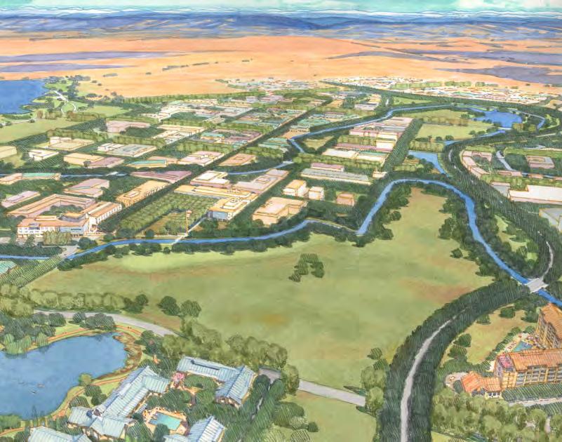
187
INTRODUCTION. Strive to achieve excellence in all areas of operational sustainability.
 1 INTRODUCTION 1 INTRODUCTION A master plan guides the physical development of a campus, presenting long-range strategies for campus growth and transformation. As no single issue can be considered in isolation,
Arlington, Virginia is a worldclass
 EXECUTIVE S U M M A RY Arlington maintains a rich variety of stable neighborhoods, quality schools and enlightened land use policies, and received the Environmental Protection Agency s highest award for
3.10 LAND USE SETTING PROJECT SITE EXISTING LAND USE DESIGNATIONS AND ZONING. General Plan Land Use Designations.
 This section of the Draft EIR addresses the existing land uses on and adjacent to the project site and discusses the potential impacts of the proposed project on existing land uses. Key issues addressed
Member Service Plan Sierra Nevada AmeriCorps Partnership
 Member Service Plan Sierra Nevada AmeriCorps Partnership Service plans lay the framework for what each Member will be doing during their service. Service plans detail the major projects and expected results
SAN RAFAEL GENERAL PLAN 2040 INTRODUCTION AND OVERVIEW
 SAN RAFAEL GENERAL PLAN 2040 INTRODUCTION AND OVERVIEW Steering Committee Presentation February 14, 2018 Purpose of General Plan Guide land use and development decisions Coordinate transportation, infrastructure,
University of Denver Land Use Plan Update I. Executive Summary
 Executive Summary The task of developing a Land Use Plan for the University of Denver has been an exciting collaborative process that engaged a variety of interested people, including members of the University
MATHEMATICAL SCIENCES BUILDING
 Final Focused Tiered Environmental Impact Report State Clearinghouse No. 2002072048 Prepared By: OFFICE OF RESOURCE MANAGEMENT AND PLANNING University of California One Shields Avenue 376 Mrak Hall Davis,
North Fair Oaks Community Plan Summary and Information
 North Fair Oaks Community Plan Summary and Information WHAT IS THE NORTH FAIR OAKS COMMUNITY PLAN? The North Fair Oaks Community Plan is part of the San Mateo County General Plan, and establishes policies
UNIVERSITY OF TEXAS BRACKENRIDGE TRACT THE TEAM
 UNIVERSITY OF TEXAS BRACKENRIDGE TRACT THE TEAM 1 JOHNSON FAIN / OLIN PARTNERSHIP Master Planning + Land Use Planning + Urban Design + Landscape Architecture TANIGUCHI ARCHITECTS Design Consultant + Public
Introduction and Overview
 Introduction and Overview Articulate local values and priorities Guide land use and development decisions Coordinate transportation, infrastructure, and City services with expected growth and available
Technical Appendix L, University Community Plan Town Center
 Technical Appendix L, University Community Plan Town Center Table of Contents L.1 Executive Summary L.2 Merced County University Community Plan, 2004 Findings L.2.1 Visioning L.2.2 UCP Goals, Objectives
UNIVERSITY OF CALIFORNIA, SAN DIEGO
 UNIVERSITY OF CALIFORNIA, SAN DIEGO BERKELEY DAVIS IRVINE LOS ANGELES MERCED RIVERSIDE SAN DIEGO SAN FRANCISCO SANTA BARBARA SANTA CRUZ CAMPUS PLANNING 9500 GILMAN DRIVE # 0074 TEL: (858) 534 6515 LA JOLLA,
Department of Community Development. Planning and Environmental Review Division Revised Notice of Preparation
 Department of Community Development Michael J. Penrose, Acting Director Divisions Building Permits & Inspection Code Enforcement County Engineering Economic Development & Marketing Planning & Environmental
NORTHERN LANDS NORTHERN LEADERSHIP
 NORTHERN LANDS NORTHERN LEADERSHIP The GNWT Land Use and Sustainability Framework Our Lands, Our Interests, Our Future ii Land is Life MESSAGE FROM THE PREMIER Land is life. It is the link to our past.
Phase 1 : Understanding the Campus Context. Phase 2 : APPROACHES - Alternates & Preferred Plan
 Introduction MASTER PLAN PURPOSE WHY A CAMPUS MASTER PLAN? The purpose of the Master Plan at the University of Illinois at Chicago is to translate UIC s strategic goals and objectives into a compelling
A Delta Renewed: A Guide to Science Based Ecological Restoration in the Delta
 A Delta Renewed: A Guide to Science Based Ecological Restoration in the Delta J. Letitia Grenier, San Francisco Estuary Institute, letitia@sfei.org Julie Beagle, San Francisco Estuary Institute, julieb@sfei.org
Introduction. Introduction
 Introduction Introduction I MAGINE that in the next 10 to 20 years, we can begin to reshape Grounds to reflect the civic intent and environs created by Thomas Jefferson s Academical Village. Through a
Plan Overview. Manhattan Area 2035 Reflections and Progress. Chapter 1: Introduction. Background
 Plan Overview The Manhattan Urban Area Comprehensive Plan (the Comprehensive Plan) is a joint planning initiative of the City of Manhattan, Pottawatomie County, and Riley County. The 2014 Comprehensive
The Village of Sugar Grove, in partnership with Kane County, the Illinois Department of Transportation, and the Illinois Tollway welcomes you to the
 The Village of Sugar Grove, in partnership with Kane County, the Illinois Department of Transportation, and the Illinois Tollway welcomes you to the first Public Meeting for the proposed interchange improvement
CAL POLY MASTER PLAN UPDATE, March 2015
 Some Key Themes in the General Guiding Principles Academic Mission The plan must foremost advance the University s academic mission and student success. Foresight and Adaptability The plan should take
Authority of the General Plan
 Authority of the General Plan This La Habra Heights General Plan will serve as the blueprint for future planning and development in the City. This General Plan describes the City s vision for the future
implementation r expression in landscape
 6 ubc okanagan implementation campus plan r expression in landscape 68 6 implementation campus plan sections The Campus Plan supports the academic mission, values and commitments of the University by providing
Academics Efficient use of space will be used to enhance investments in new pedagogies such as active learning classrooms.
 Goals and Assumptions Physical Planning Goals and Objectives The guiding principles of this Master Plan were developed in consultation with various constituencies that make up the NMSU community and were
Planning Commission Report
 Planning Commission Report To: From: Subject: Planning Commission Meeting: January 6, 2016 Agenda Item: 8-B Planning Commission David Martin, Planning & Community Development Director Introduction to the
6. RECREATION AND OPEN SPACE ELEMENT
 6. RECREATION AND OPEN SPACE Introduction This Recreation and Open Space Element includes Goals, Objectives and Policies (GOP) that apply to the main campus in Gainesville and the Lake Wauburg Recreation
3. VISION AND GOALS. Vision Statement. Goals, Objectives and Policies
 Vision Statement Queen Creek s interconnected network of parks, trails, open spaces and recreation opportunities provide safe and diverse activities and programs that sustain its unique, small town, equestrian
Preface. Erie. Scranton. Allentown. Pittsburgh. Harrisburg. Philadelphia
 The Southern Alleghenies Region The Southern Alleghenies Region spans the Laurel Highlands and Allegheny Front in the west across the Appalachians to the east. It is comprised of Blair, Bedford, Cambria,
TABLE OF CONTENTS. Tables Table UC Davis Park and Open Space Resources
 TABLE OF CONTENTS 4.13 Recreation... 4.13-1 4.13.1 Environmental Setting... 4.13-1 4.13.2 Impacts and Mitigation Measures... 4.13-4 4.13.3 References... 4.13-8 Tables Table 4.13-1 UC Davis Park and Open
This page intentionally blank.
 This page intentionally blank. Parks, Recreation, and Open Space Chapter Relationship to Vision Vision Parks, Recreation and Open Space Chapter Concepts County Government. County government that is accountable
3.0 PROJECT DESCRIPTION
 3.0 PROJECT DESCRIPTION 3.1 BACKGROUND Under California law (Government Code Section 65300 et seq.), every city and county is required to have a general plan. The general plan is to be comprehensive and
ENVIRONMENTAL STUDIES AND PLANNING
 ENVIRONMENTAL STUDIES AND PLANNING DEPARTMENT OFFICE Rachel Carson Hall 18 (707) 664-2306 www.sonoma.edu/ensp/ DEPARTMENT CHAIR Laura A. Watt ADMINISTRATIVE COORDINATOR Karen Targett Faculty Each student
ELK GROVE GENERAL PLAN VISION
 2-1 CHAPTER 2: 2-2 CREATING OUR The Community Vision for Elk Grove, expressed through a Vision Statement and a series of Supporting Principles, is a declaration of the kind of community that Elk Grove
2040 LUP is a part of the Comprehensive Plan and carries the same legal authority. Economic Challenges
 1.1. Guiding Anchorage s Growth Where will new residents settle over the next two decades? Where will people work, shop, and play? Will there be enough room to grow? How will Anchorage look? Will growth
CITY OF CHARLOTTESVILLE, VIRGINIA CITY COUNCIL AGENDA
 CITY OF CHARLOTTESVILLE, VIRGINIA CITY COUNCIL AGENDA Agenda Date: December 16, 2013 Action Required: Adoption of Resolution Presenter: Staff Contacts: Title: James E. Tolbert, AICP, Director of NDS James
iii. Visioning framework
 III. VISION iii. Visioning framework III.1 Overview A vision is a clear and succinct description of what an institution and its community should look like after it successfully implements its goals and
1 Welcome! UBC Okanagan Master Plan Update - Open House
 1 Welcome! UBC Okanagan Master Plan Update - Open House UBC is updating the Master Plan for the Okanagan Campus. The purpose of today s Open House is to: Present the draft 2015 Master Plan Answer any questions
The Trinity River Corridor, offering Dallas areas of natural
 IMPLEMENTATION PLAN FOR THE TRINITY RIVER CORRIDOR The Trinity River Corridor, offering Dallas areas of natural beauty and untapped potential, runs through the heart of the city. Proposed improvements
V. Vision and Guiding Principles
 V. Vision and Guiding Principles The Master Plan for the Powers Ferry Corridor seeks a foundation in the desires of the community. At times, various elements of the community offered opposing viewpoints,
1INTRODUCTION. Purpose of the Truckee Railyard Master Plan
 1INTRODUCTION Purpose of the Truckee Railyard Master Plan The purpose of the Truckee Railyard Master Plan is to capture and describe the Town s vision for the Railyard Area and to guide its future redevelopment.
Mendota Heights 2040 Comprehensive Plan Draft Vers
 4 Parks and Trails The City of Mendota Heights boasts a variety of recreational and open space opportunities. Few cities can claim access to regional trails, riverside and lakeside parks, scenic bluffs
Academic Building Naming Prospectus. Environment Hall HOME OF THE NICHOLAS SCHOOL OF THE ENVIRONMENT AT DUKE UNIVERSITY
 Academic Building Naming Prospectus HOME OF THE NICHOLAS SCHOOL OF THE ENVIRONMENT AT DUKE UNIVERSITY In today s interconnected world, the ripples of environmental change impact us all and every facet
38 Queen s University Campus Master Plan Part 1
 38 Queen s University Campus Master Plan Part 1 46 The Campus at the City Scale Chapter 4 The Campus at the City Scale 39 Queen s is an urban University centrally located in Kingston. Decisions made by
COASTAL CONSERVANCY. Staff Recommendation June 5, 2008 SAN DIEGO RIVER TRIBUTARY CANYONS PROJECT. File No Project Manager: Megan Johnson
 COASTAL CONSERVANCY Staff Recommendation June 5, 2008 SAN DIEGO RIVER TRIBUTARY CANYONS PROJECT File No. 08-059 Project Manager: Megan Johnson RECOMMENDED ACTION: Authorization to disburse an amount not
Community Conservation Workshop. Saranac River Basin Communities
 Community Conservation Workshop Saranac River Basin Communities 2 Community Conservation Program Welcome! We have designed a Community Conservation Program that listens to the needs of community members.
Rappahannock- Rapidan Regional Commission
 Rappahannock- Rapidan Regional Commission Last Updated July 2008 RAPPAHANNOCK-RAPIDAN REGIONAL TRANSPORTATION PLAN The Virginia Department of Transportation (VDOT) and the Rappahannock-Rapidan are partnering
University of Saskatchewan CAMPUS MASTER PLAN. Senate Meeting Preliminary Presentation. April 21, 2018 DIALOG ECS DA WATT
 University of Saskatchewan CAMPUS MASTER PLAN Senate Meeting Preliminary Presentation April 21, 2018 DIALOG ECS DA WATT project process presentation agenda Stakeholder Engagement Project Control phase1
Master Plan Objectives and Policies
 Master Plan Objectives and Policies Introduction This chapter identifies the Park issues and recommended policies established by this Master Plan. The issues were identified through meetings with staff,
ADOPTION OF THE REVISED OPEN SPACE AND CONSERVATION ELEMENT OF THE GENERAL PLAN
 TO: FROM: SUBJECT: Honorable Mayor and City Council Planning Department ADOPTION OF THE REVISED OPEN SPACE AND CONSERVATION ELEMENT OF THE GENERAL PLAN RECOMMENDATION: It is recommended that the City Council:
Chapter 19: Cultural Resources
 Chapter 19: Cultural Resources Introduction and Setting Traditionally the term "cultural resources" has been used rather narrowly to refer to archaeological remains and to historical structures. Archaeologists,
CHAPTER 1 Introduction
 CHAPTER 1 Introduction From sea to summit, Lane County covers almost 4,800 square miles of diverse Oregon landscape. Stretching from the Pacific Ocean through the Coastal Range, the Willamette Valley to
Loebl Schlossman & Hackl
 Loebl Schlossman & Hackl in association with PSA-Dewberry Chicago, IL EIU Experience 1999 Plan Eastern Illinois University 1999 and 2002 Campus Master Plans Charleston, IL 2002 Update Highly Participatory
4.8 Land Use and Planning Environmental Setting Impacts and Mitigation Measures References...4.
 TABLE OF CONTENTS 4.8 Land Use and Planning...4.8-1 4.8.1 Environmental Setting...4.8-1 4.8.2 Impacts and Mitigation Measures...4.8-5 4.8.3 References...4.8-11 FIGURES Figure 4.8-1 Figure 4.8-2 Figure
Chapter 5: Recreation
 Chapter 5: Recreation Introduction and Setting Recreational opportunities within Nevada County are varied, ranging from public parks with intensively used active recreational facilities, to vast tracts
Open House - Programing and Planning Social Sciences Facility & Classroom Auditorium. Capital Planning Process
 Open House - Programing and Planning Social Sciences Facility & November 3, 2011 Recreation Lounge Colleges Nine and Ten Capital Planning Process 2005 Long Range Development Plan 2010 Physical Design Framework
IMPLEMENTING SOMERSET COUNTY S INVESTMENT FRAMEWORK
 IMPLEMENTING SOMERSET COUNTY S INVESTMENT FRAMEWORK SMART CONSERVATION THROUGH SMART GROWTH NJ LAND CONSERVATION RALLY March 22, 2014 Laurette Kratina, PP, AICP, Supervising Planner Somerset County Planning
Comprehensive Plan ADOPTED APRIL 2014
 Comprehensive Plan ADOPTED APRIL 2014 8 8. Outstanding Recreational & Cultural Opportunities We are proud of our community s parks and recreation system. Our community will ensure that the legacy of our
Appendix A. Planning Processes. Introduction
 1 Planning Processes Introduction This appendix outlines a number of planning processes which are used in the Auckland Region to support the effective management of development in the region s rural and
K. SMART ASSOCIATES LIMITED
 Planning Justification Report Zoning By-Law Amendment 185 King Street North Waterloo, Ontario April 7th, 2017 Project Reference Number 16-245 K. SMART ASSOCIATES LIMITED CONSULTING ENGINEERS AND PLANNERS
2.0 AREA PLANS. Lakeside Business District. Lakeside Business District Land Use Categories:
 Lakeside Business District Lakeside Business District Land Use Categories: Campus Commercial Campus Commercial means a mixture of uses which includes corporate offices, office parks, hotels, commercial,
Vision & Land Use. Discussion. Historic Preservation Plan. Foggy Bottom Campus Plan:
 Vision & Land Use Foggy Bottom Campus Plan: 2006-2025 Historic Preservation Plan Discussion Community Meeting Presentation August 2, 2006 Presentation Format Overview Sherry Rutherford, GW Foggy Bottom
Community Conservation Workshop. Lake Placid
 Community Conservation Workshop Lake Placid 2 Community Conservation Program Welcome! We have designed a Community Conservation Program that listens to the needs of community members. We are conducting
4.8 LAND USE AND PLANNING
 4.8 LAND USE AND PLANNING 4.8.1 INTRODUCTION This section describes existing and planned land uses at the Hayward campus and analyzes the impact of implementation of the proposed Master Plan on land uses
CAMPUS HISTORY AND STEWARDSHIP
 CHAPTER TWO CAMPUS HISTORY AND STEWARDSHIP The stewardship of the UC Davis campus history and the rich collection of natural and cultural resources is a fundamental task for the LRDP. This chapter is organized
The Illinois Department of Transportation and Lake County Division of Transportation. Route 173, including the Millburn Bypass
 The Illinois Department of Transportation and Lake County Division of Transportation welcome you to this Public Hearing for U.S. Route 45 from Illinois Route 132 to Illinois Route 173, including the Millburn
Natomas Joint Vision Open Space Plan
 Natomas Joint Vision Open Space Plan First Workshop series The City of Sacramento The County of Sacramento LAFCo ERA Economic Research Associates EIP Associates a Division of PBS & J Natomas Joint Vision
ARLINGTON COUNTY, VIRGINIA
 ARLINGTON COUNTY, VIRGINIA County Board Agenda Item Meeting October 15, 2005 DATE: September 28, 2005 SUBJECT: Request to Advertise the adoption of the 2005 Clarendon Sector Plan C. M. RECOMMENDATION:
COASTAL CONSERVANCY. Staff Recommendation March 25, 2004 LOS ANGELES GREEN VISION PLAN. File No.: Project Manager: Marc Beyeler
 COASTAL CONSERVANCY Staff Recommendation March 25, 2004 File No.: 04-014 Project Manager: Marc Beyeler RECOMMENDED ACTION: Authorization to disburse up to $50,000 to the University of Southern California
SALISBURY TOMORROW Our Vision
 SALISBURY TOMORROW Our Vision Salisbury is committed to supporting a high quality of life and sense of community for all residents. These commitments need to be reflected in our community programs, services
UC Merced Tomorrow LONG RANGE DEVELOPMENT PLAN UNIVERSITY OF CALIFORNIA, MERCED 2009 FINAL
 UC Merced Tomorrow LONG RANGE DEVELOPMENT PLAN UNIVERSITY OF CALIFORNIA, MERCED 2009 FINAL AMENDED MAY 2013 WE WELCOME YOUR COMMENTS University of California, Merced 5200 North Lake Road Merced, California
Concept Master Plan. for. Draft of. Wildlife Management Area. Prepared for. June, 2008
 Draft of Concept Master Plan for Vermillion Highlands: A Research, Recreation and Wildlife Management Area Prepared for Vermillion Highlands Steering Committee - Minnesota Department of Natural Resources
Living in Albemarle County s Urban Places
 Living in Albemarle County s Urban Places ALBEMARLE COUNTY, VIRGINIA A Closer Look at Albemarle s Approach to Managing Growth and Creating Quality Urban Environments www.albemarle.org Page 2 Living in
Introduction. Chapter 1. Purpose of the Comprehensive Plan Plan Organization Planning Process & Community Input 1-1
 Chapter 1 Introduction Lakewood 2025: Moving Forward Together Purpose of the Comprehensive Plan Plan Organization Planning Process & Community Input 1-1 Purpose of the Comprehensive Plan The Comprehensive
ATTACHMENT A AERIAL PHOTO OF McINTIRE PARK EAST
 ATTACHMENT A AERIAL PHOTO OF McINTIRE PARK EAST McIntire Botanical Garden Request for Proposals Attachments Page 1 of 33 ATTACHMENT B - MEMORANDUM OF AGREEMENT WITH THE CITY OF CHARLOTTESVILLE McIntire
FIREFIGHTING RESOURCES OF CALIFORNIA ORGANIZED FOR POTENTIAL EMERGENCIES
 FIREFIGHTING RESOURCES OF CALIFORNIA ORGANIZED FOR POTENTIAL EMERGENCIES PAST, CURRENT AND FUTURE DIRECTIONS A PROGRESS REPORT OCTOBER 1988 PAST, CURRENT, AND FUTURE Coordinate multi-agency resources during
Western Sydney Parklands Australia s Largest Urban Park
 Western Sydney Parklands Australia s Largest Urban Park 37 WLA 1 MAGAZINE 21 38 WESTERN SYDNEY PARKLANDS AUSTRALIA S LARGEST URBAN PARK Large urban parks have dual roles to play in meeting the demands
Design Principles, Design Guidelines, and Standing Review Committees for The Arboretum at Penn State
 Design Principles, Design Guidelines, and Standing Review Committees for The Arboretum at Penn State This document was prepared at the request of Kim Steiner, Arboretum director, by an Arboretum Design
Concord Community Reuse Project Goals and Guiding Principles. Overarching Goals (OG)
") Concord Community Reuse Project Goals and Guiding Principles Overarching Goals (OG) No priority is implied by the order of presentation of the goals and guiding principles. Overarching goals for the Concord
Concord Community Reuse Project Goals and Guiding Principles Overarching Goals (OG) No priority is implied by the order of presentation of the goals and guiding principles. Overarching goals for the Concord
TEMPLE MEDICAL & EDUCATION DISTRICT
 City of Temple, Texas TEMPLE MEDICAL & EDUCATION DISTRICT 1 Description. The City of Temple joined in partnership with key public and private entities to jointly promote education and medical activities
SUBJECT: Waterfront Hotel Planning Study Update TO: Planning and Development Committee FROM: Department of City Building. Recommendation: Purpose:
 Page 1 of Report PB-23-18 SUBJECT: Waterfront Hotel Planning Study Update TO: Planning and Development Committee FROM: Department of City Building Report Number: PB-23-18 Wards Affected: 2 File Numbers:
UNIVERSITY OF NEVADA, LAS VEGAS
 UNIVERSITY OF NEVADA, LAS VEGAS NORTH LAS VEGAS LAND OPPORTUNITY North Campus Background Information November 2009 Regional Context 6 7 18 Small Arms Range Site Context Guiding Principles You cannot depend
2011 ASLA Design Awards
 2011 ASLA Design Awards Interstate 70 Mountain Corridor Aesthetic Guidance Honor Award Design Workshop, Aspen / THK Associates, Inc. / CH2MHill Planning and Urban Design Project Title: Interstate70 Mountain
DRAFT FOR PUBLIC REVIEW. Game Plan for a Healthy City
 DRAFT FOR PUBLIC REVIEW 2018 Game Plan for a Healthy City 2 Denveright. Parks & Recreation Game Plan Draft for Public Review Draft for Public Review Executive Summary Game Plan Overview Executive Summary
Working together to leverage limited Funds
 Working together to leverage limited Funds ARAPAHOE COUNTY OPEN SPACES 10 County Budget Conference September 20, 2013 The Power of Partnerships 2013 SORP Conference 5/23/2014 Why Talk About Open Space?
Sustainability and the Campus Long Range Master Plan
 Sustainability and the Campus Long Range Master Plan Hawai i Sustainability in Higher Education Summit Presenters: Grant Murakami, AICP, LEED BD+C Roy Takemoto PBR HAWAII and Associates, Inc. Overview
Waco Mammoth Site Special Resource Study
 Waco Mammoth Site Waco, Texas Newsletter #2 August 2007 National Park Service U.S. Department of the Interior Waco Mammoth Site Special Resource Study We are pleased to share with you an update on the
Policy & Procedure Effective Date: Parks Department Page of
 City of Arvada Policy & Procedure Effective Date: Parks Department Page of TITLE: City of Arvada Prairie Dog Habitat Plan APPROVAL: PURPOSE: To establish a plan for the preservation of black-tailed prairie
Section 4 BUILDING THE MASTER PLAN
 The Master Plan 33 Section 4 BUILDING THE MASTER PLAN Figure 4:1. A collaborative effort characterized the two design workshops sponsored by DISC to create hypothetical Master Plans for the Towers Property
A Campus Within Context
 A Campus Within Context A Comprehensive Master Plan for East Carolina University Optimize Valuable Resources Guide Future Development Establish Capital Priorities Create a Sense of Place Sustainable Campus
EXECUTIVE SUMMARY. Introduction
 EXECUTIVE SUMMARY Introduction State Route 68 is a designated scenic route that connects the world-renowned Monterey Peninsula to US Highway 101 and the Salinas Valley. SR 68 is a key route for bicycle,
Inventing The Future 2005 Planning Retreat
 Presentations (PLI) Public Lands Institute 2005 Inventing The Future 2005 Planning Retreat Public Lands Institute Follow this and additional works at: https://digitalscholarship.unlv.edu/pli_presentations
Executive Summary. Essential Connectivity Map (Figure ES-1)
") Executive Summary The California Department of Transportation (Caltrans) and California Department of Fish and Game (CDFG) commissioned the because a functional network of connected wildlands is essential
Executive Summary The California Department of Transportation (Caltrans) and California Department of Fish and Game (CDFG) commissioned the because a functional network of connected wildlands is essential
Elliot Park 2. Neighborhood Master Plan. Historical Perspective
 Elliot Park 2 Neighborhood Master Plan Historical Perspective August 2002 Early History Development patterns and the growth of Minneapolis largely grew out of the city s historical response to its geography.
Parks, Trails, and Open space Element
 Parks, Trails, and Open space Element Parks, Trails, and Open Space element Parks, Recreation, and Open Space are important components of the quality of life desired by the residents of Elk Grove. This
SUSTAINABILITY PLAN OTTAWA COUNTY PARKS AND RECREATION COMMISSION FALL 2017
 SUSTAINABILITY PLAN OTTAWA COUNTY PARKS AND RECREATION COMMISSION FALL 2017 Table of Contents Introduction Natural Resources Quality of Life Community Continuing the Mission Sustainability Measuring Sustainability
Susan R. Peerson, AICP principal
 principal cell: (619) 405-6382 fax: (619) 221-1984 email: speerson@gmail.com Professional Practice Sue Peerson is a Principal in peerson+design+consult, inc. with over 24 years of urban design, campus
Town of Peru Comprehensive Plan Executive Summary
 Town of Peru Comprehensive Plan Executive Communities that plan grow by choice, not by chance. A plan makes growth thoughtful, understandable, and predictable. A plan shows that a community is managing
Corridor Vision. 1Pursue Minnehaha-Hiawatha Community Works Project. Mission of Hennepin County Community Works Program
 1Pursue Minnehaha-Hiawatha Community Works Project Minnehaha-Hiawatha Community Works is a project within the Hennepin Community Works (HCW) program. The mission of the HCW program is to enhance how the
Earth Science & Public Policy: Increasing Our Spheres of Influence
 Presentations (PLI) Public Lands Institute 4-16-2006 Earth Science & Public Policy: Increasing Our Spheres of Influence Margaret N. Rees University of Nevada, Las Vegas, peg.rees@unlv.edu Follow this and
urban and regional planning
 urban and regional planning Michigan Planning seeks to shape placebased policy and design for social equity and sustainability, regional solutions to metropolitan problems, just and effective remedies
Review of Opportunity Area C Draft Comprehensive Plan and Draft BOS Follow-On Motions. Special Working Group Meeting March 4, 2015
 Review of Opportunity Area C Draft Comprehensive Plan and Draft BOS Follow-On Motions Special Working Group Meeting March 4, 2015 The slides that follow identify where the draft Comprehensive Plan has