IV.A AESTHETICS INTRODUCTION
|
|
|
- Herbert Harrison
- 5 years ago
- Views:
Transcription
1 IV.A AESTHETICS INTRODUCTION This section addresses the potential impacts to visual character, views and vistas, scenic resources, light and glare, and shadows that could result from the implementation of the Jordan Downs Specific Plan (proposed project). The analysis considers visual character aspects such as design, size, shape, color, texture, and general composition of aesthetic features, as well as the relationships between these elements. The adverse visual quality impacts considered within the analysis include the loss of existing valued aesthetic features and the introduction of contrasting features that contribute to a decline in overall visual character (e.g., the introduction of contrasting features that overpower familiar features, eliminate context or associations with history, or create visual incompatibility where there may have been apparent efforts to maintain or promote a thematic or consistent character). ENVIRONMENTAL SETTING Visual Character As required under CEQA, the aesthetic analysis of a project must disclose the potential impacts the project would have on the existing visual character of the project area and surroundings. The concept of visual character, however, is not explicitly defined in the CEQA Guidelines. Therefore, in this aesthetics discussion, potential visual character impacts will be determined based on industry-accepted definitions of visual character. Visual character can be defined in terms of the overall impression formed by the relationship between perceived visual elements of the built urban environment existing in the potentially impacted area. Elements contributing to this impression include the following: The nature and quality of buildings The compatibility between uses and activities with the built environment The quality of streetscape, including roadways, sidewalks, plazas, parks and street furniture The nature and quality of landscaping that is visible to the general public Visual character functions as a point of reference in assessing whether a project s features would appear to be compatible with the established built environment. In general, the evaluation of visual character is determined by the degree of contrast that could potentially result between a proposed project and the existing built environment. Contrast is assessed by considering the consistency of the following features of a proposed project with those of the existing built environment: Scale: Refers to the general intensity of development comprised of the height and set-back of buildings; Massing: Refers to the volume and arrangement of buildings; and Open Space: Refers to setback of buildings and amount of pedestrian and recreational spaces. IV.A-1
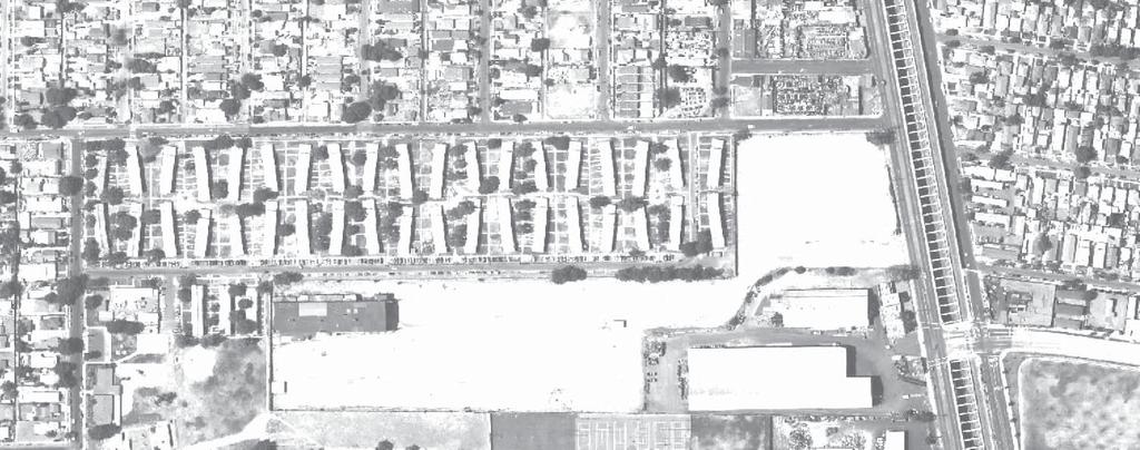
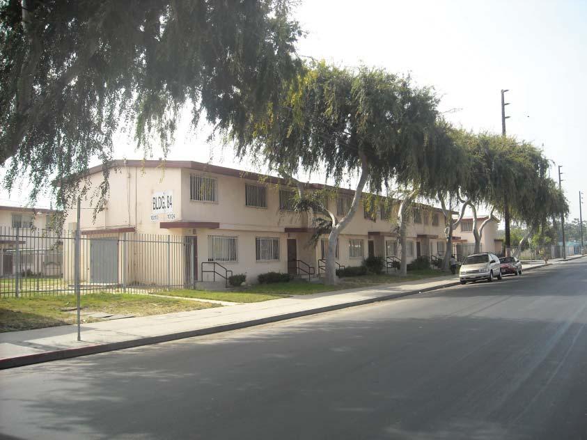
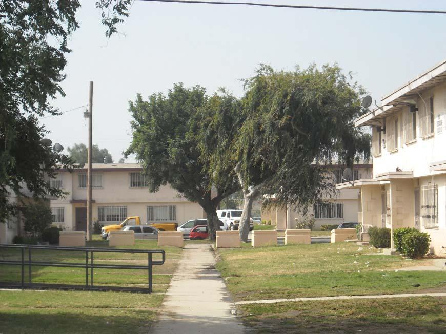
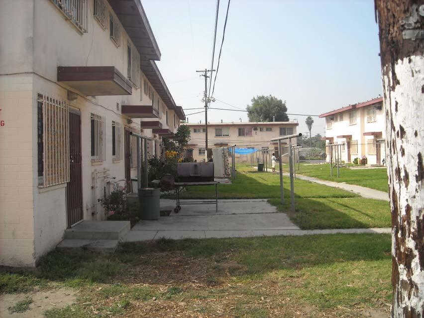
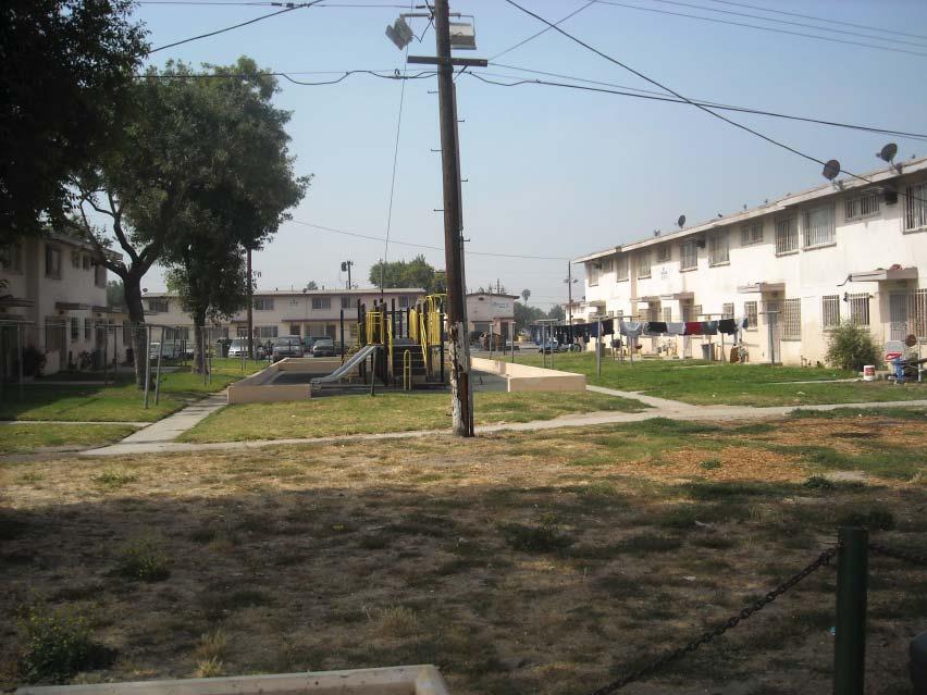
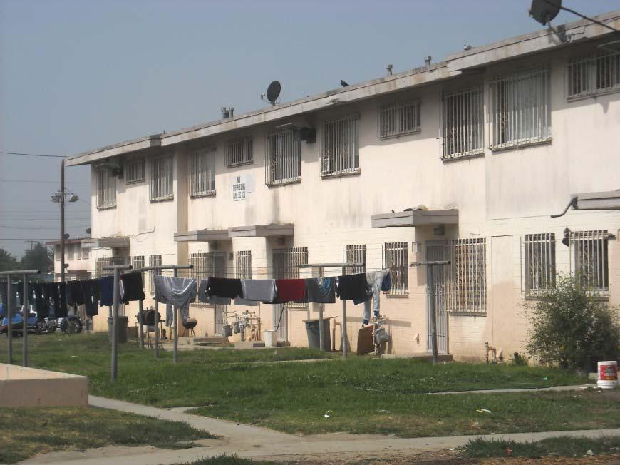
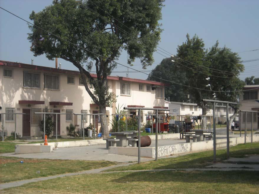
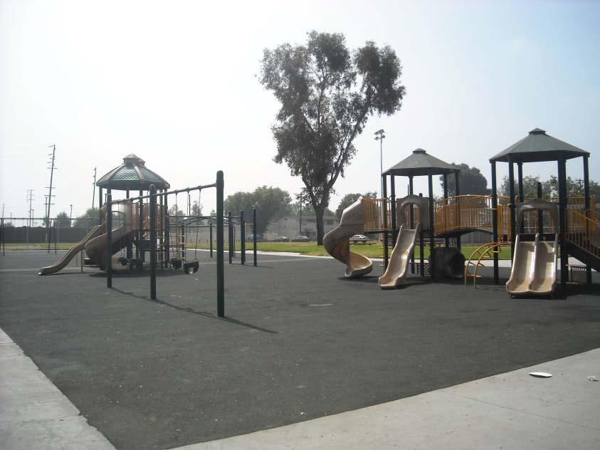
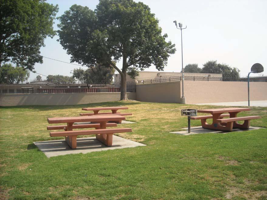
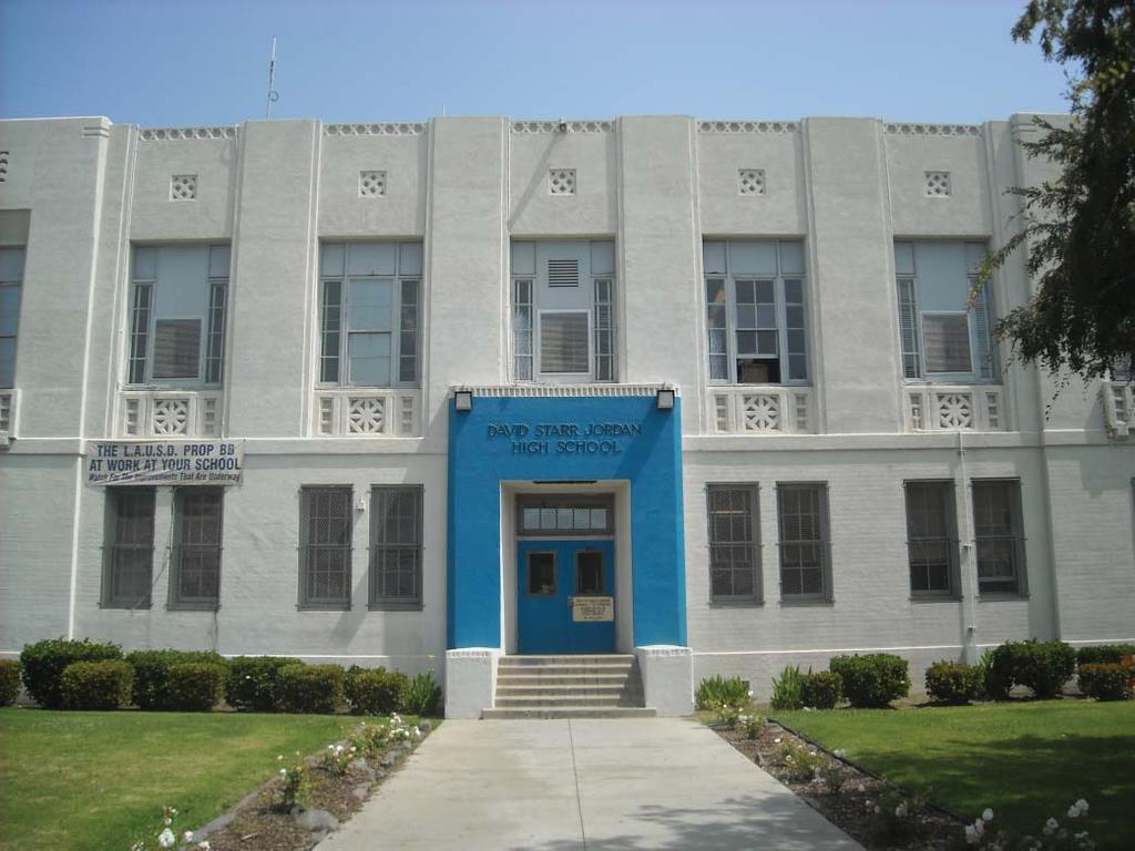
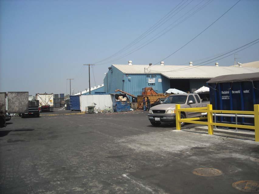
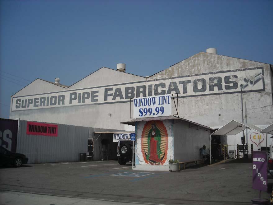
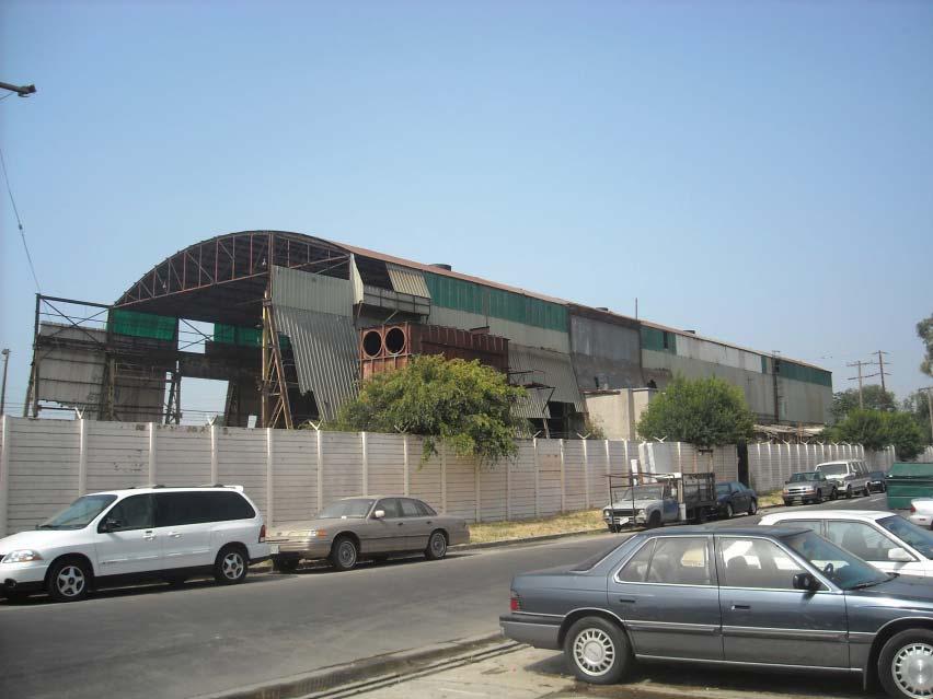
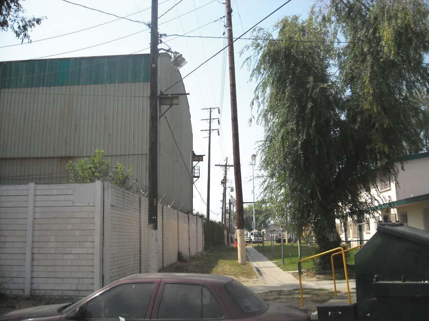
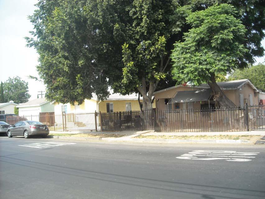
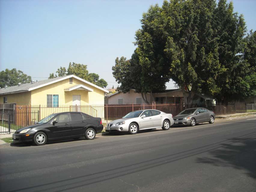
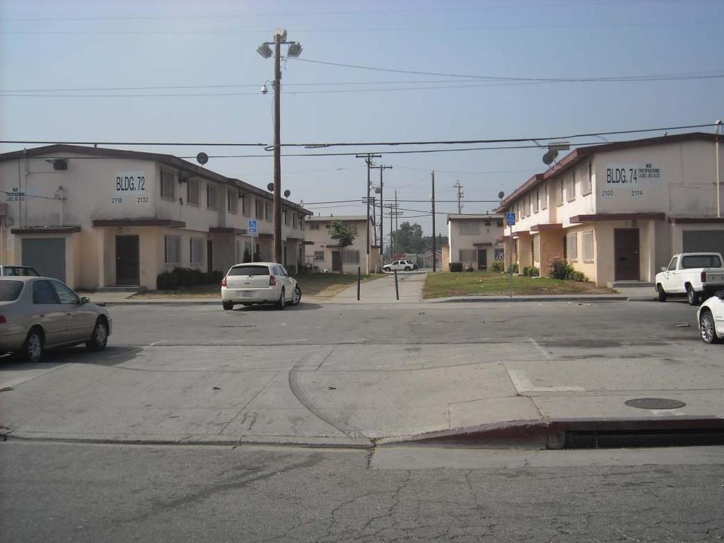
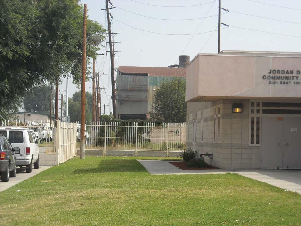
2 Specific Plan Area The proposed project encompasses acres of land area and is located approximately seven miles south of Downtown Los Angeles. The Specific Plan area is bounded by Grape Street to the west, 97 th Street to the north, Alameda Street to the east, and 103 rd Street to the south and comprises four distinct land uses: 1) Jordan Downs Public Housing Complex, 2) David Starr Jordan High School, 3) Jordan Downs Annexation Area, and the Community Garden Mudtown Farms. The visual characteristics of the Specific Plan area are described below: Jordan Downs Public Housing Complex. The Jordan Downs public housing complex is 49.5 acres in size and includes 700 residential units within 103 buildings, the Jordan Downs Recreation Center, and Mudtown Farms. 1 The earliest phases of public housing at Jordan Downs were located between 97 th Street and 99 th Place and were built in 1942 as temporary wartime dwellings. They were converted to public housing after the war and supplemented by additional units north of 103 rd Street in The 38 two-story buildings, located between 97 th Street and 99 th Place, are arranged in nineteen pairs of blocks slightly skewed from perpendicular to the street. The 65 buildings to the south of 99 th Place are arranged in clusters of five to twelve buildings, perpendicular and parallel to the surrounding streets. Figure IV.A- 1 illustrates the arrangement of the existing buildings on the site. Although constructed at different times, the architectural elements of all of the residential buildings exhibit similar characteristics in scale, massing, building materials, and open space. All of the residential buildings are attached two-story townhouse-style buildings made of concrete block and painted in a cream color with red/rust trim. The residences have both front and rear entrances with little distinction between the two. The front entrance walkway is typically shared by two units, while each rear entrance typically has its own walkway and an area for clothes lines. Play structures and picnic areas are located between the rear entrances. There are ten of these play/picnic areas within the Jordan Downs public housing complex. Figures IV.A-2 and IV.A-3 illustrate the front and rear of typical units. The Jordan Downs Recreation Center is generally situated in the central-western portion of the site, east of Grape Street between 99 th Place and the unsigned eastern extension of Century Boulevard, and contains an office with a storage shed, two community center buildings, a building used as a daycare/preschool facility, and a restroom building associated with the playground area. These one-story buildings, constructed of concrete block and painted in a cream color with red/rust or green trim, exhibit the similar visual characteristics as the residential buildings on the site. The recreation center serves as the main open space for Jordan Downs s residents, as well as the larger Watts community. The Jordan Downs Recreation Center includes a children s playground, picnic tables, barbecue pits, a baseball field, outdoor basketball courts, an indoor gymnasium, and a Teen Center. David Starr Jordan High School. The David Starr Jordan High School was constructed (and reconstructed due to the 1933 Long Beach Earthquake) between 1927 and 1937 under the federal Works Projects Administration (WPA) program. The school property is approximately 20 acres in size and is located east and south of the Jordan Downs public housing complex (Figure IV.A-5). 1 Mudtown Farms, which is owned by the Trust for Public Land and the Watts Labor Community Action Committee, has been included as part of the Jordan Downs public housing complex for purposes of describing the Specific Plan area. IV.A-2

3


4
5

6
7
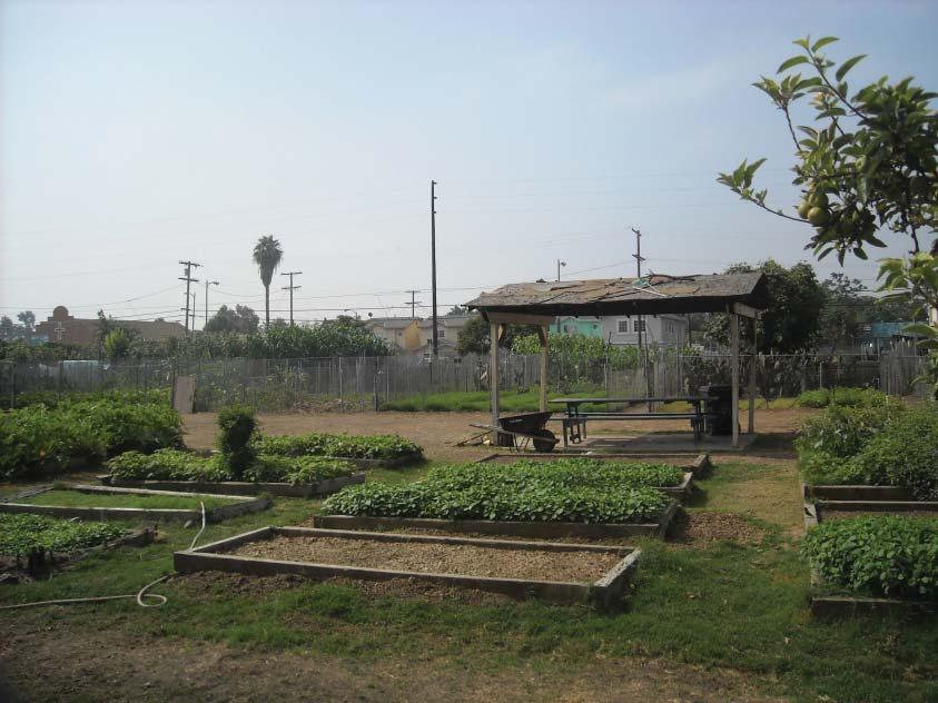
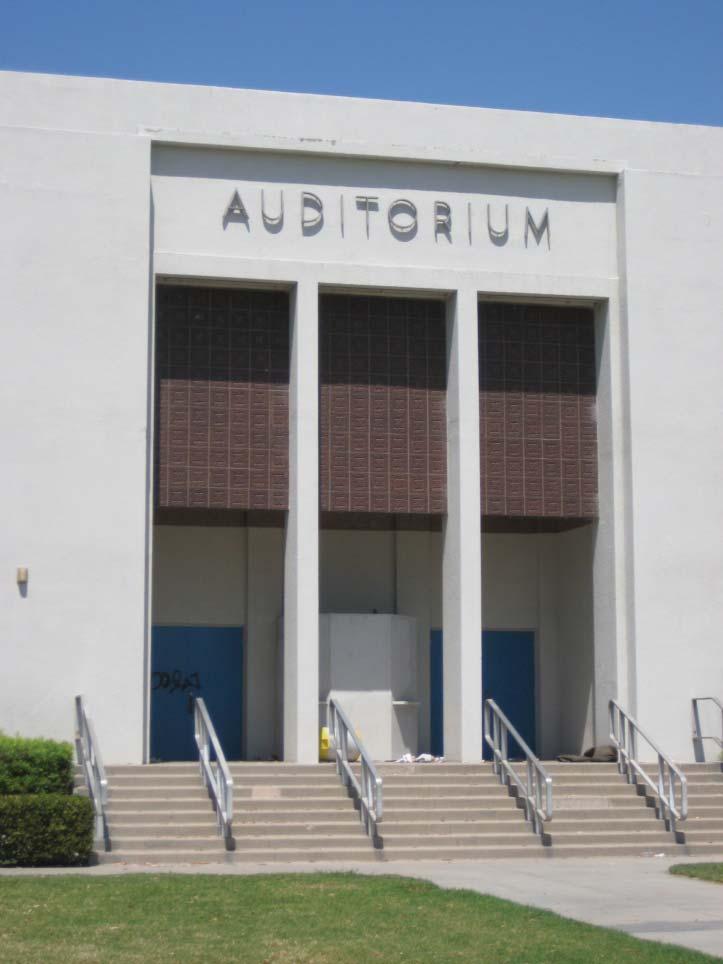
8 The high school property contains a mixture of one- to two-story, temporary, and permanent buildings that are generally oriented towards 103 rd Street. The permanent buildings are constructed of reinforced concrete and painted white with blue accents. The early buildings were designed by Los Angeles School District architect A.S. Nibecker, who was responsible for the design of many Los Angeles school buildings from the 1920s to the 1940s. The school is an example of the Public Works Administration (PWA) Moderne architecture style. PWA Moderne is an architectural style that combined elements of Art Deco, Streamline Moderne, and the Beaux-Arts style and was applied in the design of many large public buildings, civic centers, theatres, and other buildings constructed between 1933 and 1944 by the PWA, a government agency created during the Great Depression. Of the sixteen major campus buildings, seven were designed in the PWA Moderne style, including the Administration Building, Auditorium, both gymnasiums, and several classroom buildings. The Administration Building is the most visually dominant, with massive piers, smooth concrete surfaces, deeply recessed windows, and subtle minimalist geometric patterns. Other buildings on the east side of the property were added in the early 1960s and generally maintain a similar style. A surface parking lot and vehicular entryway is located along Alameda Street and the athletic fields and sports courts are located towards the interior of the school property. Jordan Downs Annexation Area. The Jordan Downs annexation area includes: 1) three parcels of land totaling approximately 21 acres that HACLA owns adjacent to the Jordan Downs public housing complex, 2) all of the public- and privately-owned parcels along the Alameda Street, and 3) right-of-way parcels. In total, the annexation area consists of approximately acres of land. From the 1940s until the 1980s a steel mill occupied the entire 21-acre HACLA-owned property adjacent to Jordan Downs public housing complex. A truck storage and repair facility currently occupies the southeast corner of this property, while the remainder of the property is vacant with an abandoned steel mill structure located at the northwest corner. A truck driving training school is temporarily operating on this property. The truck driving school consists of a temporary building, aboveground planter boxes, parking lot, and above ground utilities. Figure IV.A-6 provides the visual context of the Jordan Downs Annexation Area. The LAUSD-owned parcel fronting Alameda Street is 3.4 acres and is currently occupied by a number of school buildings, a surface parking lot, and the Jordan High School Gymnasium. This parcel separates two groupings of privately-owned properties occupied with industrial uses. The industrial parcels to the north of the LAUSD-owned parcel are currently developed with two structures and a storage yard that is occupied by a metal recycling company. The industrial parcels to the south are currently occupied by three light industrial structures with associated yards and parking areas. Community Garden: Mudtown Farms. Mudtown Farms is a 2.5-acre community garden located at the southwest corner of the Specific Plan area at the intersection of Grape and 103 rd Streets. Currently, the garden's 124 plots are tended by 118 local residents, most of whom live in the Jordan Downs public housing complex. The Trust for Public Land (TPL) and the Watts Labor Community Action Committee (WLCAC) own this property. Figure IV.A.4 shows existing open space at the Jordan Downs complex including the Recreation Center and Mudtown Farms. IV.A-8
9
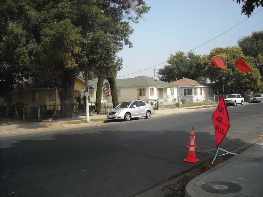
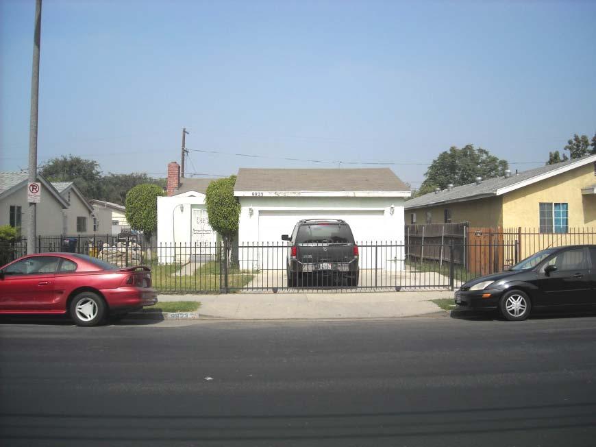
10 Specific Plan Area Vicinity The areas to the north, south, and west of the Specific Plan area consist of single-family residential neighborhoods mixed with a few multi-family buildings. Residential lots are typically 25 to 50 feet wide with front-accessed driveways leading to side-drives, garages, or car ports and 15- to 20-foot setbacks. The residential neighborhoods are characterized by a typical Los Angeles pattern of long rectangular blocks served by narrow mid-block alleys and a series of narrow one-way streets. Figure IV.A-7 shows a typical single-family home adjacent to the Specific Plan area. The site s fourth side, to the east, facing Alameda Street, is mainly industrial, and severed from the adjoining communities by the ten-mile-long Alameda Corridor that allows the passage of 40 to 50 freight trains each day from the Ports of Long Beach and Los Angeles. Tweedy Avenue is the closest road crossing over the railroad trench. The visual character of the areas around the site is influenced by heavy vehicular traffic, freight railroad lines and the Alameda Corridor trench along Alameda Street, and quiet older residential areas to the north, south and west. Further west are several one-story strip malls with chain stores. Views and Vistas Views refer to visual access and obstruction of a focal point or panoramic view from an area. Typically, views are closely tied to topography and the distance from visual features or resources. The Specific Plan area is in an urbanized commercial, flat, industrial and, residential area within Los Angeles. No particularly unique visual elements, landforms, or topographic features exist on or immediately surrounding the project area. The nearest natural feature of visual interest in the project area is the view of the San Gabriel Mountains. The Specific Plan area is situated approximately 25miles south and southwest of the San Gabriel Mountains. View corridors of these mountains are available along the north-south oriented streets in the Specific Plan area. However, existing buildings in and surrounding the Specific Plan area obstruct the views of these mountains. These north-south view corridors are valued, but there are no local policies or ordinances protecting them. In addition, north-facing views of the Downtown Los Angeles buildings skyline are available from various north-south view corridors, but are disrupted by existing buildings within and surrounding the Specific Plan area. Figure IV.A-8 shows views looking to the north and south from the Specific Plan area. Scenic Resources The nearest State-designated scenic highway to the Specific Plan area is State Route 2, north of State Route 210 in La Canada Flintridge, located approximately 22 miles north of the Specific Plan area. The view corridors of the San Gabriel Mountains and the Downtown Los Angeles buildings skyline are considered to be scenic resources. However, views of these scenic resources are currently disrupted by existing buildings and are not protected by local policies or ordinances. The nearest locally recognized scenic resource is Broadway from just north of Century Boulevard to Imperial Highway which has been designated as a City Scenic Highway by the City of Los Angeles. 2 This locally recognized scenic resource is approximately 2.5 miles west of the Specific Plan area. 2 According to the Transportation Element of the General Plan, a street can be designated a scenic highway if it traverses an urban area of cultural, historic, or aesthetic value. City of Los Angeles, City of Los Angeles General Plan Transportation Element, IV.A-10
11
12
13 Light and Glare The Specific Plan area is located in an urban area characterized by primarily residential uses with industrial and other uses along Alameda Street. A high level of ambient light exists due to existing vehicular street lighting. In addition, the residential portion of the Specific Plan area includes substantial security lighting. Approximately 40-foot-tall street lights illuminate a majority of the streets within the Specific Plan area. Glare is a common phenomenon in Southern California primarily due to the occurrence of a high number of days per year with direct sunlight and the highly urbanized nature of the region, resulting in a large concentration of potentially reflective surfaces. The majority of existing structures within the Specific Plan area are composed of non-reflective materials, such as concrete, wood, and plaster. Glare can result from sunlight reflecting off the plastic awnings or other structural fixtures of buildings located on streets adjacent to the Specific Plan area. During the daytime, parked vehicles can produce glare from sunlight being reflected off windshields and other surfaces. Shadows Shadows are cast in a clockwise direction from west/northwest to east/northeast during the daylight hours varying on the time of year. Generally, the shortest shadows are cast during the Summer Solstice (approximately June 21) and grow increasingly longer until the Winter Solstice (approximately December 21). During the Winter Solstice, the sun appears to be lower in the sky and shadows are at their maximum coverage lengths. Shadow impacts may be considered to be significant when they cover shadow-sensitive uses for a substantial amount of time (three to four hours depending on the time of year). Shadow-sensitive uses generally include routinely useable outdoor spaces associated with residential, recreational, or institutional land uses; commercial uses, such as pedestrian-oriented outdoor spaces or restaurants with outdoor eating areas; nurseries; and existing solar collectors/panels. The existing orientation of the buildings is generally long blocks facing east or west and would be expected to cast some shadows on the front entrances of the residences within Jordan Downs. However, as the buildings do not exceed two stories, shadow effects are minimal. Further, most of the shade-sensitive uses such as play and eating areas are located far enough from existing buildings to not be affected. Regulatory Framework City of Los Angeles General Plan Conservation Element. The City of Los Angeles General Plan Conservation Element, adopted in 2001, includes a discussion of the existing land forms and scenic vistas in the City of Los Angeles. Objectives, policies, and programs are included in this Element to ensure the protection of natural terrain and landforms, unique site features, and panoramic public views. Citywide General Plan Framework. The Citywide General Plan Framework Element (Framework), adopted in December 1996 and readopted in August 2001, establishes the conceptual basis for the City s General Plan. The Framework provides direction as to the City s vision for future development in the vicinity of the Specific Plan area and includes an Urban Form and Neighborhood Design chapter to guide the design of future development. Although the Framework does not directly address the design of individual neighborhoods or communities, it embodies general neighborhood design policies and implementation programs that guide local planning efforts. The Framework also states that the livability of all neighborhoods would be improved by upgrading the quality of development and improving the quality of the public realm (Objective 5.5). 3 3 General Plan Framework, page 5-14 IV.A-13
14 As discussed in Section IV.G Land Use of this, the Urban Form and Neighborhood Design Chapter establishes a goal of creating a livable city for existing and future residents with interconnected, diverse neighborhoods. Urban form refers to the general pattern of building heights and development intensity and the structural elements that define the City physically, such as natural features, transportation corridors, activity centers, and focal elements. Neighborhood design refers to the physical character of neighborhoods and communities within the City. With respect to neighborhood design, the Urban Form and Neighborhood Design Chapter encourage growth in areas that have a sufficient base of both commercial and residential development to support transit service. Also within the Framework, the Open Space and Conservation Chapter calls for the use of open space to enhance community and neighborhood character. The policies of this chapter recognize that there are communities where open space and recreational resources are currently in short supply and therefore suggests that pedestrian-oriented streets and small parks, where feasible, might serve as important resources for serving the open space and recreation needs of residents. City of Los Angeles Walkability Checklist. The City of Los Angeles Walkability Checklist, Guidance for Entitlement Review (Walkability Checklist) was created by the City s Urban Design Studio of the Department of City Planning and specifies urban design guidelines that are generally applicable to all projects requiring discretionary approval for new construction. The Walkability Checklist consists of objectives, goals, and implementation strategies regarding various design elements that are intended to improve the pedestrian environment, protect neighborhood character, and promote high quality urban form. Such topics as sidewalks, crosswalks/street crossings, on-street parking, utilities, building orientation, off-street parking and driveways, on-site landscaping, building façades, and building signage and lighting are addressed and should be considered in the design of a project. Southeast Los Angeles Community Plan. The Specific Plan area lies within the Southeast Community Plan, one of 35 community and district plans established throughout the City, which collectively comprise the Land Use Element of the City s General Plan. The intent of the Community Plans is to promote an arrangement of land uses, streets, and services which will encourage and contribute to the economic, social, and physical health, safety, welfare and convenience of the people who live and work in the community. The Community Plans also guide development to create a healthful and pleasant environment. Chapter III, Land Use Policies and Programs, within each respective Community Plan includes a number of objectives and policies that address the visual aspects of new development. The Southeast Community Plan, Chapter V, Urban Design, provides design policies for individual projects, such as commercial, industrial, and multiple residential projects. These design policies establish the minimum level of design and address design issues for parking and landscaping. In addition, the Urban Design Chapter includes community design and landscaping guidelines for streetscape improvements and landscaping in public spaces and rights-of-way. Further discussion of the Southeast Community Plan is provided in Section IV.G Land Use of this. City of Los Angeles Planning and Zoning Code. The Planning and Zoning Code is the first chapter of the City of Los Angeles Municipal Code (LAMC), which designates, regulates, and restricts the location and use of buildings, structures, and land for agriculture, residence, commerce, trade, industry, or other purposes. The Planning and Zoning Code includes design standards that seek to regulate the physical alteration of streets, intersections, alleys, pedestrian walkways, and landscaping. IV.A-14
15 ENVIRONMENTAL IMPACTS Significance Thresholds In accordance with Appendix G of the State CEQA Guidelines, the proposed project would have a significant impact on aesthetics if the proposed project were to: Have a substantial adverse effect on a scenic vista; Substantially damage scenic resources, including, but not limited to, trees, rock outcroppings, and historic buildings within a state scenic highway; Substantially degrade the existing visual character or quality of the site and its surroundings; and/or Create a new source of substantial light or glare that would adversely affect day or nighttime views in the area. In addition, the City of Los Angeles CEQA Thresholds Guide states that the determination of significance with regard to impacts on shade and shadows shall be made on a case-by-case basis, considering the following factors: A project impact would normally be considered significant if shadow-sensitive uses would be shaded by project-related structures for more than three hours between the hours of 9:00 a.m. and 3:00 p.m. Pacific Standard Time (between early November and mid-march), or for more than four hours between the hours of 9:00 a.m. and 5:00 p.m. Pacific Daylight Time (between mid-march and early November). Project Design Features Building Heights and Massing. Building heights for the proposed project would be limited to a maximum height of 90 feet depending on the type of housing proposed. Table IV.A-1 shows proposed building height by building type. Non-residential buildings would generally be two-to-three stories and would be limited to heights of 35 feet. TABLE IV.A-1: BUILDING HEIGHT RECOMMENDATIONS BY BUILDING TYPE Courtyard houses, townhouses, alley townhouses, townhouses over flats 3 stories (35 feet) Stacked flat apartments and stacked flat apartments over townhomes 5 stories (60 feet) Mid-rise stacked flat apartments 8 stories (90 feet) Non-residential buildings 2 to 3 stories (up to 35 feet) SOURCE: Urban Studio, Open Space, Landscaping and Recreational Areas. The proposed project would provide for new open space areas and landscaping that would enhance the visual character of the site and surrounding area, while serving recreational needs of the community. Open space and landscaped areas within the proposed project include the following types: Parks and Greenways Parks and greenways will provide the community with both passive and active recreation opportunities and will serve as the green backbone of the proposed project; All residents should enjoy close proximity to well-distributed parks and open space; A large neighborhood park would be centrally located within a five-minute walk of all residences; and The neighborhood park (Central Park) is the focal point of the community and a well-defined, extensive pedestrian network connects it to the surrounding residential neighborhoods. IV.A-15
16 Residential Neighborhoods Residences facing the street should be encouraged to grow fruit trees in front yards and in sidewalk planters to create a network of front porch agriculture. Live/Work Streetscapes for live/work areas should be urban in character and will include amenities such as benches, street lighting, litter receptacles, ash urns, etc. Commercial/Retail The streetscapes surrounding commercial/retail should be focused primarily on the pedestrian and should include generous sidewalk widths, safe street crossings, numerous street trees for shade, benches, café seating, ample lighting, litter receptacles/ash urns, etc.; and Street parking should be available directly adjacent to shops located along Alameda Street. Mixed Use Streetscape surrounding mixed use should be urban in character and should include amenities such as benches, café seating, street lighting, litter receptacles/ash urns, etc. Schools and Community Areas Elementary and high school sports fields would ideally serve as joint-use facilities; The existing community garden may be rehabilitated to encourage community participation in urban agriculture; and Roof gardens are encouraged atop flat-roofed public structures such as schools for growing vegetables and herbs for school cafeterias and local restaurants. Parking Design. In general, the design of the proposed project would encourage a pedestrian-scale environment and walking between residences, parks, schools, shops, and services. Building entries would be oriented to public sidewalks and open space with accommodations for bicycles provided. Parking for cars would be curb-related and fully landscaped, and/or placed within architecturally treated structures and individual garages that are not visible and/or completely screened from public view. Parking for residential units would be dependent on the housing type. Table IV.A.2 below summarizes parking for each building type. TABLE IV.A-2: PARKING BY BUILDING TYPE Courtyard Houses with Open Air Parking Courtyard houses with Semi-Subterranean Parking Townhouses with Rear Tuck-under Parking Alley Townhouses Townhouses over Flats Stacked Flat Apartments, Stacked Flat Apartments over Townhomes, Mid-rise stacked flat apartments Ground floor, open air parking court to the rear. The courtyard is used as shared space and for access to private garages incorporated into each townhome. Parking is below units in a commonly accessed garage, parking is accessed from the public right-of-way The rear of the townhouses, along the alley, provides for parking tucked under the units Except for those units that face public streets, townhome entries and garages face the common alley Garages are located on the ground floor, parking is tucked under the rear of units along alleys and private drives, alley provides access to parking at rear Parking is provided within a common garage screened from view by building uses SOURCE: Urban Studio, In addition to the residential uses described above, parking would also be provided for commercial uses on-site. In particular, a commercial mixed-use retail plaza with residential above would be located at the southern entry of the Specific Plan area at the 103 rd Street/Croesus Avenue intersection. Buildings would IV.A-16
17 be set back from Croesus Avenue to form a parking court and to serve as a public plaza on special occasions. Signage and Lighting. Public signage for the proposed project would be designed to be compatible with architectural elements throughout the Specific Plan area and would be designated and/or specified in conjunction with other furnishings to ensure a consistent palette of streetscape elements. Signage will be placed at key entries and gateways and would be designed to minimize clutter at eye level and to minimize vandalism. Lighting would be provided throughout the Specific Plan area to increase visibility, promote safety and enhance the nighttime environment. Specifically, adequate lighting would be installed along all pedestrian walkways and vehicular accessways. Appropriately scaled street lighting will define the pedestrian realm and bring the street scale down to the human level. Parks and plazas would also include pedestrian-scale pole-mounted light fixtures that could be enhanced by in-ground light fixtures and lit bollards. Regional streets would include aesthetically pleasing fixtures with a height of approximately 30 feet, while secondary streets and internal/neighborhood street and paseos would include fixtures approximately 12 feet in height which would be used specifically to illuminate the adjacent path. Architectural Guidelines. The Specific Plan provides an overall urban design framework and defines standards for location of new buildings, maximum heights, setbacks from sidewalks, location of common open space, and a pedestrian-oriented and human-scaled street and sidewalk grid that connects the Specific Plan area to the surrounding Watts community. To supplement these big picture concepts, a set of Architectural Design Guidelines were developed to provide a detailed architectural framework and to establish baseline quality on a building-by-building basis. The Architectural Design Guidelines include the following goals: Goal 2.1 Goal 2.2 Goal 2.3 Relate the scale of new buildings to the existing community: To further the creation of one community where all mix and live together, affordable, public, private, live-work, obtainable, and market-rate buildings should be intermixed to the maximum extent feasible and indistinguishable with regard to architectural character. Orient new buildings to pedestrians: To encourage the creation of a pedestrian-scale environment and walking between residences, parks, schools, shops, and services at the new Jordan Downs, buildings and building entries should be related to public sidewalks and open spaces, accommodations for bicycles provided, and parking for cars be either curb-related and fully landscaped, and/or placed within architecturally treated structures and individual garages that are not visible and/or completely screened from public rightof-ways. Ensure that new buildings and residences are ground-related: To enhance community safety, the first inhabited floor of buildings should be close to grade and feature regularly occurring outward-facing ground-related entries, incorporate secured transitional areas between public and private space such as stoops and courtyards visible to the public sidewalk, and include a variety of active and passive uses that overlook and are adjacent to public right-of-ways such as residences, live-work units, small shops, and neighborhood service uses. IV.A-17
18 Goal 2.4 Goal 2.5 Goal 2.6 Provide a range of unit types: To provide for a variety of household types, including homes for individuals, families, and seniors, a wide range of unit types that meet minimum size and accessibility criteria should be provided. Realize one community where all live together: To further the creation of one community where all mix and live together, new buildings should be inclusive and mix public, affordable, work force, and market-rate dwellings such that one cannot be distinguished from the other. Express region-related architectural character and identity: To establish within the new Jordan Downs an architectural connection that is linked to a larger Southern California legacy that creates a sense of common identity for all residents; new buildings should incorporate architectural character that recalls and builds upon understandings of this region s Mediterranean-influenced architecture. Analysis of the Proposed Project Impacts Visual Character Construction Construction activities generally cause a contrast to, and disruption in, the general order and aesthetic character of an area. Although temporary in nature, construction activities may cause a visually unappealing quality in the community. During construction activities, the visual appearance of the Specific Plan area would be altered due to the removal of existing buildings, surface parking areas, and/or landscaping. Other construction activities including site preparation and grading; the staging of construction equipment and materials; and the construction of foundations, new buildings, and outdoor open space areas would alter the visual quality of the Specific Plan area. Some of these construction activities would be visible to pedestrians, motorists, and residents on adjacent streets. Temporary construction fencing would be placed along the periphery of the area of construction to screen much of the construction activity from view at the street level. Pedestrian walkways and construction fencing could serve as targets for graffiti, if not appropriately monitored. The altered visual conditions associated with construction activities would be temporary and typical for visual distractions associated with construction activities and equipment. Therefore, less-than-significant construction-related visual impacts would occur. Operation Impacts to visual character generally include perceived contrast between existing development and a newly introduced element. The key factors influencing contrast include scale (intensity, height and setback), massing (volume and arrangement), and open space (surface parking, pedestrian spaces, and setbacks). The Specific Plan area is located in an area with residential uses that are primarily one- and two-story homes, as well as industrial and commercial uses. The surrounding neighborhood is characterized by narrow building lots with the short side of the parcel facing the street and consistent front yard setbacks. The building interface between Jordan Downs and the community will occur along Grape Street, 103 rd Street, and 97 th Street where new and existing buildings will front the same street. Development of the proposed project would involve the demolition of the existing Jordan Downs residences, the recreation center buildings, and the abandoned steel mill structure located in the northwest IV.A-18
19 corner of the acre property HACLA now owns adjacent to the public housing complex, and the construction of up to 1,800 residential units and ancillary uses. The proposed project would be constructed to conform to the set of architectural guidelines described above. The architectural guidelines would ensure that the buildings on-site are of a compatible type and scale, thereby limiting the opportunities for visual contrast on-site. In addition, the overall visual character of the site would be enhanced through public open space, increased and improved landscaping, and a large central park. Therefore, visual contrasts on-site would not occur. Development of the proposed project would provide opportunities for taller buildings and at higher densities than those that currently exist in the community. The new buildings will have larger parcels, incorporate multiple housing units and will feature a mix of uses. The new buildings will be required to conform both to overall height limits as well as building type height limits. Figure IV.A-9 shows the height limits by building type for the Specific Plan area. The building height recommendations by building type are also shown above in Table IV.A-1. The courtyard houses, townhouses and alley townhouses would be generally similar in height and massing to the existing uses within the Specific Plan area. These housing types would have a maximum height of up to three stories with courtyards, gardens and other open areas. The alley townhouses and townhouses over flats would demonstrate an increase in density from existing uses, in that the housing would be grouped together in tighter, smaller blocks creating a semi-urban feel. In the northwest portion of the Specific Plan area, for example, along 97 th and Grape Streets, the residences would be low in overall height, but there would be a greater number of units in that area. This could create a contrast between the Specific Plan area and the adjacent single-family neighborhoods. The stacked flat apartments and stacked flat apartments over townhomes would exceed the existing height of residences at Jordan Downs. This housing type would be located primarily along the interior of the site, at the north end of the Specific Plan area where 97 th Street meets Croesus Avenue. The stacked flats would be located on either side of the entryway park and would abut the park on all sides including the south end along 103 rd Street. This housing type would also be located on the east and west ends of Kalmia Street and the east end of Laurel Street. In general, where the stacked flats would be located in the interior of the Specific Plan area, they would not create a visual contrast. However, at the north and south end of the site along Croesus Avenue, these higher density housing types would interface with the existing community. In particular, along 103 rd Street, the stacked flats would be combined with the tallest building type, the mid-rise stacked flat apartments which could be up to eight stories in height. Although the mid-rise stacked flats would be facing the interior of the site along 102 nd Street, they would still be visible from the exterior of the Specific Plan area and would create a visual contrast with the existing single-family uses. This would be a significant impact without mitigation. Figures IV.A-10 and IV.A- 11 demonstrate the interface between the single-family neighborhoods and the proposed project along 97 th and Grape Streets. In addition to the adjacent residential uses, the new buildings would also be located adjacent to the existing Jordan High School. Building types that would be located adjacent to the high school include stacked-flat apartment buildings located along the western boundary of the high school (near the athletic fields) and courtyard houses located adjacent to the historically significant buildings along 103 rd Street. As discussed above, the courtyard houses would be up to 35 feet tall and would be designed in an architectural style that reflects the larger Southern California character. Therefore, the new buildings would not create a visual contrast with the existing high school. IV.A-19

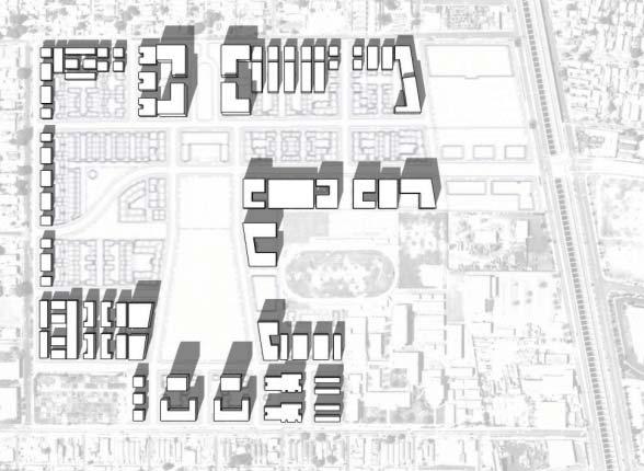
20 97TH ST WILMINGTON AVE GRAPE ST TYPE B TYPE A TYPE A 99TH ST TYPE C TYPE B TYPE B TYPE B CENTURY BLVD TYPE C TYPE A CENTURY BLVD TYPE A TYPE B TYPE A 101ST ST TYPE B TYPE A TYPE C TYPE A TYPE B 103RD ST GRAPE ST CROESUS AVE KALMIA ST WEIGAND AVE GRAPE ST CROESUS AVE KALMIA ST MISSOURI AVE TWEEDY BLVD ALAMEDA ST LEGEND: Specific Plan Area Building Heights Type A: Courtyard Houses, Townhouses, and Alley Townhouses (35 feet up to three stories) Type B: Stacked Flat Apartment Buildings (60 feet up to five stories) Type C: Limited Residential Mid-Rise Tower Opportunities (90 feet up to eight stories) SOURCE: WRT/Soloman E.T.C., Jordan Downs Specific Plan Environmental Impact Report CITY OF LOS ANGELES DEPARTMENT OF CITY PLANNING APPROX. SCALE FIGURE IV.A-9 PROPOSED BUILDING CONFIGURATIONS AND SCALE N FEET
21
22
23 In addition to the direct impacts described above, indirect impacts could also occur due to changes in the zoning designation of the privately held parcels. As part of the proposed project, uses on the privately held parcels would be rezoned and would have a limited ability to make major changes or improvements. Without the ability to make substantial upgrades or improvements, these properties could continue to deteriorate detracting from the overall visual character of the Specific Plan area. The contrast between the proposed new buildings and the privately held parcels could degrade the overall visual character of the site. This would be a significant impact without mitigation. The incorporation of new landscaping within the Specific Plan area would provide visual enhancement. New landscaping will occur as each of the project phases are complete, with the Central Park being completed in Phase 2. The landscaping will serve to soften and buffer views of the proposed structures. New landscaping features would include parks and greenways, community gardens, paseos, picnic areas and plazas with outdoor furniture and decorative lighting and other amenities intended to add variety and contribute to a sense of human scale. Architectural guidelines and requirements in the proposed Specific Plan will help ensure maximum compatibility of design, ensure minimization of light and glare, promote pedestrian-friendly entries and uses, and promote the use of compatible exterior materials. Additional features of the Specific Plan include provisions related to streetscape improvements and height restrictions. In general, the proposed project would serve to improve the aesthetic character of the Specific Plan area given the architectural guidelines for the proposed project, the use of design elements such as landscaped corridors and walkways, and the new landscape features to be implemented. However, despite incorporation of the architectural guidelines and new landscaping, implementation of the proposed project would adversely alter the existing visual character of the Specific Plan area and its surroundings over the long-term because of the significant increase in building heights and massing compared to existing conditions and the surrounding uses. In addition, without the ability to make improvements, the privately held parcels could detract from the overall visual character of the Specific Plan area. Therefore, significant impacts related to visual character during operations would occur without mitigation. Views and Vistas The Specific Plan area does not occupy a portion of a valued viewshed. Specifically, north-facing views of visual resources are not available from viewing locations immediately south of the Specific Plan area. Views of the Downtown Los Angeles skyline are generally only available from along north-south street corridors. Views from the south are thus limited to views of the Specific Plan area itself. While building heights would increase with the proposed project, valued views would not be affected. Therefore, lessthan-significant impacts related to views and vistas would occur. Scenic Resources The proposed project is not located in the vicinity of any designated scenic highway and, therefore, would not damage scenic resources, trees, rock outcroppings, and historic buildings within a state scenic highway. The historically significant David Starr Jordan High School is located in the Specific Plan area. The historically significant buildings associated with the high school are located along 103 rd Street on the southern boundary of the Specific Plan area. Although the southern boundary of the site would be landscaped, the high school itself would not be disturbed. Therefore, less-than-significant impacts related to scenic resources would occur. IV.A-23
24 Shade and Shadow The prevalence of shadow impacts are directly attributable to building heights, scale, massing, setback specifications, the angle of the sun, and location of a project relative to off-site shadow-sensitive uses as described above. Shadows are typically cast in a westward to eastward direction as the day advances from morning to afternoon to evening. Figure IV.A-12 through Figure IV.A-14 illustrate the projected shadow conditions associated with the proposed project for the three primary solar conditions of the year: Summer Solstice (approximately June 22), Winter Solstice (approximately December 22) and Spring/Fall Equinox (approximately March 22/September 22). The proposed project would introduce new residential buildings throughout the site that would range from three to eight stories, depending on the building type (courtyard, stacked flat, etc). The concern related to shadows would be where the new buildings interface with the existing community, in particular along Grape and 97 th Streets, as the Specific Plan would add new features that could contrast with existing residential uses. Shadows cast internal to the site were also evaluated, however, the evaluation concentrated on open space throughout the site, such as Central Park, and playfields. During the summer solstice, shadows would be cast from the Specific Plan area on the interior of the Specific Plan area. Shadows would be cast in the late afternoon (between 3:00 p.m. and 5:00 p.m.) onto the park located at the northern portion of the Specific Plan area. As Figure IV.A-12 illustrates, projectrelated shadows would not affect the adjacent single-family residential uses and the majority of the Central Park would not be affected. No shade sensitive uses external to the Specific Plan area, such as residential front and rear yards, balconies, or playgrounds would be significantly affected by the shadows that would be cast by the proposed project. As the proposed project would not cast shadows onto shadesensitive uses for more than four hours between the hours of 9:00 a.m. and 5:00 p.m. during the Summer Solstice, less-than-significant shadow impacts would occur. During the Winter Solstice, shadows cast from the Specific Plan area from 9:00 a.m. through 3:00 p.m. would not cast shadows on adjacent residential lots, buildings, or usable outdoor space with the exception of residences on the north side of 97 th Street located to the east and west of Croesus Avenue. As Figure IV.A.13 illustrates, shadows generated from the Specific Plan area would affect the front yards of these residences for a period of more than three hours. This would be a potentially significant impact. In addition, a small portion of the high school athletic fields would be shaded for a portion of the day; however, these shadows would not be cast on the field for more than three consecutive hours. Shade and shadow impacts on the high school would be less than significant. During the Spring and Fall Equinoxes, shadows cast from the Specific Plan area between 9:00 a.m. and 3:00 p.m. would not cast shadows on adjacent residential lots, buildings, or usable outdoor space. As Figure IV.A.14 illustrates, the shadows would cover alternating portions of the Central Park during the day, but would not cover any one area continuously. Further, the proposed project would not cast shadows for any continuous period of the day on the adjacent residential uses. As the proposed project would not cast shadows onto shade-sensitive uses for more than three hours, less-than-significant impacts would result. In addition a small portion of the high school athletic field would be shaded during the day; however, these shadows would not be cast on the field for more than three consecutive hours. Shade and shadow impacts on the high school would be less than significant. IV.A-24
25
26
27
28 Light and Glare New development associated with the proposed project could create new sources of light from exterior building illumination and lighted recreation/athletic facilities, as well as glare from reflective building surfaces or the headlights of increased vehicular traffic. These new sources of permanent light or glare could affect day or nighttime views of adjacent sensitive land uses and result in a significant impact without mitigation. Nighttime lighting used during construction would consist primarily of security lights, although lighting may be used for construction activities occurring during morning or evening hours, particularly in the winter. This lighting will be temporary in nature and would not result in any substantial long-term light or glare impacts. New permanent exterior nighttime lighting would be used to define the pedestrian realm and create a human-scale environment, as well as a secure nighttime environment. Lighting would be used to highlight architectural elements, landscaping and plazas and building exteriors. Security and safety lighting would be provided, as necessary, in open areas and building exteriors. Further, increased vehicular traffic resulting from the increase in new residential uses could result in more opportunities for vehicular headlights to affect existing light-sensitive uses along project area streets. All proposed lighting would be subject to regulations in the Los Angeles Municipal Code and/or the proposed Specific Plan and be subject to the review and approval of the City. Therefore, new lighting sources would not result in substantial impacts affecting nighttime views. Currently, there is substantial nighttime lighting in the project area, and the addition of new sources of permanent light and glare, from the increase in housing units and overall density on the site, as a result of implementation of the proposed project would increase ambient lighting in the project area and surrounding area. However, due to the highly developed urban nature of the City and the Watts Community, there is a substantial amount of ambient light both in the Specific Plan area and in the immediately surrounding vicinity, in particular along Alameda Street. Therefore, an increase in ambient nighttime lighting would be anticipated to have a minimal effect on existing conditions. Therefore, impacts related to increased ambient lighting affecting nighttime views in the Specific Plan area would be less than significant. Implementation of the proposed project could create new sources of glare from reflective building surfaces. These new sources of glare could affect daytime and nighttime views from sensitive land uses, such as residences, in the vicinity of the Specific Plan area. Additional glare could be produced by an increased amount of reflective surface area of the proposed new building structures, which could reflect or concentrate sunlight or nighttime lighting (including vehicle headlights) and result in significant impacts without mitigation. CUMULATIVE IMPACTS Visual Character In general, the land use plans that guide development in the vicinity of the Specific Plan area anticipate the intensification of existing commercial and residential land uses in the surrounding area. Development of low-rise structures and lower intensity development would not be anticipated to have a substantial aesthetic effect as the Specific Plan area is highly urbanized. Future development of mid- or high-rise structures, however, may change the density and visual character of the area over time. These future developments would be subject to City discretionary review to ensure consistency with adopted IV.A-28
VISUAL RESOURCES 1. INTRODUCTION 2. EXISTING CONDITIONS. a. Visual Character
 IV.A VISUAL RESOURCES 1. INTRODUCTION This section addresses the potential changes in visual character that would result from implementation of the proposed Wilshire and La Brea Project. Also evaluated
ENVIRONMENTAL IMPACT ANALYSIS
 IV. ENVIRONMENTAL IMPACT ANALYSIS A. AESTHETICS This section addresses the potential impacts to aesthetics and views that could result from the proposed project, including development of the Add Area,
B L A C K D I A M O N D D E S I G N G U I D E L I N E S for Multi-family Development
 B L A C K D I A M O N D D E S I G N G U I D E L I N E S for Multi-family Development Adopted June 18, 2009 This section of the Design and focuses on site planning and design guidance for new multi-family
APPENDIX D: BACKGROUND AND VISION
 APPENDIX D: BACKGROUND AND VISION BACKGROUND A. Specific Plan Location Jordan Downs is located at 9800 Grape Street in Los Angeles, California, 90002. The Jordan Downs Urban Village Specific Plan area
Policies and Code Intent Sections Related to Town Center
 Policies and Code Intent Sections Related to Town Center The Town Center Vision is scattered throughout the Comprehensive Plan, development code and the 1994 Town Center Plan. What follows are sections
FLORIN ROAD CORRIDOR Site Plan and Design Review Guidelines Checklist
 FLORIN ROAD CORRIDOR Site Plan and Design Review Guidelines Checklist Applicant s Name: Project Address: Phone: Email: Applicant shall fill out the design guidelines checklist for all guidelines applicable
IV.B. VISUAL RESOURCES
 IV.B. VISUAL RESOURCES ENVIRONMENTAL SETTING Existing Visual Character Project Site The project site is located at 17331-17333 Tramonto Drive in the Pacific Palisades community of the City of Los Angeles
WEST LOOP DESIGN GUIDELINES CHECKLIST
 WEST LOOP DESIGN GUIDELINES CHECKLIST Section 1.0 General Strategies 1.1 DESIGN EXCELLENCE: ENCOURAGE HIGH QUALITY AND INNOVATIVE DESIGN OF NEW BUILDINGS WITHIN THE WEST LOOP WITHOUT BEING PRESCRIPTIVE
Clairtrell Area Context Plan
 Clairtrell Area Context Plan March 2005 Urban Development Services City Planning Contents 1. Introduction... 4 2. Development Structure... 6 2.1 Streets... 7 2.1.1 Sheppard Avenue and Bayview Avenue...
PUBLIC RIGHT-OF-WAY IN THIS CHAPTER PUBLIC REALM
 PUBLIC RIGHT-OF-WAY This section provides design guidelines for improvements in the public right-of-way. The public right-of-way refers to streets, sidewalks, non-vehicular thoroughfares, parks and greenways
DRAFT. 10% Common Open Space
 % OF CHARLOTTE IS CATEGORIZED AS A. LAND USES : Placeholder map displaying location of Place Type GOALS: Accommodate XX% of future growth. Provide a concentration of primarily commercial and civic activity
Nob Hill Pipeline Improvements Project EIR
 Section 3.1 Aesthetics This section addresses the visual aspects that may affect the views experienced by the public, including the potential to impact the existing character of each area that comprises
DESIGN REVIEW COMMITTEE AGENDA ITEM
 DESIGN REVIEW COMMITTEE AGENDA ITEM AGENDA DATE: AUGUST 2, 2017 TO: THRU: FROM: SUBJECT: Chair Imboden and Members of the Design Review Committee Anna Pehoushek, Assistant Community Development Director
Regency Developments. Urban Design Brief. Holyrood DC2 Rezoning
 Regency Developments Urban Design Brief Holyrood DC2 Rezoning Stantec Consulting Ltd. 7-31-2017 1. Overview Regency Developments intends to rezone the lands located at 8510 and 8511 93 Avenue, within the
Neighborhood Districts
 NEIGHBORHOOD DISTRICTS SEVEN MAIN DISTRICTS Neighborhood Districts While the Development Plan provides a broad-scale overview of the neighborhood, this section focuses on uses and relationships at the
IV. ENVIRONMENTAL IMPACT ANALYSIS B. AESTHETICS 1. SHADE/SHADOW
 IV. ENVIRONMENTAL IMPACT ANALYSIS B. AESTHETICS 1. SHADE/SHADOW ENVIRONMENTAL SETTING The issue of shade and shadow pertains to the blockage of direct sunlight by onsite buildings, which affect adjacent
The Village. Chapter 3. Mixed Use Development Plan SPECIFIC PLAN
 The Village SPECIFIC PLAN Chapter 3 3.1 INTRODUCTION 3.1.1 Purpose This Chapter describes the development regulations applicable to the Mixed-Use and Transit Center Planning Areas. These form-based regulations
Urban Design Brief 1576 Richmond Street City of London
 Urban Design Brief City of London Treadstone Developments October 31, 2014 Urban Design Brief October 31, 2014 TABLE OF CONTENTS Page No. INTRODUCTION... 1 SECTION 1 LAND USE PLANNING CONCEPT... 1 1.1
Highland Village Green Design Guidelines
 Highland Village Green Design Guidelines Publishing Information Title Highland Village Green Design Guidelins Author The City of Calgary Status DRAFT - Proposed document subject to changes Additional Copies
VEHICULAR AND PEDESTRIAN CIRCULATION
 This perspective sketch communicates the intended character and quality of a proposed streetscape design. Locate benches near a major intersection where people tend to gather. Seating and lighting provide
URBAN DESIGN BRIEF URBAN DESIGN BRIEF 721 FRANKLIN BLVD, CAMBRIDGE August 2018
 URBAN DESIGN BRIEF URBAN DESIGN BRIEF 721 FRANKLIN BLVD, CAMBRIDGE August 2018 DESIGN BRIEF CONTENTS PART A 1.0 INTRODUCTION 2.0 DESCRIPTION & ANALYSIS OF SITE CONTEXT 3.0 DESIGN CONSTRAINTS AND OPPORTUNITIES
ELMVALE ACRES SHOPPING CENTRE MASTER PLAN
 ELMVALE ACRES SHOPPING CENTRE MASTER PLAN Contents 1.0 INTRODUCTION... 2 2.0 LOCATION... 2 3.0 EXISTING CONTEXT... 2 4.0 VISION & GUIDING PRINCIPLES... 2 5.0 LAND USE AND BUILT FORM... 4 5.1 St. Laurent
4.0 Design Guidelines For The Village Centre. South fields Community Architectural Design Guidelines Town of Caledon
 4.0 Design Guidelines For The Village Centre 4.0 Design Guidelines for the Village Centre The Village Centre is the focal point of the entire South Fields Community and is designed as a traditional commercial
DRAFT. October Wheaton. Design Guidelines
 October 2011 DRAFT Wheaton Design Guidelines 2 Draft - Design Guidelines - Wheaton Sector Plan Contents 04 Section 1: Introduction 06 Section 2: Context 08 Section 3: Design Guidelines 09 Goal 1: Create
IV. ENVIRONMENTAL IMPACT ANALYSIS B. AESTHETICS 1. VIEWS
 IV. ENVIRONMENTAL IMPACT ANALYSIS B. AESTHETICS 1. VIEWS ENVIRONMENTAL SETTING Existing Visual Character Project Site The project site is located at 10250 Wilshire Boulevard in the Westwood community of
New-Cast Mixed-use Development Proposal King Street West, Newcastle, Ontario
 URBAN DESIGN BRIEF New-Cast Mixed-use Development Proposal King Street West, Newcastle, Ontario TABLE OF CONTENTS: 1.0 Executive Summary 2.0 Creating Vibrant and Sustainable Urban Places: Excerpts from
The transportation system in a community is an
 7 TRANSPORTATION The transportation system in a community is an important factor contributing to the quality of life of the residents. Without a sound transportation system to bring both goods and patrons
Harvard-Westlake Parking Improvement Plan, Lighting Evaluation, Lighting Design Alliance, September 25, 2013 (Appendix I)
") 3.1 AESTHETICS The purpose of this section is to characterize the visual (aesthetic) environment that currently exists in the Project area and to identify potential impacts to: visual character, views
3.1 AESTHETICS The purpose of this section is to characterize the visual (aesthetic) environment that currently exists in the Project area and to identify potential impacts to: visual character, views
The impacts examined herein take into account two attributes of aesthetic values:
 IV. ENVIRONMENTAL IMPACT ANALYSIS This section addresses the potential impacts to views and aesthetics as a result of the proposed Project at the Project Site and the development scenarios analyzed for
IV. ENVIRONMENTAL IMPACT ANALYSIS B. AESTHETICS 1. VIEWS
 IV. ENVIRONMENTAL IMPACT ANALYSIS B. AESTHETICS 1. VIEWS INTRODUCTION This section evaluates the potential impacts of the Proposed Project on aesthetics, views and vistas, light and glare, and shade and
IV. ENVIRONMENTAL IMPACT ANALYSIS B. AESTHETICS
 IV. ENVIRONMENTAL IMPACT ANALYSIS B. AESTHETICS INTRODUCTION This section evaluates the potential impacts of the Proposed Project on aesthetics, views and vistas, light and glare, and shade and shadows
R STREET CORRIDOR NEIGHBORHOOD Site Plan and Design Review Supplemental Guidelines Checklist
 R STREET CORRIDOR NEIGHBORHOOD Site Plan and Design Review Supplemental Guidelines Checklist Applicant s Name: Project Address: Phone: Email: Applicant shall fill out the design guidelines checklist for
4.9 Mendocino Avenue Corridor Plan Design Guidelines
 4.9 Mendocino Avenue Corridor Plan Design Guidelines The Mendocino Avenue Corridor Plan addresses the area between College Avenue and Steele Lane. Mendocino Avenue is a busy arterial that runs parallel
URBAN DESIGN BRIEF. 2136&2148 Trafalgar Road. Town of Oakville
 URBAN DESIGN BRIEF 2136&2148 Trafalgar Road Town of Oakville Prepared By: METROPOLITAN CONSULTING INC For 2500674 Ontario Inc November 2016 TABLE OF CONTENTS Page No. 1.0 Introduction/Description of Subject
Chapter 4: Jordan Road Character District
 4: Jordan Road Character District 4.1 Introduction The Jordan Road character district encompasses much of the former Jordan orchard and farmstead, which was a significant part of Sedona s history. The
4.1 Aesthetics Setting. a. Visual Character
 Environmental Impact Analysis Aesthetics 4.1 Aesthetics This section analyzes the proposed Specific Plan s impacts related to aesthetics, including the existing visual character of and scenic views in
Buildings may be set back to create small plazas provided that these setbacks do not substantially disrupt the street wall s continuity.
 6-22 Community Design Street Walls and Street-front Setbacks The siting of buildings will play a critical role in establishing the character and sense of place for the District. Siting buildings at the
Lehigh Acres Land Development Regulations Community Planning Project
 Lehigh Acres Land Development Regulations Planning Effort Summary In July, 2010 Commissioner Frank Mann invited the Lehigh Acres community to start discussing how to achieve their recently adopted community
II. SINGLE FAMILY RESIDENTIAL
 II. SINGLE FAMILY RESIDENTIAL Castle Rock is made up of numerous individually built houses and subdivision tracts that have been developed during the past century. Some of the tracts are diverse in architectural
Site Planning. 1.0 Site Context. 2.0 Pedestrian Circulation Systems. Pag e 2-23
 The following photographs from throughout the country illustrate key urban design principles. Photographs are provided to illustrate the overall urban design concepts described in Chapter 1 of the Downtown
4.0 AFFECTED ENVIRONMENT AND ENVIRONMENTAL CONSEQUENCES
 4.0 AFFECTED ENVIRONMENT AND ENVIRONMENTAL CONSEQUENCES The following sections discuss the impacts associated with environmental resources for the tunneling method Alternatives A and B. The construction
Standards (R-3) Figure B-11: R-3 Residential Standards Exhibit
 Figure B-11: R-3 Residential Standards Exhibit") Avila Ranch Avila Ranch Specific Plan Development Standards High Medium Density - High Residential Density Residential Lot and Building Lot and Standards Building (R-3) Standards (R-3) EXAMPLES These sketches
Avila Ranch Avila Ranch Specific Plan Development Standards High Medium Density - High Residential Density Residential Lot and Building Lot and Standards Building (R-3) Standards (R-3) EXAMPLES These sketches
Environmental Setting, Impacts, and Mitigation Measures
 CHAPTER 3 Environmental Setting, Impacts, and Mitigation Measures Format of the Environmental Analysis The assessment of each environmental resource discussed in this chapter includes the following: Environmental
3.0 URBAN DESIGN. December 6, OVERVIEW
 Urban Design 3.0 URBAN DESIGN December 6, 2007 3.1 OVERVIEW The highly urban character of Easton Place is defined by the overall design of the community. The following sections provide an overview of the
Resolution : Exhibit A. Downtown District Design Guidelines March 2003
 Resolution 03-011: Exhibit A Downtown District Design Guidelines March 2003 DOWNTOWN DISTRICT DESIGN GUIDELINES CITY OF SOUTHLAKE, TEXAS Adopted March 2003 1 DOWNTOWN DISTRICT DESIGN GUIDELINES Adopted
3.1 community vision. 3.3 required plan elements
 Chapter 3 Community Form 3.1 community vision 3.2 Parks & landscaping concepts 3.3 required plan elements D R A F T 20 Community Form Chapter 3 3.0 Community form 3.1 community vision The Specific Plan
Proposed for Vic West Neighbourhood Plan. Design Guidelines for Intensive Residential Development - Townhouse and Attached Dwelling
 Proposed for Vic West Neighbourhood Plan Design Guidelines for Intensive Residential Development - Townhouse and Attached Dwelling Design Guidelines for Intensive Residential Development - Townhouse and
appendix and street interface guidelines
 appendix five: building and street interface guidelines appendix 5 building and street interface guidelines BOULEVARDS Boulevards are generally characterized by higher levels of traffic movement at higher
Complete Neighbourhood Guidelines Review Tool
 Complete Neighbourhood Guidelines Review Tool Prepared By: City of Regina Planning Department October 2014 Page 1 of 14 Community Development Review Checklist for Secondary Plans and Concept Plans The
Community Design Plan
 Gardena General Plan 2006 Authority While the is not a required element of a General Plan, it is included because improving the community appearance and image is paramount to the overall quality of life
CONTENTS 8.0 LAND USE 8.1 GENERAL LAND USE 8.2 RESIDENTIAL 8.3 MIXED USE 8.4 COMMERCIAL 8.5 EMPLOYMENT LANDS
 8-2 Land Use 8.0 LAND USE CONTENTS 8.1 GENERAL LAND USE 8.1.1 Uses provided for in all Land Use Designations 8.1.2 Uses prohibited in Hazardous Lands, Hazardous Sites and Special Policy Areas 8.1.3 Uses
ENVIRONMENTAL IMPACT ANALYSIS A. AESTHETICS
 IV.A Aesthetics IV. ENVIRONMENTAL IMPACT ANALYSIS A. AESTHETICS This section addresses the potential impacts to aesthetics and views that could result from the proposed project. The analysis of aesthetics
4.1 AESTHETICS. A. Regulatory Framework
 4.1 This section includes a description of the existing visual setting of the project site and an analysis of the effects the proposed project would have on aesthetics in the project vicinity. Aesthetics
WATERFRONT DISTRICT DESIGN STANDARDS
 WATERFRONT DISTRICT DESIGN STANDARDS 20.25.080 WATERFRONT DISTRICT A. Purpose. This section is intended to implement The Waterfront District Subarea Plan by: 1. Creating a safe, vibrant mixed-use urban
13. New Construction. Context & Character
 13. New Construction Context & Character While historic districts convey a sense of time and place which is retained through the preservation of historic buildings and relationships, these areas continue
FRUITVALE TRANSIT VILLAGE (Phase 2) Residential Project
 Residential Project") FRUITVALE TRANSIT VILLAGE (Phase 2) Residential Project DEVELOPER: SIGNATURE PROPERTIES ARCHITECT: HKIT ARCHITECTS April 23, 2010 TABLE OF CONTENTS 3 Vision 4 Description of Site 5 Guiding Concepts 6
FRUITVALE TRANSIT VILLAGE (Phase 2) Residential Project DEVELOPER: SIGNATURE PROPERTIES ARCHITECT: HKIT ARCHITECTS April 23, 2010 TABLE OF CONTENTS 3 Vision 4 Description of Site 5 Guiding Concepts 6
CHAPTER 3. Design Standards for Business, Commercial, Industrial, Recreational and Institutional Uses
 CHAPTER 3 Design Standards for Business, Commercial, Section Number Title Ordinance Number Date of Ordinance 16-3-1 Applicability 2006-11 2008-04 07-01-08 16-3-2 Uniform Standards for Architectural Design
QUEEN-RIVER SECONDARY PLAN
 34 QUEEN-RIVER SECONDARY PLAN 34. QUEEN RIVER SECONDARY PLAN 1. INTRODUCTION The Queen-River area is approximately 6.4 hectares and is located at the eastern edge of the Downtown as shown on Map 34-1.
3.1 Aesthetics, Light, and Glare
 3.1 3.1.1 Introduction This section describes the existing aesthetics, light, and glare setting and potential effects from project implementation on visual resources and the site and its surroundings.
Metro. Activity Center Design Guidelines. Recommendations For Developing Focused, Mixed-Use Commercial/Residential Centers
 Metro Activity Center Design Guidelines Recommendations For Developing Focused, Mixed-Use Commercial/Residential Centers Metro Activity Centers What is a MAC? Legacy, the adopted guide for the future growth
(DC1) Direct Development Control Provision DC1 Area 4
 Direct Development Control Provision DC1 Area 4") . General Purpose (DC) Direct Development Control Provision DC Area 4 The purpose of this Provision is to provide for an area of commercial office employment and residential development in support of the
. General Purpose (DC) Direct Development Control Provision DC Area 4 The purpose of this Provision is to provide for an area of commercial office employment and residential development in support of the
for Master Planned Development Framework Design Standards & Guidelines
 B L A C K D I A M O N D DE S I G N G U I D E L I N E S for Master Planned Development Framework Design Standards & Adopted June 18, 2009 Introduction and Purpose The Master Planned Development (MPD) Framework
Design Guidelines. Roosevelt. Mike Podowski DPD Design Guidelines Ordinance ATT 13 August 13, 2012 Version #1
 Roosevelt Design Guidelines The Roosevelt Neighborhood Design Guidelines apply within the Neighborhood Boundary. Map 1 2 Map 2 3 Map 3 4 CS1 Natural Systems and Site Features Citywide Guideline: Use natural
East Bayshore Road Neighbourhood
 East Bayshore Road Neighbourhood Northridge Property Management Urban Design Brief 3195 East Bayshore Road City of Owen Sound January 2016 East Bayshore Road Neighbourhood Northridge Property Management
VILLAGE OF SKOKIE Design Guidelines for Mixed-Use Districts NX Neighborhood Mixed-Use TX Transit Mixed-Use CX Core Mixed-Use
 VILLAGE OF SKOKIE Design Guidelines for Mixed-Use Districts NX Neighborhood Mixed-Use TX Transit Mixed-Use CX Core Mixed-Use TABLE OF CONTENTS CHAPTER 1 SITE DESIGN Purpose 1 CHAPTER 2 SITE DESIGN Streetscape
SUBCHAPTER 4-B GUIDELINES FOR THE B-3 COMMERCIAL CHARACTER AREA
 1 SUBCHAPTER 4-B GUIDELINES FOR THE B-3 COMMERCIAL CHARACTER AREA Downtown Bozeman should be the location of buildings of greatest height and intensity in the community. The following guidelines apply
URBAN DESIGN BRIEF REPORT
 URBAN DESIGN BRIEF REPORT PREPARED FOR 2568401 ONTARIO INC NEW GASBAR, CONVENIENCE STORE & CARWASH DEVELOPMENT @ 1509 FANSHAWE PARK ROAD WEST LONDON, ONTARIO GAMA ENGINEERING INC. PROJECT NUMBER 1669 PREPARED
Table of Contents. Elm Avenue Improvement Plan City of Waco, Texas. Introduction 1. Existing Context 1 Figure 1 2.
 Table of Contents Introduction 1 Existing Context 1 Figure 1 2 Plan Guidelines 3 Future Urban Form 4 The West-End 4 Main Street 6 The East-End 7 Figure 2 9 Public Improvement Recommendations 7 General
Sheridan Boulevard S TAT I O N A R E A P L A N S H E R I D A N B O U L E VA R D S TAT I O N A R E A P L A N
 Sheridan Boulevard S TAT I O N A R E A P L A N 1 City of Lakewood Adopted November, 2006 S H E R I D A N B O U L E VA R D S TAT I O N A R E A P L A N The Vision The City of Lakewood s overall vision is
ELK GROVE TOWN CENTER DESIGN GUIDELINES
 ......... ELK GROVE TOWN CENTER DESIGN GUIDELINES LAGUNA RIDGE SPECIFIC PLAN... June 2008 ............ DESIGN GUIDELINES Table of Contents Contents Section A: Town Center Overview...1 A.1. Purpose and
PROPOSED WATERFRONT DISTRICT DESIGN STANDARDS
 PROPOSED WATERFRONT DISTRICT DESIGN STANDARDS 20.25 DESIGN REVIEW. 20.25.080 WATERFRONT DISTRICT A. Purpose. This section is intended to implement The Waterfront District Subarea Plan by: 1. Creating a
Chapter PEDESTRIAN COMMERCIAL (PC) ZONING DISTRICT
 ZONING DISTRICT") Chapter 11-17 PEDESTRIAN COMMERCIAL (PC) ZONING DISTRICT Sections: 11-17-01 GENERAL PURPOSE 11-17-02 PERMITTED BUILDING TYPES 11-17-03 USES PERMITTED WITH DESIGN REVIEW 11-17-04 USES PERMITTED BY CONDITIONAL
Chapter 11-17 PEDESTRIAN COMMERCIAL (PC) ZONING DISTRICT Sections: 11-17-01 GENERAL PURPOSE 11-17-02 PERMITTED BUILDING TYPES 11-17-03 USES PERMITTED WITH DESIGN REVIEW 11-17-04 USES PERMITTED BY CONDITIONAL
Figure Example of out door dining in the public right-of-way.
 Section 2 Core Area Goal 2.2.1 To maintain and enhance the character of existing streets in the Downtown Area. Character Figure 2.2.1 Example of out door dining in the public right-of-way. A. Provide street
Commercial Development Permit Area
 City of Kamloops KAMPLAN Commercial Development Permit Area PURPOSE The purpose of this Development Permit Area (DPA) is to establish objectives and provide guidelines for the form and character of commercial
WESTSIDE SUBWAY EXTENSION PROJECT. Addendum to the Visual and Aesthetic Impacts Technical Report
 PROJECT to the Visual and Aesthetic Impacts Technical Report August 2011 Visual and Aesthetic Impacts Technical Report SUMMARY On October 28, 2010, the Metro Board selected the Westwood/VA Hospital Extension
Town Center (part of the Comprehensive Plan)
") Town Center (part of the Comprehensive Plan) Mercer Island Town Center Looking North (2014) In 1994, a year-long process culminated in a set of design guidelines and code requirements for the Town Center
Town Center (part of the Comprehensive Plan) Mercer Island Town Center Looking North (2014) In 1994, a year-long process culminated in a set of design guidelines and code requirements for the Town Center
DRAFT Northeast Quadrant of Kipling Avenue and Highway 7 DRAFT AUGUST 29, Goals Land Use. The goals of this Plan are to:
 AUGUST 29, 2017 12.15 Northeast Quadrant of Kipling Avenue and Highway 7 12.15.1 Goals 12.15.2 Land Use The goals of this Plan are to: 12.15.2.1 General Provisions: a) Ensure the development of a compact
CHAPTER FIVE COMMUNITY DESIGN
 CHAPTER FIVE COMMUNITY DESIGN CHAPTER FIVE - COMMUNITY DESIGN Assumptions Frazier Park and Lebec have historically developed according to different patterns of spatial form. While both communities are
Chapter 5: Mixed Use Neighborhood Character District
 5: Mixed Use Neighborhood Character District 5.1 Introduction The Mixed Use Neighborhood character district acts as a transition or bridge between the State Route 89A District s commercial area to the
SECTION UNIFIED DEVELOPMENT ORDINANCE SECTION Part 1 Ordinance. ARTICLE 1 Zoning Districts
 SECTION 1-100 UNIFIED DEVELOPMENT ORDINANCE SECTION 1-300 Part 1 Ordinance SECTION 1-100. Introduction. ARTICLE 1 Zoning Districts Crystal Lake strives to maintain a balance of various land uses for a
GUIDING PRINCIPLES IN THIS CHAPTER
 GUIDING PRINCIPLES The guiding principles and design concepts in this chapter work together with the Chapel Hill 2020 Comprehensive Plan to support new public places that can be enjoyed by all while also
B. Blocks, Buildings and Street Networks
 B. Blocks, Buildings and Street Networks Figure IV.4 A rational block pattern with connected streets Introduction The single most important element in the physical and functional integration of mixed use
Community Mixed Use Zone Districts (CMU)
") 18.28.500 Community Mixed Use Zone Districts (CMU) The Community Mixed Use Zone Districts (CMU) are intended to help implement the land use goals and strategies found in the Golden Vision 2030 values,
18.28.500 Community Mixed Use Zone Districts (CMU) The Community Mixed Use Zone Districts (CMU) are intended to help implement the land use goals and strategies found in the Golden Vision 2030 values,
PROJECT SITE The Proposed Project includes the Allen and Pike Street malls between Delancey and South Streets (see Figure 2C-1).
.") Chapter 2, Section C: A. INTRODUCTION This chapter considers the potential of the proposed Reconstruction of the Allen and Pike Street Malls project to affect the urban design characteristics and visual
Chapter 2, Section C: A. INTRODUCTION This chapter considers the potential of the proposed Reconstruction of the Allen and Pike Street Malls project to affect the urban design characteristics and visual
4.1.3 LAND USE CATEGORIES
 4.1.3 LAND USE CATEGORIES a. City Center District The City Center District incorporates the existing character and mix of uses in downtown Belmont to encourage redevelopment and new development in keeping
The open space system should provide connective elements, relate to natural resources, and enhance the suburban character of the landscape..
 The open space system should provide connective elements, relate to natural resources, and enhance the suburban character of the landscape.. Mixed-use and infill development should maintain or enhance
[PLANNING RATIONALE] For Site Plan Control and Lifting of Holding Zone By-Law 101 Champagne Avenue. May 23, 2014
![[PLANNING RATIONALE] For Site Plan Control and Lifting of Holding Zone By-Law 101 Champagne Avenue. May 23, 2014](/thumbs/75/71599615.jpg "[PLANNING RATIONALE] For Site Plan Control and Lifting of Holding Zone By-Law 101 Champagne Avenue. May 23, 2014") [PLANNING RATIONALE] For Site Plan Control and Lifting of Holding Zone By-Law 101 Champagne Avenue May 23, 2014 Contents 1.0 Introduction... 2 2.0 Site Context... 2 2.1 Adjacent Uses... 2 Figure 1: Site
[PLANNING RATIONALE] For Site Plan Control and Lifting of Holding Zone By-Law 101 Champagne Avenue May 23, 2014 Contents 1.0 Introduction... 2 2.0 Site Context... 2 2.1 Adjacent Uses... 2 Figure 1: Site
A. WHAT IS A GENERAL PLAN?
 I. Introduction A. WHAT IS A GENERAL PLAN? A general plan is the planning guideline for the future of a city. It contains goals and policies which regulate urban development, the protection of the natural
Town Center. Block 5 Existing multifamily residential units are expected to remain.
 Area Guidelines Germantown s districts should be developed as distinct communities with unique features that are supported through the guidelines. The guidelines not only help distinguish these districts
AIRPORT BUSINESS PARK
 PIER MAC PETROLEUM INSTALLATION LTD. AIRPORT BUSINESS PARK DEVELOPMENT APPLICATIONS March 2003 4.1 Airport Business Park Development Permit Area 4.1.1 Justification/Design Concept The design concept envisioned
Bayshore Boulevard Home Improvement District Design Guidelines
 Bayshore Boulevard Home Improvement District Design Guidelines guidelines for New construction projects and major alterations IN the bayshore boulevard home improvement special use DISTRICT SAN FRANCISCO
URBAN DESIGN BRIEF 305, 309, & 315 SOUTHDALE ROAD WEST LONDON ONTARIO
 URBAN DESIGN BRIEF 305, 309, & 315 SOUTHDALE ROAD WEST LONDON ONTARIO CARVEST PROPERTIES LTD. December 2013 Section 1 - Land Use Planning Context 1.1 Subject Lands The subject lands are located immediately
BUILDING SCALE AND SETBACKS 5 ELEMENTS:... 5 FAÇADES (COMMERCIAL/RESIDENTIAL) 5
 5") VISION STATEMENT 3 UTILIZATION OF THE GUIDELINES 3 IMPLEMENTATION 3 PROCEDURES FOR DESIGN REVIEW 3 LAND USE AND ZONING 4 LAND USE 4 ELEMENTS:... 4 ZONING 4 ELEMENTS:... 4 BUILDING SCALE AND SETBACKS 5
VISION STATEMENT 3 UTILIZATION OF THE GUIDELINES 3 IMPLEMENTATION 3 PROCEDURES FOR DESIGN REVIEW 3 LAND USE AND ZONING 4 LAND USE 4 ELEMENTS:... 4 ZONING 4 ELEMENTS:... 4 BUILDING SCALE AND SETBACKS 5
5.1 Site Plan Guidelines
 5. Community Core Guidelines Development of the Community Core will take place by plan of subdivision and site plan approval. It will occur in a phased manner that will reflect the timing of residential
2. Form and Character. 2.1 Introduction. 2.2 The Downtown Addition Plan. 2.1 Introduction
 2.1 Introduction 2.1 Introduction This section of the Specific Plan describes and illustrates the desired form, character and uses of the Downtown Addition and explains the underlying design principles.
Westwind Developments Ltd. PIONEER LANDS AREA STRUCTURE PLAN - PROPOSED AMENDMENT
 FEBRUARY 2013 TABLE OF CONTENTS 1.0 BACKGROUND... 1 1.1 Amendment... 1 2.0 LOCATION & CONTEXT... 2 2.1 Land Ownership... 2 3.0 POLICY CONTEXT... 3 3.1 Municipal Development Plan... 3 3.2 Capital Region
III. PROJECT DESCRIPTION
 III. PROJECT DESCRIPTION LOCATION AND BOUNDARIES The City of Manhattan Beach is located in the South Bay region of Los Angeles County, California, approximately 2 miles south of the Los Angeles International
GENERAL PLAN CONSISTENCY ANALYSIS
 GENERAL PLAN CONSISTENCY ANALYSIS Prepared by Planning Staff 10/28/2013 APPLICABLE GOALS, POLICIES AND PROGRAMS FROM the LAND USE CHAPTER Goal LU-1 Policy LU-1.1 Policy LU-1.2 Goal LU-2 Protect the character
5.1 AESTHETICS Environmental Setting Scenic Views FONTANA FORWARD GENERAL PLAN UPDATE DRAFT ENVIRONMENTAL IMPACT REPORT
 5.1 AESTHETICS This section describes the City s scenic resources, and landscape and neighborhood characteristics, and addresses the potential impacts on aesthetic and visual resources associated with
OCEAN BOULEVARD PLANNED DEVELOPMENT DISTRICT (PD-5)
") OCEAN BOULEVARD PLANNED DEVELOPMENT DISTRICT (PD-5) Ordinance History: C-5562, 1982 The intent of the Planned Development Plan is to provide a framework to guide new development in a way that is sensitive
OCEAN BOULEVARD PLANNED DEVELOPMENT DISTRICT (PD-5) Ordinance History: C-5562, 1982 The intent of the Planned Development Plan is to provide a framework to guide new development in a way that is sensitive