ENVIRONMENTAL SCOPING REPORT FOR THE PROPOSED MONAVONI X 51
|
|
|
- Chrystal Elliott
- 5 years ago
- Views:
Transcription

 346 3810 Fax: 086 570 5659 E-mail: lizelleg@mweb.co.")
1 ENVIRONMENTAL SCOPING REPORT FOR THE PROPOSED MONAVONI X 51 Part of the Remainder of Portion 5 of the farm Mooiplaats 355 JR and part of Portion 2 of the farm Zwartkop 383 JR GAUT: 002/13-14/E0032 OCTOBER 2013 B O K A M O S O LANDSCAPE ARCHITECTS AND ENVIRONMENTAL CONSULTANTS Tel: (012) Fax: lizelleg@mweb.co.za P O BOX MAROELANA 0161
2 TABLE OF CONTENTS 1. INTRODUCTION Background Activities Applied For In Terms of NEMA The Town Planning Process Environmental Assessment Practitioner (EAP) TERMS OF REFERENCE SCOPE OF WORK AND APPROACH TO THE STUDY Scope of Work Approach to the Study 19 4 REGISTERED OWNERS AND TITLE DEEDS 19 5 ALTERNATIVES IDENTIFIED Locality Alternatives Land Use Alternatives Layout Alternatives No-Go Alternatives 29 6 THE DESCRIPTION OF THE BIOPHYSICAL ENVIRONMENT THE PHYSICAL ENVIRONMENT Geology Hydrology Topography Climate THE BIOLOGICAL ENVIRONMENT Fauna and Flora 38 1
3 7 DESCRIPTION OF THE EXISTING SOCIAL ENVIRONMENT Existing Land Use The Proposed Land Use Visual Environment Sense of Place Demography Services Traffic Archaeology/Cultural Historical Institutional Public Participation 66 8 ENVIRONMENTAL ISSUES AND POTENTIAL IMPACT IDENTIFICATION Preliminary Environmental Issues and Sensitivity Map Anticipated impacts, including cumulative impacts Comparative Assessment between Alternative 1 and Alternative Methodology of assessing impacts that have been identified Specialized processes and specialist studies Significance Description Methodology 95 9 PLAN OF STUDY FOR ENVIRONMENTAL IMPACT ASSESSMENT CONCLUSION RECOMMENDATIONS 99 2
4 LIST OF FIGURES FIGURE 1 : LOCALITY MAP FIGURE 2 : AERIAL MAP FIGURE 3 : MONAVONI DEVELOPMENT FRAMEWORK FIGURE 4 : AGRICULTURAL POTENTIAL MAP FIGURE 5 : AGRICULTURAL HUB MAP FIGURE 6 : CONSERVANCY MAP FIGURE 7 : TSHWANE OPEN SPACE FRAMEWORK FIGURE 8 : LAYOUT PLAN (PRELIMINARY) FIGURE 9 : C-PLAN IRREPLACEABLE SITES MAP FIGURE 10 : DOLOMITE MAP FIGURE 11 : HYDROLOGY MAP FIGURE 12 : VISUAL ASSESSMENT MAP FIGURE 13 : SURROUNDING FACILITIES MAP FIGURE 14 : URBAN EDGE MAP FIGURE 15 : PRELIMINARY SENSITIVE ISSUES MAP LIST OF TABLES TABLE 1 : LISTED ACTIVITIES IN TERMS OF NOTICE NO. R386 TABLE 2 : LISTED ACTIVITIES IN TERMS OF NOTICE NO. R387 TABLE 3 : LISTED ACTIVITIES NOT APPLICABLE TO THE PROPOSED DEVELOPMENT TABLE 4 : PROPOSED LAND USES TABLE 5 : VISUAL IMPACT TABLE 6 : PRELIMINARY ENVIRONMENTAL IMPACT MATRIX OF PROPOSED MONAVONI EXTENSION 51 DEVELOPMENT TABLE 7 : COMPARATIVE ASSESSMENT BETWEEN IMPACTS OF ALTERNATIVE 1 AND ALTERNATIVE 2 BEFORE MITIGATION TABLE 8 : COMPARATIVE ASSESSMENT BETWEEN IMPACTS OF ALTERNATIVE 1 AND ALTERNATIVE 2 AFTER MITIGATION 3
5 TABLE 9 : SEVERITY RATINGS LIST OF DIAGRAMS DIAGRAM 1 : ENVIRONMENTAL ISSUES: NO-GO OPTION DIAGRAM 2 : ENVIRONMENTAL ISSUES: OF THE PROPOSED DEVELOPMENT LIST OF ANNEXURES ANNEXURE A : ENLARGEMENTS OF FIGURES ANNEXURE B : LIZELLE GREGORY S CV ANNEXURE C : MONAVONI SPATIAL DEVELOPMENT FRAMEWORK ANNEXURE D : PUBLIC PARTICIPATION PROCESS ANNEXURE D (i) : SITE NOTICE ANNEXURE D (ii) : PROOF OF NEWSPAPER ADVERTISEMENT ANNEXURE D (iii) : FLYERS DISTRIBUTION OF PUBLIC NOTICE ANNEXURE D (iv) : COMMENTS FROM SAHRA ANNEXURE D (v) : PROOF OF NOTIFICATION DRAFT SR AVAILABLE FOR REVIEW ANNEXURE D (vi) : COMMENTS FROM COT ANNEXURE D (vii) ; CORRESPONDENCE TO DWA ANNEXURE E : PLAN OF STUDY FOR EIA LIST OF ABBREVIATIONS CBD: Central Business District C-Plan: Conservation Plan DEA: Department of Environmental Affairs EAP: Environmental Assessment Practitioner 4
6 ECA: Environmental Conservation Act EIA: Environmental Impact Assessment IEMA: Institute of Environmental Management and Assessment EIAR: Environmental Impacts Assessment Report COT: City of Tshwane DWA: Department of Water Affairs EMP: Environmental Management Plan GAPA: Gauteng Agricultural Potential Atlas GDARD: Gauteng Department of Agriculture and Rural Development GSDF: Gauteng Spatial Development Framework I&AP: Interested and affected party IDP : Integrated Development Plan NSBA: National Spatial Biodiversity Assessment NEMA : National Environmental Management Act POS: Plan of Study SACLAP: The South African Council of the Landscape Architects Profession SAHRA: South African Heritage Resources Agency SR: Scoping Report SDF: Spatial Development framework TIA: Traffic Impact Assessment UNCED : United Nations Conference on Environment and Development GLOSSARY OF TERMS Agricultural Hub: An area identified for agricultural use by GDARD according to the Draft Policy on the Protection of Agricultural Land (2006). Alien Species: A plant or animal species introduced from elsewhere: neither endemic nor 5
7 indigenous. Applicant: Any person who applies for an authorisation to undertake an activity or to cause such activity to be undertaken as contemplated in the National Environmental Management Act (Act No. 107 of 1998), as amended and the Environmental Impact Assessment Regulations, Biodiversity: The variability among living organisms from all sources including, terrestrial, marine and other aquatic ecosystems and the ecological complexes of which they are apart. C-Plan: The GDARD C-Plan focuses on the mapping and management of biodiversity priority areas within Gauteng. The C-Plan includes protected areas, irreplaceable and important sites due to the presence of Red Data species, endemic species and potential habitat for these species to occur. C-Plan 3, Conservation of Agricultural Resources Act, 1983 (Act No. 43 of 1983): This Act provides for control over the utilization of the natural agricultural resources of the Republic in order to promote the conservation of the soil, the water sources and the vegetation and the combating of weeds and invader plants; and for matters connected therewith. Development Facilitation Act (DFA), 1995 (Act No. 67 of 1995): This Act formulates a set of general principles to serve as guidelines for land development. Ecology: The study of the inter relationships between organisms and their environments. Environment: All physical, chemical and biological factors and conditions that influence an object and/or organism. Also defined as the surroundings within which humans exist and are made up of the land, water, atmosphere, plant and animal life (micro and macro), interrelationship between the factors and the physical or chemical conditions 6
8 that influence human health and well-being. Environmental Impact Assessment: Assessment of the effects of a development on the environment. Environmental Management Plan: A legally binding working document, which stipulates environmental and socio-economic mitigation measures which must be implemented by several responsible parties throughout the duration of the proposed project. GDARD Draft Ridges Policy, 2001: According to the GDARD Draft Ridges Policy no development should take place on slopes steeper than 8.8%. GDARD Draft Red Data Species Policy, 2001: A draft policy to assist with the evaluation of development applications that affected Red Data plant species. GDARD Requirements for Biodiversity Assessments Version 2 (June 2012): GDARD requirements for biodiversity assessments. National Environmental Management Act (NEMA), 1998 (Act No. 107 of 1998): NEMA provides for co-operative, environmental governance by establishing principles for decision-making on matters affecting the environment, institutions that will promote cooperative governance and procedures for co-ordinating environmental functions exercised by organs of state; and to provide for matters connected therewith. National Environmental Management: Air Quality Act, 2004 (Act No. 39 of 2004): The purpose of the Act is To reform the law regulating air quality in order to protect the environment by providing reasonable measures for the prevention of pollution and ecological degradation and for securing ecologically sustainable development while promoting justifiable economic and social development; to provide for national norms and standards regulating air quality monitoring, management and control by all spheres 7
9 of government; for specific air quality measures; and for matters incident thereto. National Environmental Management: Biodiversity Act, 2004 (Act No. 10 of 2004): The purpose of the Biodiversity Act is to provide for the management and conservation of South Africa s biodiversity within the framework of the NEMA and the protection of species and ecosystems that warrant national protection. As part of its implementation strategy, the National Spatial Biodiversity Assessment was developed. National Environmental Management: Protected Areas Act, 2003 (Act No. 57 of 2003): The purpose of this Act is to provide the protection, conservation and management of ecologically viable areas representative of South Africa s biological diversity and its natural landscapes. National Heritage Resource Act, 1999 (Act No. 25 of 1999): The National Heritage Resources Act legislates the necessity for cultural and heritage impact assessment in areas earmarked for development, which exceed 0.5 ha. The Act makes provision for the potential destruction to existing sites, pending the archaeologist s recommendations through permitting procedures. Permits are administered by the South African Heritage Resources Agency (SAHRA). National Veld and Forest Fire Act, 1998 (Act No. 101 of 1998): The purpose of this Act is to prevent and combat veld, forest and mountain fires throughout the Republic. Furthermore the Act provides for a variety of institutions, methods and practices for achieving the prevention of fires. National Road Traffic Act, 1996 (Act No. 93 of 1996): This Act provides for all road traffic matters which shall apply uniformly throughout the Republic and for matters connected therewith. National Water Act, 1998 (Act No. 36 of 1998): The purpose of this Act is to ensure that the 8
10 nation s water resources are protected, used, developed, conserved, managed and controlled. Open Space: Areas free of building that provide ecological, socio-economic and place- making functions at all scales of the metropolitan area. Study Area: Refers to the entire study area compassing the total area of the land parcels as indicated on the study area map. Sustainable Development: Development that has integrated social, economic and environmental factors into planning, implementation and decision making, so as to ensure that it serves present and future generations. Water Services Act, 1997 (Act No. 108 of 1997): The purpose of this Act is to ensure the regulation of national standards and measures to conserve water. 9
 Ltd (JR 209 Investments (Pty) Ltd) is planning a proposed township development to be known as Monavoni Extension 51 on part of the Remainder of Portion 5 of the")
11 1. INTRODUCTION 1.1 Background M & T Development (Pty) Ltd (JR 209 Investments (Pty) Ltd) is planning a proposed township development to be known as Monavoni Extension 51 on part of the Remainder of Portion 5 of the farm Mooiplaats 355 JR and part of Portion 2 of the farm Zwartkop 383 JR. The size of the property is approximately 41,7622 ha. (Refer to Figure 1 - Locality Map and Figure 2 - Aerial Map). Refer to Annexure A for enlargements of the figures. The proposed township is situated to the east of the proposed PWV-9, west of the R55, to the north of the M34 (Ruimte Road) and the N14, south of Mimosa Road, south-west of Sunderland Ridge, and to the east of Gardener Ross Golf Estate. The study area falls within the area of jurisdiction of the City of Tshwane Metropolitan Municipality. 10
12 The application is for the establishment of a residential township Monavoni Extension 51 with the following proposed land uses: 5 erven zoned Industrial 2 ; 10 erven zoned for Business 2 ; 5 erven zoned for Residential 2 purposes with a density of 25 units/ha 5 erven zoned Private Open Space. This report represents the Scoping Report that is prepared for the proposed development. Although no specialist reports were included as part of this scoping report, the information contained in some specialist reports that were compiled during the scoping process, were used to identify the issues and additional specialist studies required to address/mitigate issues identified during the scoping phase. 1.2 Activities Applied for in Terms of NEMA In April 2006 the Minister of Environmental Affairs and Tourism passed Environmental Impact Assessment Regulations 1 (the Regulations) in terms of Chapter 5 of the National Environmental Management Act, (NEMA). The Regulations replaced the Environmental Impact Assessment (EIA) regulations, which were promulgated in terms of the Environment Conservation Act, in The new regulations came into place on 3 July 2006 and, therefore, all new applications submitted after this date (and prior to June 2010) must have been made in terms of the New NEMA regulations and not in terms of the New Regulations of the ECA. The Minister of Environmental Affairs (DEA) passed in June 2010 the Amended Environmental Impact Assessment Regulations in terms of Chapter 5 of the National Environmental Management Act, 1998 (NEMA). The Amended Regulations came into effect on 2 August The purpose of this process is to determine the possible negative and 1 Environmental Impact Regulations, Act No. 107 of Act No. 73 of
13 positive impacts of the proposed development on the surrounding environment and to provide measures for the mitigation of negative impacts and to maximise positive impacts. Notice R. 544, R 545, & R 546 of the Amended Regulations list activities that indicate the process to be followed. The Activities listed in Notice No. Notice R. 544 & R 546 require that a Basic Assessment process be followed and the activities listed in Notice No. R 545 requires that the Scoping and EIA process be followed. In the environmental application process (to be compiled in terms of NEMA) the applicant is applying for the following listed activities: Table 1: Listed activities in terms of Notices R. 544, R. 545 & R. 546 Indicate the number and date of the relevant Government Notice: Listing No. 1 R. 544, 18 June 2010 Listing No. 1 R. 544, 18 June 2010 Listing No. 1 R. 544, 18 June 2010 Listing No. 1 R. 544, 18 June 2010 Activity No (s) (in terms of the relevant notice) : Activity 9 Activity 13 Activity 22 Activity 23 Describe each listed activity: The construction of facilities or infrastructures exceeding 1000 metres in length for the bulk transportation of water, sewage or storm water- (i) with an internal diameter of 0,36 metres or more; or (ii) with a peak throughput of 120 litres per second or more, excluding where: (a) such facilities or infrastructures are for bulk transportation of water, sewage or storm water or storm water drainage inside a road reserve; or where such construction will occur within urban areas but further than 32 metres from a watercourse, measured from the edge of the watercourse. The construction of facilities or infrastructure for the storage, or for the storage and handling, of a dangerous good, where such storage occurs in containers with a combined capacity of 80 but not exceeding 500 cubic metres. The construction of a road outside urban areas, (i) with a reserve wider than 13,5 meters or, (ii) where no reserve exists where the road is wider than 8 metres, or (iii) for which an environmental authorisation was obtained for the route determination in terms of activity 5 in Government Notice 387 of 2006 or activity 18 in Notice 545 of The transformation of undeveloped, vacant or derelict land to (i) residential, retail, commercial, recreational, industrial or institutional use, inside an urban area, and where the total area to be transformed is 5 hectares or more, but less than 20 hectares, or I (ii) residential, retail, commercial, recreational, industrial or institutional use, outside an urban area and where the total area to be transformed is bigger than 1 hectare but less than 20 hectares; except where such transformation takes place for linear activities. 12
14 Listing No. 1 R. 544, 18 June 2010 Listing No. 1 R. 544, 18 June 2010 Listing No. 1 R. 544, 18 June 2010 Listing No. 1 R. 544, 18 June 2010 Listing No. 1 R. 544, 18 June 2010 Listing No. 2 R. 545, 18 June 2010 Activity 24 Activity 26 Activity 37 Activity 47 Activity 56 Activity 15 The transformation of land bigger than 1000 square meters in size, to residential, retail, commercial, industrial or institutional use, where, at the time of the coming into effect of this Schedule such land was zoned open space, conservation or had an equivalent zoning. Any process or activity identified in terms of section 53(1) of the National Environmental Management: Biodiversity Act, 2004 (Act No. 10 of 2004). The expansion of facilities or infrastructure for the bulk transportation of water where: a. the facility or infrastructure is expanded by more than 1000 metres in length; or b. where the throughput capacity of the facility or infrastructure will be increased by 10% or more excluding where such expansion: i. relates to transportation of water, sewage or storm water within a road reserve; or where such expansion will occur within urban areas but further than 32 metres from a watercourse, measured from the edge of the watercourse. The widening of a road by more than 6 metres, or the lengthening of a road by more than 1 kilometre (i) (ii) where the existing reserve is wider than 13.5 metres; or where no reserve exists, where the existing road is wider than 8 metres excluding widening or lengthening occurring inside urban areas. Phased activities for all activities listed in this Schedule, which commenced on or after the effective date of this Schedule, where any one phase of the activity may be below a threshold but where a combination of the phases, including expansions or extensions, will exceed a specific threshold:- Excluding the following activities listed in this Schedule: 2; 11(i)-(vii); 16(i)-(iv); 17; 19; 20; 22(i) &22(iii); 25; 26; 27(iii) & (iv); 28; 39; 45(i)-(iv) & (vii)-(xv); 50; 51; 53; and 54. Physical alteration of undeveloped land, vacant or derelict land for residential, retail, commercial, recreational, industrial or institutional use where the total area to be transformed is 20 hectares or more; Listing No. 3 R. 546, 18 June Activity 4 Except where such physical alterations takes place for: (i) linear development activities; or agricultural or afforestation where activity 16 in this Schedule will apply. The construction of a road wider than 4 metres with a reserve less than 13,5 metres. (b) In Gauteng: i. A protected area identified in terms of NEMPAA, excluding conservancies; 13
15 Listing No. 3 R. 546, 18 June 2010 Activity 13 The clearance of an area of 1 hectare or more of vegetation where 75% or more of the vegetative cover constitutes indigenous vegetation, except where such removal of vegetation is required for: (1) the undertaking of a process or activity included in the list of waste management activities published in terms of section 19 of the National Environmental Management Waste Act, 2008 (Act No. 59 of 2008) in which case the activity is regarded to be excluded from this list; (2) the undertaking of a linear activity falling below the thresholds mentioned in Listing Notice 1 in terms of GN No.544 of ii. National Protected Area Expansion Strategy Focus areas; iii. Sensitive areas as identified in an environmental management framework as contemplated in chapter 5 of the Act as adopted by the competent authority; iv. Sites or areas identified in terms of the Ramsar Convention; v. Sites identified as irreplaceable or important in the Gauteng Conservation plan; vi. Areas larger than 2 hectares zoned for use as public open space; vii. Areas zoned for conservation purpose; viii. Any declared protected area including Municipal or Provincial Nature Reserves as contemplated by the Environmental Conservation Act, 1989 (Act No. 73 of 1989) and the Nature Conservation Ordinance (Ordinance 12 of 1983); Any site identified as land with high agricultural potential located within the Agricultural Hubs or Important Agricultural Sites identified in terms of the Gauteng Agricultural Potential Atlas, (d) In Gauteng: i. A protected area identified in terms of NEMPAA, excluding conservancies; ii. National Protected Area Expansion Strategy Focus areas; iii. iv. Any declared protected area including Municipal or Provincial Nature Reserves as contemplated by the Environment Conservation Act, 1989 (Act No. 73 of 1989). the Nature Conservation Ordinance (Ordinance 12 of 1983); (v) Sensitive areas as identified in an environmental management framework as contemplated in chapter 5 of the Act and as adopted by the competent authority; Sites or areas identified 14
16 Listing No. 3 R. 546, 18 June 2010 Listing No. 3 R. 546, 18 June 2010 Activity 14 The clearance of an area of 5 hectares or more of vegetation where 75% or more of the vegetation cover constitutes indigenous vegetation, except where such removal of vegetation is required for: Activity 19 (1) purposes of agriculture or afforestation inside areas identified in spatial instruments adopted by the competent authority for agriculture or afforestation purposes; (2)the undertaking of a process or activity included in the list of waste management activities published in terms of section 19 of the National Environmental Management Waste Act, 2008 (Act No. 59 of 2008) in which case the activity is regarded to be excluded from this list; (3) The undertaking of a linear activity falling below the thresholds in Notice 544 of The widening of a road by more than 4 metres, or the lengthening of a road by more than 1 kilometre. in terms of an International Convention; Sites identified as irreplaceable or important in the Gauteng Conservation Plan. (d) In Gauteng: i. A protected area identified in terms of NEMPAA, excluding conservancies; ii. National Protected Area Expansion Strategy Focus areas; iii. Any declared protected area including Municipal or Provincial Nature Reserves as contemplated by the Environment Conservation Act, 1989 (Act No. 73 of 1989). the Nature Conservation Ordinance (Ordinance 12 of 1983); (v) Sensitive areas as identified in an environmental management framework as contemplated in chapter 5 of the Act and as adopted by the competent authority; iv. Sites or areas identified in terms of an International Convention; Sites identified as irreplaceable or important in the Gauteng Conservation Plan. (b) in Gauteng: i. A protected area identified in terms of NEMPAA, excluding conservancies; ii. iii. National Protected Area Expansion Strategy Focus areas; Sensitive areas as identified in an environmental management framework as contemplated in chapter 5 of the Act and as adopted by the competent authority; iv. Sites or areas identified in terms of an 15
17 International Convention; v. Any site identified as land with high agricultural potential located within the Agricultural Hubs or Important Agricultural Sites identified in terms of the Gauteng Agricultural Potential Atlas, 2006; vi. vii. All sites identified as irreplaceable or important in terms of the applicable Gauteng Conservation Plan; Any declared protected area including Municipal or Provincial Nature Reserves as contemplated by the Environment Conservation Act, 1989 (Act No. 73 of 1989), the Nature Conservation Ordinance (Ordinance 12 of 1983) and the NEMPAA. Listing No. 3 R. 546, 18 June 2010 Activity 26 Phased activities for all activities listed in this Schedule and as it applies to a specific geographical area, which commenced on or after the effective date of this Schedule, where any phase of the activity may be below a threshold but where a combination of the phases, including expansions or extensions, will exceed a specified threshold. All the areas as identified for the specific activities listed in this schedule. M & T Development (Pty) Ltd therefore appointed Bokamoso Landscape Architects and Environmental Consultants, to submit an EIA Application for the proposed township development. 16
18 1.3 The Town Planning Process The Town Planning Application was made in terms of Section 96(1) of the Town Planning Ordinance (Ordinance 15 of 1986) and the township will be known as Monavoni Extension Environmental Assessment Practitioner (EAP) The Environmental Regulations require that relevant details of the Environmental Assessment Practitioner as well as the expertise of the EAP to compile a scoping report must be included as part of the scoping report. Attached as Annexure B, is a copy of the CV of Lizelle Gregory from Bokamoso Landscape Architects and Environmental Consultants. In summary details of the EAP are indicated here under: o Name: Lizelle Gregory o Company: Bokamoso Landscape Architects and Environmental Consultants. o Qualifications: Registered Landscape Architect and Environmental Consultant (degree obtained at the University of Pretoria) with more than 18 years experience in the following fields: Environmental Planning and Management; Compilation of Environmental Impact Assessment; Landscape Architecture; and Landscape Contracting Ms. L. Gregory also lectured at the Technicon of South Africa and the University of Pretoria. She is a registered member of the South African Council of the Landscape Architects Profession (SACLAP), the International Association of Impact Assessments (IAIA) and the Institute of Environmental Management and Assessment (IEMA). 17
19 2. TERMS OF REFERENCE The following terms of reference have been set: Determine if the proposed site is a suitable site for the proposed development from and environmental point of view. Prepare such an Environmental Scoping Report, taking into consideration the biophysical and socio-economic environment. Assess the attitude of the surrounding landowners to such a development. 3. SCOPE OF WORK AND APPROACH TO THE STUDY 3.1 Scope of work The scope of work will include the necessary investigations, to assess the suitability of the study area for the proposed activities and alternatives. The scoping exercise will consider the environmental aspects, in keeping with the terms of reference, and identify the possible negative and positive impacts including cumulative impacts of the proposed development and alternatives on the study area and its surroundings. Reference will be made to specialist studies that may be necessary to investigate the environmental issues and sensitivities on site, identified during the scoping process in order to identify specific impacts and to facilitate the design and construction of an environmentally acceptable facility in the Plan of Study for EIA in Annexure E of this report. Mitigation measures to minimize the negative impacts and maximize the positive impacts will be fully discussed in the Environmental Impact Assessment Report and the Environmental Management Plan (EMP) that will be included in the EIA. 18
20 3.2 Approach to the study An investigative approach was followed and the relevant biophysical and socioeconomic environmental aspects were assessed. Legislation and guidelines applicable to the application were considered in the preparation of the report. All available material and literature were collected and used for the purpose of this study and it was further supplemented with discussion with provincial authorities, local authorities, other interested and affected parties, as well as by site surveys and photographic recording. 4. REGISTERED OWNER AND TITLE DEEDS Part of the Remainder of Portion 5, of the Farm Mooiplaats 355 JR is registered in the name of JR 209 Investments (Pty) Ltd as set out in Deed of Transfer T173587/2004. Part of Portion 2 of the Farm Swartkop 383 JR is registered in the name of JR 209 Investments (Pty) Ltd as set out in Deed of Transfer T119977/
21 5. ALTERNATIVES IDENTIFIED 5.1 Locality Alternatives M&T Development (Pty) Ltd owns a substantial amount of property within the Monavoni area and has developed various developments in the area during which a considerate amount of money was spent to obtain engineering services to the adjacent townships. The study area forms part of the larger Monavoni Development for which a Development Framework had been compiled by M & T Development (refer to Figure 3 and Annexure C). Developable properties in the South-Western section of Tshwane / South-Western section of Centurion are very costly, because the City of Tshwane identified the area between the R55 Figure 3 Monavoni Development Framework 20
22 and the Gerhardsville Road as a future growth area. The study area is situated within this future growth area and due to enormous development pressures in the area. The pressure for development originates from: The rural development axis between Johannesburg and the Hartebeespoort dam; Lanseria Airport Olievenhoutbosch South-western growth of Centurion (Region 5). The involved local authority already compiled (with the assistance of the Centurion West Development Forum (consisting of a group of developers and land-owners in the area)) a Draft Spatial Development Framework for the area. The study area is situated within an area that has been earmarked for industrial, commercial and residential development that is in line with the proposed land-use alternatives for the study area. Due to capacity problems the involved local authority appointed a team of specialist consultants to finalise the Spatial Development Framework/ Environmental Management Framework 4 for the area. The project team already completed the status quo report for the area. This report addresses the social (roads, services, qualitative environment, cultural and historical etc.), ecological (fauna and flora, geology, soils, agricultural potential, hydrology, topography etc.), institutional (IDP, Development Frameworks, policies and guidelines etc.) and economical environments (job creation etc.) and this framework document were finalised in The consultant already discussed the proposed document with GDARD and according to GDARD NEMA does not authorize the project team and the involved local authority to compile an EMF with legal status. The EMF must be compiled by GDARD or in collaboration with GDARD. The attorney of the local authority (he forms part of the SDF/ EMF project team) is currently investigating the proposed format for the document to be compiled. The project team wants GDARD to become part of the planning process and they want the framework document to have some legal status. 21
23 The involved local authority and the market research team of the developer regard the study area as ideally situated for the proposed development and therefore no locality alternatives were considered. The locality of the study area is desirable for the proposed development due to the following reasons: Existing and proposed residential developments in the surrounding area; Existing and proposed office developments in the surrounding area; Approved school development south-east of the proposed application; The site is strategically located within the region and sufficient north south and east west links could be provided to ensure adequate distribution of traffic through the area, based on the current development patterns for the area. Numerous policies and frameworks have been compiled and implemented in order to structure and manage this influx of people and to ensure that the new developments are well-ordered and sustainable and that all necessary infrastructure and amenities are available to new residents; No locality alternatives were therefore considered for the proposed development. 5.2 Land Use Alternatives Residential Many housing developments are planned for the Centurion West Area and the developer regarded the need for a residential development as high. The involved local authority regards the south-western section of Centurion as one of the primary growth areas and this necessitates urban densification on the existing farm portions and agricultural holdings in the area earmarked for urban development. 22
24 The local authority identified the area between the R55 and the Gerhardsville Road suitable for various land-use types and the study area falls within the area that was earmarked for residential development. Furthermore, the developer already developed some residential properties (with mixed densities) in the area and the market proved to be favourable for residential developments that are in line with the proposed development. The market research team of the developer and the agents employed by the developer regard the proposed residential land-use as a suitable land-use from an economical and social point of view. The geotechnical engineer of the developer is satisfied with the proposed land-use for the study area and the Town Planners of the developer and the Town Planning Department of the involved local authority regard the proposed land-use as in line with the land-use planning for the area. From and environmental point of view, the study area is also regarded as suitable for residential development. The proposed Monavoni Ext 51 Development would not only promote the optimum utilisation of the available services in the direct vicinity, but will also contribute to the upgrading of existing services. The proposed Township Development is fully compatible with the proposals of the area. However, a residential development only is not regarded as the preferred land use due to the current economic situation Mixed Use development consisting of Industrial, Business and Residential land uses A mixed use development consisting of Industrial, Business and Residential land uses was considered as the preferred land use alternative. The study area is in close proximity to informal settlements and the planned industrial parks and office developments within the proposed development will have a big impact on the informal settlements as it will create work opportunities. 23
25 The recent trend has emerged over the last couple of years for offices and industrial properties situated outside of the CBD. The reason for this being that business owner and their workers can live closer to work, and in close proximity to other amenities such as convenient stores. There is also unprivileged work force that can benefit from jobs. There is a need to provide a diversity of land uses and type of residential units in an area. This proposed development will be situated to the north west of the Sevilla, Silverstone, Silverwood and Thornfield estate of which the erven are full title stands of approximately 500 square meters. The proposed Monavoni X 51 development caters for sectional title units and will be developed in such a way as to optimally make use of the surrounding open space areas. The proposed mixed use development will also include business uses i.e. office developments. There is a need for some office developments in any residential development to provide professional suites, medical suites and other offices that are required to be situated in close proximity to Residential erven, but with good access from the region. The proposed land use complies with numerous planning policies and frameworks for the area (refer to Section 7.9) Agriculture The GAPA 3 (Gauteng Agricultural Potential Atlas) indicates that the study area has a high agricultural potential. Current land use in the area is not restricted to one specific use. Topsoil has been removed from large areas. Very few, if any of the surrounding landowners, use their properties for small-scale or other farming activities. It is clear that none of the surrounding 24


26 landowners, at this stage or in the recent past have had any intensions of bone fide intensive farming activities on their properties. The study area is situated within an area underlain by dolomitic conditions, and extensive irrigation of such soils is not supported. Furthermore the study area is not situated within any of the 7 agricultural hubs identified for Gauteng and is located within the Gauteng Provincial Urban Edge. FIGURE 4: AGRICULTURAL POTENTIAL MAP GAPA 3 FIGURE 5: AGRICULTURAL HUB MAP 25

27 5.2.4 Conservation The north-western part of the study area site falls within the Hennopsvallei Conservancy. However the study area is not affected by any ridges or drainage lines that could create linkages with open space systems within the conservancy. In terms of the Tshwane Open Space Framework, the study area is not affected by any green way, blue way, blue node, red node, red way, brown node or brown way. The proposed development Monavoni Ext 51 is however affected by a green node (Hennops Rivier Conservancy) and proposed brown node (Proposed PWV9). FIGURE 7: TOSF REGION 5 MAP Although the study area falls within the Hennops Rivier Conservancy the surrounding area is already FIGURE 6: CONSERANCY MAP disturbed by human activities such as a landfill site (Waste Group lies in the Conservancy) north west of the site and an informal settlement (also within the Conservancy) north of the site. 26
28 5.3 Layout Alternatives Many alternative layouts for the development will be considered during the EIA phase of the development before the layout will be finalised. The physical constraints of the study area are considered as the main form giving elements for the layout. The final layout will also be tested against an environmental sensitivity map that will be compiled for the study area. (Refer to Figure 15 for Preliminary Sensitive Issues Map). The final layout will be a product of a multi-disciplinary workshop (during the EIA phase) between the appointed professionals. At the workshops each discipline (including the environmental consultant) will be afforded the opportunity to share his/ her findings with the other members of the project team. The environmental consultants will also present the environmental sensitivity map to the project team during the workshops. Refer to Figure 8, Preliminary Layout Plan. The following disciplines will most probably take part in the workshop: - The civil engineers; - The electrical engineers, - The geotechnical engineers; - Town and Regional Planners; - The Architects and Landscape Architects; - The Environmental Consultants (Bokamoso); and - The Applicant. 27

29 FIGURE 8 PRELIMINARY LAYOUT The comments and issues raised by the interested and affected parties will also be taken into consideration during the workshops. The proposed Monavoni Extension 51 development forms part of a range of developments in Monavoni by M&T Development for which a Monavoni development framework was designed (Please refer to Annexure C). TABLE 4: PROPOSED LAND USES Use Zone Erf numbers Q Area Ha Average % Industrial , Business ,
30 Residential , 20 & , Private Open Space 19, , Special for Access , Public Road Total n.a The No-Go Alternative The developer purchased the property for development purposes and did not consider the No-Go alternative due to the following: The study area falls within the Gauteng Provincial Urban Edge; The study area falls within an area earmarked for development according to the Monavoni and Western Farms Development Framework 2020; According to the GDARD C-Plan version 3 only a section of the study area is regarded as ecologically sensitive (refer to figure 6). The study area does not fall within an Agricultural Hub, an area identified for agricultural use by GDARD (refer to Figure 5); and The study area forms part of the larger Monavoni Development for which a Spatial Development Framework had been compiled (refer to Figure 3). 29

31 FIGURE 9 GDARD C-PLAN IRREPLACEABLE SITES Diagram 1: Environmental Issues - No-Go Option Issue Short term Medium term Long Term Geology soils Hydrology and Positive Neutral Negative Positive Neutral Negative No development will not have a significant impact on the geology or hydrology of the study area, especially in the short term. Indirect impacts created by the edge effects of the surrounding developments could however, in the long term, lead to a decrease in vegetative coverage and even to exposed areas. Erosion, siltation and water pollution problems could then be caused. Changes in the surface drainage patterns could also occur. Vegetation Fauna Positive Neutral Negative Positive Neutral If no development takes place in the area surrounding the study area, the impacts on the fauna and flora and bio-diversity will not be significant. If development takes place adjacent to the study area (i.e. Monavoni X 50, Monavoni X 49), the edge effect could, in the long term, have an impact on the ecological potential and bio-diversity of the vegetation of the study area. 30
32 Negative Social Positive Neutral Economic Negative Positive Neutral Negative The study area is currently vacant and informal settlements could establish on the study area and surroundings. This could have a major impact on the safety and security of the surrounding land owners. Note: The no-go option is predominantly neutral in the short and medium term, and turns negative in the long term Diagram 2: Environmental Issues of the proposed development Issue Short term Medium term Long Term Geology soils and Positive Neutral Negative In the short term (the construction phase), the proposed development will have a negative impact on the geology and hydrology of the study area. It is, however possible to mitigate the impacts to acceptable levels. If well planned, the long term impacts on the hydrology will be neutral or even positive. Hydrology Positive Neutral Negative Effective temporary and permanent storm water management and guidelines to reduce impacts on water courses and wetlands as well as a dolomite risk management plan will have to be implemented during all the development phases. Vegetation Positive Fauna Neutral Negative Positive Neutral Negative The proposed development will have a negative impact on the vegetation and fauna and bio-diversity of the study area in the short and medium term. Some of the natural grassland vegetation will be permanently lost. Weeds and exotic invaders will be removed on a continuous basis throughout the proposed development. Social Economic Positive Neutral Negative Positive From a social, institutional and economical point of view, the proposed development will have significant positive impacts. The construction phase could cause some minimal social impacts, but in the long term the surrounding community and the larger region will benefit from the proposed development. The construction and operational phase will also create some temporary and permanent job opportunities. 31

33 Neutral Negative Note: From the preliminary investigations that were done, it is anticipated that the proposed development option is predominantly negative in the short term, turns neutral in the medium term and then positive in the long term. 6. DESCRIPTION OF THE ENVIRONMENT This section briefly describes the environment directly and indirectly associated with the study area. All the environmental (social, ecological, economical and institutional) will be taken into considerations and the potential implications for the development will be listed for each aspect. 6.1 The Physical Environment Geology According to the GDARD C Plan the entire site is underlain by dolomite (Refer to Figure 10, Dolomite Map). A dolomite stability investigation had already been conducted on the study area. According to the investigation the study area appears to be underlain by rocks and weathering products FIGURE 10: GDARD C-PLAN DOLOMITE MAP of the Oaktree Formation as well as numerous syenite intrusions. 32
34 Preliminary Issues Identified - Risk of sinkhole and doline formation; - Risk of lowering of groundwater levels; - Stability of structures due to dolomite; - Blasting may be required due to rock outcrops; and - The loss of topsoil. Additional Information Or Studies Required For the EIA Phase A detailed Dolomite Stability investigation must be conducted and comments must be obtained from the Council of Geoscience. The Dolomite Stability report and comments from the Council for Geoscience on the report will be included as part of the EIA. The objectives of the study are as follows: Determine and/confirm the dolomite stability zonation of the study area. Present appropriate foundation recommendations and water precautionary measures in accordance with the Council of Geoscience, National Home Builders Registration Council s and the Department of Public Works guidelines. Present a Dolomite Risk Management Plan/Strategy. Present a pro-active maintenance strategy for water bearing services and other infrastructure to reduce the probability of the occurrence of ground movement events. 33

35 6.1.2 Hydrology Surface Water FIGURE 11 HYDROLOGY MAP Storm water will drain in a north-eastern direction towards a proposed stormwater channel. The study area has a gradual slope in a northeasterly direction. It is expected that the slope will be sufficient to allow for natural storm water drainage as well as for the installation of essential services. The topographical characteristics will have no detrimental effect on the development potential of the site. Refer to Figure 11, Hydrology Map Sub-surface Water The groundwater situation of the study area was investigated during the Geotechnical study in order to determine the specific impacts on the proposed development on groundwater and the implications this will have for the proposed development. It was concluded that the dolomitic groundwater rest level in the vicinity of the site has not experienced a natural fluctuation of more than 8m in the past two decades. These circumstances can be expected to continue for as long as no new large scale groundwater abstraction (e.g. for irrigation purposes) is developed in proximity to the subject area. Thus groundwater use in the subject area and surrounds is probably limited to domestic water supply, garden irrigation and limited stock watering applications associated with land use activities that are characteristic of small holdings. 34
36 Flood Lines The study area is not affected by any rivers, drainage lines or wetlands and therefore is not affected by a flood line with an expected frequency of 1:50 years or 1:100 years. Refer to Figure 11, Hydrology Map Preliminary Issues Identified - Ground water pollution, siltation and erosion problems; - Pollution and siltation of water bodies lower down the catchment; - More impermeable surfaces will lead to an increase in the speed, quantity and quality of the storm water; - Erosion caused at discharge points of storm water (especially if less and larger storm water pipes are used); and - Lowering of groundwater levels. Additional Information or Studies Required for the EIA Phase A detailed storm water management plan will be required for assessment and inclusion during the EIA phase. The storm water design for the proposed development must be designed to: - Reduce and/ or prevent siltation, erosion and water pollution. If erosion, siltation and water pollution is not addressed, the sustainability of the drainage and the open space systems lower down in the catchment area can be negatively impacted by the development. - Storm water runoff should not be concentrated as far as possible and sheet flow should be implemented. 35
37 6.1.3 Topography The slope is gradual and descends in a north-easterly direction. The slope is sufficient to allow for natural storm water drainage as well as for the installation of essential services. Preliminary Issues Identified - According to the consulting engineers the slope is sufficient to allow for natural stormwater drainage as well as for the cost-effective installation of essential engineering services. - The topographical characteristics will have no detrimental effect on the development potential of the site. Additional Information Or Studies Required For The EIA Phase A detailed storm water management plan will be required for assessment and inclusion during the EIA phase Climate The climate is typical of the Transvaal Highveld. The summers are mild to hot and the winters are mild with severe frequent winter frosts. The study area falls into a summer rainfall region. The moisture index is between 0-20, indicating a sub-humid area. Climatic data for the site was taken from the weather station Irene. Wind Summer prevailing winds is in a northwestern direction and winter winds in a southeastern direction. 36
38 Temperature C In the summer average maximum 26, 7 C and the minimum 14, 4 C in summer. During the winter average maximum temperature 18, 2 C and the minimum 2, 7 C. Rain Maximum annual rainfall for the area is 960 mm, and the minimum 559 mm, with an average of 717 mm. Lighting 87 Days Hail 4 Days Preliminary Issues Identified Should the construction phase be scheduled for the summer months, frequent rain could cause very wet conditions, which makes construction and environmental rehabilitation works extremely difficult; Such wet conditions often cause delays to building projects and the draining of water away from the construction works, could (if not planned and managed correctly) have an impact on the environment. If dry and windy conditions occur during the construction phase, dust pollution could become a problem. During the summer months dust pollution could be carried over other proposed Monavoni developments surrounding it. Additional Information or Studies Required for the EIA Phase Recommendations to mitigate dust pollution will be included in the Environmental Management Plan EMP. 37
39 6.2 THE BIOLOGICAL ENVIRONMENT The study area lies in the quarter degree grid square 2528CC (Centurion) and the vegetation is classified as Carltonville Dolomite Grassland according to Mucina and Rutherford (2006). The grassland is species-rich with shallow soil and slightly undulating plains on dolomite dissected by prominent rocky chert ridges. The study area consists of two portions and the north-western borders on the proposed Monavoni Ext 52 whereas the south-eastern borders with the proposed Monavoni Ext 44. The western boundary is formed by a continuous ditch, the purpose of which is not apparent. The south-eastern portion is marred by earthworks. According to the GDARD C-Plan 3 sections of the study area are situated on irreplaceable sites (refer to Figure 9). Preliminary Issues Identified - Possible presence of red data fauna and flora species on the study area; - A section of the study area is covered by grassland; - The study area is located on dolomite and caves could be present; - Loss of habitat; - Creation of new habitats; - Snaring and hunting of fauna species on the property and on adjacent properties during the construction phase; - Loss of movement corridors and the lack of open spaces links (i.e. through the erection of solid walls around the development); Additional Information Or Studies Required For The EIA Phase A detailed fauna and flora survey must be conducted and be included as part of the EIA; and 38
40 The presence of caves on the study area must be investigated and if present a cave biodiversity study must be included as part of the EIA. 7 SOCIO-ECONOMIC ENVIRONMENT 7.1 Existing Land Use Surrounding Area Refer to Figure 3, Monavoni Spatial Development Framework The following land uses are found surrounding the area: The proposed Monavoni Extension 52 development (Commercial and Very Light Industrial) is situated north-west of the study area. The proposed Monavoni Extension 44 development (Commercial and High density Residential) is situated south-west of the study area. The south-east of the site is an approved school development known as Monavoni Extension 23, and more south is an approved mixed land use development Monavoni Extension 39 (Shops, Restaurants, Banks, Showrooms, Medical Suites and etc.) The Study Area In terms of the Centurion Town-planning Scheme, 1992, the study area is zoned Agricultural and is vacant. The people (residents) in the area are already aware of the future planning for the area and some are selling their properties for large sums of money. 39
41 7.2 Proposed Land Use As already mentioned the proposed Monavoni Extension 51 development will consist of the following land uses: 5 erven zoned Industrial 2"; 10 erven zoned for Business 2 ; 5 erven zoned for Residential 2 purposes with a density of 25 units/ha 5 erven zoned Private Open Space Need and desirability (Information obtained from M & T Development Town Planning) M&T Development owns a substantial amount of property within the area of the application site, and has developed various developments in the area. With the developments M&T spent a considerate amount of money to obtain engineering services to the adjacent townships. The already installed services will therefore be optimally utilized as was planned from the previous developments that M&T developed in the adjacent area of the application site. It was therefore always the idea to expand the Monavoni precinct. The market demand is the main factor that the township has not yet been proceeded with. In the last two years the development market has slowed down considerably with the global recession. Indicators and previous recessions have shown that the recession will end in the near future, therefore, the development will be at the end stages when the recession is over. The application site is also located within the urban edge. This is an important aspect to take cognisance of, the reason being that there is limited space available within the urban edge for new developments. It is therefore important to develop new 40
42 developments within the urban edge, to combat urban sprawl, to save valuable agricultural land. The application site is in close proximity to informal settlements. The planned industrial parks and office developments within the proposed development will have a big impact on the informal settlements as it will create work opportunities and have a mixed use development close to the informal settlement, that will enhance the sense of place of the area. The recent trend has emerged over the last couple of years for offices and industrial properties situated outside of the CBD. The reason for this being that business owner and their workers can live closer to work, and in close proximity to other amenities such as convenient stores. There is also unprivileged work force that can benefit from jobs. There are three residential erven within the development, and in recent years the residential market has grown significantly to provide for a growing number of home owners. The growth in the residential market can be contributed to a few factors, which include favourable interest rates, a larger amount of investors in residential property as a result of increasing house prices and more potential home owners. Cost of residential property have increased continuously for the last five years and even though the market has slowed down some in the last 2 years, in line with a decline in the global economy, indications are that the residential market is recovering and house prices are again starting to increase as banks are approving more home loans and people again start to invest in property and property development. Interest rates have again reduced substantially which will ensure a renewed interest in residential development. A trend in residential development that has not changed is a need for smaller, more affordable residential units, where you can buy a lock-up-and-go unit in close proximity to amenities. 41
43 There is a need to provide a diversity of land uses and type of residential units in an area. This proposed development will be situated to the north west of the Sevilla, Silverstone, Silverwood and Thornfield estate. The erven in this development is full title stands of approximately 500 square meters. Most of the erven in this estate is exclusive and with the establishment of this development you can live at the right address in a secure environment with all the surrounding amenities, but at much more affordable rates. This development caters for sectional title units and will be developed in such a way as to optimally make use of the surrounding open space areas. This residential development will provide the opportunity for the first home buyer to own a unit within a group housing development without having to bear the high costs. The development will also be very attractive for the pensioner, who wishes to retire in a smaller residential unit, within a secure environment, and still having the benefits of a beautiful and peaceful environment. The north western erven in the development, situated directly adjacent to the proposed Mimosa Street will be developed for offices. There is a need for some office developments in any residential development to provide professional suites, medical suites and other offices that are required to be situated in close proximity to Residential erven, but with good access from the region. This will also contribute towards a sense of place by having a mixed use zoning. This township is part of a large property where development up to now, was mainly used for agricultural purposes. Most of the property can be developed at high densities, due to minor environmental sensitivities, such a ridges and important waterways. This property has no sensitivity areas and is not affected by a 1:50 or 1:100 year floodlines, but the creation of open space green lungs through the development will still be provided. The open space areas provide for a green lung through the development where residents can interact with the surrounding natural environment, to create a sense of place. 42
44 Security has become the number one priority for new home owners. Throughout South Africa there has been a general move towards safer and secure neighbourhoods. This has also been proven by the amount of street closures for security purposes in traditional neighbourhoods and the fact that most of the new residential and office developments throughout South Africa include security and access control as the main attraction point for new home buyers. This proposed residential development will provide in a need for secure development where a lifestyle with peace of mind will be established. The development will have 24 hour interactive security, an electric perimeter fence around the development, and manned access control point will be provided at the entrance. The park area will be retained in its natural state and where landscaped, it will be in line with a detailed master landscaping plan. Some walkways and other recreational facilities within a natural environment will be created for the residents. The erven in this development will be set in a pleasant environment, with good access to work opportunities. The development will be attractive to a wide range of homeowners, and businesses with added benefit of security and have access to amenities close by. Desirability (Information obtained from M & T Development Town Planning) Several factors will contribute towards the desirability of the proposed development and these aspects will be discussed in more detail. As will compliance with regards to the Development Facilitation Act and the IDP of Centurion. The quality and desirability of the living environment which is proposed will also be addressed. 43
45 Desirability of land uses This proposed development is situated in an area that has a very moderate climate and which lends itself to an outdoor lifestyle. The central theme and the main focus of this development is a generous open space system which represents a portion to the total area of the township. The residential group housing developments will face onto the open space area. These aspects will contribute towards maintaining the rural character of the estate and will ensure that this development will optimise and promote an outdoor lifestyle for the residents residing in the residential estate, making the most of the picturesque setting of development. The communal open space area will be landscaped to ensure a pleasant environment for the residents of the environment, and the open space will open be landscaped for the reticulation of stormwater. The proposed township is situated within a node of estate development such as Stone Ridge Country Estate, Silver Wood Estate, Silver Wood Estate, Raslouw Lifestyle Estate, and Heuwelsig Estate that already constitutes a node for development in the area and this proposed development will complement the existing residential node in the area. The developer has already invested in bringing services to this area and these existing services should be utilised optimally. The development should also facilitate the sensible and economic growth of the area. All the above elements will contribute towards the creation of a unique lifestyle environment which will be in harmony with the surrounding area and natural elements of the site. Preliminary Issues Identified - Impacts of the proposed development on the infrastructure of the area; - Rates and taxes payable to the authorities; - Impacts on the values of the surrounding properties; - Job creation; - Compatibility of the proposed land-use with the surrounding land-uses; - Geotechnical conditions; 44
46 - Need and desirability of the proposed land-use; and - Economical viability of the proposed land-use. Additional Information Or Studies Required For The EIA Phase Identified impacts to be discussed in detail as part of the EIA. 7.3 Visual The following preliminary visual assessment criteria have been used to determine the impact of the proposed Monavoni X 51 development on the state of the environment the significance is indicated by the respective colour coding for each of the impacts, being high, medium and low: TABLE 5: VISUAL IMPACT IMPACT CRITERIA HIGH MEDIUM LOW Visibility A prominent place with an almost tangible theme or ambience Visual quality A very attractive setting with great variation and interest no clutter A place with a loosely defined theme or ambience A setting with some visual and aesthetic merit A place having little or no ambience with which it can be associated A setting with no or little aesthetic value Compatibility with the surrounding landscape Character Cannot accommodate proposed development without the development appearing totally out of place not compatible with the existing theme The site or surrounding area has a definite Can accommodate the proposed development without it looking completely out of place The site or surrounding environment has some The surrounding environment will ideally suit or match the proposed development The site or surrounding environment exhibits 45

47 Visual Absorption Capacity View distance character/ sense of place The ability of the landscape not to accept a proposed development because of a uniform texture, flat slope and limited vegetation cover If uninterrupted view distances to the site are > 5Km character The ability of the landscape to less easily accept visually a particular type of development because of less diverse landform, vegetation and texture If uninterrupted view distances to the site are < 5Km but > 1Km little or no character/ sense of place The ability of the landscape to easily accept visually a particular type of development because of its diverse landform, vegetation and texture If uninterrupted view distances to the site are > 500m and < 1000m Critical Views Views of the site seen by people from sensitive view sheds i.e. farms, nature areas, hiking trails etc. Scale A landscape with horizontal and vertical elements in high contrast to human scale Some views of the site from sensitive view sheds A landscape with some horizontal and vertical elements in some contrast to human scale Limited or partial views of the site from sensitive view sheds Where vertical variation is limited and most elements are related to the human and horizontal scale As illustrated on the preliminary visual assessment below the study area is highly visible from the surrounding view sheds due to the topography FIGURE 12: VISUAL ASSESSMENT 46
48 The site is regarded as homogeneous to the surrounding environment and the construction of a new township might cause a visual impact. However, as already mentioned in this report a global development framework was developed for the ±500 ha of land purchased by M & T Development. The visual impact can however be mitigated to some extent by following certain guidelines that will give the proposed development an aesthetic value. Some of the guidelines that are suggested: Rooftops should be designed to blend in with the natural colours of the surrounding environment instead of standing out and creating a high visual impact. Existing trees should be retained at all costs in order to prevent the high visual impact of removed trees. The proposed development will also have an added aesthetical value if the trees are retained, which will in turn add to the market value of the development. Implications for the Proposed Development The method of integration of the proposed development into the existing surrounding will determine the grade of visual impact. The proposed architecture should blend in with the existing character of the area and that of the surrounding developments. 7.4 Sense of Place and Place Structure The concept of a Sense of Place does not equate simply to the creation of picturesque landscapes or pretty buildings, but to recognize the importance of a sense of belonging. Embracing uniqueness as opposed to standardization attains quality of place. In terms of the natural environment it requires the identification, a response to and the emphasis of the distinguishing features and characteristics of landscapes. Different natural landscapes suggest different responses. Accordingly, settlement design should respond to nature. 47
49 In terms of the human made environment, quality of place recognizes that there are points where elements of settlement structure, particularly the movement system, come together to create places of high accessibility and these places are recognized in that they become the focus of the public investment, aimed at making them attractive, userfriendly and comfortable to experience. The landscape is usually experienced in a sensory, psychological and sequential sense, in order to provide a feel and image of place (genius loci). A landscape is an integrated set of expressions, which responds to different influences. Each has its unique spirit of place, or genius loci. Each landscape has a distinct character, which makes an impression in the mind, an image that endures long after the eye has moved to other settings. If planned correctly the proposed development could enhance the genius loci of the broader area by establishing a residential township and open spaces. Sense of Place is the subjective feeling a person gets about a place, by experiencing the place, visually, physically, socially and emotionally. The Sense of Place of a property/ area within the boundaries of a city is one of the major contributors to the Image of a City /City Image. City Image consists of two main components, namely place structure and sense of place. Place structure refers to the arrangement of physical place making elements within a space, whereas sense place refers to the spirit of a place. It could be defined as follows: Place Structure refers to the arrangement of physical place making elements within a unique structure that can be easily legible and remembered. The Sense of place is the subjective meanings attached to a certain area by individuals or groups and is closely linked to its history, culture, activities, ambience and emotions the place creates. 48
50 Preliminary Issues Identified The impact on the Sense of Place of the study area and its surroundings. Additional Information Or Studies Required For The EIA Phase A more detailed visual impact assessment must be done during the EIA stage; Mitigation measures must be supplied for the visual impacts during the EIA Process; and Architectural guidelines must be based on the mitigation measures supplied in the EIA report. 7.5 Demography The study area is situated in a section of Centurion, which is earmarked for residential commercial and industrial land use. The demographics of the area comprises of middle to high income residential. Centurion is one of the areas with the highest growing population and also the highest increase in housing and residential areas. What makes Centurion such a sought after location, is the fact that it is situated between Midrand / Johannesburg and Pretoria. With regards to transportation the planned Gautrain will increase the accessibility of Centurion to Pretoria and Johannesburg. It is also well facilitated with schools, hospitals, shopping centers and churches. (Refer to Figure 13 for the Surrounding Facilities Map) FIGURE 13 SURROUNDING FACILITIES MAP 49
51 Preliminary Issues Identified Not significant. The study area is located within an area that is well facilitated with social facilities and is highly accessible. 7.6 Services CES Engineers have been appointed to compile a Water and Sewer Master Plan for City of Tshwane. The larger Monavoni development was taken into consideration in the Master Plan. The services of the proposed development must comply with the Water Services Act, 1997 (Act No 108 of 1997) and the basic sanitation and water supply must be according to national standards. Preliminary Issues Identified - The availability of services must be confirmed; - The upgrading of existing services in the area; - The upgrading of existing infrastructure; - Temporary disruptions to services in surrounding area during the installation and upgrading of services. Additional Information Or Studies Required For The EIA Phase Storm water A detailed storm water management plan will be required for assessment and inclusion during the EIA phase; 50
52 All external storm water pipes and channels to be indicated on plans for purpose of the EIA process; Details regarding properties that will be affected by the storm water management measures to be implemented to be supplied during the EIA process. Must also include information regarding servitudes to be registered. Sewer Confirmation of the capacity of the municipal sewer system is required for the purpose of the EIA and external upgrades need to be investigated in order to ensure available capacity for this development. Domestic Water Details of proposed reservoir(s) / confirmation of capacity of existing reservoir and associated infrastructure to be supplied during the EIA process. Electricity Details of the capacity of the existing substation to be supplied during the EIA process. Details regarding properties that will be affected by the proposed electricity upgradings to be supplied during the EIA process. Must also include information regarding servitudes to be registered. Waste Management Confirmation of party (local authority or waste removal contractor) for both domestic waste and industrial waste to be supplied during the EIA process; Confirmation that the local registered landfill site has the capacity to receive the waste generated by the construction and operational phases of the project. All services reports must be included and evaluated as part of the EIA. 51
53 7.7 Traffic ITS Transport Engineers compiled a Traffic Master Plan for the entire Monavoni area. The study is not a detailed traffic impact study, but rather a guideline to determine macro level road upgrades that will be required to accommodate the development. The road upgradings and access to the proposed development must comply with the Gauteng Transport Infrastructure Act, 2001 (Act No 8, 2001). Preliminary Issues Identified The upgrading of existing roads; Additional traffic; and Access Additional Information Or Studies Required For The EIA Phase The Traffic Master Plan to be included as part of the EIA document; Detail drawing of all required road upgradings to be supplied for the EIA process; Details regarding properties that will be affected by the proposed road upgradings to be supplied during the EIA process. Must also include information regarding servitudes to be registered. 7.8 Archaeological/Cultural Historical It terms of the legislation, it is necessary to identify and list the specific legislation and permit requirements which potentially could be infringed upon by the proposed project. The necessity and possibilities for the implementation of mitigation measures should also be identified. 52
54 It should be noted that in terms of the South African Resources Act (Act 25 of 1999) Section 35(4) no person may, without a permit issued by the responsible heritage resources authority destroy, damage, excavate, alter, deface or otherwise disturb any archaeological or palaeontological site or material. Also important is that Section 34(1) of this act states that no person may alter or demolish any structure or part of a structure, which is older than 60 years without a permit, issued by the relevant provincial heritage resources authority. An Archaeological survey had already been conducted during the planning phases of the development. The aim of the survey was to: Identify possible archaeological, cultural and historic sites within the proposed development areas; Evaluate the potential impacts of construction, operation and maintenance of the proposed development on archaeological, cultural and historical resources; and Recommend mitigation measures to ameliorate any negative impacts on areas of archaeological, cultural or historical importance. Preliminary Issues Identified Possible presence of artefacts exposed during construction. Additional Information Or Studies Required For The EIA Phase The cultural and historical report must be included as part of the EIA. The comments from SAHRA on the cultural and historical report must be included as part of the EIA. 53
55 7.9 Institutional Framework On An International Level Relevant International Conventions to which South Africa is party Convention relative to the Preservation of Fauna and Flora in their natural state, 8 November 1993 (London); Convention on Biological Diversity, 1995 (provided and added stimulus for a reexamining and harmonization of its activities relating to biodiversity conservation. This convention also allows for the in-situ and ex-situ propagation of gene material); Agenda 21 adopted at the United Nations Conference on Environment and Development (UNCED) in (An action plan and blueprint for sustainable development) On a National Level The Development Facilitation Act, 1995 (Act 67 of 1995) Information supplied by M & T Development Town Planning The proposed development will ensure a coordinated development of the larger area by creating a residential enclave in harmony with the open space area. The density for the development will ensure that as many units which can be accommodated on this are being developed, without compromising the surrounding environment. Therefore existing resources will be optimally utilised for this development. The proposed development will therefore comply in broad terms with the principles of the Development Facilitation Act, 1995 in that it will balance the economic and social needs of the developer with that of surrounding property owners and developments to create a development which will benefit the larger area. 54
56 The development will optimise the utilisation of existing resources, including resources relating to agriculture, land, minerals, bulk infrastructure, roads, transportation, and social facilities. This development was planned taking full cognisance of the physical aspects of the property and all aspects relating to existing resources of bulk infrastructure, roads, and transportation were investigated in detail. All existing resources will be fully optimised and the provision of additional service infrastructure will be to the benefit of the larger area. The natural environment played an integral part in the design of the township and is a very important component of the township establishment process. Cognisance was taken of environmental sustainability and environmental sensitivity of surrounding land uses. From the above mentioned it is evident that this proposed development takes cognisance of the development principals as set out in the Development Facilitation Act and will aim at compliance with the principles in broad terms. Principles contained in NEMA and the DFA Principles of NEMA and the DFA, which give effect to sustainable development, were followed: - development must be socially, environmentally and economically sustainable; - promotion of integrated land development in rural and urban areas in support of each other; The National Environmental Management Act; 1998 (Act 107 of 1998) In terms of Government Notices no. R544, no. R545 and no. R546 published in the Government Gazette no of 18 June 2010 of the National Environment Management Act, 1998 (Act 55
57 No. 107 of 1998) an Environmental Impact Assessment Process is required for the proposed development. This act addresses issues relating to environmental administration and it promotes sustainable development. If the involved authorities do not take the principles of NEMA into consideration when evaluating an environmental report/ document, the involved authority can be held responsible for any damage to the environmental (social, ecological and economical). The National Water Act, 1998 (Act No: 36 of 1998) The purpose of this Act is to ensure that the nation s water resources are protected, used, developed, conserved, managed and controlled in ways that take into account, amongst other factors, the following: Meeting the basic human needs of present and future generations; Promoting equitable access to water; Promoting the efficient, sustainable and beneficial use of water in the public interest; Reducing and preventing pollution and degradation of water resources; Facilitating social and economic development; and Providing for the growing demand for water use. The study area is not affected by 1:50 and 1: 100 year flood lines. Water use licenses in terms of the Section 21 of the National Water Act are required for any activity within floodlines. 56
58 Water Services Act, 1997 (Act No 108 of 1997) The purpose of this Act is to ensure the regulation of national standards and measures to conserve water taking into account, amongst other factors, the following: Basic sanitation; Basic Water supply; Interruption in provision of water services; Quality of potable water; Control of objectionable substances; Disposal of grey water; Use of effluent; and Quantity and quality of industrial effluent discharged into a sewerage system. Basic sanitation and water supply for the proposed development must be according to national standards. National Environmental Management: Biodiversity Act, 2004 (Act No 10 of 2004) The purpose of the Biodiversity Act is to provide for the management and conservation of South Africa s biodiversity within the framework of the NEMA and the protection of species and ecosystems that warrant national protection. As part of its implementation strategy, the National Spatial Biodiversity Assessment was developed. Specialist ecological assessment studies had been conducted for the study area. National Spatial Biodiversity Assessment The National Spatial Biodiversity Assessment (NSBA) classifies areas worthy of protection based on its biophysical characteristics, which are ranked according to priority levels. 57
59 Specialist ecological and wetland assessment studies are currently being conducted for the study area. These assessments will determine the biodiversity of the study area and identify those faunal and fauna species worthy of protection. National Environmental Management: Protected Areas Act, 2003 (Act No 57 of 2003) The purpose of this Act is to provide the protection, conservation and management of ecologically viable areas representative of South Africa s biological diversity and its natural landscapes. Specialist ecological assessment studies had been conducted for the study area. National Environmental Management: Air Quality Act (Act No. 39 of 2004) This act replaced the Atmospheric Pollution Prevention Act (Act No. 45 of 1965), however Part 2 of the act is still applicable. Part 2 deals with the control of noxious or offensive gases and has relevance to the proposed development. The purpose of the Act is To reform the law regulating air quality in order to protect the environment by providing reasonable measures for the prevention of pollution and ecological degradation and for securing ecologically sustainable development while promoting justifiable economic and social development; to provide for national norms and standards regulating air quality monitoring, management and control by all spheres of government; for specific air quality measures; and for matters incident thereto. It is not foreseen that the proposed development would contribute significantly in terms of pollution by smoke as it is a mixed use development consisting of residential, commercial, light industry and business uses. Dust pollution could be a concern primarily during the 58
60 construction phase of the proposed project. Dust control would be adequately minimised during this phase by way of water spraying and possible dust-nets, when working close to existing residential dwellings. National Heritages Resources Act, 1999 (Act No 25 of 1999) The National Heritage Resources Act legislates the necessity for cultural and heritage impact assessment in areas earmarked for development which exceed 0.5 ha. The Act makes provision for potential destruction to existing sites, pending the archaeologist s recommendations through permitting procedures. Permits are administered by the SAHRA. Dr. Johnny van Schalkwyk has been appointed to conduct the heritage Impact Assessment for the project. This report will form part of the EIA report and the findings of the specialist input will be reported on in detail. National Environmental Management: Waste Act, 2008 (Act No. 59 of 2008) The purpose of the act is to reform the law regulating waste management in order to protect health and the environment by providing reasonable measures for the prevention of pollution and ecological degradation and for securing ecologically sustainable development; to provide for institutional arrangements and planning matters; to provide for national norms and standards for regulating the management of waste by all spheres of government; to provide for specific waste management measures; to provide for the licensing and control of waste management activities; to provide for the remediation of contaminated land; to provide for the national waste information system; to provide for compliance and enforcement; and to provide for matters connected therewith. The proposed development does not trigger any listed activities in terms of the Waste Act. 59
61 Conservation of Agricultural Resources Act (Act No. 43 of 1983) This Act provides for control over the utilization of the natural agricultural resources of the Republic in order to promote the conservation of the soil, the water sources and the vegetation and the combating of weeds and invader plants; and for matters connected therewith. According to the GAPA 3 the agricultural potential of the study area ranges from very low to high. However, the study area does not fall within an agricultural hub. In addition, the results of the agricultural potential study revealed that only a small portion of the study area is covered with high agricultural potential soils. The agricultural potential survey will be discussed in detail and be included in the EIA report Provincial Level Gauteng Transport Infrastructure Act, 2001 (Act No 8, 2001) The purpose of this Act is to consolidate the laws relating to roads and other types of transport infrastructure in Gauteng. It provides for the planning, design, development, construction, financing, management, control, maintenance, protection and rehabilitation of provincial roads, railway lines and other transport infrastructure in Gauteng. This Act is relevant to the access road of the proposed development. 60
62 GDARD Draft Ridges Policy, 2007 The study area is not affected by a ridge according to the GDARD C-Plan 3 and the Draft Ridges Policy is therefore not applicable. The Draft Red Data Policy The main purpose of the draft Red Data Policy is to protect red data plant species in Gauteng Province. This policy required that red data species remain in situ and it gives priority ratings (based on where they occur) to the different red data species. The Draft Red Data Policy will be applicable if any red data species are identified on site. Draft Policy on the Protection of Agricultural Land GDARD identified areas to be protected for agricultural production i.e. spatial plan for agriculture development. 7 Agricultural hubs have been identified in Gauteng (3 in Sedibeng, 2 in Metsweding, 1 in West Rand and 1 in Ekurhuleni) which occupy 37% of the total surface of Gauteng. The objectives of the agricultural hubs are: Optimizing agriculture output and input in Gauteng GDP Fulfil the mandate of natural resources protection Achieve sustainable development through balanced land use Integrating agri-tourism as an outcome of the development of the agriculture hubs (e.g. flower routes) The study area does not fall within an agricultural hub identified by GDARD. 61

63 Gauteng Urban Edge FIGURE 14: GAUTENG URBAN EDGE, 2010 The study area falls within the Gauteng Urban Edge and therefore falls within an area earmarked for development. Refer to Figure 14. The Gauteng Transport Infrastructure Act, 2001 The Act was created to consolidate the laws relating to roads and other types of transport infrastructure in Gauteng; and to provide for the planning, design, development, construction, financing, management, control, maintenance, protection and rehabilitation of provincial roads, railway lines and other transport infrastructure in Gauteng; and to provide for matter connected therewith. All developments in Gauteng must take the Gauteng Road network as published into consideration and no development may be planned across any provincial or K-route. Gauteng Spatial Development Framework (GSDF) This document published by the Gauteng Department of Development Planning and Local Government provides a spatial development framework for the whole of the Gauteng Province, and focuses on growth and development on a broad level. This Document identifies several spatial development components, of which the following is relevant to the proposed development: Centurion is identified as a Growth Area. 62
64 The GSDF also lists so-called interventions of which the following is applicable to the proposed Monavoni Extension 51: o Containing and Compacting the City: The infill of vacant land contributes towards the optimizing of municipal infrastructure o Economic Growth: Proposed mixed land use development should be encouraged. o Access and Mobility: The easy access to the study area in close proximity of the National Freeway, as well as the densification of the city, also encourages the optimizing of municipal resources. The proposed development should be supported from a provincial development framework point of view, as the development can be motivated in terms of the strategies and interventions of the GSDF Local Municipal Systems Act 2000 This Act clearly establishes the Integrated Development Plan and Integrated Spatial Development Framework as guidelines to inform development and processes in this regard. Integrated Development Plan (LIDP) The integrated Development Plan (LIDP) for the City of Tshwane Metropolitan Municipality was approved by the MEC: Gauteng Department of Planning and Local Government in May In terms of development, the LIDP provides broad strategies and visions for a 63
65 city, and is done in conjunction with the community through a public participation process. The LIDP perceives the vacant land and vast areas of holdings/ farmland as a prominent character of Centurion. This can be recognized as a weakness due to the security threat that vacant land imposes, as well as the negative influence it has on the image of a neighborhood, specifically, a residential area. The vacant land, which implies lower residential densities, makes the provision of essential municipal services less viable and more expensive to provide. By developing the existing land within the municipal boundaries and within existing residential developments with higher densities, the phenomenon of urban sprawl can be curbed and the development of urban fiber can be stimulated. The LIDP identifies certain objectives, and compliance with these objectives is self explanatory and can be summarized as follows: Compact the city and promotes infill development; Strengthen and develop nodes of mixed land use patterns; The optimal use of the existing road network, as well as other existing infrastructure; The integration, infill and densification of land to ensure the viability of services; and The management of development in an environmentally sustainable manner. It is important to see the proposed development in the context of the gross future development area. The urban designer, Mr. Gawie Greeff, has developed a global development framework for the 500ha of land that M& T Development has purchased. Monavoni Extension 23, which is situated to the east of the study area, has already been approved with a positive ROD (Reference number: Gaut 002/08-09/N0160). South of the study area is an approved residential development Monavoni Extension 31(Gaut 002/06-07/N0239). Further south of the proposed township, is a mixed land use development with 64
66 a positive ROD, Monavoni Extension 39 (Gaut 002/07-08/N1065) consisting of shops, banks, showrooms, restaurants, medical suites, bakeries and etc The global development framework has been preliminary discussed with the Planning Division of City of Tshwane Metropolitan Municipality (CTMM). The division was in principal in agreement with the proposals of the framework. The study area can be connected to municipal services and according to the involved Town and Regional Planner it is in line with the objectives of the LIDP for the area. This type of development is supported in this area and the development is in line with the policies and planning frameworks. The Tshwane Open Space Framework According to the Tshwane Open Space Framework the study area is not affected by any green way, blue way, blue node, red node, red way, grey node, grey way or brown node. Though the proposed development Monavoni Ext 51 is situated on a green node Hennopsvallei Conservancy and is in close proximity to a brown Way the proposed PWV 9. Refer to Figure 7. Monavoni and Western Farms Development Framework 2020 (November 2008) Information supplied by M & T Development Town Planning Division A development framework was drafted in terms of which areas were earmarked for urban expansion during the period 2008 to A Development Edge was also proposed in terms of this framework to provide a guideline for the type of land uses that can be allowed inside and outside the Development Edge. 65
67 The properties that form part of this application fall within the boundaries of the Development Edge. This area was further divided into a number of Land use Management zones. The aim of these zones is to promote the development of a specific land use character through the application of land use mix and density. The portion of the proposed township has been earmarked for Residential Estate, which aim to provide areas for low-density residential estate development. Residential densities will be subject to the geotechnical conditions and environmental sensitivities with a maximum density of 10 units per hectare. Land uses proposed should be residential supporting and can include schools, religious facilities and other social facilities. To the north-east as an Industrial zone with the aim to maintain and enhance the residential character of typical residential neighbourhoods. A minimum residential density of 10 Units per hectare is supported by Zone 2 with a maximum density of 25 units per hectare. Medium-density types such as cluster housing will be supported within this zone. The proposed development must comply with all the relevant legislation and it must strive to comply with the development frameworks, policies and guidelines for the area. The finalized layout must also take cognizance of the applicable institutional framework Public Participation Refer to Annexure D Public Participation is a cornerstone of any environmental impact assessment. The principles of the National Environment Management Act, 1998 (Act No. 107 of 1998) govern many aspects of environmental impact assessments, including public participation. These include provision of sufficient and transparent information on an ongoing basis to the stakeholders to allow them to comment and ensuring the participation of previously disadvantaged people, women and youth. 66
68 Effective public involvement is an essential component of many decision making structures, and effective community involvement is the only way in which the power given to communities can be used efficiently. The public participation process is designed to provide sufficient and accessible information to interested and affected parties (I&AP s) in an objective manner to assist them to: o Raise issues of concern and suggestions for enhanced benefits. o Verify that their issues have been captured. o Verify that their issues have been considered by the technical investigations. o Comment on the findings of the EIA. Key Stakeholders and affected parties Interested and affected parties (I & AP s) representing the following sectors of the society were identified during the first public participation process (refer to Annexure D(ii) for a complete I & AP distribution list): National, provincial and local government Local landowners Tshwane Ward Councillor DWA SANRAL SAHRA In terms of Government Notice no. R385 published in the Government Gazette No of 21 April 2006 of the National Environment Management Act, 1998 (Act No. 107 of 1998) stakeholders (I&AP s) were notified of the Environmental Evaluation Process through: 67
 Notices were distributed to the surrounding land-owners and interested and affected parties by means of faxes, hand delivery and e-mail (Refer to Annexure D ii for proof of public notice); 3) An")
69 1) A site notice that was erected (at a prominent point on the study area) on 16 May 2013 (Refer to Annexure D i for proof of notice). 2) Notices were distributed to the surrounding land-owners and interested and affected parties by means of faxes, hand delivery and (Refer to Annexure D ii for proof of public notice); 3) An advertisement was placed in the Beeld newspaper on 16 May 2013 (Refer to Annexure D iii for proof of advertisement); 4) No parties registered as I & AP for the proposed development. 5) Comments were received by SAHRA (refer to Annexure D iv) Photograph of Site Notice 68
70 The Draft Scoping Report was available for review by registered I & APs and stakeholders including DWA, City of Tshwane, SANRAL, SAHRA for a period of 40 days (refer to Annexure D v for proof of notification). Comments were only received from City of Tshwane Environmental Management Services Department, Environmental Planning and Open Space Management Section. The following comments on the Draft Scoping Report were received from City of Tshwane, Environmental Management Services Department, Environmental Planning and Open Space Management Section (refer to Annexure D vi): The Department supports the Scoping Report subject to the following recommendations: a) A Dolomite Stability study (Geotechnical survey) must be conducted to confirm the presence of dolomite on the proposed study area. The study should not only include mitigation and precautionary measures, but also recommendations on the structural design. b) A Traffic Impact Study must be included within the EIA Report. This Report should aim to address expected traffic volumes and the expected noise impact of the proposed development. c) GDARD Biodiversity comments should be included within the final EIA Report. Any issues as identified by the GDARD Biodiversity Section must be addressed within the final Report. d) Comments from the Hennopsvallei Conservancy must be included in the final EIA Report. Any issues related to this project from the conservation department must be addressed before the final EIA report is submitted. e) A Stormwater Management Plan should be included within the final EIA Report. The plan should aim to prevent pollution, erosion and siltation during both the construction and operational phases. The increase in speed, quantity and quality of surface stormwater should also be addressed. 69
71 f) The EMP should address impacts and mitigation measures for the pre-construction, construction and post-construction activities. All issues and recommendations as indicated above should be included within the final and approved EMP. An Environmental Control Officer and contact details should also be included within the EMP. g) A Rehabilitation Plan shall be included in the EIA Report and should aim to prevent erosion and aid the return of natural, endemic and indigenous vegetation cover to at least 80% of the rehabilitated area. Any disturbance to the Private Open Space shall be rehabilitated to at least 80% coverage of the rehabilitated area. The proposed rehabilitation plan should be included within the finalized and approved EMP in detail. No comments on the Draft Scoping Report was received from DWA (refer to Annexure D (vii) for correspondence to DWA). Any comments received from DWA on the Final Scoping Report will be included in the EIA Report. 8. ENVIRONMENTAL ISSUES AND POTENTIAL IMPACT IDENTIFICATION The overall aim of ecologically sound urban development is to minimize the negative impact of development on the environment, thus limiting the ecological footprint of development while moving towards greater sustainability over the longer term. 8.1 Preliminary Environmental Issues and Sensitivity Map From the preliminary information available, the following environmental issues were identified (refer to Figure 15, Preliminary Sensitive Issues Map). Geology: Risk for the formation of sinkholes and dolines due to underlying Dolomite. 70

72 Fauna and Flora: Possible sensitive fauna and flora species due to presence of irreplaceable sites. Loss of Agricultural Land: Some high potential agricultural land will be lost due to the proposed development. Visual Impact: The proposed development will have a high visual impact. Landfill Site: Impact of existing landfill site on proposed Monavoni X 51 development. FIGURE 15: SENSITIVE ISSUES MAP 71
73 8.2 Anticipated impacts, including cumulative impacts The impacts/ aspects (beneficial and adverse) of the proposed mixed township development ( Industrial 1, Special for the purpose of commercial uses, light industry and business buildings and Residential 2 ) on the receiving environment were identified. The above impacts, as well as the affected environmental characteristics associated with the proposed development are indicated in Table 6 below. 72
74 TABLE 6: PRELIMINARY ENVIRONMENTAL IMPACT MATRIX OF PROPOSED MONAVONI EXTENSION 51 MIXED USE DEVELOPMENT: ALTERNATIVE 1 - (RESIDENTIAL) LAND-USE (LISTED AS (1) IN TABLE BELOW) AND ALTERNATIVE 2 MIXED LAND USE (LISTED AS (2) IN TABLE BELOW) ADVERSE IMPACTS BENEFICIAL IMPACTS Environmental Soil and Soil Topography Water Flora & Fauna Existing Land- Visual Quality Qualitative Socio- Mitigation Aspects Stability Quality use of Study & Sense of Environment Economic Possibilities area and its surroundings Place (Air Quality & Acoustical Environment) (I.e. Services, Economical Impacts, High Medium Cultural & Historical) Low Positive Impact not necessary to mitigate CONSTRUCTION PHASE Construction works could cause disturbance and eradication of the sensitive ecosystems and habitats on site. Erosion may take place on site if storm water is not 1&2 1&2 1&2 1&2 1&2 1&2 1&2 1&2 1&2 1&2 1&2 1&2 1&2 73
75 Environmental Soil and Soil Topography Water Flora & Fauna Existing Land- Visual Quality Qualitative Socio- Mitigation Aspects Stability Quality use of Study & Sense of Environment Economic Possibilities area and its surroundings Place (Air Quality & Acoustical Environment) (I.e. Services, Economical Impacts, High Medium Cultural & Historical) Low Positive Impact not necessary to mitigate managed sufficiently during the construction phase. Erosion, siltation and pollution of the water bodies if storm water is not managed sufficiently during the construction phase. If not planned and managed correctly, topsoil will be lost due to construction 1&2 1&2 1&2 1&2 1&2 1&2 1&2 1&2 1&2 74
76 Environmental Soil and Soil Topography Water Flora & Fauna Existing Land- Visual Quality Qualitative Socio- Mitigation Aspects Stability Quality use of Study & Sense of Environment Economic Possibilities area and its surroundings Place (Air Quality & Acoustical Environment) (I.e. Services, Economical Impacts, High Medium Cultural & Historical) Low Positive Impact not necessary to mitigate activities. Surface water flows will be altered during the construction phase. Construction during the dry and windy season could cause some impacts and dust pollution. Traffic congestion caused by heavy slow construction vehicles on the 1&2 1&2 1&2 1&2 1&2 1&2 1&2 1&2 1&2 1&2 1&2 1&2 75
77 Environmental Soil and Soil Topography Water Flora & Fauna Existing Land- Visual Quality Qualitative Socio- Mitigation Aspects Stability Quality use of Study & Sense of Environment Economic Possibilities area and its surroundings Place (Air Quality & Acoustical Environment) (I.e. Services, Economical Impacts, High Medium Cultural & Historical) Low Positive Impact not necessary to mitigate local roads. Localized vibration Construction during the rainy season can cause unnecessary delays and damage to the environment. The clearing of the site and the construction of the proposed structures and infrastructure can result in the 1&2 1&2 1&2 1&2 1&2 1&2 1&2 1&2 1&2 1&2 1&2 1&2 1&2 1&2 76
78 Environmental Soil and Soil Topography Water Flora & Fauna Existing Land- Visual Quality Qualitative Socio- Mitigation Aspects Stability Quality use of Study & Sense of Environment Economic Possibilities area and its surroundings Place (Air Quality & Acoustical Environment) (I.e. Services, Economical Impacts, High Medium Cultural & Historical) Low Positive Impact not necessary to mitigate eradication of the existing vegetation (with and without conservation value) in and around the study area During the construction phase some safety and security problems (especially for the surrounding residents) are likely to occur. 1&2 1&2 77
79 Environmental Soil and Soil Topography Water Flora & Fauna Existing Land- Visual Quality Qualitative Socio- Mitigation Aspects Stability Quality use of Study & Sense of Environment Economic Possibilities area and its surroundings Place (Air Quality & Acoustical Environment) (I.e. Services, Economical Impacts, High Medium Cultural & Historical) Low Positive Impact not necessary to mitigate Creation of Job opportunities Soil might be lost from the site due to heavy vehicles tracking the soils from the site onto adjacent areas and roads. Site office and camp, and associated waste. Vehicle maintenance may cause pollution. 1&2 1&2 1&2 1&2 1&2 1&2 1&2 1&2 1&2 1&2 1&2 1&2 1&2 1&2 1&2 1&2 1&2 1&2 1&2 1&2 78
80 Environmental Soil and Soil Topography Water Flora & Fauna Existing Land- Visual Quality Qualitative Socio- Mitigation Aspects Stability Quality use of Study & Sense of Environment Economic Possibilities area and its surroundings Place (Air Quality & Acoustical Environment) (I.e. Services, Economical Impacts, High Medium Cultural & Historical) Low Positive Impact not necessary to mitigate Disposal of building waste & liquids. The construction vehicles and facilities will have a negative impact on the study area and surrounding views. No temporary erosion protection at release points of water (especially during the rainy season) 1&2 1&2 1&2 1&2 1&2 1&2 1&2 1&2 1&2 1&2 1&2 1&2 1&2 1&2 1&2 79
81 Environmental Soil and Soil Topography Water Flora & Fauna Existing Land- Visual Quality Qualitative Socio- Mitigation Aspects Stability Quality use of Study & Sense of Environment Economic Possibilities area and its surroundings Place (Air Quality & Acoustical Environment) (I.e. Services, Economical Impacts, High Medium Cultural & Historical) Low Positive Impact not necessary to mitigate Dumping of rubble in sensitive areas and on the surrounding properties. Construction activities could disturb neighbours in terms of noise, visual and dust pollution Uncontrolled veld fires may cause damage to infrastructure, cause loss of vegetation and 1&2 1&2 1&2 1&2 1&2 1&2 1&2 1&2 1&2 1&2 1&2 1&2 1&2 1&2 1&2 1&2 1&2 1&2 80
82 Environmental Soil and Soil Topography Water Flora & Fauna Existing Land- Visual Quality Qualitative Socio- Mitigation Aspects Stability Quality use of Study & Sense of Environment Economic Possibilities area and its surroundings Place (Air Quality & Acoustical Environment) (I.e. Services, Economical Impacts, High Medium Cultural & Historical) Low Positive Impact not necessary to mitigate fauna Eradication of invasive and exotic species from the site. Causing damage to fauna habitats Temporary disruption of services due to relocation and installation of services 1&2 1&2 1&2 1&2 1&2 1&2 1&2 1&2 1&2 1&2 81
83 Environmental Soil and Soil Topography Water Flora & Fauna Existing Land- Visual Quality Qualitative Socio- Mitigation Aspects Stability Quality use of Study & Sense of Environment Economic Possibilities area and its surroundings Place (Air Quality & Acoustical Environment) (I.e. Services, Economical Impacts, High Medium Cultural & Historical) Low Positive Impact not necessary to mitigate The visual impact of the construction works on the surrounding communities. 1&2 1&2 Precautionary measures for 1&2 1&2 1&2 construction on dolomite are not followed. Heavy buildings are erected without detailed Geotechnical investigation to determine the 1& 2 1& 2 1 &2 82
84 Environmental Soil and Soil Topography Water Flora & Fauna Existing Land- Visual Quality Qualitative Socio- Mitigation Aspects Stability Quality use of Study & Sense of Environment Economic Possibilities area and its surroundings Place (Air Quality & Acoustical Environment) (I.e. Services, Economical Impacts, High Medium Cultural & Historical) Low Positive Impact not necessary to mitigate underlying geological conditions and foundation requirements Some blasting exercises may be required 1& 2 1& 2 1& 2 1& 2 1& 2 1&2 OPERATIONAL PHASE Eradication of invasive species 1&2 1&2 1&2 1&2 1&2 1&2 Increased surface water runoff to 1&2 1&2 1&2 83
85 Environmental Soil and Soil Topography Water Flora & Fauna Existing Land- Visual Quality Qualitative Socio- Mitigation Aspects Stability Quality use of Study & Sense of Environment Economic Possibilities area and its surroundings Place (Air Quality & Acoustical Environment) (I.e. Services, Economical Impacts, High Medium Cultural & Historical) Low Positive Impact not necessary to mitigate storm water management system from hard surfaces may impact on surface and ground water. Erosion, siltation and pollution of the water bodies if storm water is not managed sufficiently during the operational phase. 1&2 1&2 1&2 1&2 1&2 1&2 Compatibility with surrounding land 1 2 1&2 1&2 1&2 84
86 Environmental Soil and Soil Topography Water Flora & Fauna Existing Land- Visual Quality Qualitative Socio- Mitigation Aspects Stability Quality use of Study & Sense of Environment Economic Possibilities area and its surroundings Place (Air Quality & Acoustical Environment) (I.e. Services, Economical Impacts, High Medium Cultural & Historical) Low Positive Impact not necessary to mitigate uses Provision of residential units/erven in close proximity to employment opportunities. Increased security in the area and on the study area Optimal use of infrastructure &2 1&2 1&2 1&2 1&2 1&2 1&2 Contribution to the upgrading of infrastructure and services 85
87 Environmental Soil and Soil Topography Water Flora & Fauna Existing Land- Visual Quality Qualitative Socio- Mitigation Aspects Stability Quality use of Study & Sense of Environment Economic Possibilities area and its surroundings Place (Air Quality & Acoustical Environment) (I.e. Services, Economical Impacts, High Medium Cultural & Historical) Low Positive Impact not necessary to mitigate Creation of temporary and permanent jobs 1&2 1&2 1&2 Creating a major contribution to rates and taxes to the local municipality. 1&2 1&2 Impact of additional vehicle traffic on already busy roads due to traffic associated with development Light pollution during the night 1&2 1&2 1&2 1&2 1&2 1&2 1&2 86
88 Environmental Soil and Soil Topography Water Flora & Fauna Existing Land- Visual Quality Qualitative Socio- Mitigation Aspects Stability Quality use of Study & Sense of Environment Economic Possibilities area and its surroundings Place (Air Quality & Acoustical Environment) (I.e. Services, Economical Impacts, High Medium Cultural & Historical) Low Positive Impact not necessary to mitigate Risk of sinkhole formation due to 1&2 1&2 1&2 ineffective dolomite risk management Loss of grassland 1&2 1&2 1&2 Loss of agricultural land 1&2 1&2 Adverse Impact Beneficial Impact 1 Alternative 1 2 Alternative 2 87
89 8.3 Comparative Assessment between Alternative 1 and Alternative 2 Tables 7 and 8 below are preliminary comparative assessments based on the issues identified in table 5 above. The issues identified in Tables 5 are based on the status quo information that was available for the Scoping Phase and the scoping report already identified the aspects that must be investigated in more detail during the EIA phase. The purpose of the preliminary issues identification and comparative assessment process is 1) to identify fatal flaws that could prevent the project from happening at an early stage, 2) to identify specialist studies and plans to be done for the EIA phase of the application, 3) to identify the mitigation possibilities of the preliminary issues identified and 4) to compare (already at an early stage) the workable alternatives identified with each other before and after mitigation. The comparative assessment will assist the EAP with the identification of the preferred alternative. The environmental issues and the results of the comparative assessment are however only preliminary results that must be still confirmed during the EIA phase. Some of the specialist studies done during the EIA phase could identify additional issues to be addressed and it could even identify Fatal Flaws that could prevent the project from happening/ place restrictions (i.e. buffers around red data species identified) that could have a significant impact on the preliminary layout and alternatives identified. Due to the fact that many of the high impact issues identified in the above mentioned tables can be mitigated to more acceptable levels, the issues ratings before and after mitigation could differ considerably. In many cases, high impact issues (mostly related to the construction phase of a development) can be mitigated completely. The comparative assessment after mitigation (Refer to table 8 below) will therefore give a more accurate indication of the preliminary preferred alternative for the project. 88
90 Table 7: Comparative Assessment between impacts of Alternative 1 and 2 before Mitigation Environmental Physical Biological Socio-Economical Institutional Total of Impacts Aspects Key to impacts: l Lower positive m Medium positive h Higher positive l Lower negative m Medium negative h Higher negative - Neutral Geology and Soils Hydrology Topography Climate Fauna Flora Qualitative Environment Visual, Noise, Pollution, Security Compatibility of Land-Use Availability of municipal services Upgrading of Municipal Services Economical Impact Local Authority Economical Impact I&AP s Economical Impact Private Sector Cultural and Historical Impact on high agricultural potential land In line with IDP In line with SDF or other frameworks And open space plans In line with policies and guidelines In line with Water Act and other legislation CONSTRUCTION PHASE Preliminary Issues and Impacts Alternative 1 Residential h m l m m m m l m m h h h h h h x 5 x 4 l x 2 m x 7 h x 1 Alternative 2 Mixed Use h m l m m m m l m m h h h h h h x 5 x 4 l x 2 89
91 m x 7 OPERATIONAL PHASE Preliminary Issues and Impacts h x 1 Geology/ soils Hydrology Topography Climate Fauna Flora Qualitative Env Land-Use Municipal Serv Upgrading of Mun Serv Econ Impact LA Econ Impact I & AP s Econ Impact Priv Sector Cult & Hist Agric Potential IDP SDF, Open Space Plan Policies/ Guidelines Acts other legislation Alternative 1 h m l m m m m h h m l h h h h h h x 6 m x 3 l x 1 Residential x 3 l x 1 m x 3 h x 1 Alternative 2 Mixed Use m m l l m m l h h h h l h h h h h h x 8 l x 2 x 3 l x 1 m x 4 90
92 Table 8: Comparative Assessment between impacts of Alternative 1 and 2 after Mitigation Environmental Physical Biological Socio-Economical Institutional Total of Impacts Aspects Key to impacts: l Lower positive m Medium positive h Higher positive l Lower negative m Medium negative h Higher negative - Neutral Geology and Soils Hydrology Topography Climate Fauna Flora Qualitative Environment Visual, Noise, Pollution, Security Compatibility of Land-Use Availability of municipal services Upgrading of Municipal Services Economical Impact Local Authority Economical Impact I&AP s Economical Impact Private Sector Cultural and Historical Impact on high agricultural potential land In line with IDP In line with SDF or other frameworks And open space plans In line with policies and guidelines In line with Water Act and other legislation CONSTRUCTION PHASE Preliminary Issues and Impacts Alternative 1 Residential m l l m m l m l l l h h h h h h x 5 x 4 l x 6 m x 4 h x 5 Alternative 2 m l l m m l l l l l h h h h h x 4 Mixed Use l x 7 m x 3 91
93 OPERATIONAL PHASE Preliminary Issues and Impacts Geology/ soils Hydrology Topography Climate Fauna Flora Qualitative Env Land-Use Municipal Serv Upgrading of Mun Serv Econ Impact LA Econ Impact I & AP s Econ Impact Priv Sector Cult & Hist Agric Potential IDP SDF, Open Space Plan Policies/ Guidelines Acts other legislation m m l l m m h h m l l h h h h h x 6 m x 3 Alternative 1 Residential l x 1 x 4 m x 2 l x 2 h x 9 l m l l m h h h h h h h h h h m x 1 Alternative 2 l x 0 Mixed Use x 4 l x 3 m x 1 92
94 Preferred Alternative Based on the comparative impact assessment Alternative 2 is regarded as the preferred alternative. 93
95 Environmental Scoping Report for the proposed Monavoni X 51 development Summary From Table 8 above it can be concluded that Alternative 2 (the development proposal) is the preferred alternative. From the available information the biological impacts for both alternatives are more or less equal for the two alternatives, and after mitigation are not regarded as significant. From a physical point of view the preferred alternative will only be identified when detailed geotechnical investigations have been conducted to confirm the dolomite stability and zonation of the study area. Alternative 2 is the preferred alternative from a socio-economic point of view. A mixed use development satisfies the need and desirability over a broad spectrum and is aimed at a mixed market, which is desirable in the current economical situation. In addition, a mixed use development will also supply employment opportunities in close proximity to residential areas and will contribute to the economy in the Centurion area. Based on the preliminary investigations Alternative 2 (the development proposal) is regarded as the preferred alternative from an environmental point of view (biological, physical, socio-economical and institutional environments) Methodology of assessing impacts that have been identified Specialized processes and specialist studies Please refer to the Plan of Study for EIA (Annexure E) for specialized processes and specialist studies needed to further investigate the environmental issues. 94
96 Environmental Scoping Report for the proposed Monavoni X 51 development Significance Description Methodology The significance of Environmental Impacts will be assessed in the EIA process in accordance with the following method: Significance is the product of probability and severity. Probability describes the likelihood of the impact actually occurring, and is rated as follows: Improbable - Low possibility of impact to occur either because of design or historic experience. Rating = 2 Probable - Distinct possibility that impact will occur. Rating = 3 Highly probable - Most likely that impact will occur. Rating = 4 Definite - Impact will occur, in the case of adverse impacts regardless of any prevention measures. Rating = 5 The severity factor is calculated from the factors given to intensity and duration. Intensity and duration factors are awarded to each impact, as described below. The Intensity factor is awarded to each impact according to the following method: o Low intensity - natural and manmade functions not affected Factor 1 95
97 Environmental Scoping Report for the proposed Monavoni X 51 development o Medium intensity - environment affected but natural and manmade functions and processes continue -Factor 2 o High intensity - environment affected to the extent that natural or man made functions are altered to the extent that it will temporarily or permanently cease or become dysfunctional - Factor 4 Duration is assessed and a factor awarded in accordance with the following: o Short term - <1 to 5 years - Factor 2 o Medium term - 5 to 15 years - Factor 3 o Long term - impact will only cease after the operational life of the activity, either because of natural process or by human intervention - Factor 4. o Permanent - mitigation, either by natural process or by human intervention, will not occur in such a way or in such a time span that the impact can be considered transient - Factor 4. The severity rating is obtained from calculating a severity factor, and comparing the severity factor to the rating in the table below. For example: The Severity factor = Intensity factor X Duration factor = 2 x 3 = 6 A Severity factor of six (6) equals a Severity Rating of Medium severity (Rating 3) as per table below: 96
98 Environmental Scoping Report for the proposed Monavoni X 51 development TABLE 9: SEVERITY RATINGS RATING FACTOR Low Severity (Rating 2) Calculated values 2 to 4 Medium Severity (Rating 3) Calculated values 5 to 8 High Severity (Rating 4) Calculated values 9 to 12 Very High severity (Rating 5) Calculated values 13 to 16 Severity factors below 3 indicate no impact A Significance Rating is calculated by multiplying the Severity Rating with the Probability Rating. The significance rating should influence the development project as described below: Low significance (calculated Significance Rating 4 to 6) - Positive impact and negative impacts of low significance should have no influence on the proposed development project. Medium significance (calculated Significance Rating >6 to 15) - Positive impact: Should weigh towards a decision to continue - Negative impact: Should be mitigated to a level where the impact would be of medium significance before project can be approved. High significance (calculated Significance Rating 16 and more) - Positive impact: Should weigh towards a decision to continue, should be enhanced in final design. - Negative impact: Should weigh towards a decision to terminate proposal, or mitigation should be performed to reduce significance to at least medium significance rating. 97
99 Environmental Scoping Report for the proposed Monavoni X 51 development 9. PLAN OF STUDY FOR ENVIRONMENTAL IMPACT ASSESSMENT Refer to Annexure E for the Plan of Study for Environmental Impact Assessment which sets out the proposed approach to the environment impact assessment of the application that includes: o A description of the tasks that will be undertaken as part of the environmental impact assessment process, including any specialized processes, and the manner in which such tasks will be undertaken; o An indication of the stages at which the competent authority will be consulted; o A description of the proposed method of assessing the environmental issues and alternatives, including the option of not proceeding with the activity; o Particulars of the public participation process. 10. CONCLUSION The purpose of the scoping process was to do a status quo analysis of the study area, to investigate the alternatives considered for the project, to identify the most significant environmental issues associated with the proposed project, to determine the impact of the proposed development on the social environment and to identify (already at an early stage) possible fatal flaws that could prevent the project from happening. The results of the preliminary investigation of possible issues that might affect the proposed development and alternatives were used in producing a preliminary conceptual layout for the proposed township establishment. This concept layout will be assessed (mainly through the overlay method) during the EIA process. It is also important to note that the scoping process identified other crucial issues that must be addressed in more detail during the EIA process. 98
100 Environmental Scoping Report for the proposed Monavoni X 51 development It is also important to note that the scoping process identified other crucial issues that must be addressed in more detail during the EIA process and it is requested that the authorities that evaluate the scoping report (GDARD and the involved local authority) examine the issues listed under each environment and where possible add issues to/remove issues from the issues lists in Section 8 of this report. The mitigation possibilities of the issues listed were also identified in this scoping report and we (Bokamoso) are of the opinion that it will be possible to mitigate all the detrimental issues completely or to more acceptable levels. However, the issues listed will be assessed in more detail during the EIA phase and detailed mitigation measures to reduce or prevent the issues/impacts will be supplied and incorporated as part of an Environmental Management Plan (EMP) for the preconstruction, construction and/or operational phases of the project. It can be concluded from the scoping process that Alternative 2 (the development proposal) is regarded as the preferred alternative, due to having higher significant positive impacts than Alternative 1. Other alternatives including locality, other land uses and layout alternatives as well as the no-go option were investigated and it was concluded that they would not be feasible or less feasible than the proposed two alternatives. 11. RECOMMENDATIONS It is believed that the both beneficial and adverse impacts were thoroughly assessed, the needs and the benefits for this project has been assessed so as to give it a go ahead. Based on the above-mentioned information supplied and the conclusions that were made, it is suggested that the Scoping Report be accepted, that the Plan of Study for EIA be approved and that the applicant be allowed to commence with the EIA for the project. The completed EIA must, amongst others, include the following information/comply with the following documents: o The approved Plan of Study for EIA 99
101 Environmental Scoping Report for the proposed Monavoni X 51 development o The specialist reports listed by Bokamoso in this Scoping Report o The specialist inputs as listed in the Plan of Study for EIA; and o Additional specialist inputs and other relevant information listed by the relevant authorities. 100
102 Annexure A

103 Fig 1: Locality Map Monavoni LDA X 51
104 Fig 2: Aerial Map Monavoni LDA X 51

105 Fig 3: Monavoni Development Framework Monavoni LDA X 51

106 Fig 4: Agricultural Potential Map Monavoni LDA X 51

107 Fig 5: Agricultural Hubs Map Monavoni LDA X 51

108 Fig 6: Conservancy Map Monavoni LDA X 51

109 Fig 7: Tshwane Open Space Framework LDA Monavoni X 51
110 Fig 8: Layout Plan (Preliminary) Monavoni LDA X 51
111 Fig 9: Irreplaceable Sites GDARD C-Plan 3 Monavoni LDA X 51

112 Fig 10: Dolomite Map GDARD C-Plan 3 Monavoni LDA X 51

113 Fig 11: Hydrology Map Monavoni LDA X 51
114 Fig 12: Visual Assessment Map Monavoni LDA X 51

115 Fig 13: Surrounding Facilities Map Monavoni LDA X 51

116 Fig 14: Urban Edge Map Monavoni LDA X 51
117 Landfill Site GDARD C-Plan 3 Irreplaceable Sites Agricultural Potential: According to GAPA 3 the entire study area is located on high potential soils Visual Impact: The study area is completely visible from the Surrounding view sheds Geology: The entire study area is underlain by Dolomite Fig 15: Preliminary Sensitive Issues Map Monavoni LDA X 51
118 Annexure B


")

119 Landscape Architects & Environmental consultants P.O.BOX Maroelana 0161 Tel: (012) Fax: (086) Website:


120 01 Executive Summary 02 Vision, Mission & Values 03 Human Resources 04 Services 05 Landscape Projects 06 Corporate Highlights 07 Environmental Projects 08 Indicative Clients 09 Tools Table of Contents

121 Bokamoso specialises in the fields of Landscape Architecture and all aspects of Environmental Management and Planning. Bokamoso was founded in 1992 and has shown growth by continually meeting the needs of our clients. Our area of expertise stretches throughout the whole of South Africa. Our projects reflect the competence of our well compiled team. The diversity of our members enables us to tend to a variety of needs. Our integrated approach establishes a basis for outstanding quality. We are well known to clients in the private, commercial as well as governmental sector. At Bokamoso we stand on a firm basis of environmental investigation in order to find unique solutions to the requirements of our clients and add value to their operations. 01 Executive Summary 011 Company Overview


122 Vision: At Bokamoso we strive to find the best planning solutions by taking into account the functions of a healthy ecosystem. Man and nature should be in balance with each other. Mission: We design according to our ethical responsibility, take responsibility for successful completion of projects and constitute a landscape that contributes to a sustainable environment. We add value to the operations of our clients and build long term relationships that are mutually beneficial. Values: Integrity Respect 02 Vision, Mission & Values


123 Bokamoso stands on the basis of fairness. This include respect within our multicultural team and equal opportunities in terms of gender, nationality and race. We have a wide variety of projects to tend to, from complicated reports to landscape installation. This wide range of projects enables us to combine a variety of professionals and skilled employees in our team. Bokamoso further aids in the development of proficiency within the working environment. Each project, whether in need of skilled or unskilled tasks has its own variety of facets to bring to the table. We are currently in the process of receiving our BEE scorecard. We support transformation in all areas of our company dynamics. 03 Human Resources 031 Employment Equity

, it is recommended that the Environmental")
.")
; Strategic Environmental Assessments; All stages of")

124 Lizelle Gregory (100% interest) Lizelle Gregory obtained a degree in Landscape Architecture from the University of Pretoria in 1992 and passed her board exam in Her professional practice number is PrLArch Ms. Gregory has been a member of both the Institute for Landscape Architecture in South Africa (ILASA) and South African Council for the Landscape Architecture Profession (SACLAP), since Although the existing Environmental Legislation doesn t yet stipulate the academic requirements of an Environmental Assessment Practitioner (EAP), it is recommended that the Environmental Consultant be registered at the International Association of Impact Assessments (IAIA). Ms. Gregory has been registered as a member of IAIA in Ms. Gregory attended and passed an International Environmental Auditing course in She is a registered member of the International Environmental Management and Assessment Council (IEMA). She has lectured at the Tshwane University of Technology (TUT) and the University of Pretoria (UP). The lecturing included fields of Landscape Architecture and Environmental Management. Ms. Gregory has more than 18 years experience in the compilation of Environmental Evaluation Reports: Environmental Management Plans (EMP); Strategic Environmental Assessments; All stages of Environmental input ; EIA under ECA and the new and amended NEMA regulations and various other Environmental reports and documents. Ms. Gregory has compiled and submitted more than 600 Impact Assessments within the last 5-6 years. Furthermore, Ms. L. Gregory is also familiar with all the GDARD/Provincial Environmental policies and guidelines. She assisted and supplied GAUTRANS/former PWV Consortium with Environmental input and reports regarding road network plans, road determinations, preliminary and detailed designs for the past 12 years. 03 Human Resources 032 Members
125 ;. : ; -. 1 MSc Medical Sciences (US) BSc (Hons) Medical Sciences (US) More than 8 years experience in the compilation of various environmental reports Introduction to Sustainable Environmental Management An overview of Principles, Tools,& Issues (Potch 2006) Leadership Training School (Lewende Woord 2010) BA Environmental Management (UNISA 2011) PGCE Education (Unisa 2013) Project Manager More than 10 years experience in the compilation of various environmental reports G>D3. Environmental Management (UNISA) Specialises in compiling various environmental reports. D BSc (Hons) Environmental Science (NWU) BSc Tourism (NWU) 1 year 4 months experience in the field of Environmental Sciences. Specialises in Water Use License Applications 30 BSc Landscape Architecture (UP) More than 4 years experience in the field of Landscape Architecture. Specialises in Landscape Design, ECO,& Environmentalist in training.. B-Tech Nature Conservation (TUT) N. Dip.Nature Conservation (TUT) EMI Training (GDARD/University of Pretoria) 5years Biodiversity Enforcement& Awareness Training experience Specialises in Water Use Licences 89,
 Specializes in Public relations and public participation processes Mary-Lee Potgieter Msc.")
 12 years experience in GIS and IT in general. GIS Operator and Multimedia Specialist.")
126 Anton Nel B-Tech Landscape Technology (TUT) N Dip Landscape Technology (TUT) 1 year experience in ECO. Specialises in Basic Assessment Reports. Juanita de Beer Events Management and Marketing (Damelin) Specializes in Public relations and public participation processes Mary-Lee Potgieter Msc. Plant Science (UP) BSc (Hons) Plant Science (UP) BSc Ecology (UP) 1year 5months working experience in the Environmental field Specialises in ECO works, Basic Assessments, EIA s, and Flora Reports Alfred Thomas CIW Foundation& Internet Marketing (IT Academy) 12 years experience in GIS and IT in general. GIS Operator and Multimedia Specialist. Maretha Roux Effective People Management (UCT) 18 years management experience Specializes in AutoCAD, Visio, Accounting, and Administration Compiling of various Environmental Reports/ Assisting Project Management Photographer 03 Human Resources 034 Personnel
127 6 < E.$; ;. & ( A ccounting/ Receptionist ) and Secretary to Lizelle Gregory " N. Dip. Professional Teacher ( Heidelberg Teachers Training College ) Librarian and PA to Project Manager.3 Administration Assistant with in-house training in bookkeeping ;. 3 Site manager overseeing landscape installations. Irrigation design and implementation. Landscape maintenance 18 years experience in landscape contracting works. The contracting section compromises of six permanently employed black male workers. In many cases the team consists of up to 12 workers, depending on the quantity of work. 89


 Visual Impact assessments")

128 01 Environmental Management Services Basic Assessment Reports EIA & Scoping Reports Environmental Management Plans Environmental Scans Strategic Environmental Assessments EMP for Mines Environmental Input and Evaluation of Spatial Development Frameworks State of Environmental Reports Compilation of Environmental Legislation and Policy Documents Environmental Auditing and Monitoring Environmental Control Officer (ECO) Visual Impact assessments Specialist Assistance with Environmental Legislation Issues and Appeals Development Process Management Water Use License applications to DWA Waste License Application 04 Services 041 Consulting Services
 Contract and Tender Documentation Landscape")

129 02 Landscape Architecture Master Planning Sketch Plans Planting Plans Working Drawings Furniture Design Detail Design Landscape Development Frameworks Landscape Development Plans (LDP) Contract and Tender Documentation Landscape Rehabilitation Works 03 Landscape Contracting Implementation of Plans for: Office Parks Commercial/ Retail / Recreational Development Residential Complexes Private Residential Gardens Implementation of irrigation systems 04 Services 042 Contracting Services


130 Team Composition Environmental Landscape 04 Services 043 Orientation


131 01 Valpre Bottling Plant, Heidelberg 05 Landscape Projects Current 051 Commercial

132 01 Valpre Bottling Plant,Heidelberg 051Commercial

133 01Valpre Bottling Plant,Heidelberg 051 Commercial


134 01 Valpre Bottling Plant, Heidelberg 05 Landscape Projects Current 051 Commercial


135 02 Melodie Waters, Hartebeespoortdam Spatial Planning Streetscape Indigenous Planting 05 Landscape Projects Current 052 Commercial/Recreational


136 02 Melodie waters, Hartebeestpoortdam Development Framework 05 Landscape Projects Current Rehabilitation Area Layout 052 Commercial/Recreational


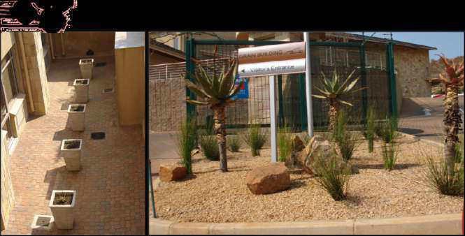


137 03 Grain Building, Pretoria 05 Landscape Projects Completed 053 Offices

138 04 Ismail Dawson offices, Pretoria 053 Offices

139 05 Celtic Manor,Pretoria -Completed Development

140 Development

141 07 The Wilds,Pretoria 055 Residential


142 08 The Wilds, Pretoria 05 Landscape Projects Completed 055 Residential

143 09 The Wilds,Pretoria \. 055 Residential


144 010 The Wilds, Pretoria 05 L0a5nLdasncdaspceapPeroPjreocjetcscst s CCoommpplleetted 055 Residential


145 011 Governor of Reserve Bank s Residence, Pretoria Plant Palette Option 1 Option 2 05 Landscape Projects Conceptual 055 Residential


146 012 House Ismail, Pretoria Front Garden Back Garden 05 Landscape Projects - Conceptual 055 Residential


147 013 Forest Garden, Pretoria 05 Landscape Projects Completed 055 Residential

148 016 Forest Garden,Pretoria -Completed 055 Residential

149 01 Safari Garden Expo Received a Silver Certificate at the Safari Garden Expo, 2010 Highlights 061 Awards
150 02 UNISA Sunnyside Campus, Pretoria Best Commercial Paving Plan in Gauteng, Corporate Highlights 061 Awards

151 Project Name Status Project Environmental Impact Assessment(EIA) and Scoping Report Junction 21 ROD EIA 5 O'clock site access In Progress EIA Bokamoso X 1 In Progress Scoping & EIA Doornvallei Phase 6 & 7 In Progress EIA Engen Interchange In Progress Scoping & EIA Erasmia X15 In Progress EIA Franschkloof In Progress EIA K113 Amendment of ROD EIA K220 East ROD EIA K220 West ROD EIA K54 ROD conditions In Progress EIA Knopjeslaagte 95/Peachtree ROD EIA Knopjeslaagte portion 20 & 21 ROD EIA Lillieslief/Nooitgedacht In Progress EIA Mooiplaats 70 (Sutherland) In Progress EIA Naauwpoort 1-12/Valley View In Progress EIA PeachTree X5 In Progress EIA Strydfontein 60 In Progress EIA Thabe Motswere In Progress Scoping & EIA Vlakplaats In Progress EIA Waterval Valley In Progress EIA Environmental Opinion Doornkloof 68 (Ross) In Progress Opinion Monavoni X 53 In Progress BA & Opinion Mooikloof (USN) In Progress Opinion Norwood Mall/Sandspruit In Progress Opinion Riversong X 9 In Progress Opinion Sud Chemie In Progress Opinion USN Benjoh Fishing Resort In Progress Opinion The adjacent list host the status of our current projects. Only a selected amount of projects are displayed. 07 Current Environmental Projects 071 EIA, Scoping& Opinion
 In Progress BA Monavoni External Services ROD BA Monavoni X 45 Amendment of ROD BA Montana X 146 In Progress BA")

152 Project Name Status Project Basic Assessment(BA) Annlin X 138 In Progress BA Clubview X 29 ROD BA Darrenwood Dam In Progress BA Durley Holding 90 & 91 In Progress BA Elim In Progress BA Fochville X 3 In Progress BA Hartebeeshoek 251 In Progress BA Klerksdorp (Matlosana Mall) In Progress BA Monavoni External Services ROD BA Monavoni X 45 Amendment of ROD BA Montana X 146 In Progress BA Rooihuiskraal X29 In Progress BA Thorntree Mall In Progress BA Environmental control officer (ECO) Grace Point Church In Progress ECO R 81 In Progress ECO Highveld X 61 In Progress ECO Mall of the North In Progress ECO Olievenhoutbosch Road In Progress ECO Orchards 39 In Progress ECO Pierre van Ryneveld Reservoir In Progress ECO Project Shelter In Progress ECO S24 G Wonderboom In Progress S24 G Mogwasi Guest houses Completed S24 G 07 Current Environmental Projects 072 BA, ECO & S24 G
 In Progress DFA Roos Senekal In Progress")
153 Project Name Status Project Objection Colesberg WWTW In Progress Objection Nigel Steelmill Completed Objection Chantilly Waters Completed Objection Development facilitation Act- Input (DFA) Burgersfort In Progress DFA & BA Doornpoort Filling Station In Progress DFA & EIA & Scoping Eastwood Junction In Progress DFA Ingersol Road (Erf 78, 81-83) In Progress DFA Roos Senekal In Progress DFA & EIA & Scoping Thaba Meetse 1 In Progress DFA & EIA & Scoping Water Use License Act (WULA) Britstown Bulk Water Supply In Progress WULA Celery Road / Green Channel In Progress WULA Clayville X 46 In Progress WULA Dindingwe Lodge In Progress WULA Doornpoort Filling Station In Progress WULA+DFA+EIA+SC Eco Park Dam In Progress WULA Groote Drift Potch In Progress WULA Jozini Shopping Centre In Progress WULA+BA K60 Completed WULA Maloto Roads In Progress WULA Kwazele Sewage Works In Progress WULA Monavoni External Services In Progress WULA+BA Nyathi Eco Estate In Progress WULA Prairie Giants X 3 In Progress WULA Waveside Water Bottling Plant Completed WULA 07 Current Environmental Projects 073 Objection, DFA & WULA


154 Project Name Status Project Environmental Management Plan(EMP) Heidelberg X 12 ROD EMP Monavoni Shopping Centre Completed EMP Forest Hill Development Completed EMP Weltevreden Farm 105KQ Completed EMP+EIA Raslouw Holding 93 Completed EMP+BA Durley Development Completed EMP+BA Rooihuiskraal North X 28 Completed EMP Rehabilitation Plan Norwood Mall/Sandspruit In Progress Rehabilitation Project Shelter Heidelberg In Progress Rehabilitation Sagewood Attenuation Pond ROD Rehabilitation Velmore Hotel Completed Rehabilitation Grace Point Church Completed Rehabilitation Mmamelodi Pipeline Completed Rehabilitation Visual Impact Assessment Swatzkop Industrial DevelopmeCompleted Assessment +DFA Erasmia Completed Assessment Signage Application Menlyn Advertising Completed Signage The Villa Mall Completed Signage+EMP+BA 07 Current Environmental Projects 074 EMP, Rehabilitation, Waste Management & Signage Application


155 - Billion Property Group - Cavaleros Developments - Centro Developers - Chaimberlains - Chieftain - Century Property Group - Coca Cola - Elmado Property Development - Flanagan & Gerard - Gautrans - Hartland Property Group - Moolman Group - MTN - M&T Development - Old Mutual - Property Investment Company - Petroland Developments - RSD Construction - SAND - Stephan Parsons - Twin City Developments - Urban Construction - USN 08 Indicative Clients


156 - Adobe Illustrator CS3 - Adobe Photoshop CS3 - Adobe InDesign CS3 - AutoCAD - Google SketchUP - GIS - Microsoft Office Word - Microsoft Office Excel - Microsoft Office Publisher - Microsoft Office Power Point 09 Tools
157 Annexure C
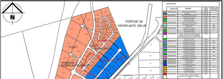


158
159 Annexure D
160 Annexure D(i)
161 NOTICE OF SCOPING EVIRONMENTAL IMPACT ASSESSMENT PROCESS Notice is given of an application for a Scoping Environmental Impact Assessment Process that was submitted to the Gauteng Department of Agriculture and Rural Development, in terms of Regulation No. R543 published in the Government Notice No of 18 June 2010 of the National Environment Management Act, 1998 (Act No. 107 of 1998) governing Environmental Impact Assessment Procedures (Listing Notice: 1, 2 and 3 Governing Notice R544, R545 & R546) for the following activity: Reference No: Project Name: Monavoni X 51 Property Description: Part of the Remainder of Portion 5 of the farm Mooiplaats 355 JR and part of Portion 2 of the farm Zwartkop 383 JR Proposed Zoning Information: The proposed activity will entail the construction of a mixed use township and associated infrastructure with the following proposed land uses: Industrial 2 ; Business 2 ; Residential 2 with a density of 25 units/ha and Private Open Space. Listing Activities Applied for: GNR 544 (Listing Notice 1), 18 June 2010 Activity 9, 13, 22, 23, 24, 26, 37, 47 & 56 GNR 545 (Listing Notice 2), 18 June 2010 Activity 15 GNR 546 (Listing Notice 3), 18 June 2010 Activity 4, 13, 14, 19 & 26 Proponent Name: R 209 Investments (Pty) Ltd Location: The proposed township is situated to the east of the proposed PWV9, west of the R55, to the north of the M34 (Ruimte Road) and the N14, south of Mimosa Road, south west of Sunderland Ridge, and to the east of Gardener Ross Golf Estate. Date of Notice: 16 May June 2013 Queries regarding this matter should be referred to: Bokamoso Landscape Architects and Environmental Consultants Public Participation registration and inquiries: Juanita De Beer Project inquiries: Mientjie Coetzee Tel: (012) P.O. Box Fax: (086) Maroelana lizelleg@mweb.co.za In order to ensure that you are identified as an Interested and/or Affected Party (I&AP) please submit your name, contact information and interest in the matter, in writing, to the contact person given above within 40 days of this Notice.
162 Annexure D(ii)

 g o ve rning Environme nta l Impa c t Asse ssme nt Proc e dure s (Notic e 1, 2 a nd 3 Gove rning Notic e R544, R545 & R546) fo r the fo llo wing a c tivity: Re fe re nc e No: Ga ut:")
163 Mona voni X 51 NOTICE OF SCOPING ENVIRONMENTAL IMPACT ASSESSMENT PROCESS Notice isgivenofanapplicationforansc oping Environme nta l Impa c t Asse ssme nt Proc e ss tha t wa s sub mitte d to the Ga ute ng De pa rtme nt o f Ag ric ulture a nd Rura l De ve lo pme nt, in te rms o f Re g ula tio n No. R543 p ub lishe d in the Go ve rnme nt No tic e No o f 18 June 2010 o f the Na tio na l Enviro nme nt Ma na g e me nt Ac t, 1998 (Ac t No. 107 o f 1998) g o ve rning Environme nta l Impa c t Asse ssme nt Proc e dure s (Notic e 1, 2 a nd 3 Gove rning Notic e R544, R545 & R546) fo r the fo llo wing a c tivity: Re fe re nc e No: Ga ut: 002/ 13-14/ E0032 Proje c t Na me : Mo na vo ni X 51 Prope rty De sc ription: Pa rt o f the Re ma inde r o f Po rtio n 5 o f the fa rm Mo o ipla a ts 355 JR a nd pa rt o f Po rtio n 2 o f the fa rm Zwa rtko p 383 JR. Propose d Zoning Informa tion: The pro po se d a c tivity will e nta il the c o nstruc tio n o f a mixe d use to wnship a nd a sso c ia te d infra struc ture with the fo llo wing pro po se d la nd use s: Industria l 2, Busine ss 2, Re side ntia l 2 with a de nsity o f 25 units/ ha a nd Priva te Ope n Spa c e. Propone nt Na me : JR 209 Inve stme nts (Pty) Ltd Listing Ac tivitie s Applie d: GNR 544 (Listing No tic e 1), 18 June 2010 Ac tivity 9, 13, 22, 23, 24, 26, 37, 47 & 56. GNR 545 (Listing No tic e 2), 18 June 2010 Ac tivity 15. GNR 546 (Listing No tic e 3), 18 June 2010 Ac tivity 4, 13, 14, 19 & 26. Loc a tion: The pro po se d to wnship is situa te d to the e a st o f the pro po se d PWV9, we st o f the R55, to the no rth o f the M34 (Ruimte Ro a d) a nd the N14, so uth o f Mimo sa Ro a d, so uth we st o f Sunde rla nd Ridg e, a nd to the e a st o f Ga rde ne r Ro ss Go lf Esta te. Da te of Notic e : 16 Ma y 25 June 2013 Que rie s re g a rding this ma tte r should be re fe rre d to: Bo ka mo so La ndsc a pe Arc hite c ts a nd Enviro nme nta l Co nsulta nts Public Partic ipatio n re g istratio n and inquirie s: Jua nita De Be e r Pro je c t inq uirie s: Mie ntjie Coe tze e Te l: (012) P.O. Bo x Fa x: (086) Ma ro e la na 0161 E-ma il: lize lle mwe b.c o.za mo so.ne t Locality Map In o rde r to e nsure tha t yo u a re ide ntifie d a s a n Inte re ste d a nd/ o r Affe c te d Pa rty (I&AP) ple a se sub mit yo ur na me, c o nta c t info rma tio n a nd inte re st in the ma tte r, in writing, to the c o nta c t pe rso n g ive n a b o ve within 40 da ys of this Notic e.
164 Annexure D(iii)

165
166 NOTICE OF SCOPING EVIRONMENTAL IMPACT ASSESSMENT PROCESS Notice is given of an application for a Scoping Environmental Impact Assessment Process that was submitted to the Gauteng Department of Agriculture and Rural Development, in terms of Regulation No. R543 published in the Government Notice No of 18 June 2010 of the National Environment Management Act, 1998 (Act No. 107 of 1998) governing Environmental Impact Assessment Procedures (Listing Notice: 1, 2 and 3 Governing Notice R544, R545 & R546) for the following activity: Reference No: Project Name: Monavoni X 51 Property Description: Part of the Remainder of Portion 5 of the farm Mooiplaats 355 JR and part of Portion 2 of the farm Zwartkop 383 JR Proposed Zoning Information: The proposed activity will entail the construction of a mixed use township and associated infrastructure with the following proposed land uses: Industrial 2 ; Business 2 ; Residential 2 with a density of 25 units/ha and Private Open Space. Listing Activities Applied for: GNR 544 (Listing Notice 1), 18 June 2010 Activity 9, 13, 22, 23, 24, 26, 37, 47 & 56. GNR 545 (Listing Notice 2), 18 June 2010 Activity 15. GNR 546 (Listing Notice 3), 18 June 2010 Activity 4, 13, 14, 19 & 26 Proponent Name: R 209 Investments (Pty) Ltd Location: The proposed township is situated to the east of the proposed PWV9, west of the R55, to the north of the M34 (Ruimte Road) and the N14, south of Mimosa Road, south west of Sunderland Ridge, and to the east of Gardener Ross Golf Estate. Date of Notice: 16 May June 2013 Queries regarding this matter should be referred to: Bokamoso Landscape Architects and Environmental Consultants Public Participation registration and inquiries: Juanita De Beer Project inquiries: Mientjie Coetzee ; Tel: (012) P.O. Box ; Fax: (086) Maroelana 0161 ; lizelleg@mweb.co.za In order to ensure that you are identified as an Interested and/or Affected Party (I&AP) please submit your name, contact information and interest in the matter, in writing, to the contact person given above within 40 days of this Notice.
167 Annexure D(iv)
168 Monavoni X51 Our Ref: 9/2/228/0001 Enquiries: Andrew Salomon Date: Friday June 14, 2013 Tel: Page No: 1 CaseID: 2351 Letter In terms of Section 38 of the National Heritage Resources Act (Act 25 of 1999) Attention: JR 209 Investments (Pty) Ltd The proposed activity will entail the construction of a mixed use township and associated infrastructure with the following proposed land uses: "Industrial 2", "Business 2", "Residential 2" with a density of 25 units/ha and "Private Open Space"/ Part of the Remainder of Portion 5 of the farm Mooiplaats 355 JR and part of Portion 2 of the farm Zwartkop 383 JR. Thank you for your notification regarding this development. In terms of the National Heritage Resources Act, no 25 of 1999, heritage resources, including archaeological or palaeontological sites over 100 years old, graves older than 60 years, structures older than 60 years are protected. They may not be disturbed without a permit from the relevant heritage resources authority. This means that prior to development it is incumbent on the developer to ensure that a Heritage Impact Assessment is done. This must include the archaeological component (Phase 1) and any other applicable heritage components. Appropriate (Phase 2) mitigation, which involves recording, sampling and dating sites that are to be destroyed, must be done as required. The quickest process to follow for the archaeological component is to contract an accredited specialist (see the web site of the Association of Southern African Professional Archaeologists to provide a Phase 1 Archaeological Impact Assessment Report. This must be done before any large development takes place. The Phase 1 Impact Assessment Report will identify the archaeological sites and assess their significance. It should also make recommendations (as indicated in section 38) about the process to be followed. For example, there may need to be a mitigation phase (Phase 2) where the specialist will collect or excavate material and date the site. At the end of the process the heritage authority may give permission for destruction of the sites. Where bedrock is to be affected, or where there are coastal sediments, or marine or river terraces and in potentially fossiliferous superficial deposits, a Palaeontological Desk Top study must be undertaken to assess whether or not the development will impact upon palaeontological resources - or at least a letter of exemption from a Palaeontologist is needed to indicate that this is unnecessary. If the area is deemed sensitive, a full Phase 1 Palaeontological Impact Assessment will be required and if necessary a Phase 2 rescue operation might be necessary. If the property is very small or disturbed and there is no significant site the heritage specialist may choose to
169 Powered by TCPDF ( Monavoni X51 Our Ref: 9/2/228/0001 Enquiries: Andrew Salomon Date: Friday June 14, 2013 Tel: Page No: 2 CaseID: 2351 send a letter to the heritage authority to indicate that there is no necessity for any further assessment. Any other heritage resources that may be impacted such as built structures over 60 years old, sites of cultural significance associated with oral histories, burial grounds and graves, graves of victims of conflict, and cultural landscapes or viewscapes must also be assessed. Should you have any further queries, please contact the designated official using the case number quoted above in the case header. Yours faithfully Andrew Salomon Heritage Officer: Archaeology South African Heritage Resources Agency Colette Scheermeyer SAHRA Head Archaeologist South African Heritage Resources Agency ADMIN: Direct URL to case:
170 Annexure D(v)
171 All inte re ste d and affe c te d partie s are invite d to re vie w the de ve lo pme nt info rmatio n and to re g iste r any issue s and c o nc e rns to be inc lude d and addre sse d in the Final Sc o ping Re po rt. Ve nue : Zwartko ps Rally Rac ing Trac k Main Offic e Te l: / 9 Da te : 17 July 26 Aug ust 2013 We bsite : moso.biz Ple ase do no t he sitate to c o ntac t us if the re are any que stio ns in c o nne c tio n with the abo ve me ntio ne d de ve lo pme nt. Co ntac t pe rso n: Jua nita De Be e r Te l: Fax: lize lle mwe b.c o.za
172 All interested and affected parties are invited to review the development information and to register any issues and concerns to be included and addressed in the Final Scoping Report. Venue: ZwartkopsRally Racing Track Main Office Tel: /9 Date: 17 July 26 August 2013 Website: Please do not hesitate to contact us if there are any questions in connection with the abovementioned development. Contact person: Juanita De Beer Tel: Fax:
173 Annexure D(vi)
174

175
176
177
178 Annexure D(vii)
179 Tel: (012) Fax: Website: Landscape Architects, Environmental Consultants, Environmental Auditing, Water License Applications DEPARTMENT OF WATER AFFAIRS 12 JULY 2013 BOTHONGO PLAZA EAST 285 FRANCIS BAARD STREET PRETORIA TEL: FAX: ATTENTION: T.L MATHEBE RE: SUBMISSION OF DRAFT SCOPING REPORT FOR THE PROPOSED MONAVONI X 51 DEVELOPMENT REFERENCE NUMBER: GAUT 002/13-14/E0032 Please find 1x hard copy of the Draft Scoping Report for the proposed Monavoni X 51 development on part of the Remainder of Portion 5 of the farm Mooiplaats 355 JR and part of Portion 2 of the farm Zwartkop 383 JR. Please supply us with your valuable comments on the Draft Scoping Report on or before 23 August Please do not hesitate to contact us should you need any additional information. Kind regards. Lizelle Gregory REG NO: CK 2000/054190/23 VAT REG NO: BOKAMOSO LANDSCAPE CC MEMBER: Lizelle Gregory

180 Tel: (012) Fax: Website: Landscape Architects, Environmental Consultants, Environmental Auditing, Water License Applications DEPARTMENT OF WATER AFFAIRS 29 AUGUST 2013 BOTHONGO PLAZA EAST 285 FRANCIS BAARD STREET PRETORIA TEL: FAX: ATTENTION: T.L MATHEBE RE: SUBMISSION OF DRAFT SCOPING REPORT FOR THE PROPOSED MONAVONI X 51 DEVELOPMENT REFERENCE NUMBER: GAUT 002/13-14/E0032 The Draft Scoping Report for the proposed Monavoni X 51 development on part of the Remainder of Portion 5 of the farm Mooiplaats 355 JR and part of Portion 2 of the farm Zwartkop 383 JR submitted to your department on 12 July 2013 for comments refers. The comment period expired on 23 August 2013 and we have not received comments from your department yet. Please submit your department s comments within the next week in order for us to address it in the final Scoping Report. Please do not hesitate to contact us should you need any additional information. Kind regards. Lizelle Gregory REG NO: CK 2000/054190/23 VAT REG NO: BOKAMOSO LANDSCAPE CC MEMBER: Lizelle Gregory
ENVIRONMENTAL IMPACT ASSESSMENT
 ENVIRONMENTAL IMPACT ASSESSMENT NOTICE OF ENVIRONMENTAL IMPACT ASSESSMENT PROCESS FOR THE SARATOGA VEGETATION CLEARING SECTION 24G ON PORTION 4 OF THE FARM KLAAS VOOGDS RIVIER NO. 40, ROBERTSON, WESTERN
PURPOSE OF MEETING MEETING GUIDELINES PROJECT BACKGROUND ESKOM CLOCOLAN-FICKSBURG 88 KV POWERLINE, FREE STATE
 ESKOM CLOCOLAN-FICKSBURG 88 KV POWERLINE, FREE STATE DRAFT BASIC ASSESSMENT REPORT PUBLIC REVIEW LANDOWNERS MEETING FICKSBURG 23 JULY 2013 T his project is being conducted on behalf of Eskom PRESENTATION
ENVIRONMENTAL IMPACT ASSESSMENT
 ENVIRONMENTAL IMPACT ASSESSMENT NOTICE OF ENVIRONMENTAL IMPACT ASSESSMENT PROCESS FOR THE PROPOSED HAASENDAL DEVELOPMENT AND KUILS RIVER GOLF COURSE RE-DEVELOPMENT ON ERF 23580, ERF 23579, ERF 23582, ERF
Cape Environmental Assessment Practitioners(Pty)
") BACKGROUND INFORMATION DOCUMENT (BID) Introduction Cape Environmental Assessment Practitioners(Pty) Ltd Reg. No. 2008/004627/07 Telephone: (044) 874 0365 First Floor, Eagles View Building Facsimile: (044)
BACKGROUND INFORMATION DOCUMENT (BID) Introduction Cape Environmental Assessment Practitioners(Pty) Ltd Reg. No. 2008/004627/07 Telephone: (044) 874 0365 First Floor, Eagles View Building Facsimile: (044)
MEETING HELD AT THE EDTEA OFFICES (ethekwini) ON 03 July 2018 AT 10h00. Ms. Naadira Nadasen (NN) Mrs Chen read (CR) and Mrs Tejal Singh (TS)
 ON 03 July 2018 AT 10h00. Ms. Naadira Nadasen (NN) Mrs Chen read (CR) and Mrs Tejal Singh (TS)") MINUTES OF THE PRE-APPLICATION MEETING IN RESPECT OF THE APPLICATION FOR ENVIRONMENTAL AUTHORISATION OF THE PROPOSED BEACHWOOD RESORT AND ESTATE DEVELOPEMENT MEETING HELD AT THE EDTEA OFFICES (ethekwini)
MINUTES OF THE PRE-APPLICATION MEETING IN RESPECT OF THE APPLICATION FOR ENVIRONMENTAL AUTHORISATION OF THE PROPOSED BEACHWOOD RESORT AND ESTATE DEVELOPEMENT MEETING HELD AT THE EDTEA OFFICES (ethekwini)
BASIC ASSESSMENT PROCESS
 BASIC ASSESSMENT PROCESS NOTICE OF A BASIC ASSESSMENT PROCESS FOR THE PROPOSED MIXED USE DEVELOPMENT ON THE REMAINDER OF PORTION 2, REMAINDER OF PORTION 7, PORTION 7, REMAINDER OF PORTION 9, REMAINDER
BACKGROUND INFORMATION DOCUMENT (BID) AND INVITATION TO PARTICIPATE
 AND INVITATION TO PARTICIPATE") To: Interested and Affected Parties 2 October 2017 NOTIFICATION OF ENVIRONMENTAL IMPACT ASSESSMENT PROCESS FOR THE PROPOSED DEVELOPMENT OF RESIDENTIAL HOUSING ON PORTION 56 OF THE FARM CHELSEA NO. 25,
To: Interested and Affected Parties 2 October 2017 NOTIFICATION OF ENVIRONMENTAL IMPACT ASSESSMENT PROCESS FOR THE PROPOSED DEVELOPMENT OF RESIDENTIAL HOUSING ON PORTION 56 OF THE FARM CHELSEA NO. 25,
The Jigsaw: Legal Instruments for Biodiversity Planning in South Africa
 The Jigsaw: Legal Instruments for Biodiversity Planning in South Africa Annual Conference, Environmental Law Association AUGUST 2012 Dr. Marie Parramon-Gurney Head of Programmes: Sustainability and Development
BACKGROUND INFORMATION DOCUMENT:
 BACKGROUND INFORMATION DOCUMENT: Proposed Construction of Mpophomeni Shopping Centre, Umgungundlovu District Municipality, KZN A Project of Dymatron (Pty) Ltd 21 NOVEMBER 2014 BID DOCUMENT DESCRIPTION
BASIC ASSESSMENT PROCESS THE PROPOSED CANELANDS EXTENSION, KWAZULU-NATAL KZN DAEA REF NO: DM/0031/2012 BACKGROUND INFORMATION DOCUMENT AUGUST 2012
 BASIC ASSESSMENT PROCESS THE PROPOSED CANELANDS EXTENSION, KWAZULU-NATAL KZN DAEA REF NO: DM/0031/2012 BACKGROUND INFORMATION DOCUMENT AUGUST 2012 WHAT DOES THIS DOCUMENT TELL YOU? This document aims to
Our Constitutional imperative
 PARLIAMENT: PUBLIC HEARINGS EFFICACY OF SOUTH AFRICA'S ENVIRONMENTAL IMPACT ASSESSMENT (EIA) REGIME Henri Fortuin Cape Town 29July 2013 Our Constitutional imperative Section 24 of our Constitution gives
TSHWANE STRENGTHENING PROJECT PHASE 1, GAUTENG PROVINCE: Draft Scoping Report: Apollo - Verwoerdburg July 2009
 APPROACH TO UNDERTAKING THE ENVIRONMENTAL SCOPING STUDY CHAPTER 3 An Environmental Impact Assessment (EIA) process refers to that process (as per the EIA Regulations) which involves the identification
14.5 HOPEFIELD: (REFER PLAN 39 AND PLAN 40)
") URBAN DYNAMICS WESTERN CAPE INC. 248 14.5 HOPEFIELD: (REFER PLAN 39 AND PLAN 40) FIGURE 83: LOCALITY - HOPEFIELD Within the context of the Saldanha Bay Municipal area, Hopefield, an historical agricultural
URBAN DYNAMICS WESTERN CAPE INC. 248 14.5 HOPEFIELD: (REFER PLAN 39 AND PLAN 40) FIGURE 83: LOCALITY - HOPEFIELD Within the context of the Saldanha Bay Municipal area, Hopefield, an historical agricultural
RIVER MAINTENANCE MANAGEMENT PLAN APPLICATION
 RIVER MAINTENANCE MANAGEMENT PLAN APPLICATION NOTICE OF PUBLIC PARTICIPATION PERIOD OF A RIVER MAINTENANCE MAANGEMENT PLAN (RMMP) FOR THE PROPOSED MAINTENANCE OF THE KM 8.920 CULVERT, WAARBURGH ROAD, PAARL,
PROPOSED GARDEN CITY NEW TOWN DEVELOPMENT, KRAAIFONTEIN DRAFT ENVIRONMENTAL IMPACT REPORT Summary Document
 1 PROPOSED GARDEN CITY NEW TOWN DEVELOPMENT, KRAAIFONTEIN DRAFT ENVIRONMENTAL IMPACT REPORT Summary Document What is an Environmental Impact Assessment? Garden Cities Incorporated Association Not For Gain
ENVIRONMENTAL IMPACT ASSESSMENT
 ENVIRONMENTAL IMPACT ASSESSMENT NOTICE OF APPLICATION FOR AMENDMENT OF AN ENVIRONMENTAL AUTHORISATION FOR THE HAASENDAL DEVELOPMENT ON PORTIONS 1, 11, 26, 30, 34, 58, AND 87 OF FARM HAASENDAL NO. 222,
SINGITA SWENI LODGE EXPANSION: SUMMARY REPORT - BAR
 7 PROJECT: SINGITA SWENI LODGE EXPANSION: SUMMARY REPORT - BAR Basic Environmental Assessment for Lodge expansion and Refurbishment of the Singita Sweni Lodge, within the Singita Private Concession in
BACKGROUND INFORMATION DOCUMENT
 BACKGROUND INFORMATION DOCUMENT PROPOSED UPGRADING OF THE N2 NATIONAL ROAD FROM KRAAIBOSCH TO DIE VLEIE BASIC ENVIRONMENTAL IMPACT ASSESSMENT The South African National Roads Agency Society Limited (SANRAL)
STORMWATER MANAGEMENT PLAN: ERAND GARDENS X70
 STORMWATER MANAGEMENT PLAN: ERAND GARDENS X70 Client: Central Developments 09 April 2018 _ Rev00 Report no: SWMP/410/00 SWMP FOR ERAND GARDENS X70 TABLE OF CONTENTS 1 INTRODUCTION... 1 2 GENERAL INFORMATION...
Digital Terrestrial Television Infrastructure Rollout. Environmental Impact Assessment - Corridor -
 Digital Terrestrial Television Infrastructure Rollout Environmental Impact Assessment - Corridor - 1 1 ENVIRONMENTAL IMPACT ASSESSMENT (EIA): CORRIDOR 1.1 INTRODUCTION Corridor is a small farming community
PRESENTATION ON JOHANNESBURG S BIODIVERSITY PROGRAMME
 PRESENTATION ON JOHANNESBURG S BIODIVERSITY PROGRAMME Member of Mayoral Committee: Cllr Prema Naidoo Environmental Management & Johannesburg City Parks PRESENTATION OVERVIEW Jo burg Overview & Context
BASIC ASSESSMENT REPORT. Background Information Document
 BASIC ASSESSMENT REPORT Background Information Document BASIC ASSESSMENT FOR THE PROPOSED LUIPERDSHOEK 33 KV POWER LINE PROJECT TO BE LOCATED NORTH OF THE TOWN OF POFADDER IN THE NORTHERN CAPE (DEA Ref
Attention: Interested and Affected Party (I&AP) Commenting Period: 22 November January 2018 GNEC Code: 20327
 Commenting Period: 22 November January 2018 GNEC Code: 20327") 22 November 2017 Attention: Interested and Affected Party (I&AP) Commenting Period: 22 November 2017 15 January 2018 GNEC Code: 20327 Dear Interested and Affected Party INFORMING START OF 30 DAY PUBLIC
22 November 2017 Attention: Interested and Affected Party (I&AP) Commenting Period: 22 November 2017 15 January 2018 GNEC Code: 20327 Dear Interested and Affected Party INFORMING START OF 30 DAY PUBLIC
PHASE 1 ARCHAEOLOGICAL IMPACT ASSESSMENT PROPOSED DEVELOPMENT ERF 3 ROBERTSON WESTERN CAPE PROVINCE
 PHASE 1 ARCHAEOLOGICAL IMPACT ASSESSMENT PROPOSED DEVELOPMENT ERF 3 ROBERTSON WESTERN CAPE PROVINCE Prepared for BOLAND ENVIRO Att: Mr Nik Wullschleger PO Box 250 Worcester 6849 Fax: (023) 347 0336 By
THE CORPORATION OF THE CITY OF WINDSOR Office of the City Solicitor Planning Department
 THE CORPORATION OF THE CITY OF WINDSOR Office of the City Solicitor Planning Department REPORT TO THE CITY OF WINDSOR PLANNING ADVISORY COMMITTEE DATE OF REPORT: August 19, 2010 SUBJECT: Official Plan
NATIONAL ROAD 3: KEEVERSFONTEIN TO WARDEN (DE BEERS PASS SECTION) CHAPTER 1: INTRODUCTION
 CHAPTER 1: INTRODUCTION") February 2016 NATIONAL ROAD 3: KEEVERSFONTEIN TO WARDEN (DE BEERS PASS SECTION) CHAPTER 1: INTRODUCTION 1. INTRODUCTION This Environmental Impact Assessment Report (EIR) has been compiled as part of an
February 2016 NATIONAL ROAD 3: KEEVERSFONTEIN TO WARDEN (DE BEERS PASS SECTION) CHAPTER 1: INTRODUCTION 1. INTRODUCTION This Environmental Impact Assessment Report (EIR) has been compiled as part of an
INDEX INTRODUCTION. The development encompasses multifaceted living and will include the following:
 INDEX INTRODUCTION 2 THE VISION 3 RESIDENTIAL 4 SPECIALIST STUDIES 6 TRAFFIC IMPACT SUMMARY 6 NEW & UPGRADING ROADS 7 FAQ 8 CONTACT DETAILS 10 2 INTRODUCTION The Linksfield, Integrated Mixed Use Development,
OPEN SPACE MANAGEMENT WORKSHOP. Johannesburg Botanical Gardens 22 May 2009 TOWN PLANNING SCHEME REQUIREMENTS
 1 OPEN SPACE MANAGEMENT WORKSHOP Johannesburg Botanical Gardens 22 May 2009 TOWN PLANNING SCHEME REQUIREMENTS INTRODUCTION What is the purpose and function of a Town Planning Scheme? 3 To manage the use
DRAFT IMPACT ASSESSMENT REPORT
 DRAFT IMPACT ASSESSMENT REPORT APPLICATION FOR AMENDMENT OF ENVIRONMENTAL AUTHORISATION ERASMUSPARK: PORTION OF THE R/E OF THE FARM WATERKLOOF 378 JR GAUT: 006/18-19/E0012 Prepared for: Atterbury Property
Fabriek Street 45 Paarl. P.O. Box 2632 Paarl Tel: Cell:
 11 July 2016 Organisation: Department of Environmental Affairs and Development Planning Attention: Mr. Shafeeq Mallick NOTICE OF FIRST PUBLIC PARTICIPATION PERIOD: 12 July 2016 15 August 2016 GNEC Code:
RURAL ZONE - POLICY. Rural Zone Policy. Issue: Rural Environment. Ruapehu District Plan Page 1 of 8
 Rural Zone Policy RU2 RURAL ZONE - POLICY RU2.1 Introduction The natural resources of the rural environment in the Ruapehu District provide the basis for the existing and potential character, intensity
City of Surrey PLANNING & DEVELOPMENT REPORT File:
 City of Surrey PLANNING & DEVELOPMENT REPORT File: 7916-0362-00 Planning Report Date: July 10, 2017 PROPOSAL: Development Permit Development Variance Permit to allow a truck/trailer staging area and to
CORNUBIA RETAIL PARK- PLANNING REPORT REVERT 3
 CORNUBIA RETAIL PARK- PLANNING REPORT 19.04.2013 REVERT 3 1 FOR: BY: 28 DEVONSHIRE AVENUE GLENWOOD DURBAN 4001 P.O. BOX 17390 CONGELLA 4013 T +27 31 202 9550 F +27 31 202 9551 1st FLOOR THE MEDIA MILL
City of Hume Planning Scheme Amendment C207. Statement of Expert Evidence Provided to Planning Panels Victoria
 14 August 2017 Revision: 1 Reference: 1702 City of Hume Planning Scheme Amendment C207 Statement of Expert Evidence Provided to Planning Panels Victoria Stormwater Management Evidence for 35 Buckland Way
AMENDMENTS. Date Effective. Amendment No. Council. DCP 14 Davidson St, Greenacre Page 2
 AMENDMENTS Amendment No. Description Adopted by Council Date Effective DCP 14 Davidson St, Greenacre Page 2 TABLE OF CONTENTS 1.0 INTRODUCTION... 4 1.1 NAME OF THIS PLAN... 4 1.2 COMMENCEMENT OF DEVELOPMENT
4 RESIDENTIAL ZONE. 4.1 Background
 4 RESIDENTIAL ZONE 4.1 Background The residential areas within the City are characterised by mainly lowrise dwellings sited on individual allotments. Past architectural styles, settlement patterns and
Implementing sustainable water strategy through development industry engagement
 Implementing sustainable water strategy through development industry engagement Ian Director, Organica Engineering, Melbourne, Australia E-mail: iadams@organicaeng.com.au Edward Cotter Sustainability Leader,
Official Plan Review
 Official Plan Review Summary Report - The Built Environment August 2014 Part 1: Introduction Planning for a healthy, prosperous and sustainable community is an important goal for our municipality. From
9 CITY OF VAUGHAN OFFICIAL PLAN AMENDMENT NO BOCA EAST INVESTMENTS LIMITED
 9 CITY OF VAUGHAN OFFICIAL PLAN AMENDMENT NO. 631 - BOCA EAST INVESTMENTS LIMITED The Planning and Economic Development Committee recommends the adoption of the recommendations contained in the following
Sustainability Statement. Whitby Business Park Area Action Plan
 Sustainability Statement Whitby Business Park Area Action Plan November 2014 Contents Page 1. Introduction 1 2. Scoping 3 3. Sustainability Appraisal of Options 6 4. Assessment of Draft Area Action Plan
Chapter 3: Natural Environment. Proposed Waikato District Plan Stage 1. (Notified version)
") Chapter 3: Natural Environment Proposed Waikato District Plan Stage 1 Page 2 of 7 Contents Chapter 3: Natural Environment... 3 3.1 Indigenous Vegetation and Habitats... 3 3.1.1 Objective Biodiversity and
Chapter 3: Natural Environment Proposed Waikato District Plan Stage 1 Page 2 of 7 Contents Chapter 3: Natural Environment... 3 3.1 Indigenous Vegetation and Habitats... 3 3.1.1 Objective Biodiversity and
I615. Westgate Precinct
 I615. Westgate Precinct I615.1. Precinct Description The Westgate Precinct is located approximately 18km west of the Auckland city centre. There are seven Sub-precincts in the Westgate Precinct: Sub-precinct
SITE INVESTIGATION REPORT: CONSTRUCTION OF NTUMBA VEHICULAR/PEDESTRIAN BRIDGE ACROSS A STREAM IN ROOKDALE, OKHAHLAMBA LOCAL MUNICIPALITY
 SITE INVESTIGATION REPORT: CONSTRUCTION OF NTUMBA VEHICULAR/PEDESTRIAN BRIDGE ACROSS A STREAM IN ROOKDALE, OKHAHLAMBA LOCAL MUNICIPALITY PREPARED ON BEHALF OF: ECA CONSULTING CIVIL & STRUCTURAL ENGINEERS
APPENDIX 1: SCOPED ENVIRONMENTAL IMPACT STATEMENT (EIS) FORM
 FORM") APPENDIX 1: SCOPED ENVIRONMENTAL IMPACT STATEMENT (EIS) FORM This form is intended for use by applicants (primarily private landowners) who need to conduct a Scoped EIS in support of minor development
APPENDIX 1: SCOPED ENVIRONMENTAL IMPACT STATEMENT (EIS) FORM This form is intended for use by applicants (primarily private landowners) who need to conduct a Scoped EIS in support of minor development
PROJECTS OF DUBRUTO URBAN PLANNING 22 February 2016 Centurion Lake Redevelopment - Symbio City
 PROJECTS OF DUBRUTO URBAN PLANNING 22 February 2016 Centurion Lake Redevelopment - Symbio City Background This is the well-known project to redevelop erf 53 Verwoerdburg Stad. DUBRUTO URBAN PLANNING Inc.
Application of traffic impact studies as part of the EIA process: a case study as applied to the extension of a mineral processing plant
 Urban Transport XIX 519 Application of traffic impact studies as part of the EIA process: a case study as applied to the extension of a mineral processing plant I. M. Schoeman School for Computer, Statistical
Land Use Amendment in Southwood (Ward 11) at and Elbow Drive SW, LOC
 at and Elbow Drive SW, LOC") 2018 November 15 Page 1 of 10 EXECUTIVE SUMMARY This land use amendment application was submitted by Rick Balbi Architect on 2017 August 31 on behalf of Sable Developments Ltd, and with authorization from
2018 November 15 Page 1 of 10 EXECUTIVE SUMMARY This land use amendment application was submitted by Rick Balbi Architect on 2017 August 31 on behalf of Sable Developments Ltd, and with authorization from
Planning Proposal Concurrent DA/LEP Amendment for Belmont North Pharmacy Amendment No. 24 to Lake Macquarie Local Environmental Plan (LMLEP) 2014
 2014") Planning Proposal Concurrent DA/LEP Amendment for Belmont North Pharmacy Amendment No. 24 to Lake Macquarie Local Environmental Plan (LMLEP) 2014 Local Government Area: Name of Draft LEP: Subject Land:
Planning Proposal Concurrent DA/LEP Amendment for Belmont North Pharmacy Amendment No. 24 to Lake Macquarie Local Environmental Plan (LMLEP) 2014 Local Government Area: Name of Draft LEP: Subject Land:
LAND USE AMENDMENT CORNERSTONE (WARD 3) 60 STREET NE AND COUNTRY HILLS BOULEVARD NE MAP 26NE BYLAW 22D2017
 60 STREET NE AND COUNTRY HILLS BOULEVARD NE MAP 26NE BYLAW 22D2017") Page 1 of 14 EXECUTIVE SUMMARY This Land Use Amendment application covers an area of 43.76 hectares ± (108.14 acres ±) located in northeast Calgary, bound by Country Hills Boulevard NE to the south and
Page 1 of 14 EXECUTIVE SUMMARY This Land Use Amendment application covers an area of 43.76 hectares ± (108.14 acres ±) located in northeast Calgary, bound by Country Hills Boulevard NE to the south and
Engineering Geological and Geotechnical Report
 Engineering Geological and Geotechnical Report !"##$%&'()"(*"+,%-&#.!/ 01234 (""#"& 535 #)5*6636-1)5*66344 78&# &'!&##8!&'#'!/" #98": 5;5 8
A Growing Community Rural Settlement Areas
 Town of Huntsville Official Plan Review - POLICY BACKGROUND PAPER A Growing Community Rural Settlement Areas BACKGROUND: In addition to the fully municipally-serviced Urban Settlement Area and the Hidden
CONSULTING SERVICES FOR THE WHITEBELT VISIONING EXERCISE ADDENDUM TO THE GTA WEST LAND USE STUDY WORK PROGRAM
 CONSULTING SERVICES FOR THE WHITEBELT VISIONING EXERCISE ADDENDUM TO THE GTA WEST LAND USE STUDY 1. Introduction WORK PROGRAM The Town of Caledon is a large, local municipality located in the Greater Toronto
DRAFT SCOPE FOR THE DRAFT ENVIRONMENTAL IMPACT STATEMENT FOR HUDSON HIGHLANDS RESERVE TOWN OF PHILIPSTOWN, NEW YORK June 5, 2018
 DRAFT SCOPE FOR THE DRAFT ENVIRONMENTAL IMPACT STATEMENT FOR HUDSON HIGHLANDS RESERVE TOWN OF PHILIPSTOWN, NEW YORK June 5, 2018 Project Name: Project Location SEQRA Classification of Project: Lead Agency:
Checklists. Project Name: Location: File Number: Date of Submittal: Reviewer: Date: Applicant: Contact Name: Phone Number:
 Applicant: Contact Name: Phone Number: Email: Project Name: Location: File Number: Date of Submittal: Reviewer: Date: Concept Plan Requirements: I. General Project Information 1. Address or parcel number
Development of land adjacent to Braggs Farm Lane and Rumbush Lane, Dickens Heath. Welcome. Today s exhibition. The proposal site
 Welcome Welcome to this event to discuss the development of land adjacent to Braggs Farm Lane. is currently in the preliminary stages of designing proposals to sensitively develop this site with high-quality
Leduc Industrial Outline Plan SE W4
 Leduc Industrial Outline Plan SE 1-50-25-W4 Within the North Leduc Industrial ASP Prepared for: Leduc Energy Park Ltd. Prepared by: Stantec Consulting Ltd. File No. 1161 104655 V5 Table of Contents 1.0
National Conservation Council AGENDA
 2017-05-03 NCC GM Agenda v1 National Conservation Council Special General Meeting (National Trust Meeting Room Dart Park, Wednesday 3 rd May 3:30pm- 5pm) AGENDA 1. Call to Order a. Attendees, Apologies,
SECTION 7A: WHAKARONGO RESIDENTIAL AREA
 SECTION 7A: WHAKARONGO RESIDENTIAL AREA CONTENTS 7A.1 Introduction 1 7A.2 Resource Management Issues 1 7A.3 Objectives and Policies 1 7A.4 Methods 4 7A.5 Residential Zone 4 7A.5.1 Rules: Controlled Activities
MAYFIELD WEST SECONDARY PLAN PHASE 2
 MAYFIELD WEST SECONDARY PLAN PHASE 2 Public Open House #3 February 25, 2010 Draft Preferred Land Use Scenario TOWN OF CALEDON PLANNING & DEVELOPMENT DEPARTMENT Open House Agenda TOWN OF CALEDON 1. Welcome
The Hadean-Creation studio.
 Residential Designing Spring 2016 The Hadean-Creation studio. We provide sustainable and ethical responses to the client s brief by adding value and empowering a sense of pride and ownership. Hadean-Creation
University Park, Worcester Non Technical Summary December 2011
 University Park, Worcester Non Technical Summary December 2011 Introduction UW Wrenbridge LLP, a Joint Venture Company of the University of Worcester and Wrenbridge Land Ltd (the Applicants ) intend to
APPENDIX D PUBLIC NOTIFICATIONS
 APPENDIX D PUBLIC NOTIFICATIONS APPENDIX D1 NEWSPAPER ADVERT APPENDIX D2 CORRESPONDENCE TO I&APs 18 February 2011 Dear Interested and Affected Party (I&AP), NOTICE OF ENVIRONMENTAL IMPACT ASSESSMENT FOR
7. The Landscape. 7.1 Introduction. Environmental Impact Statement (EIS) Scoping Report
 Scoping Report") 7. The Landscape 7.1 Introduction The purpose of this section of the EIS Scoping Report is to describe the scope of work and methods to be applied in the identification and assessment of landscape and
7. The Landscape 7.1 Introduction The purpose of this section of the EIS Scoping Report is to describe the scope of work and methods to be applied in the identification and assessment of landscape and
CHAPTER 4: CONTEXTUALISING THE PROPOSED PROJECT ENVIRONMENT WITHIN THE NATIONAL AND LOCAL
 : CONTEXTUALISING THE PROPOSED PROJECT WITHIN THE NATIONAL AND LOCAL ENVIRONMENT CONTENTS 4. CONTEXTUALISING THE PROPOSED PROJECT WITHIN THE NATIONAL AND LOCAL ENVIRONMENT 4-1 4.1 Introduction to the Coega
Draft Eastern District Plan
 Draft Eastern District Plan Submission_id: 31238 Date of Lodgment: 13 Dec 2017 Origin of Submission: Online Organisation name: Turrulla Gardens Pty Ltd C/- Mecone Organisation type: Industry First name:
ROCHFORD LOCAL DEVELOPMENT FRAMEWORK: Sustainability Appraisal/ Strategic Environmental Assessment. Rochford Core Strategy Preferred Options Document
 ROCHFORD LOCAL DEVELOPMENT FRAMEWORK: Sustainability Appraisal/ Strategic Environmental Assessment Non Technical Summary Rochford Core Strategy Preferred Options Document October 2008 SUSTAINABILITY APPRAISAL
Circular L8/08 2 September Water Services Investment and Rural Water Programmes Protection of Natural Heritage and National Monuments
 Circular L8/08 2 September 2008 Water Services Investment and Rural Water Programmes Protection of Natural Heritage and National Monuments 1. The purpose of this Circular is to provide local authorities
ONTARIO MUNICIPAL BOARD
 PL 120483 ONTARIO MUNICIPAL BOARD Applicant/Appellant: 2124123 Ontario Limited Subject: OPA, Rezoning and Draft Plan of Subdivision Municipal Address: 3940 Highway 7 East Municipality: City of Markham
Mollers Lane, Leopold, Victoria Significant Landscape Overlay Re-assessment
 XURBAN Mollers Lane, Leopold, Victoria Significant Landscape Overlay Re-assessment For: TGM Group November 2016 Final Mollers Lane, Leopold, Victoria Significant Landscape Overlay Re-assessment Client
Digital Terrestrial Television Infrastructure Rollout. Site-specific Environmental Management Plan - Omega -
 Digital Terrestrial Television Infrastructure Rollout Site-specific Environmental Management Plan - Omega - 2 1 ENVIRONMENTAL IMPACT ASSESSMENT: OMEGA 1.1 RATIONALE FOR THE SITE Omega is situated in the
12 TH ANNUAL CHILTERNS AONB PLANNING CONFERENCE ENGLISH HERITAGE: HISTORIC ENVIRONMENT GOOD PRACTICE ADVICE
 12 TH ANNUAL CHILTERNS AONB PLANNING CONFERENCE ENGLISH HERITAGE: HISTORIC ENVIRONMENT GOOD PRACTICE ADVICE MARTIN SMALL HISTORIC ENVIRONMENT PLANNING ADVISER ENGLISH HERITAGE Policy ENGLISH HERITAGE GOOD
STRATEGIC DIRECTION. QLDC PROPOSED DISTRICT PLAN [PART TWO] DECISIONS VERSION 3 strategic direction
![STRATEGIC DIRECTION. QLDC PROPOSED DISTRICT PLAN [PART TWO] DECISIONS VERSION 3 strategic direction](/thumbs/79/79711764.jpg "STRATEGIC DIRECTION. QLDC PROPOSED DISTRICT PLAN [PART TWO] DECISIONS VERSION 3 strategic direction") 3 STRATEGIC DIRECTION QLDC PROPOSED DISTRICT PLAN [PART TWO] DECISIONS VERSION 3 strategic direction QLDC DISTRICT PLAN [PART TWO] AUGUST 2015 3 strategic direction 3.1 Purpose This chapter sets out the
3 STRATEGIC DIRECTION QLDC PROPOSED DISTRICT PLAN [PART TWO] DECISIONS VERSION 3 strategic direction QLDC DISTRICT PLAN [PART TWO] AUGUST 2015 3 strategic direction 3.1 Purpose This chapter sets out the
HARTENBOS NORTH (population: Census 2011)
") 5.8 HARTENBOS NORTH (population: + 184 Census 2011) Figure 5.8.1.1 Hartenbos North: Aerial photograph CNdV africa (Pty) Ltd DRAFT CONCEPTUAL DEVELOPMENT FRAMEWORK REPORT page 439 5.8.1 SPATIAL ANALYSIS,
5.8 HARTENBOS NORTH (population: + 184 Census 2011) Figure 5.8.1.1 Hartenbos North: Aerial photograph CNdV africa (Pty) Ltd DRAFT CONCEPTUAL DEVELOPMENT FRAMEWORK REPORT page 439 5.8.1 SPATIAL ANALYSIS,
City of Grande Prairie Development Services Department KENNEDY DEVELOPMENTS LTD. OUTLINE PLAN OP-09-01
 City of Grande Prairie Development Services Department KENNEDY DEVELOPMENTS LTD. OUTLINE PLAN OP-09-01 July 27, 2009 TABLE OF CONTENTS 1.0 Introduction... 1 1.1 Plan Area Location & Context... 1 1.2 Ownership
POLICY SRT/D4 STORMWATER MANAGEMENT
 POLICY SRT/D4 STORMWATER MANAGEMENT BACKGROUND Increasing population, decreasing rainfall and increasing community expectations regarding environmental issues have led to increasing recognition of the
4 Residential and Urban Living Zones
 4 Residential and Urban Living Zones Refer to Chapters 11 to 20 for additional rules that may apply to these zones. 4.1 OBJECTIVES AND POLICIES Objective Res1 Policy 1 Policy 2 Policy 3 Policy 4 Policy
Pennsylvania Stormwater Best Management Practices Manual. Chapter 1. Introduction and Purpose
 Pennsylvania Stormwater Best Management Practices Manual Chapter 1 Introduction and Purpose Chapter 1 Introduction and Purpose 1.1 Purpose of this Manual 1 1.2 How to Use this Manual...1 1.3 Overview
The Place Solar Farm
 The Place Solar Farm Environmental Statement Non-Technical Summary 28 August 2014 Produced for Prepared by St John s House Queen Street, Manchester M2 5JB Contents Contents... 2 1 Introduction... 3 1.1
Anglo American Platinum; Mogalakwena Mine: Construction of Bridge and Gravel Road. Consultation with community members 26 July 2016
 Anglo American Platinum; Mogalakwena Mine: Construction of Bridge and Gravel Road Consultation with community members 26 July 2016 AGENDA Welcome and introduction. Meeting protocol. Purpose of the meeting.
and Richmond Street West - Official Plan Amendment Application - Preliminary Report
 STAFF REPORT ACTION REQUIRED 822-838 and 860-862 Richmond Street West - Official Plan Amendment Application - Preliminary Report Date: August 14, 2017 To: From: Wards: Reference Number: Toronto and East
Township of Adjala-Tosorontio Official Plan Review. Natural Heritage
 Township of Adjala-Tosorontio Official Plan Review 13 Natural Heritage Introduction What is an Official Plan? An official plan is a municipal policy document which sets out the community s vision and strategies
volume 11 environmental assessment section 2 environmental impact assessment Part 4 ha 204/08 scoping of environmental impact assessments
 DESIGN MANUAL FOR ROADS AND BRIDGES volume 11 environmental assessment section 2 environmental impact assessment Part 4 ha 204/08 scoping of environmental impact assessments SUMMARY This Advice Note provides
Development Permit Application Form. Property Owner Information as Registered on Legal Title Property Owner Name: Phone:
 Development Application Requirements 1 1926 Tsawwassen Drive Tel: 604-943-2112 Tsawwassen, BC V4M 4G2 www.tsawwassenfirstnation.com Canada Development Permit Application Form Name of Applicant: Address:
Notice of Preparation and Notice of Public Scoping Meeting. At Dublin Project
 Notice of Preparation and Notice of Public Scoping Meeting Date January 17, 2018 To Project Title Project Application Number Project Location Project Applicant Contact For questions or submitting comments.
TIDAPA Structure Plan
 TIDAPA Structure Plan Prepared by Tract Consultants 28 MARCH 2017 0217-0074 Table of Contents 01 STRATEGIC CONTEXT Executive Summary Regional Context Page 3 Page 4 02 LOCAL CONTEXT Aerial Photograph Local
Procedures IV. V. Rural Road Design Option
 i IV. Procedures A. All applicants required to prepare a Conservation Design Subdivision shall provide the Planning Board with a conceptual conventional subdivision design as well as a proposed layout
WEST HILL BUSINESS PARK AREA STRUCTURE PLAN
 MUNICIPAL DISTRICT OF PEACE NO. 135 WEST HILL BUSINESS PARK AREA STRUCTURE PLAN Prepared by: TABLE OF CONTENTS 1.0 Introduction... 1 1.1 Purpose of Plan........ 1 1.2 Plan Area..... 1 1.3 Existing Conditions...
Appendix 1 Structure plan guidelines
 Appendix 1 Structure plan guidelines This appendix forms part of the regional policy statement [rps]. 1.1. Introduction Structure plans are an important method for establishing the pattern of land use
MAYFIELD WEST SECONDARY PLAN PHASE 2
 MAYFIELD WEST SECONDARY PLAN PHASE 2 Council Information Workshop February 16, 2010 Draft Preferred Land Use Plan TOWN OF CALEDON PLANNING & DEVELOPMENT DEPARTMENT Workshop Agenda TOWN OF CALEDON 1. Welcome
VCA Guidance Note. Contents
 Contents 1. Introduction... 2 2. Who can register a VCA?... 2 3. VCAs and sustainable development... 3 4. Verifying conservation performance... 4 4.1 Transparent, voluntary commitments... 4 4.2 Independent
ST. MARY S SOIL CONSERVATION DISTRICT (SMSCD) AND DPW&T CONCEPT EROSION AND SEDIMENT CONTROL AND STORMWATER MANAGEMENT GUIDELINES AND CHECKLIST
 AND DPW&T CONCEPT EROSION AND SEDIMENT CONTROL AND STORMWATER MANAGEMENT GUIDELINES AND CHECKLIST") St. Mary s Soil Conservation District 26737 Radio Station Way, Suite B Leonardtown, MD 20650 Phone: 301-475-8402 ext. 3 Fax: 301-475-8391 www.stmarysscd.com St. Mary s County Government Department of Public
St. Mary s Soil Conservation District 26737 Radio Station Way, Suite B Leonardtown, MD 20650 Phone: 301-475-8402 ext. 3 Fax: 301-475-8391 www.stmarysscd.com St. Mary s County Government Department of Public
S A C R A M E N T O C O U N T Y JACKSON HIGHWAY & GRANT LINE EAST VISIONING STUDY
 JACKSON HIGHWAY & GRANT LINE EAST S A C R A M E N T O C O U N T Y P L A N N I N G D E P A R T M E N T SUMMARY AND WORKBOOK November 19, 2008 History of the Visioning Study Sacramento County has two growth
Spencer Environmental 3.0 METHODS
 3.0 METHODS 3.1 General Methods Following is a summary of the main steps and activities employed in the preparation of this EISA. These were not necessarily sequential steps; many were iterative. We participated
CITY COUNCIL AGENDA REPORT
 CITY COUNCIL AGENDA REPORT Subject: DESIGNATED FLOOD LINE CARROT CREEK Recommendation(s) That Administration bring forward a Land Use Bylaw amendment in October 2014 establishing the Designated Flood Line
Proposed Southland District Plan 2012 Appeal Version October 2016
 S e c t i o n 3. 5 - F i o r d l a n d / R a k i u r a Z o n e The Fiordland/Rakiura Zone encompasses the Fiordland and Rakiura National Parks and part of Mt Aspiring National Park. It also includes areas
AMENDMENT NO. 30 TO THE OFFICIAL PLAN OF THE TOWN OF MILTON
 AMENDMENT NO. 30 TO THE OFFICIAL PLAN OF THE TOWN OF MILTON Subject: Boyne Survey Secondary Plan and Related Official Plan Amendments The following text and schedules constitute Amendment No. 30 to the
SCHEDULE THREE TO THE DEVELOPMENT PLAN OVERLAY EASTERN GOLF COURSE KEY REDEVELOPMENT SITE
 DD/MM/YY SCHEDULE THREE TO THE DEVELOPMENT PLAN OVERLAY Shown on the planning scheme map as DPO3 EASTERN GOLF COURSE KEY REDEVELOPMENT SITE 1.0 A permit may be granted before a development plan has been
Chapter 4 - Preparation of Stormwater Site Plans
 Chapter 4 - Preparation of Stormwater Site Plans The Stormwater Site Plan is the comprehensive report containing all of the technical information and analysis necessary for the City to evaluate a proposed
3. Highway Landscaping Assessment
 Guidelines for Highway Landscaping 3-1 3. Highway Landscaping Assessment 3.1 Introduction This section outlines the steps necessary to assess the highway landscaping component of a state highway construction
Rannoch 132 / 33 kv Substation Extension
 Who we are Scottish and Southern Energy Power Distribution is part of the SSE plc group of companies. We own, maintain and invest in the networks in the north of Scotland the electricity transmission network