City of Merced Economic Development Advisory Committee
|
|
|
- Sandra Underwood
- 5 years ago
- Views:
Transcription
1 City of Merced Economic Development Advisory Committee AGENDA 7:00 AM TUESDAY THIRD FLOOR CONFERENCE ROOM April 29, 2014 MERCED CIVIC CENTER 678 W. 18 th STREET MERCED, CALIFORNIA A. CALL TO ORDER B. ROLL CALL C. ADDITIONS/DELETIONS TO THE AGENDA D. ORAL COMMUNICATIONS At this time any member of the audience may comment on any matter which is not listed on the agenda. PLEASE STATE YOUR NAME AND ADDRESS for the record. Please be brief and to the point - preferably speaking a maximum of 5 minutes. Avoid repeating what was said by previous speakers. If two or more individuals are here as a group and want to speak on one side of an issue, please select a single spokesperson to present your views. E. CONSENT CALENDAR 1. Minutes of January 28, 2014 (Item E-1) 2. Minutes of February 25, 2014 (Item E-2) F. DIRECTOR S REPORT G. ACTION/INFORMATION ITEMS 1. Bellevue Community Plan Public Review Draft Presentation King (Item G-1) ACTION: Oral Presentation, Discussion, and Review 2. Memorial Day Holiday and EDAC Meeting Schedule ACTION: Cancel the EDAC Meeting of May 27, 2014 Our Economic Development Mission Expand economic opportunities in Merced and strengthen Merced s role as a regional center, by enhancing Merced s climate for business and industry, and continually improving the quality of the community.
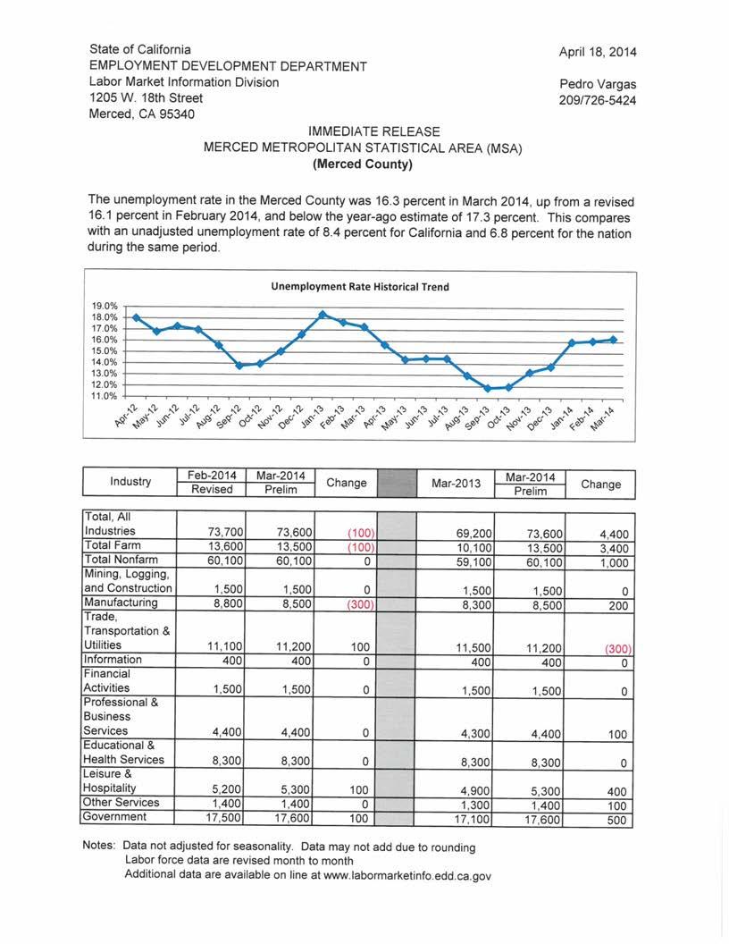
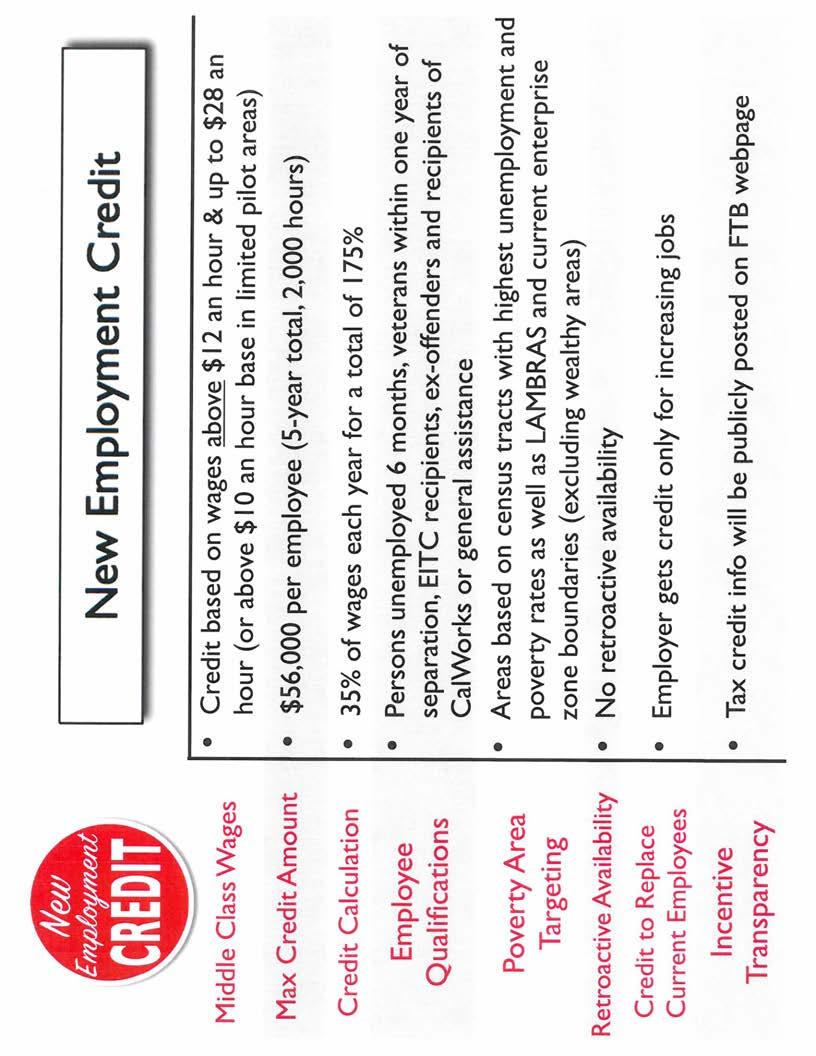
2 EDAC April 29, 2014 Page 2 H. OTHER BUSINESS I. ADJOURN To the EDAC meeting of June 24, 2014, 7:00am, 3 rd Floor Conference Room, Merced Civic Center. INFORMATIONAL ATTACHMENTS 1. EDD Labor Market Report, March New Employment Tax Credit Press Release, April 24, 2014 MEETINGS: EDAC, June 24, 2014, 7:00am Agenda: April 29,
3 ITEM E-1 ECONOMIC DEVELOPMENT ADVISORY COMMITTEE City of Merced MINUTES MERCED CIVIC CENTER TUESDAY 3 RD FLOOR CONFERENCE ROOM JANUARY 28, W 18 TH STREET MERCED, CALIFORNIA A. CALL TO ORDER The meeting was called to order by Committee Chair Doug Fluetsch at 7:00A.M. B. ROLL CALL Members Present: Mary Camper Doug Fluetsch Christie Hendricks Vanessa Lara Ashley Leffard Paul Lundberg Jeff Pennington Joe Ramirez Steve Roussos 2 Vacancies Members Absent: None Others Present: Octavio Valencia, Alliance for Community Research and Development Staff Present: John Bramble, City Manager Frank Quintero, Director of Economic Development Maria Mendoza, Development Associate C. ADDITIONS/DELETIONS TO THE AGENDA None D. ORAL COMMUNICATIONS
4 EDAC Minutes January 28, 2014 Page 2 None E. CONSENT CALENDAR E.1 Minutes of November 26, 2013 M/S LUNDBERG/CAMPER to approve the EDAC minutes of November 26, The motion passed by unanimous voice vote of the members present. F. DIRECTOR S REPORT F.1 Economic Development Director of Economic Development Frank QUINTERO reported that an offer was on the table for the purchase of the former Pepsi plant. The sale would include the 13.9 acres allocated to the plant as well as 1.5 acres of frontage which currently belongs to the City but cannot be maintained by the City. Terms of the sales may include clawbacks and certain requirements in terms of investment and number of jobs. The project is a consolidation and expansion of current operations, would create jobs, and represent $5 Million in machinery and equipment investment. The buyer has agreed to a first source agreement and would work with the Department of Workforce Investment to attempt hiring local first. Mr. QUINTERO stated that the City was working with a Mexico based plastics company. Two other communities were in the running but the company is strongly considering Merced because they found a vacant building and a property owner willing to work on tenant improvements. The City brought in the State to assist this company regarding the new tax credit program eligibility. Operations would begin with employees and be between employees by year two. G. ACTION/INFORMATION ITEMS G.1 Presentation of Downtown Survey Results Development Associate Maria MENDOZA briefly reviewed the history of the Downtown Fund with the Committee. Dr. Steve ROUSSOS went over the items supported by the Downtown fund such as promotions, cleanliness, events and
5 EDAC Minutes January 28, 2014 Page 3 safety. Mr. Roussos stated that out of the three focus group meetings held, six businesses attended from the Core, four businesses attended from the East end, two businesses attended from the West end and six UC Merced students also provided feedback. Surveys were made available online to all of the downtown businesses and some businesses were given the surveys in person. In total, 60 businesses responded which represents 11% of the businesses within the Business Improvement District. The common outcome was that cleanliness, safety and events were priorities. The businesses on the East and West end understood that even though they didn t see as much benefit from the fund as the Core does, they are participating in the bigger picture of improving the Downtown but they would like to see more done to benefit their areas. Director of Economic Development Frank QUINTERO stated that although the Downtown Fund is small; generating between $65,000 - $85,000 per year, it is very staff intensive. Three options regarding the future of the Fund would be presented to Council: 1.) Eliminating the Fund, 2.) Restructuring the Fund with staff and 3.) Contracting with another organization to administer the Fund. The Committee discussed the needs of the Downtown which included more safety measures such as actively watched security cameras, more Downtown happenings in order to create a safe, family friendly environment and more emphasis on cleanliness. Committee Member Ashley LEFFARD also stated that improved communication is needed between public and private parties responsible for hosting Downtown events and the businesses. Oftentimes, the businesses are not made aware of an event and therefore do not plan to stay open later hours or participate. Committee Chair Doug FLEUTSCH stated that he has attended several meetings where the topic was the creation of a Downtown Association. Instead it was more of a meeting of an organization that wanted to have enough power to voice their complaints and have someone else solve them while they did nothing. The Committee agreed that a strong, capable Downtown Association was needed, independent of Government, in order to improve the Downtown. H. OTHER BUSINESS Director of Economic Development Frank QUINTERO stated that the Federal Government was requiring Cities to conform to new parking standards. The new standards would result in on street parking being changed to two hours and parking lots being changed to 8 hours. The changes were being worked on by staff. I. ADJOURNMENT
6 EDAC Minutes January 28, 2014 Page 4 There being no further business, the meeting was adjourned at 8:32 a.m. to the EDAC meeting on February 25, 2014 at 7:00 a.m., Third Floor Conference Room, Merced Civic Center, 678 W. 18 th Street, Merced, CA Prepared by: Approved by: Maria Mendoza Recording Secretary Doug Fluetsch Chair
7 ITEM E-2 ECONOMIC DEVELOPMENT ADVISORY COMMITTEE City of Merced MINUTES MERCED CIVIC CENTER TUESDAY 3 RD FLOOR CONFERENCE ROOM FEBRUARY 25, W 18 TH STREET MERCED, CALIFORNIA A. CALL TO ORDER The meeting was called to order by Committee Chair Doug Fluetsch at 7:00A.M. B. ROLL CALL Members Present: Mary Camper Doug Fluetsch Christie Hendricks Vanessa Lara Paul Lundberg Jeff Pennington Joe Ramirez Steve Roussos Members Absent: Ashley Leffard, Excused 2 Vacancies Others Present: None Staff Present: John Bramble, City Manager Frank Quintero, Director of Economic Development Maria Mendoza, Development Associate C. ADDITIONS/DELETIONS TO THE AGENDA None D. ORAL COMMUNICATIONS
8 EDAC Minutes February 25, 2014 Page 2 None E. CONSENT CALENDAR None F. DIRECTOR S REPORT F.1 Economic Development Director of Economic Development Frank QUINTERO reported that the Office of Economic Development continues to work with the Mexico based plastics client as well as a few other prospects. February was a busy month in terms of marketing and outreach. Development Associate Maria MENDOZA reported on outreach activity at the World Ag Expo in Tulare as well as the California League of Food Processors show in Sacramento. Efforts were made at both shows to keep Merced on the forefront as a place to do business with ease. Mr. QUINTERO emphasized the importance of building relationships in Economic Development. As a result of relationships formed through TeamCalifornia, the City of Merced works collaboratively on joint ventures with the Imperial Valley Economic Development Corporation. Mr. QUINTERO reported on some of the industrial and retail activity taking place in the community. A Letter of Intent for the former Budweiser building has been signed by Mexico based company. Development Services and Economic Development staff are working with a local industry undergoing an expansion, and Chipotle was scheduled to open the first week of March Staff met with Panera Bread s Corporate Real Estate Manager and Broker. Both were very pleased with staff s assistance on the project as well as the community s reception to the restaurant and the number of qualified applicants they received for positions. Harbor Freight was finalizing their improvements and staff continues to work with Family Dollar on the 16 th and MLK Jr. Way and Yosemite Parkway projects. A group representing a family fun center was looking at a few empty buildings in Merced including the former Albertsons, Circuit City and Orchard Hardware. Downtown Merced has become a fitness cluster with independently owned, specialized gyms opening their doors and establishing themselves as part of the community. The former Wimpy s building was being retrofitted to become an auto parts store. City Manager John Bramble stated that a bid would be sent out to developers and brokers on the City s surplus property located at 23 rd and G Streets. Quality
9 EDAC Minutes February 25, 2014 Page 3 of the project as well as number of jobs created would outweigh the purchase price. Mr. BRAMBLE stated that the City was preparing the budget and looking at ways to enhance Economic Development in the process. The Merced Boosters commissioned a study on the City s fees and would be presenting their findings to Council. G. ACTION/INFORMATION ITEMS G.1 Proposed Purchase and Sale Agreement for 1 West Avenue Building and Land Sale Director of Economic Development Frank QUINTERO stated that staff has been working with Sun Valley Nut out of Turlock, California. Sun Valley Nut is a total of three entities; Sun Valley Inc., Sun Valley LLC, and their farming branch. The company was completely out of space at their current location and needed to consolidate operations and expand. The former Pepsi building was valued at $2.5 million by an Industrial Broker. Due to the building being vacant for quite some time, damage had been done to the electrical panels and the copper wire had been stolen. The estimate to bring the facility back to its original condition was valued between $330, and $550, The negotiated sale price on the building was $1.43 million. Part of those negotiations as part of the deal included the creation of a minimum of 75 full time jobs at the facility and a first source agreement with the Department of Workforce Investment to attempt to hire locally first. In addition, the company would make a $7 Million investment into the facility. The City owned strips of land that serve as frontage on the building would be included in the deal but building could not take place on them. Sun Valley Nut would be responsible for maintaining them. Sun Valley Nut would have 120 days in their due diligence phase. $20, would be owed to the City by them if that time was exceeded. They would then have 12 to 24 months after the due diligence phase to make additions to the facility. Average pay for employees is $15.00/hour and the City has retained the right of revertership meaning that the City would be able to buy the facility back within the next 12 months at the selling price. All improvements to date would become property of the City. M/S LUNDBERG/RAMIREZ to recommend Approval of the Purchase and Sale Agreement to the Merced City Council. The motion passed by unanimous voice vote of the members present.
10 EDAC Minutes February 25, 2014 Page 4 H. OTHER BUSINESS Director of Economic Development Frank QUINTERO advised the Committee to review the California Regional Bulletin. I. ADJOURNMENT There being no further business, the meeting was adjourned at 7:49 a.m. to the EDAC meeting on March 25, 2014 at 7:00 a.m., Third Floor Conference Room, Merced Civic Center, 678 W. 18 th Street, Merced, CA Prepared by: Approved by: Maria Mendoza Recording Secretary Doug Fluetsch Chair
11 ITEM G-1 City of Merced Department of Economic Development Office of Economic Development Date: April 29, 2014 To: Economic Development Advisory Committee From: Frank Quintero, Director of Economic Development Subject: Bellevue Community Plan Public Review Draft - Presentation ACTION: Oral Presentation, Discussion, and Review Under the guidance of the City of Merced Planning Division, the DRAFT Bellevue Corridor Community Plan was prepared by lead consultant Lisa Wise Consulting and four sub consultants. Community participation included a Citizen Advisory Committee composed of 18 members with broad backgrounds. Supporting the efforts of the Planning Division, Citizen Advisory Committee, and consultant was a 28 member Technical Advisory Committee. Attached for the committee s review are the BCP Executive Summary and Introduction chapters to provide a foundation for the discussion with the Planning staff. Executive Summary Excerpt: The Bellevue Community Plan (BCP) was developed to be consistent with the Merced Vision 2030 General Plan, and is highly reflective of its policies, illustrative plans and guiding features, such as providing significant employment generating uses that would benefit from being in close proximity to the UC Merced campus. The BCP establishes a high-level planning framework that strikes a balance between certainty and flexibility by anchoring key land uses while allowing their size to adapt to changing market conditions in response to economic growth and the expansion of UC Merced. While the BCP provides a broad range of uses and densities that could occur throughout the plan area, it emphasizes the foundational building blocks of street connectivity, functional mobility choices, active and passive recreation open space corridors and bikeways, gateway street designs, and attractive business park settings to create a great sense of place with investment certainty. The BCP is now available for public review. The Planning Division is seeking input from EDAC since the BCP weighs heavily on economic development factors. EDAC member Jeff Pennington and former EDAC member Janet Young participated on the Citizen Advisory Committee. A full electronic copy of the BCP will be provided to the EDAC Committee and distributed at the meeting of April 29, A full copy of the BCP is available on the City of Merced website at the following address: cuments/default.asp
12 After the DRAFT BCP is presented to the EDAC committee, members will be asked to review the document and provide their feedback on the document to the Planning Division. A deadline for EDAC comments will be provided at the meeting. Attachment: BCP Executive Summary and Introduction 2 P age


13 Bellevue Community Plan Public Review Draft CITY OF MERCED MARCH 2014
14

15 CITY OF MERCED Bellevue Community Plan Lead Consultant Lisa Wise Consulting, Inc. Lisa Wise, President 983 Osos Street San Luis Obispo, CA Sub Consultants Sargent Town Planning David Sargent, Principal 448 South Hill Street, Suite 418 Los Angles, CA Tony Perez Associates Tony Perez, Principal 225 Camino La Madera Avenue Camarillo CA Nelson\Nygaard Consulting, Assoc. Colin Burgett, Principal 116 New Montgomery Street, Suite 500 San Francisco, CA Economic & Planning Systems, Inc. Jason Moody, Principal 2501 Ninth Street, Suite 200 Berkeley, CA MARCH 2014
16 ACKNOWLEDGEMENTS Special thanks to the City Council, Citizen Advisory Committee, Technical Advisory Committe, and City Staff who generously gave their time to help create the Bellevue Community Plan. Special thanks to the UC Merced Resource Center for the Community Engaged Scholarship (ReCCES program) - Planning an Innovation Hub, Dr. S.A. Davis, and Geneva Skram for their continued support and assistance. City Council Stan Thurston Noah Lor Kevin Blake Tony Dossetti Mike Murphy Josh Pedrozo Michael Belluomini Citizen Advisory Committee Jerry Callister Susan Gerhardt Melbourne Gwin, Jr. Dan Holmes Sharon Hunt-Dicker Richard Kirby Lee Kolligian Walt Lopes Carol McCoy Steve Simmons Justi Smith Bill Spriggs Greg Thompson Steve Tinetti Jeff Pennington Diana Westmoreland-Pedrozo Mary Ward Janet Young Technical Advisory Committee Norm Andrade Gene Barerra Michael Conway Richard Cummings Ken Elwin Kim Espinosa Kraig Magnussen Matthew Fell David Gonzalves Rod Ghearing Richard Green Mark Hamilton Mark Hendrickson Bill King Thomas Lollini Michael McLaughlin Maria Mendoza Stan Murdock Bill Nicholson Ron Price Frank Quintero Steven Rough Ken Rozell John Sagin Julie Sterling David Spaur Mike Wegley Phillip Woods
17 CONTENTS Executive Summary Plan Development and Community Participation Plan Organization and Contents Core Findings and Policy Recommendations Next Steps i i i iii iv 1. Introduction 1 Community Plan Overview 1 Setting 4 General Plan Guidance 7 2. Vision & Urban Design 17 Plan Framework and Flexibility 28 Plan Vision and Strategies 30 Bellevue Community Plan Goals and Policies Mobility 35 Setting 36 BCP Circulation Plan Components 39 Bellevue Community Plan Goals and Policies Open Space, Conservation, and Recreation 65 Setting 66 Open-Space Service Standard 72 Park Types 74 Conceptual Open-Space Diagram 77 Bellevue Community Plan Goals and Policies 79 The work upon which this publication is based was funded in whole or in part through a grant awarded by the Strategic Growth Council. The statements and conclusions of this report are those of the GRANTEE and/or Subcontractor and not necessarily those of the Strategic Growth Council or of the Department of Conservation, or its employees. The Strategic Growth Council and the Department make no warranties, express or implied, and assume no liability for the information contained in the succeeding text.
18 5. Community Character 83 Setting 84 General Plan Consistency 85 Core elements for Community Character Areas 87 Place Types/Character Areas: 89 Neighborhood Master Planning 102 BCP Regulatory Framework 104 Bellevue Community Plan Goals and Policies Urban Expansion 109 Governance and Terminology 111 Growth Factors 116 Community Plan Growth Scenarios 123 Public Facilities Financing and Next Steps 125 Bellevue Community Plan Goals and Policies Public Services and Facilities 131 Setting and Issues 132 Public Facilities Financing 139 Bellevue Community Plan Goals and Policies Plan Maintenance Works Cited Appendix 151 A. Bellevue Community Plan Consistency with the City s General Plan A-1 B. Development Projects and Plans B-1 C. Applicable Merced Vision 2030 General Plan Goals, Policies and Actions C-1 D. Technical Circulation Memorandum D-1 E. Foundation Report E-1 F. Plan Development and Community Participation F-1 G. Merced s Loop Road G-1 H. Innovation Hub Elements, Relevance and Suggested Policies H-1 I. Findings Report with Supporting Background Reports I-1 J. Relevance of the Urban Land Institute to the BCP J-1 K. Anticipated Research and Development K-1 L. University Community Plan Town Center L-1 M. Plan Assessment Tool M-1
19 LIST OF FIGURES Figure 1. Bellevue Community Plan Area in Relation to Downtown Merced 5 Figure 2. Proximate Development Plans and Projects surrounding the Bellevue Community Plan Area 6 Figure 3. Bellevue Community Plan Illustrative Plan 10 Figure 4. Urban Design Framework 17 Figure 5. Merced Loop System 18 Figure 6. City of Merced Transit Corridor 19 Figure 7. California High Speed Rail Proposed Alignment 22 Figure 8. Illustration of an Interconnected Block Structure 23 Figure 9. Illustration of Possible Gateway Design Overlay Along Bellevue 25 Figure 10. UCM Triple Zero Commitments 26 Figure 11. Existing Regional Bus Connectivity 37 Figure 12. Complete Street Components in the Bellevue Community Plan 40 Figure 13. BCP Street Classification 42 Figure 14. Bellevue Road with Two-way Side Access Road 44 Figure 15. Example of a Boulevard with One-way Side Access Slip Road and Intersections in Berkeley, CA 44 Figure 16. Example of a Boulevard with One-way Side Access Slip Road in Berkeley, CA 44 Figure 17. Gardner Road in Single Family Character Area 45 Figure 18. Collector Street through a Typical Multi-Family Character Area 46 Figure 19. Collector Street through a Typical Mixed-Use Character Area 47 Figure 20. Collector Street through a Typical Single-Family Character Area 47 Figure 21. Mandeville Road- Transit Avenue - T.O.D. Center 48 Figure 22. Typical Edge Drive with Side Parking 51 Figure 23. Lake Road - Natural Rural Edge Drive 51 Figure 24. Lake Road - Edge Drive with Mixed-Use Character Area 51 Figure 25. BCP Gateway Overlay at Bellevue Road & G Street 52 Figure 26. Five Minute Walk from Proposed Transit Line 54 Figure 27. Bicycle Transportation Map 56 Figure 28. Pedestrian Transportation Map 57 Figure 29.Examples of Street Landscape Features 58 Figure 30. Example of an Urban Plaza and Festival Streets 58
20 Figure 31. Crosswalks 59 Figure 32. Bulb-outs 59 Figure 33. Pedestrian Realm 60 Figure 34. Sensitive Habitats and Conservation Lands within and near the Plan Area 67 Figure 35. Site Topography and Drainage Features Within and Near the Planning Area 69 Figure 36. Wetland Features with and near the Plan Area 71 Figure 37. Existing and Planned Recreational Facilities Within and Near the Plan Area 73 Figure 38. BCP Open-Space Diagram 78 Figure 39. Community Character Place Type Plan 90 Figure 40. Illustration of a R&D Employment District 94 Figure 41. Illustration of a Typical Neighborhood Center 96 Figure 42. Illustration of Multi-Family Neighborhood Character Area 99 Figure 43. Illustration of Single Family Residential 100 Figure 44. Bellevue Community Plan Area 110 Figure 45. Merced City Limit, Sphere of Influence (SOI), Sphere of Specific Urban Development (SUDP), and Area of Interest (AOI) 112 Figure 46. City of Merced 2015 and 2030 Sphere of Influence (SOI) 114 Figure 47. Key Growth Factors for the Bellevue Community Plan 116 Figure 48. Bellevue Community Plan Project Index 122 Figure 49. Image of Lake Yosemite and Area Storm Water Runoff 135 Figure 50. Site Topography and Water Features within and Near the Plan Area 136 Figure 51. Plan Maintenance Key Characteristics 145
21 LIST OF TABLES Table 1 Land Use Designations from the Merced Vision 2030 General Plan 11 Table 2 Citizen Advisory Committee Desired Outcomes of the Bellevue Corridor Community Plan 30 Table 3 Vision and Urban Design Goals and Policies Specific to the Bellevue Corridor Community Plan consistent with the City s General Plan 32 Table 4 Street Classifications within the Bellevue Community Plan 41 Table 5 Pedestrian Way Standards 60 Table 6 Mobility Goals and Policies Specific to the Bellevue Corridor Community Plan Consistent with the City s General Plan 61 Table 7 Open Space, Conservation, and Recreation Goals and Policies Specific to the Bellevue Corridor Community Plan consistent with the City s General Plan 79 Table 8 Place Type Characteristics 89 Table 9 BCP Character Area Descriptions and Regulatory Framework 104 Table 10 Community Character Goals and Policies Specific to the Bellevue Community Plan consistent with the City s General Plan 106 Table 11 Urban Expansion Goals and Policies Specific to the Bellevue Corridor Community Plan consistent with the City s General Plan Regarding Urban Expansion 127 Table 12 Public Services and Facilities Goals and Policies Specific to the Bellevue Corridor Community Plan consistent with the City s General Plan 141
22 This page intentionally left blank.

23 Executive Summary EXECUTIVE SUMMARY The Bellevue Community Plan (BCP) was developed to be consistent with the Merced Vision 2030 General Plan, and is highly reflective of its policies, illustrative plans and guiding features, such as providing significant employment generating uses that would benefit from being in close proximity to the UC Merced campus. The BCP establishes a high-level planning framework that strikes a balance between certainty and flexibility by anchoring key land uses while allowing their size to adapt to changing market conditions in response to economic growth and the expansion of UC Merced. While the BCP provides a broad range of uses and densities that could occur throughout the plan area, it emphasizes the foundational building blocks of street connectivity, functional mobility choices, active and passive recreation open space corridors and bikeways, gateway street designs, and attractive business park settings to create a great sense of place with investment certainty. PLAN DEVELOPMENT AND COMMUNITY PARTICIPATION The development of the Bellevue Community Plan (BCP) was designed to be a dynamic process built on: Realistic assessments of past and future conditions; Consistency with the Merced Vision 2030 General Plan and other guiding documents; Professional planning and engineering guidance; Stakeholder participation, outreach to underrepresented groups, and public workshops; and, Actions of an ad-hoc advisory committee, with input from an engaged community. Public Workshop Presentation Technical Memorandum F (Appendix F) includes a detailed description of plan development process and the community participation program that helped shape the BCP. PLAN ORGANIZATION AND CONTENTS The Bellevue Community Plan is comprised of Plan Chapters, Technical Appendices and Environmental Review Documents. The Plan Chapters, described below, include narratives, images and policy language. PLAN CHAPTERS Chapter 1 Introduction identifies the context which the plan was developed, including descriptions of the community and physical setting, the parameters and relevant issues of the plan area established by the City s General Plan, and plan area assumptions, opportunities and constraints. Chapter 2 Vision and Urban Design provides the long-term vision of the Plan and policy direction about core design principles which broadly influence mobility, open space, land use and public services and facilities in the plan area. City of Merced Bellevue Community Plan Public Review Draft i
24 Executive Summary Chapter 3 Mobility emphasizes the development of a municipal circulation and transportation system, integrated with open spaces and land uses, and accommodates all modes of transit (automobiles, transit, bicycles, and pedestrians), including provision for Transit Priority Projects (TPP). Chapter 3 includes rights-of-way templates and graphics depicting future streets, pathways and transit corridors within the Plan Area. Chapter 4 Open Space, Conservation, and Recreation elements are designed in a comprehensive multiuse approach addressing recreation, storm-drainage, joint use school facilities, connectivity of uses, and natural resource needs of the planning area and surrounding lands. Chapter 5 Community Character anticipates and identifies locations for future land uses, and arranges them in a pattern that is both complementary and compatible with nearby uses including the UC Merced, Rural Residential Neighborhoods, and planned communities. Chapter 6 Urban Expansion describes governance challenges, growth factors and several growth scenarios for the plan area. The Urban Expansion Chapter emphasizes a comprehensive and collaborative approach, identifying infrastructure planning and fiscal responsibility as key drivers in future decisions concerning urban expansion. Chapter 7 Public Services and Facilities addresses the public service and facility needs of an expanding City population. Chapter 8 Plan Maintenance describes how the Bellevue Community Plan may be implemented, monitored, and updated, as needed. On the topics of sustainable development, housing, noise and safety, the Bellevue Community Plan defers to the Merced Vision 2030 General Plan. TECHNICAL APPENDICES Plan Appendices contain detailed background information that is foundational to the discussion and policies of the Bellevue Community Plan, and includes the following topics: A. Bellevue Community Plan Consistency with the City s General Plan. B. Development Projects and Plans. C. Applicable Merced Vision 2030 General Plan Goals, Policies and Actions. D. Technical Circulation Memorandum. E. Foundation Report. F. Plan Development and Community Participation. G. Merced s Loop Road. H. Innovation Hub Elements, Relevance and Suggested Policies. I. Findings Report with Supporting Background Reports. J. Relevance of the Urban Land Institute to the BCP. K. Anticipated Research and Development. L. University Community Plan Town Center. M. Plan Assessment Tool. ii City of Merced Bellevue Community Plan Public Review Draft
25 Executive Summary CORE FINDINGS AND POLICY RECOMMENDATIONS DEFINED YET FLEXIBLE The Bellevue Community Plan is a long-term document with a tremendous amount of uncertainty. To counter this, the plan has a policy framework for future master planning that is comprehensive and is supported by the community. The policy and development framework will deliver an interconnected transit-oriented development pattern, clarity of urban character and flexibility of use to respond to changing markets. INVESTMENT CERTAINTY While the Bellevue Community Plan provides a broad range of uses and densities that could occur, it also emphasizes the development of a great sense of place with investment certainty. The BCP is geared to make projects that are connected to their neighbors and to the transit spine with complete, walkable streets. So the City creates a systematic development pattern where the next development is framed by the preceding development site that implements the overall vision, rather than a smattering of projects. A STRONG DOWNTOWN Downtowns are sensitive to market forces, particularly to urban growth in other areas. Initially, an identity distinct from Downtown Merced will need to be fostered by the City to develop a separate and non-competing center in the BCP plan area. Over time, as the market expands, greater flexibility in land uses may be achieved. ATTRACTING JOBS-BASED ECONOMIC DEVELOPMENT The Merced Vision 2030 General Plan includes numerous policies and narratives concerning the anticipation for significant jobs-based land uses within the BCP. Following the lead of the General Plan, the BCP includes a Research and Development Park Character Area that could accommodate up to 2.9 million square-feet of Research and Development floor space. The Plan is flexible, supporting the size of this land use to adjust depending upon market conditions. The Research and Development employment corridor is infused with innovation hub design elements to attract new firms and industry wishing to locate near the campus. HOUSING The Bellevue Community Plan relies on the housing-related narrative, images, diagrams and policies of the Merced Vision 2030 General Plan to guide planning, provision and development of future housing units in anticipation of Merced s increased population. The BCP includes a wide variety of housing types ranging from rural residential estate homes to high-density multifamily dwellings. A TAILOR-SUITED LAND USE MODEL The Merced Vision 2030 General Plan contains policy direction to utilize the Urban Village as a design template for future growth areas within the Bellevue Community Plan area. Statements in the General Plan and comments received from the community made it clear that the urban design of the BCP would be unique, however. General Plan Policy UD-1.1h calls for unique Urban Village designs to be developed for increased opportunities for job-based land uses attracted by a university climate. The community also expressed concerns about the amount of low-density residential that has traditionally been located in the City s Urban Villages, and the location and intensity of commercial uses. Thus, a unique design is recommended that is consistent with the General Plan while responding to concerns of the community, and is discussed in greater detail in the land use section of Technical Appendix A. City of Merced Bellevue Community Plan Public Review Draft iii
26 Executive Summary CONSERVATION OF NATURAL LANDS In that the Bellevue Community Plan contains sensitive species and habitat areas, the Plan considered and recommends several methods to conserve these natural resources. Consistent with adopted mitigation measures of City s General Plan EIR, property owners are required to prepare delineations of Waters of the U.S. and Wetlands prior to annexation, and to obtain permits from relevant state and federal agencies. Property owners also need to comply with the adopted Memorandum of Understanding between the City of Merced and the United States Fish and Wildlife Service. Additionally, the Open Space Master Plan of the BCP establishes several open space corridors that include identified sensitive habitats. For example, the Plan proposes a large corridor extending from Cardella Road to Lake Road at a point north of Bellevue Road. These may shrink or expand depending upon the findings and actions of the permitting process described above. OPEN SPACE FOR OUTDOOR RECREATION The Bellevue Community Plan includes several active parks including three neighborhood parks, a community park and several urban plazas. Neighborhood parks are recommended to be combined with future school sites to serve the anticipated population, and urban plazas will add open space opportunities to high-density populations along Mandeville Avenue. Open space corridors featuring pedestrian and bicycle pathways connect to parks and other destinations. SUPPORT CIRCULATION MODES THROUGH LAND USE DESIGN Along Bellevue Road the goal is to emphasize smooth traffic flow and provide access to adjacent uses at appropriate intervals and through innovative means, while also creating a distinct gateway appearance through attractive building designs and associated landscaping. Within the Mandeville transit route, which links the planned transit stations in Bellevue Ranch and UC Merced. New development should be organized in the form of complete neighborhoods and districts and be oriented to pedestrians and transit. Higher-intensity development and activities should be concentrated near planned transit stops. This arrangement supports regional automobile trips on Bellevue Road, while creating a pedestrian-oriented corridor along Mandeville Avenue, and enhances the value of the research and development area that is to be located between these roads. NEIGHBORHOOD MASTER PLANNING The Bellevue Community Plan recommends that the City create a dynamic neighborhood master plan process to ensure that each new increment of development is well-connected to existing and future adjacent development, while responding to market. The framework for new development would be a clear and interconnected yet flexible network of complete streets and community open spaces. This process acts as the fundamental tool to ensure that the overall physical community structure is developed as envisioned in the BCP. NEXT STEPS PLAN INTEGRATION Upon adoption of the Bellevue Community Plan, the City should begin the process to integrate it with existing master plan documents and processes, including but not limited to the following: Merced Vision 2030 General Plan. City of Merced 2013 Bicycle Transportation Plan Parks and Recreation Master Plan. Capital Improvement Planning. Public Utility Master Plans. Transit Planning Documents. Regional Transportation Plans (as appropriate). iv City of Merced Bellevue Community Plan Public Review Draft
27 Executive Summary COORDINATED DEVELOPMENT A common vision and approach to urban expansion creates certainty, and certainty attracts investments, and investments create jobs. Yet, as evidenced in the growth scenarios of the BCP (Chapter 6, Urban Expansion), along with concerns raised by the BCP Ad-hoc Advisory Committee, there are numerous unanswered questions and challenges concerning infrastructure, financing and phasing of growth in and adjacent to the BCP planning area. The BCP is a collaborative effort to create a multijurisdictional infrastructure and service plan to support growth in a manner that serves the interest of the community as a whole, in a fiscally sound manner. Partners with the City in this effort would include Merced County, the University of California, as well as the Merced Irrigation District, local schools and the Merced County Association of Governments. The UC Merced Long Range Development Plan (LRDP), the University Community Plan (UCP), and the Bellevue Community Plan, among other plans, provide the necessary information and options from which a unified development phasing plan could be crafted. Future outcomes of this collaborative effort could include: Select a growth scenario, or combination thereof. Develop a strategic phasing plan and plan for services that coordinate expenditure of resources, provides certainty in the marketplace, and leads to an efficient use of public infrastructure and services. Update financing and master plans and programs to align with the broad decisions concerning financing, infrastructure, and phasing in the northeast Merced SOI. City of Merced Bellevue Community Plan Public Review Draft v

28
 provides policy direction to the decision making process for development within a defined geographic portion of")
29 Introduction 1. INTRODUCTION COMMUNITY PLAN OVERVIEW PURPOSE The Bellevue Community Plan (BCP or Plan) provides policy direction to the decision making process for development within a defined geographic portion of the Planning area of the City s General Plan. The plan forms a broad framework for mutual understanding among citizens, public agencies, and the development community. Preparing a community plan serves the following purposes: To facilitate the Planning Commission and City Council concurrence on long-range development policies; To provide a basis for evaluating the level to which private development proposals and public projects are consistent with these policies; To better enable the public and government entities to design projects that are consistent with City policies, or to seek changes in these policies through the General Plan Amendment process; To record the City s policies and standards for the maintenance and improvement of existing development and the location and characteristics of future development; To better inform citizens on land use policy issues and promote opportunities to participate in the local planning and decisionmaking process; To serve as a blueprint for future growth and development within a defined area of the City of Merced s Sphere of Influence (SOI); 1 and, Community Plans may, but are not required to, identify components of infrastructure needed to support planned land uses, as well as appropriate financing mechanisms. 3 The BCP focuses on providing a vision and framework for coordinating transportation, infrastructure, and open space, with varied land use mixes and intensities. A Community Plan serves as a blueprint for future growth and development within a defined area of the City of Merced s growth boundary. Aerial View of Merced City of Merced Bellevue Community Plan Public Review Draft 1
30 Introduction THE CITY S GUIDING PRINCIPLES FOR COMMUNITY PLANS General plan s provide a policy framework upon which community plans are constructed and a foundation to build more detailed implementation tools including community plan diagrams, policies, maps and illustrative plans. The City s Guiding Principles for local community plans (Section 3.7.2, Merced Vision 2030 General Plan) are: Community Plans which include or are adjacent to established neighborhoods will address the needs of these neighborhoods and potential adverse impacts resulting from plan implementation. Public participation by area residents and property owners in the planning process will be emphasized. Community Plan areas need connectivity with existing and planned urban areas. Community Plans will include all elements determined necessary to ensure consistency with the General Plan. These elements may include, but not be limited to, Land Use, Circulation, Open Space, and infrastructure phasing. Community Plans will include a land use and infrastructure phasing plan. The Urban Villages concept should be incorporated into the planning of these areas as much as feasible. The Community Planning process should be focused on the planning issues or concerns which need to be resolved for that planning area and, to this degree, provide data, information, or policy clarification necessary to carry out the goals of the Merced Vision 2030 General Plan. BCP RELATIONSHIP TO FUTURE ANNEXATIONS AND GROWTH The BCP is not a project that will annex unincorporated properties into the City of Merced. That action occurs through a separate process usually initiated by private property owners with specific development interests, and then only after a formal annexation request is granted by both the City of Merced and the Merced County Local Agency Formation Commission (LAFCO). For more information on annexation and implementation of the Plan see Chapter 6 (Urban Expansion). FRAMEWORK PLAN VS. DEVELOPMENT PLAN The BCP is not a development project. A development project contains specific land-use entitlements with specific standards. As with the City s General Plan, the BCP is a conceptual framework within which future decisions about development projects would be made when more information is in place. The BCP does not include the specificity or rigidity that comes with a development plan as does, for example the Bellevue Ranch Master Development Plan. 2 City of Merced Bellevue Community Plan Public Review Draft

31 Introduction PLANNING VS. ZONING The Bellevue Community Plan does not rezone property. Upon adoption of the Plan, properties within the planning area will remain in Merced County and will retain their current zoning designations. As there is no City zoning within the plan boundaries, the BCP effort does not affect current property rights. The BCP provides a foundation for future development in a manner that will benefit the property owners and the community. VISION VS. CONSTRUCTION The BCP planning process allowed the community to take a comprehensive approach to examining land use, circulation, and other issues. As the City s urban fabric expands with market demand, the BCP offers guidance for growth that is grounded in the community s vision, takes advantage of existing resources, and avoids potential constraints. However, for future urbanization to occur in the Plan Area, additional input will be needed from the community as the scope and scale of development becomes influenced by market conditions, decisions from local landowners, and the availability of public services. Tour of Bellevue Corridor Project Area and Presentation City of Merced Bellevue Community Plan Public Review Draft 3
32 Introduction SETTING The Bellevue Community Plan study area is located outside but adjacent to the Merced City limits, and within the City s planned growth area, otherwise known as the Specific Urban Development Plan (SUDP) and Sphere of Influence (SOI). COMMUNITY SETTING The City of Merced is approximately seven miles long from north to south and six miles at its widest point from east to west. In January 2012, the City of Merced covered approximately 23 square miles and had an estimated population of 79,328. The Bellevue Community Plan area is located to the northeast of the City of Merced, and covers an area of approximately 2.4 square-miles. The planning area is generally bounded by G Street on the west; Farmland Avenue on the north; Lake Road on the east and Cardella Road on the South (between Lake Road and Gardner Road), and generally ½ mile south of Bellevue Road (between Gardner Road and G Street). Lake Yosemite, UC Merced and the northern part of the UC Community Plan area abuts the eastern edge of the BCP study area. From the project boundary, Downtown Merced is 3.5 miles to the southwest, and Castle Airport and the City of Atwater are 6 miles to the west. The Bellevue Community Plan study area is located outside but adjacent to the Merced City limits, and within the City s planned growth area, otherwise known as the Specific Urban Development Plan (SUDP) and Sphere of Influence (SOI). PHYSICAL SETTING The northeastern portion of the City s planned growth area is characterized by gently rolling terrain while the remainder of the City is relatively flat. The northern, western, and eastern portions of the City contain a number of creeks and canals including Bear Creek, Black Rascal Creek, Fahrens Creek, and Cottonwood Creek. These creeks all traverse the City from east to west. With the exception of a few pockets of rural residential homes, the BCP planning area is predominately grasslands. 4 City of Merced Bellevue Community Plan Public Review Draft

33 Introduction Figure 1. Bellevue Community Plan Area in Relation to Downtown Merced City of Merced Bellevue Community Plan Public Review Draft 5

34 Introduction Figure 2. Proximate Development Plans and Projects surrounding the Bellevue Community Plan Area The community of Merced has participated in important planning initiatives over the past several years including the City s Merced Vision 2030 General Plan, UC Merced s Long Range Development Plan, PROXIMATE DEVELOPMENT PLANS AND PROJECTS The community of Merced has participated in important planning initiatives over the past several years including the City s Merced Vision 2030 General Plan, UC Merced s Long Range Development Plan, and Merced County s University Community Plan. The outcomes of these and other planning initiatives serve as an important basis for the BCP. A detailed description of development plans and projects occurring within and near the Bellevue Community Plan area is provided in Technical Memorandum B (Appendix B) of the BCP. The Projects and Plans document identifies and describes recent and anticipated growth patterns. and Merced County s University Community Plan. 6 City of Merced Bellevue Community Plan Public Review Draft
35 Introduction GENERAL PLAN GUIDANCE CONSISTENCY WITH THE MERCED VISION 2030 GENERAL PLAN The Bellevue Community Plan was developed to be consistent with the Merced Vision 2030 General Plan, and reflects key criteria detailed in the General Plan. The following sections from the General Plan created the foundation of the BCP and established the Core Principles discussed in Chapter 2 (Vision and Urban Design chapter): Merced Vision 2030 General Plan Merced Vision 2030 General Plan Key Goals, Policies and Implementation Actions Key Features and Issues of the Bellevue Community Plan The Bellevue Community Plan Illustrative Plan KEY GOALS, POLICIES, AND IMPLEMENTING ACTIONS A complete and full listing of Merced Vision 2030 General Plan goals, objectives, policies, and implementing actions that have notable relevance to the BCP project area and/or plan objectives are listed in Technical Memorandum C (Appendix C) of the BCP. This appendix also includes policies crafted as a part of the BCP, which offer greater detail and refinement of the broader General Plan language. The policies in Technical Memorandum C are a key part of the BCP and are intended to guide and inform development-related activities in the project area. January 2012 KEY FEATURES AND ISSUES OF THE BELLEVUE COMMUNITY PLAN The Merced Vision 2030 General Plan (Section 3.7.4) identified several key features and related direction for the BCP, including: economic development, land use, transportation, public facilities, environment and urban design. ECONOMIC DEVELOPMENT The City s General Plan describes Bellevue Road as a gateway to UC Merced connecting the campus to Castle Airport Aviation and Development Center, other employment centers, and to Downtown Merced via the G, M and R Street corridors, and that (1) their economic development strategies should be compatible and complementary; and (2) they should connect to one another via a network of transportation and communications systems that optimize access between and among them. The Merced Vision 2030 General Plan also describes the Bellevue Corridor as likely to contain significant employment generating uses that would benefit from being in close proximity to the UC Merced campus (Section 3.5.5), and is identified as a Commercial and Industrial Employment Corridor to contain heavy concentrations of commercial and industrial development. The emphasis on economic development also appears in a General Plan discussion to adjust the City s Urban Village concept near UC Merced. The General Plan states, The composition and pattern of land uses in the Urban Villages near UC Merced along Bellevue Road will have unique designs City of Merced Bellevue Community Plan Public Review Draft 7
36 Introduction and functions due to the economic opportunities and connectivity to the university. Each of the Urban Villages between Lake Road and G Street should contain, in addition to Neighborhood Commercial, Village Residential, and Professional Commercial -Office, the opportunity for an expanded urban core comprised of a jobs-based office, business park or research and development type land use supported or spun-off from UC Merced. This additional land use potential is represented in Figure 38. Community Character Place Type Plan. LAND USE The City s General Plan describes the Bellevue Corridor as one that should be designed as a place where services, shops, schools, businesses, public uses, and residences mix in a vibrant setting. The BCP should assess the viability of expanding office, commercial, and research and development land use capacities in the plan area. The City s Urban Village will be the backbone concept model for creating core commercial nodes along Bellevue Road and a connection to neighborhoods to the south and north. Some of the land uses could connect to research and development activities associated with the campus research programs or professional services associated with the campus s professional schools. The City s General Plan specifically identifies that the following features should be included in or influence the creation of the BCP: Urban Village Design Urban Villages are described in the Merced Vision 2030 General Plan as mixed-use, mixed-density neighborhood developments incorporated into and planned in conjunction with a network of interconnected, walkable streets. This design allows for a variety of land uses including jobs-based land uses attracted to a university climate to be intermixed within the BCP framework. Special Urban Village designs suited to the Bellevue Corridor Planning Principles and potential expansion thereof to provide for increased opportunities for job-based land uses attracted by a university climate while still maintaining the basic concept of mixed-use, pedestrian, and transit oriented communities. These Urban Villages may differ from others in the Community in the mixture of business park, research and development, office, public/ cultural uses, and retail uses within the Village Core areas instead of the retail/office/public facilities focus of other Villages which are more residential in nature; and, Land Uses should be compatible and complimentary with one another and planned as integrated, coordinated mixed-use neighborhoods and communities; and, The influence and effects of the UC Merced and University Community land use and circulation plans on adjacent (western) properties; and, Interface issues and infill land use patterns adjacent to and within pre-existing Rural Residential properties; and, A variety of housing types and densities should be encouraged within the Community Plan area in addition to job-generating uses consistent with the City s overall economic strategy and the Bellevue Corridor Economic Analysis (see Appendix I). 8 City of Merced Bellevue Community Plan Public Review Draft
37 Introduction TRANSPORTATION Per the City s General Plan, it will be essential that adequate rights-of-ways be reserved along all major corridors. The design cross-section of these corridors may vary depending upon the adjacent land uses, but they should have two characteristics in common. They should be designed as multimodal access corridors that accommodate both automobiles and a public transit system (rubber tire or light rail), as well as bicycles and pedestrians. Further, they should be designed to unify, rather than separate, the elements of the community located on opposite sides of the road. These roads should be designed as landscaped, multimodal boulevards. Establish Bellevue Parkway Planning Principles describing the design [including appropriate right-of-way, function and land use pattern along Bellevue Road] recognizing two key traits: (1) multi-modal access corridor that accommodates both automobiles and public transit systems, as well as bikes and pedestrians; and (2) designed to unify rather than separate the community located on opposite sides of the road. Establish a system of collector streets and arterials with appropriate rightsof-ways to encourage internal circulation within the Community Plan area. This would include determining the proper alignment and right-of-way for Gardner Road. PUBLIC FACILITIES The City s General Plan states the BCP should establish adequate public facilities to accommodate growth within the area. The General Plan states the BCP provide the, Location and financing of public facilities including a fire station, schools, roadways, off-street bike and pedestrian paths, and parks/ open space. ENVIRONMENT The BCP addresses specific environmental issues and vulnerable areas relevant to the plan area which necessitate protection or preservation. The City s General Plan states that the BCP should address the following: Lake Yosemite Inundation Area and Sensitive species and habitat conservation. It will be essential that adequate rights-of-ways be reserved along all major corridors. The design crosssection of these corridors may vary depending upon the adjacent land uses, but they should have two characteristics in common. They should be designed as multi-modal access corridors that accommodate both automobiles and a public transit system (rubber tire or light rail), as well as bicycles and pedestrians. Further, they should be designed to unify, rather than separate, the elements of the community located on opposite sides of the road. These roads should be designed as landscaped, multimodal boulevards. CHARACTER/DESIGN The General Plan states the BCP should include design parameters to guide the future development of the plan area. The General Plan identifies the following characteristics be included in the BCP: Establish, through the Community Plan process, design guidelines for development along the Bellevue Corridor in accordance with the City s Urban Design principles outlined in Chapter 6 of the General Plan. The natural hill, which occurs on the south side of Bellevue Road between G Street and Gardner Road, should be considered as a focal point for the Corridor. City of Merced Bellevue Community Plan Public Review Draft 9

38 Introduction THE BELLEVUE COMMUNITY PLAN ILLUSTRATIVE PLAN The Merced Vision 2030 General Plan includes illustrative plans as an appendix to its Land Use Chapter. Illustrative plans are not adopted plans and are only included in the Merced Vision 2030 General Plan to inform the public of preliminary land use concepts under consideration in each of the Plan areas. No land use entitlements are granted by including illustrative plans in that appendix. The land uses shown in the northwest corner of Lake Road and Bellevue Road are a part of the formally adopted Land Use Diagram of the City of Merced, and not considered illustrative. The Illustrative Plan (Figure 3) below from the General Plan shows a conceptual land use plan for the BCP area. Figure 3. Bellevue Community Plan Illustrative Plan 10 City of Merced Bellevue Community Plan Public Review Draft
39 Introduction Table 1 Land Use Designations from the Merced Vision 2030 General Plan Land Use Designations Key Intended Uses Density Rural Residential (RR) Light Yellow Residential: single-family 1 3 units per acre Low Density Residential (LD) Yellow Residential: single-family detached, condominium, and zero-lot line 2 6 units per acre Low-Medium Density Residential (LMD) Tan Residential: single-family detached, duplex, triplex, fourplex, condominium, zero-lot-line units per acre High-Medium Density Residential (HMD) Light Brown Residential: multifamily, apartment, condominium, triplex, fourplex units per acre High Density Residential (HD) Dark Brown Residential: multifamily units per acre Neighborhood Commercial (CN) Pink Commercial: retail, eating and drinking, commercial recreation, auto services, etc. Average 0.35 FAR Bellevue Corridor Mixed Use Light Purple A mixture of LMD, HMD, HD, CO and CN. Varies Thoroughfare Commercial (CT) Red Commercial: auto-oriented commerce, large recreational facilities, some heavy commercial, lodging and hospitality, automobile sales and services 0.35 Floor Area Ratio Business Park (BP) Purple Commercial and industrial: heavy commercial, office, research and development, light manufacturing, warehousing, information-based and service-based activities 0.40 Floor Area Ratio Open Space Park/Recreation Facility (OS-PK) Green Recreation: public parks, golf courses, greens, commons, playgrounds, and other public and private open spaces 0.10 Floor Area Ratio School Blue Circles Public Elementary Schools N/A BELLEVUE COMMUNITY PLAN (BCP) The General Plan conceptual land use plan (for illustrative purposes only) for the BCP is shown on the previous page. This illustrative plan also appears on the City s Official Land Use Diagram. Through the development of the BCP, the General Plan Illustrative Plan and land use designations (Table 1), described above, were refined in order to develop the community s vision for the BCP area in the following chapters of this community plan. City of Merced Bellevue Community Plan Public Review Draft 11
40 Introduction ASSUMPTIONS, OPPORTUNITIES, AND CONSTRAINTS The Bellevue Community Plan was guided by the following assumptions and the assessment of opportunities and constraints regarding anticipated future conditions to the year 2030 listed in the Merced Vision 2030 General Plan and developed through the community engagement process. ASSUMPTIONS Although essentially vacant today, the BCP is surrounded by existing and proposed urban and suburban land uses. All lands within the City s adopted Sphere of Influence within and near the BCP will be developed. Development within the BCP area will be guided by Urban Expansion policies in the City s Merced Vision 2030 General Plan as well as Merced County Local Agency Formation Commission s (LAFCO) procedures, codes, and actions. Significant amounts of job-generating land uses will be located in close proximity to the UC Merced Campus. The University of California Merced (UCM) campus will continue to expand in the vicinity of Lake Yosemite on the northeastern edge of the Merced growth boundary or SUDP/SOI along with a future University Community. Urban development (residential, commercial, and industrial) will continue to be focused within the City of Merced s growth area (SUDP/SOI) and not in the unincorporated areas surrounding the City. From City Council Resolution # regarding the University Community: The University Community will be incorporated into the City of Merced and will not be a separate city or part of the unincorporated County. Annexation along the Bellevue Corridor is encouraged to provide contiguity between UC Merced and the City of Merced. It is realistic to expect development proposals in the BCP planning area in the near-term. Though no separate wastewater treatment plant should service the University Community, consideration of innovative methods of wastewater treatment for that area may occur. The City will encourage annexation along the Bellevue Corridor to provide contiguity between the University Community and the City of Merced. OPPORTUNITIES The BCP presents important opportunities for the City of Merced. The continued growth of UC Merced will provide an influx of people, ideas, and energy. The plan should capitalize on this growth and ensure that new development meets the needs and desires of new and existing residents. Potential opportunities include the following: 12 City of Merced Bellevue Community Plan Public Review Draft
41 Introduction Growing University-Oriented Population At full buildout, UC Merced is expected to grow to approximately 25,000 students and over 6,500 faculty and staff members. As the population grows, there will be an expanding market for housing, goods, and services. Future Research and Development Park Sites The plan should anticipate and prepare for the market demands caused by a growing University, including identifying sites for future job generating research and development parks and encouraging multiple interests to collaborate for long-term economic and fiscal benefits. Home for Entrepreneurs The plan should help foster a living and working environment to attract a new generation of entrepreneurs, leading to innovations, technologies, and expansion of local investment and job-generators. Alternative Transportation The plan should identify and implement circulation and land use standards that encourage multi-modal transportation including walking, biking, transit, and driving. By implementing the complete transportation network and shifting away from auto-centric mobility patterns, it is possible to compliment and build upon the UC Merced investment while moderating the environmental impacts of increased development within the BCP area. It is essential to offer multi-modal access to the student population of UC Merced and to future BCP residents. Leverage New Investment The expanding University community has and will continue to spark associated investment in Merced. The plan should identify opportunities to leverage new investments in the University to improve citywide economic vitality. Low-Impact Development Well-planned growth in the BCP area can ensure that development minimizes impacts to natural resources, air quality, and water quality. The plan should identify and incorporate concepts for development patterns and solutions that conserve and enhance resources from which a community prospers. Community Character There is little existing development within the BCP area, thus the BCP presents an important opportunity to elaborate on General Plan vision concepts for developing a unique community character. The plan should encourage memorable livable, human-scale public spaces and distinctive community centers that facilitate positive interaction and idea sharing. City of Merced Bellevue Community Plan Public Review Draft 13
42 Introduction Existing Rural Residential Communities Though primarily located outside the Plan Area, existing ranchette neighborhoods provide a semi-rural lifestyle defined by open space and agricultural uses. The BCP provides an opportunity to maintain and strengthen the character of these neighborhoods with appropriate soft transitions to new higher intensity development; these neighborhoods can also provide development themes for some areas of the BCP, such as equestrian-oriented facilities and trails. CONSTRAINTS While there are many opportunities for the City to capitalize on, the following constraints and challenges have been taken into account during the development of the Plan. The scale of the Plan area and timing of the UC campus build-out will make phasing an important consideration in Plan implementation. The pattern and timeframe in which the area develops will impact transit opportunities, development feasibility, and interim community character. Development Phasing The scale of the Plan area and timing of the UC campus build-out will make phasing an important consideration in Plan implementation. The pattern and timeframe in which the area develops will impact transit opportunities, development feasibility, and interim community character. Natural Resource and Habitat Disruption Portions of the Plan area are home to sensitive natural resources such as vernal pools that must be considered and which have the potential to enhance unique public open spaces. Multiple Interests BCP standards and policies must address the needs and concerns of individual property owners and local jurisdictions, while ensuring each unique development contributes to a unified whole. The project area is within the City s SOI and SUDP, but is currently under County jurisdiction. Multiple City Focus Points The City has important existing resources including the charming downtown and several historic neighborhoods. The BCP must ensure that development within the BCP complements, rather than competes with these and other existing or future community focal points. Campus Parkway Regional Traffic (Loop Road) Bellevue Road is part of Merced s planned loop road to carry regional traffic. While this serves an important regional transportation need, it limits the use of the road for transit, bicycling, and pedestrian-scale development. 14 City of Merced Bellevue Community Plan Public Review Draft

43 Introduction View of Bellevue Road An Uncertain Economy The current economy is still uncertain and growth forecasts for Merced and the BCP vary widely. Competition to Serve the UCM Market The BCP area and the University Community will potentially be competing for valuable economic development and expensive infrastructure capacity for many decades to come. Affect on Downtown Downtowns are sensitive to market forces, particularly to urban growth in other areas, including the development of the BCP. Disparate Visions The BCP area will be developed by many property owners and developers over the course of several decades. A focused and consistent effort will be needed on the part of decision makers to ensure successful, long-term implementation. This Plan provides an overall vision and general framework for new development, and also provides procedures for the preparation of more detailed neighborhood master plans to help coordinate and connect new development among and between multiple property owners. A focused and consistent effort will be needed on the part of decision makers so ensure successful, long-term implementation. City of Merced Bellevue Community Plan Public Review Draft 15
44
45
46
47

48
49
DRAFT BELLEVUE COMMUNITY PLAN
 DRAFT BELLEVUE COMMUNITY PLAN City of Merced Planning Commission October 22, 2014 General Plan Amendment #14-02 Plan Adoption PROJECT LOCATION Bellevue Road UC Merced PROJECT LOCATION CONSIDERATIONS Advisory
DRAFT BELLEVUE COMMUNITY PLAN. City Council Study Session February 17, 2015
 DRAFT BELLEVUE COMMUNITY PLAN City Council Study Session February 17, 2015 PROJECT LOCATION Bellevue Road UC Merced PROJECT LOCATION CONSIDERATIONS Advisory Committee and public input Merced Vision 2030
CITY OF MERCED Planning & Permitting Division. STAFF REPORT: # Addendum AGENDA ITEM: 4.1
 CITY OF MERCED Planning & Permitting Division STAFF REPORT: #14-14 - Addendum AGENDA ITEM: 4.1 FROM: Kim Espinosa, PLANNING COMMISSION Planning Manager MEETING DATE: Dec. 3, 2014 PREPARED BY: Bill King,
1. INTRODUCTION COMMUNITY PLAN OVERVIEW PURPOSE. A Community Plan serves as. a blueprint for future growth. and development within a
 1. INTRODUCTION COMMUNITY PLAN OVERVIEW PURPOSE The Bellevue Community Plan (BCP or Plan) provides policy direction to the decision making process for development within a defined geographic portion of
Technical Appendix A, BCP Consistency with City s General Plan
 Technical Appendix A, BCP Consistency with City s General Plan Table of Contents A.1 Consistency Overview A.1.1 Purpose and Utility A.1.2 Consistency with the City s Guiding Principles for Community Plans
Technical Appendix A of the BCP, BCP Consistency with City s General Plan
 Technical Appendix A of the BCP, BCP Consistency with City s General Plan Table of Contents A.1 Consistency Overview A.1.1 Purpose and Utility A.1.2 Consistency with the City s Guiding Principles for Community
BELLEVUE CORRIDOR COMMUNITY PLAN AD-HOC CITIZENS ADVISORY COMMITTEE M I N U T E S
 BELLEVUE CORRIDOR COMMUNITY PLAN AD-HOC CITIZENS ADVISORY COMMITTEE M I N U T E S SAM PIPES CONFERENCE ROOM 678 W. 18 TH STREET THURSDAY MERCED, CALIFORNIA AUGUST 23, 2012 (A) CALL TO ORDER Principal Planner
1.0 Purpose of a Secondary Plan for the Masonville Transit Village
 Report to Planning and Environment Committee To: Chair and Members Planning & Environment Committee From: John M. Fleming Managing Director, Planning and City Planner Subject: Masonville Transit Village
SAN RAFAEL GENERAL PLAN 2040 INTRODUCTION AND OVERVIEW
 SAN RAFAEL GENERAL PLAN 2040 INTRODUCTION AND OVERVIEW Steering Committee Presentation February 14, 2018 Purpose of General Plan Guide land use and development decisions Coordinate transportation, infrastructure,
Technical Appendix L, University Community Plan Town Center
 Technical Appendix L, University Community Plan Town Center Table of Contents L.1 Executive Summary L.2 Merced County University Community Plan, 2004 Findings L.2.1 Visioning L.2.2 UCP Goals, Objectives
A. WHAT IS A GENERAL PLAN?
 I. Introduction A. WHAT IS A GENERAL PLAN? A general plan is the planning guideline for the future of a city. It contains goals and policies which regulate urban development, the protection of the natural
CITY OF VAUGHAN EXTRACT FROM COUNCIL MEETING MINUTES OF NOVEMBER 15, 2016
 Item 11, Report No. 38, of the Committee of the Whole, which was adopted without amendment by the Council of the City of Vaughan on November 15, 2016. Regional Councillor Di Biase declared an interest
SUBJECT: Waterfront Hotel Planning Study Update TO: Planning and Development Committee FROM: Department of City Building. Recommendation: Purpose:
 Page 1 of Report PB-23-18 SUBJECT: Waterfront Hotel Planning Study Update TO: Planning and Development Committee FROM: Department of City Building Report Number: PB-23-18 Wards Affected: 2 File Numbers:
Chapter 1.0 Introduction
 Chapter 1.0 Introduction 1.1 Background The North Metro commuter rail line is part of the RTD FasTracks regional transit system expansion program to build more than 100 miles of rail transit throughout
PSRC REVIEW REPORT & CERTIFICATION RECOMMENDATION
 PSRC REVIEW REPORT & CERTIFICATION RECOMMENDATION KITSAP COUNTY COUNTYWIDE PLANNING POLICIES July 2, 2012 BACKGROUND A major emphasis of the Washington State Growth Management Act (GMA) is the need to
CITY OF CHARLOTTESVILLE, VIRGINIA CITY COUNCIL AGENDA
 CITY OF CHARLOTTESVILLE, VIRGINIA CITY COUNCIL AGENDA Agenda Date: December 16, 2013 Action Required: Adoption of Resolution Presenter: Staff Contacts: Title: James E. Tolbert, AICP, Director of NDS James
DRAFT PLAN PRESENTATION
 DRAFT PLAN PRESENTATION 1.23.2018 AGENDA Process Project Schedule Results from Visioning Workshop Draft Plan Highlights Concept Plans Feedback Next Steps PROJECT SCHEDULE KICK-OFF WORKSHOP August 29 th
CITY OF PUYALLUP. Background. Development Services
 CITY OF PUYALLUP Development Services 333 South Meridian Puyallup WA 98371 To: City Council From: Katie Baker, AICP, Planning Division Re: South Hill Neighborhood Plan Adoption Date: (Meeting date: February
TEMPLE MEDICAL & EDUCATION DISTRICT
 City of Temple, Texas TEMPLE MEDICAL & EDUCATION DISTRICT 1 Description. The City of Temple joined in partnership with key public and private entities to jointly promote education and medical activities
CHAPTER 1. Ms. Guajardo s Class - Central Elementary CH 1 1
 INTRODUCTION CHAPTER 1 Ms. Guajardo s Class - Central Elementary CH 1 1 1.1 SETTING South Centre City is a linear corridor south of Downtown Escondido paralleling Centre City Parkway and South Escondido
DRAFT Amsterdam/Churchill Community Plan (4/17/08) Adopted By the Gallatin County Commission
 Adopted By the Gallatin County Commission") DRAFT Amsterdam/Churchill Community Plan (4/17/08) Adopted By the Gallatin County Commission Table of Contents Acknowledgements Chapter 1: Introduction A Brief History What s Next Authority Organization
DRAFT Amsterdam/Churchill Community Plan (4/17/08) Adopted By the Gallatin County Commission Table of Contents Acknowledgements Chapter 1: Introduction A Brief History What s Next Authority Organization
EXHIBIT A. Tax Increment Reinvestment Zone No. 1 (Town Center) First Amended Project Plan 1
 First Amended Project Plan 1") EXHIBIT A Tax Increment Reinvestment Zone No. 1 (Town Center) First Amended Project Plan 1 1 As amended by Resolution No. 2008-02-001(TR1R) of the Tax Increment Reinvestment Zone No.1, and approved to
EXHIBIT A Tax Increment Reinvestment Zone No. 1 (Town Center) First Amended Project Plan 1 1 As amended by Resolution No. 2008-02-001(TR1R) of the Tax Increment Reinvestment Zone No.1, and approved to
AWH REPORT OF THE PLANNING AND DEVELOPMENT DEPARTMENT FOR APPLICATION FOR REZONING ORDINANCE TO PLANNED UNIT DEVELOPMENT
 AWH REPORT OF THE PLANNING AND DEVELOPMENT DEPARTMENT FOR APPLICATION FOR REZONING ORDINANCE TO PLANNED UNIT DEVELOPMENT MAY 8, 2014 The Planning and Development Department hereby forwards to the Planning
Staff Report and Recommendation
 Community Planning and Development Planning Services 201 W. Colfax Ave., Dept. 205 Denver, CO 80202 p: 720.865.2915 f: 720.865.3052 www.denvergov.org/cpd TO: City Council Neighborhoods and Planning Committee
Town of Oakville Streetscape Strategy
 Town of Oakville Streetscape Strategy Endorsed by PDC on February 10, 2014 (PD-011-14) Town of Oakville Streetscape Strategy [endorsed by PDC February 10, 2014] 0 Town of Oakville Streetscape Strategy
~!VAUGHAN NOV Z November 21, Mr. Denis Kelly, Regional Clerk The Regional Municipality of York Yonge Street Newmarket, ON L3Y 6Z1
 ~!VAUGHAN NOV Z 5 2016 November 21, 2016 Mr. Denis Kelly, Regional Clerk The Regional Municipality of York 17250 Yonge Street Newmarket, ON L3Y 6Z1 Dear Mr. Kelly: RE: NEW KIRBY GO STATION IN BLOCK 27
The transportation system in a community is an
 7 TRANSPORTATION The transportation system in a community is an important factor contributing to the quality of life of the residents. Without a sound transportation system to bring both goods and patrons
North Fair Oaks Community Plan Summary and Information
 North Fair Oaks Community Plan Summary and Information WHAT IS THE NORTH FAIR OAKS COMMUNITY PLAN? The North Fair Oaks Community Plan is part of the San Mateo County General Plan, and establishes policies
COLVER ROAD INDUSTRIAL CONCEPT PLAN
 COLVER ROAD INDUSTRIAL CONCEPT PLAN A CONCEPTUAL LAND USE AND TRANSPORTATION PLAN FOR TA-4 AN URBAN RESERVE AREA OF THE CITY TALENT City of Talent Adopted by City Council Resolution No., June, 2015 PART
Natomas Vision Plan and PLNP
 Natomas Vision Plan 20030171 and PLNP2014-00172 Department of Community Development Planning and Environmental Review Leighann Moffitt Sub-Agenda 1. Staff Presentation Leighann Moffitt, County Planning
RESOLUTION NO. R Refining the route, profile and stations for the Downtown Redmond Link Extension
 RESOLUTION NO. R2018-32 Refining the route, profile and stations for the Downtown Redmond Link Extension MEETING: DATE: TYPE OF ACTION: STAFF CONTACT: Capital Committee Board PROPOSED ACTION 09/13/2018
Introduction. Chapter 1. Purpose of the Comprehensive Plan Plan Organization Planning Process & Community Input 1-1
 Chapter 1 Introduction Lakewood 2025: Moving Forward Together Purpose of the Comprehensive Plan Plan Organization Planning Process & Community Input 1-1 Purpose of the Comprehensive Plan The Comprehensive
WAC #7 3/14/14. Coachella General Plan Update
 WAC #7 3/14/14 Coachella General Plan Update Agenda 2 Introductions Public Draft General Plan Overview and Discussion of Next Steps Implementation and Evaluation Health Element Process Evaluation (discussion)
Honorable Mayor and Members of the City Council. Submitted by: Eric Angstadt, Director, Planning and Development
 Office of the City Manager ACTION CALENDAR January 29, 2013 To: From: Honorable Mayor and Members of the City Council Christine Daniel, City Manager Submitted by: Eric Angstadt, Director, Planning and
3. VISION AND GOALS. Vision Statement. Goals, Objectives and Policies
 Vision Statement Queen Creek s interconnected network of parks, trails, open spaces and recreation opportunities provide safe and diverse activities and programs that sustain its unique, small town, equestrian
Gold Line Bus Rapid Transit Transit Oriented Development (BRTOD) Helmo Station Area Plan
 Helmo Station Area Plan") Appendix F Gold Line Bus Rapid Transit Transit Oriented Development (BRTOD) Helmo Station Area Plan Introduction and Purpose of the Plan The Gold Line Bus Rapid Transit facility is an eleven-mile dedicated
Appendix F Gold Line Bus Rapid Transit Transit Oriented Development (BRTOD) Helmo Station Area Plan Introduction and Purpose of the Plan The Gold Line Bus Rapid Transit facility is an eleven-mile dedicated
THE TOWN OF WASAGA BEACH
 THE TOWN OF WASAGA BEACH Downtown Development Master Plan Committee of the Whole Presentation January 26 th 2017 Uses within this designation should reflect a dependence on tourism as opposed to the permanent
ELMVALE ACRES SHOPPING CENTRE MASTER PLAN
 ELMVALE ACRES SHOPPING CENTRE MASTER PLAN Contents 1.0 INTRODUCTION... 2 2.0 LOCATION... 2 3.0 EXISTING CONTEXT... 2 4.0 VISION & GUIDING PRINCIPLES... 2 5.0 LAND USE AND BUILT FORM... 4 5.1 St. Laurent
Plan Overview. Manhattan Area 2035 Reflections and Progress. Chapter 1: Introduction. Background
 Plan Overview The Manhattan Urban Area Comprehensive Plan (the Comprehensive Plan) is a joint planning initiative of the City of Manhattan, Pottawatomie County, and Riley County. The 2014 Comprehensive
2040 LUP is a part of the Comprehensive Plan and carries the same legal authority. Economic Challenges
 1.1. Guiding Anchorage s Growth Where will new residents settle over the next two decades? Where will people work, shop, and play? Will there be enough room to grow? How will Anchorage look? Will growth
Former Rockcliffe Airbase Community Design Plan Guiding Design Vision and Principles December 4, 2013
 APPENDIX 5 - Guiding Design Vision and Principles Former Rockcliffe Airbase Community Design Plan Guiding Design Vision and Principles December 4, 2013 Vision Statement The redevelopment of the former
SUBJECT: GO Station Mobility Hubs Preferred Concepts: Aldershot GO, Burlington GO and Appleby GO. Planning and Development Committee - Public Meeting
 Page 1 of Report PB-76-17 SUBJECT: GO Station Mobility Hubs Preferred Concepts: Aldershot GO, Burlington GO and Appleby GO TO: FROM: Planning and Development Committee - Public Meeting Planning and Building
Official Plan Review
 Official Plan Review Summary Report - The Built Environment August 2014 Part 1: Introduction Planning for a healthy, prosperous and sustainable community is an important goal for our municipality. From
ARLINGTON COUNTY, VIRGINIA
 ARLINGTON COUNTY, VIRGINIA County Board Agenda Item Meeting October 15, 2005 DATE: September 28, 2005 SUBJECT: Request to Advertise the adoption of the 2005 Clarendon Sector Plan C. M. RECOMMENDATION:
New Partners for Smart Growth Conference February 5, 2010
 Dan Stroh, Planning Director City of Bellevue Planning and Community Development Bellevue, WA New Partners for Smart Growth Conference February 5, 2010 Summary of Project Long-range plan update for Bel-Red
Introduction and Overview
 Introduction and Overview Articulate local values and priorities Guide land use and development decisions Coordinate transportation, infrastructure, and City services with expected growth and available
CHARLES PUTMAN CHARLES PUTMAN AND ASSOCIATES, INC
 MEMORANDUM CHARLES PUTMAN & ASSOCIATES, INC. LAND DEVELOPMENT CONSULTANTS PLANNING ZONING PERMITTING 4722 NW Boca Raton Boulevard, Suite C-106 Boca Raton, Florida 33431 Phone: 561/994-6411 FAX: 561/994-0447
Edward R. Sajecki Commissioner of Planning and Building
 Corporate Report Clerk s Files Originator s Files CD.03.POR DATE: TO: FROM: SUBJECT: Chair and Members of Planning and Development Committee Meeting Date: February 27, 2012 Edward R. Sajecki Commissioner
DISCUSSION ON VACAVILLE S2 INVESTORS PROPERTY IN URBAN RESERVE
 Agenda Item No. 9C April 25, 2017 TO: FROM: SUBJECT: Honorable Mayor and City Council Attention: Jeremy Craig, Interim City Manager Barton Brierley, AICP, Community Development Director (Staff Contact:
DENVER DESIGN DISTRICT GDP
 DENVER DESIGN DISTRICT GDP Urban Design Standards and Guidelines November 17, 2008 Amended February 3, 2016 City and County of Denver CF Property Management, Inc. C/O Denver Design District - Starboard
CHAPTER 12 IMPLEMENTATION
 CHAPTER 12 IMPLEMENTATION The 2010 Town of Denton Comprehensive Plan is intended to capture a vision of the future of Denton. As such, it provides a basis for a wide variety of public and private actions
1INTRODUCTION. Purpose of the Truckee Railyard Master Plan
 1INTRODUCTION Purpose of the Truckee Railyard Master Plan The purpose of the Truckee Railyard Master Plan is to capture and describe the Town s vision for the Railyard Area and to guide its future redevelopment.
Sheridan Boulevard S TAT I O N A R E A P L A N S H E R I D A N B O U L E VA R D S TAT I O N A R E A P L A N
 Sheridan Boulevard S TAT I O N A R E A P L A N 1 City of Lakewood Adopted November, 2006 S H E R I D A N B O U L E VA R D S TAT I O N A R E A P L A N The Vision The City of Lakewood s overall vision is
LAND USE AMENDMENT DOWNTOWN COMMERCIAL CORE (WARD 7) MACLEOD TRAIL SE AND 5 AVENUE SE BYLAW 254D2017
 MACLEOD TRAIL SE AND 5 AVENUE SE BYLAW 254D2017") Page 1 of 10 EXECUTIVE SUMMARY This Land Use Amendment application seeks to redesignate a full downtown block (currently the YWCA site) from a Direct Control based on the CM-2 District (Land Use Bylaw
Page 1 of 10 EXECUTIVE SUMMARY This Land Use Amendment application seeks to redesignate a full downtown block (currently the YWCA site) from a Direct Control based on the CM-2 District (Land Use Bylaw
S A C R A M E N T O C O U N T Y JACKSON HIGHWAY & GRANT LINE EAST VISIONING STUDY
 JACKSON HIGHWAY & GRANT LINE EAST S A C R A M E N T O C O U N T Y P L A N N I N G D E P A R T M E N T SUMMARY AND WORKBOOK November 19, 2008 History of the Visioning Study Sacramento County has two growth
Welcome to the Oakridge Centre Open House
 Welcome to the Oakridge Centre Open House Why is the City hosting this event? This open house is to inform you of a rezoning application submitted to the City of Vancouver to amend the existing CD-1 (Comprehensive
Urban Planning and Land Use
 Urban Planning and Land Use 701 North 7 th Street, Room 423 Phone: (913) 573-5750 Kansas City, Kansas 66101 Fax: (913) 573-5796 Email: planninginfo@wycokck.org www.wycokck.org/planning To: From: City Planning
3.10 LAND USE SETTING PROJECT SITE EXISTING LAND USE DESIGNATIONS AND ZONING. General Plan Land Use Designations.
 This section of the Draft EIR addresses the existing land uses on and adjacent to the project site and discusses the potential impacts of the proposed project on existing land uses. Key issues addressed
S C O P E O F W O R K A P R I L
 white flint 2 sector plan S C O P E O F W O R K A P R I L 2 0 1 2 MONTGOMERY COUNTY PLANNING DEPARTMENT M-NCPPC MontgomeryPlanning.org 1 white flint 2 sector plan Scope of Work abstract This scope of work
Report to: Development Services Committee Report Date: April 24, 2017
 SUBJECT: Cornell Rouge National Urban Park Gateway - Report on Design Charrette and Next Steps PREPARED BY: Lilli Duoba, MES, MCIP, RPP, Manager, Natural Heritage (ext. 7925) REVIEWED BY: Marg Wouters,
Cumberland Region Tomorrow is a private, non-profit, citizen based regional organization working with Greater Nashville Regional Council
 Cumberland Region Tomorrow is a private, non-profit, citizen based regional organization working with Greater Nashville Regional Council and others in the public and private sectors, dedicated to planning
Ten Mile Creek Planning Area
 PLANNING AREA POLICIES TEN MILE CREEK Ten Mile Creek Planning Area Location and Context The Ten Mile Creek Planning Area ( Ten Mile Creek area ) is located south of the current Boise AOCI, generally south
COMMISSION ACTION FORM
 ITEM #: 6 DATE: 09-06-17 COMMISSION ACTION FORM REQUEST: Introduction and Initial Review of Proposed Amendments to the Ames Urban Fringe Future Land Map for the North Growth Gap Area BACKGROUND INFORMATION:
DRAFT Subject to Modifications
 TREASURE COAST REGIONAL PLANNING COUNCIL M E M O R A N D U M To: Council Members AGENDA ITEM 8 From: Date: Subject: Staff May 19, 2017 Council Meeting Florida Department of Transportation Complete Streets
EXECUTIVE SUMMARY DRAFT CHAPTER 1 INTRODUCTION EXECUTIVE SUMMARY
 CHAPTER 1 EXECUTIVE SUMMARY INTRODUCTION Through the joint efforts of the City of Tulsa planning staff and the Land Services division of Indian Nations Council of Governments (INCOG), the Berryhill Land
Authority of the General Plan
 Authority of the General Plan This La Habra Heights General Plan will serve as the blueprint for future planning and development in the City. This General Plan describes the City s vision for the future
D-O LRT Zoning Discussion. Chapel Hill Boards & Commissions October 16, 2017
 D-O LRT Zoning Discussion Chapel Hill Boards & Commissions October 16, 2017 Update on Overall D-O LRT Station Area Initiative Objectives Design and educate on principles of Good Transit-Oriented Development
MAYFIELD WEST SECONDARY PLAN PHASE 2
 MAYFIELD WEST SECONDARY PLAN PHASE 2 Public Open House #3 February 25, 2010 Draft Preferred Land Use Scenario TOWN OF CALEDON PLANNING & DEVELOPMENT DEPARTMENT Open House Agenda TOWN OF CALEDON 1. Welcome
hermitage town center
 hermitage town center A Community Vision prepared by Strada for The City of Hermitage and The Mercer County Regional Planning Commission January 2007 table of contents introduction 3 design principles
Appendix C: Interim Mixed-Use Evaluation Criteria
 Appendix C: Interim Mixed-Use Evaluation Criteria C-1 Appendix C: Interim Mixed-Use Evaluation Criteria PURPOSE: The implementation of numerous policies contained within the Master Plan hinges on the creation
3.0 PROJECT DESCRIPTION
 3.0 PROJECT DESCRIPTION 3.1 BACKGROUND Under California law (Government Code Section 65300 et seq.), every city and county is required to have a general plan. The general plan is to be comprehensive and
Land Use Amendment in Southwood (Ward 11) at and Elbow Drive SW, LOC
 at and Elbow Drive SW, LOC") 2018 November 15 Page 1 of 10 EXECUTIVE SUMMARY This land use amendment application was submitted by Rick Balbi Architect on 2017 August 31 on behalf of Sable Developments Ltd, and with authorization from
2018 November 15 Page 1 of 10 EXECUTIVE SUMMARY This land use amendment application was submitted by Rick Balbi Architect on 2017 August 31 on behalf of Sable Developments Ltd, and with authorization from
Department of Community Development. Planning and Environmental Review Division Revised Notice of Preparation
 Department of Community Development Michael J. Penrose, Acting Director Divisions Building Permits & Inspection Code Enforcement County Engineering Economic Development & Marketing Planning & Environmental
PART 1. Background to the Study. Avenue Study. The Danforth
 The Danforth 1.1/ Study Purpose & Key Municipal Goals 1.2/ The Local Advisory Committee 1.3/ The Project Team 1.4/ Study Process/Summary of Method 1.5/ Summary of Consultation 1.1 Study Purpose and Key
City Center Specific Plan Amendments And Background Report City of Richmond. PLANNING COMMISION FINAL DRAFT January, 2001
 City Center Specific Plan Amendments And Background Report City of Richmond PLANNING COMMISION FINAL DRAFT January, 2001 TABLE OF CONTENTS Page LIST OF TABLES... LIST OF FIGURES... INDEX... OVERVIEW...
PLAN ELEMENTS WORKSHOP. April 5, 2016
 PLAN ELEMENTS WORKSHOP April 5, 2016 needs more housing. But there is no one-size fits-all solution. Every neighborhood has its own character. In some places, density is not only appropriate it is badly
CHAPTER 7: Transportation, Mobility and Circulation
 AGLE AREA COMMUNITY Plan CHAPTER 7 CHAPTER 7: Transportation, Mobility and Circulation Transportation, Mobility and Circulation The purpose of the Transportation, Mobility and Circulation Chapter is to
Hockessin Community Redevelopment Plan
 Hockessin Community Redevelopment Plan 3.1 Introduction The Community Redevelopment Plan for the Village of Hockessin is the result of the people s vision for a distinct village center that serves as the
MEETING PURPOSE AND OVERVIEW
 MEETING PURPOSE AND OVERVIEW On February 23, 2012, the City of Elk Grove hosted the first of two community workshops related to the Southeast Policy Area. The workshop was held from 6:00 8:30 p.m. in the
Economic Development & Housing Council Committee Comprehensive Plan Update September 20, 2005
 1 Economic Development & Housing Council Committee Comprehensive Plan Update September 20, 2005 Purpose To update the Committee on the ForwardDallas! Plan, including: Status Anticipated Products Public
2.0 AREA PLANS. Lakeside Business District. Lakeside Business District Land Use Categories:
 Lakeside Business District Lakeside Business District Land Use Categories: Campus Commercial Campus Commercial means a mixture of uses which includes corporate offices, office parks, hotels, commercial,
City Of Sparks Planning Commission Item
 Page 1 of 12 City Of Sparks Planning Commission Item Meeting Date: May17, 2012 Subject: PCN12009, Public Hearing, Consideration and possible action on a Master Plan Amendment and Rezoning request to change
REZONING GUIDE. Zone Map Amendment (Rezoning) - Application. Rezoning Application Page 1 of 3. Return completed form to
 - Application. Rezoning Application Page 1 of 3. Return completed form to") Zone Map Amendment (Rezoning) - Application COMMUNITY PLANNING & DEVELOPMENT REZONING GUIDE Rezoning Application Page 1 of 3 PROPERTY OWNER INFORMATION* CHECK IF POINT OF CONTACT FOR APPLICATION Property
Zone Map Amendment (Rezoning) - Application COMMUNITY PLANNING & DEVELOPMENT REZONING GUIDE Rezoning Application Page 1 of 3 PROPERTY OWNER INFORMATION* CHECK IF POINT OF CONTACT FOR APPLICATION Property
WELCOME TO THE CHOUTEAU GREENWAY EQUITY WORKING GROUP!
 WELCOME TO THE CHOUTEAU GREENWAY EQUITY WORKING GROUP! Chouteau Greenway Steering Committee and Working Groups Overview Overview January 9, 2019 Chouteau Greenway will transform St. Louis by connecting
City of Tacoma Planning and Development Services
 Agenda Item E-1 City of Tacoma Planning and Development Services To: Planning Commission From: Elliott Barnett, Planning Services Division Subject: Tacoma Mall Regional Center Subarea Plan and EIS Meeting
LAND USE AMENDMENT CORNERSTONE (WARD 3) 60 STREET NE AND COUNTRY HILLS BOULEVARD NE MAP 26NE BYLAW 22D2017
 60 STREET NE AND COUNTRY HILLS BOULEVARD NE MAP 26NE BYLAW 22D2017") Page 1 of 14 EXECUTIVE SUMMARY This Land Use Amendment application covers an area of 43.76 hectares ± (108.14 acres ±) located in northeast Calgary, bound by Country Hills Boulevard NE to the south and
Page 1 of 14 EXECUTIVE SUMMARY This Land Use Amendment application covers an area of 43.76 hectares ± (108.14 acres ±) located in northeast Calgary, bound by Country Hills Boulevard NE to the south and
Town Center (part of the Comprehensive Plan)
") Town Center (part of the Comprehensive Plan) Mercer Island Town Center Looking North (2014) In 1994, a year-long process culminated in a set of design guidelines and code requirements for the Town Center
Town Center (part of the Comprehensive Plan) Mercer Island Town Center Looking North (2014) In 1994, a year-long process culminated in a set of design guidelines and code requirements for the Town Center
SCARBOROUGH SUBWAY EXTENSION. Scarborough Subway Extension. Final Terms of Reference
 Scarborough Subway Extension Final Terms of Reference 1 1.0 Introduction and Background 1.1 Introduction Toronto City Council recently confirmed support for an extension of the Bloor-Danforth Subway from
City of Farmington. Downtown Plan. Amendment to the 1998 Master Plan Adopted October 11, 2004
 City of Farmington Amendment to the 1998 Master Plan Adopted October 11, 2004 Introduction Planning Background 1 Scope and Components of the Plan Amendment 2 Concept Introduction 3 Plan Concepts 3 Conceptual
John M. Fleming Managing Director, Planning and City Planner. Old East Village Dundas Street Corridor Secondary Plan Draft Terms of Reference
 Report to Planning and Environment Committee To: From: Subject: Chair and Members Planning & Environment Committee John M. Fleming Managing Director, Planning and City Planner Old East Village Dundas Street
Chapter 2: Vision, Goals and Strategies
 Chapter 2: Vision, Goals and Lake Elmo Today & Tomorrow Comprehensive Plan 2040 2 VISION, GOALS & STRATEGIES - DRAFT 4-6-2018 INTRODUCTION Comprehensive Plan Purpose Perhapse the most important objective
Scope of Services. River Oaks Boulevard (SH 183) Corridor Master Plan
 Corridor Master Plan") Scope of Services River Oaks Boulevard (SH 183) Corridor Master Plan PROJECT AREA The project area consists of the River Oaks Boulevard (SH 183) corridor bounded by SH 199 at the northern end and the Trinity
Scope of Services River Oaks Boulevard (SH 183) Corridor Master Plan PROJECT AREA The project area consists of the River Oaks Boulevard (SH 183) corridor bounded by SH 199 at the northern end and the Trinity
INTERGOVERNMENTAL COORDINATION ELEMENT
 Goals, Objectives and Policies COORDINATION ELEMENT GOAL 8.1.: ESTABLISH EFFECTIVE COORDINATION MEASURES AMONG ALL PERTINENT PUBLIC AND QUASI-PUBLIC ENTITIES SO TO BEST MAINTAIN PALM BEACH GARDENS' QUALITY
Bloor St. W. Rezoning - Preliminary Report
 STAFF REPORT ACTION REQUIRED 1638-1644 Bloor St. W. Rezoning - Preliminary Report Date: April 1, 2008 To: From: Wards: Reference Number: Toronto and East York Community Council Acting Director, Community
Midtown Greenway Land Use and Development Plan Executive Summary
 Midtown Greenway Land Use and Development Plan Executive Summary Introduction The Midtown Greenway Land Use and Development Plan sets policy direction for land use and development in the Midtown Greenway
1.0 Introduction. Purpose and Basis for Updating the TMP. Introduction 1
 1.0 Introduction The Town of Castle Rock is situated between the metropolitan areas of Denver and Colorado Springs, amidst a unique terrain of rolling hills, mesas, ravines, and waterways. Like many Front
Planning Commission Report
 Planning Commission Report To: From: Subject: Planning Commission Meeting: January 6, 2016 Agenda Item: 8-B Planning Commission David Martin, Planning & Community Development Director Introduction to the
CITY OF COLWICH COMPREHENSIVE PLAN LAND USE LAND USE 1
 LAND USE LAND USE 1 WHAT YOU WILL FIND IN THIS CHAPTER: Discussion of today s conditions and tomorrow s projections Discussion of challenges and opportunities Discussion of the environmental quality goals,
Citizen Comment Staff Response Staff Recommended Revision Planning Committee
 Citizen Comment Staff Response Staff Recommended Revision Planning Committee Area No. 1: Owner desires retail land uses. Area No. 1a: Owner of two small parcels adjacent to Area No. 1 desires retail land
C. Westerly Creek Village & The Montview Corridor
 C. Westerly Creek Village & The VISION Community Vision When the goals of the city are achieved Westerly Creek Village, a distinctive community defined by Montview Boulevard and Westerly Creek, is a strong