Form-Based Code as a Regulatory Tool for Mixed Use Urban Infill Development in Lincoln, Nebraska
|
|
|
- Virginia Walters
- 5 years ago
- Views:
Transcription

1 University of Nebraska - Lincoln DigitalCommons@University of Nebraska - Lincoln Community and Regional Planning Program: Student Projects and Theses Community and Regional Planning Program December 2006 Form-Based Code as a Regulatory Tool for Mixed Use Urban Infill Development in Lincoln, Nebraska University of Nebraska - Lincoln, davidgaspers@hotmail.com Follow this and additional works at: Part of the Urban, Community and Regional Planning Commons Gaspers, David A., "Form-Based Code as a Regulatory Tool for Mixed Use Urban Infill Development in Lincoln, Nebraska" (2006). Community and Regional Planning Program: Student Projects and Theses This Article is brought to you for free and open access by the Community and Regional Planning Program at DigitalCommons@University of Nebraska - Lincoln. It has been accepted for inclusion in Community and Regional Planning Program: Student Projects and Theses by an authorized administrator of DigitalCommons@University of Nebraska - Lincoln.
2 Form-Based Code as a Regulatory Tool for Mixed Use Urban lnfill Development in Lincoln, Nebraska. A Professional Project in partial fulfillment of requirements for the Master of Community and Regional Planning Degree at the University of Nebraska-Lincoln Project Advisory Committee Prof. Gordon Scholz, Chair Dr. N. Brito Mutunayagam Prof. Tom Laging Dr. Ed Zimmer, Lincoln-Lancaster County Planning Staff December 16,2006
3 Copyright O 2006 by David A Gaspers All rights reserved
4 To Mom and Dad, thank you for my life
5 CONTENTS List of Figures and Tables Abstract Chapter One: Introduction Chapter Two: The evolution of Modem Zoning in the United States Early Land Use Controls in the United States Nuisance Laws The New York City Zoning Ordinance Euclid v. Ambler Realty The Nuts and Bolts of Euclidean Zoning Zoning in Context of City Government Successes of Euclidean Zoning Failures of Euclidean Zoning Sprawl Post World War I1 Development Patterns Five Components to Sprawl The Consequences of the Separation of Land Uses Current Administrative Issues with Euclidean Zoning Alternatives to Euclidean Zoning Chapter Three: Form-Based Codes Basics of the Code The Charrette Process and Dynamic Planning The Application of Form-based codes Unified Development Codes Advantages of Form-based codes Implementation Issues with Form-based codes Chapter Four: The Case Studies Columbus, Ohio, Traditional Neighborhood Development Article St. Paul, Minnesota, Urban Village Code Farmers Branch, Texas, Station Area Code Arlington County, Virginia, Columbia Pike Corridor Form-Based Code Chapter Five: Form-based code within the Context of Dynamic Planning Chapter Six: A New Approach for Redevelopment in Lincoln Historical Perspective of the South Street Business Corridor The Need for Redevelopment of the South Street Business Corridor The Potential for the South Street Business Corridor An Urban Village on South Street through Form-based code The Case for Form-based code for the South Street Business Corridor The South Street Business Corridor Regulating Plan The South Street Business Corridor Building Envelope Standards
6 Appendix A: City of Lincoln Maps Appendix B: Existing South Street Conditions Appendix C: Examples of Urban Village Development Reference List
7 List of Figures and Tables Figure 1.1 Figure 1.2 Figure 1.3 Figure 1.4 Figure 1.5 Figure 1.6 Figure 2.1 Figure 2.2 Figure 2.3 Figure 2.4 Figure 2.5 Figure 2.6 Figure 2.7 Figure 2.8 Figure 2.9 Figure 2.10 New York City 1900's Source: 18.html Sprawl near Orlando, Florida Source: Disconnected Street System Source: Mc Donalds, North 27th Street, Lincoln Source: Photo by Author Rendering of Pleasant Hill BART Station, near San Francisco, California Source: Planning Magazine, November 2004 Website Graphic for the "Heart of Peoria" project Source: com/charrette.html Savannah, 1734 Source: I83 savannah/83visuall.htm Plan for San Antonio, Texas Source: Lower Manhattan Skyline, Source: ac.uki3 cities/large/ 1053.HTM New York City Zoning Map Source: Levy, Lincoln Zoning Map Source: Dr. Edward Zimmer, 2006 The Primacy of the Residential Zone, A Street, Lincoln, Nebraska, 1920 Source: Dr. Edward Zimmer, 2006 Siting Requirements, B-3 Zoning District, Lincoln, Nebraska Source: Chapter , City of Lincoln, Nebraska Municipal Code New Subdivision, Orlando, Florida Source: Los Angeles Freeway System Source : /sharemed/targets/images/pho/t3 04IT A.j pg Townhouses, Lincoln, Nebraska Source: City of Lincoln Image file
8 Figure 2.11 Figure 2.12 Figure 2.13 Figure 3.1 Figure 3.2 Figure 3.3 Figure 3.4 Figure 3.5 Figure 3.6 Figure 3.7 Figure 3.8 Figure 3.9 Figure 3.10 Figure 4.1 Figure 4.2 Figure 4.3 Country Club Plaza, Kansas City Source: 1 O.kcity.htm1 Sprawl versus traditional neighborhood patterns Source: Duany Plater-Zyberk Fallbrook PUD, Lincoln Nebraska Source: 11.jpg Regulating Plan for the Central Petaluma Specific Plan Source: Section Zoning Map, Central Petaluma Specific Plan, Petaluma, California Excerpt of Building Envelope Standards, Columbia Pike Corridor Formbased code Source: Columbia Pike Special Revitalization District - Form-based code, Administrative Regulation 4.1.2, Arlington, Virginia, 2003 Excerpt of Siting Specifications, Columbia Pike Corridor Form-based code Source: Columbia Pike Special Revitalization District - Form-based code, Administrative Regulation 4.1.2, Arlington, Virginia, 2003 Excerpt of Element Specifications, Columbia Pike Corridor Form-based code Source: Columbia Pike Special Revitalization District - Form-based code, Administrative Regulation 4.1.2, Arlington, Virginia, 2003 Use Specifications, Columbia Pike Corridor Form-based code Source: Columbia Pike Special Revitalization District - Form-based code, Administrative Regulation 4.1.2, Arlington, Virginia, 2003 Streetscape Standards, Farmers Branch Texas Source: Form-based code - Station Area, Chapter 11: The Regulating Plan, Farmers Branch, Texas, 2005 Village Gardens PUD, Lincoln, Nebraska Source: Photo by Author Mission Meridian TOD, Pasadena California Source: Photo by Author Smartcode Transect Source: Duany, Plater-Zyberk Rendering of Future Development, Petaluma, California Source: Chapter 4 - Communiv Design,, Central Petaluma Specific Plan, Petaluma, California Columbus TND Article Transect Source: Article 11, Section , City of Columbus, Ohio Zoning Ordinance Graphic Illustration of desired public open space Source: Article 11, Section , City of Columbus, Ohio Zoning Ordinance Figure 4.3 Illustrations of Dominion Homes Traditional Neighborhood Houses Source: /homelisting. aspx vii
9 Figure 4.4 Figure 4.5 Figure 4.6 Figure 4.7 Figure 4.8 Figure 4.9 Figure 4.10 Figure 4.11 Figure 4.12 Figure 4.13 Figure 4.14 Figure 4.15 Figure 6.1 Figure 6.2 Figure 6.3 Figure 6.4 Figure 6.5 Lowry Town Center and Prospect Neighborhood Center Source: Photos by Author, 2005 St. Paul Zoning Map of a TN-2 district Source: Department of Planning and Economic Development Zoning Map, City of St. Paul, Minnesota August 2004 Existing Conditions of the Farmers Branch Station Area Source: Farmers Branch Station Area Conceptual Master Plan - Existing Conditions, Farmers Branch, Texas, 2004 Figure 4.7 Architectural Standards Illustrations, Farmers Branch, Texas Source: Form-based code - Station Area, Chapter F Architectural Standards, Farmers Branch, Texas, 2005 Regulating Plan, Farmers Branch, Texas Station Area Source: Form-based code - Station Area, Chapter 11: The Regulating Plan, Farmers Branch, Texas, 2005 Regulating Plan Key, Farmers Branch, Texas Station Area Source: Form-based code - Station Area, Chapter 11: The Regulating Plan, Farmers Branch, Texas, Annual Report Source: It 's All in the Mix, 2005 Annual Report, Planning Division, City of Farmers Branch, Texas Existing Conditions, Columbia Pike Corridor Source: Columbia Pike Initiative - Introduction, Arlington County, Virginia, 2003 Columbia Pike Corridor, Illustrative Plan Source: Columbia Pike Form-Based Code, Dover Kohl and Associates, (n.d.) Potential Build Out appearance of the Columbia Pike Town Center Source: Columbia Pike Initiative - Introduction, Arlington County, Virginia, 2003 Columbia Pike Corridor, Town Center Regulating Plan Source: Section 20: "CP-FBC" - Columbia Pike Form-Based Code Districts, Arlington County, Virginia Zoning Ordinance, 2003 Columbia Pike Corridor Main Street Building Envelope Standards Source: Columbia Pike Special Revitalization District - Form-Based Code, Administrative Regulation 4.1.2, Arlington, Virginia, 2003 South Street Redevelopment Area with Surrounding Neighborhoods Source: Author modified from City of Lincoln Map 1928 Sanborn Atlas, 14th and South Streets Source: Ciiy of Lincoln, Nebraska Fire Insurance Map, Sanborn Company, 1928 Street Car line at 14th & South, looking West, 1920's Source: Dr. Edward Zimmer, 2006 Lincoln Street Car Lines, 1924 Source: Dr. Edward Zimmer, 2006 St Elizabeth's Hospital Source: Dr. Edward Zimmer, Vlll
10 Figure 6.6 Figure 6.7 Figure 6.8 Figure 6.9 Table 6.10 Figure 6.11 Figure 6.12 Figure 6.13 Appendix A1 Appendix A2 Appendix A3 Appendix A4 Appendix A5 Appendix A6 Appendix A7 Appendix B 1 Appendix B2 Appendix B3 Appendix B4 Appendix B5 South Street Blight Study Area 9 1 Source: Urban Development Department, City of Lincoln, Nebraska, 2006 Redevelopment on North 27th Street, Lincoln, Nebraska 93 Source: Photo by Author, 2006 Example of existing urban form of North 27th Street 94 Source: Photo by Author, 2006 The business corridor on North 4gth Street in the University Place 9 5 neighborhood of Lincoln Source: Photo by Author, Census Statistics for adjacent South Street Neighborhoods 96 Source: United States Census, 2000 Bus Routes near the South Street Redevelopment Area 97 Source: http :// ne.gov/city/pworks/startran/routemap /weekday/pdf/allcity. pdf South Street Business Corridor Form-based code Regulating Plan 105 Source: City of Lincoln Urban Development Department Map, modified by Author South Street Business Corridor Form-based code Building Envelope 106 Standards Source: Author Map of Commerce Centers 110 Source: Lincoln/Lancaster Couniy Comprehensive Plan, 2000 Existing Neighborhood Principles 11 1 Source: Lincoln/Lancaster Couniy Comprehensive Plan, 2000 Map of Lincoln's Pedestrian Activity Centers 112 Source: Lincoln/Lancaster Couniy Comprehensive Plan, 2000 B-3 COMMERCIAL DISTRICT 113 Source: Chapter , Ciiy of Lincoln Municipal Code City of Lincoln, Census Tract Source: City of Lincoln, Census Tract Source: Zoning for the North 27th Street Corridor and Environs Redevelopment 123 Plan Source: North 2 7th street Corridor and Environs Redevelopment Plan, Lincoln, Nebraska, 2002 Key to Photographs Existing of the South Street Business Corridor 124 Source: Author North-west comer of 10th and South Streets, looking east 125 Source: Author 2004 S 10th Street, viewed from the southwest 125 Source: Author South Street, looking towards 13th Street from the southwest 126 Source: Author South Street, looking towards 13th Street from the southeast 126 Source: Author
11 Appendix B6 Appendix B7 Appendix B8 Appendix B9 Appendix B 10 Appendix B 11 Appendix C 1 Appendix C2 Appendix C3 Appendix C4 Appendix C5 Appendix C6 Appendix C7 Appendix C8 South Street at 14th Street, looking from the west Source: Author 1325 South Street, looking from the north-west Source: Author 1400 block of South Street, viewed from the west Source: Author South Street Plaza, viewed from the southeast Source: Author 17th and South Streets, viewed from the southwest comer of the intersection Source: Author Sunmart Foods, southwest corner of 17th and South Streets Source: Author The Commons, Denver, Colorado Source: Author Stapleton East 29th St Center, Denver, Colorado Source: Addison Circle, Addison, Texas Source: Author Lowry Town Center, Denver Colorado Source: Kings Farm, Maryland Source: org/photos.php New Town Prospect, Longmont, Colorado Source: Author Kings Farm, Maryland Source: org/photos.php Town Center, Englewood, Colorado Source: Author
12 Abstract Form-Based Codes Form-Based Code as a Regulatory Tool for Mixed Use Urban lnfill Development in Lincoln, Nebraska. By: The separation of incompatible uses by zoning has been an established land regulatory tool for the past eighty years. The Standard State Zoning Enabling Act was made available to states by the U.S. Department of Commerce in 1924 to provide state governments with standardized language with which they could pass legislation that would grant governments the authority to enact zoning ordinances to promote the health, safety and welfare of the public. The United States Supreme Court held up the legality of zoning with the landmark 1926 case of Euclid v. Ambler Realty. Since that time, zoning has been the predominant land use regulation tool in the United States. After World War 11, many societal and demographic changes, in combination with government policy changes, the proliferation of the automobile and technological advancements in the construction and development industries has resulted in many residual effects beyond the initial intent of Euclidean zoning. Euclidean zoning is often linked to the rapid spread of fragmented, low-density, automobile-dependent development known as urban sprawl. The criticism of Euclidean zoning, starting with the writings of Jane Jacobs and William Whyte, has been growing since the 1950s. The basis of much of the criticism centers on the inability of Euclidean zoning to allow the mixing of land uses within the same zoning district. As a result, "traditional" patterns of development in the United States, consisting of a mix of housing types, near-by commercial uses and multi-modal
13 thoroughfares, became nearly impossible to build under the regulations of Euclidean zoning. Recently, trends in planning, most notably the New Urbanism movement, have renewed interest in "traditional" development patterns. To produce "neo-traditional" neighborhoods or redevelop existing urban areas, communities have turned to emerging alternatives, modifications and supplements to Euclidean zoning. Possibly the most promising of these new tools is form-based coding. This regulatory device changes the hierarchy of Euclidean zoning to emphasize form over use. Form-based codes elevate urban design within the planning profession in the belief that a more cohesive public realm can improve the quality of life of citizens. This project examines the evolution of land use regulation in the United States and the validity of form-based codes as an alternative in areas where a community desires a finer mixing of uses and stronger public realm than Euclidean Zoning allows or promotes. Four case studies then examine the experiences of communities that are using form-based codes. Finally, the project places form-based code within the context of the dynamic planning process and applies a hypothetical form-based code to a redevelopment project in the city of Lincoln, Nebraska. xii

14 Chapter One: Introduction Figure 1.1 New York City 1900s The Industrial Revolution of the 1 9 century ~ ~ could be defined as the beginning of the modem machine age. This "revolution" was the basis of the rise of the United States as an urban society. The urbanization of the country, and the unsanitary and overcrowded housing conditions (Figure 1.1) that followed in the largest U.S. cities gave rise to today's modem planning profession. Housing reform and zoning laws began to change the urban landscape that had organically grown before. The zoning of urban areas by land use became common by the 1920s and became enforceable with the 1926 Supreme Court ruling in Euclid v. Amber Realty. Euclidean Zoning, as it has become known, is the most pervasive administrative tool in controlling the use of land in the United States. The separation of land uses by zones was deemed necessary to keep noxious or undesirable uses away from more benign uses, such as housing. In achieving this, Euclidean zoning has been a great success. In the eighty years since the Euclid v. Amber Realty decision, the United States has seen almost all distinctly different uses of the land separated and clearly defined. 1


15 This type of development, which was accelerated by the post WWII economic boom in the U.S. economy and by federally backed housing initiatives and transportation infrastructure, is now often referred to as sprawl. Sprawl can be Figure 1.2 Sprawl near Orlando, Florida characterized by large tracts of similar styled single family homes with retail centers and stand-alone office buildings that are fronted or surrounded by parking lots, all being connected by an extensive roadway system. This sprawling suburban America is largely dependent on the automobile and thus tends to be built at a scale that accommodates such. This decentralization of America would have been seen as a near Utopia to reformers 100 years ago, but they could have hardly understood the consequences of this low-rise, sprawling urban landscape. In contrast to late 19'" century and early 20'" century reform ideals, 21" century reformers are concerned with a country that is paving over its green space for places that they hardly consider paradise. Many suburban areas of the country can be easily mistaken for any other suburban area, all having a similar layout, with the same national chains of large retailers and franchises dotting the landscape. Many modern subdivisions have confusing roadway systems and homes built more for the two or more cars in the garage than for the family who drives them. This all leads to a place that doesn't really seem

16 like anywhere, a country that is void of the places in the public realm that 1 9 century ~ ~ reformers would have taken for granted. Current zoning creates pods of uses that hardly resemble the pedestrian friendly neighborhoods that had accessibility to shops, parks and schools. Nor does current zoning promote truly urban places to shop or work. This type of development, argely due to the zoning practices that. - firimarily focus on the use of the land and not the form that is built upon it, has crept into older urban areas as well. Major historically urbanized areas that were built before Euclidean Figure 1.4 McDonalds, North 27th Street, Lincoln zoning and sprawl occurred may have organically spawned good public spaces, now choose to mimic their suburban neighbors, with strip malls and stand-alone fast food restaurants (Figure 1.4). Major urban renewal projects in inner city neighborhoods also have been designed to mimic suburban style "utopia," most often to ill effect. Form-based code (FBC) can be used as a modification or supplement to current Euclidean zoning practices. As traditional zoning controls the use of land with a hierarchy of, first, use and then form, FBC turns that notion on its head, promoting form first, then function. This allows all parties involved -the citizens, developers and city planners - to predict what a certain area should look like and thus have greater control over the public realm that the development creates. Form-based code is a simpler, easier to understand land use tool than current municipal zoning regulations, that can be influenced by the people who will be most affected by development in a given area


17 before, not after, a developer decides to build in the area. This approach aims to minimize discretionary review. Form-based code dictates the most basic of site layout requirements in clear, concise terms, allowing a potential developer to more easily follow the code requirements and eliminate the need for variances or waivers to zoning and subdivision ordinances. This straight-forward review process can benefit all involved parties and allows urban spaces to occur according to market demand. Figure 1.5 Rendering of future development using form-based code at the Pleasant Hill BART Station, near San Francisco, California Rooted in many other generations' attempts to better prescribe public space for the betterment of the community, form-based coding has gained a foothold in communities all across the country as a solution to some of the issues associated with traditional Euclidean zoning. This latest movement to regulate land by form began not with planners but with developers, whose neo-traditional neighborhoods were in need of
18 a more precise way to predict the public realm on a block by block, lot by lot basis. This ability to envision how a neighborhood or street would appear in the future has made form-based coding a crucial tool for city officials, planning departments and citizens in efforts to revitalize and improve existing urban areas and corridors. The form-based coding process encourages communities to look at the most positive examples of preferred urban form already in place in a particular district and then construct a code that regulates and encourages similar patterns of development. Figure 1.6 Web site graphic for the Heart of Peoria project; Ferrell Madden Associates are writing Form-based codes for the community. More information at Many communities similar to Lincoln have found great success in this type of strategy. Midwestern cities such as Madison, Wisconsin; Iowa City, Iowa; and Peoria, Illinois; either have a form-based code in place or are in the coding process. St. Paul, Minnesota, has used an urban village zoning district with form-based elements to encourage desired growth patterns along existing urban corridors and neighborhood centers. Denver, a bastion of New Urbanist development, is now going through similar zoning changes for its urban corridors. Historically, Lincoln is a community made up of "urban villages," including pockets of mixed use urbanism such as the former college towns of University Place and
19 College View that now function as neighborhood centers for the surrounding residential areas within the city. These pockets of urbanism were historically connected by street car lines that have evolved into current urban corridors. These existing urban examples in Lincoln show the mixed use, pedestrian friendly traits that are commonly desired in New Urbanist zoning codes. Lincoln transportation corridors, such as 27th, 48th, and South Streets, previously had street car lines and now exhibit a mix of traditional urban development and modern suburban development patterns. These streets have recently or are currently receiving streetscaping and redevelopment efforts that include the use of tax increment financing. The characteristics of place that these efforts promote are often determined by the underlying zoning of the area. In a one-size-fits-all mentality, the current regulatory hierarchy of use, intensity and dimension in existing zoning regulations commonly only permit a suburban, auto-oriented development pattern to occur. Form-based code, which establishes a regulatory hierarchy of form, intensity and use, allows a community to establish what type of development pattern is desired for a certain area based on existing positive attributes and how the public realm in that area would function in the future. When combined with incentives such as tax increment financing and an expedited review process, a form-based code can be a significant component of an effective economic redevelopment strategy.

20 Chapter Two: The evolution of Modern Zoning in the United States To the general public, enforcement of zoning regulations is often perceived to be all that planners do. The practice of zoning-the separation of different land uses in distinct districts-is generally accepted as a right by a local government for controlling the orderly growth of the city. The everyday citizen would most likely not have any idea how or why zoning has become the way to regulate development, just that it's they way it is. They might answer that it's written into the constitution or that that's how European cities were built or just shrug their shoulders with an air of indifference, but very few would know that zoning as an extension of the police power given to local governments and has been used in the United States only for the last 80 years. The right of a city to impose certain restrictions upon its citizens to provide the pubic with a certainty of greater safety, health and welfare is often a risky topic. But, in general, zoning as a local government regulatory tool has gained a level of acceptance by citizens. Good city planning is evident in American cities since the earliest colonial times. Cities such as Savannah, Philadelphia and Santa Fe were laid out in well-thoughtout patterns for the needs of their inhabitants Figure 2.1 Savannah, 1734 I and for their future growth. The city founders placed civic uses, open space, commercial and residential areas in appropriate places, being influenced by their European homelands, most notably Great Britain and Spain. King Phillip I1 of Spain's 7

21 1573 Law of the Indies laid out the general provisions for all new towns under Spanish rule in the New World (Dover 1996, 9). As the United States emerged as an economic powerhouse during the Industrial Revolution of the late 19'" and early 2oth centuries, the great American metropolises grew to rival their European counterparts in not only size and wealth but also in their overcrowded streets, tenement houses and unsanitary conditions. As these issues,#, grew in importance, the leaders of the American d.. ' "'- * " Figure 2.2 Plan for San Antonio, Texas cities looked once again to Europe for ideas to better plan their urban environment. What they found, the preventative separation of land uses, is what dominates city planning in the United States today. This separation of land uses through use-defined districts, what is now known as zoning, was introduced in the German cities of Frankfurt am Main and Altona by at least 1891 (Goldberg and Honvood 1980, 12). Land use controls had been in place to various degrees in Germany since the 1300s. The city of Munich created separate districts for different types of commodity trades. The exchange of grains, meats, fish and wine were only conducted in specifically designated neighborhoods. This means of separating land uses was so widely accepted in Germany that by 1912 the city of Karlsruhe had sixteen classes of streets in place for its city ordinance (Goldberg and Honvood 1980, 12).
22 Early Land Use Controls in the United States The regulation of land uses predating modem zoning also existed in the United States. In 1899, Congress passed a bill that limited the heights of buildings in residential streets in Washington, D.C., to 90 feet and to 130 feet on wider streets in order to improve light, air and traffic congestion (Levy 2000, 65). In 1904 Boston had a height limit of 125 feet imposed on structures in the business district and 80 feet elsewhere in the city. In regards to use restrictions, the United States Supreme Court made it clear that a law that prohibited a specific use was legal if it could be justified that the use endangered the public's health, welfare or safety with the 1887 case of Mugler v. Kansas (Cullingworth and Caves 2003, 65). A Kansas state act prohibited the manufacture and sale of intoxicating liquor. In his lawsuit, Mugler claimed that even though he retained his property, the law rendered his brewery worthless. The United States Supreme Court's judgment ruled in favor of the state and, by doing so, clarified a government's right to prohibit uses on private land through use of their given police power. A prohibition simply upon the use of property for purposes that are declared, by valid legislation, to be injurious to the health, morals or safety of the community, cannot, in any case be deemed a taking or an appropriation of property for the public benefit. Mugler v. Kansas 1887 (United States Supreme Court, 1926) The police power is a government's right to regulate for the advancement of the public's health, morals, safety, or general welfare. Further clarifying a city's right to control land use through the use of its police power is the landmark case, Hadacheck v. Sebastian. The City of Los Angeles enacted an ordinance in 1909 that divided the city into a number of commercial districts and a residential district (Cullingworth and Caves 2003, 66). Hadacheck had operated a
23 brickworks company in the countryside until the city annexed his land into its residential district. The city forced the brickworks to cease operations so the new residents would not be subject to undue noise, dust and traffic. The United States Supreme Court sustained the city, stating that "There must be progress, and if in its march private interests are in the way they must yield to the good of the community" (Levy 2003, 66). Nuisance Laws In reality, most municipal laws that affected land use at this time were designed to prevent nuisance uses from infringing on other property owners. San Francisco passed such an ordinance in 1867 that prohibited the building of slaughter houses, hog storage facilities and hide curing plants in certain districts (Cullingworth and Caves 2003, 66). This nuisance law is noteworthy for being preventive in nature, rather than a post facto restriction on land use in certain areas of the city, setting the stage for further evolution of land use control in the United States (Gerckens 1988, 26). Unfortunately, these nuance laws were often veiled attempts to segregate certain parts of the population. An example is a Modesto, California, ordinance enacted in 1885 to prohibit laundry services to operate in designated areas of the community. Disguised as a nuisance law, in reality the ordinance was used to keep the city's Chinese population in one area of the city (Goldberg and Honvood 1980, 11). This use of police power to, in effect, separate social classes or people of different ethnic backgrounds would continue to permeate into the 2oth century.

24 The 1916 New York City Zoning Ordinance By the late 1800s, American cities began to experience two correlating factors that would impact the form of the city itself. As the Industrial Revolution came to fully impact the United States, technological advances allowed buildings to reach heights unknown only a decade before. The structural integrity of steel frame construction allowed previously unattainable building heights to be achieved, and the elevator allowed access to higher floors. This rise in height was most notable in New York City, where taller buildings began to choke out the light and air at street level. The industrial revolution also influenced the demographics of the city, with over 18 million immigrants between 1890 and 1920 pouring into the United States to work at the factories and sweatshops. In these three decades the population of the United States grew by 42 million and the urban population grew from 22 million to 54 million, with New York alone growing from 1.4 million to 5.6 million (Cullingworth and Caves 2003, 67). A segment of this new immigrant population began to thrive in providing services to each other and the general population by the way of small businesses. These two forces of advancing technology and industrialization and the rise of the urban immigrant population led to the 1916 New York City zoning ordinance. This was the first 11

25 comprehensive zoning ordinance implemented for an entire city in the United States that included stipulations over height, area and use restrictions (Goldberg and Honvoodl980, 3). First, the ordinance limited building height in relation to the width of its adjacent street through an overlay district. Figure 2.4 illustrates this height-to-width ratio. Each zone is labeled with the allowed building height in comparison to the adjacent street width (i.e., 1 % the width of the street). This bulk restriction allowed more light and air to reach the pedestrians below the skyscrapers and created an architectural style of progressively deeper building setbacks as the height of buildings increased. Secondly, the Figure 2.4 New York City Zoning Map, 1916 ordinance separated incompatible uses from each other by breaking the city into nine districts of use, including a residential district, two business districts, four commercial districts, a manufacturing district and a mixed, unlimited use district (Cullingworth and Caves 2003, 68). This relieved the concern of fashionable retailers on 5"' Avenue who saw the influx of Jewish garment manufacturers and their immigrant employees invading the space of the upscale shops of the avenue as an affront to their prosperity. The ordinance successfully stopped the falling real estate prices of the district and protected the property investments of the land owners. This basic exclusionary component of zoning could be perceived as a result of the turbulent situation of race and ethnicity in America in the early 2oth century. 12
26 The ordinance was designed by attorney Edward M. Bassett, who was able to relate every facet of it to some matter of the public's health, safety and welfare. By doing so, the ordinance became bulletproof to the inevitable lawsuits that followed, maintained that zoning was a land use control that was within the police power of a municipality and did not require compensation be granted for any loss of property value (Levy 2003, 67). Euclid v. Ambler Realty The success and influence of the New York City ordinance is evident as hundreds of other municipalities enacted similar laws within the next 10 years. In Nebraska, Lincoln's Chamber of Commerce sponsored a draft zoning ordinance in 1922, and Omaha had state enabling legislation in 1922 that empowered the community to "regulate and restrict location of trades and location of buildings designed for specific uses" and "divide the city into districts" (Nebraska C.S. 1922, 3622). A 1923 Lincoln Chamber of Commerce publication stated that "The present zoning plan is an effort to introduce a modern and up-to-date plan, based on the knowledge gained by competent city planning engineers" (Lincoln 1994, 1-3). The Nebraska Legislature enabled Cities of the First Class that were less then 25,000 but greater then 5,000 in population with similar powers during the 1925 session (Nebraska C.S. 1927, ). In response to many states enacting similar legislation, the Advisory Committee on Building Codes and Zoning, a group appointed by Secretary of Commerce Herbert Hoover in 1924, drafted a Standard State Zoning Enabling Act that could be used as a model for cities across the United States (Cullingworth and Caves 2003, 70).
27 The legality of zoning was clarified by the 1926 United States Supreme Court case of Euclid v. Ambler Realty. The Village of Euclid, Ohio, a rural suburb of Cleveland enacted a comprehensive zoning ordinance. Ambler Realty wanted to develop 68 acres of land within the city for industrial use. Euclid rejected Ambler's proposal on the basis that the zoning did not permit industrial uses. Ambler challenged Euclid's zoning ordinance on the basis that it was not in the best interest of the public and thus not a valid use of police power (Cullingworth and Caves 2003, 72). In Euclid v. Ambler Realty, Justice Sutherland's opinion stated: Until recent years, urban life was comparatively simple; but with the great increase and concentration of population, problems have developed...which require, and will continue to require, additional restrictions in respect of the use and occupation of private lands in urban communities... The exclusion of buildings devoted to business, trade, etc., from residential districts, bears a rational relation to the health and safety of the community. Some of the grounds for this conclusion are...aiding the health and safety of the community by excluding from residential areas the confusion and danger of fire, contagion and disorder which in greater or less degree attach to the location of stores, shops, and factories. Euclid v. Ambler Realty (United States Supreme Court, 1926) As the legal precedent was now set, zoning was enacted in communities all over the United States within the context of comprehensive plans. These comprehensive plans were in reality dominated by the zoning of the city and resulted in the dominance of zoning in the majority of city planning documents in the United States (Kelly and Becker 2000,47). In Lincoln, the movement to regulate began as early as 1909, when developer Harvey Rathbone began to include restrictive covenants that dictated siting elements within subdivision plats. These restrictive covenants were exclusionary in nature and
28 were intended to increase and maintain real estate values for newly subdivided land. The Lincoln city council enacted a comprehensive zoning map in 1924, two years before the Euclid v. Ambler case, but the city did not have power given to the local government by the state to enforce the zoning until 1929 (Lincoln 1994, 1-1; Nebraska C. S. 1929, ). The 1929 Nebraska state enabling legislation for cities of the first class with populations less than 100,000 but greater than 40,000 (Lincoln was the only city within those parameters) was enacted after Omaha and cities of the first class with a population less than 40,000 had such powers. Both the Omaha and other first class cities statutes had text included stating that the zoning should be "made in accordance with a comprehensive plan", whereas the Lincoln statute had no such text. Zoning in Lincoln was not tied to a Comprehensive plan until legislation passed in 1959 that detailed the duties of the city's Planning Director (Nebraska C.S. 1959, ). Lincoln's zoning in 1929 was depicted on a "Property Regulation Map" issued by the office of the city engineer (see Figure 2.5). The Nuts and Bolts of Euclidean Zoning The term "Euclidean Zoning" with reference to zoning today can be considered a misnomer of sorts. The village of Euclid's zoning used a pyramid system of inclusion. The concept is based on a pyramid of allowed uses, the most restrictive zones being placed on top of the pyramid, such as single family detached residences, with each lower zone including both additional uses and the previous zone's uses (Cullingworth and Caves 2003, 72). This is a simplistic zoning method that would have allowed single family residences in even the most intensive-use zone would not be used by even the smallest of communities today. Instead, Euclidean zoning has evolved into the modem 15


29 -- Ibssmcn u- #%le!m+mnxm h- m* Figure Zoning Map
30 zoning ordinance that separates all "incompatible" uses by essentially creating multiple "use zones" that prohibit intermixing of uses. This theory of total separation has been suggested to be more beneficial to the public good (Goldberg and Honvood 1980, 15). The idea of incompatible uses has become so ingrained into modern society, either through basic logic or threat of legal action, that the idea of single family housing and heavy industrial uses being located near each other is not a hot issue amongst citizens. The intent of the modern zoning ordinance is threefold when it applies to individual parcels of land. It first regulates the use of land or buildings, then the intensity of that use, and finally the height or bulk of the use (Kelly and Becker 2000,203). The ordinance is comprised of two main components, the zoning map and the zoning text. The map is used to illustrate where each use zone is located. The zones are readable down to the parcel level of the community, so each property owner can see where and how his or her property is designated. The second part of the ordinance is the text, which specifies what the portion of each parcel upon which structures can be placed, the maximum size of the structures,and what the structures can be used for. At the beginning of each of the zoning district texts, the municipality lists building uses that are allowed by right, uses that require a special permit, and uses that are strictly prohibited. The text and map combine to prescribe for a property owner what is an allowed use of his or her parcel of land.
31 Regulation of Use Provisions to regulate use are generally organized in three or four categories: residential commercial or business industrial or manufacturing agricultural Many cities further divide these uses into subcategories that clarify the intent of each zone (Kelly and Becker 2000, 2005). Subcategories for industrial use are commonly divided by intensity of use, with the heaviest uses (steel mills, livestock rendering facilities) in a separate district from the lightest uses (warehouses or light assembly). Subcategories of commercial uses address both intensity and issues of orientation, such as placing sit-down restaurants in a different zone than fast food restaurants (Kelly and Becker 2000, 205). In addition, other zones, such as special use zones (i.e., highway commercial zones) or overlay zones (for historic districts or other preservation measures) may be included in an ordinance. Figure 2.6 The Primacy of the Residential Zone, A Street, Lincoln, Nebraska, 1920 The primacy of the single family home that was evident in the Euclid, Ohio, ordinance still is extant in the regulation of uses in residential zones. The most restrictive residential zone is usually reserved solely for
32 single family homes on large lots, with each subsequent residential zone increasing in dwelling density and adding other types of residential structures. This cumulative nature is commonly reserved for only the residential zones of a modern ordinance. Regulation of Intensity Intensity can be defined in planning terms as the measure of the quantity of a particular use allowed at a particular location (Kelly and Becker 2000, 207). Often the major distinction between certain zoning districts is the intensity of the use. Residential zones, for example, may be identical except for the minimum lot size required. A measure of density used in the comprehensive plan. A measure of intensity for commercial and industrial zones is often calculated in floor-area ratio (FAR). This ratio was first used in a 1960s revision to the 1916 New York City zoning ordinance. FAR specifies the maximum amount of floor area of a proposed building allowed in relation to the land area of the lot on which it will be built (Kelly and Becker 2000,208). Intensity is also regulated is through maximum height restrictions, for structures built on an individual parcel. Regulation of Dimensions The regulation of dimensions is closely related to intensity regulations and also derives from concerns about public health, safety, and welfare. Ordinances regulate lot and building dimensions through required lot width and depth, building height, building bulk and yard and setback requirements (Kelly and Becker, 2000, 208). Lot width and depth are controlled to avoid odd shaped lots. Building heights often are used to control the intensity and overall visual appeal and consistency of a zone. Bulk standards
33 are more often than not controlled by yard and setback requirements. These prohibit building within certain distances of the front, rear or side lot lines. Setbacks allow parking and are used to set the building back from the lot lines. In zones that do not allow parking in front yards, setbacks may still be required to provide open space and visual clearance for pedestrians and automobiles (Kelly and Becker 2000, 209). Lot Area (Sq. ft,) Frontage Req'd Front Yard Req'd Side Yard Req'd Rear Yard Height Dwelling, 1,000 Abm~ First per unit Story Other Pelmitted 0 Cses 0' 0'; if biock face partially in residmtia1 0' district, same as abutting residentia1 dlstrict Of, 5'* if abutting refidentin1 district Of, 5'* if abuthg residential district Of, 3 O'"if abutting residential district Of, 30f* if abutting residential district 45'; 35' if abrztting R-1, R-2 cw R-3 zoning district * When a side or rear yard abu~ a midentid district, it shail be screened in conformance with the landscape &sip standards adopted by the City of Lmcoln. Figure 2.7 Siting Requirements, B-3 Zoning District, Lincoln, Nebraska Zoning in Context of City Government Zoning is one of the three basic tools of land use control available to local governments. In 1921, a committee later known as the Advisory Commission on City Planning and Zoning was appointed by Department of Commerce Secretary Herbert Hoover (Kelly and Becker 2000, 46). Hoover was instrumental in promoting the federal government's role in standardizing social and economic reforms across the country.
34 Two separate Acts created by the Commission placed zoning within the context of a city's comprehensive plan and the subdivision of land within the city's jurisdiction Standard State Zoning Enabling Act A city uses zoning to exercise power over private land use through enabling legislation passed by the state in which it is located. Most states use legislation modeled after the Standard State Zoning Enabling Act (SSZEA) of 1926 (Kelly and Becker 2000, 47). A part of the federal government's push for standardization included assisting with the introduction of a system for orderly development which would be safe as an investment for both lenders and borrowers (Cullingworth and Caves 2003, 70). Zoning, as well as other federal standardization steps, such as an accepted mortgage lending system and uniform building codes, were part of this orderly development. The SSZEA was principally written by Edward Bassett, who was also responsible for the New York City Zoning Ordinance some ten years earlier. Its intent was to provide "a procedure, based upon an accepted concept of property rights and careful legal precedent, for each community to follow" (Boyer 1983, 164). The text of the SSZEA was written to secure that cities would have the legal right to control land use over private land, free of lawsuits from affected property owners (Levy 2003, 38). For the purpose of promoting health, safety, morals, or the general welfare of the community, the legislative body of cities and incorporated villages is hereby empowered to regulate and restrict the height, number of stories, and size of buildings and other structures, the percentage of lot that may be occupied, the size of yards, courts, and other open spaces, the density of population and the location and use of buildings, structures, and land for trade, industry, residence or other purposes. SSZEA, Section One (Cullingworth and Caves 2003, Box 5.1, 78) Today, over 95 percent of the United States population lives in areas where the local zoning is based on this model zoning statute (Kelly and Becker 2000, 222).
35 The Comprehensive Plan Section three of the SSZEA provides that zoning regulations "shall be made in accordance with a comprehensive plan." This should indicate that all zoning decisions would be consistant with a plan adopted by the municipality, outlining the orderly growth of the city. Unfortunately, as zoning became the widely accepted mechanism for regulating local land use decisions, conforming those decisions to a comprehensive plan did not always happen in reality. Zoning had often been viewed as the principal tool of planning for a community, rather than a regulatory device for implementing a comprehensive plan. Section three of the SSZEA requires municipalities to have a comprehensive plan in order to have a zoning ordinance. Whether the intent of this section is clear or not within each state's enabling legislation, the reality is that zoning in many municipalities does not always reflect the goals and objectives of a city's master or general plan (Cullingworth and Caves 2003, 75). Some states, such as California and Arizona, require zoning to be consistent with a comprehensive plan. Unfortunately, what is deemed consistent is often unclear and difficult to enforce. In most states, it is the zoning ordinance and not the comprehensive plan that carries the force of law (Cullingworth and Caves 2003, 78). The Subdivision of Land The Standard City Planning Enabling Act of 1928 defines subdivision as "the division of a lot, tract, or parcel of land into two or more lots, plats, sites, or other divisions of land for the purpose, whether immediate or future, of sale or of building development" (Cullingworth and Caves 2003, 86). The controlled subdivision of land by a city preceded comprehensive zoning through the implementation of the platting process 22

36 of land ownership and annexation of land into a city's boundaries. Unlike zoning's quickly accepted use, due in part to the Great Depression and World War 11, the use of a subdivision ordinance as a development code was not widely accepted as standardized practice. For example, state enabling legislation for local governments' subdivision regulations in Nebraska consists of one paragraph in the 1930 statutes (Nebraska C.S. 1930, ). The original intent of regulating subdivisions was the concern for the proper construction and placement of city streets (Kelly and Becker 2000, 225). This concern for basic infrastructure needs Figure 2.8 New Subdivision, Orlando, Florida evolved into addressing three related sets of issues: Design of internal streets and utilities resulting in the layout of lots and blocks; Relationship of the streets and utilities to those of the larger community; and Construction of the actual streets, utilities and other improvements within the subdivision. Subdivision regulations and zoning are closely related. The zoning of a parcel of land or the changing of zoning designation of a parcel of land dictates where new growth areas of a city will occur. Land developers then use the subdivision process to transform rural land into an urban or, more accurately, suburban environment. The internal design and layout of the subdivision is controlled by the subdivision ordinance. The uses that are allowed in these subdivisions are controlled by the underlying zoning of the land.
37 Successes of Euclidean Zoning To the credit of Edward Bassett and the early proponents of zoning regulations, Euclidean zoning has successfully achieved its goal. The desirability of separating incompatible land uses has been generally accepted across the country. The idea of a single family home placed next to a factory is rarely favored by a planning commission or zoning board anywhere in the country. Zoning has assisted in getting rid of some of the severe congestion and pollution that plagued dense urban places before land use regulations became common (Barnett 2003,252). Euclidean zoning has also proven to be a legally defensible use of a municipality's police power to control land use. Because zoning of privately owned property is not considered a taking, it is a virtually cost-free regulatory tool for communities to use in guiding growth. Compensation to land owners who may suffer reductions in property values caused by regulations in a zoning ordinance is not required. A zoning ordinance's cost to a city would solely be administrative or legal in nature (Levy 2003, 120). Similar land use control could be achieved by the use of eminent domain or individual contracts between a municipality and a property owner, but not without the need for major expenditures (Levy 2003, 121). One of the main reasons for the popularity of zoning is the level of certainty that it provides to property owners. Zoning in principle is a rigid land use regulatory tool (Kelly and Becker 2000, 218). This rigidity is derived from its inherent exclusionary nature that provides the great appeal of certainty to protective home owners (Cullingworth and Caves 2003, 64). Zoning is seen by property owners as the most effective way to maintain their property values by keeping not only unlike uses but also other social or 24
.")
38 ethnic demographics from invading their neighborhoods, a legally indefensible, yet common purpose (Cullingworth and Caves 2003, 93). Many communities use residential zones that require large single family lots as a method to slow growth or push denser developments to other neighboring communities (Whyte 2000, 180). Zoning also functions as a place holder for future growth areas in a community, and an appropriate change of zone can open up parcels to development when infrastructure has reached the area Failures of Euclidean Zoning In the reality of the political stage on which zoning ordinances function, the ideal of the rigidity of zoning is often compromised. Zoning in the United States is clearly a local matter (Levy 2003, 122). Because zoning is left up to the local level of government, individual communities face pressure by Figure 2.9 Los Angeles Freeway System developers or others to change zoning with such promises as local economic development and a widening tax base that will result. This is in conflict with the original concept of zoning as a tool to implement a comprehensive plan for a community's long-term development goals (Cullingworth and Caves 2003, 79). The separation of uses that was so desired by cities in the early 2oth century occurred in a pedestrian-dominated transportation system. The intent of separating the daily activities of living, working and shopping was well intended to improve the quality of life for residents concerned with the overcrowded conditions of cities at the time. The proliferation of the automobile and the extent of its use for the majority of daily transportation needs have mutated the separation
39 of these uses into a much larger scale. This large, automobile-orientated environment leads to excessive infrastructure requirements, loss of open space, increased air pollution, limited provisions for pedestrians and a much lower quality public realm (Kunstler 1993, 118). In direct relation, these isolated pods of homes and businesses that are created by zoning large portions of land for individual uses have made use of the automobile a necessity for most people. Criticism of the planning profession's use I of zoning is not new. Jane Jacobs insightfully Figure 2.10 Townhouses. Lincoln. Nebraska is that it encourages the monotony of the urban (and suburban) landscape by regulating the kind of use instead of the scale of use. "Raskin, in his essay on variety, suggested that the greatest flaw in city zoning is that it permits monotony. I think this is correct. Perhaps the next greatest flaw is that it ignores scale of use, where this is an important consideration, or confuses it with kind of use, and this leads, on the one hand, to visual (and sometimes functional) disintegration of streets, or on the other hand to indiscriminate attempts to sort out and segregate kinds of uses no matter what their size or empiric effect. Diversity itself is thus unnecessarily suppressed." (Jacobs 196 1, 237) Critic William H. Whyte attacked the exclusionary nature of zoning as causing developers to begin the practice of leapfrog development. Leapfrog development is defined as the development of land not connected to existing urban areas for reasons of greater economic profit or avoidance of regulatory tools. Whyte said in his 1968 book.
40 The Last Landscape, about the suburban tendency to require large minimum lot sizes to discourage growth, "The developers did go somewhere else, at first, but the respite did not help the suburbs, which soon found that they were not being penetrated so much as enveloped" (Whyte 2000, 180). Whyte continued to discuss the problems of developers who bypassed the edge of cities to avoid increased land use regulation by building on undeveloped land along major rural roads. "While the gentry of the rural townships kept a wary eye out for the likes of Levitt, a motley of local builders and contractors would buy up frontage land from farmers and line it with a string of concrete bungalows on overblown lots" (Whyte 2000, 1 80). William Whyte was a main early opponent of what is now commonly known as urban sprawl. Sprawl has been defined by numerous critics and scholars of cities. One of the earliest known uses of the term "sprawl" within the context of land use was made by Earle Draper, the director of the Tennessee Valley Authority, in 1937 when he said: "Perhaps diffusion is too kind of word.... In bursting its bounds, the city actually sprawled and made the countryside ugly..., uneconomic [in terms] of services and doubtful social value" (Retrieved from h~p:llwww.plannersweb.com/sprawl/define. html on Januarv 6, 2006). The Merriam-Webster Dictionary defines sprawl as meaning "to spread or develop irregularly" and defines urban sprawl as "the spreading of urban developments (as houses and shopping centers) on undeveloped land near a city." Jonathan Barnett, in his book Redesigning Cities: Principles, Practices, Implementation, places sprawl within the context of how government regulations affect development by defining the phenomenon as "low-density urban development rapidly spreading across rural areas. It may seem

41 unplanned but is actually the result of complex interactions among government regulations and private initiatives." In 1999, the United States General Accounting Office released a report on the federal influence on urban sprawl. It stated, "When suburban growth means the rapid spread of fragmented, low-density, automobiledependent development on the fringes of cities, some observers see such growth as urban 'sprawl' (U. S. General Accounting Office 1999, 1). Post World War I1 Development Patterns The explosive growth of the suburbs occurred after World War 11. The 1950 U.S. Census revealed that 84.5 million out of 1--'L. cp.-... A million Americans were living in metropolitan areas. Figure 2.11 Country Club Plaza, Kansas City had 60 million residents, while cities only had 45 million. Since 1980, the suburban population has grown ten times faster than central city populations in larger metropolitan areas (Williams 2000, 11). The development of the United States landscape in this sprawling manner has many contributing reasons for its occurrence. Many of these can be tied to the changing economic and social conditions of the country following World War 11, but the decentralization of America had already begun before the war. The fact that the Village of Euclid, Ohio, was facing pressure from the industries of Cleveland is a testament to the 2 8
42 spreading of urban areas prior to Even the influence of the automobile was already apparent. In 1925, developer J.C. Nichols opened the first auto-orientated shopping center, the Country Club Plaza, in Kansas City. The Great Depression held the decentralization process in check, but forces from both the public and private sectors combined to accelerate it after the Second World War. These forces include: The middle class emerged as a major force. The GI Bill allowing many veterans to attend college who previously could not have afforded it (Whyte 2000, 5). The establishment of the Federal Housing Administration. The FHA stemmed from the introduction of federal mortgage insurance and restructured home financing that were implemented to encourage home ownership and to reduce the risk of foreclosure. After WWII, more liberalized FHA and Veterans Administration loan policies encouraged home ownership for veterans, specifically ownership of single family homes in suburban areas (Jackson 1985, 204). Home builders like George Levitt introduced tract subdivisions of nearly identical houses to meet the pent-up housing demand that was created by the Great Depression and World War I1 (Cullingworth and Caves 2003, 38). The Interstate Highway Act of 1956 opened large areas of land for development that were previously too distant from urban areas (Jackson 1985, 249). The ever increasing residential mobility of the American middle class. The general attitude of college graduated veterans to prefer security and normalcy in their careers and housing decisions by choosing job opportunities with large corporations and housing near similar social and cultural types (Whyte 2000, 6). The widespread application of management lessons learned by the veterans of World War I1 overseas that centered on the twin acts of classifying and counting (Duany, Plater-Zyberk, Speck 2000, 11).
.")
43 These factors all contributed to the increased pressure to develop more land on the edges of urban areas. It cannot be lost that city planners uniformly were convinced that zoning was the best and most efficient way to plan and control this type of development (Duany, Plater-Zyberk, Speck 2000, 10). Five Components to Sprawl Sprawl is easily identified across the country in all suburban areas. Andres Duany and Elizabeth Plater-Zyberk list five independently occurring stimuli that create sprawl: Housing subdivisions: Consisting solely of residences. Shopping centers: Characterized by single-story-height shopping buildings placed in the middle of large parking lots or stripped alongside maj or roadways. Office parks and business parks: Designed only for work and usually consisting of free standing, modernist, boxy buildings surrounded by parking lots. Figure 2.12 Sprawl versus traditional neighborhood patterns (Duany Plater- * Civic institutions: Unadorned, free Zyberk) standing public buildings such as churches, schools and community buildings. Roadways: The transportation network necessary to connect the other four disassociated components. These components are directly related to the zoning codes that produce this type of landscape. There is an extreme separation of uses being built at a larger scale and at greater distances from one another thanks to the zoning ordinances that guide new growth on the edges of cities (Kunstler 1993, 117). In quickly urbanizing metropolitan areas, the
44 fragmentation of governmental powers between competing municipalities without a regional vision can lead to worst-case sprawl scenarios (Downs 1999,4). To guard against unwanted growth on the edge of a metropolitan area, a city or county often zones rural areas for large two- to five-acre single family lots in order to preserve the rural character of the landscape. Instead of managing the oncoming growth, these typical zoning laws not only fail to protect the landscape, they virtually mandate sprawl (Arendt 1996, xvii). Simply put, if someone wants to build a traditional town in the middle of the countryside, it would be illegal under modern zoning regulations. The Consequences of the Separation of Land Uses Auto Dependency Land use and transportation are inevitably linked. Transportation is essential to the economic system in which we live. If a product or service cannot be reached, its value is worthless. The complete network of roads, sidewalks and rail lines that makes up our transportation system is determined by the pattern of land uses it connects (Cullingworth and Caves 2003, 190). Most modem Euclidean zoning maps have large bubbles of single use zones connected by a series of collector and arterial streets. This hierarchy of street types pushes all traffic onto the arterial street, no matter how short a trip is necessary. This is because these bubbles of use, even if they are adjacent to each other, such as a housing subdivision that backs onto a shopping center, are barricaded from each other. This strict separation makes pedestrian mobility nearly impossible while forcing the residents to not only use automobile, but to also use the same major streets as everyone else. The auto is the only form of transportation that works in this sprawling landscape. The typical low density of the suburbs makes effective mass transit options nearly impossible. The low density sprawl of the suburbs is built for the automobile and the complete dependence on the automobile for travel ensures that more of the same type of sprawl will be built (Young 1995, 6). As proof of the American dependence on the automobile, 84 percent of all trips made from the home are by auto, and the average total distance driven by Americans rose 16 percent from 1980 to 1990 (Young 1995,7).
45 Consumption of Land and the Loss of Open Space To produce this sprawling, ever repeating suburb, developers are using extraordinary amounts of land. The population of the Milwaukee metropolitan area between 1970 and 1990 only grew by 3 percent, but the amount of land it consumed grew by 38 percent. During the same period in Los Angeles, the population expanded 45 percent, and land consumption grew 300 percent (Cieslewicz 2000, Retrieved from 1 kfiiends.orejpublicationslonline DocumentsICity Ethic.htm on June 1, 2006). Many rustbelt cities have actually lost population while still growing in physical size. This massive amount of land being converted into new subdivisions is taking large amounts of prime farmland and open space. Statistics show that land used for farming has dropped from 1.2 billion acres in 1950 to 968 million acres by 1997 (Williams 2000, 13). Open space that is now graded and paved over to accommodate homes and businesses can cause severe environmental degradation. This disrespect of the natural landscape derives from the zoning and subdivision ordinances written at a time when the interactions between the built and natural environments were not as well understood (Barnett 2003, 4). New low density, automobile-friendly developments also require cities to build necessary, yet under utilized, infrastructure to service them, causing additional tax burden on current residents. Many communities experiencing rapid rates of urban sprawl have become overwhelmed by the fiscal burdens of new development occurring around them (Williams 2000, 17). These issues revolve around the basic principle that Euclidean zoning treats land as a commodity to be allocated amongst different uses instead of being part of a living ecosystem (Barnett 2003,4). Current Administrative Issues with Euclidean Zoning Outdated and Complex in Nature In theory, Euclidean zoning is static in nature. Many cities' zoning ordinances are, at best, decades old. The concepts for these ordinances were formulated in the period after World War I and no longer relate to the current ideas about a desirable community or to current development patterns (Barnett 2003, 4). In an attempt to update a static ordinance, cities are consistently amending and revising to meet the needs of the evolving
46 urban area. When examining the 1969 zoning ordinance for the Dallas suburb of Farmers Branch, Texas, planners discovered over 500 amendments to the document. The result was a complex document that only a few select people could understand (Rangwala 2005B, 1). A typical city zoning ordinance is strictly text-based, as each zone's regulations are described. Most communities actually have an amalgamation of land-use regulations, development standards, design guidelines, and administrative procedures working together as the "code" (Siege1 2005, 1). As these numerous documents are amended, numerous inconsistencies, duplications, and errors are impossible to avoid. Many zoning ordinances can be hundreds of pages in length. To complicate matters more, the needed lexicon to accurately describe regulations that control the three dimensional built environment has created a planning language unto itself (Dover 1996, 3). Slow Administrative Process This complex web of planning documents has led to a cumbersome administrative review process that is often a major complaint of developers. Euclidean zoning acts as a placeholder for undeveloped land, maintaining its status until the time is ready to convert the area to a higher use (Rangwala 2005B, 1). Euclidean zoning is proscriptive by nature, indicating what not to do at a specific location, but gives no indication what the city and its citizens actually want for that location (Dover 1996, 9). When a developer brings forth a development proposal, it is common to request a change in zoning, as well as a list of variances or nonconforming uses to the zoning and subdivision regulations. By altering the future land use of an area at the time of the development proposal, neighboring property owners are suddenly required to reconsider their interests in the use of the adjacent land. Such a review process requires public hearings and planning commission and city council approvals that can prove to be time consuming and costly for developers.
47 Alternatives to Euclidean Zoning In an attempt to control the spread of low density developments, while maintaining their current zoning ordinances, planners have created tools that attempt to create more livable communities. One technique is to give incentives to developers in exchange for more desirable amenities. Bonus or incentive zoning may allow a developer to build at a higher density than a certain zone may allow in exchange for a certain number of low to moderate income tenants (Levy 2003, 130). In high density urban areas, bonuses such as additional floors sometimes are given to developers in exchange for public open space in the form of plazas, arcades or mass transit stations (Cullingworth and Caves 2003, 117). Bonus and incentive approaches have been criticized because of the time consuming nature of negotiations that are often required, as well as its ability to undermine the certainty of the underlying zoning ordinance. Another zoning related device is the transfer of development rights (TDR). The intent of this method is to concentrate development in areas where it is wanted and to restrict it in areas where it is not (Levy 2003, 130). Property owners in areas that are being preserved can sell their development rights to property owners in areas where greater density is desired. This can be an effective tool to encourage farmers to retain their land for agriculture (Cullingworth and Caves 2003, 162). One of the most successful TDR programs is in Montgomery County, Maryland, where over 40,000 acres of farmland have been preserved from development (American Farmland Trust TDR Fact Sheet (n. d.) Retrieved from littp:llwww.farmlandinfo.orddocuments/2s TDR 1-01.pdf on February 20, 2006). The planned unit development (PUD) has become one of the most popular tools used to free developers and planners from the rigidity of Euclidean zoning. PUDs give the developer the freedom to design areas as the market demands. The use-based zoning is thrown out in favor of the ability to mix housing, commercial or industrial uses together (Cullingworth and Caves 2003, 102). Lincoln's PUD ordinance was passed in 1984, and the first PUD project, at 5oth and Van Dorn was approved the same year (Lincoln 1994, 1-5). The flexibility of a PUD can take form in reducing setbacks, modifying parking requirements, increasing densities, etc., all occurring over multiple


48 underlying zones. The concept of the PUD is an extension of cluster zoning, which can be used to maintain the overall density of a development while preserving open space and environmentally sensitive areas as an amenity for the residents (Arendt 1996, 7). Many early New Urbanism communities have been built Figure 2.13 Fallbrook PUD, Lincoln Nebraska PUDs in part because the uses mandated by Euclidean zoning can be bypassed. Locally, two traditional neighborhood developments, Fallbrook and Village Gardens, both used the Lincoln PUD ordinance to achieve their New Urbanist qualities. A major criticism of PUDs is that even though internal connectivity is often achieved between different uses, the PUD often fails to effectively connect to the local street system (Barnett 2003,256). This lack of connectivity can lead to an additional burden on arterial roadways. Form-based code (FBC) is the latest response to the failure of Euclidean zoning to create livable communities. FBC differs from other alternatives to current zoning ordinances in that it can actually replace the ordinance as a land use regulation tool instead of just modifying or adjusting the existing ordinance. FBC controls the use of the land at a lower priority in the hierarchy of form, density, and use.
49 Chapter Three: Form-Based Codes A new regulatory tool for implementing New Urbanism is form-based coding. This type of code focuses, in part, on delineating the physical dimensions of the public realm by controlling either the building or the street type (Russell 2004B, 36). Form- based codes can be applied in many different situations, varying from a site plan for a city block to a code that parallels traditional zoning regulations for an entire city. Form- based codes can be used to encourage traditional neighborhood designs for greenfield developments, as well as for urban infill or brownfield sites. By using an illustration- based ordinance that is shorter and more concise, as opposed to the common text-based zoning ordinance, form-based codes are simpler and easier for citizens to use (Katz 2004, 21). The prescriptive nature of the form-based code also allows an expedited approval process for the development industry (Farmers Branch, Texas. (n.d.) Codes Project: Frequently Asked Questions. Retrieved from html on November 9, 2005). Form- based land use regulation has historical precedent dating to the earliest colonial times in North America. The Spanish Law of the Indies dictated private form to control the public realm. The colonial cities of Savannah, Georgia, and Alexandria, Virginia, as well as new towns designed in the 1920s and '30s by urban designer John Nolen controlled form to a certain extent (Dover 1996, 15). The current movement toward form-based codes can be traced to the code devised by Andres Duany and Elizabeth Plater-Zyberk for
50 Seaside, the resort community, built by developer Robert Davis in the Florida panhandle (Katz 2004, 20). Basics of the Code Euclidean zoning dictates land use with a descending hierarchy of use, bulk (density) and form, with form being controlled as the least important of the characteristics. A form-based code reverses this hierarchy in the belief that physical form is a community's most important characteristic. The buildings, streets and public spaces are what give an area a certain sense of place. In shaping a high quality public realm, form-based codes are intended to promote greater civic interaction and a healthier lifestyle (Katz 2004, 18). The form of the buildings that frame the public realm is the subject of primary regulation. This is achieved by using graphic prescriptions for building height, how a building is placed on a lot, and crucial building elements. Land use is not forgotten, but rather it is simply lowered in the hierarchy of importance within the regulatory ordinance with broad parameters that can respond to current market economics (Codes Project: Frequently Asked Questions. (n.d.) Retrieved from 1 on November 9, 2005). Form- based codes generally have three or four distinct components: the regulating plan, the building form standards, a glossary of terms, and optional architectural standards. The Regulating Plan The regulating plan provides a key overall geographic framework and guide for a form-based code. This document resembles the common zoning map, but it communicates more detailed information to the user. The plan avoids labeling areas for


ISTRICT.:D.?) I-, R U : DISTKCT (D-3'1 \"..t\"lt'tl.kt 1: 1.1,-:.. ;<.")
51 uses; instead, it regulates the land by typology, depending on the size of the area being coded. Some regulating plans assign specific building types to each parcel of land, while others indicate the desired type of building by street or area (Katz 2004, 19). The detail expressed in a regulating plan allows for greater control of how streets interact with the Central Petalurna Specific Plan Zoning Map URBAN ZENERAL (T-4; Ucil3fiNCENIkt? ii 5: URBAN CORE :T-6'1 H a.5 nlsrnict 117-1).,::c&l-L '.:,:.:.d,-i,,::. La&- z.., >, ( - Rkrl RCAn T)ISTRICT.:D.?) I-, R U : DISTKCT (D-3'1 "..t"lt'tl.kt 1: 1.1,-:.. ;<.! TH08CuGHFnQE DlST CIVIL' SPACE IHtAIkF: LiISI64lC: " Figure 3.1 Regulating Plan for the Central Petaluma Specific Plan
52 buildings and open spaces that define them (Rangwala 2005A, 84). For example, the regulating plan for the Central Petaluma Specific Plan (Figure 3.1) specifies types of street frontages required in designated areas. Arcades and galleries are required in one area and shopfronts and awnings, arcades, or gallery frontages are either recommended or required in other designated areas. The Building Form Standards These standards control building types within four basic parameters Height- The maximum and minimum requirements to retain the desired street wall Special Conditions: Within 1 0 FT of MAIN-STREET RBL: - Wakefield to 4 Mile Run, MAX 4 STORIES Heiglit Specifications Wilhin 40 FT of h l Street Lot 32 FT EAVES a PARAPET height STREET WALLS Height Specifications 1. Principal building height is measured in m~. These parameters preserve appropriate mm-space and allow for greater variety in building height. 2. Each building shall be between 3 and 6 STOFOES in height, except where otherwise noted here or in the REGULATING PLAN. Parking Structure Height No parking structure within the ELKK shall exceed the EAVE height of any building (built after 2002) within 40 fet of the parking structure. Figure 3.2 Excerpt of Building Envelope Standards, Columbia Pike Corridor Form-based Code, Arlington, Virginia Siting- The placement of buildings in relation to the street and adjacent lots by dictating the front, side and rear building location with required build-to lines (RBL). Siting of side yards, courtyards and parking is also included (Sperber


53 Siting Specifications mrrz Facade 1. The Stam fqade shall be built t~ nut less than 75 percent of the overall RBL. Hawwer, the danuvb Rm pwtans of the SsRcrr fa~ade within 7 het of a BLbb; Gmm are exempt from this requirement in order to albw weal corner trpatmenb in these areas. 2. The 5tamfa~ade hall b cmnps-d as a simple pbne (limited jogs less than 24 inches xe codered a simple pbne within this requirement) ihupted only by porch=, rrocff, MV moms, stmphnb, ad nucum$. Figure 3.3 Excerpt of Siting Specifications, Columbia Pike Corridor Form-based Code, Arlington, Virginia Elements- The placement of doors, windows, porches, stoops, balconies and other architectural features that affect the public realm. The specific size, location and configuration are described (Burdette 2004, 42). Elelnents Specifications The m b m r fapde shall hare bet- 60 percent and 90 percent re~erramerr [measured as a percentage of the fa~ade that is between 2 and 10 feet ahe the fdng sidewalk]. Plrmm and overhangs are emurqed [except whew otherwise d-nated on the bum U). Figure 3.4 Excerpt of Elements Specifications, Columbia Pike Formbased Code, Arlington, Virginia Uses- The listing of permitted uses in generic terms such as residential or retail (Sperber, ). These broad use restrictions, placed directly into the building


54 form diagrams, allow uses to differ from one floor to another, building to building and adapt to market demands as needed. 1. l-hed~aummushal~r&dwesas dlned ar page IF16 as dl as lobby and taess for-*- 2. TherehdlbefuKtiollingmtrydoa(s)abg t)re~fqdeat~swtgreabwtha6[)feet with any site. Retail {-pt are nut pmnw m the uwr SIXIES thme o f k than 900 square feet d fw Figure 3.5 Use Specifications, Columbia Pike Corridor Form-based code, Arlington, Virginia These parameters can be listed for each type of building desired, all on individual, self-contained sheets. If streets are not already designed, thoroughfare standards can be diagramed to define dimensions of the car lanes, parking, sidewalks, medians and planting strips. Street standards govern the public realm and prescribe such elements as.-=vrrll CdandR~UhwLam) + paving and street trees (Goldstein 2006, 3) Landscape standards list appropriate tree and Figure 3.6 Streetscape Standards, Farmers Branch, Texas groundcover species.
55 Glossary of Terms A glossary of terms used within the document is usually provided. By clarifying terms not readily used by the public, the glossary increases the user friendly nature of the code. These definitions can be specific to each regulating plan and eliminate any confusion between what is being required by the code and lead to greater clarity of a community's desired form (Burdette 2004, 42). Architectural Standards This optional element regulates the important public elements of the facade (Rangwala 2005B, 3). These may include specific materials, colors and building form limitations (i.e., roof pitch). These standards are only used when a community or developer wants greater control over the appearance of a specific area. In new developments, these standards are often imposed by the use of covenants and enforced by neighborhood associations (Burdette 2004,43). The Charrette Process and Dynamic Planning The creation of form-based codes generally begins with a community visioning process (Katz 2004, 19). This process often includes an intense public design workshop called a charrette. According to Bill Lennertz of the National Charrette Institute, a charrette is a multi-day planning process during which an interdisciplinary professional design team creates a complete and buildable smart growth plan that reflects the input of all stakeholders involved (Lennertz 2003, 12-2). This intense design process benefits
56 from regular stakeholder input and review sessions that occur during short feedback loops. These feedback loops are intended to increase the level of influence and buy-in from reviewers (Lennertz 2003, 12-3). The charrette empowers residents, gauges public wishes, and examines alternatives during the planning and design process (Peirce 2003, 2). The charrette is the main component to a larger comprehensive approach called "dynamic planning" (Lennertz 2003, 12-4). Dynamic planning is a more responsive planning process that focuses on a community's vision through citizen input and buy-in. It has three phases; (1) research and education, (2) the charrette itself and (3) implementation. When considering the relatively new concept of form-based codes to implement New Urbanist principles, many communities have used this process to gain the necessary community understanding and support of these new regulations. A community can effectively use the educational process and the excitement of the charrette itself as a marketing tool to heighten community interest in any project (Duany 2003, 12-8). The Application of Form-based codes As a means to achieve implementation of New Urbanism principles, form-based codes can be added to a city's municipal code using a variety of approaches that are not mutually exclusive (Russell 2004B, 28). Many communities use a combination of approaches either concurrently or sequentially that fall into three general categories: Area specific regulation: Policy and regulation are applicable to a defined geographic area. Strategic regulatory intervention: Changes are made to portions of zoning and related codes in order to insert New Urbanist provisions.
57 Comprehensive regulatory reform: New land development regulations are adopted for the entire municipality (Russell 2004B, 28). The heart of the New Urbanism often lies with detailed site-specific design codes; yet, without a revolution in codes for larger geographic areas, these specific area plans might remain islands surrounded by suburban sprawl (Russell 2004A, 14). PUD Code Ordinances As form-based codes function on the neighborhood level, their most common application is with smaller-scale specific area regulation, and the concept has grown from this need (Langdon 2006, 28). The term "form-based codes" has only been commonly used in the recent past; yet, the concept has been evolving for years under different names (Lewis 2004, 1). The concepts of a form-based code have been most closely tied to New Urbanism communities. The first generation of these traditional neighborhood developments (TNDs) was almost always in the form of a planned unit development (PUD) without any land use regulations explicitly calling for New Urbanism ear., Figure 3.7 Village Gardens PUD, Lincoln, Nebraska (Greenberg 2004, 42). As New Urbanism practitioners would design TNDs for developers, their biggest obstacle was that the current local zoning ordinances made the desired mix of uses (i.e. separate residential/commercial districts) and more urban building types (i.e. required minimum setbacks in commercial districts) illegal (York 2005, 3). To overcome this, the developer and designer would work within the confines of a Planned Unit Development (PUD)
58 ordinance. The "code" would be written into the PUD agreement and possibly covenants enforced by a neighborhood association, with the typical zoning districts still lying underneath the PUD. In this scenario, the local government has little to do with the code, as enforcement is done by the developer and later by the neighborhood association (Langdon 2006,27). This approach, which is still the most common implementation process of formbased codes for New Urbanism development, has several drawbacks. PUDs are intended to create flexibility in the design for a developer, but its openness makes severely flawed results possible. The quality of a New Urbanism PUD depends on the ability and commitment of the developer and the quality of the review process (Russell 2004A, 13). Many PUDs are approved by communities willing to accept a vague bubble diagram instead of a detailed plan (Dover 1996, 7). This vagueness often can lead to PUDs turning their backs to neighboring subdivisions and thereby sacrificing the connectivity espoused by New Urbanism. Another burden associated with the application of formbased codes within the PUD process is that it can be very repetitive, since a new code needs to be written for each new development. & TND and TOD Zones The next step for form- based codes beyond being included within a PUD agreement is for a
59 based. These zones are often referred to as TND (traditional neighborhood design) or TOD (transit oriented development) zones. Through strategic regulatory intervention, this approach marks a step toward a wider acceptance on the part of communities to encourage development with characteristics in line with New Urbanism principles. These zones differ from PUDs on several levels and can be applied by communities in a wide array of development situations but are still used for specific area plans. Both TND and TOD zones are generally placed within a community's existing zoning ordinance and can be either mandatory or optional in nature (Russell 2004B, 33). This optional or "parallel" method is a common approach to ease form-based codes into a community that is apprehensive about adopting entirely new land regulation tools. This approach also can be coupled with incentives to encourage use of the form-based option in desired locations (Russell 2004B, 27). A key advantage of these zones is that the form-based code allows for more predictability of the three-dimensional characteristics of the built environment in an area that has multiple property owners (Rangwala 2005B, 1). Through the charrette process, TND zones can be used in existing urban areas where people are concerned about losing the area's distinctive characteristics. TOD zones can encourage denser mixed use developments along transit corridors that enable commuters to reach regional work centers with mass transit. Unified Development Codes Communities with a strong commitment to the implementation of New Urbanist principles may want to enable form-based codes across a large section of their land area. To do so, a unified development code that incorporates all land use regulation ordinances (zoning and subdivision ordinances, design guidelines) together in one document could 46
60 be written (Russell 2004A, 10). This document is known by several names, including Land Development Code, Land Use Code or Unified Development Ordinance and can function as either a mandatory or parallel code. The City San Antonio, Texas, adopted a Unified Development Code in 1997 that has many New Urbanist principles and uses form-based regulations as a parallel code to traditional zoning. The SmartCode Andres Duany and Elizabeth Plater-Zyberk (DPZ) implemented an early version of form-based coding with the "Seaside Code" to regulate the town of Seaside, Florida, in 1982 (Weitz 2005, 1). Duany has expanded this code into what he now refers to the SmartCode for use as a comprehensive planning ordinance, which combines zoning, subdivision regulations, urban design and basic architectural standards into one document (Smart Code Facts, Retrieved from January 20th, 2006). The SmartCode is based on the transect, a concept reinterpreted from the field of ecology. A transect is a geographical cross-section of a region used to reveal a sequence of environments. In transect planning it is these environments that are the basis for arranging the buildings, streets and open space used for human inhabitation (Duany 2005, 2). The SmartCode is divided into six separate Ilransect zones: Natural (TI), Rural (T2), Sub-urban (T3), General Urban (T4), Urban Center (T5) and Urban Core (T6), plus one special district (SD). The lowest transect, T1 Natural, displays the most rural characteristics; whereas, each subsequent transect increases in density and, thus, its urban qualities. The special district allows for large scale public or industrial uses, such as a power plant or industrial site. This system allows a community to offer a full diversity of
. The SmartCode functions at three different levels: (1) the sector (regional) scale, (2) the community scale, and (3) the block and building scale.")
61 building types, thoroughfare types, and civic space types while ensuring that each has the appropriate characteristics for its location (Smart Code Facts, Retrieved from hm on January 20th, 2006). The SmartCode functions at three different levels: (1) the sector (regional) scale, (2) the community scale, and (3) the block and building scale. The SmartCode is a form Figure 3.9 The SmartCode Transect based code at the block and building level. The six transect zones can each have a specific form-based code to dictate the built environment at the elemental building block of communities, the neighborhood. Advantages of Form-based codes There are several advantages for a community to use form-based codes in place of conventional Euclidean style zoning. Design-oriented, prescriptive codes, such as a form-based code, lend themselves to illustrations (Dover 1996, 10). Euclidean zoning ordinances are text-based documents that can become tangled, lengthy and cause confusion among developers and planners (Siege1 2005, 1). The relatively simple organization and graphic nature of form-based codes makes them easier to comprehend
62 and more accessible to all involved parties (Siege1 2005, 1). Form-based codes can be presented in a matrix format that organizes information into rows and columns according to subjects and situations (Dover 1996, 11). This matrix can be posted at the review counter in a planning department for easy reference (Dover 1996, 1 1). Due to their prescriptive nature, form-based codes create opportunities to expedite the review process. The code gives developers clear parameters on what is desired through the regulating plan and building standards and discourages the use of variances and exceptions (Codes Project: Frequently Asked Questions. (n.d.) Retrieved from htrnl on November 9,2005). Since public involvement is instigated during the charrette at the beginning of a project's design phase, more projects can be processed through administrative review instead of numerous public hearings. Lois Fisher of Fisher and Hall Urban Design, who assisted the city of Petaluma, California, in implementing the SmartCode for 400 acres of the city's downtown, claims that the code eliminated two-thirds of the approval process and has encouraged millions of dollars of investment. By having the SmartCode approved by both the Planning Commission and City Council, developers wishing to build under the SmartCode only need to go through an administrative design review process (Miller 2005, 6). Implementation Issues with Form-based codes An overriding issue with form-based codes may be the lack of legal support for form-based codes at the state level. In June 2004, Governor Arnold Schwarzenegger signed Assembly Bill 1268, which made California the first state to specifically enable the practice of form-based development regulation Watz 2004, 21). Arizona and Florida
.")
63 have followed California's lead in zoning reform, but form-based codes have a long battle before they reach the acceptance that Euclidean zoning has enjoyed for the last 80 years. Since form-based codes deal with land regulation at the block and building scale, they generally only serve a niche need, providing site specific control of development (Weitz 2005, 2). It is Figure 3.10 Rendering of Future Development, Petaluma, California reasonable to doubt that form-based codes are capable of fully replacing Euclidean zoning on a city-wide scale (Weitz 2005, 3). Andres Duany's Smartcode, the closest model for a form-based comprehensive zoning ordinance, has been implemented only in portions of established cities (Petaluma, California, and Saratoga Springs, New York). Scott Siegel states that he is unaware of any municipality that has replaced its entire zoning code with a form-based code that applies across the entire transect (Siegel 2005, 2). Even smaller communities, such as the villages of Davidson and Cornelius, North Carolina have not adopted form-based codes in their entirety, but have adopted only a portion of the transect because of their relatively small size. Form-based codes, as with zoning ordinances, are only one dimension of local land use and development regulation. One of the bigger problems with administration of the code is that it may conflict with engineering standards, such as line of sight triangles (Steuteville 2004, 6). Form-based codes do not replace the need for a unified land development ordinance, as they do not address site planning issues such as grading practices and stormwater management (Weitz 2005,2).
64 Another criticism of form-based codes is their lack of implementation in rural areas (Siegel 2005, 1). Even though Duany's transect has zones for natural and rural areas, all implemented form-based codes function in areas that are primarily urban or suburban in nature (Siegel 2005, 1). This criticism is just, but is nearly unavoidable, considering the early level of acceptance that the form-based code has achieved. People living in rural areas, especially those who are not concerned with new development or the general preservation of their existing landscapes, would not be quick to adopt new land use regulations. Finally, the biggest hurdle that may face the implementation of form-based codes may occur within the planning department itself. The planning profession has its roots in physical planning, yet has neglected that aspect of the profession over the last 50 years (Rangwala 2005B, 85). Form-based codes require strong visual design skills that most planners do not have in their toolbelt (Rangwala 2005B, 85). In a city that uses a formbased code, planners with no formal design or construction training may be relegated to simply managing or facilitating the development process (Rangwala 2005B, 85). This is beside the fact that many planning departments may not have the staff to produce and administer a form-based code (Weitz 2005, 3).
65 Chapter Four: The Case Studies Communities across the country are incorporating New Urbanist principles into their municipal land use regulations. The four communities chosen for case studies recognized the need for regulatory reform through long-range planning projects, either comprehensive or specific in nature, and illustrate codes that use either strategic regulatory intervention or area specific regulation. The level of execution by each community to use form-based codes in an effort to integrate New Urbanist principles into city ordinances varies greatly. The communities were chosen in an effort to illustrate various types of form-based codes in cities or situations that may be relevant to the City of Lincoln. All four communities have, in some manner, integrated form-based regulations into their city zoning ordinance, and two communities-farmers Branch, Texas, and Arlington County, Virginia-used a dynamic planning process to achieve community support. Columbus, Ohio, Traditional Neighborhood Development Article The 1993 Comprehensive Plan for the city of Columbus, Ohio, calls for the adoption of neo-traditional development standards. Excerpts from the document include:...the Plan seeks development opportunities in the fringes of the city that portray high quality of life characteristics. The Plan recognizes that neo-traditional planning principles can be appropriately applied in both central city and suburban pattern neighborhoods. A balance needs to be struck between in-town and suburban development patterns. Suburban development should accommodate a mix of lifestyles and age
66 groups, as should redevelopment within the existing city. There also needs to be greater effort placed on achieving an appropriate land use mix in a community. The following recommended development standards will be implemented through extensive revisions of appropriate city codes. These standards should help to achieve high quality development and redevelopment in both the central city and suburban development patterns. (Columbus Ohio Comprehensive Plan 1993,20) N~OHBORH~D NEIGHBORHOOD NE1GflBORH00D TOW CENTER EDGE GENERAL CENTER SUBURBAN Less Denslty Primarily Residential Use - - Smaller Buildings Most Buildings Detached I Arbcwlated Massing Pitched Roofs Larger Setbacks. Figure 4.1 Columbus TND Article Transect URBAN Mom Densitv Primarily Flexible Use Larger Buildings - Most Buildings Attached Simple Massing. Flat Roofs Shallow Setbacks With the leadership of a determined city council member, the Columbus Planning Department, with the help of the Duany Plater-Zyberk firm, drafted a Traditional Neighborhood Development Article. The planning department opted to not use a charrette session in the process. Instead, they conducted a series of meetings with other city departments, developers and community members to achieve compromise (Reza 53

67 Reyazi, Personal Communication May 15, 2006). The TND article was adopted as a part of the zoning ordinance in May 2001 (Greenberg 2004, 64). The article is a New Urbanist TND code that is parallel to existing land use regulations and is implemented as a strategic regulatory device. Unlike many other parallel codes that have been slow to be accepted by developers, the Columbus TND article has been used extensively, with over 10,000 residential units being approved or rezoned as TNDs since its adoption (Reyazi, 2006). The code is based on the transect, as it establishes four TND zoning districts which correspond with the urban-to-rural transect zones. The zones are, from rural to urban: Neighborhood Edge (T3), Neighborhood General (T4), Neighborhood Center (T5), and Town Center (T6). Elements of form-based code that are employed by the article include the requirement of a regulating plan for approved rezoning and the inclusion of three auam Plaza Figure 4.2 Graphic Illustration of desired public open space dimensional graphics of civic spaces and thoroughfares. Unfortunately, the city met resistance to using graphics to illustrate building envelope standards so these graphics were not included. Some local builders felt that the visual codes could be misrepresented and limit them in construction (Reza Reyazi, Personal Communication, May 15, 2006).
68 How it works The TND districts are used as a regulatory alternative to conventional zoning and are used when a property owner requests a rezoning as small as two acres as a TND district. A site plan is required, indicating which TND districts are to be applied and where (Greenberg 2004, 64). The code uses a mix of mandatory and "desired elements. Applicants must submit a regulating plan after rezoning approval occurs. All city departments concerned with the project then review the plan using a checklist requiring conformance with the mandatory elements and at least 50 percent of the desired elements (Greenberg 2004, 65). The desired elements are prioritized using a point system, which encourages the inclusion of such elements as parking lots placed behind buildings. This point system, as well as several other elements of the article, are currently under review and may be removed or altered (City of Columbus, Ohio website, retrieved from on May 14, 2006). Successes The TND article has had a major impact on the residential home builders and developers in the Columbus region. Several thousand new housing units have been built under the new zoning, and several thousand more have been included in TND rezonings (Schmidt, 2006). The article made the developers rethink setback requirements to accommodate house styles that function in a neo-traditional neighborhood (Schmidt, 2006). Figure 4.3 illustrates these TND characteristics in two house styles produced by one of the area's largest builders, Dominion Homes.

.")
69 Figure 4.3 Illustrations of Dominion Homes Traditional Neighborhood Houses, Columbus 0 hio Columbus city planner Reza Reyazi stated that several elements of the TND article, such as single loaded streets with park space on the other side, have become standard practice for developers in the city. Reyazi also feels that it has set a local precedent in acknowledging that roadways are public space (Reyazi, 2006). Columbus developer Bill Westbrook, who is using the TND zoning for his Village at Cobbleton development, feels that the article has been successful on several fronts. Most importantly, it has effectively increased the overall gross residential density for new greenfield developments in the city. The article has also introduced the benefits of mixed use areas as a way to facilitate "a purposeful walk (Westbrook, 2006). Failures The Columbus TND article has faced numerous difficulties since its adoption in Even though this parallel code has seen extensive use by developers, compared to other parallel codes implemented across the country, TND rezonings have only occurred with greenfield subdivision developments. Even though the code was written for rezonings as small as two acres, it has not been used for infill development purposes (Reyazi, 2006). The article's administrative review process has become cumbersome and
70 a hindrance to developers using the code (Westbrook, 2006). In an opinion expressed at a panel discussion of the Columbus TND article at the 2006 APA National Conference in San Antonio, Texas, Westbrook said this has occurred because of the general lack of support by other city departments that are not supportive of aspects of the code. Examples of this lack of cooperation from other city departments are the Recreation and Park Department's desire to aggregate open space in a TND and the Public Safety Department's desire for a 55 mile per hour thoroughfare in a town center. These desires clearly conflict with the goals of the article (Westbrook, 2006). Such contradictions stem from the lack of design knowledge among the various city departments' assigned reviewers of the TND regulating plan (Reyazi, 2006). Lessons Learned The difficulty with the administrative review process has created unwanted consequences for the TND article in Columbus. The uncooperative nature of other city departments with the code was evident early in the planning process (Reyazi, 2006). Many of the department representatives at joint meetings of city officials, the development community, and concerned citizens, did not contribute to the writing of the code or at times failed to attend meetings altogether (Westbrook, 2006). It was only after the article was adopted that other city departments began to acknowledge the conflicts between the city's established regulation of conventional suburban development design and the new traditional neighborhood design. This uncooperative nature of the various city departments, combined with the lack of design skills by city administrative reviewers, has created a review process that takes three additional months to complete when compared to a conventional Planned Unit Development rezoning (Schmidt, 2006). 57
71 This lengthy review process has led developers to take only the elements of the TND article that they want and apply those to a PUD, creating a development that the city planners have called "TND Lite". The current problems of the Columbus TND article were planted when city planners failed to gain the support of other city departments at the onset of writing the code. The article also didn't take into consideration the reality of the local development market (Westbrook, 2006). Columbus area developer Bill Westbrook expressed his opinion that the mixed use nature of the TND zoning requires a master developer willing to produce multiple types of housing and commercial spaces. The Columbus market currently does not have a developer that has experience handling multiple building approaches (Westbrook, 2006). This has created many TND neighborhoods lacking any commercial activity. This statement by Westbrook may be grounded in the realities of the Columbus area real estate and development industries, but also may illustrate the lack of comprehension in the potential of a form-based code. In an ideal scenario, using the TND article in Columbus, a developer purchases a 300 acre parcel of land and intends to build a traditional neighborhood using the city's TND article. The developer only wants to produce the single family housing units and the attached townhouse units that would be considered "Neighborhood General" within the transect. The developer produces a regulating plan for the entire neighborhood, including areas for Neighborhood Center and Town Center development. The building envelope standards for those transect zones have siting and bulk requirements such as required build-to-lines and minimum and maximum heights as to
72 ensure the certainty of the public realm while providing a great amount of flexibility in the mix of uses. As the developer begins to build housing units in the Neighborhood General zone, other developers can decide what the market is for the uses in the Neighborhood Center and Town Center zones and build accordingly. The timeline for the development of the other aspects of a regulating plan would be strongly tied to local market forces and strategic placement of traditional neighborhood developments in high growth potential areas or existing higher density areas of a region. Figure 4.4 Lowry Town Center (left) Denver, Colorado, and Prospect Neighborhood Center, Longmont, Colorado An example of this is in the Denver, Colorado, metropolitan area. The Lowry traditional neighborhood, a redevelopment project of a United States Air Base is bounded on its east side by Quebec Avenue, a highly used arterial street. Lowry had the market demand for its neighborhood center immediately because of its location adjacent to this busy urban traffic corridor. In contrast, New Town Prospect, an often-cited Duany Plater-Zyberk New Urbanism community near Longmont and Boulder, Colorado, has yet to complete its neighborhood center, even though home construction began over ten years
73 ago. Prospect is located at the intersection of U.S. Highway 287 and Pike Road, an area that is transitioning from a rural to urban area, but may lack the adjacent housing units or traffic count for neighborhood center development. The Columbus, Ohio, experience must be put into context of what the TND article could accomplish despite its internal city department opposition and local development market. Columbus city planner Reza Reyazi feels that the TND article must be judged from the perspective of where the community started "It is meant for the Columbus housing market based on what the norms were at that time. It is important to remember where you start from has a great deal of bearing on how far you can go. And given where we started, the standards and limitations we ended up with were reasonable." (Reza Reyazi, Personal Communication, May 15, 2006) St. Paul, Minnesota, Urban Village Code How it happened The city of Saint Paul Minnesota's 1999 Comprehensive Plan acknowledged the advantages of traditional neighborhood design practices in contrast to typical suburban development. The community felt that these New Urbanist practices could be used to help maintain and enhance the strengths of the city's older, existing neighborhoods. It has been a long-standing city policy to maintain and enhance the unique character of those neighborhoods. The "Traditional Neighborhood Design" and "New Urbanism" movements represent recognition of the value of Saint Paul's neighborhoods in contrast to typical suburban development. (St. Paul Comprehensive Plan Summary 1999, 9) The comprehensive plan specifically calls for the concept of urban villages as a way to promote opportunities to live, work and shop in close proximity. Neighborhoods as Urban Villages. Opportunities to live, work and shop in close proximity will reinforce the urban village characteristics of Saint Paul
74 neighborhoods. Improvements and new developments should contribute to a high quality, visually inviting, pedestrian-friendly environment. Land Use and Housing chapter policies support application of urban village principles in neighborhood planning and development. (St. Paul Comprehensive Plan Summary 1999, 9) The urban village code is one way that the city can achieve the goal of directing improvements and new developments in older neighborhoods towards these goals (Greenberg 2004, 74). The urban village code is similar to the Columbus, Ohio, traditional neighborhood development article in that it is a regulatory device that implements New Urbanism principles into a city's standard zoning ordinance. This mandatory code attempts to focus on the form of new infill development and how that form affects the public realm. How it works The urban village code is integrated directly into the city's zoning ordinance by introducing three new districts that have new urbanist principles as their basis. The city chose to administer the code with the existing development review process to lessen the impact on staff (Lucy Thompson, Personal Communication, August 23, 2006). The TN-1 is a transitional zone; the TN-2 is a mixed use zone; and the TN-3 zone is designed for large redevelopment sites that would become the city's new urban villages (Greenberg 2004, 74). The TN-3 zone requires a master plan for projects greater than 15 acres in size (Lucy Thompson, Personal Communication, August 23, 2006). All three districts allow, as of right, a variety of housing types, specifically focusing on multi-family homes. Another key provision is that surface parking is restricted to the rear sides of lots and that parking is only allowed as a principal use of a lot when shared by multiple businesses (Greenberg 2004, 75). Other parking standards, such as allowing on-street parking to
75 satisfy the requirement in the TN-3 district, help to reduce the impact of the automobile and encourage compact, walkable neighborhoods. The TN-3 district's parking standards have been a noted success as an incentive for large infill development projects (Lucy Thompson, Personal Communication, August 23, 2006). The real heart of the urban village code is the traditional neighborhood district design standards which control the public realm. These standards control the character and presentation of new development within the context of existing structures in infill developments. The guidelines act similar to a form-based code's building envelope, street, and architectural standards. Items addressed in the guidelines include block length, using the established build-to line, facade articulation, fenestration placement and parking standards. Examples of the code's traditional neighborhood district design standards include: (2) Similar facing buildings. Buildings that face each other across a street shall be generally similar in height, scale and articulation. (7) Buildings anchor the corner. New buildings on corner lots shall be oriented to the comer and both public streets. (12) Building height-treatment of I-story buildings. New buildings of two (2) or more stories are encouraged in TN1 and TN2 districts, and required in the TN3 district. One-story buildings, where constructed, shall be designed to convey an impression of greater height in relation to the street. This can be achieved through the use of pitched roofs with dormers or gables facing the street, a higher parapet, and/or the use of an intermediate cornice line to separate the ground floor and the upper level. (14) Door and window openings- minimum and character. a. For new commercial and civic buildings, windows and doors or openings shall comprise at least fifty (50) percent of the length and at least thirty (30) percent of the area of the ground floor of the primary street facade.
 The St. Paul urban village code has seen wide implementation in revitalization projects in the city's older neighborhoods, specifically along major corridors and at intersections.")

76 Res u I ts Form-Based Codes b. Windows shall be designed with punched and recessed openings, in order to create a strong rhythm of light and shadow. (St. Paul, Minnesota Article ) The St. Paul urban village code has seen wide implementation in revitalization projects in the city's older neighborhoods, specifically along major corridors and at intersections. The design standards have been well received by the development community and have succeeded in producing high quality, pedestrian oriented neighborhoods. City departments have mutually supported the traditional neighborhood districts, and few issues have occurred in the review process (Lucy Thompson, Personal Communication, August 23, The TN-3 district is being used for two major redevelopment projects near downtown St. Paul, Westside Flats and the Upper Landing, that have a combined twelve hundred housing units. These projects are the center of a revitalization Figure 4.5 St Paul district =7 %IF Zoning Map of a TN-2 effort of former industrialized areas adjacent to the Mississippi River and are extensively using tax increment financing. The TN-2 district has been used for smaller projects, at times on a parcel-by-parcel basis as a defense against auto-oriented development (Lucy Thompson, Personal Communication, August 23, 2006). The TN-1 district, designed as a
 plans to extend light rail to the northeast sector the metropolitan area along the 135-E corridor (Projected")
 The anticipation of DART has encouraged several communities in its path to prepare for the coming of mass transit One of these communities is Farmers Branch, a community of")
77 transitional zone between higher-intensity commercial districts and adjacent neighborhoods, has seen more limited use. Form-Based Codes Farmers Branch, Texas, Station Area Code Dallas Area Rapid Transit (DART) plans to extend light rail to the northeast sector the metropolitan area along the 135-E corridor (Projected Rail Opening Dates (n d ) Retrieved from IttP:// on May 29,2006) The anticipation of DART has encouraged several communities in its path to prepare for the coming of mass transit One of these communities is Farmers Branch, a community of approximately 27,000 people, whose historic "downtown" is h centered along a Union Pacific E right-of-way and passenger,a , I - - -> Figure 4.6 Existing Conditions of the Farmers Branch, Texas, Station Area -.-,--- d*cl 8 ". - deteriorated state for many The community has seized upon the opportunity of future mass transit to revitalize the area (Rangwala 2005B, 1). As opposed to the Columbus, Ohio, or St. Paul, Minnesota, codes, the City of Farmers Branch fully implements a form-based code as a specific area regulation to approximately 150 acres surrounding the new DART light rail station.
78 How it happened Public workshops in 2001 and 2002 resulted in the adoption of the Farmers Branch Station Area Plan for the area. A visual assessment survey was used during the workshops to help identify public preferences on how people envisioned the area to develop (Station Area Plan (n. d.) Retrieved from January 28,2006). The plan called for a mix of uses in a pedestrian friendly, urban atmosphere. The city, suspecting that the current city codes could not produce such an environment, began a public discussion about the options available for the area. A codes forum was organized to bring together nearby communities and planning agencies for discussion of their numerous experiences with transit-oriented development (Rangwala 2005B, 1). The city recognized that public support and participation was critical to the success of any plan for the area. The process of devising a new code was initiated with an 18-month lecture series, to which development code experts from across the country were invited to speak. The lecture series was intended as an educational opportunity for the public, city council, planning commission and staff members (Rangwala 2005B, 1). The city worked with graduate students from the University of Texas-Arlington in conducting an objective survey of frequent users of the city's existing development code. This survey indicated that existing codes would not function in the manner necessary to bring the type of desired development to the Station Area (Rangwala 2005, 2). Ferrell and Madden Associates were brought in as consultants to devise a new code for the Station Area. The resulting code is a complete form-based ordinance that
79 uses a regulating plan, building envelope, streetscape and architectural standards, and definitions. The code is graphically depicted and has a expedited review process when compared to the city's existing zoning and subdivision ordinances. How it works The Station Area Code is a mandatory land use regulation for all new development within the specified area, while still allows existing property owners to maintain their current structures. The code is a planned development zoning district that only applies to the Station Area and is in a seven-section document that outlines its intent and function for users. A street typology is used to determine where each building envelope standard is applied. The four street types found in the area are classified as Shopfront Colonnade, General, 1-35 Special, and Local Frontage. Several civic buildings including the City Hall and Library are located within the district's boundaries and will serve to anchor the area. Depending on the size and timing of a project, an applicant submits either a site plan or a conceptual plan for review by the Design Review Committee. This Design Review Committee is appointed by the City Manager and must be composed of at least five members consisting of city staff that have an interest in the development review and approval process (Farmers Branch, Texas 2005, 68). The Committee has full responsibility to determine if a project conforms to the Station Area Code; Planning Commission or City Council approval is not required to finalize their decisions. A property ownerldeveloper has four steps before a proposed site or conceptual plan is ready to be reviewed by the committee. The initial step is to identify the lot to be developed on the regulating plan. By identifying the correct street type from 66


80 the regulating plan, the developer knows the appropriate building envelope standards, which dictate bulk and use to apply to the property. Architectural standards are then referred to for building material types and architectural configurations. Finally, appropriate Streetscape Standards are applied to the development according to street type. The Committee cannot grant variances to the Station Area Code or the city's comprehensive plan. If the Design Review Committee denies a site plan or conceptual plan, the applicant has the right to appeal the decision to the Planning Commission and City Council. If an applicant believes that his or her project cannot be built to meet strict conformance with the Station Area Code due to unusual circumstances, a special Figure 4.7 Architectural Standards Illustrations, Farmers Branch, Texas
81 exemption may be granted by the Planning Commission. The Design Review Committee meetings are open to the public, but participation is limited to Committee members unless otherwise requested by the members themselves. Lessons Learned The DART station at Farmers Branch is anticipated to open in the year With at least four years remaining before the arrival of light rail, the Station Area code has yet to be put to the test of developers. The city expects development activity to accelerate in the next year or two and is currently in discussions with several developers (Kaizer Rangwala, Personal Communication June 16,2006). Even with development of the Station Area several years away, the city is clearly confident in the potential of Form- based code as an improved land regulatory tool. In June 2006, the Farmers Branch planning department released the first draft of the Mercer Crossing form-based code for the West Side Area of the community. The West Side Area is directly west of the Station Area, across Interstate 35 East. The Mercer Crossing Form-based code was written by Ferrell Madden and Associates. Kaizer Rangwala, Farmers Branch Planning Director, believes that the form-based codes can succeed in part because of the process that creates them. Any community considering form-based codes should do so after evaluating all options with stakeholders. The appeal of the form-based approach is that the outcomes are more predictable and the process is streamlined. (Kaiser Rangwala, Personal Communication June 16, 2006) Rangwala also cautions planning departments that the administration of form-based Codes takes a staff possessing multidisciplinary sensitivity and skills (Rangwala 2006, Personal Communication June 16, 2006).
82 It is important to note that the City of Farmers Branch has taken extraordinary steps in educating and involving the community in its planning efforts. The Farmers Branch's Planning Department has won several awards including the 2005 American Planning Association's Best Use of Information Technology for Public Participation Award for its efforts with "E-planning", public education and outreach.

83 Figure 4.8 Above, Regulating Plan, Farmers Branch, Texas Station Area Figure 4.9 Right, Regulating Plan Key, Farmers Branch, Texas Station Area

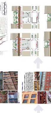
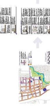
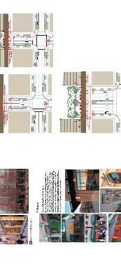

84

.")
85 Arlington County, Virginia, Columbia Pike Corridor Form-Based Code Columbia Pike is the historic "main street" of the southern portion of Arlington County, Virginia. The county has seen explosive development along other major corridors for the past thirty years, but the Pike Corridor has remained stagnant. County officials joined forces with the Columbia Pike Revitalization Organization (CPRO) in an effort to encourage development that is pedestrian friendly and conducive to future potential mass transit options along the corridor (Retrieved from advanta~e.comlassets/columbia~2opike.pdf on October 20,2006). The CPRO was founded during previous revitalization attempts for the corridor and contributed Figure 4.11 Existing Conditions, Columbia Pike Corridor with county planners in a two-year educational and visioning process, culminating with the Arlington County Board adopting a plan in the spring of 2002 to target the Columbia Pike Corridor for revitalization. Many ethnic businesses along the corridor are owned by recent immigrants - Ethiopians, Guatemalans and Salvadorans to name a few (Peirce 2003, 1). The roadway has served functionally as a way to move traffic quickly through the area to other parts of the county. So, the corridor is not an economic or transportation failure. But the area
86 ~ -. Form-Based Codes hasn't seen any major construction for over 40 years, and the building stock consists primarily of commercial strip centers, fast food restaurants and parking lots typical of older commercial corridors (Peirce 2003, 1). How it Works Through a charrette process conducted by Dover Kohl Associates of Miami in 2002, Geoffrey Ferrell and Associates (now Ferrell Madden) produced the Columbia Pike Special Revitalization District Form-based code. The Code is a parallel zoning district that overlays the existing Euclidean zoning along the corridor. The ordinance contains all the components to be considered a complete form-based code: 1) regulating plan, 2) building envelope standards, 3) streetscape and architectural standards and 4) glossary. In addition, an illustrative plan shows four areas along the 3.5 mile section of the roadway where redevelopment is to be focused. Each of these four areas - the Town Center, Village Center, Neighborhood Center, and Western Gateway - has a specific regulating plan. The Form-based code is integrated into the existing Euclidean zoning format of the county's zoning ordinance as its own district (CP-FBC). L. L,,,- -,,,.,,. - : i. -, d..?'. - A '3. " I, -."... I, '7.i.-' -, ' I., , :.,,, :-,,.. - I,. - ': NEIGHBORHOOD C EfiTER,-I,.-.l ".!.' r':7:7 :.-!' 1.. ', I1 -,: --.:.,-.I.',.:.. ' 1.4 r ~ '1 I:., -...'. '. L '.,, - -..,.' ,, ;:. :,,,!.>'.. ;1,? i"?, WE5TERPI GATEWAY.... _:, J r,.>: ' I..,,, -,.; ;Ii, ' :. 3' >, ' Figure 4.12 Columbia Pike Corridor, Illustrative Plan showing three of the redevelopment areas along the 3.5 mile corridor in Arlington County, Virginia.
87 The Columbia Pike Initiative Administrative Review Team is in charge of all development proposal reviews within the CP-FBC district. This review team consists of city staff members including a project coordinator, design specialist, zoning specialist, transportation planner and business development specialist. Under the code, applicants have a by-right option and special exceptionluse permit option (Arlington County, Virginia 2004, 53). Projects less than 40,000 square feet that conform to the Code can be built by right in the district. The review team is required to review proposals within 30 days of a completed application. Projects larger then 40,000 square feet or projects not in conformance with the Code must be processed using the special exception use permit option. This allows for appropriate deviations of the code that are deemed constant with the goals to revitalize the Columbia Pike and requires a 55-day review process (Arlington County, Virginia 2004, 54). In both processes, the Review Team seeks comments from the Columbia Pike Revitalization Organization and affected civic associations prior to approval of plans. This is an opportunity for the CPRO and civic associations to review the plans and the staffs analysis of their compliance with the Columbia Pike Corridor Form-based code. The special exception use permit also requires notification of abutting property owners. Additional incentives have also been incorporated into the revitalization of the corridor including a dramatic reduction of on-site parking requirements and the availability of tax increment financing for project-related public improvements. Successes The success of one of the most written-about form-based codes is still far from conclusive. Even though writers such as Neil Peirce have written that the code could be 74
88 Figure 4.13 Potential Build Out appearance of the Columbia Pike Town Center, Arlington County, Virginia. "A Cure for Cluttered Roadways" and that numerous projects were approved or in the pipeline for a quick approval in 2003, as of June 2006, the corridor still had not attracted significant new development. In fact, according to Arlington County Planner Richard Tucker, who is involved with administering the Columbia Pike Corridor Form-based code, there has been no new development aside from a stand-alone bank and a stand- alone drug store over the past twenty years (Personal Communication June 16, 2006). There are two significant mixed use projects that have been approved, though. Columbia Station is a 257-unit condominium project with 42,000 square feet, of retail space and Columbia Village has 235 condominium units and 7,500 square feet of retail space. In addition, a third project, Penrose Square, is scheduled to be reviewed by the Planning Commission in July, This project would add 299 rental units to the corridor and include 95,000 square feet of retail space, including a grocery store (Richard Tucker, Personal Communication June 16, 2006). These projects indicate that the Code is beginning to work as it was originally intended, but this slow start to the redevelopment of the corridor has raised doubts about the effectiveness of a incentive-based, parallel form-based code as a economic stimulus. Currently, even if the Planning Department would determine that a proposed project would be good for the corridor, it would be
89 discouraged if it is not in conformance with the CP-FBC (Richard Tucker, Personal Communication June 16, 2006). But it is not clear whether the Planning Commission would deny site approval for a project that is submitted only in conformance with the existing (parallel) zoning for the corridor. The streamlined approval process also has been a situation of hit and miss. The expedited process has allowed public review, which has shortened the process, yet the time for the staff review to make sure the site plan complies fully with the form-based code has taken longer than anticipated (Richard Tucker, Personal Communication June 16, 2006). Other city departments do work to comply with the code, but certain departments, such as Transportation, do so only because they are required to. This has led to numerous amendments to the code, which have been time consuming (Richard Tucker, Personal Communication June 16, 2006).


90 Figure 4.14 Columbia Pike Corridor, Town Center Regulating Plan, Arlington County, Virginia.


91 - LWa-urmrm-Hm l i ~ m m a a s t d h d ~ m 6bradam-hb*thr*a. dr+ndnmifnruda~rdrra~ md-*m Ibww- m arn--rd 2 m H b o ~ ~ - h - a --xd---inm, h#rawa-.lr~ilcnmw -4h-h=r& h m r f &, l m r s d t h s ~ ~ ~ ~ t h r s m a w r w. r r d l m a Y r Ummmt-rnmtwmrarr (WbdBmmrn~ww m-xan-btlm-mm rnscadkraa Figure 4.15 Columbia Pike Corridor Main Street Building Envelope Standards, Arlington County, Virginia.
92 Chapter Five: Form-based code within the Context of Dynamic Planning It is important to frame the discussion of form-based codes used as a regulatory tool to improve the results of redevelopment plans by discussing the process and merits of the dynamic planning process. Historically, city planning efforts have often been initiated by private organizations. Daniel Burnham's Plan of Chicago, published in 1909, was funded by the Commerce and Merchant Clubs of Chicago. In Lincoln, the first comprehensive zoning map was sponsored by the local Commerce Club. Even through city plans, such as the Lincoln Comprehensive Plan, have since become largely the responsibility of city planning departments, citizen involvement in the planning process is critical to the legitimacy of the process itself. The noted urban planner Alexander Garvin, author of American Cities, What Works, What Doesn 't, defines planning as "a public action that generates a wide-spread and lasting market reaction" (Garvin 2006). If the "public action" is not the wish of the community it is to serve, will the private market reaction be what is desired? The process of dynamic planning puts research, public education and participation to the forefront of any "public action" in order to better ensure it is the community's vision. By doing so, this type of process can overcome political, financial and design challenges that could take years to overcome in a more typically static planning process. Dynamic planning has three phases: 1) Project research, education and charrette preparation; 2) The charrette process; and
93 3) Project implementation. Phase one of the process should include stakeholder outreach, base data research and analysis, and public meetings conducted in an effort to gain trust between project sponsors and community members (Lennertz and Lutzenhiser 2006,45) The public education and stakeholder outreach aspect can take numerous forms, but here are a few approaches to consider: A series of lectures from leading experts, critics and authors that discuss the issues at hand for a specific planning project, national trends, or case studies of similar projects A forum of leaders from nearby communities to share experiences in their recent planning experiences dealing with similar projects Use of visual assessment surveys, which can help community members better understand the options for future development in an area. These surveys include public preference ratings for different types of spaces through the use of existing photographs and threedimensional images of possible future development. City Council and Planning Commission members touring other project sites in communities that have traits similar to the current local project Use of the city television channel to air some or all of these educational opportunities to reach the widest possible demographic of the community.
94 Use of the local newspaper and releases of relevant printed material to help market and promote the process as a part of the larger community visioning process. Regardless of the methods used to accomplish this research and education phase, the most important concept is the stated goal of raising public awareness and building consensus that alternative planning approaches should be considered. A charrette functions as the core phase of the dynamic planning process. The term "charrette" is often overused and misused to describe many types of public involvement. In reality, a charrette should be a multi-day (4 to 7 days are preferred) planning process during which an interdisciplinary professional design team creates a complete and buildable plan that reflects the input of all stakeholders who are involved by engaging them in a series of feedback loops (Lennertz 2003, 12-3). This process occurs through a series of feedback sessions, as stakeholders review subsequent design concepts that evolve through stakeholder input. These sessions are scheduled at various times of the day to accommodate citizens' different time restraints. The multi-day process allows "word-of-mouth advertising to occur between citizens, generating greater interest and participation from the public (Lennertz 2003, 12-5). The result of this design process is a public presentation that includes all elements of the project, including: A master plan Building elements Economic and transportation impacts and strategy An implementation action plan
95 To capitalize on the energy of a charrette-produced plan, quick approval of such a plan by a city council or other governing body is important. Some communities have held the charrette final presentation of a plan in conjunction with a city council meeting (Lennertz 2003, 12-5). Through this dynamic planning process, many communities realize that the current zoning and subdivision ordinances for an area will not produce the desired outcome of the community's vision. The planning processes of Farmers Branch, Texas, and Arlington, Virginia, discussed in Chapter Four both resulted in the belief that a new implementation process was necessary. Form-based codes have become a popular alternative to traditional zoning as the tool that a community uses to implement a plan created through the dynamic planning process. A form-based code is written after a community's vision has been established and a strong consensus exists for the future of an area. The code is based on that vision and allows an area to develop as the community planned it, but only when property owners deem the market is ready for such development.


96 Chapter Six: A New Approach for Redevelopment in Lincoln Figure 6.1 South Street Redevelopment Area with Surrounding Neighborhoods This chapter examines a specific opportunity to use dynamic planning in the City of Lincoln and how a form-based code could be used to regulate the vision created from that dynamic planning process. The redevelopment plans for Farmers Branch, Texas, and Arlington, Virginia, are only two of many possible examples of communities across the country that have specific planning documents to guide the redevelopment of an existing urban area. Lincoln is no different, currently having five active redevelopment efforts in
97 process. Many older, urbanized areas that have become distressed or were never fully developed face certain disadvantages compared to suburban, greenfield developments. To combat disadvantages such as diversified ownership and outdated infrastructure, programs and tools such as Nebraska's Community Development Law and the federally funded Community Development Block Grant program have been created to assist in redevelopment efforts. A dynamic planning process, as detailed in the last chapter, used by a community open to alternative planning and land regulation methods and committed to a strong vision for a specific area, may improve the results of redevelopment plans that use the resources provided by such programs. A form-based code is an alternative regulatory tool that could better enhance the public realm and encourage greater investment in a redevelopment area. Lincoln's South Street Business Corridor is one such area that could benefit from the combination of dynamic planning and form-based code. This portion of South Street from 8"' street to 18th Street is currently going through the redevelopment process and exhibits many characteristics that lend it as an area where a strong community vision that is expressed by regulations focused on form could be applied. Historical Perspective of the South Street Business Corridor South Street has long served Lincoln as a center of activity for its surrounding neighborhoods. A section of the street between loth and 1 4 streets ~ ~ was platted by the early 1870s as part of Dawson's Subdivision, one of the first additions to the original plat of the city. Despite a narrow sixty-six foot right-of-way, the street's location and adjacent land uses made it a major thoroughfare early in Lincoln's development, and became a prime corridor along which commercial development would occur. As the 84

98 Lincoln Traction Company's network of streetcar lines expanded throughout the city, South Street become a major intersection for four different routes. The streetcar line running eastlwest on South Street provided service along Sheridan Boulevard * Figure , *>c-..-.-~... L"L. I Sanborn Atlas, 14th and South streets and as far east as College View. Three streetcar routes intersected with South Street, loth St (to the State Hospital) 1 4 Street ~ ~ (to the State Penitentiary) and 17th Street (terminating just south of South Street). This concentration of activity stimulated development of I I - - _- Lr. i a level of density and mix of uses along the corridor that was common for urban areas in the Figure 6.3 Street Car line at 14th & South, looking West, early 2oth century, The commercial 1920's buildings facing South Street from 9th Street to Street were built up to the property line, addressed the street, and had shop windows for pedestrians and streetcar passengers to peer through. These businesses served many of the daily needs of residents of adjacent middle class neighborhoods, as well as the more affluent Sheridan Park and Franklin Heights neighborhoods approximately eight blocks to the east on South Street. 85
99 Figure 6.4 Lincoln Street Car Lines, 1924.

100 Early tenants of these buildings included a bakery shop, grocery stores, pharmacy, barber shop and other common service type businesses. The area also served the community as a major health care center. St. Elizabeth's Hospital, established in 1889, was located on the south side of South Street at 15'" Street and was one of the largest employers in the city Figure 6.5 St ~lizabeth's Hospital (Cheerier 1890, 45). Lincoln General Hospital was built in 1923 on 17'" Street, two blocks south of South Street. Saratoga Elementary School was built just one block south of South and 13'" Streets in 1893 to serve the expanding neighborhood and added to the mix of activities in the area (Ed Zimmer, Personal Communication July 26'", 2006). As Lincoln transitioned from a community built around pedestrian mobility and mass transit to the automobile, the South Street business corridor maintained its role as a center of commercial activity for the neighborhood. Stand-alone, auto-oriented businesses such as fast food restaurants, drive-through banks and gas stations were added to the mix of uses on the corridor. In fact, by the 1920s several "filling stations" were already in place along South Street (Sanbom 1928, 3;345). A larger neighborhood Hinky Dinky grocery store was built on the southwest comer of 17'" and South in A Safeway grocery store built in 1973 on the northeast comer of 16'" and South has since been converted into a suburban style commercial strip development. To accommodate the growing traffic count, South Street was widened in 1966 (South Street History (n.d.) Retrieved from htt~://www. southstreetim~rovements.com/ on July 27, 2006). During
101 this time, the corridor showed the signs of decline typical of a neighborhood that was past its height of success as the city continued to push to the south and east with new neighborhoods and newer commercial and retail locations. The Need for Redevelopment of the South Street Business Corridor By 1982, the decline of the South Street business corridor was apparent to civic leaders. A blight study was commissioned for the area and was conducted by the firm of Clark Enersen Partners (Ernie Castillo, Personal Communication July 14, 2006). Even though there was a level of concern at this time, the area was not declared blighted. Concern for the corridor rose again in the late 1990s, as the Near South and Irvingdale Neighborhood Associations contacted the city's Urban Development Department to examine options to revitalize the area (Ernie Castillo, Personal Communication July 14, 2006). At the time, the socio-economic characteristics of the neighborhoods adjacent to South Street precluded use of Community Development Block Grant (CDBG) funds for redevelopment of the corridor, except for the northern side of South Street from approximately 8th Street to 17'" Street. The area on the south side of South Street would not have qualified for CDBG funding assistance. This division of the corridor halted any effort by the city to improve the corridor through a streetscaping project. By 2003, new U.S. Census data indicated that the southern half of South Street also would be eligible for CDBG funding, so a streetscaping project was added to the future projects list for the Urban Development Department (Ernie Castillo, Personal Communication July 14, 2006).
102 In 2005, the South Street Streetscaping project became a priority for the Form-Based Codes Department in an effort to coordinate their efforts with road improvements proposed by the city Public Works and Utilities Department. A public involvement process was initiated, with focus groups including area property owners, business owners and the Irvingdale, Near South and Everett Neighborhood Associations meeting to discuss the issues with the South Street business corridor. The most important issues included the overall safety of the area (including pedestrian safety), crime prevention, business development and design guidelines (Ernie Castillo, Personal Communication July 14, 2006). Resulting from the cooperation of the neighborhood associations, property owners, and business owners, the South Street Business and Civic Association was formed. This association consists of fourteen board members and meets monthly to discuss the issues of the corridor and the progress and direction of the redevelopment efforts. With this public involvement in mind, the Urban Development Department decided that a redevelopment plan in addition to the streetscaping efforts, would be desirable to guide revitalization of the corridor. Since 1975, Nebraska cities have been given the power to carry redevelopment programs through the establishment of a Community Redevelopment Authority (Nebraska R.S ). To use the powers of this authority, which includes land acquisition and tax increment financing, a community is required to use a specific procedure. This begins with the community declaring the redevelopment area as "blighted. The range of conditions that lead to a blight declaration includes: a substantial number of deteriorated or deteriorating structures existence of defective or inadequate street layout faulty lot layout in relation to size, adequacy, accessibility, or usefulness unsanitary or unsafe conditions
103 deterioration of site or other improvements diversity of ownership tax or special assessment delinquency exceeding the fair value of the land defective or unusual conditions of title improper subdivision or obsolete platting; and existence of conditions which endanger life or property by fire and other causes. (Nebraska Community Development Law Website, Section Retrieved from on August 14, 2006). In any blighted area, one of these five mandatory conditions must be present: unemployment in the designated area is at least 120 percent of the state or national average average age of residential or commercial units is at least 40 years more than half of the plotted and subdivided property in the designated area is unimproved land that has been within the city for at least 40 years and has remained unimproved during that time the per capita income of the area is lower than the average per capita income of the city or village in which the area is located; or the area has had either stable or decreasing population based on the last two decennial censuses. (Nebraska Community Development Law Website, Section Retrieved from htrt qn August 14, 2006). If an area is declared blighted, a community can proceed with a redevelopment plan for the area. The plan must conform to the comprehensive plan of the community and outline the actions to be taken for the redevelopment to occur. The Community Development Law also requires the plan to be "sufficiently complete to indicate its relationship to definite local objectives as to appropriate land uses, improved traffic, public transportation, public utilities, recreation and community facilities and other public improvements and the proposed land uses and building requirements in the redevelopment project area" (Nebraska R. S ). One of the advantages of using the Community Development Law is that it permits the use of tax-increment financing (TIF) as a method to fund the public improvements needed for a redevelopment area. TIF does this by using the additional


104 property taxes that are created by individual projects within the redevelopment area. When TIF is applied to a redevelopment area, property tax collected from the pre- redevelopment valuation of the property continues to be received by all taxing districts. Once a redevelopment project creates an increased property valuation, the additional property tax (the increment) collected is directed to the Community Redevelopment Authority (CRA) to pay interest due on bonds used for the public improvements of the redevelopment plan (Nebraska Community Development Law Website, Section Retrieved from lttp:iinevlannin~r.unl.edu/index.html on August 14, 2006). Lum*I*@LlbVbn-m Figure 6.6 South Street Blight Study Area 2006, City of Lincoln Urban Development Department. A blight study has been completed by Hanna Keelan Associates that defines the area from 8th Street to 17'" Street along South Street (See Figure 6.6) as blighted (Lincoln Journal Star, 11 July 2006). The Lincoln City Council approved a declaration of blight for the area on July 10, The Urban Development Department plans to present a
105 redevelopment plan for South Street in September 2006 with bids being solicited in the fall of 2006 for a South Street improvement project that would start in the spring of The Potential for the South Street Business Corridor The redevelopment of urban corridors has been an issue for many communities. Urban corridors often are subject to street widening that is designed to move automobile traffic quickly through areas that were built originally with the pedestrian also in mind. To adapt to an automobile dependent society, new developments are commonly designed with buildings sited a significant distance from the street and with parking lots located in between the building and the street right-of-way. The result of this inconsistent mix of building siting approaches along partially redeveloped urban corridors is an area that lacks any real sense of place and, in turn, becomes an undesirable place to be. The Columbia Pike Corridor case study illustrates just one example of a community using form-based code to reclaim thoroughfares lost to the singularity of the automobile as the design determinant. The City of Memphis has launched the Broad Avenue Plan Initiative in an effort to revitalize a once thriving neighborhood that was tom apart by a planned freeway that was never completed. A charrette report and master plan has been completed for the area, and Ferrell Madden Associates has been hired to draft a formbased code as a part of the strategy to revitalize the area. The citizens of Denver acknowledged that zoning reform was necessary in both the 2000 Comprehensive Plan and the 2002 Integrated Land Use and Transportation Plan, entitled Blueprint Denver (Denver, Colorado 2005, Ordinance 660). The City Council of Denver passed an ordinance in September 2005 authorizing three new form-based "Main Street" zoning districts for the plan. These new zoning codes are designed for use in urban corridors to 92
106 better reflect community goals. The new codes intend to relieve adjacent neighborhoods of density issues while encouraging mixed used, higher density development along the corridor itself. The first use of the Main Street district is an implementation of the redevelopment plan for East Colfax Avenue (Retrieved from July 20, 2006). The Intent section of the zoning district text makes several important statements that indicate that the citizens of Denver believe regulation is not just about use: (4) Improve the function and appearance of commercial streets, and enhance the convenience, ease and enjoyment of transit use, walking, shopping and public gathering. (5) Clearly define and activate the public realm by locating buildings to form street edges and corners, and locating entrances and windows to activate the street level. (6) Define building forms to be compatible with their context. (Denver 2005, Main Street Zone Fact Sheet 1) Currently in Lincoln, five redevelopment projects for urban corridors are in various stages. Four of these are older, established corridors, including the 48th and 0 Street area, North 27th Street, West 0 Street, and South Street. The fifth area is the Antelope Valley project, which involves large-scale redevelopment. The North 27th Street IZ. redevelopment plan was adopted in 2002 and has led to numerous redevelopment projects along the corridor. The project is clearly a success on many fronts. The streetscape project has improved the Figure 6.7 Redevelopment on North 27th Street, Lincoln, Nebraska appearance of the corridor, and numerous commercial projects have been built in
107 accordance with the area's redevelopment plan using tax increment financing as an incentive. Even with these accomplishments, there may be room for greater success with similar redevelopment plans in the future. If the North 27'" Street redevelopment were measured against the standards of the Denver Main Street Zoning Ordinance, does it accomplish the goals to "clearly define and activate the public realm" or define "building forms to be compatible with their context"? The answer is no. The North 27th Street Redevelopment Plan does establish similar guiding principles: A Pedestrian Friendly Environment: The entire corridor redevelopment should provide a safe and positive environment for pedestrian movement by: a. Providing clearly marked and signaled major street intersections. b. Using pedestrian scale lighting and graphics along 27th Street. c. Providing clear paths from adjacent neighborhoods to the 27th Street corridor and activity centers near or along 27th Street. d. Developing pedestrian overpasses and connectors at strategic points along the corridor. e. Requiring new projects to provide direct connections from front door of businesses to 27th Street sidewalks. f. Encouraging project designs which place commercial buildings rather than parking lots along the street. (North 27th Street Corridor and Environs Redevelopment Plan 2002,23) Has the redevelopment on the North 27th Street Corridor adhered to these principles? To some extent, yes, but has it consistently produced redevelopment providing direct connections from the front door to the 27th Street sidewalk or commercial Figure 6.8 Example of existing urban form of North 27th Street buildings along the street (sections e. and f.)? The answer is no; most of the projects under the redevelopment plan have taken the form of suburban, strip-style commercial
108 buildings. The opportunity was lost to capitalize on the area's existing good urban forms that have proven their sustainability and to maintain and improve upon those forms for the benefit of the neighborhood. An Urban Village on South Street through Form-based code Place neighborhood of Lincoln acts as park-once, pedestrian friendly, mixed-use area. The potential redevelopment of the South Street Business Corridor of 8"' to 18'~ street is a rare opportunity for the area's citizens, property owners and business owners to transform the corridor from an under-utilized commercial strip to something closer to its potential: an inviting, pedestrian-friendly neighborhood center. In comparison to Lincoln's other redevelopment areas, the South Street business corridor presents the greatest opportunity to create an "urban village" with characteristics of places like
109 University Place or Havelock. Author David Sucher best describes how to identify an urban village: "...while you are driving round a modem American city, you come across a commercial district where you want to get out of your car and stroll around. You have found an urban village..." (Sucher 2003, 16) A modem urban village is similar to places like the South Street Business Corridor during the early 2oth century-multi-modal, mixed-use centers of activity serving surrounding neighborhoods (See Appendix C for examples of urban villages). The urban village is similar in concept to the popular "lifestyle center" model used by suburban developers. The Village Pointe shopping center in West Omaha is an example of a lifestyle center that encourages a park-once shopping, dining and entertainment area. The Wilderness Hills Lifestyle Center, to be located near South 27th Street and Yankee Hill Road, in south Lincoln will be another example of this mixed use retail concept. Lincoln's two major traditional neighborhood developments, Fallbrook and Village Gardens, both have plans for mixed use town centers to serve their respective neighborhoods. The South Street Business Corridor has several important attributes that suggests its potential as an urban village. It is surrounded by tightly woven neighborhoods Near South Everett South Salt Creek Irvingdale Total Population 10,808 3,662 3,235 2,562 20,267 Total Households 5,503 1,988 1, ,758 Table U.S. Census Statistics for Neighborhoods adjacent to South Street consisting of a mix of housing types that are well connected to the corridor through a street grid. These neighborhoods are of a higher density than the rest of the city (See Figure 6.6 for map of South Street Business Corridor and adjacent neighborhoods).
.")

. Figure 6.")
110 According to the 2000 United States Census, Tracts 22 and 23, which encompasses the South Street Blighted Area have a density of 5,434 persons per square mile, which is a higher density then the city average of 3,022 persons per square mile (See Figure A5 and A6 in Appendix A). There is a total population within the four neighborhoods of 20,267 with 9,758 total households (See Table 6.10). This higher density and the presence of Bryan LGH West Hospital as a major employer and visitor attraction gives the corridor a built in-base of potential pedestrian traffic and public transportation users (See Figure 6.11). Figure 6.11 Bus routes, South Street Business Corridor The area currently does have numerous successful businesses to build around, and property owners and developers appear interested to invest in the area. The additional parking structures recently built by Bryan LGH have the potential for serving parking needs in the corridor beyond the immediate needs of the hospital. Many other cities with
111 similar redeveloping urban centers use an in-lieu parking program that encourages the use of parking garages in an effort to have pedestrian oriented, park-once districts. The proposed streetscaping program that is scheduled for South Street in 2007 and the potential for tax increment financing as a result of the redevelopment plan should encourage these efforts. But without a regulatory code that builds upon and encourages good urban form, South Street could see the same suburban-type development that has occurred in conjunction with the North 27'" Street redevelopment plan The existing zoning for the South Street Business Corridor encourages neither the guiding principles of the city's Comprehensive Plan nor the environmental qualities envisioned in the forthcoming South Street Redevelopment Plan (See Figure 6.6 for zoning map). The following are excerpts from these guiding documents. For additional information, including illustrations please refer to the Appendix at the end of this chapter. The South Street Redevelopment Area Blight and Substandard Determination Study staff report lists six objectives of the Comprehensive Plan to be met by the redevelopment plan for South Street: F-17 "Maximize the community's present infrastructure investment by planning for residential and commercial development in areas with available capacity. This can be accomplished in many ways including encouraging appropriate new development on unused land in older neighborhoods, and encouraging a greater amount of commercial space per acre and more dwelling units per acre in new neighborhoods. F-17 Preservation and renewal of historic buildings, districts, and landscapes is encouraged. Development and redevelopment should respect historical patterns, precedents, and boundaries in towns, cities and existing neighborhoods. F-18 "Encourage mixed-use redevelopment, adaptive reuse, and in-fill development including residential, commercial and retail uses."
112 F-49 "Encourage renovation and reuse of existing commercial centers. Infill commercial development should be compatible with the character of the area and pedestrian oriented." F-49 "Maintain and encourage retail establishment and businesses that are convenient to, and serve, neighborhood residents, yet are compatible with, but not intrusive upon residential neighborhoods." F-49 "Encourage efforts to find new uses for abandoned, under utilized or "brownfield" sites that are contaminated." (LincolnILancaster Planning Commission Staff Report, June 7, 2006) The Lincoln-Lancaster County Comprehensive Plan calls for commerce centers (See Figure A1 in Appendix A) that share attributes with urban villages. In the Future Business and Commerce section of the plan states: "Commerce Centers should develop as compact clusters or hubs with appropriate site design features to accommodate shared parking, ease of pedestrian movement, minimize impacts on adjacent areas, and possess a unique character." (Lincoln Comprehensive Plan 2000, F41) "Commercial locations should be easily accessible by all modes of transportation including pedestrian, bicycle, transit and automobiles. Centers should be especially accessible to pedestrians and bicycles with multiple safe and convenient access points." (Lincoln Comprehensive Plan 2000, F42) The Future Residential section of the Comprehensive Plan states several guiding principles for existing residential areas (See Figure A2 in Appendix A) that are compatible with an urban village; 2. Encourage pedestrian orientation with parking at rear of residential and neighborhood commercial uses. 3. Require new development to be compatible with character of neighborhood and adjacent uses (i.e., parking at rear, similar setback, height and land use). 4. Encourage a mix of housing types, including single family, duplex, attached single family units, apartments, and elderly housing all within one area. Encourage multi-family near commercial areas. (Lincoln Comprehensive Plan 2000, F 69)
113 The South Street Business Corridor is also considered an existing pedestrian district in the city (See Figure A3 in Appendix A), and the Lincoln-Lancaster County Comprehensive Plan calls for standards to be applied in these districts: "Pedestrian level of service standards in these areas should be high. These areas should have direct, continuous sidewalks with safe street crossings. Visual interest and amenities should serve to attract people to these districts." (Lincoln Comprehensive Plan 2000, F91) The South Street Redevelopment Plan will have "Design Principles" that state the community's desire to have a more pedestrian friendly, urban place that fits well in the form context of the area. The plan will also call for guidelines to be based upon these principles. These guidelines would be applied in additional to the current B-3 zoning regulations (See Figure A4 in Appendix A) for the South Street Business Corridor. This current zoning, by being proscriptive in nature, fails to require the form of proposed redevelopment projects to adhere to the vision of the corridor that has been established in the Comprehensive Plan and Redevelopment Plan. The B-3 Commercial district clearly delineates that retail businesses such as barber shops and tailor shops are permitted uses (See Figure A4, pages in Appendix A). The specific nature of text describing permitted uses includes only generalities when dealing with the height and area regulations, such as the front yard, which has no minimum required, allowing a building to be placed anywhere between the front and back lot lines. These regulations give no indication of how a new development will add to or define the public realm, that is, the street, sidewalk and other public spaces that we all share. To illustrate the issue that the current zoning cannot control the desired type of development for South Street, consider other B-3 districts in the city. The B-3 100
114 district was originally written as part of a larger reworking of the entire city's zoning ordinance in The B-3 district is generally used for existing urban areas, such as University Place, College View and North 27'" Street (See Figure 6.8). The district allows buildings placed up to the right-of-way and vertically mixed uses. Yet, the 2002 Redevelopment Plan for North 27'" Street, in its "Guiding Development Principles" acknowledges the need for a new regulatory device to achieve its goals: 9. Regulatory Framework: Develop zoning and signage regulations for the 27th Street corridor which recognize its mixed use character and the objective of reducing visual conflicts. Elements should include: a. Developing an urban corridor overlay district as a combination or replacement for the current B-3 zoning in the study area. b. Implementing new sign standards for the corridor. (North 27'" Street Corridor and Environs Redevelopment Plan 2002,23) Even though the redevelopment of the corridor has been occurring for over four years, no new zoning or design guidelines have been approved (See Figure A7 in Appendix A) for the area and projects along the corridor have taken a distinctly auto-oriented, suburban appearance. (See Figure 6.7) The Case for Form-based code for the South Street Business Corridor The evidence that a new regulatory tool is needed to implement the goals of redevelopment plans for areas such as South Street comes from many different sources. As with communities such as Denver and Memphis, the case for regulatory reform for urban corridor redevelopment projects has been growing in Lincoln for many years. The current planning process has brought forth many of these points, including: South Street has strong historical precedent as a commercial and employment center for adjacent neighborhoods. Initially, South Street 10 1
115 served as a multi-modal transportation corridor that accommodated public transit, personal mobility and pedestrian activity simultaneously. The last sixty years have seen a gradual transition to an auto-oriented transportation corridor. The South Street Business and Civic Association has expressed an interest in returning the area between 8"' and 18'" Streets to a pedestrian friendly area based on extant urban building types found on South Street. The adjacent neighborhoods have the necessary density levels and connectivity to South Street to support an urban village concept. The presence of Bryan LGH Medical Center West as a major employer and visitation center provides additional pedestrian activity and requires mass transit. The current B-3 zoning has failed to produce the urban, pedestrian friendly areas that are called for in existing redevelopment plans and the neighborhood centers, such as South Street, described in the city's Comprehensive Plan. Other communities facing similar redevelopment efforts have turned to form-based codes as a way to regulate the public realm in such a way that pedestrian friendly, multi-modal, mixed use neighborhood centers are supported. The current revitalization efforts for the South Street Business Corridor would be aided by a code that regulates the form of the built environment and by doing so, protects and enhances the public realm. A form-based code-created through input from citizens
116 of the adjacent neighborhoods, current business owners and effected property ownersthat controls the three dimensional qualities of new construction along the corridor may be of the greatest benefit for all interested parties. In a hypothetical scenario, the City of Lincoln could begin its own dynamic planning process to execute the writing and implementation of the South Street Business Corridor Form-based code (SSBCFBC). The document prepared by this author could serve as a springboard to the research and public education portion of the planning process. Additional education opportunities could include guest speakers on concepts like form-based codes and other smart growth practices by local experts such as Doug Bisson of HDR Inc and nationally known figures such as Bill Lennertz, executive director of the National Charrette Institute. A charrette session would then be organized, inviting all key members of the South Street area to participate in the design process of a new regulatory code. This charrette session would be headed by a consultant who has extensive experience with the charrette process and who could effectively illustrate the community's vision for the area. If the charrette process produces a community vision for the South Street Business Corridor that reflects many of the same concepts that have been expressed collectively by the South Street Business and Civic Association, the LincolnILancaster County Comprehensive Plan and the South Street Redevelopment Plan, a form-based code may be the best regulatory tool for the Corridor. The code could consist of a newly created zoning district (serving in a similar capacity as a regulating plan) within the current city zoning ordinance that contains both text and illustrations (that would serve as the city's building envelope standards). If the community vision includes certain architectural elements that bring desired design cohesion to the area,
117 architectural standards also could be produced. The code would encourage development that would result in the type of pedestrian-friendly, mixed use area the City of Lincoln is trying to accomplish for its existing and future commercial centers. The following pages exhibit a Regulating Plan and Building Envelope Standards for the South Street Business Corridor similar to those that may have been produced if a dynamic planning process had occurred. Two street types, a South Street Frontage-1 and South Street Frontage-2 are suggested for the Regulating Plan. Several Building Envelope Standards are presented to illustrate how the public realm would be defined for the area.


118 The South Street Business Corridor Regulating Plan
 15' from Right of Way 60% of South Street Frontage-2 must be occupied ide Street Frontage must be")
119 Building Envelope Standards (RBL) 8' from Right of Way Required 3' high screening if building not builtto Right-of-way to maintain streetwall 80% of South Street Frontage-1 must be occupie South Street (RBL) 15' from Right of Way 60% of South Street Frontage-2 must be occupied ide Street Frontage must be occupied by


120 Parking Lot Screening Parking lots shall be screened from the ground to 3' above the surface of the lot within a minimum 6' landscape strip. Parking lots adjacent residential districts shall be screened from the ground to 10' at least 60 Zone of Transparency -a- * 60% of the area between 3'6" and 8'6" above grade must contain windows on any South Street Frontage 5% of the area between 3'6" and 8'6" above grade must contain windows on any Side Street


121 Main Entrance Option A Primary entrances are required to face Main Streets Main Entrance I F Option B A primary street facing entrance may be angled on the corner or the may be setback no more than 10' from the Main Street property


122 I Building Height South Street Frontage-I 2 to 4 story buildings required on lots fronting South Street Frontage-1 South Street Frontage-2 20 foot minimum requirement on lots fronting South Street Frontage-2
123 Appendix A: City of Lincoln Maps %e~b R d Buff Rd I Existing and Proposed Commerce Centers Figure A1 : Map of Commerce Centers


. 4.")

 as centers of neighborhood - encourage shared parking whenever possible - permit minor incursions")
124 Figure A2: Existing Neighborhood Principles The image is an example of how these piinciples might work together in an existing neighborhood, including the following principles: 1. Encourage a mis of compatible land uses in neighborhoods, but similar uses on the same block face. Similar housing types face each other: single family faces single family, change to different use at rear of lot. Commercial parking lots should not intrude into residential areas where residential uses predominate a block face. More intense commercial uses (gas stations, big box stores, car wash, fast food; etc.) may not be compatible due to impact on nearby housing. Expansion in esisting centers should not encroach, or expand to encroach, on existing neighborhoods, and commercial areas must be screened from residential areas. 2. Encourage pedestrian orientation with parking at rear of residential and neighborhood commercial uses. 3. Require new development to be compatible with character of neighborhood and adjacent uses (i.e., parking at rear, similar setback, height and land use). 4. Encourage a ms of housing types, including single family, duplex, attached singlc family units, apartments, and elderly housing all within one area. Encourage multi-family near commercial areas. 5. Encourage retention of single family uses in order to maintain mix of housing. 6. Encourage historic presen~alion and the rehabilitation and maintenance of buildings. 7. Maintain small parks and open space within walking distance of all residences. 8. Support retention of public uses (elementary schools, churches) as centers of neighborhood - encourage shared parking whenever possible - permit minor incursions of accessory parking for public/semi-public uses into neighborhood if properly screened. 9. Transit stops integrated into commercial center, near arterial. 10. Maintain existing pattern of streets 11. Arterial streets compatible with the existing character with two through lanes and a center turn lane.
125 - Figure A3: Map of Lincoln's Pedestrian Activity Centers
126 Figure A4: City of Lincoln/Lancaster County B-3 Zoning District Chapter B-3 COMMERCIAL DISTRICT Sections: Scope of Regulations Permitted Uses Permitted Conditional Uses Permitted Special Uses Accessory Uses Parking Regulations Pedestrian Circulation Regulations Sign Regulations Grading and Land Disturbance Regulations Height and Area Regulations. This is a district providing for local commercial uses in a redeveloping neighborhood generally located in established retail centers of those neighborhoods. The uses permitted generally are those for neighborhood uses, plus additional limited manufacturing uses that reflect the character of that commercial area Scope of Regulations. The regulations set forth in this chapter, or set forth elsewhere in this title when referred to in this chapter, are the regulations in the B-3 Commercial District. (Ord $205; May 8, 1979) Permitted Uses. A building or premises shall be permitted to be used for the following purposes in the B-3 Commercial District: (a) Parks, playgrounds, and community buildings, owned or operated by a public agency; (b) Public libraries; (c) Public elementary and high schools, or private schools having a curriculum equivalent to a public elementary or public high school, and having no rooms regularly used for housing or sleeping purposes; (d) Churches; (e) Nonprofit religious, educational, and philanthropic institutions; (f) Banks, savings and loan associations, credit unions, and finance companies; (g) Barber shops, beauty parlors, and shoeshine shops; (h) Private schools, including but not limited to, business or commercial schools, dance or music academies, and nursery schools; (i) Adult care centers; (j) Hospitals and clinics for animals, but not open kennels; (k) Self-service laundromats, and launderettes; (I) Receiving stores for dry cleaning or laundry; (m) Messenger and telegraph stations;
127 (n) Office buildings; (0) Restaurants; (p) Stores or shops for the sale of goods at retail; (q) Undertaking establishments; (r) Photography studios; (s) Key shops; (t) Ambulance services; (u) Retail bakery; (v) Sales and showrooms, including service facilities and rental of equipment, provided all displays and merchandise are within the enclosure walls of the buildings; (w) Milk distribution stations, but not involving any bottling on the premises; (x) Food storage lockers; (y) Optical lens grinding and finishing; (z) Clubs; (aa) Parking lots and storage garages; (bb) Enclosed commercial recreational facilities; (cc) Motorcycle, bicycle, and home and office equipment, but not including vehicle body repair shops (dd) Mail order catalog sales; (ee) Tailor shops, shoe repair shops, upholstery shops, printing and photocopying shops, or other, similar business establishments. (Ord $1; October 2, 2000: prior Ord $3; March 25, 1996: Ord $6; April 10, 1995: Ord $2; October 26, 1992: Ord $6; July 6, 1992: Ord $5; September 3, 1985: Ord as amended by Ord $3; January 3, 1984: Ord $206; May 8, 1979) Permitted Conditional Uses. A building or premises may be used for the following purposes in the B-3 Commercial District in conformance with the conditions prescribed herein: (a) Automobile wash facility: (1) Automatic, conveyor-operated: The length and location of vehicle stacking lane or lanes for the approach side or sides and the exit side or sides of the wash operation shall be in conformance with the "guidelines and regulations for driveway design and location" as adopted by the City of Lincoln. The stacking space shall not be located within the required front yard. (2) Self-service, coin-operated car wash: The car wash facility shall not exceed four wash bays. The length and location of vehicle stacking lane or lanes for the approach side or sides and the exit side or sides of the wash operation shall be in conformance with the "guidelines and regulations for driveway design and location" as adopted by the City of Lincoln. The stacking space shall not be located within the required front yard.
128 (b) Motels and hotels: A distance of at least twenty feet shall be maintained between buildings on the lot, and each hotel or motel unit shall have a minimum enclosed floor area of 200 square feet. (c) Furnace, heating, sheet metal, electrical shops or electrical contractors, heating and air conditioning contractors, and cabinet shops or stores: (1) The floor area of said premises not devoted to sales or office space shall not exceed 8,000 square feet; (2) Not more than ten percent of the lot or tract occupied by the establishment shall be used for open and unenclosed storage of material and equipment; (3) All outside storage of material and equipment shall be screened by an opaque six foot tall fence constructed of wood, or a substitute material found acceptable by the Director of Building and Safety. (d) Tire stores and sales, including vulcanizing: (1) The floor area of said premises not devoted to sales or office space shall not exceed 4,000 square feet; (2) There shall be no manufacturing on the premises. (e) Tailor shops, shoe repairing, upholstery shops, printing, photocopying, household appliances repairs, or similar business establishments; dyeing and drycleaning works; laundry; plumbing and water softener service shops. The floor area of said premises not devoted to sales or office space shall not exceed 4,000 square feet. (9 Dwellings, provided that: (1) Except as provided subparagraph 2 below, dwellings shall only be permitted above the first story of a building, with the first story used for a non-dwelling use as permitted in the district. Such non-dwelling use shall not be accessory to the residential use or be a parking lot or garage. (2) Dwellings shall be permitted in buildings that were originally constructed for a residential use prior to November 1, (g) Recycling center: (1) The building area of such center shall not exceed 4,000 square feet; (2) Adequate traffic stacking shall be provided on site as determined by the city; (3) All required parking shall be provided on site; (4) The facility shall not be designed to receive nor shall it accept shipments by semi-trailer trucks; (5) The construction and operation of such center shall comply with all applicable health and fire codes; (h) Vehicle body repair shop: (1) All salvage material including vehicles being salvaged shall be kept inside a building; (2) All vehicles stored outside a building shall be repaired to an operating state
129 within thirty days; (3) All vehicles stored outside a building waiting repair shall be screened in accordance with the screening requirements for salvage and scrap processing operations; (4) The construction and operation of such shop shall comply with all applicable health and fire codes; (5) Vehicle body repair shops lawfully existing on the effective date of this ordinance shall have until January 1, 1987 to be brought into compliance with conditions (I), (2), (31, and (4) above. (i) Early childhood care facilities: (1) Such facilities shall comply with all applicable state and local early childhood care requirements; (2) Such facilities shall comply with all building and life safety code requirements; (3) Such facilities shall be fenced and have play areas that comply with the design standards for early childhood care facilities; (4) Such facilities must receive a conditional use permit from the Department of Building and Safety. (j) Service stations and automobile or appliance sales and repair facilities, but not including vehicle body repair shops. (1) No automobile or appliance sales and repair facility shall be permitted to locate within 100 feet of any residential use or district; (2) Any service station or automobile or appliance sales and repair facility located within 100 feet of any residential use or district which was lawfully established in this district on the effective date of this ordinance, shall screen the facility from such residential use or district by the use of an opaque fence six feet in height, constructed of wood, or of a substitute material found acceptable to the Director of Building and Safety subject to the provision of condition (3) below; (3) Any service station or automobile or appliance sales and repair facility located within 100 feet of any residential use or district which was lawfully established in this district on the effective date of this ordinance shall have until October 1, 2003 to be brought into compliance with condition (2) above; (4) The locational or screening requirements of (I), (2), and (3) above shall not apply when said residential use or district is across a public street from the service station or automobile or appliance sales and repair facility, but shall apply if said residential use or district is across an alley or private drive from the service station or automobile or appliance sales and repair facility; (5) Any service station lawfully established in this district, after the effective date
130 of this ordinance, shall screen the facility from any residential use or district by the use of an opaque fence, six feet in height, constructed of wood or of a substitute material found acceptable to the Director of Building and Safety; provided that said screening requirement shall not apply when said residential use or district is across a public street from the service station, but shall apply if said residential use or district is across an alley or private drive from the service station. (Ord $2; October 2,2000: prior Ord $1; October 20, 1997: Ord $3; February 5, 1996: Ord $3 1; August 14, 1995: Ord $6; September 3, 1985: Ord $3; March 29, 1982: Ord $207; May 8, 1979) Permitted Special Uses. A building or premises may be used for the following purposes in the B-3 Commercial District if a special permit for such use has been obtained in conformance with the requirements of Chapter 27.63: (a) Health care facilities; (b) Recreational facilities; (c) Church steeples, towers, and ornamental spires which exceed the maximum district height; (d) Broadcast towers; (e) Expansion of nonconforming use; (0 Historic preservation; (g) Public utility purposes; (h) Wind energy conversion systems; (i) Cemeteries; (j) Dwellings above the first story of a building which cannot meet the yard requirements of Section (g); (k) Sale of alcoholic beverages for consumption on the premises; (1) Sale of alcoholic beverages for consumption off the premises. (Ord $1; April 1, 2002: prior Ord $2; October 20, 1997: Ord $3; April 11, 1994: Ord $3; November 26, 1990: $12; November 2, 1987: Ord $1 1; May 5, 1986: Ord $12; May 9, 1983: Ord $16; August 25, 1980: Ord $17; April 7, 1980: Ord $208; May 8, 1979) Accessory Uses. Accessory uses permitted in the B-3 Commercial District are accessory buildings and uses customarily incident to the permitted uses. (Ord $209; May 8, 1979) Parking Regulations.
131 All parking within the B-3 Commercial District shall be regulated in conformance with the provisions of Chapter (Ord $210; May 8, 1979) Pedestrian Circulation Regulations. Construction of on-site pedestrian circulation sidewalk systems shall be regulated in conformance with the provisions of Section (Ord $8; March 20, 2006) Sign Regulations. Signs within the B-3 Commercial District shall be regulated in conformance with the provisions of Chapter (Ord $21 1; May 8, 1979) Grading and Land Disturbance Regulations. Grading and land disturbance within the B-3 Commercial District shall be regulated in conformance with the provisions of Chapter (Ord $ 18; February 22,2000.) Height and Area Regulations. The maximum height and minimum lot requirements within the B-3 Commercial District shall be as follows: (a) General requirements: * When a side or rear yard abuts a residential district, it shall be screened in conformance with the landscape design standards adopted by the City of Lincoln. (b) There shall be a required front yard on each street side of a double frontage lot. (c) There shall be a required front yard on each street side of a comer lot; provided, however, that the buildable width of a lot of record on November 2, 1953, need not be reduced to less than twenty-eight feet except where necessary to provide a required side yard of not less than five feet in place of one of the required front yards. (d) Open space requirements for residential use: A minimum amount of usable and accessible open space must be provided for each residential use. This requirement shall be as follows: 125 square feet for the first dwelling unit; 80 square feet per unit for the next four dwelling units; 25 square feet per unit for the next four dwelling units; 20 square feet per unit for each additional dwelling unit beyond nine. This open space requirement may be met in the following manner: (1) The required rear yard may be counted; however, the required front and side yards may not be counted toward fulfillment of said open space requirement, except for porches, terraces and balconies as permitted in Sections and (2) Parking spaces, and land occupied by any building or structure may not be counted toward fulfillment of this open space requirement. (3) Required open space may be provided either on a balcony four or more feet in depth or on a rooftop, provided that the roof is designed and surfaced in such a manner that it may be developed with areas of planting, open space, recreation and other uses that are consistent with
132 similar uses in ground-level side and rear yards for dwellings. Such rooftop areas may not be occupied by structures such as vents, exhaust intakes, or other mechanical devices, except where they do not interfere with the usable nature of the open space. (4) The depth-to-width ratio of any area used to fulfill the open space requirement may not exceed three to one if the smallest dimension of the open space is twelve feet or less. (e) Accessory buildings shall not extend into any required yard except accessory buildings to nonstandard residential uses may be allowed in the required rear yard when no more than thirty percent of such yard is occupied and such building is not nearer than two feet to any side or rear lot line. (9 Dwellings existing in this district on the effective date of this title which do not meet the requirements of this chapter shall be considered nonstandard uses in conformance with the provisions of Chapter Accessory buildings for such non-standard dwellings shall not extend into any required yard except as follows: Accessory buildings which are attached to or not located more than six feet from the main structure shall be considered a part of the main structure and shall comply with the height, front, side and rear yard requirements of the main building. Accessory buildings not a part of the main structure may be located in the required rear yard but such accessory buildings may not occupy more than forty percent of the required rear yard and shall not be nearer than two feet to any side or rear lot line, nor more than fifteen feet in height. Accessory buildings not a part of the main structure, if located not less than sixty feet from the front lot line, may extend into the required side yard though not nearer than two feet to the side lot line. A garage which is entered from an alley shall not be located closer than ten feet to the alley line. (g) Where a yard is not otherwise required, a five foot yard shall be required adjacent to the wall of a building which contains windows for dwelling units. The yard shall be on the premises on which the building is situated. (Ord $9; March 20, 2006; prior Ord $4; November 26, 1990: Ord $3; September 17, 1990: Ord $1; July 6, 1987: Ord $1; July 1,
133 1985: Ord $2; May 4, 1981: Ord $1; July 16, 1979: Ord $212; May 8, 1979).


134 - Lincoln, NE Census Tract 22.cemusTr& BOU- SCRbbls Mika JtdL; m2 v y 1 -. m x t l Figure A5: Census Tract 22, Lincoln, Nebraska


135 Figure A6: Census Tract 23, Lincoln, Nebraska


136 Figure A7: Zoning for the North 27th Street Corridor and Environs Redevelopment Plan


137 Form-Based Codes
138 Form-Based Codes
139 Form-Based Codes
140 Figure B7: 1325 Soutn btreet, IOOklng Irom tne nortn-west
141 r igure BY: = bouth Street rlaza, viewed Irom tne soutneast
142 I I,---. * * -:a- +*---**. r igure B I I : bunmart r ooas, soutnwest corner 01 I ~ tn ana boutn btreets


143 Ggure C2: Stapleton East 29th St Center, Denver, Colorado

144 Figure C3 : Lowry Town Center, Denver Colorado


145 Figure C5: Kings Farm, Maryland Figure C6: New Town Prospect, Longmont, Colorado

146 Form-Based Codes
Overview of Presentation
 Edward J. Bloustein School of Planning and Public Policy Center for Government Services A Brief History of Zoning and Development Regulations in the U.S. Stuart Meck, FAICP/PP Director, Center for Government
ARLINGTON COUNTY, VIRGINIA
 ARLINGTON COUNTY, VIRGINIA County Board Agenda Item Meeting of April 12, 2014 DATE: April 2, 2014 SUBJECT: to the Arlington County Zoning Ordinance, Article 11.1 "CP-FBC" Columbia Pike Form Based Code
Ninth Square, New Haven Definition of Form-Based Zoning
 MIXED-USE AND FORM-BASED ZONING Connecticut Land Use Academy Hot Topics in Land Use Conference November 1, 2008 Timothy Bates* *Robert Sitkowski,, Esq., assisted with preparation materials Definition of
Section 9 NEIGHBORHOOD DESIGN
 Section 9 NEIGHBORHOOD DESIGN City of Lancaster Comprehensive Plan D u n k i n, S e f k o & A s s o c i a t e s, I n c. NEIGHBORHOOD DESIGN INTRODUCTION There are many ways in which a neighborhood can
SECTION UNIFIED DEVELOPMENT ORDINANCE SECTION Part 1 Ordinance. ARTICLE 1 Zoning Districts
 SECTION 1-100 UNIFIED DEVELOPMENT ORDINANCE SECTION 1-300 Part 1 Ordinance SECTION 1-100. Introduction. ARTICLE 1 Zoning Districts Crystal Lake strives to maintain a balance of various land uses for a
Arlington County Retail Plan
 Arlington County Retail Plan Draft April 28, 2015 EXECUTIVE SUMMARY Arlington will be a community where retail is convenient, appealing, activating and sustainable; that provides interest and authenticity,
CHAPTER 12 IMPLEMENTATION
 CHAPTER 12 IMPLEMENTATION The 2010 Town of Denton Comprehensive Plan is intended to capture a vision of the future of Denton. As such, it provides a basis for a wide variety of public and private actions
Aesthetics and Design
 University of Connecticut Department of Geography Urban and Regional Planning Lecture 8. Adjunct Lecturer: Donald J. Poland, MS, AICP E-mail: don@donaldpoland.com Web: www.donaldpoland.com Aesthetics and
ORDINANCE WHEREAS, this Ordinance is consistent with the City of Winter Garden Comprehensive Plan; and
 ORDINANCE 17-06 AN ORDINANCE OF THE CITY COMMISSION OF THE CITY OF WINTER GARDEN, FLORIDA, CREATING ARTICLE XIV OF CHAPTER 118 OF THE CITY OF WINTER GARDEN CODE OF ORDINANCES PROVIDING FOR THE EAST PLANT
Incentive Zoning Regulations Florida Municipal City of Orlando
 Topic: Resource Type: State: Jurisdiction Type: Municipality: Year (adopted, written, etc.): 2002 Community Type applicable to: Title: Incentive Zoning Regulations Florida Municipal City of Orlando Document
NEW CASTLE COUNTY S ZONING DISTRICTS
 NEW CASTLE COUNTY S ZONING DISTRICTS This is general information about New Castle County s zoning districts. The information included is by no means exhaustive or complete. Before designing plans to develop
4.1.3 LAND USE CATEGORIES
 4.1.3 LAND USE CATEGORIES a. City Center District The City Center District incorporates the existing character and mix of uses in downtown Belmont to encourage redevelopment and new development in keeping
10/19/2016. Chapter 22 Lecture Outline Urbanization. Urbanization and Sustainable Cities. Outline
 Chapter 22 Lecture Outline Urbanization 1 Urbanization and Sustainable Cities 2 Outline Urbanization Push and Pull Factors Urban Challenges in the Developing World Urban Challenges in the Developed World
ARTICLE 6: Special and Planned Development Districts
 ARTICLE 6: Special and Planned Development Districts 6-10 Traditional Neighborhood Development (TND) District 6-10.10 Purpose and Intent The Traditional Neighborhood Development (TND) District provides
Appendix A. SmartCode
 Appendix A Adopted June 16, 2003 Ordinance No. 2152 N.C.S. Appendix A of the uses material from SmartCode. Notwithstanding any other agreements with Duany Plater-Zyberk & Company (DPZ) or the Municipal
New Town Mixed Use District
 New Town Mixed Use District Montgomery County Planning Commission 2009 Annual Conference PA Chapter of the American Planning Association October 6, 2009 What is NTMU? More urban style of development Complementary
Sustainable Urban Planning:
 Sustainable Urban Planning: A More Energy Efficient Lifestyle with a Return to the Walkable City Elizabeth Monterrosa Energy Law Spring 2009 emonterrosa@kentlaw.edu Walkable City v. Urban Sprawl European
ONTARIO MUNICIPAL BOARD
 PL 120483 ONTARIO MUNICIPAL BOARD Applicant/Appellant: 2124123 Ontario Limited Subject: OPA, Rezoning and Draft Plan of Subdivision Municipal Address: 3940 Highway 7 East Municipality: City of Markham
Glenborough at Easton Land Use Master Plan
 Implementation 114 9.0 IMPLEMENTATION 9.1 OVERVIEW This chapter summarizes the administrative procedures necessary to implement the proposed land use plan, infrastructure improvements, development standards,
TO: FROM: SUBJECT: Background
 TO: FROM: SUBJECT: Long Range Planning Committee and Zoning Committee of the Planning Commission Kellie Brown and Margaret Rhodes, Planning Division, CPHD DATE: June 8, 2017 Courthouse Square Implementation
General Manager, Planning and Development; General Manager, Parks, Recreation and Culture. Proposed Mini-Park and Plaza Designations
 Corporate NO: R106 Report COUNCIL DATE: June 16, 2008 REGULAR COUNCIL TO: Mayor & Council DATE: June 12, 2008 FROM: SUBJECT: General Manager, Planning and Development; General Manager, Parks, Recreation
REPORT OF THE PLANNING AND DEVELOPMENT DEPARTMENT FOR APPLICATION FOR REZONING ORDINANCE TO PLANNED UNIT DEVELOPMENT AUGUST 18, 2016
 REPORT OF THE PLANNING AND DEVELOPMENT DEPARTMENT FOR APPLICATION FOR REZONING ORDINANCE TO PLANNED UNIT DEVELOPMENT AUGUST 18, 2016 AWH The Planning and Development Department hereby forwards to the Planning
Chapter 4. Linking Land Use with Transportation. Chapter 4
 Chapter 4 Linking Land Use with Transportation Chapter 4 59 Chapter 4 Linking Land Use with Transportation Community Design and Transportation Program Introduction Since the 1950s, the predominant development
RESIDENTIAL DISTRICTS
 RESIDENTIAL DISTRICTS The residential district standards have been revised to reflect on-the-ground conditions, while continuing to respect the use patterns established within the neighborhoods. This will
The Urban Core: Downtown Lincoln
 The 'P' Street corridor linking The Urban Core: Downtown Lincoln the Haymarket District to the Antelope Valley Parkway is a place of many possibilities. What are the conditions & attributes that will successfully
13 THORNHILL YONGE STREET STUDY IMPLEMENTATION CITY OF VAUGHAN OPA 669 AND TOWN OF MARKHAM OPA 154
 13 THORNHILL YONGE STREET STUDY IMPLEMENTATION CITY OF VAUGHAN OPA 669 AND TOWN OF MARKHAM OPA 154 The Planning and Economic Development Committee recommends the adoption of the recommendations contained
Planning & Zoning Commission Staff Report
 Planning & Zoning Commission Staff Report Meeting Date: May 26, 2015 Drafted by: Katherine Harrison-Rogers CASE # Z2886 PROJECT NAME: APPLICANT/ REPRESENTATIVE: Shawna Runyan PROPERTY OWNER: 1840 (previously
The Village of Shirlington
 The Village of Shirlington Suburban Smart Growth Without Rail Transit July 2018 Agenda History (1940 to present) Attributes and Outcomes Lessons Learned Setting the Stage Arlington County Arlington is
Chapter 6: Community Character
 Chapter 6: Community Character The term "community character" covers a broad spectrum of concerns. First and foremost, community character is a visual concept. In Long Grove, however, community character
EXHIBIT A. Tax Increment Reinvestment Zone No. 1 (Town Center) First Amended Project Plan 1
 First Amended Project Plan 1") EXHIBIT A Tax Increment Reinvestment Zone No. 1 (Town Center) First Amended Project Plan 1 1 As amended by Resolution No. 2008-02-001(TR1R) of the Tax Increment Reinvestment Zone No.1, and approved to
EXHIBIT A Tax Increment Reinvestment Zone No. 1 (Town Center) First Amended Project Plan 1 1 As amended by Resolution No. 2008-02-001(TR1R) of the Tax Increment Reinvestment Zone No.1, and approved to
PLANNING COMMISSION STAFF REPORT Legislative Item
 PLANNING COMMISSION STAFF REPORT Legislative Item Manufacturing Districts Monument Sign Height Zoning Text Amendment PLNPCM2013-00197 Citywide August 28, 2013 Planning Division Department of Community
THE POLICY FRAMEWORK FOR WALKABLE COMMUNITIES. Community Technical Assistance Program Building Active Communities Institute March 2016
 THE POLICY FRAMEWORK FOR WALKABLE COMMUNITIES Community Technical Assistance Program Building Active Communities Institute March 2016 ACTIVE COMMUNITIES BACK THEN ACTIVE COMMUNITIES BACK THEN Lifestyle
CITY OF MARYLAND HEIGHTS. Mixed-Use
 CITY OF MARYLAND HEIGHTS Mixed-Use BIG IDEA: Mixed-use is a development approach that should be given strong consideration as part of the Comprehensive Plan update, and subsequent amendments to the Zoning
Baumgarten MPUD. Exhibit 3 Evaluation Criteria
 Pursuant to LDC subsections 10.02.13 B, 10.02.08 F and Chapter 3 G. of the Administrative Code, staff s analysis and recommendation to the Planning Commission, and the Planning Commission s recommendation
How To Get the Development You Planned
 How To Planning Series Prepared by Strafford Regional Planning Commission. Funded by the NH Office of State Planning How To Get the Development You Planned The purpose of the master plan is... to guide
Section 4 BUILDING THE MASTER PLAN
 The Master Plan 33 Section 4 BUILDING THE MASTER PLAN Figure 4:1. A collaborative effort characterized the two design workshops sponsored by DISC to create hypothetical Master Plans for the Towers Property
PLANNING COMMISSION AGENDA REPORT NOVEMBER 15, 2012
 PLANNING COMMISSION AGENDA REPORT NOVEMBER 15, 2012 TO: FROM: Members of the Planning Commission Michael Klein, Associate Planner FILE NO.: 120000890 PROPOSAL: APPLICANT: Request for an Administrative
INCREASING BUILDING HEIGHT SAVES WOODLANDS
 WOODED SITE 2-STORY BUILDING HEIGHT 40,000 SF 4-STORY BUILDING HEIGHT 40,000 SF INCREASING BUILDING HEIGHT SAVES WOODLANDS INCREASING BUILDING HEIGHT SAVES WOODLANDS EXISTING WOODLANDS SOFTEN THE VISUAL
Authority of the General Plan
 Authority of the General Plan This La Habra Heights General Plan will serve as the blueprint for future planning and development in the City. This General Plan describes the City s vision for the future
Courtice Main Street Study Community Vision Workshop PLANNING SERVICES DEPARTMENT
 Courtice Main Street Study Community Vision Workshop PLANNING SERVICES DEPARTMENT July 22, 2009 Tonight s Meeting 7:00 pm Introduction David Crome, Director of Planning 7:05 Presentation Stasia Bogdan,
3.0 LAND USE PLAN. 3.1 Regional Location. 3.2 Existing Conditions Existing Uses. Exhibit Regional Location Map
 3.0 LAND USE PLAN 3.1 Regional Location The Anaheim Resort Specific Plan (ARSP) area is located in the City of Anaheim, which is 35 miles southeast of downtown Los Angeles and 7 miles northwest of Santa
MINUTES CITY OF FARMINGTON HILLS PLANNING COMMISSION REGULAR MEETING FARMINGTON HILLS CITY HALL COMMUNITY ROOM October 13, 2016, 7:30 P.M.
 MINUTES CITY OF FARMINGTON HILLS PLANNING COMMISSION REGULAR MEETING FARMINGTON HILLS CITY HALL COMMUNITY ROOM, 7:30 P.M. APPROVED 11/17/2016 Vice Chair Schwartz called the Planning Commission meeting
COUNTY COUNCIL OF PRINCE GEORGE'S COUNTY, MARYLAND SITTING AS THE DISTRICT COUNCIL 2010 Legislative Session. Council Members Dernoga and Olson
 DR- COUNTY COUNCIL OF PRINCE GEORGE'S COUNTY, MARYLAND SITTING AS THE DISTRICT COUNCIL 00 Legislative Session Bill No. CB--00 Chapter No. Proposed and Presented by Introduced by Co-Sponsors The Chairman
Analysis of Environs of 1000 New York Street, German Methodist Episcopal Church
 Item No. 3: L-14-00028 p.1 Analysis of Environs of New York Street, German Methodist Episcopal Church Step One Historical Significance and Context According to the application for Historic Landmark Designation,
TEMPLE MEDICAL & EDUCATION DISTRICT
 City of Temple, Texas TEMPLE MEDICAL & EDUCATION DISTRICT 1 Description. The City of Temple joined in partnership with key public and private entities to jointly promote education and medical activities
Listening Sessions: Guiding Principles and Unified Development Code New Castle County, Delaware
 Listening Sessions: Guiding Principles and Unified Development Code New Castle County, Delaware March 2015 AGENDA Introduction: Who We Are Work Program and Schedule Guiding Principles Discussion Project
Town of Portola Valley General Plan. Nathhorst Triangle Area Plan
 Town of Portola Valley General Plan Amended December 10, 1997 Table of Contents Introduction... 1 Planning Area... 1 Objectives... 2 Principles... 2 Standards... 4 Description... 4 Community Commercial...
Request Alternative Compliance to the prescribed criteria of the Oceanfront Resort District Form-Based Code. Staff Recommendation Approval
 Applicant & Property Owner Public Hearing February 8, 2017 City Council Election District Beach Agenda Item D1 Request Alternative Compliance to the prescribed criteria of the Oceanfront Resort District
Infill Residential Design Guidelines
 Infill Residential Design Guidelines Adopted March 23, 2004 Amended September 10, 2013 City of Orange Community Development Department Planning Division Phone: (714) 744-7220 Fax: (714) 744-7222 www.cityoforange.org
CHAPTER 2 URBAN PLANNING AND DEVELOPMENT IN INDIA AND THE CASE CITY OF CHENNAI
 9 CHAPTER 2 URBAN PLANNING AND DEVELOPMENT IN INDIA AND THE CASE CITY OF CHENNAI This chapter gives a background of urban development in India in general and describes in detail the urban planning and
Citizen Advisory Group Meeting 5: Land Use April 14, 2011
 Citizen Advisory Group Meeting 5: Land Use April 14, 2011 Meeting Agenda 1. Background Review 2. Transportation Follow-up 3. PED Overlay Approach 4. Land Use Mapping 5. Group Exercise 6. Wrap-up and Next
Presentation August 6, 2018
 Steering Committee Meeting #4 Presentation August 6, 2018 1 A. Commercial Strip Development and Alternatives B. Public Kick-off Meeting C. Next Steering Committee Meeting Road Map of Planning Process 2
Chapter 10 IMPLEMENTATION RECOMMENDATIONS
 Chapter 10 IMPLEMENTATION RECOMMENDATIONS The recommended land use plan presented in the previous chapter provides a design for the attainment of the urban and rural development and open space preservation
12 January 12, 2011 Public Hearing APPLICANT: TAILWIND DEVELOPMENT GROUP,LLC PROPERTY OWNER: CITY OF VIRGINIA BEACH
 12 January 12, 2011 Public Hearing APPLICANT: TAILWIND DEVELOPMENT GROUP,LLC PROPERTY OWNER: CITY OF VIRGINIA BEACH STAFF PLANNER: Faith Christie REQUEST: Conditional Change of Zoning (from PD-H1 Planned
Urban Planning and Land Use
 Urban Planning and Land Use 701 North 7 th Street, Room 423 Phone: (913) 573-5750 Kansas City, Kansas 66101 Fax: (913) 573-5796 Email: planninginfo@wycokck.org www.wycokck.org/planning To: From: City Planning
ARLINGTON COUNTY, VIRGINIA
 ARLINGTON COUNTY, VIRGINIA County Board Agenda Item Meeting October 15, 2005 DATE: September 28, 2005 SUBJECT: Request to Advertise the adoption of the 2005 Clarendon Sector Plan C. M. RECOMMENDATION:
Chapter 1 - General Design Guidelines CHAPTER 1 GENERAL DESIGN GUIDELINES
 CHAPTER 1 GENERAL DESIGN GUIDELINES 1.0 INTRODUCTION This Publication has been developed to provide current, uniform procedures and guidelines for the application and design of safe, convenient, efficient
Chapter 13 Learning Guide Urban Patterns
 Chapter 13 Learning Guide Urban Patterns Key Issue 4 Why Do Suburbs Face Distinctive Challenges? Pgs. 424 434 Urban Expansion 1. What is annexation? Process of legally adding land area to a city 2. What
Definitions. Average Daily Traffic Demand (ADT): The actual number or projected number of cars that pass a point in a 24-hour period.
: The actual number or projected number of cars that pass a point in a 24-hour period.") Definitions Access Management: A combination of physical techniques and transportation policies used to control the flow of traffic between roads and the surrounding lands. Alternative City Form Scenarios:
Definitions Access Management: A combination of physical techniques and transportation policies used to control the flow of traffic between roads and the surrounding lands. Alternative City Form Scenarios:
City Center Specific Plan Amendments And Background Report City of Richmond. PLANNING COMMISION FINAL DRAFT January, 2001
 City Center Specific Plan Amendments And Background Report City of Richmond PLANNING COMMISION FINAL DRAFT January, 2001 TABLE OF CONTENTS Page LIST OF TABLES... LIST OF FIGURES... INDEX... OVERVIEW...
Mark-up of the effect of the proposed Bronte Village Growth Area OPA No.18 on the text of section 24, Bronte Village, of the Livable Oakville Plan
 Mark-up of the effect of the proposed Bronte Village Growth Area OPA No.18 on the text of section 24, Bronte Village, of the Livable Oakville Plan Notes: This document is provided for information purposes
Comprehensive Plan. Faribault, Minnesota. Hoisington Koegler Group Inc. Claybaugh Preservation Architecture Inc. Howard R. Green Company Bonz/REA
 Comprehensive Plan Faribault, Minnesota Adopted by the Faribault City Council July 8, 2003 prepared for: prepared by: Hoisington Koegler Group Inc. Claybaugh Preservation Architecture Inc. Howard R. Green
MIXED-USE VILLAGE OVERLAY FLOATING DISTRICT
 MIXED-USE VILLAGE OVERLAY FLOATING DISTRICT Zoning regulations developed by committee to the Planning Board for the Town of DeWitt, NY Issue date: 13 July 2017 revised 3/12/2018, revised 4/26/2018, 5/9/2018
CHAPTER SPECIAL PURPOSE AND OVERLAY ZONING DISTRICTS
 Special Purpose and Overlay Zoning Districts 106.28.010 CHAPTER 106.28 - SPECIAL PURPOSE AND OVERLAY ZONING DISTRICTS SPECIAL PURPOSE AND OVERLAY ZONING DISTRICTS Sections: 106.28.010 - Purpose 106.28.020
4. ENVIRONMENTAL IMPACT ANALYSIS 7. LAND USE AND PLANNING
 4. ENVIRONMENTAL IMPACT ANALYSIS 7. LAND USE AND PLANNING 4.7.1 INTRODUCTION The following analysis discusses the consistency of the Proposed Project with the corresponding land use and zoning designations
To encourage commercial development which is consistent with the long range, comprehensive, general plan for Knoxville and Knox County.
 Page 1 of 5 9. - C-6 general commercial park district. A. Legislative purpose, intent and application. The legislative purpose, intent and application of the general commercial park development [district]
1.0 PLANNING MARKHAM S FUTURE CONTENTS
 1-1 Planning Markham s Future 1.0 PLANNING MARKHAM S FUTURE CONTENTS 1.1 THE PURPOSE OF THE OFFICIAL PLAN 1.2 THE MARKHAM CONTEXT 1.3 THE REGULATORY CONTEXT 1.3.1 Province of Ontario 1.3.2 York Region
CITY OF PUYALLUP. Background. Development Services
 CITY OF PUYALLUP Development Services 333 South Meridian Puyallup WA 98371 To: City Council From: Katie Baker, AICP, Planning Division Re: South Hill Neighborhood Plan Adoption Date: (Meeting date: February
Shifting Paradigms Urban Planning and Town Center Development in the United States
 Timothy H. Haahs PE, AIA April 20, 2010 Shifting Paradigms Urban Planning and Town Center Development in the United States Urban Life "The street is the river of life." Trends / 국민일보 2010 년 3 월 1 일자발췌
Dwelling Units Max 12 dwelling units per acre/min 8 dwelling units per acre. Development Mix 80% non residential/20% residential
 13. OSTEEN LOCAL PLAN Background: The Osteen Local Plan area is located in southwest Volusia County along the SR 415 corridor between Lemon Bluff Road and Acorn Lake Road and includes 3,990 acres. The
D3 January 14, 2015 Public Hearing
 D3 January 14, 2015 Public Hearing APPLICANT: DONALD J. BOUCHER, JR. PROPERTY OWNER: D.J.B. SERVICE CENTER, LLC STAFF PLANNER: Kristine Gay REQUEST: A. Conditional Change of Zoning (I-1 to B-2) B. Conditional
Land Use Amendment in Southwood (Ward 11) at and Elbow Drive SW, LOC
 at and Elbow Drive SW, LOC") 2018 November 15 Page 1 of 10 EXECUTIVE SUMMARY This land use amendment application was submitted by Rick Balbi Architect on 2017 August 31 on behalf of Sable Developments Ltd, and with authorization from
2018 November 15 Page 1 of 10 EXECUTIVE SUMMARY This land use amendment application was submitted by Rick Balbi Architect on 2017 August 31 on behalf of Sable Developments Ltd, and with authorization from
SUBJECT: PREDEVELOPMENT PLAN REVIEW OF PROJECT LOCATED AT 2632 EAST WASHINGTON BOULEVARD ('ST. LUKE MEDICAL CENTER')
") TO: FROM: Honorable Mayor and City Council Planning & Community Development Department SUBJECT: PREDEVELOPMENT PLAN REVIEW OF PROJECT LOCATED AT 2632 EAST WASHINGTON BOULEVARD ('ST. LUKE MEDICAL CENTER')
TO: FROM: Honorable Mayor and City Council Planning & Community Development Department SUBJECT: PREDEVELOPMENT PLAN REVIEW OF PROJECT LOCATED AT 2632 EAST WASHINGTON BOULEVARD ('ST. LUKE MEDICAL CENTER')
CITY OF CYPRESS 5275 Orange Avenue Cypress, California (714) DESIGN REVIEW COMMITTEE PERMIT PROCESS
 DESIGN REVIEW COMMITTEE PERMIT PROCESS") CITY OF CYPRESS 5275 Orange Avenue Cypress, California 90630 (714) 229-6720 DESIGN REVIEW COMMITTEE PERMIT PROCESS 1. Discuss project with Planning staff to determine zoning regulations, any unusual characteristics
CITY OF CYPRESS 5275 Orange Avenue Cypress, California 90630 (714) 229-6720 DESIGN REVIEW COMMITTEE PERMIT PROCESS 1. Discuss project with Planning staff to determine zoning regulations, any unusual characteristics
THAT the attached Terms of Reference for the Thornhill Centre Street Study be approved.
 COMMITTEE OF THE WHOLE AUGUST 18, 2003 THORNHILL CENTRE STREET STUDY PLANNING FILE: 15.92 Recommendation The Commissioner of Planning recommends: THAT the attached Terms of Reference for the Thornhill
Future Land Use SAMPLE RECOMMENDATIONS
 SAMPLE RECOMMENDATIONS Future Land Use The Future Land Use Chapter of the Master Plan builds upon prior chapters examining the existing conditions in their respective topic areas to present a comprehensive
40 Years of Smart Growth Arlington County s Experience with Transit Oriented Development in the Rosslyn-Ballston Metro Corridor
 40 Years of Smart Growth Arlington County s Experience with Transit Oriented Development in the Rosslyn-Ballston Metro Corridor A presentation by the Arlington County Department of Community Planning,
CHAPTER 3 VISION, GOALS, & PLANNING PRINCIPLES. City of Greensburg Comprehensive Plan. Introduction. Vision Statement. Growth Management Goals.
 CHAPTER 3 VISION, GOALS, & PLANNING PRINCIPLES Introduction The Greensburg Comprehensive Plan is intended as a working community document. A combination of long and short-term goals, this document is intended
Fire Sprinklers Working Group Final Report
 Introduction The Building Act received Royal Assent on March 25, 2015. The Act aims to establish more consistent building requirements across British Columbia and create a more robust and modern building
40 Years of Smart Growth Arlington County s Experience with Transit Oriented Development in the Rosslyn-Ballston Metro Corridor
 40 Years of Smart Growth Arlington County s Experience with Transit Oriented Development in the Rosslyn-Ballston Metro Corridor A presentation by the Arlington County Department of Community Planning,
OVERVIEW OF PLANS FOR THE JEFFERSON COUNTY COUNTRYSIDE FARM In the Context of Quality Place Characteristics
 OVERVIEW OF PLANS FOR THE JEFFERSON COUNTY COUNTRYSIDE FARM In the Context of Quality Place Characteristics By Steve Grabow, Professor and Community Development Educator University of Wisconsin-Extension,
V. Vision and Guiding Principles
 V. Vision and Guiding Principles The Master Plan for the Powers Ferry Corridor seeks a foundation in the desires of the community. At times, various elements of the community offered opposing viewpoints,
D1 September 11, 2013 Public Hearing APPLICANT:
 D1 September 11, 2013 Public Hearing APPLICANT: BEACH MUNICIPAL FEDERAL CREDIT UNION PROPERTY OWNER: SISTERS II, LLC STAFF PLANNER: Karen Prochilo REQUEST: Conditional Change of Zoning (AG-2 Agriculture
Planning Commission Staff Report June 5, 2008
 Owner/Applicant Taylor Village Sacramento Investments Partners, LP c/o Kim Whitney 1792 Tribute Road #270 Sacramento, CA 95815 Staff Recommendation Planning Commission Staff Report Project: File: Request:
BYLAW C A Bylaw of Rocky View County to amend Land Use Bylaw C
 BYLAW C-7720-2017 A Bylaw of Rocky View County to amend Land Use Bylaw C-4841-97. The Council of Rocky View County enacts as follows: PART 1 TITLE This Bylaw shall be known as Bylaw C-7720-2017. PART 2
CONTENTS 8.0 LAND USE 8.1 GENERAL LAND USE 8.2 RESIDENTIAL 8.3 MIXED USE 8.4 COMMERCIAL 8.5 EMPLOYMENT LANDS
 8-2 Land Use 8.0 LAND USE CONTENTS 8.1 GENERAL LAND USE 8.1.1 Uses provided for in all Land Use Designations 8.1.2 Uses prohibited in Hazardous Lands, Hazardous Sites and Special Policy Areas 8.1.3 Uses
Zoning and Central Square
 Zoning and Central Square Need cleaner sidewalks/public space Too many vacant and damaged buildings Solid metal gates that cover storefronts after hours Lack of collective planning (sign types vary by
Iowa s Statewide Urban Design Standards Promote Improved Access Management
 Iowa s Statewide Urban Design Standards Promote Improved Access Management David J. Plazak and Dale S. Harrington Center for Transportation Research and Education Iowa State University 2901 South Loop
CITY OF CHARLOTTESVILLE, VIRGINIA CITY COUNCIL AGENDA
 CITY OF CHARLOTTESVILLE, VIRGINIA CITY COUNCIL AGENDA Agenda Date: December 16, 2013 Action Required: Adoption of Resolution Presenter: Staff Contacts: Title: James E. Tolbert, AICP, Director of NDS James
CHAPTER 4 COMMUNITY DEVELOPMENT AND DESIGN
 CHAPTER 4 COMMUNITY DEVELOPMENT AND DESIGN The Community Development and Design Chapter is extremely important because it, together with the Transportation and Circulation Chapter, provides the foundation
A BILL FOR AN ORDINANCE TO AMEND CHAPTER 9, KAUAI COUNTY CODE 1987, RELATING TO STREET REQUIRE:MENTS FOR SUBDIVISIONS
 ORDINANCE NO. BILL NO. { vy"yj1j A BILL FOR AN ORDINANCE TO AMEND CHAPTER 9, KAUAI COUNTY CODE 1987, RELATING TO STREET REQUIRE:MENTS FOR SUBDIVISIONS BE IT ORDAINED BY THE COUNCIL OF THE COUNTY OF KAUA'I,
hermitage town center
 hermitage town center A Community Vision prepared by Strada for The City of Hermitage and The Mercer County Regional Planning Commission January 2007 table of contents introduction 3 design principles
LAND USE ELEMENT. Purpose. General Goals & Policies
 LAND USE ELEMENT Purpose This Land Use Element contains the goals and policies necessary to support the City s responsibility for managing land resources and guiding development through implementing regulations,
4. Shape Transitions. 4. Shape Transitions
 4. Shape Transitions 49 Zoning District Policies Overall Intent: Maintain neighborhood character by creating compatible transitions that minimize land use conflicts. Strategy: Define the character of zoning
Wasatch CHOICE for 2040
 Wasatch CHOICE for 2040 Economic Opportunities We Can Choose a Better Future We enjoy an unparalleled quality of life along the Wasatch Front. People from all over the world are drawn to our stunning scenery,
7Page 91 CLEMMONS COMMUNITY COMPASS 7 COMMUNITY CHARACTER
 7 Community Character The beauty of Clemmons won t necessarily be a reflection of our past, but our future. This quote from Comprehensive Plan Steering Committee member Wayne Dodson captures the essence
FUTURE LAND USE ELEMENT
 FUTURE LAND USE ELEMENT GOAL I: To create and sustain a great place to live, play, and prosper Objective 1: The City of Ocala shall incorporate the principles and strategies of the Ocala 2035 Vision into
Staff Report and Recommendation
 Community Planning and Development Planning Services 201 W. Colfax Ave., Dept. 205 Denver, CO 80202 p: 720.865.2915 f: 720.865.3052 www.denvergov.org/cpd TO: City Council Neighborhoods and Planning Committee
URBAN DESIGN BRIEF. 2136&2148 Trafalgar Road. Town of Oakville
 URBAN DESIGN BRIEF 2136&2148 Trafalgar Road Town of Oakville Prepared By: METROPOLITAN CONSULTING INC For 2500674 Ontario Inc November 2016 TABLE OF CONTENTS Page No. 1.0 Introduction/Description of Subject
Planning Primer Legislative Background, Policy Documents and Development Review Processes. Presented by: Planning Services Date: April 6, 2017
 Planning Primer Legislative Background, Policy Documents and Development Review Processes Presented by: Planning Services Date: April 6, 2017 Agenda Legislative Background 7:30 to 8:00 pm Questions 8:00