New Town Mixed Use District
|
|
|
- Verity Walker
- 6 years ago
- Views:
Transcription


1 New Town Mixed Use District Montgomery County Planning Commission 2009 Annual Conference PA Chapter of the American Planning Association October 6, 2009 What is NTMU? More urban style of development Complementary mix of uses Encourages compatible infill Multi-modal transportation options What Is NTMU? Scale Not all NTMU development is created equally Design Mitigating density in traditionally suburban locations


2 Why NTMU? Smart Growth principles Efficient use of infrastructure Reuses obsolete or underperforming commercial sites Can help to preserve open space and more rural character Greater tax revenue / Ratables Improve community identity NTMU Examples Market Common Clarendon Arlington, VA NTMU Examples Market Common Clarendon Arlington, VA


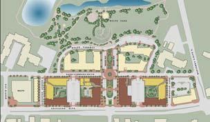
3 NTMU Examples Market Common Clarendon Arlington, VA NTMU Examples Market Common Clarendon Arlington, VA NTMU Examples Excelsior & Grand St. Louis Park, MN Metropolitan Council ESG Architects


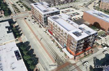
4 NTMU Examples Excelsior & Grand St. Louis Park, MN Payton Chung Metropolitan Council Alec Johnson, AC Johnson Photography NTMU Examples Gables West Village Dallas, TX NTMU Examples Gables West Village Dallas, TX

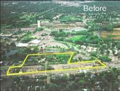
5 New Town Mixed Use District Planning Issues Let Fading Old Places Become New, Lively Spaces Vacant retail buildings can become... active, pedestrian-oriented centers. Abandoned industrial complexes can be... redeveloped into vibrant new places. Underutilized train station parking can... be transformed into new development. EXISTING OFFICE DEVELOPMENT. INTERNAL ROAD SYSTEM UNDERUTILIZED RETAIL LAND HIGHWAY ACCESS MALL PARKING LOT PUBLIC TRANSPORTATION Reinventing Suburban Commercial Areas


6 STRUCTURED PARKING ONE STORY RETAIL APARTMENTS MAIN STREET COMMERCIAL OFFICE CAMPUS PUBLIC TRANSPORTATION Reinventing Suburban Commercial Areas PUBLIC TRANSPORTATION WALKABILITY TO DOWNTOWN CURRENT USE OF SITE ROAD ACCESS HISTORIC PRESERVATION RIVERFRONT Redeveloping Old Industrial Sites RIVERFRONT TRAIL HISTORIC LOFTS NEW ROAD PUBLIC PLAZA MIXED USE DEVELOPMENT Redeveloping Old Industrial Sites


7 ABUTTING COMMERCIAL AREA PUBLIC TRANSPORTATION WALKABILITY TO DOWNTOWN ROAD ACCESS CURRENT USE OF PROPERTY NEIGHBORING PROPERTIES Reinvigorating Transit Nodes NEW APARTMENTS STRUCTURED PARKING NEW RETAIL SPACE LARGE SETBACK FROM ROAD PLAZA AREA Reinvigorating Transit Nodes Consistency with County Plan
8 Pennsylvania Municipalities Planning Code Summary of a Few Provisions of Article VII-A, Traditional Neighborhood Development Power granted... To allow fully integrated, mixed-use pedestrian-oriented neighborhoods Objectives are... To create community focal points, like parks and plazas To minimize traffic congestion and encourage walking To make public transit viable To provide good communities for the elderly and children To create a sense of place Mapping alternatives are... Overlay for new development Overlay or mapped for infill or extension Ordinances can regulate... Open space and public plazas Overall design Location of structures, including close to the street Street pattern, including a requirement for grids The location of parking, preferably to the side or behind buildings Alternative Impacts Existing Development versus New Town Mixed Use Development Road and Traffic Impact Old Industrial Sites, Suburban Shopping Centers, or Suburban Business Parks Generates significant car and truck traffic. New Town Mixed Use Development More development means more traffic. Howeve, this is somewhat offset with walkability, public transit, and mixed uses. Public Transportation Impact Does not support public transportation. Supports public transportation. Environmental Impact Negative environmental impact. Similar negative environmental impact at the local level. Positive environmental impact at the broader regional and global level. Fiscal Impact Positive fiscal impact. An even more positive fiscal impact. Community Character Impact Impact on Residential Neighbors Suburban character and little sense of place. Old industrial land can have a negative image. Negative impact on residential neighbors. Has a more urban character and a more defined sense of place. New, modern development can improve the image of a community. Potential negative impact on residential neighbors offset by increased property values. New Town Mixed Use District Model Ordinance and Design Standards


9 Permitted and Conditional Uses Wide range of permitted uses typical for mixed use development Office Entertainment Institutional Retail Restaurant Apartments, above the 2 nd floor Parks, Open Spaces, and Plazas Structured Parking Accessory Uses to a Principle Use, including Surface Parking Lots Payton Chung Conditional Uses to give municipality more control Apartments on first floor Townhouses, Twins, and/or Single Family Detached Homes Transit Facilities Temporary Surface Parking Lots Land Use Group Group 1: Office Entertainment Institutional Related Uses Group 2: Retail Restaurant Related Uses Group 3: Residential Mixing Requirements Tracts greater than 10 acres in size Minimum Percent of Building Floor Area 5% 5% 20% Maximum Percent of Building Floor Area 70% 50% 85% Tracts of 1 to 10 acres in size At least two of the land use groups listed in the first column, with each group comprising at least 10% of the development s total building floor area. In addition, Group 2 uses may not comprise more than 35% of the development s total building floor area. Tracts of less than 1 acre in size No mixing requirement. Developments can consist of one or many uses Dimensional Standards - Setbacks 20 Setback between Buildings up to 40 high 25 Maximum Setback from Local Streets 35 Maximum Setback from Arterials 20 Minimum Setback from Arterial Streets 12 Minimum Setback from Local Streets No Maximum Setback when Plazas front Streets


10 Dimensional Standards - Setbacks 40 Setback between Buildings from 40 to 75 high MRP Realty 25 Minimum Setback for Buildings 40 to 75 high Dimensional Standards - Height Maximum of 75 or 6 Stories Dimensional Standards - Height The Martin Architectural Group


11 Dimensional Standards - FAR Maximum Floor Area Ratio with No Bonus = 1.5 Maximum Floor Area Ratio with Bonus = 2.5 General Layout Street Pattern Streets should be laid out to create blocks, which should not exceed 800 in length Streets should be interconnected with each other and streets on abutting properties in grid or modified grid pattern Don t t Do This Do This! Drawings courtesy of Duany Plater-Zyberk and Co Streets need to accommodate and encourage pedestrian and public transit access
 Roofs Building Massing Building Design Standards Parking Design Standards Structured Parking Wrapping parking structures with other uses is")

12 Building Design Standards Building Orientation and Entrances Blank walls not permitted along streets and transit stations Minimum window coverage of 35% (50% for ground floor retail) Roofs Building Massing Building Design Standards Parking Design Standards Structured Parking Wrapping parking structures with other uses is ideal, but the basic goal is to conceal the parking element as much as possible Active uses should occupy at least 70% of the first floor of parking garages that front a public street Exposed parking structures should have design treatments to create the appearance of an occupied building Cars should be visually screened


13 Parking Design Standards Surface Parking Surface parking lots must be located to the rear or side of principal buildings No parking allowed between a building and a street 70 maximum width of parking along any street without being interrupted by a principal building Parking lots within the same NTMU block should be interconnected with cross-access easements 3 screening when adjacent to street, 6 6 screening from adjacent residential uses screening should be opaque Open Space and Plaza Design Standards Usable open space and plazas must comprise at least 5% of the net tract area for an NTMU development 1 square foot of plaza area is required for every 40 square feet of gross building floor area Plazas can range in size from 2,500 sq. ft. to 40,000 sq. ft. Plazas should be designed as focal points for the NTMU district Pedestrian Design Streetscaping Lighting Screening Refuse Area Outdoor Dining Other Design Standards
14 Bonus Provisions Increase of 0.5 Floor Area Ratio per feature, up to a total F.A.R. of 2.5 Potential Bonus Features: Workforce Housing Green Buildings Historic Preservation Riverfront Trails and Open Space Green Roofs Green Streets and Improved Stormwater Facilities Reservation or Construction of Road Realignments or Extra Right-of of-way Public Art Montgomery County Planning Commission Questions and Answers All Model Ordinance Publications are available online at: planning.montcopa.org Click on Publications Contact Staff for More Info: Holly Mager -- hmager@montcopa.org Brian O Leary, AICP boleary@montcopa.org Scott France sfrance@montcopa.org
CHAPTER 3 VISION, GOALS, & PLANNING PRINCIPLES. City of Greensburg Comprehensive Plan. Introduction. Vision Statement. Growth Management Goals.
 CHAPTER 3 VISION, GOALS, & PLANNING PRINCIPLES Introduction The Greensburg Comprehensive Plan is intended as a working community document. A combination of long and short-term goals, this document is intended
Lower Merion Commercial Districts Issues and Characteristics Handbook November 2013
 Lower Merion Commercial Districts Issues and Characteristics Handbook November 2013 DRAFT TOWNSHIP-WIDE VISION: To maintain and enhance commercial areas to complement the surrounding high-quality residential
2.0 AREA PLANS. Lakeside Business District. Lakeside Business District Land Use Categories:
 Lakeside Business District Lakeside Business District Land Use Categories: Campus Commercial Campus Commercial means a mixture of uses which includes corporate offices, office parks, hotels, commercial,
Complete Neighbourhood Guidelines Review Tool
 Complete Neighbourhood Guidelines Review Tool Prepared By: City of Regina Planning Department October 2014 Page 1 of 14 Community Development Review Checklist for Secondary Plans and Concept Plans The
4. Shape Transitions. 4. Shape Transitions
 4. Shape Transitions 49 Zoning District Policies Overall Intent: Maintain neighborhood character by creating compatible transitions that minimize land use conflicts. Strategy: Define the character of zoning
Be it enacted by the Town Board of the Town of Guilderland that the following new A (Transit Oriented Development (TOD) District) is adopted:
 District) is adopted:") Local Law No. 4 of 2018 (Adoption of 280-18A (Transit Oriented Development District) Be it enacted by the Town Board of the Town of Guilderland that the following new 280-18A (Transit Oriented Development
Local Law No. 4 of 2018 (Adoption of 280-18A (Transit Oriented Development District) Be it enacted by the Town Board of the Town of Guilderland that the following new 280-18A (Transit Oriented Development
Policies and Code Intent Sections Related to Town Center
 Policies and Code Intent Sections Related to Town Center The Town Center Vision is scattered throughout the Comprehensive Plan, development code and the 1994 Town Center Plan. What follows are sections
Gold Line Bus Rapid Transit Transit Oriented Development (BRTOD) Helmo Station Area Plan
 Helmo Station Area Plan") Appendix F Gold Line Bus Rapid Transit Transit Oriented Development (BRTOD) Helmo Station Area Plan Introduction and Purpose of the Plan The Gold Line Bus Rapid Transit facility is an eleven-mile dedicated
Appendix F Gold Line Bus Rapid Transit Transit Oriented Development (BRTOD) Helmo Station Area Plan Introduction and Purpose of the Plan The Gold Line Bus Rapid Transit facility is an eleven-mile dedicated
U T D N o r t h C a m p u s T O D and D o w n t o w n D e n t o n T O D
 U n i v e r s i t y o f T e x a s a t D a l l a s C i t y o f R i c h a r d s o n U T D N o r t h C a m p u s T O D and D o w n t o w n D e n t o n T O D Rick Leisner, AICP Assistant Director of Development
Welcome! to Keller Town Hall
 Welcome! to Keller Town Hall Keller Town Center Planning a New Downtown What is Keller Town Center? A new, growing downtown district planned as an urban village A combination of retail and office spaces,
4.1.3 LAND USE CATEGORIES
 4.1.3 LAND USE CATEGORIES a. City Center District The City Center District incorporates the existing character and mix of uses in downtown Belmont to encourage redevelopment and new development in keeping
The Floyds Fork Area Plan
 The Floyds Fork Area Plan Growth Framework and Design Principles Presented by: Wallace Roberts & Todd, LLC March 24, 2009 Ted Wathen / Quadrant Agenda Project overview and purpose Growth framework Design
Planning Districts INTRODUCTION
 INTRODUCTION To facilitate detailed examination of development prospects for all areas of the community, Delano has been divided into 14 planning districts. The location of these planning districts is
FUTURE LAND USE ELEMENT
 FUTURE LAND USE ELEMENT GOAL I: To create and sustain a great place to live, play, and prosper Objective 1: The City of Ocala shall incorporate the principles and strategies of the Ocala 2035 Vision into
Shifting Paradigms Urban Planning and Town Center Development in the United States
 Timothy H. Haahs PE, AIA April 20, 2010 Shifting Paradigms Urban Planning and Town Center Development in the United States Urban Life "The street is the river of life." Trends / 국민일보 2010 년 3 월 1 일자발췌
5.1 Site Plan Guidelines
 5. Community Core Guidelines Development of the Community Core will take place by plan of subdivision and site plan approval. It will occur in a phased manner that will reflect the timing of residential
TRANSIT ORIENTED DEVELOPMENT PINELLAS COUNTY MPO LIVABLE COMMUNITIES INITIATIVE PINELLAS COUNTY COMPREHENSIVE PLAN AMENDMENTS
 PINELLAS COUNTY MPO LIVABLE COMMUNITIES INITIATIVE MODEL LAND DEVELOPMENT CODE TRANSIT ORIENTED DEVELOPMENT PINELLAS COUNTY COMPREHENSIVE PLAN AMENDMENTS MPO Livable Communities Initiative Goal: Improve
The transportation system in a community is an
 7 TRANSPORTATION The transportation system in a community is an important factor contributing to the quality of life of the residents. Without a sound transportation system to bring both goods and patrons
Vision Statement for the Town of Flower Mound Master Plan The Town of Flower Mound Master Plan furthers the established community based vision to:
 Vision Statement for the The furthers the established community based vision to: Preserve the country atmosphere and natural environment that makes Flower Mound a unique and desirable community; Mitigate
WEST LOOP DESIGN GUIDELINES CHECKLIST
 WEST LOOP DESIGN GUIDELINES CHECKLIST Section 1.0 General Strategies 1.1 DESIGN EXCELLENCE: ENCOURAGE HIGH QUALITY AND INNOVATIVE DESIGN OF NEW BUILDINGS WITHIN THE WEST LOOP WITHOUT BEING PRESCRIPTIVE
E. RURAL COMMERCIAL/INDUSTRIAL PARK MODEL
 E. RURAL COMMERCIAL/INDUSTRIAL PARK MODEL 1. PURPOSE The purpose of the Rural Commerce/Industrial Park Model is to provide parameters within which a grouping of business buildings with parking, loading
Eastern Gateway / 7 Corners. City of Falls Church & Fairfax County May 14, 2013
 Eastern Gateway / 7 Corners City of Falls Church & Fairfax County May 14, 2013 Eastern Gateway Concept Plan Current Conditions Vision & Goals Building Potential Transportation Circulator to East Falls
SECTION UNIFIED DEVELOPMENT ORDINANCE SECTION Part 1 Ordinance. ARTICLE 1 Zoning Districts
 SECTION 1-100 UNIFIED DEVELOPMENT ORDINANCE SECTION 1-300 Part 1 Ordinance SECTION 1-100. Introduction. ARTICLE 1 Zoning Districts Crystal Lake strives to maintain a balance of various land uses for a
Section 3: Land Use M C H E N R Y K A N E. Figure 3.1: Potential Future Municipal Boundaries. Future Municipal Boundaries. County Land Use Plans
 Section 3: Land Use Figure 3.1: Potential Future Municipal Boundaries Land use and transportation are intertwined; yet, land use and transpor- tation planning are often undertaken as separate disciplines.
URBAN DESIGN BRIEF. 2136&2148 Trafalgar Road. Town of Oakville
 URBAN DESIGN BRIEF 2136&2148 Trafalgar Road Town of Oakville Prepared By: METROPOLITAN CONSULTING INC For 2500674 Ontario Inc November 2016 TABLE OF CONTENTS Page No. 1.0 Introduction/Description of Subject
City Council Presentation November 6, 2017
 City Council Presentation November 6, 2017 Paul Jensen Recap Downtown Vision Key issues 3-D simulation exercise (CivicKnit - Breeze Kinsey) Planning Commissioner Larry Paul Elements of good design Next
3.1 community vision. 3.3 required plan elements
 Chapter 3 Community Form 3.1 community vision 3.2 Parks & landscaping concepts 3.3 required plan elements D R A F T 20 Community Form Chapter 3 3.0 Community form 3.1 community vision The Specific Plan
The Neighbourhood Unit
 DESIGN... Site Framework PROCESS IMPLEMENTATION 22 TOOL DESCRIPTION The neighbourhood unit is a holistic planning and design strategy that addresses the configuration of the major physical components of
Silver Line CPAM UPDATE. Transportation and Land Use Committee October 14, 2016
 Silver Line CPAM UPDATE Transportation and Land Use Committee October 14, 2016 Purpose Recap Project History and Map Changes Provide Overview of CPAM Components Discuss Transportation Impacts Discuss Fiscal
Zoning Interface: Districts and Forms for Sioux Falls Zoning Ordinance
 Zoning Interface: Districts and Forms for Sioux Falls Zoning Ordinance For more information about each form, click on the associated link. Single-Family Residential Districts RR Rural Residential RS Single-Family
Status Report: MD 355 Project
 Status Report: MD 355 Project OCTOBER 2006 M-NCPPC MONTGOMERY COUNTY PLANNING DEPARTMENT Summary of Community Comments, and break to the Results of the MD 355 Participation Session Brookside Gardens -
EXISTING COMPREHENSIVE PLAN
 EXISTING COMPREHENSIVE PLAN Town Center Land Use Element: V. LAND USE POLICIES Town Center Mercer Island's business district vision as described in "Your Mercer Island Citizen-Designed Downtown" was an
Town of Avon Village Center. A New Village Center for Avon October, 2015
 Town of Avon Village Center A New Village Center for Avon October, 2015 A busy Avon Center approx. 1940 The Avon Town Center Study: In 2004 the Planning and Zoning Commission (PZC) undertook the Avon
Corridors. Re-vitalize our Corridors and Gateways
 Corridors Re-vitalize our Corridors and Gateways Artist s rendering from the 287 Strategic Plan, 2015 Corridors are the major throughways of Loveland but they also provide important commercial, community
II. SINGLE FAMILY RESIDENTIAL
 II. SINGLE FAMILY RESIDENTIAL Castle Rock is made up of numerous individually built houses and subdivision tracts that have been developed during the past century. Some of the tracts are diverse in architectural
Plano Tomorrow Vision and Policies
 Plano Tomorrow Vision and Policies PLANO TOMORROW PILLARS The Built Environment The Social Environment The Natural Environment The Economic Environment Land Use and Urban Design Transportation Housing
City of Fairfax, Virginia City Council Work Session
 City of Fairfax, Virginia City Council Work Session Agenda Item # WS 2 City Council Meeting 7/5/2016 TO: FROM: SUBJECT: Honorable Mayor and Members of City Council Robert Sisson, City Manager Request of
REPORT OF THE PLANNING AND DEVELOPMENT DEPARTMENT FOR APPLICATION FOR REZONING ORDINANCE TO PLANNED UNIT DEVELOPMENT AUGUST 18, 2016
 REPORT OF THE PLANNING AND DEVELOPMENT DEPARTMENT FOR APPLICATION FOR REZONING ORDINANCE TO PLANNED UNIT DEVELOPMENT AUGUST 18, 2016 AWH The Planning and Development Department hereby forwards to the Planning
Anatomy of A Vibrant Downtown. Anatomy of a Vibrant Downtown
 Anatomy of A Vibrant Downtown The goal of MAIN ST. REVITALIZATION PLANNING is to provide a framework that will help transform your downtown into a VIBRANT DOWNTOWN a place where people love to LIVE, WORK,
Chapter 4. Linking Land Use with Transportation. Chapter 4
 Chapter 4 Linking Land Use with Transportation Chapter 4 59 Chapter 4 Linking Land Use with Transportation Community Design and Transportation Program Introduction Since the 1950s, the predominant development
INTRODUCTION... 1 MODEL CODE PROVISIONS FOR INFILL DEVELOPMENT INFILL DEVELOPMENT STANDARDS GENERAL... 2
 CONTENTS INTRODUCTION... 1 MODEL CODE PROVISIONS FOR INFILL DEVELOPMENT... 2 1.1. INFILL DEVELOPMENT STANDARDS GENERAL... 2 1.1.1. PURPOSE STATEMENT... 2 1.1.2. APPLICABILITY... 2 1.2. DEFINITIONS... 2
Chapter PEDESTRIAN COMMERCIAL (PC) ZONING DISTRICT
 ZONING DISTRICT") Chapter 11-17 PEDESTRIAN COMMERCIAL (PC) ZONING DISTRICT Sections: 11-17-01 GENERAL PURPOSE 11-17-02 PERMITTED BUILDING TYPES 11-17-03 USES PERMITTED WITH DESIGN REVIEW 11-17-04 USES PERMITTED BY CONDITIONAL
Chapter 11-17 PEDESTRIAN COMMERCIAL (PC) ZONING DISTRICT Sections: 11-17-01 GENERAL PURPOSE 11-17-02 PERMITTED BUILDING TYPES 11-17-03 USES PERMITTED WITH DESIGN REVIEW 11-17-04 USES PERMITTED BY CONDITIONAL
I. Introduction. Prior Approvals
 Statement of Justification First National Bank 19790 Crystal Rock Drive, Germantown, Maryland Application for Site Plan and Limited Preliminary Plan Amendment I. Introduction DPH Architecture, for First
VILLAGE OF SKOKIE Design Guidelines for Mixed-Use Districts NX Neighborhood Mixed-Use TX Transit Mixed-Use CX Core Mixed-Use
 VILLAGE OF SKOKIE Design Guidelines for Mixed-Use Districts NX Neighborhood Mixed-Use TX Transit Mixed-Use CX Core Mixed-Use TABLE OF CONTENTS CHAPTER 1 SITE DESIGN Purpose 1 CHAPTER 2 SITE DESIGN Streetscape
COMMUNITY DESIGN. GOAL: Create livable and attractive communities. Intent
 COMMUNITY DESIGN Intent An attractive, well-designed County will attract quality development, instill civic pride, improve the visual character of the community, and create a strong, positive image for
Urban Design Brief December 23, 2015 Southside Construction Group Official Plan & Zoning By-Law Amendment
 Urban Design Brief Proposed Official Plan & Zoning By-Law Amendment 3244, 3263 and 3274 Wonderland Road South Southside Group December 23, 2015 TABLE OF CONTENTS Page No. INTRODUCTION... 1 SECTION 1 LAND
VISION, GOALS & CONCEPT DIAGRAM 2.0
 CHAPTER 2.0 2.1 Vision Creation Process 2.2 City Center Vision Statement, Goals and Objectives 2.3 Individual Zone Visions 2.4 Steps in City Building 2.5 Urban Form Concept Diagram for City Center VISION,
Metro. Activity Center Design Guidelines. Recommendations For Developing Focused, Mixed-Use Commercial/Residential Centers
 Metro Activity Center Design Guidelines Recommendations For Developing Focused, Mixed-Use Commercial/Residential Centers Metro Activity Centers What is a MAC? Legacy, the adopted guide for the future growth
Section 9 NEIGHBORHOOD DESIGN
 Section 9 NEIGHBORHOOD DESIGN City of Lancaster Comprehensive Plan D u n k i n, S e f k o & A s s o c i a t e s, I n c. NEIGHBORHOOD DESIGN INTRODUCTION There are many ways in which a neighborhood can
Planning Commission March 14, Presented by: City of Bellingham Port of Bellingham
 Planning Commission March 14, 2013 Presented by: City of Bellingham Port of Bellingham 1 Agenda Waterfront District Background Waterfront District Proposal Overview Sub-area Plan Development Regulations
Zoning Technical Review Presented by Camiros. November 10, 2015
 Zoning Technical Review Presented by Camiros November 10, 2015 TECHNICAL REVIEW OVERVIEW Purpose of this Report Outline issues with current Ordinance Present preliminary approaches for revisions Set drafting
Courthouse Square Planning & Urban Design Study Working Group Meeting #11 September 2, 2014
 Courthouse Square Planning & Urban Design Study Working Group Meeting #11 September 2, 2014 1 Study Area Courthouse Square DRAFT Design Concepts A B C 3 Public Feedback July 23 Workshop & Online Survey
New-Cast Mixed-use Development Proposal King Street West, Newcastle, Ontario
 URBAN DESIGN BRIEF New-Cast Mixed-use Development Proposal King Street West, Newcastle, Ontario TABLE OF CONTENTS: 1.0 Executive Summary 2.0 Creating Vibrant and Sustainable Urban Places: Excerpts from
Identifying the Model Smart Growth Code. New Partners for Smart Growth Conference Thursday February 7, 2008
 Identifying the Model Smart Growth Code New Partners for Smart Growth Conference Thursday February 7, 2008 Featured Speakers Kevin Nelson, Senior Policy Analyst, US EPA Rick Williams, Partner, Van Meter
Lehigh Acres Land Development Regulations Community Planning Project
 Lehigh Acres Land Development Regulations Planning Effort Summary In July, 2010 Commissioner Frank Mann invited the Lehigh Acres community to start discussing how to achieve their recently adopted community
CHAPTER 2: FUTURE LAND USE CONCEPTS
 CHAPTER 2: FUTURE LAND USE CONCEPTS INTRODUCTION The future land use concepts presented in this chapter are an expression of community support for a viable and vital US 50 Corridor. Land use recommendations
DRAFT. 10% Common Open Space
 % OF CHARLOTTE IS CATEGORIZED AS A. LAND USES : Placeholder map displaying location of Place Type GOALS: Accommodate XX% of future growth. Provide a concentration of primarily commercial and civic activity
EXHIBIT A. Tax Increment Reinvestment Zone No. 1 (Town Center) First Amended Project Plan 1
 First Amended Project Plan 1") EXHIBIT A Tax Increment Reinvestment Zone No. 1 (Town Center) First Amended Project Plan 1 1 As amended by Resolution No. 2008-02-001(TR1R) of the Tax Increment Reinvestment Zone No.1, and approved to
EXHIBIT A Tax Increment Reinvestment Zone No. 1 (Town Center) First Amended Project Plan 1 1 As amended by Resolution No. 2008-02-001(TR1R) of the Tax Increment Reinvestment Zone No.1, and approved to
Dwelling Units Max 12 dwelling units per acre/min 8 dwelling units per acre. Development Mix 80% non residential/20% residential
 13. OSTEEN LOCAL PLAN Background: The Osteen Local Plan area is located in southwest Volusia County along the SR 415 corridor between Lemon Bluff Road and Acorn Lake Road and includes 3,990 acres. The
Concord Community Reuse Project Goals and Guiding Principles. Overarching Goals (OG)
") Concord Community Reuse Project Goals and Guiding Principles Overarching Goals (OG) No priority is implied by the order of presentation of the goals and guiding principles. Overarching goals for the Concord
Concord Community Reuse Project Goals and Guiding Principles Overarching Goals (OG) No priority is implied by the order of presentation of the goals and guiding principles. Overarching goals for the Concord
Linking Land Use and Transportation
 Linking Land Use and Transportation NJ s Experience January 18, 2006 NYMTC - PFAC Mark Stout Planning & Development New Jersey Department of Transportation Where We Are Los Angeles, CA San Francisco, CA
The Village. Chapter 3. Mixed Use Development Plan SPECIFIC PLAN
 The Village SPECIFIC PLAN Chapter 3 3.1 INTRODUCTION 3.1.1 Purpose This Chapter describes the development regulations applicable to the Mixed-Use and Transit Center Planning Areas. These form-based regulations
City of Astoria Development Code ARTICLE 2 USE ZONES R-1: LOW DENSITY RESIDENTIAL ZONE
 ARTICLE 2 R-1 Zone USE ZONES R-1: LOW DENSITY RESIDENTIAL ZONE 2.015. PURPOSE. The purpose of the R-1 Zone is to provide an area of low density single-family dwellings, at an average density of eight (8)
6 PORT SYDNEY SETTLEMENT AREA
 Section 6 Port Sydney Page 61 6 PORT SYDNEY SETTLEMENT AREA 6.1 Basis and Principles Village of Port Sydney Waterfront Community Existing Services 6.1.1 Port Sydney is an historic settlement that has developed
Staff Report to the North Ogden City Planning Commission
 Staff Report to the North Ogden City Planning Commission SYNOPSIS / APPLICATION INFORMATION Application Request: Concept review on a legislative application to rezone land located at approximately 1750
CHAPTER 7: VISION AND ACTION STATEMENTS. Noble 2025 Vision Statement
 CHAPTER 7: VISION AND ACTION STATEMENTS This chapter presents the vision, policy and action statements that transform the comprehensive planning study, an analysis of Noble s past, future trends and community
INSTITUTIONAL USE DESIGN COMPATIBILITY TECHNIQUES
 INSTITUTIONAL USE DESIGN COMPATIBILITY TECHNIQUES INTRODUCTION Community institutions are an important part of the character and vitality of neighborhoods in Forsyth County. Institutional uses include
K. SMART ASSOCIATES LIMITED
 Planning Justification Report Zoning By-Law Amendment 185 King Street North Waterloo, Ontario April 7th, 2017 Project Reference Number 16-245 K. SMART ASSOCIATES LIMITED CONSULTING ENGINEERS AND PLANNERS
ANC 2A Presentation. November 9, 2006
 ANC 2A Presentation November 9, 2006 Introduction & Overview Applicants Boston Properties and KSI Services (project developers) The George Washington University (land owner) 2.66 acre site (former GW hospital
Three Decades of Smart Growth: Arlington s Urban Village
 Three Decades of Smart Growth: Arlington s Urban Village An Overview Christopher Zimmerman Arlington County Board January 26, 2006 Arlington, Virginia 3 1 Arlington Today Population ~200,000 Jobs >200,000
I615. Westgate Precinct
 I615. Westgate Precinct I615.1. Precinct Description The Westgate Precinct is located approximately 18km west of the Auckland city centre. There are seven Sub-precincts in the Westgate Precinct: Sub-precinct
Repositioning Suburban Corridors: From Souless Strips to Something Better
 Repositioning Suburban Corridors: From Souless Strips to Something Better Moderator: Ed McMahon, Urban Land Institute Presenters: Takis Karatonis, Columbia Pike Revitalization Organization Mike Hallibaugh,
The broad range of permitted and special uses allowed in the district remain, but some descriptions have been clarified.
 Memorandum To: Emily Fultz, AICP City Planner, City of Edwardsville From: Michael Blue, FAICP Principal, Teska Associates Date: January 24, 2019 RE: B-1 Zoning District Update A draft, updated B-1 Central
City of Fairfax, Virginia City Council Work Session
 City of Fairfax, Virginia City Council Work Session Agenda Item # 12a City Council Meeting 5/8/2018 TO: FROM: SUBJECT: Honorable Mayor and Members of City Council Robert Sisson, City Manager Request of
THE 355/270 CORRIDOR:
 THE 355/270 CORRIDOR: Strategic Ideas for Sustaining a Livable Work Place Project Summary ACCESS LIFE DESIGN HEALTH WORK Montgomery County Planning Department The Maryland-National Capital Park and Planning
B L A C K D I A M O N D D E S I G N G U I D E L I N E S for Multi-family Development
 B L A C K D I A M O N D D E S I G N G U I D E L I N E S for Multi-family Development Adopted June 18, 2009 This section of the Design and focuses on site planning and design guidance for new multi-family
Chapter 4: Land Use and Growth Management
 LAND USE AND GROWTH MANAGEMENT 4-1 Chapter 4: Land Use and Growth Management BACKGROUND AND INTENT Growth brings a number of benefits to a community; however, it also brings a number of impacts and costs.
INDEPENDENCE BOULEVARD AREA PLAN
 INDEPENDENCE BOULEVARD AREA PLAN Public Meeting October 28, 2008 Tonight s Agenda Introduction 4:00 4:05 Tom Warshauer Presentation 4:05 5:00 Blake Drury Group Exercises 5:00 5:50 All Wrap Up & Next Steps
A Context-Based Design Code for Pedestrian & Transit-Oriented Development RAIL~VOLUTION NOVEMBER 2006
 A Context-Based Design Code for Pedestrian & Transit-Oriented Development RAIL~VOLUTION NOVEMBER 2006 Palo Alto Zoning Ordinance Update. Project Overview City of Palo Alto Palo Alto Zoning Ordinance Update.
Table of Contents. Elm Avenue Improvement Plan City of Waco, Texas. Introduction 1. Existing Context 1 Figure 1 2.
 Table of Contents Introduction 1 Existing Context 1 Figure 1 2 Plan Guidelines 3 Future Urban Form 4 The West-End 4 Main Street 6 The East-End 7 Figure 2 9 Public Improvement Recommendations 7 General
URBAN DESIGN BRIEF URBAN DESIGN BRIEF 721 FRANKLIN BLVD, CAMBRIDGE August 2018
 URBAN DESIGN BRIEF URBAN DESIGN BRIEF 721 FRANKLIN BLVD, CAMBRIDGE August 2018 DESIGN BRIEF CONTENTS PART A 1.0 INTRODUCTION 2.0 DESCRIPTION & ANALYSIS OF SITE CONTEXT 3.0 DESIGN CONSTRAINTS AND OPPORTUNITIES
Cobb County Design Guidelines Mableton Parkway & Veterans Memorial Highway Community Design Workshop January 12, 2017
 Community Design Workshop January 12, 2017 Agenda Opening Remarks / Introductions Scope of Work Existing Conditions Key Issues / Opportunities VPS Summary Draft Vision & Goal Statement Implementation Concepts
Mill Conversion Overlay District Zoning Bylaw Amendment
 Mill Conversion Overlay District Zoning Bylaw Amendment To see if the Town will vote to amend the Zoning By-Law by adding a new Section 13, Mill Conversion Overlay District, and by amending Sections 2.1,
ULI PLACEMAKING OBJECTIVES
 ULI PLACEMAKING OBJECTIVES I) What is considered Great Placemaking and why? - Visual examples of New large scale projects with critical mass - Visual examples of Redevelopment smaller scale Main Street
A General Summary of Land Use Zones 1
 A General Summary of Land Use s 1 2 A General Summary of Land Use s A General Summary of Land Use s Land use zones are used to classify and regulate land development and use. The following descriptions
TO: FROM: SUBJECT: Background
 TO: FROM: SUBJECT: Long Range Planning Committee and Zoning Committee of the Planning Commission Kellie Brown and Margaret Rhodes, Planning Division, CPHD DATE: June 8, 2017 Courthouse Square Implementation
St. Kevin s Area Planning Collaborative
 Table of Contents page 2 EXECUTIVE SUMMARY 3 MISSION STATEMENT 4 NEIGHBORHOOD CONTEXT 6 STREET CHARACTER 7 SITE PARAMETERS 9 COMMUNITY CHARRETTE - VISIONING GROUP TABLE 1 11 GROUP TABLE 2 12 GROUP TABLE
17.11 Establishment of Land Use Districts
 17.11 Establishment of Land Use Districts 17.11.010 Purpose. To promote the health, safety, and general welfare of City residents and those who come to South Salt Lake to work, exchange commerce and recreate.
Courthouse Square Planning & Urban Design Study. Courthouse Square Working Group #13 October 15, 2014
 Courthouse Square Planning & Urban Design Study Courthouse Square Working Group #13 October 15, 2014 1 Courthouse Square Process Working Group Community Courthouse Square Advisory Groups & Civic Associations
SECTION TWO: Overall Design Guidelines
 SECTION TWO: Overall Design Guidelines This section provides overall design principles and guidelines for the Gardnerville Mixed-use Overlay. They provide criteria for mixed-use places consisting of residential,
City of Villages Parking Strategies. William Anderson, FAICP City Planning & Community Investment San Diego Parking Symposium July 14, 2006
 City of Villages Parking Strategies William Anderson, FAICP City Planning & Community Investment San Diego Parking Symposium July 14, 2006 City of Villages Strategy A hierarchy of walkable, mixed use districts
Noblesville Unified Development Ordinance Audit
 Noblesville Unified Development Ordinance Audit December 4 th, 2012 Shane Burkhardt, AICP RW Armstrong Project Summary Started project in the beginning of June 2012 Conducted focus groups July 2012 Conducted
Atlanta BeltLine Subarea 3 Master Plan Update
 Atlanta BeltLine Subarea 3 Master Plan Update April 14, 2018 Workshop Meeting 1 22 miles, connecting 45 neighborhoods 22 MILES of transit 46 MILES of streetscapes and complete streets 33 MILES of urban
Incentive Zoning Regulations Florida Municipal City of Orlando
 Topic: Resource Type: State: Jurisdiction Type: Municipality: Year (adopted, written, etc.): 2002 Community Type applicable to: Title: Incentive Zoning Regulations Florida Municipal City of Orlando Document
1296 Kennedy Road - Zoning Amendment Application - Preliminary Report
 STAFF REPORT ACTION REQUIRED 1296 Kennedy Road - Zoning Amendment Application - Preliminary Report Date: January 15, 2016 To: From: Wards: Reference Number: Scarborough Community Council Acting Director,
Taming Tysons Corner Transforming the Quintessential Edge City
 Taming Tysons Corner Transforming the Quintessential Edge City Transit is the greatest catalyst for change at Tysons, but how do we take advantage of this billion-dollar investment? If transit is built
FORMER CANADIAN FORCES BASE (CFB) ROCKCLIFFE SECONDARY PLAN. Official Plan Amendment XX to the Official Plan for the City of Ottawa
 ROCKCLIFFE SECONDARY PLAN. Official Plan Amendment XX to the Official Plan for the City of Ottawa") FORMER CANADIAN FORCES BASE (CFB) ROCKCLIFFE SECONDARY PLAN Official Plan Amendment XX to the Official Plan for the City of Ottawa 1 INDEX THE STATEMENT OF COMPONENTS PART A THE PREAMBLE PAGE Purpose...
FORMER CANADIAN FORCES BASE (CFB) ROCKCLIFFE SECONDARY PLAN Official Plan Amendment XX to the Official Plan for the City of Ottawa 1 INDEX THE STATEMENT OF COMPONENTS PART A THE PREAMBLE PAGE Purpose...
What Pioneer Grove Will Look Like?
 The City of Deerfield Beach has embarked on a journey to create a new town center within the old heart of Deerfield Beach. The new town center is known as Pioneer Grove. Pioneer Grove will be Everybody
VILLAGE OF CLEMMONS PLANNING BOARD DRAFT STAFF REPORT
 VILLAGE OF CLEMMONS PLANNING BOARD DRAFT STAFF REPORT PETITION INFORMATION Docket # C-226 Staff Megan Ledbetter Petitioner(s) JBJH Properties, LLC Owner(s) JBJH Properties, LLC Subject Property 5892-49-1766
4. POPULATION, LAND USE, AND DEVELOPMENT
 WEATHERFORD GENERAL PLAN POPULATION, LAND USE, AND DEVELOPMENT ELEMENT 4. POPULATION, LAND USE, AND DEVELOPMENT 4. LAND USE AND DEVELOPMENT ELEMENT INTRODUCTION The Land Use and Development Element is