City of Edmonton Valley Line Stage 1 Light Rail Transit (LRT) Project Environmental Impact Screening Assessment Update
|
|
|
- Cathleen Philomena Daniels
- 5 years ago
- Views:
Transcription
1 City of Edmonton Valley Line Stage 1 Light Rail Transit (LRT) Project Environmental Impact Screening Assessment Update Final Report Prepared for: LRT D and C Transportation Services City of Edmonton Edmonton, Alberta Prepared by: Spencer Environmental Management Services Ltd. Edmonton, Alberta Under Contract to: AECOM Connected Transit Partnership Edmonton Alberta Project Number EP February 2015
2
3 Distribution List # of Hard Copies # CDs Required Association / Company Name 6 2 C of E LRT D and C- Waqar Syed 1 2 C of E Sustainable Development- Glinis Buffalo 2 1 Connected Transit Partnership Mark Perry
4 EXECUTIVE SUMMARY In 2013, pursuant to the City of Edmonton s North Saskatchewan River Valley Area Redevelopment Plan (Bylaw 7188), LRT Design and Construction prepared an Environmental Impact Screening Assessment (EISA) for the portion of the Valley Line Stage 1 that will be situated within the North Saskatchewan River Valley (NSRV). City Council approved that report in September Subsequent project planning, including ongoing community group consultation, has identified eight proposed changes to Valley Line, NSRV project components. Most of these changes are minor in nature and scale; one is more substantial. Assessment of these proposed changes is required because the changes involve previously unassessed activities or require adjustments to the approved 2013 Project Area. Consequently, LRT D and C has prepared this EISA Update to assess of the following eight proposed changes: Development of a temporary, primary construction access route through the west side of Louise McKinney Riverfront Park (LMRP). This access route will replace the use of Cameron Avenue and the future permanent portal maintenance access route (in the east side of LMRP), which will now be utilized only as a secondary construction access route. Modifications to the west boundary of the Project Area, within Henrietta Muir Edwards Park (HMEP). This will include the exclusion of two small parcels of land to reduce impacts on the abandoned Mill Creek channel, and the addition of one small parcel to include all lands occupied by an existing picnic shelter that, through consultation with Community Services, was identified in the 2013 EISA as available for demolition. Inclusion of a small parcel of land at the entrance to HMEP to allow for more flexibility in providing required temporary pedestrian access to the 98 Avenue Pedestrian Bridge during LRT construction. Explicit recognition of potential for installation of ground anchors as a means of supporting retaining walls at two locations, and, potential for those ground anchors to extend underground beyond the previously defined project boundaries but within City-owned lands. A minor extension of the Project Area to allow for local slope re-grading and relocation of ski hill infrastructure as mitigation for project impacts on one Edmonton Ski Club run. Closure/demolition of a 200 m long, one-way road connecting northbound Connors Road to the Muttart Access Road. Locating the replacement Muttart Conservatory storage building and associated yard slightly southeast of the previously-approved location. This new location will overlap with the 2013 Project Area boundary. This component is no longer part of the P3 project and will be undertaken by the City as early work. Construction of a temporary, short connecting trail in LMRP, outside the Project Area, to provide for improved internal pedestrian circulation during the LRT construction period. As mitigation, the trail will be constructed by the City, prior to Valley Line construction. February 2015 Valley Line-Stage 1 LRT EISA Update FINAL REPORT Page i
5 The EISA Update describes the above-noted changes and assesses their potential to affect river valley resources. This EISA Update identifies some new, component-specific impacts and sets out specific mitigation commitments that will also be City or Project Co requirements and will be incorporated into the Project Agreement. Important among these is the need for the City and Project Co to do some additional geotechnical investigations and to follow all resulting recommendations. Most new mitigation measures are directed at reducing impacts associated with the temporary, primary construction access route through the west side of LMRP. For that project component, despite application of mitigation measures, the presence of an active construction access route will temporarily and adversely affect park user experience, park visual resources, park vegetation and, to a lesser extent, wildlife habitat movement through the west park. With mitigation, these effects were rated as minor. All of these impacts are temporary, and most of them will be eliminated in short order upon completion of construction. The residual impact of clearing of woody vegetation in the park will be longer-lasting as mitigation will be a longer-term native forest restoration effort. Finally, the EISA update also describes four other minor adjustments to the Project Area that are required to implement previously-approved activities and mitigation measures. These components are described for documentation purposes but not assessed. February 2015 Valley Line-Stage 1 LRT EISA Update FINAL REPORT Page ii
6 Chapter Table of Contents Page 1.0 INTRODUCTION Background and Need for an EISA Update Changed Project Components Spatial Clarifications EISA Amendment Objectives Report Organization PROJECT DESCRIPTION Changed Project Components North Valley Primary Construction Access - Project Co Component West Project Boundary Modifications at HMEP - Project Co Component HMEP Entrance - Project Co Component Retaining Wall Ground Anchors - Project Co Component Ski Club Infrastructure Relocation - Project Co Component Muttart Access Road Partial Removal - Project Co Component Muttart Storage Building Replacement- City Component LMRP Temporary Trail Connector - City Component Spatial Clarifications LMRP Rose Garden and SUP Tie-in A Avenue Trail Tie-in to SUP Reconfigured Trail, Muttart Stop to 98 Avenue A Street Parking Lot ASSESSMENT METHODS General Methods Issue Identification Selection of Valued Environmental Components Assessment Spatial and Temporal Scope Description of Existing Conditions Impact Analysis Potential Impacts Residual Impacts Public Engagement Process NORTH VALLEY PRIMARY CONSTRUCTION ACCESS Context Assessment Methods Key Issues Existing Conditions by VEC Geology/Geomorphology Soils Hydrology Vegetation February 2015 Valley Line-Stage 1 LRT EISA Update FINAL REPORT Page iii
7 4.4.5 Wildlife Habitat Connectivity Recreational Land Use Visual Resources Utilities Historical Resources Potential Impacts and Mitigation Measures Geology/Geomorphology Soils Hydrology Vegetation Wildlife Habitat Connectivity Recreational Land Use Visual Resources Utilities Historical Resources Summary Assessment Summary of Residual Impacts Monitoring Requirements Resolution of Key Environmental Issues WEST PROJECT BOUNDARY MODIFICATIONS AT HMEP Context Assessment Methods Key Issues Existing Conditions Geology/Geomorphology and Soils Vegetation Wildlife Habitat and Connectivity Recreational Land Use Utilities Visual Resources Potential Impacts and Mitigation Measures Soils and Geotechnical Stability Vegetation Wildlife Habitat and Connectivity Recreational Land Use Utilities Visual Resources Summary Assessment Summary of Residual Impacts Monitoring Requirements Resolution of Key Environmental Issues HMEP ENTRANCE Context February 2015 Valley Line-Stage 1 LRT EISA Update FINAL REPORT Page iv
8 6.2 Assessment Methods Key Issues Existing Conditions by VEC Soils and Geotechnical Stability Vegetation & Wildlife Habitat Residential Land Use Recreational Land Use Visual Resources Utilities Potential Impacts and Mitigation Measures Soils Vegetation, Wildlife Habitat and Connectivity Recreational Land Use Visual Resources Utilities Summary Assessment Summary of Residual Impacts Monitoring Requirements Resolution of Key Environmental Issues RETAINING WALL GROUND ANCHORS Context Assessment Methods Key Issues Existing Conditions Geomorphology and Geotechnical Stability Residential Land Use Potential Impacts and Mitigation Measures Geomorphology and Geotechnical Stability Residential Land Use Summary Assessment Summary of Residual Impacts Monitoring Requirements Resolution of Key Environmental Issues SKI CLUB INFRASTRUCTURE RELOCATION Context Assessment Methods Key Issues Existing Conditions Geomorphology/Geotechnical Stability and Soils Vegetation, Wildlife Habitat and Connectivity Recreational Land Use Visual Resources Potential Impacts and Mitigation Measures Soils Impacts to Slope Stability February 2015 Valley Line-Stage 1 LRT EISA Update FINAL REPORT Page v
9 8.5.3 Vegetation, Wildlife Habitat and Connectivity Recreational Land Use Visual Resources Summary Assessment Summary of Residual Impacts Monitoring Requirements Resolution of Key Environmental Issues MUTTART ACCESS ROAD PARTIAL REMOVAL Context Assessment Methods Key Issues Existing Conditions Vegetation Transportation Land Use Potential Impacts and Mitigation Measures Vegetation Transportation Land Use Summary Assessment Summary of Residual Impacts Resolution of Key Environmental Issues MCSB REPLACEMENT Context Assessment Methods Key Issues Existing Conditions by VEC Geology/Geomorphology and Soils Hydrology Surface Water/Groundwater Vegetation, Wildlife Habitat and Connectivity Recreational Land Use Visual Resources Utilities Potential Impacts and Mitigation Measures Geology/Geomorphology and Soils Hydrology Surface Water/Groundwater Vegetation, Wildlife and Habitat Connectivity Recreational Land Use Visual Resources Utilities Summary Assessment Summary of Residual Impacts Resolution of Key Environmental Issues LRMP TEMPORARY TRAIL CONNECTOR Context Assessment Methods February 2015 Valley Line-Stage 1 LRT EISA Update FINAL REPORT Page vi
10 11.3 Key Issues Existing Conditions Soils and Geotechnical Stability Hydrology Surface Water Vegetation and Wildlife Habitat Recreational Land Use Visual Resources Utilities Potential Impacts and Mitigation Measures Geotechnical Stability and Soils Hydrology Surface Water Vegetation, Wildlife Habitat and Connectivity Recreational Land Use Utilities Visual Resources Summary Assessment Summary of Residual Impacts Monitoring Requirements Resolution of Key Environmental Issues CONCLUSIONS Summary of Public Engagement Response New Potential Impacts and Mitigation Commitments Summary of Changed Project Components North Valley Primary Construction Access Road West Project Boundary Modifications at HMEP HMEP Entrance Project Co Component Retaining Wall Ground Anchors Project Co Component Ski Club Infrastructure Relocation Project Co Component Muttart Access Road Partial Removal Project Co Component Muttart Storage Building Replacement City Component LMRP Temporary Trail Connector City Component REFERENCES Literature Cited Personal Communications APPENDIX A: ALTERNATIVE ANALYSIS FOR CONSTRUCTION ACCESS ROUTE... A1 APPENDIX B: TEMPORARY CONSTRUCTION ACCESS ROAD GEOTECHNICAL AND SLOPE STABILITY ASSESSMENT (THURBER ENGINEERING 2014) SEE COMPACT DISC... B1 APPENDIX C: VEGETATION DATA... C1 APPENDIX D: WILDLIFE SPECIES POTENTIALLY FOUND IN THE STUDY AREAS... D1 February 2015 Valley Line-Stage 1 LRT EISA Update FINAL REPORT Page vii
11 APPENDIX E: SPECIAL STATUS WILDLIFE SPECIES POTENTIALLY FOUND IN THE STUDY AREAS... E1 APPENDIX F: LMRP SUBSURFACE UTILITIES (T2 UTILITY ENGINEERS 2013) F1 List of Figures Figure 1.1. Valley Line Stage 1 Location... 2 Figure 2.1a. Project Components Assessed in EISA Update... 8 Figure 2.1b. Project Components Assessed in EISA Update... 9 Figure 2.1c. Project Components Assessed in EISA Update Figure 2.1d. Project Components Assessed in EISA Update Figure 2.2. Excerpt from HMEP, 70% Landscape Drawing Figure 2.3a. Retaining Wall Ground Anchor, Typical Description Figure 2.3b. Retaining Wall Ground Anchor, Typical Construction Sequence Figure 2.4. Muttart Access Road Partial Removal Figure 2.5a. MCSB, Replacement Site Plan Figure 2.5b. MCSB, Replacement Site Plan Figure 2.5c. MCSB, Replacement Site Plan Figure 2.6. LMRP Temporary Trail Connector, Landscape Drawing Figure 2.7. Spatial Clarifications Figure 2.8a. LMRP SUP Tie-in, Landscape Drawing Figure 2.8b. LMRP SUP Tie-in, Landscape Drawing Figure A Avenue SUP Tie-in, Landscape Drawing Figure Reconfigured Trail at 98 Avenue, Landscape Drawing Figure 4.1. Geotechnical Investigations Undertaken for the Access Road Figure 4.2. Estimated Boundaries of Former Grierson Nuisance Grounds Figure 4.3. Existing Plant Communities in LMRP Figure 4.4. Wildlife Survey Locations in LMRP Figure 4.5. Location of New Accessible Trail in LMRP Figure 5.1. West Project Boundary Modifications at HMEP, Contours Figure 5.2. HMEP West Project Boundary Modifications, Existing Plant Communities Figure 9.1. Naturalization at Former Road Location Figure Muttart Storage Building Replacement Site Plan Figure Muttart Grading Plan Figure Muttart Storage Building Elevations List of Tables Table 4.1. Justification for the selection of VECs North Valley Primary Construction Access Table 4.2. Bird species recorded during point count and meandering surveys conducted during the breeding season of 2014 in LMRP Table 4.3. Select special status species with a moderate probability of occurrence in the study area February 2015 Valley Line-Stage 1 LRT EISA Update FINAL REPORT Page viii
12 Table 5.1. Justification for the selection of VECs West Project Boundary Modifications at HMEP Table 6.1. Justification for the selection of VECs HMEP Entrance Table 7.1. Justification for the selection of VECs Retaining wall ground anchors Table 8.1. Justification for the selection of VECs Ski club infrastructure relocation 123 Table 9.1. Justification for the selection of VECs Muttart Access Road Partial Removal Table Justification for the selection of VECs MCSB replacement Table Justification for the selection of VECs LRMP temporary connector trail153 List of Plates Plate 2.1. Segment of proposed Louise McKinney Riverfront Park Construction Access Road using existing maintenance road, looking northeast Plate 2.2: Trans Canada SUP to be used as Primary construction Access Route in LMRP Plate 2.3. HMEP west project boundary modifications, looking west; picnic shelter and paving stone area (Sept. 2013) Plate 2.5. Area of proposed boundary changes at HMEP entrance (98 Ave and 96A St), looking northeast (June 2014) Plate 2.7. Manicured lawn of proposed MCSB replacement and parking area (hill to be re-graded in foreground, existing building will be situated mid-ground), view to northeast (Sept. 2014) Plate 2.8. Approximate area of proposed LMRP temporary trail connector, looking south (Jan. 2015) Plate 2.9. Existing World Walk SUP and Rose Garden (June 2014) Plate Site of trail tie-in work required at HMEP and 98A Avenue, behind the nostopping sign, see in the foreground (Jan. 2015) Plate Site of trail tie-in work required at HMEP and 98A Avenue, looking north from within HMEP (April 2013) Plate 4.1. The west portion of LMRP is characterized by landscaped parkland, including manicured lawn, gardens and paved pathways (July 2014) Plate 4.2. Naturalized (unmanicured) grassland communities on the slopes of Louise McKinney Riverfront Park (July 2014) Plate 4.3. Open understorey in a Manitoba maple community in Louise McKinney Park (July 2014) Plate 4.4. The margins of the PMM community, adjacent to along the existing access road typified Edmonton river valley forest edge communities, view looking south (July 2014) Plate 4.5. Dense understorey in the interior of the PMM community along the west edge of LMRP (July 2014) Plate 4.6. Manicured areas and paths, including columnar poplar, adjacent to the proposed access road alignment (July 2014) Plate 4.7. A typical planted bed along a staircase intersecting with the to the proposed access road alignment (July 2014) February 2015 Valley Line-Stage 1 LRT EISA Update FINAL REPORT Page ix
13 Plate 4.8. LMRP supports numerous programmed and un-programmed activities, including passive and active uses Plate 4.9. Maintenance/service vehicle road turn-around, looking north (July 2014). This road does not provide vehicular park access or parking for the general public Plate Riverfront Plaza, looking northwest: River Valley Adventures operates a Segway rental service that relies on the connection to the paved Trans Canada Trail and the broader river valley SUP network (July 2014) Plate Paved fully accessible trail leading south to the Riverfront Promenade, looking east (July 2014) Plate West End of proposed primary construction access road, looking southeast along the maintenance vehicle access road, from the Shaw Conference Centre (June 2014) Plate West End of proposed primary construction access road, looking northeast towards the maintenance vehicle access road and the Shaw Conference Centre, from the Riverfront Plaza (June 2014) Plate Rooftop view from the Riverfront Plaza, looking east (June 2014) Plate Several utility panels/boxes are located along the vehicle access road turnaround, looking north Plate A subsurface holding tank, an associated sanitary line and a monitoring cable are located west of the Riverfront Plaza building Plate An informal trail that connects to the maintenance access road from the LMRP parking lot, looking north (July 2014) Plate Three pathways (from west, south and east) connect to vehicle maintenance access road (July 2014) Plate 5.1. HMEP west project boundary modifications looking west; manicured lawn and mature poplars dominate this area, looking west (Sept. 2014) Plate 5.2. HMEP west project boundary modifications looking east; several planted choke cherry are situated in this area, looking east (Sept. 2014) Plate 5.3. HMEP west project boundary modifications looking southwest; Manitoba maple borders the west edge of the project component area and transitions to balsam poplar forest (Sept. 2014) Plate 5.4. The northernmost area is immediately adjacent to the east bank of abandoned Mill Creek (June 2013) Plate 5.5. The southern parcel also contains a section of abandoned Mill Creek, with a sparse understory (April 2013) Plate 5.6. Picnic Shelter situated in the proposed changes to the west boundary of the project area, looking southwest (Sept. 2014) Plate 5.7. Benches, picnic tables, garbage cans and a drinking fountain are also situated in this area (Sept. 2014) Plate 5.8. The picnic shelter and hard surface appear to be in disrepair and public fireplaces installed as part of the picnic shelter structure have been boarded over (April 2013) Plate 6.1: Bridge abutment fill in the parcel to be added to the Project Area, looking northeast (June 2014) Plate 6.2. HMEP near the north end of the 98 Avenue Pedestrian Bridge looking northeast; planted bed with park entrance sign, looking southwest (Sept 2014) February 2015 Valley Line-Stage 1 LRT EISA Update FINAL REPORT Page x
14 Plate 6.3. HMEP entrance looking northeast; mature poplar and Manitoba maple stand, (Sept. 2104) Plate 6.4. HMEP entrance looking northeast; unmowed grasses on the pedestrian bridge embankment (Sept. 2014) Plate 8.1. Sloping terrain of existing T-bar run to be re-graded. (Jan. 2015) Plate 8.2. Southeastern portion of lands required for ski club infrastructure relocation, looking west from Cloverdale Hill Road. Mature planted spruce on right are within the original Project Area. Deciduous stand of native vegetation shown on right is situated outside of the Project Area and will be undisturbed (Jan. 2015) Plate 8.4. The existing T-bar terminus is clearly visible from Connors Road, dominating views at the crest of the hill, looking northwest (Jan. 2015) Plate MCSB replacement lands are situated on an existing bench and extend south into a shallow hill situated in Gallagher Park, looking southeast (July 2014) Plate Vegetation in the MCSB replacement site consists entirely of manicured lawn, looking north (09 July 2014) Plate View of MCSB Replacement site (in foreground) looking northwest; the existing slope provides passive recreation and one informal trail. Views from the site currently include the existing building (July 2014) Plate Alternative view of existing storage building and surrounding grounds (July 2014) February 2015 Valley Line-Stage 1 LRT EISA Update FINAL REPORT Page xi
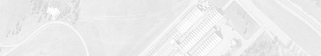
15 1.0 INTRODUCTION 1.1 Background and Need for an EISA Update City of Edmonton (the City), led by Transportation Services LRT Design and Construction (LRT D and C), is expanding Edmonton s Light Rail Transit (LRT) network by constructing the Valley Line Stage 1, connecting Downtown to Mill Woods (Figure 1.1). This new line necessarily involves a crossing of the North Saskatchewan River Valley (NSRV) (Figure 1-1). Planning for the project began in 2008 and preliminary design was completed in 2013, culminating in a Reference Design for a new, urban-style, low-floor system. The project will be delivered through a Public Private Partnership (P3) and is now in the proponent procurement phase. The procurement schedule includes awarding a contract to the successful bidder, referred to as Project Co, in January In 2012/2013, as part of the preliminary planning exercise and pursuant to the City of Edmonton s North Saskatchewan River Valley Area Redevelopment Plan (Bylaw 7188), LRT D and C prepared an Environmental Impact Screening Assessment (EISA) for the portion of the project situated within the NSRV. The report, City of Edmonton Valley Line-Stage 1 Light Rail Transit (LRT), Project Environmental Screening Impact Assessment (Spencer Environmental 2013), hereafter referred to as the 2013 EISA, addressed all identified Valley Line project components situated in the river valley, as described in the Reference Design. The 2013 EISA report acknowledged that the selected P3 delivery model influenced the level of design detail available for assessment and also the potential for some additional change to occur during the design and construction phase by Project Co. It was clear that the environmental review process must acknowledge some tolerance for minor, future design variance. To facilitate impact assessment and ensure that all unexplored potential project impacts were assessed moving forward, the 2013 EISA delineated an absolute boundary for construction-related activities, the Project Area, and assessed the impact associated with disturbance of all of the Project Area. Included in the 2013 EISA was a commitment to subject any future proposed works that would require modification of the Project Area or facilities situated outside of the approved Project Area and within the Bylaw 7188 lands, to further Bylaw 7188 review. City Council approved the EISA in September 2013, but instructed LRT D and C to continue to work with select community groups into the next project phases to mitigate select impacts, particularly as they affect community groups. Project planning, including ongoing community group consultation, refinement of select mitigation measures and preparation of P3 procurement documents, has progressed since summer of Through this planning, several changes to select river valley project components have been made that require adjustment of the Project Area shown in the 2013 EISA. Most changes are considered to be minor, both in terms of the nature of the change and the area affected; one is considered more substantial. Through summer of 2014, consultation with City of Edmonton Sustainable Development and Community Services determined that LRT D and C should prepare an amendment to the 2013 EISA addressing these known changes and that the amendment should be brought back to Council for approval. February 2015 Valley Line-Stage 1 LRT EISA Update FINAL REPORT Page 1
16 102 Ave. 95 St. River Valley Crossing Connors Rd. 95 Ave. 85 St. 82 Ave./Whyte Ave. 83 St. Argyll Rd. 75 St. Whitemud Dr. 34 Ave. 66 St. 28 Ave. Legend Valley Line LRT Alignment (Reference Design) Bylaw 7188 Boundary Figure 1.1 Valley Line Stage 1 Location City of Edmonton LRT Valley Line - Stage 1 EISA Update ,000 Meters Aerial Photograph Date: May 2012 Date Map Created: 10 February :30,400
17 The proposed changes were grouped into two categories: 1) Changed Project Components changes having potential to result in previously-unassessed impacts, in most cases by expanding an activity into newly added lands; and 2) Spatial Clarification minor adjustments of work limits required either as a result of a closer examination of the components; or design refinement of previously-described and assessed activities; or advancement of mitigation measures. In essence, this is a clarification of previously described required lands. It was agreed that while changes of this nature should be included in the update exercise, treatment would be limited to documentation of changes in the update report, rather than assessment of impacts. 1.2 Changed Project Components As of October 2014, LRT D and C have identified the following eight discrete project component changes that require adjustment of the previously-approved Project Area boundaries and have potential to result in previously-unassessed impacts 1) Designation of Cameron Avenue and the Shared Use Path (SUP) in east end of Louise McKinney Riverfront Park (LMRP) as the secondary rather than primary, north valley construction access route and identification of a temporary, primary construction access route through the west side of LMRP. 2) Modifications to the west boundary of the Project Area, within Henrietta Muir Edwards Park (HMEP). This will include the exclusion of two small parcels of land to reduce impacts on the abandoned Mill Creek channel, and the addition of one small parcel to include all lands occupied by an existing picnic area that, after consultation with Community Services, was identified in the 2013 EISA as available for demolition. 3) A minor expansion of the Project Area in HMEP to allow for more flexibility toward provision of temporary pedestrian access to the 98 Avenue Pedestrian Bridge during LRT construction. 4) Explicit recognition of potential for installation of ground anchors as a means of support for the previously identified retaining walls at two locations and potential for ground anchors to extend, below ground, beyond the previously-defined project boundaries but remaining within City-owned lands. 5) A minor expansion of lands at the top of Connors Hill to allow for slope regrading for relocation of ski hill infrastructure as mitigation for project impacts on an existing Edmonton Ski Club run. 6) Removal of a one-way connector road between north Connors Road to the Muttart Access Road. (Note: This does not require a boundary adjustment but removal was not previously assessed). 7) Shifting the replacement Muttart Conservatory storage building to the southeast of the previously identified location and slightly beyond the 2013 Project Area boundary, and, having the City undertake construction prior to commencement of P3 work. 8) Construction of a temporary, connecting trail in the Chinese Gardens, in advance of the project, to provide for improved internal pedestrian circulation through LMRP during the Valley Line construction period. February 2015 Valley Line-Stage 1 LRT EISA Update FINAL REPORT Page 3
18 Items seven and eight, construction of a new Muttart Conservatory storage building and a temporary connector pedestrian trail, are required to mitigate Valley Line project impacts and will be undertaken by City of Edmonton, Community Services prior to commencement of Valley Line construction to reduce the impact of LRT construction on park facilities and operation. This distinction is relevant to construction timing and development of mitigation measures since these components will not be governed by mitigation clauses included in the final Valley Line Project Agreement. 1.3 Spatial Clarifications Adjustments to individual recreational trails and their reconnections to the larger network were one of the major facilities approved by Council in The 2013 EISA identified the need to: restore disrupted trails within the Project Area; reconfigure some trails to accommodate new infrastructure and re-landscaping; and seamlessly tie realigned and restored trails into the existing, undisturbed trails at the project boundaries. All of these activities were discussed in the 2013 EISA in the context of mitigation of project impacts. Since then, as committed to, several specific mitigation measures have been refined or further developed, some to a relatively advanced state. Importantly, through consultation with Community Services, LRT D and C have developed 70% landscape drawings (known as River Valley Landscape Drawings) to ensure full mitigation of project impacts to park resources in a manner consistent with existing and future plans for these important public spaces. These drawings are intended to provide the City with more control and certainty over the post-construction landscaping of the Project Area in LMRP, HMEP and at Muttart Conservatory grounds by providing Project Co with detailed guidance. These landscaping plans represent a refinement of several mitigation measures that were previously only generally described in the 2013 EISA. Importantly, the plans explicitly acknowledge how Project Co is to tie the re-landscaped Project Area into surrounding, unaffected, existing park landscaping and how much land will be required to achieve a seamless tie-in at critical locations. For Project Co to implement those newly-developed plans, the 2013 Project Area must be adjusted in a minor way at three manicured park locations. Work in these specific areas will be restricted to that required to realize the landscaping plans. General construction use will not be allowed. The following are the three components: Tie-in of remnant World Walk and Rose Garden in LMRP to gardens and the SUPs that were re-landscaped by Project Co within the Project Area. Installing a new HMEP trail connecting to the SUP at 98A Avenue and HMEP parking lot. Reconfiguration of a trail connecting Muttart Gardens to 98 Avenue and Cloverdale Neighbourhood. Since these trail activities are mitigation measures and were previously committed to in the 2013 EISA, further assessment of these activities is not warranted, but documentation is desirable. February 2015 Valley Line-Stage 1 LRT EISA Update FINAL REPORT Page 4
19 In addition, planning during the last year identified a required modification of the Project Area in the vicinity of the HMEP parking lot at 96A Street. The 2013 EISA text identified that parking lot as included in the Project Area and available for use as a general construction area. The parking lot is critical to Project Co achieving feasible access from 98 Avenue to the south river bank work area. However, in 2013 the Project Area boundary drawn did not quite capture the entire parking lot as was intended. Accordingly, this boundary has now been adjusted slightly to follow the parking lot west boundary and include the whole of the parking lot. This adjustment is the fourth spatial clarification element. Because undertaking the four above-noted components in this category requires an adjustment of the Project Area delineated in the 2013 EISA there is a need to document and explain these project aspects for record keeping purposes. To that end, each of these Spatial Clarification components is described in detail in Chapter 2 along with the rationale for the change and placement in the category of Spatial Clarification, but these components are not then further assessed. 1.4 EISA Amendment Objectives Considering the above, following are the primary objectives of this EISA Update: Meet the commitment to ensure Bylaw 7188 review of Valley Line project changes affecting lands or facilities outside the Project Area. Document minor Project Area adjustments required to accommodate the refinement of previously-approved activities or mitigation measures. Prepare a publicly-available report for consideration by City Council. 1.5 Report Organization This EISA Update consists of 13 chapters. Chapter 1 provides context and background on the need for the EISA Update and describes the focus of this report. Chapter 2 describes each project component addressed in this document, the motivation and rationale for the change, and the resulting changes to the previously-approved boundary. Chapter 2 also describes, in more detail, the spatial clarification components and the lands involved. Chapter 3 outlines the impact assessment methods specific to this EISA Update. Chapters 4 through 11 assess each of the described project components, describing specific methods used, existing conditions, impacts and mitigation, and includes a summary assessment for that component. Chapter 12 summarizes results from the public engagement process and major conclusions and commitments for all component changes. Chapter 13 provides all references and personal communications cited in the report. This report includes the following appendices: Appendix A: Alternatives Analysis for North Valley Construction Access Route Appendix B: Temporary Construction Access Road Geotechnical and Slope Stability Assessment (Thurber Engineering 2014) February 2015 Valley Line-Stage 1 LRT EISA Update FINAL REPORT Page 5
20 Appendix C: LMRP Vegetation Data Appendix D: Wildlife Species Potentially Found in the LMRP Study Area Appendix E: Special Status Wildlife Species Potentially Found in the LMRP Study Area Appendix F: LMRP Subsurface Utilities (T2 Utility Engineers 2013) February 2015 Valley Line-Stage 1 LRT EISA Update FINAL REPORT Page 6
21 2.0 PROJECT DESCRIPTION 2.1 Changed Project Components Figure 2.1a illustrates the location and spatial extent of the eight project components assessed in this update; Figures 2.1b through 2.1d show these components at a finerscale. Six of these components will be included in the scope of work to be undertaken by Project Co, and two will be undertaken by the City of Edmonton as preparatory (early) works (see Figure 2.1a) North Valley Primary Construction Access - Project Co Component The 2013 EISA identified the primary north river valley construction access corridor as moving through the east side of LMRP. The identified route involved approaching the park along the edge of Riverdale Neighbourhood, following Cameron Avenue to its intersection with 94 Street and 99 Avenue, then moving west into LMRP using the Trans Canada Trail SUP. The 2013 Project Area included the lands along that SUP. This route was also identified as the required permanent emergency and maintenance access route to the portal and tunnel (Figure 2.1b). The 2013 EISA identified the possible need for a secondary construction access from the west, through LMRP, but a specific location was not discussed, nor was the specific purpose of a secondary access route discussed. Because of this, associated impacts were not described. At that time, it was assumed that any secondary access would be used only for select but unspecified activities and would not require physical modification of park lands. It was agreed that if a need to use lands in the western end of LMRP in this way emerged, the impacts would be assessed in later project planning. Since that time, additional planning and community group consultation has determined that the designated primary construction access route will be through the west half of LMRP, entering the park from Grierson Hill Road and accessing the valley slope east to the west edge of the Project Area that was described in 2013 (Figure 2.1b). From there access would then continue within the approved 2013 Project Area. The original east park route using Cameron Avenue is now identified as the secondary access route, to be used only at select times during construction on an as-needed basis, when the west, primary access route is unavailable to Project Co. The proposed primary construction access road will be temporary only but present for the duration of construction in the north valley, a period lasting approximately five years; the east permanent emergency access and maintenance road will remain as described in the 2013 EISA and, as before, both roads will be designed and constructed by Project Co. February 2015 Valley Line-Stage 1 LRT EISA Update FINAL REPORT Page 7
22 Jasper Ave. Grierson Hill LMRP Temporary Trail Connector LOUISE MCKINNEY RIVERFRONT PARK 95 St. Tunnel * * Cameron Ave. Portal Structure Potential Retaining Wall Anchors Edmonton Queen Riverboat North Valley Primary Construction Access North Saskatchewan River HENRIETTA MUIR EDWARDS PARK West Project Boundary Modifications at HMEP HMEP Entrance 98 Ave. 96a St. 95 St. Potential Retaining Wall Anchors Muttart Access Road Partial Removal MUTTART CONSERVATORY PARK Cloverdale Scona Rd. Connors Rd. Muttart Conservatory Storage Building Replacement GALLAGHER PARK Ski Club Infrastructure Relocation MILL CREEK RAVINE PARK Legend Additional Lands Undertaken by Project Co Excluded Lands Areas Removed from Project Area No Lands Change - Undertaken by Project Co Road Removal/Landscaping Potential Retaining Wall Anchors (Sub-Surface Work Only) Lands Involved in Preparatory (Early) Works * Undertaken by City of Edmonton Lands Previously Assessed in 2013 EISA Project Area Valley Line LRT Alignment (Reference Design) Bylaw 7188 Boundary Indicative Location Only Meters 1:5,500 Figure 2.1a Project Components Assessed in EISA Update City of Edmonton LRT Valley Line - Stage 1 EISA Update Aerial Photograph Date: May 2012 Date Map Created: 10 February 2015
23 95 St. Grierson Hill Cameron Ave. Tunnel * LOUISE MCKINNEY RIVERFRONT PARK LMRP Temporary Trail Connector Portal Structure * Potential Retaining Wall Anchors 056 RV North Valley Primary Construction Access North Saskatchewan River Edmonton Queen Riverboat 048 RV Legend Additional Lands Undertaken by Project Co Excluded Lands Areas Removed from Project Area No Lands Change - Undertaken by Project Co Road Removal/Landscaping Potential Retaining Wall Anchors (Sub-Surface Work Only) Lands Involved in Preparatory (Early) Works Undertaken by City of Edmonton Lands Previously Assessed in 2013 EISA Project Area Valley Line LRT Alignment (Reference Design) Portal Access Route Bylaw 7188 Boundary City of Edmonton River Valley Natural Areas (2010) *Indicative Location Only Meters 1:2,100 Figure 2.1b Project Components Assessed in EISA Update City of Edmonton LRT Valley Line - Stage 1 EISA Update Aerial Photograph Date: May 2012 Date Map Created: 10 February 2015
24 96a St. 95 St. HENRIETTA MUIR EDWARDS PARK West Project Boundary Modifications at HMEP 048 RV HMEP Entrance 98 Ave. Potential Retaining Wall Anchors Legend Additional Lands Undertaken by Project Co Excluded Lands Areas Removed from Project Area No Lands Change - Undertaken by Project Co Road Removal/Landscaping Potential Retaining Wall Anchors (Sub-Surface Work Only) Lands Involved in Preparatory (Early) Works Undertaken by City of Edmonton Lands Previously Assessed in 2013 EISA Project Area Valley Line LRT Alignment (Reference Design) Portal Access Route Bylaw 7188 Boundary City of Edmonton River Valley Natural Areas (2010) *Indicative Location Only Meters 1:2,100 Figure 2.1c Project Components Assessed in EISA Update City of Edmonton LRT Valley Line - Stage 1 EISA Update Aerial Photograph Date: May 2012 Date Map Created: 10 February 2015
25 Cloverdale MUTTART CONSERVATORY PARK Connors Rd. Muttart Conservatory Storage Building Replacement Muttart Access Road Partial Removal GALLAGHER PARK Ski Club Infrastructure Relocation 053 RV 055 RV Legend Additional Lands Undertaken by Project Co Excluded Lands Areas Removed from Project Area No Lands Change - Undertaken by Project Co Road Removal/Landscaping Potential Retaining Wall Anchors (Sub-Surface Work Only) Lands Involved in Preparatory (Early) Works Undertaken by City of Edmonton Lands Previously Assessed in 2013 EISA Project Area Valley Line LRT Alignment (Reference Design) Portal Access Route Bylaw 7188 Boundary City of Edmonton River Valley Natural Areas (2010) *Indicative Location Only Meters 1:2,100 Figure 2.1d Project Components Assessed in EISA Update City of Edmonton LRT Valley Line - Stage 1 EISA Update Aerial Photograph Date: May 2012 Date Map Created: 10 February 2015
.")
26 The proposed primary north valley construction access route enters LMRP from Grierson Hill Road near the Shaw Conference Centre, at the park main vehicle access point (Plate 2.1). From there, the access road travels southeast along the existing paved maintenance vehicle access, to the Riverfront Plaza, and then ties into an existing paved SUP (Figure 2.1b; Plate 2.2). The entire route follows existing asphalt, of variable width. Project Co will be required to design and construct the access road to the standard needed to carry out the work safely and without adversely affecting slope stability in the park. Based on the anticipated types of required construction equipment and the anticipated volume of traffic, Project Co is expected to upgrade the existing route. At a minimum, this is expected to involve some re-grading along the SUP to create a road base, and some preparatory work to assure a stable base. The road will have to accommodate two-way construction traffic and must fit within the corridor shown on Figure 2.1b. Temporary fencing may be installed to ensure safe separation of the route from public areas. The tight curves and narrow width of the existing access road from Grierson Hill to the Riverfront Plaza may be unable to accommodate large construction equipment. Thus, at this stage the City has not ruled out the need for Project Co to widen that route, which may require some clearing into adjacent natural vegetation. Plate 2.1. Segment of proposed Louise McKinney Riverfront Park Construction Access Road using existing maintenance road, looking northeast. February 2015 Valley Line-Stage 1 LRT EISA Update FINAL REPORT Page 12

27 Plate 2.2: Trans Canada SUP to be used as Primary construction Access Route in LMRP. Only activities specific to construction and operation of this temporary access road will be permitted in the Project Area delineated for this component as shown in Figure 2.1b. Lands identified as part of the primary construction access road will not be available for general construction activities (i.e. staging and material storage) and the installation of permanent infrastructure associated with the Valley Line LRT will not be permitted. Once construction activities on the north valley wall and riverbank are completed, the temporary construction access road lands will be returned to the pre-disturbance grades and similar or better condition. All disturbed vegetation will be re-established. The construction access road will support high volumes of traffic during select construction activities such as tunneling, fill placement, concrete pours, steel installation and bridge demolition and at least some of these activities will consist of numerous heavy loads for periods lasting many days. While in use as the Valley Line construction access, the existing vehicular access road must also remain available to others for servicing of the facilities at the Riverfront Plaza, including the holding tank and future lift station. Alternatives Considered When the City determined a need for a primary access route through west LMRP, LRT D and C identified three possible routes, consulted with Community Services and in November 2013 initiated an alternatives analysis exercise, considering in brief: constructability, slope issues, existing park conditions and impacts to park facilities and programming. The outcome of the route analysis was adoption of the route assessed here and shown on Figure 2.1b as the preferred alternative. The memo detailing this analysis is provided in Appendix A. February 2015 Valley Line-Stage 1 LRT EISA Update FINAL REPORT Page 13
28 2.1.2 West Project Boundary Modifications at HMEP - Project Co Component The City proposes to modify the western Project Area boundary, within HMEP, in two ways (Figure 2.1c) for two very different reasons. The 2013 EISA project description included demolition of a derelict picnic shelter near the west margin of the Project Area and use of those lands for general construction. The picnic area includes a shelter, benches and picnic tables (Plate 2.4). Closer inspection of the aerial photograph base overlain by the Project Area boundary revealed that, as drawn, the boundary cut through the shelter and thus did not allow for its demolition as part of the project. At the same time, LRT D and C continued to examine the impact of the Project on the Crown-owned bed and shore of the abandoned Mill Creek, north of 98 Avenue. It became evident that if the Project Area could be extended west to include the whole of the picnic area and be made available to Project Co for general construction use such as staging, lands encompassing the bed and shore of Mill Creek, and supporting native forest, could be removed from the Project Area, without adversely affecting constructability. Lands to be added to the Project Area, in support of picnic shelter demolition and used for general construction, total approximately 800 m 2. Lands to be removed from the Project Area include two parcels, approximately 539 m 2 and 1138 m 2 in area, totaling approximately 1677 m 2. Overall, the HMEP west project boundary modification represent a reduction of approximately 877 m 2 in land disturbed by construction activities. In combination, these proposed modifications, one extension and two reductions, were seen as a net gain in environmental protection. Furthermore, the subsequently developed 70% River Valley Landscape Drawings reflect the demolition of the picnic shelter, and show this area as relandscaping of a portion of those lands and native forest restoration (Figure 2.2). In summary, the proposed west boundary of the Project Area in HMEP involves an expansion in one location and a reduction in two locations. The boundary adjustment not only reduces impact on Mill Creek and the adjacent native balsam poplar forest, some lands currently supporting a hard-surfaced area would be returned to native forest. February 2015 Valley Line-Stage 1 LRT EISA Update FINAL REPORT Page 14
29 West Project Boundary Modifications at HMEP, Area of Interest 22/08/2014 Figure 2.2

.")
30 Plate 2.3. HMEP west project boundary modifications, looking west; picnic shelter and paving stone area (Sept. 2013). Plate 2.4. Derelict picnic shelter and grounds in HMEP (April 2013). February 2015 Valley Line-Stage 1 LRT EISA Update FINAL REPORT Page 16
31 2.1.3 HMEP Entrance - Project Co Component The 2013 EISA Project Area deliberately excluded from the Project Area a small parcel of land situated between the 98 Avenue Pedestrian Bridge and 96A Street (Figure 2.1c; Plate 2.5). Subsequent planning has determined that inclusion of this approximate 763 m 2 area of land would create more flexibility for Project Co to provide continuous pedestrian access to 98 Avenue Pedestrian Bridge, as required in the contract. In earlier planning stages it was thought that excluding the lands would assist in assuring continuous access to the bridge, but by adding that small parcel, Project Co would have more flexibility to provide access to and from that bridge terminus, in a manner that best suits sequential construction stages. The contract will still require that pedestrian access to the bridge be maintained at all times. Post-construction, this area would be reclaimed through landscaping. Plate 2.5. Area of proposed boundary changes at HMEP entrance (98 Ave and 96A St), looking northeast (June 2014). February 2015 Valley Line-Stage 1 LRT EISA Update FINAL REPORT Page 17
32 2.1.4 Retaining Wall Ground Anchors - Project Co Component The 2013 EISA identified the need for the installation of one or more retaining walls in the vicinity of Muttart Stop and along the permanent portal emergency and maintenance access route. The need for these retaining walls and the possible use of ground anchors as a means of providing wall support was acknowledged in the 2013 EISA. These robust, typically steel anchors are drilled or driven (pounded) at a downward angle into adjacent lands at increasing depth. The length of the anchor is, in part, a function of the height of the wall, and the anchor often extends as far as four times the height of the wall. Thus, at the two identified locations, ground anchors, should Project Co choose to use them, would extend beyond the previously identified Project Area, occupying an area coarsely depicted in Figure 2.1b and 2.1c. The installation of retaining wall anchors does not require surface disturbance. Such anchors are commonly used when new infrastructure is installed in built environments and installation without disturbing adjacent infrastructure is a proven procedure. Final design of the retaining walls and their support methods will be the responsibility of Project Co and, at these locations, ground anchors will be among the available options. The contract will not permit the anchors to extend past the limits of City-owned land and under privately-held lands. Following construction, anchor locations will be documented and registered and thus on record with Alberta First Call. There will be no post-construction restrictions on surface use of lands underlain by anchors. Following is a technical description of ground anchors, their utility and the benefits of having this method remain available to Project Co. This description was developed for EISA Update purposes by Thurber Engineering. Permanent or temporary excavations in constrained sites are typically supported using non-gravity, cantilever or anchored/braced retaining walls. For both systems, support is provided through the shear and bending stiffness of the vertical wall elements and the passive resistance from the soil below the finished excavation grade. For anchored/braced walls, added support is provided by the lateral resistance of the ground anchors or internal bracing elements. Because of lack of lateral restraint, cantilever walls undergo larger lateral deformations than anchored/braced systems, and their use is often limited to supporting excavations shallower than about 5 m. For deep excavations in certain design and soil conditions, ground anchors and anchored retaining systems offer some key technical and economic advantages over cantilever or internally braced walls. A summary of these advantages is noted below: Anchored walls can resist relatively large horizontal pressures without requiring a significant increase in wall cross section; The active forces applied by pre-stressed ground anchors are an effective way of limiting wall deformations, which is particularly important in design situations where strict control of lateral movement of retained ground is required (e.g. excavations of steep or marginally stable slopes, excavations near sensitive structures, etc.); The use of ground anchors can reduce the required embedment of vertical wall elements below the excavation grade line; February 2015 Valley Line-Stage 1 LRT EISA Update FINAL REPORT Page 18
33 The use of ground anchors offers unobstructed workspace inside the excavations. Typical industry practice involves verifying the actual performance of ground anchors via full scale field testing during construction. Construction of a ground anchor involves the insertion of high strength steel element (bar or stand) into a predrilled hole that extends a certain design distance behind the excavation face. The hole is subsequently filled with cement grout (usually under pressure) and the steel member pre-tensioned. The pre-stressing force is transmitted to the retaining structure at the cut face via an anchorage system. Figure 2.3a shows a schematic diagram of the main components of a typical ground anchor. Figure 2.3b illustrates the construction sequence of one type of anchored retaining wall systems, namely, solider piles and lagging. For ground anchors to be effective, they should be installed into competent soil or bedrock beyond any potential slip surfaces. Ground anchors are commonly installed at angles of 15 to 30 degrees below the horizontal, and can extend generally between 12 and 40 m behind the excavation face. An assessment of the feasibility of ground anchors at a given site should consider underground obstructions/utilities, soil and groundwater conditions, right-of-way and easement limitations and effects on adjacent structures. In Edmonton, ground anchors have been used successfully on many projects, including the Shaw Conference Center, the south riverbank portal of the existing LRT line, and the widening of Fox Drive and Scona Road. Ground anchors in Edmonton are usually embedded into hard glacial till, dense Saskatchewan sand and gravel, or clay shale/sandstone bedrock. February 2015 Valley Line-Stage 1 LRT EISA Update FINAL REPORT Page 19
34 Figure 1 Main Components of a ground anchor (FHWA, 1999) Figure 2.3a
35 Figure 2.3b Figure 2 Construction sequence for permanent soldier beam and lagging wall (FHWA, 1999)

36 2.1.5 Ski Club Infrastructure Relocation - Project Co Component The 2013 EISA indicated that up to three Edmonton Ski Club lift towers must be relocated to accommodate a wider transportation corridor and the resulting changed grades north of Connors Road. Since then, studies of the effect of the project on the nearby ski runs have refined the City s understanding of the impact and of available and required mitigation means. As anticipated in 2013, Ski club infrastructure requires relocation at three locations, all of which can be undertaken within the 2013 delineated Project Area. However, at the third location, near the intersection of Connors Road and Cloverdale Hill Road, relocation of the T-bar return terminal bullwheel has implications for the associated downslope run. According to a specialist s report prepared for the City (BHA 2014), to maintain the minimum recommended unloading distance of 25 m between the relocated return terminal bullwheel and the last T-Bar tower there is a need to move the T-Bar tower slightly downslope and re-grade a small area to create a new suitable landing area. The existing operator shack shown in Plate 2.6 will also have to move further downslope, to be near the relocated return terminal bullwheel. Re-grading falls slightly outside the 2013 boundary and thus requires a small extension of the Project Area (Figure 2.1d) adding approximately 362 m 2 of additional land (Plate 2.6). Plate 2.6. Edmonton Ski Club return terminal bullwheel (foreground), operator shack (middle ground) and last tower (background) for the T-bar run, looking northwest (Jan. 2015) For this scenario, a new tower may also have to be added to maintain passenger ropeway standards (BHA 2014). This will be finalized at a later date. February 2015 Valley Line-Stage 1 LRT EISA Update FINAL REPORT Page 22
37 Any infrastructure removal/relocation and installation will be the responsibility of the Edmonton Ski Club, as funded and facilitated by LRT D and C. Project Co is responsible only for re-grading and the final condition of the affected lands. Project Co activities in this extended parcel will be restricted to site fencing and re-grading for ski club purposes. The re-grading between the return terminal bullwheel and last tower is mandated to occur between April 15 and August 20. This timing requirement now forms part of the contract, providing the ski club time to reinstall the equipment prior to the start of the following ski season Muttart Access Road Partial Removal - Project Co Component As part of Valley Line LRT construction, the Muttart Access Road, connecting Connors Road northbound and 98 Avenue, and providing access to the conservatory grounds, will be permanently realigned to accommodate the LRT trackway and Muttart Stop. The need for realignment was covered in the 2013 EISA. As part of that realignment, closure/demolition of a 200 m long, one-way road connecting northbound Connors Road to the Muttart Access Road will be required (Figure 2.4). That connector road will be permanently removed as part of the Valley Line project. As 2013 EISA stated that the existing connector from Connors Road north would remain intact, this minor, permanent change in the road network was not fully assessed. The road removal involves approximately 2,070 m 2 of land. This project component differs from the others assessed in this update in that it requires no adjustments to the Project Area and most of the activities associated with removal would be the same as which these undertaken as part of the realignment of the access road, was covered in the 2013 EISA Muttart Storage Building Replacement- City Component The 2013 EISA identified Project Co as responsible for constructing the replacement Muttart Conservatory Storage Building (MSCB) and ancillary facilities, required as a result of the location of the LRT trackway and Muttart Stop. The delineated Project Area included lands to accommodate the new facility, showed a conceptual building location and assumed that Project Co would construct the building at the time it staged construction of other facilities in that area. Subsequent planning has since refined that location, considering details such as how best to accommodate a like-for-like storage building, associated parking and delivery truck access requirements in a manner that also responds to the delivery needs of the Muttart greenhouses (Figure 2.5a 2.5c).. The final building location then shifted another 5.8 m to the southwest so as not to foreclose on the potential for a future park access road and future SUP running between the greenhouses and the storage building. Specifically, the new facility location was affected by the need to ensure effective delivery service to both the working greenhouses and the storage building. The new location had to account for efficient delivery service to both these areas and between the storage building and working greenhouses for items such as soil storage. The changed location led to the decision to reassign this component from the larger project to early works by the City. February 2015 Valley Line-Stage 1 LRT EISA Update FINAL REPORT Page 23
38 Figure 2.4 Muttart Access Road Partial Removal
39 The new building is close to identical in size, shape and function as the building it is to replace. The replacement project includes re-establishment of essential ancillary facilities (a small number of parking stalls and delivery truck turn around). Much of the disturbance footprint shown in Figure 2.1d is temporary, required to accommodate the necessary re-grading (Plate 2.7) and will be returned to parkland following construction. The total project component footprint is 8,795 m 2, of which approximately 5,966m 2 (68%) will be restored to turf and possibly other small landscaping features near the facility (i.e. planted beds). Lands to be disturbed consist entirely of manicured lawn and one SUP, situated along the existing west margin of the Muttart working greenhouses. Minor realignment of that SUP will be required. Construction activities associated with this project component will be undertaken by the City in summer and autumn of 2015, prior to commencement of general construction activities associated with the Valley Line. Since construction of the proposed replacement building will be undertaken by the City of Edmonton, the footprint for the replacement structure has been removed from the Project Co lands, as shown in Figure 2.1d, and distinguished from those lands as a City component (shown in blue). Demolition of the existing storage building for the Muttart Conservatory will be undertaken by Project Co as was described in the 2013 EISA and the existing building remains within the original Project Area. In the event that construction is not complete by spring of 2016, when Project Co is anticipated to begin work in the river valley, arrangements will be made to ensure no conflicts arise with other contractors that may be working in the area. This assessment assumes that certain construction protection measures will be built into the MCSB replacement construction contract, with the chief one being the need to remain compliant with City of Edmonton s ENVISO program. Thus, new facility construction is assumed to be governed by a project-specific, Environmental Construction Operations (ECO) Plan, prepared by the contractor in compliance with the City s Environmental Construction Operations (ECO) Plan Framework. This plan will include a comprehensive Temporary Erosion and Sedimentation Control Plan (TESCP) that meets or exceeds the standards of the City of Edmonton s Erosion and Sedimentation Control Guidelines (2005). Further, the contract will specify the need to address utilities, as required. Finally, it is expected that all appropriate fuel handling procedures and occupational health and safety requirements will be followed and all construction practices will be in compliance with all City environmental bylaws. February 2015 Valley Line-Stage 1 LRT EISA Update FINAL REPORT Page 25


40 Figure 2.5a


41 Figure 2.5b
42 Figure 2.5c
 2.1.")
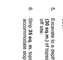
43 Plate 2.7. Manicured lawn of proposed MCSB replacement and parking area (hill to be re-graded in foreground, existing building will be situated mid-ground), view to northeast (Sept. 2014) LMRP Temporary Trail Connector - City Component Prior to commencement of Valley Line construction, to reduce the impact of the up to five years of construction on LMRP trails and facility use, the City will construct a short, temporary connector trail just west of the Project Area in the Chinese Gardens (Figure 2.1b; Plate 2.8). The temporary trail will connect the western portion of the primary north-south SUP to an established trail in the Chinese Garden, allowing pedestrians and cyclists to circulate through the broader network of park trails situated west of the main LRT project corridor and avoiding trail dead ends. The proposed temporary gravel trail will be approximately 1.5 m wide and 15 m in length. Design details and location are shown on Figure 2.6. Construction drawings indicate that the trail will be sub-excavated to 150 mm depth, filled with compact clay and topped with gravel. Trail construction in this sloped area will involve grade changes. The grade adjacent to the existing trail will be raised using clay fill and will taper down to the existing grade with a maximum slope of 1:3 (Figure 2.6). Fill will be stabilized using mm boulders installed at the bottom of the new embankment with one third of the boulders buried into the subgrade/topsoil. Topsoil and sod will be placed on disturbed soil adjacent to the new trail and positive drainage will be provided. The width of disturbed area will be approximately 2-3 m; total area of disturbance will be approximately 65 m 2. February 2015 Valley Line-Stage 1 LRT EISA Update FINAL REPORT Page 29

44 Figure 2.6

45 Plate 2.8. Approximate area of proposed LMRP temporary trail connector, looking south (Jan. 2015). The trail will cut through an existing planting bed and, thus, will require some site preparation, including relocation of several shrubs from the planting bed; stripping approximately 30 m 2 of shrub bed mulch and topsoil, and, stockpiling for re-use in nearby sites. Post-construction, all disturbed lands will be returned to their predisturbance condition. The connector trail will be constructed in late summer 2015, under a contract administered by Community Services. The contract will specify the need to prepare an ECO Plan, address utilities as required, and comply with all City bylaws and relevant environmental guidelines. 2.2 Spatial Clarifications Figure 2.7 shows the location and relative extent of the four project components requiring spatial clarification. All of the activities associated with each of the four project components will be undertaken by Project Co LMRP Rose Garden and SUP Tie-in As documented in the 2013 EISA, Valley Line construction will result in temporary disturbance to a portion of the World Walk SUP and associated Rose Garden in LMRP (Plate 2.9). The 2013 EISA noted that a portion of the Rose Garden was expected to be removed in support of construction and that it would either be restored at its current site February 2015 Valley Line-Stage 1 LRT EISA Update FINAL REPORT Page 31
46 LMRP Rose Garden/ SUP Tie-In Portal Structure * * Tunnel Cameron Ave. North Saskatchewan River 98A Ave. Trail Tie-In 048 RV 96A St. Parking Lot 98 Ave. Reconfigured Trail, Muttart Stop to 98 Ave. Legend Refinements to Project Co Project Lands Project Area Valley Line LRT Alignment (Reference Design) Bylaw 7188 Boundary City of Edmonton River Valley Natural Areas (2010) * Indicative Location Only Meters 1:1,500 Figure 2.7 Spatial Clarifications City of Edmonton LRT Valley Line - Stage 1 EISA Update Aerial Photograph Date: May 2012 Date Map Created: 10 February 2015

47 Plate 2.9. Existing World Walk SUP and Rose Garden (June 2014). following construction, or relocated to a new, permanent site. The 70% River Valley Landscape Drawings and the Project Agreement now in place for the project require Project Co to install a revisioned Rose Garden within the original Project Area. The drawings also require that the new garden area properly tie-in to the remnant portions of the Rose Garden and SUP situated west of the Project Area (Figure 2.8a). These activities represent a refinement of a mitigation measure committed to in the 2013 EISA; however, the tie-in work requires a slight extension of the Project Area. The project contract documents restrict Project Co activities in this area to landscaping activities only (Figure 2.8b). The total area associated with the tie-in work for the SUP and Rose Garden is approximately 527 m 2 (Figure 2.7). February 2015 Valley Line-Stage 1 LRT EISA Update FINAL REPORT Page 33
48 LMRP Rose Garden and SUP Tie-In, Area of Interest 22/08/2014 Figure 2.8a
49 LMRP Rose Garden and SUP Tie-In, Area of Interest 22/08/2014 Figure 2.8b

50 A Avenue Trail Tie-in to SUP The 2013 EISA noted that LRT construction will disrupt portions of trails situated in HMEP in the vicinity of the south end of the new Tawatina Bridge crossing the NSR. It acknowledged the need to redevelop that area of the park and committed to providing a seamless tie-in to adjacent existing trails. During development of the 70% River Valley Landscape Drawings it became evident that the full area required for this work, particularly to appropriately tie-in to the existing east-west SUP at the north end of the HMEP parking lot, near 98A Avenue, was not captured by the 2013 EISA Project Area (Figure 2.9) (Plate 2.10, 2.11). This area has now been captured by both the landscape drawings that guide Project Co and by the revised Project Area boundary (Figure 2.7). The work area for this SUP tie-in will total 108 m 2 (Figure 2.9). Valley Line contract documents include specifications that limit Project Co work in this area to the work described in the landscape drawings; the added area will not be permitted to function as a general construction area. Plate Site of trail tie-in work required at HMEP and 98A Avenue, behind the no-stopping sign, see in the foreground (Jan. 2015). February 2015 Valley Line-Stage 1 LRT EISA Update FINAL REPORT Page 36

51 98A Avenue Trail Tie-In, Area of Interest 22/08/2014 Figure 2.9

52 Plate Site of trail tie-in work required at HMEP and 98A Avenue, looking north from within HMEP (April 2013) Reconfigured Trail, Muttart Stop to 98 Avenue The 2013 EISA describes LRT work required in the vicinity of the Muttart Conservatory and the Muttart Stop as temporarily and adversely affecting river valley trails in the Muttart grounds. Built-in mitigation measures included installation of a new entrance plaza connecting the Conservatory grounds to the new LRT stop and reconfiguration of trails in that area to provide appropriate access to both north and south bound platforms and the larger local path network, as needed. The trail or pathway connections in this area have now been refined as part of development of the 70% River Valley Landscape Drawings. Those plans show a realigned trail connecting the south (northbound) platform to the Muttart Conservatory grounds and local trail network, and, a new trail connecting the north (southbound) platform to the Muttart grounds and Cloverdale Neighbourhood at 96A Street, thus providing access to the south terminus of the 98 Avenue Pedestrian Bridge. The new trail moves under the bridge to connect with 96A Street. That connection requires a narrow extension of the Project Area in that locality, parallel to 98 Avenue (Figure 2.10; Plate 2.12, 2.13) totaling an additional 227 m 2. The Valley Line contract includes specifications that limit Project Co work in this area to trail construction only; the area will not be permitted to function as a general construction area. February 2015 Valley Line-Stage 1 LRT EISA Update FINAL REPORT Page 38


53 Plate 2.12: Lands extension for the new tie-in trail south of 98 Avenue, looking east (June 2014). Plate 2.13: Lands extension for new tie-in trail, south of 98 Avenue, west of 96A Street, looking northwest (June 2014). February 2015 Valley Line-Stage 1 LRT EISA Update FINAL REPORT Page 39
54 Reconfigured to Trail, Muttart Stop 98 Avenue, Area of Interest 22/08/2014 Figure 2.10

55 A Street Parking Lot The 2013 EISA described the temporary loss of a small trailhead parking lot situated in HMEP, immediately west of 96A Street (Figure 2.4; Plate 2.14). The parking lot was described as within the Project Area and available to Project Co for general construction purposes. Post-construction re-establishment of the parking lot was included in EISA mitigation commitments. While the 2013 EISA narrative identified this small parking lot as part of the Project Area, the Project Area boundary presented in that report included only the western half of the parking lot. As the full parking lot would necessarily be affected during parking lot re-establishment, the Project Area boundary has now been shifted approximately 10 m to the east to include the entire parking lot, adding 364 m 2 to the Project Area. As had been intended all along, the full parking lot will be available to Project Co for general construction activities. Plate 2.14: Trailhead parking lot at HMEP; lands will include up to the far side of the treed median shown mid-photograph. February 2015 Valley Line-Stage 1 LRT EISA Update FINAL REPORT Page 41
56 3.0 ASSESSMENT METHODS 3.1 General Methods This update differs from the 2013 EISA in that it builds on information provided in that EISA. Therefore, to varying degrees for each project component, an abbreviated impact assessment process was adopted based on the methods used in The disparate locations, size and nature of the eight assessed project components lent themselves to treatment in separate report chapters, with the level of assessment and the aspects assessed commensurate with the proposed change. That the City is undertaking two of the eight project components also favours the separate treatment of components, particularly with respect to mitigation development. For each component, impact assessment examined specific key issues, for select Valued Environmental Components (VECs), used known design information and construction practices specific to that proposed change and did not consider those impacts that had already been addressed in the 2013 EISA. For this update, only new impacts were examined in detail. 3.2 Issue Identification For each component, key project issues were identified by considering project component activities, issues raised for the overall Valley Line project, issues raised by the public through review of the released RFP documents, issues raised at the EISA Update open house held in February 2015 (see Section 3.7) and applying professional judgement. Each key issue was examined during impact assessment. The resolution of each identified key issues is described at the end of each component chapter. 3.3 Selection of Valued Environmental Components VECs for this EISA Update were selected separately for each assessed project component. For each component, VECs from the 2013 EISA and the Bylaw 7188 environmental review guidelines were reviewed to assess relevance. If no potential existed for the project component to interact with that VEC in a manner that resulted in additional or unique issues, no further consideration was given to that VEC. In instances where it was determined that some potential existed for additional or unique issues, that VEC was then examined with respect to relative abundance/status, public concerns, professional judgement, economic importance, and regulatory concerns to more specifically justify the inclusion of the VEC. This selection process is documented individually for each project component in subsequent sections of this report. 3.4 Assessment Spatial and Temporal Scope The spatial boundaries, or discrete study areas, used for individual project components are shown in Figure 2.1a 2.1d. For each component, the study area was generally defined by the lands to be directly affected by that component. For some component, for February 2015 Valley Line-Stage 1 LRT EISA Update FINAL REPORT Page 42
57 a select few VECs, a component s study area was expanded to fully account for all potential interactions. Such expansions are detailed in Chapters 4 through 11. For Project Co components, the construction period is anticipated to be 2016 to For City components, construction is anticipated to occur in 2015, possibly extending to As the Project Co components are not integral to LRT operation, this update covers only the construction period. All of the lands supporting the assessed components will be handed back to the City at Service Commencement or in the very early operations phases, once reclamation and landscaping work is fully complete. For the City components, the assessment focuses only on construction, including reclamation because 1) park connector trail operation is a known entity subject to standard maintenance practices and 2) a Muttart Storage building has been operating in the valley for many years, thus this is not a new activity. 3.5 Description of Existing Conditions The description of existing conditions provides a current snapshot of the individual project component areas as documented by investigations during the period 2012 to Methodologies employed to describe existing conditions generally followed those used in the 2013 EISA and component-specific methods are specifically described in each project component chapter. 3.6 Impact Analysis Potential Impacts Where it was determined that the potential existed for new or unique impacts to individual VECs specific to a project component, impacts were investigated, described and classified using the same methodology as employed in the 2013 EISA. Potential impacts were addressed based on the information presented in the component project description (in Chapter 2). Sound project planning involves incorporating best management practices and mitigation measures into early planning, and this has been done for these components. This initial assessment assumes that built-in mitigation measures noted in the project descriptions, such as compliance with all laws and best management practice guidelines are all effectively implemented. Additionally, previously-developed Project Agreement clauses (contractual obligations) specific to the Valley Line LRT were also considered in assessments for all project components to be undertaken by Project Co. All identified impacts were described and classified as to their direction (positive, adverse), magnitude (negligible, minor, or major), and duration (short-term, long-term, or permanent) and our confidence in impact prediction (predictable or uncertain effect) noted. These descriptors were defined as follows: February 2015 Valley Line-Stage 1 LRT EISA Update FINAL REPORT Page 43
58 Direction: Positive Impact: An interaction that enhances the quality or abundance of natural or historical resources, or social pursuits or opportunities. Adverse Impact: An interaction that diminishes the abundance or quality of natural or historical resources, or social pursuits or opportunities. Magnitude: Negligible Impact: An interaction that is determined to have essentially no appreciable effect on the resource. Such impacts are not characterized with respect to direction, duration or confidence. Minor Impact: An interaction that has an appreciable effect but does not affect local or regional populations, natural or historical resources beyond a defined critical threshold (where that exists) or beyond normal limits of natural perturbation; or, an interaction that slightly alters existing or future recreational pursuits at established facilities or well-used areas. Major Impact: An interaction that affects local or regional populations, natural or historical resources beyond a defined critical threshold (where that exists) or beyond the normal limits of natural perturbation; or, an interaction that changes the character or precludes existing or future social pursuits at established facilities or well-used areas. Duration: Short-term Impact: An interaction resulting in measurable change that does not persist for longer than two years. Long-term Impact: An interaction resulting in measurable change that persists longer than two years, but at some point dissipates completely. Permanent Impact: An interaction resulting in measurable change that persists indefinitely. Confidence: Predictable Impact: Effects on VEC are well understood through experience in projects of a similar nature. Uncertain Impact: Effects on VEC are not well understood owing to lack of knowledge of the VEC and/or its response to disturbance. February 2015 Valley Line-Stage 1 LRT EISA Update FINAL REPORT Page 44
59 3.6.2 Residual Impacts In the next step of the assessment, mitigation measures were developed to address identified adverse, minor and major potential impacts. Residual impacts were then characterized. Residual impacts are impacts predicted to remain after application of mitigation measures. Residual impacts were characterized according to the above impact descriptors, with one exception: Predictable Residual Impact: Efficacy of proposed mitigation measures is well understood through application in similar projects or circumstances. Uncertain Residual Impact: Efficacy of mitigation measure is not well understood because of lack of previous experience in similar circumstances or lack of knowledge about the VEC. 3.7 Public Engagement Process The 2013 EISA required that the public be engaged regarding any proposed changes to the Valley Line. Additionally, the City s Guide to Environmental Review Requirements in the North Saskatchewan River Valley requires public participation appropriate to the scope and scale of the proposed project. Taking this into consideration, LRT D and C developed a supplementary public engagement plan for the EISA Update which included the following objectives: Satisfy the requirements of Bylaw 7188 by: o Creating awareness of the project adjustments. o Providing an opportunity for public input. Ensure project adjustments and the context of EISA Update are understood. Exhibit responsiveness to public issues and concerns. Demonstrate process transparency. Implementation of the public engagement plan took the form of a drop-in public open house, held from 17:00 to 20:30 hours on 03 February 2015 at the Old Timer s Cabin at 9430 Scona Road in Edmonton. Stakeholders were notified in advance of the open house through a variety of methods, including web/ notification, direct mail, roadside signs and social media. Representatives from LRT D and C and Spencer Environmental were present to discuss the update and receive public input. Display panels covering the 2013 EISA and Update, its purpose and objectives, the proposed changes being assessed and other supplementary information not directly related to the Update (i.e. trail detours and ongoing engagement) were presented to members of the public during the open house. Hard copy comment forms were provided to attendees and online comments were also accepted. February 2015 Valley Line-Stage 1 LRT EISA Update FINAL REPORT Page 45
60 4.0 NORTH VALLEY PRIMARY CONSTRUCTION ACCESS 4.1 Context The proposed primary construction access road for all north valley construction activity will be temporary in nature but in place for the duration of construction in the north valley, estimated at five years. The proposed access road will support high volumes of traffic during select construction activities, for periods lasting many days. The route will follow the corridor shown in Figure 2.1b and Plate 2.2. Project Co will be required to design and construct the access road to the standard needed to carry out the work safely and without adversely affecting slope stability in the park. Project Co is expected to upgrade the SUP portion of the route to accommodate two-way construction traffic. At this stage, the City has not ruled out the need for Project Co to widen the existing maintenance vehicle road leading from Grierson Hill. While in use for Valley Line construction, that road must also remain available to others for servicing of the facilities at the Riverfront Plaza. The access route may not be used for general construction purposes. 4.2 Assessment Methods As this project component was not assessed in 2013 and involves a significant boundary adjustment, the VECs selected for this assessment are very similar to those included in the 2013 EISA (Table 4.1). The spatial boundaries, or study area, for this assessment, are shown in Figure 2.1b. The assessment recognizes that project access routes will extend beyond these boundaries along established City roads, but this aspect was not covered in the assessment. For a select few VECs the study area was expanded. Expansions are noted in VEC-specific sections. Specific studies undertaken for this assessment in 2014 included the following: Reconnaissance-level site inspections on 20 June and 15 September 2014, focusing on general vegetative characteristics. A rare plant survey on 07 July Breeding bird surveys on 17 and 27 June Site-specific geotechnical and slope stability assessment of lands traversed by the proposed road (Thurber Engineering 2014) (Full report provided in Appendix B). February 2015 Valley Line-Stage 1 LRT EISA Update FINAL REPORT Page 46
61 Potential for Additional or Unique Issues 1 Relative Abundance or Status Public Concern Professional Concern Economic Importance Regulatory Concern Spencer Environmental Table 4.1. Justification for the selection of VECs North Valley Primary Construction Access Valued Environmental Components Relevant Legislation/Bylaw/Policy Geology/Geomorphology Valued Ecosystem Components Yes Soils Yes Hydrology Surface Water/ Groundwater Fish and Fish Habitat Vegetation Wildlife Yes No Yes Yes Bylaw 7188 Bylaw 7188 Drainage Bylaw Bylaw 7188 Drainage Bylaw Alberta Water Act Bylaw 7188 Alberta Weed Control Act Bylaw 7188 Federal Species at Risk Act Federal Migratory Birds Convention Act Alberta Wildlife Act Habitat Connectivity Yes Bylaw 7188 Valued Socio-economic Components Land Disposition and No Land Use Zoning Residential Land Use No Recreational Land Use Yes Bylaw 7188 Utilities Yes Bylaw 7188 Worker and Public Safety No Visual Resources Yes Bylaw 7188 Valued Historic Components Historical Resources Yes Alberta Historical Resources Act Bylaw In instances where it was determined that no potential existed for additional or unique issues to arise, no further consideration to that VEC was given February 2015 Valley Line-Stage 1 LRT EISA Update FINAL REPORT Page 47
62 4.3 Key Issues Key issues were identified by: 1) examining the project component location, known conditions and potential project activities; 2) considering concerns raised by the public and City services departments; and 3) applying professional judgement. Following are the key issues identified in association with the proposed primary construction access road: Will construction of the access road adversely impact slope stability on the north valley wall or riverbank? Will the landfill present challenges to road stability or performance and lead to more disturbance? Do contaminated soils occur within the project component area? Could the work result in mobilization of contaminants from contaminated soils? Will construction of the access road lead to surface erosion? Does contaminated groundwater occur within the project component area? Could the work result in mobilization of contaminated groundwater? Will vegetation in recognized Natural Areas be affected? Does the work have potential to affect rare, threatened or endangered plants or plant communities? Will any special status wildlife species be affected by access road construction? Will local pathway disruptions be suitably mitigated for all users, including those requiring a fully accessible pathway? Will access to River Valley Adventures/Urban Green Café or washrooms be disrupted as a result of the access road? Will use of the construction access interfere with park programming or special events? Does this project component have potential to affect known historical resources? 4.4 Existing Conditions by VEC Geology/Geomorphology Methods Thurber Engineering (2014; Appendix B) conducted a site-specific geotechnical investigation and preliminary slope assessment in support of the proposed construction access road through the west side of LMRP. Their investigation comprised a desktop analysis of existing geotechnical information available for LMRP and a field program conducted on March The field program comprised drilling eight test holes for the installation of geotechnical instruments - six holes along the proposed access road alignment to depths ranging between 6 m and 10 m below existing ground surface, and two deep holes upslope of the road alignment to depths 45.6 m and 33.3 m below existing ground surface. Also, five additional test holes were drilled to depths ranging from 5.2 m to 11.9 m below existing ground surface near the eastern end of the road alignment, for a separate study characterizing the thickness of waste material present in the area. February 2015 Valley Line-Stage 1 LRT EISA Update FINAL REPORT Page 48
63 Standpipe piezometers were installed in the boreholes along the proposed access road alignment, to monitor groundwater levels. Soils and bedrock collected in boreholes were subject to laboratory investigations to assess physical, chemical and mechanical properties such as moisture content, strength, and grain size. The full suite of parameters examined, and results for individual samples, are presented in Thurber Engineering 2014 (Appendix B). As part of this study, Thurber Engineering examined antecedent and new data from six inclinometers, including two inclinometers installed along the proposed access road alignment and four previously installed inclinometers at the eastern end of the access road alignment. All newly and previously installed instruments were monitored several times each year following installation. In addition, slope stability assessments were carried out on four cross sections of two bentonite seams ( A and B ) and also at the riverbank, using the software SLOPE/W (Thurber Engineering 2014). The intent of the stability analyses was to compare existing slope stability and factor of safety (prior to construction) with predicted slope stability and factor of safety following access road construction. Composition of bedrock and depositional layers, shear strength of material and groundwater conditions were all incorporated into assessments of slope stability. Further details are provided in Thurber Engineering 2014 (Appendix B). For the purposes of their assessment, Thurber Engineering (2014) assumed that fills associated with construction of the proposed access road would be placed up to 1 m high and that the road would be approximately 8 m wide to accommodate two-way traffic Description Slope Stability The cross-slope, proposed primary construction access road would be located near the toe of the Grierson Hill Slide, a major deep-seated landslide that occurred on the north slope of the North Saskatchewan Valley in 1901 (Thurber Engineering 2014). The landslide measures approximately 600 m east-west along the riverbank in LMRP extending from the Shaw Conference Centre in the west to the Cloverdale Pedestrian Bridge to the east. The northern limits of the slide are bounded by Grierson Hill Road and the south limits by the north bank of the NSR (Figure 4.1) (Thurber Engineering 2014). Since the initial slope failure in 1901, the Grierson Hill slope has been modified by extensive dumping and backfilling, mainly on the upper portions of the slope, including using the area as a City landfill (Grierson Nuisance Grounds see below). Movement of the valley slope has been monitored since the 1950 s and movement rates have been noted as very sensitive to changes in slope condition (e.g., grading works, toe erosion, precipitation, etc.). Various slope stabilization measures have been implemented over the years, which have considerably improved overall slope stability. Slope inclinometers, installed in 2000, 2010 and 2011, and monitored regularly since November 2010, have detected no noticeable slope movements since their installation (Thurber Engineering 2014; Appendix B). February 2015 Valley Line-Stage 1 LRT EISA Update FINAL REPORT Page 49


 APPROXIMATE")
 APPROXIMATE TOE OF")
 PROPOSED LRT")


64 Z:\19\ \for tme\ ar.dwg - 1AR - Oct. 09, 2014 BASE PLAN PROVIDED BY CH2M HILL CANADA LTD. LEGEND TEST HOLE LOCATION BY THURBER PREVIOUS TEST HOLE LOCATION BY OTHERS TEST HOLE LOCATION WITH EXISTING SLOPE INCLINOMETER BY THURBER CURRENT SLOPE CREST / SCARP (APPROXIMATE) APPROXIMATE SLOPE CREST IN 1887 (BEFORE FAILURE) APPROXIMATE TOE OF RIVERBANK IN 1887 (BEFORE FAILURE) PROPOSED LRT ALIGNMENT m SCALE SCALE 1:2000 DRAWN BY DESIGNED BY APPROVED BY DATE FILE No. PROPOSED NORTH BANK ACCESS ROAD PRELIMINARY GEOTECHNICAL INVESTIGATION AND ASSESSMENT SITE PLAN SHOWING THE ALIGNMENT OF THE PROPOSED CONSTRUCTION ACCESS ROAD AND APPROXIMATE TEST HOLE LOCATIONS DWG No AR ML TME HER 1:2000 OCTOBER Figure 4.1
65 Landfill As noted above, the site of the Grierson Hill landslide was used as a landfill (Grierson Nuisance Grounds) for several decades in the early 20th century. Since then, the landfill has been covered with soil fills and landscaped for the creation of LMRP. The approximate boundaries of the landfill have been identified as shown in Figure 4.2 and the 2013 EISA documented the overlap with the proposed LRT infrastructure. The proposed construction access road will intersect with the southern edge of the landfill. Based on their test hole data, Thurber Engineering (2014) noted that landfill materials were up to 20 m thick in the central area of LMRP, approximately 200 to 300 m west of the LRT alignment. Fill encountered during drilling included brick fragments, pieces of glass and wood. Some waste has also been documented close to the surface. For example, waste was evident at 30 cm below existing ground surface at Testhole 14-1, in the vicinity of the construction access road. As noted in the 2013 EISA, a Phase II ESA undertaken in early 2013 (Connected Transit Partnership 2013b) included two test holes at the former landfill location, yielding soils with significant metals exceedances including arsenic, boron, lead, copper nickel, tin, zinc, and boron Soils Methods Thurber Engineering (2014) also provided some information on soil depth and additional information on sub-surface conditions along the proposed construction access alignment Description Subsurface conditions in the proposed primary construction access road corridor comprised topsoil and fills of varying composition and thickness overlying colluvium (lacustrine clay, clay till and sand) (Thurber Engineering 2014). Conversely, clay shale and sandstone bedrock were encountered directly beneath the topsoil or below a limited thickness of fill at the east end of the proposed alignment. Topsoil was encountered in all test holes and ranged in thickness between 0.15 m to 0.3 m. The fill ranged from 1.6 to 2.9 m in thickness at the western and eastern ends of the proposed road alignment, which coincided with the flanks of the Grierson Hill slide. Fill was approximately 5.8 m thick along the central part of the alignment. Overall, fill comprised clay or clay shale with intermittent gravelly and sandy horizons and included coal, peat, organic soils, brick fragments, pieces of glass and wood (Thurber Engineering 2014) Hydrology Methods Hydrology investigations specific to this component focused on groundwater as there are no surface water features in the study area. The NSR, previously discussed in the 2013 EISA, is situated downslope from the proposed road, approximately 40 m at its closest point. February 2015 Valley Line-Stage 1 LRT EISA Update FINAL REPORT Page 51
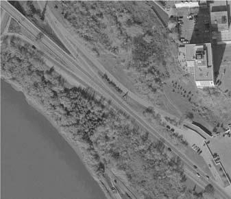
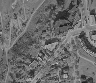
66 SCALE Z:\19\ \ Report Dwg\ A & 6.dwg - 3A - Mar. 14, 2012 LEGEND GRIERSON HILL USED AS A WASTE DUMP FOR EDMONTON BETWEEN 1911 AND 1940 PRESENT DAY SLOPE CREST / SCARP SLOPE CREST IN 1887 (BEFORE FAILURE) TOE OF RIVERBANK IN 1987 (BEFORE FAILURE) PROPOSED LRT ALIGNMENT SCALE 1: m AIR PHOTO PROVIDED BY CH2M HILL CANADA LTD. EDMONTON SOUTHEAST LRT EXTENSION PRELIMINARY GEOTECHNICAL INVESTIGATION GRIERSON HILL SLIDE - PLAN VIEW DRAWN BY DESIGNED BY APPROVED BY DATE FILE No. KLW MB HER 1:3000 MARCH DWG No A Figure 4.2
67 To assess groundwater conditions, Thurber Engineering (2014) installed standpipe piezometers in six of the boreholes drilled along the proposed access road alignment for groundwater level monitoring Description Groundwater Depth Short-term groundwater levels measured by Thurber Engineering in 2014 along the proposed road alignment ranged from 4.6 m to 8.1 m below existing ground surface, with two piezometers recording no groundwater (Thurber Engineering 2014). As these are short-term results, they may not represent stabilized long-term groundwater levels. Landfill Contaminated groundwater is known to exist within the boundaries of the former landfill. This was not further examined for this project component, as the proposed work does not involve deep excavation. In support of other Valley Line components, a landfill groundwater monitoring program has been established further east, closer to the permanent Valley Line infrastructure. Results are not yet available Vegetation Methods A rare plant and plant community survey was undertaken by a professional plant ecologist in LMRP on 07 July 2014 in support of this proposed construction access road assessment. For this VEC, the study area was expanded to encompass most of LMRP west of the Project Area previously surveyed for the 2013 EISA. Both natural plant communities and manicured areas occur in the west portion of the park. The focus of the plant surveys was to map and characterize natural vegetation; however, manicured areas were also coarsely characterized. Plant Communities First, all plant communities in the study area were delineated on an aerial photograph as a desktop exercise, then field investigations were undertaken to ground truth and refine community boundaries, develop descriptions of plant community character and floristics, and document rare plant occurrences. Each natural plant community was surveyed via meandering transects. All species observed were documented and their relative abundances ranked as dominant, abundant, frequent, occasional, or rare (meaning uncommon in that community). Plant species that could not be identified in the field were collected and identified with the aid of a dissecting scope and various keys and botanical manuals. Following field surveys, species were classified as native or exotic based on data in the Alberta Conservation Information Management System (ACIMS), which provides a comprehensive database of species known to occur in the province (Alberta Environment and Sustainable Resource Development 2014). Species nomenclature followed ACIMS. Common species names are used throughout this February 2015 Valley Line-Stage 1 LRT EISA Update FINAL REPORT Page 53
68 document with scientific names provided in brackets. Complete plant community data, including species scientific names, are provided in Appendix C. Plant communities were delineated based on aerial photographs during field surveys, and later classified according to the system developed by Westworth and Associates (In: EPEC Consulting Western Ltd. 1981) specific to Emonton in the NSRV, but adjusted as necessary. This classification system focuses largely on forest types, as the majority of natural communities found in the river valley are treed, and classification is primarily based on canopy composition. Spencer Environmental has found it necessary in the past to include separate classifications for caragana (Caragana arborescens) and Manitoba maple (Acer negundo) dominated communities, as those communities do not fit within the system developed by Westworth and Associates but are present throughout the river valley. Manicured areas were classified as lawns, gardens, and planted beds. Lawns were defined for the purpose of this assessment as areas dominated by grass and regularly mowed, that may also contain scattered, planted trees. Gardens were discrete beds dominated by ornamental flowers and shrub species. Planted beds were characterized by concentrations of planted, native or exotic shrubs and trees and having definite boundaries. Gardens and planted beds were coarsely surveyed, gathering only the data necessary to characterize them broadly. Lawns were mapped but not surveyed; therefore, individual planted trees are not identified. Reconnaissance level investigations showed that all manicured areas were typically dominated by ornamental cultivars and non-native plants. Rare Plant Survey All plant communities were surveyed at an intensity that was deemed sufficient to capture the diversity of habitats within the site and to encounter any rare species present. Prior to conducting the rare plant survey, the ACIMS database was consulted to identify any existing records of rare plants within or near the study area, as this was last done for this general area in The rare plant survey was carried out via meandering transects in all natural plant communities. Rarity was defined by subnational ranks (S-ranks) based on up-to-date data from ACIMS. For the purposes of this report, S1, S2, and S3 species were considered rare, as is the stated practice of City of Edmonton Urban Ecology (Young pers. comm.) Description Vegetation in the west portion of LMRP is characterized by landscaped parkland, including manicured lawns and several types of formal gardens, and is traversed by several paved pathways (Plate 4.1). Non-manicured, natural communities in this area are relatively small and, at the time of our survey, consisted of grassland (G), Manitoba maple (MM) and a portion of one larger, poplar-manitoba maple (PMM) forest community on the west edge of the study area (Figure 4.3). Detailed descriptions of each community are provided below. A full list of species observed in each community is provided in Appendix C. February 2015 Valley Line-Stage 1 LRT EISA Update FINAL REPORT Page 54
69 LMRP Temporary Trail Connector Tunnel * Grierson Hill LOUISE MCKINNEY RIVERFRONT PARK Portal Structure * 056 RV North Valley Primary Construction Access North Saskatchewan River Legend Additional Lands Undertaken by Project Co Lands Involved in Preparatory (Early) Works Undertaken by City of Edmonton Project Area Valley Line LRT Alignment (Reference Design) Bylaw 7188 Boundary City of Edmonton River Valley Natural Areas (2010) Pathway/Structure Natural Communities * Indicative Location Only Balsam Poplar/Manitoba Maple (PMM) Manitoba Maple (MM) Caragana (C) Grassland/Shrub (G/S) Grassland (G) Manicured Communities Lawn Garden Planted Bed Meters 1:1,400 Figure 4.3 North Valley Primary Construction Access & LMRP Temporary Trail Connector, Existing Plant Communities City of Edmonton LRT Valley Line - Stage 1 EISA Update Aerial Photograph Date: May 2012 Date Map Created: 10 February 2015
 Grassland (G) Small naturalized grasslands (G) communities were")
70 Plate 4.1. The west portion of LMRP is characterized by landscaped parkland, including manicured lawn, gardens and paved pathways (July 2014) Grassland (G) Small naturalized grasslands (G) communities were located throughout the park including parallel to the SUP that will form the proposed construction access road and were commonly dominated by exotic grass species, including smooth brome, quack grass, and crested wheatgrass (Plate 4.2). Reed canary grass (Phalaris arundinacea) and slender wheatgrass (Elymus trachycaulus), both native grasses, were also dominant or abundant in some areas; Kentucky bluegrass (Poa pratensis) and western wheatgrass (Agropyron smithii) were frequently observed. Other common species included wild vetch (Vicia americana), alsike clover (Trifolium hybridum), common goat s-beard (Tragopogon dubius), prickly rose (Rosa acicularis), and buckbrush (Symphoricarpos occidentalis). A total of 52 species was detected in grassland communities, 20 (38%) of which were native. The remaining 32 species (62%) were exotic, with five of those species listed as noxious under the Alberta Weed Control Act. February 2015 Valley Line-Stage 1 LRT EISA Update FINAL REPORT Page 56
 grassland communities on the slopes of Louise McKinney Riverfront Park (July 2014) Manitoba Maple (MM) One naturalized Manitoba maple (MM) community was located in the west")
71 Plate 4.2. Naturalized (unmanicured) grassland communities on the slopes of Louise McKinney Riverfront Park (July 2014) Manitoba Maple (MM) One naturalized Manitoba maple (MM) community was located in the west end of the park bordering the maintenance vehicle access road (Figure 4.3). That community was dominated by Manitoba maple, with occasional balsam poplar (Populus balsamifera) and red-osier dogwood (Cornus stolonifera). The understorey was typically open, comprising reed canary grass, smooth brome (Bromus inermis), and quack grass (Elytrigia repens) (Plate 4.3). A total of 11 species was detected in this community, 7 (64%) of which were native. The remaining four species (36%) were exotic, with one noxious weed species observed. Manitoba maple is not native to this region of Alberta but has naturalized and commonly occurs in the NSRV and is often found as a sub-dominant tall shrub or tree species. February 2015 Valley Line-Stage 1 LRT EISA Update FINAL REPORT Page 57
 Poplar-Manitoba Maple (PMM) A densely-forested balsam poplar-manitoba maple (PMM) community was located on the slope")
72 Plate 4.3. Open understorey in a Manitoba maple community in Louise McKinney Park (July 2014) Poplar-Manitoba Maple (PMM) A densely-forested balsam poplar-manitoba maple (PMM) community was located on the slope below the Shaw Conference Centre at the west margin of LMRP and bordering much of the maintenance vehicle access road (Figure 4.2). This community is part of a larger area that is mapped by the City as Natural Area 056 RV. The canopy of this forest community was dominated by Manitoba maple and balsam poplar, and had occasional aspen (Populus tremuloides). The dense shrub layer consisted of buckbrush, prickly rose, red-osier dogwood, Saskatoon (Amelanchier alnifolia), and bracted honeysuckle (Lonicera involucrate). The margins of the PMM community, adjacent to along the existing access road were characterized as a typical edge community (Plate 4.4) that graded into the more mature stand interior. The margins consisted of shrubbery and young trees, with few mature trees. In particular, Manitoba maple formed dense populations with red osier-dogwood and prickly rose shrubs comprising the majority of the shrub layer. Together, these trees and shrubs formed a dense band, limiting the space available for low-growing shrubs or forbs to establish. The understorey along the edge was dominated by exotic species: smooth brome and quack grass were widespread, as were alfalfa and white sweetclover. Occasional creeping thistle, a noxious weed, was also observed along the edge, near the bottom of the slope. In contrast, the interior of this stand was characterized by a patchy canopy of balsam poplar and Manitoba maple, where the trees tended to be taller, February 2015 Valley Line-Stage 1 LRT EISA Update FINAL REPORT Page 58

73 with larger DBHs than closer to the edge (Plate 4.5). More space between trees promoted heterogeneity and facilitated the establishment of diverse shrub and herbaceous layers. Red-osier dogwood and prickly rose were common shrubs in the interior of the stand, as they were along the edges; however, snowberry and species of honeysuckle and currant were also frequently observed in the interior. Interior understorey was characterized by a variety of native forbs, such as wild sarsaparilla, northern bedstraw, star-flowered Solomon s-seal, and species of aster. Exotic and noxious weed species occurred throughout the stand, but they tended to be rare in the interior. A total of 58 species was detected in this community, 36 (62%) of which were native. The remaining 22 species (38%) were exotic, with three of those species listed as noxious weeds. Plate 4.4. The margins of the PMM community, adjacent to along the existing access road typified Edmonton river valley forest edge communities, view looking south (July 2014) February 2015 Valley Line-Stage 1 LRT EISA Update FINAL REPORT Page 59
 Manicured Areas Manicured lawns, gardens, and planted beds occupied most of the park including some")
74 Plate 4.5. Dense understorey in the interior of the PMM community along the west edge of LMRP (July 2014) Manicured Areas Manicured lawns, gardens, and planted beds occupied most of the park including some occurances in the vicinity of the SUP portion of the proposed access road. Planted beds in the park supported ornamental perennial forbs as well as trees and shrubs; common species included oleaster (Elaeagnus sp.), ornamental columnar poplar (Populus sp.), pine (Pinus sp.), and larch (Larix sp.). Planted beds comprising oleaster, pine, and columnar poplar were located along the staircases intersecting with the SUP to be upgraded (Plates 4.6 and 4.7). Special Status Species No rare plant species (i.e., ranked S1, S2 or S3) were detected within the construction access road corridor during the July 2014 survey. One rare plant species, smooth sweet cicely (Osmorhiza longistylis), was found at the edge of the vegetation survey area, within Natural Area 056 RV, but his was approximately 175 m southwest of the access road corridor. February 2015 Valley Line-Stage 1 LRT EISA Update FINAL REPORT Page 60


75 Plate 4.6. Manicured areas and paths, including columnar poplar, adjacent to the proposed access road alignment (July 2014) Plate 4.7. A typical planted bed along a staircase intersecting with the to the proposed access road alignment (July 2014) February 2015 Valley Line-Stage 1 LRT EISA Update FINAL REPORT Page 61
76 4.4.5 Wildlife Methods As the western portion of LMRP was not described in detail in the 2013 EISA, wildlife communities within the proposed primary construction access road area were described using a combination of literature review (including the 2013 EISA) and field investigations. Analysis of existing wildlife conditions was completed to a level commensurate with the scale of the project component area and the habitat potential, to enable a description of commonly occurring species and habitat quality, and a brief discussion of potential for the area to support special status species. Species nomenclature followed ACIMS. Common names are used throughout the report; scientific names are provided in Appendix D and E. Literature Review Several resources were consulted to determine wildlife species previously recorded in the area. The Fisheries and Wildlife Internet Mapping Tool (FWMIT) (Alberta Environment and Sustainable Resource Development 2014) was searched on 04 September 2014 for information regarding special status species recorded in the area. ebird, a publicly available database of citizen-scientist bird observations, was searched on 04 September 2014 for observations of bird species within the project area (Sullivan et al. 2009). To determine wildlife species potentially present in LMRP, information was compiled through a review of previous studies conducted within the NSRV. As was the case for the 2013 EISA, Westworth & Associates (1980) provided preliminary information. More recent and local supplemental information was provided by the 2013 EISA and an earlier study centered on LMRP (Spencer Environmental 2005). In addition, a number of scientific papers and field guides were consulted to determine species ranges and behavior. Field Investigations Wildlife field investigations were limited to the spring and comprised breeding bird surveys. No suitable amphibian breeding habitat was identified in the park. For bird surveys, the study area was expanded to include natural habitat adjacent to the proposed road corridor. A breeding bird survey was conducted on 17 June 2014 and repeated on 27 June 2014, to characterize breeding bird richness and abundance. Each bird survey consisted of a point count at each of two stations located within areas of natural vegetation (i.e., the PMM and MM plant communities) and a meandering search of areas supporting manicured vegetation (Figure 4.4). Each point count was an eight-minute survey, wherein all birds detected (seen or heard) within a 50 m radius were recorded. The meandering survey consisted of walking SUPs in the vicinity of the proposed primary construction access road at a rate of approximately 40 m/s and recording all birds detected using habitat in that area. Data from the bird surveys were reported as the maximum number of individuals of each species detected on 17 or 27 June 2014, and the total number of surveys that each species was detected in (out of four point counts and two meandering surveys). All other animal observations or signs were documented and described in terms of presence and habitat use. All habitat types present were briefly described and qualitatively assessed with respect to habit potential. February 2015 Valley Line-Stage 1 LRT EISA Update FINAL REPORT Page 62
77 101a Ave. Jasper Ave. 95 St. Cameron Ave. Grierson Hill LOUISE MCKINNEY RIVERFRONT PARK North Valley Primary Construction Access Tunnel Portal Structure * * North Saskatchewan River REGIONAL WILDLIFE STUDY AREA Legend Bird Point Count Survey Location (with 50m radius plot) Bird Survey Transect Addition to Lands Undertaken by Project Co * Indicative Location Only Figure 4.4 North Valley Primary Construction Access, Wildlife Survey Locations City of Edmonton LRT Valley Line - Stage 1 EISA Update Project Area Valley Line LRT Alignment (Reference Design) Bylaw 7188 Boundary Meters Aerial Photograph Date: May 2012 Date Map Created: 10 February :2,700
78 Description The manicured character of LMRP and its location in the center of Edmonton makes the habitat within the project area most suitable for urban-adapted species (e.g., coyotes, several small mammals, commonly-occurring, disturbance-tolerant bird species), although some less tolerant wildlife species may be present on an irregular basis. Please refer to the 2013 EISA for a more complete discussion of wildlife habitat and communities within this reach of the NSRV. Wildlife Habitat Of the habitat present within LMRP, there are three types of natural vegetation that are not manicured and experience lower levels of human use. These areas are assumed to provide the highest quality wildlife habitat within the west part of LMRP. The first is a patch of poplar-manitoba maple (PMM) along the steep slope at the western edge of LMRP (Figure 4.3). The second is a patch of large Manitoba maple (MM) trees on the east side of the existing paved maintenance vehicle access road. The third habitat type is naturalized grassland (G), which occurs as several discrete patches scattered around the west part of LMRP. All of these habitats likely support a small variety of small animals. The existing buildings and structures within LMRP also offer suitable nesting habitat for avian species such as eastern phoebes and some swallows species. Finally, manicured lawns offer some foraging habitat to commonly-occurring species, such as American robins, and ornamental trees can provide perching and nesting habitat for several urbantolerant bird species. The NSR, located outside of our survey area, but possibly influencing bird use in the park, comprises aquatic habitat suitable for foraging and loafing by a number of waterbird species. It is possible that some urban-tolerant waterbird species at times nest, graze, or loaf in the park. Avifauna A total of eight bird species was observed during point count and meandering surveys (Table 4.2; Appendix D). The most common species observed within the naturally vegetated areas in LMRP was the black-billed magpie, which was the most abundant species and was observed at both survey stations and during both visits (17 June and 27 June 2014). Yellow warblers were also abundant during the 17 June 2014 survey. Along the meandering search transect, clay-coloured sparrows were abundant in the shrubs along the NSR, south of the paved SUP. Song sparrows were also frequently observed in this area. All of the species observed are common, urban-adapted species that typically occupy deciduous woodland, shrubby habitat, or manicured areas, the common natural habitat types in the study area. No special status species were observed. February 2015 Valley Line-Stage 1 LRT EISA Update FINAL REPORT Page 64
79 Table 4.2. Bird species recorded during point count and meandering surveys conducted during the breeding season of 2014 in LMRP Point Count Survey Meandering Survey Species Total Count % of Surveys Present (n=4) Total Count % of Surveys Present (n=2) Gray catbird (Dumetella carolinensis) Yellow warbler (Setphaga petechia) Black-billed magpie (Pica pica) Clay-coloured sparrow (Spizella pallida) American robin (Turdus migratorius) Chipping sparrow (Spizella passerina) House finch (Haemorhous mexicanus) Song sparrow (Melospiza melodia) Total # Species 8 Bird abundance was greatest in the poplar-manitoba maple (PMM) forest (Figure 4.3). During the survey on 17 June 2014, three yellow warblers were observed singing in response to each other on either side of the paved SUP, indicating that this is good yellow warbler breeding habitat. Black-billed magpies were detected in this area on both visits. Fewer birds were detected in the Manitoba maple plant (MM) community. One claycoloured sparrow was heard singing from the planted pine trees to the east of that community. Only black-billed magpies and American robins were observed to be using the Manitoba maples, suggesting this habitat is only suitable for highly urban-adapted species and reflecting the lack of vertical habitat structure present in the community due to the sparse understorey. During the meandering survey, clay-coloured sparrows and song sparrows were frequently detected in the shrubs adjacent to the river and one gray catbird was also seen and heard moving through the shrubs in the study area. The two final species detected, house finch and chipping sparrow, are urban-adapted species that were detected in the manicured areas surrounding the parking lots. Mammals Of the mammal species that may occur within LMRP, small- and medium- sized urbanadapted species are the most likely to occur (Appendix D). White-tailed jackrabbits and red squirrels were observed in LMRP during field investigations. Ground-squirrels and skunks have previously been observed within the project area (City of Edmonton Animal Care and Control Centre 2011, Spencer Environmental 2005). Several larger mammals are also present. Coyote movement monitoring conducted by the Edmonton Urban Coyote Project has documented coyotes moving within the park (Murray and Cassidy St Clair unpublished data). Both white-tailed and mule deer have been observed in the NSRV, primarily outside the downtown core, but smaller populations and transients also occur closer to the city center, usually not far from the NSRV. Deer have been documented in Mill Creek Ravine and Gallagher Park less than 1 km across the NSR (Spencer Environmental unpublished data) and they are anecdotally reported in LMRP. February 2015 Valley Line-Stage 1 LRT EISA Update FINAL REPORT Page 65
80 The high level of human activity and lack of natural vegetation in LMRP likely discourages regular use by deer and other large ungulates and carnivores.. Amphibians & Reptiles No suitable breeding amphibian habitat is available in LMRP; however, two reptile species may occur year round within more natural habitat in the project area (Appendix D). The project area is within the range of red-sided and plains garter snakes; however, garter snakes generally prefer natural habitat with ample ground cover (Russell and Bauer 2000), and so if present in the project area are likely to be generally confined to the naturally vegetated areas (e.g., poplar-manitoba maple habitat on west margin of LMRP). Special Status Species Based on habitat requirements, habitat availability and provincial distributions, two special status species were considered to have at least a moderate probability of occurring in the north valley access study area: peregrine falcon, ranked provincially as At Risk, and little brown bat, ranked federally as Endangered under the Species at Risk Act (SARA) (Table 4.3; Appendix E). Common Name Peregrine Falcon (Falco peregrinus anatum) Little Brown Bat (Myotis lucifugus) Table 4.3. Select special status species with a moderate probability of occurrence in the study area Provincial Status* At Risk Wildlife Act Designation and New Species Assessed by ESCC 1 Threatened COSEWIC Designation 2 Special Concern SARA Designation 3 Schedule 1 (Threatened) Secure Endangered Endangered No *According to General Status of AB Wild Species (date) 1 ESCC- Alberta's Endangered Species Conservation Committee 2 COSEWIC - 3 SARA Committee on the Status of Endangered Wildlife in Canada 4 Fish and Wildlife Information Management System Recorded in Study Area Potential Habitat Use FWMIS Foraging High Foraging/ Roosting Peregrine falcons prefer to nest in rocky cliffs, or tall buildings in cities (White et al. 2002) and are known to nest on office buildings in Edmonton s downtown core, approximately 1 km northeast of the Cloverdale Pedestrian Bridge, and within 5 km at the University of Alberta. Peregrine falcons are also known to have nested in recent years on the High Level Bridge approximately 3 km upstream from the study area. Peregrine falcons often hunt in the NSRV and are recorded in FWMIS as foraging within 1 km of the local study area. Considering this information, Peregrine falcons are considered to have a high likelihood of foraging in the study area. Likelihood of Occurrence Moderate February 2015 Valley Line-Stage 1 LRT EISA Update FINAL REPORT Page 66
81 The most commonly occurring bat species in Edmonton, the little brown bat, may be present in the park as it is most often seen foraging around water bodies such as the NSR (Alberta Sustainable Resource Development 2001). Suitable roosting snags occur within the poplar-manitoba maple community. The little brown bat has recently been listed under the federal Species at Risk Act as Endangered due to extreme rates of mortality in the eastern United States caused by white-nose syndrome (WNS) (COSEWIC 2012). Although WNS has not yet been reported in western Canada, a similar event is expected, and this could severely reduce this species abundance. At present, the little brown bat remains common in the Edmonton area (ASRD 2001). Little brown bats roost in old nest cavities or under the bark of trees, and could make diurnal use of old snags in the poplars in the forest at the west end of LMRP and thus are considered to have a moderate potential to roost and forage in LMRP, and possibly breed in suitable trees or buildings. They do not overwinter in the Edmonton area. Within the areas subject to potential vegetation clearing, the potential for little brown bat breeding and roosting is considered low because the trees in these areas are relatively small, and little brown bats prefer larger than average diameter tree snags for cavity roosts (Crampton and Barclay 1998, Olson and Barclay 2013) Habitat Connectivity Methods Study Area Habitat connectivity was considered at two scales: locally and regionally. A regional wildlife study area was delineated to account for the fact that the local project area in LMRP comprises only a small portion of the home range for some species in that area and to facilitate the discussion of the NSR system as a wildlife movement corridor. A reduced regional study area used in the 2013 EISA was suitable because it included ecological boundaries relevant to potentially occurring wildlife species with large home range requirements, and considered the topographic NSRV features in the vicinity of the local project component study area. Habitat connectivity was assessed based on the quality and distribution of habitat in the local and regional study areas; consideration of local topography; a review of an existing report on landscape linkages and connectivity in the City of Edmonton (Spencer Environmental 2006); preliminary data from the University of Alberta urban coyote project (Murray and Cassidy St. Clair, unpublished data); and wildlife collision data from City of Edmonton Animal Care and Control Centre (2011) Description When juxtaposed with natural areas, highly developed lands, such as those supporting residential, commercial and recreational land uses, pose barriers to wildlife attempting to move through the lands to the adjacent more suitable natural habitat patches beyond them. In such cases, wildlife corridors within the developed areas play a key role in successful wildlife movement between the disjunct, natural habitat patches. They provide a necessary link between larger habitat areas, accommodating daily, seasonal or February 2015 Valley Line-Stage 1 LRT EISA Update FINAL REPORT Page 67
82 dispersal movements that enable genetic exchange and access to other resources (Paquet et al. 2004). The viability of an area as a wildlife corridor is a function of the continuity in its vegetation structure, its width, the amount and type of surrounding disturbance and the quality of the habitat it connects. Major wildlife corridors provide cover and resources, connecting large areas of habitat at a regional scale. River valleys and their associated riparian strips are widely recognized as major wildlife corridors (Vermont Agency of Natural Resources 2005). The Edmonton NSRV is the longest continuous urban green space in North America, has abundant natural cover, links much wilder habitat on either end of the City, and is viewed as an important regional biological corridor (Spencer Environmental 2006). For those reasons, the NSRV serves as the foundation of Edmonton s ecological network. Within the regional study area, the presumed general direction of dispersal movement is east-west, following the river alignment and the quality of the corridor is variable. At the west end a relatively narrow strip of naturally wooded valley lines the riverbank and provides a nearly continuous corridor for movement through that part of the city core. This segment is assumed to be used regularly by species that are tolerant of the adjacent residential areas and valley recreational use and to also be important for intermittent use by species attempting to follow the valley through the city. The existing paved maintenance vehicle access and the Riverfront Plaza likely deflect movement of animals leaving the east and south edges of that natural habitat patch. The proposed primary construction access corridor, while mostly paved, is currently embedded in a mosaic of naturalized grassland habitat on the valley slopes. The slope bottom comprises landscaped manicured habitat. The lack of forested area within this construction corridor does not provide the protective cover preferred by many species such as deer or fox and weasel. This highly developed and manicured park area is an exposed portion of the longer north valley corridor. There is some more continuous habitat cover along the riverbank within the local study area that may facilitate the movement of smaller wildlife species through the area, but the value is diminished by the presence of the riprapped bank and the concrete promenade. The Cloverdale Pedestrian Bridge spanning that narrow band of habitat is a further limitation for the largest mammals (i.e., moose and deer). Coyotes, which tend to be less wary and more willing to travel through open areas, have been documented to travel through the area, including the open park space (Murray and Cassady St Clair unpublished data) and across the river in winter, proving the connectivity within the wider valley corridor. East of the future Valley Line LRT, lands offer more cover, but the suitable area is only approximately 60 m wide (between residential property boundaries and the shores of the river). And then, further east, wildlife movement is assumed to be further impeded but not prohibited, by a pinch point of very steep slopes. Overall, the quality of the wildlife movement corridor on the north valley slopes in the regional study area is considered low to moderate because of the lack of protective cover, the presence of a pinch point, and the area s more limited suitability for larger mammals, with the lands to be occupied by the proposed primary construction access road ranking among the lowest quality locales. February 2015 Valley Line-Stage 1 LRT EISA Update FINAL REPORT Page 68
83 4.4.7 Recreational Land Use Methods Recreational land use was described based on information and supporting investigations presented in the 2013 EISA (Spencer Environmental 2013), new LMRP event information generated in 2014 and reconnaissance site visits on 20 June and 15 September The recreation study area was expanded to include lands surrounding the project component area in order to capture indirect effects on recreational activities Description Due to its central location and high quality amenities within the NSRV, LMRP supports numerous programmed and un-programmed activities, including passive and active uses (Plate 4.8), some commercial activities, and two major events, the annual Edmonton Dragon Boat Festival and the inaugural Edmonton 2015 Red Bull Crashed Ice event. The 2013 EISA documented the recreational value of LMRP in general and the facilities present. In the more limited area of the proposed primary construction access road alignment, park facilities include an important service road, recreational pathways and facilities as follows: A paved maintenance/service vehicle road and turn-around that connects to the gravel east-west park maintenance road and recreational businesses and public washrooms. It also facilitates regular holding tank service. This road does not provide vehicular park access or parking for the general public (Plate 4.9) Situated along both the SUP and the vehicle access road is the Riverfront Plaza which includes public washrooms and two businesses (River Valley Adventures/Urban Green Café). River Valley Adventures operates a Segway rental service that relies on their connection to the paved Trans Canada Trail and the broader river valley SUP network (Plate 4.10). The SUP within the proposed project area is one of two SUPs travelling through LMRP. This SUP forms part of the main spine of east-west trails through the longer river valley and is part of the Trans Canada Trail. Within the park, the west section of this SUP connects with the aforementioned maintenance access road and continues west, outside the park, towards the Low Level Bridge; the east section of this SUP connects with the Cloverdale Pedestrian Bridge and continues east, outside the park, towards Riverdale and Dawson Park. Within the footprint of the proposed primary construction access road, this SUP intersects with four stairways and one paved path: two bisecting downhill staircases connect uphill trails and amenities to the Riverfront Promenade; two intersecting staircases lead south to the Riverfront Promenade, one paved, fully accessible trail leads south to the promenade (Plate 4.11). Through the promenade, these routes also lead to the public boat launch/dock just west of the promenade; however, the dock can also be accessed from trails further west. February 2015 Valley Line-Stage 1 LRT EISA Update FINAL REPORT Page 69

.")
84 Plate 4.8. LMRP supports numerous programmed and un-programmed activities, including passive and active uses. Plate 4.9. Maintenance/service vehicle road turn-around, looking north (July 2014). This road does not provide vehicular park access or parking for the general public. February 2015 Valley Line-Stage 1 LRT EISA Update FINAL REPORT Page 70

.")
85 Plate Riverfront Plaza, looking northwest: River Valley Adventures operates a Segway rental service that relies on the connection to the paved Trans Canada Trail and the broader river valley SUP network (July 2014). Plate Paved fully accessible trail leading south to the Riverfront Promenade, looking east (July 2014). An additional, fully accessible north-south pathway is planned for construction in 2015 by City of Edmonton Community Services (Figure 4.5), to provide February 2015 Valley Line-Stage 1 LRT EISA Update FINAL REPORT Page 71
86 increased accessibility to the Riverfront Plaza, the SUP and the Riverfront Promenade and to replace the accessible trail in the east park that will be temporarily closed by LRT construction. Since trail construction is scheduled to be undertaken prior to Valley Line LRT construction, this assessment assumes this trail to be an operating park facility that must be accounted for by the proposed primary construction access road. An additional staircase connecting the above-mentioned accessible path to the Riverfront Plaza is also anticipated to be constructed by Community Services in 2015 (Figure 4.5). The Dragon Boat Festival occurs in LMRP annually during August. The festival is centered on the water but also involves land-based activities in the west part of LRMP, within the proposed primary construction access road corridor. In March 2015, Edmonton s inaugural Red Bull Crashed Ice event will take place in the west part of LMRP, making use of the maintenance vehicle access road, Riverfront Plaza and adjacent lands. This event is expected to repeat in 2017 and Other Park Infrastructure Within the boundaries of the proposed primary construction access study area, other park infrastructure is limited. There are no light standards, benches or other recreational infrastructure situated within the area. In autumn 2014, the entrance path connecting to the east part of the Riverfront Plaza included two portable bike racks, one portable picnic bench and decorative planters Visual Resources Methods Visual resources were described based on information and supporting investigations presented in the 2013 EISA (Spencer Environmental 2013) and subsequent reconnaissance site visits on 20 June and 15 September Description The role of LMRP as an important visual resource in Edmonton, aesthetically linking the downtown urban environment with the natural environment of the NSRV, is well documented in the 2013 EISA. This assessment focuses on the smaller area of LMRP that would be traversed by the proposed primary construction access road (Plate 4.12). The western part of LMRP is highly visible from several in-valley and top-of-bank westfacing vantage points, including the Cloverdale Pedestrian Bridge, higher points of land across the NSR, the Shaw Conference Centre (Plate 4.13) and LMRP parking lot and the Riverfront Plaza (rooftop views) (Plate 4.14), (looking east and west), and several residential properties at the top of the river valley west of Cameron Avenue. February 2015 Valley Line-Stage 1 LRT EISA Update FINAL REPORT Page 72

87 Figure 4.5


88 Plate West End of proposed primary construction access road, looking southeast along the maintenance vehicle access road, from the Shaw Conference Centre (June 2014). Plate West End of proposed primary construction access road, looking northeast towards the maintenance vehicle access road and the Shaw Conference Centre, from the Riverfront Plaza (June 2014). February 2015 Valley Line-Stage 1 LRT EISA Update FINAL REPORT Page 74

89 Plate Rooftop view from the Riverfront Plaza, looking east (June 2014) Utilities Utility information was derived from detailed LRMP utility maps provided by Community Services to LRT D and C. It is possible that not all utilities have currently been located. Prior to beginning work on the site, Project Co will need to confirm all utilities and their locations within the designated Project Area. Multiple buried utility lines (and associated surface components) are present in the proposed construction access road project area (Appendix F). Several buried EPCOR electrical lines are within the project area including one running parallel with the Trans Canada SUP at the base of the slope, which terminates at an electrical panel near the east end of the Promenade. EPCOR lines also travel north, east and south and intersect with the project component area. Several utility panels/boxes are located along the vehicle access road turnaround (Plate 4.15). Two storm sewer lines are located across and adjacent to the entrance to the maintenance access road to the Riverfront Plaza building and two additional storm sewer lines are documented as running north/south across the valley slope east of the plaza building. A subsurface holding tank, an associated sanitary line and a monitoring cable are located west of the Riverfront Plaza building, with surface connections and the majority of the tank located in the grassed centre of the vehicle turn-around (Plate 4.16). This holding tank is anticipated to be replaced with a lift station and associated sanitary lines in One north-south water main and fire hydrant are situated immediately west of the Riverfront Plaza. An ATCO gas line is located under the west side of the vehicle access road to LMRP, within the project component lands. There are no identified overhead utilities. While some of the utility relocations required for the Valley Line are already underway, no relocation work has been undertaken in support of the proposed primary construction access road in LMRP. February 2015 Valley Line-Stage 1 LRT EISA Update FINAL REPORT Page 75


90 Plate Several utility panels/boxes are located along the vehicle access road turnaround, looking north. Plate A subsurface holding tank, an associated sanitary line and a monitoring cable are located west of the Riverfront Plaza building. February 2015 Valley Line-Stage 1 LRT EISA Update FINAL REPORT Page 76
91 Historical Resources The entire project has been granted Clearance under the Historic Resources Act, in the form of two Clearance letters issued by the Province. The second letter, issued on 01 December 2014, accounted for the lands affected by the proposed construction access road. The Province has indicated that the abandoned landfill, the Grierson Nuisance Grounds, is in their inventory of known historic sites and is designated as site FjPj-166. Portions of the proposed construction access road would intersect with site FjPj Potential Impacts and Mitigation Measures Geology/Geomorphology Slope Stability Impact While a history of slope stabilization measures has improved the overall slope stability in LMRP, it is recognized that excavation and fill activities associated with construction of the proposed primary construction access road along the toe of the former Grierson Hill Slide may have potential to result in slope instability. Thus, to assess this, Thurber Engineering (2014) compared pre- and post-construction use factors of safety. They found that construction of the proposed access road would have no effect on the slope factor of safety for Bentonite Seams A and B (Thurber Engineering 2014). Thurber Engineering attributed this finding to the relatively minute height/volume of road fill, 1 m high embankments, compared to the volume of the slide mass. At the riverbank, the pre-construction factor of safety was estimated to be in the range of 1.15 to 1.25 while the post-construction factor of safety was estimated to be reduced by 2 to 7 percent, to a factor of safety ranging from 1.1 to 1.2 (Thurber Engineering 2014). While the percent reduction was not considered large, it reduces the already low factors of safety for the riverbank. Overall, Thurber Engineering found that construction of the proposed construction access road is expected to have a minimal adverse impact on the stability of the overall valley slope (Thurber Engineering 2014; Appendix B), but could adversely affect the stability of the shallow bank along the NSR. Although such a failure would impact a limited portion of the valley slope, instabilities along the toe of the sensitive Grierson Hill slide may trigger slope movements on a wider scale, if not repaired on a timely basis. The above potential is, therefore, rated as an adverse, major, permanent and predictable impact. Mitigation Measures and Residual Impact Thurber Engineering (2014) recommended the following measures be incorporated into construction and operation of the portion of the proposed primary construction access road situated along the existing SUP, as built-in mitigation: Placement of additional fill (greater than 1 m in height) should be avoided during construction of the primary construction access road. February 2015 Valley Line-Stage 1 LRT EISA Update FINAL REPORT Page 77
92 The footprint of the primary construction access road (to accommodate an 8 m wide road) should be kept as far north as practical from the rest of the riverbank. Limited cuts may be used to achieve the required road width. To limit the extent of excavation, cuts could be supported using temporary retaining systems (e.g. lock-block walls). Several slope inclinometers should be installed along the proposed alignment and monitored on a regular basis to help detect and assess any slope movements. Visual inspections of the river valley slope in the general area of the access road should also be carried out regularly during road and Valley Line LRT construction to identify any signs of ground movement (e.g., cracks, bulging, tilted trees or posts, etc.) Should the slope monitoring or visual inspections indicate any ground movement, a review of the slope condition should be carried out immediately by a geotechnical engineer and measures to arrest the movement should be implemented as soon as possible. Project Co will be required to comply with all geotechnical and slope stability recommendations by Thurber Engineering for the design and construction and use of the portion of the proposed primary construction access road situated along the existing SUP. For the portion of the proposed primary construction access road situated along the existing maintenance access road (leading from Grierson Road), the City will undertake a geotechnical assessment of road upgrading in this area and develop recommendations required to ensure slope stability. LRT D and C will submit any geotechnical report to Transportation Services for review and sign-off. Project Co will be required to implement all recommendations and abide by all limitations. Should the City report recommend no clearing of native vegetation or re-grading, Project Co will be required to use the road in its current horizontal and vertical alignment. With such recommendations in place, residual impacts to slope and riverbank stability from construction of the proposed primary construction access road are anticipated to be negligible Soils Construction and operation of the proposed primary construction access road has the potential to interact with surface water from precipitation and snow melt. As identified in the 2013 EISA and carried forward into the Project Agreement, Project Co will be required to develop an EMS and an associated ECO Plan and ESC Plan. The ESC Plan will conform to the City of Edmonton Erosion and Sedimentation Control Guidelines and Erosion and Sedimentation Control Field Manual and must provide for measures commensurate with the sensitivities of the site conditions a location within the landscape. Thus, no new impacts relating to erosion and sedimentation and no new mitigation measures are required. Construction and operation of the proposed primary construction access road does, however, have the potential to interact with soils in several other ways. February 2015 Valley Line-Stage 1 LRT EISA Update FINAL REPORT Page 78
93 Disturbance of Contaminated Soils during Construction Construction of the primary construction access will follow existing grades but will likely involve some minor cuts and fills. In certain areas, minor cuts along the base of the slope may encounter landfill materials, as debris has been noted close to the ground surface, particularly in the center of the project area (Thurber Engineering 2014). A Phase II ESA (Connected Transit Partnership 2013b) confirmed that the former Grierson Nuisance Grounds appear to have contributed to heavy metals contamination in soils upgradient of the river. The 2013 EISA determined that for lands in LMRP along the new LRT track, excavation activities in support of permanent infrastructure installation must unavoidably occur within the boundaries of the abandoned landfill and will therefore interface with contaminated soils. Because of this, the proposed access road poses no impacts relating to contaminated soils over and above those associated with the permanent LRT infrastructure. Project-wide mitigation measures developed for the Valley Line LRT project require Project Co to abide by all environmental laws and include specific protocols and other requirements to ensure suitable handling of all contaminated soils and no exacerbation of soil contamination within the park. All project-wide mitigation measures developed to date are now included in the Project Agreement and will be applied to any activities associated with the construction access road. In addition, the City is developing a Valley Line risk management strategy for soil and groundwater contamination in this area, and will be consulting with the Province. This is a work in progress and Project Co will be required to comply with all Provincial recommendations Hydrology Construction and operation of the proposed primary construction access road has the potential to interact with both surface and groundwater in several ways Road Surface Drainage Impacts Impact Construction of the primary construction access road will include limited site grading and creation of a road bed, which will require draining surface water off the access roadway. Negative drainage could affect road integrity and increase the disturbance footprint. This would be a minor, adverse, long-term, predictable impact. Mitigation Measures and Residual Impact Thurber Engineering (2014) recommended that permanent site drainage be developed at the early stages of access road construction. They recommended ensuring a 2% slope to the subgrade towards side ditches. The purpose of this is to drain surface water from the subgrade and thereby prevent ponding of water which could result in swelling, softening, and/or possible frost heave of the subgrade. Project Co will also be required to develop a dewatering plan and an ESC plan for all works associated with the project component. The ESC Plan will conform to the City of Edmonton Erosion and Sedimentation Control Guidelines and Erosion and Sedimentation Control Field Manual and must account for February 2015 Valley Line-Stage 1 LRT EISA Update FINAL REPORT Page 79
94 surface drainage associated with the construction access roadway. With these mitigation measures, residual impacts should be negligible Disturbance of Contaminated Groundwater during Construction Impact Construction of the proposed primary construction access road will involve some minor cuts. While this is required in an area with known groundwater contamination, groundwater levels recorded in piezometers suggest it is unlikely that excavation would be deep enough to interact with contaminated groundwater. In the unlikely event that contaminated groundwater is encountered during excavation activities, project wide mitigation measures have already been developed for the Valley Line LRT and are included in the Project Agreement. For example, Project Co must have an approved plan in place for testing, containment, handling and disposal of contaminated water. These protocols account for all LRT work on the landfill. Because of this, the proposed access road poses no additional or unique impacts with respect to interacting with contaminated groundwater. Mitigation Measures and Residual Impact Project-wide mitigation measures developed for the Valley Line LRT project require Project Co to abide by all environmental laws and include specific protocols and other requirements to ensure suitable handling of contaminated groundwater and no exacerbation of contamination within the park. All project-wide mitigation measures developed to this end are now included in the Project Agreement and will be applied to any activities associated with the construction access road. In addition, the City is undertaking a groundwater monitoring program at the former Grierson Hill landfill in the vicinity of the permanent Valley Line infrastructure and will be developing a risk management strategy for soil and groundwater contamination and consulting with the Province. These measures will ensure no residual impacts to park resources Surface Drainage and Contaminated Soils Construction of the proposed primary construction access road will involve some minor cuts and re-grading and these activities may expose contaminated soils for brief periods. During precipitation events, surface drainage may interact with such contaminated soils, flow off site, and potentially contaminate nearby lands. Suitable project wide mitigation measures have already been developed for other Valley Line LRT components and are included in the Project Agreement. This includes the development of site dewatering plans that include measures appropriate for the handling of all potentially contaminated surface runoff. Because of this, the proposed access road poses no additional or unique impacts with respect to interacting with contaminated groundwater. February 2015 Valley Line-Stage 1 LRT EISA Update FINAL REPORT Page 80
95 Vegetation Impacts to Native and Naturalized Vegetation Impact It will be the responsibility of Project Co to determine the final design of the proposed primary construction access road. If the geotechnical assessment undertaken by the City recommends that vegetation clearing and re-grading is acceptable at the portion of the access route along the existing maintenance road, Project Co may elect to clear portions of the poplar-manitoba maple (PMM) and/or Manitoba maple (MM) communities. If the road is widened to the east, a relatively small area of the MM community would be lost, totaling approximately 168 m 2. Of greater vegetation consequence would be a widening or realignment to the west, which would involve clearing into the PMM community. This is a more diverse and more native stand and is also part of Natural Area 056 RV. The largest area that could be cleared of this community is captured in the Project Area overlap shown on Figure 4.3 and measures approximately 1,036 m 2. The overlap shown in the figure allows only for widening/upgrading of the existing road. This would permit a disturbance corridor approximately 10 m wide into the PMM community. Vegetation impacts resulting from this would include the edge and potentially the transitional area from edge to more interior habitat of the PMM community. This is considered to be the worst-case scenario and the actual area required for widening/upgrading may be smaller. Widening the portion of the access road that follows the SUP to support the movement of heavy equipment, would also require removing portions of several naturalized grassland (G) communities, clearing a total of approximately 1,305 m 2. This community is the result of park naturalization and is relatively fast growing and thus, easily restored in a relatively short time. If realized, the additional loss of native vegetation as described above is rated as adverse, minor, long-term and predictable. It is minor, even though some native vegetation would be removed, because of the relatively small areas involved. Importantly, the City has adopted a project wide strategy to ensure compliance with the City s Corporate Tree Policy. This strategy will also apply to this project component. Mitigation Measures and Residual Impact Mitigation for clearing in the Manitoba maple (MM) and poplar-manitoba maple (PMM) communities will take the form of avoidance, followed by restoration for unavoidable clearing. If road upgrading proposed by Project Co requires clearing in either of these areas, Project Co will be required to submit a detailed request to the City, justifying the clearing by indicating why other options could not be used and demonstrating that a suitable alternative that does not require clearing of trees cannot be achieved. Clearing of the MM community would be the first acceptable alternative. Clearing of the PMM community would be considered as a last resort. If clearing of the MM and/or PMM communities is approved, restoration will be governed by native forest restoration February 2015 Valley Line-Stage 1 LRT EISA Update FINAL REPORT Page 81
96 requirements already noted in the Project Agreement for any clearing of forest communities, as part of this project component change. Establishment of Manitoba maple will not be an acceptable part of restoration. Finally, to ensure compliance with the Corporate Tree Management Policy, the City of Edmonton commits to updating the Valley Line tree inventory to cover the lands included for this project component. Any loss of naturalized grassland (G) communities will be mitigated by requiring Project Co to restore all affected grasslands to their original condition, according to an approved plan. Use of clean imported topsoil will be required to ensure that re-use of any soils affected by landfill debris is avoided. The above mitigation measures will ensure that impacts to native and natural communities will be negligible; however full restoration of the native community would be a long-term process Impacts to Manicured Vegetation Impact Construction activities associated with the proposed construction access road are anticipated to impact a small area of manicured vegetation within LMRP, totaling approximately 1,622 m 2 associated with widening the existing SUP to support construction traffic. Impacts to manicured vegetation will include lawn (approximately 1,338 m 2 ), some planted trees and portions of planted beds (approximately 284 m 2 ) situated along the existing SUP. The additional loss of manicured vegetation is rated as adverse, minor, long-term and predictable. It is rated as minor because of the small patches involved and ease of restoration in comparison to naturalized communities. Mitigation Measures and Residual Impact Any manicured park areas disturbed by this project component will be reclaimed to the existing landscaped condition. Project Co will be required to include this area in their project landscaping plans that demonstrate that full reclamation will be achieved. Any removal of trees within this project component will be subject to the City s Corporate Tree Management Policy and, more specifically, to the process and tree inventory that the City has established for the Valley Line LRT to ensure compliance with that policy. These measures should result in a negligible residual impact to manicured vegetation, in the long-term, allowing for time for plantings to mature Wildlife Loss of Terrestrial Habitat Due to Clearing Activities Impact Construction activities associated with the proposed primary construction access road have potential to remove some small areas of the park s unmanicured and comparatively better quality wildlife habitat. Those losses will only be required if it is determined that February 2015 Valley Line-Stage 1 LRT EISA Update FINAL REPORT Page 82
97 the existing maintenance/service vehicle access road in LMRP would require some realignment to accommodate construction vehicles. Because the potentially affected areas are small, not of the highest quality, would not be fully removed, are found in abundance in the NSRV and support commonly-occurring species, and must be replaced as part of mitigation efforts, this potential loss of habitat is rated as a minor, long-term adverse and predictable impact. Mitigation Measures and Residual Impact Because Project Co will be required to re-establish all lost native or naturalized plant communities, as described in the previous section, the long-term residual impact to wildlife habitat within the project component area is rated as negligible Special Status Species Impact None of the project components are thought to have potential to adversely influence peregrine falcons because falcons do not now regularly occur in the area. Construction activity may alienate some potential peregrine avian prey species from the park, thereby further reducing the potential for peregrines to use the area. An abundance of foraging opportunities exist elsewhere in the NSRV. The potential impact to peregrine falcons is considered negligible. Because the areas subject to potential clearing are not suited to little brown bat roosting, the project has negligible potential to affect little brown bat habitat or to result in direct mortality to little brown bats as a result of clearing. Potential for direct mortality is further reduced by the Project Agreement clause that prohibits all clearing in vertically complex forest (which applies to the PMM community) between 10 May and 10 August. In the Edmonton area, little brown bats can return to cavity roosts in early May; however, their numbers in early May are generally low (Schowalter et al. 1979, Alberta Fish and Wildlife Division n.d.). Females do not give birth until June, their young fledge in late July and most roosts are free of little brown bats by the second week of August (Schowalter et al. 1979). If bats happen to be present in early May or after 10 August, and are disturbed during roosting, they would be mobile enough to fly away. Mitigation Measures and Residual Impact Additional mitigation measures are not required Habitat Connectivity Impact Although the manicured west portion of LMRP is not considered to be a high quality movement corridor, the construction and use of the proposed primary construction access road is likely to further reduce its suitability for use as a wildlife corridor. Conversely, as the access road is to be oriented parallel and not perpendicular to the riverbank and February 2015 Valley Line-Stage 1 LRT EISA Update FINAL REPORT Page 83
98 because construction activity will typically occur between the hours of 07:00-22:00 hours Monday to Saturday and 09:00-21:00 hours on Sundays and holidays, the potential effect of this project component on wildlife movement through the western part of the park is reduced. During working hours the noise and visible traffic may deter some animal movement through this area; impacts during these periods are anticipated to be adverse but only minor, short-term, and predictable. Mitigation Measures and Residual Impact The 2013 EISA required Project Co to develop several measures to accommodate wildlife movement through the valley, the main ones being to ensure that during construction, a corridor remains present in the north river valley and to address any wildlife-worker conflicts. Such requirements have been incorporated into the Project Agreement for the Valley Line LRT. These measures are anticipated to reduce the impact but because it may not eliminate all adverse impacts, it does not change the impact severity rating Recreational Land Use Use of the proposed north valley primary construction access road will impact recreational land use within the western part of LMRP. The 2013 EISA addressed the impacts of partial closure of this east-west SUP, as it was recognized that further east this same SUP intersects with the LRT alignment and main construction zone. This update is, therefore, specific to the impacts of closure of the additional (western) portion of the SUP and use of the existing maintenance/service vehicle access road and SUP as the primary construction access road. Impact Impacts to the Pathway Network West Park Pathway Use Closure of the east-west SUP to the public and use of it as the proposed primary construction access road has the following implications for public use of the greater west LMRP pathway network: The four north-south wooden staircases intersections with the SUP must either be controlled for safety reasons or closed, limiting access to the Riverfront Promenade. Ensure that all businesses located in LMRP remain accessible to recreationalists and service vehicles. The new accessible pathway to be constructed in 2015, and remain open during Valley Line LRT construction, will intersect with the proposed primary construction access road, creating a need to ensure safe access across this area to the existing accessible path south of the SUP that leads to the promenade. Segway renters will have more limited access to the greater SUP network to the east and west. February 2015 Valley Line-Stage 1 LRT EISA Update FINAL REPORT Page 84
. Unmitigated, potential impacts to the pathway network are rated as adverse, major, longterm and predictable. Plate 4.17. An informal trail that connects to the maintenance access road from the LMRP parking lot, looking north (July 2014).")
99 There is potential for construction traffic to pose a safety hazard to members of the public using available shared use routes and where pathways intersect with the vehicle access route (Plates 4.17 and 4.18). Unmitigated, potential impacts to the pathway network are rated as adverse, major, longterm and predictable. Plate An informal trail that connects to the maintenance access road from the LMRP parking lot, looking north (July 2014). February 2015 Valley Line-Stage 1 LRT EISA Update FINAL REPORT Page 85

100 Plate Three pathways (from west, south and east) connect to vehicle maintenance access road (July 2014). Mitigation Measures and Residual Impact To mitigate the limitations that the construction access route will have on existing pathways that currently access the east-west SUP and the Riverfront Promenade to the south, Project Co will be required to undertake the following: Provide and maintain barrier-free and safe access across the primary construction access road at the two wooden staircases leading south to the Riverfront Promenade and at the connection with the accessible pathway to the north and to the south. Post-construction, re-establish all affected pathways and staircases will be reestablished to the pre-disturbance condition, alignment and width, restoring the trail network in the local area. During the construction period, all works associated with the primary construction access road will be subject to the contractual obligations of the Valley Line LRT, which includes requirements and protocols pertaining to trail detours, signage and communications. Ensure safe and effective shared use of the existing or upgraded maintenance/service vehicle access route with vehicular traffic servicing the existing facilities. Provide a safe crossing of the existing maintenance/service vehicle access route for all recreationists accessing the formal pathway network to the west, south and northeast. February 2015 Valley Line-Stage 1 LRT EISA Update FINAL REPORT Page 86
101 Implementing these measures should ensure that residual adverse impacts to trail users are minimized, reducing the adverse effect of the proposed route to minor, long-term and predictable General Park Use Impact The use of the proposed primary construction access for all activities in the north river valley will result in the daily flow of numerous trucks and various types of heavy equipment through the area, with intermittent periods of peak activity each lasting up to several months. This has potential to create noise and dust and be a very noticeable project component in the lower, western portion of LMRP. Therefore, there is some potential for this to adversely affect unprogrammed uses in that part of the park, such as use of the Riverfront Plaza roof top patio, grassed areas for picnicking and nature appreciation. Vehicles servicing the Riverfront Plaza and associated businesses may be inconvenienced by the volume and nature of the construction traffic. There is also potential for construction traffic through the park to pose a safety hazard to members of the public using adjacent manicured areas of the park, if public access is uncontrolled. Unmitigated, the potential impact to park users is rated as adverse, minor, long-term and predictable. The severity is minor because of the relatively low passive use in this park locale. Mitigation Measures and Residual Impact To mitigate the impact of construction traffic on unprogrammed park uses the City will ensure the following: Project Co will be required to continuously control dust emanating from the road surface using acceptable protocols as set out in the Project Agreement. Project Co will make available to the café any printed project update information generated through the public communications plan, so as to allow patrons using the plaza and rooftop to interpret visible construction activities. Effective barriers are present along the construction route to clearly delineate the route and protect the safety of nearby park users. Project Co will ensure continuous access for vehicles servicing facilities at the Riverfront Plaza, including the holding tank and future lift station. Implementing these measures should ensure that residual adverse impacts are minimized, reducing the adverse effect of the proposed route on the quality of recreation experiences to minor, long-term and predictable. It remains minor because of the anticipated traffic noise that will be incompatible with most park uses. February 2015 Valley Line-Stage 1 LRT EISA Update FINAL REPORT Page 87
102 Special Events Impact Programmed uses in this part of the park include the annual Dragon Boat Festival and the inaugural Edmonton 2015 Red Bull Crashed Ice event (with anticipated future events in 2017 and 2019) both of which have considerable spatial overlap with the construction access route, involve installation of temporary infrastructure, attract hundreds of spectators and rely on good visual sightlines and broadcasting acoustics for a successful event. In addition, the Dragon Boat Festival requires direct access for spectators to the Riverfront Promenade. None of these event requirements are compatible with an active construction access route, and thus, unmitigated, this project component has potential to create significant conflict with these events. Overall, the potential impact to special events, prior to mitigation is rated as adverse, major, long-term and predictable. It is rated as major because these are major events that rely on public attendance and draw people from across the City. Mitigation Measures and Residual Impact To mitigate the effects of this project component on the Dragon Boat Festival, the City will implement the following protocols and measures: For the period of 4 days before to 2 days after the event, Project Co must provide unimpeded access to the Edmonton Dragon Boat Festival site from Grierson Hill Road to allow for festival set-up and tear-down and for emergency evacuation. Valley Line construction access via the north valley primary access route will be suspended from noon on the Friday of the Edmonton Dragon Boat Festival event to midnight on the Sunday of the event, during which time construction access will be via the portal maintenance access road from Cameron Avenue. The City will reserve the right to modify these measures as informed by the experience gained during the first occurrence of the event after project initiation, assumed to be To mitigate the effects of this project component on Red Bull Crashed Ice, the City will implement the following protocols and measures for the period spanning 28 days prior to, and until 14 days following the, Red Bull Crashed Ice event: Use of the construction access road will cease and unimpeded access from Grierson Hill will be granted to event organizers for activities associated with setup, tear down and emergency evacuation related to the event. Construction equipment vehicle access will be by way of Cameron Avenue and the north portal permanent access road. Grierson Hill Road will not be used for construction access and the road will be fully closed for the four day event. All Project Co construction fencing, temporary structures, equipment and materials will be removed from the Red Bull Crashed Ice Site. February 2015 Valley Line-Stage 1 LRT EISA Update FINAL REPORT Page 88
103 Within the entire river valley, all Project Co construction activity will be suspended during the four-day event. Specific activities having no potential to be audible may be allowed at the discretion of the City. Red Bull Crashed Ice organizers may erect temporary fencing on their site, as needed. The City will reserve the right to modify these measures as informed by the experience gained during the 2015 event. Implementing these measures should ensure that residual adverse impacts on special events are reduced to negligible Visual Resources Impact The North Valley Primary Construction Access will be highly visible within the NSRV, including from in-valley and top-of-bank vantage points. Activities associated with this project component will, however, be undertaken concurrently with other extensive construction associated with the Valley Line PRT including the north valley portal and the Tawatina Bridge, and this portion is expected to be relatively minor although one of the longer lasting components. Visual impacts will include the temporary conversion of vegetated areas to construction zones, some fencing and the frequent presence of numerous construction vehicles and heavy equipment. Based on these considerations, impacts to visual resources are considered to be adverse, minor to major, long-term and predictable. Mitigation Measures and Residual Impact During construction, all works associated with the North Valley Primary Construction Access project component will be subject to the contractual obligations of the Valley Line LRT, which includes requirements to provide aesthetically suitable fence and/or visual screening. Despite the implementation of such measures, works associated with this project component are anticipated to increase the overall visual impact within the local area, thus, impacts are still rated as adverse, minor, long-term and predictable Utilities Impact Use of the park maintenance access road as the construction access road has some potential to affect several buried utilities situated underneath the access route, including but potentially not limited to, a subsurface holding tank, an associated sanitary line and monitoring cable located west of the Riverfront Plaza building, several EPCOR lines connecting to the electrical panels to the immediate northwest of the Riverfront Plaza, and an ATCO gas line located under the west side of the vehicle access road to LMRP. Even if subsurface work or road widening is not required in that section of the construction access route, there is some uninvestigated potential for these underlying utilities to be damaged by the heavy loads that will use this road. Should the road require straightening this also has potential to affect buried and surface utilities. The SUP February 2015 Valley Line-Stage 1 LRT EISA Update FINAL REPORT Page 89
104 corridor will also carry heavy loads and constructing the access road will require some subsurface work, including cuts. Utilities in that corridor may also require protection and/or relocation. Should any utility relocations be necessary, it would be the utility owner that would undertake the work, in cooperation with Project Co. Although not at present anticipated, since utility locates and road design are still in the future, it is possible that temporary or permanent relocations will be required and may involve lands outside the Project Area, affecting other park resources. This impact is rated as adverse, minor, and uncertain. It is minor based on the assumption that relocations would affect very small areas only. Mitigation Measures and Residual Impact Project Co will need to confirm utility locations prior to commencing construction and will then implement suitable mitigation, which may be protection in place through proven measures such as temporary bridging over the utility, or may be temporary or permanent relocation. Protection of such utilities should also include the holding tank or lift station and associated sanitary line. Continued accessibility for maintenance vehicles servicing the tank/lift station will also be required. Relocation within the Project Area would be subject to all of the environmental protection measures included in the contract agreement and any impacts would thus be mitigated. Should it become evident that utility relocation or new utility installation is required on lands outside the Project Area, the work would be undertaken by the utility owner. The work would be subject to review under Bylaw 7188, would most likely take the form of an Initial Project Review (IPR) and would be the responsibility of the utility owner. An approved Bylaw 7188 review is expected to ensure no attendant long-term impacts to park resources Historical Resources The second Clearance Letter issued by the Province covers the construction access road component and all conditions and associated reporting requirements stipulated in the Historic Resource Act Clearance letter are included in the Valley Line Project Agreement. Because there is some potential for the construction access road to affect historical artifacts in the Grierson Landfill, the Provincial Clearance includes a condition requiring archaeological monitoring of all excavations at site FjPj-166. This includes any excavation work associated with the construction access road. The Provincial conditions ensure that any uncovered historical resources will be documented and brought to the attention of the Province. On that basis, there should be no residual impacts on Historical Resources. 4.6 Summary Assessment Summary of Residual Impacts Five residual adverse impacts were identified after the application of mitigation measures. The assessment determined that during construction, even with mitigation, there will be adverse minor impacts to native vegetation, habitat connectivity during construction, the recreational pathway network, general park use and visual resources. February 2015 Valley Line-Stage 1 LRT EISA Update FINAL REPORT Page 90
105 With the exception of some vegetation, these residual impacts will be eliminated very shortly after construction. Impacts associated with any removal of woody vegetation will be much longer-lasting, but not permanent, as forest restoration and planted trees will take time to mature Monitoring Requirements The Province requires monitoring of excavation work within site FjPj-166, at the former Grierson Landfill Resolution of Key Environmental Issues The following are brief answers to the questions initially posed in Section 4.3. Will construction of the access route adversely impact slope stability on the north valley wall or river bank? No. Project Co will be required to comply with all geotechnical and slope stability information and recommendations by Thurber Engineering for the design and construction and use of the portion of the proposed primary construction access road situated along the existing SUP. For the portion of the proposed primary construction access road situated along the existing maintenance access road (leading from Grierson Road), the City will undertake a geotechnical assessment of road upgrading in this area and develop recommendations required to ensure slope stability. LRT D and C will submit any geotechnical report to Transportation Services for review and sign-off. Project Co will be required to implement such recommendations. Should the City report recommend no clearing of native vegetation or re-grading, Project Co will be required to use the road in its current horizontal and vertical alignment. Will the landfill present challenges to road stability or performance and lead to more disturbance? No, not if Thurber Engineering (2014) recommendations and subsequent recommendations from the City s additional geotechnical assessment are incorporated into construction and operation of the proposed primary construction access road. These measures took into consideration the presence of the existing landfill. Project Co will be required to comply with all geotechnical and slope stability information and recommendations by both reports for the design and construction of the temporary construction access road through Louise McKinney Riverfront Park. Do contaminated soils occur within the project component area? Yes. Could the project result in mobilization of contaminants or contaminated soils? Unlikely. Project-wide mitigation measures developed for the Valley Line LRT project require Project Co to abide by all environmental laws and include specific protocols and other requirements to ensure suitable handling of all contaminated soils and no exacerbation of soil contamination within the park. All project-wide mitigation measures developed to date are now included in the Project Agreement and will be applied to any activities associated with the construction access road. In addition, the City is developing February 2015 Valley Line-Stage 1 LRT EISA Update FINAL REPORT Page 91
106 a Valley Line risk management strategy for soil and groundwater contamination in this area, and is consulting with the Province. Project Co will comply with any resulting provincial requirements. Will construction of the access road lead to surface erosion? Construction and operation of the proposed primary construction access road has the potential to interact with surface water from precipitation and snow melt. As identified in the 2013 EISA and carried forward into the Project Agreement, Project Co will be required to develop an EMS and an associated ECO Plan and ESC Plan. The ESC Plan will conform to the City of Edmonton Erosion and Sedimentation Control Guidelines and Erosion and Sedimentation Control Field Manual and must provide for measures commensurate with the sensitivities of the site conditions a location within the landscape. Does contaminated groundwater occur within the project component area? Yes. Could construction access route activities result in mobilization of contaminants or contaminated groundwater? Not likely. Project-wide mitigation measures developed for the Valley Line LRT project require Project Co to abide by all environmental laws and include specific protocols and other requirements to ensure suitable handling of contaminated groundwater and no exacerbation of contamination within the park. All project-wide mitigation measures developed to this end are now included in the Project Agreement and will be applied to any activities associated with the construction access road. In addition, the City is undertaking a groundwater monitoring program at the former Grierson Hill landfill in the vicinity of the Valley Line permanent infrastructure and will be developing a risk management strategy for soil and groundwater contamination and consulting with the Province. Project Co will have to comply with any resulting requirements. Do construction access road activities have the potential to affect rare, threatened or endangered plants or plant communities? No. No rare, threatened or endangered plants or plant communities are present within the project component area. Will vegetation in recognized Natural Areas be affected? Possibly. Such an impact would occur only if it is determined that the existing maintenance vehicle access road into LMRP would require widening/upgrading to support construction vehicle access. Clearing would be contingent on the results of the City s geotechnical assessment for the portion of the access route situated at the existing maintenance road. In a worst case scenario, this would result in the disturbance of up to approximately 1,036 m 2 (or approximately 1.5%) of Natural Area 056 RV. If Project Co determines that such a widening/upgrading required and if geotechnical assessments undertaken by the City support such works, Project Co will adhere to the requirements governing native forest restoration in the river valley noted in the Project Agreement for any clearing of the MM or PMM communities. Establishment of Manitoba maple will not be an acceptable part of restoration. All plans will be subject to approval by the City. February 2015 Valley Line-Stage 1 LRT EISA Update FINAL REPORT Page 92
107 Will any special status wildlife species be affected by access road construction? No. Both special status species within the potential to occur in the project area are highly mobile and wide ranging and can avoid the area during construction. Will local pathway disruptions during construction activities be suitably mitigated for all users, including those availing themselves of wheelchair accessibility? Yes. Numerous measures will be incorporated into the Project Agreement to mitigate effects on pathway use. In addition, the City has developed several other measures, such as provision of fully accessible routes. Will access to River Valley Adventures/Urban Green Café or washrooms be disrupted as a result of the access road? No. River Valley Adventures, the Urban Green Café and public washrooms at the Riverfront Plaza will remain accessible during project activities. It is anticipated, however, that closure of the nearby east-west SUP will result in a more limited access for Segway renters to the greater SUP network to the west. Will construction activities interfere with park programming or special events? No. Programmed uses in this part of the park include the annual Dragon Boat Festival and inaugural Edmonton 2015 Red Bull Crashed Ice event (with anticipated future events in 2017 and 2019), both of which have considerable spatial overlap with the construction access route. To mitigate the effects of this project component on these events, the City has developed event-specific mitigation measures to ensure that construction does not impact the accessibility and operation of these events in LMRP. Will project activities occur in an area where the Province requires historical resources monitoring of subsurface construction activities? Yes. There is some potential for the construction access road to affect historical artifacts in the Grierson Landfill, thus, the Provincial Clearance includes a condition requiring archaeological monitoring of all excavations at site FjPj-166. This includes any excavation work associated with the construction access road. February 2015 Valley Line-Stage 1 LRT EISA Update FINAL REPORT Page 93
108 5.0 WEST PROJECT BOUNDARY MODIFICATIONS AT HMEP 5.1 Context The proposed west project boundary modifications at Henrietta Muir Edwards Park (HMEP) are the result of further planning at a finer scale that better reflects the resources present. The changes protect the valued natural features present, better align with natural topography and better accommodate the previously approved removal of aging picnic area infrastructure that has been deemed to be of low value and available for demolition. The modifications involve exclusion of two small parcels, totaling approximately 1,677 m 2, from, the Project Area, thus reducing the effect of the project on the abandoned Mill Creek reach. The modifications also include the expansion of one area, totaling approximately 800 m 2, to fully include an aging picnic area that is no longer a desirable park feature. The expanded lands will be available for general construction activities. Post-construction, all lands disturbed in this area will be subject to native forest restoration efforts. Overall, the west project boundary modifications at HMEP represent a net reduction of approximately 877 m 2 in land disturbed by construction activities. 5.2 Assessment Methods Valued Ecosystem Components Several VECs were selected for this assessment, as newly affected lands supporting numerous resources are involved (Table 5.1). Study Area The study area for assessment of this project component is shown in Figure 2.1c. Because some lands affected by this project component were included in the 2013 EISA field work, specific studies undertaken for this assessment in 2014 were limited to reconnaissance-level site inspections on 20 June and 15 September 2014 and an examination of site-specific contours to assist in boundary delineation. February 2015 Valley Line-Stage 1 LRT EISA Update FINAL REPORT Page 94
109 Potential for Additional or Unique Issues 1 Relative Abundance or Status Public Concern Professional Concern Economic Importance Regulatory Concern Spencer Environmental Table 5.1. Justification for the selection of VECs West Project Boundary Modifications at HMEP Valued Environmental Components Relevant Legislation/Bylaw/Policy Geology/Geomorphology Valued Ecosystem Components Yes Soils Yes Hydrology Surface Water/ Groundwater Fish and Fish Habitat Vegetation Wildlife Yes No Yes Yes Bylaw 7188 Bylaw 7188 Drainage Bylaw Bylaw 7188 Drainage Bylaw Alberta Water Act Bylaw 7188 Alberta Weed Control Act Bylaw 7188 Federal Species at Risk Act Federal Migratory Birds Convention Act Alberta Wildlife Act Habitat Connectivity Yes Bylaw 7188 Valued Socio-economic Components Land Disposition and No Land Use Zoning Residential Land Use No Recreational Land Use Yes Bylaw 7188 Utilities Yes Bylaw 7188 Worker and Public Safety No Visual Resources Yes Bylaw 7188 Valued Historic Components Historical Resources No 1 In instances where it was determined that no potential existed for additional or unique issues to arise, no further consideration to that VEC was given February 2015 Valley Line-Stage 1 LRT EISA Update FINAL REPORT Page 95
110 5.3 Key Issues Key issues were identified by: 1) examining the project component location, known conditions and potential project activities; 2) considering concerns raised by the public and city services departments; and 3) applying professional judgement. Following are the key issues identified in association with the west project boundary modifications at HMEP: Will project activities impact the abandoned channel of Mill Creek? What changes to assessed vegetation impacts, identified in the 2013 EISA, will result from the proposed project boundary modifications? Will project activities adversely impact recreational infrastructure in the local area? Will project boundary modifications result in additional impacts to visual resources in the local area? 5.4 Existing Conditions Geology/Geomorphology and Soils The Project Area situated in HMEP forms part of a wide, low-lying, relatively flat terrace along the south river bank. This project component is bounded on the west by an abandoned reach of Mill Creek and on the north by the bank of the NSR. No known slope stability issues have been documented for these lands by the numerous studies associated with this part of the river valley for the Valley Line project. The geology is well described in the 2103 EISA. Lands to be removed from the Project Area support mature native forest, suggesting native soils with no recent history of disturbance. These lands slope to the west toward an abandoned reach of Mill Creek (Figure 5.1), and show some slight terracing. This reach of Mill Creek, north of 98 Avenue, was isolated from upstream reaches as a result of a full creek diversion in the 1960s and significant road development. Nevertheless, the abandoned channel remains evident and short sections intersect with these small parcels. The picnic shelter area, to be added to the Project Area, is much flatter and borders steeper, creek-influenced topography. Development of the park amenities in the 1970s, as evidenced by park plaques, likely require some minor re-grading to flatten the area and assure positive drainage. The modified outer boundaries of this area were drawn with a view to excluding the steeper slopes leading to the creek. No soil survey or environmental drilling was undertaken for these small areas, but a Phase I ESA undertaken for the Valley Line LRT (ConnectEd Transit Partnership 2013a) did not flag any known soil contamination issues within these particular areas. February 2015 Valley Line-Stage 1 LRT EISA Update FINAL REPORT Page 96
111 *Adapted by Spencer Environmental from base information provided by CTP. 22/08/2014 Lands (2013), approx. Lands (14Jan15), approx. Mill Creek Channel Figure 5.1 Boundary Changes to Exclude Mill Creek
112 5.4.2 Vegetation Lands involved in the west project boundary modifications at HMEP support manicured and native vegetation (Figure 5.2). Lands to be added to the Project Area are largely manicured and include lawn, large planted trees, hard surfaces (paving stones) and passive recreational infrastructure including a picnic shelter, benches and tables. Within manicured areas, site reconnaissance indicated that in the small parcel to be expanded, vegetation is characterized by manicured lawn with large mature planted poplars interspersed throughout (Plate 5.1). Several planted choke cherry (Prunus virginiana) trees are also located in this area (Plate 5.2). Numerous mature Manitoba maple are situated on the edge of the proposed boundary expansion, adjacent to terrain influenced by Mill Creek (Plate 5.3). Lands to be removed from the Project Area support native balsam poplar communities, surveyed in July Balsam poplar was the dominant community tree species, with Manitoba maple along the stand edges, adjacent to lawn. In 2012, the shrub layer consisted of red-osier dogwood, European mountain-ash (Sorbus acuparia), and snowberry (Symphoricarpos alba), while common understory species included wild lilyof-the-valley (Maianthemum canadense), Canada anemone (Anemone canadensis), and wild sarsaparilla (Aralia nudicaulis) and there was no evidence of disturbance in The northernmost area is immediately adjacent to the south bank of the NSR and the east bank of abandoned Mill Creek (Plate 5.4). The abandoned creek channel supports little vegetation, as it is still influenced by flowing water during periods of snowmelt and precipitation. The southern parcel also contains a section of abandoned Mill Creek, similarly scarcely vegetated (Plate 5.5). Plate 5.1. HMEP west project boundary modifications looking west; manicured lawn and mature poplars dominate this area, looking west (Sept. 2014). February 2015 Valley Line-Stage 1 LRT EISA Update FINAL REPORT Page 98


113 Plate 5.2. HMEP west project boundary modifications looking east; several planted choke cherry are situated in this area, looking east (Sept. 2014). Plate 5.3. HMEP west project boundary modifications looking southwest; Manitoba maple borders the west edge of the project component area and transitions to balsam poplar forest (Sept. 2014). February 2015 Valley Line-Stage 1 LRT EISA Update FINAL REPORT Page 99


114 Plate 5.4. The northernmost area is immediately adjacent to the east bank of abandoned Mill Creek (June 2013). Plate 5.5. The southern parcel also contains a section of abandoned Mill Creek, with a sparse understory (April 2013). February 2015 Valley Line-Stage 1 LRT EISA Update FINAL REPORT Page 100
115 North Saskatchewan River 048 RV HENRIETTA MUIR EDWARDS PARK West Project Boundary Modifications at HMEP Picnic Shelter 98 Ave. HMEP Entrance Legend Additional Lands Undertaken by Project Co Reduced Lands Areas Removed from Project Lands Natural Communities Balsam Poplar (P1) Manicured Communities Lawn Figure 5.2 HMEP West Project Boundary Modifications, Existing Plant Communities City of Edmonton LRT Valley Line - Stage 1 EISA Update Project Area Valley Line LRT Alignment (Reference Design) Bylaw 7188 Boundary City of Edmonton River Valley Natural Areas (2010) Garden Planted Bed Pathway/Structure Meters 1:1,400 Aerial Photograph Date: May 2012 Date Map Created: 10 February 2015

116 5.4.3 Wildlife Habitat and Connectivity The wildlife habitat potential of the Project Area to be expanded is limited by its small size, hard surface and frequent human traffic, but would still provide good canopy habitat for birds. The vast majority of lands within the parcels to be excluded from the Project Area are dominated by a native vegetation (balsam poplar forest community), providing excellent breeding habitat for songbirds. This forested area likely also provides some cover and foraging habitat for small and medium-sized mammals. Larger mammals such as coyote and deer and smaller mammals and birds, almost certainly periodically pass through the area while moving through the NSRV. Coyote have recently been documented moving through the project component area (Murray and Cassidy St Clair, unpublished data). Connectivity of lands in this area was assessed in the 2013 ESIA and was identified as part of an important riparian wildlife corridor within the City s central biological corridor Recreational Land Use Lands involved in the west project boundary modifications at HMEP include a formerlyimportant picnic area whose amenities include a large picnic shelter, several benches, picnic tables, garbage cans and one drinking fountain (Plates 5.6, 5.7). A commemorative sign is installed at the entrance to the picnic shelter area. The picnic shelter and hard surfaces (paving stones) appear to be in disrepair and public fireplaces installed as part of the picnic shelter structure have been boarded over (Plate 5.8). According to Community Services, the area is not a bookable space and has no heritage value (S. Buchanan, pers. comm.). All of these facilities are situated in the Project Area to be expanded. There are no recreational facilities in the two areas proposed to be excluded from the Project Area. Plate 5.6. Picnic Shelter situated in the proposed changes to the west boundary of the project area, looking southwest (Sept. 2014). February 2015 Valley Line-Stage 1 LRT EISA Update FINAL REPORT Page 102


117 Plate 5.7. Benches, picnic tables, garbage cans and a drinking fountain are also situated in this area (Sept. 2014). Plate 5.8. The picnic shelter and hard surface appear to be in disrepair and public fireplaces installed as part of the picnic shelter structure have been boarded over (April 2013). February 2015 Valley Line-Stage 1 LRT EISA Update FINAL REPORT Page 103
118 5.4.5 Utilities The 2013 EISA did not identify any major utility lines within the boundaries of this project component. It is anticipated, however, that subsurface electric cables for light standards and a water line for the existing drinking fountain are situated in the manicured portion of the park that will be added to the Project Area. Utilities will be confirmed prior to initiation of work in the area Visual Resources All lands within the HMEP west project boundary modifications provide minimal views of the NSR and the north bank of the NSR, including downtown and LMRP, as their views come from a lower angle and are largely screened by forest vegetation, even in winter. Lands to be removed from the Project Area are naturally vegetated and, thus, contribute to visual resources for the NSRV as a Ribbon of Green. For lands to be excluded from the Project Area, the picnic shelter area is highly visible to users of the main spine trail to the Cloverdale Pedestrian Bridge. Nearby residents living at the west end of the condominium complex along 96A Street, with western exposures look out into this park area. 5.5 Potential Impacts and Mitigation Measures Soils and Geotechnical Stability Erosion and Sedimentation of the Abandoned Mill Creek Channel Impact and Mitigation Measures Lands to be added to the Project Area are situated adjacent to the east channel bank of abandoned Mill Creek. General construction activities within this area, assuming cleared vegetation, have the potential to result in some soil erosion and therefore also have potential to result in release of sediment to the abandoned creek channel. Because the channel carries water intermittently, such sediments could then flow into the NSR. If realized, sedimentation would be rated as an adverse, minor short or long-term and predictable impact. Any construction activities undertaken within these lands in west HMEP will be subject to the contractual obligations of the Valley Line LRT project. For any works within the Project Area, Project Co will be required to develop an EMS and an associated ECO Plan and ESC Plan. The ESC Plan will conform to the City of Edmonton Erosion and Sedimentation Control Guidelines and Erosion and Sedimentation Control Field Manual and must provide for measures commensurate with the sensitivities of the site conditions a location within the landscape. Effectively developing and implementing these programs will ensure that impacts associated with erosion and sedimentation are reduced to negligible. Exclusion of the two parcels from the Project Area that contain sections of abandoned Mill Creek has the effect of mitigating impacts on geomorphology and soils. With the exception of a very small area at the east half of the former confluence of the creek and February 2015 Valley Line-Stage 1 LRT EISA Update FINAL REPORT Page 104
119 the river (see Figure 5.1), there will be no need to fill or re-contour Mill Creek channel to allow for working areas or transit nor to get permission from Public Lands, the bed and shore owner. This will greatly reduce potential for sediments to be carried into the NSR. To protect the small intersection with the creek channel at the river confluence, Project Co will be prohibited from re-contouring the bed and shore and required to protect those existing contours Vegetation Native Vegetation Impact and Mitigation Measures The west project boundary modifications at HMEP include a reduction of Lands dominated by native vegetation, totaling approximately 1,632 m 2. Areas to be added to the Project Area, and allowed to be cleared, include a very small area of native vegetation, totaling approximately 66 m 2. These Project Area modifications represent an overall reduction of approximately 1,566 m 2 of disturbance to native vegetation in the NSRV. Additionally, any lands disturbed within the expanded Project Area will be subject to native forest restoration efforts (Figure 2.2). Such lands will include all manicured and hard surfaces within this project component, totaling approximately 778 m 2. Based on these considerations, on balance, this boundary modification represents an overall reduction in native vegetation loss to the project and replacement of non-native forest to a native forest. This replacement will in the long-term result in a positive, minor, permanent and predictable vegetation impact Manicured Vegetation Impact and Mitigation Measures The west project boundary modifications at HMEP include approximately 351 m 2 of area covered by manicured vegetation that will be added to the Project Area and allowed to be cleared. Modifications will also include a very small area of manicured vegetation to be removed from the project area, totaling approximately 36 m 2. These Lands modifications represent an overall addition of approximately 315 m 2 of manicured vegetation that will be impacted as part of construction activities. Much of area to be added to the Project Area is covered in paving stones (Plate 5.4), thus, no impacts to manicured vegetation was calculated for such areas. The 351 m 2 of manicured vegetation that will be added to the Project Area includes manicured lawn with numerous mature planted poplars and some planted choke cherry. These trees and lawns will be removed for construction. The loss of the trees will be addressed through the City s Corporate Tree Management Policy. Measures to ensure compliance with this policy are already included in the Project Agreement for the entire Project Area, which will include this project component change. Post-construction, all lands disturbed as part of this project component will be subject to native forest restoration efforts, in a manner similar to that already applied to other affected forested areas of HMEP, and as shown on the 70% Landscape Drawings (Figure February 2015 Valley Line-Stage 1 LRT EISA Update FINAL REPORT Page 105
120 2.2). Within this area, a native balsam poplar riparian forest will be restored on lands previously dominated by manicured vegetation. While the permanent loss of manicured vegetation would typically be considered an adverse impact, its long-term replacement with a native forest community negates such a rating Wildlife Habitat and Connectivity The west project boundary modifications at HMEP will result in an overall reduction in adversely affected wildlife habitat, in the amount of approximately 1,566 m 2, as it reduces the loss of native forest in the NSRV. Additionally, long-term native forest restoration efforts will result in the addition of approximately 778 m 2 of native balsam poplar riparian forest habitat to the local area. Based on these considerations, no new or unique impacts to wildlife habitat and connectivity have been identified, and the earlier assessment of loss in this area has been mitigated Recreational Land Use Work associated with the west project boundary modifications at HMEP will disturb manicured park areas and an existing picnic area Loss of Recreational Infrastructure Impact and Mitigation Measures The expansion of the Project Area to accommodate construction activities will result in the permanent removal of the HMEP picnic shelter, several benches, picnic tables, garbage cans and one drinking fountain. The loss of this picnic area has been sanctioned by Community Services and was assessed in the 2013 EISA and rated as a negligible impact because of the derelict nature of the area. Post-construction, all lands disturbed within this parcel will be subject to native forest restoration efforts; no recreational infrastructure will be re-installed in this area. The net result in the expanded Project Area will be a more pleasing, regenerating natural environment. The open park space to the immediate east will be enhanced according to the 70% Landscape Drawing (Figure 2.2). Construction activity in this area will not result in additional temporary or permanent disruptions to the pathway network in the local area, thus, no new or unique impacts have been identified Utilities Removal of the picnic shelter and associated recreational infrastructure by Project Co will include decommissioning or removal of associated power and water connections. Any such utility works will be subject to the contractual obligations of the Valley Line LRT project. Based on these considerations, no new or unique impacts as a result of utility removal have been identified. February 2015 Valley Line-Stage 1 LRT EISA Update FINAL REPORT Page 106
121 5.5.6 Visual Resources The west project boundary modifications at HMEP will result in the retention of approximately 1,566 m 2 of naturally vegetated lands within the NSRV and the removal of approximately 315 m 2 of manicured park lands and numerous, leafy mature planted trees. Although disturbances to this specific area of manicured park areas may be visible to nearby residents situated at the west end of the condominium complex along 96A Street with western exposures, this impact was addressed in the 2013 EISA, as part of the general construction activity visible in this area. On a longer term basis and from more distant vantage points, the reduction of disturbance to native vegetation will also reduce the overall impact of the project to visual resources in HMEP. This project change does not, therefore, represent any short-term new or unique impacts to visual resources during construction activities. As works will ultimately result in increased natural vegetation in the NSRV Ribbon of Green, longterm impacts related to this boundary change are considered to be positive and minor. 5.6 Summary Assessment Summary of Residual Impacts This assessment identified no residual adverse impacts or outstanding issues and two positive impacts. Positive residual impacts were related to overall improvements to visual resources and the net small increase in native balsam poplar forest. Furthermore, the proposed reduction of the Project Area would serve to avoid disturbance native forest and the abandoned Mill Creek channel Monitoring Requirements There are no monitoring requirements unique to this project component. Monitoring requirements specific to erosion and sediment control, general construction activities and the native forest restoration efforts were committed to in the 2013 EISA and are now well described in the general Project Agreement Resolution of Key Environmental Issues The following are brief answers to the questions initially posed in Section 5.3. Will works impact the abandoned channel of Mill Creek? No. Construction activities will be undertaken immediately adjacent to the abandoned east channel bank of Mill Creek, but not within the creek bed itself. Any construction activities undertaken within these lands in west HMEP will be subject to the contractual obligations of the Valley Line LRT project. For all Lands, Project Co will be required to develop an ECO Plan and ESC Plan. The ESC Plan will conform to the City of Edmonton Erosion and Sedimentation Control Guidelines and Erosion and Sedimentation Control Field Manual and must provide for measures commensurate with the sensitivities of the site conditions at the location within the larger landscape. February 2015 Valley Line-Stage 1 LRT EISA Update FINAL REPORT Page 107
122 What changes to assessed vegetation impacts, identified in the 2013 EISA, will result from the proposed project boundary modifications? Modifications to the project boundaries will result in the retention of approximately 1,566 m 2 of natural vegetation and the removal of approximately 351 m 2 of manicured vegetation, including some planted mature trees. Additionally, any lands disturbed as part of this project component will be subject to native forest restoration efforts that will result in the creation of approximately 778 m 2 of native balsam poplar riparian forest. Will project activities adversely impact recreational infrastructure in the local area? Yes. The expansion of lands to accommodate construction activities will result in the permanent removal of the HMEP picnic shelter, several benches, picnic tables, garbage cans and one drinking fountain. The loss of these picnic facilities has been sanctioned by Community Services and was assessed in the 2013 EISA and rated as a negligible impact because of the derelict nature of the area. No recreational infrastructure will be reinstalled in this area. Any lands disturbed as part of this project component will be subject to native forest restoration efforts, the net result of which will be a more pleasing, regenerating natural environment. Will project boundary modifications impact visual resources in the local area? Yes. Although disturbances to manicured park areas may be visible to nearby residents situated at the west end of the condominium complex along 96A Street with western exposures, this impact was addressed in the 2013 EISA, as part of the general construction activity visible in this area. On a longer term basis and from more distant vantage points, the reduction of disturbance to native vegetation will reduce the overall impact to visual resources in HMEP. As works will ultimately result in increased natural vegetation in the NSRV Ribbon of Green, long-term impacts related to this boundary change are considered to be positive and minor. February 2015 Valley Line-Stage 1 LRT EISA Update FINAL REPORT Page 108
123 6.0 HMEP ENTRANCE 6.1 Context Adding the small parcel at Henrietta Muir Edwards Park (HMEP) entrance, totaling approximately 763 m 2 in area, represents a minimal addition to the overall river valley project area for the Valley Line LRT. This small project component is bordered by the previously approved Project Area to the north, east and west, with 98 Avenue situated to the south (Figure 2.1c). This area consists of manicured and un-manicured lawn, one manicured planted bed and one naturalized planted bed which includes planted trees. These lands will be available to Project Co for general construction activities and may be used to access or egress the Lands north to the river. 6.2 Assessment Methods Table 6.1 details the few VECs selected for this project component. The spatial boundaries, or study area, for this assessment are shown in Figure 2.1c. Although this area was not included in the 2013 EISA, all surrounding lands were assessed. This fact, combined with the small area involved and the manicured nature of the lands, meant that detailed field studies were not warranted for the 2014 assessment. Investigations were limited to reconnaissance-level site inspections on 20 June and 15 September 2014 which included characterization of vegetation at an appropriate scale and documentation with photographs. Previous studies relied on for site-specific information includes a Phase I ESA covering all Valley Line river valley lands (ConnectEd Transit Partnership 2013a). February 2015 Valley Line-Stage 1 LRT EISA Update FINAL REPORT Page 109
124 Potential for Additional or Unique Issues 1 Relative Abundance or Status Public Concern Professional Concern Economic Importance Regulatory Concern Spencer Environmental Table 6.1. Justification for the selection of VECs HMEP Entrance Valued Environmental Components Relevant Legislation/Bylaw/Policy Valued Ecosystem Components Soils/Geotechnical Yes Hydrology Surface Water/ Groundwater Fish and Fish Habitat Vegetation and Wildlife No No Yes Bylaw 7188 Drainage Bylaw Bylaw 7188 Federal Species at Risk Act Alberta Weed Control Act Federal Migratory Birds Convention Act Alberta Wildlife Act Habitat Connectivity No Valued Socio-economic Components Land Disposition and Land Use Zoning No Residential Land Use No Recreational Land Use Yes Bylaw 7188 Utilities Yes Bylaw 7188 Worker and Public Safety No Visual Resources Yes Bylaw 7188 Valued Historic Components Historical Resources No 1 In instances where it was determined that no potential existed for additional or unique issues to arise, no further consideration to that VEC was given 6.3 Key Issues Key issues were identified by: 1) examining the project component location, known conditions and potential project activities; 2) considering concerns raised by the public and city services departments; and 3) applying professional judgement. Following are the key issues identified in association with the small parcel at HMEP entrance: Will re-grading activities potentially occur in this area? If so, could it have adverse impacts on the 98 Avenue Pedestrian Bridge or lead to erosion? February 2015 Valley Line-Stage 1 LRT EISA Update FINAL REPORT Page 110
125 Will additional manicured vegetation or planted trees require removal? Will works result in disruptions to the local pathway network? Will the entrance sign to HMEP be impacted by construction activities? Will works adversely impact visual resources in the local area? 6.4 Existing Conditions by VEC Soils and Geotechnical Stability Soils in this parcel have likely been subject to past disturbance associated with the construction of the existing 98 Avenue Pedestrian Bridge and associated landscaping. The soils present appear to be fill material. A constructed embankment associated with the bridge abutment occupies much of the area (Plate 6.1). The Phase 1 ESA undertaken for the Valley Line LRT did not identify issues pertaining to soil contamination or slope stability for these lands (ConnectEd Transit Partnership 2013a). Geotechnical studies have not been undertaken as there is no intended infrastructure in this area Vegetation & Wildlife Habitat Vegetation within the proposed parcel includes manicured and non-manicured areas (Figure 5.2). Two planted beds are present: the first, in the southeast corner of the area, is manicured and includes junipers and pine shrubs (Plate 6.2), the second, in the north ends of the area, has naturalized and includes mature poplars with Manitoba maple shrubs interspersed throughout (Plate 6.3). Lands immediately around the planted beds consist of manicured lawns. Immediately west of the manicured planted bed is the constructed embankment associated with the 98 Avenue Pedestrian Bridge. No mowing appears to be conducted in this area likely due to the steep slope; vegetation consists of a mix of grass and weedy species with some small shrub saplings (Plate 6.4). The wildlife habitat potential of this project component is low due to its small size, largely manicured nature, and adjacency to frequent anthropogenic disturbance. Manicured areas may provide foraging habitat for highly urban-adapted ground-foraging species (e.g., deer mice, black-billed magpies). The shrubs and poplar trees may provide limited breeding habitat for some disturbance-tolerant bird species, but are too small to provide an entire breeding territory for most species. Urban-adapted mammal species may use the lands as a stepping stone through the area on occasion. February 2015 Valley Line-Stage 1 LRT EISA Update FINAL REPORT Page 111

. 2.")
126 Plate 6.1: Bridge abutment fill in the parcel to be added to the Project Area, looking northeast (June 2014). Plate 6.2. HMEP near the north end of the 98 Avenue Pedestrian Bridge looking northeast; planted bed with park entrance sign, looking southwest (Sept 2014). February 2015 Valley Line-Stage 1 LRT EISA Update FINAL REPORT Page 112


127 Plate 6.3. HMEP entrance looking northeast; mature poplar and Manitoba maple stand, (Sept. 2104). Plate 6.4. HMEP entrance looking northeast; unmowed grasses on the pedestrian bridge embankment (Sept. 2014). February 2015 Valley Line-Stage 1 LRT EISA Update FINAL REPORT Page 113
128 6.4.3 Residential Land Use This proposed parcel, at the north end of the 98 Avenue Pedestrian Bridge, is located directly across the road from a condominium complex, situated along 96A Street that forms part of the Cloverdale neighbourhood Recreational Land Use The proposed parcel is the landscaped entrance to HMEP and is signed as such (Plate 6.1); however no active recreational use occurs on the parcel. There is no trail access through the parcel to the 98 Ave Pedestrian Bridge; access to the bridge is from the parking lot and trails further north. The pedestrian bridge is an important recreational facility but it is excluded from this parcel and will remain open to the public during construction activities associated with the Valley Line LRT Visual Resources Lands in this parcel provide no views of the NSR, or downtown across the river, as a result of low elevation and the screening provided by the bridge embankment and mature trees. The 98 Avenue Pedestrian Bridge is visible to the west. Residents of the condominium complex across 96A Street with western exposures look out directly on to this park entrance, including the pedestrian bridge. Motorists on 98 Avenue also have clear views of this area Utilities Utilities have not been fully identified; however, this work is in progress. One abovesurface power line and one light standard for 98 Avenue are situated on the southern edge of the project component boundary and a buried transmission line lies along the north edge of 98 Avenue. 6.5 Potential Impacts and Mitigation Measures Soils Impacts to soils resulting from construction activities in this parcel should be no different from impacts to soil resources in manicured areas further north in the park. If Project Co chooses to use the parcel for construction, soils are expected to be affected. In the most extreme scenario, Project Co would elect to re-grade this parcel to allow for a wider array of uses, shoring up the bridge abutment in a new way. This would be allowed, provided that measures were employed to protect the integrity of the bridge. The general Project Agreement clauses require Project Co to protect existing City infrastructure and to repair in the event of accidental damage. In this way, the infrastructure integrity will be achieved. Project-wide mitigation measures already detailed in the 2013 EISA and developed in the Project Agreement, are designed to minimize erosion, topsoil/subsoil mixing, compaction, contamination of or other degradation to soil resources will also be applied to any activities within this project component area. Thus, no new mitigation measures are required and the overall impact on soils, following mitigation, should be negligible. February 2015 Valley Line-Stage 1 LRT EISA Update FINAL REPORT Page 114
129 Vegetation, Wildlife Habitat and Connectivity Loss of Manicured Vegetation and Planted Beds/Trees Impacts and Mitigation Measures Construction activity in this parcel may result in the removal of some or all of the vegetation within the parcel. Vegetation potentially impacted includes two planted beds including several mature balsam poplars and Manitoba maple shrubs, in a naturalized bed and manicured and un-manicured lawn. If all of the parcel were disturbed, approximately 474 m 2 of lawn and 228 m 2 of planted beds would be disturbed, totaling approximately 702 m 2. Any removal of trees within this project component will be subject to the City s Corporate Tree Management Policy and all contractual obligations already developed for all Project Works. Post-construction, any areas disturbed within this project component will be reclaimed through landscaping, as identified in the Project Agreement. This will include replacement of the planted bed and trees in a new arrangement but roughly the same location. Such landscaping would be conducted as part of the overall planned landscaping in HMEP. Based on these considerations, long-term impacts to vegetation are considered to be negligible Recreational Land Use The addition of this parcel to the Project Area is required to provide flexibility for Project Co with respect to required continuous pedestrian access to the north terminus of the 98 Avenue Pedestrian Bridge, for the duration of the construction period. To realize this, Project Co will likely create one or more temporary routes to the bridge through HMEP. Any change in access to the north end of the bridge, including through this parcel will be subject to the SUP/Pathway closure and detour plan that Project Co will be required to develop as part of the Valley Line LRT. Based on these considerations, no additional or unique impacts to the pathway network have been identified as part of this project component Temporary Removal of HMEP Entrance Sign Impacts and Mitigation Measures The entrance sign to HMEP, situated within the planted bed, will require temporary removal in support of construction activities within the project component area. Prior to the initiation of construction, the City has committed to removing the above-ground portion of the sign. Project Co will then be responsible for removing and replacing the sign base. The original entrance sign to HMEP would then be reinstalled by the City on the new base. Project Co will notify the City at least 90 days prior to the planned removal of the sign base to permit adequate time for the City to remove the sign. Implementation of these measures will ensure that any long-term impacts will be mitigated and, therefore, negligible. The short-term loss of a park entrance sign is considered be negligible given the construction that will be occurring in this area of the park and the temporary unavailability of the trailhead parking lot. February 2015 Valley Line-Stage 1 LRT EISA Update FINAL REPORT Page 115
130 6.5.4 Visual Resources Impacts and Mitigation Measures Any activities to be undertaken in this small (approximately 763 m 2 ) parcel will be highly visible to motorist and local residents. The Project Agreement contains conditions around visual screening of works in the river valley. The City will include this area in their review of areas to be adequately screened during construction to prevent unmitigated, chronic exposure to active construction. Post-construction, any areas disturbed within this project component will be reclaimed through landscaping. Project Co will be required to design and install a replacement bed slightly larger in area than the existing bed. The bed will be in the same general location and will accommodate the park sign and some trees. In the long-term, residents and motorists will have a view similar to existing views. Considering this, the long-term residual impacts to visual resources is considered to be negligible Utilities No utility removals or relocations are currently planned as part of the work in the lands at the HMEP entrance. Project Co. will, however, be required to protect all existing utilities during construction activities. No additional or unique impacts to utilities have been identified. 6.6 Summary Assessment Summary of Residual Impacts This assessment identified no residual impacts or outstanding issues Monitoring Requirements No monitoring requirements unique to this project component will be required. Monitoring requirements specific to erosion and sediment control, general construction activities and landscaping are defined through the general Project Agreement Resolution of Key Environmental Issues The following are brief answers to the questions initially posed in Section 6.3. Will re-grading activities potentially occur in this area? If so, could it have adverse impacts on the 98 Avenue Pedestrian Bridge or lead to erosion? In the most extreme scenario for this project component, Project Co would elect to regrade this parcel to allow for a wider array of uses, shoring up the bridge abutment in a new way. The general Project Agreement clauses require Project Co to protect existing City infrastructure and to repair in the event of accidental damage. In this way, the infrastructure integrity will be achieved. Project-wide mitigation measures already approved in the 2013 EISA and designed to minimize erosion, topsoil/subsoil mixing, compaction, contamination of or other degradation to soil resources will also be applied to any activities within this project component area. February 2015 Valley Line-Stage 1 LRT EISA Update FINAL REPORT Page 116
131 Will additional manicured vegetation or planted trees require removal? Yes. Construction activity in this parcel may result in the removal of some or all of the vegetation within the parcel. If all of the parcel were disturbed, approximately 474 m 2 of lawn and 228 m 2 of planted beds would be disturbed, totaling approximately 702 m 2. Post-construction, any areas disturbed within this project component will be reclaimed through landscaping, with specific requirements made of Project Co. This will include replacement of the planted bed and lost trees. Therefore, in the long-term all lost resources will be replaced. Will works result in disruptions to the local pathway network? No. Work associated with this project component is required to provide flexibility for Project Co to provide the required continuous pedestrian access to the 98 Avenue Pedestrian Bridge for the duration of the construction period. Will the entrance sign to HMEP be impacted by construction activities? Yes. The entrance sign will be temporarily removed by the City prior to construction activities in the project area. Project Co would then be responsible for removing, and ultimately reinstalling, the sign base as part of post-construction landscaping. The City would then reinstall the sign on the new base. Will works adversely impact visual resources in the local area? Yes. Any activities to be undertaken in this small (approximately 763 m 2 ) area will be highly visible to motorist and a few local residents. The City will require that this area be adequately screened during construction to prevent unmitigated chronic exposure to active construction. Post-construction, any areas disturbed within this project component will be reclaimed through landscaping. This will include replacement of the planted bed and trees such that the end result will be similar to present landscaping. February 2015 Valley Line-Stage 1 LRT EISA Update FINAL REPORT Page 117
132 7.0 RETAINING WALL GROUND ANCHORS 7.1 Context Retaining walls are required in the vicinity of the Muttart Stop and along the portal access road and, at these two locations, ground anchors are among the options available to Project Co for retaining wall stabilization. The areas where anchors may potentially be used and the potential subsurface extent are coarsely shown in (Figure 2.1b and 2.1c). Anchors would be installed by drilling into adjacent lands and will extend down and away from the wall through the subsurface at an angle. There would be no surface disturbance in the lands shown in yellow stipling outside the Project Area and anchor use will be limited to lands owned by the City. 7.2 Assessment Methods Valued Ecosystem Components Considering that the need for retaining walls and some form of support was identified in the 2013 EISA, and the limited activities that are required in support of the installation of ground anchors, VECs selected for this project component are few (Table 7.1). Study Area The study areas, for this assessment are shown in yellow in Figure 2.1b and 2.1c. As surface disturbance is not involved, no field investigations were required. February 2015 Valley Line-Stage 1 LRT EISA Update FINAL REPORT Page 118
133 Potential for Additional or Unique Issues 1 Relative Abundance or Status Public Concern Professional Concern Economic Importance Regulatory Concern Spencer Environmental Table 7.1. Justification for the selection of VECs Retaining wall ground anchors Valued Environmental Components Relevant Legislation/Bylaw/Policy Geology/Geomorphology Soils Hydrology Surface Water/ Groundwater Fish and Fish Habitat Vegetation Wildlife Valued Ecosystem Components Yes No No No No No Bylaw 7188 Habitat Connectivity No Valued Socio-economic Components Land Disposition and Land Use Zoning No Residential Land Use Yes Bylaw 7188 Recreational Land Use No Utilities No Worker and Public Safety No Visual Resources No Valued Historic Components Historical Resources No 1 In instances where it was determined that no potential existed for additional or unique issues to arise, no further consideration to that VEC was given 7.3 Key Issues Key issues were identified by: 1) examining the project component location, known conditions and potential project activities; 2) considering concerns raised by the public and city services departments; and 3) applying professional judgement. Following are the key issues identified in association with retaining wall ground anchors: Will subsurface works adversely impact slope stability? Will local residents be adversely affected by anchor installation? February 2015 Valley Line-Stage 1 LRT EISA Update FINAL REPORT Page 119
134 7.4 Existing Conditions Geomorphology and Geotechnical Stability As this part of the river valley has a history of slope instability and fill placement, any subsurface works should be premised with geotechnical investigations to ensure local and global slope stability and retaining wall integrity. Thurber Engineering has indicated that for ground anchors to be effective, they should be installed into competent soil or bedrock beyond any potential slip surfaces. No site-specific studies have been undertaken to date but these are planned Residential Land Use There are no residences in the immediate vicinity of the retaining walls expected to be installed at Muttart Stop. Several Riverdale residences border LMRP in the vicinity of the walls anticipated to be installed along the portal access road and, in one point location, the private property boundary abuts the park boundary and the Project Area boundary, as reflected by the notch shown in the boundary in Figure 2.1b. 7.5 Potential Impacts and Mitigation Measures Geomorphology and Geotechnical Stability Prior to the installation of the retaining walls Project Co will undertake a detailed sitespecific geotechnical investigation and assessment for retaining walls and associated support methods, this will include an analysis of ground anchor installation if they wish to use them. The report will be submitted to the City for approval and all approved recommendations will be implemented Residential Land Use Impacts to Local Residents during Construction Activities Impacts and Mitigation Measures Several Riverdale residences bordering east LMRP are situated immediately upslope from the planned retaining wall and potentially associated ground anchors. Anchor installation will respect private property boundaries and the Project Agreement will restrict anchors to beneath City-owned lands. Anchor installation can be achieved using several techniques, at least one of which, pounding, can be a significant, temporary source of noise. To reduce potential for noise disturbance to local residents at both locations, the Project Agreement will specify installation by drilling. Drilling is not anticipated to generate noise levels more noticeable than the general construction activities. Based on these considerations, ground anchors are not anticipated to worsen impacts on residents or residences any more than general construction noise will. 7.6 Summary Assessment Summary of Residual Impacts This assessment identified no residual impacts or outstanding issues. February 2015 Valley Line-Stage 1 LRT EISA Update FINAL REPORT Page 120
135 7.6.2 Monitoring Requirements No monitoring requirements unique to this project component will be required. Monitoring requirements specific to noise and general construction activities are already defined in the general Project Agreement Resolution of Key Environmental Issues The following are brief answers to the questions initially posed for this project component Will ground anchors adversely impact slope stability? No. Project Co will undertake geotechnical investigations prior to retaining wall installation and will only install ground anchors if they will be effective and will have no adverse impact on slope stability. Will local residents be adversely affected by anchor installation? Unlikely. Construction activities will be undertaken in accordance with the Community Standards Bylaw and to reduce potential for noise disturbance to local residents, the Project Agreement will specify ground anchor installation by drilling at both locations. Drilling is not anticipated to generate noise levels more noticeable than that from general construction activities. Anchors will not extend underneath privately-held lands. February 2015 Valley Line-Stage 1 LRT EISA Update FINAL REPORT Page 121

136 8.0 SKI CLUB INFRASTRUCTURE RELOCATION 8.1 Context The extension of the Project Area in this location, as shown in Figure 2.1d, totals approximately 362 m 2. The proposed work for this project component is part of the mitigation for impacts to Edmonton Ski Club facilities associated with widening the Connors Road corridor. The proposed extension of lands is required to mitigate effects on the T-Bar run, specifically to accommodate re-grading fora new T-bar landing area. The proposed work involves removal of existing ski club infrastructure (by the club), regrading the extended parcel (by Project Co.) and reinstallation of equipment (by the club) on those lands. Lands within this parcel will only be used for purposes of mitigating ski club impacts and not for general construction purposes. Plate 8.1. Sloping terrain of existing T-bar run to be re-graded. (Jan. 2015). 8.2 Assessment Methods VECs selected for this assessment were based on the limited range of activities required in support of the ski club infrastructure relocation and the very small area affected (Table 8.1). The study area for this assessment is shown in Figure 2.1d. For habitat connectivity the study area was expanded to consider the south valley wall. Field investigations for this component were limited to reconnaissance-level site inspections in September of 2014 and on 05 January February 2015 Valley Line-Stage 1 LRT EISA Update FINAL REPORT Page 122
137 Potential for Additional or Unique Issues 1 Relative Abundance or Status Public Concern Professional Concern Economic Importance Regulatory Concern Spencer Environmental Table 8.1. Justification for the selection of VECs Ski club infrastructure relocation Valued Environmental Components Relevant Legislation/Bylaw/Policy Valued Ecosystem Components Geomorphology/ Geotechnical Stability Yes Bylaw 7188 Soils Yes Hydrology Surface Water/ Groundwater Fish and Fish Habitat No No Vegetation, Wildlife and Habitat Connectivity Yes Bylaw 7188 Drainage Bylaw Bylaw 7188 Alberta Weed Control Act Federal Species at Risk Act Federal Migratory Birds Convention Act Alberta Wildlife Act Valued Socio-economic Components Land Disposition and Land Use Zoning No Residential Land Use No Recreational Land Use Yes Bylaw 7188 Utilities No Worker and Public Safety No Visual Resources Yes Bylaw 7188 Valued Historic Components Historical Resources No 1 In instances where it was determined that no potential existed for additional or unique issues to arise, no further consideration to that VEC was given February 2015 Valley Line-Stage 1 LRT EISA Update FINAL REPORT Page 123
138 8.3 Key Issues Key issues were identified by: 1) examining the project component location, known conditions and potential project activities; 2) considering concerns raised by the public and city services departments; and 3) applying professional judgement. Following are the key issues identified in association with ski club infrastructure relocation: Will re-grading activities adversely affect slope stability? Will the operation of the Edmonton Ski Club be adversely affected? Will the installation/new location of ski lift infrastructure affect visual resources in the local area? 8.4 Existing Conditions Geomorphology/Geotechnical Stability and Soils Slope Stability Lands required to accommodate the ski run re-grading and infrastructure relocation are situated along sloping terrain immediately west of Cloverdale Hill Road, slightly north of Connors Road (Plate 8.2). Thurber Engineering s (2012) appraisal of geotechnical conditions along Connors Road determined that it is possible that existing fills associated with the grading of the ski hill slopes were placed in a somewhat uncontrolled manner. Slope instability associated with the loading of these fills and any underlying disturbed colluvium is a concern. This was also noted in the 2013 EISA. Soils These lands fall outside the boundaries of lands used for the former Cloverdale Incinerator landfill activities and are not identified as contaminated. These lands were, however, subject to past minor fill and grading (Thurber Engineering 2012) and are landscaped to turf and planted trees, thus the soils are not native. Thurber Engineering (2012) indicates that the stratigraphic profile of the local area is expected to consist of man-made fills, colluvium materials, native lacustrine and glacial deposits overlaying bedrock. Fills in the local area range from 0.8 m to 4.6 m in depth and consist of silty clay with pockets of organic matter and wood in some places (Thurber Engineering 2012). February 2015 Valley Line-Stage 1 LRT EISA Update FINAL REPORT Page 124
. 8.4.")
139 Plate 8.2. Southeastern portion of lands required for ski club infrastructure relocation, looking west from Cloverdale Hill Road. Mature planted spruce on right are within the original Project Area. Deciduous stand of native vegetation shown on right is situated outside of the Project Area and will be undisturbed (Jan. 2015) Vegetation, Wildlife Habitat and Connectivity Lands involved in this project component consist entirely of manicured lawn and are not high quality wildlife habitat. Mature planted spruce are situated immediately south of the existing T-bar terminus and a linear stand of native vegetation is situated immediately north of the project component, both are outside of the lands to be disturbed (Plate 8.3). The 2013 EISA identified this locale as part of the larger Mill Creek-to-Cloverdale Ravine wildlife movement corridor. Existing infrastructure and ski club activity likely already compromise wildlife movement to some degree but wildlife are likely drawn to the cover offered by the adjacent linear tree stand and the area is thought to be most often used at night. The cover would be particularly useful to wildlife attempting to cross Cloverdale Hill Road. Available wildlife movement data specific to this locality are limited to preliminary coyote movement data from the University of Alberta urban coyote project (Murray and Cassidy St. Clair, unpublished data); and wildlife collision data from City of Edmonton Animal Care and Control Centre (2011). These data show movement through Gallagher Park and Cloverdale Ravine, but not preferentially at the corner occupied by this project component. February 2015 Valley Line-Stage 1 LRT EISA Update FINAL REPORT Page 125

140 8.4.3 Recreational Land Use Lands required for this project component form part of the existing lease held by the Edmonton Ski Club. These lands are situated on sloping terrain, near the top of the club s T-bar run. These project component lands are also part of Gallagher Park, which is not permanently fenced at the bounding roads and the lands are therefore currently accessible for other uses and to pedestrians in summer. These lands fall outside of the lands utilized for the annual Edmonton Folk Music Festival. No other recreational activities are facilitated on these lands Visual Resources This project component area is dominated by manicured lawn; the small parcel is screened by planted spruce at the corner of Connors and Cloverdale Road and a linear natural tree stand descending the hill. Nearby residents along Strathern Drive, to the immediate east and residences along 95 Avenue, to the south have views of this area. Motorists along Connors Road and Cloverdale Hill Road also have views of this area. The existing T-bar terminus is clearly visible from Connors Road, dominating views at the crest of the hill (Plate 8.4) Plate 8.4. The existing T-bar terminus is clearly visible from Connors Road, dominating views at the crest of the hill, looking northwest (Jan. 2015). February 2015 Valley Line-Stage 1 LRT EISA Update FINAL REPORT Page 126
141 8.5 Potential Impacts and Mitigation Measures Soils No unique impacts to soil resources associated with the ski infrastructure relocation component were identified as part of this analysis. Project-wide mitigation measures designed to minimize erosion, topsoil/subsoil mixing, compaction, contamination or other degradation to soil resources will be applied to any activities within this project component area and currently form part of the Project Agreement Impacts to Slope Stability Impacts and Mitigation Measures Soils and subsoils/fill in these lands will be removed by Project Co to approximately 1 m depth to adjust the run s landing area. All Project Co re-grading activities associated with this component will be subject to the broader contractual obligations of the Valley Line LRT project that recognize the sensitivity of slope stability in this area. These contractual obligations include the requirement for Project Co to prepare a geotechnical report demonstrating the slope stability measures needed to attain the required improvements to the slope stability factor of safety. As such, detailed site-specific geotechnical investigation(s) and assessment(s) will be undertaken in support of any regrading activities.. Adhering to such requirements will ensure that potential impacts of ski run re-grading to slope stability are negligible. Funded by the City, the Edmonton Ski Club will be responsible for installation of all existing or new structures within this area, including subsurface foundations or pilings. Once the desired infrastructure (existing or replacement) has been identified and new locations have been finalized, the club must ensure that all geotechnical concerns have been addressed. This may require a new geotechnical study for review by the City s Transportation Services. Any geotechnical study by the club would require completion of an Initial Project Review (IPR) pursuant to Bylaw If infrastructure relocation were ultimately planned for lands downslope of the parcel covered in this EISA update, a more comprehensive IPR may be required. Geotechnical work and IPRs required for reinstallation will be funded by LRT D and C as part of the mitigation for impacts to ski club operations Vegetation, Wildlife Habitat and Connectivity Loss of Manicured Vegetation Impacts and Mitigation Measures Work associated with the ski club facilities grading and relocation will include the disturbance of manicured lawn, covering approximately 362 m 2. Contractual obligations of the Valley Line LRT project contain clauses to ensure that no disturbance to adjacent trees situated just outside the Lands occurs. Impacts to vegetation are, therefore, rated as negligible. Post-construction, all lands disturbed as part of construction activities will be returned to their pre-disturbance vegetation, ensuring that impacts remain negligible. February 2015 Valley Line-Stage 1 LRT EISA Update FINAL REPORT Page 127
142 The re-grading work and greater LRT project is expected to temporarily affect wildlife use of the area because of fencing requirements and general activity levels and the Project Agreement includes mitigation measures. After the work is done, the newly located infrastructure is not expected to alter current movement patterns as post-construction conditions are not seen to be substantially different and there will be no associated loss of vegetation cover Recreational Land Use Disruption of Edmonton Ski Club Operations Impacts and Mitigation Measures The proposed ski run re-grading and the associated equipment relocation will ensure that T-Bar run at the Edmonton Ski Club remains functional. Contractual obligations for the work include a restriction of Project Co activities to just the required re-grading. These obligations also include specifications for final slopes, areas, elevations and gradients for the new landing area. The work has been defined by extensive consultation with the ski club executive. All construction activities associated with this project component will be undertaken during months when the Edmonton Ski Club is non-operational and provide time for the club to re-install equipment before the ski season begins. Based on these considerations, impacts to the operation of the ski club are considered to be negligible Visual Resources This project component and the relocation of the T-bar terminus and operator shack, as discussed in the 2013 EISA, will result in the shifting of equipment a short distance to the northeast of its existing location. As equipment is currently very visible, this change is not anticipated to have an adverse impact on viewscapes. Equipment may be less visible to motorists, however, but all relocated infrastructure will be visible from trains as they passes through the area. From the east, the relocated equipment may be better screened by existing vegetation. This changed view is rated as a negligible impact for pedestrians, motorists and local residents. 8.6 Summary Assessment Summary of Residual Impacts This assessment identified no residual impacts or outstanding issues. However, LRT D and C will continue to work with the ski club to ensure that all details of infrastructure relocation and run adjustments are addressed. Should the club be asked to prepare an IPR for subsurface structure components, LRT D and C are willing to collaborate Monitoring Requirements No monitoring requirements unique to this project component will be required. Monitoring requirements specific to broader erosion and sediment control, slope stability and general construction activities are defined through the general Project Agreement. February 2015 Valley Line-Stage 1 LRT EISA Update FINAL REPORT Page 128
143 8.6.3 Resolution of Key Environmental Issues Following are brief answers to the questions initially posed for this project component. Will re-grading activities adversely affect slope stability? No. While some slope re-grading will be done, as for the work in the larger adjacent area, Project Co will be required to undertake site-specific geotechnical work prior to regrading activities must be preceded by and demonstrate that suitable slope stability measures will be implemented to attain the required improvements to the slope stability factor of safety. Will the operation of the Edmonton Ski Club be adversely affected? No. Regarding, relocation of ski club infrastructure and any other associated equipment will ensure that this run remains functional. Detailed re-grading specifications have been developed to ensure a functional landing area. All construction activities associated with this project component will be undertaken during periods when the Edmonton Ski Club is non-operational. Will the installation of new ski life infrastructure affect visual resources in the local area? Somewhat, as the elements visible may change; however, overall, negligible changes to in the quality of views are anticipated. February 2015 Valley Line-Stage 1 LRT EISA Update FINAL REPORT Page 129
144 9.0 MUTTART ACCESS ROAD PARTIAL REMOVAL 9.1 Context Realignment of the Muttart Access Road to accommodate the LRT trackway and Muttart Stop was covered in the 2013 EISA; however, the permanent removal of a one-way road connecting northbound Connors Road to the Muttart Access Road was not acknowledges. This component differs from the others assessed in this update in that it requires no additional Lands and most of the activities associated with removal would be undertaken as part of road realignment, which was already assessed. This assessment therefore focusses tightly on the potential impacts associated with the permanent removal of this river valley roadway. The road to be removed is ~200m long and the road and verge covers a total of approximately 2,070 m 2 (0.2 ha). 9.2 Assessment Methods Very few VECs were selected for this assessment because the component does not involve any change in Lands and the majority of activities involved have already been captured by the 2013 EISA. VECs selected pertain to those potentially affected by the outcome of the road removal (Table 9.1). The study area for this assessment is shown in Figure 2.1d and was limited to directly affected lands. February 2015 Valley Line-Stage 1 LRT EISA Update FINAL REPORT Page 130
145 Potential for Additional or Unique Issues 1 Relative Abundance or Status Public Concern Professional Concern Economic Importance Regulatory Concern Spencer Environmental Table 9.1. Justification for the selection of VECs Muttart Access Road Partial Removal Valued Environmental Components Relevant Legislation/Bylaw/Policy Valued Ecosystem Components Geology/Geomorphology No Soils No Hydrology No Fish and Fish Habitat No Vegetation Yes Bylaw 7188 Wildlife No No Valued Socio-economic Components Land Disposition and Land Use Zoning No Transportation Land Use Yes Bylaw 7188 Recreational Land Use No Utilities No Worker and Public Safety No Visual Resources No Valued Historic Components Historical Resources No 1 In instances where it was determined that no potential existed for additional or unique issues to arise, no further consideration to that VEC was given February 2015 Valley Line-Stage 1 LRT EISA Update FINAL REPORT Page 131
146 9.3 Key Issues Key issues were identified by considering the project component location, known conditions, potential project activities not already assessed, concerns raised by the public and city services departments and then applying professional judgement. Many potential issues associated with this component were adequately detailed and mitigated through the 2013 EISA. The following are the key VEC issues identified for this assessment of road removal: How will removal of the connector road affect traffic circulation? What will the final condition of these lands be? 9.4 Existing Conditions Vegetation Project component lands comprise an existing roadway with a mowed turf verge Transportation Land Use The connector road is a one-lane, one-way roadway that carries relatively low volumes of traffic (Perry, pers. comm.) and currently provides direct access for Connors Road northbound traffic to the Muttart Access Road and Muttart Conservatory storage building, staff parking lot and working greenhouses. The route is therefore useful to commercial vehicles delivering goods to the conservatory and conservatory staff commuting by personal vehicle along this route. The route also serves as a convenient shortcut for motorists travelling from Connors Road northbound to 98 Avenue eastbound. It is possible that this connector road route is used by cyclists travelling north on Connors Road; however, bicycle traffic is assumed to be rare considering that the sidewalk paralleling Connors Road north terminates further south just before the pedestrian bridge and veers into a dedicated SUP, leading through Gallagher Park. It is assumed that few cyclists instead choose to travel north along Connors Road sharing the vehicle lane and from there turn onto the access road connector, over using the SUP. 9.5 Potential Impacts and Mitigation Measures Vegetation Impacts to Vegetation Lands occupied by the connector road to be removed will be reclaimed to green space by Project Co as part of the larger landscaping efforts in the river valley. The vast majority of the right-of-way to be removed has been identified as a naturalization area (Figure 9.1), the remainder will be reclaimed to manicured lawn. Naturalization efforts will include installation of trees and shrubs and will be governed by the Naturalization requirements that are currently set out in the Project Agreement. The planned naturalization will assist in reducing the total hard surface area in the LRT/road right-ofway and will screen the LRT trackway from the realigned Muttart Access Road. Based on this, impacts to vegetation associated with this project component are rated as positive, minor, permanent and predictable. February 2015 Valley Line-Stage 1 LRT EISA Update FINAL REPORT Page 132
147 98 Ave. Mutt art Access Road MUTTART CONSERVATORY PARK Connors Rd. MILL CREEK RAVINE PARK Legend Naturalization Areas Project Area Valley Line LRT Alignment (Reference Design) Bylaw 7188 Boundary Meters Figure 9.1 Naturalization at Former Road Location City of Edmonton LRT Valley Line - Stage 1 EISA Update Aerial Photograph Date: May 2012 Date Map Created: 10 February :1,500
148 9.5.2 Transportation Land Use Impacts to Local Traffic Circulation Removal of the connector road between Connors Road northbound and the Muttart Access Road has been reviewed and agreed to by City of Edmonton Transportation (Perry, pers. comm.). This route comprises a secondary access to Muttart Conservatory facilities. The primary route, continuing approximately 500 m to the northwest on Connors Road to the existing intersection at 98 Avenue and then crossing south to connect to the Muttart Access Road, will remain available to all motorists following construction of the Valley Line. Cyclists who use this connecting road have access to an alternate (and safer route) through the SUP that connects Connors Road northbound to the Muttart Access Road by following the SUP route past the working greenhouses. The removal of this short road is part of the overall advancement in transportation options that is represented by the Valley Line project. Based on these balancing of considerations, the impact of this project component on local traffic circulation is considered to be negligible. 9.6 Summary Assessment Summary of Residual Impacts The proposed road removal is rated as a positive, minor, permanent and predictable impact on park greenspace Resolution of Key Environmental Issues The following are brief answers to the questions initially posed for this project component. How will removal of the connector road affect traffic circulation? Removal of the connector road will eliminate one point of access between Connors Road northbound and 98 Avenue; however, an alternate connection to the realigned Muttart Access Road will remain available by continuing north approximately 500 m on Connors Road and crossing south over 98 Avenue. An alternative bicycle route is also available through the local SUP network. What will the final condition of these lands be? This project component will result in the replacement of approximately 2,070 m 2 of impermeable road surface with naturalized and manicured vegetation, much of which will be treed. The net effect of added green space will contribute to balancing the introduction of more infrastructure (LRT trackway) into this densely-roaded river valley locale. February 2015 Valley Line-Stage 1 LRT EISA Update FINAL REPORT Page 134
149 10.0 MCSB REPLACEMENT 10.1 Context The location of the replacement Muttart Conservatory Storage Building (MCSB) has shifted approximately 40 m to the southeast of its previously approved location (Figure 10.1). The new building, ancillary facilities (parking and access) plus the necessary site re-grading will disturb an additional area totaling 6,353 m 2, (0.64 ha). Lands to be disturbed consist entirely of manicured lawn and one SUP situated along the existing west margin of the Muttart working greenhouses. Minor realignment of the SUP will be required. Construction activities associated with this project component are planned to be undertaken by the City in summer and autumn of Assessment Methods Table 10.1 lists the VECs selected for this project component. For some VECs, this study area was expanded - these instances are noted in VEC-specific sections. The spatial boundaries, or study area, for this assessment are shown in Figure 2.1d and encompasses all land supporting new infrastructure and all lands expected to be temporarily disturbed by construction. Field investigations undertaken specifically for this project component were limited to reconnaissance-level site inspections on 20 June and 15 September Previous studies relied on for site-specific information includes the following: A Phase I Environmental Site Assessment (ESA) covering all Valley Line river valley lands (ConnectEd Transit Partnership 2013a). A Phase II ESA covering all Valley Line river valley lands (ConnectEd Transit Partnership 2013b). A preliminary draft of a Phase II ESA undertaken specifically for the MCSB replacement project (ConnectEd Transit Partnership 2014). February 2015 Valley Line-Stage 1 LRT EISA Update FINAL REPORT Page 135
150 2013 Muttart Building Conceptual Location 2015 Muttart Building Final Location Hard Surface Potential Future SUP MUTTART CONSERVATORY PARK New Building MUTTART CONSERVATORY PARK Restored Turf** 2013 Project Area Replacement Muttart Storage Building (as shown in 2013 EISA) Valley Line LRT Alignment (Reference Design) Project Area Construction Footprint Existing Contours Valley Line LRT Alignment (Reference Design) Figure 10.1 Muttart Storage Building Replacement Site Plan City of Edmonton LRT Valley Line - Stage 1 EISA Update Meters **Potential for some additional landscaping features near new building Aerial Photograph Date: May 2012 Date Map Created: 10 February :1,100
151 Potential for Additional or Unique Issues 1 Relative Abundance or Status Public Concern Professional Concern Economic Importance Regulatory Concern Spencer Environmental Table Justification for the selection of VECs MCSB replacement Valued Environmental Components Relevant Legislation/Bylaw/Policy Geology/Geomorphology Valued Ecosystem Components Yes Soils Yes Hydrology Surface Water/ Groundwater Fish and Fish Habitat Vegetation Yes Bylaw 7188 Bylaw 7188 Bylaw 7188 Alberta Water Act No Yes Bylaw 7188 Alberta Weed Control Act Bylaw 7188 Wildlife and Habitat Federal Species at Risk Act Connectivity Yes Federal Migratory Birds Convention Act Alberta Wildlife Act Valued Socio-economic Components Land Disposition and Land Use Zoning No Residential Land Use No Recreational Land Use Yes Bylaw 7188 Utilities Yes Bylaw 7188 Worker and Public Safety No Visual Resources Yes Bylaw 7188 Valued Historic Components Historical Resources No 1 In instances where it was determined that no potential existed for additional or unique issues to arise, no further consideration to that VEC was given February 2015 Valley Line-Stage 1 LRT EISA Update FINAL REPORT Page 137
152 10.3 Key Issues Key issues were identified by considering the project component location, known conditions, potential project activities, concerns raised by the public and city services departments and applying professional judgement. The following are the key VEC issues identified for exploration in this assessment: Will re-grading activities adversely affect slope stability? Do contaminated soils occur within the project component area? Could the project result in mobilization of contaminated soils? Does contaminated groundwater occur within the project component area? Could the project result in mobilization of contaminated groundwater? Will the project adversely impact the local trail network? Will the project adversely impact recreational opportunities in the local area? Will the project adversely impact the Edmonton Folk Music Festival? Will the project adversely impact the operation of the Edmonton Ski Club? Will the presence of the new MCSB adversely affect views of the area? 10.4 Existing Conditions by VEC Geology/Geomorphology and Soils The new MCSB site is situated on an existing bench and extends south into a shallow slope situated in Gallagher Park (Plate 10.1). The area has experienced a variety of former land uses and the grades and soils are not native. Thurber Engineering (2012) documented historical land uses as including the Cloverdale Incinerator, which was situated on lands, within the footprint of the new MCSB site. The incinerator was active on this site from the 1930s to Following that, in the 1970s, the local area was used to stockpile silt and clay materials from building excavations in the downtown area and construction of the James MacDonald Bridge Limited grading and park landscaping were undertaken in the local area in the 1980s. Historical land uses led to concerns that soil contamination may be present in the area and, as recommended by a Phase I ESA completed for the Valley Line (ConnectEd Transit Partnership 2013a), in 2013, Phase II drilling was conducted along the LRT alignment, curving around the Muttart Conservatory to provide additional delineation of the former incinerator footprint. Drilling results documented the presence of buried waste material in all holes, with ash, traces of coal and wet coal seams observed in some locations (ConnectEd Transit Partnership 2013b). These Phase II drilling sites were, however, outside the footprint of the proposed new MCSB, thus in support of this project and others at the Muttart grounds, 14 additional soil test holes were drilled in October 2014, two of which were within the footprint of the proposed replacement MCSB. Both of those test holes showed exceedances of metals including selenium, copper, lead, molybdenum, tin and zinc (ConnectEd Transit Partnership 2014). It was also noted that the composition of soils within those test holes largely consisted of incinerator waste (ConnectEd Transit Partnership 2014). February 2015 Valley Line-Stage 1 LRT EISA Update FINAL REPORT Page 138

153 Plate MCSB replacement lands are situated on an existing bench and extend south into a shallow hill situated in Gallagher Park, looking southeast (July 2014). Slope Stability The proposed building site has a history of surface and subsurface disturbance, fill placement, and on a larger scale and to the south, slope instability. Site-specific geotechnical drilling is underway for this project component, focusing on local slope stability and building integrity. In addition, Thurber Engineering is preparing a statement regarding the potential effects of this proposed project component on global slope stability. The statement will be available in the near future Hydrology Surface Water/Groundwater The MCSB replacement project component is situated on the south river terrace, approximately 475 m south of the NSR and outside of City of Edmonton mapped floodplain limits (City of Edmonton 2013). There are no surface water features within the component study area. As noted above, lands within the project component area are situated within the boundaries of the former Cloverdale Incinerator site (ConnectEd Transit Partnership 2013b). In 2013, groundwater sampling conducted along the LRT alignment at Muttart Conservatory indicated groundwater exceedances of metals and PAH (ConnectEd Transit Partnership 2013b). As these sampling sites were outside the footprint of the proposed MCSB replacement one additional groundwater sampling hole was drilled in October 2014, within the footprint of the proposed new MCSB. That test hole yielded exceedances of PAH, and some other routine water chemistry parameters (ConnectEd Transit Partnership 2014). Groundwater levels were also measured in both testholes: one well had a groundwater depth of approximately 8.5 m while the other well was dry (ConnectEd Transit Partnership 2014). It was also noted that groundwater flow February 2015 Valley Line-Stage 1 LRT EISA Update FINAL REPORT Page 139
.")
154 is likely northeast, towards the North Saskatchewan River (ConnectEd Transit Partnership 2014) Vegetation, Wildlife Habitat and Connectivity Vegetation Vegetation within the study area consists entirely of manicured lawn (Plate 10.1 and 10.2). No trees or planted beds are situated within the project component area. Wildlife & Habitat Connectivity The manicured lawn at the site provides minimal wildlife habitat. Ground-squirrels, mice and voles may reside in the area from on occasion and some highly urban-adapted species of birds (e.g., black-billed magpie, American robin and American crow) likely forage in the grass, however, the lack of nearby perching sites limits even this use, but all other wildlife use of this area is likely to be transient. Habitat connectivity through this area is considered moderately high because it is a greenspace with relatively few barriers to wildlife passage; however, the complete lack of vegetative cover likely limits the use of this area to highly urban-adapted species and nocturnal use. Coyote movement through here has been documented but less frequently than in areas supporting security cover (Murray and Cassidy St Clair unpublished data). The connectivity this area provides between the NSR and Mill Creek Ravine may increase the likelihood of its use by species such as white-tailed deer and skunk, but there are several vegetated corridors that are likely used more often for wildlife passage by most mammalian species. Plate Vegetation in the MCSB replacement site consists entirely of manicured lawn, looking north (09 July 2014). February 2015 Valley Line-Stage 1 LRT EISA Update FINAL REPORT Page 140
155 Recreational Land Use One SUP is situated within the study area, directly adjacent to the existing working greenhouses, connecting SUPs running along the front and the back of the Muttart grounds. There are no other recreational facilities in the study area and no programmed uses. The eastern portion of the component area overlaps with lands that have recently been the site of a temporary bike compound serving Edmonton Folk Music Festival patrons. Is it possible that the hill within the project component area provides for passive recreation activities including sightseeing, photography, picnicking and tobogganing but these are undocumented uses (Plate 10.3). One informal trail is situated along the slope, from the northwest to southeast suggesting use of the area as a shortcut between formal trails (Plate 10.2). This area is not situated within lands leased by the Edmonton Ski Club Visual Resources The project component is situated in a manicured lawn area, with rolling terrain that provides a vantage point within Gallagher Park, with a view of the Muttart Conservatory and downtown Edmonton. The site is visible to nearby recreationists at the Edmonton Ski Club, those using the upslope SUP path, and motorists on the Muttart Access Road. Current views from the hill include the existing storage building, which is slightly dilapidated, and grounds around the building, which are unpaved and only thinly graveled. Neither are considered aesthetically appealing (Plates 10.3 and 10.4). Plate View of MCSB Replacement site (in foreground) looking northwest; the existing slope provides passive recreation and one informal trail. Views from the site currently include the existing building (July 2014). February 2015 Valley Line-Stage 1 LRT EISA Update FINAL REPORT Page 141

156 Plate Alternative view of existing storage building and surrounding grounds (July 2014) Utilities One gas line and several water main lines are situated adjacent to the south boundary of the working greenhouses. The gas line travels in parallel line to the greenhouses and is partially situated within the project component footprint. Water main lines intersect with the project component boundary in three locations and include three manholes, also within the boundaries of the project component Potential Impacts and Mitigation Measures Geology/Geomorphology and Soils Slope stability and local geotechnical conditions were not known at the time of this report; however, investigations are currently underway. The City has commissioned a desktop analysis of the potential for this project component to affect global slope stability in Gallagher Park. Community Services, as the project proponent and contract manager, will be required to ensure that project design and construction complies with the global study s findings and recommendations and also the local study findings and recommendations. Community Services will be responsible for ensuring local geotechnical stability Soil Loss and Poor Handling during Construction Impacts and Mitigation Measures This project component will involve soil stripping and grading, including cutting into a hill and the project therefore has potential to adversely affect soils (Figure 10.2). February 2015 Valley Line-Stage 1 LRT EISA Update FINAL REPORT Page 142
157 SFCG Figure 10.2 EX 3.5m PAVED ACCESS ROAD % (25.00) ASP (22.70) 1.0% 1.0% 3.0% 1.0% 3.0% 3.0% 3.0% BC BC % 3.0% SFCG EX 3.5m PAVED ACCESS ROAD % 1.0% ASP % LIMIT OF GRADING 1.5% (75.00) SCALE 1:300 SUBSTRUCTURE TABLE AREA MATERIAL DEPTH Asphalt Concrete Pavement (ACF-HT) 100mm HEAVY DUTY PAVEMENT Crushed Gravel Base Course (20 mm) 300mm Subgrade with 10kg/m² cement 150mm COMPACTION 97% M.D 100% S.P.D 100% S.P.D GRADING & UNDERGROUND SERVICES PLAN
158 Mitigation measures designed to minimize erosion, subsoil compaction, contamination from spills or other degradation to soil resources will be developed as part of the contractor s site-specific ECO Plan and TESCP, to be prepared in compliance with City bylaws and guidelines. Considering there will be cuts into the hill, implementation of effective erosion control will be important Mobilization of Contaminated Soils Impacts Borehole drilling results indicated that topsoils and subsoils on site are contaminated (ConnectEd Transit Partnership 2014). The re-use or redistribution of contaminated soils on site could adversely affect reclamation and may, over time, lead to further mobilization of contamination. If realized, this would be an adverse, minor, long-term, and predictable impact. Mitigation Measures and Residual Impacts The following mitigation measures will be implemented: All contaminated topsoils and subsoils excavated within the project area will be hauled off site and disposed of at a Class II landfill, following all applicable environmental laws. Following excavation, any remaining underlying or adjacent soils will be capped or otherwise lined with a non-permeable layer to prevent further exposure or migration of contamination. The City will present this approach to contaminated soils to Alberta Environmental and Sustainable Resource Development (AESRD) for any regulatory approvals that may be necessary. With such mitigation measures in place, the presence of contaminated soils in the local area will be reduced and the residual effect will be positive, minor, permanent and predictable. It is minor because of the relatively small area involved Hydrology Surface Water/Groundwater Alteration of Surface Drainage Impacts This project component includes construction of a new storage building and associated paved surfaces for parking and maintenance/delivery vehicle access. The footprint of this project component, although small, will be impermeable and surface runoff must therefore be managed. Project design has included stormwater management during operation. Minor drainage (stormwater events below approximately a 1:5 storm event) will be intercepted through a newly installed catch basin. A sump design to capture grit will be included in the catch basin. Major drainage (stormwater events at or exceeding approximately a 1:5 storm event) will ultimately flow overland towards a planned stormwater facility that will be constructed in the vicinity of the existing storage building, February 2015 Valley Line-Stage 1 LRT EISA Update FINAL REPORT Page 144
159 as part of the Valley Line LRT project. Prior to the commissioning of the Valley Line stormwater facility, any major drainage from the new site will flow overland to that area, where it will percolate into the ground. Based on the above, the long-term impact of surface drainage is considered to be negligible as runoff can be accommodated into existing and planned conditions. The project must also considered stormwater management during construction of this project component. The project cuts into a hill that will funnel runoff onto the site and potentially off the site. There is some potential here for minor, adverse, short-term impacts to off-site lands. The project must also consider stormwater management for the period between completion of this project and completion of the Project Co Valley Line work on adjacent receiving lands. The adjacent lands will be under construction for a period of one to four years and, for that period, that site may not be an acceptable receiving area. Uncontrolled surface runoff to that site during major events could lead to adverse, minor, long-term, predictable impacts on vegetation and aesthetics. Mitigation Measures and Residual Impacts The following mitigation measures will be implemented: The City will ensure that the contractor develops a temporary erosion and sediment control plan that specifically addresses site runoff during construction, in order to avoid affecting downslopes lands and facilities. The City will also make provision to appropriately manage runoff associated with major events until such time as the Valley Line LRT stormwater management facility can accept these flows. With the above mitigation measures in place, residual impacts associated with surface drainage should be negligible Mobilization of Contaminated Groundwater Impacts Groundwater at the project component area is documented as contaminated. Although groundwater at this site may be deep, interception during excavation activities could result in migration of contaminated groundwater off the project area, and potentially into the stormwater system and then then NSR. These potential effects are rated as adverse, minor, long-term and predictable. Mitigation Measures and Residual Impacts The following mitigation measures will be implemented: The City will require the contractor to develop an appropriate dewatering plan. That plan will include provisions to contain exposed groundwater or surface water February 2015 Valley Line-Stage 1 LRT EISA Update FINAL REPORT Page 145
160 that enters excavated areas having exposed contaminants, and to dewater such that there is no further mobilization of contaminants. Following excavation, any remaining contaminated soils will be capped or lined with a non-permeable layer to prevent further collection of contaminated groundwater. The City will ensure that no buried utilities are situated within the water table, creating potential migration pathways. With these measures in place, the project should not result in exacerbation of contaminated groundwater conditions Vegetation, Wildlife and Habitat Connectivity Loss of Manicured Vegetation/Habitat Impacts and Mitigation Measures Work associated the MCSB replacement will result in the removal of approximately 8,206 m 2 of manicured lawn, 2,211 m 2 of which was considered in the 2013 EISA. Postconstruction, approximately 5,966 m 2 (68%) of the disturbed footprint will be restored to turf. Other landscaping features (i.e. planted beds) may be installed near the new building. The new storage building has roughly the same dimensions as the existing building so does not represent a net loss of green space. The new paved parking lot is approximately one fifth larger than the existing unpaved parking lot, and therefore does represent a slight net loss of green space. Within Gallagher Park, manicured lawn is abundant, even dominant. This slight loss is therefore, not considered significant. Manicured lawn provides low quality wildlife habitat. The proposed new site also represents a slight decrease in site permeability for wildlife but the area is not currently a high quality corridor. Based on these considerations, the impacts to vegetation, wildlife habitat and habitat connectivity, are considered to be negligible Recreational Land Use Impacts to the Trail Network Impacts Construction activities will require temporary closure of the on-site SUP. Such a closure would reduce trail connectivity between the north Muttart Conservatory and the pathway network south and along Connors Road. The closure will last approximately 18 months. This will reduce options available to local pedestrians, cyclists etc. and some patrons of the Edmonton Folk Music Festival (EFMF). Nearby alternative routes are, however, available to the immediate east of the Muttart Conservatory that connects with Gallagher Park, Edmonton Ski Club and EFMF grounds. Cloverdale Hill Road will also be available as a detour link. Impacts of the SUPs temporary inaccessibility are rated as adverse, minor, short-term and predictable. Post-construction approximately 110 m of the existing SUP will be replaced with a paved maintenance/delivery vehicle access, along the existing alignment. That access will become a link in the SUP, connecting to the existing path at both ends. Since the paved February 2015 Valley Line-Stage 1 LRT EISA Update FINAL REPORT Page 146
161 maintenance/delivery vehicle access will not provide public vehicle access, it is anticipated that vehicular traffic will be minimal and will not disrupt recreational passage. Mitigation Measures To minimize impacts to trail users, temporary detours and closures will be implemented in compliance with the City s River Valley Trail Closure protocols. Warning signs will be posted in advance of trail closures and detours. Those signs will provide park trail users with adequate notification of the timing and duration of the closures and advise them of detours and alternate trails. For safety reasons, temporary fencing will be installed at key locations at the construction site to prevent public access into active construction areas and the trail detour signs will assist with alerting the public to the temporary construction activities. Implementation of these measures will reduce the residual impacts to negligible Loss of Recreational Opportunities Impacts and Mitigation Measures Construction of the new MCSB facilities will require re-grading into the adjacent hill. Such activities will permanently alter the grades to a 3:1 slope towards the building and result in the removal of approximately 8,206 m 2 of manicured lawn that may be used for unprogrammed recreation. Re-grading will occupy only part of the hill and the west half of the hill s peak will remain unaffected. Based on these considerations, and the presence of other similar hills and slopes in the local area, and the large area of manicured lawn throughout adjacent lands and no programmed use, it is not anticipated that re-grading activities will have a significant impact on recreational opportunities in the local area. Impacts to recreation are, thus, considered to be negligible. In addition, as noted above, temporary fencing will be installed at key locations to prevent public access into active construction areas and the trail detour signs will assist with alerting the public to the temporary construction activities Temporary Bike Storage during the Edmonton Folk Music Festival (EFMF) Impacts and Mitigation Construction will require the EFMF to move or reconfigure their secure bike storage area as the project area overlaps with roughly half of the bike compound used last year. This represents an inconvenience but is not anticipated to render festival organizers without options as the bike storage location has varied over time, thus appears not to be the only available choice. Nearby alternative locations may be available within Gallagher Park or Cloverdale Neighbourhood. Based on these considerations, impacts to temporary bike storage during the EFMF are considered to be minor and short-term. Mitigation will comprise informing festival organizers, as soon as possible, which lands will be unavailable to them. The residual impacts should be negligible. February 2015 Valley Line-Stage 1 LRT EISA Update FINAL REPORT Page 147
162 Visual Resources Impacts and Mitigation The potential impacts to visual resources consist of the visibility of construction activities such as site grading, material stockpiling and building erection from several vantage points. During construction activities, impacts are expected to be adverse and minor, but short-term and predictable. Permanent adverse effects to visual resources are not anticipated, for the following reasons. Post-construction, replacement of turf will be undertaken in all disturbed areas and some other landscaping features (i.e. planted beds) may be installed. In addition, the replacement building has been designed to be compatible with the surroundings including the look of other Muttart Conservatory structures the building will be integrated into the hill, through grading and backfill placement (Figure 10.3) and the new building will have a largely flat roof, reducing its visibility from a distance In comparison to the existing storage building, the new building is anticipated to be an aesthetic improvement or, at least. The above effects are predicted to result in no adverse, long-term visual impacts Utilities Construction of the MCSB replacement will not require the removal or realignment of any existing utilities, but may require some on-site utility protection. New power and gas utilities will be installed, connecting to nearby existing services. Based on these considerations, no impacts to utilities have been identified and impacts to other park resources are not expected Summary Assessment Summary of Residual Impacts This assessment identified no adverse residual impacts. One positive residual impact was noted associated with the removal and appropriate disposal of contaminated soils during excavation activities, resulting in a reduction of contamination in the local area Resolution of Key Environmental Issues Following are brief answers to the questions initially posed for this project component. Will re-grading activities adversely affect slope stability? Slope stability conditions were not known at the time of this report; however, global and local investigations are currently underway. The project proponent will be required to adhere to any findings and recommendations of such geotechnical assessments and this will ensure slope stability. February 2015 Valley Line-Stage 1 LRT EISA Update FINAL REPORT Page 148
163 Figure 10.3
164 Do contaminated soils occur within the project component area? Yes. Could the project result in mobilization of contaminated soils? Unlikely. All contaminated soil excavated within the project area will be hauled off site and disposed of at a Class II landfill, following all applicable environmental laws. During construction activities, provisions will be made to contain seepage into, and drainage from, excavated areas and to dewater appropriately to minimize contaminants being released off-site into the stormwater system. Following excavation any remaining contaminated soils will be capped with clean clay material to prevent further exposure. Furthermore, the City will investigate the need to have the aforementioned approach to contamination approved by the Province. Does contaminated groundwater occur within the project component area? Yes. Could the project result in mobilization of contaminated groundwater? No. During construction activities, provisions will be made to contain seepage into, and drainage from, excavated areas and to dewater appropriately to minimize contaminants being released off-site into the stormwater system. Will additional manicured vegetation be removed? Yes. Construction of the MCSB replacement will require the removal of approximately 8,206 m 2 of manicured lawn, 2,211 m 2 of which was considered in the 2013 EISA. Within Gallagher Park, manicured lawn is abundant, even dominant. Post-construction, approximately 5,966 m 2 (68%) of the disturbed footprint will be restored to turf and possibly other landscaping features (i.e. planted beds). The slight loss is not, therefore considered significant. Will the project adversely impact the local trail network? Construction activities will require temporary closure of the SUP in the project area, lasting approximately 18 months. Nearby alternative routes are, however, available to the immediate east of the Muttart Conservatory that connects with Gallagher Park, Edmonton Ski Club and EFMF grounds. Cloverdale Hill Road will also be available as a detour link. Post-construction approximately 110 m of affected paved SUP will be replaced with a paved maintenance/delivery vehicle access, along the existing alignment. That access will become a link in the SUP, connecting to the existing path at both ends. To minimize impacts to trail users, temporary detours and closures will be implemented. Will the project adversely impact passive recreational opportunities in the local area? No. Construction of the MCSB Replacement will require re-grading of an existing hill adjacent to the planned structure. Such activities will permanently alter the grade of a section of this hill to a 3:1 slope towards the building and result in the removal of approximately 8,206 m 2 of manicured lawn that may be used for unprogrammed recreation. Re-grading will, however, occupy only part of the slope and the west half of the hill s peak will remain unaffected. February 2015 Valley Line-Stage 1 LRT EISA Update FINAL REPORT Page 150
165 Will the project adversely impact the Edmonton Folk Music Festival? Construction will require the EFMF to move or reconfigure their secure bike storage area as the project area overlaps with roughly half of the bike compound used last year. This represents an inconvenience but is not anticipated to render festival organizers without options as the bike storage location has varied over time, thus appears not to be the only available choice. Will the project adversely impact the existing or future operation of the Edmonton Ski Club? No. Lands within the project component area are situated outside the lease boundaries for the Edmonton Ski Club. Will shifting of the MCSB replacement location adversely affect visual resources? The replacement building has been designed to be compatible with the surroundings including look of other Muttart Conservatory structures. The building is concrete like other Muttart structures and the dominant cladding will be polished aluminum, enhancing its aesthetic appeal. In comparison to the existing storage building, the new building is anticipated to be an improvement. February 2015 Valley Line-Stage 1 LRT EISA Update FINAL REPORT Page 151
166 11.0 LRMP TEMPORARY TRAIL CONNECTOR 11.1 Context The proposed temporary trail will be 15 m in length and 1.5 m wide, situated within the project component area shown in Figure 2.1b. Construction will disturb a 3 m wide corridor for a total disturbance footprint of approximately m 2. Trail construction involves excavation to a depth of 150 mm and the placement of compacted clay and gravel. The connector trail will not be paved. Trail design and construction drawings have accounted for provision of slope stability, impacts to manicured vegetation and mitigation (Figure 2.6). Post-construction, the connector trail will be removed and landscaping will return the area to its pre-disturbance condition. This work will be undertaken directly through Community Services and not by Project Co, in late summer or autumn of Assessment Methods Valued Environmental Components Works associated with the temporary connector trail will be undertaken by the City prior to general Valley Line LRT construction and this work has never been assessed. As such, most VECs associated with terrestrial and park resources have been selected (Table 11.1). Study Area The study area for this assessment is shown in Figure 2.1b. Because of the manicured nature of the site, field investigations were limited to reconnaissance-level inspections on 15 September 2014 and 06 January February 2015 Valley Line-Stage 1 LRT EISA Update FINAL REPORT Page 152
167 Potential for Additional or Unique Issues 1 Relative Abundance or Status Public Concern Professional Concern Economic Importance Regulatory Concern Spencer Environmental Table Justification for the selection of VECs LRMP temporary connector trail Valued Environmental Components Relevant Legislation/Bylaw/Policy Geology/Geomorphology Valued Ecosystem Components Yes Soils Yes Bylaw 7188 Bylaw 7188 Bylaw 7188 Hydrology - Surface Yes Drainage Bylaw Water Alberta Water Act Fish and Fish Habitat No Bylaw 7188 Alberta Weed Control Act Vegetation and Wildlife Federal Species at Risk Act Yes Federal Migratory Birds Convention Act Alberta Wildlife Act Valued Socio-economic Components Land Disposition and Land Use Zoning No Residential Land Use No Recreational Land Use Yes Bylaw 7188 Utilities Yes Bylaw 7188 Worker and Public Safety No Visual Resources Yes Bylaw 7188 Valued Historic Components Historical Resources No 1 In instances where it was determined that no potential existed for additional or unique issues to arise, no further consideration to that VEC was given 11.3 Key Issues Key issues were identified by considering the project component location, known conditions, potential project activities not already assessed, concerns raised by the public and city services departments and then applying professional judgement. Many potential issues associated with this component were adequately detailed and mitigated through the February 2015 Valley Line-Stage 1 LRT EISA Update FINAL REPORT Page 153
168 2013 EISA. The following are the key VEC issues identified for this assessment of the LMRP temporary trail connector: Do excavation activities have the potential to result in slope stability concerns or interact with landfill debris? 11.4 Existing Conditions Soils and Geotechnical Stability Slope Stability Slope stability is addressed here because this location is part of the larger valley slope that has been well documented to be unstable as a result of several intrinsic factors (Thurber Engineering 2012). To date, no discussions of trails in this park have suggested surface instability in this locale. Soils Within the project component area, soils have been historically disturbed by previous land use, including the Grierson Nuisance Grounds and the subsequent placement of fill and landscaping of LMRP. Landfill As noted above, the site of the Grierson Hill landslide was used as a landfill (Grierson Nuisance Grounds) for several decades in the early 20th century and this and the subsequent reclamation is well documented in the 2013 EISA. The approximate boundaries of the landfill were identified in the 2013 EISA and are shown in Figure 4.2. The LMRP connector trail project component is situated within the centre east area of the Grierson Nuisance Grounds. Thurber Engineering (2014) indicates that waste materials remain present in subsurface layers near the ground surface and to depths up to 20 m in the middle of the landfill. Holes were not drilled in lands for this project component but holes drilled slightly east for the Valley Line LRT did intersect with landfill waste (Thurber Engineering 2014). Of the holes drilled by Thurber Engineering in the park, the shallowest waste encountered was at 30 cm depth Hydrology Surface Water The LMRP temporary connector trail project component is situated on terrain sloping towards the NSR, which is located approximately 140 m to the south. As such, surface drainage in the local area is expected to be south, towards the NSR, however, most surface runoff is assumed to percolate into the slope before it reaches the river, except during extreme events Vegetation and Wildlife Habitat Vegetation within the lands affected by the temporary trail connector is entirely manicured and consists of lawn and a portion of a planted bed of horticultural shrubs February 2015 Valley Line-Stage 1 LRT EISA Update FINAL REPORT Page 154
169 including juniper, cherry and maple. Wildlife habitat is minimal in both scale and quality Recreational Land Use The project component is situated in a highly-used manicured area of LMRP. The area currently supports no programmed recreational opportunities, but us close to several trails and the Chinese Gardens Visual Resources The LMRP temporary connector trail project component area forms one small component of the overall park landscape and includes planted shrubs and manicured lawn. It serves as a backdrop to the nearby Chinese Garden infrastructure Utilities One buried electric street light cable, associated with light standards, is situated in the northern half of the project component area, very close to the portions of the new trail. One more distant water line is situated on the south boundary of the project component area. Please refer to Appendix F for maps of all subsurface utilities within the project component area Potential Impacts and Mitigation Measures Geotechnical Stability and Soils Slope Stability and Landfill Debris Impacts and Mitigation Measures Construction of the LMRP temporary connector trail will include some sub-excavation, but only to a depth of 150 mm. Although slope stability is considered to be marginal in the local area, slope stability is not anticipated to be a concern for this project, considering the shallow nature of the excavation, which essentially involves stripping the topsoil layer. Similarly, this shallow excavation is viewed as unlikely to intersect landfill materials. The ECO Plan to be developed by Community Services, or their contractor, will note measures to be taken in the event that landfill debris is uncovered during excavation activities. Disposal will comply with all environmental standards and laws. Implementing such measures will ensure that impacts are negligible Impacts to Soils during Construction Impacts and Mitigation Measures Mitigation measures designed to minimize erosion, topsoil/subsoil stripping and stockpiling, compaction, contamination or other degradation to soil resources will be developed as part of the site-specific ECO Plan, to be prepared by Community Service, or their contractor, as required by the City of Edmonton s ENVISO program and guideline documents. Construction drawings include placement of riprap at the downslope edge as an erosion and sedimentation control measure. Implementing such measures, and February 2015 Valley Line-Stage 1 LRT EISA Update FINAL REPORT Page 155
170 associated notes developed for the construction drawings, will ensure that impacts to soils are negligible Hydrology Surface Water Construction of the LMRP temporary connector trail will include excavation, the placement of backfill materials and associated grading activities. Such activities have the potential to alter local surface drainage patterns, although in this case, on a very local scale. Temporary trail connector work will include the installation of topsoil and sod on all disturbed grounds adjacent to the new trail; once installed, positive drainage will be confirmed. The trail will be granular, with a granular base, allowing some runoff to percolate into subsoils. There are currently no drainage issues on the trails to be connected by this temporary trail, further suggestion that this will not be an issue. Based on these considerations, no impacts to hydrology have been identified Vegetation, Wildlife Habitat and Connectivity Loss of Manicured Vegetation Work associated with the LMRP temporary connector trail will result in the removal of manicured vegetation, including lawn and approximately 30 m 2 of an existing planted bed. All potential vegetation impacts have already been addressed by specifications included in the construction drawings. Shrubby vegetation within the planted bed, including one juniper, one cherry and one maple, will be transplanted prior to disturbance activities. Sod and soils are to be re-used on site. Post-construction landscaping will return the project component area to its pre-disturbance condition ensuring that no residual impacts to manicured vegetation will occur as part of this work Recreational Land Use Impacts to the Pathway Network The construction of this connector trail, prior to on-site disturbance by Valley Line construction, will connect the western portion of the primary north-south SUP to an established trail in the Chinese Gardens, allowing pedestrians and cyclists to circulate through the broader network of park trails situated west of the LRT project and avoiding trail dead ends. This project component is proposed as part of the City s mitigation measures for Valley Line impacts on LMRP. The connector trail will be shown on all communication and way-finding tools associated with detour plans to be developed by Project Co in support of the Valley Line LRT. Based on these considerations, no additional or unique impacts have been identified Utilities Utility locations will be confirmed in the field closer to construction and required protection provided, likely focusing on the electrical subsurface and surface utilities. There is no reason to anticipate that utility work has potential to result in additional impacts to park resources within or outside the component study area. February 2015 Valley Line-Stage 1 LRT EISA Update FINAL REPORT Page 156
171 Visual Resources Any construction activities to be undertaken in this small (303 m 2 ) project component area will be present for only a few weeks and because of the small scale will resemble routine park landscaping. For those reasons, this is not expected to adversely affect larger park viewscapes. Post-construction, all lands associated with this project component will be returned to their pre-disturbance conditions Summary Assessment Summary of Residual Impacts This assessment identified no residual impacts or outstanding issues Monitoring Requirements There are no monitoring requirements for this project component Resolution of Key Environmental Issues One issue was identified for this component: Do excavation activities have the potential to result in slope stability concerns or interact with existing debris? Very little potential exists. Excavation in support of the temporary trail connector will be shallow (150 mm depth) and is not expected to impact slope stability or interact with landfill debris in the local area. The contractor s ECO Plan will include a plan for dealing with the eventuality of unearthing debris. February 2015 Valley Line-Stage 1 LRT EISA Update FINAL REPORT Page 157
172 12.0 CONCLUSIONS 12.1 Summary of Public Engagement Response Approximately 108 participants took part in the 03 February 2015 drop-in open house. The open house was also covered by several media outlets. In total, 22 comment forms were completed and submitted at the open house, followed by three online submissions. The majority of comments received extended beyond the focus of the EISA Update and its proposed project component changes, focusing instead on previouslyestablished design elements (i.e. LRT alignment, replacement of Cloverdale Bridge). Overall, those responding were almost evenly divided in their views on the value of the changes, with nine of 21 responses to a specific question on this matter indicating that the changes were positive and nine indicating they would not help address concerns. Three others were unsure. No new issues related to the project components were identified in written responses. Conversation with attendees indicated that the location of the river valley facilities, the desire to limit the number of facilities in the river valley and the ability to provide for wildlife movement through the valley particularly during construction remains of interest to attendees. As the Valley Line project proceeds through procurement and preliminary design to construction, public involvement will continue to be a high priority. Methods of engagement will include five new community-based Citizen Working Groups, which will provide a platform for ongoing information-sharing and dialogue New Potential Impacts and Mitigation Commitments Few new mitigation measures, over and above those specified in the 2013 EISA, are required in response to the proposed project components and associated Project Area adjustments. This is partly because many of the assessed project components are themselves mitigation measures committed to in the 2013 EISA and most affected lands are small areas. Moreover, the Valley Line contract (Project Agreement) already contains clauses that ensure application of standard mitigation measures and all commitments made in the 2013 EISA. This pre-emptively covered many potential impacts associated with the new components. Project components identified in this update to be undertaken by Project Co will be governed by the Valley Line LRT Project Agreement. Project components identified the responsibility of the City of Edmonton will be administered through separate contracts tendered by Community Services. All new mitigation measures committed to in this EISA Update will be incorporated into the relevant contracts or implemented directly by the City, as appropriate. Following is a brief summary list of key new mitigation measures committed to for the two larger component projects - the north valley access road and the MCSB Replacement. Primary North Valley Access The Project Agreement will incorporate all of Thurber Engineering s recommendations with respect to site preparation, road design, drainage and monitoring during construction and operation of the portion of the access route situated along the existing SUP. February 2015 Valley Line-Stage 1 LRT EISA Update FINAL REPORT Page 158
173 LRT D and C will undertake and submit a geotechnical report specific to the portion of the access route located at the existing maintenance vehicle road to Transportation Services for review and sign-off. Project Co will implement all recommendations from that geotechnical assessment and abide by the limitations; should the City report recommend no clearing or grading, Project Co will be required to use the road in its current horizontal and vertical alignment. LRT D and C will ensure that all trees and shrubs located in the project area are accounted for in the Valley Line Corporate Tree Management Policy inventory. The City will discuss their approach to contaminated soils and groundwater with the Province. Project Co will be required to undertake the following: o Justify clearing of native vegetation along the maintenance vehicle access road. o Restore any disturbed native or naturalized forest communities. o Implement specified vehicle and pedestrian access and safety measures. o Continuously manage dust and safety measures. o Implement specified measures to accommodate the Red Bull Crashed Ice and Dragon Boat Festival, respecting all periods where use of the road must cease. o Have a qualified archaeologist monitor all excavation activities within the Grierson Landfill. Muttart Conservatory Storage Building LRT D and C will commission a desktop study of the potential for this component to affect global slope stability. Community Services will continue with a site-specific geotechnical study and implement recommendations. The City will discuss their approach to contaminated soils with the Province. The Contractor will develop a plan to control runoff during construction. The City will develop a plan to control runoff during major events prior to commissioning of new receiving stormwater management facility. The City will implement an SUP detour and appropriate notifications. The City will inform EFMF of the impact on the festivals temporary bike compound. With the above measures implemented, the proposed project components and associated Project Area adjustments should result in few residual impacts Summary of Changed Project Components The following sections provide concise summaries of the main points and conclusions reached for each assessed component. February 2015 Valley Line-Stage 1 LRT EISA Update FINAL REPORT Page 159
174 North Valley Primary Construction Access Road Recent planning has designated west LMRP as the new north valley primary construction access. As a consequence, the original primary access through the east park is now identified as the secondary construction access route. The proposed primary construction access road will be temporary, but present for the duration of construction in the north valley, a period lasting approximately four years. The proposed access road will support high volumes of traffic. Project Co will be required to design and construct the access road to the standard needed to carry out the work safely and without adversely affecting slope stability in the park. The route will follow a mainly paved corridor in LMRP, but will require upgrading and, possibly, some realignment. As this project component involves a significant boundary adjustment, VECs selected for this assessment were comprehensive and very similar to those included in the 2013 EISA. The assessment determined that during construction, even with mitigation, there will be adverse minor impacts to native vegetation, habitat connectivity during construction, the recreational pathway network, general park use and visual resources. In addition, impacts associated with any removal of woody vegetation will be evident until restoration efforts realize mature vegetation leading to a long-term, but not permanent, vegetation impact West Project Boundary Modifications at HMEP This component redresses the need to include enough lands around the picnic shelter to allow for demolition and restoration to a native forest. It also reduces the 2013 Project Area to avoid disturbance of the bed and shore of abandoned Mill Creek associated impacts to native balsam poplar forest. This project component represents a net gain in environmental protection. Overall, the HMEP west project boundary modification represent a reduction of approximately 877 m 2 in land disturbed by construction activities. There are no identified residual adverse impacts or outstanding issues. The long-term establishment of a native balsam poplar forest in an area previously dominated by manicured vegetation was considered a minor positive impact for vegetation and visual resources HMEP Entrance Project Co Component Inclusion of a parcel of land at the 96A Street entrance to HMEP, covering approximately 763 m 2, is proposed to afford flexibility to Project Co when providing the required continuous access to the 98 Avenue pedestrian bridge during LRT construction activities. This parcel represents a minimal addition to the overall river valley project area for the Valley Line and consists of manicured vegetation, including planted trees and the HMEP entrance sign. These lands will be available to Project Co for general construction activities and may be used as part of the access and egress to the south riverbank. Postconstruction, any areas disturbed within this project component will be reclaimed through landscaping, and this will be specified in the Project Agreement. This will include replacement of the planted bed and trees. No residual impacts were identified. February 2015 Valley Line-Stage 1 LRT EISA Update FINAL REPORT Page 160
175 Retaining Wall Ground Anchors Project Co Component Project Co is expected to propose use of retaining walls in the vicinity of the Muttart Stop and along the portal access road, to retain cut slopes. At these two locations, ground anchors are among the options available to Project Co for retaining wall stabilization. Final design of the retaining walls and their stabilizing methods will be the responsibility of Project Co. At these two locations, ground anchors, should Project Co choose to use them, would likely extend beyond the previously identified Project Area, underground and at depth. The installation of retaining wall anchors does not require surface disturbance. To assure no impact to residents, the contract will not permit the anchors to extend past the limits of City-owned land (avoiding privately-held lands) and will not allow installation by pounding. Prior to the installation of the retaining walls a detailed site-specific geotechnical investigation and assessment will be undertaken in support of retaining wall construction. This will include investigation of the use of ground anchors. No residual impacts were identified Ski Club Infrastructure Relocation Project Co Component Near the intersection of Connors Road and Cloverdale Hill Road, the project will adversely affect the Edmonton Ski Club T-Bar run. As a result of ski club infrastructure relocation, there also is a need to re-grade lands to provide a safe and appropriately graded and -sized landing area downslope of the return terminal bullwheel This regrading falls slightly outside the 2013 boundary and requires an extension of the Project Area by approximately 362 m 2. It is also possible that additional infrastructure will be required to meet new safety standards. These lands are covered entirely with manicured lawn. The Project Agreement includes detailed specifications for final elevations and gradients at the new landing area, which have been defined through extensive consultation with the ski club executive. All construction activities will be undertaken during months when the Edmonton Ski Club is non-operational and the timing will allow the club to re-install equipment before the ski season begins. Any re-grading work will be subject to site-specific geotechnical investigations and measures must be implemented to ensure that the slope stability called for in the Project Agreement is attained. Funded by the City, the Edmonton Ski Club will be responsible for (re-) installation of all structures within this area, including required subsurface foundations or pilings. For this, the club must also ensure that all geotechnical concerns have been addressed; therefore, site-specific geotechnical investigation(s) and assessment(s) will be undertaken in support of installation of relocated ski club infrastructure. Drilling for this would require an IPR pursuant to Bylaw Should any equipment require installation outside of these assessed lands, a more comprehensive IPR may be required. Required studies will be funded by LRT D and C. No other residual impacts or outstanding issues were identified Muttart Access Road Partial Removal Project Co Component The 2013 EISA identified the need to realign Muttart Access Road, which connects Connors Road and 98 Avenue and provides access to the conservatory grounds. The 2013 EISA did not, however, capture the need to permanently close and remove a one- February 2015 Valley Line-Stage 1 LRT EISA Update FINAL REPORT Page 161
176 lane, one-way, ~ 200m long connector road which handles northbound Connors Road traffic connecting to the Muttart Conservatory just west of the existing Muttart storage building. The planned road removal is fully situated with the 2013 Project Area, thus no extension of Lands is required. Once removed, this section of roadway will be subject to landscaping and naturalization efforts. Overall, the removal of the connector road is rated as a positive impact on park greenspace, while potential impacts to transportation are considered to be negligible. There are no required mitigation measures associated with this project component Muttart Storage Building Replacement City Component The 2013 Project Area included lands to accommodate the new MCSB, but at that time it was only conceptually conceived and located. During subsequent planning, the City decided to undertake construction of the replacement building prior to LRT construction; detailed design identified the space required for a new building of the same dimensions as the existing building. To accommodate this, the footprint of the new building shifted by approximately 40 m to the southeast and the eastern portion of the proposed facility is now situated outside the 2013 Project Area. Lands within the affected area consist entirely of manicured vegetation and one SUP and may support some unprogrammed recreation. After the application of mitigation measures, one positive residual impact was identified which related to the removal of known contaminated soils during excavations. No other residual impacts or outstanding issues were identified; however, additional geotechnical investigations are underway and all recommendations must be implemented LMRP Temporary Trail Connector City Component As a mitigation measure for Valley Line impacts on LMRP recreation and prior to commencement of Valley Line construction, the City will construct a short (approximately 15 m), temporary connector trail just west of the 2013 Project Area in the Chinese Gardens of LMRP. The temporary trail will connect the western portion of a primary north-south SUP to an established trail in the Chinese Garden, allowing pedestrians and cyclists to circulate through the broader network of west park trails during the up to four years of construction in LMRP. Mitigation measures for physical disturbance have been incorporated into the trail plans. The contractor will be required to comply with all City policies and guidelines, ensuring no residual impacts. February 2015 Valley Line-Stage 1 LRT EISA Update FINAL REPORT Page 162
177 13.0 REFERENCES 13.1 Literature Cited Alberta Environment and Sustainable Resource Development Alberta Conservation Information Management System (ACIMS). Alberta Environment and Sustainable Resource Development Fish & Wildlife Internet Mapping Tool (FWIMT). Accessed 04 September Alberta Sustainable Resource Development Survey of the Bats of Central and Northwestern Alberta. Alberta Species at Risk Report No. 4. Fisheries and Wildlife Management Division Resource Status and Assessment Branch. Edmonton, Alberta. Brent Harley & Associates Inc. (BHA) Impact of the Proposed LRT Alignment on the Edmonton Ski Club. Prepared for AECOM. Whistler, BC. City of Edmonton City of Edmonton Zoning Bylaw, Edmonton, Alberta. City of Edmonton Animal Care and Control Centre Wildlife-Birds DOA or Euthanized [excel workbooks]. Edmonton, AB. ConnectEd Transit Partnership. 2013a. South East Light Rail Transit North Saskatchewan River Valley Phase I Environmental Site Assessment. Edmonton, Alberta. ConnectEd Transit Partnership. 2013b. Southeast Light Rail Transit River Valley Phase II Environmental Site Assessment, Draft Report. Edmonton, Alberta. ConnectEd Transit Partnership Southeast Light Rail Transit River Valley Phase II Environmental Site Assessment, Draft Report. Edmonton, Alberta COSEWIC Technical Summary and Supporting Information for an Emergency Assessment of the Little Brown Myotis Myotis lucifugus. Committee on the Status of Endangered Species in Canada. Ottawa, ON. Crampton, L.H., Barclay, R.M.R Selection of roosting and foraging habitat by bats in different-aged aspen mixedwood stands. Conservation Biology 12(6): February 2015 Valley Line-Stage 1 LRT EISA Update FINAL REPORT Page 163
178 Murray, M., C. Cassady St Clair [Edmonton Urban Coyote Project GPS locations and connecting movement steps collected every three hours from four coyotes between ]. Unpublished data. Olson, C.R., Barclay, R.M Concurrent changes in group size and roost use by reproductive female little brown bats (Myotis lucifigus). Canadian Journal of Zoology 91: Paquet, P. M. L. Gibea, S. Herrerro, J. Jorgenson, and J. Green Wildlife corridors of the Bow River Valley Alberta: A strategy for maintaining welldistributed, viable populations of wildlife. A report to the Bow River Valley Corridor Task Force. Canmore, Alberta. Russell, A. P. and A. M. Bauer The amphibians and reptiles of Alberta. University of Alberta Press. Edmonton, Alberta. Schowalter, D.B., Gunson, J.R>, Harder, L.D Life history characteristics of little brown bats (myotis lucifugus) in Alberta. The Canadian Field-Naturalist. 93: Spencer Environmental Management Services Ltd Louise McKinney Riverfront Park Phase II Development Environmental Screening Report. Edmonton, Alberta. Spencer Environmental Management Services Ltd State of Natural Areas Project: Landscape Linkages/Connectivity Analysis Summary Report. Prepared for the City of Edmonton. Edmonton, Alberta. Spencer Environmental Management Services Ltd City of Edmonton Valley Line-Stage 1 Light Rail Transit (LRT) Project, Environmental Impact Screening Assessment, Final Report. Prepared for LRT D and C Transportation Services. Edmonton, Alberta. Spencer Environmental Management Services Ltc. tracking at Connors Hill. Unpublished data from wildlife Sullivan B.L., Wood, C.L., Iliff, M.J., Fink, D., Kelling, S ebird: a citizen-based bird observation network in the biological sciences. Biological Conservation 142: Thurber Engineering Edmonton Southeast LRT Extension: Quarters to Connors Road: an Overall Appraisal of Geotechnical Conditions Along the LRT Alignment. Prepared for AECOM. Edmonton, Alberta. Thurber Engineering Edmonton Light Rail Transit Valley Line Stage 1 Short Term Construction Access Road on North Riverbank Preliminary Geotechnical Investigation and Slope Assessment. Prepared for AECOM. Edmonton, Alberta. February 2015 Valley Line-Stage 1 LRT EISA Update FINAL REPORT Page 164
179 Vermont Agency of Natural Resources Riparian Buffers and Corridors Technical papers. Vermont Agency of Natural Resources, Waterbury, Vermont. final.pdf Westworth and Associates Environmental inventory and analysis of the North Saskatchewan River valley and ravine system vegetation and wildlife. In: EPEC Consulting Western Ltd North Saskatchewan River Valley and Ravine System Biophysical Study. Unpublished report prepared for the City of Edmonton Department of Parks and Recreation. Edmonton, Alberta. White, C. M., N. J. Clum, T. J. Cade, W. Grainger Hunt Peregrine Falcon (Falco peregrinus). The Birds of North American Online (A. Poole, Ed.). Cornell Lab of Ornithology. Ithaca, NY Personal Communications Buchanan, Sean, Planner, Community Services, City of Edmonton. In. Spencer Environmental Management Services Ltd City of Edmonton Valley Line- Stage 1 Light Rail Transit (LRT) Project, Environmental Impact Screening Assessment, Final Report. Prepared for LRT D and C Transportation Services. Edmonton, Alberta. Young, Susanne. Senior Ecological Planner, City of Edmonton. Communication dated 28 January Cheung, Eva. Senior Engineer, LRT D + C, City of Edmonton Perry, Mark. Aecom. February 2015 Valley Line-Stage 1 LRT EISA Update FINAL REPORT Page 165
180 Appendix A: Alternative Analysis for Construction Access Route February 2015 Valley Line-Stage 1 LRT EISA Update FINAL REPORT Page A1
181 Memorandum AECOM ConnectEd Transit Partnership Street, Suite 1200, Edmonton, AB, Canada T5J 3E9 To Brad Griffith Page 1 CC Subject File, Jeff Ward, Gordon Menzies, Lynn Maslen, Josh Jones, Russ Coulombe Valley Line LRT North Bank Access Route From Mark Perry Date December 19, 2013 Project Number This memo summarizes the options regarding the short term construction and long term maintenance and emergency access to the Valley Line tunnel portal and Tawatinâ Bridge on the north bank of the North Saskatchewan River. Short term construction access could include bringing in material and equipment required to build the tunnel, portal, bridge and any landscaping or pathway reconstruction. There is also the potential the access could be used for removal of excavated material from the tunnel. Long term access would be for regular maintenance of the tunnel and Tawatinâ Bridge and any emergency services required in the tunnel or on the bridge. The current design shows both the short term and long term access from Cameron Avenue. A potential minor secondary access was identified through Louise McKinney Park in the Environmental Impact Screening Assessment (EISA) in this way: Construction access for the portal structure is designated as from the east, via Cameron Avenue but, as planning proceeds, the need for a secondary access from the west, through Louise McKinney Park, may also be identified. For this reason, this environmental assessment assumes an as yet unidentified secondary access from the west but also assumes that this access will be limited and will not require physical modification. Therefore, secondary access is not shown on figures, is considered to be outside of the study area and is only assessed qualitatively. For an access through Louise McKinney Park to be used for construction would require some upgrading and therefore further review and approval to be compliant with Bylaw 7188 (North Saskatchewan River Valley Area Redevelopment Plan) Access from Cameron Avenue, although feasible, has some inherent issues. The primary issue is that the main contractor access, which would include large heavy loads and equipment, would travel down a fairly steep road through a residential neighbourhood. CTP was asked to evaluate other potential access options including through Louise McKinney Park to mitigate some of these concerns. MEMO VL-North Bank Access Review.Docx
182 Page 2 Valley Line North Bank Covering December Potential Access Alignments In addition to the Cameron Avenue access 3 alternate alignments were identified for access from the west. The alignments are shown on Figure 1. West Access Alignment 1 is from Grierson Hill past the Riverfront Plaza along the existing SUP to the bridge site on the north bank. Access to the tunnel portal site would follow the same route as the new portion of the Cameron Access route. West Access Alignment 2 is from Grierson Hill along the existing maintenance road through Louise McKinney Park. At the east end of the existing maintenance road the access route would cross through the World Walk and over a Shared Use Path (SUP) on sufficient fill to meet the elevation of the tunnel portal. Access to the bridge site on the north bank would need to go through the portal site or use the Cameron Avenue access. Figure 2 shows the profile of the Alignment 2. West Access Alignment 3 is from a SUP connection on Grierson Hill modified to accommodate construction vehicles. The route would follow the existing SUP to a point where a new connection would be provided to the tunnel portal site. To access the bridge site vehicles could either continue along the SUP or cross the tunnel portal site and access along the Cameron Avenue access connection. Figure 3 shows the profile of the Alignment 3. All of the alternate alignments would require upgrading of the SUPs or maintenance roads to accommodate construction loads. In some cases this will be building up the road structure and widening the existing structure. Alternative Comparison The attached summary identifies some of the items of consideration for the alternate alignments. It should be noted that the existing access shown in the Preliminary Design has been approved via the EISA and any substantial work that is in additional to what is discussed in the EISA may trigger a new EISA. LRT D&C has agreed that the long term access can be maintained via Cameron Avenue as this would be used only sporadically for regular maintenance and emergencies. The biggest concern and impact on the adjacent residents would be the short term access during the construction phase. The Cameron Avenue alignment provides the best long term routing for maintenance and emergency access since the anticipated frequency is relatively low, therefore not expecting to impact residents significantly, and sharing less SUPs than the west alignments. The short term construction access will have significant impact on the adjacent residents. West Access Alignment 1 does not improve on the Cameron Avenue Alignment for maintenance and emergency access since the vehicles would need to be routed along more than 600 metres of SUP before getting to the same new access road that would be needed MEMO VL-North Bank Access Review.Docx
183 Page 3 Valley Line North Bank Covering December for the Cameron route. The main advantage to Alignment 1 is that the route skirts the former dump site and since it runs along the base of the slope, appears to be the most geotechnically stable. This route also does not require any more significant retaining walls or structures than identified in the Cameron Avenue route. Alignment 1 does have a significant impact on the use of the Riverside Plaza and Promenade. A major event planned for the winters of 2015, 2017, and 2019 would require closure of this route for approximately 6 weeks. There is the potential to access the site using Alternative 1 and exit through Cameron Avenue during construction. West Access Alignment 2 would require significant grading over the existing World Walk in Louise McKinney Park to have vehicles access the tunnel portal site. This additional loading on the sensitive side slope and crossing the former dump site make this route less desirable geotechnically and therefore not recommended for short or long term access. As with Alignment 1 this route will be closed for approximately 6 weeks for the major event planned for the winters of 2015, 2017, and West Access Alignment 3 does not provide good maintenance and emergency access for the long term since the connection to Grierson Hill will be restricted to a right turn onto the access road and therefore become a one way road only. For construction access Alignment 3 would require building up the connection of the SUP to Grierson Hill. This could be incorporated into the proposed park viewpoint at this location. However there is concern that this connection would add load to the top of a historic slide area. As well additional work and retaining walls would be required to connect the SUP to the tunnel portal site. Upgrading the SUP to reach the bridge site would be likely, even for a construction access only, since the existing slope does not allow for an access road to be built adjacent to the existing path. Similar to Alignment 1 this alignment would need to be used as a one way in access for construction traffic with Cameron Avenue as the exit from site. Recommendation Due to the relatively low frequency of maintenance vehicles and the expectation that the maintenance vehicles will not be large vehicles the permanent maintenance and emergency access should come off of Cameron Avenue. This will minimize the amount of trails and park space that will have the maintenance vehicles cross through for the long term. For the short term construction access, impact on the residents needs to be weighed against the impact on Louise McKinney Park. To balance the impact consideration can be given to using West Access Alignment 1 as the access to the site and Cameron Avenue as the exit from site. This would mean that the heavier loads of construction materials such as concrete and bridge equipment would access along the SUP that would need structural upgrading instead of along Cameron Avenue. This route will need to be reviewed with Parks and event organizers to determine if it is feasible considering businesses and events planned along this route. Costs should be comparable to using the Cameron Avenue alignment as a 2 way route since there should be no significant additional retaining walls required for the construction access and the use of Cameron as a one way route only would reduce the rehabilitation costs of Cameron Avenue. As with all the alignments, additional geotechnical investigation will be required to confirm the need for structural stability, the ability to build a construction access adjacent to the SUP, or, where needed, the upgrading of the SUP to support construction loads. MEMO VL-North Bank Access Review.Docx

184 Page 4 Valley Line North Bank Covering December If West Access Alignment 1 is determined to be unfeasible due to park and event restrictions than West Access Alignment 3 should be considered as a one way access to the site with the exit to Cameron Avenue. There is a higher geotechnical risk with this option due to placing the route along the top of the slope. The slope stabilizing and additional required retaining walls to access the portal site increase the costs of the option substantially. MEMO VL-North Bank Access Review.Docx

185 L L L OLD TOP OF BANK CA ME R L FILL AND RETAINING WALLS EXISTING TOP OF BANK ALT 3 ON AV E L UPGRADE SUP AS REQUIRED WORLD WALK OLD RIVER EDGE L NEW PATH WITH RETAINING WALLS ALT 2 SHAW CONFERENCE CENTRE CAMERON AVE ALIGNMENT FILL REQUIRED MAINTENANCE ROAD TO BE UPGRADED UPGRADE SUP AS REQUIRED RIVERFRONT PLAZA ALT 1 RIVERFRONT PROMENADE THE CITY OF TRANSPORTATION SERVICES L UPGRADE SUP AS REQUIRED
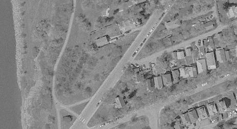
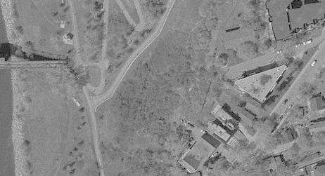
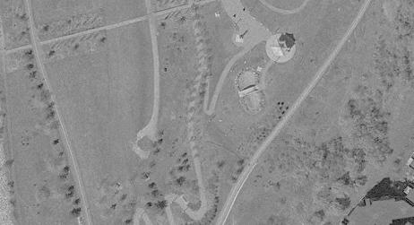
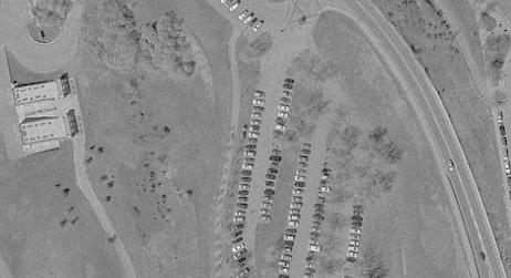
186
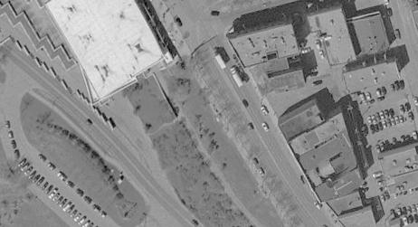
187
188 Summary of Valley Line LRT West River Bank Access Alignments Criteria Cameron Avenue Alignment West Alignment 1 West Alignment 2 West Alignment 3 Geometric Steepest Grades approx. 12% Steepest grades approx. 15% Steepest grades approx. 15% Steepest grades approx. 15% Considerations Connecting Road Cameron Avenue is a local collector road providing access to/from Riverdale community. Grierson Hill is a arterial road designated as 24 hour truck route Grierson Hill is a arterial road designated as 24 hour truck route Grierson Hill is a arterial road designated as 24 hour truck route Residential Impacts Access Considerations Route Upgrade and Restoration Tunnel Portal Construction Access Bridge Site Construction Access -Cameron Avenue on street parking would be banned -Private Property access would be impacted -Construction traffic adjacent to curb walks -Noise, vibration, dust, saftey concerns for adjacent residents Parking ban would be required on Cameron Avenue with a tight corner to make at bottom of Cameron Ave. Pavement damage leading to repaving/reconstruction of Cameron Avenue following construction. Approximately 170 m of SUP would then need postconstruction restoration. Some tree removal may be required. Via new access road None if used as 2 way access. Similar, yet less, impacts if to Cameron Avenue Alignment if Cameron Ave is used as as an exit. Traffic Signal may be needed on Grierson Hill Potentially 370 m of SUP along north river bank would require upgrading to accommodate construction vehicles and would then need post-construction restoration. Potential accomodation of a contruction access along the SUP would require potential grading, road preparation, and restoration. Some tree removal may be required. Via same new access road as Cameron Avenue alignment (This option does not provide permanent access to Tunnel) None if used as 2 way access. Similar, yet less, impacts if to Cameron Avenue Alignment if Cameron Ave is used as as an exit. Traffic Signal may be needed on Grierson Hill Approximately 310 m of maintenance access road would require upgrading and would then need post-construction restoration. Use as permanent access would mean that World Walk and rose garden would need to be relocated. Via new access connection through World Walk site (This option does not provide permanent access to Tunnel) Via existing SUP Along existing SUP Via additional access road through World Walk area or along West Alignment 1 Retaining Walls Required for new access road Required for new access road Potentially needed through park site to accommodate final access road configuration None if used as 2 way access. Similar, yet less, impacts if to Cameron Avenue Alignment if Cameron Ave is used as as an exit. Geometry may only allow right turns off of Grierson Hill. May require additional route to exit site. SUP would require upgrading for construction access and would then then need post-construction restoration. Constructing adjacent to SUP is unlikely due to steep side slopes. Some temporary retaining structures may be required. Some tree removal may be required. Via new connection from SUP Via existing SUP or new access road similar to Cameron Avenue alignment Required at access to Grierson Hill and along access to portal site Known restrictions on route use Snow Clearing EISA Louise McKinney Park: Impact to Trail Users Impact to Programmed and Unprogrammed Park Uses None Coordination with Road Maintenance for Cameron Ave clearing Included in EISA. No further approval required. Approxmately 170 m of SUP, the only existing trail access from the east, would be closed to users during construction Does not affect programmed use; adjacent lands do not support unprogrammed use, therefore no impact. Would not be able to use route for 6 weeks during winter of 2015, 2017, & 2019 due to major park event. Contractor Responsibility for snow clearing route through park Indentified as potential secondary access in EISA. Would require additional submission and approval. Potentially additional 370m of SUP would be closed to use during construction Interrupts access to Riverside Promenade which supports programmed and unprogrammed use; impacts two businesses at the Riverfront Plaza. Indirect impact on quality of unprogammed use of adjacent lands. Would not be able to use for 6 weeks during winter of 2015, 2017, & 2019 due to major park event. Contractor Responsibility for snow clearing route through park Indentified as potential secondary access in EISA. Would require additional submission and approval. Approximately 310 m of maintenance access road would be unavailable to park management but this route is not a designated pathway so there would be no impact to formal trail system. Does not directly impact programmed use but indirectly impacts quality of unprogrammed use of adjacent lands. Would be closed for 4 days for major park event during winter of 2015, 2017, & Contractor Responsibility for snow clearing route through park Indentified as potential secondary access in EISA. Would require additional submission and approval. Additional 450m of SUP would be closed to users during construction. No impact on programmed use but indirectly affects quality of unprgrammed use on adjacent lands. Page 1 of 2
189 Summary of Valley Line LRT West River Bank Access Alignments Criteria Cameron Avenue Alignment West Alignment 1 West Alignment 2 West Alignment 3 Geotechnical: Decommissioned Landfill (limits approximated) Within the landfill but very near the NE limits. Eastern half is within the landfill. Test holes indicated the presence of uncontrolled fill soils mixed with waste materials. Depths are not confirmed in this location. The existing fill/waste subgrade could be unsuitable to support construction traffic. Majority of this route is through the centre of the landfill. Test holes indicated the presence of uncontrolled fill soils mixed with waste materials up to 25 m thick. The existing fill/waste subgrade could be unsuitable to support construction traffic. Eastern two-thirds descends into the landfill. Test holes indicated the presence of uncontrolled fill soils mixed with waste materials. Depths are not confirmed in this location. The existing fill/waste subgrade could be unsuitable to support construction traffic. Construction Route Structure The existing SUP structure is unknown, but unlikely to have been designed to support heavy construction traffic. SUP structure assessment/upgrading will be required. The existing SUP structure is unknown, but unlikely to have been designed to support heavy construction traffic. SUP structure assessment/upgrading will be required. Access Road adjacent to the SUP would also need confirmation of suitable structure. The condition of the existing maintenance access road structure is unknown, but unlikely to have been designed to support heavy construction traffic. Road structure assessment/upgrading will be required. The existing SUP structure is unknown, but unlikely to have been designed to support heavy construction traffic. SUP structure assessment/upgrading will be required. Slope Stability/Grierson Hill Slide This option will have the least impact on the stability of the Grierson Hill slide Fill embankment woud be required across the World Walk and SUP to get from maintenance road to tunnel portal site. Embankment fills will exert additional loading on the Grierson Hill and, depending on their height, can trigger slope movement. Will require geotechnical evaluations to determine the impact of the proposed fills on the stability of the valley slope. This route (particularly the northern section) is close to the scarp/crest of the Grierson Hill slide. Fills, and to a lesser extent cuts, near the scarp of the slide could be detrimental to the stability of the slope (the worst location to add fills is at/near the crest of the slide). This option will require geotechnical evaluations to determine the impact of the proposed earth works on the stability of the valley slope. Fill and retaining wall required to access portal and therfore would be placing loading on the slope. Page 2 of 2
190 Appendix B: Temporary Construction Access Road Geotechnical and Slope Stability Assessment (Thurber Engineering 2014) See compact disc February 2015 Valley Line-Stage 1 LRT EISA Update FINAL REPORT Page B1
191 Appendix C: Vegetation Data February 2015 Valley Line-Stage 1 LRT EISA Update FINAL REPORT Page C1
192 Appendix C - LMRP Vegetation Data Species Scientific Name Common Name Origin ACIMS Status Grassland Achillea millefolium common yarrow Native S5 O Louise McKinney Riverfront Park Grass- Shrub Manitoba Maple Actaea rubra red and white baneberry Native S5 F Poplar- Manitoba Maple Aralia nudicaulis wild sarsaparilla Native S5 R A Arctium sp. burdock Noxious SNA F O R Artemisia absinthium absinthe wormwood Exotic SNA F O O Artemisia ludoviciana prairie sagewort Native S5 O O R Brassica sp. canola cultivar Exotic SNA R R Chenopodium album lamb's-quarters Exotic SNA F A Cirsium arvense creeping thistle Noxious SNA F O R Cosmos sp. cosmos cultivar Exotic SNA Dianthus sp. pink cultivar Exotic SNA Epilobium angustifolium common fireweed Native S5 R Erigeron sp. fleabane Native R Erysimum wormseed mustard Native S5 O cheiranthoides Euphorbia esula leafy spurge Noxious SNA R R Eurybia conspicua showy aster Native S5 F Galeopsis tetrahit hemp-nettle Exotic SNA R Galium boreale northern bedstraw Native S5 R R A Kochia scoparia summer-cypress Exotic SNA R Lactuca serriola prickly lettuce Exotic SNA O O O Lappula squarrosa bluebur Exotic SNA R Lathyrus ochroleucus cream-colored vetchling Native S5 F F Lavatera sp. lavatera cultivar Exotic SNA Linaria vulgaris common toadflax Noxious SNA O F Planted Beds
193 Appendix C - LMRP Vegetation Data Species Scientific Name Common Name Origin ACIMS Status Grassland Louise McKinney Riverfront Park Grass- Shrub Manitoba Maple Poplar- Manitoba Maple Lotus corniculatus bird's-foot trefoil Exotic SNA R O Maianthemum canadense wild lily-of-the-valley Native S5 O Matricaria pineappleweed Exotic SNA O matricarioides Medicago sativa alfalfa Exotic SNA O F R Melilotus alba white sweet-clover Exotic SNA O O O Melilotus officinale yellow sweet-clover Exotic SNA O F Mertensia paniculata tall lungwort Native S5 Osmorhiza longistylis smooth sweet cicely Native S2 R Plantago major common plantain Exotic SNA O x Polygonum wild buckwheat Exotic SNA R convolvulus Portulaca sp. portulaca cultivar Exotic SNA Rumex occidentalis western dock Native S5 R Senecio vulgaris common groundsel Exotic SNA O Silene pratense white cockle Noxious SNA O Smilacina racemosa false Solomon's-seal Native S5 O Smilacina stellata star-flowered Solomon's-seal Native S5 R F Solidago canadensis Canada goldenrod Native S5 O Sonchus sp. sow-thistle Exotic SNA O R Spiraea sp. meadowsweet Exotic SNA Symphyotrichum Lindley's aster Native S5 F ciliolatum Symphyotrichum purple-stemmed aster Native S4 O puniceum Tanacetum vulgare common tansy Noxious SNA R Taraxacum officinale common dandelion Exotic SNA F R O Planted Beds
194 Appendix C - LMRP Vegetation Data Species Scientific Name Common Name Origin ACIMS Status Grassland Louise McKinney Riverfront Park Grass- Shrub Manitoba Maple Poplar- Manitoba Maple Thlaspi arvense stinkweed Exotic SNA O O R Tragopogon dubius common goat's-beard Exotic SNA O Trifolium hybridum alsike clover Exotic SNA A O Trifolium pratense white clover Exotic SNA O Trifolium repens red clover Exotic SNA F Urtica dioica common nettle Native S5 R Veronica peregrina hairy speedwell Native S5 R Vicia americana wild vetch Native S5 A O A Vicia cracca tufted vetch Exotic SNA O R Viola canadensis western Canada violet Native S5 O Agropyron crested wheatgrass Exotic SNA A F O pectiniforme Agropyron sp. wheatgrass Exotic SNA Avena sp. oat cultivar Exotic SNA R R Bromus inermis smooth brome Exotic SNA D D A D Elymus lanceolatus northern wheatgrass Native S5 A Elymus trachycaulus slender wheatgrass Native S5 A A O Elytrigia repens quack grass Exotic SNA A A F F Hordeum jubatum foxtail barley Native S5 O O O Leymus innovatus hairy wild rye Native S5 R Phalaris arundinacea reed canary grass Native S5 D O A Phleum pratense timothy Exotic SNA R Poa pratensis Kentucky bluegrass Native S5 A A F O Alnus viridis Amelanchier alnifolia saskatoon Native S5 F Caragana arborescens common caragana Exotic SNA O A/D O Planted Beds
195 Appendix C - LMRP Vegetation Data Species Scientific Name Common Name Origin ACIMS Status Grassland Louise McKinney Riverfront Park Grass- Shrub Manitoba Maple Poplar- Manitoba Maple Cornus sp. variegated dogwood Exotic SNA x Cornus stolonifera red-osier dogwood Native S5 O A Corylus cornuta beaked hazelnut Native S5 x Crataegus sp. hawthorn cultivar Exotic SNA O Elaeagnus sp. oleaster Exotic SNA O x Lonicera dioica twining honeysuckle Native S5 R Lonicera involucrata bracted honeysuckle Native S5 O Lycium sp. goji berry Exotic SNA R R Prunus pensylvanica pin cherry Native S5 O Prunus sp. cherry Exotic SNA Prunus virginiana chokecherry Native S5 R F Ribes hirtellum wild gooseberry Native S4 O Ribes triste wild red currant Native S5 F Rosa acicularis prickly rose Native S5 A D Rosa sp. rose Exotic SNA x Sorbus acuparia European mountain-ash Exotic SNA R Symphoricarpos alba snowberry Native S5 A Symphoricarpos buckbrush Native S5 A F occidentalis Syringa vulgaris common lilac Exotic SNA O/A Viburnum edule low-bush cranberry Native S5 F Acer negundo Manitoba maple Exotic SNA O F D D Acer sp. maple Exotic SNA Aesculus glabra Ohio buckeye Exotic SNA Fraxinus pensylvanicus green ash Exotic SNA Planted Beds
196 Appendix C - LMRP Vegetation Data Species Scientific Name Common Name Origin ACIMS Status Grassland Larix laricina tamarack Native S5 R Louise McKinney Riverfront Park Grass- Shrub Manitoba Maple Poplar- Manitoba Maple Larix sp. larch Exotic SNA x Picea pungens blue spruce Exotic SNA x Pinus banksiana F r Pinus contorta lodgepole pine Native S5 O x Pinus sp. pine Exotic SNA Populus balsamifera balsam poplar Native S5 O F O D Populus sp. columnar poplar Exotic SNA x Populus tremuloides aspen Native S5 O F Quercus sp. oak Exotic SNA x Number of Species Planted Beds
197 Appendix D: Wildlife Species Potentially Found in the Study Areas February 2015 Valley Line-Stage 1 LRT EISA Update FINAL REPORT Page D1
198 Appendix D - Wildlife Species Potentially Found in the LMRP Study Area Common Name Scientific Name Species Group Provincial Status (General Status of AB Wild Species) Wildlife Act Designation and New Species Assessed by ESCC (see Comments) COSEWIC Designation SARA Designation EDMONTON AREA (within 100 km) Species Recorded in Study Area Potential Habitat Use Likelihood of Occurrence Canadian Toad Anaxyrus hemiophrys A May Be At Risk Data Deficient Not at Risk / HP Candidate (SSC) R FWMIS (1914, 1950, 1957) Wintering Low Alder Flycatcher Empidonax alnorum B Secure B American Crow Corvus brachyrhynchos B Secure B ebird American Goldfinch Spinus tristis B Secure B American Kestrel Falco sparverius B Sensitive LP Candidate (SSC) B Foraging Low American Redstart Setophaga ruticilla B Secure B American Robin Turdus migratorius B Secure B BBS, ebird American White Pelican Pelecanus erythrorhynchos B Sensitive Not at Risk B ebird Foraging High Bald Eagle Haliaeetus leucocephalus B Sensitive Not at Risk B Foraging Moderate Baltimore Oriole Icterus galbula B Sensitive B Breeding Moderate Bank Swallow Riparia riparia B Secure Threatened B ebird, personal obs Foraging High Barn Swallow Hirundo rustica B Sensitive Threatened B Foraging Low Belted Kingfisher Megaceryle alcyon B Secure LP Candidate (SSC) B Black Tern Chlidonias niger B Sensitive Not at Risk B Foraging Moderate Black-and-white Warbler Mniotilta varia B Secure B Blue-winged Teal Anas discors B Secure B Bonaparte's Gull Chroicocephalus philadelphia B Secure B Brewer's Blackbird Euphagus cyanocephalus B Secure B Broad-winged Hawk Buteo platypterus B Sensitive B Foraging Low Brown-headed Cowbird Molothrus ater B Secure B Bufflehead Bucephala albeola B Secure B California Gull Larus californicus B Secure B ebird Canada Goose Branta canadensis B Secure B Cedar Waxwing Bombycilla cedrorum B Secure B ebird Chipping Sparrow Spizella passerina B Secure B BBS, ebird Clay-colored Sparrow Spizella pallida B Secure B BBS, ebird Cliff Swallow Petrochelidon pyrrhonota B Secure B Common Goldeneye Bucephala clangula B Secure B Common Grackle Quiscalus quiscula B Secure B Common Loon Gavia immer B Secure Not at Risk B Common Merganser Mergus merganser B Secure B ebird Common Nighthawk Chordeiles minor B Sensitive Threatened (see Status Report) Schedule 1 (Threatened) B Foraging Low Common Tern Sterna hirundo B Secure Not at Risk B Common Yellowthroat Geothlypis trichas B Sensitive B Foraging Low Connecticut Warbler Oporornis agilis B Secure LP Candidate (SSC) B Cooper's Hawk Accipiter cooperii B Secure Not at Risk B Dark-eyed Junco Junco hyemalis B Secure B Double-crested Cormorant Phalacrocorax auritus B Secure Not at Risk B Eastern Kingbird Tyrannus tyrannus B Secure LP Candidate (SSC) B Eastern Phoebe Sayornis phoebe B Sensitive B Breeding Moderate European Starling Sturnus vulgaris B Exotic/Alien B ebird Forster's Tern Sterna forsteri B Sensitive Data Deficient B Foraging Low Franklin's Gull Leucophaeus pipixcan B Secure B ebird Golden-crowned Kinglet Regulus satrapa B Secure B Gray Catbird Dumetella carolinensis B Secure B BBS Great Blue Heron Ardea herodias B Sensitive B Foraging Moderate Greater Yellowlegs Tringa melanoleuca B Secure B
199 Appendix D - Wildlife Species Potentially Found in the LMRP Study Area Green-winged Teal Anas crecca carolinensis B Sensitive B Foraging Moderate Hermit Thrush Catharus guttatus B Secure B Herring Gull Larus argentatus B Secure B ebird House Wren Troglodytes aedon B Secure B Killdeer Charadrius vociferus B Secure LP Candidate (SSC) B Least Flycatcher Empidonax minimus B Sensitive LP Candidate (SSC) B Breeding Moderate Lesser Yellowlegs Tringa flavipes B Secure B Lincoln's Sparrow Melospiza lincolnii B Secure B Magnolia Warbler Setophaga magnolia B Secure B Mallard Anas platyrhynchos B Secure B ebird Merlin Falco columbarius B Secure Not at Risk B Mountain Bluebird Sialia currucoides B Secure B Mourning Dove Zenaida macroura B Secure B Northern Flicker Colaptes auratus B Secure B Northern Harrier Circus cyaneus B Sensitive Not at Risk B Foraging Low Northern Rough-winged Swallow Stelgidopteryx serripennis B Secure B Orange-crowned Warbler Oreothlypis celata B Secure B Osprey Pandion haliaetus B Sensitive B Foraging Moderate Ovenbird Seiurus aurocapilla B Secure B Peregrine Falcon Falco peregrinus anatum B At Risk Threatened Special Concern (see Comments Schedule 1 (Special Concer B FWMIS Foraging High Purple Finch Carpodacus purpureus B Secure B Purple Martin Progne subis B Sensitive B Migrating Moderate Red-eyed Vireo Vireo olivaceus B Secure B ebird Red-tailed Hawk Buteo jamaicensis B Secure Not at Risk B Red-winged Blackbird Agelaius phoeniceus B Secure B Ring-billed Gull Larus delawarensis B Secure B ebird Rose-breasted Grosbeak Pheucticus ludovicianus B Secure B Ruby-crowned Kinglet Regulus calendula B Secure B Ruby-throated Hummingbird Archilochus colubris B Secure B Savannah Sparrow Passerculus sandwichensis B Secure B ebird Sharp-shinned Hawk Accipiter striatus B Secure Not at Risk B Short-eared Owl Asio flammeus B May Be At Risk Special Concern B Breeding Low Solitary Sandpiper Tringa solitaria B Secure B Song Sparrow Melospiza melodia B Secure B BBS, ebird Spotted Sandpiper Actitis macularius B Secure B ebird Swainson's Hawk Buteo swainsoni B Sensitive B ebird Foraging High Swainson's Thrush Catharus ustulatus B Secure B Swamp Sparrow Melospiza georgiana B Secure B Tennessee Warbler Oreothlypis peregrina B Secure B Tree Swallow Tachycineta bicolor B Secure B Veery Catharus fuscescens B Secure B Vesper Sparrow Pooecetes gramineus B Secure B Warbling Vireo Vireo gilvus B Secure B Western Tanager Piranga ludoviciana B Sensitive B Foraging Low Western Wood-pewee Contopus sordidulus B Sensitive B Foraging Moderate White-throated Sparrow Zonotrichia albicollis B Secure B Yellow Warbler Setophaga petechia B Secure B BBS, ebird Yellow-bellied Sapsucker Sphyrapicus varius B Secure B Yellow-headed Blackbird Xanthocephalus xanthocephalus B Secure B Yellow-rumped Warbler Setophaga coronata B Secure B American Tree Sparrow Spizella arborea B Secure M Bay-breasted Warbler Setophaga castanea B Sensitive In Process (see Comments) M Migrating Low
200 Appendix D - Wildlife Species Potentially Found in the LMRP Study Area Cape May Warbler Setophaga tigrina B Sensitive In Process (see Comments) M Migrating Low Glaucous Gull Larus hyperboreus B Secure M Harris's Sparrow Zonotrichia querula B Secure HP Candidate (SSC) M Mew Gull Larus canus B Secure M Northern Waterthrush Parkesia noveboracensis B Secure M Sabine's Gull Xema sabini B Secure M Thayer's Gull Larus thayeri B Secure M White-crowned Sparrow Zonotrichia leucophrys B Secure M ebird Wilson's Warbler Cardellina pusilla B Secure M Barred Owl Strix varia B Sensitive Special Concern R Foraging Low Black-billed Magpie Pica hudsonia B Secure R BBS, ebird Black-capped Chickadee Poecile atricapillus B Secure R ebird Blue Jay Cyanocitta cristata B Secure R Boreal Chickadee Poecile hudsonicus B Secure R Common Raven Corvus corax B Secure R Downy Woodpecker Picoides pubescens B Secure R Evening Grosbeak Coccothraustes vespertinus B Secure R Gray Partridge Perdix perdix B Exotic/Alien R Great Horned Owl Bubo virginianus B Secure R Hairy Woodpecker Picoides villosus B Secure R House Finch Carpodacus mexicanus B Secure R BBS House Sparrow Passer domesticus B Exotic/Alien R ebird Northern Goshawk Accipiter gentilis atricapillus B Sensitive Not at Risk (see Comments) R Foraging Moderate Northern Saw-whet Owl Aegolius acadicus B Secure R Pileated Woodpecker Dryocopus pileatus B Sensitive R Foraging Moderate Pine Siskin Spinus pinus B Secure R Red-breasted Nuthatch Sitta canadensis B Secure R Rock Pigeon Columba livia B Exotic/Alien R ebird White-breasted Nuthatch Sitta carolinensis B Secure R Bohemian Waxwing Bombycilla garrulus B Secure W Common Redpoll Acanthis flammea B Secure W Hoary Redpoll Acanthis hornemanni B Secure W Red Crossbill Loxia curvirostra B Secure W Snow Bunting Plectrophenax nivalis B Secure W White-winged Crossbill Loxia leucoptera B Secure W Hoary Bat Lasiurus cinereus M Sensitive B FWMIS Foraging High American Beaver Castor canadensis M Secure R Arctic Shrew Sorex arcticus M Secure R Big Brown Bat Eptesicus fuscus M Secure R Common Porcupine Erethizon dorsatum M Secure R Coyote Canis latrans M Secure R Murray 2014 Deer Mouse Peromyscus maniculatus M Secure R Dusky Shrew Sorex monticolus M Secure R Ermine Mustela erminea M Secure R House Mouse Mus musculus M Exotic/Alien R Least Chipmunk Tamias minimus M Secure R Little Brown Bat Myotis lucifugus M Secure Endangered Endangered R Foraging, roosmoderate Long-tailed Weasel Mustela frenata M May Be At Risk Not at Risk (see Comments) R Foraging Low Masked Shrew Sorex cinereus M Secure R Meadow Jumping Mouse Zapus hudsonius M Secure R Meadow Vole Microtus pennsylvanicus M Secure R Mink Neovison vison M Secure R
201 Appendix D - Wildlife Species Potentially Found in the LMRP Study Area Moose Alces alces M Secure R Mule Deer Odocoileus hemionus M Secure R Muskrat Ondatra zibethicus M Secure R Northern Bat Myotis septentrionalis M May Be At Risk Data Deficient Endangered R Foraging Low Northern Flying Squirrel Glaucomys sabrinus M Secure R Northern Pocket Gopher Thomomys talpoides M Secure R Prairie Shrew Sorex haydeni M Secure R Pygmy Shrew Sorex hoyi M Secure R Red Fox Vulpes vulpes M Secure R Red Squirrel Tamiasciurus hudsonicus M Secure R BBS Richardson's Ground Squirrel Spermophilus richardsonii M Secure R Spencer 2005 Snowshoe Hare Lepus americanus M Secure R Southern Red-backed Vole Clethrionomys gapperi M Secure R Striped Skunk Mephitis mephitis M Secure R Western Jumping Mouse Zapus princeps M Secure R White-tailed Deer Odocoileus virginianus M Secure R White-tailed Jack Rabbit Lepus townsendii M Secure R BBS Common Garter Snake Thamnophis sirtalis R Sensitive LP Candidate LP Candidate (SSC) R Foraging Moderate Plains Garter Snake Thamnophis radix R Sensitive MP Candidate MP Candidate (SSC) R Foraging Low
202 Appendix E: Special Status Wildlife Species Potentially Found in the Study Areas February 2015 Valley Line-Stage 1 LRT EISA Update FINAL REPORT Page E1
203 Appendix E - Special Status Wildlife Species Potentially Found in the LMRP Study Area Common Name Scientific Name Provincial Status (General Status of AB Wild Species) Wildlife Act Designation and New Species Assessed by ESCC (see Comments) COSEWIC Designation SARA Designation under Schedule 1 EDMONTON AREA (within 100 km) Species Recorded in Study Area Potential Habitat Use Likelihood of Occurrence Bank Swallow Riparia riparia Secure Threatened B ebird, personal obs Foraging High Peregrine Falcon Falco peregrinus anatum At Risk Threatened Special Concern Special Concern B FWMIS Foraging High Little Brown Bat Myotis lucifugus Secure Endangered Endangered R Foraging, roosting Moderate
204 Appendix F: LMRP Subsurface Utilities (T2 Utility Engineers 2013) February 2015 Valley Line-Stage 1 LRT EISA Update FINAL REPORT Page F1
205 X X X X REVISIONS DISCLAIMER. PREPARED BY. DRAWN DATE (MM/DD/YY) PROJECT. LOUISE McKINNEY RIVERFRONT PARK EDMONTON, AB CLIENT. AECOM CHECKED T2UE APPROVED SCALE DRAWING. SUBSURFACE UTITLITY ENGINEERING MAPPING SERVICES PROJECT NO. SHEET NO OF 06
206 X X X X REVISIONS DISCLAIMER. PREPARED BY. DRAWN DATE (MM/DD/YY) PROJECT. LOUISE McKINNEY RIVERFRONT PARK EDMONTON, AB CLIENT. AECOM CHECKED T2UE APPROVED SCALE DRAWING. SUBSURFACE UTITLITY ENGINEERING MAPPING SERVICES PROJECT NO. SHEET NO OF 06
207 X X X X X REVISIONS DISCLAIMER. PREPARED BY. DRAWN DATE (MM/DD/YY) PROJECT. LOUISE McKINNEY RIVERFRONT PARK EDMONTON, AB CLIENT. AECOM CHECKED T2UE APPROVED SCALE DRAWING. SUBSURFACE UTITLITY ENGINEERING MAPPING SERVICES PROJECT NO. SHEET NO OF 06
208 X X X X REVISIONS DISCLAIMER. PREPARED BY. DRAWN DATE (MM/DD/YY) PROJECT. LOUISE McKINNEY RIVERFRONT PARK EDMONTON, AB CLIENT. AECOM CHECKED T2UE APPROVED SCALE DRAWING. SUBSURFACE UTITLITY ENGINEERING MAPPING SERVICES PROJECT NO. SHEET NO OF 06
209 X X X X X X X X X X X X X X X X X X X X X X X X X X X X X X X X X X X X X X X X X X X X X X REVISIONS DISCLAIMER. PREPARED BY. DRAWN DATE (MM/DD/YY) PROJECT. LOUISE McKINNEY RIVERFRONT PARK EDMONTON, AB CLIENT. AECOM CHECKED T2UE APPROVED SCALE DRAWING. SUBSURFACE UTITLITY ENGINEERING MAPPING SERVICES PROJECT NO. SHEET NO OF 06
 PROJECT.")

210 X X X X X X REVISIONS DISCLAIMER. PREPARED BY. DRAWN DATE (MM/DD/YY) PROJECT. LOUISE McKINNEY RIVERFRONT PARK EDMONTON, AB CLIENT. AECOM CHECKED T2UE APPROVED SCALE DRAWING. SUBSURFACE UTITLITY ENGINEERING MAPPING SERVICES PROJECT NO. SHEET NO OF 06
City of Edmonton Valley Line Stage 1 Light Rail Transit (LRT) Project Site Location Study Update
 Project Site Location Study Update") Attachment 2 City of Edmonton Valley Line Stage 1 Light Rail Transit (LRT) Project Site Location Study Update Final Report Prepared for: LRT D and C Transportation Services City of Edmonton Edmonton, Alberta
Attachment 2 City of Edmonton Valley Line Stage 1 Light Rail Transit (LRT) Project Site Location Study Update Final Report Prepared for: LRT D and C Transportation Services City of Edmonton Edmonton, Alberta
5.0 WEST PROJECT BOUNDARY MODIFICATIONS AT HMEP
 5.0 WEST PROJECT BOUNDARY MODIFICATIONS AT HMEP 5.1 Context The proposed west project boundary modifications at Henrietta Muir Edwards Park (HMEP) are the result of further planning at a finer scale that
Spencer Environmental 3.0 METHODS
 3.0 METHODS 3.1 General Methods Following is a summary of the main steps and activities employed in the preparation of this EISA. These were not necessarily sequential steps; many were iterative. We participated
SCARBOROUGH RAPID TRANSIT ENVIRONMENTAL PROJECT REPORT CHAPTER 2 PROJECT DESCRIPTION. Table 2-4: North Segment Alignment Analysis 2-21
 Table 2-4: North Segment Alignment Analysis 2-21 SCARBOROUGH RAPID TRANSIT Based on the above analysis (detailed analysis is contained in Appendix A-4), North Alignment 3 is preferred because it: Has the
City of Toronto. Emery Village Transportation Master Plan
 City of Toronto Emery Village Transportation Master Plan May 2009 Emery Village Transportation Master Plan Toronto, ON May 2009 Consulting Inc. 100 York Blvd., Suite 300 Richmond Hill, ON L4B 1J8 Tel:
Town of Portola Valley General Plan. Nathhorst Triangle Area Plan
 Town of Portola Valley General Plan Amended December 10, 1997 Table of Contents Introduction... 1 Planning Area... 1 Objectives... 2 Principles... 2 Standards... 4 Description... 4 Community Commercial...
PUBLIC ENGAGEMENT REPORT
 Attachment 4 PUBLIC ENGAGEMENT REPORT Valley Line LRT Project - Stage One Open House Environmental Impact Screening Assessment Update and Site Location Study Update February 3, 2015 Prepared by: LRT Design
Welcome. Mill Creek Ravine Pedestrian Bridges Rehabilitation. Public Information Session #1. Thursday, October 27, :00 8:00 p.m.
 Welcome Mill Creek Ravine Pedestrian Bridges Rehabilitation Public Information Session #1 Thursday, October 27, 2016 5:00 8:00 p.m. Tonight you can: Learn about the rehabilitation of 5 pedestrian bridges
TO: Mayor & Council DATE: April 12, The Planning and Development Department and the Engineering Department recommend that Council:
 CORPORATE REPORT NO: R080 COUNCIL DATE: April 12, 2010 REGULAR COUNCIL TO: Mayor & Council DATE: April 12, 2010 FROM: SUBJECT: General Manager, Planning and Development General Manager, Engineering Neighbourhood
OP Council Resolution June 16, Planning and Development Services
 OP-08-01 Council Resolution June 16, 2008 Planning and Development Services Kingsgate Landing Outline Plan Table of Contents 1.0 Introduction 1 1.1 Purpose of Plan 1 1.2 Plan Area Location 1 1.3 Ownership
FINAL MITIGATION PLAN to address
 CENTRAL CORRIDOR LRT STATE CAPITOL MALL HISTORIC FINAL MITIGATION PLAN February 2010 FINAL MITIGATION PLAN to address Adverse Effects of the Central Corridor LRT Project on the State Capitol Mall Historic
Regency Developments. Urban Design Brief. Holyrood DC2 Rezoning
 Regency Developments Urban Design Brief Holyrood DC2 Rezoning Stantec Consulting Ltd. 7-31-2017 1. Overview Regency Developments intends to rezone the lands located at 8510 and 8511 93 Avenue, within the
NORTHEAST RIVER CROSSING FUNCTIONAL PLANNING STUDY
 WELCOME Northeast River Crossing Functional Planning Study Phase 2 Public Meeting 4 to 8 PM Informal drop-in format and discussion tables Meeting Purpose Introduce the Northeast River Crossing Functional
VILLAGE OF BOLTON HERITAGE CONSERVATION DISTRICT PLAN
 Page 1 1. INTRODUCTION AND BACKGROUND 1.1 THE PROJECT VILLAGE OF BOLTON HERITAGE CONSERVATION DISTRICT PLAN TERMS OF REFERENCE The Town of Caledon (Town) is a large, predominantly rural municipality with
City of Edmonton. Walterdale Bridge Replacement and Approach Roads Evaluation. Concept Planning Study. Final Report
 City of Edmonton Final Report Walterdale Bridge Replacement and Approach Roads Evaluation April, 2011 Walterdale Bridge Replacement and Approach Roads Evaluation Final Report April 2011 Acknowledgement
THE CORPORATION OF THE CITY OF WINDSOR Office of the City Solicitor Planning Department
 THE CORPORATION OF THE CITY OF WINDSOR Office of the City Solicitor Planning Department REPORT TO THE CITY OF WINDSOR PLANNING ADVISORY COMMITTEE DATE OF REPORT: August 19, 2010 SUBJECT: Official Plan
AMENDMENT NO. 30 TO THE OFFICIAL PLAN OF THE TOWN OF MILTON
 AMENDMENT NO. 30 TO THE OFFICIAL PLAN OF THE TOWN OF MILTON Subject: Boyne Survey Secondary Plan and Related Official Plan Amendments The following text and schedules constitute Amendment No. 30 to the
Northeast Anthony Henday Drive Manning Freeway to Whitemud Drive Welcome to this Construction Information Session
 Manning Freeway to Whitemud Drive Welcome to this Construction Information Session Purpose To inform interested residents and businesses about the plans accommodation. Background: The Government of Alberta
ADMINISTRATION RECOMMENDATION(S) 2017 February 09. That Calgary Planning Commission recommends APPROVAL of the proposed Land Use Amendment.
 2017 February 09. That Calgary Planning Commission recommends APPROVAL of the proposed Land Use Amendment.") Page 1 of 10 EXECUTIVE SUMMARY This land use amendment application is to accommodate changes to the location of a stormwater retention pond and land use boundaries adjacent to Environmental Reserve in
Page 1 of 10 EXECUTIVE SUMMARY This land use amendment application is to accommodate changes to the location of a stormwater retention pond and land use boundaries adjacent to Environmental Reserve in
Central and East Neighbourhoods - Hermitage Outline Plan
 Central and East Neighbourhoods - Hermitage Outline Plan Office Consolidation September 2013 Prepared by: Planning and Policy Services Branch Planning and Development Department City of Edmonton The Central
DRAFT SECTION 4(F) EVALUATION STILLWATER MUNICIPAL BARGE FACILITY
 EVALUATION STILLWATER MUNICIPAL BARGE FACILITY") DRAFT SECTION 4(F) EVALUATION I. DESCRIPTION OF SECTION 4(F) RESOURCE The Section 4(f) resource discussed in this evaluation is known as the Stillwater Municipal Barge Facility property, known previously
DRAFT SECTION 4(F) EVALUATION I. DESCRIPTION OF SECTION 4(F) RESOURCE The Section 4(f) resource discussed in this evaluation is known as the Stillwater Municipal Barge Facility property, known previously
1.0 INTRODUCTION & BACKGROUND
 1.0 INTRODUCTION & BACKGROUND 1.1 GENERAL The Consulting Team was retained by the City of Edmonton in 2010 to complete a for the replacement of the Walterdale Bridge and the approach roads, as required,
Institutional Master Plan The Arnold Arboretum of Harvard University
 Institutional Master Plan The Arnold Arboretum of Harvard University Submitted to: Boston Redevelopment Authority One City Hall Square Boston, MA 02201 Submitted by: The Arnold Arboretum of Harvard University
Mill Woods Town Centre Proposed Rezoning LDA
 Mill Woods Town Centre Proposed Rezoning LDA15 0649 The City of Edmonton has received an application for rezoning and an amendment to the Mill Woods Station Area Redevelopment Plan (ARP) for the Mill Woods
CAPITAL LINE SOUTH LRT EXTENSION INTRODUCTION
 INTRODUCTION What: The 2010 preliminary design for the Capital Line South LRT Extension will run from the Century Park Station to Ellerslie Road. It will connect to the Heritage Valley Park and Ride located
Local Growth Planning in North Central Green Line Communities
 2018 April 30 Page 1 of 6 EXECUTIVE SUMMARY This report outlines a high-level scope for local growth planning for north central Green Line communities. The catalyst for this review is the significant investments
Gold Line Bus Rapid Transit Transit Oriented Development (BRTOD) Helmo Station Area Plan
 Helmo Station Area Plan") Appendix F Gold Line Bus Rapid Transit Transit Oriented Development (BRTOD) Helmo Station Area Plan Introduction and Purpose of the Plan The Gold Line Bus Rapid Transit facility is an eleven-mile dedicated
Appendix F Gold Line Bus Rapid Transit Transit Oriented Development (BRTOD) Helmo Station Area Plan Introduction and Purpose of the Plan The Gold Line Bus Rapid Transit facility is an eleven-mile dedicated
THAT the attached Terms of Reference for the Thornhill Centre Street Study be approved.
 COMMITTEE OF THE WHOLE AUGUST 18, 2003 THORNHILL CENTRE STREET STUDY PLANNING FILE: 15.92 Recommendation The Commissioner of Planning recommends: THAT the attached Terms of Reference for the Thornhill
PLANNING JUSTIFICATION REPORT
 PLANNING JUSTIFICATION REPORT 55 DELHI STREET CITY OF GUELPH PREPARED FOR: VESTERRA PROPERTY MANAGEMENT PREPARED BY: LABRECHE PATTERSON & ASSOCIATES INC. SCOTT PATTERSON, BA, CPT, MCIP, RPP PRINCIPAL,
Rapid Transit Implementation Working Group September 14, 2017
 Rapid Transit Implementation Working Group September 14, 2017 BACKGROUND Council approved the Rapid Transit Master Plan and Updated Business Case on July 25, 2017. Approval of the RTMP confirmed the BRT
CITY OF VAUGHAN EXTRACT FROM COUNCIL MEETING MINUTES OF NOVEMBER 15, 2016
 Item 11, Report No. 38, of the Committee of the Whole, which was adopted without amendment by the Council of the City of Vaughan on November 15, 2016. Regional Councillor Di Biase declared an interest
ONTARIO MUNICIPAL BOARD
 PL 120483 ONTARIO MUNICIPAL BOARD Applicant/Appellant: 2124123 Ontario Limited Subject: OPA, Rezoning and Draft Plan of Subdivision Municipal Address: 3940 Highway 7 East Municipality: City of Markham
Bylaw A Bylaw to amend Bylaw 12800, as amended, The Edmonton Zoning Bylaw Amendment No. 2239
 Bylaw 17672 A Bylaw to amend Bylaw 12800, as amended, The Edmonton Zoning Bylaw Amendment No. 2239 WHEREAS City Council at its meeting of February 22, 2001, gave third reading to Bylaw 12800, as amended;
Century Park to Ellerslie Road Preliminary Engineering
 Century Park to Ellerslie Road Preliminary Engineering South LRT Extension Stakeholder Information Panel Brochure March 2010 www.edmonton.ca/lrtprojects LRT Station (left) and Transit Centre Architectural
Lower Don River West Remedial Flood Protection Project TABLE OF CONTENTS. Page. Executive Summary
 TABLE OF CONTENTS Page Executive Summary 1.0 INTRODUCTION...1-1 1.1 Purpose of the Undertaking...1-1 1.2 Study Area Description...1-1 1.3 Description of the Undertaking...1-1 1.4 Rationale for the Undertaking...1-2
Urban Design Brief Woodland Cemetery Funeral Home 493 Springbank Drive
 Urban Design Brief Woodland Cemetery Funeral Home The Incorporated Synod of the Diocese of Huron April 15, 2016 Urban Design Brief April 15, 2016 TABLE OF CONTENTS Page No. INTRODUCTION... 1 SECTION 1
edmonton.ca/ribbonofgreen #ribbonofgreen
 WHAT IS THE RIBBON OF GREEN? The Ribbon of Green is Edmonton s entire river valley and ravine system. The Ribbon of Green (2018) Project will provide strategic guidance for the southwest and northeast
Bylaw No. B-03/2011 Adopted by Airdrie City Council February 21, 2012
 COOPER S CROSSING STAGE 4 Neighbourhood Structure Plan City of Airdrie WESTMARK HOLDINGS LTD. Bylaw No. B-03/2011 Adopted by Airdrie City Council February 21, 2012 CONSULTANTS: LAND USE PLANNING: Southwell
4.0 AFFECTED ENVIRONMENT AND ENVIRONMENTAL CONSEQUENCES
 4.0 AFFECTED ENVIRONMENT AND ENVIRONMENTAL CONSEQUENCES The following sections discuss the impacts associated with environmental resources for the tunneling method Alternatives A and B. The construction
Hockessin Community Redevelopment Plan
 Hockessin Community Redevelopment Plan 3.1 Introduction The Community Redevelopment Plan for the Village of Hockessin is the result of the people s vision for a distinct village center that serves as the
Appendix E Section 4(f) Evaluation
 Evaluation") Appendix E Section 4(f) Evaluation Appendix E Draft Section 4(f) Evaluation E.1 Introduction This appendix addresses a federal regulation known as Section 4(f), which protects parks, recreation areas,
Appendix E Section 4(f) Evaluation Appendix E Draft Section 4(f) Evaluation E.1 Introduction This appendix addresses a federal regulation known as Section 4(f), which protects parks, recreation areas,
City of Grande Prairie Development Services Department
 City of Grande Prairie Development Services Department ROYAL OAKS NORTH OUTLINE PLAN OP-07-03 NW 35-71-6 W6M May 7, 2007 Royal Oaks North Outline Plan TABLE OF CONTENTS 1.0 INTRODUCTION........ 3 1.1 Purpose
Open Space and Recreational Resources
 Chapter 3: Open Space and Recreational Resources A. INTRODUCTION Under the 2012 City Environmental Quality Review (CEQR) Technical Manual guidelines, open space is defined as publicly accessible, publicly
26/Old Dominion Task Force
 26/Old Dominion Task Force Meeting #9: March 21, 2019 Study Area Overview Staff Name, Department (DEPT ACRONYM) Preferred Scenarios Outline 1. Task Force Feedback from 3/7 2. Refined Concepts 3. Implementation
Mississauga Waterfront. Parks Strategy - Draft
 Potential configuration for river s edge seating. Boating on Credit River: A regatta Boating on Credit River: Active enjoyment 5.2 Port Credit Memorial Park West Priority Park 5.2.1 Site Opportunities
LAND USE AMENDMENT DOWNTOWN COMMERCIAL CORE (WARD 7) MACLEOD TRAIL SE AND 5 AVENUE SE BYLAW 254D2017
 MACLEOD TRAIL SE AND 5 AVENUE SE BYLAW 254D2017") Page 1 of 10 EXECUTIVE SUMMARY This Land Use Amendment application seeks to redesignate a full downtown block (currently the YWCA site) from a Direct Control based on the CM-2 District (Land Use Bylaw
Page 1 of 10 EXECUTIVE SUMMARY This Land Use Amendment application seeks to redesignate a full downtown block (currently the YWCA site) from a Direct Control based on the CM-2 District (Land Use Bylaw
FORMER CANADIAN FORCES BASE (CFB) ROCKCLIFFE SECONDARY PLAN. Official Plan Amendment XX to the Official Plan for the City of Ottawa
 ROCKCLIFFE SECONDARY PLAN. Official Plan Amendment XX to the Official Plan for the City of Ottawa") FORMER CANADIAN FORCES BASE (CFB) ROCKCLIFFE SECONDARY PLAN Official Plan Amendment XX to the Official Plan for the City of Ottawa 1 INDEX THE STATEMENT OF COMPONENTS PART A THE PREAMBLE PAGE Purpose...
FORMER CANADIAN FORCES BASE (CFB) ROCKCLIFFE SECONDARY PLAN Official Plan Amendment XX to the Official Plan for the City of Ottawa 1 INDEX THE STATEMENT OF COMPONENTS PART A THE PREAMBLE PAGE Purpose...
STREAM BUFFERS
 88-415 STREAM BUFFERS 88-415-01 PURPOSE In the Kansas City region and throughout the nation, vegetated stream buffers have been clearly shown to protect stream stability and related infrastructure, improve
4 Residential and Urban Living Zones
 4 Residential and Urban Living Zones Refer to Chapters 11 to 20 for additional rules that may apply to these zones. 4.1 OBJECTIVES AND POLICIES Objective Res1 Policy 1 Policy 2 Policy 3 Policy 4 Policy
I539. Smales 2 Precinct
 I539. Smales 2 Precinct I539.1. Precinct Description The Smales 2 Precinct applies to a 4.8 hectare block of land located on the southern side of Northcote Road and fronting Lake Pupuke, Takapuna. The
4.1 Build Alternative 1 Construction Phasing
 SECTION 4 Implementation Plan This section discusses potential segmentation of the build alternatives into multiple projects for implementation of improvements to the NSH from Rabbit Creek Road to 36th
North Oakville East Parks Facilities Distribution Plan. November, 2009
 North Oakville East November, 2009 POLICY CONTEXT 1) Purpose a) The purpose of this document is to be a guide for the location, configuration, design and development of the parks system for the North Oakville
ADMINISTRATION RECOMMENDATION(S) 2017 June 15. That Calgary Planning Commission recommends APPROVAL of the proposed Land Use Amendment.
 2017 June 15. That Calgary Planning Commission recommends APPROVAL of the proposed Land Use Amendment.") Page 1 of 7 EXECUTIVE SUMMARY The proposed land use amendment seeks to redesignate a Special Purpose Future Urban Development (S-FUD) District parcel in Residual Ward 3 Sub Area 3H to Industrial Outdoor
Page 1 of 7 EXECUTIVE SUMMARY The proposed land use amendment seeks to redesignate a Special Purpose Future Urban Development (S-FUD) District parcel in Residual Ward 3 Sub Area 3H to Industrial Outdoor
SUBJECT: Waterfront Hotel Planning Study Update TO: Planning and Development Committee FROM: Department of City Building. Recommendation: Purpose:
 Page 1 of Report PB-23-18 SUBJECT: Waterfront Hotel Planning Study Update TO: Planning and Development Committee FROM: Department of City Building Report Number: PB-23-18 Wards Affected: 2 File Numbers:
City of Grande Prairie Development Services Department KENNEDY DEVELOPMENTS LTD. OUTLINE PLAN OP-09-01
 City of Grande Prairie Development Services Department KENNEDY DEVELOPMENTS LTD. OUTLINE PLAN OP-09-01 July 27, 2009 TABLE OF CONTENTS 1.0 Introduction... 1 1.1 Plan Area Location & Context... 1 1.2 Ownership
PROJECT SITE The Proposed Project includes the Allen and Pike Street malls between Delancey and South Streets (see Figure 2C-1).
.") Chapter 2, Section C: A. INTRODUCTION This chapter considers the potential of the proposed Reconstruction of the Allen and Pike Street Malls project to affect the urban design characteristics and visual
Chapter 2, Section C: A. INTRODUCTION This chapter considers the potential of the proposed Reconstruction of the Allen and Pike Street Malls project to affect the urban design characteristics and visual
Rezoning. Rezone from A-1 to RH to create 9 suburban single family residential lots. Approval to Proceed
 City of Surrey PLANNING & DEVELOPMENT REPORT Rezoning Proposal: Rezone from A-1 to RH to create 9 suburban single family residential lots. Recommendation: Approval to Proceed Location: 18712 and Portion
Town Center (part of the Comprehensive Plan)
") Town Center (part of the Comprehensive Plan) Mercer Island Town Center Looking North (2014) In 1994, a year-long process culminated in a set of design guidelines and code requirements for the Town Center
Town Center (part of the Comprehensive Plan) Mercer Island Town Center Looking North (2014) In 1994, a year-long process culminated in a set of design guidelines and code requirements for the Town Center
Chapter 4. Route Window C12: Mile End Park and Eleanor Street Shafts
 Chapter 4 Route Window C12: Mile End Park and Eleanor Street Shafts 48 Crossrail Amendment of Provisions 4 Route Window C12: Mile End Park and Eleanor Street Shafts Location plan of Mile End Park and Eleanor
Second Line West Pedestrian/Cyclist Crossing of Highway 401 Class EA. Second Line West Pedestrian/Cyclist Crossing of Highway 401 Class EA
 1 1 Purpose of Public Information Centre #2 To provide interested and/or potentially affected stakeholders with an opportunity to participate in the planning and decision-making process for this Municipal
SECTION 7A: WHAKARONGO RESIDENTIAL AREA
 SECTION 7A: WHAKARONGO RESIDENTIAL AREA CONTENTS 7A.1 Introduction 1 7A.2 Resource Management Issues 1 7A.3 Objectives and Policies 1 7A.4 Methods 4 7A.5 Residential Zone 4 7A.5.1 Rules: Controlled Activities
ADOPTED CAPITAL IMPROVEMENT PROGRAM BUDGET ARROYO PROJECTS
 ADOPTED CAPITAL IMPROVEMENT PROGRAM BUDGET ARROYO PROJECTS HAHAMONGNA FY 212-216 Capital Improvement Program Priority Description Total Estimated Costs Appropriated Through FY 211 Adopted FY 212 FY 213
~!VAUGHAN NOV Z November 21, Mr. Denis Kelly, Regional Clerk The Regional Municipality of York Yonge Street Newmarket, ON L3Y 6Z1
 ~!VAUGHAN NOV Z 5 2016 November 21, 2016 Mr. Denis Kelly, Regional Clerk The Regional Municipality of York 17250 Yonge Street Newmarket, ON L3Y 6Z1 Dear Mr. Kelly: RE: NEW KIRBY GO STATION IN BLOCK 27
HEALTH SCIENCES BUILDING REDEVELOPMENT PROJECT
 INTRODUCTION In recent years, the University of Cincinnati (University) has demonstrated a commitment to identifying and implementing sustainable goals and objectives throughout University s Uptown Campuses.
112th Avenue Light Rail Options Concept Design Report JUNE 2010 PREPARED FOR PREPARED BY TBG PGH
 112th Avenue Light Rail Options Concept Design Report JUNE 2010 PREPARED FOR PREPARED BY TBG060310124909PGH C ontents Introduction 1 Project Overview 1 Public Involvement and Technical Coordination 4 Description
COLVER ROAD INDUSTRIAL CONCEPT PLAN
 COLVER ROAD INDUSTRIAL CONCEPT PLAN A CONCEPTUAL LAND USE AND TRANSPORTATION PLAN FOR TA-4 AN URBAN RESERVE AREA OF THE CITY TALENT City of Talent Adopted by City Council Resolution No., June, 2015 PART
URBAN DESIGN BRIEF REPORT
 URBAN DESIGN BRIEF REPORT PREPARED FOR 2568401 ONTARIO INC NEW GASBAR, CONVENIENCE STORE & CARWASH DEVELOPMENT @ 1509 FANSHAWE PARK ROAD WEST LONDON, ONTARIO GAMA ENGINEERING INC. PROJECT NUMBER 1669 PREPARED
ROAD CLOSURE AND LAND USE AMENDMENT SILVER SPRINGS (WARD 1) NORTHEAST OF NOSEHILL DRIVE NW AND SILVER SPRINGS ROAD NW BYLAWS 2C2018 AND 29D2018
 NORTHEAST OF NOSEHILL DRIVE NW AND SILVER SPRINGS ROAD NW BYLAWS 2C2018 AND 29D2018") Page 1 of 19 EXECUTIVE SUMMARY This application proposes redesignating two parcels in the community of Silver Springs from Special Purpose Future Urban Development (S-FUD) District and undesignated road
Page 1 of 19 EXECUTIVE SUMMARY This application proposes redesignating two parcels in the community of Silver Springs from Special Purpose Future Urban Development (S-FUD) District and undesignated road
Land Use Amendment in Southwood (Ward 11) at and Elbow Drive SW, LOC
 at and Elbow Drive SW, LOC") 2018 November 15 Page 1 of 10 EXECUTIVE SUMMARY This land use amendment application was submitted by Rick Balbi Architect on 2017 August 31 on behalf of Sable Developments Ltd, and with authorization from
2018 November 15 Page 1 of 10 EXECUTIVE SUMMARY This land use amendment application was submitted by Rick Balbi Architect on 2017 August 31 on behalf of Sable Developments Ltd, and with authorization from
3.10 LAND USE SETTING PROJECT SITE EXISTING LAND USE DESIGNATIONS AND ZONING. General Plan Land Use Designations.
 This section of the Draft EIR addresses the existing land uses on and adjacent to the project site and discusses the potential impacts of the proposed project on existing land uses. Key issues addressed
Options for addressing City of Edmonds Alternatives to Ecology s Required Changes addressing Edmonds Marsh Buffers and Setbacks.
 Options for addressing City of Edmonds Alternatives to Ecology s Required Changes addressing Edmonds Marsh Buffers and Setbacks. This document presents Ecology s response to the City of Edmonds alternatives
Humber Bay Shores Precinct Plan Final Report
 STAFF REPORT ACTION REQUIRED Humber Bay Shores Precinct Plan Final Report Date: May 21, 2010 To: From: Wards: Reference Number: Etobicoke York Community Council Director, Community Planning, Etobicoke
A. WHAT IS A GENERAL PLAN?
 I. Introduction A. WHAT IS A GENERAL PLAN? A general plan is the planning guideline for the future of a city. It contains goals and policies which regulate urban development, the protection of the natural
River Corridor Overlay Zone (RCOZ) Article 5
 Article 5") River Corridor Overlay Zone (RCOZ) Article 5 The site is in one of two designated districts. The first is the CBD (central business district) River District, which recognizes the urban character and unique
River Corridor Overlay Zone (RCOZ) Article 5 The site is in one of two designated districts. The first is the CBD (central business district) River District, which recognizes the urban character and unique
Bridge Type Assessment and Evaluation
 16M-01410-01 (3216026) Glen Road Pedestrian Bridge EA Study Bridge Type Assessment and Evaluation Factor Group/Criteria Alternative 1: Steel girder with two inclined steel legs Alternative 2: Steel girder
OVERMOUNTAIN VICTORY TRAIL BURKE CALDELL CORRIDOR FEASIBLITY STUDY REQUEST FOR QUALIFICATIONS CALDWELL COUNTY PATHWAYS
 OVERMOUNTAIN VICTORY TRAIL BURKE CALDELL CORRIDOR FEASIBLITY STUDY REQUEST FOR QUALIFICATIONS CALDWELL COUNTY PATHWAYS Caldwell County Pathways along with our co-partners City of Lenoir, Town of Gamewell,
April 11, 2016 Park Board Chair and Commissioners General Manager Vancouver Board of Parks and Recreation New Brighton Salt Marsh - Preferred Concept
 TO: FROM: SUBJECT: April 11, 2016 Park Board Chair and Commissioners General Manager Vancouver Board of Parks and Recreation New Brighton Salt Marsh - Preferred Concept RECOMMENDATION A. THAT the Vancouver
HAMLET OF KINGMAN AREA STRUCTURE PLAN
 HAMLET OF KINGMAN AREA STRUCTURE PLAN Prepared by: Austrom Consulting Ltd. Page 1 of 19 Table of Contents TABLE OF CONTENTS... 2 1. BACKGROUND... 3 1.1 PLAN AREA... 3 1.2 PLAN PURPOSE... 3 1.3 LEGISLATIVE
Office Consolidation, September 2017
 Office Consolidation, September 2017 North Saskatchewan River Valley Area Redevelopment Plan Bylaw 7188 Adopted on February 26, 1985 Office Consolidation, September 2017 Prepared by: Planning Coordination
Welcome. Green Line LRT. Beltline Alignment Options. Stay engaged! Follow the Green Line story at calgary.ca/greenline
 Welcome Green Line LRT Beltline Alignment Options Stay engaged! Follow the Green Line story at calgary.ca/greenline Green Line LRT Why are we here? Our Challenge Determine the best alignment in the Beltline.
GLEN ROAD PEDESTRIAN BRIDGE ENVIRONMENTAL ASSESSMENT STUDY PUBLIC INFORMATION CENTRE #2 OCTOBER 24, 2017
 GLEN ROAD PEDESTRIAN BRIDGE ENVIRONMENTAL ASSESSMENT STUDY PUBLIC INFORMATION CENTRE #2 OCTOBER 24, 2017 Glen Road Pedestrian Bridge Class Environmental Assessment 1 WELCOME! Welcome to the second Public
COMMISSION ACTION FORM
 ITEM #: 6 DATE: 09-06-17 COMMISSION ACTION FORM REQUEST: Introduction and Initial Review of Proposed Amendments to the Ames Urban Fringe Future Land Map for the North Growth Gap Area BACKGROUND INFORMATION:
ARROYO PROJECTS ADOPTED CAPITAL IMPROVEMENT PROGRAM BUDGET
 A RROYO P ROJECTS ADOPTED CAPITAL IMPROVEMENT PROGRAM BUDGET FISCAL YEARS 214-218 HAHAMONGNA Priority Description 1 Hahamongna Watershed Park - Implement Master Plan 211,6 211,6 (77565) 2 Hahamongna -
Department of Community Development. Planning and Environmental Review Division Revised Notice of Preparation
 Department of Community Development Michael J. Penrose, Acting Director Divisions Building Permits & Inspection Code Enforcement County Engineering Economic Development & Marketing Planning & Environmental
QUEEN-RIVER SECONDARY PLAN
 34 QUEEN-RIVER SECONDARY PLAN 34. QUEEN RIVER SECONDARY PLAN 1. INTRODUCTION The Queen-River area is approximately 6.4 hectares and is located at the eastern edge of the Downtown as shown on Map 34-1.
Bylaw C-1186 Adopted November 5, Planning and Development Services
 Bylaw C-1186 Adopted November 5, 2007 Planning and Development Services CITY OF GRANDE PRAIRIE OFFICE CONSOLIDATION BYLAW C-1186 A Bylaw to adopt the Westgate Area Structure Plan (As Amended by Bylaw C-1186-1,
4.1 LAND USE AND HOUSING
 4.1 This section provides a project-level analysis of potential impacts to land use, Shorelines of the State (shorelines), and housing. The study area for the land use and housing analysis in the Final
ENBRIDGE GAS DISTRIBUTION INC. Proposed Relocation for Ninth Line, Markham and Whitchurch-Stouffville. Environmental Screening Report
 Page 1 of 18 ENBRIDGE GAS DISTRIBUTION INC. Proposed Relocation for Ninth Line, Markham and Whitchurch-Stouffville Environmental Screening Report July 2011 Page 2 of 18 Table of Contents 1.0 INTRODUCTION
Study Process / Planning Policy Issues
 Memorandum Date: March 13 th, 2009 To: From: Reference: Subject: Murray Thompson, URS Canada Tyler Drygas, Senior Environmental Planner, URS Canada Detroit River International Crossing Study Response to
CITY OF KELOWNA MEMORANDUM. Date: June 20, 2001 File No.: Z City Manager Planning and Development Services Department
 CITY OF KELOWNA MEMORANDUM Date: June 20, 2001 File No.: Z00-1033 To: From: City Manager Planning and Development Services Department Subject: APPLICATION NO. Z00-1033 OWNER: ELDORADO RANCH LTD. AT: JIM
North Commuter Parkway and Traffic Bridge Project Market Sounding
 North Commuter Parkway and Traffic Bridge Project Market Sounding Introduction KPMG LLP ( KPMG ) has been engaged by the City of Saskatoon ( the City ) to develop a P3 business case for the North Commuter
1 INTRODUCTION Purpose Project Background PROJECT CONTEXT Background The Capital City Downtown Plan...
 Attachment 3 Contents CONTENTS 1 INTRODUCTION... 3 Purpose... 3 Project Background... 3 2 PROJECT CONTEXT... 9 Background... 9 The Capital City Downtown Plan... 9 The LRT Expansion Plan - LRT Downtown
MONTGOMERY COUNTY PLANNING DEPARTMENT THE MARYLAND-NATIONAL CAPITAL PARK AND PLANNING COMMISSION
 MONTGOMERY COUNTY PLANNING DEPARTMENT THE MARYLAND-NATIONAL CAPITAL PARK AND PLANNING COMMISSION MCPB Item No. 6 Date: 7.22.13 Bethesda Purple Line Station Minor Master Plan Amendment, Scope of Work Elza
SECTION E. Realizing the Plan
 SECTION E Realizing the Plan 60 DESIGN REGINA - OFFICIAL COMMUNITY PLAN SECTION E Realizing the Plan Design Regina has been an ambitious plan-making exercise, with a high level of community, stakeholder,
CITY COUNCIL AGENDA REPORT
 CITY COUNCIL AGENDA REPORT Subject: COUNCIL MOTION LRT ALIGNMENT REMOVAL FROM THE TRANSPORTATION MASTER PLAN On February 10, 2016 Councillor Hughes provided notice in accordance with Section 23 of Procedure
GEORGE DERBY COMMUNITY PLAN
 Planning and Building Department GEORGE DERBY COMMUNITY PLAN The following Council Report constitutes the George Derby Community Plan as adopted by Council in 1989. TO: MUNICIPAL MANAGER 1989 OCTOBER 17
Pennsy Greenway Trail
 Town of Schererville Pennsy Greenway Trail DES. #s: 0401062, 1173595 & 1382661 Construction of Pennsy Greenway Trail beginning at Wilhelm Street and continuing northwest along the former Penn Central railroad
PennDOT. single spann lanes and 3- mayy need to be to accommodate. any bridge. addition to III. Date: CRP 07/27/2015 CRP.
 (10/27/14) PennDOT Section 106 Field Assessments and Finding Combined Early tification/finding? Yes Concurrence required or requested: Yes MPMS: 51507 ER# (if consultation with PHMC required) ): County:
Northern Branch Corridor SDEIS March 2017
 Northern Branch Corridor SDEIS March 2017 15. 15.1. Chapter Overview 15.1.1. Introduction This chapter discusses changes to the Preferred Alternative resulting in the potential for project improvements
RZC Public View Corridors and Gateways
 RZC 21.42 Public View Corridors and Gateways 21.42.010 Purpose 21.42.020 Scope and Authority 21.42.030 Administration 21.42.040 Gateways Design 21.42.050 Unidentified Public Views 21.42.060 Identification