PART 5: DEVELOPMENT FRAMEWORK Figure 57: Proposed Height
|
|
|
- Johnathan Mills
- 5 years ago
- Views:
Transcription

1 Figure 57: Proposed Height 103

2 Figure 58: Proposed Land Use 104
3 Figure 59: 3D Image of the Initial Height and Land Use in the Study Area 105


4 4.3.2 Landmarks and Nodes The growth of Sandton from an out of town shopping centre within small holdings to the new centre of business and commerce in Johannesburg, has also spurred the growth of the city northwards. In recent years, Sandton has risen to include a high-rise reference to the greater Johannesburg skyline as well as a few more recognised icons which help to direct movement to the area for those people who are unfamiliar with it. In this way, the development of Sandton itself has become an icon in Johannesburg built environment. Landmarks within Sandton are the physical elements that are singled out from the rest of their surroundings. They stand out because of their contrast with their surroundings attributed to size, style, positioning, form, or function. As an example, the Michelangelo Tower stands out as a distant landmark from its surroundings because of its height. It becomes a large scale reference directing movement to this area, visible from the N12, N1 and M1 highway and most of the higher lying areas in Johannesburg. On smaller scale, local landmarks function to defined spaces within a particular node or along the junction of various movement routes. An example of this is the Sandton Library which helps to define the Nelson Mandela square by being different in architectural style to its surroundings. Landmarks can also consist of a series of landmarks along a particular path. These landmarks help to define and direct movement along a particular route and have particular reference to this scheme in redefining the character to Rivonia Road and can provide richness to the pedestrian environment proposed and highlight the new station as a landmark as well as the podium extension of Nelson Mandela Square above it. Figure 60: Nelson Mandela Square 106


5 Nodes The strategic nodal development of the Sandton Station within a committed and well integrated transit-oriented environment between Tshwane and Johannesburg, offers opportunities for the development moderate to high density mixed-use communities which are located within walking distance from basic amenities such as shops, public open space and jobs. This close proximity to living environments makes it possible to travel in ease and safety by foot, bicycle and public transport. If a node is seen simply as a junction of paths supported by a range of uses, then Sandton is integral to the successful future development of the greater area. The spatial development framework identified by the city [IDP 2006/11 p58-61] refers to the Sandton node as a metropolitan node, which is situated on a mobility spine along Rivonia Road and the Gautrain with a variety of land uses adjacent to it. Proposals aligned herein include intensifying pedestrian friendliness, increasing densification within the node and along the corridor and Figure 61: 3D Image indicating location of proposed landmarks providing a mix of uses and opportunities. The importance of the Sandton node is in view of its intensive focus as the primary link to OR Tambo International Airport and its centrality within the Tshwane-Johannesburg route. The application of TOD principles in this node further inform the need to improve the accessibility to and integration of the existing facilities within the Sandton area to unlock new development opportunities so that the maximum socio-economic value of the area is achieved. In order for this to occur, it is important to acknowledge the opportunities created by the station and the TOD principles applied. These show that nodal development within Sandton is focussed along the Rivonia Road spine with the station at its core. Although the core of activity within Sandton is currently situated around the Sandton Centre, Nelson Mandela square and north-west thereof, Space Syntax studies (Horner 2007: p8) show that future development is poised to occur within the area south-east of Rivonia and Katherine street. Rivonia Road acts as the north south urban spine. The close proximity of these areas to the station (within 5 min walking distance), their smaller block sizes, and their relatively low densities, suggest that further densification may occur within this portion of the study area, relatively soon. Figure 62: Location of proposed landmarks 107


6 PART 5: DEVELOPMENT FRAMEWORK Public open space parks and squares Within urban environments, public open spaces, such as squares and parks are places where the community can meet, share ideas, exchange and do business and identify with their neighbours. Not only do parks and squares offer amenities such as places in which to do sport and for children to play, but they also provide the psychological benefit of open space within higher density environments. It is for this reason that higher densities are places along open green spaces and retail and offices around parks. Mushroom Park becomes an invaluable asset within the Sandton node because of the rare commodity of open green space in Sandton. Residential development along its peripheries with internal activities such as sports fields is essential. In addition to movement networks informing the urban design framework, there exists an additional layer, that of existing green space and its interconnectivity with public open space. Where these areas converge, the potential for new public space is formed. To support these, all existing vegetation and open space should be maintained. Figure 64: Open Space Figure 63: Public Open Space (Nelson Mandela Square) 108


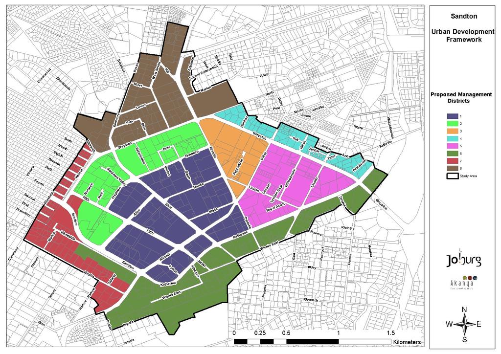
7 4.4 Manage and monitor infrastructure and services provision The successful growth and development of the Sandton node will to a large degree depend on the level of infrastructure availability and maintenance of the public environment making the City work. For the City administration, Making the City Works relates to the responsiveness of the city s departments and entities to various urban management challenges to ensure that areas in the City are kept clean and functional. Typical issues that are to be addressed include: Efficient service delivery By-law enforcement Stakeholder management Area-based Management Area Regeneration/Programme Management. Figure 65: City Features Requiring Maintenance In terms of the City s administration model, the regions will be responsible for the facilitation and co-ordination of urban management at a regional level. Co-ordination all these responsibilities for the good of communities requires leadership and direction. The different organisations involved need to work together to get the best value from their funds, their materials and their people. This avoids duplicating work, speeds progress, brings a co-ordinate approach to solving problems and produces better outcomes. One way to ensure better co-ordination is the identification of different districts in the Sandton node. The area has been divided into different districts which have been identified according to their physical relationship within their context as well as the future vision for the growth of the Sandton node. In the identification of development districts, it is important to provide smaller block sizes (3600m2) and tighter street networks (50-70m) in order to achieve the characteristics of an urban TOD. It is also important to determine incremental development opportunities which occur collectively rather than haphazardly. The districts identified will therefore assist in structuring the phasing of development of the Sandton node as well as more efficient urban management. Furthermore, in order to address the issues, goals and strategies as identified, it is important to define the desired conditions that ought to be reached in specific areas. 109
8 It is also important to recognize that the different districts will comprise different levels of development. For this reason, different levels of urban management and, specific issues, must be taken into account: The degree and intensity of council involvement and intervention will differ from district to district. In any district there will be core or direct areas of responsibility (e.g. providing street lights) and indirect areas of responsibility or influence (e.g. implementing health by-laws etc). Not all areas are at the same level of development and a one-maintenance-policy-fits-all approach is not always desirable. The level of participation and community involvement will be of varying degrees. For the purpose of this document, area boundaries (refer to Figure 55 below) are provided and the different district areas are as follows: Maybe we must just refer to the figure? District 1: The Management District is defined by Sandton Drive, Katherine Street, Rivonia Road, Alice Lane and Fredman Drive. The district forms the activity core of the node. District 2: The Management District is defined by Sandton Drive, Grayston Drive, Alice Lane and Fredman Drive. District 3: The Management District is defined by Rivonia Drive, Grayston Drive and Daisy Street. District 4: The Management District is defined by Grayston Drive. District 5: The Management District is defined by Katherine Street, Grayston drive and Daisy Street. District 6: The Management District is defined by Katherine Street and Wierda Road East. District 7: The Management District is defined by Sandton Drive and Rivonia Road. District 8: The Management District is defined by Grayston Drive and Rivonia Road. All of the above areas need to be monitored against the purpose and goals of the Sandton UDF with baseline information and needs as they arise addressed in terms of focus, service delivery and funding. Figure 66: Proposed Management Districts 110
9 111
10 4.5 Promote communication, co-ordination and engagement To a large degree, sustainable nodes and neighbourhoods are about participation and partnership building 14. Multi-sectoral partnerships are needed to address the increasingly complex environmental, social and economic issues that face local communities. Partnership structures or stakeholder groups can take many forms, but it is important that there are dedicated structures that can co-ordinate stakeholder involvement and the development of local communities. Refer to Figure 71 on the right. Another important element in the involvement of communities is the creation of public awareness and dissemination of information. Communities that are aware and capacitated to understand the benefits of the Sandton UDF can be one of the most valuable assets in the process. It is therefore important to involve communities and stakeholders in the planning, monitoring and even implementation of the Sandton UDF. The benefits include: Strengthening the legitimacy of the City Making services more responsive to local needs and situations Making use of community assistance in identifying problems, obstacles and opportunities more accurately Assisting in sustainable partnership formulation. To strengthen existing co-ordination efforts, the proposal is that certain mechanisms/forums be established at the three levels that influence the urban management process i.e. the City level, Regional level and implementation or local level. Refer to Figure 72 below for the Institutional arrangement Thus, it constitutes three main components of a Cities strategic planning and management level, a regional or functional management level and an operational and implementation level. The roles and responsibilities of each have to be clarified through further discussion. The outcomes should include: Ensuring the involvement and capacitating of communities and stakeholders Focusing service delivery on the end users Building trust and commitment Managing performance and providing regular feedback to the community 14Sandton UDFs,
UDF PLANS AND GUIDELINES
 UDF PLANS AND GUIDELINES 5 Land Use Land Use Development Plan Plan no. 3 Land Use Development Mixed Use Retail / Leisure Residential Civic and Institutional Proposed Zoning Table Development Edges Plan
DRAFT Subject to Modifications
 TREASURE COAST REGIONAL PLANNING COUNCIL M E M O R A N D U M To: Council Members AGENDA ITEM 8 From: Date: Subject: Staff May 19, 2017 Council Meeting Florida Department of Transportation Complete Streets
The role of urban mobility in (re)shaping cities
shaping cities") The role of urban mobility in (re)shaping cities Mr. Andre Dzikus Urban Basic Services Branch Coordinator www.unhabitat.org Structure 1) Urbanisation - Challenges 2) Mobility shaping the city 3) Mobility
The role of urban mobility in (re)shaping cities Mr. Andre Dzikus Urban Basic Services Branch Coordinator www.unhabitat.org Structure 1) Urbanisation - Challenges 2) Mobility shaping the city 3) Mobility
CENTURY CITY URBAN DESIGN FRAMEWORK
 CENTURY CITY URBAN DESIGN FRAMEWORK REVISION 1 OCTOBER 2005 PLANNING PARTNERS : CENTURY CITY URBAN DESIGN FRAMEWORK October 2005 REVISION 1 ACKNOWLEDGEMENT This document has been prepared for Century City
Western City District What we heard
 What we heard Vision to 2056 and Priorities Governance and implementation Infrastructure and funding The protection of the natural landscape including biodiversity and the Metropolitan Rural Area for food
The Five Components of the McLoughlin Area Plan
 The Five Components of the McLoughlin Area Plan This documents contains the complete language of the five components of the McLoughlin Area Plan: The Vision Statement The Values The Guiding Principles
Fishermans Bend Draft Framework. Submission to public consultation
 Fishermans Bend Draft Framework Submission to public consultation 14 December 2017 An opportunity for a world class innovation precinct The University of Melbourne welcomes the release of the Draft Fishermans
Taking forward the All London Green Grid
 Taking forward the All London Green Grid Foreword Earlier this year, the Mayor published the All London Green Grid Supplementary Planning Guidance to the London Plan which set the vision, and framework,
Subregion 4 Central Avenue-Metro Blue Line Corridor Transit-Oriented Development (TOD) Implementation Project. Community Meeting April 27, 2011
 Implementation Project. Community Meeting April 27, 2011") Subregion 4 Central Avenue-Metro Blue Line Corridor Transit-Oriented Development (TOD) Implementation Project Community Meeting April 27, 2011 Overview Introduction to Subregion 4 TOD Implementation Program
Subregion 4 Central Avenue-Metro Blue Line Corridor Transit-Oriented Development (TOD) Implementation Project Community Meeting April 27, 2011 Overview Introduction to Subregion 4 TOD Implementation Program
DAREBIN PLANNING SCHEME AMENDMENT C137
 Who is the planning authority? Planning and Environment Act 1987 DAREBIN PLANNING SCHEME AMENDMENT C137 EXPLANATORY REPORT This amendment has been prepared by the Darebin City Council, who is the planning
01 the vision NEW LYNN IS WAITING FOR THE GREAT LEAP FORWARD
 [A] FRAMEWORK 01 the vision 02 the framework 03 urban design principles 04 c o n t e x t 05 issues a n d o p p o r t u n i t i e s 06 creating a t.o.d. 07 key recommendations 08 seven strategic areas of
1 October Dear Citizens of Charlotte and Mecklenburg County,
 1 October 2011 Dear Citizens of Charlotte and Mecklenburg County, As co-chairs of the Center City 2020 Vision Plan Steering Committee, we are proud to present the Center City 2020 Vision Plan, which sets
TRANSIT-ORIENTED DEVELOPMENT POLICY DRAFT. City Planning and Development Department Kansas City, Missouri
 TRANSIT-ORIENTED DEVELOPMENT POLICY DRAFT City Planning and Development Department Kansas City, Missouri What is Transit Oriented Development (TOD)? Development that focuses land uses around a transit
JANUARY 19, 2011 CENTRAL AVENUE-METRO BLUE LINE TRANSIT-ORIENTED DEVELOPMENT IMPLEMENTATION PROJECT COMMUNITY FORUM
 CENTRAL AVENUE-METRO BLUE LINE TRANSIT-ORIENTED DEVELOPMENT IMPLEMENTATION PROJECT COMMUNITY FORUM JANUARY 19, 2011 THE MARYLAND-NATIONAL CAPITAL PARK AND PLANNING COMMISSION PRINCE GEORGE S COUNTY PLANNING
Downtown Whitby Action Plan
 Downtown Whitby Action Plan Final Report October 2016 Table of Contents Introduction 1 Public Consultation 2 Walkability 3 Downtown Whitby Walkability Map 4 Vision 5 Goal & Objectives 6 Objective 1 7 Objective
Western Sydney Parklands Australia s Largest Urban Park
 Western Sydney Parklands Australia s Largest Urban Park 37 WLA 1 MAGAZINE 21 38 WESTERN SYDNEY PARKLANDS AUSTRALIA S LARGEST URBAN PARK Large urban parks have dual roles to play in meeting the demands
Norwich (United Kingdom), 9-10 September 2004
, 9-10 September 2004") THE CONGRESS OF LOCAL AND REGIONAL AUTHORITIES Council of Europe F 67075 Strasbourg Cedex Tel : +33 (0)3 88 41 20 00 Fax : +33 (0)3 88 41 27 51/ 37 47 http://www.coe.int/cplre COLLOQUIES, SEMINARS, FORUMS
THE CONGRESS OF LOCAL AND REGIONAL AUTHORITIES Council of Europe F 67075 Strasbourg Cedex Tel : +33 (0)3 88 41 20 00 Fax : +33 (0)3 88 41 27 51/ 37 47 http://www.coe.int/cplre COLLOQUIES, SEMINARS, FORUMS
ELMVALE ACRES SHOPPING CENTRE MASTER PLAN
 ELMVALE ACRES SHOPPING CENTRE MASTER PLAN Contents 1.0 INTRODUCTION... 2 2.0 LOCATION... 2 3.0 EXISTING CONTEXT... 2 4.0 VISION & GUIDING PRINCIPLES... 2 5.0 LAND USE AND BUILT FORM... 4 5.1 St. Laurent
Appendix 1 Structure plan guidelines
 Appendix 1 Structure plan guidelines This appendix forms part of the regional policy statement [rps]. 1.1. Introduction Structure plans are an important method for establishing the pattern of land use
IMPLEMENTING SOMERSET COUNTY S INVESTMENT FRAMEWORK
 IMPLEMENTING SOMERSET COUNTY S INVESTMENT FRAMEWORK SMART CONSERVATION THROUGH SMART GROWTH NJ LAND CONSERVATION RALLY March 22, 2014 Laurette Kratina, PP, AICP, Supervising Planner Somerset County Planning
Official Plan Review
 Official Plan Review Summary Report - The Built Environment August 2014 Part 1: Introduction Planning for a healthy, prosperous and sustainable community is an important goal for our municipality. From
ANC 2A Presentation. November 9, 2006
 ANC 2A Presentation November 9, 2006 Introduction & Overview Applicants Boston Properties and KSI Services (project developers) The George Washington University (land owner) 2.66 acre site (former GW hospital
MOUNT PLEASANT SECONDARY PLAN & VILLAGE BLOCK PLAN. Wednesday, March 5, 2008 Informal Public Open House
 MOUNT PLEASANT SECONDARY PLAN & VILLAGE BLOCK PLAN Wednesday, March 5, 2008 Informal Public Open House 1. Welcome & Introductions 2. Highlights of Provincial Growth Plan 3. Overview and Status Update -
Corridor Vision. 1Pursue Minnehaha-Hiawatha Community Works Project. Mission of Hennepin County Community Works Program
 1Pursue Minnehaha-Hiawatha Community Works Project Minnehaha-Hiawatha Community Works is a project within the Hennepin Community Works (HCW) program. The mission of the HCW program is to enhance how the
Published in March 2005 by the. Ministry for the Environment. PO Box , Wellington, New Zealand ISBN: X.
 Action Pack Published in March 2005 by the Ministry for the Environment Manatū Mō Te Taiao PO Box 10-362, Wellington, New Zealand ISBN: 0-478-18994-X ME number: 580 This document is available on the Ministry
PROPOSED URBAN STRUCTURE
 CHAPTER 3 PROPOSED URBAN STRUCTURE PLANNING PARTNERS: CENTURY CITY URBAN DESIGN FRAMEWORK October 2005 13 THE PROPOSED URBAN STRUCTURE The urban design rationale outlined in the previous chapter provides
PLACE WORKSHOP REPORT. A+DS SNH sustainable placemaking programme
 PLACE briefing WORKSHOP REPORT A+DS SNH sustainable placemaking programme INTRODUCTION This report summarises the outcome of a Scottish Natural Heritage workshop on placemaking which was held on Wednesday
Create Policy Options Draft Plan Plan Approval. Public Consultation Events. Phase 2
 Background Grandview-Woodland Community Plan In the spring of 2012, the City of Vancouver embarked on a comprehensive community planning program in the Grandview-Woodland neighbourhood. The process has
World Towns Agreement
 World Towns Agreement A Public-Private-Social Vision for Urban Centres Sponsored by Developed with support from MISSION STATEMENT We, the delegates and online participants at the World Towns Leadership
dr. robert paterson Spring 2016
 sustainable land use planning community and regional planning dr. robert paterson Spring 2016 Contemporary land use planning requires an analysis and understanding of physical and social demographics,
Further input invited as Colchester Growth Strategy nears final phase
 IUE 3 / NOVEMBER 2015 Further input invited as Colchester Growth trategy nears final phase trathcona County is seeking public feedback as it enters the final phase of work on a Growth Management trategy
Scottish Natural Heritage. Better places for people and nature
 Scottish Natural Heritage Better places for people and nature Contents Summary... 3 SNH approach... 5 Place-making in policy and practice... 6 Developing the contribution of the natural heritage to place-making...
Strategic Plan. Updated April City of St. Augustine
 Strategic Plan Updated April 2018 City of St. Augustine Our Vision St. Augustine will be a diverse, livable, authentic waterfront city that builds upon its rich history and environment to create a distinctive
Tāhuhu whakaruruhau ā-taone The sheltering ridge pole
 B2. Tāhuhu whakaruruhau ā-taone - Urban growth and form B2.1. Issues Tāhuhu whakaruruhau ā-taone The sheltering ridge pole Auckland s growing population increases demand for housing, employment, business,
GATEWAY AREA STRUCTURE PLAN
 CHESTERMERE GATEWAY AREA STRUCTURE PLAN COMMUNITY OPEN HOUSE SEPTEMBER 22 nd, 2015 PLAN AREA ± 512 hectares (± 1,265 acres) GATEWAY LOCATION UNDEVELOPED LANDS PRESENT AGRICULTURAL USE REGIONAL LAND USE
Rio/29 Small Area Plan. Design Plan & Implementation Framework Open House - January 25, 2018
 Rio/29 Small Area Plan Design Plan & Implementation Framework Open House - January 25, 2018 MEETING PURPOSE PRESENTATION 1. Orient to the updated design plans 2. Introduce implementing options 3. Explain
Draft Western District Plan
 Powered by TCPDF (www.tcpdf.org) Draft Western District Plan Submission_id: 31440 Date of Lodgment: 15 Dec 2017 Origin of Submission: Online Organisation name: Goodman Property Services Australia Pty Ltd
Design Guidance. Introduction, Approach and Design Principles. Mauritius. November Ministry of Housing and Lands. .. a
 sig evelo r D Mauritius s. Utilities.. Individu a s. er itects.to ls chpers.po e Public. T. h rban D Sc U e me Promot e h ners. A Design Guidance o.h Planne rs n w iticians r l useholde National Development
Neighbourhood Planning Local Green Spaces
 Neighbourhood Planning Local Green Spaces Introduction... 2 1. Why green space is important... 4 2. Neighbourhood plans and green space... 6 3. Evidence... 8 Statutory designations... 9 Green space audit...
REZONING GUIDE. Zone Map Amendment (Rezoning) - Application. Rezoning Application Page 1 of 3. Return completed form to
 - Application. Rezoning Application Page 1 of 3. Return completed form to") Zone Map Amendment (Rezoning) - Application COMMUNITY PLANNING & DEVELOPMENT REZONING GUIDE Rezoning Application Page 1 of 3 PROPERTY OWNER INFORMATION* CHECK IF POINT OF CONTACT FOR APPLICATION Property
Zone Map Amendment (Rezoning) - Application COMMUNITY PLANNING & DEVELOPMENT REZONING GUIDE Rezoning Application Page 1 of 3 PROPERTY OWNER INFORMATION* CHECK IF POINT OF CONTACT FOR APPLICATION Property
1.3 TRANSIT VISION 2040 FROM VISION TO ACTION THEME 1: PUTTING TRANSIT AT THE CENTRE OF COMMUNITIES. Fully integrate transit with community planning
 TRANSIT VISION 2040 FROM VISION TO ACTION TRANSIT VISION 2040 defines a future in which public transit maximizes its contribution to quality of life with benefits that support a vibrant and equitable society,
2017 STRATEGIC PLAN CITY OF ST. AUGUSTINE
 2017 STRATEGIC PLAN CITY OF ST. AUGUSTINE WHO WE ARE CITY OF ST. AUGUSTINE VISION St. Augustine will be a diverse, livable, authentic waterfront city that builds upon its rich history and environment to
Public Open House #1
 Public Open House #1 TONIGHT S AGENDA Welcome Project Overview The Big Picture The Station Area The Analysis Thoughts about Future Change Breakout Group Discussions Summation / Next Steps Project Overview
Newcourt Masterplan. November Exeter Local Development Framework
 Newcourt Masterplan November 2010 Exeter Local Development Framework Background The Exeter Core Strategy Proposed Submission sets out the vision, objectives and strategy for the development of Exeter up
Elderberry Walk. Developer HAB Housing
 Case studies Elderberry Walk Developer HAB Housing Development of 161 new homes on the former Dunmail Primary School site, focused around a central green street, with retained trees, new multifunctional
Regional Context Statement
 Regional Context Statement REGIONAL CONTEXT STATEMENT 3. REGIONAL CONTEXT STATEMENT In 1995, the Provincial Government passed into law the Growth Strategies Act. The purpose of this provincial initiative
Smart City Governance URBIS Solutions. David Ludlow, Assoc. Professor European Smart Cities University of the West of England, Bristol
 Smart City Governance URBIS Solutions David Ludlow, Assoc. Professor European Smart Cities University of the West of England, Bristol Integrated smart city model Smart Mobility Services focused on decreasing
Central City District What we heard
 What we heard Vision to 2056 and Priorities Governance and implementation Infrastructure and funding The vision for a metropolis of three cities, and the 30 minute city. Feedback requested: Clearer communication
The Corporation of the Town of Milton
 Report To: From: Council Barbara Koopmans, Commissioner, Planning and Development Date: May 7, 2018 Report No: Subject: Making it Possible Positioning the Town s Strategy for Growth and Economic Development
Urban Growth Management in Seven New World cities: Aligning visions and quality neighbourhood outcomes
 Urban Growth Management in Seven New World cities: Aligning visions and quality neighbourhood outcomes New Zealand Centre for Sustainable Cities 14 August 2013 Errol Haarhoff & Lee Beattie School of Architecture
V. Vision and Guiding Principles
 V. Vision and Guiding Principles The Master Plan for the Powers Ferry Corridor seeks a foundation in the desires of the community. At times, various elements of the community offered opposing viewpoints,
Urban Planning and Land Use
 Urban Planning and Land Use 701 North 7 th Street, Room 423 Phone: (913) 573-5750 Kansas City, Kansas 66101 Fax: (913) 573-5796 Email: planninginfo@wycokck.org www.wycokck.org/planning To: From: City Planning
Midtown Greenway Land Use and Development Plan Executive Summary
 Midtown Greenway Land Use and Development Plan Executive Summary Introduction The Midtown Greenway Land Use and Development Plan sets policy direction for land use and development in the Midtown Greenway
Coliseum Station Area Area Redevelopment Plan. Public Engagement #1 June 12, 2017
 Coliseum Station Area Area Redevelopment Plan Public Engagement #1 June 12, 2017 Welcome Engagement Purpose Introduce the project Share information Gather input Project Updates & Newsletter edmonton.ca/coliseumplan
Appendix A. Planning Processes. Introduction
 1 Planning Processes Introduction This appendix outlines a number of planning processes which are used in the Auckland Region to support the effective management of development in the region s rural and
Outline of Presentation
 LUSAKA CITY COUNCIL 2 nd Annual IGC Cities Conference Making Cities work for growth London School of Economics (LSE) United Kingdom. 28 th 29 th January 2016 Presenter: Alex Mwansa Town Clerk Lusaka City
North District What we heard
 What we heard Vision to 2056 and Priorities Governance and implementation Infrastructure and funding The vision for a metropolis of three cities, and the 30 minute city. Feedback emphasised: That for the
Are we creating and exploiting synergies on our transit investments?
 10 Years of TOD in the Denver Front Range Region: Are we creating and exploiting synergies on our transit investments? Tim Van Meter Van Meter Williams Pollack Architecture & Urban Design San Francisco
Land Use Amendment in Southwood (Ward 11) at and Elbow Drive SW, LOC
 at and Elbow Drive SW, LOC") 2018 November 15 Page 1 of 10 EXECUTIVE SUMMARY This land use amendment application was submitted by Rick Balbi Architect on 2017 August 31 on behalf of Sable Developments Ltd, and with authorization from
2018 November 15 Page 1 of 10 EXECUTIVE SUMMARY This land use amendment application was submitted by Rick Balbi Architect on 2017 August 31 on behalf of Sable Developments Ltd, and with authorization from
In surveys, Dallas residents say what they want to change most
 NEIGHBORHOODS ELEMENT In surveys, Dallas residents say what they want to change most in the city is its appearance they want it to look beautiful, with trees and pedestrian-friendly neighborhoods. The
Chapter 4. Linking Land Use with Transportation. Chapter 4
 Chapter 4 Linking Land Use with Transportation Chapter 4 59 Chapter 4 Linking Land Use with Transportation Community Design and Transportation Program Introduction Since the 1950s, the predominant development
Northern Territory Compact Urban Growth Policy
 Northern Territory Compact Urban Growth Policy A Reference Policy Document to clause 2.7 (Reference to Policy) of the NT Planning Scheme May 2015 Table of Contents 1 Policy Setting... 3 1.1 Context for
SQUAMISH 2010 AND BEYOND COMMUNITY VISION
 Our plan has been imagined and created to be both pragmatic and visionary. At the core of the strategy is a consideration of the highway s role and its impact on the community. First and foremost in creating
PUBLIC OPEN HOUSE HURONTARIO-MAIN CORRIDOR SECONDARY PLAN
 PUBLIC OPEN HOUSE HURONTARIO-MAIN CORRIDOR SECONDARY PLAN Tuesday, February 28, 2012 6pm 9pm 1 st Floor Atrium, City Hall 2 Wellington Street West, Brampton 1 POLICY FRAMEWORK The 2006 Provincial Growth
The New Planning System 5 June 2015
 The New Planning System 5 June 2015 The Purpose of the Planning System The town and country planning system exists to regulate the development and use of land in the public interest. The public interest
City of Hermosa Beach Administrative Policy #
 City of Hermosa Beach Administrative Policy # SUBJECT: Living Streets Policy Date: Approved by: City Council Authority: Public Works Department & Community Development Department Mayor, PURPOSE The City
14.5 HOPEFIELD: (REFER PLAN 39 AND PLAN 40)
") URBAN DYNAMICS WESTERN CAPE INC. 248 14.5 HOPEFIELD: (REFER PLAN 39 AND PLAN 40) FIGURE 83: LOCALITY - HOPEFIELD Within the context of the Saldanha Bay Municipal area, Hopefield, an historical agricultural
URBAN DYNAMICS WESTERN CAPE INC. 248 14.5 HOPEFIELD: (REFER PLAN 39 AND PLAN 40) FIGURE 83: LOCALITY - HOPEFIELD Within the context of the Saldanha Bay Municipal area, Hopefield, an historical agricultural
Complete Neighbourhood Guidelines Review Tool
 Complete Neighbourhood Guidelines Review Tool Prepared By: City of Regina Planning Department October 2014 Page 1 of 14 Community Development Review Checklist for Secondary Plans and Concept Plans The
Local Growth Planning in North Central Green Line Communities
 2018 April 30 Page 1 of 6 EXECUTIVE SUMMARY This report outlines a high-level scope for local growth planning for north central Green Line communities. The catalyst for this review is the significant investments
Welcome. Walk Around. Talk to Us. Write Down Your Comments
 Welcome This is an information meeting introducing the applications for proposed redevelopment of the Yorkdale Shopping Centre site at 3401 Dufferin Street and 1 Yorkdale Road over the next 20+ years,
1 Introduction. Chapter. In this chapter:
 Chapter 1 Introduction In this chapter: 1.1 A Snapshot of the Region 1.2 Towards a Sustainable Region 1.3 The Provincial Context 1.4 Purpose and Organization The Regional Municipality of York Official
Municipal Development Plan 2013
 UNIQUELY STONY PLAIN: Municipal Development Plan 2013 Quick Reference Guide What is a Municipal Development Plan (MDP)? The Town s highest-level planning document Sets the long-term vision and key themes
D-O LRT Zoning Discussion. Chapel Hill Boards & Commissions October 16, 2017
 D-O LRT Zoning Discussion Chapel Hill Boards & Commissions October 16, 2017 Update on Overall D-O LRT Station Area Initiative Objectives Design and educate on principles of Good Transit-Oriented Development
2040 LUP is a part of the Comprehensive Plan and carries the same legal authority. Economic Challenges
 1.1. Guiding Anchorage s Growth Where will new residents settle over the next two decades? Where will people work, shop, and play? Will there be enough room to grow? How will Anchorage look? Will growth
Broadway District Specific Plan. Community Workshop #2 February 23,2016
 Broadway District Specific Plan Community Workshop #2 February 23,2016 1 Agenda Introductions Project Progress Status Upcoming Milestones Emerging Framework Land Use Urban Design Circulation Infrastructure
38 Queen s University Campus Master Plan Part 1
 38 Queen s University Campus Master Plan Part 1 46 The Campus at the City Scale Chapter 4 The Campus at the City Scale 39 Queen s is an urban University centrally located in Kingston. Decisions made by
EDMONTON: Changing the Way We Grow and the Way We Move
 EDMONTON: Changing the Way We Grow and the Way We Move Rhonda, Toohey, P.Eng. Transportation Department City of Edmonton Paper prepared for presentation at the Sustainable Urban Transportation Session
Port Credit Local Advisory Panel October 20 th Meeting
 Port Credit Local Advisory Panel October 20 th Meeting Focus Of This Evening s Meeting: 1. Hurontario Main Street Higher Order Transit Study 2. Port Credit Mobility Hub & GO Station Parking Structure Study
Streets, Connectivity & Built Environment Working Group August 2, 2017
 Streets, Connectivity & Built Environment Working Group August 2, 2017 DOWNTOWN OAKLAND SPECIFIC PLAN WELCOME Streets, Connectivity & Built Environment Working Group Social Equity Meeting August 2, 2017
8.0 Built Form Framework
 Figure C-40. RIC and Laboratory Building Internal Pedestrian Node 8.0 Built Form Framework The built form framework defines the desired future character and function of built elements within the campus
NEW REGIONAL OFFICIAL PLAN HIGH LEVEL PROCESS & FRAMEWORK
 NEW REGIONAL OFFICIAL PLAN HIGH LEVEL PROCESS & FRAMEWORK Why A New Official Plan Originally the role of Regionally Planning and content of Regional Official Plan (1970s) primarily focused on protecting
Hobart A Strategic Framework
 Hobart 2025 A Strategic Framework Adopted by the Hobart City Council 15 October 2007 Table of Contents Introduction...2 Vision and Future Directions...3 FD1 Offers opportunities for all ages and a city
CHAPTER 1. Ms. Guajardo s Class - Central Elementary CH 1 1
 INTRODUCTION CHAPTER 1 Ms. Guajardo s Class - Central Elementary CH 1 1 1.1 SETTING South Centre City is a linear corridor south of Downtown Escondido paralleling Centre City Parkway and South Escondido
Sustainability, Health, Safety, Recreation & Open Space Working Group August 3, 2017
 Sustainability, Health, Safety, Recreation & Open Space Working Group August 3, 2017 DOWNTOWN OAKLAND SPECIFIC PLAN WELCOME Sustainability, Health, Safety, Recreation & Open Space Working Group Social
CHAPTER 7: Transportation, Mobility and Circulation
 AGLE AREA COMMUNITY Plan CHAPTER 7 CHAPTER 7: Transportation, Mobility and Circulation Transportation, Mobility and Circulation The purpose of the Transportation, Mobility and Circulation Chapter is to
City of Long Beach. creating vibrant and exciting places
 City of Long Beach creating vibrant and exciting places Land Use Element Urban Design Element Overview of the two draft General Plan elements Discuss areas of change Economic goals of the plans Case study
THAT the attached Terms of Reference for the Thornhill Centre Street Study be approved.
 COMMITTEE OF THE WHOLE AUGUST 18, 2003 THORNHILL CENTRE STREET STUDY PLANNING FILE: 15.92 Recommendation The Commissioner of Planning recommends: THAT the attached Terms of Reference for the Thornhill
Independence Boulevard Area Plan Planning Committee Public Comment May 18, 2010
 Independence Boulevard Area Plan Planning Committee Public Comment May 18, 2010 Presentation Outline Focus on Key Recommendations within Draft Plan Plan Purpose and Development Process Draft Plan Policies
Greater Langley: NEW BUILDINGS
 District Scale Overview The Liveable Region Strategic Plan (LRSP) identifies four main growth strategies: Protect the green zone; build complete communities; achieve a compact metropolitan area and increase
EXISTING COMPREHENSIVE PLAN
 EXISTING COMPREHENSIVE PLAN Town Center Land Use Element: V. LAND USE POLICIES Town Center Mercer Island's business district vision as described in "Your Mercer Island Citizen-Designed Downtown" was an
THE TOWN OF WASAGA BEACH
 THE TOWN OF WASAGA BEACH Downtown Development Master Plan Committee of the Whole Presentation January 26 th 2017 Uses within this designation should reflect a dependence on tourism as opposed to the permanent
EXECUTIVE SUMMARY DRAFT CHAPTER 1 INTRODUCTION EXECUTIVE SUMMARY
 CHAPTER 1 EXECUTIVE SUMMARY INTRODUCTION Through the joint efforts of the City of Tulsa planning staff and the Land Services division of Indian Nations Council of Governments (INCOG), the Berryhill Land
CITY VIEW OBJECTIVES
 SECTION 2: CITY VIEW OBJECTIVES CONTENTS 2.1 Introduction 1 2.2 Strategic Direction 1 2.3 The City View Resource Management Issues for the City 1 2.4 The Goal 3 2.5 The City View Objectives 3 Palmerston
Tauranga City Centre Spatial Framework
 Tauranga City Centre Spatial Framework Stakeholder Engagement Workshop 15 October 2015 Project Design Team Beca & LandLAB Our team Henry Crothers (LandLab) Landscape Architect/Urban Designer Urban and
WELCOME GYPSY LANE. Wider Site Location plan. Proposals for the development of LAND OFF FOXLYDIATE LANE WEBHEATH. Proposals for the development of
 WELCOME The developers are preparing an outline planning application for a residential led development and need the community s views in order to develop the proposals further WHAT IS PROPOSED? A high
Chapter 5 Urban Design and Public Realm
 5.1 Introduction Public realm is all areas of the urban fabric to which the public have access. It is where physical interaction takes place between people. It therefore, includes buildings and their design,
SUBJECT: Waterfront Hotel Planning Study Update TO: Planning and Development Committee FROM: Department of City Building. Recommendation: Purpose:
 Page 1 of Report PB-23-18 SUBJECT: Waterfront Hotel Planning Study Update TO: Planning and Development Committee FROM: Department of City Building Report Number: PB-23-18 Wards Affected: 2 File Numbers:
Plan Modification to Chapter B2 of the Auckland Unitary Plan(AUP) Operative in part (15 November 2016)
 Operative in part (15 November 2016)") UNITARY PLAN UPDATE REQUEST MEMORANDUM TO FROM Phill Reid Linley Wilkinson DATE 25 September 2018 SUBJECT Plan Modification to Chapter B2 of the Auckland Unitary Plan(AUP) Operative in part (15 November
UNITARY PLAN UPDATE REQUEST MEMORANDUM TO FROM Phill Reid Linley Wilkinson DATE 25 September 2018 SUBJECT Plan Modification to Chapter B2 of the Auckland Unitary Plan(AUP) Operative in part (15 November
BERTRAMS PRIORITY BLOCK. Dra support documentation to the recommendations to SAHRA for the Priority Block, Bertrams, Johannesburg OCTOBER 2008
 BERTRAMS PRIORITY BLOCK Dra support documentation to the recommendations to SAHRA for the Priority Block, Bertrams, Johannesburg OCTOBER 2008 CONTENTS 1. Execu ve Summary 2. Report Structure 3. Background
Selected Area Study. Vision Plan Draft
 East Polk County Selected Area Study Draft 10.30.08 Contents Guiding Principles...4 Context Conclusions...5 Current Context...8 Scenarios...9 Scenario: Status Quo...10 Scenario: Connected & Directed Growth...12