Character Area Study for Indian Point
|
|
|
- Melinda Ball
- 5 years ago
- Views:
Transcription


1 City of Burlington Offi cial Plan Review: Character Area Study for Indian Point Prepared By: Brook McIlroy Macaulay Shiomi Howson Ltd. Final Report August, 2014

2
3 Contents 01 Introduction & Context Study Purpose What is a Character Area Study? Indian Point Neighbourhood History of Neighbourhood 3 02 Best Practice Review Baby Point, Toronto Wychwood Park, Toronto Mississauga, Ontario Oakville, Ontario Vancouver, Canada Victoria, Australia Cairns, Australia Boroondara, Australia 9 03 Consultation Overview Character Elements Private Realm Public Realm Threats to Character Elements Character Area Statement Recommendations Implementation/Next Steps 37 Cover page: Large street trees along Indian Road (Credit - City of Burlington). Opposite Page: Private landscaping and large trees on Iroquois Road (Credit - City of Burlington).

4 ~ iv ~
5 01 Introduction & Context The Character Area Study for Indian Point identifi es the characteristics of the neighbourhood, with emphasis on the qualities that make it distinct from other neighbourhoods in the City of Burlington. The study results in recommendations for new and refi ned policies and tools for the City to support the character of Indian Point in response to development pressures. The Character Area Study will provide considerations for managing development change in Indian Point to ensure new development maintains the characteristics most valued by the community and that the distinctiveness of the neighbourhood is protected and enhanced. 1.1 Study Purpose The purpose of the Character Area Study for Indian Point is to:» Identify the area characteristics of Indian Point, with specifi c emphasis on what makes this area distinct within the City of Burlington.» Review the merit of establishing defi ned Character Areas in the City s Offi cial Plan in recognition of the identifi ed area characteristics of Indian Point.» Obtain direction to improve the management of neighbourhood character issues associated with the redevelopment within Indian Point. 1.2 What is a Character Area Study? Neighbourhood character refers to the 'look and feel of an area. Character areas are areas of a community that have achieved a distinct, recognizable, character that is different from neighbouring areas. A Character Area Study considers the public and private realm components that defi ne the area, including topography, age and style of housing, built environment, land use patterns, landscaping, street patterns, open space, and streetscapes. The character of a neighbourhood goes beyond a categorization of private and public realm components. The character of the houses and the individual properties in a neighbourhood cannot be viewed in isolation from the character of the street and the context in which they are located. Therefore, a Character Area Study identifi es a combination of components that collectively give a neighbourhood its character, quality, and sense of place. Opposite Page: Looking north on Algonquin Road (Credit - Brook McIlroy). ~ 1 ~


 30-36% Lot Coverage 2 1/2")

6 NORTH SH ORE BLVD E QE W 7-12% Lot Coverage 1 Storey Street Tree Canopy 13-18% Lot Coverage 1 1/2 Storeys Access Points Municipally Registered Heritage Houses 19-29% Lot Coverage 2 Storeys Views of Street Vistas Landmarks (Stone Gates) 30-36% Lot Coverage 2 1/2 Storeys Views of the Lake Map 1: Illustrating the key characteristics of Indian Point. ~2~
7 1.3 Indian Point Neighbourhood The Indian Point neighbourhood is located directly south-west of the Queen Elizabeth Highway in the City of Burlington. Fifteen acres in size, it is a small twenty-seven home neighbourhood situated on Burlington s only established peninsula on the north shore of Lake Ontario. The neighbourhood is made up of four roads. Indian Road runs eastwest for the length of the 200m peninsula and is broken up at approximately 50m intervals by Mohawk Road, Algonquin Road and Iroquois Road. This limited street network has a primary access and exit point off of North Shore Boulevard East, with a second exit off of Mohawk Road, resulting in a quiet and private enclave. 1.4 History of Neighbourhood Formerly a First Nations encampment, the Indian Point neighbourhood is now a mature residential neighbourhood and one of the oldest in the City of Burlington. The fi rst development in the neighbourhood was by Alfred Brigham Coleman who in 1902 built a 4-storey resort named the Brant Hotel. Located adjacent to the former home of Chief Joseph Brant (a famous Mohawk leader whose land established the village of Burlington), the hotel was a summer resort attraction which was rented to many wealthy Canadians and Americans. Coleman also built fi ve large rental cottages along the Burlington Bay at the turn of the century, some of which still remain. In 1929, the same year that Indian Point s distinctive gates were designed and built, Coleman registered Plan 236, the Indian Point Survey, which marked the beginning of the transformation of the summer resort into the planned residential neighbourhood that exists today (Adapted from Heritage Burlington Records and Burlington Historical Society, 2011). ~ 3 ~

8
9 02 Best Practice Review A detailed review of best practices for protecting and enhancing the character of unique neighbourhoods was undertaken. This review considered local, Canadian, and international precedents at a variety of scales, from neighbourhood-specifi c studies to broader city-wide policies. Strategies range from research techniques and design guidelines to zoning and policy amendments, and include a variety of approaches that are applicable to Indian Point. A selection of precedents are described in greater detail below. 2.1 Baby Point, Toronto Baby Point is a residential neighbourhood in Toronto, located on the Humber River to the northwest of Bloor West Village. The neighbourhood, a quaint enclave, is situated on a point overlooking the Humber River and is surrounded by ravines and parkland. It is characterized by a mix of dwellings with larger homes backing onto the ravine and smaller dwellings near the Jane Street entrance. A defi ning feature of Baby Point is the varied and organic location of the dwellings on their property, and in relation to adjacent dwellings. Currently, changes to the zoning bylaw are under consideration to permit a unique approach to zoning for the area that would help to preserve the organic layout of the neighbourhood. The amendment would establish minimum front and side yard setbacks as they exist on the date the amendment is enacted, requiring new builds to maintain the existing relationship of dwelling to property size and the relationship between adjacent properties. Additions to existing dwellings would be limited to the rear yard (to maintain front and side yard setbacks), but are otherwise only restricted by coverage requirements, maximizing fl exibility for property owners looking to expand the size of their dwelling. Lessons Learned Through consultation with the community, it was determined that the approach proposed for Baby Point is too prescriptive for Indian Point. However, at the highest level, this approach demonstrates the need for specifi c zoning within character areas that refl ects the on-theground context. This helped to inform the zoning amendments outlined in Recommendations # 3 and 4. Opposite Page: Looking northeast along Algonquin Road (Credit - City of Burlington). ~ 5 ~


10 2.2 Wychwood Park, Toronto While Ontario has many Heritage Conservation Districts, Toronto s Wychwood Park is the province s fi rst residential zone to be granted heritage status. Wychwood Park is located north of Downtown Toronto, to the northwest of Davenport Road and Bathurst Street. Wychwood Park is designated a Heritage Conservation District under the Ontario Heritage Act. This designation recognizes not only the dwellings (all are listed on the City s heritage register), but also the landscape, the street arrangement, etc. Any alteration, addition, or demolition of a property within Wychwood Park requires a permit from the City, which is subject to the plan for the neighbourhood. The plan provides a detailed description of the neighbourhood, identifying the key elements that defi ne the character, including a parklike ambiance, large native trees, relationship between trees and dwellings, open spaces around dwellings, etc. Detailed guidelines are provided to ensure that new dwellings, additions, or alterations are consistent with these elements. Lessons Learned While Heritage Conservation Districts can be controversial, and are often criticized for limiting the evolution of a neighbourhood, elements from Wychwood Park can be applied to Indian Point without adopting a Heritage Conservation District. The guidelines that support the Wychwood Park Heritage Conservation District are rooted in a strong understanding and description of the character and history of the neighbourhood. Recognizing the value of a strong character statement has been applied in the recommendations of this study (see Recommendation # 2). 2.3 Mississauga, Ontario Mississauga Plan, the City s Offi cial Plan, provides strong policies for neighbourhood protection at the highest level of planning policy. On Schedule 9: Character Areas, the plan recognizes a number of areas in the City that are unique and require an additional level of consideration. General policies related to these areas are provided throughout the plan, and Local Area Plans provide more detailed directions and policies for the Downtown Core, Port Credit, Lakeview, and Southdown. Within the Local Area Plans, each plan area is divided into unique precincts. The character of each precinct is defi ned, and specifi c policies are provided to support the elements that defi ne the character. Lessons learned Mississauga s approach to character planning further supports the importance of a strong character statement for each unique area. More importantly, Mississauga demonstrates a comprehensive approach to character planning where broad directions (i.e. Mississauga Plan) are supported by area-specifi c directions (i.e. Local Area Plans). This approach is refl ected in the recommendations for Indian Point, where a character statement and policies in the Offi cial Plan (see Recommendation # 1 and 2) support changes to the zoning bylaw (see Recommendations # 3 and 4). Credit - Duffy & Associates/Ian MacDonald Credit - Brook McIlroy ~ 6 ~
, which call for compatible infill.")

11 2.4 Oakville, Ontario The Town of Oakville s Design Guidelines for Stable Residential Communities provide detailed directions for new detached dwellings (infi ll and/ or rebuilds) and large additions within stable residential areas. The guidelines build on the broad policies of the Liveable Oakville Plan (the Town s Official Plan), which call for compatible infill. By providing detailed directions related to height, scale, transitions between properties, rear yard privacy, etc. the guidelines limit the ambiguity of a broad term such as compatibility. The guidelines provide neighbourhood residents with a sense of comfort about future development, provide developers with a clear understanding of Council s vision for compatible infill, and assist Town staff in evaluating proposals. Lessons Learned Through consultation with the community, it was determined that property owners in Indian Point are invested in high quality built form without the requirement of detailed design guidelines. However, like Mississauga s Local Area Plans, Oakville s approach demonstrates a comprehensive approach to character planning where broad directions (i.e. Liveable Oakville Plan) are supported by areaspecific directions (i.e. Urban Design Guidelines). This approach is reflected in the recommendations for Indian Point, where a character statement and policies in the Official Plan (see Recommendation # 1 and 2) support changes to the zoning bylaw (see Recommendations # 3 and 4). 2.5 Vancouver, Canada The City of Vancouver protects important neighbourhoods through the preparation of Community Plans, including plans for Marpole, Mount Pleasant, West End, and Norquay Village. Within these larger areas, the plans recognize a number of unique sub-neighbourhoods that have their own character and identity. Through the creation of a Local Area Profile, Community Plans start by identifying the key elements that define each neighbourhood. This includes a statement of the neighbourhood s character, as well as a list of the public and private realm elements that support this character. In addition, the Local Area Profiles address the threats that potentially undermine this character. The Community Plans are supported by policies that are specific to each neighbourhood. Lessons Learned Vancouver s Community Plans reinforce many lessons learned through other precedents, including the value of a strong character statement and area-specifi c policies. They are unique in that identifying the potential threats to the character results in directions that specifi cally aim to mitigate these concerns, rather than simply preserving the existing elements. A similar approach was used in Indian Point, where the threats to character elements were identifi ed (see Section 3.3) and used to inform the fi nal recommendations. Credit - Brook McIlroy Credit - Google ~ 7 ~


12 2.6 Victoria, Australia In Victoria, ResCode is a design code (bylaw) that applies to all residential development and makes neighbourhood character the primary criterion for assessing residential development applications in the City. ResCode requires a detailed site analysis for every development proposal to identify the character of the neighbourhood and to demonstrate how the proposed development meets or enhances this character. To facilitate the retention of neighbourhood character, ResCode provides detailed requirements related to dwelling position, setbacks, height, roof pitch, etc. These are not guidelines, but are mandatory requirements that must be met by all new development. Lessons Learned ResCode exemplifi es how specifi c elements of zoning can be used to ensure that the character of an area is protected. While the requirements of ResCode go beyond the recommendations of this report, it demonstrates that zoning amendments are one of the most impactful ways to protect the character of a neighbourhood, as all future development is required to adhere to the requirements. This was recognized in developing Recommendations # 3 and Cairns, Australia To protect the character of unique neighbourhoods in Cairns, the City utilizes many of the same elements that have been discussed in previous precedents. Twenty-three unique cultural heritage precincts have been identifi ed throughout the City, and a character statement and detailed design guidelines have been provided for each. Similar to Vancouver, Cairns also identifi es the threats to neighbourhood character and uses this to create guidelines that address issues such as contemporary infi ll, large dwelling additions, etc. Where Cairns approach is unique is in the appointment of a Regional Urban Design Board. This is a board comprised of the Mayor, the GM of Planning and Environment, and eight industry professionals. The board is called upon, on an asneeded basis, to provide design advice. While the board is involved in a variety of planning contexts, this approach has proven particularly useful in assisting with issues of neighbourhood character. Lessons Learned The approach to character protection in Cairns solidifi es the lessons learned through previous precedents. In addition, given the contention and ambiguity that is inherent in matters of neighbourhood character, the Regional Urban Design Board approach might be relevant in specifi c instances in Indian Point where additional guidance is required (i.e. severance applications). Credit - Ruwoltj (Flickr Creative Commons) Credit - Patrick Begbie (Flickr Creative Commons) ~ 8 ~

13 2.8 Boroondara, Australia In the City of Boroondara, a Neighbourhood Character Study has identifi ed seventy-fi ve unique precincts within the City. To ensure that the character of these precincts is protected as new development occurs, a simple and easilydistributable brochure has been prepared for each area outlining the character, the elements that defi ne this character, and the potential threats to this character (new houses dominating the streetscape, lack of vegetation, loss of large trees, period reproduction styles, etc.). This description of the area is an integral component during the evaluation of development applications within each neighbourhood. Lessons Learned The creation of additional zoning regulations is one method of how a City can implement the key fi ndings following a study of neighbourhood character. However, another method is to require applicants to report a response to the Neighbourhood Character Study. A similar approach is recommended in this report, where a character statement and policies in the Offi cial Plan (see Recommendation # 1 and 2) support changes to the zoning bylaw (see Recommendations # 3 and 4). In addition, the City has used the fi ndings of the Neighbourhood Character Study and is currently in the process of implementing new designations within the zoning that address high level character components, while requiring applicants to provide a response to the Neighbourhood Character Study. Credit - Buxton, Realestate.com ~ 9 ~
14 03 Consultation Overview A four-part consultation program was used to engage the Indian Point community, and to develop the fi nal recommendations through a collaborative and iterative process. The workshops generated signifi cant interest, with a signifi cant portion of each session allocated as a question and answer period, to expand on and refi ne the recommended policies and tools. Ultimately, through consultation with the neighbourhood, it was determined that a less stringent approach to character protection is preferred, focusing on a few key recommendations. An overview of each session is provided below. Workshop # 1 - Visioning On April 2nd, 2013, the fi rst public meeting was held, with approximately 25 people in attendance. The objectives of this meeting were to introduce the study to the community, gather input about the elements that defi ne Indian Point s character, and develop a preliminary Character Area Statement for Indian Point. The meeting began with a drop-in session, where participants were encouraged to review display boards and interact with the consultant team. A presentation by the consultant team outlined the fi ndings of the background research. Turning Point, a polling technology, was used to elicit feedback throughout the presentation, and distilled the following information:» The majority of attendees live and own property in the neighbourhood and/or have development interest in the neighbourhood;» The majority of residents are either long-term (greater than 20 years) or recent (less than 5 years) residents;» Key features of the neighbourhood include large mature trees, the lakeside context, privacy, and, private landscaping. In smaller groups, participants engaged in in-depth discussions using a large map and worksheet for guidance. The meeting concluded with each group sharing their top discussion points with the plenary group. A wide range of feedback was generated from each of the working groups, with many consistent recommendations for maintaining the character of the Roseland neighbourhood including:» Ensure that privately and publicly owned trees in the neighbourhood are protected to maintain the tree canopy. ~ 10 ~

15 Residents participate in a hands-on workshop (Credit - Brook McIlroy).» Where trees are approaching the end of their life expectancy, they should be replaced with trees of equivalent size, in proportion to the property and house size.» Maintain the privacy of the neighbourhood. The Lakeside context, historic gates and limited street access to the neighbourhood all help to ensure this privacy.» Ensure new development and additions to existing houses are complementary in character, size and scale to others in Indian Point.» Maintain the organic lot patterns with a variety of lot shapes and sizes.» Support and encourage the eclectic and varied architectural styles of houses in the neighbourhood.» The landscape design and maintenance of privately owned properties in Indian Point should be of a consistently high standard.» Ensure future development does not impact views of the Lake. The key fi ndings of this session assisted the study team in understanding what elements of the neighbourhood character are important to attendees as well as the community s general concerns.» Ensure the scale of houses is proportionate to the size of the lot to reinforce the feeling of the spacious lots. ~ 11 ~
16 Workshop # 2 - Potential Tools On June 5th, 2013, the second public meeting was held, with approximately 10 people in attendance. Building on the fi ndings of the fi rst workshop, the objective of the second workshop was to introduce all of the potential policy and process tools that are available to protect Indian Point s identifi ed character elements. The meeting was initially designed to workshop through various planning approaches to manage neighbourhood change. However, the meeting generally followed a group discussion format, corresponding with the consultant presentation. As each tool was discussed in great detail, and a large amount of time was dedicated to a broader discussion of the pros and cons of the study process, there was insuffi cient time to address all of the potential tools. Of the tools and policy amendments discussed, there was a general consensus that the level of intervention described may be too prescriptive and may be detrimental to property values in the neighbourhood. Instead, as the discussion evolved, it was recognized that severances are the greatest threat in Indian Point. As only a few properties had the potential to sever, it was noted that focusing on a few key elements (i.e. minimum frontage) may be suffi cient, and that the remaining elements can be protected through ownership and investment of the community, without additional policies. The above sentiment led to a shift in the project approach, to a more context-specifi c management of development as the recommended policies and tools were selected for subsequent discussion. This approach, called Legacy Zoning, establishes front and side yard setbacks on a site-by-site basis based on the location of the existing dwelling on the date the bylaw is enacted. This approach ensures new development maintains the existing relationship between dwellings as additions/ rebuilds occur. Working Committee Meeting On December 11th, 2013, a meeting was held with the project Working Committee, a smaller group comprised of members of the community. The objective of this meeting was to discuss the Legacy Zoning approach and other draft recommendations in greater detail prior to the fi nal public workshop. The smaller group atmosphere allowed detailed discussions of each of the proposed recommendations, and it was generally felt that the Legacy Zoning approach was still too prescriptive for the neighbourhood. Key discussion points included:» Legacy Zoning may negatively impact property values if too prescriptive;» A revised maximum lot coverage and minimum lot width may be a better approach to limit severance potential;» The lot frontage requirements of the previous R2.0 zoning (21.3m) were more neighbourhood-specifi c;» A careful balance is required to protect both private property rights and the greater public interest. The study will address both existing and future residents of Indian Point; and,» A hold should be put on new development/ severance applications prior to the completion of this study. Following this meeting, the recommendations were once again shifted to be less restrictive, and to focus more on refi ning the existing policies, rather than introducing a new approach. ~ 12 ~

17 Workshop # 3 - Recommendations The fi nal public workshop was held on January 29th, 2014, with approximately 20 people in attendance. The objective of this workshop was to present and obtain feedback on the draft fi nal recommendations. Participants were in favour of the overall vision for Indian Point, and the elements that should be protected. However, a consensus was still not reached on the best method to protect these elements with some attendees in favour of the recommendations and others opposed. In general, it was felt that it is difficult to understand how the draft directions and policy amendments would apply at each property. All feedback received was taken into consideration. Without a consensus, the fi nal recommendations presented in Section 6 of this report refl ect the consultant s professional opinion on how to best protect the character within Indian Point. Display boards were used to introduce the study, and the key fi ndings of the background work (Credit - Brook McIlroy). ~ 13 ~
18
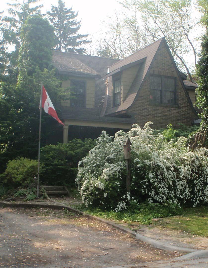
19 04 Character Elements The Indian Point neighbourhood has a special character that has developed incrementally since the earliest cottages built in the early 20th century. This character is the result of a number of public and private character elements which collectively create a neighbourhood unlike any other in Burlington, making it a distinct and desirable place to live in the city. The following section outlines each of these character elements which have been established as a result of detailed site visits and neighbourhood mapping analysis, precedent review and the feedback gained from the public visioning workshop. 3.1 Private Realm Spacious Properties As a peninsula, the Indian Point neighbourhood has a spacious character that is generally reinforced by the following characteristics:» Throughout the neighbourhood, properties generally have a low lot coverage, with most properties at less than 18%. This generally results in a large amount of open space in the front, side and rear yard, as well as large separation distances between dwellings.» On the south side of Indian Road (east of Mohawk Road), properties are generally wide (an average of 39.4m) and shallow. While the bungalow-style dwellings are wide and shallow to conform to the lot, the signifi cant width of the lots provides a large separation distance (9-19m) between dwellings, providing clear views through to the water.» The single-storey height of the bungalow-style dwellings permits views to the water from the higher elevations on Algonquin Road and Iroquois Road.» Dwellings to the west of Mohawk Road, and on the north side of Indian Road (east of Mohawk Road) are generally 1.5 to 2.5-storeys, and include a mix of original dwellings and new buildings. These dwellings are generally set back signifi cantly from Indian Road (the primary street in the neighbourhood) with access provided from Mohawk Road, Algonquin Road, and Iroquois Road. From Indian Road, this creates the impression that these dwellings are nestled into the landscape. These spacious properties, with random and irregular dwelling siting, are a key element in defi ning the character of Indian Point. The large lots offset the size of the (often) large dwellings, and provide space for attractive private landscaping, and a large, mature tree canopy. Opposite Page: Dwellings nestled in the landscape characterize Indian Point (Credit - City of Burlington). ~ 15 ~
20 Organic Lot Pattern The varied size and shape of lots in Indian Point can be attributed to the original resort development patterns of the early 1900s, and to the redevelopment of the area prior to the implementation of the City s zoning bylaw. This organic nature is particularly evident where existing houses overlap the municipal property lines. The unique arrangement and orientation of the lots has afforded the opportunity to locate dwellings on site in a manner that capitalizes on the varied topography and creates a strong visual impact at corner sites and at the end of terminating streets. Dwelling Style and Scale The Indian Point neighbourhood is a collection of architecturally distinct houses, many of which were built in the 1920s and 1930s. There is a mix of historic and modern architecture in the neighbourhood, a product of decades of evolving architectural designs. Key styles represented in the neighbourhood include:» Single-storey dwellings along the south side of Indian Road (east of Mohawk Road).» A mix of styles in the remaining neighbourhood, including the Canadian interpretation of the English Arts and Crafts movement, Neo- Tudor, ranch-style bungalows, and modern dwellings. Despite this variety of architectural styles, the dwellings are compatible with each other for a number of reasons, including:» The houses are generally 1 to 2-storeys, with consistent heights within each block;» Use of high-quality, natural materials, including wood, brick, stone, and stucco, that reinforce a strong connection to their natural setting along the water;» Facade articulation that is consistent with the applicable style. For example, the Arts and Crafts and Neo-Tudor style dwellings have a signifi cant amount of vertical and horizontal articulation, including dormers, bay windows, recesses and projections, column elements, continuous banding, large chimneys, enhanced cornice detailing, front porches, etc. On the other hand, the bungalows have a simpler articulation, including the use of doors, windows, shutters, minor recesses and/or projections to defi ne the primary facade. In the absence of a consistent style, it is this strong attention to detail and high-quality materials, combined with the spaciousness of the properties (as described previously), that allow the various architectural styles to coexist in close proximity. Private Landscaping Private landscaping and gardens are wellestablished in Indian Point and are prominent features of most front and rear yards. These gardens generally consist of shrubs, lawn, canopy trees, and fl ower plantings. The overall design and maintenance of the privately owned properties in Indian Point are of a high standard and help to give each property a distinct character. The landscaping also promotes privacy for residents without requiring fencing, further strengthening the porous qualities of the neighbourhood.» Pitched roofs, representing the applicable dwellings style (i.e. Neo-Tudor dwellings have a steep pitch, with signifi cant articulation in the roofl ine, while bungalows have a standard pitch with minimal variation); ~ 16 ~ Opposite Page: The photos illustrate Indian Point as a product of a century of evolving architecture and lot patterns (Credits- Google).


21
22 3.2 Public Realm Large, Mature Trees Among the defi ning features of the Indian Point neighbourhood are the large, mature trees that line the streets and frame properties. The trees are well established and vary in type, including pine and maple species. The resulting tree canopy in the neighbourhood is vast, and creates a sense of enclosure along the streets. These trees, both private and public, provide privacy for residents and shaded streetscapes. Their maturity signifi es the neighbourhood s age and history. Houses in Indian Point are generally well-proportioned with the trees, which contributes to the balance and rhythm within the neighbourhood. Private Enclave The Indian Point neighbourhood is a private enclave, removed both visually and physically from the rest of Burlington through its position on a peninsula, the limited entrance and exit points, the dense tree cover, and the historic gates. The singular access point to Indian Point is from North Shore Boulevard East, and all four roads that make up the neighbourhood are dead ends (with the exception of Mohawk Road which is a oneway exit) which results in a street network that is used primarily by those who live in or are visiting the neighbourhood. Lack of Sidewalks There are no sidewalks in Indian Point, which is a remnant of the original neighbourhood design. This helps to reinforce the historic character of the neighbourhood, and represents an atypical urban standard despite being an urban neighbourhood, while also supporting a comfortable and informal pedestrian environment. Landmarks The distinctive and historic Indian Point stone gates signify arrival into the neighbourhood and represent the neighbourhood s early history and unique location in the City. The gates were built in the Craftsman-Style and combine fi eldstones of variable colour, size and shape. Located at the entrance to the neighbourhood from North Shore Boulevard East and the exit off of Mohawk Road, the gates refl ect and complement the architectural interest of the houses within the neighbourhood. The light standards in Indian Point are also distinctive markers of the cultural signifi cance and early history of the neighbourhood. Key features of the lights include:» Traditional lantern design on a coloured (black), precast concrete pole;» Powder-coated metal arm in a black fi nish;» A gooseneck-style arm; and,» A decorative scroll support-arm with a double bend. On private properties, a wide variety of lighting complements the high-quality architecture and landscape design. In 1996, Burlington City Council approved By-law , designating the Indian Point gates and streetlamps as having historical and architectural value and interest pursuant to the Ontario Heritage Act. Views The neighbourhood s location on the north shore of Lake Ontario provides over half of the properties with water views and/or access (see Map 1, Page 2). The existing road network, topography and housing stock have resulted in smaller cottagestyle homes being located along the lake, which allows for views of the water from the homes that are located on the gently sloping hill on the east side of Indian Road. Along with views of the water are terminus views along Indian Road. The large trees, well set back homes and sloping topography, create sightlines when entering and exiting the neighbourhood that are distinct to the Indian Point neighbourhood. ~ 18 ~ Opposite Page: The photos demonstrate some of the private realm elements that characterize Indian Point (Credits - Google).


23
24 3.3 Threats to Character Elements In the previous sections, the public and private realm elements that defi ne Indian Point s character were presented, building on the fi ndings of the initial consultation with the community. During this consultation, the elements that have/may threaten this character were also identifi ed and are outlined below. Inappropriate Severances Spacious properties are a defi ning characteristic of Indian Point (see Section 3.1) and are responsible for many of the elements that defi ne the character of the neighbourhood, including large setbacks, extensive separation distances between dwellings, and views between properties. As demonstrated at recent Ontario Municipal Board hearings, the 18m minimum lot width requirement of the existing R2.1 zoning permits wider properties in the neighbourhood to sever into two properties. The resulting properties are not able to maintain the same large setbacks and separation distances that previously characterized the property. Uniform Dwelling Location The existing zoning requires an 11m minimum front yard setback for all properties in Indian Point. During redevelopment, a new dwelling would typically be located on a property at the minimum front yard setback line. If all the neighbours in a block were to follow suit, the varied front yard setbacks, including the large front yards that defi ne the neighbourhood, would be lost. The uniform requirements for side yard setbacks (10% of lot width, with a 3m minimum on one side) could have a similar impact, standardizing the location of dwellings in relation to each other. While this was recognized as a potential threat, residents generally felt that if measures were implemented to eliminate severances, landowners would not require further measures to locate dwellings on site in a manner that is consistent with the character of the neighbourhood. Loss of Views The key views in Indian Point, which include views to Lake Ontario, unique views toward a dwelling at the terminus of some streets, and general visibility between properties are directly related to the large separation distances between dwellings, and by dwellings that are positioned to frame and highlight these views. Where properties are permitted to sever under the current zoning, it would result in smaller properties which would allow less freedom in locating dwellings on site, and therefore, reduced separation distances between dwellings and the adoption of more standard urban style built form and siting. On the south side of Indian Road, this would directly impact the large views to the lake that currently exist between dwellings. In the remainder of the neighbourhood, this could greatly reduce visibility between properties. Loss of Trees Indian Point s extensive tree canopy is a defi ning characteristic of the neighbourhood. While there is no immediate threat of large-scale loss of this canopy due to redevelopment, it can be expected that a number of trees on both public and private property are approaching the end of their life expectancy. The City already has policies in place that address the protection and replacement of trees in the public realm, but no policies/incentives exist for the protection of trees on private property, or to encourage the planting of new trees. ~ 20 ~


25 Cut-Through Traffic Community members have reported an increase of traffi c in the neighbourhood as a result of vehicles entering the neighbourhood off of North Shore Boulevard East and using Mohawk Road to bypass the traffi c lights at the highway offramp. This type of cut-through traffic should be discouraged to maintain the privacy and safety of the neighbourhood. Loss of Landscaping The spacious lots that currently exist in Indian Point can accommodate high quality and expansive landscaping. This landscaping provides privacy, contributes to the unique individual character of each property, and enhances the overall aesthetic of the neighbourhood. Reduced lot sizes as a result of inappropriate severances may not provide a similar amount of open space and may not provide the opportunity for adequate outdoor amenity space that presently contributes to the character of the neighbourhood. Inconsistent Street Lamps Community members have described the street lamps that are a part of the stone gates as not fi tting with the character of the neighbourhood. It is important to ensure the character of the distinctive and historically signifi cant street lamps is consistent throughout the neighbourhood. Credit - Photo Dean, Flickr Creative Commons Credit - Dennis S. Hurd, Flickr Creative Commons Top (Inappropriate New Dwelling): The image represents a new dwelling that would not be appropriate in Indian Point. While the property is well-landscaped and the building appropriately set, the use of non-natural materials, and a lack of distinction between the two storeys (material changes at the roof peaks are used for decoration only), is inconsistent with the character of Indian Point. Bottom (Appropriate New Dwelling): The bottom image demonstrates a building that is well located on the property to accommodate signifi cant landscaping. The dwelling utilizes natural materials and has as a clear distinction between the fi rst and second-storeys (consistent with the style of building), minimizing the perceived bulk of the massing. ~ 21 ~

26
27 05 Character Area Statement Indian Point is a distinct historic neighbourhood characterized by its lakeside context, large, mature tree canopy, spacious properties with houses that are proportionate to their lot size, architectural authenticity, and walkable streets. New development should protect and enhance these character elements. The character area statement for Indian Point builds on the character elements, summarizing the qualities that make the neighbourhood distinct from others in the City of Burlington. This statement describes the most important character components in the neighbourhood, and provides direction on how the residents of Indian Point would like the neighbourhood to evolve. This statement refl ects and builds on the vision statements that community members developed during the community visioning workshop. Key Terms: Historic Neighbourhood - The history of Indian Point is reinforced through the original housing stock, the historic gates and light posts, a lack of sidewalks, and large, mature trees. Lakeside Context - In various locations throughout Indian Point, views to the lake are afforded by the topography and the spacing between dwellings. Mature Tree Canopy - Many of the trees in Indian Point are close to a century old. Their expansive canopy provides continuous shade on the street, while providing a buffer between public and private space. Walkable Streets - Streets in Indian Point are generally wide. They are safe and well lit, with limited traffi c due to a lack of through streets. Opposite Page: Looking north from Indian Road, east of Iroquois Road (Credit - Brook McIlroy). ~ 23 ~

28
29 06 Recommendations To protect and preserve the character of Indian Point, fi ve recommendations have been provided, including Offi cial Plan Amendments, Zoning Bylaw Amendments, and new planning tools. On their own, each of these recommendations protects specifi c (or multiple) elements of Indian Point s character. Together, they provide a complementary framework across various levels of policy to ensure that future development will strengthen the overall character of the neighbourhood. Each of the fi ve recommendations are described in greater detail in the sections that follow, including their impact on the neighbourhood. Where appropriate, typical blocks have been selected to demonstrate how these recommendations will apply on the ground. These examples do not represent an exhaustive list of all possible applications, but demonstrate many of the property characteristics in Indian Point. Opposite Page: Looking west on Indian Road toward Algonquin Road (Credit - Brook McIlroy). ~ 25 ~
30 Recommendation # 1 Create a Residential Character Area designation in the City s Official Plan Description In the current Offi cial Plan, Indian Point is designated Low-Density Residential, and is subject to the same policies that apply to all neighborhoods in the City. These policies are broad, and do not recognize the unique characteristics of neighborhoods such as Indian Point (i.e. the policies permit 25 units/hectare, while Indian Point has approximately 4.5 units/ hectare). Creating a Residential - Character Area designation in the Offi cial Plan will guide the development of unique neighbourhoods, by providing:» Introductory text that describes what a character area is and why it should be protected.» General policies that apply to all character areas, including policies that will encourage the protection of the urban tree canopy.» Enabling policies that will allow for contextspecifi c zoning for character areas (see Recommendation # 3 and 4).» Neighbourhood specifi c policies that build on the general policies and address the contextspecifi c characteristics of the neighbourhood, including public and private realm elements. Neighbourhood Impact» Creating a Residential - Character Area designation identifi es, at the highest level of municipal policy, that the City recognizes that Indian Point is distinct and should be considered independent of the general residential policies.» Providing neighbourhood-specifi c policies, including additional criteria for severance and minor variation applications, further reinforces Indian Point as a neighbourhood that should be protected from development that is inconsistent with the vision of the neighbourhood.» The neighbourhood-specifi c policies will inform and support changes to the zoning bylaw (see Recommendations # 3 and 4).» New development applications will be required to demonstrate that they conform to the Residential - Character Area policies, and the neighbourhood-specifi c policies. Sample policies are provided on the following page. This new designation should be included on Schedule B: Comprehensive Land Use Plan, identifying Indian Point as a Residential - Character Area. ~ 26 ~
31 Sample Indian Point-Specific Official Plan Policies 1. Only single-detached dwellings shall be permitted. 2. Dwellings on corner lots should create a strong connection to both streetscapes through a similar level of treatment (i.e. vertical and horizontal articulation, material quality, windows) on both streets. 3. Applicants of Consent to Sever or Minor Variance applications shall demonstrate that new development will maintain the character of Indian Point using the following criteria: a) spacious properties that are consistent with the predominant characteristics on either the north or south side of Indian Road, including: - low lot coverage; - open space between adjacent dwellings; - large, front-yard setbacks on the north side of Indian Road, and/or - low, single-storey housing forms on the south side of Indian Road. b) preservation of mature trees; c) maintain the existing topography; d) a dwelling height that ranges between 1 to 2-storeys and is consistent with adjacent dwellings in the block; e) architectural authenticity that refl ects the intended style and period of the proposed dwelling. f) views to the Lake should be protected and maximized. Where possible, views should generally align with Algonquin Road and Mohawk Road. 4. Any new development should maintain an ample separation distance between dwellings. 5. Dwellings should be located on their lots to create a large front yard setback. Setbacks should vary between properties. 6. A variety of architectural styles shall be permitted to support the varied and organic character of the existing neighbourhood. High quality materials (i.e. brick, wood, stone) shall be used to refl ect and reinforce existing dwellings. 7. Tree protection measures should be implemented during any new development. ~ 27 ~
32 Recommendation # 2 Describe the vision for Indian Point within the new Residential - Character Area designation Description Once a new Residential - Character Area designation is established in the Offi cial Plan, and Indian Point has been identifi ed as a character area on Schedule B, a detailed vision statement should be provided within the Indian Pointspecifi c policies. This statement should outline the elements that defi ne Indian Point s character (see Section 3), including public and private realm features. Neighbourhood Impact» Providing a vision statement within the Indian Point-specifi c section of the Offi cial Plan identifi es, at the highest level of municipal policy, the public and private realm elements that contribute to Indian Point s character and should be protected and enhanced through future development.» The vision statement will inform and support changes to the zoning bylaw (see Recommendations # 3 and 4).» The vision statement will be used, in conjunction with Offi cial Plan policies and neighbourhood-specifi c zoning, to evaluate development applications during the Site Plan, Minor Variance or Consent processes and to ensure that proposals are consistent with the character of the neighbourhood. ~ 28 ~
: Indian Point is a distinct historic neighbourhood characterized by its lakeside context, large, mature tree canopy, spacious properties with houses that")
33 Historic Indian Point gates on Indian Road (Credit - Google). Sample character statement (from Section 5): Indian Point is a distinct historic neighbourhood characterized by its lakeside context, large, mature tree canopy, spacious properties with houses that are proportionate to their lot size, a variety of architecture, and walkable streets. New development should protect and enhance these character elements. ~ 29 ~
34 Recommendation # 3 Amend the minimum lot width to reflect the previous R-2 Zoning (21.3m) Description As outlined in Section 3.1, the lots in Indian Point generally have a very large width compared to a typical residential lot in Burlington. These large widths create the potential to sever lots into two smaller properties with a width of 18m (the minimum lot width in the existing R2.1 zoning bylaw) or less (if approved by the Committee of Adjustments). The resulting lots would be inconsistent with the existing pattern of wide, spacious lots. The R-2 District zoning policies of By-law 1642 that applied to Indian Point prior to the enactment of By-law 2020 were more relevant to the larger lots that exist in Indian Point, requiring a minimum lot width of 21.3m. It is recommended that the existing bylaw be amended to increase the minimum lot width requirements to match the 21.3m of the previous zoning bylaw.» Where properties are large enough to sever under the new lot width requirements, the resulting 21.3m frontage would provide larger side yard setbacks (compared to an 18m frontage) as a result of the existing side yard setback requirements of 10% of the total lot width.» Once severed, the two new properties would be subject to all other requirements of the existing zoning bylaw, including front, side and rear yard setbacks. The total lot coverage would be subject to the reduced requirements outlined in this report (see Recommendation # 4). Neighbourhood Impacts» An increased minimum lot width of 21.3m would require a lot frontage of 42.6m in order to facilitate a severance. This would reduce the total number of properties in the neighbourhood that are capable of severing as very few properties have a lot width greater than 42.6m. It would also limit the potential to obtain a minor variance to sever where the resulting properties are close to the 18m minimum. ~ 30 ~


.")


35 N 52m Algonquin Road 40m B A Indian Road 32m D 30m C 30m How This Recommendation Applies On the Ground:» The lot width on the above properties range from 30-52m.» Under the current zoning, Properties A and B would be able to sever and still maintain the minimum 18m lot width requirements.» Under the proposed zoning, Property B would not be able to sever without a minor variance because the resulting width (20m) would be less than the required minimum (21.3m).» At 60m, Property C could sever into two smaller 30m properties (shown in red) under both the existing and the proposed zoning.» At 32m, Property D does not have suffi cient width to sever under either minimum width requirements. ~ 31 ~
36 Recommendation # 4 Reduce the maximum lot coverage prescribed in the current zoning to 25% Description The current zoning in Indian Point allows up to 40% coverage for a 1-storey dwelling and 35% coverage for a 2-storey dwelling. This is signifi cantly larger than the coverage of most dwellings in the neighbourhood (approximately 17%), and it is recommended that this maximum coverage be reduced to 25%. This reduced coverage will protect the generous dwellingto-lot-size ratio that currently exists in the neighbourhood, while providing fl exibility and opportunities for additions and redevelopment. The overall size of additions or new dwellings would continue to be determined by the existing zoning bylaw. Neighbourhood Impacts» With a reduced maximum lot coverage, property owners would be able to provide an addition to the front, rear or side of their dwelling provided all other minimum setbacks in the zoning are achieved.» A number of dwellings in the neighbourhood have a coverage that is less than 25%, allowing the potential for additions or rebuilds that are signifi cantly larger than the original dwelling. However, a number of properties in the neighbourhood have a coverage of 25% or greater, which would mean new dwellings at this coverage would not be signifi cantly out of place. In discussions with the community, the height and scale of dwellings was determined to be less of a concern than their relation to the lot size; the height and scale would still be protected through reduced coverage requirements.» Existing properties with a low lot coverage (i.e. 7-12%) are generally characterized by large dwellings on exceptionally large lots. While it would be possible in some instances for these dwellings to more than double in size, it is unlikely given their existing footprint, local market conditions, fi nancial feasibility, etc. ~ 32 ~


 or the rear yard (20m), as the")


37 McMILLANS LANE Lot Coverage 13% N Lot Coverage 17% Lot Coverage 22% Lot Coverage 25% Lot Coverage 25% A B INDIAN ROAD C D E NORTH SHORE BLVD E How This Recommendation Applies On the Ground:» The above properties range from 13-25% lot coverage.» Under the revised lot coverage requirements, all properties would be permitted a maximum coverage of 25%.» Property A could build an addition up to 12% of the total property area. This addition would likely be limited to the larger side yard (15m) or the rear yard (20m), as the front yard (9m) and interior side yard (4m) are close to the maximum permitted in the existing zoning bylaw.» Property B could have an addition up to 8% of the total property area. This addition would be limited to the rear yard (29m) as the front and side yards are at the maximum permitted in the zoning bylaw.» As a new build, a dwelling on property C could have up to 25% lot coverage provided all other zoning requirements are met.» Properties D and E would be unable to add an addition without applying for a minor variance because they are already at the maximum lot coverage permitted (40% lot coverage for a 1-storey dwelling and 35% lot coverage for a 2-storey dwelling including accessory buildings). ~ 33 ~
38 Recommendation # 5 Provide incentives for new private trees Description The large mature trees on both public and private property play a substantial role in defi ning the character of Indian Point. They provide shaded sidewalks and reduce the urban heat island effect, allowing for a comfortable place to stroll; they augment private landscaping, creating attractive front and side yards; and, they provide a buffer between the public and private realm, helping to reinforce Indian Point as a private enclave. The City currently has measures in place to protect and preserve trees in the public realm. Additional opportunities should be implemented to encourage the protection of existing trees and the planting of new trees on private property. Potential opportunities include:» As part of a larger City-wide initiative, the City could explore opportunities to partially or fully subsidize new trees on private property. An additional study may be required to determine the specifi c details of such a program (i.e. subsidy amounts, priority areas, tree species, etc.).» A Full Circle Tree Initiative, similar to a program used in Oakville, where participants are given the opportunity to be involved in various stages of tree growth, from planting to nursing to relocation. Once ready, trees can be replanted throughout the Indian Point neighbourhood. This provides an opportunity for interested parties to be directly involved in enhancing the urban tree canopy.» The City could provide information pamphlets to help educate residents about the importance of the urban tree canopy, and to encourage the planting of new private trees. Considerations could include: why new trees are important; how to plant and maintain trees; what trees are appropriate, etc. Neighbourhood Impacts» Encouraging new trees on private property will help to enhance the City s overall tree canopy, helping to clean the air, reduce greenhouse gases, and conserve energy.» Property values are regularly shown to be higher in neighbourhoods with a strong tree canopy.» Initiatives such as the Full Circle Tree Initiative provide an educational opportunity for local youth (and adults), and encourage a sense of ownership in the neighbourhood.» Local tree preservation initiatives could be overseen by a Community Association, providing opportunities for increased involvement in the evolution of the neighbourhood. ~ 34 ~
.")
39 Large private trees in the rear yard of a dwelling in Indian Point (Credit - Google). ~ 35 ~

40 ~ 36 ~
City of Burlington Official Plan Review: Indian Point Character Area Study. April 2, 2013 Public Visioning Workshop
 City of Burlington Official Plan Review: Indian Point Character Area Study April 2, 2013 Public Visioning Workshop Tonight s Schedule 6:30 6:35 City s Introduction 6:35 7:05 Consultant Presentation 7:05
City of Burlington. Official Plan Review. January 29, Public Consultation #3
 City of Burlington Official Plan Review Indian Point Character Area Study January 29, Public Consultation #3 PRESENTATION OUTLINE Study Update Recommendations Working Session Next Steps STUDY UPDATE Neighbourhood
City of Burlington. Official Plan Review. December 11, Working Committee Meeting
 City of Burlington Official Plan Review Indian Point Character Area Study December 11, Working Committee Meeting PRESENTATION OUTLINE Study Update Recommendations Working Session Next Steps STUDY UPDATE
Vision Workshop Summary Report
 City of Burlington Official Plan Review: Indian Point Character Area Study Vision Workshop Summary Report Submitted By: Brook McIlroy 51 Camden St, Suite 300 Toronto, ON M5V 1V2 April, 2013 Indian Road,
URBAN DESIGN BRIEF New Street Burlington, ON
 3225-3237 New Street Burlington, ON MARCH 2017 Prepared for: Royal Living Development Group Inc. Prepared by: adesso design inc. 218 Locke Street South, 2nd Floor Hamilton, ON L8P 4B4 t. 905.526.8876 3225-3237
Infill Residential Design Guidelines
 Infill Residential Design Guidelines Adopted March 23, 2004 Amended September 10, 2013 City of Orange Community Development Department Planning Division Phone: (714) 744-7220 Fax: (714) 744-7222 www.cityoforange.org
URBAN DESIGN BRIEF URBAN DESIGN BRIEF 721 FRANKLIN BLVD, CAMBRIDGE August 2018
 URBAN DESIGN BRIEF URBAN DESIGN BRIEF 721 FRANKLIN BLVD, CAMBRIDGE August 2018 DESIGN BRIEF CONTENTS PART A 1.0 INTRODUCTION 2.0 DESCRIPTION & ANALYSIS OF SITE CONTEXT 3.0 DESIGN CONSTRAINTS AND OPPORTUNITIES
Wide asphalt driveway abutting school property. garage built with incompatible materials, too close to park. incompatible fencing materials
 Wide asphalt driveway abutting school property incompatible fencing materials garage built with incompatible materials, too close to park Lack of plantings as a buffer between private property and open
Long Branch Neighbourhood Character Guidelines Final Report
 STAFF REPORT ACTION REQUIRED Long Branch Neighbourhood Character Guidelines Final Report Date: October 26, 2017 To: From: Wards: Reference Number: Etobicoke York Community Council Director, Community Planning,
URBAN DESIGN BRIEF 181 Burloak Drive, Oakville
 URBAN DESIGN BRIEF 181 Burloak Drive, Oakville February 2017 Our File: 1730B 230-7050 WESTON ROAD / WOODBRIDGE / ONTARIO / L4L 8G7 / T: 905 761 5588/ F: 905 761 5589/WWW.MHBCPLAN.COM TABLE OF CONTENTS
TRAFALGAR ROAD
 158-2192 TRAFALGAR ROAD URBAN DESIGN BRIEF PREPARED BY KLM PLANNING PARTNERS INC. FOR DUNPAR DEVELOPMENTS INC. TOWN OF OAKVILLE JUNE 2012 TABLE OF CONTENTS 1 INTRODUCTION 1.1 Project Description...1 1.1.1
GUIDELINES REPLACEMENT HOUSING GUIDELINES LOCATION INTRODUCTION URBAN DESIGN GUIDELINES
 Replacement housing in the former City of North York will be consistent with the following urban design guidelines. They provide a framework for residential re-development in the former City of North York
What We Heard Report: Westmount Architectural Heritage Area Rezoning Drop-in Workshop
 What We Heard Report: Westmount Architectural Heritage Area Rezoning Drop-in Workshop August 2018 What We Heard Report: Westmount Architectural Heritage Area Rezoning Drop-in Workshop Executive Summary
B L A C K D I A M O N D D E S I G N G U I D E L I N E S for Multi-family Development
 B L A C K D I A M O N D D E S I G N G U I D E L I N E S for Multi-family Development Adopted June 18, 2009 This section of the Design and focuses on site planning and design guidance for new multi-family
BENSON / HUNT TERTIARY PLAN
 BENSON / HUNT TERTIARY PLAN TABLE OF CONTENTS 1.0 INTRODUCTION 1.1 Purpose 2 1.2 How to Read This Plan 3 1.3 Tertiary Plan Context 3 1.4 Vision and Principles 5 1.5 Public Consultation 5 2.0 PLANNING CONTEXT
Appendix A COMMUNITY IMPROVEMENT PLAN DESIGN GUIDELINES
 Appendix A COMMUNITY IMPROVEMENT PLAN DESIGN GUIDELINES INTRODUCTION The continuous and desirable improvement of Arnprior requires a clear understanding of what is envisioned for the Town. These Design
East Bayshore Road Neighbourhood
 East Bayshore Road Neighbourhood Northridge Property Management Urban Design Brief 3195 East Bayshore Road City of Owen Sound January 2016 East Bayshore Road Neighbourhood Northridge Property Management
Urban Design Manual PLANNING AROUND RAPID TRANSIT STATIONS (PARTS) Introduction. Station Study Areas
 Introduction. Station Study Areas") 111111 PLANNING AROUND RAPID TRANSIT STATIONS (PARTS) Introduction The ION rapid transit system will link Waterloo, Kitchener and Cambridge through a central transit corridor (CTC). There are a number
111111 PLANNING AROUND RAPID TRANSIT STATIONS (PARTS) Introduction The ION rapid transit system will link Waterloo, Kitchener and Cambridge through a central transit corridor (CTC). There are a number
Historic Yonge Street HCD Study Public Meeting #2
 Historic Yonge Street HCD Study Public Meeting #2 March 26, 2014 Archaeological Services Inc. Philip Goldsmith Architect Agenda: 7:00 p.m. Open House 7:30 p.m. Welcome and Presentation 8:00 p.m. Questions
MOMENTUM. Design Brief. Site Plan Control and Minor Variance Applications. 59 Russell Avenue
 MOMENTUM PLANNING AND COMMUNICATIONS Design Brief Site Plan Control and Minor Variance Applications 59 Russell Avenue December 2014 Revised February 2015 Prepared by: Dennis Jacobs MCIP, RPP Index 1. Introduction
Duplex Design Guidelines
 Duplex Design Guidelines Adopted by Council May 29, 2006 Prepared By: Table of Contents 1.0 Application and Intent 1 2.0 Areas of Application 2 3.0 Design Principles 3 4.0 Design Guidelines 4 4.1 Site
Mark-up of the effect of the proposed Bronte Village Growth Area OPA No.18 on the text of section 24, Bronte Village, of the Livable Oakville Plan
 Mark-up of the effect of the proposed Bronte Village Growth Area OPA No.18 on the text of section 24, Bronte Village, of the Livable Oakville Plan Notes: This document is provided for information purposes
Urban Design Brief Woodland Cemetery Funeral Home 493 Springbank Drive
 Urban Design Brief Woodland Cemetery Funeral Home The Incorporated Synod of the Diocese of Huron April 15, 2016 Urban Design Brief April 15, 2016 TABLE OF CONTENTS Page No. INTRODUCTION... 1 SECTION 1
14.0 BUILT FORM DESIGN CRITERIA
 14.0 BUILT FORM DESIGN CRITERIA CORPORATION OF THE TOWN OF CARLETON PLACE DEVELOPMENT PERMIT BY-LAW 123 124 CORPORATION OF THE TOWN OF CARLETON PLACE DEVELOPMENT PERMIT BY-LAW 14.1 MISSISSIPPI DISTRICT
URBAN DESIGN BRIEF. 2136&2148 Trafalgar Road. Town of Oakville
 URBAN DESIGN BRIEF 2136&2148 Trafalgar Road Town of Oakville Prepared By: METROPOLITAN CONSULTING INC For 2500674 Ontario Inc November 2016 TABLE OF CONTENTS Page No. 1.0 Introduction/Description of Subject
New-Cast Mixed-use Development Proposal King Street West, Newcastle, Ontario
 URBAN DESIGN BRIEF New-Cast Mixed-use Development Proposal King Street West, Newcastle, Ontario TABLE OF CONTENTS: 1.0 Executive Summary 2.0 Creating Vibrant and Sustainable Urban Places: Excerpts from
VILLAGE OF BOLTON HERITAGE CONSERVATION DISTRICT PLAN
 Page 1 1. INTRODUCTION AND BACKGROUND 1.1 THE PROJECT VILLAGE OF BOLTON HERITAGE CONSERVATION DISTRICT PLAN TERMS OF REFERENCE The Town of Caledon (Town) is a large, predominantly rural municipality with
Housing and Coach House Guidelines - Ladner
 Housing and Coach House Guidelines - Ladner Policy D.8: Encourage Compatible Housing Design Encourage housing design that is sensitive to existing single family housing neighbourhoods by requiring a design
St. Lawrence Neighbourhood Focused Area - Official Plan Amendment Status Report
 STAFF REPORT ACTION REQUIRED St. Lawrence Neighbourhood Focused Area - Official Plan Amendment Status Report Date: May 21, 2015 To: From: Wards: Reference Number: Toronto and East York Community Council
13. New Construction. Context & Character
 13. New Construction Context & Character While historic districts convey a sense of time and place which is retained through the preservation of historic buildings and relationships, these areas continue
Clairtrell Area Context Plan
 Clairtrell Area Context Plan March 2005 Urban Development Services City Planning Contents 1. Introduction... 4 2. Development Structure... 6 2.1 Streets... 7 2.1.1 Sheppard Avenue and Bayview Avenue...
Uptown Rideau Street Secondary Plan [Amendment #166, January 12, 2016]
![Uptown Rideau Street Secondary Plan [Amendment #166, January 12, 2016]](/thumbs/76/73760497.jpg "Uptown Rideau Street Secondary Plan [Amendment #166, January 12, 2016]") [Amendment #166, January 12, 2016] The policies of this Secondary Plan are in effect, save and except for the property at 560 Rideau Street, for which there remains a site specific appeal to this Secondary
[Amendment #166, January 12, 2016] The policies of this Secondary Plan are in effect, save and except for the property at 560 Rideau Street, for which there remains a site specific appeal to this Secondary
DRAFT Northeast Quadrant of Kipling Avenue and Highway 7 DRAFT AUGUST 29, Goals Land Use. The goals of this Plan are to:
 AUGUST 29, 2017 12.15 Northeast Quadrant of Kipling Avenue and Highway 7 12.15.1 Goals 12.15.2 Land Use The goals of this Plan are to: 12.15.2.1 General Provisions: a) Ensure the development of a compact
Downtown Streetscape Manual & Built Form Standards
 City of Guelph Downtown Streetscape Manual & Built Form Standards July 2014 Prepared by Brook McIlroy Inc. in association with Unterman McPhail Associates and McCormick Rankin Inc. City of Guelph Downtown
4.0 Design Guidelines For The Village Centre. South fields Community Architectural Design Guidelines Town of Caledon
 4.0 Design Guidelines For The Village Centre 4.0 Design Guidelines for the Village Centre The Village Centre is the focal point of the entire South Fields Community and is designed as a traditional commercial
5.1 Site Plan Guidelines
 5. Community Core Guidelines Development of the Community Core will take place by plan of subdivision and site plan approval. It will occur in a phased manner that will reflect the timing of residential
Town of Cobourg Heritage Master Plan. Statutory Public Meeting
 Town of Cobourg Heritage Master Plan Statutory Public Meeting April 25 th 2016 Presentation Overview 1. Introduction 2. Project background and schedule overview 3. Review of strategic direction content
Agenda. 7 Wright Crescent Urban Design Study. Public Meeting and Urban Design Workshop. 1 INTRODUCTION AND BACKGROUND (City of Kingston)
") Urban Design Study Public Meeting and Urban Design Workshop October 02, 2013 Agenda 1 INTRODUCTION AND BACKGROUND (City of Kingston) 2 URBAN DESIGN STUDY PRESENTATION (Antonio Gomez-Palacio, DIALOG) 3
Urban Design Study Public Meeting and Urban Design Workshop October 02, 2013 Agenda 1 INTRODUCTION AND BACKGROUND (City of Kingston) 2 URBAN DESIGN STUDY PRESENTATION (Antonio Gomez-Palacio, DIALOG) 3
New Street Proposed Redevelopment Architecture & Urban Design Brief
 2130 2136 New Street Proposed Redevelopment Architecture & Urban Design Brief Prepared By: Cynthia Zahoruk Architect Inc. 3077 New Street, Burlington, ON, L7N 1M6 TABLE OF CONTENTS Background and Objective
Bel-Air Lexus Automobile Service Station
 Bel-Air Lexus Automobile Service Station Design Brief 443-447 McArthur Avenue Ottawa April 30, 2015 14-1299-MCA Site Details Application: Site Plan Control Legal Description and Municipal Addresses: 443
ELMVALE ACRES SHOPPING CENTRE MASTER PLAN
 ELMVALE ACRES SHOPPING CENTRE MASTER PLAN Contents 1.0 INTRODUCTION... 2 2.0 LOCATION... 2 3.0 EXISTING CONTEXT... 2 4.0 VISION & GUIDING PRINCIPLES... 2 5.0 LAND USE AND BUILT FORM... 4 5.1 St. Laurent
KEY MAP DEVELOPMENT PERMIT AREA MAP. Sunnymede North Sub-Area Plan
 Richmond Official Community Plan BROADMOOR AREA SUNNYMEDE NORTH SUB-AREA PLAN Bylaw 7100 Schedule 2.6C SUNNYMEDE NORTH SUB-AREA PLAN SUNNYMEDE NORTH SUB-AREA PLAN SUNNYMEDE NORTH SUB-AREA PLAN KEY MAP
burlington mobility hubs study Downtown Burlington Mobility Hub
 burlington mobility hubs study Downtown Burlington Mobility Hub Draft Precinct Plan Workbook PIC #3, September 7, 2017 downtown mobility hub objectives City staff and their consultants are proposing an
Design Guidelines - 1 -
 Design Guidelines REAR YARDS Rear yard decks and porches, attached to a garden or garage suite, should be permitted provided minimum rear yard setbacks, separation distances, and necessary site access
Design Guidelines. Roosevelt. Mike Podowski DPD Design Guidelines Ordinance ATT 13 August 13, 2012 Version #1
 Roosevelt Design Guidelines The Roosevelt Neighborhood Design Guidelines apply within the Neighborhood Boundary. Map 1 2 Map 2 3 Map 3 4 CS1 Natural Systems and Site Features Citywide Guideline: Use natural
SCHEDULE 'A' TO BY-LAW as Amended by AMENDMENT NO. 90 TO THE WHITBY OFFICIAL PLAN
 SCHEDULE 'A' TO BY-LAW 6413-10 as Amended by 6553-11 AMENDMENT NO. 90 TO THE WHITBY OFFICIAL PLAN SECTION A: GROWTH PLAN CONFORMITY PURPOSE: LOCATION: BASIS: The purpose of this Amendment is to: conform
Future Five. Design/ Development Guidelines. January 2008 Amended June 08 per City Council motion
 Future Five Design/ Development Guidelines January 2008 Amended June 08 per City Council motion 5-Points Design Guidelines Table of Contents I. Introduction 3 II. Area boundaries 4 III. Review Process
City of Farmington. Downtown Plan. Amendment to the 1998 Master Plan Adopted October 11, 2004
 City of Farmington Amendment to the 1998 Master Plan Adopted October 11, 2004 Introduction Planning Background 1 Scope and Components of the Plan Amendment 2 Concept Introduction 3 Plan Concepts 3 Conceptual
URBAN DESIGN BRIEF REPORT
 URBAN DESIGN BRIEF REPORT PREPARED FOR 2568401 ONTARIO INC NEW GASBAR, CONVENIENCE STORE & CARWASH DEVELOPMENT @ 1509 FANSHAWE PARK ROAD WEST LONDON, ONTARIO GAMA ENGINEERING INC. PROJECT NUMBER 1669 PREPARED
City of Vaughan Urban Design Guidelines for Infill Development in Established Low-Rise Residential Neighbourhoods
 City of Vaughan Urban Design Guidelines for Infill Development in Established Low-Rise Residential Neighbourhoods DRAFT - September 2016 Contents 1. Introduction 1 2. Policy Context 3 3. Characteristics
CONTENTS 8.0 LAND USE 8.1 GENERAL LAND USE 8.2 RESIDENTIAL 8.3 MIXED USE 8.4 COMMERCIAL 8.5 EMPLOYMENT LANDS
 8-2 Land Use 8.0 LAND USE CONTENTS 8.1 GENERAL LAND USE 8.1.1 Uses provided for in all Land Use Designations 8.1.2 Uses prohibited in Hazardous Lands, Hazardous Sites and Special Policy Areas 8.1.3 Uses
King-Spadina Secondary Plan Community Consultation Meeting. Michelle Knieriem, City Planner October 11, 2017
 King-Spadina Secondary Plan Community Consultation Meeting Michelle Knieriem, City Planner October 11, 2017 Agenda 6:30 Welcome 6:35 Presentation 7:15 Question and Answer Session 8:15 Closing Remarks HOW
PLANNING JUSTIFICATION REPORT
 PLANNING JUSTIFICATION REPORT 55 DELHI STREET CITY OF GUELPH PREPARED FOR: VESTERRA PROPERTY MANAGEMENT PREPARED BY: LABRECHE PATTERSON & ASSOCIATES INC. SCOTT PATTERSON, BA, CPT, MCIP, RPP PRINCIPAL,
Official Plan Review: Draft Built Form Policies
 PG.30.1 REPORT FOR ACTION Official Plan Review: Draft Built Form Policies Date: May 15, 2018 To: Planning and Growth Management Committee From: Chief Planner and Executive Director, City Planning Division
Highland Village Green Design Guidelines
 Highland Village Green Design Guidelines Publishing Information Title Highland Village Green Design Guidelins Author The City of Calgary Status DRAFT - Proposed document subject to changes Additional Copies
Cookstown Heritage Conservation District Study Public Consultation March 26, 2013
 Public Consultation March 26, 2013 Funded by the Government of Ontario MMM Group Darryl Bird Project Manager, Senior Planner, CAHP Intern Shannon Baker Senior Landscape Architect, CAHP AREA Architects
Urban Design Guidelines Townhouse and Apartment Built Form
 Urban Design Guidelines Townhouse and Apartment Built Form Town of Wasaga Beach Table of Contents 1. Introduction 1.1. Purpose 1.2. Urban Design Principles 1.3. Application of Guidelines 2. Site Design,
SUBJECT: Waterfront Hotel Planning Study Update TO: Planning and Development Committee FROM: Department of City Building. Recommendation: Purpose:
 Page 1 of Report PB-23-18 SUBJECT: Waterfront Hotel Planning Study Update TO: Planning and Development Committee FROM: Department of City Building Report Number: PB-23-18 Wards Affected: 2 File Numbers:
ADMINISTRATION RECOMMENDATION(S) 2018 January 25. That Calgary Planning Commission recommend APPROVAL of the proposed Land Use Amendment.
 2018 January 25. That Calgary Planning Commission recommend APPROVAL of the proposed Land Use Amendment.") Page 1 of 9 EXECUTIVE SUMMARY This land use amendment proposes to redesignate a parcel from DC Direct Control District to Multi-Residential Contextual Grade-Oriented (M-CG) District to allow for multi-residential
Page 1 of 9 EXECUTIVE SUMMARY This land use amendment proposes to redesignate a parcel from DC Direct Control District to Multi-Residential Contextual Grade-Oriented (M-CG) District to allow for multi-residential
Extract from Whitehorse Planning Scheme - LOCAL PLANNING POLICIES - CLAUSE Preferred Character Statements
 Extract from Whitehorse Planning Scheme - LOCAL PLANNING POLICIES - CLAUSE 22.03 22.03-5 Preferred Character Statements Bush Environment The streetscapes will be dominated by vegetation with subservient
Urban Design Brief to 1557 Gordon Street & 34 Lowes Road West
 Urban Design Brief 1533 to 1557 Gordon Street & 34 Lowes Road West Reid s Heritage Homes Ltd. & 883928 Ontario Ltd. and RHH Property Management Ltd. City of Guelph Zoning By-law Amendment November 2017
Edward R. Sajecki Commissioner of Planning and Building. Land Use Review- Former Parkway Belt West Lands- Fieldgate Drive and Audubon Boulevard
 Corporate Report Clerk s Files Originator s Files CD.04.FOR DATE: November 15, 2011 TO: FROM: SUBJECT: Chair and Members of Planning and Development Committee Meeting Date: December 5, 2011 Edward R. Sajecki
Bayview Avenue Official Plan Amendment, Zoning Amendment and Site Plan Control Applications Request for Direction Report
 STAFF REPORT ACTION REQUIRED 2425 2427 Bayview Avenue Official Plan Amendment, Zoning Amendment and Site Plan Control Applications Request for Direction Report Date: May 28, 2015 To: From: Wards: Reference
SUBJECT: Proposed Downtown Mobility Hub Precinct Plan and Proposed Official Plan Policies
 Page 1 of Report PB-81-17 SUBJECT: Proposed Downtown Mobility Hub Precinct Plan and Proposed Official Plan Policies TO: FROM: Committee of the Whole Planning and Building Department Report Number: PB-81-17
WINDSOR GLEN DESIGN GUIDELINES
 WINDSOR GLEN DESIGN GUIDELINES Adopted by Council, 2006 WINDSOR GLEN REDEVELOPMENT DESIGN GUIDELINES August 2006 1.0 Master Plan Organization For this area of the Coquitlam Town Centre, a mix of high,
KING-SPADINA COMMERCIAL HERITAGE CONSERVATION DISTRICT PLAN COMMUNITY CONSULTATION MEETING #1
 KING-SPADINA COMMERCIAL HERITAGE CONSERVATION DISTRICT PLAN 1 TUESDAY, APRIL 21, 2015 METRO HALL, ROOM 308/309 55 JOHN STREET, TORONTO 6:30 7:00 Open House 7:00 7:15 Remarks Councillor Cressy Heritage
DRAFT DRAFT DRAFT DRAFT
 # 19 EXPAND GREEN AND OPEN SPACES AND COMMUNITY FACILITIES IN TANDEM WITH NEW DEVELOPMENT The role of Eglinton will change in the coming years, along with the intensity of activity and land uses. As more
Incentive Zoning Regulations Florida Municipal City of Orlando
 Topic: Resource Type: State: Jurisdiction Type: Municipality: Year (adopted, written, etc.): 2002 Community Type applicable to: Title: Incentive Zoning Regulations Florida Municipal City of Orlando Document
4. INDUSTRIAL 53 CASTLE ROCK DESIGN
 4. INDUSTRIAL 53 CASTLE ROCK DESIGN CASTLE ROCK DESIGN 54 4. INDUSTRIAL Overview Well-designed and attractive industrial centers are the product of blending economic realities with both functional and
II. SINGLE FAMILY RESIDENTIAL
 II. SINGLE FAMILY RESIDENTIAL Castle Rock is made up of numerous individually built houses and subdivision tracts that have been developed during the past century. Some of the tracts are diverse in architectural
YONGE STEELES CORRIDOR SECONDARY PLAN. Young + Wright / IBI Group Architects Dillon Consulting Ltd. GHK International (Canada) Ltd.
 Ltd.") PART A: PREAMBLE 1.0 PURPOSE The purpose of this Secondary Plan is to provide a development framework for intensification of the Yonge/ Steeles corridor including the north side of Steeles Avenue West
PART A: PREAMBLE 1.0 PURPOSE The purpose of this Secondary Plan is to provide a development framework for intensification of the Yonge/ Steeles corridor including the north side of Steeles Avenue West
QUEEN-RIVER SECONDARY PLAN
 34 QUEEN-RIVER SECONDARY PLAN 34. QUEEN RIVER SECONDARY PLAN 1. INTRODUCTION The Queen-River area is approximately 6.4 hectares and is located at the eastern edge of the Downtown as shown on Map 34-1.
Urban Design Brief Proposed Residential Development 5219 Upper Middle Road City of Burlington
 Urban Design Brief Proposed Residential Development 5219 Upper Middle Road City of Burlington Prepared by Weston Consulting Prepared for BLOOMFIELD DEVELOPMENT INC. Date: March 2017 Table of Contents 1.
FORMER CANADIAN FORCES BASE (CFB) ROCKCLIFFE SECONDARY PLAN. Official Plan Amendment XX to the Official Plan for the City of Ottawa
 ROCKCLIFFE SECONDARY PLAN. Official Plan Amendment XX to the Official Plan for the City of Ottawa") FORMER CANADIAN FORCES BASE (CFB) ROCKCLIFFE SECONDARY PLAN Official Plan Amendment XX to the Official Plan for the City of Ottawa 1 INDEX THE STATEMENT OF COMPONENTS PART A THE PREAMBLE PAGE Purpose...
FORMER CANADIAN FORCES BASE (CFB) ROCKCLIFFE SECONDARY PLAN Official Plan Amendment XX to the Official Plan for the City of Ottawa 1 INDEX THE STATEMENT OF COMPONENTS PART A THE PREAMBLE PAGE Purpose...
6 PORT SYDNEY SETTLEMENT AREA
 Section 6 Port Sydney Page 61 6 PORT SYDNEY SETTLEMENT AREA 6.1 Basis and Principles Village of Port Sydney Waterfront Community Existing Services 6.1.1 Port Sydney is an historic settlement that has developed
Tazewell Pike. Neighborhood Conservation Overlay District Design Guidelines
 Tazewell Pike Neighborhood Conservation Overlay District Design Guidelines Knoxville Knox County Metropolitan Planning Commission November 2, 2000 These design guidelines were: Adopted by the Knoxville
The Proposed Auckland Unitary Plan (notified 30 September 2013)
") 3 Business zones Introduction There are 10 business zones in the Unitary Plan: City Centre Metropolitan Centre Town Centre Local Centre Neighbourhood Centre Mixed Use General Business Business Park Light
3 Business zones Introduction There are 10 business zones in the Unitary Plan: City Centre Metropolitan Centre Town Centre Local Centre Neighbourhood Centre Mixed Use General Business Business Park Light
June 19th Public Workshop #3 Summary
 Norval Secondary Plan Review June 19th Public Workshop #3 Summary SUBMITTED BY: Macaulay Shiomi Howson Ltd June, 2013 Table of Contents 1.0 Introduction 1 1.1 Workshop Outline 1 1.2 Who Came to the Workshop?
178 Carruthers Properties Inc.
 178 Carruthers Properties Inc. Planning Rationale for 178 Carruthers Avenue Site Plan Control Application June 2014 Table of Contents 1.0 Introduction 2.0 Overview of Subject Property 3.0 Current Zoning
Welcome. Walk Around. Talk to Us. Write Down Your Comments
 Welcome This is an information meeting introducing the applications for proposed redevelopment of the Yorkdale Shopping Centre site at 3401 Dufferin Street and 1 Yorkdale Road over the next 20+ years,
Welcome to Our Open House
 Welcome to Our Councillor Gerbasi & the Planning, Property, & Development Department welcome you to tonight s open house The open house outlines the proposed Osborne Village Neighbourhood Plan a secondary
Former Temple Cowley Pools, Oxford TEMPLE COWLEY LIBRARY * ELEVATION SHOWN IS INDICATIVE AND SUBJECT TO FINAL DESIGN AND AGREEMENT.
 OPEN SPACE TEMPLE COWLEY LIBRARY library beyond Proposed apartments Proposed apartments Proposed houses Temple Road * ELEVATION SHOWN IS INDICATIVE AND SUBJECT TO FINAL DESIGN AND AGREEMENT. * Welcome
Regency Developments. Urban Design Brief. Holyrood DC2 Rezoning
 Regency Developments Urban Design Brief Holyrood DC2 Rezoning Stantec Consulting Ltd. 7-31-2017 1. Overview Regency Developments intends to rezone the lands located at 8510 and 8511 93 Avenue, within the
WELLINGTON STREET WEST COMMUNITY DESIGN PLAN
 36 3.CDP POLICIES 37 Wellington Street West CDP Vision Statement 38 3.1 Introduction 3.1.1 Purpose The development of buildings and public spaces is influenced by a variety of factors over time. City of
GUIDELINES BAYVIEW INSTITUTIONS CONTEXT PLAN LOCATION PLAN COMPONENTS URBAN DESIGN GUIDELINES
 Development in the Bayview Sunnybrook area will be consistent with the following urban design guidelines. They provide a framework for development in the area and are to be read in conjunction with the
Six Mile Lake GFA Policies Official Plan Amendment
 MEMO KITCHENER WOODBRIDGE LONDON KINGSTON BARRIE BURLINGTON To: From: Nick Popovich Jamie Robinson Date: December 20, 2017 File: Subject: 09165AW Six Mile Lake GFA Policies Official Plan Amendment This
L 4-1. Heritage Report: Reasons for Heritage Designation. Kodors House. 35 Rosedale Avenue West
 L 4-1 Brampton Heritage Board Date: January 17, 2012 Heritage Report: Reasons for Heritage Designation Kodors House 35 Rosedale Avenue West December 2011 1 L 4-2 Profile of Subject Property Municipal Address
Urban Design Brief. Watson Parkway North & Watson Road North Guelph, Ontario. Prepared by Coletara Development
 Urban Design Brief Watson Parkway North & Watson Road North Guelph, Ontario Prepared by Coletara Development December, 2013 Urban Design Brief, Coletara Development 1 Introduction This Urban Design Brief
MULTIFAMILY RESIDENTIAL DESIGN PRINCIPLES Site Plan and Design Review Principles Checklist
 MULTIFAMILY RESIDENTIAL DESIGN PRINCIPLES Site Plan and Design Review Principles Checklist Applicant s Name: Project Address: Phone: Email: Applicant shall fill out the design guidelines checklist for
280 Manse Road - Official Plan Amendment, Zoning Amendment, Draft Plan of Subdivision Applications - Preliminary Report
 STAFF REPORT ACTION REQUIRED 280 Manse Road - Official Plan Amendment, Zoning Amendment, Draft Plan of Subdivision Applications - Preliminary Report Date: March 11, 2014 To: From: Wards: Reference Number:
DAVENPORT VILLAGE SECONDARY PLAN
 27 DAVENPORT VILLAGE SECONDARY PLAN 27. DAVENPORT VILLAGE SECONDARY PLAN 1. VISION FOR THE DAVENPORT VILLAGE SECONDARY PLAN Davenport Village, municipally known as 830, 940, 980 and 1100 Lansdowne Avenue,
Historic Yonge Street HCD Plan Community Consultation October 14, 2015
 Historic Yonge Street HCD Plan Community Consultation October 14, 2015 Archaeological Services Inc. Philip Goldsmith Architect BRAY Heritage Historic Yonge Street HCD Plan Agenda: 6:30 Open House 7:30
Attachment 1 TOWN OF NEW TECUMSETH. Manual for the Preparation of an Urban Design Report
 Attachment 1 TOWN OF NEW TECUMSETH Manual for the Preparation of an Urban Design Report July 2010 TABLE OF CONTENTS Background, Policy Framework and the Preparation of Urban Design Reports 1. Introduction
GUIDING PRINCIPLES IN THIS CHAPTER
 GUIDING PRINCIPLES The guiding principles and design concepts in this chapter work together with the Chapel Hill 2020 Comprehensive Plan to support new public places that can be enjoyed by all while also
CITY OF PUYALLUP. Background. Development Services
 CITY OF PUYALLUP Development Services 333 South Meridian Puyallup WA 98371 To: City Council From: Katie Baker, AICP, Planning Division Re: South Hill Neighborhood Plan Adoption Date: (Meeting date: February
Commercial, Industrial & Institutional
 Official Community Plan Draft Policies Commercial, Industrial & Institutional I. COMMERCIAL/ COMMERCIAL MIXED-USE The commercial/commercial mixed-use areas are shown on the Land Use Designation Map. Encourage
KING-SPADINA SECONDARY PLAN
 16 KING-SPADINA SECONDARY PLAN 16. KING-SPADINA SECONDARY PLAN 1. INERPREAION 1.1 he lands affected by this Secondary Plan for the King-Spadina Area are shown on Map 16-1. 1.2 Where a building within a
Derry Green Corporate Business Park
 Town of Milton Derry Green Corporate Business Park Urban Design Guidelines BMI/Pace - June 2010 Draft 3 Prepared by: Brook McIlroy Planning + Urban Design / Pace Architects Suite 300-51 Camden Street Toronto,
The Humber Bay Shores. Urban Design Guidelines Update and Public Realm Plan. July, 2008
 Urban Design Guidelines Update and Public Realm Plan July, 2008 prepared by Brook McIlroy Planning and Urban Design / Pace Architects Content i EXECUTIVE SUMMARY KEY RECOMMENDATIONS iii ONE INTRODUCTION
Architectural Inventory Form (page 1 of 5)
") OAHP1403 Rev. 9/98 COLORADO CULTURAL RESOURCE SURVEY (page 1 of 5) Official eligibility determination (OAHP use only) Date Initials Determined Eligible- NR Determined Not Eligible- NR Determined Eligible-
OAHP1403 Rev. 9/98 COLORADO CULTURAL RESOURCE SURVEY (page 1 of 5) Official eligibility determination (OAHP use only) Date Initials Determined Eligible- NR Determined Not Eligible- NR Determined Eligible-