ARCHAEOLOGICAL INVENTORY SURVEY
|
|
|
- Erik Lawrence
- 5 years ago
- Views:
Transcription
1 Zephyr Estates Project, Suisun City, Solano County, Archaeological Inventory Survey ARCHAEOLOGICAL INVENTORY SURVEY Zephyr Estates Development Project, circa 8.6-acres, Suisun City, Solano County, California. Prepared for SCO Planning and Engineering, Inc. 140 Litton Drive, Suite 240 Grass Valley, CA Author Sean Michael Jensen, M. A. Keywords for Information Center Use: Archaeological Inventory Survey, 8.6-acres, Stanislaus County, CEQA, USGS Elmira, Ca. 7.5 Quad., No Significant Historical Resources, No Unique Archaeological Resources. April 7, 2014 GENESIS SOCIETY ARCHAEOLOGICAL - HISTORICAL - CULTURAL RESOURCE MANAGEMENT SERVICES
2 Zephyr Estates Project, Suisun City, Solano County, Archaeological Inventory Survey ARCHAEOLOGICAL INVENTORY SURVEY Zephyr Estates Development Project, circa 8.6-acres, Suisun City, Solano County, California. ATTACHMENTS Archaeological Survey Area Map Records Search from NWIC Response from the Native American Heritage Commission (NAHC) Information Request Letter submitted to NAHC listed parties Response Letter from Yocha Dehe Wintun Nation GENESIS SOCIETY ARCHAEOLOGICAL - HISTORICAL - CULTURAL RESOURCE MANAGEMENT SERVICES
3 Zephyr Estates Project, Suisun City, Solano County, Archaeological Inventory Survey Page 1 1. INTRODUCTION Project Background This report details the results of an archaeological inventory survey of approximately 8.6 acres of land located adjacent to the east side of Walters Road, and the south and west sides of East Tabor Avenue, within Suisun City, Solano County, California. The proposed project would involve residential and commercial development, which would ultimately include construction of new residences, access roads, sidewalks, buried utilities, etc. Since the project will involve physical disturbance to ground surface and sub-surface components in conjunction with residential/commercial development, it has the potential to impact cultural resources that may be located within the APE. In this case, the APE would consist of the 8.6-acre land area itself. Evaluation of the project s potential to impact cultural resources must be undertaken in conformity with Suisun City and Solano County rules and regulations, and in compliance with requirements of the California Environmental Quality Act of 1970, Public Resources Code, Section 21000, et seq. (CEQA), and The California CEQA Environmental Quality Act Guidelines, California Administrative Code, Section et seq. (Guidelines as amended). Scope of Work At the most general level, compliance with CEQA requires completion of projects in conformity with standards contained in Section of the CEQA Guidelines. Based on this and other relevant Sections of the Guidelines, the following specific tasks were considered an adequate and appropriate Scope of Work for the present project: Conduct a records search at the Northwest Information Center of the California Historical Resources Information System at CSU-Sonoma and consult with the Native American Heritage Commission. Collectively, the goals of the records search and consultation are to determine (a) the extent and distribution of previous archaeological surveys, (b) the locations of known archaeological sites and any previously recorded archaeological districts, and (c) the relationships among known sites and environmental variables. This step is also designed to ensure that during pedestrian field survey, all cultural resources considered significant or potentially significant per CEQA are discovered, correctly identified, and properly interpreted. Conduct a pedestrian field survey of the project area. Based on generally uniform terrain and archaeological sensitivity within the project area, complete-coverage, intensive-level coverage was considered appropriate. The purpose of the pedestrian survey is to ensure that any previously recorded sites that may have been identified during the records search and consultation are re-located and significance evaluations updated on the basis of existing field conditions vis-à-vis site integrity. For any previously undocumented sites discovered that retain sufficient integrity to be considered significant historical or unique archaeological resources, the field survey Genesis Society 1
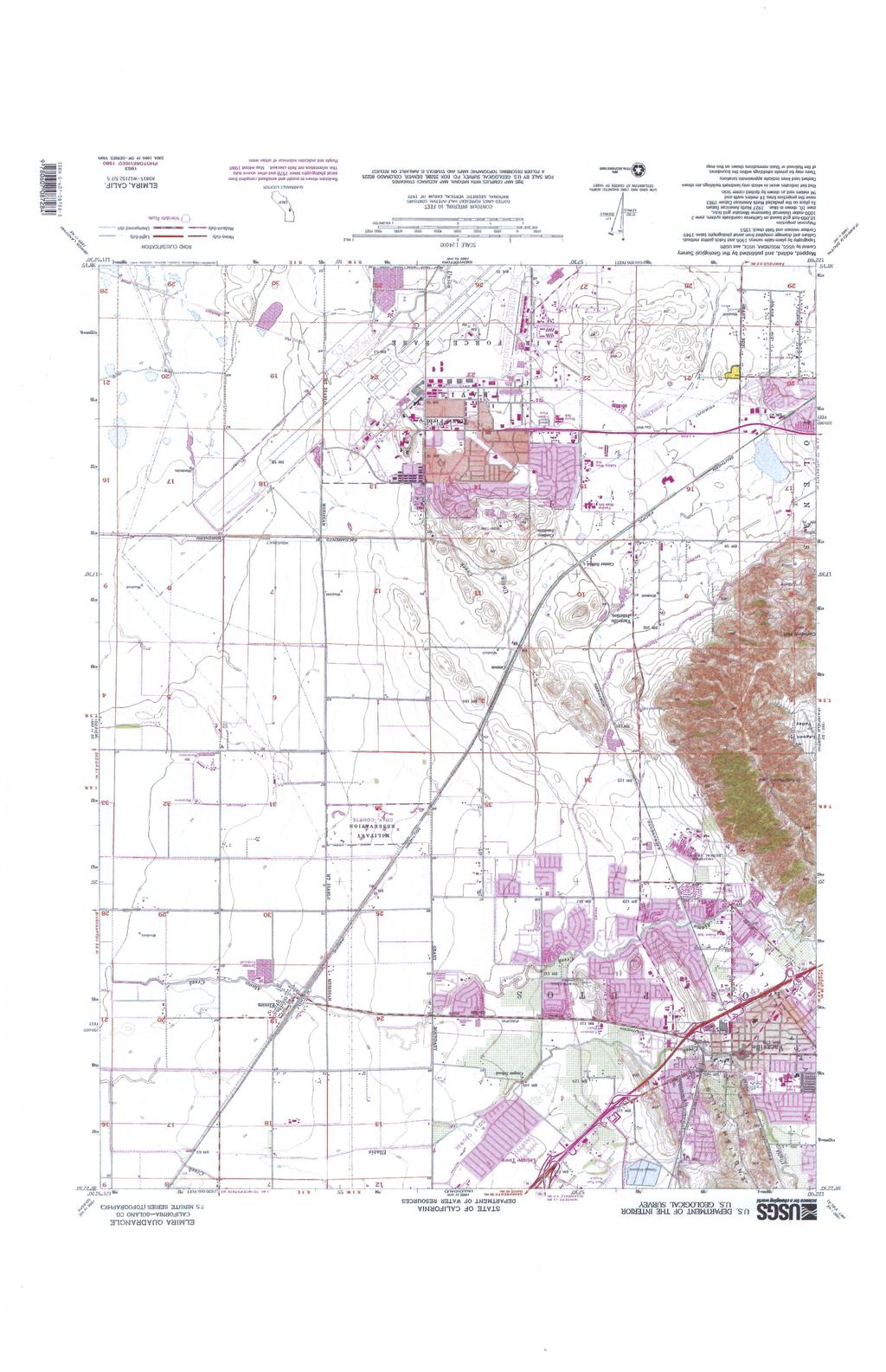
4 Zephyr Estates Project, Suisun City, Solano County, Archaeological Inventory Survey Page 2 would involve formally recording these on State DPR-523 forms. For both previously identified and newly identified sites located within the APE, the level of field work would be sufficient to recommend measures to avoid, minimize or mitigate potential adverse effects of the proposed project to any cultural resources determined significant or potentially significant. Upon completion of the records search and pedestrian survey, prepare an Archaeological Survey Report that identifies project effects and recommends appropriate mitigation measures for sites found significant or potentially significant under CEQA and whose significant qualities would be impacted by the project. The remainder of the present document constitutes the final report for this project, detailing the results of the records search, consultation and pedestrian survey and providing recommendations for treatment of significant or unique resources that could be impacted. All field survey procedures followed guidelines provided by the State Historic Preservation Office (Sacramento) and conform to accepted professional standards. 2. Location, Environmental and Cultural Context Location The project area comprises approximately 8.6-acres of formerly rural pasture lands which have been surrounded by recent, contemporary commercial/residential development. Lands affected are located within the northwest quarter of the southwest quarter of Section 21 of Township 5 North, Range 1 West, as shown on the USGS Elmira, California, 7.5 series quadrangle (see attached Project Location Map). Environment Situated within the flat, grassland region of the Sacramento Delta, the local terrain is characterized by nearby wetland regions and Suisun Bay to the southwest, the whole of which has been subjected to agricultural, commercial and residential development throughout the past 150 years. Elevation within the APE is approximately 44 feet above mean sea level, and no natural sources of surface water, or remarkable topography exist within the vicinity. Prehistory The San Joaquin Valley area generally has a long and complex cultural history with distinct regional patterns that extends back more than 11,000 years. The first generally agreed-upon evidence for the presence of prehistoric peoples in the area is represented by the distinctive fluted spear points (e.g. Heizer 1938), some resembling Clovis Points, found on the margins of extinct lakes in the San Joaquin Valley. The Clovis points are found on the same surface with the bones of extinct animals such as mammoths, sloths, and camels. Based on evidence from elsewhere, the ancient hunters who used these spear points existed during a narrow time range between about 10,900 BP and 11,200 BP (Moratto 2004). Genesis Society 2
5 Zephyr Estates Project, Suisun City, Solano County, Archaeological Inventory Survey Page 3 The next cultural period represented, the Western Pluvial Lakes Tradition and thought by most to be subsequent to the Clovis period, is another widespread complex that is characterized by stemmed spear points. This poorly defined early cultural tradition is regionally known from a small number of sites in the Central Coast Range, San Joaquin Valley lake margins, and Sierra Nevada foothills. The cultural tradition is dated to between about 8,000 and 10,000 years ago and its practitioners may be the precursors to the subsequent cultural pattern (Wallace 1978c). About 8,000 years ago, many California cultures shifted the main focus of their subsistence strategies from hunting to seed gathering as evidenced by the increase in food-grinding implements found in archeological sites dating to this period. This cultural pattern is best known for southern California, where it has been termed the Milling Stone Horizon (Wallace, 1954, 1978a). However, subsequent research suggests that the horizon may be more widespread than originally described and likely extended throughout the Valley (Moratto 2004); radiocarbon dates suggest a maximum age range between about 8,000 and 2,000 BP, but with most clustering between about 6,000 to 4,000 BP. Cultural patterns as reflected in the archeological record, particularly specialized subsistence practices, became codified within the last 3,000 years. The archeological record becomes more complex, as specialized adaptations to locally available resources were developed and populations expanded. Many sites dated to this time period contain mortars and pestles and/or are associated with bedrock mortars implying the intense exploitation of the acorn. The range of subsistence resources utilized along with regional exchange systems expanded significantly. Along the coast and in the Central Valley, archeological evidence of social stratification and craft specialization is indicated by well-made artifacts such as charmstones and beads, often found as mortuary items. Ethnographic lifeways serve as good analogs for this period. Ethnography The project area is located within territory which, at the time of Contact with European/American culture (circa AD 1850), was claimed by the Patwin (Johnson 1978). The Patwin occupied the southwest Sacramento Valley from the town of Princeton, north of Colusa, south to San Pablo and Suisun bays, and from the lower hills of the eastern North Coast Ranges to the Sacramento River. The Patwin were Penutian speakers, for whom the basic social unit was the family, although the village may also have functioned as a social, political and economic unit. Villages were usually located near water sources, with major villages inhabited mainly in the winter as it was necessary to go out into the hills and higher elevation zones to establish temporary camps during food gathering seasons (i.e., spring, summer and fall). Villages typically consisted of a scattering of bark houses, numbering from four or five to several dozen in larger villages, each house containing a single family of from three to seven people. As with all northern California Indian groups, economic life for these Penutian speaking groups revolved around hunting, fishing and the collecting of plant foods. Deer were an important meat source and were hunted by individuals by stalking or snaring, or by groups in community drives. Salmon runs, and other food resources available along the Sacramento Genesis Society 3
6 Zephyr Estates Project, Suisun City, Solano County, Archaeological Inventory Survey Page 4 River and some of its major tributaries, also contributed significantly to local economies. While much of the fish protein was consumed immediately, a significant percentage, particularly during the fall salmon run, was prepared for storage and consumed during winter months. Acorns represented one of the most important vegetal foods and were particularly abundant within the Oak Park Woodland which flanked both sides of the Sacramento River, as well as the Oak-Savannah biosystem within the foothill-delta interface. Relations between Euro-Americans and Native Americans in the northern Sacramento Valley followed the course of interaction documented in most other parts of North America, but with particularly devastating consequences for the Sacramento Valley Indians. John Work s fur trapping expedition through the region in resulted in the introduction of several communicable diseases, the results of which were devastating to Native culture and society (Work 1945; Cook 1955). Resource Considerations, Native American Sites. The discussion of regional prehistory and ethnography (above) provides insight into the types of Native American sites that have been documented within the region generally. These include: Large village sites located along the margins of streams, particularly at confluences, and at or near other natural surface water sources (springs, marshes and other wetlands) and on naturally elevated ground. Surface scatters of lithic artifacts without buried cultural deposits, resulting from short-term occupation and/or specialized economic activities. Petroglyphs, often in the form of cupped boulders, at or close to village sites or encampments. Bedrock food-processing (milling) stations, including mortar holes and metate slicks, most likely to be present within the western portion of the APE. Trails. Mortuary sites, often but not exclusively associated with large village complexes. Isolated finds of aboriginal artifacts and flakes. Clearly, it is not expected that all of these site types would be documented during the present pedestrian survey, but rather that these would be the most likely types to be encountered based on the results of previous regional research. Historic Context Interior California was initially visited by Anglo-American fur trappers, Russian scientists, and Spanish-Mexican expeditions during the early part of the 19 th Century. These early explorations were followed by a rapid escalation of European-American activities, which culminated in the massive influx fostered by the discovery of gold at Coloma in Early Spanish expeditions arrived from Bay Area missions as early as 1804, penetrating the northwestern San Joaquin Valley (Cook 1976). By the mid-1820s, hundreds of fur trappers were annually traversing the Valley on behalf of the Hudson s Bay Company (Maloney 1945). By the late 1830s and early 1840s, several small permanent European-American settlements had emerged in the Central Valley and adjacent foothill lands, including Ranchos Genesis Society 4
7 Zephyr Estates Project, Suisun City, Solano County, Archaeological Inventory Survey Page 5 in the interior Coast Range, and of course the settlement at New Helvetia (Sutter s Fort) at the confluence of the Sacramento and American Rivers (Sacramento). With the discovery of gold in the Sierra Nevada, large numbers of European-Americans, Hispanics, and Chinese arrived in and traveled through the Valley. The Valley s east-side mining communities demands for hard commodities led quickly to the expansion of ranching and agriculture throughout the Great Central Valley and the interior valleys of the Coast Range. Stable, larger populations arose and permanent communities slowly emerged in the Central Valley, particularly along major transportation corridors. The present APE is located within Solano County, which is one of California s original counties. The County s first seat of government was established in Benicia, but moved to Fairfield in Early settlers into the county cultivated fruits and vegetables for local consumption and grains were grown on a larger scale for exportation. Dry farm crops such as wheat and oats, used for cattle fodder, proved profitable in the area despite limited irrigation. Initially, agricultural products were transported via the waterways but with the completion of California Pacific Railroad, connecting directly with the Transcontinental Railroad in 1869, goods were transported by rail (Rawls and Bean 1993). Fruit and nut crops were particularly successful in the project vicinity and by 1910, Solano- Yolo Land and Water Company proposed dam and irrigation systems to support these crops. However, by 1930, government standards resulted in sales and abandonment of orchards with subsequent fruit workers strikes and riots resulting in the closure of the peach and cherry shipping industry (RootsWeb 2006). The fruit and nut industry slowly turned around and was aided by the formation of the Solano Irrigation District in Solano County continued to grow over the years with the addition of Travis Air Force Base, new industrial parks, and a resurgence of fruit processing and packing warehouses. Resource Considerations, Historic Resources. Historic overviews for the region document the presence of a wide range of historic site and feature types and complexes throughout the area generally. These include: Historic railroad alignments. Two-track historic trails/wagon roads, most of which are now paved over and represent fully contemporary features. Water distribution systems, including small and large ditch, canal and channel systems, and levees dating to historic time periods. Occupation sites and homesteads with associated features such as refuse disposal features, privy pits, barns, and sheds. Commercial undertakings and associated buildings and structures. Refuse disposal site(s) associated with historic Hughson. Ranch features, including structures, structural remnants, corrals, other feature types. As with prehistoric sites, it was not expected that all of these would be encountered within the APE. Rather, these sites and features represented the most likely types to be encountered during the pedestrian archaeological survey. Genesis Society 5
8 Zephyr Estates Project, Suisun City, Solano County, Archaeological Inventory Survey Page 6 3. RECORDS SEARCH and SOURCES CONSULTED Several types of information were considered relevant to evaluating the types of archaeological sites and site distribution that might be encountered within the project area. The information evaluated prior to conducting the pedestrian survey includes data maintained by the Northwest Information Center (CSU-Sonoma), and available published and unpublished documents relevant to regional prehistory, ethnography, and early historic developments. Northwest Information Center Records The official Solano County archaeological records were examined on January 24, 2014 (NWIC File No.: ). This search documented the following existing conditions for the 8.6-acre APE: According to the information center, approximately 80% of the present Area of Potential Effects (APE) has been subjected to archaeological survey as a result of two previous investigations. Greenway (1975) conducted an archaeological survey for a roadwidening project which included the western margin of the present APE (S-12743). Bowen and Siskin (2005) prepared an Historical Resources Evaluation Report and an Archaeological Survey Report for the Jepson Parkway project, which included the western 80% of the present APE (S-32047). Two archaeological investigations have been conducted on lands adjacent to, or outside of, the present APE: S immediately to the north and S to the northeast. However, there appears to be no overlap of these previous investigations with the present APE configuration. No prehistoric or historic-era resources (sites) have been documented within the APE. Likewise, no cultural resources have been formally recorded within 1/8-mile radius of the present APE. Other Sources Consulted In addition to examining the archaeological site and survey records of Solano County maintained at the Northwest Information Center, the following sources were also included in the search conducted at the Information Center, or were evaluated separately: The National Register of Historic Places (1986, Supplements to 2012). The California Register of Historical Resources (2013). The California Inventory of Historic Resources (1976). California State Historical Landmarks (1996). California Points of Historical Interest (1992). OHP Historic Property Data File (2012). OHP Archaeological Determination of Eligibility (2012). Caltrans Structure Maintenance and Investigations (2013). Elmira 7.5 Quadrangle (1917). Genesis Society 6
9 Zephyr Estates Project, Suisun City, Solano County, Archaeological Inventory Survey Page 7 GLO Plats, Vacaville 15 Quadrangle (1908 and 1953). Thomas Bros Map. Records of sites and previous archaeological surveys maintained by and available at the Information Center. Existing published and unpublished documents relevant to prehistory, ethnography, and early historic developments in the vicinity. These sources, reviewed below, provided a general environmental and cultural context by means of which to assess likely site types and distribution patterns for the project area. 4. ARCHAEOLOGICAL SURVEY and CULTURAL INVENTORY Survey Strategy and Field Work All of the circa 8.6-acre APE was subjected to intensive pedestrian survey by means of walking systematic transects, spaced at 5 meter intervals, across the entire APE. In searching for cultural resources, the surveyor took into account the results of background research and was alert for any unusual contours, soil changes, distinctive vegetation patterns, exotic materials, artifacts, feature or feature remnants and other possible markers of cultural sites. Fieldwork was undertaken on April 3, 2014 by Sean Michael Jensen. Mr. Jensen is a professional archaeologist and professional historian, with 27 years experience in archaeology and history, who meets the Secretary of Interior s Standards for Professional Qualification, as demonstrated in his listing on the California Historical Resources Information System list of qualified archaeologists and historians. No special problems were encountered and all survey objectives were satisfactorily achieved. General Field Observations Fieldwork identified the following general conditions within the project area. Intensive disturbance was observed immediately adjacent to the APE in the form of contemporary residential development, road and sidewalk construction and placement of buried utilities. As well, evidence of past grading was observed on the surface of the present APE lands. Prehistoric Resources No evidence of prehistoric use or presence was noted during the pedestrian survey. The absence of these resources may best be explained by the presence of more suitable habitation settings located a short distance east of the APE. Genesis Society 7
10 Zephyr Estates Project, Suisun City, Solano County, Archaeological Inventory Survey Page 8 Historic Resources No evidence of historic-era resources was observed within the APE during the present pedestrian survey. The absence of such resources may possibly be explained by the region s historic agricultural use. 5. PROJECT EFFECTS A project may have a significant impact or adverse effect on significant historical resources/unique archaeological resources if the project will or could result in the physical demolition, destruction, relocation, or alteration of the resource or its immediate surroundings such that the significance or values of the historic resource would be materially impaired. Actions that would materially impair a cultural resource are actions that would alter or diminish those attributes of a site that qualify the site for inclusion in State site registers. Based on the specific findings detailed above under Pedestrian Survey and Inventory, no significant historical resources/unique archaeological resources are present within the project area and no significant historical resources/unique archaeological resources will be affected by the undertaking, as presently proposed. 6. Native American Consultation In conjunction with the records search for the present project, the Native American Heritage Commission (NAHC) was contacted and asked to supply information concerning sacred lands and to provide a list of interested Native American individuals/groups/tribes that could be contacted for information concerning traditional use areas and/or known archaeological sites. A letter was sent to the NAHC on December 10, The NAHC responded on December 31, 2013, indicating that their search had failed to indicate the presence of Native American cultural resources in the immediate project area. The NAHC also provided a list of Native American individuals/groups/tribes knowledgeable about cultural resources in the project area. The contact list from the Native American Heritage Commission included the following individuals and groups, all of whom were contacted and requested to supply any information they might have concerning prehistoric sites or traditional use areas within the project area: Kesner Flores, Wheatland, California. Charlie Wright of the Cortina Band of Indians. Marshall McKay, Leland Kinter and Cynthia Clarke of the Yocha Dehe Wintun Nation. Written correspondences were mailed to these individuals/tribes on January 3, To date, only one response has been received from the contacted parties. On February 4, 2014, Marshall McKay, Tribal Chairman of the Yocha Dehe Wintun Nation responded via letter, Genesis Society 8
11 Zephyr Estates Project, Suisun City, Solano County, Archaeological Inventory Survey Page 9 and indicated that the tribe was not aware of any known cultural resources near this project site As no prehistoric cultural resources were identified within the APE, no additional consultation was conducted. 7. PROJECT SUMMARY This report details the results of an archaeological inventory survey of approximately 8.6 acres of land located adjacent to the east side of Walters Road, and the south and west sides of East Tabor Avenue, within Suisun City, Solano County, California. The proposed project would involve residential and commercial development, which would ultimately include construction of new residences, access roads, sidewalks, buried utilities, etc. Existing records at the NWIC document that approximately 80% of the APE has been subjected to previous archaeological survey, and that no prehistoric, or historic-era sites have been documented within, or immediately adjacent to the APE. The Native American Heritage Commission indicated that no sacred lands or cultural resources were identified during their file search, and consultation with NAHC listed parties garnered only one response. The Yocha Dehe Wintun Nation indicated that their records document no cultural resources within the present APE. The negative results achieved during both the records search and the subsequent pedestrian survey indicate that no cultural resources will be affected by the present project. Based on the absence of significant historical resources/unique archaeological resources within the APE, archaeological clearance is recommended for the project/undertaking as presently proposed, although the following general provisions are considered appropriate: 1. Consultation in the event of inadvertent discovery of human remains: In the event that human remains are inadvertently encountered during trenching or other grounddisturbing activity or at any time subsequently, State law shall be followed, which includes but is not limited to immediately contacting the County Coroner's office upon any discovery of human remains. 2. Consultation in the event of inadvertent discovery of cultural material: The present evaluation and recommendations are based on the findings of an inventory-level surface survey only. There is always the possibility that important unidentified cultural materials could be encountered on or below the surface during the course of future gravel extraction or other activities. This possibility is particularly relevant considering the constraints generally to archaeological field survey, and particularly where past ground disturbance activities (e.g., agricultural/residential/commercial development) have partially obscured historic ground surface visibility. In the event of an inadvertent discovery of previously unidentified cultural material, archaeological consultation should be sought immediately. Genesis Society 9
12 Zephyr Estates Project, Suisun City, Solano County, Archaeological Inventory Survey Page REFERENCES CITED and/or UTILIZED Barbour, M. G. and J. Major (eds.) 1977 Terrestrial Vegetation of California. New York: John Wiley & Sons. Baumhoff, Martin A Ecological Determinants of Aboriginal California Populations. University of California Publications in American Archaeology and Ethnology 49(2): Berkeley and Los Angeles. Burcham, L.T California Range Land: An Historico-Ecological Study of the Range Resources of California. California Division of Forestry, Department of Natural Resources. Sacramento. California, Department of Transportation (Caltrans) 1987 Caltrans State and Local Bridge Survey. Sacramento, California Caltrans State and Local Bridge Survey. Sacramento, California. California, State of 1970 Public Resources Code, Section 21000, et seq. (CEQA), and The California Environmental Quality Act Guidelines, California Administrative Code, Section et seq. (Guidelines, as amended October 1998). State of California, Sacramento The California Inventory of Historic Resources. State of California, Sacramento The California Historical Landmarks. State of California, Sacramento (Updates through 1996) Directory of Properties in the Historic Property Data File. Listing of the Office of Historic Preservation. Clark, William B Gold Districts of California. California Division of Mines and Geology, Bulletin 193. San Francisco. Cook, S. F The Conflict Between the California Indian and White Civilization. Berkeley: University of California Press. Gudde, Erwin G California Place Names: The Origin and Etymology of Current Geographical Names. University of California Press. Berkeley California Gold Camps. University of California Press. Berkeley. Genesis Society 10
13 Zephyr Estates Project, Suisun City, Solano County, Archaeological Inventory Survey Page 11 Heizer, Robert F A Folsom-Type Point from the Sacramento Valley. The Masterkey 12(5): Los Angeles. Johnson, Patti J Patwin, In, Handbook of North American Indians, Volume 8: California, Robert F. Heizer, Editor, pp Smithsonian Institution, Washington, D.C. Kroeber, Alfred L Handbook of the Indians of California. Smithsonian Institution, Bureau of American Ethnology, Bulletin 78. Washington, D.C. Kuchler, A. W Map titled Natural Vegetation of California, In, M. G. Barbour and J. Major, Editors, Terrestrial Vegetation of California. Wiley: New York. Maloney, Alice Bay 1945 Fur Brigade to the Bonaventura. California Historical Society. San Francisco. McGowan, J History of the Sacramento Valley. New York: Lewis Historical Publication Company. Moratto, Michael 2004 California Archaeology, 2 nd Edition. Academic Press, New York. Ragir, Sonia 1972 The Early Horizon in Central California Prehistory. Contributions of the University of California Archaeological Research Facility. Berkeley. Rawls, J.J. and W. Bean 1993 California: An Interpretive History. McGraw Hill, San Francisco. RootsWeb.com 2006 Website: True, Delbert L., Paul Bouey, Mark Basgall 1981 Archaeological Survey of the Proposed San Luis Drain Project: Kesterson Reservoir to the Sacramento-San Joaquin Delta, California. Report on File, Central California Information Center, CSU-Stanislaus, File # United States Department of the Interior 1986 National Register of Historic Places. Federal Register 1986, Supplements through December Washington, D.C. Genesis Society 11
14 Zephyr Estates Project, Suisun City, Solano County, Archaeological Inventory Survey Page 12 Wallace, William J The Little Sycamore Site and Early Milling Stone Cultures in Southern California. American Antiquity 20(2): a Southern Valley Yokuts, IN, Handbook of North American Indians, Volume 8: California, Robert F. Heizer, Editor, pp Smithsonian Institution, Washington, D.C. 1978b Northern Valley Yokuts, IN, Handbook of North American Indians, Volume 8: California, Robert F. Heizer, Editor, pp Smithsonian Institution, Washington, D.C. 1978c Post-Pleistocene Archaeology, IN, Handbook of North American Indians, Volume 8: California, Robert F. Heizer, Editor, pp Smithsonian Institution, Washington, D.C. West, James 1983 Pollen Analysis Results, In, Archaeological Investigations on Pilot Ridge, Six Rivers National Forest, by William Hildebrandt and J. Hayes, pp Report on File, Six Rivers National Forest, Eureka, California. Work, John 1945 Fur Brigade to the Bonaventura: John Work s California Expedition, , for the Hudson s Bay Company, In, The Journal of John Work, Alice B. Maloney, Editor. California Historical Society, San Francisco. Genesis Society 12
15
16
17
18
19
ARCHAEOLOGICAL INVENTORY SURVEY
 Alta Sierra Development Project, Nevada County, Archaeological Survey ARCHAEOLOGICAL INVENTORY SURVEY Alta Sierra Development Project, One-acre, Nevada County, California. Prepared for Simon CRE 5111 N.
ARCHAEOLOGICAL INVESTIGATIONS FOR THE OLD DAVIS ROAD REALIGNMENT PROJECT ON THE UNIVERSITY OF CALIFORNIA, DAVIS CAMPUS YOLO COUNTY, CALIFORNIA
 Cultural Resources Consultants ARCHAEOLOGICAL INVESTIGATIONS FOR THE OLD DAVIS ROAD REALIGNMENT PROJECT ON THE UNIVERSITY OF CALIFORNIA, DAVIS CAMPUS YOLO COUNTY, CALIFORNIA Prepared for: Matt Dulcich,
Appendix C Cultural Resources Survey
 Appendix C Cultural Resources Survey A Cultural Resources Survey for the Gallo Winery Expansion Project 18000 River Road, Livingston Merced County, California Eileen Barrow, M.A./R.P.A. July 22, 2011 A
Appendix E Archaeological Inventory Survey
 Appendix E Archaeological Inventory Survey BCAG Transit Project, Butte County, California, Archaeological Inventory Survey ARCHAEOLOGICAL INVENTORY SURVEY Proposed BCAG Transit Project, c. 20-acres, City
ARCHAEOLOGICAL INVENTORY SURVEY
 SE Sewer Trunkline Project, Butte County, Archaeological Inventory Survey ARCHAEOLOGICAL INVENTORY SURVEY SE Sewer Trunkline Project circa 4,450 linear corridor City of Chico, Butte County, California.
Chapter 19: Cultural Resources
 Chapter 19: Cultural Resources Introduction and Setting Traditionally the term "cultural resources" has been used rather narrowly to refer to archaeological remains and to historical structures. Archaeologists,
2.1.8 Cultural Resources Regulatory Setting. Affected Environment, Environmental
 REVISED DRAFT ENVIRONMENTAL IMPACT REPORT/ Affected Environment, Environmental 2.1.8 Cultural Resources This section evaluates the potential for historical and archaeological resources within the proposed
4.5 CULTURAL RESOURCES
 4.5 CULTURAL RESOURCES This section identifies, evaluates, and assesses the potential impacts to cultural resources at the Specific Plan site and along the 13.5 mile (approximately 145 acre) linear alignment
THE CALIFORNIA ENVIRONMENTAL QUALITY ACT (CEQA) AND HISTORICAL AND TRIBAL CULTURAL RESOURCES
 AND HISTORICAL AND TRIBAL CULTURAL RESOURCES") THE CALIFORNIA ENVIRONMENTAL QUALITY ACT (CEQA) AND HISTORICAL AND TRIBAL CULTURAL RESOURCES A review by Dr. John Parker, RPA original 2008, updated 2016 What Projects Require CEQA Review?...1 How does
THE CALIFORNIA ENVIRONMENTAL QUALITY ACT (CEQA) AND HISTORICAL AND TRIBAL CULTURAL RESOURCES A review by Dr. John Parker, RPA original 2008, updated 2016 What Projects Require CEQA Review?...1 How does
Archaeological Survey Report
 Archaeological Survey Report for UNION STREET RAILROAD BRIDGE (Trail Connection Project) Key No. 11085 ODOT, Region 2 Local Agency On-Call ATA 23456 WOC 1 City of Salem, Urban Development HDR Project No.
REQUEST FOR PROPOSALS. Preparation of National Register of Historic Places. Nominations for the following:
 REQUEST FOR PROPOSALS Preparation of National Register of Historic Places Nominations for the following: The Conner Swales Site, The Baumann Village Site, The Bird Point Heaven Village Site, The Wise Village
I 5 South Multimodal Corridor Study. Appendix F. I 5 South Multimodal Corridor Study Cultural Resources Constraints Analysis (February 8, 2010)
") I 5 South Multimodal Corridor Study Appendix F I 5 South Multimodal Corridor Study Cultural Resources Constraints Analysis (February 8, 2010) 847 Jamacha Road, El Cajon, California 92019-3206 tel: (619)
I 5 South Multimodal Corridor Study Appendix F I 5 South Multimodal Corridor Study Cultural Resources Constraints Analysis (February 8, 2010) 847 Jamacha Road, El Cajon, California 92019-3206 tel: (619)
Draft Environmental Assessment Appendix A. SHPO Correspondence, January 19, 2017
 Draft Environmental Assessment Appendix A. SHPO Correspondence, January 19, 2017 Rosecrans/Marquardt Grade Separation Project April 2018 Federal Railroad Administration U.S. Department 1200 New Jersey
ANTH 481/NATV 481 Native American Archaeological Monitoring
 ANTH 481/NATV 481 Native American Archaeological Monitoring Course Description Students work with local Native American bands concerning cultural preservation from a Native American perspective as it relates
Final Initial Study. Chalice Unitarian Universalist Congregation Conditional Use Permit
 5 Final Initial Study Chalice Unitarian Universalist Congregation Conditional Use Permit Appendix B Chalice Unitarian Universalist Congregation Cultural Resources Memorandum TRC 9685 Research Drive Irvine,
EASTERN GOLETA VALLEY COMMUNITY PLAN
 D. CULTURAL RESOURCES Cultural resources include but are not limited to buildings, structures, and districts, prehistoric and historic archaeological sites, historical landscapes, and traditional cultural
3.0 Cumulative Scenario and Methodology. 3.0 Cumulative Scenario and Methodology
 3.0 Cumulative Scenario and Methodology Under the CEQA Guidelines, a cumulative impact consists of an impact which is created as a result of the combination of the project evaluated in the environmental
V. ENVIRONMENTAL IMPACT ANALYSIS D. CULTURAL RESOURCES
 V. ENVIRONMENTAL IMPACT ANALYSIS D. CULTURAL RESOURCES Incorporated into this section are the findings and conclusions of two archaeological investigations conducted on the Project Site: a site survey
Summary of Other State Archeological Guidelines
 Summary of Other State Archeological Guidelines This is a summary all guidelines for archeology from 17 other states. This information was gathered in order to see what type of guidelines other states
Architectural Inventory Form
 COLORADO CULTURAL RESOURCE SURVEY Page 1 of 8 Official Eligibility Determination (OAHP use only) Rev. 9/98 OAHP1403 Date Initials Determined Eligible National Register Determined Not Eligible National
PennDOT. single spann lanes and 3- mayy need to be to accommodate. any bridge. addition to III. Date: CRP 07/27/2015 CRP.
 (10/27/14) PennDOT Section 106 Field Assessments and Finding Combined Early tification/finding? Yes Concurrence required or requested: Yes MPMS: 51507 ER# (if consultation with PHMC required) ): County:
Submitted: July 23, 2009
 Stage I and II Archaeological Assessment Jock River Estates Phase 2 PML Project No. 0801-01 Client: 773804 Ontario Inc. Lot 21, Concession 2 Geographic Township of Goulbourn City of Ottawa Submitted: July
National Historic Preservation Act Section 106 Compliance
 National Historic Preservation Act Section 106 Compliance Regulatory Program Workshop Erin E. Hess Cultural Resource Specialist National Historic Preservation Act Compliance Regulatory Division, Sacramento
2.0 Hi s t o r y & Existing Co n d i t i o n s
 2.0 Hi s t o r y & Existing Co n d i t i o n s 2.1 Plan Area History The Lincoln East Specific Plan (Specific Plan) area is a significant part of the history of Sutter County. A 48,000 acre land grant
April 4, 2013 Rana Ahmadi San Francisco Municipal Transportation Agency 1 South Van Ness Avenue, 7th Floor San Francisco, CA 94103
 April 4, 2013 Rana Ahmadi San Francisco Municipal Transportation Agency 1 South Van Ness Avenue, 7th Floor San Francisco, CA 94103 RE: CEQA Review Ocean Avenue Public Plaza Block/Lot 3180/001, Case No.
Bureau for Historic Preservation s Guidance for Historic Preservation Planning
 Bureau for Historic Preservation s Guidance for Historic Preservation Planning The Municipalities Planning Code was revised in 2000 and included a provision for historic preservation planning. The Bureau
AN ARCHAEOLOGICAL SURVEY FOR THE RICHARDS, TEXAS FARM-TO-MARKET ROAD 149 FIBER OPTIC CABLE PROJECT IN MONTGOMERY COUNTY, TEXAS
 AN ARCHAEOLOGICAL SURVEY FOR THE RICHARDS, TEXAS FARM-TO-MARKET ROAD 149 FIBER OPTIC CABLE PROJECT IN MONTGOMERY COUNTY, TEXAS Antiquities Permit 6097 By William E. Moore Brazos Valley Research Associates
The following summary of the cultural setting describes the prehistory and history of the regional vicinity.
 3.5 CULTURAL RESOURCES Cultural resources represent and document the activities, accomplishments, and traditions of past and present cultures and link current and former inhabitants of an area. Archaeological
General Terms Property, as used to describe eligibility for the National Register of Historic Places:
 Key Definitions Historic Landscapes Compiled by Camille Fife and Barbara Wyatt The field of historic landscape preservation has generated a specific vocabulary. Definitions have been published by two National
SANTA ROSA ISLAND RANCHING DISTRICT, CHANNEL ISLANDS NATIONAL PARK, CALIFORNIA
 DEPARTMENT OF LANDSCAPE ARCHITECTURE School of Architecture and Allied Arts University of Oregon Site Planning and Design Studio, Fall 2016 LA 489 / 589: CRN: 13477 / 13496 Professor Robert Z Melnick,
TOWN OF AURORA HERITAGE IMPACT ASSESSMENTS AND CONSERVATION PLANS GUIDE
 PLANNING AND DEVELOPMENT SERVICES Development Planning Division Heritage Planning Section Phone: 905-727-3123 ext. 4226 Fax: 905-726-4736 Email: planning@aurora.ca Town of Aurora 100 John West Way, Box
THE REGIONAL MUNICIPALITY OF YORK BYLAW NO A bylaw to adopt Amendment No. 6 to the Official Plan for The Regional Municipality of York
 THE REGIONAL MUNICIPALITY OF YORK BILL NO. 13 BYLAW NO. 2014-13 A bylaw to adopt Amendment No. 6 to the Official Plan for The Regional Municipality of York WHEREAS the Planning Act, R.S.O. 1990, c.p.13,
4.4 CULTURAL RESOURCES
 4.4 This chapter discusses existing conditions on the Project site and in the vicinity and analyzes potential impacts to cultural resources that could result from buildout of the Project. Cultural resources
W.H. Bonner Associates
 15619 Ogram Avenu Gardena, CA 90249-444 W.H. Bonner Associates Archaeofaunal Studies Archaeological Surveys Historical & Genealogical Research (310) 675-274 E-mail: whbonner@aol.com April 21, 2014 Wendy
CEQA and Historic Resources: The Local Government Perspective
 CEQA and Historic Resources: The Local Government Perspective Ken Bernstein, Principal City Planner City of Los Angeles, Office of Historic Resources The Three Key Questions on CEQA and Historic Resources
MATHEMATICAL SCIENCES BUILDING
 Final Focused Tiered Environmental Impact Report State Clearinghouse No. 2002072048 Prepared By: OFFICE OF RESOURCE MANAGEMENT AND PLANNING University of California One Shields Avenue 376 Mrak Hall Davis,
NOTICE OF PREPARATION
 NOTICE OF PREPARATION To: All Interested Parties Subject: Notice of Preparation of an Environmental Impact Report From: City of Petaluma Address: 11 English Street, Petaluma, CA 94952-2610 Contact: Heather
National Museum of African American History & Culture ENVIRONMENTAL IMPACT STATEMENT & SECTION 106 CONSULTATION
 Smithsonian Institution National Museum of African American History & Culture ENVIRONMENTAL IMPACT STATEMENT & SECTION 106 CONSULTATION Phase II Archeology May 30, 2007 Review of Phase I Findings Archival
COMBINED PHASE I ARCHAEOLOGICAL SURVEY BUILDING/LANDSCAPE AND ARCHAEOLOGICAL ASSESSMENT PLAN
 COMBINED PHASE I ARCHAEOLOGICAL SURVEY BUILDING/LANDSCAPE AND ARCHAEOLOGICAL ASSESSMENT PLAN ST. ELIZABETHS HOSPITAL - WEST CAMPUS 2700 MARTIN LUTHER KING, JR. AVENUE, SE DISTRICT OF COLUMBIA [SITE NUMBER
Chapter 5: Recreation
 Chapter 5: Recreation Introduction and Setting Recreational opportunities within Nevada County are varied, ranging from public parks with intensively used active recreational facilities, to vast tracts
CHAPTER 10 AESTHETICS
 CHAPTER 10 AESTHETICS CHAPTER 10 AESTHETICS This section identifies and evaluates key visual resources in the project area to determine the degree of visual impact that would be attributable to the project.
National Character Area 70 Melbourne Parklands
 Summary The are a landscape of rolling farmland, parkland and woodland on the northern flanks of the ridge between Burton upon Trent and Swadlincote. The land slopes down to the River Trent, which borders
Decision Notice. Proposed Action
 Decision Notice Paving Weld County Road 105 USDA Forest Service Arapaho and Roosevelt National Forest and Pawnee National Grassland Pawnee National Grassland Ranger District Weld County, Colorado November
CAMPUS HISTORY AND STEWARDSHIP
 CHAPTER TWO CAMPUS HISTORY AND STEWARDSHIP The stewardship of the UC Davis campus history and the rich collection of natural and cultural resources is a fundamental task for the LRDP. This chapter is organized
Historic England Advice Report 26 August 2016
 Case Name: Kingsland Castle Case Number: 1435892 Background Historic England has been asked to review the scheduling for Kingsland Castle. The land on which the monument lies is understood to be for sale.
TABLE OF CONTENTS HISTORIC PRESERVATION ELEMENT I. INTRODUCTION HP. A. Purpose HP B. Assessment and Conclusions...
 TABLE OF CONTENTS HISTORIC PRESERVATION ELEMENT I. INTRODUCTION... 1 - HP A. Purpose... 1 - HP B. Assessment and Conclusions... 1 - HP II. GOAL, OBJECTIVES AND POLICIES... 3 - HP GOAL 1: PROTECTION AND
Policy & Procedure Effective Date: Parks Department Page of
 City of Arvada Policy & Procedure Effective Date: Parks Department Page of TITLE: City of Arvada Prairie Dog Habitat Plan APPROVAL: PURPOSE: To establish a plan for the preservation of black-tailed prairie
Architectural Inventory Form (page 1 of 5)
") OAHP1403 Rev. 9/98 COLORADO CULTURAL RESOURCE SURVEY (page 1 of 5) Official eligibility determination (OAHP use only) Date Initials Determined Eligible- NR Determined Not Eligible- NR Determined Eligible-
OAHP1403 Rev. 9/98 COLORADO CULTURAL RESOURCE SURVEY (page 1 of 5) Official eligibility determination (OAHP use only) Date Initials Determined Eligible- NR Determined Not Eligible- NR Determined Eligible-
Architectural Inventory Form
 COLORADO CULTURAL RESOURCE SURVEY Page 1 of 8 Official Eligibility Determination (OAHP use only) Rev. 9/98 OAHP1403 Date Initials Determined Eligible National Register Determined Not Eligible National
Stewardship. Streamlining. Consensus
 Stewardship Streamlining Consensus Translating Section 106: Building Consensus among Multiple Responsible Parties For the Doyle Drive Replacement Project in the Presidio of San Francisco National Historic
Ivol Buildings, Woodcote Road, South Stoke, Oxfordshire
 Ivol Buildings, Woodcote Road, South Stoke, Oxfordshire An Archaeological Watching Brief For Christ Church, Oxford by Pamela Jenkins Thames Valley Archaeological Services Ltd Site Code IBSS 04/03 March
7.0 SOCIAL, ECONOMIC, AND ENVIRONMENTAL ISSUES
 7.0 SOCIAL, ECONOMIC, AND ENVIRONMENTAL ISSUES The following list of social, economic, and environmental issues have been identified based on a preliminary inventory of resources in the project area, an
Pinellas County Greenways
 Pinellas County Greenways USING GREENWAYS TO LINK OPEN SPACES The Florida Greenways Commission has defined a greenway as...a corridor of protected open space that is managed for conservation and/or recreation.
3.10 LAND USE SETTING PROJECT SITE EXISTING LAND USE DESIGNATIONS AND ZONING. General Plan Land Use Designations.
 This section of the Draft EIR addresses the existing land uses on and adjacent to the project site and discusses the potential impacts of the proposed project on existing land uses. Key issues addressed
STAGE 1 2 ARCHAEOLOGICAL ASSESSMENT OF YONGE STREET SUBWAY EXTENSION, LOTS 37-41, CONCESSION EYS, TOWNSHIP OF MARKHAM, CITY OF TORONTO, YORK COUNTY
 STAGE 1 2 ARCHAEOLOGICAL ASSESSMENT OF YONGE STREET SUBWAY EXTENSION, LOTS 37-41, CONCESSION EYS, TOWNSHIP OF MARKHAM, CITY OF TORONTO, YORK COUNTY Original License Report Submitted to: Ecoplans Limited
Postcards from America Required landscape Exercise LANDSCAPE FEATURE TOPICS
 Postcards from America Required landscape Exercise LANDSCAPE FEATURE TOPICS Choose a mix of 16 landscapes from the 80 listed to include in your portfolio. The 16 landscape features you choose should be
Meales Farm, Sulhamstead, West Berkshire
 Meales Farm, Sulhamstead, West Berkshire An Archaeological Watching Brief For Mr. Robert Astor by Steve Ford Thames Valley Archaeological Services Ltd Site Code CHH02/29 May 2002 Summary Site name: Meales
3.1 AESTHETICS Background and Methodology
 3.1 AESTHETICS 3.1.1 Background and Methodology 3.1.1.1 Regulatory Context The California Environmental Quality Act (CEQA) requires that project sponsors evaluate the project s potential to cause aesthetic
INTRODUCTION. 1.1 What is a General Plan? 1.2 Requirements for a General Plan. 1.3 Introduction to Monterey County
 1.1 What is a General Plan? INTRODUCTION California state law requires each city and county to adopt a comprehensive, long-term general plan for the physical development of the county or city, and any
COMMUNITY DESIGN. GOAL: Create livable and attractive communities. Intent
 COMMUNITY DESIGN Intent An attractive, well-designed County will attract quality development, instill civic pride, improve the visual character of the community, and create a strong, positive image for
Revised License Report
 STAGE 1 2 ARCHAEOLOGICAL ASSESSMENT OF THE EGLINTON CROSSTOWN LIGHT RAIL TRANSIT CORRIDOR, EGLINTON AVENUE FROM JANE STREET TO BRICKNELL STREET, CONCESSION 5, LOT 11, CONCESSION 6, LOT 41, YORK TOWNSHIP,
FINAL MITIGATION PLAN to address
 CENTRAL CORRIDOR LRT STATE CAPITOL MALL HISTORIC FINAL MITIGATION PLAN February 2010 FINAL MITIGATION PLAN to address Adverse Effects of the Central Corridor LRT Project on the State Capitol Mall Historic
Archaeological Evaluation and Assessment of Land at Kent Cottage, 19 Chapel Street, Hythe, Kent
 Archaeological Evaluation and Assessment of Land at Kent Cottage, 19 Chapel Street, Hythe, Kent Planning Application Y13/0463/SH Date of Report: 29/04/2015 Report for Marc Carney SWAT. ARCHAEOLOGY Swale
Architectural Inventory Form
 OAHP1403 Rev. 9/98 COLORADO CULTURAL RESOURCE SURVEY Architectural Inventory Form Official eligibility determination (OAHP use only) Date Initials Determined Eligible- NR Determined Not Eligible- NR Determined
6.8 SCENIC HIGHWAYS Introduction
 6.8 SCENIC HIGHWAYS 6.8.1 Introduction The Scenic Highways Element is an optional General Plan element authorized by Section 65303 of the Government Code. The Scenic Highways Element is intended to establish
CEQA and Historic Preservation: A 360 Degree Review
 CEQA and Historic Preservation: A 360 Degree Review California Preservation Foundation Workshop February 11, 2015 Presented by Chris McMorris Partner / Architectural Historian CEQA and Historic Preservation
Florida Department of TRANSPORTATION. Technical Memorandum Cultural Resource Assessment Survey of the Proposed VE Pond
 Florida Department of TRANSPORTATION Technical Memorandum Cultural Resource Assessment Survey of the Proposed VE Pond Malabar Road (SR 514) PD&E Study From East of Babcock Street (SR 507) to US 1 Brevard
McKay Road Interchange and Salem / Lockhart Crossing
 McKay Road Interchange and Salem / Lockhart Crossing The McKay Road Interchange Class EA has two components: 1. A new MacKay Road Interchange at Highway 400; and 2. A new bridge crossing of Highway 400
Phase One Archaeological Investigation Results, James Madison Park Master Development Plan Project, City of Madison, Dane County, Wisconsin
 Phase One Archaeological Investigation Results, James Madison Park Master Development Plan Project, City of Madison, Dane County, Wisconsin Prepared for the City of Madison Parks Department 28 January
Los Angeles Department of City Planning RECOMMENDATION REPORT
 Los Angeles Department of City Planning RECOMMENDATION REPORT CULTURAL HERITAGE COMMISSION HEARING DATE: January 13, 2011 TIME: 10:00 AM PLACE: City Hall, Room 1010 200 N. Spring Street Los Angeles, CA
City of Larkspur. Notice of Mitigated Negative Declaration for the 285
 Notice of Mitigated Negative Declaration for the 285 Magnolia Avenue Mixed-Use Project Date: December 2, 2013 Responsible Agency: Project Title: 285 Magnolia Avenue Mixed-Use Project Project Address: 285
CHAPTER 2: HISTORIC BACKGROUND
 CHAPTER 2: HISTORIC BACKGROUND The historic town of Eastlake was created on June 22, 1911 when the Eastlake Subdivision was recorded at the Adams County Clerk and Recorder s Office. The Eastlake Investment
Chapter 8: Cultural Heritage Assessment
 Chapter 8: Cultural Heritage Assessment Cultural Heritage Assessment 8. Cultural Heritage Assessment... 2 8.1 Introduction... 2 8.2 Baseline Assessment... 2 8.3 Results / Assessment Findings... 3 8.4 Mitigation...
Authority of the General Plan
 Authority of the General Plan This La Habra Heights General Plan will serve as the blueprint for future planning and development in the City. This General Plan describes the City s vision for the future
TAKANINI STRUCTURE PLAN AREAS 6A & 6B: ARCHAEOLOGICAL ASSESSMENT
 TAKANINI STRUCTURE PLAN AREAS 6A & 6B: ARCHAEOLOGICAL ASSESSMENT Report prepared for Hosken & Associates Ltd By Barry Baquie (MA) Rod Clough (PhD) April 2006 Clough & Associates Ltd heritage@clough.co.nz
A REGIONAL HERITAGE STRATEGIC PLAN for OKANAGAN - SIMILKAMEEN
 A REGIONAL HERITAGE STRATEGIC PLAN for OKANAGAN - SIMILKAMEEN The Regional District of Okanagan-Similkameen is preparing a Regional Heritage Strategic Plan. The Strategic Plan will identify important themes
A Research Framework for the Archaeology of Wales Version 01, Final Paper Neolithic and Earlier Bronze Age
 NEOLITHIC AND EARLIER BRONZE AGE Introduction The introduction of farming around 4000 BC had a dramatic impact on the landscape of Wales and fundamentally changed they ways in which people lived and interacted.
Request for Statement of Interest in Implementation of the Roosevelt Road Redevelopment Plan
 425 Hillside Avenue Request for Statement of Interest in Implementation of the Roosevelt Road Redevelopment Plan I. INTRODUCTION The is seeking the services of a qualified consulting firm to prepare plans
4.3 CULTURAL and HISTORIC RESOURCES
 4.3 CULTURAL and HISTORIC RESOURCES This section includes a discussion of onsite development s potential impacts to historic and cultural resources. Information has been summarized from a report prepared
PRIMARY RECORD Trinomial # NRHP Status Code 3S, 3CS, 5S3 Other Listings Review Code Reviewer Date
 PRIMARY RECORD # NRHP Status Code 3S, 3CS, 5S3 Other Listings Review Code Reviewer Date Page 1 of 6 1252 *Resource Name or # (Assigned by recorder) Old Topanga Canyon Road P1. Other Identifier: *P2. Location:
NOTICE OF PREPARATION
 NOTICE OF PREPARATION DATE: January 6, 2016 TO: LEAD AGENCY: Responsible Agencies, Organizations, and Interested Parties Contact: Tyler Barrington, Principal Planner Planning Department Community Development
NOTICE OF PREPARATION
 Date: June 30, 2017 CITY OF CITRUS HEIGHTS COMMUNITY & ECONOMIC DEVELOPMENT DEPARTMENT, PLANNING DIVISION 6360 Fountain Square Drive, Citrus Heights, CA 95621 (916) 727-4740 NOTICE OF PREPARATION To: Subject:
1.0 PLANNING MARKHAM S FUTURE CONTENTS
 1-1 Planning Markham s Future 1.0 PLANNING MARKHAM S FUTURE CONTENTS 1.1 THE PURPOSE OF THE OFFICIAL PLAN 1.2 THE MARKHAM CONTEXT 1.3 THE REGULATORY CONTEXT 1.3.1 Province of Ontario 1.3.2 York Region
THE PLANNING AREA 2.1 PLANNING AREA LOCATION
 2. The Planning Area Brisbane Baylands Specific Plan 21 2 THE PLANNING AREA 2.1 PLANNING AREA LOCATION The Baylands is located approximately midway between San Francisco s central business district and
STAGE 1 ARCHAEOLOGICAL ASSESSMENT OF RATHBURN ROAD, FROM DUKE OF YORK BOULEVARD TO SHIPP DRIVE, CITY OF MISSISSAUGA. Submitted to:
 STAGE 1 ARCHAEOLOGICAL ASSESSMENT OF RATHBURN ROAD, FROM DUKE OF YORK BOULEVARD TO SHIPP DRIVE, CITY OF MISSISSAUGA Submitted to: McCormick Rankin Corporation 2655 North Sheridan Way, Suite 280 Mississauga,
Baby Point Heritage Conservation District Study. Kick-off Community Meeting March 27, 2017 Humbercrest United Church
 Baby Point Heritage Conservation District Study Kick-off Community Meeting March 27, 2017 Humbercrest United Church Agenda 7:00 Welcome 7:10 HCD Study Overview and Process 8:00 Interactive Discussion /
24. ARCHAEOLOGY & BUILT HERITAGE
 24. ARCHAEOLOGY & BUILT HERITAGE Overview There are no known archaeological or built heritage sites within or adjacent to the Project designation boundaries. There is a history of both Māori and European
A Delta Renewed: A Guide to Science Based Ecological Restoration in the Delta
 A Delta Renewed: A Guide to Science Based Ecological Restoration in the Delta J. Letitia Grenier, San Francisco Estuary Institute, letitia@sfei.org Julie Beagle, San Francisco Estuary Institute, julieb@sfei.org
I. INTRODUCTION. A. Consistency with Other Elements
 OPEN SPACE ELEMENT I. INTRODUCTION The Open Space Element identifies the County s open space land, and establishes guiding policies for the preservation and conservation of land within the County that
BRANDT-HAWLEY LAW GROUP
 Susan Brandt-Hawley Paige J. Swartley BRANDT-HAWLEY LAW GROUP Environment/Preservation Chauvet House PO Box 1659 Glen Ellen, California 95442 September 8, 2006 Legal Assistants Sara Hews Shannen Jones
4.4 CULTURAL RESOURCES
 4.4 This chapter describes the regulatory framework and existing conditions in the Project area related to cultural resources, and the potential impacts of the Project on cultural resources. The section
III. PROJECT DESCRIPTION
 III. PROJECT DESCRIPTION A. PROJECT LOCATION Regional Setting The project site is located in the southeast quadrant of the City of Chico in Butte County, California and is comprised of four parcels totaling
Architectural Inventory Form
 COLORADO CULTURAL RESOURCE SURVEY Page 1 of 8 Official Eligibility Determination (OAHP use only) Rev. 9/98 OAHP1403 Date Initials Determined Eligible National Register Determined Not Eligible National
HISTORICAL ECOLOGY OF THE DELTA Emerging Concepts about a Spatially Complex and Temporally Dynamic System
 ITEM REMOVED DUE TO COPYRIGHT STATUS HISTORICAL ECOLOGY OF THE DELTA Emerging Concepts about a Spatially Complex and Temporally Dynamic System Robin Grossinger and Alison Whipple San Francisco Estuary
CHAPTER 2 SUMMARY 1. PROJECT SUMMARY DATA
 CHAPTER 2 SUMMARY This is an Initial Study format used to determine, pursuant to CEQA Guidelines Section 15177, whether a project 1) is within the scope of a Master EIR (MEIR), 2) may result in additional
FOREST SERVICE MANUAL NATIONAL HEADQUARTERS (WO) WASHINGTON, DC
 WASHINGTON, DC") Page 1 of 11 FOREST SERVICE MANUAL NATIONAL HEADQUARTERS (WO) WASHINGTON, DC FSM 2300 RECREATION, WILDERNESS, AND RELATED RESOURCE MANAGEMENT Amendment No.: 2300-2011-2 Effective Date: October 19, 2011
Page 1 of 11 FOREST SERVICE MANUAL NATIONAL HEADQUARTERS (WO) WASHINGTON, DC FSM 2300 RECREATION, WILDERNESS, AND RELATED RESOURCE MANAGEMENT Amendment No.: 2300-2011-2 Effective Date: October 19, 2011
SECTION 4(f) DE MINIMIS DOCUMENTATION
 DE MINIMIS DOCUMENTATION") SECTION 4(f) DE MINIMIS DOCUMENTATION Illinois Route 60/83 IL 176 to the intersection of IL 60 (Townline Road) Lake County P-91-084-07 Mundelein Park and Recreation District Project Limit SECTION 4(f)
SECTION 4(f) DE MINIMIS DOCUMENTATION Illinois Route 60/83 IL 176 to the intersection of IL 60 (Townline Road) Lake County P-91-084-07 Mundelein Park and Recreation District Project Limit SECTION 4(f)
Environmental Assessment for a New Landfill Footprint at the West Carleton Environmental Centre
 Waste Management of Canada Corporation Environmental Assessment for a New Landfill Footprint at the West Carleton Environmental Centre ARCHEOLOGY DETAILED IMPACT ASSESSMENT Prepared by: Archeoworks Inc.
Introduction to the Issue: Fluidity in the Law
 Golden Gate University Law Review Volume 30 Issue 4 The American Coast: Law on the Edge Article 1 January 2000 Introduction to the Issue: Fluidity in the Law Paul Stanton Kibel Golden Gate University School
4.1 AESTHETICS AND VISUAL QUALITY
 SCOPE AND METHODOLOGY 4.1 AESTHETICS AND VISUAL QUALITY This section evaluates the potential impacts to aesthetics and visual quality. Aesthetics refers to visual resources and the quality of what can