ARCHAEOLOGICAL INVENTORY SURVEY
|
|
|
- Cory Powers
- 6 years ago
- Views:
Transcription
1 Alta Sierra Development Project, Nevada County, Archaeological Survey ARCHAEOLOGICAL INVENTORY SURVEY Alta Sierra Development Project, One-acre, Nevada County, California. Prepared for Simon CRE 5111 N. Scottsdale Road, Suite 200 Scottsdale, AZ Author Sean Michael Jensen, M.A. Keywords for Information Center Use: Archaeological Inventory Survey, one-acre, Nevada County, CEQA, USGS Grass Valley, Ca. 7.5 Quads., No Eligible/Significant Historic Properties/Resources. June 23, 2014 GENESIS SOCIETY ARCHAEOLOGICAL - HISTORICAL - CULTURAL RESOURCE MANAGEMENT SERVICES
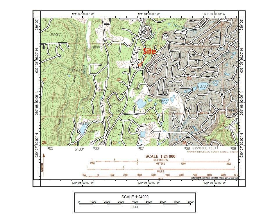
2 Alta Sierra Development Project, Nevada County, Inventory Survey Page 1 1. INTRODUCTION Project Background This report details the results of an archaeological inventory survey of the proposed Alta Sierra development project, involving approximately one-acre located adjacent to the east side of Alta Sierra Drive, and the west side of Little Valley Road, approximately 200 meters east of State Route 49, in Nevada County, California (see attached Project Location and Archaeological Survey Area Map). The proposed project would involve commercial development of the parcel which could result in construction of a new commercial building and associated features, including buried and overhead utilities, driveways, parking, landscaping, etc. The proposed project will involve physical disturbance to ground surface and sub-surface components and will therefore have the potential to impact cultural resources located within the Area of Potential Effect (APE). In this case, the APE consists of the circa one-acre property itself. Evaluation of the project s effects to cultural resources must be undertaken in conformity with Nevada County rules and regulations, and in compliance with requirements of the California Environmental Quality Act of 1970, Public Resources Code, Section 21000, et seq. (CEQA), and The California CEQA Environmental Quality Act Guidelines, California Administrative Code, Section et seq. (Guidelines as amended). Scope of Work At the most general level, compliance with CEQA requires completion of projects in conformity with the standards contained in Section of the CEQA Guidelines, as amended. Based on this and other relevant Sections of the Guidelines, the following specific tasks were considered an adequate and appropriate Scope of Work for the present project: Conduct a records search at the North Central Information Center of the California Historical Resources Information System at CSU-Sacramento, and review state data bases and other relevant background information. The goals of the records search and data base review are to determine (a) the extent and distribution of previous archaeological surveys, (b) the locations of known archaeological sites and any previously recorded archaeological districts, and (c) the relationships between known sites and environmental variables. This step is designed to ensure that, during subsequent field survey work, all archaeological and historical sites considered significant per CEQA are discovered, correctly identified, fully documented, and properly interpreted. Conduct a pedestrian field survey of the project area. Based on map review, a complete coverage intensive survey was considered appropriate, given the presence of low to moderate archaeological sensitivity throughout the project area. The purpose of the pedestrian survey is to ensure that any previously recorded sites identified during the records search are re-located and existing evaluations updated based on current site and field conditions. For previously undocumented sites Genesis Society 1
3 Alta Sierra Development Project, Nevada County, Inventory Survey Page 2 identified which might qualify as cultural resources per CEQA, the field survey would involve formally recording these on DPR-523 Forms. Upon completion of the records search and pedestrian survey, prepare an archaeological inventory survey report that identifies project effects and recommends appropriate mitigation measures for any prehistoric or historic sites recommended significant under CEQA and which might be affected by the project. The remainder of the present document constitutes the Final Report for this project, detailing the results of the records search and field survey and containing recommendations for treatment of significant sites that could be impacted by the project. All field survey procedures followed guidelines provided by the State Historic Preservation Office (Sacramento) and conform to accepted professional standards. Location The Alta Sierra development project involves approximately one-acre parcel located adjacent to the east side of Alta Sierra Drive, and the west side of Little Valley Road, approximately 200 meters east of State Route 49, in Nevada County, California. Lands affected are located within a portion of the northeast quarter of Section 22 of Township 15 North, Range 8 East, as shown on the USGS Grass Valley, California, 7.5 series quad (see attached Project Location and Archaeological Survey Area Map). A number of important streams are located within the general vicinity of the project area, including Rattlesnake Creek to the north, and Wolf Creek to the west. However, none of these are located within or adjacent to the subject APE. Until relatively recently, lands within this general area remained largely undeveloped for residential and related use, being utilized since about 1865 for ranching and farming. During the past several decades, however, the pace of development within this area of Nevada County has intensified with recent, residential and commercial development having occurred within the general vicinity, including immediately adjacent to the subject parcel. Based on available topographic and other maps, but notwithstanding the effects of past and on-going land uses, the project area appeared to contain lands ranging from low to moderate in sensitivity for both prehistoric and historic-period sites and features. 2. EXISTING CONDITIONS Several information sources were considered relevant to evaluating the types of sites and site distribution that might be encountered within the project area. The information evaluated includes data maintained by the North Central Information Center of the California Historical Resources Information System, consultation with the NAHC and Native American representatives on the NAHC contact list, and published and unpublished documents relevant to regional ethnography, prehistory, and early historic developments. Genesis Society 2
4 Alta Sierra Development Project, Nevada County, Inventory Survey Page 3 North Central Information Center Records The records of the North Central Information Center were examined for existing recorded prehistoric and historic sites and previous archaeological survey within or near the project area (Records Search dated June 18, 2014, N.C.I.C. File NEV 14-24, copy attached), with the following results. Previous Archaeological Survey: The Information Center s records indicated that none of the subject property has been subjected to past archaeological survey. Likewise, no archaeological investigations have been conducted immediately adjacent to the subject parcel. Recorded Cultural Resources: According to the Information Center s records, no prehistoric or historic-era resources have been identified or recorded within, or immediately adjacent to, the subject APE. Other Sources In addition to examining records at the North Central Information Center and Native American consultation, the following sources were also reviewed by the Information Center, or separately: The National Register of Historic Places (2010 and Updates). The California Register of Historical Resources (2010 and Updates). The California Inventory of Historical Resources (1976). California Historical Landmarks (State of California 1996). California Points of Historical Interest (May 1992 and updates). The Historic Property Data File (OHP 2014). The Determination of Eligibility (OHP 2014). Caltrans Bridge Inventory (2009). USGS Quadrangle: 1949 Grass Valley 7.5. GLO Plats: 1855, T15N/8E. Published and unpublished documents relevant to ethnography, prehistory and early historic developments in the vicinity (reviewed below), providing context for assessing likely site types and site distribution patterns for the project area. Ethnographically, the project area is located within territory occupied by the Nisenan at the time of initial contact with European Americans (Wilson and Towne 1978: Figure 1). The Nisenan are Native American peoples also referred to as Southern Maidu who occupied the drainages of the southern Feather River and Honcut Creek in the north, through Bear River and the Yuba and American River drainages in the south. Villages were frequently located on flats adjoining streams, and were inhabited mainly in the winter as it was usually necessary to go out into the hills and higher elevation zones to establish temporary camps during food gathering seasons (i.e., spring, summer and fall). Genesis Society 3
5 Alta Sierra Development Project, Nevada County, Inventory Survey Page 4 As with all northern California Indian groups, economic life for the Nisenan revolved around hunting, fishing and the collecting of plant foods. These people were very sophisticated in terms of their knowledge of the uses of local animals and plants, and of the availability of raw material sources that could be used in manufacturing an immense array of primary and secondary tools and implements. Unfortunately, only fragmentary evidence of the material culture of these people remains, due in part to perishability and in part to the impacts to archaeological sites resulting from later (historic) land uses (mining, ranching and timber harvest). Based on the results of previous survey work within the southwestern portion of Nevada County, the potential range of prehistoric site types included the following: Surface scatters of lithic artifacts and debitage associated with midden accumulations (sometimes including other surface features such as housepit depressions, mortar holes, petroglyphs), resulting from protracted occupation along stream channels, particularly where streams merge with one another. Surface scatters of lithic artifacts and debitage without midden accumulations, resulting from short-term occupation and/or specialized economic activities. Bedrock milling stations, including especially mortar holes, where suitable bedrock outcrops are exposed. Petroglyphs. Isolated finds of aboriginal artifacts and flakes. Clearly, it was not expected that all of these site types would be encountered within the project area, but rather that these would be the most likely types to be encountered if any sites or features were identified at all. Antecedent cultures in the area span several thousands of years and document use and occupation centered along water courses and elsewhere throughout the area. Detailed archaeological sequences are reviewed in works by Moratto (2004) and others. Recorded history in the project area begins with the attempts of Spanish colonists to explore parts of California beyond the coastal zone. Gabriel Moraga s expedition was undertaken in 1806, with additional incursions occurring through the 1840 s. European Americans began arriving in more substantial numbers in the mid-1820 s, most notably with the trapping expeditions of Jedediah Smith. However, the European American incursion with the greatest impact on Native American population and culture occurred immediately following the discovery of gold at Coloma in 1848, which initiated the Gold Rush of Mining along virtually every stream in the Nevada City and Grass Valley areas was underway by Placer mining continued to yield large quantities of gold through the next several years, and by 1855 supporting industry in the mine fields of Nevada County and along what is now Highway 49 and other early transportation corridors included stores, transportation companies, saloons, toll roads and stage lines, foundries, lumber mills, and water companies. Isolated features related to historic mining activities and associated transportation are ubiquitous throughout portions of Nevada County, and include sluiced areas, ditches, glory holes, collapsed shafts and adits, debris scatters, tailings piles, and occasionally structural remains. Genesis Society 4
6 Alta Sierra Development Project, Nevada County, Inventory Survey Page 5 Logging, ranching and wood mill operations represent additional historic themes for this area of the County. As with the earlier mining emphasis, activities associated with these activities have also adversely affected the local cultural resource base. Historic overviews for the region document the presence of a range of historic site and feature types and complexes throughout the area generally. Relevant historic site types potentially present in this area include: Historic narrow gauge railroad. Two-track trails/wagon roads, most of which are now paved roadways or no longer exist. Water distribution systems, including small and large ditch, canal and channel systems, and levees dating to historic time periods. Occupation sites and homesteads with associated features such as refuse disposal areas, privy pits, barns, and sheds. Ranch features, including structures, structural remnants, corrals, other feature types. Bridges associated with historic road corridors. Landscape modifications associated with both historic mining and wood mill operations, including also shafts, glory holes, tailings piles and additional feature types. As with prehistoric sites, not all of these were expected to be present within the project area, with the list above representing the range of types considered most likely to be present based on background information available. 3. ARCHAEOLOGICAL SURVEY and CULTURAL INVENTORY Survey Strategy and Field Work All of the one-acre APE was subjected to intensive pedestrian survey by means of walking systematic, parallel transects across the project area, with transects spaced at approximate 10 meter intervals. In searching for cultural resources, the surveyor took into account the results of background research and was alert for any unusual contours, soil changes, distinctive vegetation patterns, exotic materials, artifacts, feature or feature remnants and other possible markers of cultural sites. Field work was undertaken on June 21, 2014 by Sean Michael Jensen, M.A. Mr. Jensen is a professional archaeologist and historian, with 28 years experience in California archaeology, who meets the Secretary of Interior s Standards for Professional Qualification, as demonstrated in his inclusion on the California Historical Resources Information System s list of qualified archaeologists and historians. No special problems were encountered and all survey objectives were satisfactorily achieved. Genesis Society 5
7 Alta Sierra Development Project, Nevada County, Inventory Survey Page 6 General Field Observations Fieldwork identified the following general conditions within the project area. Disturbance to the ground surface throughout the property has been moderate to minimal, resulting from adjacent road construction, and construction of adjacent residential and commercial facilities. Likewise, limited past tree and brush removal was evident, and recent evidence of perc/mantle excavations were observed within the APE. Finally, both buried and overhead utilities were observed within/adjacent to the subject property. Prehistoric Sites No evidence of prehistoric occupation or utilization was observed within the subject APE during the present pedestrian survey. The absence of such resources may best be explained by the absence of a suitable source of surface water within close proximity of the APE, and to more suitable habitation settings located along stream courses in the vicinity. Historic Sites No evidence of historic-era use or activity was observed within the subject APE. 4. ELIGIBILITY RECOMMENDATIONS A project may have a significant impact or adverse effect on cultural resources/historic properties if the project will or could result in the physical demolition, destruction, relocation, or alteration of the resource or its immediate surroundings such that the significance or values of the resource would be materially impaired. Based on the specific findings detailed above under Pedestrian Survey and Inventory, no historic properties are present within the project area and no historic properties will be affected by the undertaking, as presently proposed. 5. Native American Consultation The Native American Heritage Commission (NAHC) was contacted and asked to supply information concerning sacred lands and to provide a list of interested Native American individuals/groups/tribes that could be contacted for information concerning traditional use areas and/or known archaeological sites. A letter was sent to the NAHC on June 17, The NAHC responded on June 18, 2014, indicating that their search had failed to indicate the presence of Native American cultural resources in the immediate project area. As no prehistoric cultural resources were identified within the APE, no additional consultation was conducted. Genesis Society 6
8 Alta Sierra Development Project, Nevada County, Inventory Survey Page 7 6. PROJECT SUMMARY This report details the results of an archaeological inventory survey involving approximately one-acre adjacent to the east side of Alta Sierra Drive, and the west side of Little Valley Road, approximately 200 meters east of State Route 49, in Nevada County, California. The proposed project would involve commercial development of the parcel. Neither the pedestrian survey, existing records at the NCIC, or consultation with the NAHC, yielded any information concerning prehistoric or historic-era sites or features within the APE. Based on project findings as summarized above, archaeological clearance is recommended for the proposed Alta Sierra development Project, with the following general provisions: 1) Evidence of human burial or scattered human remains related to prehistoric occupation of the area could be inadvertently encountered anywhere within the project area during construction or other ground-disturbing activities. In the event of such an inadvertent discovery, the County Coroner and the Native American Heritage Commission (State of California) would have to be informed and consulted, per State law. 2) The present evaluation and recommendations are based on the findings of an inventory-level surface survey only. There is always the possibility that previously unidentified cultural materials could be encountered on or below the surface during the course of future development or construction activities. This is particularly relevant considering the constraints generally to archaeological field survey, and particularly where past development and land uses partially obscure ground surface visibility. In the event of an inadvertent discovery of previously unidentified cultural material, archaeological consultation should be sought immediately. 7. REFERENCES CITED and/or UTILIZED ACHP (Advisory Council on Historic Preservation) 1980 Treatment of Archaeological Properties: A Handbook. Advisory Council on Historic Preservation. Washington, D.C. Barbour, M. G. and J. Major (eds.) 1977 Terrestrial Vegetation of California. New York: John Wiley & Sons. California, State of 1970 Public Resources Code, Section 21000, et seq. (CEQA), and The California Environmental Quality Act Guidelines, California Administrative Code, Section et seq. (Guidelines as Amended) 1976 The California Inventory of Historic Resources California Historical Landmarks. Genesis Society 7
9 Alta Sierra Development Project, Nevada County, Inventory Survey Page California Points of Historical Interest listing (1990, and updates) California Register of Historical Resources. Clark, William B Gold Districts of California. California Division of Mines, Bulletin 193. San Francisco, California. Code of Federal Regulations (CFR) 36 CFR Part 60: National Register of Historic Places. Washington, D.C.: Dept. of the Interior, National Park Service. 36 CFR Part 66: Proposed Guidelines Recovery of Scientific, Prehistoric, Historic, and Archaeological Data: Methods, Standards, and Reporting Requirements. Washington, D.C.: Dept. of the Interior, National Park Service. Fredrickson, D. A Cultural Diversity in Early Central California: A View from the North Coast Ranges. Journal of California Anthropology 1(1): Davis, California. Gudde, Erwin G California Place Names: The Origin and Etymology of Current Geographical Names. University of California Press. Berkeley California Gold Camps. University of California Press. Berkeley. Heizer, R. F A Folsom-type point from the Sacramento Valley. Los Angeles: The Masterkey 12(5): Jensen, Peter M. 1999a Archaeological Survey, c. 7-Acre Word Alive Church Development Project (NCIC Report # 1933). Report on File, North Central Information Center, CSU-Sacramento. 1999b Archaeological Survey, Casilli property, 15-acre Development (NCIC Report # 1935). Report on File, North Central Information Center, CSU-Sacramento Archaeological Survey, Penn Valley Fire Station, c. 13-acre Development, Penn Valley, Nevada County, California (NCIC Report # 2615). Report on File, North Central Information Center, CSU-Sacramento Archaeological Survey, c. 1-acre Fultz Property, Nevada County, California (NCIC Report # 7273). Report on File, North Central Information Center, CSU-Sacramento. Genesis Society 8
10 Alta Sierra Development Project, Nevada County, Inventory Survey Page 9 Jensen, Sean M Archaeological Inventory Survey, Penn Valley Mobile Home Ranch, Re- Subdivision of c. 40-acres at Penn Valley, Nevada County, California (NCIC Report # 3247). Report on File, North Central Information Center, CSU- Sacramento Archaeological Inventory Survey, Western Gateway Park, County Update to Master Plan, Penn Valley, Nevada County, California (NCIC Report # 3225). Report on File, North Central Information Center, CSU-Sacramento. Kroeber, Alfred L Handbook of the Indians of California. Bureau of American Ethnology Bulletin 78. Smithsonian Institution. Washington, D.C. Kuchler, A. W Map of the natural vegetation of California, In M.G. Barbour and J. Major, Eds., Terrestrial Vegetation of California. Wiley: New York. Kyle, Douglas E. (ed.) 1990 Historic Spots in California. Stanford University Press. Stanford. Maloney, A. B Fur Brigade to the Bonaventura. California Historical Society. San Francisco. Moratto, Michael J California Archaeology 2 nd Edition. Academic Press. Orlando, Florida. Ragir, Sonia 1972 The Early Horizon in Central California Prehistory. Contributions of the University of California Archaeological Research Facility. University of California, Berkeley. Sundahl, Elaine 1982 The Shasta Complex in the Redding Area. Unpublished Master s Thesis, Department of Anthropology, California State University, Chico. United States Department of the Interior 1983 Archaeology and Historic Preservation: Secretary of the Interior s Standards and Guidelines, Federal Register 48:190 (29 Sept. 1983), pp National Register of Historic Places. Federal Register 1986, Supplements through December Washington, D.C. West, James 1983 Pollen Analysis Results, IN, Archaeological Investigations on Pilot Ridge, Six Rivers National Forest, by William Hildebrandt and J. Hayes, pp Report on File, Six Rivers National Forest, Eureka, California. Genesis Society 9
11 Alta Sierra Development Project, Nevada County, Inventory Survey Page 10 Wilson, Norman L., and Arlean H. Towne 1978 Nisenan,, Handbook of North American Indians, Volume 8: California, Robert F. Heizer, Editor, pp Smithsonian Institution, Washington, D.C. Work, John 1945 Fur Brigade to the Bonaventura: John Work s California Expedition, , for the Hudson s Bay Company, The Journal of John Work, Alice B. Maloney, Editor. California Historical Society, San Francisco. Genesis Society 10
12 Alta Sierra Development Project, Nevada County, Archaeological Survey ARCHAEOLOGICAL INVENTORY SURVEY Alta Sierra Development Project, One-acre, Nevada County, California. ATTACHMENTS Project Location Map Records Search from CSU-Sacramento Response from the Native American Heritage Commission GENESIS SOCIETY ARCHAEOLOGICAL - HISTORICAL - CULTURAL RESOURCE MANAGEMENT SERVICES
13
14 6/18/2014 NCIC File No.: NEV Sean Jensen Genesis Society 7053 Molokai Drive Paradise, CA Re: Alta Sierra The North Central Information Center received your record search request for the project area referenced above, located on the Grass Valley USGS 7.5 quad. The following reflects the results of the records search for the project area: As indicated on the data request form, the locations of resources and reports are provided in the following format: custom GIS maps shapefiles Resources within project area: Resources within radius: Reports within project area: Reports within radius: No known resources are located within the project area. No radius requested. No known resources are located within the project area. No radius requested. Resource Database Printout (list): Resource Database Printout (details): Resource Digital Database Records: Report Database Printout (list): Report Database Printout (details): Report Digital Database Records: Resource Record Copies: Report Copies: OHP Historic Properties Directory: enclosed not requested nothing listed enclosed not requested nothing listed
15 Archaeological Determinations of Eligibility: CA Inventory of Historic Resources (1976): Caltrans Bridge Survey: Ethnographic Information: Historical Literature: Historical Maps: Local Inventories: GLO and/or Rancho Plat Maps: Shipwreck Inventory: Soil Survey Maps: enclosed not requested nothing listed enclosed not requested nothing listed enclosed not requested nothing listed enclosed not requested nothing listed enclosed not requested nothing listed Please forward a copy of any resulting reports from this project to the office as soon as possible. Due to the sensitive nature of archaeological site location data, we ask that you do not include resource location maps and resource location descriptions in your report if the report is for public distribution. If you have any questions regarding the results presented herein, please contact the office at the phone number listed above. The provision of CHRIS Data via this records search response does not in any way constitute public disclosure of records otherwise exempt from disclosure under the California Public Records Act or any other law, including, but not limited to, records related to archeological site information maintained by or on behalf of, or in the possession of, the State of California, Department of Parks and Recreation, State Historic Preservation Officer, Office of Historic Preservation, or the State Historical Resources Commission. Should you require any additional information for the above referenced project, reference the record search number listed above when making inquiries. Requests made after initial invoicing will result in the preparation of a separate invoice. Sincerely, Machiel Van Dordrecht Researcher
16
17
ARCHAEOLOGICAL INVENTORY SURVEY
 Zephyr Estates Project, Suisun City, Solano County, Archaeological Inventory Survey ARCHAEOLOGICAL INVENTORY SURVEY Zephyr Estates Development Project, circa 8.6-acres, Suisun City, Solano County, California.
Appendix E Archaeological Inventory Survey
 Appendix E Archaeological Inventory Survey BCAG Transit Project, Butte County, California, Archaeological Inventory Survey ARCHAEOLOGICAL INVENTORY SURVEY Proposed BCAG Transit Project, c. 20-acres, City
Chapter 19: Cultural Resources
 Chapter 19: Cultural Resources Introduction and Setting Traditionally the term "cultural resources" has been used rather narrowly to refer to archaeological remains and to historical structures. Archaeologists,
Appendix C Cultural Resources Survey
 Appendix C Cultural Resources Survey A Cultural Resources Survey for the Gallo Winery Expansion Project 18000 River Road, Livingston Merced County, California Eileen Barrow, M.A./R.P.A. July 22, 2011 A
ARCHAEOLOGICAL INVENTORY SURVEY
 SE Sewer Trunkline Project, Butte County, Archaeological Inventory Survey ARCHAEOLOGICAL INVENTORY SURVEY SE Sewer Trunkline Project circa 4,450 linear corridor City of Chico, Butte County, California.
ARCHAEOLOGICAL INVESTIGATIONS FOR THE OLD DAVIS ROAD REALIGNMENT PROJECT ON THE UNIVERSITY OF CALIFORNIA, DAVIS CAMPUS YOLO COUNTY, CALIFORNIA
 Cultural Resources Consultants ARCHAEOLOGICAL INVESTIGATIONS FOR THE OLD DAVIS ROAD REALIGNMENT PROJECT ON THE UNIVERSITY OF CALIFORNIA, DAVIS CAMPUS YOLO COUNTY, CALIFORNIA Prepared for: Matt Dulcich,
2.1.8 Cultural Resources Regulatory Setting. Affected Environment, Environmental
 REVISED DRAFT ENVIRONMENTAL IMPACT REPORT/ Affected Environment, Environmental 2.1.8 Cultural Resources This section evaluates the potential for historical and archaeological resources within the proposed
4.5 CULTURAL RESOURCES
 4.5 CULTURAL RESOURCES This section identifies, evaluates, and assesses the potential impacts to cultural resources at the Specific Plan site and along the 13.5 mile (approximately 145 acre) linear alignment
Draft Environmental Assessment Appendix A. SHPO Correspondence, January 19, 2017
 Draft Environmental Assessment Appendix A. SHPO Correspondence, January 19, 2017 Rosecrans/Marquardt Grade Separation Project April 2018 Federal Railroad Administration U.S. Department 1200 New Jersey
THE CALIFORNIA ENVIRONMENTAL QUALITY ACT (CEQA) AND HISTORICAL AND TRIBAL CULTURAL RESOURCES
 AND HISTORICAL AND TRIBAL CULTURAL RESOURCES") THE CALIFORNIA ENVIRONMENTAL QUALITY ACT (CEQA) AND HISTORICAL AND TRIBAL CULTURAL RESOURCES A review by Dr. John Parker, RPA original 2008, updated 2016 What Projects Require CEQA Review?...1 How does
THE CALIFORNIA ENVIRONMENTAL QUALITY ACT (CEQA) AND HISTORICAL AND TRIBAL CULTURAL RESOURCES A review by Dr. John Parker, RPA original 2008, updated 2016 What Projects Require CEQA Review?...1 How does
V. ENVIRONMENTAL IMPACT ANALYSIS D. CULTURAL RESOURCES
 V. ENVIRONMENTAL IMPACT ANALYSIS D. CULTURAL RESOURCES Incorporated into this section are the findings and conclusions of two archaeological investigations conducted on the Project Site: a site survey
Summary of Other State Archeological Guidelines
 Summary of Other State Archeological Guidelines This is a summary all guidelines for archeology from 17 other states. This information was gathered in order to see what type of guidelines other states
April 4, 2013 Rana Ahmadi San Francisco Municipal Transportation Agency 1 South Van Ness Avenue, 7th Floor San Francisco, CA 94103
 April 4, 2013 Rana Ahmadi San Francisco Municipal Transportation Agency 1 South Van Ness Avenue, 7th Floor San Francisco, CA 94103 RE: CEQA Review Ocean Avenue Public Plaza Block/Lot 3180/001, Case No.
CEQA and Historic Preservation: A 360 Degree Review
 CEQA and Historic Preservation: A 360 Degree Review California Preservation Foundation Workshop February 11, 2015 Presented by Chris McMorris Partner / Architectural Historian CEQA and Historic Preservation
W.H. Bonner Associates
 15619 Ogram Avenu Gardena, CA 90249-444 W.H. Bonner Associates Archaeofaunal Studies Archaeological Surveys Historical & Genealogical Research (310) 675-274 E-mail: whbonner@aol.com April 21, 2014 Wendy
REQUEST FOR PROPOSALS. Preparation of National Register of Historic Places. Nominations for the following:
 REQUEST FOR PROPOSALS Preparation of National Register of Historic Places Nominations for the following: The Conner Swales Site, The Baumann Village Site, The Bird Point Heaven Village Site, The Wise Village
Archaeological Survey Report
 Archaeological Survey Report for UNION STREET RAILROAD BRIDGE (Trail Connection Project) Key No. 11085 ODOT, Region 2 Local Agency On-Call ATA 23456 WOC 1 City of Salem, Urban Development HDR Project No.
I 5 South Multimodal Corridor Study. Appendix F. I 5 South Multimodal Corridor Study Cultural Resources Constraints Analysis (February 8, 2010)
") I 5 South Multimodal Corridor Study Appendix F I 5 South Multimodal Corridor Study Cultural Resources Constraints Analysis (February 8, 2010) 847 Jamacha Road, El Cajon, California 92019-3206 tel: (619)
I 5 South Multimodal Corridor Study Appendix F I 5 South Multimodal Corridor Study Cultural Resources Constraints Analysis (February 8, 2010) 847 Jamacha Road, El Cajon, California 92019-3206 tel: (619)
National Historic Preservation Act Section 106 Compliance
 National Historic Preservation Act Section 106 Compliance Regulatory Program Workshop Erin E. Hess Cultural Resource Specialist National Historic Preservation Act Compliance Regulatory Division, Sacramento
AN ARCHAEOLOGICAL SURVEY FOR THE RICHARDS, TEXAS FARM-TO-MARKET ROAD 149 FIBER OPTIC CABLE PROJECT IN MONTGOMERY COUNTY, TEXAS
 AN ARCHAEOLOGICAL SURVEY FOR THE RICHARDS, TEXAS FARM-TO-MARKET ROAD 149 FIBER OPTIC CABLE PROJECT IN MONTGOMERY COUNTY, TEXAS Antiquities Permit 6097 By William E. Moore Brazos Valley Research Associates
3.10 LAND USE SETTING PROJECT SITE EXISTING LAND USE DESIGNATIONS AND ZONING. General Plan Land Use Designations.
 This section of the Draft EIR addresses the existing land uses on and adjacent to the project site and discusses the potential impacts of the proposed project on existing land uses. Key issues addressed
Chapter 8: Cultural Heritage Assessment
 Chapter 8: Cultural Heritage Assessment Cultural Heritage Assessment 8. Cultural Heritage Assessment... 2 8.1 Introduction... 2 8.2 Baseline Assessment... 2 8.3 Results / Assessment Findings... 3 8.4 Mitigation...
TOWN OF AURORA HERITAGE IMPACT ASSESSMENTS AND CONSERVATION PLANS GUIDE
 PLANNING AND DEVELOPMENT SERVICES Development Planning Division Heritage Planning Section Phone: 905-727-3123 ext. 4226 Fax: 905-726-4736 Email: planning@aurora.ca Town of Aurora 100 John West Way, Box
ANTH 481/NATV 481 Native American Archaeological Monitoring
 ANTH 481/NATV 481 Native American Archaeological Monitoring Course Description Students work with local Native American bands concerning cultural preservation from a Native American perspective as it relates
THE REGIONAL MUNICIPALITY OF YORK BYLAW NO A bylaw to adopt Amendment No. 6 to the Official Plan for The Regional Municipality of York
 THE REGIONAL MUNICIPALITY OF YORK BILL NO. 13 BYLAW NO. 2014-13 A bylaw to adopt Amendment No. 6 to the Official Plan for The Regional Municipality of York WHEREAS the Planning Act, R.S.O. 1990, c.p.13,
TAKANINI STRUCTURE PLAN AREAS 6A & 6B: ARCHAEOLOGICAL ASSESSMENT
 TAKANINI STRUCTURE PLAN AREAS 6A & 6B: ARCHAEOLOGICAL ASSESSMENT Report prepared for Hosken & Associates Ltd By Barry Baquie (MA) Rod Clough (PhD) April 2006 Clough & Associates Ltd heritage@clough.co.nz
Chapter 5: Recreation
 Chapter 5: Recreation Introduction and Setting Recreational opportunities within Nevada County are varied, ranging from public parks with intensively used active recreational facilities, to vast tracts
Final Initial Study. Chalice Unitarian Universalist Congregation Conditional Use Permit
 5 Final Initial Study Chalice Unitarian Universalist Congregation Conditional Use Permit Appendix B Chalice Unitarian Universalist Congregation Cultural Resources Memorandum TRC 9685 Research Drive Irvine,
Appendix G. Archaeological and Paleontological Resources Records Searches
 Appendix G Archaeological and Paleontological Resources Records Searches South Central Coastal Information Center California State University, Fullerton Department of Anthropology MH-426 800 North State
Bureau for Historic Preservation s Guidance for Historic Preservation Planning
 Bureau for Historic Preservation s Guidance for Historic Preservation Planning The Municipalities Planning Code was revised in 2000 and included a provision for historic preservation planning. The Bureau
Florida Department of TRANSPORTATION. Technical Memorandum Cultural Resource Assessment Survey of the Proposed VE Pond
 Florida Department of TRANSPORTATION Technical Memorandum Cultural Resource Assessment Survey of the Proposed VE Pond Malabar Road (SR 514) PD&E Study From East of Babcock Street (SR 507) to US 1 Brevard
STAFF REPORT FOR STANDARD COASTAL DEVELOPMENT PERMIT #CDP FEBRUARY 26, 2015 CPA - 1 PO BOX 238 APTOS, CA 94001
 STAFF REPORT FOR STANDARD COASTAL DEVELOPMENT PERMIT #CDP 2014-0030 FEBRUARY 26, 2015 CPA - 1 OWNER/APPLICANT: AGENT: REQUEST: HANS HEIM PO BOX 238 APTOS, CA 94001 JAMES HAY PO BOX 762 MENDOCINO, CA 95460
PennDOT. single spann lanes and 3- mayy need to be to accommodate. any bridge. addition to III. Date: CRP 07/27/2015 CRP.
 (10/27/14) PennDOT Section 106 Field Assessments and Finding Combined Early tification/finding? Yes Concurrence required or requested: Yes MPMS: 51507 ER# (if consultation with PHMC required) ): County:
Phase One Archaeological Investigation Results, James Madison Park Master Development Plan Project, City of Madison, Dane County, Wisconsin
 Phase One Archaeological Investigation Results, James Madison Park Master Development Plan Project, City of Madison, Dane County, Wisconsin Prepared for the City of Madison Parks Department 28 January
COMBINED PHASE I ARCHAEOLOGICAL SURVEY BUILDING/LANDSCAPE AND ARCHAEOLOGICAL ASSESSMENT PLAN
 COMBINED PHASE I ARCHAEOLOGICAL SURVEY BUILDING/LANDSCAPE AND ARCHAEOLOGICAL ASSESSMENT PLAN ST. ELIZABETHS HOSPITAL - WEST CAMPUS 2700 MARTIN LUTHER KING, JR. AVENUE, SE DISTRICT OF COLUMBIA [SITE NUMBER
APPENDIX J SHPO COORDINATION
 Final Environmental Impact Statement/Final Environment Impact Report Appendix J SHPO Coordination APPENDIX J SHPO COORDINATION August 2011 CRENSHAW/LAX TRANSIT CORRIDOR PROJECT Final Environmental Impact
The following summary of the cultural setting describes the prehistory and history of the regional vicinity.
 3.5 CULTURAL RESOURCES Cultural resources represent and document the activities, accomplishments, and traditions of past and present cultures and link current and former inhabitants of an area. Archaeological
EASTERN GOLETA VALLEY COMMUNITY PLAN
 D. CULTURAL RESOURCES Cultural resources include but are not limited to buildings, structures, and districts, prehistoric and historic archaeological sites, historical landscapes, and traditional cultural
STAGE 1 ARCHAEOLOGICAL ASSESSMENT OF RATHBURN ROAD, FROM DUKE OF YORK BOULEVARD TO SHIPP DRIVE, CITY OF MISSISSAUGA. Submitted to:
 STAGE 1 ARCHAEOLOGICAL ASSESSMENT OF RATHBURN ROAD, FROM DUKE OF YORK BOULEVARD TO SHIPP DRIVE, CITY OF MISSISSAUGA Submitted to: McCormick Rankin Corporation 2655 North Sheridan Way, Suite 280 Mississauga,
4.3 CULTURAL and HISTORIC RESOURCES
 4.3 CULTURAL and HISTORIC RESOURCES This section includes a discussion of onsite development s potential impacts to historic and cultural resources. Information has been summarized from a report prepared
City of Larkspur. Notice of Mitigated Negative Declaration for the 285
 Notice of Mitigated Negative Declaration for the 285 Magnolia Avenue Mixed-Use Project Date: December 2, 2013 Responsible Agency: Project Title: 285 Magnolia Avenue Mixed-Use Project Project Address: 285
Procedures IV. V. Rural Road Design Option
 i IV. Procedures A. All applicants required to prepare a Conservation Design Subdivision shall provide the Planning Board with a conceptual conventional subdivision design as well as a proposed layout
4.4 CULTURAL RESOURCES
 4.4 This chapter discusses existing conditions on the Project site and in the vicinity and analyzes potential impacts to cultural resources that could result from buildout of the Project. Cultural resources
Submitted: July 23, 2009
 Stage I and II Archaeological Assessment Jock River Estates Phase 2 PML Project No. 0801-01 Client: 773804 Ontario Inc. Lot 21, Concession 2 Geographic Township of Goulbourn City of Ottawa Submitted: July
24. ARCHAEOLOGY & BUILT HERITAGE
 24. ARCHAEOLOGY & BUILT HERITAGE Overview There are no known archaeological or built heritage sites within or adjacent to the Project designation boundaries. There is a history of both Māori and European
WESTSIDE SUBWAY EXTENSION PROJECT
 Archaeological Resources Supplemental Survey Technical Report 3.0 Area of Potential Effects March 2012 Figure 3-6: Archaeological APE for LPA Alignment (Map 5 of 7) March 2012 Page 3-9 Archaeological Resources
Cultural Heritage Resources
 Cultural Heritage Resources An Information Bulletin for Projects Subject to Ontario Regulation 359/09 - Renewable Energy Approvals Ministry of Tourism, Culture and Sport 2011 (updated August 2013) Disclaimer:
LOS ANGELES CITY PLANNING DEPARTMENT STAFF REPORT
 LOS ANGELES CITY PLANNING DEPARTMENT STAFF REPORT LOS ANGELES CITY PLANNING COMMISSION CASE NO: CPC 2006-9374 CRA CEQA: Exempt DATE: December 21, 2006 Location: Valley Plaza and Laurel Plaza TIME: after
Nob Hill Pipeline Improvements Project EIR
 Section 3.1 Aesthetics This section addresses the visual aspects that may affect the views experienced by the public, including the potential to impact the existing character of each area that comprises
2.1 Decision Making Matrix
 2.1 Decision Making Matrix The following decision-making matrix merges the elements of architectural and historical significance and current condition within the over-arching treatment recommendation of
3.1 AESTHETICS Background and Methodology
 3.1 AESTHETICS 3.1.1 Background and Methodology 3.1.1.1 Regulatory Context The California Environmental Quality Act (CEQA) requires that project sponsors evaluate the project s potential to cause aesthetic
ARTICLE VI: SITE PLAN REVIEW
 Section 6.01 - Site Plan Review (All Districts) ARTICLE VI: SITE PLAN REVIEW Site plans give the Planning commission an opportunity to review development proposals in a concise and consistent manner. The
Los Angeles Department of City Planning RECOMMENDATION REPORT
 Los Angeles Department of City Planning RECOMMENDATION REPORT CULTURAL HERITAGE COMMISSION HEARING DATE: January 13, 2011 TIME: 10:00 AM PLACE: City Hall, Room 1010 200 N. Spring Street Los Angeles, CA
4.1 AESTHETICS AND VISUAL QUALITY
 SCOPE AND METHODOLOGY 4.1 AESTHETICS AND VISUAL QUALITY This section evaluates the potential impacts to aesthetics and visual quality. Aesthetics refers to visual resources and the quality of what can
The Capital Design Advisory Committee St. Mary s College of Maryland & Historic St. Mary s City
 The Capital Design Advisory Committee St. Mary s College of Maryland & Historic St. Mary s City Welcome April 21, 2010 Capital Design Advisory Presentation: Relocating Margaret Brent Hall Traffic Calming
RECOMMENDATION REPORT
 DEPARTMENT OF CITY PLANNING RECOMMENDATION REPORT City Planning Commission Case No.: CPC-2012-1165-GPA-ZC Date: August 9, 2012 Time: After 8:30 AM Place: City Hall, Room 350 Public Hearing: Required CEQA
Ivol Buildings, Woodcote Road, South Stoke, Oxfordshire
 Ivol Buildings, Woodcote Road, South Stoke, Oxfordshire An Archaeological Watching Brief For Christ Church, Oxford by Pamela Jenkins Thames Valley Archaeological Services Ltd Site Code IBSS 04/03 March
Architectural Inventory Form (page 1 of 5)
") OAHP1403 Rev. 9/98 COLORADO CULTURAL RESOURCE SURVEY (page 1 of 5) I. IDENTIFICATION 1. Resource number 5RT-2050 2. Temporary resource number: 145008005 3. County: Routt County 4. City: Steamboat Springs
OAHP1403 Rev. 9/98 COLORADO CULTURAL RESOURCE SURVEY (page 1 of 5) I. IDENTIFICATION 1. Resource number 5RT-2050 2. Temporary resource number: 145008005 3. County: Routt County 4. City: Steamboat Springs
Notice of Preparation of an Environmental Impact Report and Scoping Meeting for the Canyon Lane Roadway Improvements Development Project
 of an Environmental Impact Report and Scoping Meeting for the As the Lead Agency, the County of San Mateo (County) will prepare an Environmental Impact Report (EIR) for the (project), and would like your
A Research Framework for the Archaeology of Wales Version 01, Final Paper Neolithic and Earlier Bronze Age
 NEOLITHIC AND EARLIER BRONZE AGE Introduction The introduction of farming around 4000 BC had a dramatic impact on the landscape of Wales and fundamentally changed they ways in which people lived and interacted.
Northern Branch Corridor DEIS December 2011
 16 Floodplains 161 Chapter Overview 1611 Introduction The flowing chapter identifies floodplains found within the Northern Branch Corridor in accordance with Executive Order 11988, Floodplain Management
4.4 CULTURAL RESOURCES
 4.4 This chapter describes the regulatory framework and existing conditions in the Project area related to cultural resources, and the potential impacts of the Project on cultural resources. The section
Architectural Inventory Form
 OAHP1403 Rev. 9/98 COLORADO CULTURAL RESOURCE SURVEY Architectural Inventory Form Official eligibility determination (OAHP use only) Date Initials Determined Eligible- NR Determined Not Eligible- NR Determined
NOTICE OF PREPARATION
 NOTICE OF PREPARATION DATE: January 6, 2016 TO: LEAD AGENCY: Responsible Agencies, Organizations, and Interested Parties Contact: Tyler Barrington, Principal Planner Planning Department Community Development
Historic England Advice Report 26 August 2016
 Case Name: Kingsland Castle Case Number: 1435892 Background Historic England has been asked to review the scheduling for Kingsland Castle. The land on which the monument lies is understood to be for sale.
An Archaeological Evaluation at Granta Cottages, Newmarket Road, Great Chesterford, Essex. August 2015
 An Archaeological Evaluation at Granta Cottages, Newmarket Road, Great Chesterford, Essex August 2015 by Pip Parmenter and Ben Holloway on behalf of Mr G Elmer and Mrs L King CAT project ref.: 15/06a NGR:
CEQA and Historic Resources: The Local Government Perspective
 CEQA and Historic Resources: The Local Government Perspective Ken Bernstein, Principal City Planner City of Los Angeles, Office of Historic Resources The Three Key Questions on CEQA and Historic Resources
CHAPTER 2: HISTORIC BACKGROUND
 CHAPTER 2: HISTORIC BACKGROUND The historic town of Eastlake was created on June 22, 1911 when the Eastlake Subdivision was recorded at the Adams County Clerk and Recorder s Office. The Eastlake Investment
Clay Street Bridge Replacement Project
 Clay Street Bridge Replacement Project Frequently Asked Questions (FAQs) No. 2 April 4, 2018 The project is located in downtown Placerville on Clay Street between US Highway 50 and Main Street and Cedar
7.0 SOCIAL, ECONOMIC, AND ENVIRONMENTAL ISSUES
 7.0 SOCIAL, ECONOMIC, AND ENVIRONMENTAL ISSUES The following list of social, economic, and environmental issues have been identified based on a preliminary inventory of resources in the project area, an
CHAPTER 10 AESTHETICS
 CHAPTER 10 AESTHETICS CHAPTER 10 AESTHETICS This section identifies and evaluates key visual resources in the project area to determine the degree of visual impact that would be attributable to the project.
Architectural Inventory Form
 COLORADO CULTURAL RESOURCE SURVEY Page 1 of 8 Official Eligibility Determination (OAHP use only) Rev. 9/98 OAHP1403 Date Initials Determined Eligible National Register Determined Not Eligible National
Environmental Assessment for a New Landfill Footprint at the West Carleton Environmental Centre
 Waste Management of Canada Corporation Environmental Assessment for a New Landfill Footprint at the West Carleton Environmental Centre ARCHEOLOGY DETAILED IMPACT ASSESSMENT Prepared by: Archeoworks Inc.
STAGE 1 2 ARCHAEOLOGICAL ASSESSMENT OF YONGE STREET SUBWAY EXTENSION, LOTS 37-41, CONCESSION EYS, TOWNSHIP OF MARKHAM, CITY OF TORONTO, YORK COUNTY
 STAGE 1 2 ARCHAEOLOGICAL ASSESSMENT OF YONGE STREET SUBWAY EXTENSION, LOTS 37-41, CONCESSION EYS, TOWNSHIP OF MARKHAM, CITY OF TORONTO, YORK COUNTY Original License Report Submitted to: Ecoplans Limited
HISTORICAL AND ARCHAEOLOGICAL RESOURCES POLICIES
 HISTORICAL AND ARCHAEOLOGICAL RESOURCES POLICIES The County will: GOALS AND OBJECTIVES 5.1 Historic Resource Protection Protect historic resources for their historic, cultural, social and educational values
SBCAG STAFF REPORT. MEETING DATE: March 17, 2016 AGENDA ITEM: 5I
 SBCAG STAFF REPORT SUBJECT: Cabrillo-UPRR Bridge Project MEETING DATE: March 17, 2016 AGENDA ITEM: 5I STAFF CONTACT: Fred Luna RECOMMENDATION: Authorize the chair to sign a Memorandum of Understanding
2.4 FUTURE LAND USE ELEMENT Goals, Objectives and Policies
 GOAL 1: To create developmental patterns that direct future growth to appropriate areas on campus, in a manner that promotes the educational mission of the University, the protection of environmentally
Project Description. Dear Ms. Roland-Nawi:
 U.S. Department of Transportation Federal Transit Administration REGION IX Arizona, California, Hawaii, Nevada, Guam American Samoa, Northern Mariana Islands 201 Mission Street Suite 1650 San Francisco,
Request for Statement of Interest in Implementation of the Roosevelt Road Redevelopment Plan
 425 Hillside Avenue Request for Statement of Interest in Implementation of the Roosevelt Road Redevelopment Plan I. INTRODUCTION The is seeking the services of a qualified consulting firm to prepare plans
NOTICE OF PREPARATION
 Date: June 30, 2017 CITY OF CITRUS HEIGHTS COMMUNITY & ECONOMIC DEVELOPMENT DEPARTMENT, PLANNING DIVISION 6360 Fountain Square Drive, Citrus Heights, CA 95621 (916) 727-4740 NOTICE OF PREPARATION To: Subject:
Revised License Report
 STAGE 1 2 ARCHAEOLOGICAL ASSESSMENT OF THE EGLINTON CROSSTOWN LIGHT RAIL TRANSIT CORRIDOR, EGLINTON AVENUE FROM JANE STREET TO BRICKNELL STREET, CONCESSION 5, LOT 11, CONCESSION 6, LOT 41, YORK TOWNSHIP,
3.0 Cumulative Scenario and Methodology. 3.0 Cumulative Scenario and Methodology
 3.0 Cumulative Scenario and Methodology Under the CEQA Guidelines, a cumulative impact consists of an impact which is created as a result of the combination of the project evaluated in the environmental
TABLE OF CONTENTS HISTORIC PRESERVATION ELEMENT I. INTRODUCTION HP. A. Purpose HP B. Assessment and Conclusions...
 TABLE OF CONTENTS HISTORIC PRESERVATION ELEMENT I. INTRODUCTION... 1 - HP A. Purpose... 1 - HP B. Assessment and Conclusions... 1 - HP II. GOAL, OBJECTIVES AND POLICIES... 3 - HP GOAL 1: PROTECTION AND
TOWNSHIP OF LOGAN SOIL & FILL IMPORTATION AND PLACEMENT APPLICATION SUBMITTAL CHECKLIST
 TOWNSHIP OF LOGAN SOIL & FILL IMPORTATION AND PLACEMENT APPLICATION SUBMITTAL CHECKLIST Applications: 5 copies of application - Applicant will reproduce the copies at his/her costs. The Township Clerk
Section 3.5 Cultural Resources
 Section 3.5 Cultural Resources 3.5.1 Introduction Cannabis cultivation and manufacturing may result in environmental impacts to cultural resources, including the damage or degradation of historic resources
ARTICLE 17 SITE PLAN REVIEW
 ARTICLE 17 SITE PLAN REVIEW 17.01 INTENT AND PURPOSE The intent of this section is to provide for consultation and cooperation between the applicant and the township planning commission so that the applicant
APPENDIX D: CULTURAL RESOURCES STUDY FOR THE ATHERTON CIVIC CENTER MASTER PLAN
 APPENDIX D: CULTURAL RESOURCES STUDY FOR THE ATHERTON CIVIC CENTER MASTER PLAN... ... A Cultural Resources Study for the Atherton Civic Center Master Plan, Atherton, San Mateo County, California Janine
The Historic Landscape of Mendocino: what terms define the landscape of a Rural Historic Landscape?
 Louisiana State University LSU Digital Commons LSU Master's Theses Graduate School 2002 The Historic Landscape of Mendocino: what terms define the landscape of a Rural Historic Landscape? William Morrison
PRIMARY RECORD Trinomial # NRHP Status Code 3S, 3CS, 5S3 Other Listings Review Code Reviewer Date
 PRIMARY RECORD # NRHP Status Code 3S, 3CS, 5S3 Other Listings Review Code Reviewer Date Page 1 of 6 1252 *Resource Name or # (Assigned by recorder) Old Topanga Canyon Road P1. Other Identifier: *P2. Location:
National Museum of African American History & Culture ENVIRONMENTAL IMPACT STATEMENT & SECTION 106 CONSULTATION
 Smithsonian Institution National Museum of African American History & Culture ENVIRONMENTAL IMPACT STATEMENT & SECTION 106 CONSULTATION Phase II Archeology May 30, 2007 Review of Phase I Findings Archival
Paleontological Resources: Paleontology is the study of plant and animal fossils.
 3.5 3.5.1 Introduction This section describes the existing cultural resource setting and potential effects from Project implementation on the Project Site and its surrounding area. Descriptions and analysis
The Illinois Department of Transportation and Lake County Division of Transportation. Route 173, including the Millburn Bypass
 The Illinois Department of Transportation and Lake County Division of Transportation welcome you to this Public Hearing for U.S. Route 45 from Illinois Route 132 to Illinois Route 173, including the Millburn
Meales Farm, Sulhamstead, West Berkshire
 Meales Farm, Sulhamstead, West Berkshire An Archaeological Watching Brief For Mr. Robert Astor by Steve Ford Thames Valley Archaeological Services Ltd Site Code CHH02/29 May 2002 Summary Site name: Meales
ARCHAEOLOGICAL SURVEY OF AREAS SLATED FOR MODIFICATION LAREDO INTERNATIONAL BRIDGE II CITY OF LAREDO, TEXAS. Feris A. Bass, Jr. and. Thomas R.
 ARCHAEOLOGICAL SURVEY OF AREAS SLATED FOR MODIFICATION LAREDO INTERNATIONAL BRIDGE II CITY OF LAREDO, TEXAS Feris A. Bass, Jr. and Thomas R. Hester Center for Archaeological Research The University of
ENVIRONMENTAL REQUIREMENTS FOR FEDERALLY FUNDED PROJECTS: SECTION 106 AND SECTION 4(F)
") ENVIRONMENTAL REQUIREMENTS FOR FEDERALLY FUNDED PROJECTS: SECTION 106 AND SECTION 4(F) Oklahoma Association of County Engineers November 8, 2016 Law and Regulatory Requirements: Section 106 National Historic
ENVIRONMENTAL REQUIREMENTS FOR FEDERALLY FUNDED PROJECTS: SECTION 106 AND SECTION 4(F) Oklahoma Association of County Engineers November 8, 2016 Law and Regulatory Requirements: Section 106 National Historic
Goal 1 To establish and follow land use patterns for the long-range development of the campus.
 ELEMENT 4 FUTURE LAND USE Goal 1 To establish and follow land use patterns for the long-range development of the campus. Objective 1A Correct existing incompatible campus land uses. Policy 1A-1 Reduce
2.0 Hi s t o r y & Existing Co n d i t i o n s
 2.0 Hi s t o r y & Existing Co n d i t i o n s 2.1 Plan Area History The Lincoln East Specific Plan (Specific Plan) area is a significant part of the history of Sutter County. A 48,000 acre land grant
CONSENT CALENDAR CITY PLANNING COMMISSION AGENDA ITEM NO: A.1, A.2 STAFF: LARRY LARSEN
 Page 8 CONSENT CALENDAR CITY PLANNING COMMISSION AGENDA ITEM NO: A.1, A.2 STAFF: LARRY LARSEN FILE NO: CPC PUZ 14-00013 - QUASI-JUDICIAL FILE NO: CPC PUD 14-00014 QUASI-JUDICIAL PROJECT: APPLICANT: OWNER:
COMMUNITY DEVELOPMENT SERVICES PLANNING AND BUILDING DEPARTMENT PLACERVILLE OFFICE:
 COMMUNITY DEVELOPMENT SERVICES PLANNING AND BUILDING DEPARTMENT http://www.edcgov.us/devservices/ PLACERVILLE OFFICE: LAKE TAHOE OFFICE: 2850 Fair Lane Court, Placerville, CA 95667 924 B Emerald Bay Rd.
CHAPTER 2 SUMMARY 1. PROJECT SUMMARY DATA
 CHAPTER 2 SUMMARY This is an Initial Study format used to determine, pursuant to CEQA Guidelines Section 15177, whether a project 1) is within the scope of a Master EIR (MEIR), 2) may result in additional