IV. Environmental Impact Analysis B. Aesthetics. 1. Visual Quality/Views. a. Introduction
|
|
|
- Maud Conley
- 5 years ago
- Views:
Transcription
1 IV. Environmental Impact Analysis B. Aesthetics 1. Visual Quality/Views a. Introduction This section addresses the potential impacts that could result from the Proposed Project with regard to visual quality and views. Visual quality refers to the overall aesthetics of an area or a field of view. Visual quality or aesthetics includes aspects such as size, shape, color, texture, and general composition, as well as the relationships between these elements. Aesthetic features often consist of unique or prominent natural or man-made attributes or several small features that, when viewed together, create a whole that is visually interesting or appealing. Adverse visual quality effects can include the loss of aesthetic features or the introduction of contrasting features that could contribute to a decline in overall visual character. The analysis of visual quality presented below addresses the Proposed Project s visual relationship with existing and future known land uses in the surrounding area, as well as consistency of the Proposed Project with the regulatory environment (e.g., applicable land use plans and ordinances related to visual quality). The degree of visual access to an aesthetic resource contributes to the value of aesthetic features. In this regard, the analysis of view obstruction focuses on the extent to which a project would interfere with visual access to aesthetic features from a vantage point or corridor. Focal views consist of views of a particular object, scene, setting, or feature of visual interest; panoramic views or vistas consist of views of a large geographic area for which the view may be wide and extend into the distance. Structures and other elements constructed or added to a project may obstruct focal or panoramic views. The State of California and the have recognized the value of access to visual resources through planning and zoning regulations that designate, preserve, and enhance public views. Through the designation of scenic resources and various land use plans, the City specifies development standards that help prevent the obstruction of views. These standards include the regulation of building height and mass, which are principal issues in view obstruction. Page IV.B-1
2 This analysis addresses visual quality and view impacts that could occur from both Option A and Option B. Physical differences between the Option B With Office Scenario and Without Office Scenario would be limited to the internal configuration of the north building. There would be no discernable differences in external characteristics including building heights, placements, and façade treatments. Accordingly, the Option B analysis in this section is representative of both Development Scenarios. b. Environmental Setting (1) Visual Quality Existing Visual Environment (a) Century City Area Located within Century City, the Project Site is situated in a highly urbanized area characterized by distinctive mid-and high-rise buildings. The physical setting of Century City consists of gradual rolling terrain, which is generally higher in elevation than adjacent areas to the north and south. Since the cluster of high-rise buildings in Century City is higher than the built environment of the surrounding area, and because the ground elevation of Century City is generally higher than the surrounding terrain, the predominant high-rise structures of Century City, which are visible from a great distance throughout the Los Angeles Basin, create a distinctive component of the West Los Angeles urban skyline. The strong aesthetic components that represent Century City s valued aesthetic image are its modern high-rise towers, distinctive skyline, landscaping, and broad avenues. Notable buildings in the Century City vicinity include the two 44-story Century Plaza Towers, the 39-story AIG SunAmerica Building, the 35-story Fox Plaza office building, the 35-story Constellation Plaza ( MGM Building ), the 23-story Watt Plaza towers, the 40-story residential tower The Century (adjacent to the southeastern boundary of the Project Site), and the Existing Hotel, which is the 16-story Hyatt Regency Century Plaza Hotel located on the Project Site (see Figure II-2, Aerial Photograph, in Section II, Project Description, of this Draft EIR). Many of the high-rise structures that comprise the Century City skyline have been constructed since the 1980s, including the Fox Plaza (1984), AIG SunAmerica Building (1990), and MGM Building (2003). The development of Century City has continued to evolve over the years. The original master plan for Century City was developed by Welton Becket and Associates in 1961, and a subsequent study model was developed by Charles Luckman Associates in During this time period, the City within a City was Page IV.B-2
3 envisioned as an area with residential, business, hotel, cultural, and shopping uses designed to take place on an elevated concrete plane and connected via a series of midblock crossing bridges. 1 The original concept has been only partially implemented through Century City s recognizable architecture and design. Recently, Century City has experienced the continued construction of mid- and high-rise buildings that incorporate a diverse mix of land uses punctuated by pedestrian-friendly amenities and public open spaces at the ground level, in an effort to provide opportunities to live, work, and play in one community. Such projects include the Creative Artists Agency ( CAA ) Building at 2000 Avenue of the Stars, which recently replaced the ABC Entertainment Center (on the opposite side of Avenue of the Stars from the Project Site); the recently approved Constellation Park Project which includes two 47-story towers and one 12-story building housing a total of 483 multi-family residential units, approximately 1.7 acres of open space, and a landscaped plaza at the northern corner of Avenue of the Stars and Constellation Boulevard (on the opposite side of the intersection from the Project Site); and The Century residential tower recently completed at 2055 Avenue of the Stars (adjacent to the southeastern boundary of the Project Site), which is comprised of a 40-story residential tower housing 147 high-rise condominiums, a 7,000-square foot restaurant, and a 43,000- square foot private club. The New Century Project, another recently approved project, will remodel the Westfield Shoppingtown Century City Mall (located north of the Project Site across Constellation Boulevard) to include a 39-story residential tower housing 262 condominium units, anchored by a network of new walking paths, retail stores, sidewalks restaurants, and open space areas at the ground level. Other notable features in the vicinity of the Project Site include landscaped setbacks, plazas, fountains, streetscape, and a pedestrian bridge across Avenue of the Stars, which is designated as a Scenic Highway in the General Plan ( General Plan ) Transportation Element. The Scenic Highway designation influences the design and alignment of roadways for the enhancement of existing scenic resources; establishes design criteria for lighting and landscaping, including the incorporation of landscape medians, where appropriate; and includes restrictions on off-highway signage and the removal of outstanding tree specimens. 2 According to the West Los Angeles Community Plan ( Community Plan ), Scenic Highways are roadways which merit special controls and/or visual enhancement programs in order to protect scenic resources; accordingly, the land contiguous to a Scenic Highway is designated by the Community Plan 1 2 Greening of Century City, Pedestrian Connectivity Plan, Historical Context, Rios Clementi Hale Studios, May 3, 2007, pg. 4. General Plan, Transportation Element, Chapter VI, Street Designations and Standards, D. Scenic Highway Guidelines, Adopted September 8, Page IV.B-3
4 as a Scenic Corridor. 3 With its unique visual features that are guided by the Scenic Highway and Scenic Corridor designations, Avenue of the Stars is an important contributor to the quality and character of Century City s visual environment. The pedestrian bridge that crosses Avenue of the Stars south of Santa Monica Boulevard is part of the Pedestrian Corridor established in the Century City North Specific Plan ( CCNSP ). The Pedestrian Corridor consists of designated Pedestrian Walkways and Pedestrian Crossings designed to be a wholly contiguous and completely accessible corridor that spans several properties within the four city blocks bounded by Santa Monica Boulevard to the north, Century Park East to the east, Olympic Boulevard to the south, and Century Park West to the west. The Pedestrian Corridor crosses Avenue of the Stars in front of the Project Site and generally aligns with the Project Site s southeast, south, and west property lines. 4 In addition to the aesthetic environment within Century City itself, its high-rise buildings present a distinctive skyline effect, as viewed from the streets and highways of West Los Angeles. Century City s high-rise skyline is visible from near locations, as well as from locations several miles away, and its distinctive and dramatic skyline is considered an aesthetic resource. Vantage points with views of Century City s high-rise profile include tall buildings or geographically higher areas, such as the Getty Center in the Hollywood Hills. Areas free of immediate view obstructions such as public parks, golf courses, and other open space areas that have adequate setbacks also have views of Century City s skyline. (b) Project Site The Project Site is currently improved with the Existing Hotel and associated uses, including a two-story Equinox spa/fitness center and a hotel pool located behind (west of) the Existing Hotel building. It is located at the center of Century City on the main thoroughfare, Avenue of the Stars. The 16-story steel-framed Existing Hotel is a slightly curved crescent shape with a corresponding curved driveway. As measured by Los Angeles Department of Building and Safety ( LADBS ) standards, the Existing Hotel extends 177 feet above grade level. The concave side of the building (east façade) faces Avenue of the Stars. The Existing Hotel is positioned across from a large elliptical fountain and on axis with the Century Plaza Towers and the CAA Building (formerly the site of the ABC Entertainment Center). A below-grade meeting/conference center and plaza area is located on the east side of the building, with primary access to the conference center 3 4 West Los Angeles Community Plan, page III-27., Century City North Specific Plan, Figure 1, November 24, Page IV.B-4
5 located below street level, directly in front of the existing structure, adjacent to Avenue of the Stars. Landscaping and mature, ornamental shrubs and trees surround the existing structure. Views of the Project Site are provided in Figures II-3 through II-6 in Section II, Environmental Setting, of this Draft EIR. Constructed in 1966, the Existing Hotel was designed by Architect Minoru Yamasaki who also designed several other large and important projects throughout the United States, including the World Trade Center Towers in New York City (1976); the Woodrow Wilson School of Public and International Affairs at Princeton University (1965); the McGregor Memorial Community Conference Center at Wayne State University in Detroit (1958); the United States Science Pavilion at the Seattle Exposition (1962); and the iconic, triangular Century Plaza Towers in Century City (1975), located approximately 850 feet east of the Project Site. As discussed in Section IV.D (Historic Resources) of this Draft EIR, Yamasaki was one of several architects whose work embodied the New Formalism style of Mid- Century Modern architecture. The crescent-shaped plan of the Existing Hotel is its dominant character defining feature, and the principal façade, the concave side, faces Avenue of the Stars. The building is a steel-frame and concrete structure finished with cement plaster and anodized aluminum panels. A flat roof tops the building and projects to form wide eaves, which are ornamented with anodized aluminum panels pressed with a rectangular and oval pattern, a motif that recurs in other building elements. The Existing Hotel s first two stories are devoted to public spaces while all upper floors above contain guest rooms. At each of the top fourteen floors, projecting concrete slabs create balconies to each guestroom. The façade is divided into thirty vertical bays by narrow projecting concrete piers, which form partition walls between each balcony. Simple metal railings line the balconies. Where the balcony floors and vertical piers intersect, the balcony slabs have crescent-shaped cutouts, which are echoed in the form of the balcony railing. Full-height windows and glazed doors fill the wall plane of each balcony and the openings on the first and second floors. A flared metal awning, or canopy, covers the main entrance. The concrete balconies and flat roof create a strong horizontal emphasis which is balanced by the vertical piers. The main façade is distinguished by a below-grade open-air plaza, a sunken level accessible by staircases and surrounded above by the main driveway around which vehicular traffic circulates. It was originally the location of outdoor dining and retail shops. A subterranean tunnel traverses eastward beneath Avenue of the Stars, connecting the sunken plaza to the CAA Building across the street. The subterranean tunnel is a Pedestrian Crossing that is part of the Pedestrian Corridor defined by the CCNSP. The sunken plaza originally served as the entrance point to the subterranean tunnel. Though the tunnel still exists in compliance with the CCNSP designation, its portal has been modified so that it is no longer the prominent central feature of the sunken plaza s east elevation. Page IV.B-5
6 Although the rear (west) façade is convex, the design composition is similar to that of the front façade; piers and cantilevered concrete balconies divide the façade into 30 bays. Unlike the front façade, two elevator towers complete the symmetrical arrangement. The northern elevator tower is flush and the southern elevator projects from the building; both are covered in vertical anodized aluminum panels. The north and south façades are identical. Each has a central bay with concrete balconies and railings like those on the front and rear elevations. Vertical bands of aluminum panels flank the central bay. Unlike the east and west elevations, the design of these elevations is predominantly vertical in character. Overall, the visual character of the Project Site can be described as urban commercial and is generally consistent with the high-rise development and design features that comprise the business-oriented visual environment of the CCNSP area. However, when viewed in the context of the surrounding modern structures, the Existing Hotel appears as a single-function, private use that lacks the interactive, pedestrian-friendly features that have come to characterize more recent developments in the CCNSP area and as envisioned in the Greening of Century City Pedestrian Connectivity Plan (the Greening Plan ), further discussed below under the Regulatory Framework heading. The visual character of the Project Site is also defined by the historic nature of the Existing Hotel. As discussed in Section IV.D (Historic Resources) of this Draft EIR, the Existing Hotel is considered a historic resource under the California Environmental Quality Act ( CEQA ). When viewed in the context of the surrounding modern high-rise structures, the Existing Hotel appears exceptionally unique as one of the few remaining structures of its era. According to the Historic Resource Evaluation and Project Analysis prepared for the Proposed Project by Architectural Resources Group (see Appendix IV.D-1 to this Draft EIR), the character-defining features of the Project Site and the building that give the Existing Hotel its visual character and convey the historic significance of the Existing Hotel are predominantly related to the viewshed from Avenue of the Stars. Those characterdefining features relevant to the assessment of impacts to visual quality include (but are not limited to) the: Setback from Avenue of the Stars; Sunken plaza; Driveway configuration from Avenue of the Stars; Site trees; and Page IV.B-6
7 Unique building elements of the Existing Hotel, including (but not limited to) its curvilinear, crescent building shape, flat roof, exterior finishes and materials, projecting rooftop cornice, and balconies. (c) Area Surrounding the Project Site The Project Site is bounded by Constellation Boulevard to the northwest, Avenue of the Stars to the northeast, the 40-story residential tower The Century to the southeast, and the 35-story MGM Building, MGM Drive, and a multi-level parking structure to the southwest. The Century Woods residential development, which fronts Century Park West south of the Project Site and is bounded by The Century to the east and MGM Drive and the parking structure to the north, consists of a variety of low-rise, multi-family residences that are two to five stories in height. Along the Project Site property line, Avenue of the Stars slopes to the south along an approximate 20-foot gradient, and Constellation Boulevard slopes to the west along an approximate 20-foot gradient. Olympic Boulevard lies at a lower elevation, running roughly perpendicular to and below Avenue of the Stars. Curvilinear street ramps located southeast of the Project Site connect Avenue of the Stars to both directions of traffic along Olympic Boulevard. Century Park West also descends in elevation heading south towards Olympic Boulevard. Land uses to the north, northwest, and northeast of the Project Site primarily consist of commercial/retail uses. A 12-story restaurant/retail/office development, the CAA Building, is located northeast of the Project Site across the street at 2000 Avenue of the Stars. The twin 44-story Century Plaza Towers, also providing restaurant/retail/office uses, are located just beyond the CAA Building, fronting Century Park East. Twin 23-story Watt Plaza Towers front Century Park East north of Constellation Boulevard. The 39-story AIG SunAmerica Building is located at the northwest corner of Avenue of the Stars and Constellation Boulevard. The AIG SunAmerica Building has a distinctive architectural design that features a curved façade facing the center of the Avenue of the Stars and Constellation Boulevard intersection and a broad entry drive and plaza along Avenue of the Stars. Adjacent to the AIG SunAmerica Building is the 20-story office building at 1901 Avenue of the Stars. Further northwest of the Project Site across Constellation Boulevard is the Westfield Shoppingtown Century City Mall. In addition, two 47-story residential condominium towers and a 12-story residential loft building have been approved at the currently vacant parcel at the northeast corner of Avenue of the Stars and Constellation Boulevard. Adjacent to this future project site is the 28-story office building at 1900 Avenue of the Stars. Further north of the Project Site, uses in the vicinity of Santa Monica Boulevard generally include one- and two-story commercial uses along the north side of Santa Monica Boulevard, a small hotel, limited multi-family residential uses, and multi-story office buildings up to ten stories in height. Single-family neighborhoods are located to the north Page IV.B-7
8 and west of the low-rise commercial uses north of Santa Monica Boulevard. The Los Angeles Country Club is also located to the north of Santa Monica Boulevard. The setback of the commercial uses from Santa Monica Boulevard, the width of that arterial street, and the topographic difference (the area to the north is higher in elevation than the Project Site), create an effective functional and aesthetic barrier between Century City and the offsite low-rise commercial and residential uses to the north. Single-family residences along Fox Hills Drive are the nearest low-density uses to the west of the Project Site. These land uses to the west have no direct access to Century Park West. In addition, many of the land uses to the west of the Project Site are screened from Century Park West by a fence with adjacent mature landscaping located at the top of a slope rising above Century Park West. All land uses directly west and north of the Project Site and Century City are located within the. Further south of the Project Site, land uses on the south side of Olympic Boulevard include the Park Place Condominiums, which consist of 4-story residential buildings and parking structures, and high-rise and mid-rise commercial and office structures, including the 35-story Fox Plaza office building and the 18-story InterContinental Hotel beyond the Fox Plaza building to the southeast. The Century Hills Condominiums are located further southeast of the Park Place Condominiums, along the northeast side of Avenue of the Stars. Fox Studios is located to the south of Century City, north of Pico Boulevard. Rancho Park Golf Course and the Hillcrest Country Club are also located to the south of Century City, but south of Pico Boulevard. All of these uses are within the City of Los Angeles. The jurisdictional boundary between the and the City of Beverly Hills is to the east of Century Park East, with Beverly Hills High School located immediately adjacent to the City boundary, north of Olympic Boulevard. Multi-family residential uses are located south and east of Beverly Hills High School. Single-family residential uses in the City of Beverly Hills are located south of Beverly Hills High School and north of Pico Boulevard (abutting the southern tip of the City boundary). To the east, the Roxbury Recreation Center is bounded by Olympic Boulevard to the north and the City boundary to the south. Overall, the visual character of the Project Site vicinity can be described as urban commercial. The visual environment of Century City is largely characterized by a concentration of modern high-rise structures, hotels, a regional shopping center, entertainment centers, and to a lesser degree both high- and low-rise condominium developments. Unlike the Existing Hotel, many of the high-rise structures have been constructed since the 1980s, including the Fox Plaza (1984), AIG SunAmerica Building (1990), and MGM Building (2003). As discussed above, Century City is experiencing the continued construction of mid- and high-rise buildings that incorporate a diverse mix of land Page IV.B-8
9 uses punctuated by pedestrian-friendly amenities and public open spaces at the ground level, in an effort to provide opportunities to live, work, and play in one community. These include the CAA Building at 2000 Avenue of the Stars which recently replaced the ABC Entertainment Center, the recently approved Constellation Park Project north of the Project Site, and The Century residential tower adjacent to the southeastern boundary of the Project Site. The New Century Project, also recently approved, will renovate the Westfield Shoppingtown Century City Mall (located north of the Project Site across Constellation Boulevard) to include a 39-story residential tower housing 262 condominium units, anchored by a network of new walking paths, retail stores, sidewalk restaurants, and open space areas at the ground level. Large, open space areas such as the Los Angeles Country Club, Hillcrest Country Club, and Rancho Park Golf Course also contribute to the area s visual character. (2) Visual Resources (a) Project Site A visual resource is a natural or urban aesthetic feature that contributes to the valued aesthetic character of a site or area. Potential visual resources on the Project Site are limited to the Existing Hotel. In accordance with the L.A. CEQA Thresholds Guide, the assessment of the Existing Hotel as a visual resource is based on the structure s architectural significance, historic significance, and visual prominence. 5 The Existing Hotel s architectural and historic significance is analyzed in Section IV.D (Historic Resources) which concludes that the Existing Hotel is eligible for listing on the California Register of Historical Resources ( California Register ) for its role in social history as a hub of political, social and cultural activity in the and is also eligible for designation as a Historic-Cultural Monument ( HCM ). With respect to visual prominence, as described below under the Views of and Towards the Project Site heading, the appearance of the Existing Hotel varies substantially depending on the viewer s vantage point. From near distances, the Existing Hotel can appear massive and occupy a large field of view, due to its crescent shape and its flat, uniform surface. However, from longer distances, the Existing Hotel appears noticeably shorter and wider than the surrounding high-rise structures, many of which are over twice as tall as the Existing Hotel and feature compact and slender forms. From several long distance vantage points, views of the Existing Hotel are entirely impeded by 5 L.A. CEQA Thresholds Guide, 2006, p. A.1-1. Page IV.B-9
10 surrounding buildings. As discussed above, the viewshed of the Project Site from Avenue of the Stars is the primary character-defining feature of the Existing Hotel. Therefore, the visual prominence of the Existing Hotel is most appropriately assessed from Avenue of the Stars, where the building makes the strongest impression on the viewer. When viewed in the context of the surrounding modern high-rise structures from Avenue of the Stars, the Existing Hotel appears exceptionally unique as one of the few remaining structures of its era. Its distinct crescent shape sets it apart as a one-of-a-kind building and contributes to its status as a highly recognizable local icon. Therefore, the Existing Hotel is considered highly prominent from a visual standpoint. In conclusion, the Existing Hotel s architectural significance, historic significance, and visual prominence qualify the Existing Hotel as a visual resource pursuant to the guidance set forth in the L.A. CEQA Thresholds Guide. Accordingly, the Existing Hotel is considered a visual resource for purposes of this analysis. (b) Area Surrounding the Project Site The has recognized the value of access to visual resources. A variety of visual resources occur within the Century City area and the region that have the potential to be affected by additional development within Century City. Visual resources within the Century City area that are visible from public and private view locations in the vicinity include: The Century City skyline; Distinctive buildings, such as the AIG SunAmerica building, MGM Building, and the Century Plaza Towers; Open space areas such as the Los Angeles Country Club, Hillcrest Country Club, and Rancho Park Golf Course; The Santa Monica Mountains to the north; and The Westwood/Wilshire Boulevard high-rise skyline to the northwest. Additionally, as discussed above, the Transportation Element of the General Plan designates Avenue of the Stars as a Scenic Highway. The Scenic Highway designation influences the design and alignment of roadways for the enhancement of existing scenic resources; establishes design criteria for lighting and landscaping, including the Page IV.B-10
11 incorporation of landscape medians, where appropriate; and includes restrictions on offhighway signage and the removal of outstanding tree specimens. 6 According to the Community Plan, Scenic Highways are roadways which merit special controls and/or visual enhancement programs in order to protect scenic resources; accordingly, the land contiguous to a Scenic Highway is designated by the Community Plan as a Scenic Corridor. 7 Visual resources that contribute to Avenue of the Stars designation as a Scenic Highway and Scenic Corridor include: The ordered design and layout of Century City; A system of pedestrian walkways, tunnels, and bridges, including the pedestrian bridge over Avenue of the Stars; Landscaping, fountains and other water features in public open spaces along the edges and in the median of the street; High-quality architecture and a unique variety of modern buildings and towers; Buried utilities; Street trees; A unified pedestrian and street lighting plan along the length of the boulevard; and A curved street alignment allowing a variable width median and a variety of landscape amenities. (3) Existing Viewsheds Viewsheds refer to the visual qualities of a geographical area that are defined by the horizon, topography, and other natural features that give an area its visual boundary and context, or by development that has become a prominent visual component of the area. In the area surrounding the Project Site, the existing viewsheds are defined primarily by highrise buildings that comprise the Century City skyline. 6 7 General Plan, Transportation Element, Chapter VI, Street Designations and Standards, D. Scenic Highway Guidelines, Adopted September 8, West Los Angeles Community Plan, page III-27. Page IV.B-11
12 Public views are those that can be seen from vantage points that are publicly accessible, such as streets, freeways, parks, and vista points. These views are generally available to a greater number of persons than are private views. Private views are those which can be seen from vantage points located on private properties. The views associated with the Project Site are discussed in detail in the following paragraphs. The degree of access to a visual resource contributes to the value of that resource. Based on the visual resources identified above, view resources within the Century City area that are available from public and view locations include: (1) views of the Century City skyline from near and distant view locations; (2) focal views of distinctive buildings, such as the AIG SunAmerica building, the MGM Building, and the Century Plaza Towers; (3) focal views of visual resources within and along the Avenue of the Stars Scenic Corridor; (4) panoramic views of open space areas within the surrounding urban environment, such as the Los Angeles Country Club Golf Course; (5) panoramic horizon or mountain views; and (6) panoramic views of the Westwood/Wilshire Boulevard high-rise skyline. (a) Views of and Toward the Project Site Century City, depending on weather conditions, is visible from many areas throughout the western portion of the Los Angeles Basin. Views of Century City are considered aesthetic resources, due to the notable high-rise buildings that contribute to the interest and variety of the skyline. Locations having views of Century City include those within Century City itself, surrounding residential and commercial areas, as well as more distant areas such as those along the Santa Monica and San Diego Freeways and beyond. Several view locations have been identified and photographed to depict the quality and nature of existing views available from both public and private vantage points surrounding the Project Site. The photographs are presented in Figures IV.B-2 through IV.B-10 on pages IV.B-70 through IV.B-78. Figure IV.B-1 on page IV.B-69 depicts the locations of each view. Due to the volume of figures provided in this Section, all figures are located at the end of the section to facilitate readability. As discussed above, public vantage points are locations that are accessible to the general public. Public vantage points in the Project area occur along the major roadways, including Avenue of the Stars, Constellation Boulevard, Olympic Boulevard, and Santa Monica Boulevard. These locations were selected because these thoroughfares offer the highest quality focal and panoramic views of the Project Site available from public vantage points, due to their proximity to the Project Site and the wide viewing space afforded by the right-of-ways. As such, these locations reveal the public s predominant visual perception of the Project Site. Page IV.B-12
13 Private vantage points are locations that, although they may be located on a public street, represent views from private property such as the commercial buildings adjacent to the Project Site as well as residential neighborhoods within and surrounding Century City. For example, view locations within the interior of the Westfield Shoppingtown Century City Mall are included because this location provides outdoor spaces in close proximity to the Project Site that are frequently utilized by Century City residents and visitors for shopping, dining, and other leisurely activities (as discussed above, these outdoor spaces will be renovated and/or redeveloped as a result of the recently approved New Century Project). Additionally, several longer distance, panoramic skyline views of the Project Site from local residential streets are provided, since they approximate views that would be available from the surrounding residences. One such view is from the residential neighborhood located southwest of the Project Site (from the intersection of Linnington Avenue and Holmby Avenue). Another is from the residential neighborhood located northwest of the Project Site (from the intersection of Holmby Avenue and Ashton Avenue). Another is from Moreno Drive and Young Drive, adjacent to Beverly Hills High School, located northeast of the Project Site in the City of Beverly Hills. Finally, a view from the Century Woods residential development, located south of and adjacent to the Project Site, is provided to represent shorter distance views from private residential uses adjacent to the Project Site. (i) Public Views (A) Views from Avenue of the Stars As noted above, Avenue of the Stars is a City-designated Scenic Highway. Visual resources that contribute to Avenue of the Stars designation as a Scenic Highway and Scenic Corridor include the ordered design and layout of Century City; a system of pedestrian walkways, tunnels, and bridges, including the pedestrian bridge over Avenue of the Stars; landscaping, fountains and other water features in public open spaces along the edges and in the median of the street; high-quality architecture and a unique variety of modern buildings and towers; buried utilities; street trees; a unified pedestrian and street lighting plan along the length of the boulevard, and; a curved street alignment allowing a variable width median and a variety of landscape amenities. Other recognized visual resources in the Century City area that may be visible from Avenue of the Stars include distinctive buildings, such as the AIG SunAmerica building, the MGM Building, and the Century Plaza Towers; the Los Angeles Country Club; and the Santa Monica Mountains to the north. View A in Figure IV.B-2 shows a northern view of the Project Site as viewed from the approximate location southeast of the Project Site where southbound motorists on Olympic Avenue would exit onto Avenue of the Stars. From this perspective, the 16-story Existing Hotel is the predominant feature. The concave orientation of the Existing Hotel is particularly noticeable from this vantage point. To the right of the view, the 39-story AIG SunAmerica Building located north of the Project Site is visible, which is taller and displays Page IV.B-13
14 a more contemporary façade than the Existing Hotel. In the background, the upper 3-4 stories of the MGM Building are visible, while the view of the rest of the building is blocked by the Existing Hotel. Adjacent to the sidewalk in the foreground, a small landscaped area on the Existing Hotel property containing grass, and low-lying flowers and shrubs is shown. A few ornamental trees on the north and east corners of the Project Site are also visible. Street lighting along the Avenue of the Stars sidewalk is also shown. (B) Views from the Intersection of Avenue of the Stars and Constellation Boulevard Views of the Project Site from the intersection of Avenue of the Stars and Constellation Boulevard, a public vantage point directly adjacent to the Project Site, are provided in Views B and C of Figure IV.B-3. View B depicts the Project Site as viewed from the northern corner of the intersection. From this vantage point, viewers currently see the front (eastern) and side (northern) façade of the Existing Hotel. Due to its concave shape and large floor plate, the Existing Hotel appears substantial and occupies a large portion of the field of view from this vantage point. A landscaped area on the Existing Hotel property containing grass, low-lying flowers and shrubs, mature ornamental trees, and hotel monument signage is shown adjacent to the sidewalk in the middle-ground. Street lighting along the Avenue of the Stars and Constellation Boulevard sidewalks is also shown. The Avenue of the Stars right-of-way appears expansive in the foreground, and includes a crosswalk that connects to the northern corner of the Project Site. The Century, a 40-story high-rise condominium project to the south of the Project Site, is visible in the background. (Since the View B photograph was taken, construction of The Century has been completed.) The Century appears substantially taller and more compact than the Existing Hotel, and displays a more contemporary façade than the Existing Hotel. View C in Figure IV.B-3 depicts the Project Site as viewed from the northwest corner of the intersection. From this intersection, viewers currently see the front (eastern) and side (northern) façade of the Existing Hotel, as well as a landscaped area on the Existing Hotel property containing grass, low-lying flowers and shrubs, mature ornamental trees, and hotel monument signage. Street lighting along the Constellation Boulevard sidewalk is also shown. The Constellation Boulevard right-of-way is partially visible in the foreground. In the background, other high-rise structures along the Avenue of the Stars corridor south of the Project Site are visible, including The Century and the Fox Plaza tower. As discussed above, The Century appears substantially taller and more compact than the Existing Hotel, and displays a more contemporary façade than the Existing Hotel. The 35-story Fox Plaza tower is also a modern high-rise structure, and as shown, features an articulated roofline and surface design. Both structures contain contrasting materials, such as glass and lighter sheathing materials, to create a greater dimension and contrast between glass and wall color. Page IV.B-14
15 (C) Views from Constellation Boulevard Views of the Project Site from Constellation Boulevard are provided in Figure IV.B-4. View D in Figure IV.B-4 depicts the Project Site as viewed from the pedestrian entrance to the Westfield Shoppingtown Century City Mall on Constellation Boulevard to the west of the Project Site. From this perspective, viewers currently see the rear (western) façade of the 16-story Existing Hotel and the two-story Equinox spa/fitness center in the middle-ground. Some ornamental landscaping, including mature trees and shrubs, is shown unevenly distributed along the Project Site s western perimeter in the foreground of the view. In the background, a portion of the CAA Building at 2000 Avenue o the Stars is seen, which includes mixed commercial uses and a 12-story office building. The CAA Building features a modern, glass exterior façade, and appears shorter than the Existing Hotel. As shown, the CAA Building is partially blocked by the Existing Hotel. Beyond the CAA Building, the upper stories of the twin 44-story Century Plaza Towers are partly visible in the background. The Century Plaza Towers, which feature narrow vertical strips of glass in between aluminum metal panels, are largely blocked by the CAA Building and the Existing Hotel from this perspective. View E in Figure IV.B-4 depicts the Project Site as viewed from Constellation Boulevard to the west of the Project Site (further west from View D). From this perspective, portions of the rear (west) façade of the Existing Hotel are visible, but are largely blocked from view by the 35-story MGM Building in the foreground. The MGM Building appears noticeably taller and more modern looking than the Existing Hotel. It features contrasting materials, such as glass and lighter sheathing materials, to create a greater dimension and contrast between glass and wall color. Additionally, the terraced façade reduces the perceived bulk and height of the structure. In the background, the CAA Building and Century Plaza Towers (discussed above in View D) are visible. These structures are largely blocked by the Existing Hotel and the MGM Building. The northernmost Century Plaza Tower is more visible in this view as compared to View D. In the foreground of the view, Constellation Boulevard is shown, flanked by sidewalks, streetscape, and street lighting. (D) Views from Olympic Boulevard A view of the Project Site from Olympic Boulevard is provided in Figure IV.B-5. View F in Figure IV.B-5 depicts the Project Site as viewed from the eastern side of Olympic Avenue to the east of the Project Site. From this perspective, views of the Project Site are significantly impeded by mature ornamental trees along Olympic Boulevard which is visible in the foreground. Above the tree canopy, a portion of the 35-story MGM Building is visible. As observed in previous views, the MGM Building appears noticeably taller and more modern looking than the Existing Hotel, due to architectural details such as its articulated roofline, terraced façade, and use of modern and contrasting surface materials such as Page IV.B-15
16 glass. The MGM Building is partially blocked by the Existing Hotel and landscaping along Olympic Boulevard so that only the upper stories are visible. (E) Views from Santa Monica Boulevard Long-distance views of the Century City skyline from two locations along Santa Monica Boulevard are provided in Views G and H in Figure IV.B-6. From this perspective, the views of the Existing Hotel are completely impeded by intervening development. Several high-rise buildings in the mid- and right-views, including the MGM Building, Century Plaza Towers, AIG SunAmerica building, and The Century, display unique architectural designs and detailing that give them a distinguished and modern presence within the skyline view (e.g., articulated rooflines, terraced façades, use of modern and contrasting surface materials such as glass). Lower-profile office towers fill in the skyline further north towards Santa Monica Boulevard. Overall, the Century City skyline forms a strong and unique contrast to the low-rise character of the commercial and multi-family residential uses in the foreground of each View. No natural horizon features are visible in this panoramic view, as the Santa Monica Mountains are located outside the viewshed to the north. Overall, this View is one of an articulated urban skyline characterized by buildings of various heights and dimensions. (F) Views from the City of Beverly Hills View I in Figure IV.B-7 is a southwest facing view from Moreno Drive and Young Drive in the City of Beverly Hills. One- to two-story school buildings and landscaping are visible in the foreground of the View. The north and easterly walls of the triangular, 44-story Century Plaza Towers, located at the southwest corner of Avenue of the Stars and Century Park East, comprise the majority of this view of Century City. Although separated from the high school campus by Century Park East and existing mid-rise development along the east side of Century Park East, the Century Plaza Towers are highly visible from this viewing location. However, the distinctive triangular design of the buildings and the angular orientation in relation to each other create a view that makes a strong impression from this vantage point. The upper stories of the 39-story AIG SunAmerica Building, on the east side of the Avenue of the Stars, are barely visible, due to the distance of this building, as well as being partially blocked by the high school campus buildings. Also prominent in this View are the southerly tower of the Watt Plaza Towers, located on the west side of Century Park East, and the 21-story 1888 Century Park East building located on the east side of Century Park East. Views of the balance of Century City s high-rise structures are primarily blocked by intervening development. This is due to the proximity of the view location to the aforementioned structures coupled with the topography of the area, which collectively serve to reduce the perceived mass and density of the overall Century City skyline from this and other nearby vantage points. Notwithstanding, like Views G and H, this View is one of an articulated urban skyline characterized by buildings of various heights and dimensions. Page IV.B-16
17 (ii) Private Views (A) Views from the Westfield Shoppingtown Century City Mall View J in Figure IV.B-8 depicts the Proposed Project as viewed from the exterior food court of the Westfield Shoppingtown Century City Mall to the west of the Project Site. As shown, only the uppermost level of the Existing Hotel is visible from this perspective due to intervening mall development. Several modern high-rise structures are also partially visible in this view, including the AIG SunAmerica building, the MGM Building, and one of the Century Plaza Towers. (B) Views from the Single-Family Residential Neighborhood West of Century City View K in Figure IV.B-9 depicts a panoramic skyline view of the Project Site as viewed from Holmby Avenue and Linnington Avenue to the southwest of the Project Site. This location is representative of Century City views from the single-family residential neighborhood to the west. From this perspective, the Existing Hotel is partially visible as a component of a noticeably taller skyline. The short, wide design of the concave Existing Hotel differs from the tall, columnar forms that characterize the majority of the surrounding structures. As discussed above, the surrounding skyscrapers, including the MGM Building, Fox Plaza tower, Century Plaza Towers, AIG SunAmerica building, and The Century, display unique architectural designs and detailing that give them a distinguished and modern presence within the skyline view (e.g., articulated rooflines, terraced façades, and use of modern and contrasting surface materials such as glass). However, unlike the surrounding high-rise buildings, the aesthetic features of the Existing Hotel are difficult to discern from this distance. Overall, the Century City skyline forms a strong and unique contrast to the low-density and low-rise character of the residential neighborhood in the foreground. No natural horizon features are visible in this panoramic view, as the Santa Monica Mountains are located outside the viewshed to the north. Overall, like Views G, H, and I, this View is one of an articulated urban skyline characterized by buildings of various heights and dimensions. (C) Views from the Single-Family Residential Neighborhood Northwest of Century City View L in Figure IV.B-10 is a southeast facing view from the single-family residential neighborhood north of Century City, taken from the intersection of Holmby Avenue and Ashton Avenue. From this view, west-facing residences largely block views of the high-rise structures in Century City. However, views of the upper floors of some of the higher-profile skyscrapers, including the AIG SunAmerica Building, MGM Building, and The Century, are visible. From this perspective, the partial views of the upper floors of the structures provide a contrasting background to the low-rise residential neighborhood in the foreground. Page IV.B-17
18 (D) Views from the Century Woods Multiple-Family Residential Neighborhood View M in Figure IV.B-10 is a north facing view from the Century Woods multiplefamily residential development located south of and adjacent to the Project Site. This photograph, taken from a central area within the Century Woods development, is representative of views of the Project Site from this adjacent neighborhood. From this view, a small portion of the Existing Hotel is visible behind a screen of mature trees and vegetation on the Century Woods property. Multiple high-rise buildings are visible throughout the entire span of the view, including the MGM Building and The Century in the left and right foreground, the AIG SunAmerica Building and the south Century Plaza Tower in the middle-ground, and the 1901 Avenue of the Stars in the background. Due to their heights and proximity to the property, the MGM Building and AIG SunAmerica Building are nearly fully visible from this perspective, with only the lower floors blocked from view. Views of nearby high-rise buildings provide a contrasting background to the low-rise vegetation and roofs of the low-rise residential neighborhood in the foreground. (4) Regulatory Framework (a) General Plan Framework Element The General Plan Framework Element ( General Plan Framework ) provides direction as to the City s vision for future development in the project vicinity. Under the Urban Form and Neighborhood Design section of the General Plan Framework, Century City is identified as a Regional Center. Regional Centers include retail, commercial, and mixed uses and are characterized by development of 6 to 20 stories in height (or taller). Although the General Plan Framework does not directly address the design of individual neighborhoods or communities, it embodies generic neighborhood design policies and implementation programs that guide local planning efforts. The General Plan Framework encourages the development of centers in which scale and built form allow both daytime and night-time use. As an example, Policy c states that the built form will vary by location. This policy acknowledges that, although non-pedestrian-oriented freestanding high-rises characterize a portion of the Century City Regional Center, Regional Centers should contain pedestrian oriented areas, and that pedestrian-oriented design as acknowledged in Policy should be incorporated into the overall pattern of development within Century City. 8 This urban design policy also acknowledges the need for the enhancement of pedestrian activity through the provision of well-lit exteriors to provide safety and comfort (Policy e) and the screening or location of parking out of public 8 General Plan Framework, Policy c, page 5-8. Page IV.B-18
19 view (Policy g). The General Plan Framework also states that the livability of all neighborhoods would be improved by upgrading the quality of development and improving the quality of the public realm (Objective 5.5). 9 Policies that support this objective include the planting of street trees which provide shade and give scale to the residential and commercial streets in all neighborhoods of the City (Policy 5.5.1) and the incorporation of street lights, bus shelters, benches, and other street furniture (Policy 5.5.4). An analysis of the applicable Urban Form and Neighborhood Design policies of the General Plan Framework is presented later in this Section under the Policy and Regulatory Compliance heading. (b) General Plan Transportation Element Map E of the Transportation Element of the City s General Plan designates Avenue of the Stars as a Scenic Highway. Visual resources attributed to Avenue of the Stars include the ordered design and layout of Century City; large blocks which add dimension and visual interest to the area; a system of pedestrian walkways, tunnels, and bridges, including the pedestrian bridge over Avenue of the Stars; landscaping, fountains, and other water features in public open spaces along the edges and in the median of the street; highquality architecture and a unique variety of modern buildings and towers; underground utilities; street trees; a unified pedestrian and street lighting plan along the length of the boulevard; and a curved street alignment allowing a variable width median and a variety of landscape amenities. Avenue of the Stars currently complies with Scenic Highway requirements, which are intended to design and align streets and highways for the enhancement of existing scenic resources. The Scenic Highway designation requires landscaping along the right-of-way of the designated street or highway and the undergrounding of utilities and overhead lines within 500 feet from the centerline of the roadway. In addition, the Scenic Highway designation prohibits outdoor advertising within the public right-of-way or on public land within 500 feet of the centerline of the highway. (c) West Los Angeles Community Plan The Project Site is located within the West Los Angeles Community Plan Area and is therefore subject to the policies and goals of the Community Plan. The boundaries of the Community Plan Area are Wilshire and Santa Monica Boulevards to the north, Durango Avenue, Robertson Boulevard, and Canfield Avenue to the east, National, Pico, and Exposition Boulevards to the south, and Centinela Avenue to the west. The Community Plan designates the Project Site for Regional Center Commercial uses. 9 General Plan Framework, page Page IV.B-19
20 The Community Plan implements the urban form policies of the General Plan Framework. The urban design goals of the Community Plan are to identify general design standards that should be utilized by decision-makers when reviewing individual projects. These policies establish the minimum level of design that should be observed. In addition, the Community Design and Landscaping Guidelines section of the Community Plan is directed at the use of streetscape improvements and landscaping in public spaces and rights-of-way. The Community Plan design policies and guidelines are intended to ensure that projects incorporate specific elements of good design, the intent of which is to promote a stable and pleasant environment. 10 In commercial areas, the emphasis is on the provision and maintenance of the visual continuity of streetscapes and the creation of an environment that encourages both pedestrian and economic activity. In multi-family neighborhoods, the emphasis is on architectural design that enhances the quality of life, living conditions, and neighborhood pride of the residents. 11 Applicable design policies intended to implement the Urban Form policies of the General Plan Framework for multifamily neighborhoods include the use of articulations and recesses in exterior walls to improve community appearance by avoiding excessive variety or monotonous repetition. In addition to establishing design standards for individual projects, the Community Plan sets forth Community Design and Landscaping Guidelines for streetscape and landscaping in public places and rights-of-way. The intent of the Landscaping Guidelines is to improve the physical and aesthetic public environment. According to the Community Plan, the presence or absence of street trees is an important ingredient to the aesthetic quality of an area. Other Community Design and Landscaping Guidelines include entryway improvements, streetscape, street furniture, street lighting, sidewalks and paving, signage, and public open space. An analysis of the Community Plan s applicable design policies and guidelines is presented later in this Section under the Policy and Regulatory Compliance heading. (d) Century City North Specific Plan The Project Site is located within the core area of the CCNSP area. The boundaries of the CCNSP area are Santa Monica Boulevard to the north, the City of Beverly Hills to the east, Olympic Boulevard to the southeast, and the southwestern boundary of The Century property to the southeast of the Project Site. The CCNSP guides West Los Angeles Community Plan, page V-1. Ibid. Page IV.B-20
21 development in this high-intensity Century City Center through the provision of regulatory controls that are in addition to those set forth in the planning and zoning provisions of Chapter 1 of the Los Angeles Municipal Code. All projects within the CCNSP must comply with a range of requirements, including requirements related to visual resources. Visual resource policies in the CCNSP include shade/shadow requirements, which include assurance that a project would not cast a shadow for more than two hours on single-family residences outside the CCNSP boundary (refer to Section IV.B.2, Light, Glare, and Shading, of this Draft EIR for an analysis of the Proposed Project s shading impacts under the CCNSP threshold); design of a project so that ventilation, heating, and air conditioning ducts and other appurtenances are screened from pedestrians, motorists, and occupants of adjacent buildings; and the design of parking façades to be compatible in architectural character with the principal building and adjacent buildings. An analysis of the CCNSP s requirements related to visual resources that are applicable to the Proposed Project is presented later in this Section under the Policy and Regulatory Compliance heading. As previously discussed, the CCNSP also designates a Pedestrian Corridor that consists of designated Pedestrian Walkways and Pedestrian Crossings designed to be a wholly contiguous and completely accessible corridor that spans several properties within the four city blocks bounded by Santa Monica Boulevard to the north, Century Park East to the east, Olympic Boulevard to the south, and Century Park West to the west. As shown in Figure 1 of the CCNSP, the Project Site is connected to two Pedestrian Crossings. The first is the subterranean tunnel that extends under Avenue of the Stars from the on-site sunken plaza to the CAA Building. The sunken plaza originally served as the entrance point to the subterranean tunnel. Though the tunnel still exists and provides access in compliance with the CCNSP designation, its portal has been modified so that it is no longer the prominent central feature of the sunken plaza s east elevation. Recently, the portal has remained mostly closed except for a pair of double doors leading to the tunnel. The second Pedestrian Crossing crosses Constellation Boulevard mid-block between Century Park West and Avenue of the Stars. A designated Pedestrian Walkway generally aligns with the Project Site s southeast, south, and west property lines to connect the two Pedestrian Crossings. (e) Greening of Century City Pedestrian Connectivity Plan The April 2007 Greening Plan, which encompasses the CCNSP, envisions a livework-play community where all aspects of life can be accessed within Century City, enhanced with connections to transit that provide quick and easy routes to other parts of the City. According to the Greening Plan, an innovative streetscape design, open space network, and art programming will also help give Century City a new, updated identity that will transform the community into an active, integrated, sustainable, and walkable community. With these goals in mind, the Greening Plan sets forth five guiding urban design principles to help strategize improvements to Century City and streamline new Page IV.B-21
22 project development: (1) Improved Pedestrian Experience; (2) Enhanced Transit Connectivity; (3) A More Beautiful Public Realm; (4) Updated Identity; and (5) A Sustainable Century City. The Greening Plan also provides conceptual design plans that apply the five urban design principles to strategic improvement areas throughout the CCNSP, namely the Avenue of the Stars, Santa Monica Boulevard, Constellation Boulevard, Century Park West, and Century Park East corridors. The Project Site is located in Segment Plan B in Concept Plan 1, which includes the Avenue of the Stars corridor between Constellation Boulevard and Olympic Boulevard. The Concept Plan suggests the following improvements on and immediately adjacent to the Project Site: a new pocket park at the southwest corner of Avenue of the Stars and Constellation Boulevard (on the side of the Project Site); restaurants facing the street and café kiosks located so as to add to the street activity level; tree-lined streets that create strolling gardens; programmed pedestrian-oriented landscape areas at the street level; and renovation of the existing water feature located in the street median fronting the Project Site. (f) Los Angeles Municipal Code The Project Site is currently zoned C2-2-O (Commercial) by the Los Angeles Municipal Code (LAMC). The C2 portion of the zoning classification indicates that the Project Site is located in a commercial zone. The 2 portion of the zoning classification indicates that the Project Site is located in Height District No. 2, which limits development to a maximum 6 to 1 FAR. The O portion of the zoning classification indicates that the Project Site is located in an Oil Drilling District, where the drilling of oil wells or the production from the wells of oil, gases or other hydrocarbon substances is permitted. However, no oil extraction or production activities currently occur on the Project Site. c. Environmental Impacts (1) Methodology Visual simulations are provided in Figures IV.B-11 through IV.B-36 on pages IV.B-79 through IV.B-104 to graphically illustrate the appearance of both Option A and Option B of the Proposed Project and assist in the analysis of both visual quality/aesthetics impacts and view obstruction impacts. The model used to create the Option A simulations shows two 49-story structures reaching a maximum height of 872 feet above mean seal level ( msl ). The model used to create the Option B simulations shows two 46-story structures reaching a maximum height of 848 feet above msl. As shown in Figure IV.B-1, view locations have been selected from both public and private vantage points. Public vantage points are locations that are accessible to the general public, and occur along the major roadways in the Project Area, including Avenue Page IV.B-22
23 of the Stars, Constellation Boulevard, Olympic Boulevard, and Santa Monica Boulevard. These locations were selected because these thoroughfares offer the highest quality focal and panoramic views of the Project Site available from public vantage points, due to their proximity to the Project Site and the wide viewing space afforded by the right-of-ways. As such, these locations reveal the public s predominant visual perception of the Project Site. Private vantage points are locations that, although they may be located on a public street or publicly accessible area, represent views from private property, such as the commercial buildings adjacent to the Project Site, as well as residential neighborhoods within and surrounding Century City. For example, view locations within the interior of the Westfield Shoppingtown Century City Mall are included because this location provides outdoor spaces in close proximity to the Project Site that are frequently utilized by Century City residents and visitors for shopping, dining, and other leisurely activities (as discussed above, these outdoor spaces will be renovated and/or redeveloped by the New Century Project). Additionally, several longer distance, panoramic skyline views of the Project Site from local residential streets are provided, since they approximate views that would be available from the surrounding residences. One such view is from the residential neighborhood located southwest of the Project Site (from the intersection of Linnington Avenue and Holmby Avenue). Another is from the residential neighborhood located northwest of the Project Site (from the intersection of Holmby Avenue and Ashton Avenue). Another is from Moreno Drive and Young Drive adjacent to Beverly Hills High School, located northeast of the Project Site in the City of Beverly Hills. Finally, a view from the Century Woods residential development, located south of and adjacent to the Project Site, is provided to represent shorter distance views from private residential uses adjacent to the Project Site. (a) Visual Quality/Aesthetics The analysis of visual quality considers the visual quality of the area immediately surrounding the Project Site and the impacts of the Proposed Project with respect to the existing aesthetic environment. The analysis is based on the evaluation of visual simulations utilizing composite photographs showing existing and future conditions for representative locations within a range of distances and variety of directions from the Project Site. The analyses of both Option A and Option B are guided by the following three-step process: Step 1: Describe the massing and general proportion of buildings and open space, and proposed treatments around the Proposed Project edges, which may be anticipated on the basis of the Proposed Project s design features. Page IV.B-23
24 Step 2: Compare the expected appearance to the existing site appearance and character of adjacent uses and determine whether and/or to what extent a degrading of the visual character of the area could occur (considering factors such as changes in the appearance of natural features and open space and the blending/contrasting of new and existing buildings given the proposed uses, density, height, bulk, setbacks, signage, etc.). Step 3: Compare the anticipated appearance of the project to standards within existing plans and policies that are applicable to the Proposed Project Site (regulatory analysis). (b) View Obstruction The intent of the view obstruction analysis is to determine if valued view resources exist and whether valued view resources would be blocked or diminished. The analysis further considers whether the Proposed Project under both Option A and Option B would enhance viewing conditions through the creation of new resources, and whether the Proposed Project includes design features that would offset or mitigate specific impacts under both Option A and Option B. The L.A. CEQA Thresholds Guide (2006, p. A.2-3) provides that the assessment of project impacts to visual resources must analyze views from such public places as designated scenic highways, corridors, parkways, public roadways, bike paths and trails. To determine whether a potential view impact would occur, a three-step process is used to weigh several considerations, as follows: Step 1: Define the view resources that could be affected by proposed development. Step 2: Identify the potential obstruction of view resources as a result of development of the Project Site. Step 3: Evaluate whether a potential obstruction would substantially alter the view. The substantiality of an alteration in viewing is somewhat subjective and dependent on many factors. In this case an obstruction in the view of a particular view resource is considered substantial if it exhibits the following traits: the area viewed contains a valued view resource; the obstruction of the resource covers more than an incidental/small portion of the resource; and the obstruction would occur along a public view area. Page IV.B-24
25 (2) Thresholds of Significance (a) CEQA Thresholds Guide As set forth in the L.A. CEQA Thresholds Guide (2006, pp. A.1-3 A.1-4), the determination of significance as to visual quality shall be made on a case-by-case basis, considering the following factors: The amount or relative proportion of existing features or elements that substantially contribute to the valued visual character or image of a neighborhood, community, or localized area, which would be removed, altered, or demolished; The amount of natural open space to be graded or developed; The degree to which proposed structures in natural open space areas would be effectively integrated into the aesthetics of the site, through appropriate design, etc.; The degree of contrast between proposed features and existing features that represent the area s valued aesthetic image; The degree to which a proposed zone change would result in buildings that would detract from the existing style or image of the area due to density, height, bulk, setbacks, signage, or other physical elements; The degree to which the project would contribute to the area s aesthetic value; and Applicable guidelines and regulations. With respect to possible obstruction of views, the determination is also made on a case-by-case basis, considering the following factors: The nature and quality of recognized or valued views (such as natural topography, settings, man-made or natural features of visual interest, and resources such as mountains or the ocean); Whether the project affects views from a designated scenic highway, corridor, or parkway; The extent of obstruction (e.g., total blockage, partial interruption, or minor diminishment); and Page IV.B-25
26 The extent to which the project affects recognized views available from a length of a public roadway, bike path, or trail, as opposed to a single, fixed vantage point. (3) Impacts Scoped out from Further Study In the assessment of visual quality and view impacts, no topics were scoped out from further study. The following analysis addresses all of the above thresholds of significance. (4) Project Impacts (a) Project Design Features (i) Option A As described in Section III, Project Description, of this Draft EIR, Option A would involve the demolition of all existing structures on the Project Site, including the Existing Hotel, excavation and grading, and the construction of a large mixed-use development featuring two 49-story high-rise buildings positioned on the north and south sides of a 2-acre publicly accessible plaza with ground-level retail and restaurant uses. The north and south buildings would reach a maximum height of 872 feet above msl (the existing grade elevation on-site ranges from 260 to 318 feet above msl). Option A s north and south buildings would be constructed in a contemporary architectural style and, coupled with the plaza surrounded by retail, restaurant, and café space, would be designed to create an iconic identity for the Project Site. Architectural renderings depicting the anticipated design of Option Aare provided in Figures III-2 through III-4 in Section III, Project Description, of this Draft EIR. It should be noted that the architectural renderings are meant to represent the general design and appearance of Option A for analytical purposes only. Specific elements may change as the project plans are refined. The architectural design of the two high-rise buildings would be distinctive and progressive. The south building would feature a triangular configuration formed by three concave sides. The north building would feature an elliptical shape punctuated by defined angles at the tips of the ellipse. The concave façade of the southern building paired with the convex façade of the northern building would create different yet complementary shapes, adding visual interest to the Project Site while maintaining unity between the structures. The cohesiveness and visual effect of the proposed structures would be further enhanced by the use of complementary surface materials and treatments, including lowreflective glass, lighter sheathing materials, articulated rooflines, and, in the case of the northern structure, a terraced surface that would create dimension and result in a narrower profile at the upper building levels. The high-rise structures would be oriented along opposite ends of a wide angle that opens towards the center of the Project Site, creating a Page IV.B-26
27 sense of openness in the plaza below, reducing the overall sense of mass, and opening up off-site views through the center of the Project Site. The lower buildings within Option A s retail and restaurant component would form circular courtyards at the base of each highrise structure, providing a base for the taller structures and adding visual interest and connectivity at the ground level. One of the primary goals of Option A is to create a ground level designed with a human scale that invites active participation in the plaza and its surrounding amenities. The plaza would be anchored by a deep landscaped setback along Avenue of the Stars and enhanced with extensive greenery, multiple water features, including a green living wall/waterwall that would form a visually impressive backdrop to the main entrance, an abundance of seating and relaxation space, and high-quality hardscape materials. Approximately 106,000 square feet of retail, restaurant, and cafe space would be strategically located around the plaza, forming circular courtyards at the base of each highrise building, as described above. The plaza would be decorated with its own outdoor public art program and sculpture gardens, as envisioned by the Greening Plan. New sidewalks would be paved with pervious (permeable) concrete or interlocking pavers to create a distinctive pedestrian environment and to increase the opportunity for stormwater infiltration on the site. Extensive landscaping would be installed along the Avenue of the Stars and Constellation Boulevard street frontages, increasing street landscaping around the Project Site s edges. Any street trees removed during construction would be replaced in accordance with applicable City requirements. Option A would be designed to encourage public pedestrian access, walkability of the Project Site, and strong pedestrian connections to the rest of Century City. Pedestrian access would be provided from both Avenue of the Stars and Constellation Boulevard. The northeastern corner of the plaza would be accessible from the crosswalk at Avenue of the Stars and Constellation Boulevard to encourage the easy flow of pedestrians to and from the Project Site and the remainder of the core of Century City. By better connecting the Project Site to the pedestrian corridors in Century City, and introducing the ground-level amenities described above, Option A would create a more inviting and accessible public realm on the Project Site. (ii) Option B Like Option A, Option B would convert the Project Site from a single-function private use to a live-work-play environment. However, Option B would implement this goal through retention and integration of the Existing Hotel as its centerpiece into the proposed design. Option B would retain and rehabilitate the Existing Hotel into a mixed-use building containing hotel, residential, retail, and restaurant uses (the Rehabilitated Building ). As further discussed below, Option B s design places a high priority on the retention of the Existing Hotel s original historic fabric. The exterior façade of the Existing Hotel would Page IV.B-27
28 remain intact, maintaining the original building shape and setback, and the majority of the original building materials subject to established treatment protocols. The north and south high-rise buildings would be positioned behind (west of) the Rehabilitated Building and would be 46 stories tall. The north and south buildings would reach a maximum height of 848 feet above msl (the existing grade elevation on-site ranges from 260 to 318 feet msl). At the ground level, Option B would include one- and two-story retail buildings along Constellation Boulevard and MGM Drive creating the base for both the north and south buildings and forming a portion of an approximately 2-acre publicly accessible plaza. The buildings at the ground level would house restaurant and retail space and, similar to Option A, would be designed to encourage public pedestrian circulation and walkability of and around the Project Site. Similar to Option A, the plaza would be an open and active publicly accessible space fronted by various retail anchors and the north and south buildings. However, as compared to Option A, the plaza would be located further west on the Project Site, and would be less prominent from the Avenue of the Stars frontage due to the presence of the Rehabilitated Building. On the east side of the Rehabilitated Building, the existing sunken plaza would be filled in at varying degrees to re-engage the Rehabilitated Building and the rest of the Project Site with Avenue of the Stars. Approximately 5,276 square feet of single-story restaurant uses, outdoor seating areas, water features, landscaping, and hardscape would be provided along Avenue of the Stars in accordance with the Greening Plan. A series of pedestrian walkways would provide connections between the Avenue of the Stars frontage and the plaza behind the Rehabilitated Building as well as connections to Constellation Boulevard. The primary and prominent visible connection would be an open lobby that would extend through the center of the Rehabilitated Building at the ground level. To construct the open lobby, the certain portions of the existing storefront at the ground floor of the Rehabilitated Building would be removed and the area renovated to create an open-air pedestrian passageway to the rest of the Project Site. Like Option A, the architectural design of the two high-rise buildings would be distinctive and modern while integrating the Rehabilitated Building as the centerpiece into the overall Project design (see Figures III-6 through III-8, Architectural Renderings of Option B, on pages III-18 through III-20 in Section III, Project Description, of this Draft EIR). The north and south building façades would be clad in panels of exterior cladding, neutral to warm in coloration. Surface treatments like sunscreen panels, guardrails, frames, and canopies would be finished in complementary materials such as aluminum panel, stainless steel, glass (translucent and clear laminated), and ornamental metal or wood, adding additional articulation and definition. The soffits (underside) of the balconies would be clad in aluminum panel and finished with a pewter grey metallic coating. The windows would have deeply recessed sidelights, and would utilize pewter colored metal liners at the sides/jambs of the windows to magnify the impression of window depth. Sunscreen elements would project across the heads of the windows. Page IV.B-28
29 Various design features would be employed to ensure that the new buildings not only complement the Rehabilitated Building, but work together to create one development on the Project Site rather than individual buildings with their own identities. For example, the two slender buildings along with the low rise retail buildings located to the west of the Rehabilitated Building would provide a backdrop for the Rehabilitated Building. By aligning the new buildings with the centerline of the Rehabilitated Building and plaza in the east/west axis, a geometry would be established that integrates the various proposed uses into a single mixed-use development that not only compliments the Rehabilitated Building but celebrates its preeminence on the Project Site. The existing driveway along Avenue of the Stars would be used as the main entry point for all uses. From Avenue of the Stars, the new buildings would appear identical in height and width, and identical in setback from the rear (west) side of the Rehabilitated Building. The buildings slender forms defined by convexly curved façades and vertically proportioned windows would provide both complement and counterpoint to the concavely curved lower height volume of the Rehabilitated Building, with its horizontally proportioned balconies. Like the latticework of the equally scaled balconies that would compose the curved east and west façades of the Rehabilitated Building, the curved east and west façades of the north and south buildings would be reticular, composed of an even cadence of equally sized windows subdivided by equal width pilasters and narrow floor spandrels. The even tempo of the new and old façades would help to visually amplify the respective curvatures of those façades, as well as unify the ensemble of differently proportioned structures. The neutral, warm color of the exterior cladding on the north and south buildings would complement the predominately warm hue of the Rehabilitated Building. Likewise, the warm metallic color of the balcony and soffit cladding on the north and south faces of the buildings would complement the warm pewter color anodized aluminum panel walls on the north and south faces of the Rehabilitated Building. Finally, the tops of both the north and south buildings would meet the sky in discrete curved screen-walls which may be illuminated at night, to complement the internally illuminated grille-like cornice across the top of the Rehabilitated Building. Like Option A, the Option B site plan includes extensive publicly accessible space that would be enhanced with landscaping, multiple water features, and high-quality hardscape materials. The plaza would also include outdoor public art and sculptures, as envisioned by the Greening Plan. Like Option A, Option B would improve the pedestrian connectivity between the Project Site and surrounding public streets by establishing new access points along Avenue of the Stars and Constellation Boulevard, as well as within the plaza. Like with Option A, one of the primary goals of Option B is to create a ground level designed with a human scale that invites active participation on the Project Site. Whereas under Option A the pedestrian realm would converge at the plaza that would be centrally located on the Project Site and clearly visible from the Avenue of the Stars frontage, under Option B, pedestrian access to the site would be improved by re-engaging Avenue of the Page IV.B-29
30 Stars with the Rehabilitated Building and connecting to the plaza by a breezeway or open lobby that would extend through the center of the Rehabilitated Building. As noted above, Option B would be designed to support more street-level program activities along Avenue of the Stars, fronting the Project Site, as recommended by the Greening Plan. As discussed in Section III (Project Description) of this Draft EIR, a Treatment Protocol (the Treatment Protocol ) has been developed as a Project Design Feature of Option B to ensure the appropriate treatment of original building materials and characterdefining features, as guided by the Secretary of the Interior s Standards for Rehabilitation, published by the National Park Service (Department of the Interior regulations, 36 C.F.R. Part 67). The Treatment Protocol emphasizes retention and repair of the historic features, or in kind replacement, if necessary, with the goal of ensuring continued eligibility of the Rehabilitated Building as a historic resource under Option B. A high priority is the retention of original historic fabric. In accordance with the Treatment Protocol, the exterior façade of the Existing Hotel would remain intact under Option B, maintaining the original building shape and setback, and the majority of the original building materials and treatment details including, but not limited to: the rooftop cornice, balconies, concrete floor slabs, ground floor main entry structural canopy frame, aluminum surfaces, cement plaster, glass sliding doors, rails and coping that define the sunken plaza, flat rooftop and projection, and rooftop penthouse. Removed and/or altered exterior features would include: the sunken plaza, portions of the ground floor storefront (to create the open lobby), and most landscaping. For detailed discussion of the Treatment Protocol refer to Section IV.D (Historic Resources) of this Draft EIR. (b) Visual Quality/Character Impacts (i) Construction Impacts Option A and Option B Construction activities often contrast with, and disrupt the general order and existing aesthetic character of a given location or area. Construction impacts associated with both Option A and Option B would be temporary, with the various components (demolition, excavation, building construction, landscaping, etc.) to occur over an approximate 3.5-year period. Construction activities under both Option A and Option B are expected to begin shortly after all project approvals are granted, with full project buildout and operation anticipated in Although temporary in nature and common for most construction sites, construction activities associated with the Proposed Project under both Option A and Option B would likely give the Project Site a visually unappealing quality for the duration of these activities. Construction of Option A would require the demolition and removal of all of the existing structures, while construction of Option B would require demolition of the Equinox gym, site improvements around the Existing Hotel, and soft demolition of portions of the interior of the Existing Hotel. In both cases, the existing structures to be removed or remodeled are located within the central portion of the Project Site and are visible from surrounding public streets. Construction of both Option A and Option B would Page IV.B-30
31 entail removal of all existing trees and landscaping (with the exception of any trees that may be identified as features that contribute to the Existing Hotel s historic eligibility, which would be retained under Option B), as well as portions of sidewalks and other areas, extensive grading and excavation activities to allow adequate foundations for the proposed structures, and construction of two high-rise buildings, retail, and parking. The reconstruction of sidewalks along Avenue of the Stars and Constellation Boulevard may require the removal of mature street trees under both Option A and Option B. The removal of any street trees would reduce the visual quality of these streets during the construction phase of the Proposed Project under both Option A and Option B. However, both Option A and Option B s landscaping plan would replace removed street trees to the maximum extent feasible. As the loss of street trees would be temporary, the removal of street trees during construction activities would not substantially alter, degrade or eliminate the existing visual character of the area. Therefore, visual quality impacts with respect to street trees would be less than significant under both Option A and Option B. After the completion of construction activities under either Option A or Option B, the aesthetic impacts directly associated with the disruption and alteration of the Project Site would cease. While the various construction activities would substantially reduce the existing visual attributes of the Project Site for the duration of the period, due to the temporary nature of construction, these activities would not substantially degrade or eliminate the existing aesthetic image of the project vicinity or Century City, or generate substantial long-term contrast with the visual character of the surrounding area. One obvious distinction between construction activities under Option A and Option B is the treatment of the Existing Hotel. As previously discussed, the Existing Hotel has, over time, become a highly recognized icon in the context of both the Century City community and the, and is considered both a visual and historic resource for purposes of CEQA. Option A would remove the Existing Hotel, an existing feature that substantially contributes to the valued visual character or image of the local area. As such, construction-related impacts to visual resources that contribute to the visual character of the Project Site would be significant and unavoidable under Option A. Based on the above, visual quality/character impacts associated with construction of the Proposed Project would be significant and unavoidable under Option A and less than significant under Option B. Page IV.B-31
32 (ii) Operational Impacts Option A and Option B (A) Visual Simulations Visual simulations of the completed Proposed Project within each of the existing Views presented above are provided to illustrate the effects of the Proposed Project on the visual character of the Project Site, the surrounding area, and Century City in general. For each View, a simulation is presented for Option A and Option B. Each simulation figure also contains an inset photograph showing the existing View for comparison, and an inset location map showing the location of the vantage point. Simulated View A: Avenue of the Stars Southeast of the Project Site. The simulations in Figure IV.B-11 on page IV.B-79 and Figure IV.B-12 on page IV.B- 80 depict Option A and Option B (respectively) as viewed from the approximate location southeast of the Project Site where southbound motorists on Olympic Avenue would exit onto Avenue of the Stars (location of existing View A). With implementation of Option A, the bulk of the view currently occupied by the Existing Hotel would be opened and replaced with shorter structures providing ground-floor commercial/retail amenities, fronted by a pedestrian friendly streetscape. These structures would be flanked on either side by the north and south buildings, whose modern glass façades would appear consistent in style with the existing adjacent AIG SunAmerica Building and MGM Building. The removal of the Existing Hotel would also open up westfacing views of the MGM Building at the lower floors, a distinctive building that contributes to the valued visual character of Century City. The existing vegetation on the perimeter of the Project Site would be replaced with a more plentiful and visually appealing landscape palette, and the pedestrian sidewalk would be expanded. Both of these improvements would result in the Project Site being more consistent with the requirements set by the Scenic Highway and Scenic Corridor designations of Avenue of the Stars, as well as the Greening Plan. With implementation of Option B, the view would continue to be occupied by the Existing Hotel, now the Rehabilitated Building. The Rehabilitated Building s distinctive form, shape, footprint, and massing would be retained. By and large, the existing exterior façade of the structure would remain unchanged, in accordance with the Project Applicant s goal of maintaining historic significance of the Rehabilitated Building. One exception will be at the entry plaza, where an open-air passageway would alter the arrival experience and the perception of the Rehabilitated Building from Avenue of the Stars. The open lobby is designed to connect the Rehabilitated Building with new street-level development along Avenue of the Stars and new retail to the west of the property. The ground floor storefronts on each side of the breezeway would be generally unchanged in terms of rhythm and configuration. Original exterior materials that are character-defining features, Page IV.B-32
33 such as the anodized aluminum panels, plaster, concrete, and handrails would be retained, repaired, and reused in accordance with the Treatment Protocol. The program elements along the Avenue of the Stars frontage would change the visual relationship of the former sunken plaza to the main building while respecting its original aesthetic expression. The program elements include single story restaurant uses, outdoor seating areas, water features, landscaping, and hardscape that serve to reactivate the pedestrian realm in front of the Rehabilitated Building. Although the sunken plaza would be infilled, many of the original features of the sunken plaza would be retained in the new design including the original railings and staircase. Two leaf-shaped, freestanding buildings would be symmetrically positioned in the former sunken plaza so as to not impede the view of the Rehabilitated Building while travelling north or south on Avenue of the Stars. Overall, this View shows a sensitive treatment of the former sunken plaza and the Rehabilitated Building, and their remaining character defining features. The north and south buildings are shown forming a backdrop behind the Rehabilitated Building. The addition of the high rise buildings to the west of the hotel would not impact its setting in such a way that it is dwarfed by the buildings, as it already sits amongst a number of tall buildings, including the MGM Building and AIG SunAmerica Building, which are also visible in the View. Simulated View B: North Corner of Avenue of the Stars and Constellation Boulevard. The simulations in Figure IV.B-13 on page IV.B-81 and Figure IV.B- 14 on page IV.B-82 show Option A and Option B (respectively) as viewed from the northern corner of the Avenue of the Stars and Constellation Boulevard intersection (location of existing View B). With implementation of Option A, the middle-ground of the view would be occupied by the plaza featuring wider setbacks and improved landscape and streetscape, including improved streetscape along Avenue of the Stars and Constellation Boulevard. The plaza would form a defined entryway to the Proposed Project s ground-level commercial/retail uses, which would be oriented towards the crosswalk at Avenue of the Stars and Constellation Boulevard. These improvements would result in the Project Site being more consistent with the requirements set by the Scenic Highway and Scenic Corridor designations of Avenue of the Stars, as well as the Greening Plan. Both of the twin high-rise buildings would be visible in the background, flanking either side of the plaza. The removal of the Existing Hotel would open up views to the sky above the ground-level retail buildings and between the proposed high-rise buildings. The high-rise buildings would appear more consistent with The Century, shown in the left view, with respect to massing, height, architecture, and exterior design. With implementation of Option B, the Existing Hotel, which would become the Rehabilitated Building as part of the Proposed Project, would continue to be the primary focal point of the View. The introduction of single-story restaurant Page IV.B-33
34 uses and other pedestrian amenities, including outdoor seating areas, water features, landscaping, and hardscape, along the Avenue of the Stars frontage would serve to reactivate the pedestrian realm in front of the Rehabilitated Building. These improvements would result in the Project Site being more consistent with the requirements set by the Scenic Highway and Scenic Corridor designations of Avenue of the Stars, as well as the Greening Plan. Both of the high-rise buildings would be visible in the background, flanking either side of the plaza. The high-rise buildings would appear consistent with The Century, shown in the left view, with respect to massing, height, architecture, and exterior design. The high-rise buildings would be noticeable taller and narrower than but complementary to the Rehabilitated Building due to the use of complementary building materials, exterior treatments, and building placement in relation to the Rehabilitated Building, as discussed above under the Project Design Features heading. Simulated View C: West Corner of Avenue of the Stars and Constellation Boulevard. The simulations in Figure IV.B-15 on page IV.B-83 and Figure IV.B- 16 on page IV.B-84 show the Option A and Option B (respectively) as viewed from the western corner of the Avenue of the Stars and Constellation Boulevard intersection (location of existing View C). With implementation of Option A, the foreground of the view would be occupied by the rear façade of the Proposed Project s ground-level commercial/retail uses (1 2 stories), an expanded sidewalk, and improved streetscape. Large, rectangular cut-outs in the northern façade of the ground-level structures would reduce the perceived bulk at the street level and providing contrast at the building surface. Whereas in the Existing View, the northern corner of the Project Site generally consists of private space containing Existing Hotel signage and front yard landscaping, the Proposed View shows an activated street-level environment designed in accordance with local plans and policies intended to promote pedestrian-oriented activity and create a more inviting, accessible public realm. This is achieved through an expanded setback and added pedestrian features (paving, streetscape, water features, seating, etc.). The middle portion of the south high-rise building would be visible in the background, and would be of similar bulk and appearance as the Fox Plaza tower and The Century in the background. The view of the Fox Plaza tower would generally be unchanged, while the view of The Century would be slightly changed, showing more of the middle levels of the building and none of the lower levels. Overall Option A would appear more consistent with Fox Plaza tower and The Century, distinctive buildings that contribute to the valued visual character of Century City, with respect to massing, height, architecture, and exterior design. With implementation of Option B, the foreground of the view would be occupied ground-level commercial/retail uses (1-story), an expanded sidewalk, and improved streetscape. Whereas in the Existing View, the northern corner of the Project Site generally consists of private space Page IV.B-34
35 containing Existing Hotel signage and front yard landscaping, the Proposed View shows an activated street-level environment designed in accordance with local plans and policies intended to promote pedestrian-oriented activity and create a more inviting, accessible public realm. This is achieved through an expanded setback and added pedestrian features (paving, streetscape, seating, etc.). In the middle-ground, the Rehabilitated Building occupies a large field of view, providing a familiar backdrop to the ground-level pedestrian realm that links the new development to the historic context of the site. Due to the presence of the Rehabilitated Building, the north and south towers are not visible from this View. Simulated View D: Entrance to Westfield Shoppingtown Century City Mall on Constellation Boulevard. The simulations in Figure IV.B-17 on page IV.B-85 and Figure IV.B-18 on page IV.B-86 depict Option A and Option B (respectively) as viewed from the pedestrian entrance to the Westfield Shoppingtown Century City Mall on Constellation Boulevard to the west of the Project Site (location of existing View D). With implementation of Option A, the background of the view would be completely occupied by the western façade of the northern high-rise building. The proposed structure would appear taller and have a greater mass than the existing on-site structures, and would occupy a greater percentage of the viewshed. However, the perceived mass of the building would be reduced through the use of glass surface materials across the entire western façade. Partial views of the CAA Building and the Century Plaza Towers would no longer be available. In the foreground, the landscape and streetscape palette would appear more congruous and complementary of activity at the streetlevel than the current conditions. The sidewalk would also be expanded to better accommodate pedestrian mobility along the edge of the Project Site and provide an access point for a pedestrian connection from the Westfield Shoppingtown Century City Mall in accordance with the CCNSP. With implementation of Option B, the background of the view would be completely occupied by the western façade of the northern high-rise building. The proposed structure would appear taller and have a greater mass than the existing on-site structures, and would occupy a greater percentage of the viewshed. However, the perceived mass of the building would be reduced through the use of glass surface materials across the entire western façade. Partial views of the CAA Building and the Century Plaza Towers to the left would remain. The previously available view of the Existing Hotel would be nearly entirely blocked, with a small portion of the Rehabilitated Building visible to the left of the north building. In the foreground, the landscape and streetscape palette would appear more congruous and complementary of activity at the street-level than the current conditions. Street level uses visible from this perspective would include two-story retail uses and office lobby space. The sidewalk would also be expanded to better accommodate pedestrian mobility along the edge of the Project Site and provide an access Page IV.B-35
36 point for a pedestrian connection from the Westfield Shoppingtown Century City Mall in accordance with the CCNSP. Simulated View E: Constellation Boulevard West of the Project Site. The simulations in Figure IV.B-19 on page IV.B-87 and Figure IV.B-20 on page IV.B- 88 depict Option A and Option B (respectively) as viewed from Constellation Boulevard to the west of the Project Site (location of Existing View E). With implementation of Option A, the north and south buildings would be visible and would appear consistent with the MGM Building in the foreground with respect to massing, height, architecture, and exterior design. The lower floors of Option A would feature glass surface materials that would reduce the perceived bulk of the building and complement the surface materials of the adjacent MGM Building. The existing partial view of the CAA Building would no longer be available, and partial views of the Century Plaza Towers would be further impeded by the proposed buildings. With implementation of Option B, the north and south buildings would be visible and would appear consistent with the MGM Building in the foreground with respect to massing, height, architecture, and exterior design. The north and south buildings would appear more slender than Option A. The lower floors of Option B would feature glass surface materials at the base, complemented by a combination of glass, metal, and stone elements at the higher levels. These façade elements would reduce the perceived bulk of the building and complement the surface materials of the adjacent MGM Building. The existing partial view of the CAA Building would no longer be available, and partial views of the Century Plaza Towers would be further impeded by the proposed buildings. The Rehabilitated Building would be blocked by the north tower and would not be visible from this View. Simulated View F: Olympic Boulevard Southeast of the Project Site. The simulations in Figure IV.B-21 on page IV.B-89and Figure IV.B-22 on page IV.B- 90 depict Option A and Option B (respectively) as viewed from the eastern side of Olympic Avenue to the east of the Project Site (location of Existing View F). With implementation of Option A, the upper levels of the southern high-rise building would be visible; however, the lower levels would be obscured by vegetation and the mature trees on Olympic Boulevard. The proposed highrise building would appear consistent with the MGM Building in the background with respect to architecture and exterior design. The proposed high-rise building would appear more massive and taller than the MGM Building from this vantage point due to the lower topography of the vantage point and resulting viewing angle. With implementation of Option B, the upper levels of the southern high-rise building would be visible; however, the lower levels would be obscured by vegetation and mature trees on Olympic Boulevard. The proposed high-rise Page IV.B-36
37 building would appear consistent with the MGM Building in the background with respect to architecture and exterior design. The proposed high-rise building would appear more massive and taller than the MGM Building from this vantage point due to the lower topography of the vantage point and resulting viewing angle. The Existing Hotel, now the Rehabilitated Building, would continue to be partially obscured by vegetation and mature trees on Olympic Boulevard. Simulated View G: Santa Monica Boulevard and Beverly Glen Boulevard West of Project Site. The simulations in Figure IV.B-23 on page IV.B-91 and Figure IV.B-24 on page IV.B-92 depict a long-distance skyline view of Option A and Option B (respectively) as viewed from Santa Monica Boulevard and Beverly Glen Boulevard to the west of the Project Site (location of Existing View G). This location, as well as the location of View H, is representative of Century City views from the Santa Monica Boulevard thoroughfare as the viewer approaches Century City from the west. With implementation of Option A, the upper levels of the high-rise buildings would be visible and would complement and add greater dimension and variety to the existing Century City backdrop and skyline. The proposed buildings would appear consistent with other modern, high-rise structures in the area with respect to massing, height, architecture, and exterior design. The southern high-rise building would be only partially visible behind the similarly-sized MGM Building, and the northern high-rise building would be generally occupy the space between the southern Century Plaza Tower and the AIG SunAmerica Building. With implementation of Option B, the upper levels of the high-rise buildings would be visible and would complement and add greater dimension and variety to the existing Century City backdrop and skyline. The proposed buildings would appear consistent with other modern, high-rise structures in the area with respect to massing, height, architecture, and exterior design. The southern high-rise building would be only partially visible behind the similarly-sized MGM Building, and the northern high-rise building would be generally occupy the space between the southern Century Plaza Tower and the AIG SunAmerica Building. The height of Option B would appear slightly shorter than Option A. Simulated View H: Santa Monica Boulevard and Manning Avenue West of Project Site. The simulations in Figure IV.B-25 on page IV.B-93 and Figure IV.B- 26 on page IV.B-94 depict a long-distance skyline view of Option A and Option (respectively) as viewed from Santa Monica Boulevard and Manning Avenue to the west of the Project Site (location of Existing View H). This location, as well as the location of View G, is representative of Century City views from the Santa Monica Boulevard thoroughfare as the viewer approaches Century City from the west. Page IV.B-37
38 With implementation of Option A, the mid and upper levels of the high-rise buildings would be visible and would complement and add greater dimension and variety to the existing Century City backdrop and skyline. Appearing slightly taller by a few floors, but generally consistent with other high rise structures in Century City, the proposed buildings would appear consistent with other modern, high-rise structures in the area with respect to massing, height, architecture, and exterior design. The northern high-rise building would occupy the space between the MGM Building and the AIG SunAmerica Building and would block views of the southern Century Plaza Tower, and the northern high-rise building would be generally occupy the space between the southern Century Plaza Tower and The Century. With implementation of Option B, the mid and upper levels of the high-rise buildings would be visible and would complement and add greater dimension and variety to the existing Century City backdrop and skyline. Appearing general the same height as The Century from this perspective, the proposed buildings would appear consistent with other modern, high-rise structures in the area with respect to massing, height, architecture, and exterior design. The northern high-rise building would occupy the space between the MGM Building and the AIG SunAmerica Building and would block views of the southern Century Plaza Tower, and the northern high-rise building would be generally occupy the space between the southern Century Plaza Tower and The Century. Simulated View I: Moreno Drive and Young Drive in the City of Beverly Hills. The simulations in Figure IV.B-27 on page IV.B-95 and Figure IV.B-28 on page IV.B-96 depict Option A and Option B (respectively) as viewed from Moreno Drive and Young Drive in the City of Beverly Hills to the east of the Project Site (location of Existing View I). Public views at this location are available from the local roadway network and the Beverly Hills High School campus. Views of the 44-story Century Plaza Towers visually dominate available views from this location. The contrast of the modern high-rise cluster against the low-rise traditional high school buildings is architecturally interesting due to the variety of heights and dimensions of visible structures and creates a valued view resource. Option A would be visible to the right of the northern Century Plaza Tower and would obscure the limited view of the upper stories of the AIG SunAmerica Building currently visible from this location. Since Option A is at a farther distance than the Century Plaza Towers, it would create depth in the field of view and diversity in the skyline. Option A would also contribute to the variety of architectural designs comprising the visible Century City structures. Thus, while very limited existing views of one architecturally characteristic building would be blocked, equally characteristic views of Option A would be introduced, contributing to Century City s valued skyline. In addition, due to the Project s distance from this view location and the Century Plaza Towers, Page IV.B-38
39 Option A would not add substantial mass or a sense of encroachment upon, or contrast to, the high school campus. Option B would be visible to the right of the northern Century Plaza Tower and would obscure the limited view of the upper stories of the MGM Building currently visible from this location. Since Option B is at a farther distance than the Century Plaza Towers, it would create depth in the field of view and add to the diversity of the skyline. Option B would also contribute to the variety of architectural designs comprising the visible Century City structures. Thus, while very limited existing views of one architecturally characteristic building would be blocked, equally characteristic views of Option B would be introduced, contributing to Century City s valued skyline. In addition, due to the Project s distance from this view location and the Century Plaza Towers, Option B would not add substantial mass or a sense of encroachment upon, or contrast to, the high school campus. Simulated View J: Exterior food court of the Westfield Shoppingtown Century City Mall. The simulations in Figure IV.B-29 on page IV.B-97 and Figure IV.B-30 on page IV.B-98 depict Option A and Option B (respectively) as viewed from the exterior food court of the Westfield Shoppingtown Century City Mall to the west of the Project Site (location of Existing View J). With implementation of Option A, the mid to upper levels of the north and south buildings would be visible, and would complement and add greater dimension and variety to the existing Century City backdrop and skyline. Partial views of the AIG SunAmerica building and MGM Building would remind unchanged, while the partial view of the Century Plaza Tower would be slightly obscured by the north building. Although appearing slightly taller from this vantage point than the existing high-rise structures, the proposed buildings would appear consistent with other modern, high-rise structures in the area with respect to massing, height, architecture, and exterior design. With implementation of Option B, the upper levels of the north building would be visible, and would complement and add greater dimension and variety to the existing Century City backdrop and skyline. Partial views of the upper level of the south building would also be visible. Partial views of the AIG SunAmerica building, MGM Building, and the Century Plaza Tower would remain unchanged. Partial views of the upper two floors of the Existing Hotel (now the Rehabilitated Building) would be mostly obscured by the north building. Although appearing slightly taller from this vantage point than the existing high-rise structures, the proposed buildings would appear consistent with other modern, high-rise structures in the area with respect to massing, height, architecture, and exterior design. The north and south buildings under Option B would also appear more slender and elliptical in shape than the buildings under Option A. Page IV.B-39
40 Simulated View K: Century City Skyline from Holmby Avenue and Linnington Avenue. The simulations in Figure IV.B-31 on page IV.B-99 and Figure IV.B-32 on page IV.B-100 depict panoramic skyline views Option A and Option B (respectively) as viewed from Holmby Avenue and Linnington Avenue to the southwest of the Project Site (location of Existing View K). This location is representative of Century City views from the single-family residential neighborhood to the west. With implementation of Option A, the upper levels of the high-rise buildings would be visible and would complement and add greater dimension and variety to the existing Century City backdrop and skyline. Although appearing slightly taller than the existing high-rise structures as viewed from this perspective (due to the closer proximity of the proposed buildings), the proposed buildings would appear consistent with other modern, high-rise structures in the area with respect to massing, height, architecture, and exterior design. The northern high-rise building would be only partially visible behind the similarly-sized MGM Building, and the southern high-rise building would be generally occupy the space between the southern Century Plaza Tower and The Century. With implementation of Option B, the upper levels of the high-rise buildings would be visible and would complement and add greater dimension and variety to the existing Century City backdrop and skyline. Although appearing slightly taller than the existing high-rise structures as viewed from this perspective (due to the closer proximity of the proposed buildings), the proposed buildings would appear consistent with other modern, high-rise structures in the area with respect to massing, height, architecture, and exterior design. The north and south buildings under Option B would appear slightly shorter (by a few floors) than Option A. The northern high-rise building would be only partially visible behind the similarly-sized MGM Building, and the southern high-rise building would be generally occupy the space between the southern Century Plaza Tower and The Century. Simulated View L: Century City Skyline from Holmby Avenue and Ashton Avenue. The simulations in Figure IV.B-33 on page IV.B-101 and Figure IV.B- 34 on page IV.B-102 depict panoramic skyline views of Option A and Option B (respectively) as viewed from Holmby Avenue and Ashton Avenue to the southwest of the Project Site (location of Existing View L). This location is representative of Century City views from the single-family residential neighborhood to the north. With implementation of Option A, the upper levels of the high-rise buildings would be visible and would complement and add greater dimension and variety to the existing Century City backdrop and skyline. The proposed buildings would occupy the space between the AIG SunAmerica Building and the MGM Building and would appear consistent with other modern, high-rise Page IV.B-40
41 structures in the area with respect to massing, height, architecture, and exterior design. With implementation of Option B, the upper levels of the high-rise buildings would be visible and would complement and add greater dimension and variety to the existing Century City backdrop and skyline. The proposed buildings would occupy the space between the AIG SunAmerica Building and the MGM Building and would appear consistent with other modern, high-rise structures in the area with respect to massing, height, architecture, and exterior design. The north and south buildings under Option B would appear slightly shorter (by a few floors) than Option A. Simulated View M: Century Woods Residential Development. The simulations in Figure IV.B-35 and Figure IV.B-36 depict short-range views of Option A and Option B (respectively) as viewed from the Century Woods multiple-family residential development located south of and adjacent to the Project Site (location of existing View M). This view from a central area within the Century Woods development is representative of views of the Project Site from this adjacent neighborhood. With implementation of Option A, the north and south buildings would be very apparent given the height and mass of the structures and their proximity to the Century Woods property. Partial views of the Existing Hotel would no longer be available and the view of the AIG SunAmerica Building would be partially impeded. The proposed buildings would appear consistent with other modern, high-rise structures in the area with respect to architecture and exterior design. In terms of height and massing, given their proximity to the Century Woods property, the north and south buildings would appear larger and taller than most of the surrounding high-rise buildings with the exception of The Century. Although it is only partially visible from this particular camera angle, because it is also located directly adjacent to the Century Woods development and is a similar height as the Proposed Project, The Century also appears notably taller and larger than the surrounding buildings from the majority of locations within Century Woods. With implementation of Option B, the north and south buildings would be very apparent given the height and mass of the structures and their proximity to the Century Woods property. Partial views of the Existing Hotel would no longer be available from this particular location but may be available from other locations within Century Woods that are further to the northwest and have a direct line-of-sight to the central plaza between the north and south buildings. The view of the AIG SunAmerica Building would be partially impeded, although to a lesser extent than under Option A. The proposed buildings would appear consistent with other modern, high-rise structures in the area with respect to architecture and exterior design. In terms of height and massing, given their proximity to the Century Woods property, the north and south buildings would appear larger and taller than most of the Page IV.B-41
42 surrounding high-rise buildings, with the exception of The Century, from the Century Woods neighborhood. Although it is only partially visible from this particular camera angle, because it is also located directly adjacent to the Century Woods development and is a similar height as the Proposed Project, The Century also appears notably taller and larger than the surrounding buildings from the majority of locations within Century Woods. (iii) Visual Quality/Character of Project Site and Area Conclusion The Project Site is located in Century City, a highly urbanized regional center located in the western portion of the. The Century City area contains numerous high-rise structures that, combined, form a distinctive element of the skyline of urban west Los Angeles. Views of the Century City skyline are available to varying degrees throughout the Los Angeles Basin. The Project Site and surrounding area are characterized by numerous high-rise buildings consisting of office, retail, and existing and future multi-family residential land uses. There is no natural open space on the Project Site or in the Century City area. Option A would involve the construction of a mixed-use development that would include two 49-story buildings positioned on the north and south sides of a 2-acre publicly accessible plaza area that would be surrounded by ground-level retail and restaurant uses. Option A would remove the Existing Hotel, which is considered both a visual and historic resource, from the Project Site. Option B would also construct a mixed-use development situated within a 2-acre publicly accessible plaza with ground-level retail and restaurant uses, but would retain the Existing Hotel as the centerpiece of the proposed development. Similar to Option A, two high-rise buildings would be constructed on the Project Site, although they would be slightly shorter (46 stories) than the proposed north and south buildings under Option A. The buildings under Option B would also appear more slender in shape from many vantage points in the vicinity. The size and nature of both Option A and Option B would result in a substantially greater building mass and density at the Project Site than under existing conditions. Several visual simulations presented above demonstrate both Option A and Option B s building mass and design within the context of the existing high-rise environment. This would be most apparent from adjacent locations such as the Century Woods condominium development represented in View M. As discussed in Section IV.H (Land Use Planning) of this Draft EIR, with approval of the requested Conditional Use Permit related to required yards, both Option A and Option B would be consistent with the existing zoning on the Project Site, including density, height, bulk, setback, and signage regulations. Both Option A and Option B would consist of residential, hotel, office, retail, and restaurant uses. The north and south buildings would be constructed in a contemporary architectural style designed to complement the existing predominant modern building design in Century City. The design of Option A would utilize a modern architectural style Page IV.B-42
43 consistent with other high rise development in the area. The design of Option B would also display these characteristics, but with the façade designed such that the proposed north and south buildings are complementary to the façade of the Rehabilitated Building and seamlessly incorporate the Rehabilitated Building into the overall site planning as the centerpiece of the Project. This would be achieved through the use of complementary building materials, exterior treatments, and building placement in relation to the Rehabilitated Building, as discussed above under the Project Design Features heading. At ground level of both Option A and Option B, the plaza, accessed from Avenue of the Stars and Constellation Boulevard, would be pedestrian friendly and extensively landscaped, including water features. The high-rise nature of the proposed residential and mixed-use buildings under both Option A and Option B would be consistent in character with many other modern mid- and high-rise structures in the area, which are major contributors to Century City s valued aesthetic image. Other high-rise structures adjacent to the Project Site include: the CAA Building, a 12-story restaurant/retail/office development fronting Avenue of the Stars immediately northeast of the Project Site; the twin, 44-story, Century Plaza Towers located just beyond the CAA Building to the northeast; the 39-story AIG SunAmerica office building immediately northwest of the Project Site across Constellation Boulevard; The Century, a 40-story high-rise condominium development located immediately southeast of the Project Site; and the 35-story MGM Building located immediately southwest of the Project Site. Other high-rise and mid-rise commercial and office structures in the vicinity of the Project Site include the 35-story Fox Plaza building, the 18-story InterContinental Hotel beyond the Fox Plaza building to the southeast, the 28-story 1900 Avenue of the Stars office building and the 23-story Watt Plaza towers. In addition, two 47-story residential condominium towers have been approved at the northeast corner of Avenue of the Stars and Constellation Boulevard. Like the Proposed Project under both Option A and Option B, many of these developments incorporate a diverse mix of land uses punctuated by pedestrian-friendly amenities and public open spaces at the ground level. The proposed north and south buildings would be effectively integrated into the aesthetics of the Project Site and Area by means of design, architecture, size, massing, and location under both Option A and Option B. The buildings would add greater dimension and variety to the Century City backdrop and skyline and would be substantially consistent with existing surrounding conditions. While both Option A and Option B would alter views towards the Project Site from the Century Woods condominium development south of and adjacent to the Project Site, they would not appear substantially out of context, as the view is already characterized by numerous high-rise buildings that are part of the Century City skyline. Overall, the future view (as demonstrated in View M) is consistent with what would reasonably be expected to be seen from a low-rise residential area that is located directly adjacent to a highly urbanized Regional Center characterized by distinctive mid-and high-rise buildings. Page IV.B-43
44 The Project Site currently lacks the interactive, pedestrian-friendly features that have come to characterize more recent developments in the CCNSP area, as envisioned by the Greening Plan. Both Option A and Option B would create a ground level designed with a human scale that invites active participation in the publicly accessible plaza and its surrounding amenities. Both Option A and Option B would convert the aesthetic environment at the Project Site from a single-function private use to a live-work-play environment. Both Option A and Option B would incorporate pedestrian-friendly amenities at the ground level, as well as modern, unique design elements. Through these design features, both Option A and Option B would create a greater sense of place and connection to the Project Site from the perspective of viewers. While the aesthetic impacts of Option A and Option B would be similar when considering the effects of the north and south buildings and the reactivation of the ground level with pedestrian amenities, one obvious distinction between the two Development Scenarios is the treatment of the Existing Hotel. As previously discussed, the Existing Hotel has, over time, become a highly recognized icon in the context of both the Century City community and the, and is considered both a visual and historic resource for purposes of CEQA. Beginning at the construction phase, Option A would remove the Existing Hotel, an existing feature that substantially contributes to the valued visual character or image of the local area. Notwithstanding the aesthetic benefits that would be achieved by other design elements of Option A, given this fact, impacts to the visual character of the Project Site under Option A would be significant during the construction phase and thereafter given the permanent removal of the Existing Hotel. Option B would be constructed in a contemporary architectural style in a manner that integrates the Rehabilitated Building as its centerpiece into the overall Project design. This would be achieved through the use of complementary building materials, exterior treatments, and building placement in relation to the Rehabilitated Building, as discussed above under the Project Design Features heading. By aligning the new buildings with the centerline of the Rehabilitated Building and plaza in the east/west axis, a geometry would be established that integrates the various proposed uses into a single mixed-use development that not only compliments the Rehabilitated Building but celebrates its preeminence on the Project Site. The structure s aesthetic expression is largely derived from its distinctive form, shape, footprint, and massing, which will not be affected by Option B. Implementation of the Treatment Protocol, a Project Design Feature as described above, would ensure that the Rehabilitated Building would maintain the exterior characteristics that contribute to its valued aesthetic and historic qualities. Therefore, impacts to visual character would be less than significant under Option B. Page IV.B-44
45 (c) Policy and Regulatory Compliance (i) General Plan Framework Both Option A and Option B would be consistent with the policies set forth in the Urban Form and Neighborhood Design section of the City s General Plan Framework document. Primary Urban Form and Neighborhood Design goals of the General Plan Framework are intended to promote pedestrian activity and to provide a quality experience for the City s residents. The General Plan Framework also encourages the enhancement of the livability of all neighborhoods by upgrading the quality of development and improving the quality of the public realm. A comparison of General Framework policies with the design features of the Proposed Project under both Option A and Option B is provided in detail in Table IV.B-1 on page IV.B-46. As discussed in Table IV.B-1, both Option A and Option B would include residential, hotel, office, retail, and restaurant uses, which by increasing the interaction between on-site residents and commercial uses and services, would promote general pedestrian activity in the area. Option A would provide greater street-level amenities including 106,000 square feet of retail, restaurant and cafe space strategically located around a 2-acre publicly accessible plaza. The plaza would be designed to have an inviting ambiance that incorporates landscaping, multiple water features and extensive seating and relaxation space. Option B would also provide greater street-level amenities including 5,276 square feet of single story restaurant uses, outdoor seating areas, water features, landscaping, and hardscape provided along Avenue of the Stars in the location of the location of the sunken plaza. When combined with the ground-level uses situated around the plaza, Option B would include a total of 93,840 square feet of retail, restaurant and cafe space. The introduction of these pedestrian amenities along the Avenue of the Stars frontage would serve to reactivate the pedestrian realm in front of the Rehabilitated Building. An open lobby would provide connections between the Avenue of the Stars frontage and the plaza behind the Rehabilitated Building surrounded by residential, office, retail, and restaurant uses. Both Option A and Option B would be designed to encourage public access, walkability, and sustainable building features in Century City, encouraging the easy flow of pedestrians to and from the Project Site and the remainder of the core of Century City. Since the Proposed Project would comply with the urban design policies of the General Plan Framework under both Option A and Option B, the impact of the Proposed Project with respect to General Plan Framework policy and regulatory compliance would be less than significant under both Option A and Option B. (ii) General Plan Transportation Element The comparison of the Proposed Project with the applicable policies of the Transportation Element is presented in Table IV.B-2 on page IV.B-50 for both Option A and Page IV.B-45
46 Table IV.B-1 Consistency of the Proposed Project (Option A and Option B) with Urban Form and Neighborhood Design Policies of the General Plan Framework Recommendation Goal 3L: Districts that promote pedestrian activity and provide a quality experience for the City s residents. Consistency Discussion Consistent. Both Option A and Option B include design features that are aimed at improving pedestrian activity within Century City. These design features include the approximately 2-acre plaza that would be enhanced with extensive greenery, multiple water features, including a green living wall/waterwall (under Option A), and highquality hardscape materials. Under Option B, restaurant uses would be provided along Avenue of the Stars, reactivating the pedestrian realm in front of the Rehabilitated Building and introducing an open lobby that would provide a connection through the Rehabilitated Building to the plaza behind. Under Option A and Option B the northeastern corner of the plaza would be accessible from the crosswalk at Avenue of the Stars and Constellation Boulevard to encourage the easy flow of pedestrians to and from the Project Site and the remainder of the core of Century City. Under both Option A and Option B, the plaza would incorporate an outdoor public art program and sculpture gardens as envisioned by the Greening Plan. Both Option A and Option B would be designed to encourage public access, walkability and sustainable building features to Century City, thereby providing a quality experience for the City s residents. Both Option A and Option B would improve an under-utilized area in the front of the Project Site that currently acts as a barrier to connectivity and pedestrian access. In the case of Option B, the rehabilitation of the Existing Hotel would uniquely improve the quality of the public realm by preserving, improving, and reactivating the usage of a valued visual and historic resource in the community. In addition, the expansion of commercial uses would increase interaction between Century City s residential and its daytime employee populations. Both Option A and Option B would include a mix of retail, restaurant, hotel, office, and residential uses which would increase the interaction between on-site residences and commercial uses and services and promote pedestrian activity in the area. The presence of on-site residents and hotel guests who would be able to walk to uses within and near the Project Site would increase evening and weekend activity on-site and in the area. Further, the designs of both Option A and Option B conform to the Greening Plan in terms of their large-scale planning and specific, pedestrian scale design, which would serve to better enhance pedestrian connectivity and experience in Century City. Therefore, the Proposed Project would be consistent with this goal under both Option A and Page IV.B-46
47 Table IV.B-1 (Continued) Consistency of the Proposed Project (Option A and Option B) with Urban Form and Neighborhood Design Policies of the General Plan Framework Recommendation Option B. Consistency Discussion Policy 5.2.2: Encourage the development of centers, districts, and selected corridor/ boulevard nodes such that the land uses, scale, and built form allowed and/or encouraged within these areas allow them to function as centers and support transit use, both in daytime and nighttime. Additionally, develop these areas so that they are compatible with surrounding neighborhoods. Policy c Regional Centers should contain pedestrian oriented areas. Consistent. The existing neighborhood is interconnected with a range of residential, office, hospitality, retail, dining, and other commercial development uses all within proximity to one another. Both Option A and Option B would provide a new mixeduse development comparable in scale and character to the existing uses in the surrounding area. Both Option A and Option B would provide higher density residential and commercial uses on an existing property, adjacent to major thoroughfares. Additionally, Both Option A and Option B would increase the housing choices of residents residing in the West Los Angeles community and throughout the, and the location of the Proposed Project adjacent to major MTA bus lines would increase housing opportunities for those wishing to reside near public transportation. As described above, Both Option A and Option B would also promote pedestrian activity and support the pedestrian orientation of the area. Therefore, the Proposed Project would be consistent with this policy under both Option A and Option B. Policy 5.2.3: Encourage the development of housing surrounding or adjacent to centers and along designated corridors, at sufficient densities to support the centers, corridors, and the transit system. Consistent: Century City is an intensely developed urban community characterized by a mix of office, retail, hotel, restaurant, entertainment, and residential uses in a contemporary, mid-rise and high-rise setting. Generally, commercial uses are located within the Century City core area, within which the Project Site is located, with residential uses at the periphery. As Century City is designated as a Regional Center it is targeted for high-density growth and economic development. The continuing introduction of residential uses within the commercial core of Century City, which is promoted by the various land use plans for the area, would serve to create an integrated center where new residents would have easy access to all scales of commercial uses and jobs (ranging from local serving retail uses, to the Westfield Shoppingtown Century City Mall, to high-rise office buildings). The housing units proposed under both Option A and Option B would be located within this core area at a density that maximizes the General Plan and zoning allowances for the Project Site. Century City contains a concentration of existing and planned public transportation infrastructure. Public transit service in the Project area is provided in the form of local, express, and commuter bus services which collectively comprise a total of 12 bus lines operated by six transit authorities. Twenty-five bus stops are located Page IV.B-47
48 Table IV.B-1 (Continued) Consistency of the Proposed Project (Option A and Option B) with Urban Form and Neighborhood Design Policies of the General Plan Framework Recommendation Consistency Discussion within one-quarter mile of the Project Site. In addition, Metro is currently in the early stages of evaluating a Westside corridor subway extension which includes a station in Century City, which would be at the intersection of Avenue of the Stars and Santa Monica Boulevard (one block from the Project Site) or the intersection of Avenue of the Stars and Constellation Boulevard (adjacent to the Project Site). Thus, the Proposed Project under both Option A and Option B would provide employment, housing, and entertainment opportunities within a high-density development that would be easily accessible from numerous existing transit lines, and may, in the future, be located directly adjacent to a Metro subway station. The Proposed Project under both Option A and Option B would provide a new mixed-use development comparable in scale and character to the existing uses in the surrounding area, adjacent to major thoroughfares and a concentration of existing and potential future transit stops. Therefore, both Option A and Option B would be consistent with this policy. Objective 5.5: Enhance the livability of all neighborhoods by upgrading the quality of development and improving the quality of the public realm. Consistent. Both Option A and Option B would provide high quality architectural design and landscape amenities that would improve the public experience of Century City and contribute to Century City s aesthetic skyline. Both Option A and Option B would provide greater street-level amenities including retail, restaurant and cafe space strategically located around a publicly accessible plaza near the center of the Project Site, and in the case of Option B, along the Avenue of the Stars frontage. The ground level under both Option A and Option B would include lush landscaping. This publicly accessible space would help to create a more interconnected, pedestrian friendly Century City. The plaza for both Option A and Option B would be designed to have an inviting ambiance that incorporates landscaping, multiple water features and extensive sitting and relaxation space. Under Option A, the northeastern corner of the plaza would be accessible from the crosswalk at Avenue of the Stars and Constellation Boulevard to encourage the easy flow of pedestrians to and from the Project Site and the remainder of the core of Century City. Under Option B, an open-air breezeway through the Rehabilitated Building would provide a highly visible pedestrian connection to the remainder of the Project Site. In the case of Option B, the rehabilitation of the Existing Hotel would uniquely improve the quality of the public realm by preserving, improving, and reactivating the usage of Page IV.B-48
49 Table IV.B-1 (Continued) Consistency of the Proposed Project (Option A and Option B) with Urban Form and Neighborhood Design Policies of the General Plan Framework Recommendation Consistency Discussion a valued visual and historic resource in the community. Therefore, the Proposed Project would be consistent with this policy under both Option A and Option B. Source: Matrix Environmental, Option B. Neither Option A nor Option B would require the realignment of Avenue of the Stars, a City-designated scenic highway. Scenic features within the right-of-way would be enhanced in the sense that the Proposed Project would convert the existing private, singlefunction space along the frontage of Avenue of the Stars into a dramatic entrance to the plaza and publicly accessible gathering space under Option A, or in the case of Option B, an outdoor restaurant and seating area that anchors the breezeway entrance to the plaza to the west of the Rehabilitated Building. Both Option A and Option B would be designed to facilitate pedestrian access to retail and restaurants from Avenue of the Stars and Constellation Boulevard, and would implement the model for street activation outlined in the Greening Plan. Both Option A and Option B would also dramatically upgrade the portion of the Project Site fronting Constellation Boulevard from its currently underutilized condition into a prime pedestrian corridor. Both Option A and Option B would also comply with all applicable regulations governing signage, landscape, and utilities within the scenic corridor. As discussed above under the Visual Resources heading in the Environmental Setting subsection, the Existing Hotel s architectural significance, historic significance, and visual prominence are considered substantial and qualify the Existing Hotel as a visual resource pursuant to the guidance set forth in the L.A. CEQA Thresholds Guide. Accordingly, the Existing Hotel is considered a visual resource for purposes of this analysis and as such, the removal of the Existing Hotel under Option A would result in an adverse impact to a visual resource within a designated scenic highway. As discussed below, the proposed renovation to the Existing Hotel under Option B would not degrade the quality of the visual resource and as such, impacts to visual resources within a designated scenic highway would be less than significant under Option B. (iii) West Los Angeles Community Plan The West Los Angeles Community Plan implements the Urban Form and Neighborhood Design policies of the General Plan Framework. Under the Community Page IV.B-49
50 Table IV.B-2 Consistency of the Project with Applicable Scenic Highway Policies of the Transportation Element Of The General Plan Policy Roadway a. Design and alignment must include considerations of safety and capacity as well as preservation and enhancement of scenic resources. Where a standard roadway design or alignment would destroy a scenic feature or preclude visual access to a scenic feature, design alternatives must be considered through preparation of an environmental impact report. b. Design characteristics such as curves, changes of direction and topography which provide identity to individual Scenic Highways shall be preserved to the maximum extent feasible. Earthwork/Grading a. Grading for new cuts or fills shall be minimized. Angular cuts and fills shall be avoided to the maximum extent feasible. Planting/Landscaping a. Fire-resistant native plants and trees shall be utilized in the parkway. b. Outstanding specimens of existing trees and plants located within the public right-of-way of a Scenic Highway shall be retained to the maximum extent feasible within the same public right-of-way. Consistency Discussion Consistent. Under both Option A and Option B, on-site driveways would be designed in accordance with standard safety and fire code standards. Required roadway improvements, in and of themselves, would not result in the destruction of any scenic features. Therefore, the Proposed Project would be consistent with this policy under both Option A and Option B. Consistent. Neither Option A nor Option B would alter the alignment or topography of Avenue of the Stars, which is designed to create interest and to feature landscaping, water fountains and other aesthetic features along its route through Century City. Therefore, the Proposed Project would be consistent with this policy under both Option A and Option B. Consistent. Both Option A and Option B would minimize cuts and fills directly adjacent to the Avenue of the Stars right-of-way and angular cuts and fills would be avoided to the maximum extent feasible. Therefore, the Proposed Project would be consistent with this policy under both Option A and Option B. Consistent. Under both Option A and Option B, all new street trees would be reviewed and approved by the Street Tree Division of the Department of Public Works to assure that the proposed plantings would consist of approved species, and would include trees and plants appropriate to the area s degree of susceptibility to fire hazard. Therefore, the Proposed Project would be consistent with this policy under both Option A and Option B. Consistent. Under both Option A and Option B, any street trees removed during the construction of the Proposed Project would be replaced in accordance with the Street Tree Ordinance. If any street trees or landscaping plants are found to be outstanding specimens, they would be preserved to the maximum extent feasible. Therefore, the Proposed Project would be consistent with this policy under both Option A and Option B. Page IV.B-50
51 Table IV.B-2 (Continued) Consistency of the Project with Applicable Scenic Highway Policies of the Transportation Element Of The General Plan Policy Signs/Outdoor Advertising a. Only traffic, information, and identification signs shall be permitted within the public rightof-way of a Scenic Highway. b. Off-site outdoor advertising is prohibited in the public right-of-way of, and on publicly owned land within 500 feet of the centerline of a Scenic Highway. c. A standard condition for discretionary land use approvals involving parcels zoned for nonresidential use located within 500 feet of the centerline of a Scenic Highway shall be in compliance with the sign requirements of the CR zone. Utilities a. To the maximum extent feasible, all new or relocated electric, communication, and other public utility distribution facilities within 500 feet of the Scenic Highway shall be placed underground. Consistency Discussion Consistent. Neither Option A nor Option B would locate any signs within the Avenue of the Stars public right-ofway. In addition, signage along Avenue of the Stars would be informational or identification signage. Therefore, the Proposed Project would be consistent with this policy under both Option A and Option B. Consistent. Neither Option A nor Option B would include any off-site outdoor advertising signs within publicly-owned land within 500 feet of Avenue of the Stars. Therefore, the Proposed Project would be consistent with this policy under both Option A and Option B. Consistent. Signs such as tenant identification signs consistent with applicable LAMC requirements would be located along the Avenue of the Stars frontage under both Option A and Option B. Signage would be consistent with signage permitted in the CR zone. Therefore, the Proposed Project would be consistent with this policy under both Option A and Option B. Consistent. All new utility lines would be placed underground in accordance with existing design standards and the current program of undergrounding utilities throughout Century City under both Option A and Option B. Therefore, the Proposed Project would be consistent with this policy under both Option A and Option B. Source: Matrix Environmental, Plan, projects must comply with the applicable urban design policies outlined in the Community Plan, to the maximum extent feasible. The Community Plan design policiesand guidelines are intended to ensure that projects incorporate specific elements of good design, the intent of which is to promote a stable and pleasant environment. In commercial areas, the emphasis is on the provision and maintenance of the visual continuity of streetscapes and the creation of an environment that encourages both pedestrian and Page IV.B-51
52 economic activity. 12 In multi-family neighborhoods, the emphasis is on an architectural design that enhances the quality of life, living conditions, and neighborhood pride of the residents. For public open space, streetscape and landscaping in public places and rightsof-way, the emphasis of the Community Plan s Urban Design Policies is on the improvement of the physical and aesthetic public environment. Both Option A and Option B would be consistent with the Community Plan s applicable urban design policies, which establish the minimum level of design that would be observed. The analysis of the Community Plan s applicable design policies and guidelines is presented in Table IV.B-3 on page IV.B-53. Applicable urban design policies address commercial uses, individual multi-family projects, and public open space. As discussed in Table IV.B-3, both Option A and Option B s architectural designs would comply with the Community Plan s urban design policies. With the incorporation of residential, retail, hotel, office, and restaurant uses, both Option A and Option B would support increased pedestrian activity and economic growth. Both Option A and Option B would be compatible with the quality and scale of surrounding development and would complement the existing high-quality architecture of Century City. As discussed in Table IV.B-3, both Option A and Option B would be substantially consistent with the Community Plan s Urban Design policies. (iv) Century City North Specific Plan The Project Site is located within the core of the CCNSP area. Development within this designated area is allowed in accordance with specified criteria. All approved projects within the CCNSP must comply with a range of requirements, including requirements related to visual resources. The analysis of Option A and Option B s relationships with applicable CCNSP design policies and guidelines is presented in Table IV.B-4 on page IV.B-61. Both Option A and Option B would be consistent with all visual resources requirements of the CCNSP, including policies related to shade/shadow, screening of mechanical equipment, parking structure design, and building heights within the designated core area. With respect to visual resources, both Option A and Option B would be consistent with the regulatory policies and objectives of the CCNSP. Additionally, the existing tunnel under Avenue of the Stars that is part of the Pedestrian Corridor established by the CCNSP would be maintained with access incorporated into the design of the partially infilled sunken plaza under the Proposed Project. Also refer to Section IV.I, Land Use Planning, of this Draft EIR, for an analysis of the Proposed Project s consistency with the CCNSP under both Option A and Option B. 12 Ibid. Page IV.B-52
53 Table IV.B-3 Project Consistency with Applicable Urban Design Policies of the West Los Angeles Community Plan Design Guidelines for Individual Projects Commercial Structures shall be oriented toward the main commercial street where a parcel is located and shall avoid pedestrian/vehicular conflicts by minimizing the number of driveways providing access from major and secondary highways. Require that commercial projects be designed and developed to achieve a high level of quality, distinctive character and compatibility with surrounding uses and development. Encourage the retention of passive and visual open space in balance with development in the community. Consistency Discussion Consistent. The Project Site is fronted by Avenue of the Stars, a Major Highway II, and Constellation Boulevard, a Secondary Highway. Thus, all access must occur from major and secondary highways. Under both Option A and Option B, structures and entry points would be oriented so that main access to the Proposed Project would be provided at Avenue of the Stars, the main commercial street fronting the Project Site. While new access is proposed to facilitate the efficient movement of vehicles under both Option A and Option B, such vehicular access would be clearly separated from pedestrian access such that conflicts between vehicles and pedestrians would be avoided. The number of driveways would be minimized. Therefore, the Proposed Project would be consistent with this design guideline under both Option A and Option B. Consistent. Under both Option A and Option B, the design of the Proposed Project would be such that it would create an iconic identity for the Project Site. Option A would implement this goal through the use of contemporary architectural style and a 2-acre plaza enhanced with extensive greenery, multiple water features, including a green living wall/waterwall, and highquality hardscape materials. Option B would implement this goal through retention and integration of the Existing Hotel as its centerpiece into the proposed design. The design of the Proposed Project and its proposed uses under both Option A and Option B would be compatible and complementary to the existing uses in Century City. Therefore, the Proposed Project would be consistent with this design guideline under both Option A and Option B. Consistent. Open space would be incorporated into the site design under both Option A and Option B, and the site will be enhanced with extensive greenery, multiple water features, including a green living wall/waterwall (under Option A), and high quality hardscape materials surrounding a publicly accessible pedestrian plaza. In the case of both Option A and Option B, the Proposed Project s on-site open space and recreational areas would be designed to exceed the open space requirements set forth in Los Angeles Municipal Code (LAMC) Section G.2 and would provide for an urban gathering place for residents and visitors alike. Therefore, the Proposed Project would be consistent with this design guideline under both Option A and Option B. Page IV.B-53
54 Table IV.B-3 (Continued) Project Consistency with Applicable Urban Design Policies of the West Los Angeles Community Plan Design Guidelines for Individual Projects Structures shall be oriented toward the main commercial street where a parcel is located and shall avoid pedestrian/vehicular conflicts by providing front pedestrian entrances for businesses fronting on main commercial streets. Providing, where feasible, the undergrounding of all new utility services. Screening of mechanical and electrical equipment from public view. Screening of rooftop equipment and building appurtenances from public view. Requiring the enclosure of trash areas for all projects. Light and Glare Installing on-site lighting along all pedestrian walkways and vehicular access ways. Consistency Discussion Consistent. Under both Option A and Option B, the proposed structures would be oriented towards Avenue of the Stars. Pedestrian access points would provide pedestrian access and linkage to streets fronting the Project Site. In addition, as discussed above, while new access is proposed to facilitate the efficient movement of vehicles, such vehicular access would be clearly separated from pedestrian access such that conflicts between vehicles and pedestrians would be avoided. Therefore, the Proposed Project would be consistent with this design guideline under both Option A and Option B. Consistent. All utilities necessary to provide for the Proposed Project would be underground under both Option A and Option B. Therefore, the Proposed Project would be consistent with this design guideline under both Option A and Option B. Consistent. All mechanical and electrical equipment would be screened from public view under both Option A and Option B. Therefore, the Proposed Project would be consistent with this design guideline under both Option A and Option B. Consistent. All rooftop equipment and building appurtenances would be screened from public view under both Option A and Option B. Therefore, the Proposed Project would be consistent with this design guideline under both Option A and Option B. Consistent. All trash collection areas would be internal to the Proposed Project and would not be visible to the public under both Option A and Option B. Therefore, the Proposed Project would be consistent with this design guideline under both Option A and Option B. Consistent. Under both Option A and Option B, pedestrian walkways, including public sidewalks and the interior pedestrian courtyards and walkways, would be lit to provide security and visibility during the evening hours. Driveways would be lighted to enhance wayfinding and security. Therefore, the Proposed Project would be consistent with this design guideline under both Option A and Option B. Page IV.B-54
55 Table IV.B-3 (Continued) Project Consistency with Applicable Urban Design Policies of the West Los Angeles Community Plan Design Guidelines for Individual Projects Directing on-site lighting onto driveways and walkways, directed away from adjacent residential uses. Residential Require architectural and height compatibility for new infill development to protect the character and scale of existing residential neighborhoods. Require that commercial projects be designed and developed to achieve a high level of quality, distinctive character and compatibility with surrounding uses and development. Consistency Discussion Consistent. Under both Option A and Option B, lighting for security and wayfinding would be directed onto the sidewalks and driveways and away from adjacent residential uses. Street lights would be kept at a minimum to reduce lighting impacts on residential neighborhoods to the west of Century City. Therefore, the Proposed Project would be consistent with this design guideline under both Option A and Option B. Consistent. Both Option A and Option B would comply with the FAR and height limitations based on the zoning of the Project Site and the CCNSP, as well as the design guidelines and policies in the West Los Angeles Community Plan. Compliance with the zoning and design guidelines would ensure that the Proposed Project design would complement the aesthetic environment of the community under both Option A and Option B. Therefore, the Proposed Project would be consistent with this design guideline under both Option A and Option B. Consistent. Under both Option A and Option B, the design of the Proposed Project would be such that it would create an iconic identity for the Project Site. Option A would implement this goal through the use of contemporary architectural style and a 2-acre plaza enhanced with extensive greenery, multiple water features, including a green living wall/waterwall, and highquality hardscape materials. Option B would implement this goal through retention and integration of the Existing Hotel as its centerpiece into the proposed design. The design of the Proposed Project and its proposed uses under both Option A and Option B would be compatible and complementary to the existing uses in Century City. Therefore, the Proposed Project would be consistent with this design guideline under both Option A and Option B. Site Planning: All multi-family residential projects of five or more units shall be designed around a landscaped focal point or courtyard to serve as an amenity for residents. Consistent. Both the Option A and Option B site plans include extensive publicly accessible space that would be enhanced with extensive landscaping, multiple water features, and high quality hardscape materials. Both Option A and Option B s on-site open space and recreational areas would be designed to exceed the open space requirements set forth in LAMC Section G.2, and would provide for an urban gathering place for occupants of the commercial space, guests of the hotel space, residents and other visitors alike. Under both Option A and Option B, a private residential courtyard would be located at the base of each high-rise residential building providing landscaped open space for residents that is on a separate level from the publicly accessible Page IV.B-55
56 Table IV.B-3 (Continued) Project Consistency with Applicable Urban Design Policies of the West Los Angeles Community Plan Design Guidelines for Individual Projects Design: The design of all buildings should be of a quality and character that improve community appearances by avoiding excessive variety or monotonous repetition. Achievement of this can be accomplished through: 1. Requiring the use of articulations, recesses, surface perforations and/or porticoes to break up long, flat building façades. 2. Utilizing complementary building materials on building façades. 3. Incorporating varying design to provide definition for each floor. Consistency Discussion plaza below. Therefore, both Option A and Option B would be consistent with this design guideline. Consistent. Under both Option A and Option B, the proposed north and south buildings would improve community appearances through the implementation of architectural treatment and theme that would avoid excessive variety and monotonous repetition. The coordinated design of the north and south buildings as a whole and architectural detailing at each floor, such as the use of articulation to break up long, flat building surfaces, would be incorporated into the building design. Therefore, both Option A and Option B would be consistent with this design guideline. Consistent. The architectural design of both Option A and Option B would assure high quality and complementary building materials among other buildings in the vicinity, the proposed residential building, and the proposed commercial uses. In the case of Option B, the proposed north and south buildings would use exterior building materials that complement the materials of the Existing Hotel. The neutral but warm color of the exterior cladding on the north and south buildings would complement the predominately warm hue of the Rehabilitated Building. Likewise, the warm pewter metallic color of the balcony and soffit cladding on the north and south faces of the buildings would complement the warm pewter color anodized aluminum panel walls on the north and south faces of the Rehabilitated Building. Finally, the tops of both the north and south buildings would meet the sky in discrete curved screenwalls of stone and glass panels, which may be illuminated at night, to complement the internally illuminated grille-like cornice across the top of the Rehabilitated Building. Therefore, the Proposed Project would be consistent with this design guideline under both Option A and Option B. Consistent. Under both Option A and Option B, the proposed north and south buildings would improve community appearances through the implementation of architectural treatment and theme that would avoid excessive variety and monotonous repetition. The coordinated design of the Proposed Project as a whole and architectural detailing at each floor, such as the use of articulation to break up long, flat building surfaces would be incorporated into the building design under both Option A and Option B. Therefore, the Proposed Project would be consistent with this design guideline under both Option A and Option B. Page IV.B-56
57 Table IV.B-3 (Continued) Project Consistency with Applicable Urban Design Policies of the West Los Angeles Community Plan Design Guidelines for Individual Projects 4. Integrating building fixtures, awnings, or security gates, into the design of buildings. 5. Screening of all roof top equipment and building appurtenances from view. 6. Requiring decorative masonry walls to enclose trash. Consistency Discussion Consistent. Both Option A and Option B would integrate all building fixtures, including, but not limited to, awnings, light fixtures, and mechanical fixtures, into the total design of the buildings. Therefore, the Proposed Project would be consistent with this design guideline under both Option A and Option B. Consistent. All rooftop equipment and appurtenances would be screened from view. Therefore, the Proposed Project would be consistent with this design guideline under both Option A and Option B. Consistent. The trash collection area for the Proposed Project would be contained within the interior loading area and would not be visible from the public street or off-site locations under both Option A and Option B. Therefore, the Proposed Project would be consistent with this design guideline under both Option A and Option B. Community Design and Landscape Guidelines Entryway Improvements: Provide improvements along principal streets and at major identified intersections and edges which clearly distinguish these as major entries to the community. Such improvements may include elements such as signage, landscaping, vertical pylons and/or distinctive treatments. Consistent. Under both Option A and Option B, The publicly accessible plaza would be designed with its own outdoor public art program and sculpture gardens, as envisioned by the Greening Plan, to distinguish Avenue of the Stars as a major entry to the community. The Proposed Project would also be designed to encourage public pedestrian access, walkability of the Project Site and strong pedestrian connections to the rest of Century City under both Option A and Option B. Therefore, the Proposed Project would be consistent with this design guideline under both Option A and Option B. Street Trees: 1. Select species which (a) enhance the pedestrian character, and convey a distinctive high quality visual image for the streets, (b) are drought and smog tolerant and fire resistant, (c) complement the existing trees. Consistent. The project s Conceptual Landscape Plan would provide for replacement street trees for all removed specimens under both Option A and Option B in accordance with applicable City requirements. High-quality street trees that are recommended for the Project area by the City would be selected to enhance the pedestrian character of the Project Site and the vicinity and convey a distinctive high quality visual image for the streets, be drought and smog tolerant, and complement the existing trees. Therefore, the Proposed Project would be consistent with this design guideline under both Option A and Option B. Street Furniture: Install street furniture that encourages pedestrian activity or physical and visual access to buildings and which is aesthetically pleasing, functional and comfortable, including such elements as bus and pedestrian benches, newspaper racks, Consistent. Under both Option A and Option B, the Proposed Project would be designed to support more street-level program activities fronting the Project Site, as recommended by the Greening Plan. Both Option A and Option B include aesthetically pleasing design features that are aimed at improving pedestrian activity within Page IV.B-57
58 Table IV.B-3 (Continued) Project Consistency with Applicable Urban Design Policies of the West Los Angeles Community Plan Design Guidelines for Individual Projects bicycle racks, bus shelters, trash receptacles, kiosks, public telephones, landscaped planters, drinking fountains, and bollards. Priority should be given to pedestrian-oriented areas. Street Lighting: 1. Any new street lighting or pedestrian lighting system built in the public right-of-way must be designed to currently adopted City standards. Equipment must be tested and approved by the Bureau of Street Lighting. 2. Establish a consistent street lighting type utilizing a light standard that is compatible with the overall street furniture. 3. New lighting systems should be designed to minimize glare and light trespass. Consistency Discussion Century City. These design features include the approximately 2-acre plaza that would be enhanced with extensive greenery, multiple water features, including a green living wall/waterwall (under Option A), and highquality hardscape materials. Under Option B, restaurant uses would be provided along Avenue of the Stars, reactivating the pedestrian realm in front of the Rehabilitated Building and introducing an open lobby that would provide a dramatic pedestrian connection through the Rehabilitated Building to the plaza behind. Under Option A and Option B the northeastern corner of the plaza would be accessible from the crosswalk at Avenue of the Stars and Constellation Boulevard to encourage the easy flow of pedestrians to and from the Project Site and the remainder of the core of Century City. Under both Option A and Option B, the plaza would incorporate an outdoor public art program and sculpture gardens as envisioned by the Greening Plan. Therefore, the Proposed Project would be consistent with this design guideline under both Option A and Option B. Consistent. All pedestrian lighting in the public-right-of way would be approved by the City s Bureau of Street Lighting and would be required to meet adopted City standards under both Option A and Option B. Equipment would be tested in accordance with the standard requirements of the Bureau of Street Lighting. Therefore, the Proposed Project would be consistent with this design guideline under both Option A and Option B. Consistent. Any street lighting installed by the Proposed Project in the public right-of-way would be compatible with the established design of street lighting along Century City s public streets and would be compatible with the overall design of existing and proposed street furniture under both Option A and Option B. Therefore, the Proposed Project would be consistent with this design guideline under both Option A and Option B. Consistent. All pole-mounted light fixtures on the Proposed Project s private property or within the public right-of way would be shielded to limit spillover of lighting onto adjacent properties and to minimize glare under both Option A and Option B. Therefore, the Proposed Project would be consistent with this design guideline under both Option A and Option B. Page IV.B-58
59 Table IV.B-3 (Continued) Project Consistency with Applicable Urban Design Policies of the West Los Angeles Community Plan Design Guidelines for Individual Projects Sidewalks/Paving: Repave existing sidewalks in pedestrian-oriented areas, with brick pavers, concrete, or other safe, non-slip materials to create a distinctive pedestrian environment. Public Open Space and Plazas: Establish public open space standards that guide the design of new public plazas and open spaces. These standards should include the following: 1. The siting of open space to maximize pedestrian accessibility and circulation. Consistency Discussion Consistent. New concrete sidewalks would be installed along portions of the Project Site and along neighboring streets under both Option A and Option B. Paving materials would be consistent with existing sidewalk and the landscaping patterns implemented in the public rightof-way throughout Century City. Therefore, the Proposed Project would be consistent with this design guideline under both Option A and Option B. Consistent. Both Option A and Option B include an extensive publicly-accessible plaza that would be enhanced with extensive landscaping, multiple water features, and high quality hardscape materials. Both Option A and Option B s on-site open space and recreational areas would be designed to exceed the open space requirements set forth in LAMC Section G.2 and would provide for an urban gathering place for occupants of the commercial space, guests of the hotel space, residents and other visitors. Therefore, the Proposed Project would be consistent with this design guideline under both Option A and Option B. 2. Solar exposure or protection Consistent. The public outdoor spaces within the plaza would have access to sunlight under both Option A and Option B. Trees along the adjoining sidewalks and within the plaza would provide solar protection to pedestrians. Therefore, the Proposed Project would be consistent with this design guideline under both Option A and Option B. 3. Adjacent to pedestrian routes and other open space. Consistent. Both Option A and Option B would improve the pedestrian connectivity between the Project Site and surrounding public streets by establishing new access points along Avenue of the Stars and Constellation Boulevard and be designed to create an inviting, 2-acre publicly accessible plaza. This design effort would convert the plaza into an open and active publicly accessible arena. By providing a series of interconnected pedestrian walkways that link to existing sidewalks, Option A would be oriented to the crosswalk at Avenue of the Stars and Constellation Boulevard. Under Option B, pedestrian access to the site would be improved by re-engaging Avenue of the Stars with the Rehabilitated Building and connecting to the plaza by a breezeway that would extend through the center of the Rehabilitated Building. Therefore, the Proposed Project would be consistent with this design guideline under both Option A and Option B. Page IV.B-59
60 Table IV.B-3 (Continued) Project Consistency with Applicable Urban Design Policies of the West Los Angeles Community Plan Design Guidelines for Individual Projects Consistency Discussion 4. Appropriate plant and hardscape materials Consistent. The Conceptual Landscape Plans for both Option A and Option B are designed to be consistent with the pattern and scale of the existing high-quality landscaping in the project area and would be appropriate in the context of the location. Since the Proposed Project would provide appropriate plant and hardscape materials, the Proposed Project would be consistent with this policy under both Option A and Option B. Therefore, the Proposed Project would be consistent with this design guideline under both Option A and Option B. Source: Matrix Environmental, (d) View Obstruction Impacts The construction of new buildings and structures within the line of sight of a scenic resource has the potential to create an adverse impact with respect to view blockage. Public viewing locations or vantage points with respect to the Project vicinity include: (1) public streets and sidewalks adjacent to the Project Site and in the surrounding area that have existing views of identified view resources; (2) public parks and recreational fields; (3) distant view locations such as the Getty Center or other locations in the Hollywood Hills; and (4) raised freeways, and all other public areas that would have views of Century City or views across the Project Site to identified view resources. As previously discussed above under the Visual Resources heading in the Environmental Setting subsection, the Existing Hotel s architectural significance, historic significance, and visual prominence are substantial to the extent that they qualify the Existing Hotel as a visual resource pursuant to the guidance set forth in the L.A. CEQA Thresholds Guide. Accordingly, the Existing Hotel is considered a visual resource for purposes of this analysis, and as such, the removal of the Existing Hotel under Option A would result in an adverse impact to a visual resource within a designated scenic highway. Because Option A would remove the Existing Hotel in its entirety, this impact is addressed in the context of on-site visual resource and visual character impacts in the above analysis, rather than view blockage impacts, which focus on the Project s relationship to views of surrounding development. Page IV.B-60
61 Table IV.B-4 Consistency of the Project with Applicable Visual Quality Guidelines of the Century City North Specific Plan Specific Plan Guideline Section 3.C.1.b: The project has been designed in a way to reasonably assure that it will not cast a shadow for more than two hours, between 8 A.M. and 8 P.M. upon any detached single-family dwelling located outside the CCNSP area. Section 3.C.1.e: The project has been designed in a manner which adequately screens ventilation, heating and air conditioning ducts, tubes, equipment and other related appurtenances from the view of pedestrians, motorists and occupants of adjacent buildings. Consistency Discussion Consistent. As discussed in Section IV.A.2 (Light, Glare, and Shading) of this Draft EIR, neither Option A nor Option B would cast a shadow for more than two hours, between 8 A.M. and 8 P.M., on any detached single-family dwelling located outside the CCNSP area. Therefore, both Option A and Option B would be consistent with this guideline. Consistent. Both Option A and Option B have been designed to screen all ventilation, heating and air conditioning ducts, tubes, and other such mechanical equipment from the line of sight of pedestrians, motorists, and occupants of adjacent buildings. Therefore, both Option A and Option B would be consistent with this guideline. Source: Matrix Environmental, Adjacent private locations, such as The Century residential tower, the MGM Building, the 1800 Avenue of the Stars building, the 1901 Avenue of the Stars building, and the AIG SunAmerica building have views across the Project Site. It should be noted that the thresholds within the City of L.A. CEQA Thresholds Guide (2006) focus on public views and not on individual private views from commercial or residential properties. View resources within the Century City area that are available from public and private view locations include (1) views of the Century City skyline from near and distant view locations; (2) focal views of distinctive buildings, such as the AIG SunAmerica building, the MGM Building, and the Century Plaza Towers; (3) focal views of development within and along the Avenue of the Stars Scenic Highway corridor; (4) panoramic views of open space areas within the surrounding urban environment, such as the Los Angeles Country Club Golf Course; (5) panoramic horizon or mountain views; and (6) panoramic views of the Westwood/Wilshire Boulevard high-rise skyline. As demonstrated in Figures IV.B-11 through IV.B-36, depending on a viewer s specific location, the proposed north and south buildings under both Option A and Option B may block public and/or private focal views of distinctive buildings or landscaping within the Avenue of the Stars scenic highway corridor and adjacent arteries. From some locations, both Option A and Option B may cover an incidental/small portion of distinctive buildings or landscaping. From other locations, neither Option A nor Option B would block any views of distinctive buildings or landscaping. Similarly, both Option A and Option B could block Page IV.B-61
62 focal views of distinctive buildings from private viewing locations in surrounding high-rise structures, depending on the location of the vantage point in relation to the Project Site and the surrounding environment. It is not feasible to document the myriad ways in which Option A and Option B would appear within the Avenue of the Stars scenic corridor from individual vantage points in the Project area. While a view may be blocked from a single vantage point, it may not be blocked from a nearby vantage point. Therefore, the substantiality of view blockage is based on whether the view blockage would occur along the length of a public view area, as opposed to a single, fixed vantage point. The visual simulations shown in Figures IV.B-11 through IV.B-36 display short- and long-range proposed views from the most affected and/or frequently visited public viewing corridors in the Project Area: Avenue of the Stars, Constellation Boulevard, Olympic Boulevard, and Santa Monica Boulevard. The visual simulations also show long-range views of Option A and Option B including views from the residential neighborhood west of Century Park West, the residential neighborhood north of Santa Monica Boulevard, and the vicinity of Beverly Hills High School in the City of Beverly Hills. Viewed from long ranges, both Option A and Option B would add greater dimension and variety to the Century City backdrop and skyline, and would be substantially consistent with existing conditions through effective integration into the aesthetics of the area by means of design, architecture, size, massing, and location. Option B would generally appear slightly shorter (by a few floors) and more slender than Option A from most locations due to the elliptical shape of its twin buildings. Overall, the Proposed Project would not adversely affect views of the Century City skyline from distant view locations under Option A or Option B. From short ranges, impacts would vary between Option A and Option B. Under Option A, the Existing Hotel would no longer be a component of the Avenue of the Stars viewshed. By removing the Existing Hotel, Option A would create a sense of openness at the ground level as viewed from Avenue of the Stars, and, while focal views of surrounding structures may be interrupted at some fixed vantage points, the compact and slender shape of the north and south buildings would generally preclude view blockage along the lengths of major public view areas. Currently, building mass at the Project Site is concentrated at the ground level, and is emphasized by the sweeping arc of the Existing Hotel. As a result, the Existing Hotel is a prominent and well-established fixture as the viewer travels past the Project Site along Avenue of the Stars. In contrast, the proposed high-rise structures under Option A would be oriented along opposite ends of a north-south axis that opens towards the center of the Project Site, creating a sense of openness in the plaza below, reducing the overall sense of mass, and opening up off-site views through the center of the Project Site. Under Option B, the proposed views would be similar to existing views in the sense that the Existing Hotel (now the Rehabilitated Building) would remain. The 1-story retail uses that would be introduced in front of the Rehabilitated Building along Avenue of the Stars would be designed and placed in a manner that would maintain the viewshed of the Rehabilitated Building from Avenue of the Stars. Thus, the Rehabilitated Page IV.B-62
63 Building would continue to serve as a primary focal point of the Avenue of the Stars viewshed. The north and south buildings would add additional dimension to the background of views of the Rehabilitated Building. Under both Option A and Option B, the pedestrian areas provided by the Proposed Project under both Option A and Option B would also provide more opportunities for public viewing of nearby high-rise buildings, including The Century, the AIG SunAmerica Building, and the MGM Building. With regard to short-range views from the Century Woods development, both Option A and Option B would block views of distinctive buildings such as the AIG SunAmerica Building from some locations, but not from others. All views of nearby structures would continue to be partially buffered by the existing screen of mature trees and landscaping that provides a visual buffer between the Century Woods low-rise development and the highdensity, high-rise development that characterizes the Century City core. As previously noted, the proposed north and south buildings would be similar in height and massing to the nearby high-rise buildings and would, therefore, be consistent with the existing and anticipated development pattern of the surrounding area under both Option A and Option B. Option B would generally appear slightly shorter (by a few floors) and more slender than Option A from most locations due to the elliptical shape of its twin buildings. Thus, while both Option A and Option B may block views focal views of some distinctive buildings or landscaping within the Avenue of the Stars scenic highway corridor completely or temporarily from some fixed vantage points, overall, neither Option A nor Option B would result in substantial view blockage from the length of any valued public view corridor. With respect to panoramic views of the surrounding urban environment, the horizon or mountains, or the Westwood/Wilshire Boulevard high-rise skyline, such views are not available from the viewing locations studied. To the extent they may be available from other private or public vantage points in the area, it is noted that both Option A and Option B would fit within the existing visual envelope created by the Century City skyline, but would be slightly taller than the existing structures. Panoramic views of long-distance resources such as the horizon or mountains would not be significantly blocked by the addition of the proposed buildings within the context of the existing skyline. Views of the Los Angeles Country Club, Hillcrest Country Club, and Rancho Park Golf Course, which are available to the north and south (respectively) along the Avenue of the Stars corridor, would not be affected because neither Option A nor Option B would encroach onto the right-of-way, and also because of the distance between the Project Site and these open space areas. For these reasons, impacts related to view obstruction would be less than significant under both Option A and Option B. d. Cumulative Impacts Cumulative impacts may occur if any of the related projects are located in close enough vicinity to the Proposed Project to combine with the Proposed Project and result in Page IV.B-63
64 significant adverse changes in visual quality/character, and/or significant view obstruction. Two related projects 13 are located within the potential area of cumulative visual impact including: New Century Project (related project #LA 55) located at Santa Monica Boulevard. If constructed, the approved New Century Project will construct an approximately 350,000-square-foot shopping center and 262 highrise condominiums at the current location of the Westfield Century City Shopping Center. The shopping center and related parking uses will be housed within several structures with heights ranging up to five stories. The most visually prominent feature of the New Century Project will be a 39-story residential tower at the corner of Santa Monica Boulevard and Avenue of the Stars. The New Century Project will remove the building at 1801 Avenue of the Stars, which was determined to be eligible for listing on the California Register and eligible for designation as a Los Angeles HCM. Constellation Park Project (related project #LA 57) located at Constellation Boulevard on the northern corner of Avenue of the Stars and Constellation Boulevard (across the street from the Project Site). If constructed, the Constellation Park Project has been approved and will consist of the development of 483 high-rise condominiums to be housed in two 47-story residential towers and one 12-story residential loft building on a currently vacant site. With respect to visual quality and character, the two related projects are similar to the Proposed Project in several ways. Each project proposes high-rise condominium towers ranging from 39 stories to 47 stories, consistent with the prominent high-rise development in the CCNSP. Each project proposes pedestrian- and visitor-friendly amenities at the ground level designed to facilitate outdoor activity and pedestrian mobility along the Avenue of the Stars corridor. For example, the New Century Project includes retail/commercial, restaurant, and entertainment uses at the ground level, and would also incorporate linkages to existing pedestrian connections, including a bridge across Avenue of the Stars, and a mid-block crossing on Constellation Boulevard. The New Century Project would also provide pedestrian accessibility to Santa Monica Boulevard transit 13 The Century residential tower (related project #LA 72) is located at 2055 Avenue of the Stars (adjacent to the southeastern boundary of the Project Site). Since the release of the NOP for the Proposed Project, The Century has been completed. It is included in the related projects list in order to provide a conservative analysis for the purposes of assessing traffic impacts. However, in the analysis of aesthetic impacts it is considered part of the existing baseline condition because it was largely completed at the time of the NOP, and as such, already a component of the surrounding visual character. Page IV.B-64
65 facilities. The Constellation Park Project will include a variety of landscaped areas and public and private outdoor spaces. At the corner of Avenue of the Stars and Constellation Boulevard, the Constellation Park Project will provide an outdoor plaza with water features, seating areas, and gardens, which is intended to serve as a community gathering space. As discussed above, the Proposed Project under both Option A and Option B would provide similar features at the opposite corner of the intersection; therefore, the beneficial impacts provided by the Proposed Project at this intersection (improved pedestrian mobility, expansion of the public realm, improvement of visual quality and accessibility at the ground level) would be further enhanced by this related project. Overall, both Option A and Option B and each of the two related projects are complementary in visual character and quality. Each project provides an improved streetlevel environment designed in accordance with local plans and policies intended to promote pedestrian-oriented activity and create a more inviting, accessible public realm. Each project includes high-density residential uses mixed with a variety of other internal and community-serving uses, including commercial/retail, office, and entertainment uses. This type of development is promoted by local and regional plans that promote the placement of residential uses near employment and transit opportunities. Further, each project conforms to the Greening Plan in terms of both large-scale planning and in the specific, pedestrian scale designs, thereby enhancing pedestrian connectivity and experience in Century City. The mix of uses provided by each project would increase the interaction between Century City residences and commercial uses and services and promote pedestrian activity in the area. The presence of Century City residents who would be able to walk to uses within and near the Project Site and the related project sites would also increase evening and weekend activity on-site and in the area. Therefore, the Proposed Project and the related projects are considered to be beneficial contributions to the existing aesthetic environment on the Project Site and in the Project Area, and cumulative impacts to visual quality/character would be less than significant under both Option A and Option B. With respect to visual resources, including visual resources along a scenic highway, as discussed above, Option A would have a significant impact due to the removal of the Existing Hotel, and Option B would have a less than significant impact. The New Century Project also involves the removal of a building that was determined to be eligible for designation as a City HCM from the viewshed of a scenic highway. While the EIRs for each of the two related projects concluded that no significant and unavoidable impacts Page IV.B-65
66 would occur with respect to visual resources/quality, 14 this Draft EIR conservatively concludes that cumulative impacts related to the removal of scenic resources within a scenic highway would be potentially significant under Option A. Cumulative impacts to visual resources under Option B would be less than significant. With respect to view obstruction, the development of the Proposed Project under both Option A and Option B and the two related projects would result in further infilling of the existing Century City skyline. As noted above, both Option A and Option B would be generally consistent in height with surrounding development, with Option B being slightly shorter than Option A by a few floors, and the two related projects would generally be the same height as the Proposed Project and therefore also generally consistent with the height of surrounding development. Similar to the Proposed Project, panoramic views of long-distance resources such as the horizon or mountains would not be significantly blocked by the addition of the proposed buildings within the context of the existing skyline. The closest related project to the Proposed Project is the Constellation Park Project, located across the Avenue of the Stars and Constellation Boulevard intersection from the Project Site (at the north corner). The nearest building in the Constellation Park Project would be separated from the Proposed Project s north building by approximately 418 feet under Option A and 540 feet under Option B (which includes the separation provided by the Avenue of the Stars right-of-way). As such, this project would not be close enough to the Proposed Project to expand the visual envelope occupied by the Proposed Project in such a way that would amplify blocked views. Rather, like the Proposed Project, each of the related projects may individually block focal views of distinctive buildings or landscaping within the Avenue of the Stars scenic highway corridor, but overall, cumulative development would not result in substantial view blockage from the length of any valued public view corridor. Also like the Proposed Project, the related projects would maintain the ordered design and layout of Century City through effective integration into the aesthetics of the area by means of design, architecture, size, massing, and location; introducing unique and distinctive architecture along the Scenic Corridor; and expanding pedestrian mobility at the ground level. Therefore, cumulative impacts to view blockage would be less than significant under Option A and Option B. e. Mitigation Measures Option A would result in a significant project and cumulative impact to visual character due to the removal of the Existing Hotel, a visual resource that contributes to the 14 EIR for the New Century Plan,, SCH No ; EIR for Constellation Boulevard,, SCH No Page IV.B-66
67 valued visual character or image of the neighborhood, community, or localized area. CEQA Guidelines Section establishes an obligation to implement mitigation measures or project alternatives to mitigate significant adverse environmental effects, if these measures or alternatives are feasible. The Proposed Project is unique in the sense that it contemplates two different and mutually exclusive Development Options whose primary distinction is the treatment of the Existing Hotel. Thus, the alternative to mitigate Option A s impact to visual resources is, in effect, approval of Option B, which is the Applicant s preferred project. Notwithstanding this fact, in determining which Development Scenario should be approved, the Lead Agency for the Proposed Project also has an obligation under CEQA to balance a variety of public objectives, including economic, environmental, and social factors, and in particular the goal of providing a decent home and satisfying living environment for every Californian. 15 Thus, while Option B is the preferred option and the only means by which to mitigate Option A s significant environmental impacts related to visual and historic resources, Option A is still under consideration in the event that entitlements for Option B are not granted. Since Option B would result in less-than-significant impacts to visual quality/views, no mitigation measures are required. Nonetheless, Mitigation Measures B-1 through B-4 are recommended for both Option A and Option B to further reduce impacts and reflect good planning and design practices currently promoted by the City. B-1 All open areas not used for buildings, driveways, pedestrian amenities or walks shall be attractively landscaped and maintained in accordance with a landscape plan, including an automatic irrigation plan, prepared by a licensed landscape architect to the satisfaction of the Planning Department. B-2 A landscape plan shall be prepared by a licensed landscape architect to the satisfaction of the Planning Department. B-3 The Applicant shall ensure through appropriate postings and daily visual inspections that no unauthorized materials are posted on any temporary construction barriers or temporary pedestrian walkways, and that such temporary barriers and walkways are maintained in a visually attractive manner throughout the construction period. B-4 The Applicant shall prepare a street tree plan to be reviewed and approved by the City s Department of Public Works, Street Tree 15 CEQA Guidelines Section 15021(d). Page IV.B-67
68 Division. All plantings in the public right-of-way shall be installed in accordance with the approved street tree plan. f. Level of Significance After Mitigation Project and cumulative impacts related to visual quality and visual resources would be significant and unavoidable under Option A due to the removal of the Existing Hotel. Project and cumulative impacts related to visual quality and visual resources would be less than significant under Option B. Project and cumulative impacts related to view blockage would be less than significant under Option A and Option B. Page IV.B-68


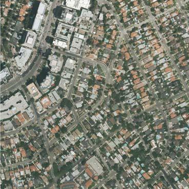
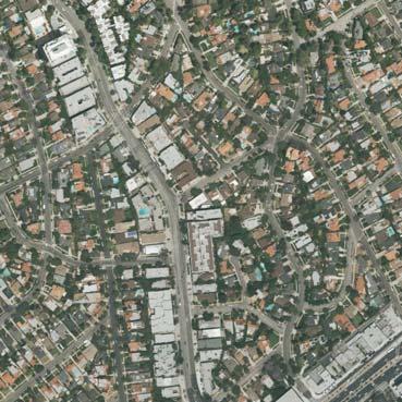

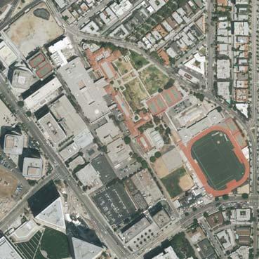

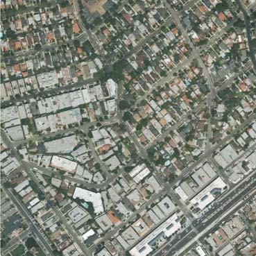
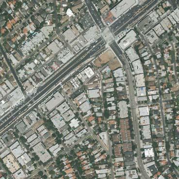
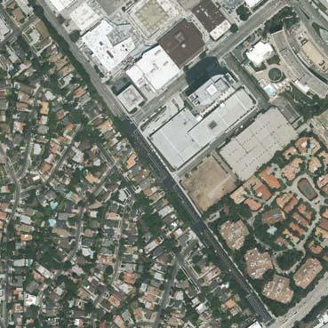
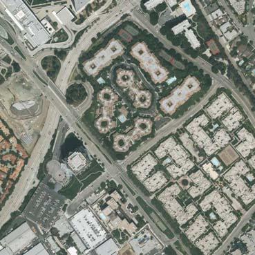
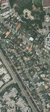
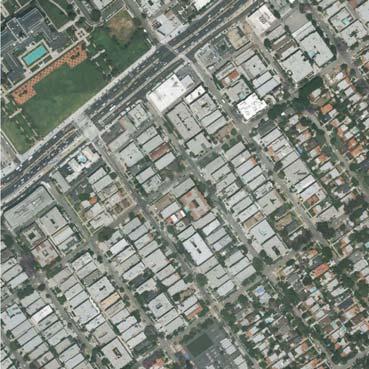
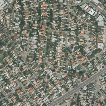
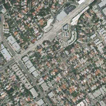
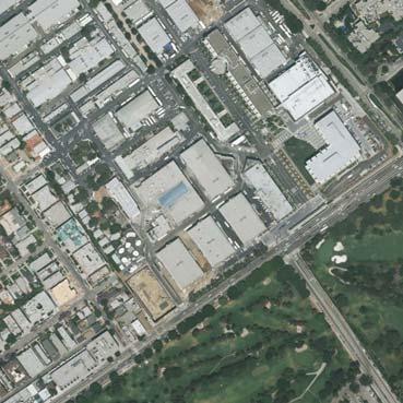
69 L I C Page Page IV.B-71 IV.B-69 Page J B Project Site D A G E F M H K Legend A Photograph Locations Source: Google Earth, Matrix Evionmental N Scale (Feet) 1500 Figure IV.B-1 Location of Selected Views

70 Page IV.B-72 Page Source: Matrix Enviromental, Figure IV.B-2 Existing View of Project Site, View A: Avenue of the Stars Southeast of Project Site

71 View B: North Corner of Avenue of the Stars and Constellation Boulevard. View C: West Corner of Avenue of the Stars and Constellation Boulevard. Source: Matrix Environmental, Page Page IV.B-73 Figure IV.B-3 Existing Views of Project Site, View B & View C


72 View D: Entrance to Westfield Shoppingtown Century City Mall on Constellation Boulevard. View E: Constellation Boulevard West of the Project Site. Source: Matrix Environmental, Page Page IV.B-74 Figure IV.B-4 Existing Views of Project Site, View D & View E

73 Page IV.B-75 Page Source: Matrix Environmental, Figure IV.B-5 Existing Views of Project Site, View F: Olympic Boulevard Southeast of the Project Site
74 View G: Santa Monica Boulevard and Beverly Glen Boulevard West of Project Site. View H: Santa Monica Boulevard and Manning Avenue West of Project Site. Source: Matrix Environmental, Page Page IV.B-76 Figure IV.B-6 Existing Views of Project Site, View G & View H
75 Page IV.B-77 Page Source: Matrix Environmental, Figure IV.B-7 Existing Views of Project Site, View I: Moreno Drive and Young Drive in the City of Beverly Hills

76 Page IV.B-78 Source: Matrix Environmental, Figure IV.B-8 Existing Views of Project Site, View J: Exterior Food Court of the Westfield Shoppingtown Century City Mall

77 Page IV.B-79 Source: Matrix Environmental, Figure IV.B-9 Existing Views of Project Site, View K: Century City Skyline from Holmby Avenue and Linnington Avenue

78 View L: Century City Skyline from Holmby Avenue and Ashton Avenue View M: Century Woods Condominium Development. Source: Matrix Environmental, Page Page IV.B-80 Figure IV.B-10 Existing Views of Project Site, View L & View M

79 Page IV.B-81 A Source: Matrix Environmental, Figure IV.B-11 Simulated View A: Avenue of the Stars Southeast of Project Site Proposed Project Option A

80 Page IV.B-80 A Source: Matrix Environmental, Figure IV.B-12 Simulated View A: Avenue of the Stars Southeast of Project Site Proposed Project Option B

81 Page IV.B-81 B Source: Matrix Environmental, Figure IV.B-13 Simulated View B: North Corner of Avenue of the Stars and Constellation Boulevard Proposed Project Option A

82 Page IV.B-82 B Source: Matrix Environmental, Figure IV.B-14 Simulated View B: North Corner of Avenue of the Stars and Constellation Boulevard Proposed Project Option B


83 Page IV.B-83 C Source: Matrix Environmental, Figure IV.B-15 Simulated View C: West Corner of Avenue of the Stars and Constellation Boulevard Proposed Project Option A

84 Page IV.B-84 C Source: Matrix Environmental, Figure IV.B-16 Simulated View C: West Corner of Avenue of the Stars and Constellation Boulevard Proposed Project Option B

85 Page IV.B-85 D Source: Matrix Environmental, Figure IV.B-17 Simulated View D: Entrance to Westfield Shoppingtown Century City Mall on Constellation Boulevard - Proposed Project Option A

86 Page IV.B-86 D Source: Matrix Environmental, Figure IV.B-18 Simulated View D: Entrance to Westfield Shoppingtown Century City Mall on Constellation Boulevard - Proposed Project Option B
87 Page IV.B-87 E Source: Matrix Environmental, Figure IV.B-19 Simulated View E: Constellation Boulevard West of the Project Site Proposed Project Option A

88 Page IV.B-88 E Source: Matrix Environmental, Figure IV.B-20 Simulated View E: Constellation Boulevard West of the Project Site Proposed Project Option B
89 Page IV.B-89 F Source: Matrix Environmental, Figure IV.B-21 Simulated View F: Olympic Boulevard Southeast of the Project Site Proposed Project Option A
90 Page IV.B-90 F Source: Matrix Environmental, Figure IV.B-22 Simulated View F: Olympic Boulevard Southeast of the Project Site Proposed Project Option B
91 Page IV.B-91 G Source: Matrix Environmental, Figure IV.B-23 Simulated View G: Santa Monica Boulevard and Beverly Glen Boulevard West of Project Site - Proposed Project Option A

92 Page IV.B-92 G Source: Matrix Environmental, Figure IV.B-24 Simulated View G: Santa Monica Boulevard and Beverly Glen Boulevard West of Project Site - Proposed Project Option B

93 Page IV.B-93 H Source: Matrix Environmental, Figure IV.B-25 Simulated View H: Santa Monica Boulevard and Manning Avenue West of Project Site - Proposed Project Option A
94 Page IV.B-94 H Source: Matrix Environmental, Figure IV.B-26 Simulated View H: Santa Monica Boulevard and Manning Avenue West of Project Site - Proposed Project Option B

95 Page IV.B-95 2 I Source: Matrix Environmental, Figure IV.B-27 Simulated View I: Moreno Drive and Young Drive in the City of Beverly Hills Proposed Project Option A
96 Page IV.B-96 2 I Source: Matrix Environmental, Figure IV.B-28 Simulated View I: Moreno Drive and Young Drive in the City of Beverly Hills Proposed Project Option B
97 Page IV.B-97 J Source: Matrix Environmental, Figure IV.B-29 Simulated View J: Exterior food court of the Westfield Shoppingtown Century City Mall - Proposed Project Option A

98 Page IV.B-98 J Source: Matrix Environmental, Figure IV.B-30 Simulated View J: Exterior food court of the Westfield Shoppingtown Century City Mall - Proposed Project Option B
99 Page IV.B-99 K Source: Matrix Environmental, Figure IV.B-31 Simulated View K: Century City Skyline from Holmby Avenue and Linnington Avenue - Proposed Project Option A
100 Page IV.B-100 K Source: Matrix Environmental, Figure IV.B-32 Simulated View K: Century City Skyline from Holmby Avenue and Linnington Avenue - Proposed Project Option B

101 Page IV.B-101 L 2 Source: Matrix Environmental, Figure IV.B-33 Simulated View L: Century City Skyline from Holmby Avenue and Ashton Avenue - Proposed Project Option A
102 Page IV.B-102 L 2 Source: Matrix Environmental, Figure IV.B-34 Simulated View L: Century City Skyline from Holmby Avenue and Ashton Avenue - Proposed Project Option B

103 Page IV.B M Source: Matrix Environmental, Figure IV.B-35 Simulated View M: Century Woods Condominium Development Proposed Project Option A

104 Page IV.B M Source: Matrix Environmental, Figure IV.B-36 Simulated View M: Century Woods Condominium Development Proposed Project Option B
IV. ENVIRONMENTAL IMPACT ANALYSIS B. AESTHETICS 1. SHADE/SHADOW
 IV. ENVIRONMENTAL IMPACT ANALYSIS B. AESTHETICS 1. SHADE/SHADOW ENVIRONMENTAL SETTING The issue of shade and shadow pertains to the blockage of direct sunlight by onsite buildings, which affect adjacent
The impacts examined herein take into account two attributes of aesthetic values:
 IV. ENVIRONMENTAL IMPACT ANALYSIS This section addresses the potential impacts to views and aesthetics as a result of the proposed Project at the Project Site and the development scenarios analyzed for
IV. ENVIRONMENTAL IMPACT ANALYSIS B. AESTHETICS 1. VIEWS
 IV. ENVIRONMENTAL IMPACT ANALYSIS B. AESTHETICS 1. VIEWS ENVIRONMENTAL SETTING Existing Visual Character Project Site The project site is located at 10250 Wilshire Boulevard in the Westwood community of
IV.B. VISUAL RESOURCES
 IV.B. VISUAL RESOURCES ENVIRONMENTAL SETTING Existing Visual Character Project Site The project site is located at 17331-17333 Tramonto Drive in the Pacific Palisades community of the City of Los Angeles
WESTSIDE SUBWAY EXTENSION PROJECT. Addendum to the Visual and Aesthetic Impacts Technical Report
 PROJECT to the Visual and Aesthetic Impacts Technical Report August 2011 Visual and Aesthetic Impacts Technical Report SUMMARY On October 28, 2010, the Metro Board selected the Westwood/VA Hospital Extension
4.0 AFFECTED ENVIRONMENT AND ENVIRONMENTAL CONSEQUENCES
 4.0 AFFECTED ENVIRONMENT AND ENVIRONMENTAL CONSEQUENCES The following sections discuss the impacts associated with environmental resources for the tunneling method Alternatives A and B. The construction
VISUAL RESOURCES 1. INTRODUCTION 2. EXISTING CONDITIONS. a. Visual Character
 IV.A VISUAL RESOURCES 1. INTRODUCTION This section addresses the potential changes in visual character that would result from implementation of the proposed Wilshire and La Brea Project. Also evaluated
Chapter 2, Section C: Urban Design and Visual Resources A. INTRODUCTION
 Chapter 2, Section C: Urban Design and Visual Resources A. INTRODUCTION This attachment considers the potential of the proposed East River Waterfront Access Project at Peck Slip to effect urban design
Urban Design Brief December 23, 2015 Southside Construction Group Official Plan & Zoning By-Law Amendment
 Urban Design Brief Proposed Official Plan & Zoning By-Law Amendment 3244, 3263 and 3274 Wonderland Road South Southside Group December 23, 2015 TABLE OF CONTENTS Page No. INTRODUCTION... 1 SECTION 1 LAND
DRAFT. October Wheaton. Design Guidelines
 October 2011 DRAFT Wheaton Design Guidelines 2 Draft - Design Guidelines - Wheaton Sector Plan Contents 04 Section 1: Introduction 06 Section 2: Context 08 Section 3: Design Guidelines 09 Goal 1: Create
Nob Hill Pipeline Improvements Project EIR
 Section 3.1 Aesthetics This section addresses the visual aspects that may affect the views experienced by the public, including the potential to impact the existing character of each area that comprises
13. New Construction. Context & Character
 13. New Construction Context & Character While historic districts convey a sense of time and place which is retained through the preservation of historic buildings and relationships, these areas continue
A. OVERVIEW OF ENVIRONMENTAL SETTING
 IV. A. OVERVIEW OF The proposed site is comprised of three parcels totaling approximately 4.24 acres, situated southwesterly of the intersection of Weyburn and Tiverton Avenues. Parcel A is 2.72 acres
3.1 Aesthetics, Light, and Glare
 3.1 3.1.1 Introduction This section describes the existing aesthetics, light, and glare setting and potential effects from project implementation on visual resources and the site and its surroundings.
Policies and Code Intent Sections Related to Town Center
 Policies and Code Intent Sections Related to Town Center The Town Center Vision is scattered throughout the Comprehensive Plan, development code and the 1994 Town Center Plan. What follows are sections
4. INDUSTRIAL 53 CASTLE ROCK DESIGN
 4. INDUSTRIAL 53 CASTLE ROCK DESIGN CASTLE ROCK DESIGN 54 4. INDUSTRIAL Overview Well-designed and attractive industrial centers are the product of blending economic realities with both functional and
B. PROPOSED REFINEMENTS POTENTIALLY AFFECTING URBAN DESIGN AND VISUAL RESOURCES
 Chapter 4: Urban Design and Visual Resources A. CONCLUSIONS OF THE FGEIS The FGEIS concluded that the Approved Plan will not result in any significant adverse impact on urban design or visual resources.
PROJECT SITE The Proposed Project includes the Allen and Pike Street malls between Delancey and South Streets (see Figure 2C-1).
.") Chapter 2, Section C: A. INTRODUCTION This chapter considers the potential of the proposed Reconstruction of the Allen and Pike Street Malls project to affect the urban design characteristics and visual
Chapter 2, Section C: A. INTRODUCTION This chapter considers the potential of the proposed Reconstruction of the Allen and Pike Street Malls project to affect the urban design characteristics and visual
AIRPORT BUSINESS PARK
 PIER MAC PETROLEUM INSTALLATION LTD. AIRPORT BUSINESS PARK DEVELOPMENT APPLICATIONS March 2003 4.1 Airport Business Park Development Permit Area 4.1.1 Justification/Design Concept The design concept envisioned
II. PROJECT DESCRIPTION
 II. PROJECT DESCRIPTION A. INTRODUCTION The Applicant, Century City Realty LLC, proposes the construction of 483 residential condominiums with associated amenities on an approximately 5.5-acre site (net
3.0 URBAN DESIGN. December 6, OVERVIEW
 Urban Design 3.0 URBAN DESIGN December 6, 2007 3.1 OVERVIEW The highly urban character of Easton Place is defined by the overall design of the community. The following sections provide an overview of the
ENVIRONMENTAL IMPACT ANALYSIS
 IV. ENVIRONMENTAL IMPACT ANALYSIS A. AESTHETICS This section addresses the potential impacts to aesthetics and views that could result from the proposed project, including development of the Add Area,
Site Planning. 1.0 Site Context. 2.0 Pedestrian Circulation Systems. Pag e 2-23
 The following photographs from throughout the country illustrate key urban design principles. Photographs are provided to illustrate the overall urban design concepts described in Chapter 1 of the Downtown
Urban Design Brief to 1557 Gordon Street & 34 Lowes Road West
 Urban Design Brief 1533 to 1557 Gordon Street & 34 Lowes Road West Reid s Heritage Homes Ltd. & 883928 Ontario Ltd. and RHH Property Management Ltd. City of Guelph Zoning By-law Amendment November 2017
ELMVALE ACRES SHOPPING CENTRE MASTER PLAN
 ELMVALE ACRES SHOPPING CENTRE MASTER PLAN Contents 1.0 INTRODUCTION... 2 2.0 LOCATION... 2 3.0 EXISTING CONTEXT... 2 4.0 VISION & GUIDING PRINCIPLES... 2 5.0 LAND USE AND BUILT FORM... 4 5.1 St. Laurent
4.1 AESTHETICS AND VISUAL QUALITY
 SCOPE AND METHODOLOGY 4.1 AESTHETICS AND VISUAL QUALITY This section evaluates the potential impacts to aesthetics and visual quality. Aesthetics refers to visual resources and the quality of what can
PLANNING RATIONALE FOR THE PROPOSED RIVERSIDE SOUTH ELEMENTARY SCHOOL 715 BRIAN GOOD AVENUE, OTTAWA, ON
 PLANNING RATIONALE FOR THE PROPOSED RIVERSIDE SOUTH ELEMENTARY SCHOOL 715 BRIAN GOOD AVENUE, OTTAWA, ON Conseil des écoles publiques de l'est de l'ontario (CEPEO) French Public School Board TABLE OF CONTENTS
Infill Residential Design Guidelines
 Infill Residential Design Guidelines Adopted March 23, 2004 Amended September 10, 2013 City of Orange Community Development Department Planning Division Phone: (714) 744-7220 Fax: (714) 744-7222 www.cityoforange.org
CHAPTER 10 AESTHETICS
 CHAPTER 10 AESTHETICS CHAPTER 10 AESTHETICS This section identifies and evaluates key visual resources in the project area to determine the degree of visual impact that would be attributable to the project.
Bel-Air Lexus Automobile Service Station
 Bel-Air Lexus Automobile Service Station Design Brief 443-447 McArthur Avenue Ottawa April 30, 2015 14-1299-MCA Site Details Application: Site Plan Control Legal Description and Municipal Addresses: 443
ARLINGTON COUNTY, VIRGINIA
 ARLINGTON COUNTY, VIRGINIA County Board Agenda Item Meeting October 15, 2005 DATE: September 28, 2005 SUBJECT: Request to Advertise the adoption of the 2005 Clarendon Sector Plan C. M. RECOMMENDATION:
Community Design Plan
 Gardena General Plan 2006 Authority While the is not a required element of a General Plan, it is included because improving the community appearance and image is paramount to the overall quality of life
ENVIRONMENTAL IMPACT ANALYSIS A. AESTHETICS 1. INTRODUCTION
 IV. ENVIRONMENTAL IMPACT ANALYSIS 1. INTRODUCTION Aesthetics, views, nighttime illumination, and daytime glare are related elements in the visual environment. Aesthetics generally refers to the identification
IV. ENVIRONMENTAL IMPACT ANALYSIS B. AESTHETICS
 IV. ENVIRONMENTAL IMPACT ANALYSIS B. AESTHETICS INTRODUCTION This section evaluates the potential impacts of the Proposed Project on aesthetics, views and vistas, light and glare, and shade and shadows
B. Blocks, Buildings and Street Networks
 B. Blocks, Buildings and Street Networks Figure IV.4 A rational block pattern with connected streets Introduction The single most important element in the physical and functional integration of mixed use
VILLAGE OF SKOKIE Design Guidelines for Mixed-Use Districts NX Neighborhood Mixed-Use TX Transit Mixed-Use CX Core Mixed-Use
 VILLAGE OF SKOKIE Design Guidelines for Mixed-Use Districts NX Neighborhood Mixed-Use TX Transit Mixed-Use CX Core Mixed-Use TABLE OF CONTENTS CHAPTER 1 SITE DESIGN Purpose 1 CHAPTER 2 SITE DESIGN Streetscape
Town Center. Block 5 Existing multifamily residential units are expected to remain.
 Area Guidelines Germantown s districts should be developed as distinct communities with unique features that are supported through the guidelines. The guidelines not only help distinguish these districts
2.0 AREA PLANS. Lakeside Business District. Lakeside Business District Land Use Categories:
 Lakeside Business District Lakeside Business District Land Use Categories: Campus Commercial Campus Commercial means a mixture of uses which includes corporate offices, office parks, hotels, commercial,
CHAPTER 3. Design Standards for Business, Commercial, Industrial, Recreational and Institutional Uses
 CHAPTER 3 Design Standards for Business, Commercial, Section Number Title Ordinance Number Date of Ordinance 16-3-1 Applicability 2006-11 2008-04 07-01-08 16-3-2 Uniform Standards for Architectural Design
Seneca Meadows. Block 4 Locate office, technology, and medical development adjacent to I Screen views of garage structures from I-270.
 Seneca Meadows Seneca Meadows has an industrial park in its southern end and a mixed-use employment area planned for the north end. The district benefits from extensive I-270 visibility, stream valley
RZC Public View Corridors and Gateways
 RZC 21.42 Public View Corridors and Gateways 21.42.010 Purpose 21.42.020 Scope and Authority 21.42.030 Administration 21.42.040 Gateways Design 21.42.050 Unidentified Public Views 21.42.060 Identification
DRAFT Northeast Quadrant of Kipling Avenue and Highway 7 DRAFT AUGUST 29, Goals Land Use. The goals of this Plan are to:
 AUGUST 29, 2017 12.15 Northeast Quadrant of Kipling Avenue and Highway 7 12.15.1 Goals 12.15.2 Land Use The goals of this Plan are to: 12.15.2.1 General Provisions: a) Ensure the development of a compact
WEST LOOP DESIGN GUIDELINES CHECKLIST
 WEST LOOP DESIGN GUIDELINES CHECKLIST Section 1.0 General Strategies 1.1 DESIGN EXCELLENCE: ENCOURAGE HIGH QUALITY AND INNOVATIVE DESIGN OF NEW BUILDINGS WITHIN THE WEST LOOP WITHOUT BEING PRESCRIPTIVE
WINDSOR GLEN DESIGN GUIDELINES
 WINDSOR GLEN DESIGN GUIDELINES Adopted by Council, 2006 WINDSOR GLEN REDEVELOPMENT DESIGN GUIDELINES August 2006 1.0 Master Plan Organization For this area of the Coquitlam Town Centre, a mix of high,
appendix and street interface guidelines
 appendix five: building and street interface guidelines appendix 5 building and street interface guidelines BOULEVARDS Boulevards are generally characterized by higher levels of traffic movement at higher
lot flankage Y street 16m 6m landscape strip for large site 3m landscape strip for small medium site
 Commercial General Commercial Objectives Create developments compatible with adjacent land uses in scale, function and character Define a consistent and attractive street edge with quality landscaping,
4.0 Design Guidelines For The Village Centre. South fields Community Architectural Design Guidelines Town of Caledon
 4.0 Design Guidelines For The Village Centre 4.0 Design Guidelines for the Village Centre The Village Centre is the focal point of the entire South Fields Community and is designed as a traditional commercial
Future Five. Design/ Development Guidelines. January 2008 Amended June 08 per City Council motion
 Future Five Design/ Development Guidelines January 2008 Amended June 08 per City Council motion 5-Points Design Guidelines Table of Contents I. Introduction 3 II. Area boundaries 4 III. Review Process
IV. ENVIRONMENTAL IMPACT ANALYSIS B. AESTHETICS 1. AESTHETICS/VIEWS
 IV. ENVIRONMENTAL IMPACT ANALYSIS B. AESTHETICS 1. AESTHETICS/VIEWS ENVIRONMENTAL SETTING Aesthetic impact assessment generally deals with the issue of contrast, or the degree to which elements of the
Los Angeles Department of City Planning RECOMMENDATION REPORT
 Los Angeles Department of City Planning RECOMMENDATION REPORT CULTURAL HERITAGE COMMISSION HEARING DATE: April 7, 2011 TIME: 10:00 AM PLACE: City Hall, Room 1010 200 N. Spring Street Los Angeles, CA 90012
County of Loudoun. Department of Planning MEMORANDUM. SUBJECT: ZMOD , Dulles North Business Park Comprehensive Sign Plan, 2 nd Referral
 County of Loudoun Department of Planning MEMORANDUM DATE: May 30, 2014 TO: FROM: Ginny Rowen, Project Manager Land Use Review Pat Giglio, Planner III Community Planning SUBJECT: ZMOD 2013-0001, Dulles
Architectural Review Board Report
 Architectural Review Board Report Architectural Review Board Meeting: February 3, 2014 Agenda Item: 7.9 To: From: Subject: Architectural Review Board Steve Traeger, Principal Urban Designer Scott Albright,
FLORIN ROAD CORRIDOR Site Plan and Design Review Guidelines Checklist
 FLORIN ROAD CORRIDOR Site Plan and Design Review Guidelines Checklist Applicant s Name: Project Address: Phone: Email: Applicant shall fill out the design guidelines checklist for all guidelines applicable
SUBCHAPTER 4-B GUIDELINES FOR THE B-3 COMMERCIAL CHARACTER AREA
 1 SUBCHAPTER 4-B GUIDELINES FOR THE B-3 COMMERCIAL CHARACTER AREA Downtown Bozeman should be the location of buildings of greatest height and intensity in the community. The following guidelines apply
Clairtrell Area Context Plan
 Clairtrell Area Context Plan March 2005 Urban Development Services City Planning Contents 1. Introduction... 4 2. Development Structure... 6 2.1 Streets... 7 2.1.1 Sheppard Avenue and Bayview Avenue...
CONTENTS 8.0 LAND USE 8.1 GENERAL LAND USE 8.2 RESIDENTIAL 8.3 MIXED USE 8.4 COMMERCIAL 8.5 EMPLOYMENT LANDS
 8-2 Land Use 8.0 LAND USE CONTENTS 8.1 GENERAL LAND USE 8.1.1 Uses provided for in all Land Use Designations 8.1.2 Uses prohibited in Hazardous Lands, Hazardous Sites and Special Policy Areas 8.1.3 Uses
IV. ENVIRONMENTAL IMPACT ANALYSIS I. LAND USE PLANNING
 IV. ENVIRONMENTAL IMPACT ANALYSIS I. LAND USE PLANNING ENVIRONMENTAL SETTING Existing Onsite Land Uses The 3.8-acre project site is located at 2055 Avenue of the Stars in the West Los Angeles community
IV. ENVIRONMENTAL IMPACT ANALYSIS
 IV. ENVIRONMENTAL IMPACT ANALYSIS A. AESTHETICS/VIEWS EXISTING CONDITIONS REGIONAL SETTING The project area (between Devonshire Street and the SR-118 freeway) is generally characterized by single-family
Visual Impact Assessment 830 Pratt Avenue St Helena, CA
 Visual Impact Assessment 830 Pratt Avenue St Helena, CA 1. Introduction The following aesthetic visual impact assessment has been prepared pursuant to the California Environmental Quality Act (CEQA). The
Yonge Eglinton Centre Urban Design Guidelines
 Yonge Eglinton Centre Urban Design Guidelines City Planning Urban Design January 2009 YONGE EGLINTON CENTRE INTRODUCTION.................................................... 1 GENERAL SITE PLAN OBJECTIVES......................................
URBAN DESIGN BRIEF. 2136&2148 Trafalgar Road. Town of Oakville
 URBAN DESIGN BRIEF 2136&2148 Trafalgar Road Town of Oakville Prepared By: METROPOLITAN CONSULTING INC For 2500674 Ontario Inc November 2016 TABLE OF CONTENTS Page No. 1.0 Introduction/Description of Subject
II. SINGLE FAMILY RESIDENTIAL
 II. SINGLE FAMILY RESIDENTIAL Castle Rock is made up of numerous individually built houses and subdivision tracts that have been developed during the past century. Some of the tracts are diverse in architectural
Table of Contents. Elm Avenue Improvement Plan City of Waco, Texas. Introduction 1. Existing Context 1 Figure 1 2.
 Table of Contents Introduction 1 Existing Context 1 Figure 1 2 Plan Guidelines 3 Future Urban Form 4 The West-End 4 Main Street 6 The East-End 7 Figure 2 9 Public Improvement Recommendations 7 General
(DC1) Direct Development Control Provision DC1 Area 4
 Direct Development Control Provision DC1 Area 4") . General Purpose (DC) Direct Development Control Provision DC Area 4 The purpose of this Provision is to provide for an area of commercial office employment and residential development in support of the
. General Purpose (DC) Direct Development Control Provision DC Area 4 The purpose of this Provision is to provide for an area of commercial office employment and residential development in support of the
Regency Developments. Urban Design Brief. Holyrood DC2 Rezoning
 Regency Developments Urban Design Brief Holyrood DC2 Rezoning Stantec Consulting Ltd. 7-31-2017 1. Overview Regency Developments intends to rezone the lands located at 8510 and 8511 93 Avenue, within the
401/Keele Provincial Campus Ontario Realty Corp.
 1.0 INTRODUCTION 1.1 Site Location and Description The study area consists of approximately 74 acres (30 ha) located in the Keele Street and Wilson Avenue area. It is bounded by Wilson Avenue to the north,
NEIGHBORHOOD 3: UNIVERSITY EDGE
 NEIGHBORHOOD 3: UNIVERSITY EDGE Aerial View of North Indiana Avenue EXISTING CHARACTER The University Edge neighborhood represents the primary town/gown interface between the campus and the city of Bloomington,
APPENDIX D: Visual and Aesthetic Conditions for NCCU Station Refinement. Durham-Orange Light Rail Transit Project
 APPENDIX D: Visual and Aesthetic Conditions for NCCU Station Refinement Durham-Orange Light Rail Transit Project October 2016 1. Introduction The Combined FEIS/ROD summarizes the effects of the D-O LRT
2. INTRODUCTION 2.1 AUTHORITY 2.2 PURPOSE AND INTENT 2.3 SITE LOCATION
 2. INTRODUCTION 2.1 AUTHORITY The City of Gardena initiated and prepared the Artesia Corridor Specific Plan pursuant to the provisions of California Government Code, Title 7, Division 1, Chapter 3, Article
4.1 Aesthetics Setting. a. Visual Character
 Environmental Impact Analysis Aesthetics 4.1 Aesthetics This section analyzes the proposed Specific Plan s impacts related to aesthetics, including the existing visual character of and scenic views in
Preci nct P l ans Figure 56 Campus Aerial Photo, 2008 CAL STATE EAST BAY, HAYWARD CAMPUS MASTER PLAN
 9 Precinct Plans This section contains a detailed discussion of the planning and design concepts for specific areas or precincts of the Cal State East Bay Hayward campus. The Precinct Plans pertain to
Metro. Activity Center Design Guidelines. Recommendations For Developing Focused, Mixed-Use Commercial/Residential Centers
 Metro Activity Center Design Guidelines Recommendations For Developing Focused, Mixed-Use Commercial/Residential Centers Metro Activity Centers What is a MAC? Legacy, the adopted guide for the future growth
New-Cast Mixed-use Development Proposal King Street West, Newcastle, Ontario
 URBAN DESIGN BRIEF New-Cast Mixed-use Development Proposal King Street West, Newcastle, Ontario TABLE OF CONTENTS: 1.0 Executive Summary 2.0 Creating Vibrant and Sustainable Urban Places: Excerpts from
Lehigh Acres Land Development Regulations Community Planning Project
 Lehigh Acres Land Development Regulations Planning Effort Summary In July, 2010 Commissioner Frank Mann invited the Lehigh Acres community to start discussing how to achieve their recently adopted community
M E M O R A N D U M PLANNING AND COMMUNITY DEVELOPMENT DEPARTMENT CITY OF SANTA MONICA PLANNING DIVISION
 M E M O R A N D U M 10-B PLANNING AND COMMUNITY DEVELOPMENT DEPARTMENT CITY OF SANTA MONICA PLANNING DIVISION DATE: April 9, 2018 TO: FROM: SUBJECT: The Honorable Landmarks Commission Planning Staff 133
Buildings may be set back to create small plazas provided that these setbacks do not substantially disrupt the street wall s continuity.
 6-22 Community Design Street Walls and Street-front Setbacks The siting of buildings will play a critical role in establishing the character and sense of place for the District. Siting buildings at the
4.9 Mendocino Avenue Corridor Plan Design Guidelines
 4.9 Mendocino Avenue Corridor Plan Design Guidelines The Mendocino Avenue Corridor Plan addresses the area between College Avenue and Steele Lane. Mendocino Avenue is a busy arterial that runs parallel
BOULEVARD AND PARKWAY STANDARDS
 88-323 BOULEVARD AND PARKWAY STANDARDS 88-323-01 PURPOSE Considerable public and private investment exists and is expected to occur adjacent to boulevards and parkways within the city. The following standards
Cha p t e r 2: Ge n e r a l De s i g n Gu i d e l i n e s
 Downtown Ann Arbor Design Guidelines Cha p t e r 2: Ge n e r a l De s i g n Gu i d e l i n e s This chapter presents general design guidelines for new site plan or PUD projects in downtown Ann Arbor. The
CITY OF MERCER ISLAND DESIGN COMMISSION STAFF REPORT
 CITY OF MERCER ISLAND DESIGN COMMISSION STAFF REPORT Agenda Item: 2 March 9, 2011 Project: Description: Applicant: DSR11-004 The applicant is requesting approval to replace the existing exterior wood framed
WESTSIDE SUBWAY EXTENSION August 13, 2010 Page 4-25
 4.0 Affected Environment There are also views to and from the south that include some of the tall buildings in Downtown LA, including the Los Angeles Metro building (Figure 4-39). Figure 4-40 shows a view
Wide asphalt driveway abutting school property. garage built with incompatible materials, too close to park. incompatible fencing materials
 Wide asphalt driveway abutting school property incompatible fencing materials garage built with incompatible materials, too close to park Lack of plantings as a buffer between private property and open
3.10 LAND USE SETTING PROJECT SITE EXISTING LAND USE DESIGNATIONS AND ZONING. General Plan Land Use Designations.
 This section of the Draft EIR addresses the existing land uses on and adjacent to the project site and discusses the potential impacts of the proposed project on existing land uses. Key issues addressed
Physical Structure. This historic image from 1882 emphasizes the dramatic topography that distinguishes Cornell s setting at the top of East Hill.
 Physical Structure The natural, agrarian and urban setting for Cornell s campus is a precious resource to protect and enhance. It has also shaped the physical structure of the campus. Buildings, roads
KANATA CENTRUM 255 KANATA AVENUE OFFICIAL PLAN AMENDMENT ZONING BY-LAW AMENDMENT
 KANATA CENTRUM 255 KANATA AVENUE OFFICIAL PLAN AMENDMENT ZONING BY-LAW AMENDMENT JUNE 2015 PREPARED BY: FOTENN Consultants Inc. 223 Mcleod Street Ottawa, ON K2P OZ8 (613) 730-5709 PREPARED FOR: Kanata
MIXED-USE ZONING DISTRICT DESIGN GUIDELINES
 MIXED-USE ZONING DISTRICT DESIGN GUIDELINES In addition to the development regulations contained in the Mixed-Use Zoning District, design guidelines are presented here to provide an added level of definition
URBAN DESIGN BRIEF Gordon Street City of Guelph. Prepared on behalf of Ontario Inc. March 25, Project No. 1507
 URBAN DESIGN BRIEF 1131 Gordon Street City of Guelph Prepared on behalf of 1876698 Ontario Inc. March 25, 2016 Project No. 1507 423 Woolwich Street, Suite 201, Guelph, Ontario, N1H 3X3 Phone (519) 836-7526
Resolution : Exhibit A. Downtown District Design Guidelines March 2003
 Resolution 03-011: Exhibit A Downtown District Design Guidelines March 2003 DOWNTOWN DISTRICT DESIGN GUIDELINES CITY OF SOUTHLAKE, TEXAS Adopted March 2003 1 DOWNTOWN DISTRICT DESIGN GUIDELINES Adopted
GENERAL PLAN CONSISTENCY ANALYSIS
 GENERAL PLAN CONSISTENCY ANALYSIS Prepared by Planning Staff 10/28/2013 APPLICABLE GOALS, POLICIES AND PROGRAMS FROM the LAND USE CHAPTER Goal LU-1 Policy LU-1.1 Policy LU-1.2 Goal LU-2 Protect the character
IV. ENVIRONMENTAL IMPACT ANALYSIS
 IV. ENVIRONMENTAL IMPACT ANALYSIS IV. ENVIRONMENTAL IMPACT ANALYSIS A. AESTHETICS AND VIEWS 1. INTRODUCTION This section analyzes the potential impacts that could result from the proposed project with
SECTION TWO: Overall Design Guidelines
 SECTION TWO: Overall Design Guidelines This section provides overall design principles and guidelines for the Gardnerville Mixed-use Overlay. They provide criteria for mixed-use places consisting of residential,
DESIGN REVIEW COMMITTEE AGENDA ITEM
 DESIGN REVIEW COMMITTEE AGENDA ITEM AGENDA DATE: AUGUST 2, 2017 TO: THRU: FROM: SUBJECT: Chair Imboden and Members of the Design Review Committee Anna Pehoushek, Assistant Community Development Director
5.1 Site Plan Guidelines
 5. Community Core Guidelines Development of the Community Core will take place by plan of subdivision and site plan approval. It will occur in a phased manner that will reflect the timing of residential
WATERFRONT DISTRICT DESIGN STANDARDS
 WATERFRONT DISTRICT DESIGN STANDARDS 20.25.080 WATERFRONT DISTRICT A. Purpose. This section is intended to implement The Waterfront District Subarea Plan by: 1. Creating a safe, vibrant mixed-use urban
Urban Design and Visual Resources
 Chapter 9: Urban Design and Visual Resources A. INTRODUCTION This chapter considers the potential for the Proposed Actions to adversely affect the urban design characteristics and visual resources of the
Wheaton CBD & Vicinity Sector Plan D E S I G N G U I D E L I N E S
 Wheaton CBD & Vicinity Sector Plan D E S I G N G U I D E L I N E S 1 a b s t r a c t This document contains the design guidelines the property owners, community members, and planners should use to implement
3.1 AESTHETICS Background and Methodology
 3.1 AESTHETICS 3.1.1 Background and Methodology 3.1.1.1 Regulatory Context The California Environmental Quality Act (CEQA) requires that project sponsors evaluate the project s potential to cause aesthetic
ELK GROVE TOWN CENTER DESIGN GUIDELINES
 ......... ELK GROVE TOWN CENTER DESIGN GUIDELINES LAGUNA RIDGE SPECIFIC PLAN... June 2008 ............ DESIGN GUIDELINES Table of Contents Contents Section A: Town Center Overview...1 A.1. Purpose and
Urban Design 9Identity
 Urban Design 9Identity URBAN DESIGN IDENTITY Urban design is about connecting people to their places through the built environment, nature, and overall urban form. Done well, it creates a memorable space
Town Center (part of the Comprehensive Plan)
") Town Center (part of the Comprehensive Plan) Mercer Island Town Center Looking North (2014) In 1994, a year-long process culminated in a set of design guidelines and code requirements for the Town Center
Town Center (part of the Comprehensive Plan) Mercer Island Town Center Looking North (2014) In 1994, a year-long process culminated in a set of design guidelines and code requirements for the Town Center