Main Street Streetscape and Open Space Improvements Master Plan. Final Report
|
|
|
- Aubrey Holland
- 5 years ago
- Views:
Transcription

 576-3650 Fax: (519)576-0121 wshearer@mhbcplan.")
1 Village of Bayfield Municipality of Bluewater Heritage Conservation District Main Street Streetscape and Open Space Improvements Master Plan Final Report Prepared by: Wendy Shearer Landscape Architect A Division of MHBC Planning Bingemans Centre Dr. Kitchener ON N2B 3X9 Phone: (519) Fax: (519) wshearer@mhbcplan.com First Issued on October 10, 2003
2 Village of Bayfield Heritage Conservation District Main St. Streetscape and Open Space Improvements Master Plan 1. Background 2. Heritage Conservation District Plan 3. Existing Conditions 3.1 On-Street Parking 3.2 Walkways 3.3 Tree Collection 3.4 Utilities and Lighting 3.5 Street Furniture Table of Contents 4. Streetscape and Open Space Improvements Master Plan 4.1 On-Street Parking 4.2 Walkways 4.3 Tree Collection 4.4 Utilities and Lighting 4.5 Street Furniture 5. Maintenance 6. Cost Estimates and Funding 7. Open Space - Clan Gregor Square 8. Public Consultation 9. Conclusion Appendix 1 - Historic Photos Appendix 2 - Existing Conditions Appendix 3 - Mapping Appendix 4 - Site Furniture Bayfield Streetscape and Open Space Master Plan Page 1
3 Village of Bayfield Heritage Conservation District Main St. Streetscape and Open Space Improvements Master Plan 1. BACKGROUND The Village of Bayfield, now part of the Municipality of Bluewater, has been an important pioneer settlement on the shores of Lake Huron since the 1830's. This long history and the unique street pattern of a wide main street leading to a public park, Clan Gregor Square, were instrumental in the establishment of a Heritage Conservation District in April The district was designated under Part V of the Ontario Heritage Act and approved by the Ontario Municipal Board. (Appendix 3 - District Boundary) The Bayfield Heritage Conservation District is one of over 50 in the province which have been established in the past 25 years on the initiative of the local community. Administration of the districts typically involves a volunteer heritage committee which consults with property owners on any significant alteration or change within the Conservation District and advises Municipal council on heritage matters. At the time of its establishment, the Village of Bayfield Heritage Conservation District was one of the first in Ontario. The Heritage District Plan prepared by Hill and Borgal contains a description of the heritage resources, both architectural and landscape, within the District boundary and general policies for their Aviability, preservation and enhancement@. The Plan contains a description of the unique history and physical qualities within the Main Street Heritage Conservation District: its variety of building types, materials and styles and the wide, tree lined streetscape with parking, grass boulevards (verges) and informal footpaths for pedestrians. The Plan also notes the increasing pressures for redevelopment as tourism activities increase. For the past 20 years, the Plan has been used to guide architectural changes and new development within the District. Within the past year however, there has been increased interest in developing a Master Plan for the streetscape and open space within the District to guide future public realm initiatives related to infrastructure upgrades. 2. HERITAGE DISTRICT PLAN At the time of the preparation of the Plan in the early eighties, the tree collection was Afull bodied and luxurious@. Other important landscape features were identified specifically as the grass boulevards and the meandering paths between the trees and the stores. The objectives for the Plan were aimed at continued upgrading and renewal of the trees and the boulevard and the retention of the mud footpaths. The Plan noted that two buildings were fronted by concrete sidewalks. Specific policies for lighting and site furniture called for a design which complements the heritage character preferably a Asuitable contemporary design@. Due to the many changes which have occurred in the District in the past 20 years, the heritage committee arranged for this Master Plan to be prepared. It would provide an updated vision for the future District as it relates to the streetscape and open space. The Master Plan was developed with input from the heritage committee, municipal staff, special interest groups, business owners and the general public. The final Master Plan reflects many of the issues raised through the consultation process balanced with heritage conservation policies. The Plan proposes an overall strategy to retain and enhance the significant heritage features identified in the original District Plan and at the same time allows for the much needed improvements to parking, walkways, Bayfield Streetscape and Open Space Master Plan Page 2
4 tree collection, lighting and other landscape features. It is intended that the Master Plan will be incorporated in the implementation planning for future improvements to the utilities and servicing infrastructure. This Plan is intended to guide the continued evolution of Bayfield to manage the changes which occur rather than freeze the village in a specific time period as a museum artifact. 3. EXISTING CONDITIONS During the past twenty years, many changes have occurred which have led to the need for a Streetscape and Open Space Master Plan. As mentioned previously, this work is intended to provide recommendations for future public work initiatives specifically relating to the infrastructure and pedestrian areas of Main Street. It is the intention that this Master Plan be based on the foundation of the policies and directions set out in the original District Conservation Plan. 3.1 On-Street Parking Twenty years ago, the Plan commented that the 120 angle parking spaces on Main Street were adequate for the existing parking demand. Today, the success of Bayfield as a tourism centre means that on any summer weekend hundreds of day visitors arrive to shop, dine and stroll the Main Street. This special market is in addition to the increased number of seasonal cottagers and year round residents who regularly visit the post office, library and other shops and restaurants on Main Street. As a result of this growing parking demand, there are frequently parking encroachments on the boulevards on the adjacent streets. Today, vehicles are encouraged to angle park on the wide shoulder by signs located along both sides of Main Street. On a busy day, cars can be seen lined on both sides of the road parked on many angles and often on the adjoining sod boulevard or gravel walkway since there are generally no curbs and the parking areas are typically gravel. There is not a clear separation between pedestrian space and vehicular space along Main Street. There is no change in surface material for the parking area to provide a visual indicator for motorists and many vehicles are unsure of where to stop pulling ahead. (Photo 6, Appendix 2) Gravel is a material that has been present on Main Street for many years and provides an informal look to the streetscape. However, problems are occurring in several locations with the grading of the parking areas causing uneven drainage. Because there are no painted lines delineating parking spaces, the capacity of the parking spaces varies significantly. When all the cars are parked parallel to each other at the preferred angle, the maximum number of cars which can park along the street is 150. In practical terms however, this maximum is rarely achieved. (Photo 5,9, Appendix 2) As a result, there is frequently parking on the adjacent residential streets and around Clan Gregor Square. The goal of the Master Plan is to increase, if possible, the number and improve the means to define each parking space on Main Street. In the long term, however, an off-site area may be required to accommodate peak parking demand. The specific problems of drainage and delineation of parking areas will be addressed in the Master Plan. In the winter time, municipal staff plow the street and parking areas piling snow at the front of the parking spaces. This provides a clearer limit to edges of the parking although it means that pedestrians have to climb over the drift or use short cuts or driveways cleared by the business owners. (Photo 4, Appendix 2) 3.2 Walkways The mud footpaths identified in the Heritage Plan have been replaced in some areas with gravel or with interlocking pavers such as at the library. Other businesses have added asphalt, Bayfield Streetscape and Open Space Master Plan Page 3
5 natural flagstone walkways, and concrete sidewalks along their frontages. There are several areas along the street which are uneven and because of the variety of materials are a challenge to visitors and residents with mobility difficulties. As well, the mud and gravel walkways pose a maintenance problem for business owners because of the material tracking into the buildings. 3.3 Tree Collection During the past 20 years, a significant change has occurred to the tree collection on Main Street. Several large, full canopied trees have been removed because of their poor condition. This has dramatically altered the character of the street decreasing the amount of shade and canopy. Many of the trees that remain are very mature and will require replacement in the near future. The trees are of a wide variety of species and ages ranging from very mature to recently planted. This pattern of having variety in the tree collection is an important part of the heritage of the Village and contrasts with the modern style of using a limited number of species as street trees to create a more uniform look. The tree species found on Main Street are: horse chestnut, silver maple, willow, sugar maple, locust, walnut, rock elm, ash, honey locust, crimson king maple, Norway maple, and Norway spruce. Many of the oldest trees tower above the buildings providing an important scale to the wide street. The variety of species adds a great deal of visual interest throughout the year. The informal parking areas have encroached on the root zones of the existing trees increasing the stress on these trees. 3.4 Utilities and Services At the present time there are underground sanitary services running along Main Street. In several localized areas there are also catch basins and storm sewers. However, there is no continuous storm drainage infrastructure in place. As well, there is no water service along Main Street. Street lighting is provided by means of streetlights generally mounted on wooden hydro poles running along the south side of the street. Overhead wires run to each building and cross the street diagonally at several locations to service the north side. Many of the large mature trees have to be pruned to reduce interference with the overhead wires. The first hydro poles and overhead wires were installed in the late 1890's and have been part of the streetscape for over a century. Many of the street light fixtures are mounted on a decorative arms extending toward the street. These street lights are incandescent with a fluted radial reflector. Other street lights are the arm mounted utility light. (Photo2, Appendix 1). There are no lights specifically illuminating the pedestrian routes along the street except where individual buildings are lit by their owners. As a result, many areas are not uniformly well lit especially where a tree canopy blocks the street light. 3.5 Street Furniture At the present time there are large wooden trash and can recycling receptacles placed along Main Street at various locations. (Photo 8, Appendix 2). There are no benches except where individual businesses have provided them at their entrances. There is a variety of ornamental fences, both wooden and iron, trimmed hedges Bayfield Streetscape and Open Space Master Plan Page 4
6 and planting boxes along the edge of the public property which significantly contributes to the inviting character of the area Other items in the boulevard include: utility boxes, transformers, signage, and one large gnarled tree stump. 4. STREETSCAPE AND OPEN SPACE IMPROVEMENTS MASTER PLAN The impact of increased pedestrian use, loss of tree canopy and increased parking demand has created the need for guidance on how to make improvements, particularly to the pedestrian environment on Main Street. The intent of the Master Plan is to accommodate the high volume of use and at the same time be sympathetic to the principles and policies of the Heritage Conservation District Plan. The goals for the Streetscape Master Plan are to: $ build on the foundation of the previous Heritage District and the significant heritage character and resources on the street $ provide a safe pedestrian environment suitable for residents and visitors with a range of mobilities including walker and wheelchair users, and those with baby strollers and other encumbrances $ increase parking capacity of the street $ provide an improved growing environment for the existing and replacement street trees $ improve street and sidewalk light levels $ ensure year round maintainability of streets, parking areas, boulevards and walkways by municipal staff and business owners $ provide enhanced street furniture; benches, bike racks, trash receptacles for the use and enjoyment of the pedestrian The overall Master Plan calls for the retention of the existing streetscape features that provide the special look to the street. These include; the wide shoulders for angle parking, the sod boulevard, two asphalt driving lanes, the existing variety of street trees and for the immediate future, the wooden hydro poles and overhead wires. The Plan also identifies new elements to be added to address specific issues such as the need for consistent pedestrian routes, improved lighting, better definition of the parking limits and the edge of the boulevard, improved drainage and enhanced street furniture. 4.1 On-Street Parking The Master Plan calls for the addition of poured concrete curbs to delineate the edge of the parking space. The 100mm (4") high curb will prevent cars from encroaching on the grass boulevard. It still allows for snow clearing of the parking space in the winter and is a vital part of improving the surface drainage of the parking areas. The poured in place concrete curb will also create islands at each end of the row of parking assisting in maintaining uniform angled parking and providing protected tree planting locations. Each parking space will be identified with a painted line on the curb which in the summertime at least will assist the drivers in parking. The end result of the use of curbs and creating additional parking west of Catherine Street is to increase the parking capacity of the street to a maximum potential of 169. The surface of the parking will remain aggregate or gravel since its texture is an important heritage feature of the street. In order to improve drainage of the parking areas, a new gutter is proposed to run along the back of each space, along the edge of the road asphalt. The purpose of this gutter is to collect the surface runoff from the gravel space and to carry it parallel to the street to the nearest catch basin. This gutter will be an important feature Bayfield Streetscape and Open Space Master Plan Page 5
7 of the redesign of the storm drainage system on the street. Since this is a new feature in the streetscape, several possible materials have been investigated. The preferred material is a type of Aporous paving@ consisting of an interlocking precast paver with the voids filled with granular material to enhance water percolation into the subgrade. This material has the environmental advantage of decreasing runoff and at the same time, its texture is complementary to the texture of the gravel parking area. The Master Plan also calls for the addition of new angle parking west of Catharine Street. This area will provide room for 13 cars. There are no residences immediately adjacent to this new parking area. On the south side of the street, the parking area ends in front of the last commercial property and is not extended further west because of the adjacent residential properties. 4.2 Walkways The provision of a continuous, safe walkway on both sides of the street is an important addition to the streetscape to increase accessibility for residents and visitors. It must provide a durable, easily maintained surface able to handle the large number of pedestrians who now visit Main Street. The layout of the walkway is to remain meandering between the property line and the sod boulevard in the location where the informal gravel and concrete sidewalks are currently located. The layout should provide adequate clearance from the existing trees to reduce the impact of new construction on their root zones. The recommended width of the sidewalk is 1.5m (5'). This width will accommodate the volume of pedestrians using the area. It is also recommended that a new sidewalk be extended from Catherine Street to Bayfield Terrace on the east side of the street to provide a clear pedestrian route to the river=s edge. Hard surface short cut linkages between the parking spaces across the grass boulevard are also recommended to focus the foot traffic on specific areas to reduce damage to the street tree root zones and the turf cover on the boulevard. The material suggested for the walkways is poured in place concrete. This material has been used historically within the Main Street area and in fact is visible in early photos across the front of the general store. Concrete is cost effective, easily installed and maintained year round, and can be replaced as necessary with a matching colour and texture. Because of the historical precedent and the above features, poured in place concrete with a light broom finish, clear curing compound (not white) and with a wide trowelled edge along the sides is recommended for the sidewalks. In lieu of mud foot paths across the boulevard, it is suggested that short narrow paths of compacted wood chips be used to link the parking with the sidewalk. An alternative material such as crushed stone that would also provide the informal character and texture of the wood chips, may be used. The use of limestone screenings is not recommended since its fine particles tend to track on the bottom of the pedestrians= feet onto the adjacent surfaces requiring more maintenance. Hardwood chips are cost effective, readily available and able to be compacted to a firm stable surface. Depending on the foot traffic, wood chip resurfacing will be necessary every 3-4 years. Other materials were investigated for walkway surfacing including asphalt, flagstone, wooden boardwalk, interlocking precast concrete pavers and limestone screenings. Limestone screenings, although very cost effective, are not recommended because of the tracking problem. Asphalt although the second least Bayfield Streetscape and Open Space Master Plan Page 6
8 expensive material does not provide the visual quality required here since it is usually associated with park trails or driveways and parking areas. It is not in keeping with the historic walkways on Main Street. Interlocking precast concrete pavers come in a variety of colours and patterns. Problems may occur if the installation of the walkways is not done properly and uneven settlement of the granular base occurs. In order to overcome this situation, many municipalities now are installing these pavers in special character areas or boutique shopping districts on a poured in place concrete base. This prevents settlement and the resulting trip hazards but has the disadvantage of adding significantly to the cost. Flagstone is a high quality material, the costliest of materials investigated but not uniform enough to provide an easily maintained surface for visitors with a range of mobility skills. There are also new products on the market which were investigated including stamped coloured poured in place concrete or stamped coloured asphalt. These new materials were considered not complementary to the traditional materials used in the District. Similarly, wooden boardwalks were discussed but their limited durability and tendency to be slippery when wet, does not fit with the goal of making a safe pedestrian environment. Therefore, after investigating many alternatives, poured in place concrete is recommended because of its economical cost, sustainability and historical precedence as a traditional material within the district. 4.3 Tree Collection The most visible component of the streetscape is the tree collection. The historic photos show that since early tree planting efforts in the 1890's, the Main Street street trees have been an important public initiative. It is recommended that the diverse mix of species currently found on the street be continued. Existing trees should be maintained and new trees should be added in the new locations created by the defined edge to the boulevard and the parking area islands. Recommended street trees include sugar maple, linden, horsechestnut, walnut, silver and red maple, ash (in small quantities because of potential pest problems), locust and disease resistant elm such as Delaware, Homestead or Pioneer varieties. Norway maple varieties are not recommended since they have adverse affect on adjacent natural areas because of their invasiveness. The location of new trees should be selected so that there are no conflicts with overhead wires. This will reduce future maintenance requirements. Shredded bark mulch saucers may be added at the root zone of both existing trees and at new tree installations to prevent soil compaction caused by foot traffic and to reduce bark damage caused by wire or string weed trimmers. The large tree stump on the boulevard if it is sound, has the potential to be carved into a unique street feature. If it is not sound it should be removed and a new tree planted in its location. 4.4 Utilities and Lighting Upgrading and installation of future underground services will provide an opportunity to make improvements to the streetscape as part of the reconstruction work. Improvements to storm drainage should be planned to ensure the pedestrian routes and parking areas are well drained with no standing water. As described earlier, there is no specific pedestrian lighting on Main Street. Bayfield Streetscape and Open Space Master Plan Page 7
9 Improvements to the street lighting should be undertaken to deliver the necessary light levels for vehicular traffic. The illuminating Engineering Society of North America has produced a document, RP-8 for Roadway Lighting which provides current standards for vehicular traffic based on road classification. Their organization has also produced a document containing guidelines for lighting for Walkway and Class I Bikeways, ADG-5-94". It is used by municipalities to guide pedestrian lighting improvements across North America. In general, new lighting fixtures should be high intensity discharge or HID, which are energy efficient, deliver high light output and have a long life. The most energy efficient lights are high pressure sodium which cast a soft orange light and is typically used on streets. Metal halide light is also frequently used and although not as long lived, it is energy efficient and delivers a light with accurate colours. Metal halide lighting is recommended for the pedestrian area because it casts a truer coloured light on vegetation and pedestrians. The spacing and height of the street lights will be determined by the relevant standards. For the walkways, the opportunity exists to add a set of shorter poles, 5m in height to direct light on the pedestrian routes. The pedestrian lighting design should be designed to ensure that there are no dark spots between the light poles. These pedestrian poles should have reflectors to ensure that light is directed on the sidewalk and reduce glare to the adjacent buildings. The existing street lights consisting of the arm and decorative reflector could be reused in special areas such as beside the archives. 4.5 Street Furniture Street furniture adds a level of interest and visual detail to the street yet is not usually a permanent alteration to the street=s infrastructure. Since these items are frequently vandalized or damaged as a result of heavy use, they are changeable features. For this reason, durability, resistance to skateboarders or vandalism, and convenience is of key importance. Appendix 3 contains suggestions for appropriate new benches, planters, signage and bike racks. 5. MAINTENANCE The day to day maintenance of the streetscape is a result of a combination of efforts by both municipal staff and the adjacent business owners. Garbage collection and snow clearing of the parking areas and street is done by municipal crews. Individual business owners look after clearing snow on their walks and in the summer season, they look after the care and cleaning up of their frontages. The implementation of the Streetscape Master Plan will require maintenance of the sod boulevard in addition to regular monitoring and maintenance of the short cuts and parking areas to correct any drainage problems caused by wear and settlement. In the other villages of the Municipality of Bluewater, the boulevard grass cutting is done by municipal staff. As the Bayfield Streetscape is constructed it will require incorporation in the overall maintenance planning by the municipal staff. In most municipalities, property owners are allowed to undertake boulevard landscaping to enhance their properties on the understanding that it may be disturbed by municipal projects for servicing or repairs. This improvement activity may be encouraged in Bayfield since it would greatly enhance the pedestrian environment. In addition, wooden planter boxes may be added which will complement the existing wooden trash receptacles on the street. The use of planters filled with colourful annuals, grasses and perennials in the summer Bayfield Streetscape and Open Space Master Plan Page 8
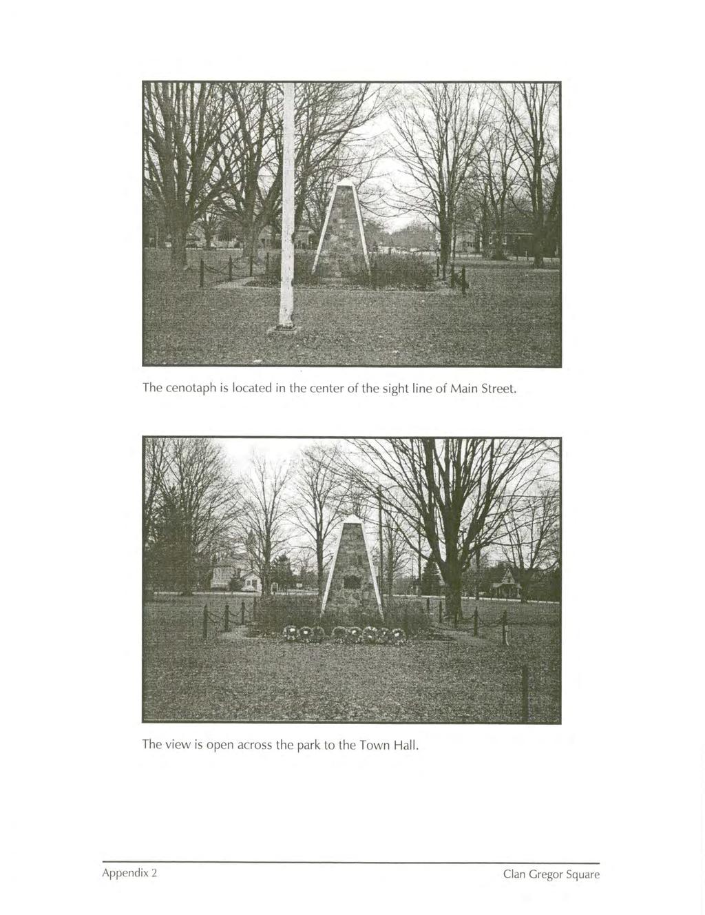
10 and evergreen boughs in the winter will add seasonal colour and interest to the street. COST ESTIMATES AND FUNDING Implementing the streetscape improvements as a stand alone project is not recommended. Because of the potential large scale infrastructure construction of water and storm sewers which will be planned and constructed in the next few years, it is preferable to complete the enhancements as part of the restoration of the road allowance disturbed as part of the construction. This will mean that the work will only be done once and it will not have to be repaired or restored if damaged by work on the underground utilities. Furthermore, the cost of many parts of the streetscape such as the curb and gutter will be part of the storm water servicing work. The addition of a new continuous concrete sidewalk in lieu of restoring the gravel walks, a new sod boulevard, new street trees and new site furniture is included in the following cost estimates. New walkway lighting has also been included. Not included is work on the asphalt road surface. (G.S.T. extra, 2003 prices). $ concrete sidewalks on granular base $80,000 $ sod boulevard & paths $18,000 $ concrete curbs $38,000 $ interlocking paving stone gutter $35,000 $ regrading granular parking areas $48,000 $ street trees $20,000 $ site furniture ie. benches, planters and bike racks $15,000 Sub-total: $254,000 $ pedestrian lighting $115,00 Funding for municipal infrastructure projects is not currently available. However, there may be funds available in the future which would enable the municipality to proceed with the design and construction of the water and sanitary servicing on Main Street. 7. CLAN GREGOR SQUARE The original layout of the pioneer settlement of Bayfield is unique in the province. At various times the park at the end of Main Street contained the Village weigh scale and was used as grazing land. The original park improvement plan included seeding and the planting of several trees in the 1880's - maple, elm and locust. An early photo shows the linear layout of the trees which is still a significant part of the park=s special appeal. Over the past decades, other improvements have been made to the park. Today, the park is a balance of open space and shady canopy, the cenotaph and flagpole, and commemorative items such as the Lioness= Gazebo, the Loyal Orange Lodge Cairn and the surveyors bench mark from which all of Bayfield was surveyed. Over the years, playground equipment has been added and the perimeter has been defined with wooden bollards to prevent parking from encroaching on the site. The key heritage features of the park which should be respected in any future plans for improvement are: the linear alignment of deciduous trees around the perimeter and diagonally across the park, the central cenotaph area, the open space within each half of the park, the open view across the park (particularly the view from the end of Howard Street to the historic Church on Highway 21 identified in the original Heritage Conservation District Plan) and the overall informal, passive qualities of Clan Gregor Square. Bayfield Streetscape and Open Space Master Plan Page 9
11 There are many issues to be taken into consideration in planning any enhancements to Clan Gregor Square. One issue is the placement and species mix of trees in the park. It is highly recommended that deciduous trees from the original plant list such as sugar maple, elm selected from the new disease resistant varieties and locust be planted. New trees should infill the rows of historic trees around the perimeter and diagonally across the park leaving the open space. Any planted coniferous trees are not recommended because current park planning concerns for public safety and security means that there should be no places in the park screened from public view. This typically means that conifers should be limbed up 1.2m (4') from the ground. This allows full visibility but it also significantly alters the form and beauty of the tree. Current thinking on municipal park planning is guided by Crime Prevention Through Environmental Design principles. For information about this see A second issue is playground equipment and safety surfacing requirements. The Canadian Standards Association has issued CAN/CSA-Z (revised) for Children=s Playspaces and Equipment which sets the requirements for both the equipment and its setting to ensure it provides a safe play experience for children. The location of play equipment should allow for the required clearances and non-encroachment zones around the equipment. As well, the requirement for mm depth safety surfacing below the equipment such as sand, Awood carpet@ or pea stone usually means a perimeter edging of 300 to 400mm depth as required. Installation of the play equipment surfacing and edging should be planned so as to minimize the disturbance to the root zones of the existing trees. In order to improve barrier free access to the central area of the park, a new walkway is recommended from the end of Main Street. This will provide a firm dry route for the park visitor to the commemorative area around the cenotaph. The remainder of the parkland may be made more accessible by topdressing the uneven turf areas with a thin layer of topsoil (under 50mm) and overseeding it preferably in later summer - early fall for good turf establishment. Tree planting and new benches are additions to the park which may be donated by community groups or individuals. Many communities have donor programs for their parks and feature areas. There are many ways to incorporate donor recognition in a park from plaquing directly on an item to having a centrally located sign board listing all donors. One advantage of a central plaque is that there are fewer items in the park which may be vandalized or damaged. A central donor board with a key plan locating each tree or bench allows for the donor and the community to easily identify the variety of contributions that have gone into the park. 8. PUBLIC CONSULTATION A community meeting was held on June 11, 2003 as part of the preparation of this Master Plan. The meeting was attended by approximately 130 people. There was an opportunity to review and comment on the preliminary plans for the Streetscape. Three different points of view were expressed at the meeting. One suggestion was the Ado nothing@ opinion which basically stated that the existing condition was acceptable and no improvements are required. The second suggestion was to add a streetscape treatment which would clearly define the area as a boutique shopping area similar to Elora, St. Jacobs or Niagara-on-the-Lake. This would involve adding new ornamental lighting, interlocking precast concrete pavers for sidewalks, uniform planting of street trees and decorative street furniture. Bayfield Streetscape and Open Space Master Plan Page 10
12 The third set of comments were put forward by residents who agreed with the need to upgrade the streetscape in terms of improving the parking and walkways but who were also concerned about retaining the special heritage character of the Main Street. At the meeting, comment sheets were available and a total of 16 written forms were received. At the meeting, the next steps of the process were described. The Master Plan will be reviewed by the heritage committee and forwarded to Council. It is intended that the recommendations be incorporated in the long term planning for the public infrastructure improvements and that as the detailed engineering plans are developed the streetscape features be added. 9.0 CONCLUSION The long and unique history of the Village of Bayfield is visible in the heritage features of Main Street and Clan Gregor Square. The Heritage Conservation District Plan established 20 years ago set out a process to manage changes in the Village to the built form. The Main Street Streetscape and Open Space Master Plan complements the original plan and provides a direction for improvements to street features for accessibility and maintainability. These changes may be efficiently implemented in the future as part of the infrastructure upgrades to water and storm sewers undertaken by the Municipality of Bluewater. Bayfield Streetscape and Open Space Master Plan Page 11
13

14

15

16
17
18
19
20
21
22
23
24
25

26
27
28
29
30
31
32
33
34
35
36
37
38
39
40
VEHICULAR AND PEDESTRIAN CIRCULATION
 This perspective sketch communicates the intended character and quality of a proposed streetscape design. Locate benches near a major intersection where people tend to gather. Seating and lighting provide
Main Street Reconstruction From Ninth Line to Stouffer Street. Town of Whitchurch-Stouffville. Public Information Centre
 Main Street Reconstruction From Ninth Line to Stouffer Street Town of Whitchurch-Stouffville Public Information Centre November 23, 2016 4:30 to 6:00 pm & 7:00 to 8:00 pm 6240 Main Street, Stouffville
The open space system should provide connective elements, relate to natural resources, and enhance the suburban character of the landscape..
 The open space system should provide connective elements, relate to natural resources, and enhance the suburban character of the landscape.. Mixed-use and infill development should maintain or enhance
CARVER COUNTY DIVISION OF PUBLIC WORKS LANDSCAPE POLICY. Adopted by the Carver County Board of Commissioners March 3, 2015
 CARVER COUNTY DIVISION OF PUBLIC WORKS LANDSCAPE POLICY Adopted by the Carver County Board of Commissioners March 3, 2015 Policy Statement Goals It is the goal of Carver County Public Works to provide
Design Guidelines and Standards for Sight Triangles. Sight Triangle MANUAL
 Design Guidelines and Standards for Sight Triangles Sight Triangle MANUAL Table of Contents 1.0 Introduction..............................................7 1.1 Key Terms..............................
3.13. Development Guidelines
 3.3 Landscaping Elements Landscaping should be used to frame and soften structures, define site functions, enhance the quality of the environment, and screen undesirable views. Safety, environmental impacts,
GUIDELINES FOR PERMEABLE SIDEWALK-LANDSCAPING PERMIT
 GUIDELINES FOR PERMEABLE SIDEWALK-LANDSCAPING PERMIT Green spaces are vital to San Francisco s quality of life as they provide a range of environmental benefits and bring beauty to our neighborhoods and
Design Guidelines for the Route 30 Corridor Master Plan: Subdivision and Land Development Elements
 Design Guidelines for the Route 30 Corridor Master Plan: Subdivision and Land Development Elements East Whiteland Township- Chester County, PA Prepared by: Draft: May 7, 2018 Design Guidelines for the
Streetscape Patterns. Design Guidelines, Ridgewood Village Center Historic District, Ridgewood, N.J. page 20
 North Broad Street has a unique streetscape pattern with broad curving street, tight enclosure on the east side with attached commercial buildings aligned with the sidewalk, and landscaped open space on
Wayfinding. North Gateway: Integrate a vertical gateway marker on the west side of Ward Street at the south corner of Vernon Street.
 3.3.6.2 Wayfinding Existing Conditions Wayfinding signage is important to direct visitors and tourists to different locations in the downtown. A significant part of the wayfinding signage in the downtown
Gas Stations ottawa.ca
 Urban Design Guidelines for Gas Stations ottawa.ca Ce document est disponible en français sur ottawa.ca. This document is available in French on ottawa.ca. Approved by City Council May 24, 2006 City of
BUFFERS, TREE PROTECTION AND LANDSCAPING. Sec Purpose and Intent.
 ARTICLE 20 BUFFERS, TREE PROTECTION AND LANDSCAPING Sec. 20.1. Purpose and Intent. Trees improve air and water quality, reduce soil erosion, reduce noise and glare, provide habitat for desirable wildlife,
STANDARD SPECIFICATIONS Book 2 ENGINEERING DRAWINGS INCLUDES ADDENDUMS
 STANDARD SPECIFICATIONS Book 2 ENGINEERING DRAWINGS INCLUDES ADDENDUMS July 23, 2018 Page 1 of 7 STANDARD LEGEND SYMBOLS (September, 1973)... AS-101A STANDARD LEGEND SYMBOLS (September, 1973)... AS-101B
THE CORPORATION OF THE MUNICIPALITY OF BLUEWATER SPECIAL COUNCIL MEETING AGENDA MONDAY, AUGUST 13, :00 p.m. BLUEWATER COUNCIL CHAMBERS
 THE CORPORATION OF THE MUNICIPALITY OF BLUEWATER SPECIAL COUNCIL MEETING AGENDA MONDAY, AUGUST 13, 2012 7:00 p.m. BLUEWATER COUNCIL CHAMBERS 1. ROLL CALL and CALL TO ORDER 2. INTRODUCTION OF ADDITIONAL
Landscaping Standards
 CHAPTER 29 ARTICLE 403 29.403 Landscaping Standards Purpose: The purpose of this section is to protect and promote the public health, safety and general welfare by requiring landscaping in relation to
5.1.1 The streetscape along US Highway 64 (Brevard Road); and, The built environment within new residential developments; and,
; and, The built environment within new residential developments; and,") Article 5. Landscaping 5.1 Purpose The Town of Laurel Park s landscape standards are designed to create a beautiful, aesthetically pleasing built environment that will complement and enhance community
Article 5. Landscaping 5.1 Purpose The Town of Laurel Park s landscape standards are designed to create a beautiful, aesthetically pleasing built environment that will complement and enhance community
THE CITY OF VAUGHAN BY-LAW BY-LAW NUMBER
 THE CITY OF VAUGHAN BY-LAW BY-LAW NUMBER 123-2013 A By-law to designate the whole of the City of Vaughan as a Site Plan Control Area, and to adopt site development guidelines and rules of procedure for
City of Sheridan Landscape Plan Checklist
 Included? Section 1. Exemptions - Landscape Plan not Applicable (Sec. 56-512) 1. Single family dwellings, attached and detached, are exempt from landscape regulations and from providing landscape plans.
Toronto Complete Streets Guidelines
 Toronto Complete Streets Guidelines 108 110 7.1 Green Infrastructure Design Principles 112 7.2 Context-Sensitive Green Streets 114 7.3 Key Green Street Elements Green infrastructure refers to natural and
CHAPTER 4: GENERAL LANDSCAPING STANDARDS 4.1 ALL PLANT STOCK 4.2 TREES
 CHAPTER 4: GENERAL LANDSCAPING STANDARDS This chapter describes plant material minimum standards that apply to landscaping both on private property (on-site) and within the public right-of-way (off-site).
COMPLETE GREEN STREET CHECKLIST
 COMPLETE GREEN STREET CHECKLIST This document was developed to dissect the structure of an urban street and explore opportunities to make our streets more complete while also integrating green street strategies.
DRAFT. 1. General Purpose. 2. Area of Application. 3. Uses CLIFTON PLACE AREA A DC2 (DRAFT)
") CLIFTON PLACE AREA A DC2 () May 1, 2017 1. General Purpose To accommodate a high rise, high density residential Tower and podium that will accommodate a potential mix of commercial and residential uses,
CLIFTON PLACE AREA A DC2 () May 1, 2017 1. General Purpose To accommodate a high rise, high density residential Tower and podium that will accommodate a potential mix of commercial and residential uses,
COUNCIL POLICY. 1. Removals. a) Dead or Hazardous Trees
 Dead or Hazardous Trees") COUNCIL POLICY SUBJECT: BOULEVARD TREE POLICY DATE: MARCH 14, 1988 REFERENCE: 88/CW Revised: June 27/88, Jan. 2/90, Jan. 27/92, Jan. 4/93, March 15/93, Jan. 17/94 1. Removals a) Dead or Hazardous Trees
COUNCIL POLICY SUBJECT: BOULEVARD TREE POLICY DATE: MARCH 14, 1988 REFERENCE: 88/CW Revised: June 27/88, Jan. 2/90, Jan. 27/92, Jan. 4/93, March 15/93, Jan. 17/94 1. Removals a) Dead or Hazardous Trees
LANDSCAPE ORDINANCE 1. LANDSCAPE PLAN REVIEW REQUIREMENTS
 LANDSCAPE ORDINANCE PURPOSE A. The purpose of this chapter is to protect and promote the public health, safety, general welfare and beautification through the City of Kalispell s authority to regulate
HUNTSVILLE PHYSICAL SERVICES DEPARTMENT
 HUNTSVILLE PHYSICAL SERVICES DEPARTMENT URBAN DEVELOPMENT SITE PLAN CONTROL DRAWING DESIGN GUIDE April, 2000 (Revised June, 2003) TABLE OF CONTENTS Part A. General Information Page 1 Part B. Site Servicing
PART TWO: PROJECT SPECIFIC DESIGN GUIDELINES
 PART TWO: PROJECT SPECIFIC DESIGN GUIDELINES 2.1.0 GENERAL REQUIREMENTS: 1. Approved warm season turf varieties shall be used for LMD/CFD, commercial, industrial, and public landscape areas. The use of
West Dennis Center: Bass River to Old Main Street. West Dennis Business District: Old Main Street to Dennis Commons
 West Dennis Center: Bass River to Old Main Street West Dennis Business District: Old Main Street to Dennis Commons Dennisport Center: Dennis Commons to Division Street Main Street Project Goals Project
2.5 Roads. Loading and service areas adjacent to Highway 401 should be screened through architectural walls and/or landscape buffer planting.
 N HIGHWAY OFF RAMP 2.5 Roads A legible road network with a clear hierarchy will help create a connected community, both within and surrounding the Milton Heights. The following section outlines the proposed
11.0. Design Manual: Sustainable Initiatives. Chapel Hill Streetscape and Lighting Master Plan mikyoung kim design all rights reserved.
 11.0 Design Manual: Sustainable Initiatives 2008 mikyoung kim design all rights reserved. Chapel Hill Streetscape and Lighting Master Plan 109 110 Chapel Hill Streetscape and Lighting Master Plan DESIGN
AIRPORT BUSINESS PARK
 PIER MAC PETROLEUM INSTALLATION LTD. AIRPORT BUSINESS PARK DEVELOPMENT APPLICATIONS March 2003 4.1 Airport Business Park Development Permit Area 4.1.1 Justification/Design Concept The design concept envisioned
TREE GUARDS AND EDGING
 CUSTOM BENCHES TREE GUARDS AND EDGING DETECTABLE WARNING PLATES Custom Bench with Rail Spikes (inset into concrete, wood bench seat) Custom Bench with Rail Wheel (inserted into end of bench) Tree guards
Bylaw A Bylaw to amend Bylaw 12800, as amended, The Edmonton Zoning Bylaw Amendment No. 2239
 Bylaw 17672 A Bylaw to amend Bylaw 12800, as amended, The Edmonton Zoning Bylaw Amendment No. 2239 WHEREAS City Council at its meeting of February 22, 2001, gave third reading to Bylaw 12800, as amended;
CHAPTER 8 LANDSCAPE REGULATIONS
 CHAPTER 8 LANDSCAPE REGULATIONS Section 8.01 Intent. Landscaping is an essential element of the site design process, and is an important feature in promoting the public health, safety, comfort, general
Building Great Neighbourhoods LAURIER HEIGHTS
 Building Great Neighbourhoods LAURIER HEIGHTS Building Great Neighbourhoods Building Great Neighbourhoods (BGN) is a longterm framework that coordinates and integrates the efforts of three City of Edmonton
ARTICLE 27 CORRIDOR OVERLAY DISTRICTS
 Section 2701 - PURPOSE ARTICLE 27 HIGHWAY 52 CORRIDOR OVERLAY DISTRICT First Reading: 9-1-2015 Second Reading: 10-6-2015 Adoption: 11-7-2015 Yankton County offers one of the most scenic drives in South
E. Natural areas include habitats such as wetlands, tidal marshes, waterways, natural drainage-ways, woodlands and grassland meadows.
 Adopted November 1999 I. Purpose A. The purpose of these guidelines is to assist in the design and layout of open space, as provided on developed lots within the District. The intent of these guidelines
Chapel Hill LUMO Topic Revisions
 Chapel Hill LUMO Topic Revisions Sec. 5.9. Parking and Loading... 022 5.9.9. Parking Landscaping cumulatively, landscaping is required for both the existing parking lot and the new parking area. A. General
City of Aurora Planning Department DESIGN STANDARDS FOR MOTOR VEHICLE FUEL DISPENSING STATION. August 3, 1998
 City of Aurora Planning Department DESIGN STANDARDS FOR MOTOR VEHICLE FUEL DISPENSING STATION August 3, 1998 1. GENERAL PURPOSE AND APPLICABILITY The following design standards for motor vehicle fuel dispensing
The standards of this Article are considered the minimum necessary to achieve these purposes.
 ARTICLE 11 LANDSCAPING, SCREENING AND BUFFERING Section 11.01 Purpose. Landscaping, greenbelts, screening and land use buffers are necessary for the protection and enhancement of the environment, and for
CENTRAL PARK LANDSCAPE DESIGN GUIDELINES
 CENTRAL PARK LANDSCAPE DESIGN GUIDELINES 1 of 9 2008 revised draft SUMMARY STATEMENT The City of Bel Aire is undertaking an ambitious transformation, developing a new city centre, with mixed use and a
The planning and zoning board considered amending the zoning code to address plantings and alteration of the swale.
 MIAMI SHORES DEPARTMENT OF PLANNING & ZONING 10050 NE 2 nd Avenue Miami Shores FL 33037-2304 www.miamishoresvillage.com David A. Dacquisto AICP, Director Main Number: 305-795-2207 Fax Number: 305-756-8972
Multi family Residential Development Permit Area
 City of Kamloops KAMPLAN Multi family Residential Development Permit Area PURPOSE The purpose of this Development Permit Area (DPA) is to establish objectives and provide guidelines for the form and character
Grafton Street < N September 2, 2015
 Grafton Street < N September 2, 2015 Project Background, Site Inventory + Analysis Brunswick Street Duke Street Scotia Bank Centre Carmichael Street Argyle Street City Hall Grand Parade Barrington Street
Official Community Plan Bylaw No. 4360, 2004, Amendment Bylaw No. 4897, 2016 (Sewell s Landing)
") District of West Vancouver Official Community Plan Bylaw No. 4360, 2004, Amendment Bylaw No. 4897, 2016 (Sewell s Landing) Effective Date: 1089612v1 District of West Vancouver Official Community Plan Bylaw
District of West Vancouver Official Community Plan Bylaw No. 4360, 2004, Amendment Bylaw No. 4897, 2016 (Sewell s Landing) Effective Date: 1089612v1 District of West Vancouver Official Community Plan Bylaw
BUSINESS DISTRICT DESIGN GUIDELINES
 Des Plaines, Illinois Prepared for the City of Des Plaines by: The Lakota Group Laurie Marston, AICP March 2005 Section 5: Streetscape Elements Business District Design Guidelines STREETSCAPE ELEMENTS
GYPSUM PARKWAY CORRIDOR ENHANCEMENT Gypsum, Colorado. Schematic Design January 2015
 GYPSUM PARKWAY CORRIDOR ENHANCEMENT Gypsum, Colorado Schematic Design January 2015 1 2 3 4 5 6 7 8 9 DESIGN WORKSHOP Landscape Architecture Land Planning Urban Design Tourism Planning Asheville Aspen Austin
CHAPTER 3. Design Standards for Business, Commercial, Industrial, Recreational and Institutional Uses
 CHAPTER 3 Design Standards for Business, Commercial, Section Number Title Ordinance Number Date of Ordinance 16-3-1 Applicability 2006-11 2008-04 07-01-08 16-3-2 Uniform Standards for Architectural Design
Hidden Pointe Landscape Master Plan. June, archi terra
 Hidden Pointe Landscape Master Plan June, 2006 t h e archi terra g r o u p 1 Table of Contents Background Purpose and Goals of the Master Plan Master Plan Process Existing Conditions Entrance Hidden Pointe
MIAMI 21 PUBLIC HEARING-FIRST READING 2009
 General Principles Public access waterfront walkways shall: 1. Feel public. No one should feel as if he or she is intruding on private property. The public should feel welcome and at ease to move along
3.0 master plan concept
 3.0 master plan concept 3.1 introduction The purpose of the Huron Church Road Master Plan Concept is to provide an overview of the Master Plan design process, identify preliminary streetscape installations
PUBLIC RIGHT-OF-WAY IN THIS CHAPTER PUBLIC REALM
 PUBLIC RIGHT-OF-WAY This section provides design guidelines for improvements in the public right-of-way. The public right-of-way refers to streets, sidewalks, non-vehicular thoroughfares, parks and greenways
SUBCHAPTER 4-B GUIDELINES FOR THE B-3 COMMERCIAL CHARACTER AREA
 1 SUBCHAPTER 4-B GUIDELINES FOR THE B-3 COMMERCIAL CHARACTER AREA Downtown Bozeman should be the location of buildings of greatest height and intensity in the community. The following guidelines apply
LANDSCAPE ORDINANCE PASADENA PLANNING DEPARTMENT (713) FAX (713)
 FAX (713)") LANDSCAPE ORDINANCE PASADENA PLANNING DEPARTMENT (713) 475-5543 FAX (713) 477-1072 ARTICLE X. LANDSCAPING OF NONRESIDENTIAL SITES* Sec. 9-195. Applicability. (a) This article shall apply to the following:
LANDSCAPE ORDINANCE PASADENA PLANNING DEPARTMENT (713) 475-5543 FAX (713) 477-1072 ARTICLE X. LANDSCAPING OF NONRESIDENTIAL SITES* Sec. 9-195. Applicability. (a) This article shall apply to the following:
City of Kelowna Consolidated Zoning Bylaw No. 8000
 Section 7 Landscaping and Screening 7.1 Required Landscaping 7.1.1 The minimum level of landscaping required in each zone along all front, rear and side yards shall be determined from the Minimum Landscape
Improve the appearance of off-street parking areas, vehicular use areas, and property abutting public and private roads;
 Bedford Township, MI (Monroe Co.) 2012 http://library.municode.com/index.aspx?clientid=02123 400.1907 - Landscaping and screening. Se 1907. 1. Intent. Landscaping, greenbelts, and screening are necessary
Appendix D North Road/N. Leroy Street Subarea Plan
 North Road/N. Leroy Street Subarea Plan INTRODUCTION The City of Fenton Master Plan was updated in 1996 and included a subarea plan for the North Leroy Street area of the City. It was recognized at that
City of Farmington. Downtown Plan. Amendment to the 1998 Master Plan Adopted October 11, 2004
 City of Farmington Amendment to the 1998 Master Plan Adopted October 11, 2004 Introduction Planning Background 1 Scope and Components of the Plan Amendment 2 Concept Introduction 3 Plan Concepts 3 Conceptual
GREENING THE BOULEVARD Master Plan Concepts for Venice Boulevard between Lincoln and Sawtelle
 GREENING THE BOULEVARD Katherine Spitz Associates Inc. 4212½ Glencoe Avenue Marina Del Rey, CA 90292 310 574 4460 Fax 574 4462 January 2008 Table of Contents Overview Proposed Design Improvements Illustration
Landscape Design Guidelines
 Section 7: Landscape Design Guidelines seven section Landscape Design Guidelines Following are landscape guidelines specific to Milledgeville. This section provides guidance to property owners and the
F. Driveways. Driveways which provide access to off-street parking or loading from public streets shall comply with the following:
 Section 20.945.040 General Design Standards for Surface Parking Areas. A. Review Authority. Parking lot design and drainage shall be subject to review and approval of the City Transportation Manager. B.
Jewel. Platte. of the. Plattsmouth Main Street Landscape Architecture by HDR
 Jewel of the Platte Plattsmouth Main Street Landscape Architecture by HDR Plattsmouth, Nebraska is a historic community of 6,500 residents located along the west bank of the Missouri River, just south
DRAFT DESIGN GUIDELINES
 IHZ Booklet #7 May 6, 2010 DRAFT DESIGN GUIDELINES CANTERBURY 7 Overview During the recent planning process for the Plan of Conservation and Development community character was identified as an important
I. VISUAL/AESTHETICS/NEIGHBORHOOD CHARACTER. b. Existing Conditions Views from Kimball Avenue
 I. VISUAL/AESTHETICS/NEIGHBORHOOD CHARACTER 1. Existing Conditions a. View Of The Site From Area Roads Figures IV.I-2, I-3 and I-4 depict existing views from the Cross County Parkway, Central Park Avenue,
Landscape and fencing requirements of this Chapter shall apply to all new landscaped areas.
 Chapter 19.06. Landscaping and Fencing. Sections: 19.06.01. Purpose. 19.06.02. Required Landscaping Improvements. 19.06.03. General Provisions. 19.06.04. Landscaping Plan. 19.06.05. Completion of Landscape
APPLICATION BRIEFING Prepared For: Submitted by: Date: Subject:
 Planning & Development APPLICATION BRIEFING Prepared For: Submitted by: Date: Subject: Planning Advisory Committee Jason Fox, Director of Planning & Development Development Agreement application by Godfrey
ROME WATERFRONT VILLAGE PROJECT NARRATIVE January 25, 2018
 January 25, 2018 The Rome Waterfront Village project is intended to foster the revitalization of the area between South James Street and Erie Boulevard north of the Erie Canal as well as improve public
CITY OF KITCHENER CONDITIONS REQUIRED FOR ISSUANCE OF SITE PLAN APPROVAL
 CITY OF KITCHENER CONDITIONS REQUIRED FOR ISSUANCE OF SITE PLAN APPROVAL The following is a list of conditions requiring completion to the City s Satisfaction prior to Site Plan Approval being granted
The purpose of the requirements in this Article is to provide for landscaping and screening of parking and other outdoor areas that will:
 XIII. LANDSCAPING & SCREENING A. Purpose The purpose of the requirements in this Article is to provide for landscaping and screening of parking and other outdoor areas that will: 1. Protect residential
Figure Example of out door dining in the public right-of-way.
 Section 2 Core Area Goal 2.2.1 To maintain and enhance the character of existing streets in the Downtown Area. Character Figure 2.2.1 Example of out door dining in the public right-of-way. A. Provide street
URBAN DESIGN BRIEF Gordon Street City of Guelph. Prepared on behalf of Ontario Inc. March 25, Project No. 1507
 URBAN DESIGN BRIEF 1131 Gordon Street City of Guelph Prepared on behalf of 1876698 Ontario Inc. March 25, 2016 Project No. 1507 423 Woolwich Street, Suite 201, Guelph, Ontario, N1H 3X3 Phone (519) 836-7526
CHAPTER 12 DESIGN GUIDELINES FOR PUBLIC IMPROVEMENTS
 CHAPTER 12 DESIGN GUIDELINES FOR PUBLIC IMPROVEMENTS Introduction This chapter provides design guidelines for public sector improvements in the downtown. This includes streetscape design, as well as the
APPENDIX F: DETAIL DRAWINGS
 APPENDIX F: DETAIL DRAWINGS DRAWING DIVISION 100 GENERAL NOTES 200 ROAD WAYS 300 TRAFFIC CONTROL 400 FENCES 500 SEDIMENT CONTROL 600 SANITARY AND STORM SEWERS 700 WATERMAIN 800 PARKS AND LANDSCAPING 900
Sec Intent and purpose.
 1 of 5 10/12/2012 10:33 AM Hastings, Michigan, Code of Ordinances >> PART II - CODE OF ORDINANCES >> Chapter 90 - ZONING >> ARTICLE XII. - LANDSCAPING >> ARTICLE XII. - LANDSCAPING Sec. 90-1006. - Intent
5.0 P A R K R E C O M M E N D A T I O N S
 5.0 P A R K R E C O M M E N D A T I O N S 5.1 Confederation Park The analysis of Confederation Park recognizes that it, along with City Hall, is the symbolic heart of Kingston. While the existing layout
Commercial Development Permit Area
 City of Kamloops KAMPLAN Commercial Development Permit Area PURPOSE The purpose of this Development Permit Area (DPA) is to establish objectives and provide guidelines for the form and character of commercial
4 January 11, 2012 Public Hearing APPLICANT:
 . 4 January 11, 2012 Public Hearing APPLICANT: MID-ATLANTIC AUTO PROPERTY OWNER: DZR, LLC STAFF PLANNER: Leslie Bonilla REQUEST: Conditional Use Permit (truck rental, automobile service, and automotive/bulk
Sidewalks Street Lights
 Boston Complete Streets Guidelines 013 Boston Transportation Department Sidewalks Introduction 17 Sidewalk Design Principles 18 Sidewalk Zones 0 Sidewalk Zones Widths Preferred and Minimum Widths for Sidewalk
LAND USE ASSESSMENT REPORT (LUAR) PROPOSED AFFORDABLE HOUSING COMPLEX MAIN ROAD PDE FILE NUMBER: REZ
 PROPOSED AFFORDABLE HOUSING COMPLEX MAIN ROAD PDE FILE NUMBER: REZ") LAND USE ASSESSMENT REPORT (LUAR) PROPOSED AFFORDABLE HOUSING COMPLEX 560-564 MAIN ROAD PDE FILE NUMBER: REZ13-00008 PREPARED FOR P.O. BOX 908 ST. JOHN'S, NL CANADA A1B 4C4 PROPONENT BROOKSIDE DEVELOPMENTS
LAND USE ASSESSMENT REPORT (LUAR) PROPOSED AFFORDABLE HOUSING COMPLEX 560-564 MAIN ROAD PDE FILE NUMBER: REZ13-00008 PREPARED FOR P.O. BOX 908 ST. JOHN'S, NL CANADA A1B 4C4 PROPONENT BROOKSIDE DEVELOPMENTS
BUILDING SCALE AND SETBACKS 5 ELEMENTS:... 5 FAÇADES (COMMERCIAL/RESIDENTIAL) 5
 5") VISION STATEMENT 3 UTILIZATION OF THE GUIDELINES 3 IMPLEMENTATION 3 PROCEDURES FOR DESIGN REVIEW 3 LAND USE AND ZONING 4 LAND USE 4 ELEMENTS:... 4 ZONING 4 ELEMENTS:... 4 BUILDING SCALE AND SETBACKS 5
VISION STATEMENT 3 UTILIZATION OF THE GUIDELINES 3 IMPLEMENTATION 3 PROCEDURES FOR DESIGN REVIEW 3 LAND USE AND ZONING 4 LAND USE 4 ELEMENTS:... 4 ZONING 4 ELEMENTS:... 4 BUILDING SCALE AND SETBACKS 5
PLANNED UNIT DEVELOPMENT Date: April 5, 2018
 PLANNED UNIT DEVELOPMENT Date: April 5, 2018 DEVELOPMENT NAME SUBDIVISION NAME LOCATION Robert Myers Robert Myers 2955 and 2989 Dauphin Street (Southeast corner of Dauphin Street and Sage Avenue) CITY
ATTACHMENT A. SILVERDALE DESIGN STANDARDS Amendments to the Waaga Way Town Center Chapter
 ATTACHMENT A SILVERDALE DESIGN STANDARDS Amendments to the Waaga Way Town Center Chapter Chapter 10. Waaga Way Town Center 10.1 Physical Identity Elements & Opportunities The Waaga Way Town Center includes
lot flankage Y street 16m 6m landscape strip for large site 3m landscape strip for small medium site
 Commercial General Commercial Objectives Create developments compatible with adjacent land uses in scale, function and character Define a consistent and attractive street edge with quality landscaping,
2-B-18-UR. Revised: 3/27/2018
 Revised: 3/27/2018 Revised: 3/27/2018 GI FOR KIDS A MEDICAL OFFICE BLDG. 0000 BOARDWALK BLVD. KNOXVILLE, TENNESSEE CONSTRUCTION PRELIMINARY - NOT FOR Landscape Plan Target Publix Town Center Boulevard
5.1 Commercial and Industrial Development. (Effective April 1, 2006)
") 5.1 Commercial and Industrial Development. (Effective April 1, 2006) A. Applicability: The requirements of this section (5.10) shall apply to all uses within the LB Local Business; HB Highway Business;
5.1 Commercial and Industrial Development. (Effective April 1, 2006) A. Applicability: The requirements of this section (5.10) shall apply to all uses within the LB Local Business; HB Highway Business;
ARLINGTON COUNTY, VIRGINIA
 ARLINGTON COUNTY, VIRGINIA County Board Agenda Item Meeting of January 27, 2007 DATE: January 12, 2007 SUBJECT: U-3101-04-2 Use Permit Review for drive-through facilities; premises known as 5222 Lee Highway
V. Streetscape Standards
 V. Streetscape Standards The Columbia Pike Special Revitalization District sites are coded to be perimeter BLOCKS with buildings placed at the STREET along the outer edge of their sites. The Streetscape
Landscape area requirement compliance and landscape plans
 ARTICLE 6 LANDSCAPING 6-1. Statement of Intent The purpose of this Article is to promote the public health, safety and welfare by providing for the preservation, installation and maintenance of trees and
The planning and zoning board held workshops on January 11, 2016, January 18, 2016 and January 25, 2016 to discuss the issue.
 MIAMI SHORES DEPARTMENT OF PLANNING & ZONING 10050 NE 2 nd Avenue Miami Shores FL 33037-2304 www.miamishoresvillage.com David A. Dacquisto AICP, Director Main Number: 305-795-2207 Fax Number: 305-756-8972
GLEN ROAD PEDESTRIAN BRIDGE ENVIRONMENTAL ASSESSMENT STUDY PUBLIC INFORMATION CENTRE #2 OCTOBER 24, 2017
 GLEN ROAD PEDESTRIAN BRIDGE ENVIRONMENTAL ASSESSMENT STUDY PUBLIC INFORMATION CENTRE #2 OCTOBER 24, 2017 Glen Road Pedestrian Bridge Class Environmental Assessment 1 WELCOME! Welcome to the second Public
Raft Island Right of Way Vegetation and Tree Management Plan
 Raft Island Right of Way Vegetation and Tree Management Plan October 13, 2010 Introduction With the advent of underground utilities executed on the Island some 10 years ago, cessation of power line right
providing proof of liability insurance, indemnifying the City from any claims or liabilities arising from use of City property.
 Sidewalk Café Guidelines The following Guidelines provide standards for the design, establishment and maintenance of Sidewalk Cafés in Edmonton. The intent is to encourage the use of public spaces to advance
REVIEW GUIDELINES FOR THE DONATION OF PUBLIC ART
 REVIEW GUIDELINES FOR THE DONATION OF PUBLIC ART OR MEMORIALS This document outlines the process for the review of proposed donations of public art or memorials to be sited in Vancouver parks. Many conditions
n1. Design 5.4.6a Urban Bioretention 5.4.6a Urban Bioretention Variations: Planter box, Extended tree pits, Stormwater curb extensions.
 5.4.6a Urban Bioretention Variations: Planter box, Extended tree pits, Stormwater curb extensions. Description: Urban bioretention SCM are similar in function to regular bioretention practices except they
Urban Design Manual 2.0 DRIVE-THROUGH FACILITIES. Background. Urban Design Challenges
 222221 2.0 DRIVE-THROUGH FACILITIES Background In recent years, drive-through facilities have grown significantly in popularity with drive-through restaurants, in particular, being established on numerous
Project Consulting Team:
 THE DOWNTOWN CHERRYVILLE LAND USE + STREETSCAPE MASTER PLAN WAS FUNDED THROUGH THE GENEROUS DONATIONS OF THE FOLLOWING: The Community Foundation of Gaston County ElectriCities of North Carolina The Cherryville
Cit of Kitchener Ur 6 an Design Manual PARTA. Desi n for _--::
 Cit of Kitchener Ur 6 an Design Manual Date PARTA Year ) Desi n for k Nodes Corridors _--:: Section Page 01 of 12 2 INTRODUCTION Purpose & Application Nodes and Corridors have been identified as key intensification
Appendix A COMMUNITY IMPROVEMENT PLAN DESIGN GUIDELINES
 Appendix A COMMUNITY IMPROVEMENT PLAN DESIGN GUIDELINES INTRODUCTION The continuous and desirable improvement of Arnprior requires a clear understanding of what is envisioned for the Town. These Design
East Bayshore Road Neighbourhood
 East Bayshore Road Neighbourhood Northridge Property Management Urban Design Brief 3195 East Bayshore Road City of Owen Sound January 2016 East Bayshore Road Neighbourhood Northridge Property Management
3.1 Streetscape Overview
 3.0 Streetscape 3.1 Streetscape Overview Existing streetscape There are four main elements within the streetscape, these include: street lighting, surfacing, street furniture, street trees and planting.
SITE PLAN SUBMISSION AND APPROVAL GUIDELINES
 SITE PLAN SUBMISSION AND APPROVAL GUIDELINES May, 2004 (last updated Jan 2019) 808 2 nd Avenue East Owen Sound, ON N4K 2H4 (519) 376-1440 TABLE OF CONTENTS SITE PLAN APPROVAL... 1 Mandate and Benefits