DRAFT DEVELOPMENT PLAN POLICY DOCUMENT:
|
|
|
- Lucy Hubbard
- 5 years ago
- Views:
Transcription
1 DRAFT DEVELOPMENT PLAN POLICY DOCUMENT: North Adelaide Large Institutions and Colleges Development Plan Amendment (DPA) FOR CONSULTATION This document is provided to assist with the ease of understanding the proposed amendments to the Development Plan. The proposed amendments are identified with the distinctive text in blue. Please refer to Amendment Instructions for the technical amendment. 1
2 CONTENTS Draft Policy Changes* 3-63 Draft Concept Plans Draft Amendments to Policy Area Maps Blue indicates the proposed changes Black indicates existing policy where no change is proposed Black strikethrough indicates deleted policy 2
3 3 North Adelaide Large Colleges and Institutions DPA DRAFT AMENDMENT NORTH ADELAIDE HISTORIC (CONSERVATION) ZONE Introduction The desired character, objective and principles of development control that follow apply to the North Adelaide Historic (Conservation) Zone shown on Maps Adel/6 to 15. They are additional to those expressed for the whole of Council area and in cases of apparent conflict, take precedence over the more general provisions. Statement of Heritage Value North Adelaide is part of the historic plan of the City of Adelaide. The historic character of North Adelaide provides strong cultural and historic evidence of the creation of the colony, the establishment and consolidation of early settlement and the subsequent development of South Australia's capital city over time. South Australia was established as a semi-commercial venture later taken over by the British government. North Adelaide formed a distinctive part of the plan for Adelaide drawn up in advance of settlement by Colonel William Light, who was appointed Surveyor-General by the South Australian Colonisation Commission. North Adelaide repeats the grid land division pattern created by Light's plan in South Adelaide, and comprises three small grids now described as Upper North Adelaide, Lower North Adelaide and the Cathedral area. The Town Acres were disposed in a regular grid layout around Wellington Square, the only public open space incorporated within the initial plan for North Adelaide other than the Park Lands belt. The location of the three distinct areas reflects Light's understanding of the local topography. The layout of one acre blocks with large frontages to unusually wide streets around the Square and Park Lands maximised views to the open spaces and the Adelaide Hills in the distance. North Adelaide is essentially a group of three residential villages separated from the square mile of the City by the belt of Park Lands. It has developed in parallel with the southern part of the City but with a greater emphasis on residential growth and the provision of local services in each area for the immediate residents. Although the original Town Acres have been divided and further developed over time, Light's Plan has been preserved essentially as he conceived it. Following survey and settlement, the natural landscape was converted to a cultural landscape which now reflects the divisions of wealth and influence in the early colony. The built form of North Adelaide is indicative of the social divisions and occupations of Adelaide society from early settlement. It retains many buildings and sites of State and local heritage value ranging from large mansions to simple row cottages, corner shops and hotels to major churches and institutional buildings that reflect the different periods of development. The diversity of scale and integrity of the remaining historic built form is a microcosm of development periods and traditional housing styles in the State as a whole. North Adelaide also retains strong physical evidence of the historical stages of the development of the colony, most particularly the typical 1850s to 1880s village type settlement pattern, with shops and other services. These remain in Kermode Street, Melbourne Street and Tynte Street particularly, as these streets served as the local main streets for the three discrete sections of North Adelaide. As the colony grew, North Adelaide became the location for a number of major religious and institutional organisations and their buildings, and for the residences of many notable Adelaide community members. Upper North Adelaide, Lower North Adelaide and the Cathedral area each display unique characteristics that contribute to the understanding of the heritage value of the Zone, as follows: Upper North Adelaide This area contains Policy Areas 1 to 7 and is the largest of the three North Adelaide areas. Tynte Street originally served as the local main street for Upper North Adelaide and major community buildings reflect its early function, including the school, post office, institute, fire station, Baptist church, and early shops. The introduction of the horse-drawn tramway along O'Connell
4 4 Street in 1878 drew commercial development away from Tynte Street but also made the western Town Acres which were previously sparsely settled, more accessible and construction of substantial houses soon followed. Prior to this period the area of Upper North Adelaide west of Wellington Square was the least desirable place to live in the City. Several religious orders were able to afford to buy land here, such as St Lawrence's in Buxton Street in 1867 and St Dominic's Priory in Molesworth Street in 1893 (during an economic recession when land prices were low). These large institutions create a contrast to the more intense residential subdivisions and housing development around them. The City Land Investment Company subdivision of Town Acres along Barnard and Molesworth Streets resulted in a sequence of large residences which form an important part of the physical character of Upper North Adelaide. A number of these still remain as State Heritage Places between Hill Street and Wellington Square. The elevated land adjacent the Park Lands, such as along Lefevre Terrace, Mills Terrace and Strangways Terrace, provided prestigious residential addresses. Narrower streets, such as Margaret and Curtis Streets retain characteristic small scale worker housing. A range of one and two storey villas characterises the most common built form throughout the rest of the area. The advent of the electric tramways public transport system in 1909 established O Connell Street as the main link to the northern suburbs and it became a major hub of activity, providing a commercial and services focus for residential development. The street retains examples of traditional commercial architecture of one and two storeys, attached rows and single shops, forming a linear shopping strip. Heritage Places have been identified in the Main Street Policy Area MS1, although the Policy Area is not within the North Adelaide Historic (Conservation) Zone. Lower North Adelaide This area contains Policy Areas The Main Street Zones - Melbourne East and Melbourne West, service this area. Lower North Adelaide sits at an oblique angle to the City, encompassing 86 Town Acres and surrounded by Park Lands. Its topography is characterised by the escarpment of the Torrens Valley, known as the North Adelaide scarp, a steep rise from Melbourne Street to Stanley Street, below which the area is relatively flat, towards the River Torrens. The ridge of the scarp along Kingston Terrace/Stanley Street and the frontages to the Park Lands provided for prestigious residential addresses. The higher concentration of small cottages in the lower section below the scarp reflects the early subdivision of these Town Acres into estates providing workers housing following the establishment of local manufacturing industries such as the Lion Brewery. The creation of the road through Brougham Place in the 1860s and the introduction of horse drawn trams along Melbourne Street in 1878 gave this section of North Adelaide closer links with the rest of the City and made the area an attractive location for workers to live. Melbourne Street was originally the village centre for the area, which included small shops, businesses and other uses such as St Cyprians Church interspersed with housing. The central node of the village was at the Melbourne Street/Jerningham Street intersection, where major two storey structures, including the Lion Hotel, brewery buildings and former ANZ bank remain. The original character of Melbourne Street is still evident, although most of the original housing that remains has been converted to commercial use. Cathedral Area The Cathedral area sits immediately north of the City at an angle to Upper North Adelaide and contains Policy Areas 8 and 9. Comprised of 24 Town Acres on land sloping upward to the north and west, it is the smallest of the three areas and serves as an entry point to Upper North Adelaide. St Peter's Cathedral, dating from 1869, is a major landmark and visually dominates this area which is characterised by large institutional buildings, with residential development located primarily to the west. St Mark's College, much of which is comprised of new buildings, is grouped around substantial early
5 residences along Pennington Terrace. Until 1856, Kermode Street was the 'High Street' of North Adelaide. The characteristic collection of shops, a police station, a church and hotel (the still trading Queens Head) were located along this street, and there are several pre 1850s buildings remaining in this area. Small cottages and worker housing, such as in Brougham Court, provide a contrast with the more substantial villas with Park Lands frontage around Palmer Place and along Pennington Terrace and are indicative of the diverse social composition of the early resident population. OBJECTIVES Objective 1: Objective 2: Conservation of the heritage values and historic character of North Adelaide established by areas of intact and architecturally diverse historic townscapes in a series of wide streets and other roads laid out according to Colonel William Light's original 1837 town plan. Development compatible with the heritage values and historic character of the Zone achieved by: (a) supporting and reinforcing the Statement of Heritage Value for North Adelaide and the desired character for each Policy Area; (b) maintaining a regular allotment pattern and orientation of buildings to public roads and incorporates high standards of design, building materials and landscaping to complement the: (i) (ii) pattern of land division established by Heritage Places, particularly the width of frontage; bulk and scale of residential Heritage Places; (iii) front and side boundary building set-back patterns of adjacent Heritage Places in each Policy Area; and (iv) established environmental quality of public and private landscaped open spaces and the adjacent Park Lands; (c) buildings interspersed with open space and landscaped front gardens forming a distinct edge to the majority of the perimeter of the Zone, visually defining the interface with the Park Lands; (d) a high degree of pedestrian amenity and safety achieved through landscaping, paving and streetscape works, with convenient access to the Park Lands, Wellington Square and the Main Street Policy Areas; and (e) managing vehicle access and parking to conserve and enhance the heritage value of North Adelaide. Objective 3: A Zone where the existing housing stock is maintained through the retention of Heritage Places and the number of dwellings increased primarily through: (a) the replacement of buildings that are not identified Heritage Places; (b) the development of vacant or under-utilised sites that does not compromise the established residential amenity and the identified heritage value of the Zone and Heritage Places; and (c) a change in use of non-residential buildings for residential purposes. 5
6 PRINCIPLES OF DEVELOPMENT CONTROL In the Zone and Policy Areas 1 to 12 inclusive, a reference to a: "major street" means a street with a road reserve 15 metres or greater in width; "minor street" means a street with a road reserve narrower than 15 metres in width. 1 Development should: (a) retain and conserve Heritage Places; (b) reflect the historic built form and its visual character through residential development of complementary design, form and density consistent with the desired character for each Policy Area; and (c) contribute to the landscape character of private and public open spaces and incorporate attractive landscaping to street frontages where building set-backs permit. 2 Development should increase the amount of residential accommodation in the Zone by: (a) a change in use of non-residential buildings to residential uses; (b) development of vacant and under-utilised sites that can be achieved without adverse impact on the established residential amenity and the historic character of the Zone or relevant Policy Area; and (c) the redevelopment of sites containing buildings that are not Heritage Places which are presently incompatible with the historic character of the Zone or the desired character of the Policy Area, particularly buildings that are visible from public roads. 3 Development of new buildings or building additions of innovative and contemporary design should demonstrate a compatible visual relationship with adjacent Heritage Places and other buildings prevailing in the Policy Area that reinforce the desired character by compatible: (a) bulk and scale; (b) width of frontage and the front and side boundary building set-back patterns; (c) proportions and vertical and/or horizontal emphasis, exhibiting vertical openings and a high solid to void ratio in the composition of the principal building facade and other elevations presenting to a public road; and (d) form and level of visual interest as determined by length and size of unbroken walling, treatment of openings and depths of reveals, roofline and silhouette, colour and texture of materials used, as well as detailing (without excessive use or mimicry of decorative elements and ornamentation) and design elements such as porches, verandahs and balconies where appropriate. 4 New buildings should utilise stone, brick and/or brick render as the main external finish to walls to complement the historic built form in the Zone. Coated surfaces that are visible from the street should be finished in natural render, limewash, cement or mineral paints, not plastic coatings or renders. Buildings with brightly coloured or highly reflective surfaces should not be developed. 5 Development should achieve the minimum landscaped open space requirements prescribed for each Policy Area. 6 Development should not introduce building styles that are out of character with the desired character of the relevant Policy Area. 7 Development should not exceed the height prescribed for each Policy Area. The height of new buildings, including the floor to ceiling clearances of each level, should take reference from the prevailing building heights within the locality, with particular reference to adjacent Heritage Places. 6
7 7 8 In a locality where single storey development prevails or is desired in accordance with the relevant desired character, low profile solutions to two storey development that are located to the rear of an existing building, may be appropriate subject to no adverse impacts on the historic character of the streetscape and overshadowing and privacy impacts on neighbouring land. 9 Where consistent building set-backs from front, side and rear allotment boundaries prevail, new development should be consistent with these established setbacks. Where a consistent building set-back is not evident in a particular locality, new buildings should not project forward of Heritage Places adjacent the development site. Building to side boundaries (other than for party walls in semi-detached, row dwellings or residential flat buildings) or to a rear boundary is generally inappropriate, but may be considered where it is demonstrated that there will be no detrimental effect on residential amenity or adjacent Heritage Place(s). 10 Redevelopment of corner sites containing buildings that are not Heritage Places should provide facades to each street frontage and should only be sited on or close to the corner frontages where the development complements the siting of Heritage Places on adjacent corner sites. 11 Appropriately pitched roofs to visibly reinforce the prevailing character of historic roof forms in the Zone should be incorporated in development rather than mono-pitch or flat roof forms falling to the street frontage or asymmetrically to a side boundary. 12 Residential flat buildings or group dwellings should be designed to have the appearance of a detached dwelling as viewed from the primary street frontage. 13 Row dwellings should only be developed where vehicle access can be provided from laneways or minor streets. Row dwellings should not incorporate garaging for vehicles in the building elevation to the primary street frontage and should not be comprised of more than six attached dwellings in any one group. Fencing 14 Fencing to a street frontage (including any secondary street frontage) and returning along the side boundaries to the alignment of the main face of the principal building on the land, should: (a) be of traditional style and detailing that is compatible with the style of the building, or in the case of a new building, its design should reflect historically sympathetic fencing styles evident in the particular streetscape; (b) on the primary street frontage, comprise low fencing or fencing with an open character combined with solid pillars and plinths or other similar fencing styles that allow views of the associated building, by their height and design; (c) comprise materials compatible with traditional fencing materials such as stone and cast iron, brick, stone or rendered pillars and plinths or other traditional materials such as timber or well detailed masonry, but should not include metal sheeting; and (d) not include solid masonry fences on the primary street frontage other than where it is required to be consistent with fencing of identified heritage value on the development site. 15 On corner sites, the front fence should return on the secondary street frontage at the same height up to the alignment of the main face of the building on the land. The remaining rear section of side fences on a secondary street frontage should be constructed of traditional materials such as brick, rendered masonry and timber and should not be higher than 1.8 metres above ground level. 16 Fences on rear and side property boundaries (behind the main face of the building), should
8 not be higher than 2 metres above ground level and should be constructed of traditional materials, including corrugated metal sheeting. Side fences or walls above 1.2 metres are generally inappropriate forward of the main face of a building. Forward of the main face of the building, fences should be of a scale that allows oblique views of buildings. Access and Car Parking 17 Vehicle access to land should be via minor streets, rear lanes and existing crossovers wherever possible. In a street where vehicle access does not prevail on the primary street frontage, new crossovers should be avoided. 18 New vehicle crossovers required for development should be: (a) of minimum width to preserve and enhance street character; (b) designed to narrow the crossover width towards the road pavement and located to avoid the need to remove historic kerbing and significant trees; (c) separated from each other and located so that as many on-street car parking spaces as possible are retained; and (d) placed to avoid relocation of utility and infrastructure inspection points, poles and equipment. 19 Vehicle parking arrangements should not incorporate undercroft parking (unless specifically expressed in a Policy Area as a possible development option in a particular street) or other parking or access arrangements that are not in keeping with the heritage character of the Zone. 20 Development should provide on-site car parking and open car parks and buildings for parking vehicles that are: (a) located at the rear of sites wherever possible; (b) designed and sited to ensure garage doors do not visually dominate the primary street frontage; and (c) be located behind the main face of the associated building. 21 Driveways commencing from a primary street frontage and terminating at or near the rear of a site, such as in hammerhead allotments and shared driveways in group dwelling developments, should be located, landscaped and fenced to minimise detrimental impact on the streetscape appearance and the amenity of neighbouring residential properties. Land Division 22 The division of land should take reference from the established allotment frontages in the relevant street and aim to create regularly proportioned allotments capable of containing dwelling types consistent with the desired character of development fronting the street. 23 The division of land in the form of a hammerhead allotment or similar allotment arrangement, such as a community title land division that includes a shared driveway, should: (a) have a frontage to a public road and a 'handle' width of not less than five metres and not more than six metres to enable the provision of landscaping on both sides of a driveway for its full length and a driveway pavement of not more than 3.5 metres in width; (b) locate allotment boundaries to provide a separation distance of 2 metres from the future driveway pavement and a bedroom window of a neighbouring dwelling; 8
9 (c) ensure that on-site car parking can be accommodated on the site of an existing dwelling in a manner that is consistent with other principles of development control for the zone; (d) avoid the repetition of driveways immediately adjacent to each other; and (e) include fencing treatment along the length of the driveway that is consistent with other principles of development control for the zone. Complying Development 24 The following kinds of development are complying: (a) Temporary depot for Council for a period of no more than 3 months provided appropriate provision is made for: (i) (ii) dust control; screening, including landscaping; (iii) containment of litter and water; and (iv) securing the site. Non-Complying Development 25 The following kinds of development are non-complying: (a) A change of use to any of the following: 9 Adult entertainment premises Adult products and services premises Amusement machine centre Art gallery except in Policy Areas 4 and 8 Auditorium Backpackers hostel except: (i) in Policy Areas 3, 4, 9 and 13 (ii) on King William Road frontages in Policy Area 8 Bank except on: (i) on Tynte Street frontages in Policy Area 4 (ii) on King William Road frontages in Policy Area 8 (iii) on Melbourne Street frontages in Policy Area 11 (iv) in Policy Area 13 Car park except where ancillary to an approved or existing use Cinema Clinic except: (i) on land identified as Calvary Hospital on Fig HS/1 (ii) from an existing non-residential premises in Policy Area 5 and 13 (iii) in Policy Area 9 Community centre except: (i) in Policy Area 4 and 13 (ii) east of Jeffcott Street in Policy Area 5 Conference centre except in Policy Area 13
10 Consulting room except: (i) on land identified as Calvary Hospital on Fig HS/1 (i) from an existing non-residential premises in Policy Area 5 and 13 (ii) on King William Road frontages in Policy Area 8 (iii) in Policy Area 9 (iv) on Melbourne Street frontages in Policy Area 11 Day centre (other than a child care centre) except: (i) in Policy Areas 4, 7 and 9 (ii) east of Jeffcott Street in Policy Area 5 10 Educational establishment except: (i) on land identified as St Dominic s Priory College on Fig HS/2 (ii) east of Jeffcott Street in Policy Area 5 (iii) in Policy Areas 3, 4, 9 and 13 (iv) on King William Road frontages in Policy Area 8 Emergency shelter except: (i) east of Jeffcott Street in Policy Area 5 (ii) in Policy Areas 4, 7, 9 and 13 Hospital except: (i) on land identified as Calvary Hospital on Fig HS/1 (i) in Policy Areas 4, 9 and 13 Hotel except: (i) in Policy Areas 3, 4, 9 and 13 (ii) on King William Road frontages in Policy Area 8 Indoor recreation centre except: (i) on Tynte Street frontages in Policy Area 4 (ii) in Policy Area 9 Industry Leisure studio except: (i) on Tynte Street frontages in Policy Area 4 (ii) in Policy Area 9 Licensed entertainment premises Licensed premises except on Tynte Street frontages in Policy Area 4 Motel except: (i) in Policy Areas 3, 4, 9 and 13 (ii) on King William Road frontages in Policy Area 8 Multiple dwelling except: (i) in Policy Areas 3, 5, 7 to 9 and 13 (ii) on land identified as St Ann s Colleges on Figure SW/1 Museum except in Policy Areas 4 and 8 Nursing home except: (i) on Archer Street frontages in Policy Area 4
11 (ii) east of Jeffcott Street in Policy Area 5 (iii) in Policy Areas 7, 9 and 13 (iv) on land identified as Helping Hand Aged Care on Fig HS/3 Office except: (i) from an existing non-residential premises in Policy Area 5 (ii) on King William Road frontages in Policy Area 8 (iii) in Policy Area 9 (iv) on Melbourne Street frontages in Policy Area 11 (v) Policy Area 13 (vi) in association with existing student accommodation on land identified as: i. Lincoln College on Fig LF/1 ii. Aquinas College on Fig C5/1 iii. St Ann s College on Fig SW/1 iv. St Mark s College on Fig C8/1 v. Kathleen Lumley College on Fig FP/1 Passenger terminal Primary school in Policy Area 1 Public library except in Policy Areas 4, 8 and 13 Research laboratory except: (i) on land identified as Calvary Hospital on Fig HS/1 (i) on Archer Street frontages in Policy Area 4 (ii) on King William Road frontages in Policy Area 8 (iii) in Policy Area 9 and 13 Restaurant in Policy Area 4 except on Tynte Street Road transport terminal Service trade premises Serviced apartment except: (i) in Policy Areas 3, 4, 9 and 13 (ii) on King William Road frontages in Policy Area 8 Shop except on: (i) on Tynte Street frontages in Policy Area 4 (ii) on King William Road frontages in Policy Area 8 (iii) on Melbourne Street frontages in Policy Area 11 (iv) on Kermode Street frontages in Policy Area 9 (v) on Strangways Terrace frontage of land identified as Calvary Hospital on Fig HS/1 Theatre except in Policy Area 13 Transport depot Warehouse (b) Building work involving any of the following: (i) Total demolition of a State Heritage Place, local heritage place or portion of a local heritage place being the frontage and side wall returns which are visible from the street, where the elements of heritage value of that place are so limited. (c) Development which exceeds any applicable maximum plot ratio (as prescribed in each Policy Area) except in Policy Area 10. (d) Development which exceeds both the building levels and maximum building height prescribed 11
12 as follows: (i) In Policy Area 1, development which exceeds both two building levels and locates a ceiling more than 6 metres above the median natural or finished ground level at any point or any part of a building, except: a. On land identified as Calvary Hospital on Fig HS/1 development which exceeds both 5 building levels and locates a ceiling more than 15 metres above the median natural or finished ground level at any point or any part of a building. b. On land identified as St Dominic s Priory College on Fig HS/2 development which exceeds both 3 building levels and locates a ceiling more than 9 metres above the median natural or finished ground level at any point or part of a building. c. On land identified as Helping Hand Aged Care on Fig HS/3 development which exceeds both 3 building levels and locates a ceiling more than 12 metres above the median natural or finished ground level at any point or any part of a building. (ii) (iii) In Policy Areas 2, 3 and 4, development which exceeds both two building levels and locates a ceiling more than 6 metres above the median natural or finished ground level at any point or any part of a building. In Policy Area 5, development which exceeds both two building levels and locates a ceiling more than 6 metres above the median natural or finished ground level at any point or any part of a building, except: a. On land identified as Aquinas College on Fig C5/1 development which exceeds both 3 building levels and locates a ceiling more than 9 metres above the median natural or finished ground level at any point or any part of a building. (iv) (v) In Policy Area 6, development which exceeds both two building levels and locates a ceiling more than 6 metres above the median natural or finished ground level at any point or any part of a building. In Policy Area 7, development which exceeds both two building levels and locates a ceiling more than 6 metres above the median natural or finished ground level at any point or any part of a building, except listed below: a. On land identified as Lincoln College on Fig LF/1 development which exceeds both 6 building levels and locates a ceiling more than 18 metres above the median natural or finished ground level at any point or any part of a building. (vi) In Policy Area 8, development which exceeds both two building levels and locates a ceiling more than 6 metres above the median natural or finished ground level at any point or any part of a building, except: a. On land identified as St Marks College on Fig C8/1 development which exceeds both 4 building levels and locates a ceiling more than 12 metres above the median natural or finished ground level at any point or any part of a building (vii) In Policy Area 9: a. North of Kermode Street on Fig WC/1 development which exceeds both the 6 building levels and locates a ceiling more than 21 metres above the median natural or finished ground level at any point or any part of a building 12 b. South of Kermode Street on Fig WC/1 l development which exceeds both 6 building levels and locates a ceiling more than 18 metres above the median
13 natural or finished ground level at any point or any part of a building (viii) In Policy Area 10, development which exceeds both two building levels and locates a ceiling more than 6 metres above the median natural or finished ground level at any point or any part of a building, except: a. On land identified as St Ann s on Fig SW/1 development which exceeds both 4 storey s and locates a ceiling more than 12 metres above the median natural or finished ground level at any point or any part of a building; b. Development along Old Street (west of New Street) which exceeds both two building levels above one level of undercroft parking and locates a ceiling more than 6 metres above the median natural or finished ground level at any point or any part of a building; c. Development along Jerningham Street which exceeds both one building level and locates a ceiling more than 3 metres above the median natural or finished ground level at any point or any part of a building. (ix) (x) In Policy Area 11, development which exceeds both two building levels and locates a ceiling more than 6 metres above the median natural or finished ground level at any point or any part of a building. In Policy Area 12, development which exceeds both two building levels and locates a ceiling more than 6 metres above the median natural or finished ground level at any point or any part of a building, except: a. On land identified as Kathleen Lumley College on Fig FP/1 which exceeds both 4 building levels and locates a ceiling more than 12 metres above the median natural or finished ground level at any point or any part of a building (xi) In Policy Area 13, development which exceeds both six building levels and locates a ceiling more than 18 metres above the median natural or finished ground level at any point or any part of a building. 13 e) Advertisements involving any of the following: Illumination in Policy Areas 1 and 10 Animation Third party advertising Advertisements at roof level where the sky or another building forms the background when viewed from ground level. Public Notification i) For the purposes of public notification in accordance with the procedures and rights established by the Development Act, 1993, development is assigned to the specified categories as follows: a. Category 1, public notification not required: i. Advertisements (except those classified as non-complying); ii. development which, in the opinion of the relevant planning authority, is of a minor nature only and is unlikely to be the subject of reasonable objection from the owners or occupiers of land in the locality of the site of the development. b. Category 2, public notification required, third parties may, at the discretion of the relevant planning authority, appear before the relevant planning authority on the matter. Third parties do not have appeal rights: i. all development, other than development classified as non-complying or
14 which falls within Part (a) of this provision. Note: For Category 3 development, public notification is required. Third parties may make written representations, appear before the relevant planning authority on the matter, and may appeal against a development consent. This includes any development not classified as either Category 1 or Category 2. Hill Street Policy Area 1 Introduction The desired character, objectives and principles of development control that follow apply to the Policy Area as shown on Maps Adel/37, 38, 42 and 43. They are additional to those expressed for the Zone and in cases of apparent conflict, take precedence over the Zone provisions. In the assessment of development, the greatest weight is to be applied to satisfying the desired character for the Policy Area. Desired Character The Hill Street Policy Area should remain one of the lowest density residential areas in Upper North Adelaide and should be protected and enhanced as one of the most historically intact residential areas in South Australia. The variety of dwelling types should be retained by the conservation of Heritage Places characterised by nineteenth and early twentieth century elegant and finely detailed mansions and other large villas set on large allotments, together with low and medium density cottages, villas and terrace houses of one and two storeys. Development should respect the scale, environmental quality and character of the Policy Area, incorporating high standards of design, materials and landscaping. The character of new residential development should be established by low density detached dwellings, semi-detached dwellings, group dwellings or residential flat buildings, all up to a maximum of two storeys, unless a particular dwelling type(s) and/or a lower building height is prescribed for development addressing the primary street frontage, to reinforce the character of the historic built form as described below: (a) Mills Terrace and Strangways Terrace (west of Hill Street): New residential buildings addressing the primary street frontage should comprise detached dwellings, group dwellings or residential flat buildings of one or two storeys that contribute to the imposing townscape character of these Park Lands frontages established by various styles of detached dwellings of identified heritage value. Built form character will be reinforced through new development incorporating articulation, bay windows, hip or hip- gable roof profiles, verandahs, balconies and porches, and set within landscaped grounds. (b) Gibbon Lane: There should be little change in the townscape character established by primarily attached and detached two storey dwellings and a single storey detached dwelling of local heritage value. Future residential buildings addressing the primary street frontage should be detached dwellings. Roofs should be pitched or incorporated behind parapets and the design and composition of facades should reflect traditional proportions of Heritage Places in the locality. 14 (c) Hill Street: This attractive townscape is formed by the many one storey local heritage places and several two storey State Heritage Places comprising large detached and semi-detached dwellings, as well as other prominent corner sites containing St. Lawrence's Church and Calvary Hospital. New residential buildings should be detached or semi-detached dwellings with a frontage to and access from the street. The siting of buildings should continue the regular building set-back from the primary street frontage and the established regular pattern of siting of Heritage Places on individual allotments relevant
15 to the particular section of the street. (d) Buxton Street: The townscape character is established by several highly cohesive frontages of single storey detached dwellings of local heritage value and other one and two storey State heritage places, including examples of finely detailed Italianate villas with intact stone and cast-iron fencing. A traditional corner shop which abuts the north-western corner of Buxton Street and Jeffcott Street frontages is an exception to the prevailing building set-back but complements the scale and character of the adjoining group of detached cottages on the northern frontage of Buxton Street. The siting of new development on the Helping Hand site should complement the setback of historic residential buildings and avoid repetitious and unbroken frontages. New development should incorporate a high standard of design, materials and finishes compatible with adjacent historic residential development. The Church of Perpetual Adoration makes a valuable contribution to the historic character of the area. New development should incorporate a high standard of design, materials and finishes compatible with adjacent historic residential development. Development on Molesworth Street should maintain the visual prominence of the facades of the Church of Perpetual Adoration with suitable building setbacks from the side façade and street frontage. Additional residential accommodation should be located on under-utilised land to the side or behind existing buildings provided the value of Heritage Places is not compromised. New residential buildings with frontage to the street should comprise single storey detached or group dwellings. (e) Molesworth Street: The residential townscape east of Hill Street is almost exclusively Heritage Places comprising semi-detached dwellings of similar architectural design on the southern side, and detached Victorian Italianate houses and other detached dwellings of local heritage value on the northern side. In other parts of the street development opportunities for additional residential accommodation should be limited to under-utilised land behind or adjacent existing buildings where the value of Heritage Places is not compromised. All dwelling types should be considered within established institutional sites. Development adjacent the primary street frontage will reinstate or reinforce the building set-back and subdivision pattern established by Heritage Places. (f) Barnard Street: The residential townscape east of Hill Street is almost exclusively Heritage Places and will remain intact through the conservation of Heritage Places characterised by detached and semi-detached dwellings. The Calvary Hospital Chapel forms an important part of the character of the area. New development should maintain the historic character and prominence retaining views and vistas to the facades of the Chapel. New buildings should complement and, where necessary, reinstate the generally consistent building set-back established by one and two storey Heritage Places. 15 (g) Jeffcott Street: The diversity of traditional dwelling types and the generally consistent character of large dwellings should be conserved through the retention of Heritage Places. Buildings that are not identified Heritage Places may be replaced with new buildings that should not necessarily repeat distinctive historic elements (such as bay windows). Such replacement
16 development should be large, single storey detached dwellings adjacent the primary street frontage, and should reinstate the prevailing building set-back established by Heritage Places relevant to the particular locality, which on corner sites may comprise buildings set on or close to the primary street frontage. (h) Childers Street: The historic townscape is established by primarily large, low density, single storey local heritage places comprising detached dwellings. Buildings that are not identified Heritage Places should be replaced by development that has the appearance of single storey detached dwellings adjacent the primary street frontage. Development should reinstate the prevailing building set-back established by Heritage Places relevant to the particular locality. (i) (j) Barton Terrace West: The diversity of dwelling types and building set-backs has eroded the former heritage townscape. Development that replaces buildings that are not identified Heritage Places should comprise detached, semi-detached and group dwellings or residential flat buildings that reinstate the building set-back and orientation of the main face of dwellings to the Park Lands established by the remaining Heritage Places. Ward Street and Strangways Terrace (east of Hill Street) The existing townscape along Ward Street is characterised by single storey detached residences of consistent architectural style, form and siting. OBJECTIVE The Calvary Hospital is a prominent corner site that contributes to the character of the area. The visual prominence of Calvary Hospital should be retained. New development should maintain the orientation and frontage of the hospital to Strangways Terrace and should incorporate a high standard of design, material and finishes compatible with adjacent historic residential development. Objective 1: Objective 2: Objective 3: Development that strengthens, achieves and is consistent with the desired character for the Policy Area. Development of the Policy Area for residential purposes at low density with landscaped setbacks to retain and reinforce the traditional character. Development of the Policy Area that maintains residential amenity by limiting non- residential development to institutional uses within existing sites. 16 PRINCIPLES OF DEVELOPMENT CONTROL 1 Development should strengthen, achieve and be consistent with the desired character for the Policy Area. 2 Residential development should be in the form of detached, semi-detached or group dwellings, residential flat buildings, or alterations and additions to existing buildings. New residential buildings in the form of row dwellings should not be developed. 3 Development should not exceed 2 building levels or locate a ceiling more than 6 metres above the median natural or finished ground level at any point or any part of a building (except for land identified as Calvary Hospital on Fig HS/1, St Dominic s Priory College on Fig HS/2 and Helping Hand Aged Care on Fig HS/3). Buildings may be allowed up to the maximum height or number of levels where such buildings are compatible with adjacent buildings and their settings in respect of their scale and siting, and where there is no adverse impact on established residential amenity. 4 The bulk and density of development should satisfy the following:
17 (a) Basic and maximum plot ratio: 0.6 (except for land identified as Calvary Hospital on Fig HS/1, St Dominic s Priory College on Fig HS/2 and Helping Hand Aged Care on Fig HS/3 where no plot ratio applies). (b) Dwelling Unit Factor: (i) (ii) 600 square metres - detached dwelling and group dwelling; 450 square metres - semi-detached dwelling; 17 (iii) 500 square metres - residential flat building not contained within an existing building; (iv) 250 square metres - residential flat building contained within an existing building; (v) 350 square metres - residential redevelopment of a site occupied by a noncomplying use. In relation to Principle 4(b), satisfying the minimum site area for a dwelling (described as the Dwelling Unit Factor) may not be sufficient to address heritage considerations relevant to a particular place or streetscape. In relation to Principle 4(b), in the case of a hammerhead allotment or similar allotment design where the only public road frontage represents the proposed vehicle access, the area of the 'handle' or right of way is excluded from the site area when performing the calculation of Dwelling Unit Factor. 5 Residential development at a greater density than that prescribed for desired dwelling types should only occur where buildings which will be visible from the primary street frontage are consistent with the desired character for the Policy Area or the street where prescribed (e.g. single storey detached dwellings) and only in the following circumstances: (a) on land greater than 2000 square metres; or (b) on land where the existing dwelling unit factor is 250 square metres or less and the development replaces a building that is not an identified Heritage Place; and (c) in either case, the resultant Dwelling Unit Factor should not vary more than 20 percent from that required. 6 The land for a dwelling should have a primary street frontage to a public road not less than the following (other than in the case of a hammerhead allotment where the frontage to a public road should be no less than five metres): (a) Detached dwelling: 14 metres; (b) Semi-detached dwelling: 12 metres; (c) Group dwelling or residential flat building: 18 metres. 7 A minimum of 50 percent of the total site area should be provided for landscaped open space on the site of development. Each dwelling in a development should provide as part of the landscaped open space, a private open space area in accordance with the Council Wide principles of development control. In relation to Principle 7, in the case of a hammerhead allotment, the area of the "handle" or right of way is excluded from the calculation of landscaped open space. Non-residential Development 8 Non-residential development comprising new buildings should respect the generally lower scale of residential buildings and provide a transition of built form at site boundaries.
18 9 Development of Calvary Hospital should: (a) be within the existing site boundaries; (b) incorporate high standards of design, materials and finishes compatible with adjacent one and two storey historic residential development; (c) maintain the frontage and orientation of the hospital to Strangways Terrace; (d) avoid overshadowing of residential areas by hospital buildings through appropriate building set-backs from residential property boundaries and lower building heights at the residential interface; (e) avoid repetitious and unbroken frontages, particularly for Hill Street and Barnard Street; (f) retain the existing pedestrian access off Barnard Street to the chapel; and (g) not provide for vehicular access to the north of the approved Hill Street access point, nor from Barnard Street, except for existing access points to St Joseph and Kimberley House. 10 Uses within the Calvary Hospital site may include ancillary hospital activities such as research activities, patient care, consulting, and visitor accommodation. 11 Development of St Dominic's should: (a) be within the existing site boundaries; (b) promote the continued use of land for educational activities and may include student accommodation; (c) incorporate high standards of design, materials and finishes compatible with adjacent one and two storey historic residential development; and (d) along the Barnard Street frontage (northern side), not be forward of the consistent building set back of Heritage Places. 12 Development of Helping Hand Aged Care Incorporated should: (a) be within the existing site boundaries; (b) promote the continued use of land for aged care and associated accommodation to meet changing needs and take advantage of medical advancements and care methods; (c) incorporate high standards of design, materials and finishes compatible with adjacent one and two storey historic residential development; and (d) where located along street frontages, complement the set back of historic residential buildings relevant to the particular street and avoid repetitious and unbroken frontages. 9. Development of Calvary Hospital should be in accordance with the Concept Plan in Fig HS/1 and should: (a) be associated with hospital use or associated hospital uses such as research activities, patient care, consulting rooms, visitor accommodation, shop, café and pharmacy. Small shops are appropriate along Strangways Terrace to activate the streetscape; (b) ensure buildings up to 5 building levels or 15 metres are designed to: (i) (ii) retain the visual prominence of the State and Local Heritage Places by retaining views and vistas along Barnard Street and Strangways Terrace; ensure new buildings or additions are not built in the area marked sensitive 18
19 (iii) (iv) heritage and character context ; minimise building mass at the interface by locating taller elements in the centre of the site and within a building envelope consisting of a 45 degree plane, measured from a height of 3 metres above natural ground level at the allotment boundary of an adjoining residential allotment, except where a variation to the building envelope demonstrates minimal impacts upon adjacent housing in terms of massing and overshadowing through alternative design methods; avoid long sections of unbroken buildings and unarticulated facades and incorporate the use of landscape open space to break up building mass; (c) minimise the visual impact of car parking and access; and (d) ensure additional onsite car parking is located at basement level (to ensure efficient use of land and minimise visual impact). 10. Development of St Dominic s Priory College should be in accordance with the Concept Plan Fig HS/2 and should: (a) be associated with educational activities or associated land uses such as student accommodation; (b) ensure new buildings up to 3 building levels and 9 metres are designed to: (i) (ii) (iii) (iv) (v) retain the visual prominence of the State and Local Heritage Places, by retaining views and vistas along Molesworth Street; ensure new buildings or additions are not built in the area marked sensitive heritage and character context ; ensure buildings do not exceed 2 building levels/6 metres in height along the Barnard Street, Hill Street, Molesworth Street and Priory Lane frontages; minimise building mass by locating taller elements in the centre of the site and within a building envelope consisting of a 45 degree plane, measured from a height of 3 metres above natural ground level at the allotment boundary of an adjoining residential allotment, except where a variation to the building envelope demonstrates minimal impacts upon adjacent housing in terms of massing and overshadowing through alternative design methods; and avoid long sections of unbroken buildings and unarticulated facades and incorporate the use of landscaped open space to break up building mass; (c) minimise the impact of vehicular access and student pick up and drop off on residential amenity. 11. Development of Helping Hand Aged Care should be in accordance with the Concept Plan Fig HS/3 and should: (a) be associated with a multi-functional aged care facility with variety of levels of care and housing models to provide suitable accommodation for the elderly community; (b) ensure new buildings up to 4 building levels or 12 metres are designed to : (i) (ii) (iii) (iv) ensure new buildings or additions are not built in the area marked sensitive heritage and character context ; ensure buildings do not exceed 2 building levels /6 metres in height and are not set within landscaped open space along the Molesworth Street, Buxton Street and Childers Street frontages; minimise building mass by locating taller elements in the centre of the site and within a building envelope consisting of a 45 degree plane, measured from a height of 3 metres above natural ground level at the allotment boundary of an adjoining residential allotment, except where a variation to the building envelope demonstrates minimal impacts upon adjacent housing in terms of massing and overshadowing through alternative design methods; and avoid long sections of unbroken buildings and unarticulated facades and incorporate the use of landscaped open space to break up building mass; (c) improve the pedestrian environment and access particularly across Buxton Street; and (d) ensure additional onsite car parking is located at basement level (to ensure efficient use of land and minimise visual impact). 19
20 Advertising 12 The maximum size of advertisements should be 0.2 square metres. 13 Advertisements more than 3 metres above natural ground level or an abutting footpath or street are inappropriate. 14 Advertisements which project from the wall of a building are inappropriate. Childers East Policy Area 2 Introduction The desired character, objectives and principles of development control that follow apply to the Policy Area as shown on Maps Adel/38 and 39. They are additional to those expressed for the Zone and in cases of apparent conflict, take precedence over the Zone provisions. In the assessment of development, the greatest weight is to be applied to satisfying the desired character for the Policy Area. Desired Character The Childers East Policy Area should remain one of the lowest density residential areas in Upper North Adelaide. The variety of dwelling types should be retained by the conservation of Heritage Places characterised by nineteenth and early twentieth century elegant and finely detailed mansions, large villas set on large allotments and low and medium density detached and semi-detached residences of one and two storey s, such as the typical cottages and terrace houses on narrower frontages. Development should complement the low scale and generally cohesive townscapes of the Policy Area. The character of new residential development should be established by low density detached dwellings, semi-detached dwellings, group dwellings or residential flat buildings, all up to a maximum of two storey s, unless a particular dwelling type(s) and/or a lower building height is prescribed for development addressing the primary street frontage, to reinforce the character of the historic built form as described below: (a) Childers Street: There should be little change in the historic townscape established by primarily single storey local heritage places, including consistently sited single-storey row cottages, detached cottages and the occasional terrace houses with narrow frontages on the northern side and on the southern side detached and attached cottages with varying setbacks. On the northern side, new residential buildings adjacent the primary street frontage should be single storey detached or semi-detached dwellings, and the continuity of parapets, verandahs and roof profiles may be reproduced in new development. On the southern side new residential buildings adjacent the primary street frontage should be single storey detached or semi-detached dwellings that reinstate the character of detached and attached cottages. (b) Gover Street: The townscape is established by primarily single storey detached dwellings. On the northern side, new residential buildings with frontage to the street should be single storey detached or semi-detached dwellings that reinstate the historic pattern of development, and should not result in built elements such as garages being developed on or close to the primary street frontage or forward of the main face of a dwelling. 20
21 On the southern side, west of Mansfield Street, development should comprise single storey detached dwellings that complement the more generous scale and siting patterns of Heritage Places. On the southern side, east of Mansfield Street, development should comprise single storey detached dwellings. (c) Jeffcott Street: This street comprises a diversity of traditional dwelling types reflecting the different stages of early residential development. Existing development includes the low scale character of row cottages with a consistent and intensive built form edge to the eastern frontage north of Childers Street and elsewhere larger detached bay window and gable-fronted villas on individual sites. North of Childers Street the townscape should remain largely unchanged, but where opportunities exist, new residential buildings should be single storey detached or semidetached dwellings sited on or close to the primary street frontage and designed to complement the established continuity of roof and verandah profiles. South of Childers Street new residential buildings should be single storey detached dwellings sited close to the primary street frontage. (d) Barton Terrace West The character of development fronting the Park Lands on Barton Terrace West has been highly modified over time and few development opportunities remain that will increase the number of dwellings. New residential development should replace buildings that are not identified Heritage Places and should comprise one or two storey detached or semi-detached dwellings. Development should reinstate a more cohesive edge along Barton Terrace West and remove non-contributory elements such as garages from the primary street frontage. Development should utilise existing vehicle access points where possible. (e) Hack Street: The intimate character of this narrow street, which is established by single storey cottages, should be maintained. Opportunities to develop additional dwellings should generally be limited to the eastern side of the street and buildings should be single storey detached dwellings with single width car parking where appropriate. (f) Mansfield Street: The character of this street, which is established by single storey cottages, should remain largely unchanged through the conservation of Heritage Places. Where opportunities for replacement development exist, buildings should be single storey detached dwellings. (g) in other minor streets: Where opportunities for replacement or infill development exist, buildings should be single storey detached dwellings. The amenity and character of the Policy Area should be maintained and enhanced by street trees and high quality paving and other landscaping. Tall trees at the intersection of Barton Terrace West and Jeffcott Street should create an imposing 'gateway' to this major entrance to North Adelaide and should complement the character of existing street tree planting. Vehicle movement should be managed predominantly for the movement of local traffic and pedestrian safety, with major flows limited to Jeffcott Street. OBJECTIVES Objective 1: Development that strengthens, achieves and is consistent with the desired character for the Policy Area. 21
22 Objective 2: Objective 3: Development of the Childers East Policy Area for residential purposes at low densities. Residential amenity maintained by restricting the introduction, expansion or intensification of non-residential uses. PRINCIPLES OF DEVELOPMENT CONTROL 1 Development should strengthen, achieve and be consistent with the desired character for the Policy Area. 2 Residential development should be in the form of detached, semi-detached or group dwellings, residential flat buildings, or alterations and additions to existing buildings. New residential buildings in the form of row dwellings should not be developed. 3 Development should not exceed two building levels or locate a ceiling more than 6 metres above the median natural or finished ground level at any point or any part of a building. Buildings may be allowed up to the maximum height or number of levels where such buildings are compatible with adjacent buildings and their settings in respect of their scale and siting, and where there is no adverse impact on established residential amenity. 4 The bulk and density of development should satisfy the following: (a) Basic and maximum plot ratio: 0.8; and (b) Dwelling Unit Factor: (i) (ii) 600 square metres detached dwelling and group dwelling; 450 square metres semi-detached dwelling; 22 (iii) 500 square metres residential flat building not contained within an existing building; (iv) 250 square metres residential flat building contained within an existing building; (v) 350 square metres residential redevelopment of a site occupied by a non- complying use. In relation to Principle4(b), satisfying the minimum site area for a dwelling (described as the Dwelling Unit Factor) may not be sufficient to address heritage considerations relevant to a particular place or streetscape. In relation to Principle 4(b), in the case of a hammerhead allotment or similar allotment design where the only public road frontage represents the proposed vehicle access, the area of the 'handle' or right of way is excluded from the site area when performing the calculation of Dwelling Unit Factor. 5 Residential development at a greater density than that prescribed for desired dwelling types should only occur where buildings which will be visible from the primary street frontage are consistent with the desired character for the Policy Area or the street where prescribed (e.g. single storey detached dwellings) and only in the following circumstances: (a) on land greater than 2000 square metres; or (b) on land where the existing dwelling unit factor is 250 square metres or less and the development replaces a building that is not an identified Heritage Place; and (c) in either case, the resultant Dwelling Unit Factor should not vary more than 20 percent from that required. 6 The land for a dwelling should have a primary street frontage not less than the following (other
23 than in the case of a hammerhead allotment where the frontage to a public road should be no less than five metres): (a) Detached dwelling: 14 metres; (b) Semi-detached dwelling: 12 metres; (c) Group dwelling or residential flat building: 18 metres. 7 A minimum of 40 percent of the total site area should be provided for landscaped open space on the site of development. Each dwelling in a development should provide as part of the landscaped open space, a private open space area in accordance with the Council Wide principles of development control. Advertising 8 The maximum size of advertisements should be 0.2 square metres and limited to one advertisement per premises. 9 Illumination of advertisements will only be considered where it will not detrimentally affect residential amenity. 10 Advertisements more than 3.0 metres above natural ground level or an abutting footpath or street are inappropriate. 11 Advertisements which project from the wall of a building are inappropriate. Wellington Square Policy Area 3 Introduction The desired character, objectives and principles of development control that follow apply to the Policy Area as shown on Map Adel/38. They are additional to those expressed for the Zone and in cases of apparent conflict, take precedence over the Zone provisions. In the assessment of development, the greatest weight is to be applied to satisfying the desired character for the Policy Area. Desired Character Wellington Square is one of the City's most important and historical public spaces and the Policy Area should be maintained as one of the most attractive residential areas in North Adelaide. The townscape is contiguous with and complementary to the townscape character of the major streets which lead into the Square. Development should create a more cohesive built form edge to the Square through selective and sensitive infill development of buildings that are sited with particular regard to the prevailing setbacks of adjacent development. New buildings should complement the historic built form comprising large, single storey local heritage places and one or two storey State heritage places. Development should preserve and enhance the Square s informal character and unity by appropriate landscaping, paving, planting, lighting and street furniture. Pedestrian paths and informal recreation areas should provide attractive and safe shelter and seating. Vehicle access to and through the Policy Area should be maintained together with a safe, pleasant pedestrian environment within Wellington Square and on the adjacent footpaths. OBJECTIVES 23 Objective 1: Development that strengthens, achieves and is consistent with the desired character for the Policy Area.
24 Objective 2: The Wellington Square Policy Area developed for residential purposes at low densities and residential amenity maintained by development associated with existing non-residential uses contained within existing site boundaries. Objective 3: The continued use of the Square as a relaxed and pleasant environment for passive recreation and an informal civic space for local activities and events. PRINCIPLES OF DEVELOPMENT CONTROL 1 Development should strengthen, achieve and be consistent with the desired character for the Policy Area. 2 Residential development should be in the form of detached, semi-detached or group dwellings, residential flat buildings, or alterations and additions to existing buildings. New residential buildings in the form of row dwellings should not be developed. 3 Buildings should not exceed 2 building levels or locate a ceiling more than 6 metres above the median natural or finished ground level at any point or any part of a building. Buildings may be allowed up to the maximum height or number of levels where such buildings are compatible with adjacent buildings and their settings in respect of their scale and siting, and where there is no adverse impact on established residential amenity. 4 The bulk, density and height of buildings should not exceed the following: (a) Basic and maximum plot ratio: 1.0; and (b) Dwelling Unit Factor: (i) (ii) 600 square metres - detached dwelling and group dwelling; 450 square metres - semi-detached dwelling; 24 (iii) 500 square metres - residential flat building not contained within an existing building; (iv) 250 square metres - residential flat building contained within an existing building; (v) 350 square metres - residential redevelopment of a site occupied by a noncomplying use. In relation to Principle 4(b), satisfying the minimum site area for a dwelling (described as the Dwelling Unit Factor) may not be sufficient to address heritage considerations relevant to a particular place or streetscape. In relation to Principle 4(b), in the case of a hammerhead allotment or similar allotment design where the only public road frontage represents the proposed vehicle access, the area of the 'handle' or right of way is excluded from the site area when performing the calculation of Dwelling Unit Factor. 5 Residential development at a greater density than that prescribed for desired dwelling types should only occur where buildings which will be visible from the primary street frontage are consistent with the desired character for the Policy Area or the street where prescribed (eg single storey detached dwellings) and only in the following circumstances: (a) on land greater than 2000 square metres; or (b) on land where the existing dwelling unit factor is 250 square metres or less and the development replaces a building that is not an identified Heritage Place; and (c) in either case, the resultant Dwelling Unit Factor should not vary more than 20 percent from that required.
25 6 The land for a dwelling should have a primary street frontage not less than the following (other than in the case of a hammerhead allotment where the frontage to a public road should be no less than five metres): (a) Detached dwelling: 14 metres; (b) Semi-detached dwelling: 12 metres; (c) Group dwelling or residential flat building: 18 metres. 7 A minimum of 50 percent of the total site area should be provided for landscaped open space on the site of development. Each dwelling in a development should provide as part of the landscaped open space, a private open space area in accordance with the Council Wide principles of development control. In relation to Principle 7, in the case of a hammerhead allotment, the area of the "handle" or right of way is excluded from the calculation of landscaped open space. 8 Non-residential development comprising new buildings should respect the generally lower scale of residential buildings and provides a transition of built form at site boundaries. 9 Development should not result in additional vehicle access on the Wellington Square frontage. 10 Residential buildings addressing the Wellington Square frontage should be one or two storey detached or semi-detached dwellings that enclose the open space of the Square through the close siting of buildings to side boundaries. 11 Buildings should be sited close to the Square or other street frontage, whichever is applicable, provided it is not forward of any adjoining Heritage Place. 12 Proposed redevelopment of corner sites comprising buildings that are not identified Heritage Places should provide an attractive facade to each street frontage and emphasise the historic townscape of the junction of Square and street by their siting, scale and shape. 13 Balconies or verandahs should not be developed over the footpaths of Wellington Square. Advertising 14 The maximum size of advertisements should be 0.2 square metres with the exception of the Wellington Square frontages of non-residential sites in the south eastern part of the Policy Area (sited between 2 and 38 Wellington Square, where larger advertisements may be appropriate. 15 Illumination of advertisements should be discreet and should not adversely affect residential amenity. 16 Advertisements more than 3.7 metres above natural ground level or an abutting footpath or street are inappropriate 17 Advertisements which project from the wall of a building are inappropriate. 25
26 Tynte Policy Area 4 Introduction The desired character, objectives and principles of development control that follow apply to the Policy Area as shown on Maps Adel/38 and 39. They are additional to those expressed for the Zone and in cases of apparent conflict, take precedence over the Zone provisions. In the assessment of development, the greatest weight is to be applied to satisfying the desired character for the Policy Area. Desired Character The Tynte Policy Area should continue as an area for low and medium density residential development characterised by a range of dwelling types as well as providing community facilities for North Adelaide. The formal and dignified historic character of Tynte Street derived from its traditional community uses such as the post office, library, hotel, church and kindergarten, and its wide treelined streetscape should be conserved. Quality landscaping, paving and street furniture should complement its historic context, with the wide footpaths used for outdoor dining and cafes where appropriate. The variety of dwelling types should be retained by the conservation of Heritage Places. An increase in the amount of residential accommodation should be achieved by redevelopment of buildings and sites that are not identified Heritage Places and may also be achieved by converting or redeveloping non-residential premises to either residential or mixed use residential and office uses. Development in Archer Street should create a gradual transition from the more contemporary building forms and townscape character of the Main Street Policy Area (O Connell Street) to the east. The attractive streetscape should be maintained and enhanced by landscaping of adjacent development. Development on Tynte Street should reinforce the dignity and quality of the public buildings in the street. Development off Tynte and Archer Streets should reflect the more intimate scale and siting of historic and established built form. The Policy Area should maintain a high level of pedestrian safety with convenient access to the Main Street Policy Area to the east, particularly to the North Adelaide Village Centre, and should remain highly accessible for local vehicle access needs. OBJECTIVE Objective 1: Objective 2: Development that strengthens, achieves and is consistent with the desired character for the Policy Area. Development of the Tynte Policy Area for residential purposes at low and medium densities and community facilities for North Adelaide that complement the established small scale traditional community uses in Tynte Street. PRINCIPLES OF DEVELOPMENT CONTROL 1 Development should strengthen, achieve and be consistent with the desired character for the Policy Area. 2 Residential development should be in the form of detached, semi-detached, row or group dwellings, residential flat buildings, or alterations and additions to existing buildings. Row dwellings should only occur where: (a) vehicle access can be provided from laneways or minor streets; 26 (b) garaging is not incorporated into the principal street frontage of the building; and
27 (c) there is a maximum of six dwellings in any one group. 3 Development should not exceed 2 building levels or locate a ceiling more than 6 metres above the median natural or finished ground level at any point or any part of a building. Buildings may be allowed up to the maximum height or number of levels where such buildings are compatible with adjacent buildings and their settings in respect of their scale and siting, and where there is no adverse impact on established residential amenity. 4 The bulk and density of development should satisfy the following: (a) Basic and maximum plot ratio: 1.0; and (b) Dwelling Unit Factor: (i) (ii) 450 square metres - detached dwelling, semi-detached dwelling and group dwelling; 450 square metres - row dwelling; 27 (iii) 450 square metres - residential flat building not contained within an existing building; (iv) 250 square metres - residential flat building contained within an existing building; (v) 300 square metres - residential redevelopment of a site occupied by a noncomplying use. In relation to Principle 4(b), satisfying the minimum site area for a dwelling (described as the Dwelling Unit Factor) may not be sufficient to address heritage considerations relevant to a particular place or streetscape. In relation to Principle 4(b), in the case of a hammerhead allotment or similar allotment design where the only public road frontage represents the proposed vehicle access, the area of the 'handle' or right of way is excluded from the site area when performing the calculation of Dwelling Unit Factor. 5 The land for a dwelling should have a primary street frontage not less than the following (other than in the case of a hammerhead allotment, where the frontage to a public road should be no less than five metres): (a) detached dwelling: 14 metres; (b) semi-detached dwelling: 12 metres; (c) row dwelling: 7 metres; (d) group dwelling or residential flat building: 18 metres. 6 A minimum of 30 percent of the total site area should be provided for landscaped open space on the site of development. Each dwelling in a development should provide as part of the landscaped open space, a private open space area in accordance with the Council Wide principles of development control. In relation to Principle 6, in the case of a hammerhead allotment, the area of the "handle" or right of way is excluded from the calculation of landscaped open space. 7 There should be no expansion of retail activities. Limited non-residential activities such as community facilities, small scale offices and consulting rooms are appropriate in Tynte Street provided they complement rather than duplicate existing non-residential uses that currently include a post office, library, hotel and child care centre. 8 In Tynte Street, verandahs or balconies should only be established across footpaths where street tree growth permits. Development should maintain the continuity of built form by
28 ensuring that new buildings are two storey s in height and abut or are sited close to the Tynte Street frontage. 9 Development in Walter Street should be more intimate in scale and character and may incorporate two storey elements away from the street frontage behind a single storey facade. 10 Development should maintain existing views to the prominent landmark buildings in the adjacent Carclew Policy Area. 11 Through-site pedestrian links to the North Adelaide Village Centre should be incorporated in development where practicable. 12 Non-residential development comprising new buildings should respect the generally lower scale of residential buildings and provide a transition of built form at site boundaries. Advertising 13 Advertisements should be restrained and discreet and relate principally to pedestrians. 14 Advertisements should be sensitively designed, located and scaled to provide an overall consistency within the townscape. 15 Illumination of advertisements will only be considered where it is discreet and does not affect the amenity of residential premises. 16 Advertisements more than 3.7 metres above natural ground level or an abutting footpath or street are inappropriate. Carclew Policy Area 5 Introduction The desired character, objectives and principles of development control that follow apply to the Policy Area as shown on Maps Adel/38, 39 and 43. They are additional to those expressed for the Zone and in cases of apparent conflict, take precedence over the Zone provisions. In the assessment of development, the greatest weight is to be applied to satisfying the desired character for the Policy Area. Desired Character The Carclew Policy Area should be conserved as one of the most attractive and historically significant residential areas in the City. The Policy Area is characterised by intact and generally cohesive townscapes of nineteenth and twentieth century detached houses set in landscaped grounds and imposing two-storey terrace houses. The character of new residential development should be established by low density detached dwellings, semi-detached dwellings, group dwellings or residential flat buildings, all up to a maximum of two storey s, unless a particular dwelling type(s) and/or a lower building height is prescribed for development addressing the primary street frontage, to reinforce the character of the historic built form as described below: 28 (a) Montefiore Hill, Palmer Place and Brougham Place: There should be little change to the unique historic townscapes derived from the setting of large mansions set in landscaped grounds. Heritage Places exhibit variations in architectural style but are generally articulated and modelled, and constructed of stone and brick with intricate detailing and ornamentation. Typical fencing defining property frontages is constructed of brick, stone or stone and cast-iron boundary walls and new fencing should unify the townscape through the use of traditional materials. Development along these frontages should be subordinate to the prevailing and traditional
29 built form and should be generously proportioned one or two storey detached or semidetached dwellings or residential flat buildings set in landscaped grounds. However, infill development opportunities should be limited due to the need to conserve an appropriate landscape setting to Heritage Places. Development of ancillary buildings associated with existing uses should be set back from the road frontage in order to be subordinate to Heritage Places. Development of similar height and building levels may be appropriate provided it does not detract from the heritage value of a place or adversely affect the high quality streetscapes and settings. Development of Aquinas College should retain the prominence of the State Heritage Places by retaining the views and vistas of the facades from Palmer Place and Montefiore Hill frontages. New development should incorporate a high standard of design, materials and finishes compatible with the adjacent heritage places. (b) Strangways Terrace: The imposing townscape character is established by the large detached Victorian villas situated on the western part of the Terrace. With the exception of the conflict in scale and character created by 1960s flat development, a cohesion is derived from the pattern of detached houses, the consistency of masonry facades, vertically proportioned windows, pitched roofs, verandahs and porches. Development within this townscape should reinforce the traditional character of detached and semi-detached dwellings set on large allotments and may accommodate more contemporary residential styles towards the southern part of Strangways Terrace. Infill development opportunities should be very limited due to the need to conserve an appropriate landscape setting to Heritage Places. (c) Jeffcott Street: North of Ward Street the residential character is derived from the low scale and close grouping of small cottages and row dwellings sited close to the street frontage. South of Ward Street, the townscape character is derived from detached residences, institutional buildings and a large contemporary apartment building. Unifying elements include articulated masonry facades, gable frontages, pitched roofs, verandahs and cast iron decoration. Development should be low density residential development in the form of detached and semi-detached dwellings with new buildings primarily limited to the replacement of noncontributory buildings of a height and form established by Heritage Places. Development should reinstate the character of residential buildings close to the street frontage where it is compatible with adjacent Heritage Places. Redevelopment of the squash courts on Jeffcott Street, incorporating detached or semidetached residential buildings of sympathetic design, proportions and building set-backs to adjacent Heritage Places is desired. Boundary fencing to Jeffcott Street is desirable and should utilise traditional materials. (d) Ward Street (east of Jeffcott Street): Development on Ward Street should be domestic in scale and should contribute to the creation of a cohesive townscape, comprising primarily detached and semi-detached dwellings and residential flat buildings that respect and interpret existing nineteenth century building forms in a sensitive, contemporary manner. (e) Ward Street (west of Jeffcott Street): The existing townscape along Ward Street is characterised by single-storey detached residences of consistent architectural style, form and siting. Development opportunities on the northern side should generally be limited to the replacement of buildings are not identified Heritage Places, in which case the building set-back established by Heritage Places addressing the street frontage should be reinstated. 29 On the southern frontage a more intimate development pattern should be maintained,
30 derived from the close grouping of smaller detached cottages of local heritage value located on or near the street. The prominence of the early limestone walls and outbuildings should be maintained. New residential development should reinforce the plain or articulated gabled frontages with a high proportion of solid to void in the composition of facades of these existing dwellings. (f) in minor streets: Development should be primarily single storey. Development should retain vistas to major landmark buildings, particularly in the vicinity of Bishops Court, where a distinctive silhouette is created by the juxtaposition of steeply pitched roof profiles, gables and tall narrow chimneys, and on Montefiore Hill by the distinctive roof forms of the prominent mansion, Carclew. Ward Street, east of Jeffcott Street, should continue to develop as a mixed use residential, office and consulting room area. The Policy Area should maintain a safe, pleasant and attractive pedestrian environment, with complementary landscaping in public places to complement the character of Palmer Gardens and the Park Lands below Montefiore Hill south of the Policy Area. OBJECTIVES Objective 1: Objective 2: Objective 3: Development that strengthens, achieves and is consistent with the desired character for the Policy Area. Development of the Carclew Policy Area for residential purposes at low densities that contributes positively to the diverse character of one of Adelaide's most historically significant residential areas located adjacent the Park Lands. Non-residential development comprising institutional and community uses compatible with residential amenity. PRINCIPLES OF DEVELOPMENT CONTROL 1 Development should strengthen, achieve and be consistent with the desired character for the Policy Area. 2 Residential development should be in the form of detached, semi-detached or group dwellings, residential flat buildings, or alterations and additions to existing buildings. New residential buildings in the form of row dwellings should not be developed. 3 Development should not exceed 2 building levels or locate a ceiling more than 6 metres above the median natural or finished ground level at any point or any part of a building (except for land identified as Aquinas College on Fig C5/1). Buildings may be allowed up to the maximum height or number of levels where such buildings are compatible with adjacent buildings and their settings in respect of their scale and siting, and where there is no adverse impact on established residential amenity. 4 The bulk and density should satisfy the following: (a) Basic and maximum plot ratio: (i) (ii) 0:8 Palmer Place, Brougham Place, Montefiore Hill, Strangways Terrace; 1.0 elsewhere (except for land identified as Aquinas College on Fig C5/1, where no plot ratio applies). (b) Dwelling Unit Factor: 30
31 (i) (ii) 600 square metres detached dwelling and group dwelling; 450 square metres semi-detached dwelling; 31 (iii) 500 square metres residential flat building not contained within an existing building; (iv) 250 square metres residential flat building contained within an existing building; (v) 350 square metres residential redevelopment of a site occupied by a noncomplying use. In relation to Principle 4(b), satisfying the minimum site area for a dwelling (described as the Dwelling Unit Factor) may not be sufficient to address heritage considerations relevant to a particular place or streetscape. In relation to Principle 4(b), in the case of a hammerhead allotment or similar allotment design where the only public road frontage represents the proposed vehicle access, the area of the 'handle' or right of way is excluded from the site area when performing the calculation of Dwelling Unit Factor. 5 Residential development at a greater density than that prescribed for desired dwelling types should only occur where buildings which will be visible from the primary street frontage are consistent with the desired character for the Policy Area or the street where prescribed (e.g. single storey detached dwellings) and only in the following circumstances: (a) on land greater than 2000 square metres; or (b) on land where the existing dwelling unit factor is 250 square metres or less and the development replaces a building that is not an identified Heritage Place; and (c) in either case, the resultant Dwelling Unit Factor should not vary more than 20 percent from that required. 6 The land for a dwelling should have a primary street frontage not less than the following (other than in the case of a hammerhead allotment where the frontage to a public road should be no less than five metres): (a) Detached dwelling: 14 metres; (b) Semi-detached dwelling: 12 metres; (c) Group dwelling or residential flat building: 18 metres. 7 A minimum of 50 percent of the total site area should be provided for landscaped open space on the site of development. Each dwelling in a development should provide as part of the landscaped open space, a private open space area in accordance with the Council Wide principles of development control. In relation to Principle 7, in the case of a hammerhead allotment, the area of the "handle" or right of way is excluded from the calculation of landscaped open space. 8 Development on the Palmer Place frontage should maintain the prominence of the Heritage Places and the visual integrity of the street. 9 Residential buildings addressing the street frontage should be generously proportioned detached or semi-detached dwellings or residential flat buildings up to two storey s set in landscaped grounds. 10 Development of ancillary buildings associated with existing residential uses should be well set back from the principal road frontage. 11 Institutional and community uses compatible with residential amenity should only be developed
32 in Ward Street, east of Jeffcott Street. 12 Development of Aquinas College within its existing site boundaries should be limited to uses associated with educational activities and student accommodation. Further development of student accommodation within the site resulting from additional floor space should not result in a net increase in student numbers and should only be developed if there is a net increase in the number of car parking spaces available for students. 13 Development of the Lutheran Seminary should only occur within its existing site boundaries. 14 Preservation of the visual prominence and landscape setting of the Seminary buildings is required including the central clock tower spire and cast iron and stone walling along the Jeffcott and Ward Street frontages. 12 Development of Aquinas College should be in accordance with the Concept Plan as Fig C5/1 and should: (a) (b) be associated with student accommodation and educational uses; ensure new buildings up to 3 building levels or 12 metres are designed to: (i) (ii) (iii) (iv) retain the visual prominence of the State Heritage Places by retaining views and vistas of the facades from Palmer Place and Montefiore Hill; ensure new buildings or additions are not built in the area marked sensitive heritage and character context ; minimise building mass by locating taller elements within the centre of the site and within a building envelope consisting of a 45 degree plane, measured from a height of 3 metres above natural ground level at the allotment boundary of an adjoining residential allotment, except where a variation to the building envelope demonstrates minimal impacts upon adjacent housing in terms of massing and overshadowing through alternative design methods; and avoid long sections of unbroken buildings and unarticulated and incorporate the use of landscaped open space to break up building mass; (c) ensure additional onsite car parking is located at basement level (to ensure efficient use of land and minimise visual impact). Advertising 13 The maximum size of advertisements should be 0.2 square metres and advertising displays should be limited to one advertising display per premises. 14 Illumination of advertisements will only be considered where it is discreet and does not affect the amenity of residential premises. 15 Advertisements more than 3 metres above natural ground level or an abutting footpath or street are inappropriate. Margaret Street Policy Area 6 Introduction The desired character, objectives and principles of development control that follow apply to the Policy Area as shown on Map Adel/39. They are additional to those expressed for the Zone and in cases of apparent conflict, take precedence over the Zone provisions. In the assessment of development, the greatest weight is to be applied to satisfying the desired character for the Policy Area. Desired Character The Margaret Street Policy Area should be conserved as one of the most historically intact residential areas in South Australia. Residential development should be in the form of low and medium density detached or semi-detached dwellings, residential flat buildings, or small groups of 32
33 row dwellings or terrace housing where it should complement or reinstate a continuous built form edge in an historic streetscape. The character of new residential development should be established by low and medium density detached dwellings, semi-detached and row dwellings, group dwellings or residential flat buildings, all up to a maximum of two storey s, unless a particular dwelling type(s) and/or a lower building height is prescribed for development addressing a primary street frontage, to reinforce the character of the historic built form as described below: (a) Gover Street: Medium density residential development of one and two storey s in Gover Street should continue the regular pattern of Heritage Places addressing the principal road frontage with a consistent building set-back from the street. On the northern side development opportunities, other than alterations and additions to the rear of Heritage Places, should be limited to the replacement of buildings that are not identified Heritage Places as there are few allotments with under-utilised land that are suitable for the development of new buildings. On the southern side, the majority of allotments contain Heritage Places addressing the street frontage. The development of existing allotments with under-utilised land at the rear should be appropriate subject to suitable access arrangements that do not require the creation of new crossovers on Gover Street. There are several vacant allotments that should be suitable for the development of new buildings. Residential development should be designed with the appearance of detached or semi-detached dwellings or residential flat buildings as viewed from the primary street frontage. (b) Tynte Street: Development along Tynte Street should respond to the areas of historic townscape which give it charm and distinction, and buildings may be larger in scale and frontage than that prevailing elsewhere in the Policy Area. Development adjacent to the intersection of Tynte and Margaret Streets should be twostorey in height, abut the street frontage and be compatible with the corner shop and row dwelling form of existing historic buildings. Development west of Margaret Street should comprise a mixture of dwelling types up to two-storey s in height, and be set close to the street frontage. East of Margaret Street development should conserve the mixture of dwelling types characterised by more generous landscaped grounds and deeper set-backs. (c) Archer Street: The distinctive townscape of Archer Street, which is characterised by a predominance of Victorian terrace housing, Victorian institutional buildings, a former traditional corner hotel and Victorian detached houses situated close to the street frontage, should be reinforced by one and two storey dwellings. (d) Ward Street: The Ward Street townscape comprises mainly single-storey detached cottages. Development opportunities should generally be limited to the replacement of noncontributory buildings. New buildings should maintain the pattern of frontages established by individual dwellings set close to the street and establish a cohesive built form character by sympathetic interpretation of traditional residential forms. (e) Ralston Street: The Ralston Street townscape comprising single-storey semi-detached dwellings should be conserved. Those on the eastern side provide a cohesive group of Edwardian historic houses of brick construction, while the western side provides a more varied townscape in terms of scale, siting and character. Development will preserve the single storey character of the street. (f) Beviss Street: 33
34 The Beviss Street townscape comprising consistently sited, detached and semi-detached single-storey cottages should be conserved. (g) Curtis Street: Development along Curtis Street should complement the consistent townscape of detached and semi-detached nineteenth century houses built close to the street frontage. Given the number of local heritage places, opportunities for infill development will be limited primarily to the rear of existing allotments. (h) Murray Street: The Victorian style row housing built in the form of closely sited semi-detached pairs should be conserved. The street is almost exclusively comprised of local heritage places, hence development opportunities will be limited to alterations and additions to the rear of Heritage Places. Consistent roof forms and verandahs contribute to a cohesive townscape which should be maintained and enhanced. (i) Margaret Street: Local heritage places addressing this street are generally single storey detached or semidetached buildings. Development opportunities should generally be limited to the replacement of buildings that are not identified Heritage Places and alterations and additions to the rear of Heritage Places. Single storey detached or semi-detached buildings addressing the Margaret Street frontage should be developed as part of any site redevelopment, with the provision of rear access where it can be accommodated within the existing street network. Pedestrian amenity and shelter should continue to be provided by street trees and a consistently high standard of paving and other landscaping should be maintained. Vehicle access to and through the Policy Area should cater primarily for local and visitor needs. OBJECTIVES Objective 1: Objective 2: Objective 3: Development that strengthens, achieves and is consistent with the desired character for the Policy Area. Development of the Margaret Street Policy Area for residential purposes at low and medium densities. Residential amenity maintained by restricting the introduction, expansion or intensification of non-residential uses. PRINCIPLES OF DEVELOPMENT CONTROL 1 Development should strengthen, achieve and be consistent with the desired character for the Policy Area. 2 Residential development should be in the form of detached, semi-detached, group dwellings, residential flat buildings, or alterations and additions to existing buildings. Row dwellings should only occur where: (a) vehicle access can be provided from laneways or minor streets; (b) garaging is not incorporated into the principal street frontage of the building; and (c) there is a maximum of six dwellings in any one group. 3 Development should not exceed 2 building levels or locate a ceiling more than 6 metres above the median natural or finished ground level at any point or any part of a building. Buildings may be allowed up to the maximum height or number of levels where such buildings are compatible with adjacent buildings and their settings in respect of their scale and siting, and where there is no adverse impact on established residential amenity. 34
35 4 The bulk and density of development should satisfy the following: (a) Basic and maximum plot ratio: 0.8. (b) Dwelling Unit Factor: (i) (ii) 350 square metres - detached dwelling, semi-detached dwelling and group dwelling; 350 square metres - row dwelling; 35 (iii) 350 square metres - residential flat building not contained within an existing building; (iv) 250 square metres - residential flat building contained within an existing building; (v) 300 square metres - residential redevelopment of a site occupied by a noncomplying use. In relation to Principle 4(b), satisfying the minimum site area for a dwelling (described as the Dwelling Unit Factor) may not be sufficient to address heritage considerations relevant to a particular place or streetscape. In relation to Principle 4(b), in the case of a hammerhead allotment or similar allotment design where the only public road frontage represents the proposed vehicle access, the area of the 'handle' or right of way is excluded from the site area when performing the calculation of Dwelling Unit Factor. 5 The site for a dwelling should have a primary street frontage not less than the following (other than in the case of a hammerhead allotment where the frontage to a public road should be no less than five metres): (a) Detached dwelling: 12 metres; (b) Semi-detached dwelling: 10 metres; (c) Row dwelling: 7 metres; (d) Group dwelling or residential flat building: 18 metres. 6 A minimum of 30 percent of the total site area should be provided for landscaped open space on the site of development. Each dwelling in a development should provide as part of the landscaped open space, a private open space area in accordance with the Council Wide principles of development control. In relation to Principle 6, in the case of a hammerhead allotment, the area of the "handle" or right of way is excluded from the calculation of landscaped open space. 7 Verandahs or balconies should not be developed over footpaths, other than alterations to those on existing non-residential corner buildings. 8 Two storey development which abuts street frontages may be appropriate at corners of major streets and minor street junctions. 9 Non-residential development comprising new buildings should respect the generally lower scale of residential buildings and should provide a transition of built form at site boundaries. Advertising 10 Advertisements should not exceed 0.2 square metres and should be limited to one advertising display per premises. 11 Illumination of advertisements will only be considered where it is discreet and does not affect the amenity of residential premises.
36 12 Advertisements more than 3 metres above natural ground level or an abutting footpath or street are inappropriate. 13 Advertisements which project from the wall of a building are inappropriate. Lefevre Policy Area 7 Introduction The desired character, objectives and principles of development control that follow apply to the Policy Area as shown on Map Adel/39. They are additional to those expressed for the Zone and in cases of apparent conflict, take precedence over the Zone provisions. In the assessment of development, the greatest weight is to be applied to satisfying the desired character for the Policy Area. Desired Character The Lefevre Policy Area should maintain a prime residential frontage overlooking the Park Lands comprising large low density residential buildings designed in a grand manner and set in generous landscaped grounds. The variety of dwelling types should be retained by the conservation of Heritage Places. The character of new residential development should be established by low density detached dwellings, semi-detached dwellings, group dwellings or residential flat buildings, all up to a maximum of two storey s, unless a particular dwelling type(s) and/or a lower building height is prescribed for development addressing the primary street frontage, to reinforce the character of the historic built form as described below: (a) Lefevre Terrace: The cohesive townscape character of Lefevre Terrace is established by the grand style and setting of nineteenth century terrace houses and Italianate villas, groupings of smaller early twentieth century villas and bungalows. The terraces and Italianate villas exhibit a high degree of facade articulation and modelling, with richly detailed masonry and cast iron ornamentation. Associated stone and cast-iron boundary walling reinforces the built form qualities of these residences. In contrast, the architectural character and detailing of the adjacent twentieth century villas and bungalows is more restrained. Development should comprise large detached and semi-detached dwellings or residential flat buildings set in generous landscaped grounds. (b) Brougham Place: The historical significance of Brougham Place requires that new development along these frontages should be subordinate to the prevailing character of the historic built form. New buildings on the Brougham Place frontage are not desired other than where it should replace non-contributory buildings. Row or terrace housing is inappropriate. New development should comprise large detached and semi-detached dwellings or residential flat buildings that should complement the existing historic houses set in landscaped grounds. (d) New development at Lincoln College should retain the visual prominence of the State Heritage Places by retaining the views and vistas of the former houses from Brougham Place and the Park Lands. 36 (c) Barton Terrace East: Along the Barton Terrace East frontage the townscape comprises late nineteenth and early twentieth century residences. The detached and semi-detached cottages and villas
37 are typically constructed of stone and brick and are generally single storey. The siting of new buildings should complement the regular pattern of detached dwellings fronting existing public roads with a building set-back complementing existing Heritage Places. Development should maintain the present scale, heights, setbacks and low density character of the street. (e) Ward Street Ward Street is character by a mix of historic and residential buildings. New development at Lincoln College should be designed and sited with the aim of improving the streetscape quality of the buildings fronting Ward Street providing a visually interesting streetscape with buildings having a high level of fenestration, detailing and orientation to the street. The Policy Area should maintain safe and attractive conditions for pedestrians and convenient access to the adjacent Park Lands with pedestrian shelter and amenity provided by trees and a high standard of paving and other landscaping. Landscaping in public places along Lefevre Terrace, Barton Terrace East and Brougham Place should provide a transition between the Policy Area's built form and the informal planting of the Park Lands. OBJECTIVES Objective 1: Objective 2: Objective 3: Development that strengthens, achieves and is consistent with the desired character for the Policy Area. Development of the Lefevre Policy Area for residential purposes at low densities that conserves and enhances the established character of historically significant buildings overlooking the Park Lands. Residential amenity maintained by restricting the introduction, expansion or intensification of non-residential uses. PRINCIPLES OF DEVELOPMENT CONTROL 1 Development should strengthen, achieve and be consistent with the desired character for the Policy Area. 2 Residential development should be in the form of detached, semi-detached or group dwellings, residential flat buildings, or alterations and additions to existing buildings. New residential buildings in the form of row dwellings should not be developed. 3 Development should not exceed 2 building levels or locate a ceiling more than 6 metres above the median natural or finished ground level at any point or any part of a building (except on land identified as Lincoln College on Fig LF/1). Buildings may be allowed up to the maximum height or number of levels where such buildings are compatible with adjacent buildings and their settings in respect of their scale and siting, and where there is no adverse impact on established residential amenity. 4 The bulk and density of development should satisfy the following: (a) Basic and maximum plot ratio: 0.8 (except on land identified as Lincoln College on Fig LF/1 where no plot ratio applies); and (b) Dwelling Unit Factor: 37
38 (i) (ii) 600 square metres - detached dwelling and group dwelling; 450 square metres - semi-detached dwelling; (iii) 500 square metres - residential flat building not contained within an existing building; (iv) 250 square metres - residential flat building contained within an existing building; (v) 350 square metres - residential redevelopment of a site occupied by a noncomplying use. In relation to Principle 4(b), satisfying the minimum site area for a dwelling (described as the Dwelling Unit Factor) may not be sufficient to address heritage considerations relevant to a particular place or streetscape. In relation to Principle 4(b), in the case of a hammerhead allotment or similar allotment design where the only public road frontage represents the proposed vehicle access, the area of the 'handle' or right of way is excluded from the site area when performing the calculation of Dwelling Unit Factor. 5 Residential development at a greater density than that prescribed for desired dwelling types should only occur where buildings which will be visible from the primary street frontage are consistent with the desired character for the Policy Area or the street where prescribed (eg single storey detached dwellings) and only in the following circumstances: (a) on land greater than 2000 square metres; or (b) on land where the existing dwelling unit factor is 250 square metres or less and the development replaces a building that is not an identified Heritage Place; and (c) in either case, the resultant Dwelling Unit Factor should not vary more than 20 percent from that required. 6 The land for a dwelling should have a primary street frontage not less than the following (other than in the case of a hammerhead allotment where the frontage to a public road should be no less than five metres): (a) Detached dwelling: 14 metres; (b) Semi-detached dwelling: 12 metres; (c) Group dwelling or residential flat building: 18 metres. 7 A minimum of 50 percent of the total site area should be provided for landscaped open space on the site of development. Each dwelling in a development should provide as part of the landscaped open space, a private open space area in accordance with the Council Wide principles of development control. In relation to Principle 7, in the case of a hammerhead allotment, the area of the "handle" or right of way is excluded from the calculation of landscaped open space. 8 Further development of Lincoln College should be within existing site boundaries and associated with educational uses or student accommodation. New development should have regard to the following: (a) any additional floor space developed within the site should not result in a net increase in student numbers; (b) additional floorspace should only be developed if there is a net increase in the number of on-site car parking spaces available for students; (c) new development should aim to improve the streetscape quality of buildings within the Lincoln College site fronting Ward Street; and 38
39 (d) new development should improve on-site landscaping and visual amenity as viewed from public roads and public spaces. 8 Development of Lincoln College should be in accordance with the Concept Plan as indicated on Fig LF/1 and should: (a) (b) be associated with student accommodation and educational uses ensure new buildings or additions up to 6 building levels or 18 metres are designed to: (i) retain the visual prominence of the State Heritage Places from Brougham Place and the Park Lands; (ii) ensure new buildings or additions are not built in the area marked sensitive heritage and character context ; (iii) achieve an orderly transition from the adjoining Main Street (O Connell) Zone to the west of the site, to the low scale development to the north and east of the site to ensure buildings are compatible with the residential character and low scale development; (iv) avoid long sections of unbroken buildings and unarticulated facades and incorporate the use of landscaped open space to break up building mass; (v) enhance the streetscape presentation to Ward Street and contribute to a high quality street environment; and (vi) improve the passive surveillance of walk ways both internally and external to the college; (c) ensure additional onsite car parking is located at basement level (to ensure efficient use of land and minimise visual impact). Advertising 9 The maximum size of advertisements should be 0.2 square metres and should be limited to one advertisement per premises. 10 Illumination of advertisements will be considered only where it is discreet and does not adversely affect residential amenity. 11 Advertisements more than 3 metres above natural ground level or an abutting footpath or street are inappropriate 12 Advertisements which project from the wall of a building are inappropriate. Cathedral Policy Area 8 Introduction The desired character, objectives and principles of development control that follow apply to the Policy Area as shown on Maps Adel/39 and 44. They are additional to those expressed for the Zone and in cases of apparent conflict, take precedence over the Zone provisions. In the assessment of development, the greatest weight is to be applied to satisfying the desired character for the Policy Area. Desired Character The Cathedral Policy Area should be maintained as a predominantly residential area and its unique character which is established by its distinctive topography, diverse range of nineteenth century architecture and is extensive Park Lands frontages, should be conserved. The variety of dwelling types should be retained by the conservation of Heritage Places. Cohesive lines of buildings set behind attractive landscaping should be maintained to visually define the perimeter of the Policy Area. 39 The character of new residential development should be established by low and medium density
40 detached dwellings, semi-detached dwellings, group dwellings or residential flat buildings, all up to a maximum of two storey s, unless a particular dwelling type(s) and/or a lower building height is prescribed for development addressing the primary street frontage, to reinforce the character of the historic built form as described below: (a) Brougham Place, Palmer Place: The Brougham Place and Palmer Place frontages should retain a low scale, late nineteenth century detached housing character in contrast to the larger mansion buildings along the northern (opposite) edge of Brougham and Palmer Places in Upper North Adelaide. (b) Brougham Court: Development along Brougham Court should complement the existing townscape, characterised almost exclusively by closely sited semi-detached and detached local heritage places, with consistent set-backs. The strong built form definition at the junction of Brougham Place and Brougham Court should be maintained to enclose Brougham Court. (c) Kermode Street: The prevailing character west of Bagot Street is characterised by late nineteenth century detached residences on individual allotments, although there are examples of semidetached buildings of local heritage value in the historic streetscape. The appearance of development as viewed from the primary street frontage should take the form of single storey detached or semi-detached buildings or residential flat buildings. East of Bagot Street unsympathetic development has disrupted the traditional residential character of the townscape. On the northern side, development involving the replacement of buildings that are not identified Heritage Places should respectfully interpret the traditional residential forms and subdivision pattern of individual one or two storey dwellings addressing the public road. (d) Pennington Terrace: There should be little change in this townscape which mostly consists of State heritage places (including those forming part of St Mark s College) with considerable siting, setback, scale and character variation. New development at St Mark s College should retain the visual prominence of the State Heritage Places and should conserve their open setting and curtilage from Pennington Terrace. (e) Lakeman Street: The intimate character and enclosure of this narrow street is derived from the small cottages and other single storey dwellings sited on the street frontage. The side boundary walling of larger residences with frontages to Pennington Terrace and Kermode Street should also remain a dominant feature. Development should maintain the low scale character of the townscape. Two-storey development should be set back so they are not readily visible from the street. (f) King William Road; St Peter s Cathedral and the grand, spacious character of the townscape and its environs should be conserved. No new buildings should be developed on this site. Redevelopment of the shops at the corner of Kermode Street would restore continuity and architectural cohesion to the townscape while preserving the important view of the northeast elevation of the Cathedral. Shelter in the form of balconies or verandahs over footpaths to the south-west corner of King William Road and Kermode Street intersection may be developed. On the eastern side of King William Road new buildings should acknowledge the scale, siting and character of the adjacent Cathedral Hotel and the Anglican Church Offices. 40
41 The Policy Area should retain major traffic flows on King William Road and Sir Edwin Smith Avenue and maintain high levels of pedestrian safety and accessibility to adjacent Park Lands and public gardens adjacent the existing public road network. OBJECTIVES Objective 1: Objective 2: Objective 3: Development that strengthens, achieves and is consistent with the desired character for the Policy Area. Development of the Cathedral Policy Area for residential purposes at low and medium densities. The maintenance of residential amenity through limiting non-residential development to existing sites. PRINCIPLES OF DEVELOPMENT CONTROL 1 Development should strengthen, achieve and be consistent with the desired character for the Policy Area. 2 Residential development should be in the form of detached, semi-detached or group dwellings, residential flat buildings, or alterations and additions to existing buildings. New residential buildings in the form of row dwellings should not be developed. 3 Development should not exceed 2 building levels or locate a ceiling more than 6 metres above the median natural or finished ground level at any point or any part of a building, (except for land identified as St Mark s College indicated on Fig C8/1) Buildings may be allowed up to the maximum height or number of levels where such buildings are compatible with adjacent buildings and their settings in respect of their scale and siting, and where there is no adverse impact on established residential amenity. 4 The bulk and density of development should satisfy the following: (a) Basic and maximum plot ratio: 1.0; (except for land identified as St Mark s College indicated on Fig C8/1 where no plot ratio applies) and (b) Dwelling Unit Factor: (i) (ii) 450 square metres - detached dwelling, semi-detached dwelling and group dwelling; 450 square metres - residential flat building not contained within an existing building; 41 (iii) 250 square metres - residential flat building contained within an existing building; (iv) 300 square metres - residential redevelopment of a site occupied by a noncomplying use. In relation to Principle 4(b), satisfying the minimum site area for a dwelling (described as the Dwelling Unit Factor) may not be sufficient to address heritage considerations relevant to a particular place or streetscape. In relation to Principle 4(b), in the case of a hammerhead allotment or similar allotment design where the only public road frontage represents the proposed vehicle access, the area of the 'handle' or right of way is excluded from the site area when performing the calculation of Dwelling Unit Factor. 5 Residential development at a greater density than that prescribed for desired dwelling types should only occur where buildings which will be visible from the primary street frontage are consistent with the desired character for the Policy Area or the street where prescribed (e.g. single storey detached dwellings) and only in the following circumstances:
42 (a) on land greater than 2000 square metres; or (b) on land where the existing dwelling unit factor is 250 square metres or less and the development replaces a building that is not an identified Heritage Place; and (c) in either case, the resultant Dwelling Unit Factor should not vary more than 20 percent from that required. 6 The land for a dwelling should have a primary street frontage not less than the following (other than in the case of a hammerhead allotment where the frontage to a public road should be no less than five metres): (a) Detached dwelling: 12 metres; (b) Semi-detached dwelling: 12 metres; (c) Group dwelling or residential flat building: 18 metres. 7 A minimum of 50 percent of the total site area should be provided for landscaped open space on the site of development. Each dwelling in a development should provide as part of the landscaped open space, a private open space area in accordance with the Council Wide principles of development control. In relation to Principle 7, in the case of a hammerhead allotment, the area of the "handle" or right of way is excluded from the calculation of landscaped open space. 8 Along Brougham Court, Brougham Place west of Brougham Court, and Palmer Place north of Kermode Street, two-storey development should be confined to the rear of properties away from street frontages, subject to overshadowing and privacy constraints. 9 Shelter in the form of verandahs over footpaths should be confined to existing verandahs, and new balconies or verandahs to the south-west corner of King William Road and Kermode Street. 10 Non-residential development comprising new buildings should respect the generally lower scale of residential buildings and provide a transition of built form at site boundaries. 11 Further development of St Marks College should be within existing site boundaries and associated with educational uses or student accommodation. The siting and design of development should have regard to the following: (a) development should preserve the visual prominence of the State heritage places, namely Walkley Cottage, Downer House, Grenfell Price Lodge and Hawker House and conserve their open setting and curtilage; (b) development should maintain the existing pattern of development characterised by free- standing buildings within landscaped grounds; (c) development replacing buildings that are not identified heritage places up to two storeys located at the street frontage or with minimal set-back to Abbot Lane is appropriate, but should present an articulated facade; (d) development on the Kermode Street frontage that replaces buildings that are not identified Heritage Places may achieve a more imposing and less domestic scale with minimal building set-back to the street frontage, provided any redevelopment on the corner complements the Queens Head Hotel opposite; and (e) new buildings are not desired on the Pennington Street frontage. 11 Development of St Mark s College should be in accordance with the Concept Plan Fig C8/1 42
43 and should: (a) be associated with student accommodation and educational uses; (b) retain the prominence of St Peter s Anglican Cathedral to the skyline when viewed from the surrounding locality and retain the views of St Peter s Anglican Cathedral from Pennington Terrace, Brougham Place and King William Street; (c) ensure new buildings up to four building levels or 12 metres are designed to: (i) (ii) (iii) (iv) designed to retain the visual prominence of the State Heritage Places; ensure buildings and additions are not built in the area marked sensitive heritage and character context retain the low scale setting of Kermode Street and Abbott Lane; and comprise of a building form which avoids long sections of unbroken buildings and unarticulated facades and incorporate the use of landscaped open space to break up building mass; (d) ensure onsite car parking is located at basement level (to ensure efficient use of land and minimise visual impact). 12. Development should not detract from the prominence of the following landmark Heritage Places: (a) St Peter s Anglican Cathedral; (b) sandstone dwelling at the junction of Kermode Street and Palmer Place; (c) bluestone terrace house at the junction of Kermode Street and Lakeman Street; (d) former North Adelaide Church of Christ Chapel; and (e) Queens Head Hotel. Advertising 13. Advertisements should be restrained in size, number and illumination and should be carefully designed and sited so as not to detract from the residential amenity of the Zone. 14. Advertisements more than 3 metres above natural ground level or an abutting footpath or street are inappropriate. Women s and Children s Hospital Policy Area 9 Introduction The desired character, objectives and principles of development control that follow apply to the Policy Area as shown on Map Adel/44. They are additional to those expressed for the Zone and in cases of apparent conflict, take precedence over the Zone provisions. In the assessment of development, the greatest weight is to be applied to satisfying the desired character for the Policy Area. Desired Character The Policy Area should be retained as a key institutional enclave. The State Heritage Places are representative of traditional institutional architecture the most significant historic townscape elements within the Policy Area. These Heritage Places complement the low scale townscape character of the adjacent Cathedral Policy Area. The Policy Area is generally fully developed for uses associated with the Women's and Children's Hospital and the Memorial Hospital. Development associated with these health care facilities should include the replacement of buildings that are not identified Heritage Places. Development 43
44 north of Kermode Street may expand the footprints of existing buildings to allow the upgrading of existing facilities. The scale of the new development should reinforce the existing scale of development. New development should improve the streetscape of Kermode Street by providing land uses that activate the street and designed to contribute to a high quality public realm. New development should conserve these individual historic elements as viewed from the public road frontages, although it is recognised that existing and future development within the central parts of the north and south sections of the Policy Area may include taller buildings. New development should ensure the visual prominence of St Peter s Anglican Cathedral is maintained when viewed from the key locations. New development should be complementary to the skyline and strengthen the architectural quality of the locality particularly when viewed from key vistas including the Riverbank and Park Lands. Development incorporating buildings at the edges of the Policy Area should, where practicable, achieve a scale and character more compatible with the lower scale and historical residential character of Lower North Adelaide to the north-east. Progressive enhancements of the landscape character and amenity by street tree planting and onsite landscaping to frontage of King William Street, Kermode Street, and Sir Edwin Smith Avenue. In particular, improvements to the frontage of the Memorial Hospital, and the outlook over the Park Lands on three sides of the Policy Area is desired. The Policy Area should maintain a high degree of pedestrian amenity and shelter provided by street trees and on-site landscaping, with pedestrian safety and ease of access to the adjacent Park Lands maintained. OBJECTIVE Objective 1: Development that strengthens, achieves and is consistent with the desired character for the Policy Area. Objective 2: Development of the Women s and Children s Hospital and the Memorial Hospital within existing site boundaries. PRINCIPLES OF DEVELOPMENT CONTROL 1 Development should strengthen, achieve and be consistent with the desired character for the Policy Area. 2 Development should not exceed the following basic and maximum plot ratio*: (a) 4.0 north of Kermode Street; and (b) 1.5 south of Kermode Street 2 Development north of Kermode Street should not exceed building height of the tallest existing building not exceed six building levels or locate a ceiling more than 21 metres above the median natural or finished ground level at any point or any part of a building. 3 Development along King William Road, Pennington Terrace and Sir Edwin Smith Avenue (south of Kermode Street) should be of a lower scale and not exceed two buildings levels or locate a ceiling more than six metres above the median natural or finished ground level at any point or part of a building. 4 Development should achieve a transition and balance between the lower scale Heritage Places within the Policy Area and the larger more recent buildings. 5 A minimum of 20 percent of the total site area should be provided for landscaped open space on the site of development. 44
45 6 Development should be complemented by landscaping to soften and relieve any large building mass and provide quality spaces. 7 Development south of Kermode Street should be in accordance with Concept Plan Fig WC/1 and should: a) Retain the sense of address and open character to the Park Lands by avoiding buildings and additions in the area marked sensitive heritage and character context. b) Ensure new buildings up to 6 building levels or 18 metres are designed to: (i) ensure that long ranging views and vistas of St Peter s Anglican Cathedral are maintained; (ii) complement and enhance the skyline which incorporates key land marks including St Peter s Anglican Cathedral and Adelaide Oval; (iii) to ensure buildings are sited off of side and rear boundaries to avoid blank walls that will be visible from the surrounding locality ; (iv) provide an activated building interface to Kermode Street; (v) provide high quality spaces to the street; (vi) provide a visually interesting streetscape with buildings having a high level of fenestration, detailing and orientation towards the street; and (vii) remove the visual impact of existing car parking, vehicle access and egresses to the area by siting any new car parking away from the street frontages; c) ensure additional onsite car parking is located at basement level (to ensure efficient use of land and minimise visual impact) Transport and movement 8 Development should facilitate the use of all modes of transport including cycling, walking, public transport, car share and vehicular access. Advertising 9 Advertisements should be restrained, discreet and limited to those required for directional purposes. 10 The restrained illumination of advertisements may be appropriate but should not detrimentally affect the skyline, streetscape environment or residential amenity of this Policy Area or the adjacent Cathedral Policy Area. Stanley West Policy Area 10 Introduction The desired character, objectives and principles of development control that follow apply to the Policy Area as shown on Maps Adel/39, 40 and 44. They are additional to those expressed for the Zone and in cases of apparent conflict, take precedence over the Zone provisions. In the assessment of development, the greatest weight is to be applied to satisfying the desired character for the Policy Area. Desired Character The Stanley West Policy Area should remain one of the lowest density residential areas in Upper North Adelaide with a distinctive and cohesive character derived from its townscapes. These are established by large nineteenth and early twentieth century dwellings comprising more substantial Victorian, Edwardian and Georgian Revival villas, and other low density detached and semidetached dwellings in a variety of forms and styles. 45
46 The character of new residential development should be established by low density detached dwellings, semi-detached dwellings, group dwellings or residential flat buildings, all up to a maximum of two storeys, unless a particular dwelling type(s) and/or a lower building height is prescribed for development addressing the primary street frontage, to reinforce the character of the historic built form as described below: a. Kingston Terrace; The townscape character is established by large one and two storey detached residences on individual allotments set close to the street with a Park Lands frontage. Towards Lefevre Terrace, the townscape is dominated by the imposing rear elevations of two large mansions with frontages to Stanley Street. New dwellings should complement existing residences, which are modelled and articulated, constructed of masonry, with a high proportion of solid to void in the composition of facades and often feature verandahs and balconies. Building set-backs from the Park Lands frontage should be consistent with the alignment of the main face of adjacent Heritage Places. Where a site is between two Heritage Places, the greater of the two set-backs should be applied to the new dwelling. Development opportunities, other than alterations or additions to the rear of Heritage Places, are likely to be limited to the replacement of buildings that are not identified Heritage Places or the development of vacant land held in an existing Certificate of Title. b. Stanley Street (northern side): The townscape features two large mansions set well back from the northern frontage on elevated ground above Stanley Street. The remainder of the townscape comprises large detached and semi-detached residences. Development opportunities, other than alterations or additions to the rear of Heritage Places, are likely to be limited to the replacement of buildings that are not identified Heritage Places or the development of detached or semi-detached buildings on vacant land held in an existing Certificate of Title. c. Stanley Street (southern side) and Brougham Place (where it is a visual continuation of Stanley Street): Because of the sloping topography two-storey residences on the southern frontage present a single-storey appearance to Stanley Street and Brougham Place. West of New Street the close subdivision pattern and consistent set-back of stone Victorian villas typified by rich detailing and cast-iron ornamentation, contribute to a distinctive and cohesive built form. This elegant character is reinforced by stone and cast iron boundary fencing along the street frontage. Development opportunities, other than alterations or additions to the rear of Heritage Places, are likely to be limited to the replacement of buildings that are not identified Heritage Places. Replacement development should reinstate the traditional built form comprising detached or semi-detached dwellings presenting as single storey to the street frontage, with front and side boundary building set-backs consistent with those of adjoining Heritage Places. 46 d. Brougham Place (western Policy Area boundary): (a) The townscape comprises the imposing and finely detailed Brougham Place Uniting Church with its dominant central tower, and the closely developed group of low scaled St. Ann's College buildings which step down the Brougham Place frontage reflecting the topography of the locality and the Policy Area generally. Development opportunities should be limited to the conservation of the Uniting Church and development of St Ann's, within the existing site boundaries. New development at St Ann s should be designed to take advantage of the landfall to provide semi-basement floors and views from the upper levels southwards over the City. (b) (c) New development at St Ann s College should be designed to retain the sense of address and open character to the Park Lands. Development should respect the scale, massing, materials and colours of domestic architectural form in the Policy Area and avoid the use of brightly coloured, black or highly reflective surfaces.
47 The retention of significant vegetation and additional high quality landscaping to soften the presentation of recent development is required in the further development of the site. The imposing residential built-form edge to Brougham Gardens and the Park Lands along the Brougham Place frontage should be preserved. Views of the City from Stanley Street and Brougham Place properties should be protected. Buildings on Stanley Street, Kingston Terrace and Brougham Place may be constructed to take advantage of the landfall to provide semi-basement floors and views from upper levels southwards over the City, provided overlooking is adequately addressed through appropriate design. Protection of the landscape qualities of public and private open space, including avenue and adjacent Park Lands planting and vistas to the Park Lands, Brougham Place and the eastern end of Stanley Street, should further distinguish the Policy Area's character. Pedestrian amenity and shelter should be provided by street trees and other landscaping and a high standard of paving. Pedestrian safety and accessibility to the adjacent Park Lands and Brougham Gardens should be maintained. OBJECTIVES Objective 1: Objective 2: Objective 3: Objective 4: Development that strengthens, achieves and is consistent with the desired character for the Policy Area. Development of the Stanley West Policy Area for residential purposes at low densities, compatible with the built form and landscape character of one of the City s most historically significant residential areas. Development of St Ann's College within its existing site boundaries. Residential amenity maintained by restricting the introduction, expansion or intensification of non-residential uses. PRINCIPLES OF DEVELOPMENT CONTROL 2 Development should strengthen, achieve and be consistent with the desired character for the Policy Area. 3 Residential development should be in the form of detached, semi-detached or group dwellings, residential flat buildings, or alterations and additions to existing buildings. New residential buildings in the form of row dwellings should not be developed. 4 Development should not exceed 2 building levels or locate a ceiling more than 6 metres above the median natural or finished ground level at any point or any part of a building except for: (a) Jerningham Street, where development should not exceed 1 building level or locate a ceiling more than 3 metres above the median natural or finished ground level at any point or any part of a building; (b) Old Street west of New Street, where development should not exceed two building levels built above one level of undercroft parking or locate a ceiling more than 6 metres above the median natural or finished ground level at any point or any part of a building; and (c) where identified as St Ann s College on Fig SW/1 Buildings may be allowed up to the maximum height or number of levels where such buildings are compatible with adjacent buildings and their settings in respect of their scale and siting, and w here there is no adverse impact on established residential amenity. 47
48 5 The bulk and density of development should satisfy the following: a) Basic and maximum plot ratio: 0.7, (except where identified as St Ann s College in Fig SW/1 where no plot ratio applies); and b) Dwelling Unit Factor: (xii) 600 square metres - detached dwelling and group dwelling; (xiii) 450 square metres - semi-detached dwelling; (xiv) 500 square metres - residential flat building not contained within an existing building; (xv) 250 square metres - residential flat building contained within an existing building; (xvi) 120 square metres - any dwelling fronting Old Street; (xvii) 350 square metres - residential redevelopment of a site occupied by a noncomplying use. In relation to Principle 4(b), satisfying the minimum site area for a dwelling (described as the Dwelling Unit Factor) may not be sufficient to address heritage considerations relevant to a particular place or streetscape. In relation to Principle 4(b), in the case of a hammerhead allotment or similar allotment design where the only public road frontage represents the proposed vehicle access, the area of the 'handle' or right of way is excluded from the site area when performing the calculation of Dwelling Unit Factor. 26 Residential development at a greater density than that prescribed for desired dwelling types should only occur where buildings which will be visible from the primary street frontage are consistent with desired character for the Policy Area or the street where prescribed (eg single storey detached dwellings) and only in the following circumstances: (a) on land greater than 2000 square metres; or (b) on land where the existing dwelling unit factor is 250 square metres or less and the development replaces a building that is not an identified Heritage Place; and (c) in either case, the resultant Dwelling Unit Factor should not vary more than 20 percent from that required. 27 The land for a dwelling should have a primary street frontage not less than the following (other than in the case of a hammerhead allotment where the frontage to a public road should be no less than five metres): (a) Detached dwelling: 14 metres; (b) Semi-detached dwelling: 12 metres; (c) Group dwelling or residential flat building: 18 metres. 28 A minimum of 50 percent of the total site should be provided for landscaped open space on the site of development. Each dwelling in a development should provide as part of the landscaped open space, a private open space area in accordance with the Council Wide principles of development control. In relation to Principle 7, in the case of a hammerhead allotment, the area of the "handle" or right of way is excluded from the calculation of landscaped open space. 29 Development of St Anne's College associated with educational uses or student accommodation within existing site boundaries may be appropriate. The siting and design of development should have regard to the following: 48
49 (a) the height, scale and siting of any new building should not detract from the landmark significance of the Brougham Place Uniting Church; (b) buildings on Brougham Place should be constructed to take advantage of the landfall to provide semi-basement floors and views from upper levels southwards over the City to complement the closely grouped low scaled St Ann's college buildings which step down the Brougham Place frontage from the landmark of the church tower; (c) buildings should be consistent with the established building set-back along Melbourne Street and Brougham Place; (d) contemporary development that respects the scale, massing, materials and colours of domestic architectural forms in the Policy Area is desired; (e) the presentation of articulated facades to the street frontage is appropriate and garage doors and blank, unrelieved elevations are not desired; and (f) the retention of significant vegetation and the introduction of additional high quality landscaping to soften the presentation of more recent development is required in the further development of the site Development of St Ann s College should be in accordance with the Concept Plan Fig SW/1 and should: (a) be associated with student accommodation and educational uses; (b) ensure buildings and additions are not built in the area marked Sensitive Heritage and Character Context on the Concept Plan Fig SW/1; (c) ensure new buildings up to 4 building levels or 12 metres are designed to : (i) ensure the height, scale and siting of any new building should not detract from the landmark significance of the Brougham Place Uniting Church; (ii) be set back 3.5 metres from Melbourne Street consistent with the setback of Melbourne Street; (iii) minimise building mass at the interface, by being constructed within a building envelope consisting of a 45 degree plane, measured from a height of 3 metres above natural ground level at the allotment boundary of an adjoining residential allotment, except where a variation to the building envelope demonstrates minimal impacts upon adjacent housing in terms of massing and overshadowing through alternative design methods; and (iv) ensure higher levels of activity are concentrated towards Melbourne Street and Brougham Place away from adjoining residential properties; (d) avoid additional vehicle movements including service vehicles from Old Street; (e) ensure additional onsite car parking is located at basement level (to ensure efficient use of land and minimise visual impact). 30 Buildings on Stanley Street, Kingston Terrace and Brougham Place may be constructed to take advantage of the landfall to provide semi-basement floors and views from upper levels southwards over the City, provided overlooking is adequately addressed through appropriate design. 31 On the southern frontages of Brougham Place and Stanley Street, west of New Street, the level of the top-most floor should not exceed that of existing adjacent development. 32 The height, scale and siting of any new building should not detract from the landmark significance of the Brougham Place Uniting Church. Advertising 33 The maximum size of advertisements should be 0.2 square metres and should be limited to one
50 advertisement for each premises. 34 Only discreet advertisements required to identify the location of premises may be appropriate. 35 Advertisements more than 3 metres above natural ground level or an abutting footpath or street are inappropriate 36 Advertisements which project from the wall of a building are inappropriate. Kentish Arms Policy Area 11 Introduction The desired character, objectives and principles of development control that follow apply to the Policy Area as shown on Maps Adel/40 and 41. They are additional to those expressed for the Zone and in cases of apparent conflict, take precedence over the Zone provisions. In the assessment of development, the greatest weight is to be applied to satisfying the desired character for the Policy Area. Desired Character The varied character of the Kentish Arms Policy Area should be conserved as a residential area reflecting the townscapes of large nineteenth and early twentieth century substantial Victorian and Edwardian villas, and other low density detached and semi-detached dwellings in a variety of forms and styles, row cottages, detached cottages and small attached cottages. There are a small number of two storey heritage places, although most of the buildings identified as Heritage Places are single storey. The variety of dwelling types should be retained by the conservation of Heritage Places. The character of new residential development should be established by low and medium density detached dwellings, semi-detached or row dwellings, group dwellings or residential flat buildings, all up to a maximum of two storey s, unless a particular dwelling type(s) and/or a lower building height is prescribed for development addressing the primary street frontage, to reinforce the character of the historic built form as described below: 50 (a) Stanley Street (south side), East and West Pallant Streets: These streets contain some of Adelaide s earliest residential buildings and are characterised by allotments containing closely sited single-storey buildings. New twostorey development should be set back behind single storey frontages and not readily visible from the street. The lowering of eaves may be necessary along these frontages to be consistent with adjoining buildings of heritage value. (b) Stanley Street (north side): This townscape consists of single-storey detached, semi-detached and row housing of the Victorian and Edwardian periods. Close siting of houses, verandahs along the street frontages and hipped roofs or parapets to front facades should be reflected in new buildings. Redevelopment of the North Adelaide School of Art should create a more sympathetic built form on the primary street frontage, with scale, siting and design which is consistent with the otherwise cohesive character of the northern side of Stanley Street established by closely sited detached and semi-detached dwellings. Development should retain or reinforce the essentially single storey historic character of the street. (c) Sussex Street: Sussex Street contains a wide variety of building types including early German settler cottages, Victorian row dwellings, blocks of flats and recent row dwellings, as well as commercial premises and sites used for car parking behind Melbourne Street frontages. As a result the townscape of Sussex Street is fragmented, but does contain sections at its eastern and western ends of small scale, closely sited and cohesive development which formerly characterised the entire street.
51 Early settler cottages on the northern side and Victorian row houses on the southern side, indicate the scale, character and rhythm of residential buildings which should be reestablished by infill development of single storey detached dwellings on smaller frontages. Two storey development may be appropriate if not readily seen from Sussex Street or other streets and if designed in a traditional form using traditional materials. (d) Kingston Terrace: The townscape from Jerningham Street to Francis Street (west) contains a mixture of single- storey row housing and detached and semi-detached houses of the late Victorian to Edwardian periods, with more recent detached houses and contemporary three storey row houses. Although the townscape contains a diversity of architectural styles and housing types, it still presents a cohesive townscape because of its relationship to the Park Lands, the predominance of traditional building stock and the absence of dominating structures. Between Fuller Street and Francis Street (west) residential buildings should continue to be single storey. Elsewhere buildings should be one and two storey detached, semi-detached or residential flat buildings subject to their compatibility with adjoining development. (e) Jerningham Street: Jerningham Street provides the solitary major north-south axis in Lower North Adelaide. Its intersections with Stanley Street and Melbourne Street (outside of the Policy Area) are bounded by examples of commercial buildings which emphasise its early significance in the street pattern as the original major north-south route through the centre of Lower North Adelaide. Single storey nineteenth century detached and semi-detached dwellings predominate. All buildings are of heritage value and therefore development opportunities will generally be limited to alterations and additions to the rear of Heritage Places. (f) MacKinnon Parade: The townscape east of Dunn Street should remain largely unchanged as it contains numerous detached and semi-detached houses of similar scale and design that are of identified heritage value. Other than alterations and additions to the rear of existing Heritage Places, development opportunities should be limited to the replacement of buildings that are not identified Heritage Places. Development should reinforce the scale and siting established by the single storey Heritage Places and not take reference from buildings of two or more storey s that are seriously at conflict with the historic character. West of Dunn Street, the several sites have been redeveloped and include a built form that has eroded the established cohesive streetscape pattern evident elsewhere on the Park Lands frontage. New development should comprise detached or semi-detached dwellings presenting to the primary street frontage replacing buildings that are not identified Heritage Places. (g) Mann Terrace: South of Melbourne Street the townscape comprises a group of identical villas, all of local heritage value. The articulated and gabled facades, pitched roof profiles and verandahs create a highly cohesive character. Development should conserve these buildings and, other than alterations and additions to the rear of Heritage Places, development opportunities should be limited to the replacement of buildings that are not identified Heritage Places. North of Melbourne Street there is also a cohesive townscape established by closely developed detached and semi-detached dwellings most of which have local heritage value and a regular building set-back from the street. Development involving the replacement of buildings on the primary street frontage should continue the scale and siting established by these Heritage Places. Other than alterations and additions to the rear of Heritage Places, development opportunities should be limited to the replacement of buildings that are not identified Heritage Places. 51 (h) Hart Street:
52 Detached stone cottages of a consistent scale, built form character and siting comprise the townscape on both sides of Hart Street. The intensity of development, masonry construction, fenestration, pitched roofs and verandahs establish a cohesive built form and should be maintained through the conservation of Heritage Places and single storey dwellings to the rear of sites where opportunities permit. (i) (j) Bower Street/Provost Street: Small detached cottages and row dwellings set on or close to the street characterise the townscape. Development should reinforce the character of the detached dwellings of local heritage value. Arthur Street: Two storey development should be contained with the roof space or located at the rear of site away from the primary street frontage to retain the low scale character of these townscapes. Development should conserve or reinstate a strong residential built-form edge to the Park Lands and Mann Terrace through the regular siting and pattern of buildings addressing the principal road frontage. The landscape qualities of public and private open space and the adjacent Park Lands should continue to have an important and complementary role in contributing to the character and amenity of the Policy Area. The Policy Area should maintain a high degree of pedestrian amenity and shelter provided by street trees, other landscaping and a high standard of paving, with pedestrian safety and ease of access to the Park Lands and Melbourne Street. OBJECTIVE Objective 1: Objective 2: Development that strengthens, achieves and is consistent with the desired character for the Policy Area. Development of the Kentish Arms Policy Area for residential purposes at low and medium densities compatible with the distinctive but varied historic character and maintenance of residential amenity. 52 PRINCIPLES OF DEVELOPMENT CONTROL 1 Development should strengthen, achieve and be consistent with the desired character for the Policy Area. 2 Residential development should be in the form of detached, semi-detached, row or group dwellings, residential flat buildings, or alterations and additions to existing buildings. Row dwellings should only occur where: (a) vehicle access can be provided from laneways or minor streets; (b) garaging is not incorporated into the principal street frontage of the building; (c) there is a maximum of six dwellings in any one group; and (d) they are not located overlooking the Park Lands or along the frontage of a major street. 3 Development should not exceed 2 building levels or locate a ceiling more than 6 metres above the median natural or finished ground level at any point or any part of a building. Buildings may be allowed up to the maximum height or number of levels where such buildings are compatible with adjacent buildings and their settings in respect of their scale and siting, and where there is no adverse impact on established residential amenity.
53 4 The bulk and density of development should satisfy the following: (a) Basic and maximum plot ratio: 0.8; and (b) Dwelling Unit Factor: (i) (ii) 350 square metres detached dwelling, semi-detached dwelling and group dwelling; 350 square metres row dwelling; (iii) 350 square metres residential flat building not contained within an existing building; (iv) 250 square metres residential flat building contained within an existing building; (v) 300 square metres residential redevelopment of a site occupied by a noncomplying use. In relation to Principle 4(b), satisfying the minimum site area for a dwelling (described as the Dwelling Unit Factor) may not be sufficient to address heritage considerations relevant to a particular place or streetscape. In relation to Principle 4(b), in the case of a hammerhead allotment or similar allotment design where the only public road frontage represents the proposed vehicle access, the area of the 'handle' or right of way is excluded from the site area when performing the calculation of Dwelling Unit Factor. 5 The land for a dwelling should have a primary street frontage not less than the following (other than in the case of a hammerhead allotment where the frontage to a public road should be no less than five metres): (a) Detached dwelling: 12 metres; (b) Semi-detached dwelling: 10 metres; (c) Row dwelling: 7 metres; (d) Group dwelling or residential flat building: 18 metres. 6 A minimum of 30 percent of the total site area should be provided for landscaped open space on the site of development. Each dwelling in a development should provide as part of the landscaped open space, a private open space area in accordance with the Council Wide principles of development control. In relation to Principle 6, in the case of a hammerhead allotment, the area of the "handle" or right of way is excluded from the calculation of landscaped open space Along Jerningham Street, Stanley Street, MacKinnon Parade, Sussex Street, Hart Street, Arthur Street and East and West Pallant Streets, two-storey development, including additions to existing buildings, should be located at the rear of the site away from the street frontage to retain the low scale single storey character of these townscapes. Two storey development should not be readily seen from the streets in the Policy Area. 8 Car parking should be located behind buildings on the frontages to Kingston Terrace, Mann Terrace, MacKinnon Parade, Melbourne Street and Sussex Street and behind or beside buildings on the Stanley Street and Jerningham Street frontages. Advertising 9 Advertisements should not exceed 0.2 square metres and should be minimal in number. 10 Illumination of advertisements will only be appropriate where it is discreet and does not affect
54 the amenity of residential premises. 11 Advertisements more than 3 metres above natural ground level or an abutting footpath or street are inappropriate. 12 Advertisements which project from the wall of a building are inappropriate. Finniss Policy Area 12 Introduction The desired character, objectives and principles of development control that follow apply to the Policy Area as shown on Maps Adel/40, 44 and 45. They are additional to those expressed for the Zone and in cases of apparent conflict, take precedence over the Zone provisions. In the assessment of development, the greatest weight is to be applied to satisfying the desired character for the Policy Area. Desired Character The Finniss Policy Area creates a distinctive built form edge between the Park Lands and Lower North Adelaide. The predominantly low scale residential character of the Policy Area will be maintained by new residential development which complements the predominantly one and two storey buildings. The heritage value of the area should be retained by the conservation of Heritage Places and sensitively designed infill development. The landscape qualities of private open space, the adjacent Park Lands and the established avenue planting in Finniss Street and MacKinnon Parade should remain important elements in the Policy Area's character. Pedestrian safety and accessibility within the Policy Area and to the adjacent Park Lands should be maintained. (a) Finniss Street (north side): Development should contribute to the historic character of the Finniss Street townscape through conserving and complementing the consistent siting and scale of the Victorian and Edwardian villas and, towards the eastern part, the terraces and cottages. New residential buildings should be single storey, detached and semi-detached dwellings. Verandahs facing the street, gable roofs, bay window frontages, open style fences or the simple facades of the early vernacular are appropriate in new development forms. Facades should be constructed with a high solid to void ratio. The prominence of the British Hotel with its fine detailing and cantilevered balcony should be maintained by the careful design and set-back of adjacent development. (b) Finniss Street (south side): Development should comprise detached and semi-detached dwellings that present to the street as single storey buildings, complementing the scale and siting of the Victorian and Edwardian villas on the northern side of Finniss Street. New development should comprise contemporary residential buildings that reflect the shape and form of Heritage Places in the Policy Area, with particular reference to roof pitch, verandahs, eaves, materials, setbacks and fencing. Facades should be constructed with a high solid to void ratio. Development adjacent the street frontage should not take reference from buildings of two or more storeys that are seriously at conflict with the historic character of the Policy Area. 54
55 New development at Kathleen Lumley College should reinforce the State Heritage Place and reinforce the Dickson Platten Masterplan. Completion of the principles of the Dickson Platten Masterplan is envisaged to provide an example of the influential architecture comprising of medium density dwellings for student accommodation. The development should be designed to incorporate sturdy red brick work, expressed off-form concrete structural elements and tiled roofs. It should also be designed to reflect the pitched roofs, well shaded verandahs and wide eaves and maintain the internal quadrant design with landscaped open space. (c) MacKinnon Parade: New development should comprise contemporary residential buildings that reflect the shape and form of traditional buildings styles, with particular reference to roof pitch, verandahs, eaves, materials, setbacks and fencing. Facades should be constructed with a high solid to void ratio. New residential buildings should comprise detached and semi-detached dwellings of one or two storeys, with the exception of existing large amalgamated sites of no heritage value, where the introduction of residential flat buildings may be appropriate provided such development is designed to reinforce the traditional siting pattern of individual detached dwellings. Development adjacent the street frontage should not take reference from buildings of two or more storeys that are seriously at conflict with the historic character of the Policy Area. (d) Brougham Place: Additional dwellings on the Brougham Place frontage are not desired. OBJECTIVE Objective 1: Objective 2: Objective 3: Development that strengthens, achieves and is consistent with the desired character for the Policy Area. Development primarily for residential purposes at low densities providing a distinctively lower scale built form edge to the Park Lands frontages. The maintenance of residential amenity by restricting the introduction, expansion or intensification of non-residential uses. 55 PRINCIPLES OF DEVELOPMENT CONTROL 1 Development should strengthen, achieve and be consistent with the desired character for the Policy Area. 2 Residential development in the form of detached, semi-detached or group dwellings, residential flat buildings, or alterations and additions to existing buildings. New residential buildings in the form of row dwellings should not be developed. 3 Development should not exceed 2 building levels or locate a ceiling more than 6 metres above the median natural or finished ground level at any point or any part of a building (except where identified as Kathleen Lumley College on Fig FS/1). Buildings may be allowed up to the maximum height or number of levels where such buildings are compatible with adjacent buildings and their settings in respect of their scale and siting, and where there is no adverse impact on established residential amenity. 4 The bulk and density of development should not exceed the following: (a) Basic and maximum plot ratio: 0.8 (except identified as Kathleen Lumley College on Fig FS/1 where no plot ratio applies); and (b) Dwelling Unit Factor:
56 (i) (ii) 600 square metres - detached dwelling and group dwelling; 450 square metres - semi-detached dwelling; 56 (iii) 500 square metres - residential flat building not contained within an existing building; (iv) 250 square metres - residential flat building contained within an existing building; (v) 350 square metres - residential redevelopment of a site occupied by a noncomplying use. In relation to Principle 4(b), satisfying the minimum site area for a dwelling (described as the Dwelling Unit Factor) may not be sufficient to address heritage considerations relevant to a particular place or streetscape. In relation to Principle 4(b), in the case of a hammerhead allotment or similar allotment design where the only public road frontage represents the proposed vehicle access, the area of the 'handle' or right of way is excluded from the site area when performing the calculation of Dwelling Unit Factor. 5 Residential development at a greater density than that prescribed for desired dwelling types should only occur where buildings which will be visible from the primary street frontage are consistent with the desired character for the Policy Area or the street where prescribed (e.g. single storey detached dwellings) and only in the following circumstances: (a) on land greater than 2000 square metres; or (b) on land where the existing dwelling unit factor is 250 square metres or less and the development replaces a building that is not an identified Heritage Place; and (c) in either case, the resultant Dwelling Unit Factor should not vary more than 20 percent from that required. 6 The land for a dwelling should have a primary street frontage not less than the following (other than in the case of a hammerhead allotment, where the frontage to a public road should be no less than five metres): (a) Detached dwelling: 14 metres; (b) Semi-detached dwelling: 12 metres; (c) Group dwelling or residential flat building: 18 metres. 7 A minimum of 40 percent of the total site should be provided for landscaped open space on the site of development. Each dwelling in a development should provide as part of the landscaped open space, a private open space area in accordance with the Council Wide principles of development control. In relation to Principle 7, in the case of a hammerhead allotment, the area of the "handle" or right of way is excluded from the calculation of landscaped open space. 8 Additional buildings on the Brougham Place frontage should not be developed. 9 Development should preserve and, where possible, reinstate a strong residential built-form edge to the Park Lands through the regular siting and pattern of single storey buildings addressing the primary street frontage. 10 Non-residential development should only occur in Finniss Street and in Jerningham Street, north of Finniss Street. Non-residential development comprising new buildings should respect the generally lower scale of residential buildings and provide a transition of built form at site boundaries. 11 Development of Kathleen Lumley College should be in accordance with the Concept Plan
57 FS/1 reinforcing the Dickson Platten Masterplan and should: (a) be associated student accommodation and educational uses; (b) ensure buildings and additions are not built in the area marked Sensitive Heritage and Character Context on the Concept Plan Fig FS/1; (c) ensure new buildings up to 3 building levels or 9 metres are designed to: (i) (ii) (iii) (iv) (v) preserve the visual prominence of the State Heritage Places; maintain the frontage and orientation of the college to McKinnon Parade; have a setback consistent with existing Finniss Street character and where above 2 building levels are well setback from the street frontage; remove the visual impact of existing car parking, access and egresses to the area by siting any new car parking away from the street frontages; and minimise building mass at the interface, by being constructed within a building envelope by a 45 degree plane, measured from a height of 3 metres above natural ground level at the allotment boundary of an adjoining residential allotment, except where a variation to the building envelope demonstrates minimal impacts upon adjacent housing in terms of massing and overshadowing through alternative design methods; ensure additional onsite car parking is located at basement level (to ensure efficient use of land and minimise visual impact). Advertising a) Advertisements should not exceed 0.2 square metres and should be limited in number. b) Illumination of advertisements will only be appropriate where it is discreet and does not adversely affect residential amenity. c) Advertisements more than 3 metres above natural ground level or an abutting footpath or street are inappropriate. Archer West Policy Area 13 Introduction The desired character, objectives and principles of development control that follow apply to the Policy Area shown in maps Adel/38 and 39. They are additional to those expressed for the Zone and in cases of apparent conflict, take precedence over the Zone provisions. In the assessment of development, the greatest weight is to be applied to satisfying the desired character for the Policy Area. Desired Character The Archer West Policy Area will be enhanced as an attractive locality with high level of amenity accommodating residential and community land uses. The Archer West Policy Area contains a number of large land parcels that will be progressively developed with contextually designed high quality developments. Opportunities exist on large land parcels for development that is greater in scale and intensity than its surrounding Policy Areas. Low scale streetscapes and residential amenity will be maintained by ensuring taller building elements are sited away from existing street frontages and sited to achieve appropriate relationships and interface with adjoining properties. The amalgamation of small land parcels presents opportunities to further improve the fragmented character of the area and strengthen the overall historic character of the Policy Area and Zone. 57
58 Development will occur in a coordinated and orderly manner with design responses complementary to the areas historic context and contributing positively to the public realm and residential amenity. A mix of residential uses including dwellings, student accommodation and aged accommodation will be developed. The residential uses will include a variety of dwelling types and building forms that respond to their site context. East of Walter Street a greater mix of land uses will continue acknowledging the proximity to the Main Street (O Connell) Zone. Non-residential land uses such as a place of worship, community centre, offices consulting rooms, library and museum are appropriate. West of Walter Street, any expansion of non-residential land uses such as consulting rooms or offices will be of a scale that does not to harm the core commercial functions of the Mainstreet (O Connell) Zone. Retail land uses are not envisaged in order to maintain the centre hierarchy established by the Mainstreet (O Connell) Zone. Development to the street frontages will remain low scale and contribute to the creation of cohesive townscapes with buildings respecting the existing nineteenth and early twentieth century building forms in a responsive, sensitive and contemporary manner. The character of new development should reinforce the character of the historic built-form as described below: (a) Archer Street Development in Archer Street will achieve a gradual transition from the more contemporary building forms and townscape character of the Main Street (O Connell) Zone to the low scale and historic character of built form surrounding Wellington Square. New buildings fronting the Square should continue the prevailing setbacks and be low scale so as to not exceed the existing height of buildings fronting the Square. (b) Jeffcott Street This townscape comprises the Lutheran Seminary buildings and a number of detached single and two storey Heritage Places of consistent architectural style, form and siting. Development will maintain the historic character derived from the prominent historic buildings of Hebart Hall and Bishops Court. Development opportunities are limited to alterations to these existing buildings that respect and interpret these building forms in a sensitive, contemporary manner. (c) Ward Street This townscape comprises the Lutheran Seminary buildings, a number of single storey detached and semi-detached dwellings and former dwellings as well more recent two and three storey buildings. At the western end of Ward Street, development will maintain the historic character derived from the prominent historic buildings of Lutheran Seminary, Hebart Hall (former Whinham College) and Bishops Court At the eastern end of Ward Street there are opportunities to redevelop under-utilised land with contextually designed new buildings and additions. (d) Walter Street Walter Street will be enhanced by development that responds to the more intimate scale and siting of the historic and established built form. 58
59 Throughout the Policy Area buildings will be developed to provide an interesting pedestrian environment and human scale. Buildings will have careful articulation and fenestration, frequent openings in building facades, verandas, balconies, and other features to provide development that is complementary to the area. Development will maintain residential amenity by providing a suitable interface to sensitive development including existing low scale residential development and Local and State Heritage Places in the Policy Area. Improved design of both public and private spaces will enhance amenity for residents and visitors and also pedestrians and cyclists. Opportunities for shared car parking arrangements should be exploited to support the new development in the Policy Area. For redevelopment of larger land, new car parking should be provided at basement level to optimise the use of land and to limit the visual impact on the amenity of the area. Additional surface car parking and above ground car parking should be avoided except in the case of low scale dwellings. OBJECTIVES Objective 1: Objective 2: Objective 3: Development that strengthens, achieves and is consistent with the desired character for the Policy Area. Development provided for primarily residential purposes at or at a variety of densities that respond to the site context. Non-residential development will contribute to a liveable community with places of employment and community services whilst maintaining high a residential amenity. PRINCIPLES OF DEVELOPMENT CONTROL Land Use 1. Development should be consistent with the Desired Character for the Zone and Policy Area. 2. Development should be in accordance with the Concept Plan (Fig AE/1). 3. The following types of development or combinations thereof are envisaged: Consulting Room Community Centre Dwelling Dwelling addition Library Office Nursing home Place of worship Residential flat building Retirement living Student Accommodation 4. Non-residential land-uses should be small scale and intensity so as to not prejudice development of non-residential zones and to be compatible with residential amenity. 5. Development should ensure a high quality living environment is achieved for residential development. Form and Character 59
60 6. Re-development of sites that are presently incompatible with the historic character of the Zone and Policy Area are encouraged. 7. A minimum of 30 percent landscaped open space should be provided on the site of any development. 8. Development fronting Ward Street, Jeffcott Street and Archer Street should complement the established low scale streetscapes and should not exceed 2 building levels or the height of an existing building fronting the street, whichever is greater. 9. Development in Walter Street (North-South section) should be more intimate in scale and character and may incorporate two-storey elements away from the street frontage behind a single storey façade. 10. Development in Walter Street (East- West section) should be responsive to existing the existing Heritage Place and transition to medium scale development of the adjoining Mainstreet (O Connell) Zone. 11. Preservation of the visual prominence and landscaped setting of the Lutheran Seminary (formerly Whinham College) buildings is required including the centre clock tower spire and cast iron and stone walling along the Jeffcott and Ward Street frontages. 12. Development should maintain existing views to the heritage places. 13. Development up to 6 building levels or 18 metres may be appropriate, where parts of buildings above 2 building levels: (a) (b) (c) (d) (e) are sited away from the street frontages to retain the low scale streetscapes and occur in a coordinated manner with design responses complementary to the areas context and contributing positively to the public realm; comprise a variety of building forms separated by high quality landscaped open space; are sited to preserve the visual prominence State and Local Heritage Places in the Policy Area; incorporate appropriately sited, orientated, scaled and proportioned buildings that reflect the historic pattern and rhythm of development in the locality; and are sited off side and rear boundaries to avoid blank walls. 14. Development should be consistent with the building envelope as shown in Figure 1, except where a variation to the building envelope demonstrates minimal impacts upon adjacent housing in terms of massing and overshadowing through alternative design methods: (a) to minimise building mass at the interface, buildings should be constructed within a building envelope provided by a 45 degree plane, measured from a height of 3 metres above natural ground level at the allotment boundary of an adjoining low scale residential allotment within Policy Area 3 and Policy Area 13, as illustrated in Figure 1: 60

61 NEAREST LOW SCALE RESIDENTIAL ALLOTMENT IN NORTH ADELAIDE HISTORIC (CONSERVATION) ZONE Figure Development will be designed to remove the visual impact of existing car parking, access and egresses to the area by siting any new car parking away from the street frontages. 16. Development should be orientated to provide passive surveillance of walkways both internal and externally to sites and to the street environment. Transport and Movement 17. Opportunities for shared parking should be exploited for the Policy Area. 18. Development should facilitate the use of all modes of transport including cycling, walking, public transport, car share and vehicular access. 19. Except for low scale dwellings, any car parking should be located in the basement to provide for the maximum utilisation of land and limit the visual impact to the locality. 20. Development should establish a clear hierarchy of movement corridors through large sites to create a legible and permeable street pattern. 21. Development should establish a north south connection which will facilitate ease of movement from Ward Street to Cambridge Street through to Tynte Street and to the Main Street (O Connell) Zone. 61
62 62 North Adelaide Large Colleges and Institutions DPA
63 CONCEPT PLANS 63
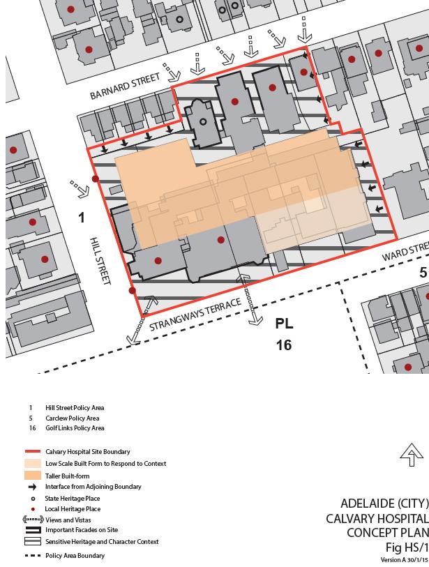
64 Attachment C 64

65 65 North Adelaide Large Colleges and Institutions DPA

66 66 North Adelaide Large Colleges and Institutions DPA
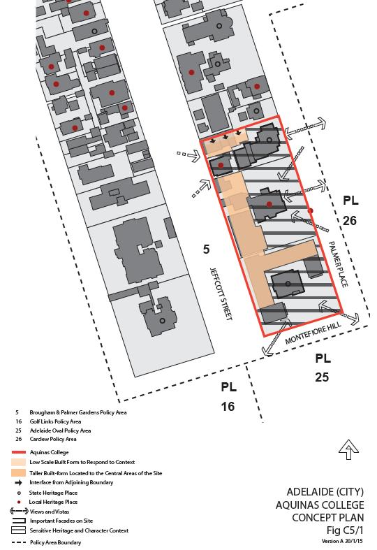
67 Attachment D 67

68 Adelaide City Error! Unknown document property name. Attachment E 68

69 Attachment F North Adelaide Large Colleges and Institutions DPA Adelaide City Error! Unknown document property name.

70 Adelaide City Error! Unknown document property name. Attachment G 70

71 Adelaide City Error! Unknown document property name. Attachment H 71

72 NORTH ADELAIDE LARGE INSTITUTIONS AND COLLEGES DPA Attachment I 72

73 NORTH ADELAIDE LARGE INSTITUTIONS AND COLLEGES DPA Attachment J 73
74 NORTH ADELAIDE LARGE INSTITUTIONS AND COLLEGES DPA MAPS 74

75 NORTH ADELAIDE LARGE INSTITUTIONS AND COLLEGES DPA Attachment K 75

76 NORTH ADELAIDE LARGE INSTITUTIONS AND COLLEGES DPA Attachment L 76
SITE ANALYSIS CALVARY HOSPITAL NORTH ADELAIDE LARGE INSTITUTIONS AND COLLEGES DPA CALVARY HOSPITAL
 SITE ANALYSIS Located at: 81-100 Strangways Terrace 55-79 Barnard Street 2-34 Hill Street 312-320 Ward Street HISTORY The Calvary Hospital was established in 1900 and is one of Adelaide's oldest hospitals.
Council. Residential and Main Street DPA. (Part 1) The Amendment. For Approval. 16 April 2014
 The Amendment. For Approval. 16 April 2014") Council Residential and Main Street DPA (Part 1) The Amendment 16 April 2014 For Approval Amendment Instruction Number Is Renumbering required (Y/N) Residential and Main Street DPA Table Name of Local
Council Residential and Main Street DPA (Part 1) The Amendment 16 April 2014 For Approval Amendment Instruction Number Is Renumbering required (Y/N) Residential and Main Street DPA Table Name of Local
Wide asphalt driveway abutting school property. garage built with incompatible materials, too close to park. incompatible fencing materials
 Wide asphalt driveway abutting school property incompatible fencing materials garage built with incompatible materials, too close to park Lack of plantings as a buffer between private property and open
WELLINGTON HOSPITAL DESIGN GUIDE TABLE OF CONTENTS
 WELLINGTON HOSPITAL DESIGN GUIDE TABLE OF CONTENTS 1.0 Introduction Page 2 The Place of Wellington Hospital 2 The Future of the Hospital 2 2.0 The Intention of the Design Guide 3 3.0 Analysis 4 General
Division 7 Character Areas Housing Zone: Assessment Criteria and Assessment Tables
 Division 7 Character Areas Housing Zone: Assessment Criteria and Assessment Tables 4.7.1 Character Areas Housing Zone The provisions in this division relate to the Character Areas Housing Zone as follows
4 Residential and Urban Living Zones
 4 Residential and Urban Living Zones Refer to Chapters 11 to 20 for additional rules that may apply to these zones. 4.1 OBJECTIVES AND POLICIES Objective Res1 Policy 1 Policy 2 Policy 3 Policy 4 Policy
Draft Part 11 Heritage Area Plans West Wallsend / Holmesville
 TABLE OF CONTENTS: PART 1 WEST WALLSEND / HOLMESVILLE HERITAGE AREA PLAN... 3 1.1 INTRODUCTION... 3 1.2 BACKGROUND... 3 1.3 LAND TO WHICH THIS PLAN APPLIES... 3 PART 2 WEST WALLSEND / HOLMESVILLE HERITAGE
Part 9 Specific Land Uses - Housing on Small and Narrow Lots
 19 HOUSING ON SMALL AND NARROW LOTS This section of the DCP applies where development for the purpose of a dwelling house, attached dwellings, or semi-detached dwellings is or are proposed in the R2 Low
APPENDIX MATAKANA COMMERCIAL URBAN DESIGN GUIDELINES
 APPENDIX MATAKANA COMMERCIAL URBAN DESIGN GUIDELINES 1.0 INTRODUCTION The following urban design guidelines are to be utilised by landowners, planners and other persons involved in development at early
Part 11 Heritage Area Plans West Wallsend / Holmesville
 TABLE OF CONTENTS: PART 1 WEST WALLSEND / HOLMESVILLE HERITAGE AREA PLAN... 3 1.1 INTRODUCTION... 3 1.2 BACKGROUND... 3 1.3 LAND TO WHICH THIS PLAN APPLIES... 3 PART 2 WEST WALLSEND / HOLMESVILLE HERITAGE
4.3 Dudley Area Plan. Introduction. History and Existing Character. Desired Future Character for Dudley
 4.3 Dudley Area Plan Introduction The suburb of Dudley has developed as a result of various circumstances including its topography, history and mineral resources. Dudley development has been identified
PART AOTEA PRECINCT
 CONTENTS... PAGE AOTEA PRECINCT...4 14.5.1 INTRODUCTION...4 14.5.2 RESOURCE MANAGEMENT ISSUES...4 14.5.3 RESOURCE MANAGEMENT OBJECTIVES AND POLICIES... 4 14.5.4 RESOURCE MANAGEMENT STRATEGY...5 14.5.5
SITE ANALYSIS MEMORIAL HOSPITAL NORTH ADELAIDE LARGE INSTITUTIONS AND COLLEGES DPA MEMORIAL HOSPITAL
 SITE ANALYSIS KING WILLIAM RD Located at: 1-20 Sir Edwin Smith Avenue 1-10 Pennington Terrace 1-23 Kermode Street HISTORY The hospital is a private, not-for-profit hospital and was established as a memorial
I539. Smales 2 Precinct
 I539. Smales 2 Precinct I539.1. Precinct Description The Smales 2 Precinct applies to a 4.8 hectare block of land located on the southern side of Northcote Road and fronting Lake Pupuke, Takapuna. The
I615. Westgate Precinct
 I615. Westgate Precinct I615.1. Precinct Description The Westgate Precinct is located approximately 18km west of the Auckland city centre. There are seven Sub-precincts in the Westgate Precinct: Sub-precinct
SCHEDULE 12 TO THE DESIGN AND DEVELOPMENT OVERLAY GLEN WAVERLEY ACTIVITY CENTRE STRUCTURE PLAN
 DD/MM/YY Proposed C120 SCHEDULE 12 TO THE DESIGN AND DEVELOPMENT OVERLAY Shown on the planning scheme map as DDO12. GLEN WAVERLEY ACTIVITY CENTRE STRUCTURE PLAN 1.0 Design objectives DD/MM/YY Proposed
Section Three, Appendix 16C Medium Density Housing, Design Assessment Criteria (Residential 8A zone)
") APPENDIX 16C MEDIUM DENSITY HOUSING, DESIGN ASSESSMENT CRITERIA (RESIDENTIAL 8A ZONE) PURPOSE OF APPENDIX 16C (RESIDENTIAL 8A ZONE) In the Residential 8A Zone the following are defined as restricted discretionary
APPENDIX 16C MEDIUM DENSITY HOUSING, DESIGN ASSESSMENT CRITERIA (RESIDENTIAL 8A ZONE) PURPOSE OF APPENDIX 16C (RESIDENTIAL 8A ZONE) In the Residential 8A Zone the following are defined as restricted discretionary
Urban Design Brief Woodland Cemetery Funeral Home 493 Springbank Drive
 Urban Design Brief Woodland Cemetery Funeral Home The Incorporated Synod of the Diocese of Huron April 15, 2016 Urban Design Brief April 15, 2016 TABLE OF CONTENTS Page No. INTRODUCTION... 1 SECTION 1
Section Three, Appendix 17C Multiple Unit Housing Design Assessment Criteria
 APPENDIX 17C MULTIPLE UNIT HOUSING DESIGN ASSESSMENT CRITERIA Purpose of Appendix 17C In the Residential 9 Zone the construction and use of multiple household units located within the Multiple Household
Duplex Design Guidelines
 Duplex Design Guidelines Adopted by Council May 29, 2006 Prepared By: Table of Contents 1.0 Application and Intent 1 2.0 Areas of Application 2 3.0 Design Principles 3 4.0 Design Guidelines 4 4.1 Site
Infill Residential Design Guidelines
 Infill Residential Design Guidelines Adopted March 23, 2004 Amended September 10, 2013 City of Orange Community Development Department Planning Division Phone: (714) 744-7220 Fax: (714) 744-7222 www.cityoforange.org
D18. Special Character Areas Overlay Residential and Business
 D18 Overlay Residential and Business D18. Overlay Residential and Business D18.1. Background The Overlay Residential and Business seeks to retain and manage the special character values of specific residential
6. REGIONAL AND COMMUNITY FACILITIES DESIGNATIONS 6.1. OBJECTIVES FOR REGIONAL AND COMMUNITY FACILITIES LAND USE DESIGNATIONS
 6. REGIONAL AND COMMUNITY FACILITIES DESIGNATIONS INTRODUCTION The Regional and land use designations provide the primary locations for uses which satisfy the health, education and other service needs
22.15 OUTDOOR ADVERTISING SIGNAGE POLICY
 22.15 OUTDOOR ADVERTISING SIGNAGE POLICY This policy applies to all land where a planning permit is required to construct or display a sign under the provisions of the Kingston Planning Scheme. 22.15-1
4.0 Design Guidelines For The Village Centre. South fields Community Architectural Design Guidelines Town of Caledon
 4.0 Design Guidelines For The Village Centre 4.0 Design Guidelines for the Village Centre The Village Centre is the focal point of the entire South Fields Community and is designed as a traditional commercial
Chapter 5 Urban Design and Public Realm
 5.1 Introduction Public realm is all areas of the urban fabric to which the public have access. It is where physical interaction takes place between people. It therefore, includes buildings and their design,
I331. St John s Theological College Precinct
 I331. St John s Theological College Precinct I331.1. Precinct Description The precinct contains the existing St John s Theological College which is a residential college for the Anglican Church in New
Mark-up of the effect of the proposed Bronte Village Growth Area OPA No.18 on the text of section 24, Bronte Village, of the Livable Oakville Plan
 Mark-up of the effect of the proposed Bronte Village Growth Area OPA No.18 on the text of section 24, Bronte Village, of the Livable Oakville Plan Notes: This document is provided for information purposes
CONTENTS 8.0 LAND USE 8.1 GENERAL LAND USE 8.2 RESIDENTIAL 8.3 MIXED USE 8.4 COMMERCIAL 8.5 EMPLOYMENT LANDS
 8-2 Land Use 8.0 LAND USE CONTENTS 8.1 GENERAL LAND USE 8.1.1 Uses provided for in all Land Use Designations 8.1.2 Uses prohibited in Hazardous Lands, Hazardous Sites and Special Policy Areas 8.1.3 Uses
(DC1) Direct Development Control Provision DC1 Area 4
 Direct Development Control Provision DC1 Area 4") . General Purpose (DC) Direct Development Control Provision DC Area 4 The purpose of this Provision is to provide for an area of commercial office employment and residential development in support of the
. General Purpose (DC) Direct Development Control Provision DC Area 4 The purpose of this Provision is to provide for an area of commercial office employment and residential development in support of the
GUIDELINES REPLACEMENT HOUSING GUIDELINES LOCATION INTRODUCTION URBAN DESIGN GUIDELINES
 Replacement housing in the former City of North York will be consistent with the following urban design guidelines. They provide a framework for residential re-development in the former City of North York
Development Control Plan
 Development Control Plan Liberty Grove Development Control Plan Date of Adoption: 4 September 2007 Effective Date: 7 March 2008 Index 1 INTRODUCTION... 3 1.1 NAME OF PLAN... 3 1.2 AREA TO WHICH THIS PLAN
RESIDENTIAL ACTIVITY PERFORMANCE STANDARDS
 Preferred Options Consultation Q&A Sheet RESIDENTIAL ACTIVITY PERFORMANCE STANDARDS What are the key goals for managing the design of residential buildings in the Second Generation Plan (2GP)? The key
DRAFT Northeast Quadrant of Kipling Avenue and Highway 7 DRAFT AUGUST 29, Goals Land Use. The goals of this Plan are to:
 AUGUST 29, 2017 12.15 Northeast Quadrant of Kipling Avenue and Highway 7 12.15.1 Goals 12.15.2 Land Use The goals of this Plan are to: 12.15.2.1 General Provisions: a) Ensure the development of a compact
Keystone Business Park Precinct Structure Plan North East Industrial Precinct. Part 2 Design Principles
 Keystone Business Park Precinct Structure Plan North East Industrial Precinct Part 2 Design Principles Context Issues Services Landform Issues Geotech and contamination Ecology Traffic and access Issues
MATURE SUBURBS RESIDENTIAL DEVELOPMENT GUIDELINES
 MATURE SUBURBS RESIDENTIAL DEVELOPMENT GUIDELINES DRAFT FEBRUARY 2005 BIRMINGHAM CITY COUNCIL 1 Introduction Mature Suburbs Residential Development Guidelines - Interim Supplementary Planning Advice -
WINDSOR GLEN DESIGN GUIDELINES
 WINDSOR GLEN DESIGN GUIDELINES Adopted by Council, 2006 WINDSOR GLEN REDEVELOPMENT DESIGN GUIDELINES August 2006 1.0 Master Plan Organization For this area of the Coquitlam Town Centre, a mix of high,
5.1 Site Plan Guidelines
 5. Community Core Guidelines Development of the Community Core will take place by plan of subdivision and site plan approval. It will occur in a phased manner that will reflect the timing of residential
GUIDELINES TORONTO GENERAL HOSPITAL LOCATION. INTRODUCTION Existing College Wing Buildings and Site Plan - Figure 1A and Figure 1B.
 GENERAL HOSPITAL Development in the south-east quandrant of University Avenue and College Street will be consistent with the following urban design guidelines. LOCATION Lands owned by the Toronto General
7.2.9 Eudlo local plan code
 7.2.9 local plan code 7.2.9.1 Application (1) This code applies to assessable development:- (a) within the local plan area as shown on Map ZM29 contained within Schedule 2 (Mapping); and (b) identified
Development Control Plan
 Development Control Plan Rhodes Corporate Park (Also known as the Digital Site) Development Control Plan Date of Adoption: 4 September 2007 Effective Date: 7 March 2008 Index 1 INTRODUCTION... 3 1.1 LAND
Residential and Main Street DPA
 and Main Street D Development Plan Policy Review - Summary This paper provides an understanding of existing policy approaches in other jurisdictions to inform the approach to any possible change as part
Sawtell Town Centre Development Control Plan
 Sawtell Town Centre Development Control Plan ABN 79 126 214 487 CONTENTS INTRODUCTION... 1 PREAMBLE... 1 HOW TO USE THIS DCP... 1 LAND TO WHICH THIS PLAN APPLIES... 1 MASTERPLAN... 2 VISION... 2 CHARACTER
Derry City and Strabane District Council Planning Committee Report
 Derry City and Strabane District Council Planning Committee Report COMMITTEE DATE: 23 rd March 2016 APPLICATION No: APPLICATION TYPE: PROPOSAL: LOCATION: APPLICANT: LA11/2015/0395/F Residential Development
East Bayshore Road Neighbourhood
 East Bayshore Road Neighbourhood Northridge Property Management Urban Design Brief 3195 East Bayshore Road City of Owen Sound January 2016 East Bayshore Road Neighbourhood Northridge Property Management
and services The protection and conservation of environmentally significant and sensitive natural heritage features and functions.
 6. Land Use 6.0 Preamble A healthy and livable city is one in which people can enjoy a vibrant economy and a sustainable healthy environment in safe, caring and diverse neighbourhoods. In order to ensure
Sunday's Well Proposed Architectural Conservation Area
 1 Sunday's Well Proposed Architectural Conservation Area D A E C B F Old City Gaol Saint Vincent s RC Church Saint Albert s Former Good Shepherd Convent Boundary of Area Sunday's Well is an area located
Cape Cabarita (Formerly known as the Wellcome Site) Development Control Plan. Date of Adoption: 4 September 2007 Effective Date: 7 March 2008
 Development Control Plan. Date of Adoption: 4 September 2007 Effective Date: 7 March 2008") Cape Cabarita (Formerly known as the Wellcome Site) Development Control Plan Date of Adoption: 4 September 2007 Effective Date: 7 March 2008 Development Control Plan Index 1 INTRODUCTION...3 1.1 LAND TO
Cape Cabarita (Formerly known as the Wellcome Site) Development Control Plan Date of Adoption: 4 September 2007 Effective Date: 7 March 2008 Development Control Plan Index 1 INTRODUCTION...3 1.1 LAND TO
Clairtrell Area Context Plan
 Clairtrell Area Context Plan March 2005 Urban Development Services City Planning Contents 1. Introduction... 4 2. Development Structure... 6 2.1 Streets... 7 2.1.1 Sheppard Avenue and Bayview Avenue...
Bylaw A Bylaw to amend Bylaw 12800, as amended, The Edmonton Zoning Bylaw Amendment No. 2239
 Bylaw 17672 A Bylaw to amend Bylaw 12800, as amended, The Edmonton Zoning Bylaw Amendment No. 2239 WHEREAS City Council at its meeting of February 22, 2001, gave third reading to Bylaw 12800, as amended;
Urban Design Brief to 1557 Gordon Street & 34 Lowes Road West
 Urban Design Brief 1533 to 1557 Gordon Street & 34 Lowes Road West Reid s Heritage Homes Ltd. & 883928 Ontario Ltd. and RHH Property Management Ltd. City of Guelph Zoning By-law Amendment November 2017
4 RESIDENTIAL ZONE. 4.1 Background
 4 RESIDENTIAL ZONE 4.1 Background The residential areas within the City are characterised by mainly lowrise dwellings sited on individual allotments. Past architectural styles, settlement patterns and
QUEEN-RIVER SECONDARY PLAN
 34 QUEEN-RIVER SECONDARY PLAN 34. QUEEN RIVER SECONDARY PLAN 1. INTRODUCTION The Queen-River area is approximately 6.4 hectares and is located at the eastern edge of the Downtown as shown on Map 34-1.
KEY MAP DEVELOPMENT PERMIT AREA MAP. Sunnymede North Sub-Area Plan
 Richmond Official Community Plan BROADMOOR AREA SUNNYMEDE NORTH SUB-AREA PLAN Bylaw 7100 Schedule 2.6C SUNNYMEDE NORTH SUB-AREA PLAN SUNNYMEDE NORTH SUB-AREA PLAN SUNNYMEDE NORTH SUB-AREA PLAN KEY MAP
B L A C K D I A M O N D D E S I G N G U I D E L I N E S for Multi-family Development
 B L A C K D I A M O N D D E S I G N G U I D E L I N E S for Multi-family Development Adopted June 18, 2009 This section of the Design and focuses on site planning and design guidance for new multi-family
6.0 Land Use Policies for Rural Settlements. 6.1 Rural Settlement Strategy
 6.0 Land Use Policies for Rural Settlements 6.1 Rural Settlement Strategy INTRODUCTION AMENDMENT NO. 131 PURPOSE Designated rural settlements comprise Rural Clusters, Villages and Serviced Villages as
The Proposed Auckland Unitary Plan (notified 30 September 2013)
") 3 Business zones Introduction There are 10 business zones in the Unitary Plan: City Centre Metropolitan Centre Town Centre Local Centre Neighbourhood Centre Mixed Use General Business Business Park Light
3 Business zones Introduction There are 10 business zones in the Unitary Plan: City Centre Metropolitan Centre Town Centre Local Centre Neighbourhood Centre Mixed Use General Business Business Park Light
medium desnity housing
 This section updated September 2013 This part of the Plan sets out the assessment criteria for medium density housing. The criteria are designed to give designers and builders flexibility and to provide
URBAN DESIGN BRIEF. 2136&2148 Trafalgar Road. Town of Oakville
 URBAN DESIGN BRIEF 2136&2148 Trafalgar Road Town of Oakville Prepared By: METROPOLITAN CONSULTING INC For 2500674 Ontario Inc November 2016 TABLE OF CONTENTS Page No. 1.0 Introduction/Description of Subject
Chapter 13 Residential Areas: Appendices APPENDIX 1 Residential Areas
 Chapter 13 Residential Areas: Appendices Page 1 Chapter 13 Residential Areas: Appendices APPENDIX 1 Residential Areas Design Code for Intensive Housing INTRODUCTION DESIGN ELEMENTS A NEIGHBOURHOOD DESIGN
I207. Learning Precinct
 I207. Learning Precinct I207.1. Precinct description The Learning Precinct is centred on the Symonds Street ridge where the University of Auckland and Auckland University of Technology have the majority
Site Planning. 1.0 Site Context. 2.0 Pedestrian Circulation Systems. Pag e 2-23
 The following photographs from throughout the country illustrate key urban design principles. Photographs are provided to illustrate the overall urban design concepts described in Chapter 1 of the Downtown
6 Site Framework Strategies
 6 Site Framework Strategies 6.1 Introduction Section 6 identifies a number of specific areas which are considered to be key sites within the Plan area and which may have potential for development / redevelopment.
Urban Design Guidelines Townhouse and Apartment Built Form
 Urban Design Guidelines Townhouse and Apartment Built Form Town of Wasaga Beach Table of Contents 1. Introduction 1.1. Purpose 1.2. Urban Design Principles 1.3. Application of Guidelines 2. Site Design,
BORRISOKANE SETTLEMENT PLAN
 BORRISOKANE SETTLEMENT PLAN 1.0 General Introduction and Development Context Location Borrisokane is located 15km north of Nenagh on the N52. While the town is primarily residential, it acts as a market
City of Vaughan Urban Design Guidelines for Infill Development in Established Low-Rise Residential Neighbourhoods
 City of Vaughan Urban Design Guidelines for Infill Development in Established Low-Rise Residential Neighbourhoods DRAFT - September 2016 Contents 1. Introduction 1 2. Policy Context 3 3. Characteristics
HERITAGE DESIGN GUIDELINES
 HERITGE DESIGN GUIDELINES July 2017 2 Table of Contents 1. Introduction 4 2. Conservation Works 5 3. Demolition and Relocation 7 4. dditions and lterations 10 5. New Buildings (ll reas) 16 6. Services
Heritage Precincts Overlay
 Rule 2.4 Heritage Precincts Overlay Rule Statement Heritage Precincts are areas with consistent special heritage character. The District Plan has identified fourthree Heritage Precincts, the Frankton Railway
Lancaster Conservation Area Appraisal. Character Area 8. Cathedral
 Lancaster Conservation Area Appraisal Character Area 8. Cathedral March 2013 118 3.8 Character Area 8. Cathedral 3.8.1. Definition of Special Interest "This character area is distinctive for the fine group
MULTIFAMILY RESIDENTIAL DESIGN PRINCIPLES Site Plan and Design Review Principles Checklist
 MULTIFAMILY RESIDENTIAL DESIGN PRINCIPLES Site Plan and Design Review Principles Checklist Applicant s Name: Project Address: Phone: Email: Applicant shall fill out the design guidelines checklist for
VIEW SHAFTS. Figure 32: Existing view shafts which are to be protected and enhanced and desirable new view shafts ANNEX 2
 VIEW SHAFTS 2.9.1 Sight lines, both from within the Viaduct Harbour area, and into the area from without, are a vital component of the character of the area. They are also an invaluable means by which
BENSON / HUNT TERTIARY PLAN
 BENSON / HUNT TERTIARY PLAN TABLE OF CONTENTS 1.0 INTRODUCTION 1.1 Purpose 2 1.2 How to Read This Plan 3 1.3 Tertiary Plan Context 3 1.4 Vision and Principles 5 1.5 Public Consultation 5 2.0 PLANNING CONTEXT
Housing and Coach House Guidelines - Ladner
 Housing and Coach House Guidelines - Ladner Policy D.8: Encourage Compatible Housing Design Encourage housing design that is sensitive to existing single family housing neighbourhoods by requiring a design
Subdivision Design Criteria. Penihana North GUIDELINES TO THE RULES
 Created September 2013 Penihana North Subdivision Design Criteria GUIDELINES TO THE RULES This part of the Plan sets out the design criteria for subdivision in Penihana North. The criteria will be considered
Eastern Golf Course, Doncaster Road, Doncaster
 , 463-535 Road, Heritage Assessment in accordance with Schedule to the Development Plan Overlay July 2013 bryce raworth conservation urban design 19 Victoria Street St Kilda Vic 3182 , 463-535 Road, Heritage
H14. Business General Business Zone
 H14. Business General Business Zone H14.1. Zone description The Business General Business Zone provides for business activities from light industrial to limited office, large format retail and trade suppliers.
GREENFORD HALL & ADJOINING LAND
 GREENFORD HALL & ADJOINING LAND CONTENTS 1. Introduction 1. Introduction 2. Urban Context 2.1 The Site and Surroundings 2.2 Urban Context Map 2.3 Access and Movement 3. Planning Context 3.1 Planning History
Celebrate the unexpected
 Celebrate the unexpected Design Guidelines September 2014 DESIGN GUIDELINES 3 Contents 1.0 Introduction 5 2.0 The purpose 7 2.1 The structure 8 2.2 The process 9 3.0 Jubilee the precinct 10 3.1 residential
KWE.1 Kamo Walkability Environment
 KWE.1 Kamo Walkability Environment Index KWE.1 Kamo Walkability Environment KWE.1.1 Description and Expectations KWE.1.2 Eligibility Rule KWE.1.3 Objectives KWE.1.4 District Wide Note KAP.1 Kamo Activity
URBAN DESIGN BRIEF URBAN DESIGN BRIEF 721 FRANKLIN BLVD, CAMBRIDGE August 2018
 URBAN DESIGN BRIEF URBAN DESIGN BRIEF 721 FRANKLIN BLVD, CAMBRIDGE August 2018 DESIGN BRIEF CONTENTS PART A 1.0 INTRODUCTION 2.0 DESCRIPTION & ANALYSIS OF SITE CONTEXT 3.0 DESIGN CONSTRAINTS AND OPPORTUNITIES
H9. Business Metropolitan Centre Zone
 H9. Business Metropolitan Centre Zone H9.1. Zone description The Business Metropolitan Centre Zone applies to centres located in different subregional catchments of Auckland. These centres are second only
Character Area 1: Town Core
 Character Area 1: Town Core Map S 354 Copyright Cotswold District Council 109 Character Area 1: Town Core Key Characteristics 355 356 357 358 359 360 361 362 363 364 365 366 367 368 369 370 Copyright Cotswold
Historic Yonge Street HCD Study Public Meeting #2
 Historic Yonge Street HCD Study Public Meeting #2 March 26, 2014 Archaeological Services Inc. Philip Goldsmith Architect Agenda: 7:00 p.m. Open House 7:30 p.m. Welcome and Presentation 8:00 p.m. Questions
DESIGN & ACCESS STATEMENT
 . DESIGN & ACCESS STATEMENT Site Adjacent to The Manor House, Upper Street,, Kingsdown, Deal, Kent. DESIGNS ARCHITECTURE + PLANNING CONTENTS Design and Access Statement Introduction Site and Location Planning
FLORIN ROAD CORRIDOR Site Plan and Design Review Guidelines Checklist
 FLORIN ROAD CORRIDOR Site Plan and Design Review Guidelines Checklist Applicant s Name: Project Address: Phone: Email: Applicant shall fill out the design guidelines checklist for all guidelines applicable
Chapter 11. Industrial Design Guidelines 11.1 INTRODUCTION AND PURPOSE 11.3 SITE PLANNING GUIDELINES 11.2 GENERAL DESIGN OBJECTIVES
 Chapter 11 Industrial Design Guidelines 11.1 INTRODUCTION AND PURPOSE The following industrial/design guidelines seek to assure high quality development in Santa Ana s industrial districts by: The design
Design Guidelines - 1 -
 Design Guidelines REAR YARDS Rear yard decks and porches, attached to a garden or garage suite, should be permitted provided minimum rear yard setbacks, separation distances, and necessary site access
CHAPTER 20 THE RAILROAD CHARACTER AREA. The Railroad Character Area contains the railroad tracks and those lands flanking them.
 CHAPTER 20 THE RAILROAD CHARACTER AREA The Railroad Character Area contains the railroad tracks and those lands flanking them. The Railroad Character Area contains the railroad tracks and those lands flanking
H10. Business Town Centre Zone
 H10. Business Town Centre Zone H10.1. Zone description The Business Town Centre Zone applies to suburban centres throughout Auckland, the satellite centres of Warkworth and Pukekohe, and the rural towns
Part 10 Town Centre Area Plans Toronto
 CONTENTS: 1 INTRODUCTION... 3 1.1 BACKGROUND... 3 1.2 EXISTING CHARACTER... 4 1.3 ENVIRONMENTAL CONSTRAINTS... 6 1.4 DESIRED FUTURE CHARACTER... 6 2 DEVELOPMENT CONTROLS... 8 2.1 BLOCK CONTROLS... 9 3
LOW DENSITY RESIDENTIAL
 LOW DENSITY RESIDENTIAL Corner lots with coach houses to increase diversity, provide unity to the streetscape and increase eyes on the street. Garages and ancillary units accessed via rear lanes. Parking
DESIGN & ACCESS STATEMENT. REVISION A Residential Development, Neon Social Club, Nairn Street, Jarrow.
 DESIGN & ACCESS STATEMENT. REVISION A Residential Development, Neon Social Club, Nairn Street, Jarrow. The following Design & Access Statement is in support of a Full Planning Application for a residential
TABLE OF CONTENTS 1.0 INTRODUCTION... 3
 TABLE OF CONTENTS 1.0 INTRODUCTION... 3 1.1. BACKGROUND... 3 1.2. THE PROPOSAL... 5 2.0 EXISTING POLICY FRAMEWORK... 5 2.1. PROVINCIAL POLICY STATEMENT (PPS)... 5 2.2. CITY OF LONDON OFFICIAL PLAN (OP)...
Planning scheme policy for Landsborough (urban design guidelines)
") SC6.2 SC6.2.1 Planning scheme policy for Landsborough (urban design guidelines) Purpose The purpose of this planning scheme policy is to provide advice about achieving outcomes in the Landsborough local
SC6.2 SC6.2.1 Planning scheme policy for Landsborough (urban design guidelines) Purpose The purpose of this planning scheme policy is to provide advice about achieving outcomes in the Landsborough local
14.0 BUILT FORM DESIGN CRITERIA
 14.0 BUILT FORM DESIGN CRITERIA CORPORATION OF THE TOWN OF CARLETON PLACE DEVELOPMENT PERMIT BY-LAW 123 124 CORPORATION OF THE TOWN OF CARLETON PLACE DEVELOPMENT PERMIT BY-LAW 14.1 MISSISSIPPI DISTRICT
13. New Construction. Context & Character
 13. New Construction Context & Character While historic districts convey a sense of time and place which is retained through the preservation of historic buildings and relationships, these areas continue
APPENDIX 10 THE RESIDENTIAL DESIGN GUIDE FOR DEVELOPMENTS IN RESIDENTIAL ZONES IN SPECIFIED GROWTH AREAS
 THE RESIDENTIAL DESIGN GUIDE FOR DEVELOPMENTS IN RESIDENTIAL ZONES IN SPECIFIED GROWTH AREAS ISTHMUS SECTION - OPERATIVE 1999 Page 1 CONTENTS... PAGE 1.0 INTRODUCTION... 4 1.1 Growth Management Strategy...
599 Kennedy Road - Official Plan Amendment and Zoning Amendment Application - Preliminary Report
 STAFF REPORT ACTION REQUIRED 599 Kennedy Road - Official Plan Amendment and Zoning Amendment Application - Preliminary Report Date: March 7, 2017 To: From: Wards: Reference Number: Scarborough Community
II. SINGLE FAMILY RESIDENTIAL
 II. SINGLE FAMILY RESIDENTIAL Castle Rock is made up of numerous individually built houses and subdivision tracts that have been developed during the past century. Some of the tracts are diverse in architectural
ELMVALE ACRES SHOPPING CENTRE MASTER PLAN
 ELMVALE ACRES SHOPPING CENTRE MASTER PLAN Contents 1.0 INTRODUCTION... 2 2.0 LOCATION... 2 3.0 EXISTING CONTEXT... 2 4.0 VISION & GUIDING PRINCIPLES... 2 5.0 LAND USE AND BUILT FORM... 4 5.1 St. Laurent