Andershaw to Coalburn 132kV Overhead Line Environmental Statement. April 2009
|
|
|
- Barry Riley
- 5 years ago
- Views:
Transcription
1 Andershaw to Coalburn 132kV Overhead Line Environmental Statement April 2009
2
3 This document has been prepared by Faber Maunsell Limited ( Faber Maunsell ) for the sole use of our client (the Client ) and in accordance with generally accepted consultancy principles, the budget for fees and the terms of reference agreed between Faber Maunsell and the Client. Any information provided by third parties and referred to herein has not been checked or verified by Faber Maunsell, unless otherwise expressly stated in the document. No third party may rely upon this document without the prior and express written agreement of Faber Maunsell. Published by: ScottishPower Ltd 1 Atlantic Quay Glasgow G2 8SP Produced for SP Transmission Ltd (a ScottishPower Company) by Faber Maunsell with specialist input from EDAW and SP PowerSystems Ltd (a ScottishPower Company). SP Transmission Ltd, Registered Office: 1 Atlantic Quay, Glasgow, G2 8SP. Registered in Scotland No. SC Copyright ScottishPower Ltd (April 2009) All rights reserved. No part of this publication may be reproduced, stored in a retrieval system, or transmitted in any form or by any means electronic, mechanical, photocopying or otherwise without prior written permission of the publisher.
4
5 Andershaw to Coalburn 132kV Overhead Line Environmental Statement Preface The Andershaw to Coalburn 132kV Overhead Line Environmental Statement is published as a single document comprising three volumes: Volume 1 Non-Technical Summary Volume 2 Environmental Statement Volume 3 Appendices The ES sets out the findings of the Environmental Impact Assessment (EIA) undertaken for the proposed overhead line connection between Andershaw Windfarm and Coalburn Substation following the requirements of the Electricity Works (Environmental Impact Assessment) (Scotland) Regulations Further copies of all these reports may be obtained from: SP Energy Networks Environmental Planning 3 Prenton Way Prenton Merseyside CH43 3ET Tel: Copies of the Environmental Statement may be obtained from SP Transmission (tel: ) at a charge of 120 for a hard copy and 10 for a DVD copy. Copies of a short standalone Non Technical Summary are available free of charge. Copies of the documents will be available for public viewing at the following locations: Council Offices: South Lanarkshire Council Clydesdale Planning and Building Standards area office South Vennel Lanark ML11 7JT Other locations: St Brides Hall Braehead Douglas ML11 0QW Any representations to the application should be made by completing the online representation form on The Scottish Government, Energy Consents website at: Or by to The Scottish Government, Energy Consents Unit mailbox at: energyconsents@scotland.gsi.gov.uk Or by post to: The Scottish Government, Energy Consents Unit, 2nd Floor, Meridian Court, 5 Cadogan Street, Glasgow, G2 6AT Representations should be dated and should clearly state the name (in block capitals) and full return or postal address of those making representation. All representations to the Scottish Government will be copied in full to the planning authority, and made available to the public on request, unless individuals request otherwise. Libraries: Lanark Library Lesmahagow Library 16 Hope Street 48 Abbeygreen Lanark Lesmahagow ML11 7LZ ML11 0EF
6
7 Andershaw to Coalburn 132kV Overhead Line Environmental Statement Contents Volume 1: Non-Technical Summary 1. Introduction 1 2. Description of Proposal 2 3. Environmental Impact Assessment 4 4. Summary and Conclusions 8 Volume 2: Environmental Statement 1. Introduction 1.1 Introduction Background Consents Required for the Scheme Environmental Impact Assessment of the Scheme Environmental Impact Assessment Process Environmental Statement Authors Structure of the Environmental Statement Availability of the Environmental Statement Development of the Scheme & Alternatives 2.1 Introduction Routeing Study Alternatives Considered Routeing Constraints and Opportunities Preferred Option Scheme Description 3.1 Introduction Proposed Overhead Line Route Line Design Specification Construction Phase Operation Phase Decommissioning Approach to Environmental Impact Assessment 4.1 Introduction The Electricity Works (EIA) (Scotland) Regulations The EIA Process Approach to the Assessment of Impacts Uncertainty, Assumptions & Limitations Mitigation Consultation and Scope of the EIA Planning Policy Context 5.1 Introduction The Electricity Act Government Energy Policy National Planning Policy Regional Planning Policy Local Planning Policy Summary Land Use, Access & Recreation 6.1 Introduction Methods Baseline Situation Predicted Impacts Mitigation Residual Impacts Summary Landscape & Visual Amenity 7.1 Introduction Methods Landscape Resources Visual Resources 7-2
8 Andershaw to Coalburn 132kV Overhead Line Environmental Statement Contents 7.3 Baseline Situation Landscape Resources Visual Resources Assessment of Residual Impacts Mitigation Landscape Resources Visual Resources Summary Ecology & Nature Conservation 8.1 Introduction Methods Baseline Situation Identification and Evaluation of Ecological Receptors Predicted Impacts Mitigation Residual Impacts Summary Ornithology 9.1 Introduction Methods Baseline Situation Identification and Evaluation of Ecological Receptors Predicted Impacts Mitigation Residual Impacts Summary Assessment of Effects Summary Ground Conditions and Water Environment 11.1 Introduction Methods Baseline Situation Predicted Impacts Mitigation Residual Impacts Summary Summary of Assessment & Mitigation 12.1 Summary of EIA Results SPT s Statutory Duties Land Use, Access & Recreation Landscape & Visual Amenity Ecology & Nature Conservation Ornithology Cultural Heritage & Archaeology Ground Conditions & Water Environment Schedule of Mitigation 13.1 Overhead Line Design Pre-Construction Construction Post-Construction Cultural Heritage & Archaeology 10.1 Introduction Methods Baseline Situation 10-2 Glossary & Abbreviations References
9 Andershaw to Coalburn 132kV Overhead Line Environmental Statement Contents Volume 3: Appendices A Overhead Line routeing Guidance A-1 B Alternatives Considered B-1 C Scoping Opinion C-1 D Phase 1 Habitat Survey Notes D-1 E Breeding Bird Survey Methods & Results E-1 F Wintering Bird Survey Methods and Results F-1 G Archaeological Assessment: Detailed Criteria G-1 H Archaeological Gazetteer H-1 Figures (contained with Volume 2) 1.1 Study Area Overview Routeing Study Methodology Proposed Overhead Line Route Proposed Wood Pole Structure Model (photograph) Existing Land Use (Sheets 1 to 4) Indicative Areas for Tree Removal & Lopping Andershaw Indicative Areas for Tree Removal & Lopping Dalquhandy Landscape Designations and Regional Character Types View within the Douglas Valley AGLV (photograph) Local Landscape Character Areas Landscape Resource Impacts within the Douglas Valley Zone of Theoretical Visibility - Full Route Zone of Theoretical Visibility - Section Zone of Theoretical Visibility - Section Zone of Theoretical Visibility - Section Zone of Theoretical Visibility - Section Zone of Theoretical Visibility - Section Viewpoint 1: Auchensaugh Hill Existing View & Photomontage View Viewpoint 2: Earl s Mill Existing View & Photomontage View Viewpoint 3: Jeanfield Bridge on the A70 Existing View & Photomontage View Viewpoint 4: Hazelside on the A70 Existing View & Render View Viewpoint 5: Dismantled Railway at Hagshaw Hill Existing View & Photomontage View Viewpoint 6: Outdoor Centre at Douglas West Existing View & Render View Viewpoint 7: Footpath on the north west of Coalburn Existing View & Photomontage View Viewpoint 8: North of Coalburn near Muirburn Existing View & Render View Viewpoint 9: Access Track south of Glaikhead Existing View & Render View Viewpoint 10: Glaikhead adjacent to Coalburn Road Existing View & Render View Visual Resource Impacts: Viewpoint Assessment Key Existing Ecological Features Phase 1 Habitat Survey (Sheets 1 to 4) Ornithological Survey Areas: Breeding and Wintering Known Archaeological Features (Sheets 1 to 2) Topography Average Monthly Rainfall Fertile soils around the Glespin Burn (photograph) Soils on the upland area at Hagshaw Hill (photograph) 11-4 Tables (contained within Volume 2) 1.1 Key Project Team Members The Holford Rules Alternative Grid Connection Routes Assessment of Impact Significance Summary of Scoping and Consultation Responses National Planning Policy Regional Planning Policy Local Planning Policy Key Existing Land Uses Assessment of Impact Significance Future Developments Landscape Sensitivity Criteria Landscape Impact Magnitude Criteria Assessment of Impact Significance (Landscape) Visual Sensitivity Criteria 7-3
10 Andershaw to Coalburn 132kV Overhead Line Environmental Statement Contents 7.5 Visual Impact Magnitude Criteria Assessment of Impact Significance (Visual) Summary of Landscape Resources and Sensitivity Viewpoint Locations and Sensitivity Summary of Residual Impacts on Landscape Resources Summary of Residual Impacts on Visual Resources Consultation Responses Resource Evaluation Criteria Common Statutory and Non-Statutory Designations Key Protection Afforded to Species Protected Sites Ancient Woodland Inventory Sites Assessment of Protected Sites Assessment of Remaining Ecological Receptors Assessment of Impact Significance SEPA water quality monitoring results Residual Impacts - Construction Residual Impacts - Operation Summary of Assessment Summary of Residual Impacts Summary of Consultation Responses Determining Nature Conservation Value Species Sensitivity Criteria Spatial Magnitude Criteria Criteria for assessing Magnitude of Ecological Impacts Assessment of Impact Significance Protected Sites Breeding Wader Territories Within 500m of Proposed Overhead Line Target Species recorded during Breeding Bird Surveys Target Species recorded during Wintering Bird Surveys Significance of Impact on Breeding Bird Species Significance of Impact on Wintering Bird Species Determining Cultural Heritage Value Determining Magnitude of Impact Assessment of Impact Significance Summary of Construction Effects Sensitivity Criteria Impact Magnitude Definition 11-1
11 Andershaw to Coalburn 132kV Overhead Line Volume 1: Non Technical Summary
12
13 Non Technical Summary Contents 1. Introduction 1 2. Description of Proposal 2 3. Environmental Impact Assessment Introduction Planning Policy Context Land Use, Access & Recreation Landscape & Visual Amenity Ecology & Nature Conservation Ornithology Cultural Heritage & Archaeology Ground Conditions & the Water Environment Mitigation 7 4. Summary & Conclusions 8
14

15 Andershaw to Coalburn 132kV Overhead Line Non Technical Summary 1 Non Technical Summary 1. Introduction 1.1 Project Background Catamount Energy Limited and Force 9 Energy are jointly developing a 14 turbine windfarm, Andershaw windfarm, approximately 4km south of Douglas in South Lanarkshire. As part of the windfarm project, the developers require the proposed windfarm to be connected to the electricity transmission grid. A 132kV grid connection from Andershaw windfarm to Coalburn substation is proposed. The responsibility for providing the grid connection to the high voltage electricity transmission grid falls upon SP Transmission Ltd (SPT), the Transmission Licence holder for the south of Scotland. SPT is obliged under the Electricity Act 1989: to develop and maintain an efficient, co-ordinated and economical system of electricity transmission. As well as being required to provide Andershaw windfarm with a grid connection, Schedule 9 of the Electricity Act 1989 requires SPT to take account of the environment when planning new overhead line developments. It states that SPT must: The requirements to undertake a statutory Environmental Impact Assessment (EIA) as part of Section 37 application are set out in the Electricity Works (Environmental Impact Assessment) (Scotland) Regulations Whilst the requirement to undertake a statutory EIA can be established through Screening the proposal with the Scottish Government, SPT, mindful of their responsibilities to people and the environment, as well as their statutory duties; consider it appropriate to undertake an EIA for this overhead line development. Study Area Coalburn Coalburn Substation Land Use, Access & Recreation; Landscape & Visual Amenity; Ecology & Nature Conservation; Ornithology; Cultural Heritage & Archaeology; Ground Conditions & the Water Environment. (a) have regard to the desirability of preserving natural beauty, of conserving flora, fauna and geological or physiographical features of special interest and of protecting sites, buildings and objects of architectural, historic or archaeological interest; and, Glespin Douglas (b) do what he reasonably can to mitigate any effect which the proposals would have on the natural beauty of the countryside or on any such flora, fauna, features, sites, buildings or objects. With these obligations in mind SPT has developed the Andershaw to Coalburn 132kV overhead line. Through the line design process SPT have sought to develop a grid connection which balances technical and economic considerations with environmental issues. It should be noted that the need for the grid connection is related to the outcome of the planning application for Andershaw windfarm. The proposed overhead line will only be constructed if the windfarm developers obtain permission to construct Andershaw windfarm. The study area is centred on the Douglas Valley and is illustrated below showing the locations of the proposed Andershaw windfarm and Coalburn substation. Andershaw windfarm is located south of the Douglas Valley in an area of commercial plantation. Coalburn substation is located approximately 11.5 km due north adjacent to Coalburn Moss and the B EIA of the Scheme In accordance with the Electricity Act 1989, SPT has submitted a Section 37 application to the Scottish Government for permission to construct and operate the 132kV transmission line. Andershaw Windfarm Based on OS Mapping with permission of the Controller of Her Majesty s Stationary Office Crown Copyright Unauthorised reproduction infringes Crown Copyright and may lead to civil proceedings. Licence No. SC The Environmental Statement As part of the Section 37 application SPT have prepared and submitted an Environmental Statement (ES) which describes the findings of the EIA. It identifies the adverse and/or beneficial environmental impacts of the scheme and the measures that will be taken to avoid, reduce or offset those impacts. The topics considered within the EIA and the approach to undertaking the assessment were established following receipt of a Scoping Opinion from the Scottish Government. This document also provided the views of South Lanarkshire Council, SNH, SEPA and Historic Scotland. Those topics identified for consideration within the EIA included:


16 2 Andershaw to Coalburn 132kV Overhead Line Non Technical Summary 2. Description of Proposal 2.1 Development of the Scheme The proposed overhead line connection between Andershaw windfarm and Coalburn substation has been identified following a detailed routeing study which considered the environmental, technical and economic constraints to overhead line development within the area. The study involved a number of key stages including consideration of a number of alternative connection routes. Coalburn Substation Alternative Grid Connections structure will be exposed as well as provide greater protection against the potential effects of ice loading. All wood poles are fully seasoned and are treated with an appropriate preservative. At the top of the wood poles the galvanised steelwork structure supports the insulators and three conductors. An earth wire is slung underneath the steelwork. 2.4 Construction of the Scheme The construction of the overhead line will be timed to coincide with the construction of Andershaw windfarm. Construction will involve: KEY STAGES IN THE PROJECT Small scale earthworks around the base of wood pole structures including top soil stripping and excavations; Identification of a Preferred Route: Environmental constraints, in particular landscape and visual issues, were a principal consideration in the development and appraisal of a number of route options. The appraisal resulted in the identification of the Preferred Route. Consultation and Scoping the Preferred Route: The results of the routeing study were reported on within a Consultation Document. The Preferred Route was then subject to consultation with statutory and non-statutory consultees including SNH and SEPA. At the same time public consultation was undertaken; exhibition boards were put in place in St Brides Hall in Douglas and Coalburn Leisure Centre and SPT met with Douglas Community Council. During the consultation period a Scoping Opinion was requested from the Scottish Government in order to identify the scope of, and approach to the EIA of the overhead line. Alternative Grid Connections Based on Os Mapping with permission of the Controller of Her Majesty s Stationary Office Crown Copyright Unauthorised reproduction infringes Crown Copyright and may lead to civil proceedings. Licence No. SC Development of the Proposed Route: Following the consultation period and receipt of consultation and scoping responses the Preferred Route was reviewed. The review included the preparation of a technical line design. This was then adopted as the Proposed Overhead Line. EIA of the Proposed Route: An EIA of the Proposed Overhead Line was then undertaken in support of the Section 37 application. During the routeing study a number of constraints and opportunities were identified including areas and designated sites which were to be avoided and existing wayleaves through woodland which could be used. Alternative routes that were considered in the development of the scheme are illustrated opposite. 2.2 Proposed Route The proposed overhead line route is illustrated on the opposite page. It is approximately 15km length; of which 14.5km is carried on an overhead line with remaining section being an underground cable into Coalburn substation. The proposed connection runs in a generally northern direction from the proposed Andershaw windfarm broadly north towards the A70 and Douglas Water. It crosses the Douglas Valley north towards Hagshaw Hill windfarm and continues through the former opencast coal mine at Dalquhandy to the west of Coalburn. The scheme crosses Muirburn and Coalburn Road and is routed north where it connects to the recently constructed substation 2km north of Coalburn. 2.3 Line Design Details Traditionally 132kV overhead line have been carried on steel lattice towers, however, for the purposes of this grid connection wood poles have been identified as the most appropriate means of carrying the overhead line. These have a number of advantages over steel lattice towers. Wood poles are more slender and simple in appearance and as a result can be more sympathetically routed through the rural and wooded landscape of the Douglas Valley. The wood pole will be a double pole structure. An example of which is illustrated opposite. It measures approximately 13-16m in height from ground level to the top of the conductors. The double pole structure is required due to the high elevations encountered along the route of the scheme. The double pole structure will provide greater rigidity against the wind speeds to which the Andershaw Windfarm Based on OS Mapping with permission of the Controller of Her Majesty s Stationary Office Crown Copyright Unauthorised reproduction infringes Crown Copyright and may lead to civil proceedings. Licence No. SC Proposed wood pole structure. Erection of the wood poles and backfilling of excavations; Stringing of the conductors; and Reinstatement of affected ground. The types of plant and equipment involved in construction activities are relatively small scale and would be limited to 4x4 vehicles with trailers and an excavator. Access to construction areas would as far as possible be taken from existing roads and tracks. Where temporary access tracks are required these would be agreed with in advance with affected landowners. Construction of the proposed overhead line connection is expected to take 60 weeks, based on a typical rate of progress of 1km of overhead line per three to four weeks. 2.5 Operation of the Scheme Wood poles have an expected lifespan of around 40 years. Consequently once operational outside of inspection and maintenance activities will be limited. Regular inspection of exposed elements which suffer from corrosion, wear, deterioration and fatigue will be required to ensure the safety of all components is in accordance with the Electricity Safety Quality and Continuity Regulations 2002.

17 Coalburn Substation Andershaw Windfarm Route of the Proposed Overhead Based on OS Mapping with permission of the Controller of Her Majesty s Stationary Office Crown Copyright Unauthorised reproduction infringes Crown Copyright and may lead to civil proceedings. Licence No. SC
18 4 Andershaw to Coalburn 132kV Overhead Line Non Technical Summary 3. Environmental Impact Assessment 3.1 Introduction EIA is the process of compiling, evaluating and presenting all of the significant environmental effects of a proposed development. This is an iterative process that allows the developer to identify potential environmental effects and develop mitigation measures which aim to avoid, reduce or offset the negative impacts of the development. The following sub-sections provide a summary of the findings of the assessment of each of the topics covered in the ES. The assessment describes negative and positive effects on a rising scale, typically none, minor, moderate or major. KEY TO IMPACTS Major: These are highly significant impacts because of their large scale and/or the importance of the area affected. Moderate: These are significant impacts because of their scale and/or the importance of the area affected. Minor: While noticeable these impacts are not significant. None: Impacts rated as none result in no detectable change to the environment. 3.2 Planning Policy Context The application to construct and operate the proposed overhead line will be made to the Scottish Ministers under Section 37 of the Electricity Act The Ministers will consider the Section 37 application in the context of a range of policies at national, regional and local level including National Planning Policy Guidance (NPPGs), Scottish Planning Policies (SPPs), the Glasgow and Clyde Valley Joint Structure Plan and the South Lanarkshire Local Plan (finalised 2006). Policies that will be particularly pertinent include those which relate to the protection of the built and natural environment as well as others relating to the development of renewable energy schemes. 3.3 Land Use, Access & Recreation Current and potential future land use within the study area has been established through site surveys and a review of maps, aerial photographs and current planning applications. The predominant land uses within 250m of the proposed overhead line are related with agriculture and commercial forestry. Agricultural use tends to be limited to rough grazing particularly on upland and moorland areas whilst on the lower valley slopes improved arable land is present. In the wider area opencast coal mining and associated activities are dominant; three active mines are present (Glentaggart, Broken Cross and Poniel) with a fourth proposed at Mainshill Wood. The proposed overhead line directly crosses six of the identified land use categories including commercial plantation, land used for rough grazing, improved agricultural land and the former opencast site at Dalquhandy. A key element in mitigating potentially negative effects on land use has been to avoid routeing over those areas identified as being particularly sensitive or valuable. However, the primary effects on land use relating to the land take associated with the proposed overhead line are unavoidable. In addition, there could also be a potential reduction to land use functions resulting from temporary severance or reduction in access. The landtake, particularly once the overhead line is operational, is minimal. In order to ensure construction impacts are reduced, working areas will be minimised and access maintained as far as practicable. Impacts on existing land use have been assessed as Minor Adverse and are therefore Not Significant. The land use assessment also considered the effects of tree removal within commercial plantation. The proposed overhead line will require widening of existing wayleaves in mature plantation and creation of wayleaves in recently planted areas. The precise areas to be felled would be determined prior to construction, however, it is estimated up to 12ha of plantation would require to be felled or lopped. In the context of the existing plantation coverage in the area this is a negligible amount. Windthrow risk within the identified wayleaves will be assessed where appropriate and mitigation measures implemented, therefore impacts are assessed as being Minor Adverse and therefore Not Significant. 3.4 Landscape & Visual Amenity The landscape within the study area has undergone intensive modification by opencast coal mining, renewable energy development, forestry and agricultural activities. It is also crossed by a network of transmission and distribution overhead lines strung on wood poles and higher voltage lines on large steel lattice towers. The range and form of development have altered the landscape to varying degrees and resulted in a decline in landscape quality and condition in some areas. However, there are also some valued and higher quality landscapes within the study area. The scheme is routed within 1.5km of the Southern Uplands Regional Scenic Area (RSA) and crosses through the western part of Douglas Area of Great Landscape Value (AGLV). There are no national landscape designations such as National Scenic Areas or Registered Historic Parks and Gardens within the study area. The proposed overhead line would pass through three Regional Landscape Character Types as identified in the Glasgow and Clyde Valley Landscape Character Assessment; Plateau Moorland (green), Plateau Farmland (purple) and Upland River Valley (yellow). However, given the relatively small extents of the study area and the scale of proposed scheme, eight local landscape character areas, which provide a more detailed landscape resource baseline have also been identified. These are: Upland Moorland with Commercial Forestry; Upland Moorland; Opencast Mining; Restored Opencast Mining; River Valley Pasture; Upland Moorland with Windfarm Lowland Moorland; and Undulating Pasture. With regard to impacts on landscape designations the proposed overhead line would not result in any significant effects on the Southern Uplands RSA. Where the scheme crosses the floor of the Douglas Valley within the AGLV there would be a Significant impact on a limited area. However, overall effects on the AGLV are considered to be Not Significant. Significant impacts on landscape character are predicted on the following landscape character types and area: Upland River Valley LCT; River Valley Pasture LLCA ;and Undulating Pasture LLCA Regional Landscape Character Types Based on OS Mapping with permission of the Controller of Her Majesty s Stationary Office Crown Copyright Unauthorised reproduction infringes Crown Copyright and may lead to civil proceedings. Licence No. SC
19 Andershaw to Coalburn 132kV Overhead Line Non Technical Summary 5 Impacts on the Upland River Valley LCT and River Valley Pasture LLCA are confined to the same area of the Douglas Valley where it is spanned by the proposed overhead line. As part of the visual assessment, a Zone of Theoretical Visibility (ZTV) has been produced. The ZTV illustrates the areas, based on elevation and the height of the wood pole, where the overhead line would be visible from. It indicates that the scheme would theoretically be visibility across most areas within 2-3km of the scheme, however, beyond 5km theoretical visibility would become more fragmented and dispersed. Visibility would be restricted by a combination of conifer plantation, deciduous woodlands and hedgerow vegetation throughout the study area. Buildings, landform and local variations in topography would also limit visibility of the overhead line. Actual visibility of the scheme would therefore be less than that illustrated by the ZTV. The visual assessment considered the effects of the overhead line from ten viewpoints identified as being representative of the scheme. The assessment concluded that there would be Significant impacts upon three viewpoints at the following locations: Earl s Mill (illustrated below); A70 near Hazelside; and Muirburn immediately north of Coalburn. The route of the proposed transmission line was selected based on the results of an options study which examined the environmental and land use constraints present between Andershaw and Coalburn. Landscape and visual interests were two of the primary environmental constraints that influenced the selection of the preferred route and the development of the proposed overhead line route. The routeing study was therefore the principal means by which the permanent and operational effects of the overhead line have been mitigated. Whilst the scheme will give rise to some adverse impacts it is considered to result in the least damaging impacts when compared to alternatives examined as part of the routeing study. Routeing of the line has sought to achieve the best fit with the landscape using landform and vegetation whilst recognising the engineering and technical constraints of the construction and operation of an overhead line. Micrositing of wood poles could further reduce impacts of the scheme by ensuring that structures are placed where they would not cause unnecessary detrimental effects. The landscape and visual impact assessment indicates that there would be significant adverse impacts upon the landscape of some parts of the study area and the Douglas Water AGLV would be affected to a degree. There would also be significant adverse effects on the visual amenity afforded from some locations. However it is considered that the visual amenity of the study area in general would not deteriorate to a significant degree and the overall impact upon the population of the study area is therefore limited. 3.5 Ecology & Nature Conservation Baseline ecological conditions with respect to flora and fauna have been identified through a combination of desk study and field surveys. The baseline survey and consultations identified the following ecological receptors that could potentially be affected by the proposed overhead line: Designated sites: Special Areas of Conservation (SAC), Special Protection Areas (SPA), Sites of Special Scientific Interest (SSSI), Ancient Woodland Inventory (AWI) and Semi-Natural Ancient Woodland Inventory (SNAWI); Habitats and notable flora: Semi-natural woodlands, unimproved acid and base rich grassland, mires and bryophyte dominated springs and flushes; and Protected species: Otters, water voles, badgers and bat species. Ecological Constraints Based on OS Mapping with permission of the Controller of Her Majesty s Stationary Office Crown Copyright Unauthorised reproduction infringes Crown Copyright and may lead to civil proceedings. Licence No. SC Photomontage view of the proposed overhead line at Earl s Mill.
20 6 Andershaw to Coalburn 132kV Overhead Line Non Technical Summary Photomontage view of the proposed overhead line on the dismantled railway below Hagshaw Hill windfarm. The proposed overhead line avoids directly crossing all statutory and non statutory designates sites. Coalburn Moss SAC and SSSI, Millers Wood SSSI and Windrow Wood AWI and SNAWI are the closest the closest designated sites to the scheme. Coalburn Moss is particularly sensitive to indirect impacts as it is a water dependant terrestrial ecosystem, however given the distance between it and the overhead line it will not be detrimentally impacted on. Millers Wood and Windrow Wood will by also be unaffected by construction of the overhead lines as no tree felling will be required at either site. Impacts on protected sites are therefore Not Significant. Habitats and notable flora are not predicted to be significantly affected by the overhead line due to the small area of land take required for the wood poles and the limited areas of botanical importance or interest affected. Within sensitive areas it is recommended that an ecologist is present on site during construction to advise on micrositing wood poles and/or temporary access routes. Given the small footprint of the wood poles the area of habitat/flora affected is considered to be minimal and effects are therefore Not Significant. Ecological surveys were undertaken along the proposed route of the overhead line. No otter holts, water vole burrows, badger setts or bat roosts were identified during the survey period, however, badgers were found to be present in the area, otters are using watercourses spanned by the scheme and scattered broadleaf trees in the vicinity of the overhead line route carry medium bat roosting potential. Potential impacts on otters, water voles, badgers and bats have been identified as Not Significant, however, pre-construction surveys and checks will be required to be undertaken prior to construction. These will seek to establish any change to the baseline conditions in the intervening period and will identify where construction areas, access routes and micrositing of wood poles may be necessary. 3.6 Ornithology The existing ornithological interests within the area have been established through consultation and field surveys for both breeding birds and wintering birds. Sites designated for their bird interests are present within the area. At its closest point the proposed overhead line is within 2km of the Muirkirk and North Lowther Uplands Special Protection Area (SPA). This regularly supports breeding populations of European importance of Annex 1 species including Golden Plover, Hen Harrier and Merlin. Field surveys undertaken include Breeding Bird Surveys (Bibby et al., 2000 and Brown and Shepherd 1993). Species identified during the breeding surveys included hen harriers, curlew, snipe and lapwing. Wintering Bird Surveys (Survey Methods for Use in Assessment of the Impacts of Proposed Onshore Wind Farms on Bird Communities (SNH, 2005)). During the wintering bird surveys species including golden plover, merlin and hen harrier and peregrine were identified. Results of field surveys were supplemented with information from various groups including the British Trust for Ornithology and the South Strathclyde Raptor Study Group. With respect to breeding bird species the potential impacts primarily relate to construction, in particular the timing of it. A pre-construction survey will be undertaken to identify the presence of breeding bird species. As much as possible construction works will take place outwith the breeding season (March to August). Where this is not possible a suitably qualified ecologist will advise on appropriate working areas and methods. Where Schedule 1 Species are known to breeding construction activities will be programmed to avoid working within their vicinity. Taking into account mitigation both construction and operation impacts on breeding birds are considered to be at worst Minor Adverse and are therefore Not Significant. Wintering birds have the potential to be impacted on during the construction period and once the overhead line is operational. Three types of impact could result disturbance, displacement or collision. Both disturbance and displacement are predicted to create temporary Minor Adverse impacts on wintering birds in vicinity of construction works. Operational impacts are restricted to collision. There is a risk that birds could collide with wood poles and conductor wires, however, the design of the wood pole structures has sought to minimise this risk. Wintering bird surveys have been undertaken and the collision risk is considered to minimal. Should pre-construction surveys or post construction monitoring indicate that there is an increased risk of collision bird diverters or flappers would be attached to overhead lines where appropriate. Collision effects are considered to be Minor Adverse and are therefore Not Significant. 3.7 Cultural Heritage & Archaeology The proposed overhead line is routed through an area which, although of some archaeological and historic interest, contains sites that are of low or negligible heritage value. Twelve sites of interest could be impacted upon during construction of the proposal, however, it is possible that these sites have already been removed or lost particularly in active or former opencast coal mines and in areas of commercial plantation. Where known archaeological or heritage features are present wood pole structures will be microsited to avoid such interests. The span of the wood pole structures, typically 60 80m, will mean that some features are spanned by the overhead line and avoided. Where sites are affected, an archaeological watching brief will be maintained during construction heritage features affected would be recorded. The impact on each of the twelve sites is assessed in the worst case as Minor Adverse and Not Significant. Even when considered in cumulative terms, the direct physical effect on the cultural heritage resource is not considered significant. In the long term the proposals will have no direct or indirect physical impacts on cultural heritage resources. Through the routeing of the overhead line it has been possible to avoid impacting on Scheduled Monuments, such as that at Auchensaugh Hill, and the listed buildings comprising the Douglas Conservation Area. The grid connection will have a negligible impact upon the historic setting of individual sites, and on the
21 Andershaw to Coalburn 132kV Overhead Line Non Technical Summary 7 historic landscape as a whole. Overall permanent effects on cultural heritage and archaeology are therefore Not Significant. 3.8 Ground Conditions & the Water Environment The prevailing ground conditions, geology and soils, exert a considerable influence over the landscape of the area as well as land use. The geology of the region comprises a number of coal seams some of which have been extensively worked. The majority of the soils are poorly draining and seasonally waterlogged and include blanket peat, peaty gleys and non-calcareous gleys. This restricts the agricultural capability of the land, particularly in upland areas where rough grazing is prevalent. The principal watercourse within the study area is the Douglas Water which flows generally north east through the Douglas Valley. The overhead line will span this watercourse and is routed over and close to some of its tributaries including the Glespin Burn. The majority of watercourses along the scheme are small burns draining the upland areas or drains located on agricultural land. Water quality is monitored in the Douglas Water and the Glespin Burn and is classified by SEPA as Good and Excellent respectively. The SEPA Flood Risk map for Scotland has been reviewed as section of the Douglas Water where it meets the Glespin Burn are identified as being susceptible to flooding. The solid and drift geology underlying the overhead line is considered to be of very low sensitivity to this form of development, however, economically important coal seams are present in the wider area. In designing the route of the overhead line consultation was undertaken with Scottish Coal so that areas containing economically important coal deposits could be identified and avoided. Impacts on soils are limited to disturbance of the land and the permanent footprint of the wood poles. In order to ensure no long lasting impacts on soils all land affected during construction will be reinstated. There will be a permanent loss of a small amount of soils but this is considered to be negligible. Consequently impacts on ground conditions are considered to be Not Significant. spans or is routed close to a number of watercourses wood poles will be located so that during construction and operation the risk of polluting watercourses is reduced. The risk of pollution will be further mitigated through careful working practices and adherence to Pollution Prevention Guidelines (PPGs). Impacts would be Minor Adverse and Not Significant. In the long term the impacts of the wood poles on surface water runoff and flood risk are, due to the minimal foot print of the wood poles, considered to be Not Significant. 3.9 Mitigation A standard hierarchical approach to identifying mitigation, summarised below, has been used to address the potentially significant adverse effects that the proposed overhead line may have on the environment. APPROACH TO MITIGATION AVOID: In the first instance, mitigation should seek to avoid the adverse effect at source for example, by locating the scheme away from a sensitive receptor. REDUCE: If the effect is unavoidable, mitigation should seek to reduce the significance of the impact. OFFSET: If the effect can neither be avoided nor reduced, mitigation should seek to offset the impact through the implementation of compensatory mitigation. The preparation of Construction Method Statement which will describe the activities to be undertaken including soil stripping, vegetation removal, excavations and land reinstatement. Prior to construction commencing ecological surveys will be undertaken to ensure that there has been no change to the baseline conditions. These will also, where appropriate, inform the locations of construction areas, access routes and the micrositing of wood poles. Training of construction staff on the requirements of the EMP and highlighting sensitive areas along and adjacent to the overhead line. Construction programming to take account of sensitive seasonal constraints as much as possible. Minimising working areas in order to reduce the disturbance of land, flora and fauna Use of excess soils from excavations around wood poles in the reinstatement, to an adequate level, of all affected land. Adherence to best practice guidance to control and manage the risk of pollution including the development of temporary drainage measures based on Sustainable Urban Drainage Systems (SUDS) techniques. Douglas Water flowing through the Douglas Valley south of Windrow Wood. Potential impacts on the water environment relate mainly to reductions in surface or groundwater quality during construction. Whilst the overhead line Through the development of the overhead line it has been possible to avoid or prevent a number of potential environmental impacts occurring from the outset. This approach to developing the route and design of the proposed overhead line is in itself the important form of mitigation. It has been through the routeing process that it has been possible to develop a grid connection that avoids designated sites as well as landscapes and other areas considered to be sensitive to the development of an overhead line. Similarly in designing the proposed overhead line the selection of the wood pole model instead of a traditional steel tower is a key component of the project s mitigation. The wood pole structures are smaller in scale and can be routed more sympathetically through the rural area using landform and vegetation to reduce the scheme s impacts. Through the EIA process further mitigation measures have been identified which have informed the overhead line design and which will underpin the construction of the scheme. A detailed schedule of the mitigation measures that have informed the design of the scheme and that will be implemented prior to, during and post construction is contained within the Environmental Statement. All aspects of construction of the scheme would be in accordance with relevant legislation and best practice. Key mitigation measures include: The preparation of an Environmental Management Plan (EMP) which will identify all the mitigation measures to implemented as part of the project.
22 Andershaw to Coalburn 132kV Overhead Line Non Technical Summary 8 4. Summary & Conclusions 4.1 Summary of EIA Results In accordance with their duties as the Transmission Licence holder, SPT has developed an overhead line that, on balance, results in a minimal environmental impact but which is also is technically and economically feasible. The results of the EIA are summarised below: Discipline Land Use, Access & Recreation Landscape & Visual Amenity Does the Proposed Overhead Line result in Significant Environmental Impacts? Construction Operation No No No Yes responsibilities to the natural environment as set out in Schedule 9 of the Electricity Act Given the limited number and localised nature of the significant environmental effects predicted to result from the construction and operation of the proposed 132kV grid connection between Andershaw windfarm and Coalburn substation SPT have fulfilled their statutory licence obligations. That is to say, the proposed grid connection is: Technically feasible; Economically viable; and Causes minimum disturbance to people and the environment. Ecology & Nature Conservation No No Ornithology No No Cultural Heritage & Archaeology Ground Conditions & the Water Environment No No No No Generally the scheme has, on balance, a minimal impact. Sensitive routeing and design as well as careful and considerate construction mean that the majority of environmental impacts can be successfully avoided or mitigated and consequently will not be significant. However, it is recognised that landscape and visual impacts are inherent with development of this type and whilst the overhead line design has sought to achieve best fit within the landscape and minimise visual impacts, limited significant effects, particularly where the scheme crosses the Douglas Valley, are predicted. Due to its location at the centre of the study area, impacts on the Douglas Valley AGLV have been unavoidable. Diverting the route to the east or west would require a significant increase in the length of the route. In the case of diverting to the east, the route would be much closer to populated areas at Rigside whilst to the west it would bring route in much closer proximity to the Muirkirk and Lowther Uplands SPA. To reduce the impact on the AGLV the proposed route is located on the AGLV s western margins avoiding the more sensitive areas north of Douglas. The area in which significant effects on landscape and visual resources are predicted to occur is confined to a limited section of the Douglas Valley south of Hazelside where the proposed overhead line spans the A70 and is routed north up the Douglas Valley. Whilst in this locality the effects are considered to be significant, in the context of the area as a whole the grid connection is not predicted to result in an overall deterioration in visual amenity. 4.2 SPT s Statutory Duties As stated at the outset SPT are obliged by the terms of their transmission licence to develop and maintain an efficient, co-ordinated and economical system of electricity transmission whilst also complying with their
23 Andershaw to Coalburn 132kV Overhead Line Volume 2: Environmental Statement
24
 has been prepared in support of the Section 37 application (under the Electricity Act 1989) to the Scottish Ministers to construct and operate a 132kV")
 of the connection scheme and has been prepared following the requirements set out in the Electricity Works (Environmental")
25 Andershaw to Coalburn 132kV Overhead Line Environmental Statement Introduction 1.1 Introduction This Environmental Statement (ES) has been prepared in support of the Section 37 application (under the Electricity Act 1989) to the Scottish Ministers to construct and operate a 132kV overhead line between the proposed Andershaw windfarm and Coalburn substation in South Lanarkshire, Scotland. The ES reports on the findings of an Environmental Impact Assessment (EIA) of the connection scheme and has been prepared following the requirements set out in the Electricity Works (Environmental Impact Assessment) (Scotland) Regulations Background Project Need In order to reduce carbon dioxide emissions and in pursuit of more sustainable sources of electricity, the UK and Scottish Governments have set ambitious targets for renewable electricity production. As a result an increasing number of renewable energy developments, in particular windfarms are being proposed. Catamount Energy Limited and Force 9 Energy are jointly developing a 14 turbine windfarm, Andershaw windfarm, approximately 4km south of Douglas in South Lanarkshire. As part of the windfarm project, the developers require the proposed windfarm to be connected to the electricity transmission grid. Consequently the windfarm developers applied to Scottish Power Transmission Ltd (SPT), the Transmission Licence holder for the south of Scotland, for a connection to the high voltage electricity transmission system. As the Transmission Licence holder, SPT is obliged under the Electricity Act 1989: to develop and maintain an efficient, co-ordinated and economical system of electricity transmission. As well as being required to provide Andershaw windfarm with a grid connection, Schedule 9 of the Electricity Act 1989 requires SPT to take account of the following when planning new overhead line developments: (a) to have regard to the desirability of preserving natural beauty, of conserving flora, fauna and geological or physiographical features of special interest and of protecting sites, buildings and objects of architectural, historic or archaeological interest; and, (b) to do what he reasonably can to mitigate any effect which the proposals would have on the natural beauty of the countryside or on any such flora, fauna, features, sites, buildings or objects. With these obligations in mind SPT has sought to develop a grid connection which balances technical and economic considerations with environmental issues. Project Overview SPT has identified that a grid connection is best achieved through the development of a new 132kV overhead line between Andershaw windfarm and Coalburn substation. The overhead line proposed by SPT is a single circuit connection carried on wood pole structures. Prior to the undertaking of the EIA and in line with SPT s obligations to consider the environmental effects of their projects, a comprehensive route selection study was undertaken. The study focused on identifying the environmental, technical and economic constraints to the routeing of overhead lines in the area illustrated below. Figure 1.1 Study Area Overview Coalburn Glespin Andershaw Windfarm Coalburn Substation Douglas Based on OS Mapping with permission of the Controller of Her Majesty s Stationary Office Crown Copyright Unauthorised reproduction infringes Crown Copyright and may lead to civil proceedings. Licence No. SC Based on the routeing study a proposed route has been identified. Further information on the proposed route, the design of the overhead line and the alternatives considered are contained within Chapter 2 of this ES. 1.3 Consents Required for the Scheme SPT are seeking consent to construct and operate the 132kV grid connection under Section 37 of the Electricity Act Additionally SPT are seeking that the Scottish Ministers issue a direction under Section 57 (2) of the Town and Country Planning (Scotland) Act 1997 that deemed planning permission be granted for the overhead line and ancillary development including the section of underground cabling. Andershaw Windfarm including its substation is subject to a separate EIA and planning application. 1.4 EIA of the Scheme In accordance with the Electricity Act 1989, SPT intends to submit a Section 37 application to construct and operate the Andershaw windfarm to Coalburn substation 132kV transmission line. Section 37 applications for consent to install or keep installed an electric line above ground fall under the Electricity Works (Environmental Impact Assessment) (Scotland) Regulations The proposed overhead line is a Schedule 2 development, for which EIAs are not mandatory. In determining the requirement to undertake an EIA, the potential for the scheme to result in significant environmental effects must be considered and if appropriate a Screening Opinion as to the need for EIA can be requested from the Scottish Government. However, a Screening Opinion was not requested and EIA has been undertaken. SPT, mindful of their responsibilities to people and the environment, as well as their statutory duties; consider it appropriate to undertake an EIA for this overhead line development. This document, the Environmental Statement (ES), summarises the findings of the EIA and is required to be submitted with the Section 37 application. 1.5 The EIA Process EIA is the process of compiling, evaluating and presenting all of the significant environmental impacts of a proposed development. The assessment is designed to help produce an environmentally sympathetic project by detecting potentially significant adverse environmental impacts early in the design process, thus leading to the identification and incorporation of appropriate mitigation measures into the final scheme design. The main steps in the assessment procedure can be summarised as follows: Examine the environmental character of the area likely to be affected by the development through baseline studies; Predict the possible effects on the environment, both beneficial and adverse, of the development; Introduce design and operational modifications or other measures to avoid, reduce or offset adverse effects, and where possible, enhance positive effects; and Summarise the results of the EIA in the ES. A Non-Technical Summary of the ES is also produced. A detailed explanation of the approach to undertaking the EIA and producing the ES is set out in Chapter 3.
26 1-2 Andershaw to Coalburn 132kV Overhead Line Environmental Statement 1.6 Environmental Statement Authors The ES has been prepared in its entirety by Faber Maunsell. Photomontages and renders, which accompany the Landscape and Visual assessment (Chapter 7), have been prepared by our sister company EDAW. Table 1.1 provides details of the key project team members and contains a brief summary of their experience. Where required, technical advice relating to the design, construction and operation of the overhead line has been provided by SPT. Table 1.1 Summary of Key Project Team Members Staff Team Role Chapter Experience Input Iain Bell David Ritchie Ruth Kirby Melanie Findlay Victoria Bennett Stephen Dixon Brian Sutton Helen Maclean EIA Project Director EIA Project Manager Landscape Architect Review Iain Bell has over 14 years experience in environmental consultancy, specialising in land use planning and the management of multi-disciplinary EIAs and SEAs. 1-6, 11 & 12 David has over 4 years experience of undertaking and managing EIAs. Responsible for the preparation of Ground Condition and Water Environment chapters for a number of projects including windfarms, overhead lines, hydroelectric schemes and mixed use developments. 7 Ruth Kirby is a chartered landscape architect and environmental scientist with over 10 years experience. Possesses a wide range of experience in EIA including landscape visual assessment of overhead lines and hydroelectric schemes and mixed use developments. Ecologist 8 Mel is an ecologist with over 15 years experience. Specialist in flora and fauna surveys and has provided ecological input to a number of EIAs including windfarms, opencast coal mines and major road schemes. Ecologist 8 Victoria is an environmental scientist with a background in ecology. She has experience in a wide range of ecological faunal surveying techniques and provided input to EIAs of mixed use developments and transport schemes. Ecologist 9 Stephen is a highly competent ornithologist with excellent bird identification skills. He possesses over 15 years experience of undertaking bird surveys as part of EIAs of windfarms and major transport schemes. Ecologist 9 Brian is an ecologist with range of experience including breeding and wintering bird surveys. This has included bird surveys for EIAs of overhead line developments in Scotland and Ireland. Archaeologist 10 Helen is an archaeologist with over 10 years experience. She undertaken archaeological assessments for EIAs of roads schemes, overhead line projects and wind farms. 1.7 Structure of the Environmental Statement The assessment described in this ES relates to the design of the scheme as submitted to the Scottish Government in April The ES is published as a single document comprising three volumes: Volume 1 Non-Technical Summary; Volume 2 Environmental Statement: Main Report; and Volume 3 Appendices to the Main Report. A summary of the ES is provided in Volume 1, the Non-Technical Summary (NTS). This is intended to be readily accessible to the general public. It is concise and written in non-technical language providing a description of the proposal, a summary of the environmental effects and proposed mitigation measures. Volume 2 is structured around the following chapter headings: Chapter 1. Introduction Chapter 2. Development of the Scheme and Alternatives Chapter 3. Scheme Description Chapter 4. Approach to EIA Chapter 5. Policy Context Chapter 6. Land Use and Recreation Chapter 7. Landscape and Visual Amenity Chapter 8. Ecology and Nature Conservation Chapter 9. Ornithology Chapter 10. Cultural Heritage and Archaeology Chapter 11. Ground Conditions and Water Environment Chapter 12. Summary of Assessment & Mitigation Requirements Chapter 13. Schedule of Mitigation Measures Volume 3 includes all Appendices and supporting information crossreferenced from Volume Availability of the Environmental Statement Further copies of the ES are available from: SP Energy Networks Environmental Planning 3 Prenton Way Prenton Merseyside CH43 3ET Tel: Copies of the Environmental Statement may be obtained from SP Transmission (tel: ) at a charge of 120 for a hard copy and 10 for a DVD. Copies of a short standalone Non-Technical Summary are available free of charge (not including Postage and Packaging). Copies of the documents will be available for public viewing at the following locations: Council Offices: South Lanarkshire Council Clydesdale Planning and Building Standards area office South Vennel Lanark ML11 7JT Libraries: Lanark Library Lesmahagow Library 16 Hope Street 48 Abbeygreen Lanark Lesmahagow ML11 7LZ ML11 0EF Other locations: St Brides Hall Braehead Douglas ML11 0QW Any representations to the application should be made by completing the online representation form on the Scottish Government, Energy Consents website at: Consents/Support-object Or by to The Scottish Government, Energy Consents Unit mailbox at: energyconsents@scotland.gsi.gov.uk Or by post to: The Scottish Government, Energy Consents Unit, 2nd Floor, Meridian Court, 5 Cadogan Street, Glasgow, G2 6AT Representations should be dated and should clearly state the name (in block capitals) and full return or postal address of those making representation. All representations to the Scottish Government will be copied in full to the planning authority, and made available to the public on request, unless individuals request otherwise.
27 Andershaw to Coalburn 132kV Overhead Line Environmental Statement Development of the Scheme and Alternatives 2.1 Introduction The proposed overhead line connection between Andershaw windfarm and Coalburn substation was identified following a detailed routeing study which considered the environmental, technical and economic constraints to overhead line development within the area. This chapter provides a summary of how the proposed Andershaw windfarm to Coalburn substation grid connection scheme has been developed and provides a summary of the alternative routes and forms of connection that have been considered. 2.2 Routeing Study Overview The results of the routeing study were reported in a Consultation Document. This was published in June 2008 with the intention of allowing statutory and non-statutory consultees the opportunity to understand how the preferred connection was identified. The routeing study considered the environmental, technical and economic constraints to the scheme and how a connection could be provided. The overall aim was to identify a preferred grid connection which balanced technical feasibility and economic viability whilst ensuring the least disturbance to people and the environment. The routeing study considered connections to Coalburn substation from two proposed windfarms, Andershaw and Limmer Hill. This included consideration of single connections and, due to the geographic proximity of the two proposed windfarms, combined connections. In the course of the EIA the Limmer Hill windfarm proposal was withdrawn. As a result the connection agreement with SPT was cancelled as no grid connection is required. Methodology The methods employed in identifying the preferred option were based on the Holford Rules; well established guidance for option selection process for electricity infrastructure. The basic premise of the Rules is that the visual impacts of an overhead line can be reduced through sensitive routeing. The Rules are described in Table 2.1. Table 2.1 The Holford Rules Rule 1 Avoid, altogether if possible, the major areas of highest amenity value, by so planning the general route of the line in the first place, even if the total mileage is somewhat increased in consequence. Rule 2 Avoid smaller areas of high amenity value or scientific interest by deviation; provided that this can be done without using too many angle towers, i.e. the more massive structures which are used when lines change direction. Rule 4 Rule 5 Rule 6 Rule 7 Choose tree and hill backgrounds in preference to sky backgrounds, wherever possible, and when the line has to cross a ridge, secure this opaque background as long as possible and cross obliquely when a dip in the ridge provides an opportunity. Where it does not, cross directly, preferably between belts of trees. Prefer moderately open valleys with woods where the apparent height of the towers will be reduced, and views of the line will be broken by trees. In country which is flat and sparsely planted, keep the high voltage lines as far as possible independent of smaller lines, converging routes, distribution poles and other masts, wires and cables, so as to avoid a concatenation or wirescape. Approach urban areas through industrial zones, where they exist; and when pleasant residential and recreation land intervenes between the approach line and the substation, go carefully into the comparative costs of undergrounding, for lines other than those of the highest voltage. Subsequent reviews of the Holford Rules have been undertaken by National Grid (NG) with supplementary notes added by Scottish Hydro Electric Transmission Ltd (SHETL) to reflect Scottish circumstances. Appendix A contains NG s supplementary notes on interpreting the Holford Rules along with guidance produced by the Forestry Commission. This guidance is contained within Appendix A. The routeing study has sought to develop routes for the grid connection that: Minimise potential landscape and visual impacts; Avoid of sites designated for ecological, cultural heritage or amenity value; and Ensure that the route does not compromise existing or future land use. As set out in the Electricity Act 1989, SPT has a duty to develop an economic and efficient electricity transmission network. In order to ensure these duties are addressed SPT has advised on technical and economic factors relating to the construction and operation of the grid network and these have been balanced against environmental constraints and considerations. The routeing methodology is illustrated in Figure 2.1 opposite. Figure 2.1 Routeing Study Methodology ENVIRONMENTAL CONSIDERATIONS EVALUATE OPTIONS AGAINST ENVIRONMENTAL CONSIDERATIONS DEVELOP ROUTEING CONSIDERATIONS PRODUCE CONSTRAINTS MAP DEVELOP ROUTEING STRATEGY & BROAD ROUTEING CORRIDORS LANDSCAPE CHARACTER & VISUAL AMENITY CONSIDERATIONS DEVELOP ROUTE OPTIONS PREFERRED ROUTE OPTION TECHNICAL & ECONOMIC CONSIDERATIONS EVALUATE OPTIONS AGAINST TECHNICAL & ECONOMIC CONSIDERATIONS Rule 3 Other things being equal, choose the most direct line, with no sharp changes of direction and thus with few angle towers.
28 2-2 Andershaw to Coalburn 132kV Overhead Line Environmental Statement 2.3 Alternatives Considered Alternative Routes When the routeing study was undertaken, two windfarms within the area required a grid connection; Andershaw and Limmer Hill. As a result, the study considered every possible approach to Coalburn Substation including individual connections for each windfarm, and due to the proximity of the two windfarms, potential combined route options. Taking into account the environmental constraints, potential routeing corridors were identified and a high level assessment of these options undertaken. A number of the corridors were rejected on the grounds of landscape and visual impacts, as well as technical feasibility. Following this, a number of overhead line route options including individual and combined connections were developed and considered in detail. These options considered various approaches to Coalburn substation including from the west adjacent to Coalburn Road, from the south along the B7078 and from the east crossing the M74. Since publication of the Consultation Document, the developers of the proposed Limmer Hill windfarm have withdrawn their proposal. As a result, the connection agreement with SPT was cancelled and so, only alternative routes for the proposed Andershaw windfarm are discussed within the ES. These are described and illustrated in Table 2.2. Detailed annotated maps illustrating the route options are contained within Appendix B. Undergrounding the Connection SPT s transmission licence requires it to comply with the Electricity Act This obliges it to develop and maintain an efficient, coordinated and economical system of electricity supply whilst taking into account the environmental effects of its activities and mitigating any adverse effects. It is SPT s policy to seek to find an overhead line solution for all transmission connections and only to use underground cables where there are exceptional constraints such as areas of the highest amenity value or in built up urban areas. Where technical constraints preclude the use of an overhead line, SPT will investigate using underground cables as an alternative. The primary advantage of underground cables as opposed to an overhead line is the reduction in the impacts on landscape character and visual amenity. Whilst there are benefits to underground cable construction there are also adverse effects which require to be considered including potential effects on ground cover, vegetation, drainage, land use, habitats and natural heritage interests. In addition, the costs associated with underground cables are typically five to ten times higher than those associated with constructing an overhead line. These costs are dependent on a number of factors such as ground conditions and the methods required to install the underground cables. In developing the Andershaw windfarm grid connection SPT has considered that the costs associated with developing an underground connection would be neither efficient or economical and thus would prevent the company from fulfilling its statutory duties under the Electricity Act. Option A Option B Option C Option A crosses a variety of landscapes and land use types. It is routed on the western margins of the Area of Great Landscape value (AGLV) and avoids routeing in the more sensitive sections of the Douglas Valley. The southern section of the route avoids Millers Wood SSSI and crosses the Douglas Valley in an open section. The majority of the route avoids breaking the skyline by using topography and landform. The route passes through the restored opencast coal site at Dalquhandy to the west of Coalburn and uses vegetation and landform to screen the route. This route was taken forward to further consider its technical feasibility. Much of the route followed by Option B is a dismantled railway running south west to north east. The route passes through the AGLV and follows the boundary of the recently opened Poniel opencast coal mine. Around the southern section of the route it avoids Millers Wood A number of existing overhead lines, both transmission and distribution, also follow this route as it passes the Douglas West substation and crosses through the Poniel area. Around Craig End and West Toun the landscape if much more enclosed and a number of properties would have views of a wirescape caused by a multitude of overhead lines passing them. To overcome this, the technical feasibility of looking to rationalise the existing overhead lines was investigated; however, this was identified as impractical. Consequently, due to the negative effects of wirescaping this route is considered to result in significant effects on visual amenity. Option C broadly follows the route of the B7078 northwards toward the site of Coalburn substation. This route is technically complicated due to the road junctions that it is required to cross where the A70 and B7078 meet. Within Mainshill Wood it would facilitate the felling of a significant number of trees and it also crosses an area identified in the South Lanarkshire minerals plan as holding extractable coal deposits. Further north the route is constrained along the B7078 by Coalburn Moss Special Area of Conservation/Site of Special Scientific Interest (SAC/SSSI) on the west and a number of mixed residential/commercial sites on the east. As a result of the constraints, the northern part of the route would require to be undergrounded as the required safety clearances from roads and private property are not achievable. Due to the constrained approach into Coalburn substation with private properties to the east and Coalburn Moss SAC/ SSSI to the west this route was rejected.
29 Andershaw to Coalburn 132kV Overhead Line Environmental Statement 2-3 Option D Option E Option F Option D traverses open rough grazing land before crossing the Douglas Valley and passing through Dalquhandy. Where the route crosses the Douglas Valley at the centre of the AGLV, the landscape is considered to be much more sensitive with a number of the AGLV s major features close by including Douglas Castle and the Douglas conservation area. The northern part of the routes utilises landform and vegetation to avoid impacting on landscape character and visual amenity. The approach into Coalburn substation avoids direct impacts on the SAC/SSSI. Due to the potential impacts on the landscape, in particular the features of the AGLV, this route option was considered to be unfeasible. Where Option E crosses the Douglas Valley it would affect a landscape of higher sensitivity to change; that centred on the designed landscape of the estate at Douglas Water. Here, the composition of meandering river valley fringed by a matrix of woodland and gently sloping farmland with mature specimen tree planting creates an area of high scenic quality and forms an important part of the AGLV. North of the Douglas Valley the route is less constrained with the route making use of vegetation and landform to screen the route from potential visual receptors. Due to the sensitivity of the landscape within the Douglas Valley where this option would cross, the potential effects on landscape character and quality were considered such that this option was discarded. Option F crosses the Douglas Valley in a similar sensitive area to Options D and E. Landscape quality within this area is high with the designed landscape forming a central component of the AGLV. Due to the sensitivity of this landscape this option was considered to be impractical. 2.4 Routeing Constraints & Opportunities The area through which the grid connection is routed contains a variety of environmental and technical constraints. In developing potential routes avoiding designated sites and minimising landscape impacts was key, however, due to its location at the centre of the study area, impacts on the Douglas Valley AGLV have been unavoidable. Diverting the route to the east or west would require a significant increase in the length of the route. In the case of diverting to the east, the route would be much closer to populated areas at Rigside whilst to the west it would bring route in much closer proximity to the Muirkirk and Lowther Uplands SPA. To reduce potential impacts on the AGLV routes on the margins of the AGLV were identified as preferred. The central section of the AGLV was identified as major constraint which should be avoided. During the study the use of existing wayleaves and overhead line infrastructure was investigated. The wayleave through which the coal conveyor is routed was identified as the most appropriate route exiting woodland at Andershaw as tree removal could be kept to a minimum. Along the dismantled railway and Douglas West substation there are a number of existing overhead lines, the feasibility of rationalising this infrastructure was investigated, however, it was not practical. A redundant overhead line running north from Douglas West into Dalquhandy was identified and its wayleave utilised for a section of a number of route options. The existing wayleave through the woodland can be used, again reducing the requirements for tree removal. There are opportunities to minimise visual impacts by routeing through the restored Dalquhandy site to the west of Coalburn. Routeing to the east of Coalburn would require the overhead line to pass a number of scattered individual properties around Poniel. Approaches into Coalburn substation from the east and west were considered. From the eastern side the route would have to follow the B7078, however, the proximity of Coalburn Moss SAC technical issues due to its close proximity to the 400kV transmission line make this approach less preferable. From the west route options can cross land to the west of Coalburn Road and use the existing vegetation to screen the majority of this section. 2.5 Preferred Option The preferred option was initially identified in the Consultation Document as a combined route, as it comprised a spur below the M74 and over the B7078 linking Limmer Hill windfarm to Andershaw windfarm and then followed the route of Option A as illustrated in Table 2.2. Following the withdrawal of the Limmer Hill windfarm proposal and subsequent cancellation of the connection agreement with SPT, the spur linking the two windfarms was no longer required and was therefore removed. The preferred route was slightly amended in places to take account of the views of statutory and non-statutory consultees, the altered position of Andershaw windfarm s substation as well as addressing some engineering requirements. Option A in Table 2.2 therefore shows the finalised preferred route for the overhead line. The preferred option was then adopted as the proposed development and is described in more detail in Chapter 3 of the ES.
30

31 Andershaw to Coalburn 132kV Overhead Line Environmental Statement Scheme Description 3.1 Introduction This chapter summarises the main components of the connection scheme including the route to be taken by the overhead line, information on the design and appearance of the wood poles which will carry the overhead line and details of construction methods. Note that the route differs from the preferred option that was identified in the Consultation Document and Scoping due to the request from the developers of the proposed Limmer Hill wind farm to withdraw their request for a grid connection and following amendments to take account of scoping responses and discussions with landowners. 3.2 Proposed Overhead Line Route Description of the Study Area The proposed grid connection is located in South Lanarkshire and runs in a generally northern direction from the proposed Andershaw windfarm to a recently constructed substation immediately north of Coalburn. The study area is centred on the Douglas Valley with the Douglas Water flowing through it and bisecting the study area in a north east to south west direction. The M74 and B7078 also bisect the study area running in generally north west to south east. Elevations range between 200m and 350mAOD and generally fall towards the north of the area. There are a number of scattered settlements and dwellings located within the study area including Glespin in the south, Douglas at the centre of the study area and Coalburn in the north. Within the wider area there are a number of major developments including Hagshaw Hill windfarm and Glentaggart, Poniel and Broken Cross operational opencast coal sites. Description of the Overhead Line Route The route of the proposed grid connection is illustrated in Figure 3.1 and described below in sections as it runs from the substation within Andershaw windfarm generally north towards Coalburn Substation. Andershaw substation is part of the windfarm planning application; it will house a transformer which steps up the voltage and connects to the overhead line. Andershaw to Earl s Mill: From Andershaw windfarm substation the overhead line corridor runs north west within the woodland. It broadly follows the route of the coal conveyor running adjacent to the existing cleared corridor within the plantation. Exiting the woodland the overhead line corridor continues north west upslope of the conveyor until Earl s Mill. Earl s Mill to Windrow Wood: From Earl s Mill the route runs northwards upslope of a minor road. It crosses this road south of Miller s Wood and drops down an embankment and continues north passing the confluence of the Glespin Burn and the Douglas Water and then crossing the A70. On the opposite side of the valley, the overhead line heads upslope adjacent to the boundary of Windrow Wood. Along this stretch an existing overhead line will be removed and buried to allow for the proposed 132kV overhead line to follow its wayleave. Windrow Wood to Dalquhandy: Along Windrow Wood the proposed overhead line route follows the dismantled railway and the route of existing overhead lines. It heads approximately north east in the direction of the Douglas substation, adjacent to the entrance to Hagshaw Hill windfarm. From this location, the proposed overhead line connection will follow the wayleave of an existing redundant overhead line through plantation woodland into the former opencast coal site at Dalquhandy. Dalquhandy to Coalburn Substation: Within Dalquhandy the overhead line follows a generally northern route towards Shoulderrig Road on the west side of Coalburn. It crosses the road in a north easterly direction across Muirburn, a flat boggy area on the fringes of the town and eventually crosses to the east of Coalburn Road. It then follows the alignment of Coalburn Road in a northern direction towards Glaikhead. From here it follows a north eastern alignment passing to the east of the derelict property at Johnshill. The overhead line then turns and heads east connecting to Coalburn substation. Whilst the route of the proposed overhead line has been refined through the EIA process and has been the subject of a detailed technical line design, the position of the wood poles may be subject to further deviation to allow for unconfirmed ground conditions and pre-construction confirmation of environmental conditions. The proposed micrositing tolerance will form part of the Section 37 Application. 3.3 Line Design Specification Single circuit 132kV overhead lines can be supported on wood poles or on lattice steel towers. On the basis of the requirements of this particular project and the technical constraints it was considered that wood poles, which are lower in height and have a more slender and simple appearance than lattice steel towers, could be more sympathetically routed through the rural and wooded landscape of the area. The wood pole will be a double pole structure due to the elevations the route crosses. This provides greater rigidity against the winds to which the structure will be exposed as well as providing greater protection against the potential effects of ice loading. At the top of the pole structure steelwork bracings support the conductor arrangements. Line Design Details In total the route is approximately 14.9km. It can be considered in two separate sections: A 132kV overhead line from Andershaw substation carried on wood poles for a distance of 14.5km. A 132kV underground cable from a terminal structure into Coalburn substation measuring 0.4km. Typically, the wood poles are approximately 13-16m tall including the height of the conductors. The minimum height line of conductors above ground complies with the Electricity Safety Quality and Continuity Regulations Clearance to other existing overhead lines and obstructions such as buildings, etc., will be in accordance with Electricity Supply Industry (ESI) Standard 43-8 Overhead Line Clearances or other appropriate standard. Wood Pole Supports Four types of wood pole support structures are used to carry the overhead line part of the connection: Intermediate or Line Structures which comprise the majority of the overhead line route; Section or Angle Structures which are used when the overhead line route requires a change of direction; Terminal Structures which are required for the transition between the overhead line sections and the underground cables; and Failure Containment Structures which are a requirement of European / British Standard document BS EN in case of conductor failure. All wood poles are fully seasoned and are treated with an appropriate preservative. On the section, angle, terminal and failure containment structures cable stays are used to provide greater rigidity. Figure 3.2 below illustrates an intermediate wood pole structure which will form the majority of the overhead section of the route. Figure 3.2 Wood Pole Model Line Structure Note: Picture is of a demonstration model (line structure) at a test site.
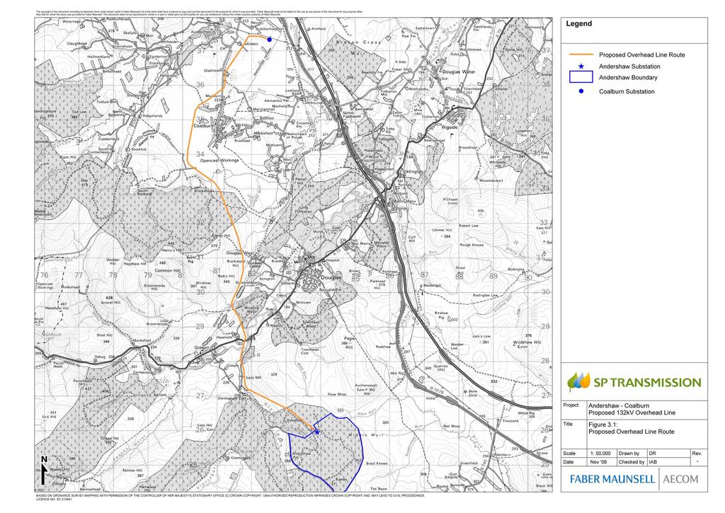
32
33 Andershaw to Coalburn 132kV Overhead Line Environmental Statement 3-3 Span Lengths The span length i.e. the distance between two adjacent structures, varies according to a number of factors including topography, prevailing ground conditions and elevation. Typically the span lengths range between 50m and 120m, with an average of 60-80m. Overhead Line Conductor Arrangement Galvanised steelworks will be located at the top of the wood pole structure. The insulator and conductor arrangement is attached to the steelworks at the top of the wood pole structures. The phase insulators are constructed of porcelain, glass or modern composite materials. On the intermediate wood poles structures, conductors are vertical. On angle or terminal wood pole structures the conductors are horizontal with insulators located on the top of the steelwork. Below the cross arm a fourth conductor acts as an earth conductor. It provides a path for fault current and is also a means of transmitting information via a fibre optic core. On every wood pole structure, the overhead line is earthed using a copper conductor and copper rods below the ground. The amount of earth conductor required at any given wood pole structure is dependent on the resistance of the surrounding bedrock or soil. Underground Cables Due to technical reasons, at the northern end of the grid connection in order to link the overhead line with Coalburn substation underground cables will be used. The conductors and optical ground wire will be located in an excavated trench 1.25m deep and 0.51m wide. Within the trench the conductors and ground wire will be contained in individual ducts. 3.4 Construction Phase Pre-Construction Activities Prior to construction a number of activities will be undertaken including: Precision ground surveys along the centre line of the route and 10m either side in order to determine the ground profile and identify exact wood pole locations. Removal or lopping of trees on or in close proximity to the route of the overhead line to obtain the necessary safety clearance to conductors. Establishment of temporary storage areas for plant and equipment. These will be situated at convenient locations in agreement with the Contractor and landowners. Agreement regarding access routes and arrangements with land owners / occupiers. Preparation of temporary access routes as required. Construction Access and Delivery of Materials Vehicular access to a maximum width of 5m will be required to every wood pole location along the length of the route. Wherever possible access will be taken from existing roads, forestry or agricultural tracks. Where there is no existing access, temporary access tracks, either a track-way system or temporary surfaced access road, will be constructed following the agreement of landowners or occupiers. Construction will typically involve the use of a selection of vehicles including: 4 wheel drive vehicles fitted with lifting devices to deliver wood poles, steelwork, insulators, conductor drums and stringing equipment. HGVs may be required to deliver and remove construction plant and materials. Vans delivering construction staff. A JCB and / or 360 degree excavator for undertaking earthworks, ground levelling and erection of wood poles. Forestry vehicles required for felling. Tractors and Mobile Elevated Working Platforms (MEWP) to undertake stringing of cables and conductors. Following construction all temporary access tracks will be reinstated. Plant and equipment will be stored at temporary compounds along the route. During construction conductor drums will be delivered as close as possible to the pole sites from which they are to be pulled. General access to the construction areas will be taken from the A70 or B7078. Prior to construction and immediately after are when vehicle movements will be most concentrated. This will be due to the delivery and removal of plant and materials. Deliveries would be controlled and staggered so that they do not result in significant effects. Daily movement of staff is not considered to give rise to significant effects. It would involve fewer vehicle movements and these would occur mainly at the start and end of the working day. During the construction period temporary traffic management measures may be required during conductor stringing particularly where the route crosses over the A70, Shoulderigg Road and Coalburn Road. Wood Pole Erection Localised earthworks and potentially ground levelling will be undertaken in order to erect the wood poles. An area of 600m 2 will be required at each pole location while construction takes place. Excavations, typically to a depth of 2.5m, will be required to allow the wood pole brace blocks and / or steel foundation braces to be installed. Earth conductors will then be laid horizontally at the base of the wood poles at a depth of 0.6m. Earth rods will then be inserted vertically along the route of these conductors. The excavations will be backfilled with the excavated material and any adjacent affected land reinstated. Conductor Stringing Overhead line conductors are generally constructed in short sections up to as much as 2km in length. When all the poles within section have been erected, insulators are installed on the tops of the wood poles along with running blocks. The conductors are then fitted using Continuous Tension Stringing. A pulling winch is located at one end of the line section with a conductor drum and tensioner with a hydraulic brake at the other. The conductor is attached to a heavy duty pilot wire and pulled through sections one conductor at a time under constant tension. This method means that conductors are above ground at all times. A working area of approximately 1000m 2 will be required to accommodate the winches used to string up the conductors. These areas will be required roughly every 2km at each short section where the conductors are being strung. The location of the working areas will be dependent on the availability of local access and the terrain. Underground Cabling Where the route is undergrounded a 15m wide working corridor will be established. Within this, a trench will be opened with a 360 degree excavator. Ducts will be laid within the trench and following this the conductors drawn through. The trench will then be backfilled and consolidated with the excavated material. Topsoil and vegetation will be retained and used as part of the reinstatement. Construction Timescales The construction of the overhead line will be timed to coincide with the construction of Andershaw windfarm. Construction of the proposed overhead line connection is expected to take 60 weeks, based on a typical rate of progress of 1km per 3 to 4 weeks. Construction Noise Noise impacts associated with the delivery and installation of the wooden support poles and electricity cabling, including all ancillary operations such as site preparation and delivery, are likely to be short-term and transient in nature. To ensure construction noise is minimised, a number of measures will be implemented as outlined in British Standard (BS) These include: Exhaust silencing and plant muffling equipment to be maintained in good working order; All working to be undertaken during the normal working day; and Loading/unloading sites to be located away from residential or other sensitive properties and shielded from those properties where practicable. 3.5 Operation Phase General Operation and Maintenance The majority of components which make up the overhead line require little maintenance; however, regular inspection of exposed elements which suffer from corrosion, wear, deterioration and fatigue will be required to ensure the safety of all components is in accordance with the Electricity Safety Quality and Continuity Regulations Overhead transmission lines require refurbishment after approximately 40 years. Likewise, wood poles have an expected lifespan of around 40 years.
34 3-4 Andershaw to Coalburn 132kV Overhead Line Environmental Statement Operational Noise Overhead line noise is generated when the conductor surface electric stress exceeds the inception level for corona discharge activity. Transmission and distribution line conductors are designed to operate below this threshold. Surface contamination on conductors will, however, cause a local enhancement of electric stress and possibly initiate discharge activity. At each discharge site a limited electrical breakdown of the air occurs. A portion of the energy associated with the corona process is released as acoustic energy and radiates into the air as sound pressure waves. The highest noise levels generated by a line generally occur during rain. Water droplets collect on the surface of the conductor and may initiate corona discharge. The number of droplets, and hence the noise level will depend primarily on the rate of rainfall. Audible noise levels are predicted to be imperceptible due to the distance between the overhead line and the nearest properties. As a result the overhead line is not predicted to result in significant noise levels. Electric and Magnetic Fields (EMF) Extremely low frequency (ELF) electric and magnetic fields (EMFs) are found virtually everywhere in our environment where electricity is used or transported. Common sources include distribution and transmission lines, appliances, and wiring to and in buildings. Electric fields are the result of voltages applied to electric conductors and equipment. Most objects including fences, shrubbery and buildings easily block electric fields. Therefore, certain appliances within the homes and the workplace are the major sources of electric fields indoors, while power lines and electric trains are the major sources of electric fields outdoors. Magnetic fields are produced by the flow of electric currents, however, unlike electric fields, most materials do not readily block magnetic fields. The magnetic field level at any point depends on characteristics of the source and its distance from the point of measurement. The levels of both electric fields and magnetic fields diminish with increasing distance from the source. The background levels of electric fields and magnetic fields in residences are between 1-20 volts per metre(v/m) and microtesla (µt), respectively. The proposed overhead line is a source of both electric and magnetic fields, whilst the proposed underground cable is a source of magnetic fields only. Fields vary greatly from line to line and over time, and a line typically produces fields much less than the maximum it is capable of. Table 3.1 shows typical ground-level electric field and magnetic field levels from 132kV overhead lines. Table 3.1 Typical Ground-level EMF Levels from Overhead Lines Voltage Magnetic Field 132kV Typical field (under line) Typical field (25m to side) Typical field (100m to side) (microteslas) Electric Field (volts per metre) ,000 2, There are no statutory regulations in the UK which limit the exposure of people to power-frequency electric or magnetic fields. However, the Heath Protection Agency (HPA) has recommended to the Government that the UK follow the exposure guidelines published by the International Commission on Non-Ionizing Radiation Protection (ICNIRP). For electric fields, the guideline level for human exposure 5000 volts per metre and for magnetic fields it is 100 microteslas. Power-frequency field strengths near ground level in the vicinity of high voltage power lines and substations should not exceed the guidelines recommended by the ICNIRP. Effects of Electric and Magnetic Fields Table 3.2 below outlines the sources of possible impacts and associated effects of the proposed overhead line and underground cable. All possible field effects can be addressed by compliance with best practice and industry standards as described below. Table 3.2 Possible effects of EMFs Source Electric Field Magnetic Field Possible Effect Field perception Radio interference Audible noise Induction on fence wires, pipelines or other conductive objects that parallel overhead lines for long distances Possible association with childhood leukaemia for long-term average exposures above 0.4µT Over the past 20 years it has been suggested that exposure to power-frequency magnetic fields of this magnitude could be linked with various health problems, ranging from headaches to Alzheimer s disease. The most persistent of these suggestions relates to childhood cancers. A number of epidemiological studies have suggested an association between the incidence of childhood cancers and the proximity of homes to power transmission and distribution lines or power-frequency magnetic-field strengths in the home. Other studies, notably the world s largest ever study of its type, the UK Childhood Cancer Study (UKCCS) conducted during the 1990s and published in 1999, have failed to confirm such associations. The Childhood Cancer Research Group (CCRG) produced a study (also known as the Draper study) in 2005 which found an association between childhood leukaemia and 274kV/400kV power lines. This association extended too far from the lines to be caused by magnetic fields or other factors and so there is no satisfactory explanation for the findings. No causal link has been established between cancer (or any other disease) and magnetic of electric fields and indeed there is no established mechanism by which these fields could cause or promote the disease. Scientists recognise the possibility of a risk associated with high exposure to magnetic fields but it is no more than a possibility. Any suggestion of a possible health risk is taken seriously by the electricity industry and the industry is continuing to support high quality research to help to gain a clearer picture of EMFs. Given the account taken of residential properties in the routeing process, the levels of EMF will have diminished to typical values that are within the range of levels measured in UK residences. The magnetic field, averaged over 24 hours, in the majority of homes in the UK is between 0.01 and 0.2 microteslas. Mitigation As a result of the routeing strategy, the proposed overhead line route reflects precautionary and good practice measures to route the line away from residences and other sensitive land uses where possible. A consideration of the reviews by the World Health Organisation (WHO), other health agencies and research support the assessment provided by the Health Protection Agency (HPA) and its advisors that the evidence for an association of magnetic fields with leukaemia is inconclusive and that: the epidemiological association may be due to chance, confounding factors or some unrecognized artefact related to the way the data have been collected. The review of the experimental studies gives no clear support for a causal relationship between ELF EMF and cancer (HPA, 2008) The good practices proposed by SP Transmission (SPT) are appropriate and consistent with the recommendations of the HPA and other health agencies. The electric and magnetic fields from the proposed line will not exceed the guidelines published by the ICNIRP and no mitigation is necessary. SPT will continue to act upon the current advice of the Government and HPA in relation to the possible risks to human health from power-frequency fields from overhead and underground power lines. The distances to nearby dwellings and to other infrastructure as well as the experience and standard practices of SPT in addressing radio interference and magnetic induction justify the classification of these effects as of very limited significance. 3.6 Decommissioning Should the overhead line require decommissioning this would involve the use of small scale plant and equipment similar to that involved in construction. The sections of the wood pole structure below ground level would be left in-situ with sections of the wood pole structures above ground including all steelworks and conductors being removed.
35 Andershaw to Coalburn 132kV Overhead Line Environmental Statement Approach to Environmental Impact Assessment 4.1 Introduction This chapter sets out the broad approach that has been followed in undertaking this Environmental Impact Assessment (EIA). It summarises the key stages that have been followed, in line with EIA good practice as described in Planning Circular 8/2007. This chapter also provides a section on the assumptions made during the EIA process. 4.2 The Electricity Works (EIA) (Scotland) Regulations 2000 EIAs have been required for certain major developments since the implementation in the UK of the European Council Directive on Environmental Assessment (EC Directive 85/337/EEC). The Directive was implemented in the UK in 1988 and subsequently amended by Directive 97/11/EC. Directive 97/11/EC is implemented by the Electricity Works (EIA) (Scotland) Regulations These Regulations set out the information that must be included in an ES, such as: A description of the development, comprising information about the site and the design and size of the project; An outline of the main alternatives considered and an indication of the main reasons for the chosen scheme; The data necessary to identify and assess the main effects that the project is likely to have on the environment; A description of the likely significant effects of the project on the environment; A description of the mitigation measures envisaged to avoid, reduce or remedy significant adverse effects; An indication of any difficulties encountered in compiling the required information; and A Non-Technical Summary of the above information. The Electricity Works (EIA) (Scotland) Regulations 2000, implemented by Directive 97/11/EC, apply to applications under Section 37 of the Electricity Act 1989 for consent to install or keep installed an electric line above ground. Under Regulation 2(1), the proposed route, from Andershaw windfarm to Coalburn substation, is a Schedule 2 development as Schedule 2(d): an electric line installed above ground with a voltage of 132 kilovolts or more, the installation of which (or the keeping installed of which) will require a section 37 consent but which is not a Schedule 1 development. As described in Chapter 1, Schedule 2 developments do not require a mandatory EIA. In determining the requirement to undertake an EIA, the potential for the scheme to result in significant environmental effects must be considered and if appropriate a Screening Opinion as to the need for EIA can be requested from the Scottish Government. SPT, mindful of their responsibilities to people and the environment, as well as their statutory duties; consider it appropriate to undertake an EIA for this overhead line development. 4.3 The EIA Process EIA is the process of compiling, evaluating and presenting all of the significant environmental effects of a proposed development. The aim of the assessment is to help produce an environmentally sympathetic project. Detection of potentially significant adverse environmental impacts can then lead to the identification and incorporation of appropriate mitigation measures into the scheme design. The main steps in the assessment procedure are as follows: Baseline surveys are carried out to provide a description of the environmental character of the area likely to be affected by the development. This information is provided to the scheme designers at the earliest opportunity; Relevant natural and man-made processes that may change the character of the area are identified; Consideration is then given to the possible interactions between the proposed development and both existing and future site conditions. These interactions or impacts are assessed using stated criteria based on accepted guidance and best practice Using the initial designs of the development, the possible environmental effects, both direct and indirect, are predicted; Recommendations can then be made to avoid, minimise or mitigate adverse effects and enhance positive effects. Alterations to the design can then be reassessed and the effectiveness of mitigation proposals determined; Any uncertainties inherent in the methods used, impact predictions made and conclusions drawn would be identified during the course of the assessment process; The results of the EIA are set out in the ES. 4.4 Approach to the Assessment of Impacts Determining the significance of impacts arising from the proposed scheme is a key stage in the EIA process. It is this judgement that is crucial to informing the decision-making process. However, defining what is significant is not a simple task. In order to assess the overall significance of an impact it is necessary to first establish the magnitude of the impact occurring in the context of the sensitivity or importance of the receiving environment. Magnitude of Impact The magnitude of potential impacts (both positive and negative) on environmental baseline conditions is identified through detailed consideration of the proposed development taking into account the following: Relevant legislative or policy standards or guidelines; The degree to which the environment is affected, e.g. whether the quality is enhanced or impaired; The scale or degree of change from the existing situation as a result of the impacts; The duration of the impact, e.g. whether it is temporary or permanent; and The reversibility of the impact. The criteria used to assess impact magnitude are provided in the relevant chapter of the ES. Sensitivity or Importance of Receptor The sensitivity of the baseline conditions is assessed according to the relative importance of existing environmental features on or near to the site (e.g. whether it is of national, regional or local importance), or by the sensitivity of receptors which would potentially be affected by the development. Criteria for the determination of sensitivity (as high, medium, or low ) or of importance (e.g. international, national, regional or authority area ) are established based on approved guidance, legislation, statutory designation and/or professional judgment. The criteria for each environmental parameter are provided in the relevant chapter of the ES. Significance of Impact The significance of the impacts arising from the proposed development are categorised throughout the ES using a seven-point scale, as follows:
36 4-2 Andershaw to Coalburn 132kV Overhead Line Environmental Statement None (i.e. little or no effect); Table 4.1 Assessment of Impact Significance Minor (adverse or beneficial); Moderate (adverse or beneficial); and Major (adverse or beneficial). The general approach adopted in the assessment of significance is outlined in the matrix shown in Table 4.1, right. A combination of the magnitude of the impact under consideration and the sensitivity of the receiving environment determines the impact significance. Note that when the significance of impacts is assessed this takes into account mitigation, i.e. the assessment applies to the residual impacts of the scheme, which can be defined as any impact that would remain following the implementation of proposed mitigation measures. Assumptions relating to mitigation and detailed design are set out in Section 4.5 below. For some topics, alternative categories have been added where a greater level of definition is required. In general terms if an impact is negligible it is environmentally acceptable; minor significance reflects the fact that the impact is manageable. Impacts assessed as moderate or higher are considered to be 'significant'. It should be noted that throughout the ES, the terms impact and effect are used interchangeably, in line with Planning Advice Note 58. High: Total loss or major alternation to key elements /features of the baseline conditions such that post development character/ composition of baseline condition will be fundamentally changed Medium: Magnitude Loss or alteration to one or more key elements/features of the baseline conditions such that post development character/composition of the baseline condition will be materially changed. High: The receptor has little ability to absorb change without fundamentally altering its present character, is of high environmental value, or of international or national importance. Medium: The receptor has moderate capacity to absorb change without significantly altering its present character, has some environmental value, or is of national importance. Sensitivity Low: The receptor is tolerant of change without detriment to its character, is low environmental value, or local importance. Negligible: The receptor is resistant to change and is of no environmental value. Major Moderate Moderate Minor Moderate Moderate Minor None Low: Minor shift away from baseline conditions. Changes arising from the alteration will be detectable but not material; the underlying character/ composition of the baseline condition will be similar to the pre-development situation. Moderate Minor None None Negligible: Very little change from baseline conditions. Change is barely distinguishable, approximating to a no change situation. Minor None None None
37 Andershaw to Coalburn 132kV Overhead Line Environmental Statement 4-3 Construction, Permanent & Operational Impacts Impacts have been separated into three types based on different phases of the development: Construction impacts are temporary, short-term impacts that occur during the construction phase only; Permanent impacts are those long-term effects that would occur as a result of the development and may include the introduction of new structures or the loss of habitat; and Operational impacts, i.e. those impacts resulting from operation and maintenance of the overhead line. Decommissioning Impacts Should the overhead line require decommissioning this would involve the use of small scale plant and equipment similar to those involved in construction. The sections of the wood pole structure below ground level would be left in-situ with sections of the wood pole structures above ground including all steelworks and conductors being removed. Impacts arising from decommissioning are similar to those predicted to occur during construction. They would include temporary disturbance of land and habitats as well as the increased risk of pollution. For the purposes of the assessment impacts resulting from decommissioning have been assessed as the same for construction. Inter-Relationships Between Impacts For the purposes of the EIA, the potential impacts of the scheme are considered in terms of impacts on each of the discrete environmental topic areas. However, in reality, topic areas such as water quality, ecology or landscape cannot always be considered in isolation since changes affecting one factor may often have secondary implications for other areas. Thus, if one impact of the scheme is to alter the quality and quantity of a watercourse, flora and fauna may be affected as a secondary effect. Under some circumstances, it is possible for the secondary or indirect impacts to actually be more significant than the changes that triggered them. Therefore where potential interactions between environmental topic areas occur these are highlighted in the text. Cumulative Impacts Combined and cumulative effects on specific resources or receptors are described, where relevant, in each of the specialist chapters. Cumulative effects may arise, where for example landscape and visual resources, land use or ecological receptors are impacted on by other developments in addition to the proposed overhead line. Cumulative impacts have been considered within the assessment and the baseline against which impacts have been considered has assumed a situation whereby Andershaw windfarm has been constructed. Cumulative effects with existing overhead lines and Hagshaw Hill windfarm have also been considered. Whilst there are other windfarms at various stages of the planning process within the wider area; including the consented Clyde windfarm, the relatively small scale of the proposed grid connection and the large separation distance between it and the various windfarms (over 13km) are such that no cumulative impacts are predicted to result. 4.5 Uncertainty, Assumptions and Limitations General The EIA process is designed to enable good decision-making based on the best possible information about the environmental implications of a proposed development. However, there will always be some uncertainty as to the exact scale and nature of the environmental impacts. This uncertainty arises because of the level of detail and information about the scheme available at the time the assessment was carried out and/or due to the limitations of the prediction process itself. Key issues relating to assumptions are described below. Other topic specific assumptions are set out, where necessary, in Chapters 5 to 10 of this ES. Level of Design Detail for EIA It is acknowledged that the scheme which is eventually designed and constructed may differ slightly from the design details that have been used in the EIA and reported in this ES. As described in Chapter 3 the Section 37 Application includes a micrositing tolerance to allow for minor deviations to wood pole locations according to pre-construction surveys. The EIA has been undertaken based on a design which specifies pole locations, however, as these are subject to minor deviations the assessment considers the area surrounding wood pole locations. A balance has been sought in the EIA between, on the one hand, specifying enough detail to undertake an assessment that meets the requirements of the EIA Regulations, and on the other hand, avoiding specification of the design to a point that restricts the scope for cost effective design. The environmental impacts that are reported in this ES represent a worst case scenario and the level of mitigation described effectively sets the minimum standard which will be achieved by the final scheme. SPT is committed to ensuring that where details of the scheme differ from those assessed in the EIA, the project will not generate additional significant adverse environmental impacts that have not been assessed in the EIA. 4.6 Mitigation Approach to Mitigation A standard hierarchical approach to identifying mitigation requirements has been used to inform the EIA: Avoid: in the first instance, mitigation should seek to avoid the adverse effect at source for example, by locating development away from a sensitive receptor. Reduce: if the effect is unavoidable, mitigation should seek to reduce the significance of the impact. Offset: if the effect can neither be avoided nor reduced, mitigation should seek to offset the impact through the implementation of compensatory mitigation. The proposed overhead line has been developed through an iterative process, a considerable element of which involved seeking to avoid or reduce significant environmental effects. The package of mitigation measures to be implemented during the construction and operation of the overhead line are set out in Chapter 11 of this ES. Assumptions Relating to Mitigation Where the potential for significant impacts has been identified, the scope for their mitigation has been discussed with the design team. In stating the mitigation measures in the ES, SPT is committed to the implementation of all those measures described. SPT is committed to ensuring that the design, construction and operation of the overhead line is within the parameters that were assessed in the EIA. The scheme will not generate significant adverse environmental impacts that have not been assessed. 4.7 Consultation and Scope of EIA Introduction As part of both the routeing study and the EIA process, consultation has been undertaken with statutory and non-statutory consultees. The aims of this were: To request information in order to understand and identify the environmental baseline; To inform consultees and the public about the details of the proposed overhead line and how it was identified; and To enable consultees to express their opinion on the overhead line and the methods that would be employed in undertaking the EIA. Consultation The Consultation Document described the initial stages of work undertaken in identifying the proposed route. At the outset of the routeing study a wide ranging consultation was undertaken with stakeholders and other interested parties. The primary aims of this were to identify all relevant baseline environmental information and consider the views of consultees on the routeing process. As part of the routeing study, public consultation was undertaken. This included meeting with local community councils to discuss the project and displaying exhibition boards at prominent public locations in Douglas and Coalburn. This ensured that the local community was aware of the proposed overhead line and that any concerns it held could be addressed. Scoping Following production of the Consultation Document, a Scoping Request was prepared and submitted to the Scottish Ministers in accordance with Regulation 7 of the Electricity Works (EIA) (Scotland) Regulations (As amended) This provision of the Regulations allowed SPT to seek clarification from the Scottish Ministers as to the information required to inform the ES prior to submitting the Section 37 Application. Scoping is a preliminary task within the EIA process and the Scoping Request provides a focus and mechanism for consulting on and agreeing the content and methodology of the subsequent EIA. In responding to the request with a formal Scoping Opinion, the Scottish Ministers obtain the views of the Consultation Authorities including SNH, SEPA and the local planning authority. The Scoping Opinion was received
38 4-4 Andershaw to Coalburn 132kV Overhead Line Environmental Statement on the 15th January The issues identified for consideration within the ES included: Land Use Planning Landscape and Visual Amenity Ecology and Nature Conservation Archaeology and Cultural Heritage Water Environment Summary of Scoping and Consultation Responses Statutory agencies and bodies consulted during the EIA process and their responses are summarised below in Table 4.2. Full copies of the responses received can be found in Appendix C. Table 4.2 Summary of Scoping and Consultation Responses Consultee Summary of Response Summary of Action Taken Fisheries Research Services (FRS) Forestry Commission Scotland (FCS) Information on local fish and fisheries should be included in addition to identification on where any potential impacts could occur and offer suitable mitigation. Advise that the visual impacts associated with woodland felling and suggested the landscape impact of routeing through woodlands be investigated. Reference should be made to the potential for instability resulting in windthrow risk. Detailed habitat and species survey should be undertaken, including Phase 1 to highlight and protect any areas of natural heritage value. Direct impacts on fisheries are considered unlikely; wood pole structures span surface watercourses, however, no work would occur within watercourses. Where works occur in the vicinity of watercourses the potential to impact on water quality is considered (Chapter 11 Ground conditions and the Water Environment) and the secondary effects on fisheries acknowledged. Mitigation to prevent pollution of watercourses is proposed. Proposed overhead line route makes best use existing wayleaves and rides through woodland with only minimal felling, lopping and pruning required. Increased windthrow risk is considered within the ES and will be assessed, where appropriate, following identification of precise areas to be cleared. Appropriate ecological surveys, including Phase 1 Habitat Survey were undertaken, details of which can be found in Chapter 8 Ecology and Nature Conservation. Health and Safety Executive (HSE) Historic Scotland HSE has no comments. Provided advice on the scope of the assessment sources of baseline information and the types of impacts that should be considered within the assessment. Advised that detailed information and advice on the project should be sought from the Council Archaeological Service, West of Scotland Archaeological Service (WoSAS). No action required. WoSAS have been contacted and their advice has been considered in preparing Chapter 10 Cultural Heritage and Archaeology. Royal Society for the Protection of Birds (RSPB) Collision risk along the overhead line route should be examined with inclusion of details on areas for wire marking with bird flight diverters or aerial marker spheres. Ornithological surveys have been undertaken during the breeding and wintering season in order to establish the presence or lack thereof of birds of conservation importance and identify areas where high densities of birds are present. Survey results are reported in Chapter 9 Ornithology. Scottish Coal Advised that planning applications have been made to SLC for the surface mining of coal from Mainshill Wood. The proposed overhead line route avoids this area. Advised that Poniel mining operations were underway & an outline planning application for residential development on Dalquhandy OCCS office/car park area submitted. The proposed route avoids all these areas. Provided guidance on the routeing through the restored site at Dalquhandy. Highlighted that the proposed overhead line cuts through an area of tree planting carried out as part of the Dalquhandy restoration programme. Advised on safety clearances and potential crossing points with respect to the Mid-Rig Coal Conveyor Taken account of constraints identified by Scottish Coal including areas of economically extractable coal deposits and safety clearances along the route of the Mid-Rig Coal Conveyor. Overhead line is proposed to continue through existing breaks and rides within the tree planting at Dalquhandy with minimal tree removal anticipated.
39 Andershaw to Coalburn 132kV Overhead Line Environmental Statement 4-5 Consultee Summary of Response Summary of Action Taken Scottish Environment Protection Agency (SEPA) Advise that construction impacts may not necessarily be temporary in nature. Construction activities and creation of access roads can impact on water quality and result in impacts which are not temporary. Identify ecological surveys that should be undertaken. Highlight that in considering flood risk the ES should have regard to SEPA s Indicative River and Coastal Flood Map. Require that impacts on aquatic ecological features be addressed. Advise that the exact locations of pole structures, storage areas and access routes should be identified within the ES. Identify that Coalburn Moss is groundwater dependent. Require that the ES addresses any significant impacts on the physical and ecological status of the water environment. Require mitigation to be provided to prevent both particulate and chemical contamination of watercourses and manage surface runoff including during periods of high rainfall. Advise that the requirements of the Controlled Activities Regulations relevant General Binding Rules, SEPA Pollution Prevention Guidelines and the CIRIA SUDS Manual inform drainage mitigation. Request that method statements are produced for all aspects of the work that might impact on the water environment and require the opportunity to review these prior to the commencement of construction. Advise that measures should be taken to ensure that waste generation is minimised and in particular waste peat arising from excavations. Advise on the various legal acts relevant to the works. Scottish Government Impacts on recreation, access and tourism should be assessed within the ES. Potential effects of Electric and Magnetic Fields (EMF) should be addressed. Traffic management should be addressed and information provided on route options and methods for delivering plant and materials to site. Advised on Land Use Planning and National policy guidance to be considered within the assessment. Advised that the it is considered best practice to set out within the EIA the qualifications of those involved in undertaking the assessment. Requested that peatslide risk assessment be undertaken. Scottish Natural Heritage (SNH) Key issues identified for consideration included ecological impacts, landscape and visual impacts and also impacts on public access. Designated Sites: Advise that the route is in close proximity to Millers Wood SSSI and Coalburn Moss SAC. Potential impacts on either site should be identified and appropriate mitigation proposed. Ornithology: Require survey methodologies and results to be clearly presented. Request information on mitigation and what is proposed to minimise collision risk. Protected Species: Confirm that the mammal surveys identified cover the main protected species likely to be present along the route of the overhead line. Habitats and Soils: identify the presence of peatland habitats in areas adjacent to along the route of the overhead line. Suggest the route avoids new broadleaf planting near Millers Wood to reduce future lopping and felling. Advise that consideration should be given to construction methods and require a Construction Methods Statement be prepared. Landscape and Visual: Require that the ES should include justification for the use of an overhead line as opposed to underground cables for sections of the route. Advise that guidelines for reducing impacts on landscape character types are contained within the Glasgow and Clyde Valley LCA. Expect the ZTV to cover an area of 5km. Confirm that viewpoints should be agreed with SNH and the local authority. Advise that the ES should assess the extent to which visual impacts impact on the integrity of the AGLV and the RSA. Require production of photomontages and wirelines from key viewpoints which illustrate the principle components of the proposal. Recreation and Access: Identify a number of Rights of Way within the area and advise that an assessment of potential effect on them should be made. Mitigation should be proposed where necessary. Where construction impacts have the potential to have lasting impact this has been identified within the ES. The appropriate ecological surveys have been undertaken as part of the assessment. Details of the surveys undertaken are included in Chapter 8 Ecology and Nature Conservation. SEPA s Flood Risk Map has been reviewed to establish the areas along the route and adjacent to it that are at risk of flooding. The linkages between water quality and aquatic ecology and the potential to impact on aquatic ecological features has been assessed. A line design has been prepared, however, pole locations may be microsited subject to the results of precision ground surveys and pre-construction surveys. Storage areas and access routes would be identified in advance of construction. The importance of groundwater in relation to ecological designations has been identified within the ES. General Binding Rules, SEPA PPG s and guidance from CIRIA has been reviewed and used to inform mitigation proposals. Mitigation measures have been summarised within Chapter 13 Schedule of Mitigation. This schedule will inform the preparation of detailed Construction Method Statements and forms the basis of an Environmental Management Plan for the project. Waste generation is considered within the assessment and mitigation is proposed to ensure that the volume of waste generated is minimised. Recreation and access have been addressed within Chapter 6 Land Use, Access and Recreation. Significant impacts on tourism are not considered likely and as such it was not considered within this assessment. EMF was scoped out during the initial stages of the EIA as EMF is not considered to be a significant issue with 132kV overhead transmission lines. This is discussed in detail within Chapter 3 Scheme Description. Details of the proposed delivery routes and trunk roads to be used are contained within Chapter 3 Scheme Description. Chapter 5 sets out the Planning Policy Context to the project at local, regional and national levels. Details of the project team are contained within Chapter 1 Introduction. Peatslide risk was scoped out as it was not considered a significant issue for overhead lines. All designated sites are identified within Chapter 8 Ecology and Nature Conservation. Generally these have been avoided in the developing the propose route, however, where the potential exists for impacts on Colburn Moss SAC and Millers Wood SSSI these have been addressed. Full details of all ornithological surveys undertaken and results can be found within Chapter 9 Ornithology. Where appropriate mitigation measures have been identified. Protected species surveys have been carried out and the results reported in Chapter 8 Ecology and Nature Conservation. Areas of peatland have been identified within the Phase 1 Habitat Survey results. Where possible the route has sought to avoid these. Mitigation includes ecological input to micrositing of wood pole structures within particular habitats. A Mitigation Schedule has been prepared and is contained within Chapter 13. The measures contained will inform the preparation of Construction Method Statements and from the basis of the Environmental Management Plan. Landscape and visual impacts, including impacts on the integrity of the AGLV and RSA are assessed within Chapter 7 Landscape and Visual Amenity. SPT s policy on undergrounding cables is described in Chapter 2., undergrounding was not considered to be required for the proposed grid connection. A full description of the routeing study and reasons for selection of the proposed route are contained within the Consultation Document (June 2008). The findings of the routeing study are summarised with Chapter 2 Development of the Scheme and Alternatives. A ZTV which extends more than 5km beyond the route has been prepared. A number of photomontages and renders have been produced. These illustrate the scheme from a number of viewpoints and have informed the assessment. Rights of Way were identified in consultation with the Scottish Rights of Way Society. Potential effects on access are considered with Chapter 6 Land Use, Recreation and Access.
40 4-6 Andershaw to Coalburn 132kV Overhead Line Environmental Statement Consultee Summary of Response Summary of Action Taken Scottish Rights of Way Society Advised on the presence of Rights of Way within the area and provided maps of recorded paths. Impacts on Rights of Way and access are considered within Chapter 6 Land Use, Access & Recreation. Scottish Wildlife Trust (SWT) South Lanarkshire Council Expressed concerns over potential effects of undergrounding cable in close proximity to Coalburn Moss. Recommended that a search of locally designated sites is undertaken. SLC provided only a brief response to the scoping opinion due to their current workload. Recommended that cumulative visual impact of the overhead line and proposed and consented windfarms is made. Advise that the cumulative visual assessment should consider Andershaw windfarm. Effects on Coalburn Moss have been addressed and are discussed within Chapters 8 and 11., Ecology and Nature Conservation and Ground Conditions and the Water Environment respectively. During the EIA details of locally designated sites were requested. Cumulative visual impact is addressed with Chapter 7 Landscape and Visual Amenity South Lanarkshire Biodiversity Partnership Advised on the presence of blanket and lowland bog within the area and recommended that there should be a presumption against felling of ancient and/or semi natural woodland. Blanket and lowland bog have been avoided where possible. Chapter 8 Ecology & Nature Conservation set out how impacts on such areas will be minimised. No ancient or semi natural woodland requires to be felled. West of Scotland Archaeological Service (WoSAS) Provided a range of baseline information and records. Advised on impacts that should be considered within ES including sub-surface archaeological features. Recommended that micrositing be employed to avoid impacting on unscheduled archaeological impacts. Impacts on archaeology including the potential to affect sub-surface features are addressed within Chapter 10 Cultural Heritage & Archaeology. Micrositing will be used to mitigate impacts where appropriate.
41 Andershaw to Coalburn 132kV Overhead Line Environmental Statement Planning Policy Context 5.1 Introduction This chapter summarises the national planning policy guidance and development plan policies (including adopted and emerging development plan policies) that are relevant to the proposed overhead line. Note that the function of this chapter is merely to identify relevant policies; there is no requirement under either the Environmental Impact Assessment (Scotland) Regulations 1999 or the Electricity Works (Environmental Impact Assessment) (Scotland) Regulations 2000 to review the proposed scheme against such policies. It is, however, helpful within a wider context to establish national, regional and local planning guidance and policy relevant to the proposed overhead line connection. 5.2 The Electricity Act 1989 This Environmental Statement (ES) accompanies the application to the Scottish Ministers, under Section 37 of the Electricity Act 1989 to install and keep installed a 132kV overhead line between Andershaw windfarm and Coalburn substation. The Section 37 Application also includes a request for a direction under Section 57(2) of the Town and Country Planning (Scotland) Act 1997 that deemed planning permission be granted for the overhead line and ancillary development. When considering development proposals for overhead line schemes a range of planning policy and guidance should be taken into account including: Government Energy Policy at both UK and Scottish levels; National Planning Policies and Guidance; Regional Planning Policies; and Local Planning Policies. 5.3 Government Energy Policy Within the UK, the Government s current energy policy is set out in the Energy White Paper of May It describes key long term policy goals including reducing emissions of carbon dioxide and increasing the amount of energy provided from renewable sources. The Paper also describes the role the planning system has to play in the delivery of the necessary energy infrastructure. Targets for the reduction of carbon dioxide emissions are set within the UK Climate Change Bill which seeks a 60% reduction in emissions by In Scotland, however, the Scottish Government have set more ambitious targets seeking a an 80% reduction by This target has been set based on the potential for a range of renewable energy developments in the country utilising wind and marine energy resources. 5.4 National Level Planning Policies National Planning Framework The National Planning Framework for Scotland (NPF) published in 2004 sets out a vision to guide development in Scotland up to While it is not prescriptive, the NPF will form a material consideration when determining the outcome of planning applications and appeals. With specific reference to energy and tackling the problem of climate change the NPF recognises that the Scottish Government has set a target of sourcing 40% of the electricity generated in Scotland from renewable energy sources by In order to achieve the target and also realise the economic potential of renewable energy sources the NPF acknowledges: The capacity of the electricity grid will require to be upgraded; Modifications of existing lines may be necessary; and New connections to the electricity grid will be required. NPF 2 will shortly supersede NPF. This also places a strong emphasis on renewable energy and recognises the need to strengthen electricity transmission links. National Planning Policy Guidance and Scottish Planning Policies At a national level, planning guidance and advice is contained within Scottish Planning Policies (SPPs) or National Planning Policy Guidance (NPPGs) and is supported by Planning Advice Notes (PANs). SPPs identify key priorities for the planning system and provide statements of Scottish Government policy on nationally important land use and other planning matters. SPPs update and replace NPPGs; however, existing NPPGs will continue to be relevant to planning decision making, until such time as they are replaced by a SPP. Hence the term SPP should be interpreted as including current NPPGs. Relevant SPPs/NPPGs are summarised in below in Table 5.1. Table 5.1 National Planning Policy Policy Document SPP The Planning System Summary Provides an overarching view of the Scottish planning system including the purpose and principles of the planning system. It seeks to place planning in the wider context of Scottish Government aims and policies and clarify the expectations of the system and the service. Policy Document SPP 6 Renewable Energy SPP 7 Planning & Flooding NPPG 14 Natural Heritage SPP 15 Planning for Rural Development SPP 23 Planning and the Historic Environment Summary Further planning advice is contained within Planning Advice Notes (PANs). These provide advice on good practice in relation to various topics. The following PANS have been considered in undertaking the EIA of the grid connection: PAN42: Archaeology Planning Process and Scheduled Monument Procedures; PAN51: Planning, Environmental Protection and Regulation; PAN56:Planning and Noise; SPP 6 describes how the planning system should manage the development, approval and implementation of renewable energy projects. Central principles include support for a diverse range of renewable energy technologies. The central purpose of SPP 7 is to prevent development that would have a significant probability of being affected by flooding or which would increase the probability of flooding elsewhere. The policy states Scotland's natural heritage includes its plants and animals, its landforms and geology, and its natural beauty and amenity. The NPPG sets out statutory obligations, objectives and recommended approaches for the conservation and management of natural heritage. The planning policy aims to ensure that where development occurs natural heritage features are safeguarded. SPP 15 provides guidance and advice with regard to development in rural areas. It sets out the approach, key messages and objectives that should underpin planning policies and decisions affecting rural areas. The objectives and main principles also apply to protected landscapes, including National Parks, but in ways appropriate and sympathetic to their special context. Describes national planning policy for the historic environment and indicates how the planning system will contribute towards the delivery of Scottish Ministers policies as set out in the current Scottish Historic Environment Policy. PAN58: Environmental Impact Assessment;
42 5-2 Andershaw to Coalburn 132kV Overhead Line Environmental Statement PAN60: Planning for Natural Heritage; PAN68: Design Statements; PAN69: Planning and Building Standards Advice on Flooding; PAN75: Planning for Transport; and PAN79: Water and Drainage. 5.5 Strategic Planning Policy The Glasgow and Clyde Valley Joint Structure Plan (GCVJSP) (adopted 2003) forms the foundation for the long term planning and development strategy in the region as well as containing policies that promote the protection of the natural and built environment. Since its adoption in 2003 the plan has undergone a number of alterations to reflect changes in national policy and economic growth. This document refers to the consolidated 2006 Structure Plan which consists of the original policies and strategies and the subsequent alterations. Key strategic policies from this draft are summarised below in Table 5.2. Table 5.2 Regional Planning Policy Policy Document Strategic Policy 7: Strategic Environmental Resources Summary Requires that particular regard be had to safeguarding and managing International, National and Strategic Environmental Resources listed in Schedule 7 of the Structure Plan. Schedule 7 includes: Ecological Resources; Landscapes; Existing and Potential Recreational Resources; Built Heritage; Agricultural Land; Mineral Reserves; and Undeveloped Functional Flood Plain Areas. This policy also advises that there shall be a presumption against any proposals which could have a significant adverse effect upon environmental resources and requires the protection and enhancement of the environmental resources listed in Schedule 7, in accordance with the guidance set out in the NPPG 14 Natural Heritage. Policy Document Strategic Policy 8: Sustainable Development of Environmental Resources Strategic Policy 9: Assessment of Development Proposals Summary Supports developments which satisfies a range of criteria including: Having regard to the relative sensitivities for further afforestation indicated; Are located within the Potential Areas of search for significant windfarm developments; Extend the supply of minerals at existing operational sites or in the locations identified in local plans in the search; and Safeguard and enhance the Strategic Environmental Resources identified in Schedule 7. In order to accord with the Structure Plan, development proposals are required to satisfy a range of criteria including that the location of the development is appropriate in terms of the need to safeguard the environmental resources listed in Schedule 7 or identified in local plans including regard to landscape character and quality. 5.6 Local Planning Policy At a local level development in South Lanarkshire is controlled by five individual Local Plans, the study area being covered by the Lower Clydesdale Local Plan LCLP (adopted 2004). Following council re-organisations the five Local Plans have been amalgamated to form the South Lanarkshire Local Plan (SLLP) (finalised August 2006). A deposit draft was consulted on in 2006 and a series of modifications presented in March It should be noted that the SLLP has not yet been formally adopted. South Lanarkshire Council have published a notification to adopt the plan and subject to approval from the Scottish government it is expected to be adopted in late March To a large extent the Local Plan reflects the content of the Structure Plan. It sets out in more detail a planning policy framework to promote and guide development including a range of policies relating to the allocation of land for housing, industry and business, regeneration opportunities and policies promoting the protection of the built and natural environment. The SLLP sets out five objectives including one specifically aimed at protecting the environment. This objective, Promoting Environmental Quality, states that the SLLP will: Protect and enhance the built and natural environment within the Local Plan area. Focus on design issues, including community safety, to promote sustainable, good quality housing in well planned developments. Protecting the habitats and species identified in the South Lanarkshire Biodiversity Action Plan and designated sites including Natura 2000 protected sites. Seeking the protection and enhancement of listed buildings, conservation areas and other built heritage assets; and Protecting the landscape quality of South Lanarkshire. Key relevant policies from the South Lanarkshire Local Plan are summarised below in Table 5.3. Table 5.3 Local Planning Policy Policy Document Policy STRAT 6: Remoter Rural Areas Policy STRAT 9: Environmental Mitigation and Enhancement Policy RES 6: Residential Land Use Policy ENV4: Protection of the Natural and Built Environment Policy ENV6: Local Nature Conservation Sites Proposal Policy ENV9: Review of Landscape Character Summary All development should seek to enhance the environmental quality of the area, or where enhancement is not possible environmental impacts should be mitigated in line with Policy STRAT 9. Advises that where development is predicted to have a negative environmental impact appropriate site surveys must be carried out to ensure that the impact is prevented, reduced or offset and that where neutral or positive impacts may result these are clearly outlined. SLC will resist development detrimental to the amenity of residential areas including development that affects visual amenity and public safety. Advises that all development proposals will be considered in terms of their effect on the character and amenity of the natural and built environment in accordance with NPPG 14 - Natural Heritage. It also provides guidance on development which may affect internationally, nationally and locally designated sites. Commits the Council to a review of all recorded Sites of Importance for Nature Conservation (SINCs) to consider the identification of new sites. Until the review is completed, development proposals affecting existing SINCs will be assessed against the requirements of Policy ENV26. Commits the Council to undertaking an assessment of the landscape character of Council area including a review of related landscape designations within the area. The objective will be achieved through a number of actions including: Policy ENV14: Renewable Energy Advises that significant windfarm developments are to be directed to the potential areas identified in the Structure Plan. All proposals will be assessed against the criteria set out in ENV 37.
43 Andershaw to Coalburn 132kV Overhead Line Environmental Statement 5-3 Policy Document Policy ENV 19: Natura 2000 Sites Policy ENV 20: European Protected Species Policy ENV 22: Ancient Monuments and Archaeology Policy ENV 25: Sites of Special Scientific Interest/ National Nature Reserves Summary Advises that development likely to have a significant effect on a Natura 2000 site will be subject to an appropriate assessment. Where an assessment is unable to conclude that a development will not adversely affect the integrity of the site, development will only be permitted where there are no alternative solutions; and there are imperative reasons of overriding public interest. Requires the assessment in compliance with this policy to take full account of impacts on the qualifying interests of all Natura 2000 sites including those which adjoin, or are located outwith the boundary of South Lanarkshire. Encourages the management and maintenance of areas supporting habitats and species, including those which contribute to the coherence of the Natura network, are Habitats and species listed in Annex I of the EC Habitats Directive; are Habitats and species of community interest listed in Annexes II, IV and V; Habitats of naturally occurring wild birds, particularly those in Annex I of the EC Birds Directive and migratory species. The policy also applies to species listed in Schedules 1, 5 and 8 of the Wildlife and Countryside Act 1981 as amended. Advises that all these resources will be given full consideration in the assessment of development proposals that may affect them. In respect of animals and plants identified in Annex IV, planning permission will not be granted unless it is demonstrated that the proposal will either not adversely affect any European Protected Species in the area, or that all three tests in Regulation 44 of the Habitats Regulations are likely to be satisfied. States that where developments would have an adverse affect on scheduled monuments or their setting they will not be permitted. Requires all other archaeological resources to be preserved in situ wherever possible and advises that in some cases an archaeological evaluation may be required prior to the determination of a planning application. Advises that development that affects a SSSI or NNR would only be permitted where it has been demonstrated that the objectives or overall integrity of the site would not be compromised or the adverse effects are outweighed by social or economic benefits of national importance. Policy Document Policy ENV 26: Local Nature Conservation Sites Policy ENV 27: Historic Gardens and Designated Landscapes Policy ENV 28: Regional Scenic Area and Areas of Great Landscape Value Policy ENV 33: Development in the Countryside Policy ENV 37: Renewable Energy Site Assessment Summary Development affecting a local nature conservation site will only be permitted where it has been demonstrated that the objectives of the designated site and its overall integrity are not compromised or the significant adverse affects are clearly outweighed by significant social and economic benefits. Development should not adversely affect the character of Historic Gardens or Designed Landscapes. important views to, from and within them, affect the site or setting or component features which contribute to their value. States that within the Regional Scenic Area and Areas of Great Landscape Value, development will only be permitted if it satisfies the requirements of policies STRAT 3-6 (as appropriate) and can be accommodated without adversely affecting the overall quality of the designated landscape area. It also advises that within and outwith these areas, in providing for new development, particular care shall be taken to conserve features which contribute to local distinctiveness, including the setting of settlements within the landscape; the pattern of woodland, fields, hedgerows and tree features, special qualities of river corridors, and skyline and hill features, including prominent views. Requires that development within the countryside complies with policy STRAT 3-6. It also advises that it should be demonstrated to the Council s satisfaction that a number of issues are addressed including that the development conserves the natural and built environment and avoids significant adverse impacts on biodiversity; respects existing landscape form; retains or reinstates trees, woodland and boundary features and avoids dominating or adversely interfering with existing views. Advises on the factors to be considered in the assessment of windfarms and other renewable energy developments including demonstrating that the environmental effects of all new transmission lines between the development and the point of connection to the grid have been assessed and been shown to have no significant adverse environmental impact. 5.7 Summary The application to construct and operate the proposed connection will be made to the Scottish Ministers under Section 37 of the Electricity Act The Ministers will consider the Section 37 application in the context of a range of policies at national, regional and local level including those relating to protection of the built and natural environment as well as others pertaining to the development of renewable energy schemes. It should be noted that the need for the connection is related to the application to construct Andershaw windfarm and that the connection will only be constructed should the windfarm application be approved.
44
45 Andershaw to Coalburn 132kV Overhead Line Environmental Statement Land Use, Access & Recreation 6.1 Introduction This chapter of the ES is concerned with the effects that the scheme will have on land and land use, including access. The scope of the assessment has been developed based on the Scoping Opinion provided by the Scottish Government. Considered within this assessment are the potential impacts on recreational, residential and agricultural areas as well as potential impacts on forestry. The assessment covers both existing and, where information is available, future land uses. In addition, the assessment also draws on, and provides information to, other elements of the assessment including Chapters 5 and 7, Policy Context and Landscape and Visual Amenity respectively. 6.2 Methods The following sub-sections detail the methods used to develop the baseline and future land use situation within the vicinity of the overhead line corridor as well as the methods used to assess the potential impacts resulting from construction and operation of the scheme. Consultation In order to collate baseline data consultation was undertaken with South Lanarkshire Council, the Scottish Rights of Way Society, the Forestry Commission and Scottish Coal. Desk Study The following specific tasks were undertaken in order to inform the baseline data collection: Review of 1:10,000 scale base mapping; Review of aerial photography; Review of the South Lanarkshire Local Plan (SLLP) (finalised August 2006); Lower Clydesdale Local Plan LCLP (adopted 2004) Glasgow and Clyde Valley Joint Structure Plan (GCVJSP) (adopted 2003); and Review of present planning applications and other development proposals in the vicinity of the development. Field Survey A field survey of the study area was undertaken on 15th October 2008 focusing on land use within 250m of the proposed overhead line route corridor. Outwith this area no construction activities would occur. The field survey identified key existing land uses, highlighting in particular the more sensitive uses and activities such as existing residential properties close to the route, as well as other important areas including commercial and industrial sites. Table 6.1 below describes the land use categories that were used during the field survey and that form the basis of the land use description. Table 6.1 Key Existing Land Uses Land Use Type Residential Industrial (current) Industrial (former) Commercial Plantation Natural Woodland Waterbodies Improved Grassland & Agricultural Land Rough Grazing & Moorland Recreational land Description of Land Use Category All types of residential properties and their land boundaries. This includes bungalows, semidetached, detached, terraced, multi-storey flats and tenements including hotels, B&Bs and their associated facilities and grounds. This category includes current areas of an industrial nature, for example opencast coal mines and associated infrastructure, factories, scrap yards, quarries and waste transfer stations. All areas of former industrial uses including restored opencast coal mines and former shale workings. All areas of commercial plantation for forestry use including recently planted areas. All areas of long established woodland of a natural or semi natural origin. This category includes rivers and burns, including their banks as well as ponds. All improved land used for agricultural purposes, both pastoral and arable. All areas of unimproved pasture and moorland in its wild state used for grazing. Facilities used for recreational purposes and local amenity areas, for example golf courses. It should be noted that there might be some unavoidable discrepancies for particular land use descriptions where, for example, commercial properties may be included in residential areas and some commercial properties may have been classed as industrial (particularly if located in a predominantly residential or industrial area respectively). Impact Assessment Criteria The criteria listed in Table 6.2 have been used when determining the significance of the potential temporary and permanent effects of constructing and operating the overhead line. Table 6.2 Assessment of Impact Significance Impact Major Adverse Impact Moderate Adverse Impact Minor Adverse Impact None 6.3 Baseline Situation Existing Land Use Description of Criteria Land take to the extent that it precludes existing or intended use. Activity to the extent that it permanently precludes use. Land take to the extent that it compromises but does not preclude use. Activity to the extent that it precludes use for an extended period of time. Loss of amenity to an extent that it compromises but does not deter use. Land take peripheral to use. Activity to the extent that it temporarily precludes use. Loss of amenity that does not compromise use. No land take. Existing or intended land use can continue. No discernible loss of amenity. The proposed overhead line route passes through various land use types which are summarised in Table 6.1 above and described within the context of the existing situation below. They are also illustrated on Figure 6.1 (sheets 1 to 4). It has been assumed that the baseline situation at the time of the assessment will also prevail at the commencement of construction, except where there is information regarding planned changes, which are discussed below. Wider Context The area through which the proposed overhead line is routed is centred on the Douglas Valley. It is bisected north east to south west by the Douglas Water and north west to south east by the M74. There are a number of
46 6-2 Andershaw to Coalburn 132kV Overhead Line Environmental Statement settlements located in the area including Coalburn, Douglas and Glespin. As well as these there are a number of scattered individual properties located throughout the valley. Land use within the wider area is predominantly related to the opencast coal mining industry. Three working opencast sites are present, all owned and operated by Scottish Coal. These are Glentaggart to the south served by the Mid-Rig conveyor and Broken Cross in the north. The recently opened Poniel opencast site is located in the centre of the study area close to Douglas. In addition there is also the former opencast coal site at Dalquhandy and a proposed opencast coal site at Mainshill Wood adjacent to the M74. The other major land uses within the wider area relate to agriculture and commercial forestry. Significant areas of moorland on the upper slopes of the valley are used for rough grazing with some improved agricultural land located on the lower lying areas adjacent to the Douglas Water. Large areas of upland are used for commercial forestry with a mix of mature and immature plantation present. The following sub-sections discuss land use along distinct sections of the proposed overhead line route. Andershaw Windfarm to Millers Wood (see Figure 6.1 Sheet 1) The route of the proposed overhead line begins at Andershaw Windfarm substation and heads through an area of mature commercial plantation primarily consisting of sitka spruce with some recently planted trees on the western periphery of the plantation. As the route runs through the plantation it is routed adjacent to an existing track and the Mid-Rig Conveyor which runs from Glentaggart opencast site to the Mid-Rig disposal point. On exiting the plantation the overhead line continues upslope of the Mid -Rig Conveyor running parallel to it for approximately 2.5km over moorland before the conveyor terminates at a depot opposite Glentaggart Cottage. During the site surveys the moorland was being used for rough grazing. Along this section the overhead line route spans a number of small watercourses including the Shiel Burn. The proposed overhead line continues north over improved agricultural land which is used for grazing and passes a residential property at Earl s Mill towards Millers Wood. In the vicinity of Earl s Mill pockets of recently planted plantation forestry are present. Beyond Earl s Mill, approximately 80m south of Millers Wood the overhead line crosses a local road and Glespin Burn and is routed over improved grassland. Millers Wood to Dalquhandy (see Figure 6.1 Sheet 2) Land adjacent to Millers Wood comprises mainly improved grassland. The overhead line heads north east over the Douglas Water and the A70 to the opposite side of the Douglas Valley. The lower slopes of the valley comprise improved agricultural land, used for both arable and pastoral farming with the upper sections occupied by moorland used mainly for rough grazing. The proposed overhead line crosses both the improved agricultural land and the moorland in a northerly direction. To the east of the route is Windrow Wood and to the west, Hazelside, a residential property. At this juncture the route crosses a dismantled railway line which provides access to the adjacent agricultural land and is also a Right of Way. The proposed overhead line runs broadly parallel to the Right of Way / dismantled railway crossing over rough grazing land downslope of Hagshaw Hill windfarm. A number of existing overhead lines also follow a similar direction north towards the Douglas west substation. The proposed overhead line crosses the access road into Hagshaw Hill windfarm continuing to cross moorland used predominantly for rough grazing. It follows the wayleave of a redundant overhead line which it will replace and enters commercial plantation forestry as it heads towards the former opencast coal site at Dalquhandy. On the periphery of the existing plantation there is an area of recently planted trees through which a wayleave will be required. Dalquhandy to Muirburn (see Figure 6.1 Sheet 3) The proposed overhead line is routed through an existing wayleave within a mature sitka spruce plantation on the fringes of the former opencast site. Within the plantation the route crosses a Right of Way. Outwith the plantation on the northern side the proposed overhead line crosses the site of the restored opencast site at Dalquhandy. As a former industrial area there are currently no discernible land uses. The access tracks within the site are used irregularly; however, adjacent areas of disturbed and subsequently restored land appear derelict. At the time of writing no information relating to potential plans for the redevelopment of the site was available, however, it has been noted that a planning application for housing development located at the former site offices off Middlemuir Road approximately 600m to the north west of the route has been lodged. On the northern side of the opencast site the route crosses restored land mainly comprising some moorland and tree planting. It crosses over Shoulderrigg Road to the west of Coalburn and is routed over open moorland in a north eastern direction. Muirburn to Coalburn Substation (see Figure 6.1 Sheet 4) From Muirburn the overhead line crosses Coalburn Road in a north eastern direction and then heads directly north parallel to the road. It crosses over an area of mixed land use including moorland and a former industrial area which once comprised a shale workings. The overhead line route is located approximately 30-40m east of Coalburn Road and is screened by a band of vegetation including trees and hedges. On the opposite side of the road are a small number of private properties. The route continues north east passing to the rear of the derelict property at Johnshill. The Forestry Commission have recently purchased the land at and around Johnshill with the intention of planting new forestry as part of the organisations carbon sequestration programme. The proposed overhead line continues beyond the property over agricultural land turning east until it terminates. An underground cable is used to connect into Coalburn substation. Future Land Use A summary of significant proposed development in the vicinity of the overhead line route is provided in Table 6.3. It should be noted that none of the planned future developments fall within 250 metres of the proposed overhead line route. These have been identified following a review of planning applications lodged on the South Lanarkshire Council website. Table 6.3 Future Developments Location Development Description Status Bellfield Bing and surrounding area, Bellfield Road, Coalburn Bellfield, Coalburn Land at Gunsgreen Middlemuir Road Coalburn ML11 0NN Land at Poniel Farm and Adjoining Woodlands South West of Junction 11, M74 Land at Mainshill adjoining A70 and B7078 near Newmains Farm Douglas South Lanarkshire Reclamation of site by colliery spoil reworking comprising: (1) Excavation, processing and transportation of material off site (2) Relocation of remnant material within site with subsequent profiling, landscaping and site restoration. Erection of 87 dwellings as well as associated roads and infrastructure work, sustainable drainage, landscaping and enabling works and temporary Residential development Variation to Condition 4 of planning permission ref CL/04/0877 (Extraction of coal and fireclay at Poniel) to permit revised working scheme comprising: relocation of soils and overburden, storage areas; relocation of internal site access road; and relocation of water treatment lagoon. Extraction of Coal and fireclay by opencast methods with restoration to agriculture and woodland. Granted Registered Granted Granted Registered During consultation the Forestry Commission advised SPT that they had purchased the derelict property at Johnshill and the surrounding land. In the long term they intend to plant new forestry in this area and sell the Johnshill property for re-development. The overhead line design has been slightly amended to account for this. In order reduce the requirement for multiple wayleaves within future woodland planting it follows an existing 11kV overhead line and passes to the east of Johnshill. Any future forestry planting will take account of the necessary wayleaves required for the grid connection.
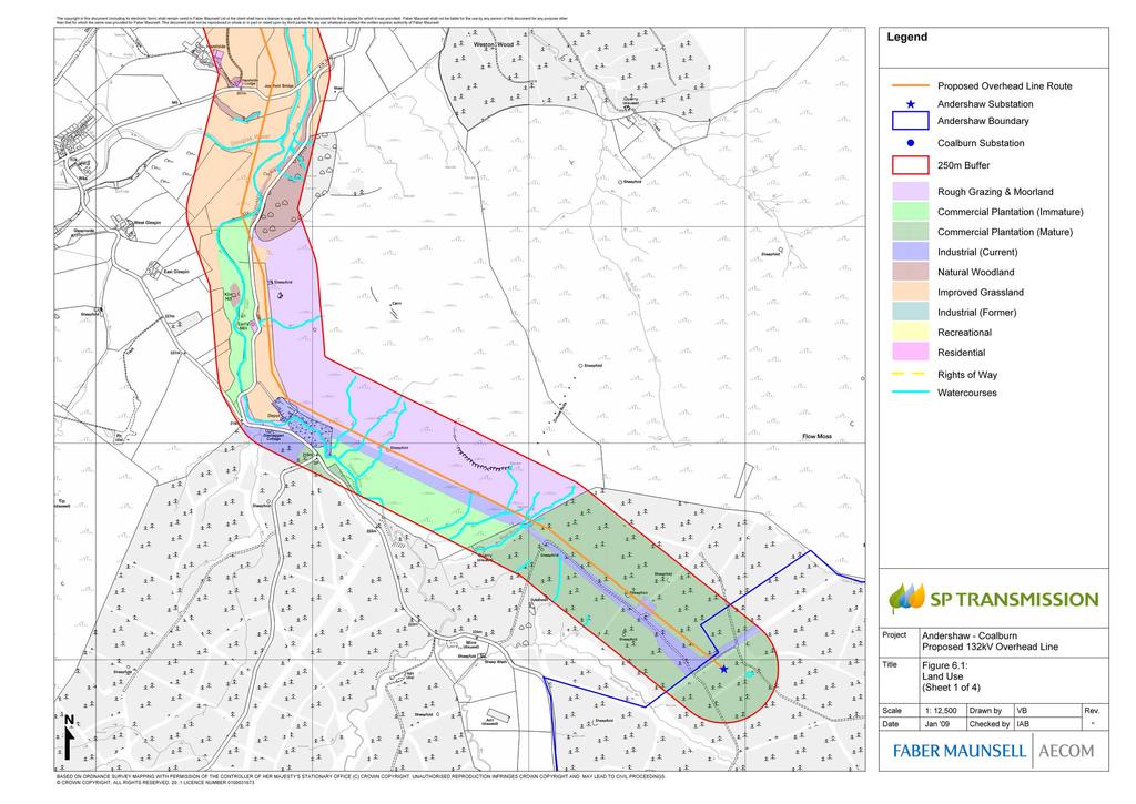
47
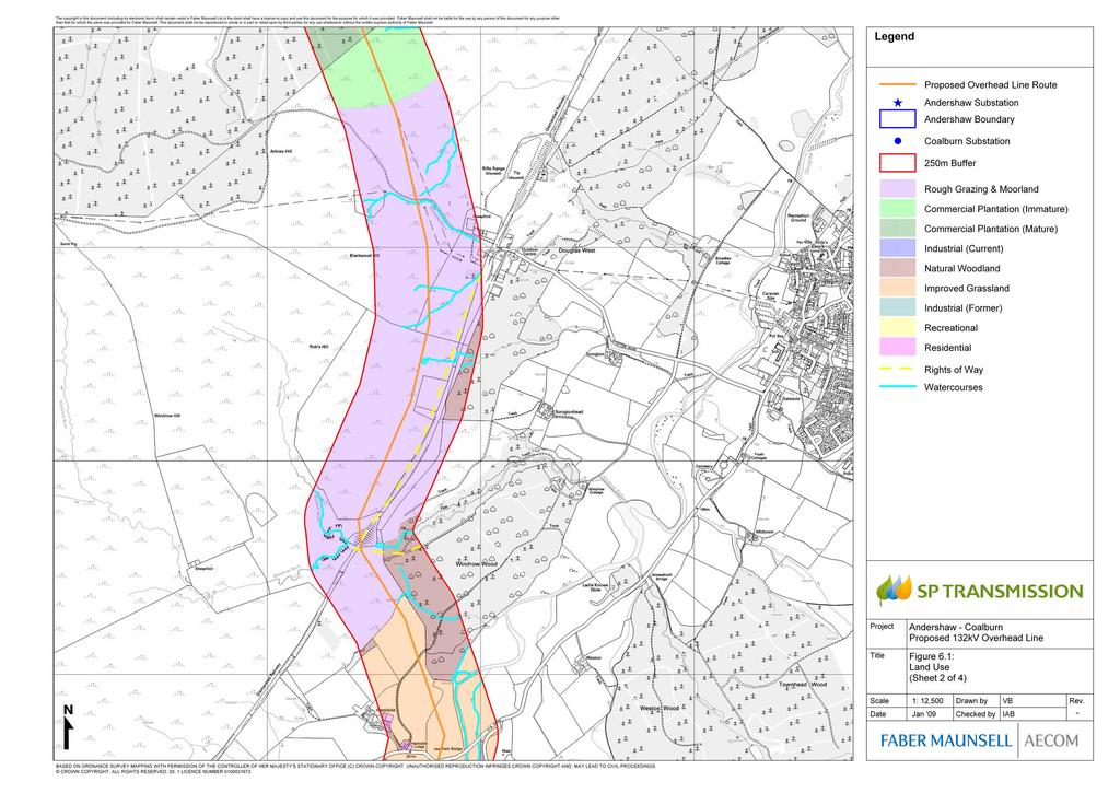
48
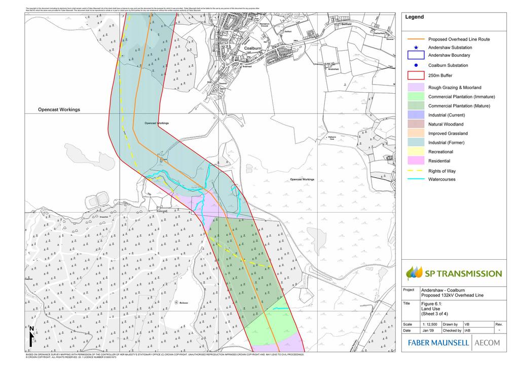
49

50
Assessing the impact of smallscale wind energy proposals on the natural heritage
 Scottish Natural Heritage Assessing the impact of smallscale wind energy proposals on the natural heritage Guidance March 2016 Version 3 1 Contents 1. Introduction. 3 2. Encouraging a spatial approach
Rannoch 132 / 33 kv Substation Extension
 Who we are Scottish and Southern Energy Power Distribution is part of the SSE plc group of companies. We own, maintain and invest in the networks in the north of Scotland the electricity transmission network
University Park, Worcester Non Technical Summary December 2011
 University Park, Worcester Non Technical Summary December 2011 Introduction UW Wrenbridge LLP, a Joint Venture Company of the University of Worcester and Wrenbridge Land Ltd (the Applicants ) intend to
NON-TECHNICAL SUMMARY
 NON-TECHNICAL SUMMARY THE HIDE, BISHOP AUCKLAND PROPOSED ECO CHALET DEVELOPMENT NON-TECHNICAL SUMMARY 1 Introduction 1.1.1 This non-technical summary for the (ES) prepared in relation to the proposed eco-chalet
BREEDON NORTHERN LIMITED
 Non Technical Summary CONTENTS 1 INTRODUCTION... 1 2 SITE DESCRIPTION... 1 3 DESCRIPTION OF THE DEVELOPMENT... 6 4 NEED FOR THE DEVELOPMENT... 8 5 KEY ISSUES CONSIDERED IN THE ENVIRONMENTAL IMPACT ASSESSMENT...
TOPIC PAPER 2: Links to other sustainability tools
 TOPIC PAPER 2: INTRODUCTION 1.1 Landscape Character Assessment can inform a range of other sustainability tools and methodologies. Equally these other tools may assist in reaching decisions concerning
Replacement Golf Course Facilities and Residential Development, Churston. Environmental Statement Non-Technical Summary
 Replacement Golf Course Facilities and Residential Development, Churston Environmental Statement Non-Technical Summary July 2011 Reproduced from the Ordnance Survey s map with the permission of the Controller
volume 11 environmental assessment section 2 environmental impact assessment Part 7 ha 218/08
 DESIGN MANUAL FOR ROADS AND BRIDGES volume 11 environmental assessment section 2 environmental impact assessment Part 7 ha 218/08 glossary of terms Used in DMRB Volume 11, Sections 1 and 2 SUMMARY This
Velindre Cancer Centre Environmental Statement Vol.1: Environmental Statement Text. Chapter 1: Introduction
 Velindre Cancer Centre Environmental Statement Vol.1: Environmental Statement Text Chapter 1: Introduction Draft - March 2017 Prepared by: Address: Email: Website: Mott McDonald, The Urbanists and HLM
Barvills Solar Farm Environmental Statement Non-Technical Summary
 Barvills Solar Farm Environmental Statement Non-Technical Summary 13 March 2015 Produced for Prepared by St John s House Queen Street, Manchester M2 5JB Contents Contents... 2 1 Introduction... 3 1.1 Development
Grantham Southern Quadrant Link Road Environmental Statement
 Grantham Southern Quadrant Link Road Environmental Statement Non Technical Summary Introduction Lincolnshire County Council (LCC) is submitting a planning application for the proposed implementation of
Dorenell Wind Farm 132 kv Grid Connection
 Who We Are Scottish and Southern Energy Power Distribution is part of the SSE plc group of companies. We own, maintain and invest in the electricity networks in the north of Scotland the electricity transmission
Kier Infrastructure and Overseas Limited Greenburn Surface Mine, Dalgig Farm Site
 Kier Infrastructure and Overseas Limited Greenburn Surface Mine, Dalgig Farm Site Planning application pursuant to s.42 Town and Country Planning (Scotland) Act 1997 to amend the restoration scheme Volume
Environmental Impact Assessment
 Environmental Impact Assessment Environmental impact assessment (EIA) is the process of systematically drawing together an assessment of the likely significant environmental effects of a development project.
CAIRNGORMS NATIONAL PARK AUTHORITY
 Title: REPORT ON CALLED-IN PLANNING APPLICATION Prepared by: KATHERINE DONNACHIE (SENIOR PLANNING OFFICER, DEVELOPMENT MANAGEMENT) DEVELOPMENT PROPOSED: FULL PLANNING PERMISSION FOR REPLACEMENT BRIDGE
The Place Solar Farm
 The Place Solar Farm Environmental Statement Non-Technical Summary 28 August 2014 Produced for Prepared by St John s House Queen Street, Manchester M2 5JB Contents Contents... 2 1 Introduction... 3 1.1
The Town and Country Planning (Environmental Impact Assessment) (Wales) Regulations 2016, Regulation 13 Scoping Opinion
 (Wales) Regulations 2016, Regulation 13 Scoping Opinion") Mr Graham Clark Berrys Newchurch Farm Kinnersley Hereford HR3 6QQ BY EMAIL The Town and Country Planning (Environmental Impact Assessment) (Wales) Regulations 2016, Regulation 13 Scoping Opinion SC/2017/0001
Mr Graham Clark Berrys Newchurch Farm Kinnersley Hereford HR3 6QQ BY EMAIL The Town and Country Planning (Environmental Impact Assessment) (Wales) Regulations 2016, Regulation 13 Scoping Opinion SC/2017/0001
London Road, Derker. Non Technical Summary. Introduction
 London Road, Derker Non Technical Summary Introduction The Oldham Rochdale Housing Market Pathfinder was set up to tackle longstanding problems of poor quality housing and to provide the framework for
Definition of Cumulative Landscape and Visual Effects
 SECTION 5: GUIDANCE FOR ASSESSING CUMULATIVE LANDSCAPE AND VISUAL EFFECTS 5.1 Although this landscape sensitivity and capacity study has identified that parts of the National Park may be able to accommodate
NON-TECHNICAL SUMMARY
 Proposed Sand and Gravel Extraction and Associated Processing Operations with Restoration to a Mixture of Agriculture and Nature Conservation including Areas of Shallow Water at Hedgeley, Northumberland
9 Archaeology & Cultural Heritage
 High Clachaig Wind Farm Scoping Report Page 56 9 Archaeology & Cultural Heritage 9.1 Introduction Cultural heritage in this context means the above- and below-ground archaeological resources, built heritage,
7 Scoping and Introduction to the Assessments
 7 Scoping and Introduction to the Assessments 7.1 Scope of the assessments 7.1.1 Rule 8 of the TWR makes provision for an applicant to request a scoping opinion from the SoS indicating the information
Request for a Scoping Opinion by Provectus. Proposed Surface Mining of Coal on Land west off the A61, Hill Top Farm, Clay Cross, Derbyshire
 Request for a Scoping Opinion by Provectus Proposed Surface Mining of Coal on Land west off the A61, Hill Top Farm, Clay Cross, Derbyshire January 2012 Contents 1 Introduction & Background... 1 2 Site
Route Alignment Options Summary Report
 Brechfa Forest Connection Project February 2014 Summary report 1. RSK Environment Ltd (RSK) was commissioned by Western Power Distribution (WPD) to provide environmental consultancy support services for
M4 Corridor around Newport Environmental Statement Volume 3: Appendices
 Environmental Statement Volume 3: Appendices Environmental Statement Volume 3: Appendices At Issue March 2016 CVJV/AAR 3 rd Floor Longross Court, 47 Newport Road, Cardiff CF24 0AD Volume 3: Contents 1
Rooley Moor Neighbourhood Development Plan
 Rooley Moor Neighbourhood Development Plan Strategic Environmental Assessment (SEA) and Habitats Regulations Assessment (HRA) Screening Report September 2018 1 Contents: 1. Introduction 3 2. Legislative
HRA PLANNING Chartered Town Planning and Environmental Consultants
 HRA PLANNING Chartered Town Planning and Environmental Consultants Screening Statement for the Purposes of Determining the need for Appropriate Assessment Proposed development of 74 no. residential units
PANSHANGER QUARRY, Hertfordshire
 PANSHANGER QUARRY, Hertfordshire Proposed enhanced restoration of Phases F & H Briefing Note 1 March 2015 INERT (INACTIVE) RESTORATION MATERIALS, CONTROLS AND OPERATIONS 1 Introduction This briefing note
South Whitehaven, Cumbria EIA
 South Whitehaven, Cumbria EIA Environmental Statement - Non Technical Summary June 2013 in association with 1. Introduction Story Homes is applying to Copeland Borough Council (CBC) for a new residential
3.1 This evidence is based on the landscape and visual impact assessment included in Chapter 10 and Appendix I of the EIS.
 LANDSCAPE & VISUAL 1 QUALIFICATIONS AND EXPERIENCE 1.1 My name is Raymond Holbeach and I am a Regional Director for RPS Planning & Environment with full responsibility for management of the RPS Belfast
Cotswolds AONB Landscape Strategy and Guidelines. June 2016
 Cotswolds AONB Landscape Strategy and Guidelines June 2016 Cotswolds AONB Landscape Strategy and Guidelines Introduction The evolution of the landscape of the Cotswolds AONB is a result of the interaction
7. The Landscape. 7.1 Introduction. Environmental Impact Statement (EIS) Scoping Report
 Scoping Report") 7. The Landscape 7.1 Introduction The purpose of this section of the EIS Scoping Report is to describe the scope of work and methods to be applied in the identification and assessment of landscape and
7. The Landscape 7.1 Introduction The purpose of this section of the EIS Scoping Report is to describe the scope of work and methods to be applied in the identification and assessment of landscape and
PLANNING APPLICATION CONONISH GOLD MINE, TYNDRUM. Planning and Environmental Statement Non-Technical Summary August 2017
 PLANNING APPLICATION CONONISH GOLD MINE, TYNDRUM Planning and Environmental Statement Non-Technical Summary August 2017 0 Scotgold Resources Ltd Cononish Gold Mine, Tyndrum On behalf of Scotgold Resources
WilloWind Linfairn Limited Linfairn Wind Farm - Addendum. Planning Statement
 WilloWind Linfairn Limited Linfairn Wind Farm - Addendum Planning Statement December 2014 Report Summary The has been prepared by SgurrEnergy Ltd on behalf of WilloWind Linfairn Limited. The document provides
LAND AT WEST YELLAND. Environmental Statement Non-Technical Summary Welbeck Strategic Land LLP
 LAND AT WEST YELLAND Environmental Statement Non-Technical Summary Welbeck Strategic Land LLP May 2014 Quality Management Issue/revision Issue 1 Revision 1 Revision 2 Revision 3 Remarks Draft FINAL Date
DEFGH. Crystal Place Park. Environmental Impact Assessment (EIA) Elin Thomas and Emily Low Waterman Environmental
 Elin Thomas and Emily Low Waterman Environmental") DEFGH Crystal Place Park Environmental Impact Assessment (EIA) Elin Thomas and Emily Low Waterman Environmental 10.12.07 EIA Presentation Content What is EIA? Legal Requirements Process Q&A Key Topics
DEFGH Crystal Place Park Environmental Impact Assessment (EIA) Elin Thomas and Emily Low Waterman Environmental 10.12.07 EIA Presentation Content What is EIA? Legal Requirements Process Q&A Key Topics
Environmental Assessment (Scotland) Act 2005: Clackmannanshire Council Sustainability Strategy Scoping Request
 Act 2005: Clackmannanshire Council Sustainability Strategy Scoping Request") TAYSIDE & CLACKMANNANSHIRE Tel: 01738 458582(direct line) Fax: 01738 458616 e-mail addresses: denise.reed@snh.gov.uk Niall Urquhart Team Leader Sustainability Clackmannanshire Council Kilncraigs Greenside
TAYSIDE & CLACKMANNANSHIRE Tel: 01738 458582(direct line) Fax: 01738 458616 e-mail addresses: denise.reed@snh.gov.uk Niall Urquhart Team Leader Sustainability Clackmannanshire Council Kilncraigs Greenside
Wyvern Park Skipton Environmental Statement. Non-technical Summary - April 2015
 Wyvern Park Skipton Environmental Statement Non-technical Summary - April 2015 BWB Consulting Ltd Whitehall Waterfront 2 Riverside Way Leeds LS1 4EH Telephone: +44(0)113 233 8000 Copyright This Report
An Bord Pleanála. Eirgrid Plc. Meath County Council Cavan County Council Monaghan County Council
 An Bord Pleanála Ref: PL02.VS0002 Prospective Applicant: Eirgrid Plc. Local Authorities: Meath County Council Cavan County Council Monaghan County Council Nature of Application: Written opinion on information
CAIRNGORMS NATIONAL PARK AUTHORITY
 DEVELOPMENT PROPOSED: Removal of Gravel Embankments at Allt an t-slugain, Invercauld Estate, Braemar REFERENCE: 2016/0082/DET APPLICANT: Scottish Natural Heritage DATE CALLED-IN: 5 th April 2016 RECOMMENDATION:
Potential sources of guidance for EIA opinions and consents for Glastir Woodland Creation schemes
 EIA guidance Potential sources of guidance for EIA s and consents for Glastir Woodland Creation schemes Every Glastir Woodland Creation plan requires an Environment Impact Assessment (EIA) to assess whether
Cardiff International Sports Village Waterfront Development Volume IV : Non-Technical Summary of the Environmental Statement
 Greenbank Partnerships Ltd October 2012 Cardiff International Sports Village Waterfront Development Volume IV : Non-Technical Summary of the Environmental Statement Environmental Statement - Non Technical
Change Paper / Date CAIRNGORMS NATIONAL PARK AUTHORITY
 Change Paper / Date CAIRNGORMS NATIONAL PARK AUTHORITY Title: Prepared by: REPORT ON CALLED-IN PLANNING APPLICATION FIONA MURPHY (PLANNING OFFICER DEVELOPMENT MANAGEMENT) DEVELOPMENT PROPOSED: REFERENCE:
Former RAF Sealand Site EIA
 Praxis (Holdings) Ltd. Former RAF Sealand Site EIA Environmental Statement - Non Technical Summary February 2012 in association with P a g e 1 1. Introduction Praxis (Holdings) Ltd. is applying to Flintshire
Garden Bridge Planning Application
 Planning Application Additional Verified photomontages and assessment September 2014 Contents Page 1 Visual assessment 2 1.1 Introduction 2 1.2 Baseline 2 1.3 Potential effects and good environmental
Circular L8/08 2 September Water Services Investment and Rural Water Programmes Protection of Natural Heritage and National Monuments
 Circular L8/08 2 September 2008 Water Services Investment and Rural Water Programmes Protection of Natural Heritage and National Monuments 1. The purpose of this Circular is to provide local authorities
SgurrEnergy Ltd Linfairn Wind Farm: Environmental Statement: Chapter 6
 6 LANDSCAPE AND VISUAL 6.1 INTRODUCTION This chapter of the ES evaluates the impacts of the Project on the landscape character and visual amenity. It achieves this by describing and evaluating the potential
Enoch Hill Wind Farm. Scoping Report
 Enoch Hill Wind Farm Scoping Report Copyright and Non-Disclosure Notice The contents and layout of this report are subject to copyright owned by AMEC ( AMEC Environment & Infrastructure UK Limited 2012)
TOWN AND COUNTRY PLANNING (SCOTLAND) ACT 1997
 ACT 1997") TOWN AND COUNTRY PLANNING (SCOTLAND) ACT 1997 APPEAL AGAINST REFUSAL OF PLANNING PERMISSION FOR CONSTRUCTION OF WIND FARM, CONSISTING OF ERECTION OF 12 NO. WIND TURBINES, HEIGHT OF 70 METRES TO HUB, ASSOCIATED
TOWN AND COUNTRY PLANNING (SCOTLAND) ACT 1997 APPEAL AGAINST REFUSAL OF PLANNING PERMISSION FOR CONSTRUCTION OF WIND FARM, CONSISTING OF ERECTION OF 12 NO. WIND TURBINES, HEIGHT OF 70 METRES TO HUB, ASSOCIATED
LAND AT HOWES LANE, BICESTER ENVIRONMENTAL STATEMENT NON-TECHNICAL SUMMARY. March 2017 Our Ref: Q70433
 LAND AT HOWES LANE, BICESTER ENVIRONMENTAL STATEMENT NON-TECHNICAL SUMMARY March 2017 Our Ref: Q70433 Contents 1 INTRODUCTION AND SITE DESCRIPTION... 1 2 EIA METHODOLOGY... 5 3 ALTERNATIVES... 6 4 DESCRIPTION
GUIDELINES FOR THE ROUTEING OF NEW HIGH VOLTAGE OVERHEAD TRANSMISSION LINES
 The Holford Rules Guidelines on overhead line routeing were first formulated in 1959 by Sir William later Lord, Holford, who was a part-time member of the CEGB. National Grid has reviewed these guidelines,
Genex Kidston Connection Project: Draf t Environmental Assessment Report Powerlink Queensland
 : Draf t Environmental Assessment Report Powerlink Queensland Chapter 14 \\autsv1fp001\projects\605x\60577456\6. Draft Docs\6.1 Reports\4. Compiled draft 17 September\Covers\Chapters\Ch 14.docx Rev ision
CORRECTIONS WITHIN DESIGN MANUAL FOR ROADS AND BRIDGES AUGUST 2009
 DESIGN MANUAL FOR ROADS AND BRIDGES CORRECTIONS WITHIN DESIGN MANUAL FOR ROADS AND BRIDGES AUGUST 2009 SUMMARY OF CORRECTION HA 200/08 VOLUME 11, SECTION 1, PART 1 AIMS AND OBJECTIVES OF ENVIRONMENTAL
volume 11 environmental assessment section 2 environmental impact assessment Part 4 ha 204/08 scoping of environmental impact assessments
 DESIGN MANUAL FOR ROADS AND BRIDGES volume 11 environmental assessment section 2 environmental impact assessment Part 4 ha 204/08 scoping of environmental impact assessments SUMMARY This Advice Note provides
Policy DM19: Development and Nature Conservation
 Avonmouth Wetland Habitat Project October 2010 and December 2011 (the Cresswell study). Policy Links Bristol Local Plan Core Strategy Lead Policy BCS4: Avonmouth and Bristol Port BCS9: Green Infrastructure
List of Policies. SESPlan. None applicable. Consolidated Scottish Borders Local Plan 2011: POLICY G1 - QUALITY STANDARDS FOR NEW DEVELOPMENT
 List of Policies Local Review Reference: 15/00021/RREF Planning Application Reference: 15/00616/FUL Development Proposal: Installation of 16no solar photovoltaic (PV) panels to roof Location: Raebank,
Lower Sensitivity. VS Classification Level 2: Hills, Lower Plateau & Scarp Slopes (74%)/ Lowland Valleys (17%) / Exposed Upland/Plateau (7%)
/ Lowland Valleys (17%) / Exposed Upland/Plateau (7%)") S06 Coedwig Gwydyr Reproduced from the Ordnance Survey map with the permission of Ordnance Survey on behalf of the Controller of Her Majesty s Stationery Office, Crown copyright Licence No. 100023387 Location
S06 Coedwig Gwydyr Reproduced from the Ordnance Survey map with the permission of Ordnance Survey on behalf of the Controller of Her Majesty s Stationery Office, Crown copyright Licence No. 100023387 Location
E16: MAINTENANCE OF LANDSCAPED AREAS
 HIGH SPEED TWO INFORMATION PAPER E16: MAINTENANCE OF LANDSCAPED AREAS This paper outlines the proposed approach to the maintenance of landscaped areas created for HS2 Phase One. It will be of particular
A737/A738 Trunk Road (Dalry Bypass)
") IN ASSOCIATION WITH DRAWING STATUS A737/A738 Trunk Road (Dalry Bypass) Environmental Statement July 2013 Introduction The A737 trunk road forms a strategic link from the M8 motorway, at Paisley, to Ayrshire.
IN ASSOCIATION WITH DRAWING STATUS A737/A738 Trunk Road (Dalry Bypass) Environmental Statement July 2013 Introduction The A737 trunk road forms a strategic link from the M8 motorway, at Paisley, to Ayrshire.
JOINT AGENCY STATEMENT & GUIDANCE ON DEER FENCING. adopted by
 JOINT AGENCY STATEMENT & GUIDANCE ON DEER FENCING adopted by DCS, FCS, SNH, SEERAD June 2004 1 CONTENTS 1 Summary...3 2 Introduction...3 3 Policy Statement...4 4 Using the guidance...5 5 Public Safety...7
Non-technical summary
 Non-technical summary Introduction NTS.1 is applying for outline planning permission for a residential development of up to 80 dwellings on land at Hambrook, on the northern fringe of Bristol. NTS.2 An
Watford Local Plan Part 2 Publication Stage Environmental Report. Appendix 3: Consultation Comments
 Watford Local Plan Part 2 Publication Stage Environmental Report Appendix 3: Consultation Comments August 2016 Appendix 3 - Responses to Consultation of the Local Plan Part 2 As required by the SEA Directive,
ABBEY MANOR GROUP/SAINSBURY S SUPERMARKETS LTD
 ABBEY MANOR GROUP/SAINSBURY S SUPERMARKETS LTD Mixed Use Development including Business Park and Foodstore Land at Bunford Park, Bunford Lane, Yeovil Environmental Statement: Non-Technical Report June
Thornton Road, Pickering Environmental Statement Non-Technical Summary. January 2016
 Thornton Road, Pickering Environmental Statement Non-Technical Summary January 2016 EIA Quality This Environmental Statement, and the Environmental Impact Assessment (EIA) carried out to identify the significant
Summary Note on Landscape and Visual Impact and Mitigation
 East Anglia TWO Offshore Windfarm Appendix 4.4 Summary Note on Landscape and Visual Impact and Mitigation Preliminary Environmental Information Volume 3 Document Reference EA2-DEVWF-ENV-REP-IBR- 000799_004
ES 5. Drakelow Park. Environmental Statement. Volume 5: Non Technical Summary. Lead Author Waterman Energy, Environment and Design Ltd
 Drakelow Park ES 5 Environmental Statement Volume 5: Non Technical Summary Lead Author Waterman Energy, Environment and Design Ltd April 2009 Environmental Statement Volume 5: Non-Technical Summary DRAKELOW
Sustainability Statement. Whitby Business Park Area Action Plan
 Sustainability Statement Whitby Business Park Area Action Plan November 2014 Contents Page 1. Introduction 1 2. Scoping 3 3. Sustainability Appraisal of Options 6 4. Assessment of Draft Area Action Plan
CAIRNGORMS NATIONAL PARK AUTHORITY
 Title: Prepared by: CONSULTATION FROM ANGUS COUNCIL KATHERINE DONNACHIE, PLANNING OFFICER (DEVELOPMENT MANAGEMENT) DEVELOPMENT PROPOSED: (1) ERECTION OF GAIA TURBINE OF 18 M. HUB HEIGHT AND 23.5 M. TO
Tandridge Local Plan Assessing the Ecological Suitability of 183 sites considered for development Tandridge District Council, Surrey
 Tandridge Local Plan Assessing the Ecological Suitability of 183 sites considered for development Tandridge District Council, Surrey PLANNING I DESIGN I ENVIRONMENT 1.0 INTRODUCTION TEP conducted Site
My role and specialisms. Worked at spawforths for nearly 13 years. Worked on EIA projects for approx. 10 years and had co-ordinator role for approx.
 My role and specialisms. Worked at spawforths for nearly 13 years. Worked on EIA projects for approx. 10 years and had co-ordinator role for approx. 9 years. Lead EIA activities in the company. The majority
Natural Heritage Guidance and Information. 6 th of December 2007 Brendan Turvey
 Natural Heritage Guidance and Information 6 th of December 2007 Brendan Turvey Outline Guidance available New guidance Guidance in the pipeline Revision of SLG Sitelink / Natural spaces Wind farm footprint
Land at BROOK STREET PROPERTIES TENCREEK FARM, LISKEARD. Environmental Statement: Non-Technical Summary
 BROOK STREET PROPERTIES TENCREEK FARM, LISKEARD Land at Environmental Statement: Non-Technical Summary Introduction Brook Street Properties is applying to Cornwall Council for outline planning permission
The Trustees of the Standen Estate Land South of Clitheroe Non-Technical Summary
 1 The Trustees of the Standen Estate Land South of Clitheroe Non-Technical Summary 1. Introduction This report summarises the results of an assessment that has been undertaken to determine how a proposed
Perth and Kinross Council Development Control Committee 28 November 2012 Report of Handling by Development Quality Manager
 Perth and Kinross Council Development Control Committee 28 November 2012 Report of Handling by Development Quality Manager 4(3)(iii) 12/538 Erection of a 90m meteorological monitoring structure for a temporary
Re-location of Rugby Farmers Mart
 Re-location of Rugby Farmers Mart LaSalle Investment Management Barberry Logo here Environmental Statement Non-Technical Summary August 2017 Re-location of Rugby Farmers Mart Non-Technical Summary Report
Draft Hailey Neighbourhood Plan
 Persimmon Homes (Wessex) Draft Hailey Neighbourhood Plan Representations to West Oxfordshire District Council s Regulation 16 Consultation December 2018 2 Copyright 2018 Persimmon Homes Ltd. All rights
Comments on the proposed scope are requested from WCC/NBBC officers to be provided to SLC Rail by 25 th March 2016 and sent to
 Introduction WCC have indicated that in advance of the surveys and assessments being undertaken consultation should be undertaken with technical officers of both Warwickshire CC and Nuneaton and Bedworth
Wind energy development in the South Pennines landscape
 Wind energy development in the South Pennines landscape Programme for today Background Policy context South Pennines landscape Impacts of wind energy development The South Pennines Wind Energy Landscape
High Speed Rail (London- West Midlands)
") High Speed Rail (London- West Midlands) Draft Environmental Minimum Requirements Annex 3: Draft Heritage Memorandum November 2013 ESA 4.4 High Speed Rail (London- West Midlands) Draft Environmental Minimum
High Speed Rail (London- West Midlands) Draft Environmental Minimum Requirements Annex 3: Draft Heritage Memorandum November 2013 ESA 4.4 High Speed Rail (London- West Midlands) Draft Environmental Minimum
Town and Country Planning (Environmental Impact Assessment Regulations) 2011 SCOPING OPINION
 2011 SCOPING OPINION") Town and Country Planning (Environmental Impact Assessment Regulations) 2011 SCOPING OPINION Application Site and Description of Development Proposed new quarry at Culham, Oxfordshire Land and Mineral
Town and Country Planning (Environmental Impact Assessment Regulations) 2011 SCOPING OPINION Application Site and Description of Development Proposed new quarry at Culham, Oxfordshire Land and Mineral
UTT/17/2075/FUL - (BERDEN) (Referred to Committee by Councillor Janice Loughlin. Reason: In the Public Interest)
 (Referred to Committee by Councillor Janice Loughlin. Reason: In the Public Interest)") UTT/17/2075/FUL - (BERDEN) (Referred to Committee by Councillor Janice Loughlin. Reason: In the Public Interest) PROPOSAL: LOCATION: APPLICANT: Amendments to the design of a scheme for a 49.99MW battery
UTT/17/2075/FUL - (BERDEN) (Referred to Committee by Councillor Janice Loughlin. Reason: In the Public Interest) PROPOSAL: LOCATION: APPLICANT: Amendments to the design of a scheme for a 49.99MW battery
Cranbrook EXPANSION ENVIRONMENTAL STATEMENT: NON-TECHNICAL SUMMARY PRODUCED BY DAVID LOCK ASSOCIATES
 Cranbrook EXPANSION ENVIRONMENTAL STATEMENT: NON-TECHNICAL SUMMARY PRODUCED BY DECEMBER 2014 CRANBROOK EXPANSION AREAS ENVIRONMENTAL STATEMENT NON TECHNICAL SUMMARY Submitted in support of Outline Planning
Delegated Report. Application Type: Full Planning Permission. Recommendation - Approve subject to conditions. Ward - Wigtown West
 Steve Rogers Head of Planning & Regulatory Services Kirkbank, English Street, Dumfries, DG1 2HS Telephone (01387) 260199 - Fax (01387) 260188 Delegated Report CHANGE OF USE OF PART OF ARTILLERY RANGE TO
PERSIMMON HOMES (SW) LIMITED LAND AT ADDINGTON, LISKEARD ENVIRONMENTAL STATEMENT NON-TECHNICAL SUMMARY
 LIMITED LAND AT ADDINGTON, LISKEARD ENVIRONMENTAL STATEMENT NON-TECHNICAL SUMMARY") PERSIMMON HOMES (SW) LIMITED LAND AT ADDINGTON, LISKEARD ENVIRONMENTAL STATEMENT NON-TECHNICAL SUMMARY APRIL 2010 INTRODUCTION This document is the Non-Technical Summary (NTS) of an Environmental Statement
PERSIMMON HOMES (SW) LIMITED LAND AT ADDINGTON, LISKEARD ENVIRONMENTAL STATEMENT NON-TECHNICAL SUMMARY APRIL 2010 INTRODUCTION This document is the Non-Technical Summary (NTS) of an Environmental Statement
Longbridge Town Centre Phase 2 Planning Application
 Longbridge Town Centre Phase 2 Planning Application Non-Technical Summary of the Environmental Statement December 2013 Introduction A full application for Planning Permission has been submitted to Birmingham
CAIRNGORMS NATIONAL PARK AUTHORITY
 CAIRNGORMS NATIONAL PARK AUTHORITY Title: Prepared by: REPORT ON CALLED-IN PLANNING APPLICATION ROBERT GRANT, PLANNING OFFICER (DEVELOPMENT MANAGEMENT) DEVELOPMENT PROPOSED: USE OF LAND FOR THE PURPOSES
WALES ONLY INTERIM ADVICE NOTE 135/10 (W) LANDSCAPE AND VISUAL EFFECTS ASSESSMENT
 LANDSCAPE AND VISUAL EFFECTS ASSESSMENT") Interim Advice Note 135/10 (W) Landscape and Visual Effects Assessment INTERIM ADVICE NOTE 135/10 (W) LANDSCAPE AND VISUAL EFFECTS ASSESSMENT WALES ONLY Summary This Interim Advice Note provides instructions
Interim Advice Note 135/10 (W) Landscape and Visual Effects Assessment INTERIM ADVICE NOTE 135/10 (W) LANDSCAPE AND VISUAL EFFECTS ASSESSMENT WALES ONLY Summary This Interim Advice Note provides instructions
Linfairn Wind Farm Addendum Chapter A6: LVIA
 A6. Landscape and Visual 6.1 Introduction The purpose of this chapter is to review amendments to the Project design and to advise of any consequent alterations to the landscape and visual effects as previously
FORMAL REQUEST FOR A SCOPING OPINION TO FACILITATE THE UNDERTAKING OF AN ENVIRONMENTAL IMPACT ASSESSMENT. For
 FORMAL REQUEST FOR A SCOPING OPINION TO FACILITATE THE UNDERTAKING OF AN ENVIRONMENTAL IMPACT ASSESSMENT For THE CONSOLIDATION OF ACTIVITIES AT HILLHOUSE QUARRY AND HALLYARDS QUARRY, UNDER THE SINGLE OWNERSHIP
Dolphingstone Farm, Prestonpans Environmental Statement. Non-Technical Summary. June Waterman Energy, Environment & Design Limited
 Dolphingstone Farm, Prestonpans Environmental Statement June 2015 Waterman Energy, Environment & Design Limited Third Floor, South Suite, 8 Nelson Mandela Place, Glasgow, G2 1BT, United Kingdom Introduction
North York Moors National Park Authority Planning Committee
 Item 8 North York Moors National Park Authority Planning Committee 12 December 2013 Consultation from Redcar and Cleveland Borough Council on proposed Wind Farm at Bank Field Guisborough 1. Purpose of
CAIRNGORMS NATIONAL PARK AUTHORITY
 CAIRNGORMS NATIONAL PARK AUTHORITY Title: Prepared by: CONSULTATION FROM SCOTTISH GOVERNMENT KATHERINE DONNACHIE PLANNING OFFICER (DEVELOPMENT MANAGEMENT) DEVELOPMENT PROPOSED: REFERENCE: APPLICANT: RECOMMENDATION:
Proposed World-Class Hotel at Former Royal High School, Regent Road, Edinburgh
 Duddingston House Properties and Urbanist Hotels Proposed World-Class Hotel at Former Royal High School, Regent Road, Edinburgh Environmental Statement Non-Technical Summary 3rd September 2015 www.oldroyalhighschool.com
Perth and Kinross Council Development Management Committee 8 June Pre-Application Report by Development Quality Manager
 Perth and Kinross Council Development Management Committee 8 June 2016 5(3)(i) 16/259 Pre-Application Report by Development Quality Manager Residential development at St Martins Road, Land 120 metres West
Perth and Kinross Council Development Management Committee 20 February 2013 Report of Handling by Development Quality Manager
 Perth and Kinross Council Development Management Committee 20 February 2013 Report of Handling by Development Quality Manager 4(4)(iii) 13/81 Erection of sports hall, associated changing facilities, offices
Derry City and Strabane District Council Planning Committee Report. Amended layout from approval A/2004/0462/F with reduction from 166 units
 Derry City and Strabane District Council Planning Committee Report COMMITTEE DATE: 1 st February 2017 APPLICATION No: APPLICATION TYPE: PROPOSAL: LOCATION: APPLICANT: AGENT: Full Planning application Amended
Plumpton Neighbourhood Development Plan Revised Pre Submission Document - Regulation 14 Consultation
 REPRESENTATIONS... Plumpton Parish Council Plumpton Neighbourhood Development Plan Revised Pre Submission Document - Regulation 14 Consultation Representations submitted on behalf of: Cala Homes (South
Mainshill Opencast Coal Site
 Mainshill Opencast Coal Site Scoping Report Prepared by: Claude Volker Checked by: David Harper 45 Timberbush Bernard Street Leith Edinburgh EH6 6QH Tel: 0131 555 5011 Fax: 0131 555 4911 Email rpsed2@rpsgroup.com
Strategic Environmental Assessment Screening Report. Dublin Port Masterplan Review 2017
 Strategic Environmental Assessment Screening Report Dublin Port Masterplan Review 2017 Table of Contents 1 Introduction... 1 2 Purpose of the Masterplan... 2 3 Task 1.1 Pre-Screening Check... 5 4 Task
Perth and Kinross Council Development Control Committee 28 November 2012 Report of Handling by Development Quality Manager
 Perth and Kinross Council Development Control Committee 28 November 2012 Report of Handling by Development Quality Manager Partial change of use of chalet development to mixed use development comprising