Triangle Land Conservancy Conservation Area Monitoring Report Carolina North
|
|
|
- Anthony Godwin Singleton
- 5 years ago
- Views:
Transcription
 514 S. Duke St.")
1 Triangle Land Conservancy Conservation Area Monitoring Report Carolina North Property Name: Bolin Creek West Conservation Area Date of first visit: County: Orange Date of second visit: Property Type: Restrictive Covenants Local Contact: Triangle Land Conservancy (office) 514 S. Duke St (fax) Durham, NC Lead conservation area monitor: Matt Rutledge Other person(s) attending inspection: Bo Howes (first visit), Greg Kopsch (Forest Manager) and Alex Ashton (Property Officer) (both at second visit) The Carolina North Property is subject to a Declaration of Restrictive Covenants recorded in Book 5541 page 360 of the Office of the Orange County Register of Deeds. A copy of the Restrictive Covenants may be found at the Register of Deeds office or the link below. %20Covenants%20-%20Carolina%20North%20Conservation%20Areas%20%20%20.pdf There is a LAND STEWARDSHIP POLICY on file for this property. The Land Stewardship Policy was completed January 15, 2013 and is available at the link below. Stewardship%20Policy-Final% pdf Problem areas noted from prior visits and areas to pay special attention to: Inert yard debris from neighboring properties, especially along the western boundary of the Conservation Area, was a problem noted in the 2013 monitoring report.
2 TLC Conservation Area Monitoring Report (Cont.) Are property boundaries clearly marked? Note any new concerns about boundaries and signs of encroachment, and if existing problems have been corrected? Yes. Boundaries clearly marked. No areas of concern. The Restrictive Covenants list eight restricted or prohibited uses and activities. Are there any violations of the following restricted or prohibited uses and activities? A. Construction. Construction or placement of buildings, roads, billboards or other advertising, utilities or other structures on or above the ground is prohibited in the Conservation Areas. Construction or placement of signs is prohibited in the Conservation Areas except for directional and boundary signs, interpretive signs describing the conservation values of the Conservation Areas, and signs and kiosks prescribing rules and regulations for the use of the Conservation Areas. No new construction was observed. B. Dumping and Landfill Activities. Dumping or placing soil or other substances or materials as landfill, or dumping or placing trash, waste or unsightly or offensive materials is prohibited in the Conservation Areas. No dumping or landfill activities were observed. C. Vegetation Destruction. Removal or destruction of healthy native trees, shrubs or other vegetation is prohibited in the Conservation Areas, unless done as a component of an established forest management plan. No vegetation destruction was observed. D. Excavation or Dredging. Excavation, dredging or removal of loam, peat, gravel, soil, rock or other mineral substance in such manner as to affect the surface is prohibited in the Conservation Areas. No excavation or dredging was observed. E. Detrimental Surface Use. Surface use except for forest or outdoor recreational purposes or purposes permitting the land or water area to remain predominantly in its natural condition is prohibited in the Conservation Areas. No detrimental surface use was observed. F. Activities Detrimental to Drainage; Flood Control, etc. Activities detrimental to drainage, flood control, water conservation, erosion control or soil conservation are prohibited in the Conservation Areas. No activities detrimental to drainage, flood control or other listed items were observed. G. Other Detrimental Acts. Other acts or uses detrimental to the retention of land or water areas are prohibited in the Conservation Areas. Based on our observation, the University has been a good steward of the Carolina North property, no detrimental acts were observed during our visits. H. Construction of New Trails and Greenways. Construction of new trails (except for potential greenways and paths that are located and approved pursuant to the terms of the
3 Development Agreement) is prohibited in the Conservation Areas. No new trails or greenways were observed. Additional comments or observations There were signs of encroachment from properties neighboring along the southern and western boundaries. These boundaries back onto multiple adjoining landowners in a residential neighborhood. One major encroachment is a playset entirely within the conservation area. Behind the same house, a portion of the backyard fence enters the Conservation Area as well. Other encroachment issues were minor consisting mostly of small amounts of trash thrown over the property line. These encroachments are not the fault of the University, but the landowners violating the conservation area should be notified and the encroachments rectified. The University was notified of these issues in early April. The UNC Property Office and the Office of Forest Management worked to resolve the encroachment issues over the course of the spring. TLC agreed to another monitoring visit on June 5, 2014, to check on the status of the encroachments. The monitoring visit on June 5 revealed that all documented encroachments had been removed after action by the University. Photos and a map of the second visit are included at the end of this report. In addition to encroachments, several areas of invasive species were noted in the conservation area. Autumn olive bushes and microstegium are extensive in places along the southern boundary and in the interior as well. The University is not required to remove these species but rather encouraged to do so. This note and the photo documentation are included only to help with identification of problematic areas. In meeting with Greg Kopsch (Forest Manager), he mentioned that outlining areas of invasive species would be helpful in a management context. He also mentioned that an Eagle Scout project is targeting invasive species removal and additional projects and volunteer activities could be part of future management. To the best of your knowledge and observation, is the land owner complying with the restrictive covenants? YES Steward s name: Matt Rutledge Signature: Matthew D. Rutledge Address: 514 S. Duke St. Phone: Durham, NC Indicate attachments to the report. Date and sign all materials. Provide descriptions of photograph and illustration locations. ground photos aerial photos maps illustrations other

4 Map 1 March 12, 2014 Monitoring Visit
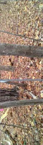
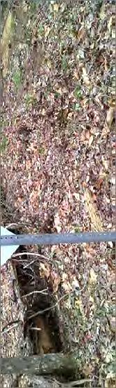
5 Photo Documentation Table March 12, 2014 Monitoring Visit Photo Point Photo Number Description Azimuth 1 1 Southeastern corner at Seawell School Rd Internal corner Internal corner Southeastern corner at Bolin Creek 20 5 Southeastern corner at Bolin Creek Floodplain along Bolin Creek Old mill site Southeastern corner, west of Bolin Creek Along southern boundary Encroachment along southern boundary - 11 Encroachment along southern boundary Internal corner and encroachment Internal corner and encroachment Internal corner on southern boundary Internal corner on southern boundary Autumn olive along southern boundary Southwestern corner Southwestern corner Interior corner on western boundary Interior corner on western boundary Trash encroachment along boundary - 22 Trash encroachment along boundary Encroachment along western boundary - 24 Encroachment along western boundary Encroachment along western boundary Encroachment along western boundary Encroachment along western boundary Encroachment along western boundary Neighboring property cleared Erosion and sediment from cleared area - 31 Erosion and sediment from cleared area - 32 Erosion and sediment from cleared area Northwest corner Northwest corner Interior corner on north boundary Interior corner on north boundary Northwest corner Northwest corner Interior corner Interior corner Interior corner Interior corner Road maintenance in power easement Northern point on eastern side Northern point on eastern side Northeastern point on Seawell School Rd Northeastern point on Seawell School Rd. 170


6 Photo #1. Easternmost corner with view northwest upslope and along the boundary. Photo #2. Internal corner 1 with view southeast along boundary. Photo #3. Internal corner 1 with view southwest towards Bolin Creek. Photo #4. Southern corner at Bolin Creek with view northeast.


7 Photo #5. Southern corner at creek with view west along boundary. Photo #6. Yellow trout lily in bloom in floodplain of creek. Photo #7. Old mill site in the interior of conservation area. Historic site. Photo #8. Back at southern corner near creek with west along boundary that passes behind neighborhood.


8 Photo #9. Fire pit behind house that is inside conservation area. Photo #10. At southern corner (Photopoint #8), playset inside conservation area. Photo #11. Playset, wheelbarrow, and lawn inside conservation area. Photo #12. Compost bin and playset in conservation area.


9 Photo #13. Corner (Photopoint #9), shows fencing, and playset inside conservation area. Photo #14. Interior corner with view southeast. Photo #15. Interior corner with view west along line. Photo #16. Large expanse of autumn olive (Elaeagnus umbellata) documented for land manager.


10 Photo #17. Southwest corner with view east down boundary. Photo #18. Southwest corner with view northeast along line. Photo #19. Interior corner with view southwest along the line. Photo #20. Interior corner with view north along boundary line.


11 Photo #21. Coil of wire and toilet dumped inside conservation area. Photo #22. Line of pinflags that enter conservation area with unsure purpose. Photo #23. Wooden ladder inside conservation area. Photo #24. Ashes dumped inside conservation area. Large number of dumped ashes.


12 Photo #25. Broken compost bin clearly just inside conservation area. Photo #26. Plastic planters dumped inside conservation area. Photo #27. Old compost bin that was probably present before the conservation area was created. Photo #28. Plastic lining that is holding runoff behind a house but inside the conservation area.


13 Photo #29. Adjacent property bordering the northeast of the conservation area has been cleared. Photo #30. Muddy, sediment laden runoff entering conservation area from cleared property. Photo #31. Plastic fencing shows where runoff has overflowed from neighboring property. Photo #32. Drainage pipe from retention pond that has led to the water entering conservation area.


14 Photo #33. Northwest corner of property with view south along boundary. Photo #34. Northwest corner with view southeast. Photo #35. Internal corner on the northern boundary, with view back northwest. Photo #36. Internal corner on the northern boundary, with view east.


15 Photo #37. Northeast corner with view back west along line. Photo #38. Northeast corner with view southwest along boundary of conservation area. Photo #39. Internal corner with view northeast. Photo #40. Internal corner with view southeast.


16 Photo #41. Interior corner with view back northwest. Photo #42. Interior corner with view northeast along the boundary line. Photo #43. Road maintenance and clearing along power easement, permitted under conservation agreement. Photo #44. North corner near Seawell School Rd, with view southwest along boundary.


17 Photo #45. North point with view towards road. Notice notch cut in tree to allow surveyor site line. Tree is ready to fall. Photo #46. Northeastern point on Seawell School Road with view northwest. Photo #47. Northeastern point on Seawell School Road with view south.
18 Map 2 June 5, 2014 Monitoring Visit
19 Photo Documentation Table June 5, 2014 Monitoring Visit Photo Point Photo Number Description Azimuth 1 1 Site of playset encroachment 80 2 Site of playset encroachment Site of fire pit encroachment Site of trash encroachment Site of ladders encroachment Site of compost bin encroachment Site of trash encroachment Site of compost bin encroachment Site of plastic lining Site of erosion from neighboring parcel -


 Photo")


20 Photo #1. Former site of playset encroachment, which was located on the bare ground (Photos #10 12 from March visit) Photo #2. View east down property line. Playset is visible outside the Conservation Area. Compost bin has been removed. Photo #3. Site of fire pit inside the Conservation Area. The fire pit has been removed. (Photo #9 from March visit) Photo #4. Site of trash encroachment. Toilet, metal cables, pin flags, and tractor bucket have been removed (Photo #21 from March visit)


21 Photo #5. Large wooden ladders have been moved outside Conservation Area. (Photo #23 from March visit) Photo #6. Former site of compost bin. (Photo #25 from March visit) Photo #7. Site of plastic planters in Conservation Area. (Photo #26 from March visit) Photo #8. Site of compost bin in Conservation Area. (Photo #27 from March visit)


 Photo #10.")


22 Photo #9. Site of plastic lining that has been removed. (Photo #28 from March visit) Photo #10. Erosion from neighboring parcel. The neighboring development has repaired the fence and added gravel to reduce runoff and erosion. (Photos #31 32 from March visit)
Triangle Land Conservancy Conservation Area Monitoring Report Carolina North
 Triangle Land Conservancy Conservation Area Monitoring Report Carolina North Property Name: Bolin Creek West Conservation Area Date of visit: 2.18.13, 2.18.13, 3.13.13, and 6.10.13 County: Orange Property
Triangle Land Conservancy Conservation Area Monitoring Report Carolina North
 Triangle Land Conservancy Conservation Area Monitoring Report Carolina North Property Name: Bolin Creek West Conservation Area Date of visit: April 11, 2018 County: Orange Property Type: Restrictive Covenants
STATE OF NORTH CAROLINA DECLARATION OF
 Prepared by and Return to: Orange County Parcel Identification Number(s): STATE OF NORTH CAROLINA COUNTY OF ORANGE DECLARATION OF RESTRICTIVE COVENANTS THIS DECLARATION OF RESTRICTIVE COVENANTS ( Declaration
Study Area Map. Wasatch Hollow Open Space Restoration, Use, & Management Plan. Legend. Harrison Ave East. Roosevelt East.
 Harrison Ave Roosevelt Emerson «4 «5 Rosecrest 1900 East «3 1800 East Wasatch Hollow Open Space Restoration, Use, & Management Plan Study Area Map Legend «2 «1 Potential Access Location Emigration Creek
SITE SUMMARY REPORT Arlington Dump NONCD Yadkin County
 SITE SUMMARY REPORT Arlington Dump NONCD 0000644 Yadkin County Hurricane Recovery Act of 2005 State of North Carolina State Contract N06009S Schnabel Project No. 06210002.15 July 31, 2009 Prepared for:
Weston s Wetlands, Stormwater, & Open Space
 Weston s Wetlands, Stormwater, & Open Space Weston s Wetlands, Stormwater, & Open Space Conservation Commission Role and Responsibilities Laws that protect wetlands What residents can do to protect wetlands
Architectural Review Committee FAQs
 Architectural Review Committee FAQs What kinds of changes to my home require ARC approval? In general all major changes to the exterior of your home require ARC approval. We most commonly receive requests
Banks Pointe Homeowners Association
 Banks Pointe Homeowners Association REGULATIONS January 30, 2012 Rev. April 3, 2013 1 CONTENTS PARKING... 3 STORAGE... 3 MAILBOXES... 3 GARDEN PLOTS... 3 PETS... 4 LAWN ORNAMENTS, DECORATIONS, OUTSIDE
PLANNED UNIT DEVELOPMENT & SUBDIVISION STAFF REPORT Date: May 18, 2017
 & PUD-0000102-2017 PLANNED UNIT DEVELOPMENT & SUBDIVISION STAFF REPORT Date: May 18, 2017 NAME SUBDIVISION NAME Dauphin Creek Estates Subdivision Dauphin Creek Estates Subdivision LOCATION CITY COUNCIL
RAIN GARDENS. Task: PART 1 (60 minutes) Student Directions: Steps you will be following: Directions for beginning: Source Information:
 Student Directions: Steps you will be following: Directions for beginning: Source Information:") PART 1 (60 minutes) Student Directions: Your assignment: Steps you will be following: Your neighborhood council is researching the benefits of installing rain gardens in your community. You will read two
PART 1 (60 minutes) Student Directions: Your assignment: Steps you will be following: Your neighborhood council is researching the benefits of installing rain gardens in your community. You will read two
City of Shady Cove Riparian Ordinance Ordinance XXX
 1 Updated October 8, 2015 City of Shady Cove Riparian Ordinance Ordinance XXX This language is to be located in Chapter 155 of the Shady Cove Code of Ordinances. This will affect property inside city limits,
TOWNSHIP OF LOGAN SOIL & FILL IMPORTATION AND PLACEMENT APPLICATION SUBMITTAL CHECKLIST
 TOWNSHIP OF LOGAN SOIL & FILL IMPORTATION AND PLACEMENT APPLICATION SUBMITTAL CHECKLIST Applications: 5 copies of application - Applicant will reproduce the copies at his/her costs. The Township Clerk
Christopher M. Price, AICP Director of Planning February 7, 2014 STAFF REPORT
 COUNTY OF PRINCE WILLIAM 5 County Complex Court, Prince William, Virginia 22192-9201 PLANNING MAIN (703) 792-7615 FAX (703) 792-4758 OFFICE www.pwcgov.org/planning Christopher M. Price, AICP Director of
2.0 AREA PLANS. Lakeside Business District. Lakeside Business District Land Use Categories:
 Lakeside Business District Lakeside Business District Land Use Categories: Campus Commercial Campus Commercial means a mixture of uses which includes corporate offices, office parks, hotels, commercial,
Asbury Chapel Subdivision Sketch Plan
 Asbury Chapel Subdivision Sketch Plan PART 1: PROJECT SUMMARY Applicant: NVR Inc. Project Size: +/- 76.13 acres Parcel Numbers: 02101112,02116101,02116112, 02116113 Current Zoning: Transitional Residential
Ponds of. Ballantrae
 Ponds of Ballantrae December 2012 Assessments & Recommendations for Pond Management Assessments and Recommendations for management of each pond were made to the CDD Board by its district engineer and pond
Carolina North Update
 Carolina North Update Public Information Meeting January 30, 2013 1 Agenda 1) Welcome/General Overview 2) Development Agreement: 2012 Annual Report Conservation Areas Restrictive Covenants 3) Signs for
Pequotsepos Brook Preserve
 AVALONIA LAND CONSERVANCY, Inc. P.O. Box 49, Old Mystic, CT 06372 Pequotsepos Brook Preserve Property Management Plan Maritime Drive Mystic, New London County, Connecticut Stonington Town Committee is
Site Development Plan (SDP) Checklist
 Checklist") Development Services Department 100 N. Wilcox Street, Castle Rock CO 80104 303-660-1393 or CRGov.com Site Development Plan (SDP) Checklist A complete Site Development Plan (SDP) submittal will contain
Development Services Department 100 N. Wilcox Street, Castle Rock CO 80104 303-660-1393 or CRGov.com Site Development Plan (SDP) Checklist A complete Site Development Plan (SDP) submittal will contain
Planning Districts INTRODUCTION
 INTRODUCTION To facilitate detailed examination of development prospects for all areas of the community, Delano has been divided into 14 planning districts. The location of these planning districts is
Section 3 Non-Structural BMPs
 3.1 Stream Buffers A stream buffer or stream setback is a designated area around a stream, lake, or wetland left in a natural, densely vegetated state so as to protect the receiving water quality and provide
Rule D Wetland and Creek Buffers
 Rule D Wetland and Creek Buffers 1 Policy It is the policy of the Board of Managers to ensure the preservation of the natural resources, recreational, habitat, water treatment and water storage functions
CHESAPEAKE LANDSCAPE ORDINANCE
 CHESAPEAKE LANDSCAPE ORDINANCE CONSERVATION PRESERVATION CZO 19-600 Effective October 16, 2008 BUFFER YARD C PARKING LOT REFORESTATION YEAR 1 REFORESTATION YEAR 4 BUFFER YARD F CBPA REFORESTATION Page
Piles, Trenching, Inverters, Cables, Material Deliveries
 Agricultural Inspection Report General Information Project Name Albany Date of Inspection 20161012 Start/End Time 7:50 am Inspector s Name(s) Inspector s Title(s) Describe present phase of construction
SITE PLAN (REVISED 8/13/18) l. Development Data Table
 l. Development Data Table") SITE PLAN (REVISED 8/13/18) l. Development Data Table a. Site Acreage: 9.25 b. Tax Parcels included in rezoning: #108-081-07 and #108-081-23 c. Existing Zoning (including overlays and vesting): R-3 (see
SITE PLAN (REVISED 8/13/18) l. Development Data Table a. Site Acreage: 9.25 b. Tax Parcels included in rezoning: #108-081-07 and #108-081-23 c. Existing Zoning (including overlays and vesting): R-3 (see
q1 7 q - ~ g -P' ~J~llllllllli tl Jtllllill II I III & '375r;}L. ) . c\1()'1-{6~ol;gl.{ ~ STATE OF NORTH CAROLINA
 . c\1()'1-{6~ol;gl.{ ~ STATE OF NORTH CAROLINA") s ~J~llllllllli tl Jtllllill C3' D6 6 20130207000032200 DECL Bk:RB5541 Pg:360 02/07/2013 02:14:58 PM 1/12 FLED Deborah 8. Brooks -------- Register of Deeds. Orange CO.NC(j Recording Fee: $26.00 ~. NC Real
s ~J~llllllllli tl Jtllllill C3' D6 6 20130207000032200 DECL Bk:RB5541 Pg:360 02/07/2013 02:14:58 PM 1/12 FLED Deborah 8. Brooks -------- Register of Deeds. Orange CO.NC(j Recording Fee: $26.00 ~. NC Real
SECTION 1 CLEARING /GRADING PERMIT APPLICATION:
 PLEASE REFER TO THE CLEARING & GRADING PERMIT CHECKLIST BELOW FOR SUBMITTAL REQUIREMENTS. SECTION 1 CLEARING /GRADING PERMIT APPLICATION: PROJECT ADDRESS (Street, Suite #): Parcel(s) #: Total Site Area
City of Lafayette Study Session Staff Report Design Review Commission
 ++ City of Lafayette Study Session Staff Report Design Review Commission Meeting Date: January 08, 2018 Staff: Subject: Chris Juram, Planning Technician SS12-17 Miramar Homebuilders, R-20 Zoning: Request
Zoning Ordinance Chapter 10
 CHAPTER 10 - WASHES SECTION 10.0 GENERAL: A. The purpose of this Ordinance is to establish standards for development in or near Major and Minor Washes as defined in Appendix A Glossary of Terms and Definitions
BISCUIT RUN PARK MASTER PLAN
 BOARD OF SUPERVISORS November 14, 2018 BISCUIT RUN PARK MASTER PLAN COUNTY OF ALBEMARLE ANHOLD ASSOCIATES Contents Project Introduction Property Background County Park Planning Process Existing Site &
Stream Restoration: Working with Nature?
 Stream Restoration: Working with Nature? Greg Jennings, PhD, PE jenningsenv@gmail.com Ecosystem Restoration activities that initiate or accelerate the recovery of ecosystem health, integrity, and sustainability
Stream Restoration: Working with Nature? Greg Jennings, PhD, PE
 Stream Restoration: Working with Nature? Greg Jennings, PhD, PE jenningsenv@gmail.com Ecosystem Restoration activities that initiate or accelerate the recovery of ecosystem health, integrity, and sustainability
Adopt-A-Creek. You are the solution to water pollution.
 Respect the property line. You are the solution to water pollution. Adopt-A-Creek Avoid polluting, dumping or draining to your creek. Respect the natural habitat. The Santa Clara Valley Water District
2. Would the proposed project comply with the Land Use map? 3. Would the proposed project require a rezoning? 4. What is the proposed zoning district?
 TOWN OF CHAPEL HILL Planning and Sustainability Department 405 Martin Luther King Jr. Blvd. Chapel Hill, NC 27514 www.townofchapelhill.org phone (919) 968 2728 Concept Plans are intended to be an opportunity
GENERAL LANDSCAPE PROVISIONS. The following landscape provisions shall be adhered to by all land uses unless otherwise noted:
 CHAPTER 1.18 Sections: 1.18.005 Purpose. 1.18.010 Landscaping, Buffering, and Fencing Improvements Required. 1.18.015 General Landscape Provisions. 1.18.020 Landscaping Plan. 1.18.025 Single-Family Dwellings
WHEREAS, after consideration of the evidence presented at the public hearing on September 11, 2008, the Prince George's County Planning Board finds:
 File No.DSDS-648 R E S O L U T I O N WHEREAS, the Prince George's County Planning Board has reviewed DSDS-648 requesting a departure of 571.44 square feet from the maximum permitted sign area of building-mounted
Erosion Control for Home Builders in the. City of Jacksonville
 Erosion Control for Home Builders in the City of Jacksonville Eroding construction sites are a leading cause of water quality problems in Jacksonville. For every acre under construction, about a dump truck
Exhibit A. 8:9 Scuffletown Rural Conservation District
 Exhibit A 8:9 Scuffletown Rural Conservation District 8:9.1 Intent and Purpose The Scuffletown Rural Conservation (SRC) District is intended to provide for residential development that supports the development
The Bruce Trail: your good neighbour
 The Bruce Trail: your good neighbour HELP US PROTECT OUR CONSERVATION CORRIDOR The Bruce Trail Conservancy Our Mission The Bruce Trail Conservancy is a charitable organization committed to establishing
ARTICLE RRCO RED ROCK CORRIDOR OVERLAY DISTRICT
 ARTICLE 11.10 RRCO RED ROCK CORRIDOR OVERLAY DISTRICT (adopted 11/22/2011 MC16-116-11) SECTIONS: 11.10.01 Intent 11.10.02 Boundaries of District 11.10.03 Development Standards 11.10.04 Variance 11.10.01
DRAFT ALDER CREEK FARM MASTER PLAN
 DRAFT ALDER CREEK FARM MASTER PLAN Lower Nehalem Community Trust Mission: To preserve land and nurture conservation values in partnership with an engaged community in the Nehalem region of the Oregon Coast
HICKORY NUT FOREST DESIGN GUIDELINES
 HICKORY NUT FOREST DESIGN GUIDELINES Introduction Hickory Nut Forest is a "net-zero energy", conservation development that is designed to protect and celebrate the property s unique ecology. A conservation
THE CITY OF MOBILE, ALABAMA
 THE CITY OF MOBILE, ALABAMA LETTER OF DECISION Ark of Safety, Inc. Mobile, AL 36617 Re: (Northwest corner of Main Street and First Avenue, extending to the Southwest corner of Esau Avenue and Main Street.)
December 13, 2005 Meeting Status of NPDES Post Fire BMPs
 December 13, 2005 Meeting Status of NPDES Post Fire BMPs Agenda Overview of Current Operations At SSFL Impacts of Fire At SSFL Rebuilding & Improvement of BMPs Future Activities Site Tour Close-out 1 Santa
Article 6 Tree Protection
 Article 6 Tree Protection 8.1 Purpose 8.2 Applicability 8.2.1 General Provisions 8.2.2 Exemptions 8.3 Permitting Procedure 8.4 Planting Procedure 8.5 Performance Guarantee Required for Belated Planting
produce food for individual consumption, but may produce food for sale, be designed for
 R-17-283 TOWNSHIP OF MONTCLAIR A RESOLUTION DECLARING THE TOWNSHIP OF MONTCLAIR S SUPPORT FOR THE CREATION, PROTECTION AND LONG-TERM SUSTAINABILITY OF COMMUNITY GARDENS December 19, 2017 WHEREAS, community
EXHIBIT B PROJECT NARRATIVE POULSBO MEADOWS
 EXHIBIT B PROJECT NARRATIVE POULSBO MEADOWS Name of Project: Poulsbo Meadows; A Planned Residential Development (PRD)/Plat Applicants Name: PBH Group LLC/Byron Harris PO Box 1010 Silverdale, WA 98038 Description
Chapter 131 GENERAL REFERENCES
 Chapter 131 STREAM CORRIDOR PROTECTION ZONE 131-1. Objectives. 131-2. Definitions. 131-3. Establishment of the Stream Corridor Protection Zone. 131-4. Uses permitted. 131-5. Uses expressly prohibited.
Staybridge Suites. Aerial Site Map CCR POL. 1 inch = 17,493 feet. 1 inch = 250 feet. Vicinity Map. Zoning Map RL.
 Staybridge Suites Aerial Site Map 1 «2nd St 1st St 14 Vine Mulberry _ ^ U V Drake Lemay Prospect Shields Mountain Vista Buckingham Park Taft Hill Douglas Horsetooth Timberline 3rd St Vicinity Map E Lincoln
SMALL PROJECTS SIMPLIFIED APPROACH
 SMALL PROJECT APPLICATION AND STORMWATER MANAGEMENT DESIGN ASSISTANCE MANUAL FOR SMALL PROJECTS IN FULTON TOWNSHIP LANCASTER COUNTY, PENNSYLVANIA SMALL PROJECTS SIMPLIFIED APPROACH Prepared By: Light-Heigel
Site Plan Review Residential Accessory Building
 COMMUNITY DEVELOPMENT DEPARTMENT Planning Division P.O. Box 490 333 Broadalbin Street SW Albany, OR 97321 Phone (541) 917-7550 Fax (541) 917-7598 www.cityofalbany.net Site Plan Review Residential Accessory
SHORE PROTECTION ACT STAFF S FINDINGS & RECOMMENDATIONS
 SHORE PROTECTION ACT STAFF S FINDINGS & RECOMMENDATIONS TO: FROM: Shore Protection Committee: Commissioner Mark Williams, Chairman Mr. Richard Gardner Mr. Henry Morgan Mr. Zach Harris Mr. Bill Hodges Department
& SUSTAINABILITY PLAN
 Chapter 6: IMPLEMENTATION, MANAGEMENT, & SUSTAINABILITY PLAN Overview The Oxbow Park and Zollman Zoo Master Plan presents a long-term vision for the park. While phasing of improvements is suggested, Olmsted
Poisoned Park? How Exide s Lead Contamination Risks Frisco s Grand Park
 Frisco City Hall has big plans to transform Stewart Creek into a Grand Park with lots of water features for kids to play in. Poisoned Park? How Exide s Lead Contamination Risks Frisco s Grand Park But
Lesson 2: Stormwater Best Management Practices (BMPs)
") Lesson 2: Stormwater Best Management Practices (BMPs) Environmental Stewards Class Christopher C. Obropta, Ph.D., P.E. Extension Specialist in Water Resources 732-932-9800 ext. 6209 obropta@envsci.rutgers.edu
Lesson 2: Stormwater Best Management Practices (BMPs) Environmental Stewards Class Christopher C. Obropta, Ph.D., P.E. Extension Specialist in Water Resources 732-932-9800 ext. 6209 obropta@envsci.rutgers.edu
SUBMITTAL REQUIREMENTS
 WHEN PROCESS TYPE III IS USED References to Process Type III applications are found in several places in the Milton Municipal Code (MMC), indicating that the development, activity, or use, is permitted
PCE PRELIMINARY DRAINAGE ANALYSIS REPORT FOR WESTWOOD MIXED USE NEIGHBORHOOD PROJECT 772 NORTH FOREST ROAD TOWN OF AMHERST, ERIE COUNTY, NEW YORK
 PCE PRELIMINARY DRAINAGE ANALYSIS REPORT FOR WESTWOOD MIXED USE NEIGHBORHOOD PROJECT 772 NORTH FOREST ROAD TOWN OF AMHERST, ERIE COUNTY, NEW YORK MAY 19, 2014 Prepared By: Timothy M. Lavocat, P.E., CFM
Feet. Overland. Drainage Area Boundary. To Swale. Swale. To Catch Basin. Culvert Pipe. To Drain Outfall. NRCS Soil Area Boundary
 0 25 50 00 Feet Parcel Boundary, Approximate 202 LIDAR 2 FT CONTOURS, VCGI BING AERIAL NRCS SOIL MAPPING MMI FIELD DATA Culvert Pipe Swale 0 Scale: "=40' SOURCE(S): NRCS Soil Area Boundary Overland st
APPENDIX A SIMPLIFIED APPROACH TO STORMWATER MANAGEMENT FOR SMALL PROJECTS. In West Sadsbury Township, Chester County, Pennsylvania
 APPENDIX A SIMPLIFIED APPROACH TO STORMWATER MANAGEMENT FOR SMALL PROJECTS In West Sadsbury Township, Chester County, Pennsylvania TABLE OF CONTENTS I. Introduction 3 II. Importance of Stormwater Management
Request Modification of Conditions of a Conditional Use Permit approved October 14, Staff Recommendation Approval. Staff Planner Stephen White
 Applicant Property Owner Public Hearing September 13, 2017 City Council Election District Lynnhaven Agenda Item 3 Request Modification of Conditions of a Conditional Use Permit approved October 14, 2003.
The following general requirements will be met for all planter box installations:
 Greenville County Technical Specification for: WQ-25 PLANTER BOX 1.0 Planter Box 1.1 Description Planter boxes are designed to capture and temporarily store stormwater runoff. Planter Boxes are intended
2018 Annual Landfill Inspection Report
 2018 Annual Landfill Inspection Report Landfill H.W. Pirkey Plant Southwestern Electric Power Company Hallsville, Texas December 17, 2018 Prepared for: Southwestern Electric Power Company H.W. Pirkey Plant
WAKE COUNTY STORMWATER MAINTENANCE CHECKLIST
 WAKE COUNTY STORMWATER MAINTENANCE CHECKLIST STORMWATER CONTOL STRUCTURE BIORETENTION MAINTENANCE AGREEMENT RESPONSIBLE PARTY: PHONE #: ADDRESS: a. Remove debris from bioretention area. b. Inspect for
A. Site plan notes. Include the heading Site Plan Notes.
 Community Development and Neighborhood Services Planning Services 281 North College Ave. P.O. Box 580 Fort Collins, CO 80522 970.221.6750 970.224.6134 - fax fcgov.com/developmentreview The following City
PLANNED UNIT DEVELOPMENT APPLICATION
 PLANNED UNIT DEVELOPMENT APPLICATION CITY OF THE DALLES Community Development Department 313 Court Street The Dalles, OR 97058 (541) 296-5481, ext. 1125 Fax (541) 298-5490 www.ci.the-dalles.or.us Date
& SUSTAINABILITY PLAN
 Chapter 6: IMPLEMENTATION, MANAGEMENT, & SUSTAINABILITY PLAN Overview The Chester Woods Master Plan presents a long-term vision for the park. While phasing of improvements is suggested, Olmsted County
Jill Stachura STORMWATER BMP AND STREAM RESTORATION IN A CITY PARK. October 2013 Southeast Stormwater Association Annual Conference, Charlotte, NC
 Jill Stachura STORMWATER BMP AND STREAM RESTORATION IN A CITY PARK October 2013 Southeast Stormwater Association Annual Conference, Charlotte, NC Project Location Gwinnett County, GA: Population: 825,000
Plan Policies. Introduction
 Plan Policies Introduction The purpose of the Plan Policies section is to identify the various Governing Body and Planning Commission land use related policy resolutions for use in evaluating development
ANNE ARUNDEL COUNTY OFFICE OF PLANNING AND ZONING - DEVELOPMENT DIVISION. Site Development Plan Submittal Application Requirements
 ANNE ARUNDEL COUNTY OFFICE OF PLANNING AND ZONING - DEVELOPMENT DIVISION Site Development Plan Submittal Application Requirements Project Name: Project Site Plan # C: Date: Instructions: All submissions
ARTICLE 3. LARGE-SCALE SOLAR PHOTOVOLTAIC INSTALLATIONS SECTION XXI
 ARTICLE 3. LARGE-SCALE SOLAR PHOTOVOLTAIC INSTALLATIONS SECTION XXI 1.1 PURPOSE The purpose of this by-law is to regulate the installation of solar photovoltaic installations that are to produce 250 kw
Village of Glenview Plan Commission
 Village of Glenview Plan Commission STAFF REPORT January 22, 2019 TO: Chairman and Plan Commissioners CASE #: P2018-047 FROM: Community Development Department CASE MANAGER: Tony Repp, Senior Planner SUBJECT:
5.1 AESTHETICS AND VISUAL RESOURCES Physical Setting
 5.1 AESTHETICS AND VISUAL RESOURCES 5.1.1 Physical Setting Aesthetic values are an important aspect in establishing the identity, sense of place, and quality of life in a community. Natural features in
Leduc Industrial Outline Plan SE W4
 Leduc Industrial Outline Plan SE 1-50-25-W4 Within the North Leduc Industrial ASP Prepared for: Leduc Energy Park Ltd. Prepared by: Stantec Consulting Ltd. File No. 1161 104655 V5 Table of Contents 1.0
O l so n M e morial Highway, S t e , G o l d e n V a l l e y, MN Delano Laketown Homes Concept Plan
 N O R T H W E S T A S S O C I A T E D C O N S U L T A N T S, I N C. 4 1 5 0 O l so n M e morial Highway, S t e. 3 2 0, G o l d e n V a l l e y, MN 5 5 4 2 2 T e l e p h o n e : 7 6 3. 9 5 7. 1 1 0 0 W
5. FINAL DEVELOPMENT PLAN APPROVAL MENORAH MEDICAL CENTER OFFICE BUILDING Vicinity of the southwest corner of 119 th Street and Nall Avenue
 5. FINAL DEVELOPMENT PLAN APPROVAL MENORAH MEDICAL CENTER Avenue 1. APPLICANT: Hoefer Wysocki Architects, L.L.C., is the applicant for this request. 2. REQUESTED ACTION: The applicant is requesting final
Michael D, Harvey, Current Planning Supervisor. This project was originally approved in 2012 by the BOCC and is summarized as follows:
 PLANNING & INSPECTIONS DEPARTMENT Craig N. Benedict, AICP, Director Current Planning (919) 245-2575 (919) 644-3002 (FAX) www.orangecountync.gov 131 W. Margaret Lane Suite 201 P. O. Box 8181 Hillsborough,
17.1 INTRODUCTION CONTEXT CONCLUSIONS
 CHAPTER 17. FLOODPLAIN 17.1 INTRODUCTION 17.1.1 CONTEXT A floodplain is part of an extensive drainage and filtration system and water cycle that serves to contain flood waters from storms. Floodplain areas
6Natural. Environment Development Permit Guidelines
 6Natural Bylaw 2600-2016, being "Official Community Plan Bylaw, 2016" Schedule "A" CITY OF ABBOTSFORD OFFICIAL COMMUNITY PLAN Environment Development Permit Guidelines Part V - 6-1 Area Subdivision or
STREAM BUFFERS
 88-415 STREAM BUFFERS 88-415-01 PURPOSE In the Kansas City region and throughout the nation, vegetated stream buffers have been clearly shown to protect stream stability and related infrastructure, improve
Stormwater Standards. Clackamas County Service District No. 1. Planting Guide for Buffers
 Stormwater Standards Clackamas County Service District No. 1 APPENDIX B Planting Guide for Buffers Table of Contents Appendix B - Planting Guide for Buffers... Page B.1 General... 1 B.1.1 Introduction...
COUNTY OF SACRAMENTO CALIFORNIA PLANNING COMMISSION REPORT
 COUNTY OF SACRAMENTO CALIFORNIA PLANNING COMMISSION REPORT TO: FROM: SUBJECT: COUNTY PLANNING COMMISSION DEPARTMENT OF COMMUNITY DEVELOPMENT GROWTH AREA PLANS UPDATE CONTACT: Cindy Storelli, Principal
Tentatively Selected Plan within Harlem River, East River and Western Long Island Sound Planning Region. First Level Costs. Federal Non-Federal Total
 HARLEM RIVER, EAST RIVER AND WESTERN LONG ISLAND SOUND PLANNING REGION Flushing Bay and Creek Ecosystem Restoration Source Feasibility Study Background Study Resolution (1994), Reconnaissance Report (1996),
GENERAL INFORMATIONaaaaaaaaaaaaaaaaaaaaaaaaaaaaaaaa
 To: Planning and Zoning Commission From: City Staff Date: November 15, 2016 Re: Case #16026 Raymore Activity Center Site Plan GENERAL INFORMATIONaaaaaaaaaaaaaaaaaaaaaaaaaaaaaaaa Applicant/ Property Owner:
BULLETIN #1 Summerfield/Riverwalk Fencing Criteria
 BULLETIN #1 Summerfield/Riverwalk Fencing Criteria PRIVACY FENCES (typically required on interior lots): Privacy fences shall be a maximum of six (6 ) feet high. The standard fence specified is Country
PRELIMINARY PLAT DESIGN REQUIREMENTS Updated 4/8/2016
 PRELIMINARY PLAT DESIGN REQUIREMENTS Updated 4/8/2016 The following items are required for the preliminary plat. Numbers correspond with those on the example preliminary plat. RENO COUNTY SUBDIVISION REQUIREMENTS
SECTION 11.07: WETLAND BUFFER ORDINANCE
 11.07. Wetland Buffer Ordinance 1.0 Council Findings, Purpose, and Means. SECTION 11.07: WETLAND BUFFER ORDINANCE Section 11.07: Wetland Buffer Ordinance Subdivision 1.0: Council Findings, Purpose, and
Chagrin River Watershed Partners, Inc. Local Regulations. Amy H. Brennan (440)
") Chagrin River Watershed Partners, Inc. Local Regulations Amy H. Brennan (440) 975-3870 www.crwp.org abrennan@crwp.org July 9, 2013 Applicable Zoning and Building Codes Erosion and Sediment Control Grading
Chagrin River Watershed Partners, Inc. Local Regulations Amy H. Brennan (440) 975-3870 www.crwp.org abrennan@crwp.org July 9, 2013 Applicable Zoning and Building Codes Erosion and Sediment Control Grading
Old Mill Community Association Bioretention Facility
 Project Overview This project will install a bioretention facility in a community recreation area owned by the Old Mill Community Association, Inc. Drainage from the area is currently unmanaged and has
APPENDIX C: STORMWATER CONTROL PLAN
 APPENDIX C: STORMWATER CONTROL PLAN STORM WATER MANAGEMENT PLAN FOR PLEASANT HILL, CALIFORNIA Prepared for Compliance with the Clean Water Program (C.3) and the San Francisco Bay Regional Water Quality
Josephine County, Oregon Board of Commissioners: Jim Riddle, Dwight F. Ellis, & Jim Raffenburg
 Josephine County, Oregon Board of Commissioners: Jim Riddle, Dwight F. Ellis, & Jim Raffenburg PLANNING OFFICE Michael Snider, Director 510 NW 4 th Street / Grants Pass, OR 97526 (541) 474-5421 / FAX (541)
STREAM BANK STABILIZATION THORPS MORTIMER RECREATION AREA Grandfather Ranger District SITE LOCATION & DRAINAGE AREA
 STREAM BANK STABILIZATION THORPS CREEK @ MORTIMER RECREATION AREA SITE LOCATION & DRAINAGE AREA SITE LOCATION Drainage Area = 1.14 sq. miles STREAM BANK STABILIZATION THORPS CREEK @ MORTIMER RECREATION
Project phasing plan (if applicable) 12 copies of site plan
 12 copies of site plan") SITE PLAN REVIEW PERMIT APPLICATION City of Grand Haven, 11 N. Sixth Street, Grand Haven, MI 49417 Phone: (616) 847-3490 Fax: (616) 844-2051 Website: www.grandhaven.org 1. Project Information Address/location
SITE PLAN REVIEW PERMIT APPLICATION City of Grand Haven, 11 N. Sixth Street, Grand Haven, MI 49417 Phone: (616) 847-3490 Fax: (616) 844-2051 Website: www.grandhaven.org 1. Project Information Address/location
A Guide to Open Space Design Development in Halifax Regional Municipality
 A uide to Open Space Design Development in Halifax Regional Municipality May 2007 1 Introduction Pursuant to Section 3.5 of the Regional Municipal Planning Strategy (RMPS), subdivision of land may proceed
Landscape Questionnaire
 Landscape Questionnaire This form was developed to assess your landscape needs and preferences. Please fill out all relevant questions and skip those that are not relevant. There is room for further elaboration
VALLEY VIEW POND Q&A. This item will be discussed under the First Reading portion of the agenda at the July 17, 2012 Village Council meeting.
 VALLEY VIEW POND Q&A This item will be discussed under the First Reading portion of the agenda at the July 17, 2012 Village Council meeting. 1. Please provide a history of the pond including Village maintenance
STORM WATER MANAGEMENT PLAN APPLICATION Manheim Borough
 STORM WATER MANAGEMENT PLAN APPLICATION Manheim Borough DATE Application is hereby made to Manheim Borough for the issuance of a Storm Water Management Plan approval pursuant to the Manheim Borough Storm
Kittson Parkway / Watershed Park Parking Lot
 Kittson Parkway / Watershed Park Parking Lot Date Constructed: Summer 2005 Site Location / Description: Kittson Parkway, North Delta, British Columbia. Permeable parking lot adjacent to Watershed Park;
Town of Portola Valley General Plan. Nathhorst Triangle Area Plan
 Town of Portola Valley General Plan Amended December 10, 1997 Table of Contents Introduction... 1 Planning Area... 1 Objectives... 2 Principles... 2 Standards... 4 Description... 4 Community Commercial...
Plat Requirements CHECKLIST FOR SITE PLAN REVIEW
 This checklist is to be used as a guide for complying with the Town of Hollis Site Plan Regulations. It is to be used for each individual site plan review application submitted. Applicants are encouraged
ADMINISTRATION RECOMMENDATION(S) 2017 February 09. That Calgary Planning Commission recommends APPROVAL of the proposed Land Use Amendment.
 2017 February 09. That Calgary Planning Commission recommends APPROVAL of the proposed Land Use Amendment.") Page 1 of 10 EXECUTIVE SUMMARY This land use amendment application is to accommodate changes to the location of a stormwater retention pond and land use boundaries adjacent to Environmental Reserve in
Page 1 of 10 EXECUTIVE SUMMARY This land use amendment application is to accommodate changes to the location of a stormwater retention pond and land use boundaries adjacent to Environmental Reserve in