Construction of upgraded stormwater outfall at the Ozone Road Jetty
|
|
|
- Tobias Campbell
- 5 years ago
- Views:
Transcription
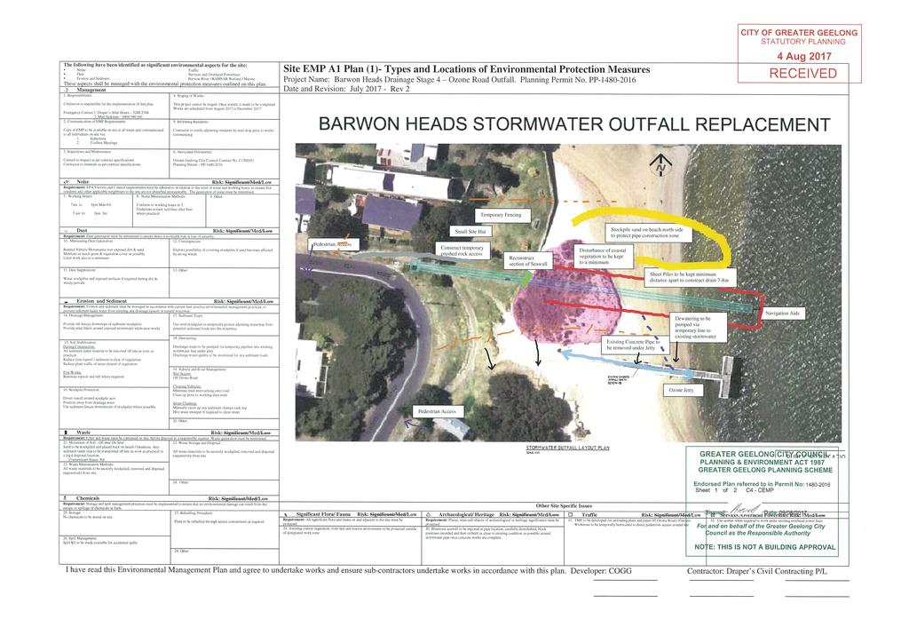
1 Construction of upgraded stormwater outfall at the Ozone Road Jetty Background The City of Greater Geelong (CoGG) is responsible for stormwater management within Barwon Heads. There is an existing 750 mm diameter stormwater outfall below the Ozone Road Jetty that can be seen at a low tide. This receives stormwater from the Clifford Parade pumping station, and gravity stormwater flows from inlets along Grove Street, Ozone Road and adjoining streets. The pumping station operates automatically in response to drainage inflows, and contains a litter trap. CoGG have identified that while the stormwater pipelines and the pumping station can accommodate storm events up to one every 100 years, the existing outfall restricts flows that occur at frequencies of greater than once every 20 years, resulting in localised flooding. For this reason they have designed a larger (1.6 m diameter) outfall that will discharge runoff from all storm events more quickly. This outfall will be parallel and 16 m north of the existing outfall, 14 m further out in the river channel, and 3.5 m east of the end of the jetty. Meeting and discussions Ross Middleton and John Nolan met with Martin Rushbrook from CoGG s Infrastructure Management and Mark Richards from the Engineering Design Unit on 18 th July. Conversations were also held with Vaughan Notting (Engineering Design) and Dianne Luscombe (Environment). All were forthcoming with information and requested documentation was provided. Response to matters or interest Will the catchment area be increased in the future? Will the stormwater volume increase? Outfall pipe diameter? Will there be a change in the peak discharge rates? Will the outfall be seen Will there be additional treatment before outfall? CoGG has given a commitment that catchment area draining into the outfall will not be increased now or in the future from that which currently occurs. This is accepted as surrounding local catchments have their own disposal points. No. 1.6 m. The concept design considered a 0.8 diameter as well as diameters up to 1.2 m. The hydraulic modelling was reviewed as part of the final detailed design by GHD. The larger pipe will reduce pipe friction losses that will enable higher flows from the pumps and greater gravity flows. The new tidal backflow valve will also be less restrictive on flows than the existing valve type. The new outfall will permit higher peak flows, and that will reduce the incidence of flooding in the Clifford - Grove Road catchment area. The top of the outfall will be lower than the existing pipeline and should not be seen as it be at the lowest astronomical tide The only water quality control is the Clifford Parade pumping station litter trap. CoGG has advised that it is not possible to install a gross pollutant trap (GPT) near the jetty due to: low pipeline grades; tidal influences and 1
2 would require a very deep pit CoGG has also advised that GPTs only work on flows up to 1 year ARIs. Bypasses are provided above these flows. When will construction occur? Will the bluestone wall be impacted? Will there be sand scouring? Scheduled to commence in late August with completion by December. The works will be undertaken by a Contractor and supervised by a CoGG Project Implementation Officer. GHD advise that a short section will be removed and reinstalled at the completion of the works. It did not require heritage consent however it is acknowledged that the wall is of historical significance. Because of this CoGG s contractor will be photographing and numbering the blocks and reinstatement will be completed by suitably qualified stonemasons. GHD undertook a sand movement study that identified local scour around piles during river floods. While this study did not explicitly consider scour associated with discharge through the outfall the flow velocity will be lower than that which currently occurs up to at least the 1 in 20 year storm event. What are the values of the vegetation that will be impacted? Ecology Partners identified a small area of dune vegetation along the foreshore consisting predominantly of introduced Marram Grass with scattered indigenous species (<25% cover) including Small-leaved Clematis, Seaberry Saltbush, Coast Saltbush and Hairy Spinifex. Grass extended toward the Barwon River shoreline. No native vegetation was present within the Barwon River or around the existing jetty. No threatened flora or fauna species were identified that are likely to be directly affected. Ecology Partners recommended that an EPBC Act referral be submitted as the works area extends about 3 m into the Port Phillip Bay (Western Shoreline) and Bellarine Ramsar site. An EPBC Act referral was made to the Department of the Environment and on 23/03/2016 GCoG received confirmation that the proposed works were not a controlled action. This means that no further assessment or approval was required under the EPBC Act before works could proceed. How will impacts on local ecological values be minimised during construction? Planning permit condition 4 requires a detailed Construction Environmental Management Plan (CEMP) to outline measures to ensure ecological values are protected during construction activities, such as weed management, soil stockpile locations and sediment control. This should include the following Ecology Partner recommendations: minimise soil disturbance to avoid erosion with sediment and erosion controls ensure contractors are aware of areas of ecological value place construction stockpiles and machinery away from areas supporting native vegetation/fauna habitat; 2
3 keep fuel and chemicals at least 50 metres from the foreshore. A copy of the CoGG endorsed CEMP is attached. How will vegetation be reinstated? How will risks to boats identify outfall location? What are the water quality implications? Planning permit condition 5 requires a Reinstatement Plan requires details of reinstatement and revegetation. As recommended it does not require the use indigenous plants as part of any landscaping/revegetation works as recommended by Ecology Partners. Three beacons will be placed as navigation markers. Extent of outfall does not go much beyond the jetty The water quality impact on the shoreline waters is likely to be less than that which currently occurs as: the flow volume will not increase the outfall is deeper and always submerged, as well as being further out the outfall is north of the jetty Will there be water quality monitoring? CoGG has given a commitment to conduct water quality monitoring at the jetty before and during construction. They are engaging ALS, a NATA accredited laboratory to undertake this work. BHA will work with stakeholders to facilitate an ongoing coastal water quality monitoring program, including the Barwon Coast Committee of Management, Corangamite CMA, DELWP, CoGG, and EPA. 11 th August 2017 Ross Middleton and John Nolan 3
4
5
POLICY SRT/D4 STORMWATER MANAGEMENT
 POLICY SRT/D4 STORMWATER MANAGEMENT BACKGROUND Increasing population, decreasing rainfall and increasing community expectations regarding environmental issues have led to increasing recognition of the
Authority. any changes required as a result of the approved CHMP.
 PLANNING PERMIT Permit No. Planning Scheme Responsible Authority../2013 Greater Geelong Planning Scheme Greater Geelong City Council ADDRESS OF THE LAND 5, 15, 21, 23, 1/23, 25, 33, 40 and 50 Caddys Road;
SOP 6: Erosion and Sedimentation Control SOP 6: EROSION AND SEDIMENTATION CONTROL
 Standard Operating Procedures Central Massachusetts Regional Stormwater Coalition SOP 6: Erosion and Sedimentation Control SOP 6: EROSION AND SEDIMENTATION CONTROL Erosion and sedimentation from land-disturbing
City of Rockingham. Local Management Practices, Costs and Strategic Coastal Planning
 City of Rockingham Local Management Practices, Costs and Strategic Coastal Planning Decision Making Process Considerations Climate Change Response Action Plan Ongoing observations/major Storm events Ongoing
Draft Rhode Island Stormwater Design and Installation Standards Manual
 Draft Rhode Island Stormwater Design and Installation Standards Manual Summary The May 2009 Public Review Draft version of the RI Stormwater Design and Installation Standards Manual consists of approximately
Coastal hazard assessments in Victoria
 Coastal hazard assessments in Victoria Viktor Brenners viktor.brenners@delwp.vic.gov.au Future Coasts program 4 year program established in 2007. Outputs included: Coastal Digital Elevation Models Victorian
7. Biodiversity & Conservation Areas
 7. & Conservation Areas 7.1. Objectives The objectives of biodiversity and conservation areas are founded on the need to recognise the importance of biodiversity and acknowledge the need to protect, restore
Shelbyville, KY Stormwater Best Management Practices. Section 2 EROSION PREVENTION AND SEDIMENT CONTROL PLAN
 Section 2 EROSION PREVENTION AND SEDIMENT CONTROL PLAN 2.1 Requirements The City of Shelbyville, KY will require an Erosion Prevention and Sediment Control (EPSC) Plan for most types of development construction.
Southport Dunes Weed Control
 Southport Dunes Weed Control Acknowledgements: Traditional Owners - Kaurna City of Onkaparinga AMLRNRM Southport Coast Care Southport SLSC Trees For Life Volunteers The Southport Dune system is one of
There is an ongoing regulatory concern that
 FWRJ Alternatives for Beach Stormwater Outfalls: Preliminary Assessment for City of Naples Reshma Thummadi, Ronald Cavalieri, Andy Holland, and Gregg Strakaluse There is an ongoing regulatory concern that
Coastal Erosion Protection Strategies Private Works on Public Land
 Coastal Erosion Protection Strategies Private Works on Public Land Arron Broom Coastal Policy Planner Coastal Management Branch, SA DEW Delegate for the Coast Protection Board 2016 Storm Events SA experienced
Ashbridges Bay Erosion and Sediment Control Project
 Ashbridges Bay Erosion and Sediment Control Project Project Brief Overview Toronto and Region Conservation Authority, in partnership with the City of Toronto, intends to carry out remedial erosion control
Soil Reclamation and Site Reinstatement
 APPENDIX 6 Soil Reclamation and Site Reinstatement Purpose To undertake soil reclamation, erosion protection, Site restoration and reinstatement, taking into account natural processes, operational requirements
TONIGHT S MEETING DRAFT SUMMARY REPORT CAPE WOOLAMAI COASTAL RESERVES MASTER PLAN PHILLIP ISLAND SOUTH AND NORTH COAST KEY AREA PLAN OCTOBER 2014
 TONIGHT S MEETING Phillip Island Nature Parks and Bass Coast Shire Council have partnered to achieve a comprehensive and integrated master plan for the safe use and management of Cape Woolamai Coastal
The Moors at Arne Project, Managing Coastal Change
 General Questions What are we doing? The Environment Agency, RSPB and Natural England are working together to adapt approximately 150ha of The Moors at Arne into a diverse wetland habitat. With the sea
143 Flinders Avenue Lara. Vegetation Assessment
 143 Flinders Avenue Lara Vegetation Assessment A Report to L. Bisinella Developments Pty Ltd Prepared by Mark Trengove Ecological Services PO Box 1502 Geelong 3220 mtrengove@pipeline.com.au ph 0428 298087
Waterways and wetlands investigations
 A4! Waterways and wetlands investigations Wader Beach Project: Gross Pollutant Traps Most of the litter at Wader Beach is sourced from uncontained debris in the Bay being deposited on the beach through
Queensland Coastal Plan. Presented by John Lane Director Environment Planning
 Queensland Coastal Plan Presented by John Lane Director Environment Planning Queensland Coastal Plan - Status Released 7 April 2011, but NOT YET IN EFFECT Formatting & operational amendments required Yet
Implementing sustainable water strategy through development industry engagement
 Implementing sustainable water strategy through development industry engagement Ian Director, Organica Engineering, Melbourne, Australia E-mail: iadams@organicaeng.com.au Edward Cotter Sustainability Leader,
PLANNING AND DESIGN OF PUTRAJAYA STORMWATER MANAGEMENT SYSTEM
 PLANNING AND DESIGN OF PUTRAJAYA STORMWATER MANAGEMENT SYSTEM Khor Chai Huat, Chang Chan Yang & Lim Yek Lan Angkasa Consulting Services Sdn. Bhd. Abstract : Putrajaya is the new administrative centre of
SUNSET COVE WALKING TRACK PROJECT
 SUNSET COVE WALKING TRACK PROJECT MANAGEMENT PLAN 2013 2015 Prepared by: Paynesville Landcare/Coastcare Group Prepared for: East Gippsland Shire Council (Committee of Management of Crown Land) East Gippsland
Review of Environmental Factors Addendum. Green Square Stormwater Drain Shea s Creek Channel Corridor Restoration
 Review of Environmental Factors Addendum Green Square Stormwater Drain Shea s Creek Channel Corridor Restoration November 2016 Sydney Water Corporation (2014). Commercial in Confidence. All rights reserved.
Perth and Kinross Council Development Management Committee 8 June Pre-Application Report by Development Quality Manager
 Perth and Kinross Council Development Management Committee 8 June 2016 5(3)(i) 16/259 Pre-Application Report by Development Quality Manager Residential development at St Martins Road, Land 120 metres West
Sunshine Coast Council Coastal Management Overview. January 2016 edition
 Sunshine Coast Council Coastal Management Overview January 2016 edition Mayor Mark Jamieson Mayor s foreword Our impressive beaches are fundamental to our Sunshine Coast lifestyle, economy and coastal
April 11, 2016 Park Board Chair and Commissioners General Manager Vancouver Board of Parks and Recreation New Brighton Salt Marsh - Preferred Concept
 TO: FROM: SUBJECT: April 11, 2016 Park Board Chair and Commissioners General Manager Vancouver Board of Parks and Recreation New Brighton Salt Marsh - Preferred Concept RECOMMENDATION A. THAT the Vancouver
Water Sensitive Urban Design Site Development Guidelines and Practice Notes. Appendix
 Water Sensitive Urban Design Site Development Guidelines and Practice Notes Appendix 108 Appendix A Water sensitive developments involve simple design and management practices that take natural site features
BACKGROUND INFORMATION DOCUMENT
 BACKGROUND INFORMATION DOCUMENT PROPOSED UPGRADING OF THE N2 NATIONAL ROAD FROM KRAAIBOSCH TO DIE VLEIE BASIC ENVIRONMENTAL IMPACT ASSESSMENT The South African National Roads Agency Society Limited (SANRAL)
Lake Macquarie Development Control Plan 2014 Revision 19
 Lake Macquarie Development Control Plan 2014 Revision 19 Part 8 Subdivision Development Adopted by Council 25 June 218 Page 0 F2018/00436 TABLE OF CONTENTS: 1 INTRODUCTION... 4 1.1 HOW TO USE THIS PLAN...
Point-No-Point Tide-Gate & Outfall Replacement Project. Briefing Memo 2013
 Point-No-Point Tide-Gate & Outfall Replacement Project Briefing Memo 2013 This memo provides an initial outline of the proposed Point-No-Point (PNP) Tide-Gate and Outfall replacement project. The current
H7 Open Space zones. (a) provide for the needs of the wider community as well as the needs of the community in which they are located;
 provide for the needs of the wider community as well as the needs of the community in which they are located;") H7. Open Space zones H7.1. Background The majority of land zoned as open space is vested in the Council or is owned by the Crown. However some areas zoned open space are privately owned. While the open
H7. Open Space zones H7.1. Background The majority of land zoned as open space is vested in the Council or is owned by the Crown. However some areas zoned open space are privately owned. While the open
Grantham Southern Quadrant Link Road Environmental Statement
 Grantham Southern Quadrant Link Road Environmental Statement Non Technical Summary Introduction Lincolnshire County Council (LCC) is submitting a planning application for the proposed implementation of
Memorandum. AECOM Technical Services Inc. Page 1
 Memorandum To: Gregg R. Strakaluse, P.E. and Andy Holland, P.E. From: Ronald Cavalieri, P.E. Prepared By: Reshma Thummadi, P.E. Date: September 20, 2013 Subject: Permitting of Subaqueous Stormwater Outfalls
Raingardens and Bioretention Tree Pits MAINTENANCE PLAN. EXAMPLE June 2008
 Raingardens and Bioretention Tree Pits MAINTENANCE PLAN EXAMPLE June 2008 Table of Contents 1 RAINGARDEN AND BIORETENTION TREE PIT FUNCTIONS... 2 2 MINIMISING LONGTERM MAINTENANCE... 4 2.1 Filter media...
Legal implications of failing to
 Legal implications of failing to plan for sea level rise Gavin Leydon, Partner 30 April 2010 Outline Relevance to local l government & developers assessment & policy Developments in case law Climate change
Statement of Expert Evidence: Amendment C369 for the Greater Geelong Planning Scheme (Drysdale Bypass Project), Victoria
, Victoria") Fina lre port Statement of Expert Evidence: Amendment C369 for the Greater Geelong Planning Scheme (Drysdale Bypass Project), Victoria Pre pa re d for Vic Roa d s(south W e ste rnre g ion) July2017 Ec
Fina lre port Statement of Expert Evidence: Amendment C369 for the Greater Geelong Planning Scheme (Drysdale Bypass Project), Victoria Pre pa re d for Vic Roa d s(south W e ste rnre g ion) July2017 Ec
Monitoring and Maintenance Permit Process
 Karen A. Duhring Marine Advisory Scientist Center for Coastal Resources Management Virginia Institute of Marine Science College of William & Mary April 9, 2010 Living Shorelines for Contractors and Project
Part B Assessment of Environmental Effects
 Consent No.:... Part B Assessment of Environmental Effects Minor Coastal Activity This application is made under section 88/section 127 of the Resource Management Act 1991 Whangārei Office Phone: 09 470
Planning Proposal Concurrent DA/LEP Amendment for Belmont North Pharmacy Amendment No. 24 to Lake Macquarie Local Environmental Plan (LMLEP) 2014
 2014") Planning Proposal Concurrent DA/LEP Amendment for Belmont North Pharmacy Amendment No. 24 to Lake Macquarie Local Environmental Plan (LMLEP) 2014 Local Government Area: Name of Draft LEP: Subject Land:
Planning Proposal Concurrent DA/LEP Amendment for Belmont North Pharmacy Amendment No. 24 to Lake Macquarie Local Environmental Plan (LMLEP) 2014 Local Government Area: Name of Draft LEP: Subject Land:
Appendix F Construction phase management
 Appendix F Construction phase management F.1. Introduction... 1 F.2. Core principles of sediment and erosion control... 2 F.3. Planning... 3 F.4. Occupational health and safety... 7 F.5. References / further
Otway Community Conservation Network (OCCN)
") South East Coastal Plain Project Otway Community Conservation Network (OCCN) Scoping Paper April 2011 TABLE OF CONTENTS 1 INTRODUCTION...3 1.1 South East Coastal Plain Project... 3 1.2 The Need for an
South East Coastal Plain Project Otway Community Conservation Network (OCCN) Scoping Paper April 2011 TABLE OF CONTENTS 1 INTRODUCTION...3 1.1 South East Coastal Plain Project... 3 1.2 The Need for an
New Development Stormwater Guidelines
 New Development Stormwater Guidelines CITY OF MOUNTLAKE TERRACE Table of Contents Introduction... 2 Ecology s Minimum Requirements for stormwater management... 2 Description of the 9 Minimum Requirements...
Section 6A 6A Purpose of the Natural Features and Landscapes Provisions
 Section 6A 6A Purpose of the Natural Features and Landscapes Provisions This Chapter addresses the protection and management of natural features and landscapes within the City. The City has a number of
Resolution XII NOTING also that with the increasingly rapid urbanization, wetlands are being threatened in two principle ways:
 12 th Meeting of the Conference of the Parties to the Convention on Wetlands (Ramsar, Iran, 1971) Punta del Este, Uruguay, 1-9 June 2015 Resolution XII.10 Wetland City 1 Accreditation of the Ramsar Convention
Using a Citizen s Wetland Education Workshop As A Tool in Regulatory Compliance
 Using a Citizen s Wetland Education Workshop As A Tool in Regulatory Compliance (A Driver s Safety Course for Wetland Violators) Kevin R. Du Bois, P.W.S. ASWM Wetlands 2007 National Symposium August 28-30,
River Mile 10.9 Removal Action Overview
 River Mile 10.9 Removal Action Overview November 13, 2014 CAG Meeting Modified from CPG s RM10.9 Removal Action Final Design Report dated Nov. 2013 1 River Mile 10.9 Removal Action Activities Dredging:
Report on the Screening Process for the Proposed Woodstock Local Area Plan
 Report on the Screening Process for the Proposed Woodstock Local Area Plan February 2006 Brendan McGrath and Associates Planning Consultants Carrick House, Newenham Street, Limerick. t: 061 3109914 f:
Priors Farm Estate SuDS Retrofitting Project, Cheltenham
 Priors Farm Estate SuDS Retrofitting Project, Cheltenham SuDS used Detention basins Bioretention Planters Rain Gardens Benefits Reduction of surface water flooding 1. Location Priors Farm Estate, Oakley,
Reimagining Arnolds Creek. Community engagement report. May 2018
 Reimagining Arnolds Creek Community engagement report May 2018 Melbourne Water is owned by the Victorian Government. We manage Melbourne s water supply catchments, remove and treat most of Melbourne s
Draft Resolution XII.10
 12 th Meeting of the Conference of the Parties to the Convention on Wetlands (Ramsar, Iran, 1971) Punta del Este, Uruguay, 1-9 June 2015 Ramsar COP12 DR10, Rev. 2 21:45, 8 June Draft Resolution XII.10
MANUAL OF DESIGN, INSTALLATION, AND MAINTENANCE REQUIREMENTS FOR STORMWATER MANAGEMENT PLANS
 MANUAL OF DESIGN, INSTALLATION, AND MAINTENANCE REQUIREMENTS FOR STORMWATER MANAGEMENT PLANS May 2007 SECTION 1 Responsibility of Applicant TABLE OF CONTENTS A. Stormwater Management Plan Required Information
MAIN ROADS Western Australia COALFIELDS HIGHWAY PROJECTS ROADSIDE REVEGETATION MANAGEMENT
 MAIN ROADS Western Australia COALFIELDS HIGHWAY PROJECTS ROADSIDE REVEGETATION MANAGEMENT Presentation - South West Region - Alan Grist, Project Manager, Environment (November 2015) Protecting and enhancing
CITY OF GREATER GEELONG
 CITY OF GREATER GEELONG AGENDA DEVELOPMENT HEARINGS PANEL MEETING NO 538 TO BE HELD AT BROUGHAM STREET OFFICE (GROUND FLOOR) 100 BROUGHAM STREET, GEELONG ON THURSDAY, 16 FEBRUARY 2017 AT 5.00 P.M. 1. Committee
BASIC ASSESSMENT PROCESS
 BASIC ASSESSMENT PROCESS NOTICE OF A BASIC ASSESSMENT PROCESS FOR THE PROPOSED MIXED USE DEVELOPMENT ON THE REMAINDER OF PORTION 2, REMAINDER OF PORTION 7, PORTION 7, REMAINDER OF PORTION 9, REMAINDER
Lake Macquarie Development Control Plan Revision 20
 Lake Macquarie Development Control Plan 2014 - Revision 20 LMCC DCP 2014 Revision 20 Page 0 F2016/01470 TABLE OF CONTENTS: 1 INTRODUCTION... 3 1.1 HOW TO USE THIS PLAN... 3 1.2 ADDITIONAL CONTROLS FOR
COMMUNITY ACTIONS for a SUSTAINABLE BARWON HEADS. February 2016
 COMMUNITY ACTIONS for a SUSTAINABLE BARWON HEADS February 2016 Acknowledgements Traditional Owners We acknowledge the traditional owners of this land and pay our respects to their elders past and present,
LEOPOLD LAND CAPABILITY AND BAY ACCESS REPORT
 LEOPOLD LAND CAPABILITY AND BAY ACCESS REPORT JULY 2015 Prepared by Spiire for City of Greater Geelong This report has been prepared by the office of Spiire Level 2 10 Moorabool Street PO Box 4032 Geelong
Lake Macquarie Development Control Plan 2014 Revision 20
 Lake Macquarie Development Control Plan 2014 Revision 20 TABLE OF CONTENTS: 1 INTRODUCTION... 3 1.1 HOW TO USE THIS PLAN... 3 1.2 ADDITIONAL CONTROLS FOR SPECIFIC LAND USES... 3 1.3 AIMS FOR DEVELOPMENT
Key elements : Filter Strips must be designed within parameters required by the Fort Wayne s Development Standards/Criteria Manual.
 4.4. Filter Strips Filter Strips are densely vegetated lands that treat sheet flow storm water from adjacent pervious and impervious areas. They function by slowing runoff, trapping sediment and pollutants,
Chapter 1: General Program Information
 Chapter 1: General Program Information 1.1 Introduction The Montgomery County Stormwater Management Resolution (#03-1-5) was adopted by the County Board of Commissioners on January 22, 2003. The purpose
Retrofitting Low Impact Development (LID) for Stormwater at Sacramento State. City of Sacramento Sacramento State Facilities Management
 for Stormwater at Sacramento State. City of Sacramento Sacramento State Facilities Management") Retrofitting Low Impact Development (LID) for Stormwater at Sacramento State City of Sacramento Sacramento State Facilities Management Project Background Campus Storm Drain System Drain Inlet - Campus
Retrofitting Low Impact Development (LID) for Stormwater at Sacramento State City of Sacramento Sacramento State Facilities Management Project Background Campus Storm Drain System Drain Inlet - Campus
Lake Macquarie Development Control Plan 2014 Revision 17
 Lake Macquarie Development Control Plan 2014 Revision 17 Part 3 Development within Residential Zones Draft LMCC DCP 2014 Page 1 F2009/00952 Version 4 Exhibition Draft July 2012 TABLE OF CONTENTS: 1 INTRODUCTION...
Sustainable Urban Drainage Systems. Diederik Rousseau Tineke Hooijmans
 Sustainable Urban Drainage Systems Diederik Rousseau Tineke Hooijmans Contents Presentation Water cycle links The issues facing stormwater management Conventional approach and drawbacks SUDS triangle and
3. Highway Landscaping Assessment
 Guidelines for Highway Landscaping 3-1 3. Highway Landscaping Assessment 3.1 Introduction This section outlines the steps necessary to assess the highway landscaping component of a state highway construction
A. INTRODUCTION AND SUMMARY OF FINDINGS B. EXISTING CONDITIONS. Table 10-1 Adjacent Storm Drains
 Chapter 10: Stormwater Management A. INTRODUCTION AND SUMMARY OF FINDINGS This chapter describes existing and proposed stormwater management on the Site. Potential impacts to stormwater infrastructure
Lake Macquarie City. A copy of the published amendment including the instrument and maps, is provided in Attachment 7 of this report.
 Planning Proposal Amendment No. 77 to Lake Macquarie Local Environmental Plan 2004 and proposed Amendment to Draft Lake Macquarie Local Environmental Plan 2013 Minor Zone Boundary Adjustment - Pasminco
I541. Te Arai North Precinct
 I541. Te Arai North Precinct I541.1. Precinct Description The Te Arai North Precinct contains approximately 616ha of coastal land north of Te Arai Point, generally known as Mangawhai North Forest. The
Mollers Lane, Leopold, Victoria Significant Landscape Overlay Re-assessment
 XURBAN Mollers Lane, Leopold, Victoria Significant Landscape Overlay Re-assessment For: TGM Group November 2016 Final Mollers Lane, Leopold, Victoria Significant Landscape Overlay Re-assessment Client
West Gate Tunnel Project. Incorporated Document May Incorporated document pursuant to section 6(2)(j) of the Planning and Environment Act 1987.
(j) of the Planning and Environment Act 1987.") West Gate Tunnel Project Incorporated Document May 2017 Incorporated document pursuant to section 6(2)(j) of the Planning and Environment Act 1987. Drafting Note: The planning control contained in this
West Gate Tunnel Project Incorporated Document May 2017 Incorporated document pursuant to section 6(2)(j) of the Planning and Environment Act 1987. Drafting Note: The planning control contained in this
CA.1 Coastal Area. Index. CA.1.1 Description and Expectations
 Index.1.2.3.4 CA.2 CA.2.1 CA.2.2 CA.2.3 CA.3 CA.3.1 CA.3.2 CA.3.1 CA.4 CA.4.1 CA.4.2 CA.4.3 CA.4.4 CA.5 CA.5.1 CA.5.2 Description and Expectations Objectives Policies Guidance Note Landuse Eligibility
STRATEGIC IMPLEMENTATION PANEL SUBMISSION
 STRATEGIC IMPLEMENTATION PANEL SUBMISSION AMENDMENT C375 to the GREATER GEELONG PLANNING SCHEME BARWON HEADS STRUCTURE PLAN IMPLEMENTATION Part A Submission to the Independent Panel Panel: Con Tsotsoros
Leading environmental solutions...
 Leading environmental solutions... About Us Australian Wetlands Consulting (AWC) is a multi-award winning environmental design and consulting company committed to creating a better environment through
Guide to Naturalizing a Lakefront Shoreline. September 2010
 Guide to Naturalizing a Lakefront Shoreline September 2010 Retaining walls and non-vegetated shorelines are a very common sight on shore-line properties in Alberta. These urbanized shorelines have a huge
E15. Vegetation management and biodiversity
 E15. management and biodiversity E15.1. Background contributes to a range of ecosystem services such as erosion and sediment control, reducing stormwater flows, protecting or enhancing water quality, amenity
Case Study Presentation of the Downtown Brampton Flood Protection Class EA
 Case Study Presentation of the Downtown Brampton Flood Protection Class EA Presented by: Kenneth M. Dion, Project Director Port Lands Integration, Waterfront Toronto (formerly Senior Manager, TRCA) At:
I602. Birdwood Precinct
 I602. Birdwood Precinct I602.1. Precinct description The Birdwood Precinct applies to an area west of Don Buck Road and south of Red Hills Road in west Auckland. It incorporates subdivision and development
West Little Pimmit Storm Sewer & John Marshall Green Street Projects. July 7, 2015 Nottingham Elementary School
 West Little Pimmit Storm Sewer & John Marshall Green Street Projects July 7, 2015 Nottingham Elementary School Project Timeline February 2015: Archeological study of island, including historic spring location,
Coastal Climate Change Vulnerability and Flexible Adaptation Planning: the Cockburn Sound Coastal Alliance Experience
 Coastal Climate Change Vulnerability and Flexible Adaptation Planning: the Cockburn Sound Coastal Alliance Experience Presentation to Climate Change Forum by Doug Vickery Manager Infrastructure Services,
Project: Developer/Designer: Reviewer: I. Narrative: 1. Project Description: Describes the nature and purpose of the land disturbing activity.
 City of Charlottesville, Virginia Erosion and Sediment Control Plan Review Checklist 610 East Market Street, Charlottesville, VA 22902 Telephone 434-970-3182; Fax 434-970-3359 Project: Developer/Designer:
Urban Stormwater: Best Practice Environmental Management Guidelines. CSIRO This electronic edition published by CSIRO PUBLISHING, 2006.
 Urban Stormwater: Best Practice Environmental Management Guidelines. Chapter 5 Water Sensitive Urban Design Key references Department of Planning, 1993, Better Drainage: Guidelines for the Multiple Use
I611. Swanson North Precinct
 I611. Swanson North Precinct I611.1. Precinct Description Swanson North is located in the north eastern foothills of the Waitakere Ranges. It is outside the Waitakere Ranges Heritage Area Act and the Waitakere
Barrow in Furness WwTW Outfall designing and installing the next generation of submarine outfall pipelines in the North West
 Barrow in Furness WwTW Outfall designing and installing the next generation of submarine outfall pipelines in the North West by Martin Berry CEng BEng MICE & Steve Dempsey BSc CEng FICE S pring 2015 saw
Re: Amendment C234 Cardinia Planning Scheme Pakenham East Precinct Submission by Earldean Pty Ltd and Auscare Commercial Pty Ltd
 23 February 2018 Victorian Planning Authority amendments@vpa.vic.gov.au Dear Sir / Madam Re: Amendment C234 Cardinia Planning Scheme Pakenham East Precinct Submission by Earldean Pty Ltd and Auscare Commercial
Weston s Wetlands, Stormwater, & Open Space
 Weston s Wetlands, Stormwater, & Open Space Weston s Wetlands, Stormwater, & Open Space Conservation Commission Role and Responsibilities Laws that protect wetlands What residents can do to protect wetlands
Waterway Corridors. Guidelines for greenfield development areas within the Port Phillip and Westernport Region
 Waterway Corridors Guidelines for greenfield development areas within the Port Phillip and Westernport Region Contents 1 Introduction 2 2 Purpose of the guidelines 3 3 What is a waterway corridor? 3 4
DEALING WITH STORM WATER MANAGEMENT
 December 2012 DEALING WITH STORM WATER MANAGEMENT This fact sheet provides information on the guiding principles of storm water management practices, explains the difference between structural and non-structural
CHAPTER Committee Substitute for Senate Bill No. 1472
 CHAPTER 2007-99 Committee Substitute for Senate Bill No. 1472 An act relating to beaches and shores; amending s. 161.021, F.S.; amending a definition; amending s. 161.085, F.S.; restricting the use of
Planning Proposal under section 55 of the EP&A Act
 FOR PUBLIC EXHIBITION [Brief description] Monday 10 October to Monday 27 October 2014 Planning Proposal under section 55 of the EP&A Act Port Macquarie-Hastings LEP 2011 (Amendment No 32) Mixed land zone
I604. Hobsonville Marina Precinct
 I604. Hobsonville Marina Precinct I604.1. Precinct description Hobsonville Marina Precinct is located at Clearwater Cove, Hobsonville in Auckland s upper Waitemata Harbour. The precinct includes the coastal
Environmental Impact Statement
 for South of Embley Project Section 12 Visual Amenity 12 VISUAL AMENITY This section describes the current visual amenity of the Project area, identification of visual receptors, and the assessment methodology
Stormwater Solutions for Residential Sites. Section 2 Stormwater Management Approach VERSION 1.0. EcoWater Solutions. Prepared for
 VERSION 1.0 Stormwater Solutions for Residential Sites Section 2 Stormwater Management Approach Prepared for EcoWater Solutions A Department of Waitakere City Council 113 Central Park Drive Henderson WAITAKERE
ARROW BOWEN PIPELINE ENVIRONMENTAL MANAGEMENT PLAN OUTLINE SOIL MANAGEMENT PLAN
 APPENDIX J ARROW BOWEN PIPELINE ENVIRONMENTAL MANAGEMENT PLAN OUTLINE SOIL MANAGEMENT PLAN Contents 1 Introduction... 1 1.1 Purpose of the Soil Management Plan... 1 1.2 Project description... 1 1.3 Legislation
Roads of national significance. MacKays to Peka Peka. Assessment of Environmental Effects: Non-Technical Summary
 Roads of national significance MacKays to Peka Peka Assessment of Environmental Effects: Non-Technical Summary March 2012 Table of Contents 1 Executive Summary... 1 1.1 Introduction... 1 1.2 Background
Kirra Beach Dune Regeneration Works: Large scale revegetation of artificially created coastal dunes Mark Bibby 1 and Rachel Lamaro 2
 Kirra Beach Dune Regeneration Works: Large scale revegetation of artificially created coastal dunes Mark Bibby 1 and Rachel Lamaro 2 1 Gecko Regen 4/1 Bee Crt Burleigh Heads QLD 4220 email. admin@geckoregen.org.au
Homeowners Guide to Stormwater BMP Maintenance
 Homeowners Guide to Stormwater BMP Maintenance What You Need to Know to Take Care of Your Property Rain Barrel Dry Well Rain Garden Pervious Asphalt Porous Pavers City of El Monte Stormwater BMP Management
THE CORPORATION OF THE CITY OF WINDSOR Office of the City Solicitor Planning Department
 THE CORPORATION OF THE CITY OF WINDSOR Office of the City Solicitor Planning Department REPORT TO THE CITY OF WINDSOR PLANNING ADVISORY COMMITTEE DATE OF REPORT: August 19, 2010 SUBJECT: Official Plan
MADRID MINING LANDSCAPE Western Planner/Nevada APA Conference. A New Mexico Abandoned Mine Land (AML) Program Community-Based Planning Project
 Program Community-Based Planning Project") MADRID MINING LANDSCAPE 2013 Western Planner/Nevada APA Conference A New Mexico Abandoned Mine Land (AML) Program Community-Based Planning Project Presented by: Ken Romig, ASLA Associate, Dekker/Perich/Sabatini
MADRID MINING LANDSCAPE 2013 Western Planner/Nevada APA Conference A New Mexico Abandoned Mine Land (AML) Program Community-Based Planning Project Presented by: Ken Romig, ASLA Associate, Dekker/Perich/Sabatini
Pennsylvania Stormwater Best Management Practices Manual. Chapter 1. Introduction and Purpose
 Pennsylvania Stormwater Best Management Practices Manual Chapter 1 Introduction and Purpose Chapter 1 Introduction and Purpose 1.1 Purpose of this Manual 1 1.2 How to Use this Manual...1 1.3 Overview
Report to COMMUNITY DEVELOPMENT & SERVICES Committee for noting
 16 499 Title: Section: Prepared by: Titirangi Update Community and Recreation Andy Kinsella (Project Manager Assistant) Meeting Date: 16 November 2016 Legal Financial Significance = Medium Report to COMMUNITY
Design considerations
 Design considerations There are many different considerations, so good forward planning will help you immensely. Most importantly: Softer solutions should be used where possible Look to the surrounding
The Napa River Flood Protection Project
 The Napa River Flood Protection Project Creating Flood Protection and Restoring Geomorphic and Biological Processes Jeremy Sarrow, Napa County Flood Control & Water Conservation District June 2, 2014.