STRATEGIC IMPLEMENTATION PANEL SUBMISSION
|
|
|
- Margaret Cole
- 5 years ago
- Views:
Transcription
1 STRATEGIC IMPLEMENTATION PANEL SUBMISSION AMENDMENT C375 to the GREATER GEELONG PLANNING SCHEME BARWON HEADS STRUCTURE PLAN IMPLEMENTATION Part A Submission to the Independent Panel Panel: Con Tsotsoros (Chair), Elissa Bell Date: Tuesday 14 August 2018 Prepared by: Peter Schembri, Acting Coordinator & Stuart Thiele, Acting Senior Strategic Planner on behalf of the City of Greater Geelong
2
3 TABLE OF CONTENTS INTRODUCTION... 5 THE AMENDMENT... 5 THE MAIN ISSUES... 5 SUMMARY OF COUNCIL S SUBMISSION... 5 LOCATION AND CONTEXT... 7 GREATER GEELONG AND BELLARINE PENINSULA CONTEXT... 7 BARWON HEADS CONTEXT... 9 EXISTING ZONING EXISTING OVERLAYS EXISTING BUILDING REGULATIONS BACKGROUND CHRONOLOGY OF EVENTS BARWON HEADS STRUCTURE PLAN ADOPTED AUGUST THE PROPOSED AMENDMENT STRATEGIC CONTEXT AND ASSESSMENT STRATEGIC ASSESSMENT THE GEELONG REGION DEVELOPMENT STRATEGY BARWON HEADS STRUCTURE PLAN URBAN GROWTH STRATEGY BARWON HEADS URBAN DESIGN FRAMEWORK HOUSING DIVERSITY STRATEGY 2007 (AMENDED SEPT 2008) BARWON HEADS STRUCTURE PLAN G21 REGIONAL GROWTH PLAN VICTORIAN COASTAL STRATEGY BELLARINE PENINSULA LOCALISED PLANNING STATEMENT PLANNING PRACTICE NOTE 36 - IMPLEMENTING A COASTAL SETTLEMENT BOUNDARY (NOV 2016) 36 AMENDMENT VC110 (MARCH 2017) DRAFT CITY OF GREATER GEELONG SETTLEMENT STRATEGY (MAY 2018) CONSIDERATION AGAINST THE PLANNING POLICY FRAMEWORK CONSIDERATION AGAINST THE LOCAL PLANNING POLICY FRAMEWORK EXHIBITION AND SUBMISSIONS COUNCIL RESOLUTION TO PREPARE AND EXHIBIT AN AMENDMENT MINISTERIAL AUTHORISATION EXHIBITION 47 SUBMISSIONS RECEIVED COUNCIL RESOLUTION REGARDING THE SUBMISSIONS CHANGES TO THE AMENDMENT DOCUMENTATION LATE SUBMISSIONS RESPONSE TO ISSUES RAISED IN SUBMISSIONS SETTLEMENT BOUNDARY
4 INCREASED HOUSING DIVERSITY AREA WARRENBEEN COURT RESIDENTIAL LAND SOUTH OF BRIDGE ROAD NEIGHBOURHOOD RESIDENTIAL ZONE MOVEMENT AND PARKING VEGETATION PROTECTION DRAFTING OF THE AMENDMENT C375 PLANNING CONTROLS VILLAGE CHARACTER CONCLUSION APPENDICES APPENDIX 1 CHRONOLOGY OF EVENTS APPENDIX 2 - RESPONSE TO STRATEGIC ASSESSMENT GUIDELINES APPENDIX 3 - AUTHORISATION FOR C375 FROM THE MINISTER S DELEGATE APPENDIX 4 - CHANGES TO THE EXHIBITED AMENDMENT DOCUMENTATION APPENDIX 5 - RESIDENTIAL ZONE & OVERLAY CHANGES IN BARWON HEADS BROCHURE APPENDIX 6 DRAFTING CHANGES TABLE OF FIGURES FIGURE 1 - BARWON HEADS IN CONTEXT OF GEELONG REGION... 8 FIGURE 2 - BARWON HEADS AREA MAP FIGURE 3 - AERIAL MAP OF BARWON HEADS AREA FIGURE 4 - PORT PHILLIP BAY & BELLARINE PENINSULA RAMSAR SITE FIGURE 5 - EXISTING ZONING FIGURE 6 - EXISTING OVERLAYS MAP FIGURE 7 - FLOOD & FIRE PRONE AREAS MAP FIGURE 8 - MAP NO 01 STUDY AREA FIGURE 9 - BARWON HEAD STRUCTURE PLAN MAP NO FIGURE 10 - BARWON HEADS EXHIBITED OVERLAY MAPS FIGURE 11 - BARWON HEADS EXHIBITED ZONE MAP FIGURE 12 - GEELONG REGION DEVELOPMENT STRATEGY FRAMEWORK PLAN FIGURE 13 - BARWON HEADS STRUCTURE PLAN FIGURE 14 - BARWON HEADS STRUCTURE PLAN MAP FIGURE 15 - SETTLEMENT AND EMPLOYMENT GROWTH DIRECTIONS FIGURE 16 - BELLARINE PENINSULA LOCALISED PS FRAMEWORK PLAN FIGURE 17 - GREATER GEELONG HOUSING FRAMEWORK PLAN FIGURE 18 - BARWON HEADS EXHIBITED IHDA MAP FIGURE 19 - WARRENBEEN COURT AERIAL MAP
5 INTRODUCTION This submission has been prepared by the Planning Authority, the City of Greater Geelong, and seeks the Panel s support for Amendment C375. The amendment The Amendment will implement the key land-use planning directions of the Council-adopted Barwon Heads Structure Plan August 2017 into the Greater Geelong Planning Scheme. More particularly, the Amendment applies to the existing urban areas of Barwon Heads by applying new residential zone and overlay controls, and updating Municipal Strategic Statement Clause and relevant local policies. The main issues The main issues that have come out of submissions are as follows: Settlement boundary Increased Housing Diversity Area Warrenbeen Court Residential land south of Bridge Road The Neighbourhood Residential Zone Movement and parking Vegetation protection Drafting (of the exhibited planning controls) Village character Summary of Council s submission The structure of this submission is to initially take the Panel through the site context, background and describe in more detail what is proposed. We will then move to the consideration of the proposal (including against the strategic assessment guidelines) and describe the formal exhibition process. The final part of our the submission is a response to the issues raised in submissions to the Amendment, and outline changes to the planning controls proposed as a result of the issues raised in submissions. 5
6 Council s case to the Panel will rely on the strategic material and background documentation supporting the Amendment to illustrate the strategic merit of the Amendment. We also rely on the Council Officer Response to submissions of 26 June 2018, these written submissions, Council s Part B hearing submission, and on the expert evidence of John Glossop of Glossop Town Planning. 6
7 LOCATION AND CONTEXT Greater Geelong and Bellarine Peninsula context As Victoria s second largest city in the fastest growing region, Geelong is the primary service centre in the south-western half of the state, playing a key support role to Melbourne. With its close proximity to the State s capital, Geelong is increasingly being seen as a major urban growth location within the broader Melbourne context. Greater Geelong s population has grown from 216,000 to 239,000 people over the last five years (ABS June 2017). During this time, the growth rate increased from 1.5 per cent, to 2.7 per cent. It is anticipated that Greater Geelong will continue to experience strong growth and demand for housing over a sustained period. The Bellarine Peninsula is located approximately 90 kilometres from Melbourne and approximately 12 kilometres to the east of the urban area of Geelong. It features significant wetland areas and open farmed landscapes with the distinct townships of Barwon Heads, Drysdale/Clifton Springs, Indented Head, Leopold, Ocean Grove, Point Lonsdale, Portarlington, Queenscliff, St Leonards and the rural living area around Wallington. Most townships are located along the coast, are popular with holiday makers, and in recent years have attracted increased numbers of permanent residents. Barwon Heads is located between the two growth area locations of Armstrong Creek to the north west and Ocean Grove located only a few kilometres away across the Barwon River to the East. Armstrong Creek will eventually provide for 22,000 homes, resulting in a population of around 65,000 people over the next 20 years. This, along with the ongoing expansion of the Geelong Ring Road, will continue to result in more people wishing to visit Barwon Heads, placing more pressure on infrastructure. The Ocean Grove Structure Plan (2016) estimates that the population of Ocean Grove will grow by about 6,000 people between 2015 and 2031; resulting in a total population of around 20,000 people. Growth of the town will result in an extensive expansion of community, retail and industrial related activities. Barwon Heads is ideally located to take advantage of the future improved services provision in Ocean Grove. 7

8 The location of the town in relation to the rest of the municipality and within the Bellarine Peninsula is indicated on Figure 1. Figure 1 - Barwon Heads in context of Geelong Region 8
9 Barwon Heads context Barwon Heads is a seaside town located at the mouth of the Barwon River, 18km south-east of Geelong city. To the north of the town lies the Barwon River and the Lake Connewarre system and to the east and south, the town is bordered by coastline to the river and Bass Strait. To the west of Barwon Heads is the Lake Connewarre State Game Reserve, Murtnaghurt Lagoon and the 13th Beach Golf Links and residential resort Barwon Heads Road is the main entrance to the town from Geelong, with an indirect route to the southern part of the town along Thirteenth Beach Road and Ewing Blyth Drive. The only connection beyond the town to the east is across the Barwon Heads Bridge, which connects Barwon Heads to the rest of the Bellarine Peninsula via Ocean Grove. Traditionally a quiet retiree and holiday township, the role of Barwon Heads has changed over the last three decades. The township retains a proportion of retirees and elderly people, however its function as a permanent home for families has increased in recent years and is expected to continue to increase. Today Barwon Heads is a commuter residential area for Geelong and a popular holiday destination. The attraction of Barwon Heads as a seaside retreat continues to grow and the town is popular for holiday home owners, tourism accommodation and day-trippers In 2016 Barwon Heads had a total permanent population of 3,875 usual residents. This is an increase from a population of 3,540 usual residents in 2006, or 335 people. Data from the Australian Bureau of Statistics census demonstrates that during the period between 1981 and 2001 the population of Barwon Heads doubled from 1,245 persons to 2,600 persons. Figures 2 and 3 map the local context of Barwon Heads. Figure 4 shows the boundaries of the Port Phillip Bay (Western Shoreline) and Bellarine Peninsula Ramsar Site - Barwon Heads along Barwon River to inlet of Reedy Lake, including Lake Connewarre section. 9

10 10 Figure 2 - Barwon Heads area map

11 Figure 3 - Aerial map of Barwon Heads area 11
 and Bellarine Peninsula Ramsar")
12 12 Figure 4 - Port Phillip Bay (Western Shoreline) and Bellarine Peninsula Ramsar Site

13 Existing zoning The zoning of Barwon Heads is shown in Figure 5. The map includes land outside the Barwon Heads Settlement Boundary that formed part of the study area for the purposes of preparing the 2017 Barwon Heads Structure Plan. Figure 5 - Existing Zoning 13

14 Existing Overlays Overlays applied to Barwon Heads are shown in Figure 6. The map includes land outside the Barwon Heads Settlement Boundary that formed part of the study area for the purposes of preparing the 2017 Barwon Heads Structure Plan. Figure 6 Existing Overlays Map Existing Building Regulations The Building Regulations designate both flood and fire prone areas in Barwon Heads as shown in Figure 7. The map includes land outside the Barwon Heads Settlement Boundary that formed part of the study area for the purposes of preparing the 2017 Barwon Heads Structure Plan. NOTE: the map includes the Bushfire Management Overlay introduced into the Greater Geelong Planning Scheme by Amendment GC13 on 3 October

15 Figure 7 Flood & Fire Prone Areas Map 15

16 BACKGROUND Chronology of events As requested in the Panel Directions, a chronology of events has been prepared, and is presented in table format at Appendix 1. Barwon Heads Structure Plan adopted August 2017 Review of the 2010 Barwon Heads Structure Plan by Council s Planning Strategy Unit commenced in April The update considered a range of factors around the changing needs of the town and recent changes to state and local policy. The Structure Plan study area extends beyond the existing urban area of Barwon Heads to consider the role and future use of land to the west of the existing urban zones and the rural interface. Figure 8 shows the Study Area map. Figure 8 Map No 01 Study Area 16
17 Preparation of the Structure Plan was accompanied by comprehensive community engagement. The Help Shape the Place sessions in October and November 2017 had 120 people attend workshops and drop in sessions, as well as 130 submissions being received. Engagement on the Draft Structure Plan in May and June 2017 resulted in 1,050 submissions. Council s submission at the panel hearing will expand on the Structure Plan preparation process. The Structure Plan was informed by specialist residential character and native vegetation assessments being: Barwon Heads Residential & Landscape Character Assessment, Hansen, 2017 Significant Residential Tree Assessment: Warrenbeen Court, Barwon Heads, Victoria, Ecology & Partners Pty Ltd, October 2016 Rural Significant Tree Assessment: Barwon Heads, Victoria, Ecology & Partners Pty Ltd, February The Structure Plan comprises three sections: (1) Part A Structure Plan; (2) Part B Implementation and Review; and Part C Background Report. Part A is the Structure Plan which includes principles and directions in response to the key influences identified in the background report, for each of the following themes: Urban Growth; Infrastructure; Settlement & Housing; Natural Environment; Town Centre & Economy; and Rural Areas. Part B contains an implementation program for the BHSP. This includes amendment to the Greater Geelong Planning Scheme to: Introduce planning policy; Apply zones and overlays; and Identify further strategic work required to support additional planning controls. Figure 9 shows the Barwon Heads Structure Plan map. 17

18 Figure 9 Barwon Head Structure Plan Map No. 02 Part C Background Report sets out the background and contextual information for the Structure Plan. It identifies and analyses the issues, opportunities and constraints facing the township for the following themes: Policy Context Natural and Urban Environment Demographics & Social Profile Township Facilities & Services Physical Infrastructure & Transport Township Growth & Residential Lot Supply The Barwon Heads Structure Plan was adopted by Council at its Ordinary Meeting on Tuesday, 22 August The resolution to adopt the Structure Plan included the preparation and exhibition of a planning scheme amendment to implement the BHSP within the Greater Geelong Planning Scheme (i.e. Amendment C375). 18
19 A copy of the adopted Barwon Heads Structure Plan, August 2017, can be found at: nts/8d56887c2c4a98e-barwonheadsstructureplanaugust2017(d ).pdf The proposed amendment Amendment C375 proposes the following changes to the Planning Scheme: Amend Clause Bellarine Peninsula to add the key strategies of the Barwon Heads Structure Plan 2017 including the updated Barwon Heads Structure Plan Map. Rezone all the land in the Residential Growth Zone Schedule 3 (except land south of Bridge Road) to the General Residential Zone Schedule 1. Rezone all the land in the General Residential Zone Schedule 2 (except Warrenbeen Court properties) and the land in the Residential Growth Zone Schedule 3 south of Bridge Road, to the Neighbourhood Residential Zone Schedule 6. Rezone all the properties in Warrenbeen Court from the General Residential Zone Schedule 2 to the Neighbourhood Residential Zone Schedule 7. Insert a new Schedule 6 Barwon Heads Incremental Change Area to Clause Neighbourhood Residential Zone. Insert a new Schedule 7 Warrenbeen Court Residential Area, Barwon Heads to Clause Neighbourhood Residential Zone. Insert a new Schedule 41 to Clause Design and Development Overlay that will apply to the majority of the land being rezoned to the Neighbourhood Residential Zone Schedule 6. Insert a new Schedule 42 to Clause Design and Development Overlay that will apply to all the land being rezoned to the General Residential Zone Schedule 1. Replace Schedule 6 to Clause Environmental Significance Overlay that applies to all the properties in Warrenbeen Court, nine 19
20 Saratoga Avenue properties, part of Taits Road and fragments of farming zoned land north of Taits Road, with a new Schedule 6 on a permanent basis. The Environmental Significance Overlay was applied in the interim by Amendment C374. Amend Schedule 9 to Clause Significant Landscape Overlay (Barwon River Environs) to ensure consistency with the proposed new Design and Development Overlays. Amend Schedule 25 to Clause Design and Development Overlay (Barwon Heads Town Centre) to provide building form consistency within the Barwon Heads Increased Housing Diversity Area. Amend Clause Heritage Overlay 1649: Flinders Heritage Area to ensure consistency with the proposed new Design and Development Overlays. Replace the Barwon Heads Increased Housing Diversity Area map in Clause with a new map to reflect the removal of residential land south of Bridge Road from the increased housing diversity area. The exhibited planning scheme map and ordinance changes are available on Council s Amendments webpage at (under the heading Amendment documents ): aspx 20


21 The exhibited new zone and overlay maps are shown below. Figure 10 Barwon Heads Exhibited Overlay maps. 21
22 Figure 11 Barwon Heads Exhibited Zone map. STRATEGIC CONTEXT AND ASSESSMENT Strategic Assessment Minister s Direction No. 11 requires a planning authority to evaluate and discuss how an amendment addresses a number of strategic considerations. What should be considered as part of the Direction is explained in the DELWP Practice Note 46 (May 2017): Strategic Assessment Guidelines for preparing and evaluating planning scheme amendments. The exhibited Explanatory Report includes a Strategic Assessment and this is the basis for the response to the Strategic Assessment Guidelines provided in Appendix 2. 22
23 This submission will now bring the Amendment into focus, and more particularly in relation to the strategic context and research base which supports the Amendment and consequently, implementation of the 2017 Barwon Head Structure Plan. An overview and assessment of the key strategic documents will be provided in chronological order so as to provide the best context to the Panel. This will be followed by assessment of the key state and local policies. The Geelong Region Development Strategy 1988 In line with its role as a regional planning agency and development facilitator, the Geelong Regional Commission was requested by the State Government to prepare Victoria s first regional economic development strategy. This request culminated in the completion of Directions: The Geelong Region Development Strategy in June The Strategy assessed the region s strengths and weaknesses, and focused on key issues including urban development. Consideration of the issues provided the foundation for a ten-year vision which included sub-goals relevant to Barwon Heads (p. 44): Sub Goal: Quality Environment - Physical The concentration of coastal growth in the main centres of Drysdale/Clifton Springs, Ocean Grove and Torquay/Jan Juc, and the containment of growth in other coastal towns within presently zoned land. The provision of a greater variety of dwelling stock, particularly an increase in medium density units, by redevelopment and infill in the inner suburbs and provision in coastal and new development areas. The development of the resort and recreational role of the coastal areas, including major opportunities for visitor accommodation. The Geelong Region Development Strategy Physical Framework Plan is shown at Figure 12. The Plan shows red arrows indicating designated urban growth area to near-by Ocean Grove, Drysdale, Torquay and Armstrong Creek. The township of Barwon Heads is contained within its existing urban area at that time. 23

24 24 Figure 12 - Geelong Region Development Strategy Framework Plan
25 Barwon Heads Structure Plan 1996 The inaugural Barwon Heads Structure Plan was prepared by the City of Greater Geelong and adopted by Council on 13 November The Structure Plan included sections on: Strategic Planning Context; Natural and Urban Environment; Infrastructure and Hydraulic Service; Demographics; Residential Development; and Characteristics & Future Development. Section 5.3 Future Residential Development (pages 21-22) provides relevant discussion and policy direction: 5.3 Future Residential Development As a small township located on the coastal hinterland at the mouth of the Barwon River, the role for Barwon Heads foreseen by the Geelong Regional Commission through Directions: The Geelong Region development Strategy was that of a township with a low key residential/retirement atmosphere with maintenance of the present visitor/caravan accommodation. In this context Barwon Heads has never been a designated coastal growth centre in the Geelong region. This Structure Plan does not recommend changes to this long held policy as growth of Barwon Heads beyond its current zoned limit to the west is not supported due to significant servicing constraints, it is contrary to the Urban Growth Strategy and the sense of community would be diminished if Barwon Heads becomes too large. Other opportunities for residential development within Barwon Heads will be as infill development better utilising available land through more intense forms of development. Accordingly the Council will pursue the following policies for residential development in Barwon Heads: There will be no further expansion of Barwon Heads beyond its current urban zoned limits. The provisions of Council s Residential Development Provisions will be applied to new subdivision and development within Barwon Heads. Within this context energy efficient designs and principles in subdivision layout and housing construction and high quality design for new housing will be promoted. A variety of dwelling stock will be promoted within Barwon Heads to cater for differing needs and demands of housing. 25

26 Medium density will be promoted around the commercial heart of Barwon Heads. The Barwon Heads Structure Plan 1996 map is shown in Figure 13. Figure 13 - Barwon Heads Structure Plan
27 Urban Growth Strategy 1996 The City of Greater Geelong Urban Growth Strategy was prepared during 1995 and The purpose of the Urban Growth Strategy was to determine the most suitable areas for the accommodation of urban growth to the year The Strategy identified the areas of Armstrong Creek, Urban Geelong, Lara, Leopold, Drysdale/Clifton Springs and Ocean Grove for urban growth. Relevant planning principles are stated in Section 3 (pages 13-14): Urban development should be restricted in catchments which drain into sensitive ecosystems such as Swan Bay, Lake Victoria and Lake Connewarre. The City should work towards a target of 25% of all its housing being made up of dwelling forms other than detached dwellings by The long standing planning policy of maintaining non-urban breaks between settlements should be upheld to foster a sense of physical identity for each of the townships outside Urban Geelong and protect the intrinsic qualities of the environs surrounding the settlements. Where possible, natural boundaries should form the edge of urban areas to assist in reinforcing the edge of urban centres and resisting development pressure on the fringe of existing townships and Urban Geelong. Urban consolidation should be actively encouraged to enable existing boundaries of townships to be maintained and increased densities that will support the provision of upgraded services. On 11 December 1996 the Urban Growth Strategy was formally adopted by Council. Barwon Heads Urban Design Framework 2003 The Urban Design Framework (UDF) identifies Barwon Heads as a small residential coastal village undergoing considerable change and development pressure. It identifies a range of environments and character values for the township and a need to protect these values, as well as physical improvements to the town centre. 27
28 Key recommendations from the UDF included: Greater Geelong Planning Scheme Inclusion of the Barwon Heads Urban Design Framework 2003, Volume 1: The Plans and Volume 2: The Report, as Reference Documents. A Local Policy summarising the main objectives and strategies from the UDF. Urban Design Guidelines for the Hitchcock Avenue area of the town centre. Rezoning to Mixed Use Zone of the existing Residential 1 zoned properties fronting Hitchcock Avenue between Ozone Road and Bridge Road. Introducing a Vegetation Protection Overlay to protect existing Moonah vegetation, subject to receiving the advice of a qualified arborist. Western Urban Growth Boundary Maintain and strengthen the valued character of the town as an island with a powerful connection to the natural landscape that surrounds it. Retain the open landscape character between the 13 th Beach Residential Estate and the established township through retention of the existing Rural zone abutting the western edge of the town (retain the current minimum Rural zone lot size of 80 hectares). Support the strongly held community view that the development of the township should be contained within its current urban zoned boundaries. The UDF was adopted by Council in November Since its adoption the UDF has been used to inform the preparation of the 2010 Barwon Heads Structure Plan. Housing Diversity Strategy 2007 (Amended Sept 2008) The Housing Diversity Strategy (HDS) recommends that residential areas within 400 metres of an identified activity centre should be subject to increased housing diversity. The strategy maps Increased Housing Diversity Area (IHDA) boundaries around existing activity centres in the municipality. The HDS recommends that areas identified for increased housing diversity should: Encourage increased residential densities, particularly within defined business zones and immediately adjoining business zones where mixed use and higher use of residential land can support the concepts of urban villages and activity centre planning. 28
29 Acknowledge that residential character in these areas will adapt and evolve over time, particularly close to the centre of business areas; and Ensure that greater consideration is given to the existing residential character/preferred character at the edges of IHDAs, where the existing and preferred character of adjoining incremental change areas will dominate. The Barwon Heads Town Centre and the surrounding 400 metre walkable catchment is currently located within an IHDA. There remains an expectation that there will be a level of development that is facilitated in Barwon Heads in the IHDA as well as through incremental change in surrounding residential areas. The HDS acknowledges however that further strategic work is required to identify specific areas of distinct character where tailored provisions should be applied (e.g. as a Design and Development Overlay). Barwon Heads is identified as one such area. The HDS was implemented into the Greater Geelong Planning Scheme in January 2010 (Amendment C129) via an updated Clause 21.06, application of the Residential 3 Zone and introduction of a new Incorporated Document. Amendment C300 subsequently rezoned the Barwon Heads IHDA to the Residential Growth Zone Schedule 3 Coastal Increased Housing Diversity Areas on 13 November The RGZ3 was applied to all Bellarine towns. Amendment C300 also introduced a new Local Policy Increased Housing Diversity Areas which included general and coastal design objectives. Barwon Heads Structure Plan 2010 Land use and development has been guided by the Structure Plan adopted by the City of Greater Geelong in 2007 and incorporated into the Greater Geelong Planning Scheme in 2010 (Amendment C159). A number of actions have been implemented into the Greater Geelong Planning Scheme following the adoption of the 2010 Structure Plan. There are also a number of other directions that have been implemented since These are set out below. A new Barwon Heads Structure Plan map was inserted in Clause see Figure
30 Properties along Hitchcock Avenue between Ozone Road and Bridge Road were rezoned from Residential 1 to Mixed Use Zone and is now included as part of the Barwon Heads town centre. A Design and Development Overlay Schedule 25 for Town Centre design standards was applied to the Barwon Heads Town Centre. Properties along Stephens Parade were rezoned from Residential 1 to Low Density Residential Zone. Properties along Stephens Parade were rezoned to the Low Density Residential Zone and applied with a Significant Landscape Overlay Schedule 8 (SLO8). A Significant Landscape Overlay Schedule 9 (SLO9) was applied to areas fronting onto the Barwon River. An updated Barwon Heads Parking and Transport Study was adopted by Council in A Bellarine Peninsula Corio Bay Local Coastal Hazard Assessment Inundation Report (2015) has been prepared to assist with the impacts of sea level rise from climate change. A review of the Structure Plan in ten years would need to examine the Settlement Boundary in the context of the State and Local policies which exist at that time. 30

31 Figure 14 - Barwon Heads Structure Plan map
32 G21 Regional Growth Plan 2013 The G21 Regional Growth Plan (April 2013) manages growth and land use pressures to It pulls together the strategic land use and growth planning already undertaken across the region including the G21 Geelong Region Plan, and builds on this to identify where future residential and employment growth will occur. It also identifies the key infrastructure required to manage and support this growth. Map 7 Settlement and Employment Growth Directions (see Figure 15) does not specifically identify Barwon Heads and states on page 28: The region s other rural and coastal settlements will continue to experience modest growth as a result of take-up of holiday homes, infill development and demographic changes. These towns will continue to play an important tourism role and provide a range of services to surrounding areas, however growth will be limited to identified settlement boundaries. In referring to the important role of settlement breaks on the Bellarine Peninsula, the Regional Growth Plan states on page 31: To ensure a strong farmed landscape character between Geelong and Bellarine towns, encourage rural production, maintain town identities and related tourism opportunities and minimise impacts on significant wetlands and coastal views. Note: Settlement breaks have not been identified on Map 7 (page 27) around all settlements. The Growth Plan confirms the role and importance of settlement boundaries as identified in township structure plans. These boundaries are critical in creating breaks between settlements and preserving the natural and landscape values and setting of all towns and settlements in the region. 32
 Victorian Coastal Strategy 2014 The Victorian Coastal Strategy (VCS) is summarised on pages 43-44 of the Barwon Heads Structure Plan 2017.")
33 Figure 15 - Settlement and Employment Growth Directions (RGP p. 27) Victorian Coastal Strategy 2014 The Victorian Coastal Strategy (VCS) is summarised on pages of the Barwon Heads Structure Plan The Strategy sets a long term vision and framework for planning and managing the Victorian coast, guided by a hierarchy of principles, policies and actions. The VCS says that development should occur in areas identified for growth. Development will only be considered where located within existing, modified and resilient environments, where the demand for development is evident and any impacts can be managed sustainably. In the first instance significant environmental and cultural values should be protected. 33
34 Bellarine Peninsula Localised Planning Statement 2015 The Bellarine Peninsula Localised Planning Statement identifies the key valued attributes of the Bellarine and puts in place objectives and strategies to ensure that they are preserved and enhanced for ongoing use by present and future generations. The Statement acknowledges that the attractiveness, accessibility and proximity of the area to metropolitan Melbourne means it is increasingly coming under pressure for growth and change. Ministerial Direction No. 17 provides that in preparing an amendment affecting land in an adopted Localised Planning Statement, a planning authority must have regard to the relevant statement. In respect to nonurban breaks the Statement notes (p.7): There is a long planning history of planning policy maintaining non-urban breaks between settlements on the Bellarine Peninsula. Non-urban breaks foster a sense of identity for each township and protect the intrinsic qualities of the environs surrounding existing settlements. Urban consolidation is encouraged to enable the existing boundaries of urban townships to be maintained and provide for increased densities that will justify provisions of additional services and utilise surplus capacity in existing services. The non-urban breaks between settlements include areas of environmental significance, areas with significant landscape value, sites with significant vegetation and some of the most productive rural land within the city of Greater Geelong. Relevant strategies to Barwon Heads are stated on pages 14-16: Protect rural and coastal environments from inappropriate urban encroachment and development. Ensure that development responds to the identity and character of the individual township in which it is located. Ensure land use and development proceeds generally in accordance with the relevant Structure Plan maps. Direct the bulk of residential growth and retail development to the designated growth locations of Drysdale/Clifton Springs, Leopold and Ocean Grove. Support a range of appropriately scaled and located tourism accommodation and activities within township boundaries. 34
 Framework Plan is shown in Figure 16.")
35 Support the development of rural land for tourism where the development will not compromise the farmed rural landscape. The Bellarine Peninsula Localised Planning Statement (BPLPS) Framework Plan is shown in Figure 16. Figure 16 - Bellarine Peninsula Localised PS Framework Plan 35
36 Planning Practice Note 36 - Implementing a Coastal Settlement Boundary (Nov 2016) PPN36 states that a settlement boundary which is: clearly articulated in the planning scheme provides an appropriate level of transparency and necessary statutory weight to help guide decisionmaking. In response to the question 'What is a coastal settlement boundary?' PPN36 states: A coastal settlement boundary defines the allowable extent of urban use and development for a settlement. It is a fixed outer boundary of urban development and represents the future growth expectations for a settlement. A coastal settlement boundary is established through a strategic planning process which involves an analysis of land opportunities and constraints with a minimum 10 year planning horizon. PPN36 notes that unmanaged growth can lead to loss of environmental and landscape values, the inability to provide cost effective infrastructure and other urban services, a proliferation of urban uses on rural land and a loss of productive agricultural land. It notes that a settlement boundary in a coastal setting has a number of positive outcomes, including: preventing ribbon development along the coast and maintaining a non-urban break between towns; containing outward growth and safeguarding conservation areas, coastal landscapes and productive agricultural land; encouraging more compact and efficient urban settlements; establishing defined areas for future housing and other development and allowing for the long term planning of infrastructure needs; and reducing land-use conflict at the urban/rural interface. PPN36 states that 'coastal settlement boundaries should be clear and easy to justify' and when being established, recognise matters such as: the desired future vision for a settlement; 36
37 constraints on development such as topography, native vegetation, rural land-use activity and areas of environmental or landscape significance and sensitivity; areas with susceptibility to flooding (both river and coastal inundation), landslip, erosion, coastal acid sulphate soils, salinity, wildfire or geotechnical risk; and supply / demand of land within a 10 year planning horizon and opportunities for future growth (if any). A key parameter for implementing a settlement boundary is to identify areas suitable for future urban development inside the settlement boundary. PPN36 recognises that other local policies and strategies that articulate the role of each coastal settlement within a region may be developed to support a coastal settlement boundary. PPN36 advises that any change to a coastal settlement boundary should be the product of a comprehensive strategic review. This will involve assessment of progress against the established coastal settlement boundary in the context of other planning issues arising across the municipality. This review has occurred as part of the adopted 2017 Barwon Heads Structure Plan. Amendment VC110 (March 2017) The State Government s Amendment VC110 (Reformed Residential Zones) introduced changes to residential zone provisions across Victoria on 27 March 2017, during the preparation of the Barwon Heads Sructure Plan. The Amendment s changes affected garden areas, building heights, neighbourhood character objectives and the number of dwellings per lot. The changes are summarised in the Department of Environment, Land, Water and Planning document: Reformed Residential Zones March 2017 (p. 9): 37
 to the General Residential Zone Schedule 1 (with a maximum building height of 11m / 3 storeys). This area is also the Increased Housing Diversity Area for Barwon Heads.")
38 The adopted 2017 Barwon Heads Structure Plan considered the implications of Amendment VC110 and proposes the following: Rezone the Residential Growth Zone Schedule 3 area (with a maximum building height of 10.5m) to the General Residential Zone Schedule 1 (with a maximum building height of 11m / 3 storeys). This area is also the Increased Housing Diversity Area for Barwon Heads. Retaining the RGZ and raising the building height limit to 13.5m is not appropriate in the Barwon Heads context. Rezone the General Residential Zone Schedule 1 area to a new Neighbourhood Residential Zone Schedule 6. The NRZ (with a maximum building height of 9m / 2 storeys) is the appropriate zone consistent with the low scale coastal design character of Barwon Heads. Furthermore, the NRZ is now not as restrictive a zone as it was previously and allows for a level of incremental change in housing stock. Rezoning the Barwon Heads Increased Housing Diversity Area to the General Residential Zone is strategically supported by the purpose of the GRZ, which includes: To encourage development that respects the neighbourhood character of the area. To encourage a diversity of housing types and housing growth particularly in locations offering good access to services and transport. 38
39 Rezoning the remainder of Barwon Head s residential area to the Neighbourhood Residential Zone is strategically supported by the purpose of the NRZ, which includes: To recognise areas of predominantly single and double storey residential development. To manage and ensure that development respects the identified neighbourhood character, heritage, environmental or landscape characteristics. At the time of writing this submission a revised Practice Note PPN78 Applying the Residential Zones had not been released by the Department: Draft City of Greater Geelong Settlement Strategy (May 2018) This broad Strategy has been prepared by Council officers following community consultation and is listed for adoption at the 11 September 2018 Council Meeting. The Strategy will then proceed to a planning scheme amendment. The Strategy consists of six themes: (1) Spatial Distribution of Growth & Land Supply; (2) Managing Future Growth; (3) Bellarine Peninsula; (4) Introducing a Permanent Settlement Boundary; (5) Urban Consolidation and (6) Monitoring & Review. The draft Settlement Strategy has no statutory effect (at this time) however it does largely represent existing housing and growth policy positions for Barwon Heads, the Bellarine and Geelong generally. Figure 17 shows the Greater Geelong Housing Framework Plan to The draft Settlement Strategy is available on the Geelong Australia website at: 5eb9923d.aspx 39

40 40 Figure 17 - Greater Geelong Housing Framework Plan 2036
41 Consideration against the Planning Policy Framework The Amendment is consistent with and supported by relevant objectives and strategies of the [State] Planning Policy Framework as follows. Clause numbers referred to in the exhibited Explanatory Report have been changed by Amendment VC148, gazetted on 31 July The current clause numbers are cited below. Clause R (Settlement Geelong G21) includes strategies to: Provide for settlement breaks between towns to maintain their unique identities. Require a settlement boundary for all towns. The Geelong G21 Regional Growth Plan in that Clause shows Barwon Heads as an existing urban area, but not as a planned growth area or district town. Ocean Grove, on the other side of the Barwon River, is identified as a district town with areas of planned growth. The Structure Plan and Amendment are consistent with this Clause as they reinforce the existing Settlement Boundary, protecting environmental assets and landscapes surrounding the town. The proposed zone and overlay changes are appropriate planning tools to respect and foster the unique character and identity of Barwon Heads. Clause S contains a strategy to: Plan to accommodate projected population growth over at least a 15 year period and provide clear direction on locations where growth should occur. Residential land supply will be considered on a municipal basis, rather than a town-by-town basis. The Structure Plan and Amendment address this strategy by reinforcing the environmental sensitivity of Barwon Heads and not recommending the westward expansion of the Settlement Boundary. The Structure Plan and Amendment support modest, respectful housing development within the existing Settlement Boundary, mainly within 400 metres of the commercial precinct. Planned growth, including greenfield development, is identified in other parts of the municipality. Clause S contains an objective to facilitate the orderly development of urban areas and a strategy to: 41
42 Ensure effective planning and management of the land use and development of an area through the preparation of relevant plans. Preparation of the Barwon Heads Structure Plan 2017 involved a comprehensive review of the 2010 Structure Plan that considered recent changes to planning policy and relevant environmental, social and economic factors. Clause S (Coastal settlement) includes strategies to: Encourage urban renewal and redevelopment opportunities in existing settlements to reduce the demand for urban sprawl. Identify a clear settlement boundary around coastal settlements to ensure that growth in coastal areas is planned and coastal values are protected The Structure Plan and Amendment are consistent with this Strategy in that they maintain the existing Settlement Boundary for Barwon Heads. Preparation of the Structure Plan considered the Victorian Coastal Strategy (2014) as required by that Clause. Clause S (Distinctive areas and landscapes) specifies an objective to protect and enhance the valued attributes of the distinctive areas and landscapes. A policy document that must be considered, as relevant, is the Bellarine Peninsula Localised Planning Statement (2015). The Amendment is consistent with and supports that Statement as follows. Under the heading Non-Urban Breaks, the Statement encourages urban consolidation to enable the existing boundaries of urban townships to be maintained. Policy objective 1 of the Statement is: To protect and enhance the rural and coastal environment on the Bellarine Peninsula and maintain non-urban breaks with open farmed landscapes between settlements. A strategy under this objective is to: Protect rural and coastal environments from inappropriate urban encroachment and development. The Structure Plan and Amendment help achieve this objective and strategy by maintaining the current Settlement Boundary. Policy objective 3 of the Statement is: To preserve and maintain the ecology of the Bellarine Peninsula s environmentally significant coastal, wetland and vegetated areas. 42
43 Strategies under this objective include: Protect and restore significant and remnant native vegetation, particularly tea tree, moonah and coastal heath. Ensure that new development allows for the protection of significant vegetation and/or planting around buildings and has minimal impact on roadside vegetation. The Amendment helps implement these strategies by applying a new Environmental Significance Overlay to area containing native vegetation in Warrenbeen Court and north of Taits Road, and by rezoning the Warrenbeen Court area to a new NRZ Schedule 7. Policy objective 4 of the Statement is: To protect, preserve and enhance built heritage, cultural and urban character values and preserve the individual identity and role of townships. A strategy under this objective is to: Ensure that development responds to the identity and character of the individual township in which it is located. Preparation of the Structure Plan included commissioning a Residential & Landscape Character Assessment. The Structure Plan and Amendment address the above objective and strategy by changes to zoning and new Design and Development Overlays. Consideration against the Local Planning Policy Framework The Amendment is consistent with and supported by relevant objectives and strategies of the Local Planning Policy Framework, as set out below. Clause (Waterways) has an objective to protect, maintain and enhance waterways, rivers, wetlands and groundwater, and a strategy to: Ensure waterways and wetlands are not drained or adversely affected as a result of development. The Structure Plan and Amendment C375 clearly define a Settlement Boundary, focusing urban coastal development within the existing urban settlement. This Settlement Boundary recognises the sensitive ecological and landscape values west of the existing urban area, including the Ramsar wetland area of Murtnaghurt Lagoon. The Structure Plan supports public land managers and community groups in ongoing management of Murtnaghurt Lagoon and the Barwon River estuary and environs. 43
44 Clause (Biodiversity) contains strategies to: Ensure that land use and development minimises the fragmentation of areas of native vegetation and other habitats. Ensure habitats of indigenous species are protected from the impacts of land use and development. The Amendment helps implement these strategies by applying a new Environmental Significance Overlay to area containing native vegetation in Warrenbeen Court and north of Taits Road, and by rezoning the Warrenbeen Court area to a new NRZ Schedule 7. Clause (Coastal environments) specifies strategies to: Focus urban coastal development within existing urban settlements. Prevent lineal urban sprawl along the coast. The Amendment implements these strategies by maintaining the Settlement Boundary currently identified in the Planning Scheme. Clause (Flooding) contains a strategy to ensure that land use and development is compatible with flood prone land. The Amendment seeks to do this by rezoning land to the NRZ and using a new Design and Development Overlay to reduce maximum site coverage to 40%, which will assist in reducing runoff and avoid exacerbation of flooding. Clause (Urban growth) contains strategies to: Direct the majority of new greenfield residential development to the designated primary urban growth areas at Armstrong Creek, Ocean Grove, Drysdale/Clifton Springs, Lara and Leopold. Ensure development occurs within designated settlement boundaries. Limit rural living development to existing zoned land [not including Barwon Heads]. The Structure Plan and Amendment implement these strategies by maintaining the Settlement Boundary currently identified in the Planning Scheme and retaining the Farming Zone over land outside of the Settlement Boundary currently in that zone. A key objective of Clause (Urban consolidation) is to consolidate existing urban areas in a managed way. This will be achieved by maximising opportunities for housing within Increased Housing Diversity 44
45 Areas (as defined in Clause 22.63), supporting medium density housing in the General Residential Zone Schedule 1 areas and limiting change in the Neighbourhood Residential Zone areas. The Amendment supports this clause by continuing to designate an Increased Housing Diversity Area (IHDA) around the town centre. However it does this in a managed way, by removing IHDA areas that have valued character identified in the Barwon Heads Residential & Landscape Character Assessment. Removing the Residential Growth Zone applied to the IHDA and replacing it with the General Residential Zone Schedule 1 also continues to support medium density housing, while the remainder of the township will be applied with the Neighbourhood Residential Zone consistent with the low-scale character of these areas. Clause (Neighbourhood character) specifies objectives to manage the impact of urban change on existing neighbourhoods and to ensure that new development responds to the existing neighbourhood character. Preparation of the Structure Plan included commissioning a Residential & Landscape Character Assessment. The Structure Plan and Amendment address the objectives by changes to zoning and new Design and Development Overlays. Clause (The Bellarine Peninsula Objectives) contains objectives specific to Barwon Heads, including: Maintain a compact urban form and avoid outward sprawl; Protect the unique character of Barwon Heads as a coastal village located within a sensitive environment and significant landscape setting; Ensure the Hitchcock Avenue shopping centre remains the focus of retail activity in Barwon Heads; Restrict new commercial development to the existing business and mixed use zones in Hitchcock Avenue between Bridge Road and Ozone Road the south side of Bridge Road; Ensure new housing development complements the character of Barwon Heads and provides for a variety of housing sizes and types; and Support the continued development of 13 th Beach Resort as a tourist destination. The Structure Plan and Amendment support these objectives by maintaining the existing Settlement Boundary, by applying zones and 45
46 overlays to protect the town s unique coastal character, and by retaining existing Mixed Use, Commercial and Comprehensive Development Zones. This Amendment implements Further Work items identified in Clause (Implementation): One item of further work in that clause is: Review township structure plans as scheduled (in structure plans) to meet emerging needs of communities. The 2010 Barwon Heads Structure Plan, which commenced preparation in 2007, called for a full review in ten years to examine the Settlement Boundary, planning policy and controls, and impacts of stormwater flooding and climate change. This has occurred with the preparation of the 2017 Barwon Heads Structure Plan. Amendment C375 gives statutory effect to the key land use directions contained within the 2017 Barwon Heads Structure Plan. A further work item specific to Barwon Heads in Clause is: Undertake a landscape assessment study of the Ewing Blyth/Golf Links/Bridge Road area and the Warrenbeen Court residential area, and apply an overlay to protect the existing character and vegetation. This work was completed during preparation of the Structure Plan. The Amendment proposes to rezone the land south of Bridge Road to the Neighbourhood Residential Zone and apply a new Design and Development Overlay Schedule 41. The Amendment also proposes a specific zoning (NRZ Schedule 7) and Environmental Significance Overlay over the Warrenbeen Court residential area. Accordingly, the Amendment seeks to remove this further work item from Clause
47 EXHIBITION AND SUBMISSIONS Council resolution to prepare and exhibit an Amendment Carried at the 22 August 2017 Ordinary Meeting was that Council: adopts the Draft Barwon Heads Structure Plan 2017, including the Structure Plan map as shown in Attachment 2; resolves to prepare and exhibit a planning scheme amendment to include the necessary elements of the Structure Plan within the Greater Geelong Planning Scheme, subject to authorisation; requests the Minister for Planning to exercise powers under Section 20(4) of the Planning and Environment Act 1987 by applying an interim Environmental Significance Overlay schedule while the formal Planning Scheme Amendment is prepared and considered. Ministerial Authorisation The Minister s delegate authorised the Amendment preparation and exhibition on 21 November 2017 see Appendix 3. Exhibition The Amendment was exhibited between 1 February 2018 and 13 March Letters were sent to 3,925 property owners and occupiers in the Barwon Heads area. Notices were placed in the Geelong Independent, The Bellarine Times, Talking Heads Magazine and the Government Gazette. The documentation was available on the Geelong Australia website and at the Barwon Heads and Ocean Grove libraries. Those who were involved in the structure plan consultation process and requested to be informed about the Amendment, were also notified. Submissions were accepted up to Friday 16 March 2018, as well as two late submissions received on 27 April. Submissions received Exhibition of Amendment C375 resulted in a total of 940 submissions. Of these, 772 were pro forma submissions, individually lodged via an on-line google App supporting retention of the current settlement boundary 47
48 location. The App also provided an opportunity for further comment in addition to the pro forma submission. The breakdown of all submissions shows there were: 168 standard submissions (letter, , Council online portal); 136 objecting on a range of issues and 32 supporting; 599 google App submissions supporting the BHSP position to retain the current settlement boundary location; 173 google App further submissions; 157 supporting the BHSP position to retain the current settlement boundary location with personal comments and 16 objecting (i.e. support the settlement boundary issue but object on other grounds); Overall, 940 submissions lodged; 788 supporting and 152 objecting. Three submission tables containing all the submissions (numbered) are available on Council s Amendments webpage at: Council resolution regarding the submissions At the Ordinary Meeting of 26 June 2018 Council considered a report on the submissions and made the following decision: That Council having considered all submissions to Amendment C375 to the Greater Geelong Planning Scheme resolves to: Request the Minister for Planning to appoint an Independent Panel under Part 8 of the Planning and Environment Act, 1987; Refer all submissions to the Panel; and Submit to the Panel its response to the submissions generally as outlined in this report; and That officers commit to and support at the Panel an updated traffic and parking study being undertaken that includes measurements conducted during both peak summer season and the non-winter period. Such study should be conducted to reflect the changing traffic conditions in Barwon Heads as a result of regional growth in surrounding areas, as well as the car dependency of residents and visitors through limited alternative transport options. 48
49 Changes to the Amendment documentation The 26 June 2018 Council Report included changes to some of the Amendment C375 exhibited documentation. These changes are shown in Appendix 4 and replace the exhibited documentation as Council s position at the Panel Hearing. Late submissions Council received two very submissions dated 9 July 2018 and 13 July 2018 which were accepted by Officers. The submissions were considered under delegation and referred to the appointed Panel on 18 July The Delegated Authority Report is available on Council s Amendments webpage at: nts/8d56887c2c4a98e-greatergeelongcouncildelegatedauthorityreport- C375ConsiderationofLateSubmissions(D ).PDF 49
50 RESPONSE TO ISSUES RAISED IN SUBMISSIONS The following response to the issues raised is taken from the Council Minutes Amendment C375 Report of 26 June References to submission number can be traced to submission tables available on Council s Amendments webpage linked above. References to an area in submissions (e.g. Area 1 or Area 4 ) is derived from the Proposed Residential Zone and Overlay Changes in Barwon Heads brochure that supported the exhibited Amendment C375 documents. The brochure is shown in Appendix 5. Settlement Boundary What is the issue? The main issue raised in submissions concerns the Barwon Heads settlement boundary, which, in effect, is the extent of the western urban edge of the town. Amendment C375 updates Clause and includes a new map that defines the settlement boundary location. The boundary location is proposed to remain the same as currently defined in the Greater Geelong Planning Scheme. The settlement boundary is shown as a thick red-dashed line on the BHSP map (refer back to Figure 8). Council received 928 submissions in support of this position. This included 772 online google App pro-forma individually lodged submissions. The App was created by the Save Barwon Heads Alliance (SBHA). Supporting submissions were received from local residents and organisations/agencies such as the Barwon Heads Association (#13), Corangamite Catchment Management Authority (#31), Geelong Environment Council (#65), Geelong Field Naturalist Club (#66), SBHA (#128) and the Department of Environment, Land, Water and Planning (DELWP #167). Reasons given in support are varied but essentially highlight the following: Barwon Heads is not a designated growth township. Avoids unacceptable pressure on finite infrastructure and township amenity, which would destroy its coastal character and charm. 50
51 Recognition of the sensitive coastal values inherent in the physical and ecological surrounds of the township and the threat that urban development represents to these values. Alignment with international, national, state and local policy that supports limits to growth in sensitive coastal areas where knowledge is uncertain. Retains non-urban breaks between settlements. Twelve submissions were received in opposition, including submissions from consultants on behalf of landowners outside the settlement boundary seeking the boundary be shifted west to include additional land. Submission #50 was prepared by Dominion Property Group on behalf of Barwon Heads Lifestyle Pty Ltd, owners of 1900 Barwon Heads Road. This 49.6 hectare site is located on the south side of Barwon Heads Road as shown on the map in Attachment 3 (under submission #50). The submission refers to site location and characteristics; being primarily zoned Farming Zone, with a southern segment zoned Rural Conservation Zone 10 which is also applied with the Environmental Significance Overlay Schedule 2 (High Value Wetlands and Associated Habitat Protection). The Land Subject to Inundation Overlay applies to a western portion of the site. Submission #50 refers to the site s planning history notably the Amendment C159 Panel Report recommendation (p.45): Council should consider the potential for limited residential development of Barwon Heads Road as a means of achieving a net improvement to the environmental values of the Murtnaghurt Lagoon and channel. This assessment should also address the issues raised in this report. According to the submission this recommendation provides a significant strategic position to facilitate a revision of the settlement boundary. Other commentary on the BHSP argues that the site s inclusion in the settlement boundary: Is modest, logical and would have no discernible difference to the residential land supply of the municipality or Barwon Heads. 51
52 Includes a commitment to incorporating a retirement and aged care complex as part of the development ($110m investment and approximately 140 permanent jobs). Can contribute to the establishment of the Round the Heads Trail; Allows efficient connection to reticulated water and sewer as well as incorporating best practice urban stormwater techniques which would pose no threat to nearby wetlands and coastal environs; Eases housing price pressures in Barwon Heads and provides market choice; Would consider landscape and biodiversity issues in any rezoning request; and Is not used for agriculture (and a change of use would have negligible impact on the sector). Submission #50 requests changes to Clause to include the developable part of the site within the settlement boundary and designating the Neighbourhood Residential Zone Schedule 6 and DDO41. The submission further requests the developable part be applied with the DDO41 and otherwise facilitate the use and development of the developable part of the land at 1900 Barwon Heads Road for residential purposes. Submission #137 was prepared by St Quentin Consulting on behalf of a consortium of landowners at 135 Taits Road, 137 Taits Road and Barwon Heads Road. This 39 hectare Farming Zone site is located on the north side of Barwon Heads Road as shown on the map in Attachment 3 (under submission #137). The submission identifies the shortcomings of the BHSP under the categories of: Growth: the BHSP implies that Council has no obligation to plan for future growth and is therefore inconsistent with Clause which seeks to provide for a broad range of housing types and redevelopment opportunities. The Amendment restricts development within the town by replacing the GRZ with the more restrictive NRZ; and replacing the RGZ with the more restrictive GRZ. A western expansion of the settlement boundary could assist in addressing the limited housing supply and may 52
53 also provide land supply for other basic services needed by the community. Wetlands: the BHSP relies on assumptions regarding the substantial threat to these wetlands posed by development west of the settlement boundary without any supporting evidence. The BHSP has not undertaken a detailed feasibility assessment of individual sites. The BHSP should remove all arguments for not extending the boundary due to potential impacts on sensitive environments because this is simply unsubstantiated. Development alternatives: the BHSP assumes that it is not possible to design an innovative development that is hidden from view, protects the environment and does not erode village atmosphere. An expansion to the western boundary could involve well-planned development with large separation distances to environmental values, plenty of parkland and vegetation, integrated water management, highly sustainable development outcomes and great linkages to the existing town. Submission #137 concludes by saying a western expansion of the settlement boundary could achieve a net community benefit. The other objections were #38, 39, 40, 51, 58, 59, 118, 126, 147 & 161. Grounds include: that Barwon Heads has a significant shortage of land for new housing; land is available on the western boundary; land is required for aged care, affordable housing, tourist accommodation, walking trails, etc; and supposed threats to wetlands can be easily managed. Submission #39 warns that if the rural land west of the settlement boundary falls into the hands of multi-national companies subdivisions will be approved, lot yields maximised and there will be no generous offers of free land for the community. Submission #161 asks why is the Special Building Overlay in the centre of Barwon Heads being supported for medium density while the area outside the boundary is ignored (and does not have potential flood problems)? One submission (#94), supports retention of the current boundary but considers very low density development north of Taits Road combined with compulsory revegetation would improve the Moonah Woodland area. Officer Response 53
54 Submissions seeking a westward shift of the settlement boundary are not supported. The supporting submissions are noted and reinforce the reasons outlined in the BHSP. Clearly, there is overwhelming and passionate support to retain the current settlement boundary location from the local community. The DELWP submission #167 notes that the Amendment is consistent with matters it raised in earlier feedback on the structure plan. This feedback was sought during the BHSP preparation phase and incorporated the views of Parks Victoria, manager of the Lake Connewarre State Game Reserve. The comments address issues relating to policy, servicing, ecology and Ramsar obligations, and potential conflicting uses. The objecting Submission #50 from Dominion Property fails to outline any planning policies to support shifting the settlement boundary, instead relying on a panel report recommendation. The C375 Explanatory Report provides a strategic assessment of the Amendment including how retaining the existing settlement boundary is consistent with the State and Local Planning Policy Framework. Providing a commitment to deliver aged care and retirement living is noted however substantial amounts of recently rezoned residential land is available in nearby Ocean Grove and Armstrong Creek Barwon Heads Road is located in the Farming Zone and sits outside the township settlement boundary. Clause requires retirement accommodation to be located within urban areas, preferably within close proximity to activity centres and public transport services. No substantive detail is provided about this commitment, nor its relationship with more conventional residential subdivision which is also presumably proposed. Regardless, the uses are urban in nature and Barwon Heads is not a designated growth location with limited local service provision. In the Section 4 Request, Submission #50 uses the term developable part of the land. However the submission has not included any technical assessments to determine and support the limits of development. It is assumed that the submission is really seeking all of the land to be included in the settlement boundary and detailed assessments undertaken at a later time. This is assumed because a Development Plan Overlay requirement is 54
55 proposed to address landscape, biodiversity, cultural heritage and stormwater constraints (on page 5). In some locations this approach may be acceptable but certainly not in this sensitive environmental location. The BHSP sets out the reasons for not supporting urban development outside the settlement boundary. Submission #50 has not included any peer and Council engineer reviewed evidence to demonstrate net environmental benefits to the area. Submission #137 from St Quentin agrees that the wetlands around Barwon Heads are of significance but says the BHSP relies on a series of assumptions regarding the threat posed by development. The submission says Council has not undertaken a detailed feasibility assessment of individual sites to support its position. This argument is rejected. The BHSP makes it clear that due to a lack of in-principle support for development, Council has not undertaken any such assessments but has received high level expert advice. This position is appropriate given the policy context and purpose of the structure plan. Other arguments raised by Submission #137 are also rejected. The Amendment is consistent with Clause as it supports managed growth and redevelopment and continues to designate an area for increased housing diversity. Council welcomes innovative, sustainable development and the owners are free to pursue opportunities in the Farming Zone. Submissions #50 and #137 highlight the contribution their land could make to the establishment of the planned round the heads trail. Private land could indeed improve the ability to realise the trail by avoiding construction within some of the Murtnaghurt tidal palaeochannel. However this alone is not a sufficient reason to support the rezoning of over 88 hectares of sensitive coastal land. All the objecting submissions refer, in one way or another, to the critical shortage of residential land supply in Barwon Heads. They also refer to the community benefits that would accrue from providing more residential land. The BHSP notes there is a limited supply of housing (Section 7.0), though when measured against Clause Supply of urban land, substantial land is available in nearby Ocean Grove and Armstrong Creek. Also, in the context of Barwon Heads, it is unlikely that providing additional land will 55
56 have a marked impact on affordability. No submission has produced any evidence that shifting the settlement boundary will increase housing affordability. The BHSP does not identify future areas for new community or educational uses. The objecting Submission #161 appears to have an interest in 1900 Barwon Heads Road. The submission raises the issue of BHSP support for medium density housing in areas prone to flooding. This issue is addressed below under 2. Increased Housing Diversity Area. Statements that the area outside the boundary has been ignored for development and (unlike within the town) does not have potential flood problems is incorrect Barwon Heads Road is partly applied with a Land Subject to Inundation Overlay under the Planning Scheme and partly designated Flood Prone under the Building Regulations. The BHSP (p. 128) notes that Council s Engineering Services does not support the expansion of the settlement boundary for residential development and further states: The location of the town boundary has always left a buffer of rural zoned land between the levee and more intensive development. Any alteration of the township boundary to the west would need to be informed by a detailed risk assessment, including structural assessment of the levee and imposition of appropriate buffers in accordance with the Victorian Floodplain Management Strategy (p. 99) It is further noted that both the CCMA and DELWP support retaining the existing settlement boundary location. Concerns that the land will fall into the hands of multi-national companies (Submission#39) is not relevant to Amendment C375. In responding to Submission #94, the rezoning of land for low density or rural living is generally not supported by Council. Clause Urban Growth limits rural living development to existing zoned land in existing nodes such as nearby Wallington. Increased Housing Diversity Area What is the issue? Amendment C375 proposes to rezone the Increased Housing Diversity Area (IHDA) from the current Residential Growth Zone Schedule 3 (with a 56
 Barwon Heads Increased Housing Diversity Area to the IHDA.")
57 maximum building height of 10.5m) to the General Residential Zone Schedule 1 (with a maximum building height of 11m and no more than 3 storeys at any point). The Amendment will also apply a Design and Development Overlay Schedule 42 (DDO42) Barwon Heads Increased Housing Diversity Area to the IHDA. It is noted that the IHDA south of Bridge Road is proposed to be removed refer to the section below under the heading Residential land south of Bridge Road. The exhibited IHDA is mapped as follows: Figure 18 Barwon Heads Exhibited IHDA map. Council received 78 submissions that object to the existence of the IHDA policy. Objections seek to either remove the IHDA completely or reduce its extent. Submissions generally call for this area be rezoned to the NRZ. Submission #10 was a petition with 24 signatures from residents seeking removal of the IHDA from the western side of Golf Links Road. Hence the submission requests this area be rezoned to the Neighbourhood Residential Zone. Reasons for the change include: negative impact on the neighbourhood; conflict with the nearby school traffic, parking and pedestrian activity; 11m is too high in the context of mainly single storey 57
58 dwellings in this part of Barwon Heads; and the Neighbourhood Residential Zone still encourages development of a significant height. Submission #57 typifies submissions saying: I do not support an IHDA classification for Barwon Heads. The principles behind the IHDA are not compatible with a non-growth zone small coastal village. It is out of scale with the size of the town. Submission #123 says the IHDA is not applicable as Barwon Heads is a coastal village and does not have transport hubs such as railway stations. Submission #82 challenges the IHDA saying: The Housing Diversity Strategy, in Map area 4, was applied by Council in 2008 and was not based on a detailed review of the existing character of individual settlements like Barwon Heads. The outcome is that a large part of Barwon Heads was identified as an Increased Housing Diversity Area. Apparently only for the reason it was within the 400m of a shopping area. Common to many of the objections is that the 11 metre building height limit (and 3 storeys) is too high and should be reduced to 9m. It is fair to say there is confusion as to why the height limit is being increased to 11m yet the zone is changing from Residential Growth to General Residential. Some submissions highlight the conflict with the existing Flinders Heritage Area (see submission #81 and #136 for instance) and encouraging development in an area prone to flooding. There is also concern that the proposed DDO42 will do little to protect the unique coastal character of Barwon Heads. The Barwon Heads Association Submission #13 seeks a reduction of the IHDA to 100m from the current commercial zone and limit to Ozone Road. Submission #77 advocates two IHDA areas: Hitchcock-Ozone-Grove-Bridge Roads and Hitchcock-Colite-Margate- Geelong Roads. Submission #84 suggests an area bound by Ozone Road, Grove Road, Bridge Road and Grandview Parade. Seven submissions support the IHDA and associated zone and overlay controls. Officer Response 58
59 Submissions calling for the complete removal of the Barwon Heads IHDA are not supported. The IHDA policy is embedded in the Municipal Strategic Statement at Clauses 21.06, and The policy is not new and has formed part of Council s housing strategy for 10 years. It also recognises the strategic policy in the G21 Regional Growth Plan for Barwon Heads to receive a moderate degree of new residential development while respecting existing character. There is continued need to encourage and support increased housing diversity close to the town centre. The existing Residential Growth Zone Schedule 3 Coastal Increased Housing Diversity Areas applies to all the Bellarine towns and sets a 10.5m building height limit. However, as a consequence of the State Government reformed residential zones (VC110) policy, RGZ schedules must be at least 13.5 metres. Heights of 13.5m and above (effectively 4 storeys) are not consistent with the preferred character of Barwon Heads. The BHSP has recommended that the IHDA be rezoned to the General Residential Zone and applied with a new DDO42. The purpose of the proposed GRZ remains consistent with the intent of the IHDA. The GRZ sets a maximum building height requirement of 11m and 3 storeys (which schedules cannot lower) and is similar to the existing 10.5m. Therefore, while the height limit has increased by half-a-metre, the addition of the DDO42 provides design requirements to ensure that dwellings are designed, sited and landscaped in a manner to reduce the dominance that a two or three storey building would have on the streetscape. Overall, the purpose of the GRZ is to encourage housing diversity and growth that respects neighbourhood character, while the purpose of the NRZ is primarily to preserve identified character. Given the IHDA is to remain, rezoning this area to the NRZ is not appropriate and not supported. Concerns about the blanket 400m walkable catchment methodology applied under the 2008 Housing Diversity Strategy are not without merit. This methodology was applied uniformly to all the coastal towns, including the larger nearby Ocean Grove (noting that Ocean Grove has two separate IHDAs) which is a designated growth location. However the 2008 Housing Diversity Strategy recognised that further work would be required stating on page 53: 59
60 Subject to specific studies undertaken by Council, consider [of] the use of Significant Landscape, Design and Development or similar Overlays to protect areas of specific urban design notably specific areas of Barwon Heads (RCS Precinct 2, 4, 5 and 6). This work occurred in the preparation of the 2017 BHSP where Council engaged Hansen Partnership and the Barwon Heads Residential & Landscape Character Assessment March 2017 was completed. The purpose of the Character Assessment was to determine if there is a need for new planning controls for residential development in Barwon Heads, in order to protect or enhance the existing character of the town in the face of new development. The Assessment formed the view that (p. 38): Increased diversity of housing stock is still encouraged but at a lower intensity commensurate with the scale of the township, associated availability of services and facilities, as well as the preferred character. The Character Assessment, which included field work and community engagement, has informed the BHSP settlement and housing discussion and directions. The City will undertake similar assessments for the other Bellarine townships to guide housing change as time and budget allows. Other main issues raised in submissions are addressed below. Reducing the extent of the IHDA (other than west of Golf Links Road) is not supported. As discussed above the strategic policy basis for the designated area is sound. Further review by the Barwon Heads Residential & Landscape Character Assessment recommended removing only two discrete parts. Removal of the IHDA from the western side of Golf Links Road is supported. This area is recommended for removal in the Barwon Heads Residential & Landscape Character Assessment (p. 41). This will require changes to planning scheme maps 81 and 88 to remove the GRZ1 and replace with NRZ6; and remove DDO42 and replace with DDO41. It is acknowledged that there is some conflict between the Flinders Heritage Area (HO1649) and the IHDA. This conflict exists now. The HO supporting policy Clause promotes detached, single and double storey dwellings (amongst other design characteristics) which differs from the proposed GRZ maximum height of 11m and the IHDA policy. Local Policy Clause
61 Increased Housing Diversity Areas requires developments to respond positively to heritage matters. Permit applications in the HO will continue to be assessed on their planning merits It is noted that just because the GRZ allows dwelling heights up to 11m does not automatically mean landowners/developers will seek higher dwellings. The Hansen assessment found no 3 storey buildings when it undertook its analysis in Since the assessment, two 3 storey buildings have been constructed, neither in a HO. It is acknowledged that parts of the IHDA are applied with a Special Building Overlay (SBO) and therefore prone to flooding. The BHSP responds to this constraint by proposing the GRZ and DDO42 to ensure redevelopment provides reduced building site coverage, and increased areas for soft landscaping, front setbacks and side setbacks. Applying these design requirements will reduce stormwater flow restrictions and increase infiltration. The introduction of the NRZ, DDO41 and removal of the IHDA from land south of Bridge Road and west of Golf Links Road are further measures to lessen the extent of stormwater flooding impacts in Barwon Heads. The interrelated hazard of climate change/sea level rise was raised in seven submissions. Climate change is discussed in the BHSP on pages and includes a map showing the flood risk (1% Annual Exceedance Probability) and the climate change risk to 2070 and 2100 (for events that occur under a 1% AEP storm surge event on top of sea level rise scenarios). The mapping shows potential inundation to fragments of the IHDA under 0.8m sea level rise (by 2100). The recently completed Bellarine Peninsula Corio Bay Local Coastal Hazard Assessment Greater Geelong and Queenscliffe Planning Schemes Implementation (Our Coast, Final Report, Dec 2017) recommends that mapped inundation affecting urban areas be applied with a Land Subject to Inundation Overlay supported by local policy. Given that hazard assessments apply to Breamlea, Ocean Grove, Point Lonsdale, Queenscliff, St Leonards, Indented Head, Portarlington and Corio Bay, as well as Barwon Heads, Council officers are currently resolving a preferred approach to implement this information uniformly into the Planning Scheme. 61
62 Warrenbeen Court What is the issue? The Amendment proposes to zone land in Warrenbeen Court to NRZ 7, with a minimum lot size of 4000 m2 that may be created in subdivision of an existing lot, and to permanently apply Schedule 6 to the Environmental Significance Overlay (ESO 6). ESO 6 currently applies on an interim basis until 30 June submissions supported the Amendment s proposals for Warrenbeen Court; eight objected and one requested changes. The eight objecting submissions were made by Warrenbeen Court landowners owners of eight of 14 affected properties. Another submission from a Warrenbeen Court landowner did not object to the Amendment but requested changes to the wording of ESO 6. One supporting submission was from the Barwon Heads Association; the other 10 from individuals. Issues raised by the objecting submissions included: Subdivision restriction Seven of the eight objecting submissions specifically opposed the proposed subdivision restriction (4000 m 2 minimum lot size for any subdivision) and/or indicated the submitters had intended to subdivide their properties after the expiry of a restrictive covenant at the end of Three submissions indicated that subdivision of Warrenbeen Court lots could still maintain the existing street character and style. Two submissions contended that subdivision of lots into two (allowing one new dwelling) could retain significant Moonah or would not have significant environmental impact. Retrospective and detriment to owners Five submissions indicated that the Amendment is a retrospective action that discriminates against owners. One argued that Warrenbeen Court has long been zoned and developed for residential use, which should be the primary policy consideration. Another stated that the effected properties are private residences, not State Parks. Two submissions queried why properties were given two street numbers if Council s original intention was not to allow subdivision. Another contended that the original Council subdivision approval being time limited indicates further subdivision after 2020 was originally intended. 62
63 Environmental Significance Overlay Schedule 6 Submissions objecting to ESO 6 argued it is: an unnecessary burden and restriction; too onerous; inappropriate in a residential area; restrictive and unreasonable in not allowing works such as carport, driveways, gardens or chook pens; best applied to land yet to be developed; and offensive to submitters who have developed sympathetically and cared for the Moonah environment. Submissions argued that a Vegetation Protection Overlay (VPO) should be used instead of an ESO; one submission argued the purposes of a VPO are more closely aligned with the findings and recommendations of the tree assessment. One submission stated ESO 6 results in significant fire danger, arguing it would create dense, fire-fuelling vegetation in the form of trees and widespread undergrowth. Vegetation Several submissions raised issues specific to the vegetation the Amendment seeks to protect. Two submissions argued there are Moonah trees in several other locations in Barwon Heads; one argued that Warrenbeen Court has been unfairly singled out. One submission argued that the Warrenbeen Court Moonah is not the healthiest condition; another stated that much of the subdivision area is degraded and is no longer Moonah woodland. Another submitter indicated that they have planted many Moonah and Bellarine Yellow-gums in the area and managed trees on their property, but this appears to stand for nothing. A submission argued it is not feasible or viable to expect landowners in an established residential area to begin land management. Other matters Two submissions indicated a lack of consultation on the proposals. Frustration was expressed that alternatives suggested in submissions to the Structure Plan were not reflected in the adopted Structure Plan. One submission stated Council has not mentioned that restrictive covenants that expire at the end of Two submissions argued that Council should maintain the ability for infill development because extension of the town s Settlement Boundary is not proposed. One submission contended Council is trying to placate residents elsewhere in Barwon Heads to the detriment of Warrenbeen Court landowners. 63
64 Officer Response Clause of the Scheme includes a further work action to undertake a landscape assessment study for Warrenbeen Court with the intention to apply an overlay to protect the existing character and vegetation. This action has been in the Scheme since 2010 and was proposed in the 2007 Barwon Heads Structure Plan. Council commissioned Ecology & Heritage Partners to conduct a significant tree assessment within private land in Warrenbeen Court (it also assessed some adjacent land in Saratoga Court). The assessment, completed in October 2016, found remnant indigenous vegetation representative of the Ecological Vegetation Class: Coastal Alkaline Scrub (EVC 858). This EVC corresponds with the Coastal Moonah woodland community, listed as threatened under the Flora and Fauna Guarantee Act The report identified Coastal Moonah woodland on all privately owned lots proposed to be zoned NRZ 7 by this Amendment. The vegetation in that area ranged from good condition to poor to moderate condition. The report concluded that all areas supporting remnant vegetation in the study area should be retained and maintained and recommended planning controls to protect the vegetation. The Amendment is justified to protect the very low density residential character and the Coastal Moonah woodland community vegetation identified by Ecology & Heritage Partners in Warrenbeen Court. The location of vegetation is such that further subdivision of the area and subsequent development of new dwellings would require substantial vegetation removal. The minimum lot size has been set at 4000 m 2 in order to prevent subdivision of lots containing the vegetation the Amendment seeks to protect. An aerial map of Warrenbeen Court is shown below: 64

65 Figure 19: Warrenbeen Court Aerial Map ESO 6 requires a permit to remove, destroy or lop vegetation indigenous to Victoria in most circumstances, as well as a permit for buildings and works affecting or within 2 metres of the outer edge of three canopy of vegetation identified in the Ecology & Heritage Partners report. Prior to the interim ESO 6, a permit was only required to remove vegetation on lots above 4000 m2; the majority of lots in Warrenbeen Court are below 4000 m2. An ESO is preferred to a VPO. While a VPO would protect specific trees, the ESO protects the entire vegetation community, including the understorey. The ESO protects the vegetation community from building or construction works by requiring a permit for these and through decision guidelines specifying the need to avoid removal, lopping, destruction or disturbance of the Coastal Moonah Woodland community. An ESO has been applied to protect environmental values in vegetated existing residential areas elsewhere in the City of Greater Geelong (e.g. Breamlea) and other Victorian local governments. While Warrenbeen Court vegetation was assessed, an approximately 1000 ha study area to the west of the Barwon Heads township was also assessed by Ecology & Heritage. 65
66 ESO 6 is also being applied to portions of several Taits Road properties as well as some Saratoga Court properties. Council acknowledges that landowners have managed the Coastal Moonah woodland, with the Ecology & Heritage assessment identifying vegetation on many lots as being in good or moderate condition. However, the Amendment s proposals are warranted to ensure ongoing protection of the Coastal Moonah Woodland community. With respect to bushfire hazard, Clauses and provide exemptions from the requirement for a permit to remove, destroy or lop vegetation in certain circumstances for bushfire protection. It is understood that the operation of Clause is under review by the State Government. There are restrictions created on the Plan of Subdivision for Lots 1 to 14 Warrenbeen Court, stipulating: The owners... shall not allow the erection of more than one dwelling on any single lot or further subdivision of any lot. The owners... shall not develop the land other than in accordance with an approved Neighbourhood Design Plan pursuant to Planning Permit No. 1057/97. The second dot point means that no building can be located outside the building envelopes shown on that Neighbourhood Design Plan. A separate private covenant on all but one lot, among various other matters relating to land use, stipulates an owner shall not build more than one dwelling on a lot or cause or permit the lot to be subdivided. This covenant expires on 31 December While the second covenant expires at the end of 2020, the restrictions on the Plan of Subdivision will remain. The implications of these restrictions is that, regardless of Scheme controls, subdivision would not be possible without removing or varying these restrictions. The process for such removal or variation is set out in the Transfer of Land Act 1958 and the Planning and Environment Act Removing or varying the restrictions in order to allow subdivision would be highly unlikely without the consent of all landowners who are beneficiaries to the covenant, given Section 60(2) of the Planning and Environment Act 1987 and the impacts of substantial 66
67 vegetation removal that subdivision and development of new lots would entail. The restrictive covenants are separate from the Scheme and are not the reason or justification for the Amendment. However, the ongoing restrictions on the Plan of Subdivision provide context for judging the fairness of the Amendment s controls on subdivision and development. Range street numbering merely reflects the lengths of a property s street frontage and is completely independent of whether there is current or anticipated subdivision potential. Submissions on the Barwon Head Structure Plan regarding Warrenbeen Court were considered and are referred to in the adopted 2017 Structure Plan. A few of the requested changes to ESO 6 (Submission #99) supporting the Amendment are supported as they provide clarity around Permit requirements. However, most of the requested changes are not supported as they are superfluous, inconsistent with the ESO parent clause or contrary to the Ministerial Direction on the Form and Content of Planning Schemes. Residential land south of Bridge Road What is the issue? 21 submissions specifically addressed Area 5, south of Bridge Road. The Amendment proposes to rezone Area 5 from Residential Growth Zone Schedule 3 (RGZ 3) to Neighbourhood Residential Zone Schedule 6 (NRZ 6), and to apply a new Design and Development Overlay Schedule 41 (DDO 41). Of the 21 submissions, eight supported and 13 opposed the Amendment s proposals for the area. Of the eight supporting submissions, three were from affected owners. Of the 13 objecting submissions, 12 were from or on behalf of affected owners. Objecting submissions raised a wide range of issues. Comments on the Amendment s proposals in general included: The Amendment affects Area 5 much more than other parts of Barwon Heads. 67
68 The Amendment significantly restricts opportunity to meet increased housing demand. Higher density must be allowed if town s settlement boundary is not expanded. The proposals contradict the Housing Diversity Strategy and the 2017 Barwon Heads Structure Plan, which identify an ageing population and the need for greater housing diversity and indicate urban consolidation and infill is the most appropriate way to accommodate projected population growth. Area 5 has no unifying neighbourhood character or unique landscape character. It is arguably too late to preserve the character of the area, as many existing dwellings in the area are not consistent with the Amendment s requirements/guidelines. Height limit and site coverage are impractical for building a house. Adverse impacts on land values. Comments specifically on the proposed rezoning from RGZ to NRZ included: Stifles development opportunities and inadequately supports projected population growth. Good design outcomes can be achieved by retaining the RGZ and relying on tools such as Clause 55 and a DDO. Despite the height limit change from 10.5 m to 9.0 m, allowing three storey buildings will dramatically change appearance of area. Some land south of Bridge Road should be included in GRZ, near the supermarket (approximately 400m area between Hitchcock Avenue and Ewing Blyth Drive). A wide range of comments were made regarding proposed DDO 41. Most objecting submissions commented on the proposed 40% site coverage, arguing that it: is overly restrictive and disadvantages affected owners. One submitter indicated it would prevent them extending their home. Another indicated 68
69 it would cause them to build higher than they would prefer. It was argued that the site coverage reduction is unfair on owners yet to build or redevelop; is too restrictive on smaller lots (a 300 m2 lot and a 540 m2 lot were cited in separate submissions); one submission argued the Amendment should acknowledge that a permit for site coverage above 40% is supported on smaller lots created at an earlier time; is unrealistic given most properties in the area already exceed this; being reduced from 70% to 40% is a substantial rather than incremental change. A submission contended this was insufficiently highlighted during exhibition and many landowners were unaware of this change; will result in more two or three storey dwellings, with overshadowing and adverse impact on character and streetscape, particularly on smaller lots; makes little sense given trend towards larger dwellings; and should be changed: one submission suggested 50 to 55%, two indicated 60%, and another indicated it should be removed or replaced with a more incremental change that also considers different limits for different lot sizes. Submissions made comment on other specific aspects of DDO 41 include: A design objective in Point 1 is to protect the unique low scale coastal design character of Barwon Heads, but this character was lost many years ago. Several submissions objected to this point in 2.0 (Buildings and works): Buildings are designed with lightweight, natural and timber materials and unobtrusive building colours. Comments included the requirement is too restrictive; few existing structures use these materials; these materials require frequent upkeep in a seaside environment; and colour control could result in a bland built environment. The requirement in 2.0 (Buildings and works) for a landscaping plan to be prepared for the site by a qualified landscape architect was questioned, contending that requiring a landscape architect is excessive and a cost burden. 69
70 Setbacks (Table 1) should be based on lot orientation. The required min 2 m setback to at least one boundary (Table 1) will severely limit development; many properties currently do not comply with this setback. Not clear that requiring garages to be set behind building frontages (Table 1) results in a more appealing outcome. A 1 m high fence (Table 1) provides insufficient security. Reducing the dominant scale of the upper level can be achieved in a number of ways, not necessarily recessing or articulating (5.0, Decision guidelines). Officer Response The proposed rezoning of Area 5 from RGZ 3 to NRZ 6 and the application of DDO 41 reflect recommendations of the Residential and Landscape Character Assessment 2017 (Character Assessment) undertaken by Hansen Consultants to inform future infill development in Barwon Heads. This assessment informed the 2017 Structure Plan. The RGZ zoning of Area 5 has resulted from the City s Housing Diversity Strategy. The Character Assessment noted that the Housing Diversity Strategy was undertaken at a municipal level and consequently was not based on a detailed review of the existing character of individual settlements. The Character Assessment also noted that the RGZ, which encourages higher density residential development, without regard to the existing character of the area, may be inappropriate for this area. The Character Assessment identified the area south of Bridge Road as having a particularly strong character through the unformed nature of roadside and vegetation, which would be significantly compromised by more intensive development. It noted that the area is influenced by both the public and private realms, with the topography and road treatments particularly influential and vegetation across both the public and the private realms also notable. The Character Assessment recommended that the area be deleted from the Increased Housing Diversity Area (IHDA). The particular character of the area south of Bridge Road has also been previously recognised. Clause of the Scheme includes a further work item to undertake a landscape assessment study of the Ewing Blyth/Golf 70
71 Links/Bridge Road area with the intention to apply an overlay to protect the existing character and vegetation. The area was also identified as having a distinct character by the 2001 Geelong Neighbourhood Character Study. Consistent with other non-ihda residential areas in Barwon Heads, the Amendment proposes the NRZ for Area 5. Given the findings and recommendations of the Character Assessment, reflected in the 2017 Structure Plan, this zoning is considered well justified. The IHDA, with its greater opportunities for infill development, will remain to the north of Bridge Road and east of Golf Links Road. Only a small proportion of properties in Area 5 currently exceed 40% site coverage. There are very few vacant lots smaller than 500 m2 in Area 5. For the few smaller lots in the area, a permit application proposing greater than 40% site coverage could be considered, although a very strong case would be required given 40% maximum site coverage is both a permit trigger and a design requirement on Table 1. In addition to protecting the character of the area, the proposed 40% maximum site coverage will also help to lessen stormwater drainage problems in Barwon Heads by retaining more permeable area as development proceeds. The proposed reduction in maximum site coverage in Area 5 from 70% to 40% was clearly stated in information mailed to all landowners. It is acknowledged that the NRZ and DDO 41 may result in more multistorey dwellings; this is not considered an undesirable outcome. The Character Assessment has already identified the area south of Bridge Road as having a higher presence of two storey buildings than most of the town. The reduced site coverage will provide greater opportunities to retain existing and plant new trees, so that multi storey dwellings will sit in a more vegetated landscape. Under the NRZ, a 9 m maximum height will apply. The various comments in submissions on specific aspects of proposed DDO 41 have been considered and some changes to DDO 41 are recommended in response to these. Recommended changes to Point 2.0 include removing the requirement for a landscape plan to be prepared by a qualified landscape architect and removing reference to unobtrusive building colours. However, the majority of the content of proposed DDO 41 is considered appropriate and well justified, being based on recommendations of the Character Assessment. 71
72 Neighbourhood Residential Zone What is the issue? The majority of the township is proposed to be rezoned from General Residential Zone Schedule 2 (GRZ2) to Neighbourhood Residential Zone Schedule 6 (NRZ6) accompanied by a Design and Development Overlay Schedule 41 (DDO41) Barwon Heads Incremental Change Residential Area. The Barwon Heads Association Submission #13 and other submitters support the NRZ6 however believe a minimum lot size of no less than 400 square metres should be applied. There is widespread support for the 9m building height limit and reduced building site coverage of 40%. Submission #84 suggests the DDO41 should be applied to Area 2. Submission #6 is strongly opposed to the 9m height limit and seeks 11 metres. Submission #94 also favours 11m in Area 1. On the other hand, Submission #87 says the height limit should be reduced to 7.5m. Submission #111 by Novo Planning on behalf of a Barwon Heads landowner says the rezoning from GRZ1 to NRZ6 blanket application should be modified to apply to targeted areas in the township (Precincts 8 and 10 in the Barwon Heads Residential & Landscape Character Assessment March 2017 should be excluded from NRZ6 and DDO41). The submission states: Newer development areas should remain in the General Residential Zone Schedule 2 to allow for varied development outcomes. The DDO41 should be applied to areas that have high visual amenity such as main roads and more established areas, not nearly all of Barwon Heads residential areas. The 40% maximum site coverage and 30% soft landscaping requirements are not supported. The default site coverage of 60% should remain, particularly given the inconsistency in the Barwon Heads Residential & Landscape Character Assessment. The combination of the garden area, landscaping and site coverage requirements are onerous and limit infill development and good design outcomes. 72
73 Officer Response The request to introduce a minimum lot size of no less than 400 square metres is not supported. Such a control would place serious restrictions on lots of less than 800 square metres and cause material detriment to landowners. Changing the exhibited NRZ6 to include a minimum subdivision area would be a transformation of the Amendment and, in accordance with the rules of natural justice, require reengagement and notification. The Barwon Heads Residential & Landscape Character Assessment has recommended zone and overlay controls to better protect and enhance the town s character as infill redevelopment occurs. The assessment identified the special vegetation character of Warrenbeen Court properties that warrant a minimum subdivision control. However the assessment recommended the broader township be applied with design and development overlays which are performance based tools. No submission has provided expert landscape character evidence to support the introduction of a 400 sqm minimum lot size. Applying the DDO41 to Area 2 is not supported as these are new residential subdivisions with notable character differences. The built form is unlikely to change and applying the DDO41 would have little to no benefit. Submissions that oppose the height limit of 9 metres and seek either higher or lower limits, are not supported. The NRZ is a Victorian Planning Provision that cannot be altered by Council. The NRZ at Clause sets the building height at 9m and no more than 2 storeys at any point. Submission #111 fails to identify the address of properties owned which may give a clearer indication of why Precincts 8 and 10 are specifically requested to be excluded from the proposed NRZ and DDO41. The arguments raised in the submission are rejected. The BHSP directs that the General Residential Zone only be applied to the IHDA. The IHDA is where infill development and diversity is encouraged. Precincts 8 and 10 in the Character Assessment are areas where most of the housing stock dates back to the 1980s or earlier. Application of the NRZ6 and DDO 41 to these areas is well justified and consistent with nearly all of Barwon Heads residential areas outside of the IHDA. 73
74 DDO 41 proposes maximum 40% site coverage, as a permit trigger and development requirement. This reflects the existing character of the town, with the great majority of properties having less than 40% site coverage. The Character Assessment notes that this lower site coverage will also reinforce the unique context of Barwon Heads and its associated coastal character. In addition to protecting the character of the area, the proposed 40% site coverage will also help to lessen stormwater drainage problems in Barwon Heads by retaining more permeable area as development proceeds. The 40% site coverage is appropriate for all of the proposed DDO 41 area. The garden area requirement is separate from, though complementary to, the site coverage and landscaping requirements in DDO 41, although it achieves similar outcomes. All of these requirements would apply, noting that the garden area requirement is mandatory whereas the other requirements may be varied. Movement and parking What is the issue? 51 submissions specifically raised traffic and/or parking issues. Car parking was a clear matter of concern to submitters, with 47 submissions specifically referring to parking issues. Submissions outlined existing traffic and/or parking problems in Barwon Heads. Many indicated that these problems are worst in summer, peak holiday periods and weekends, but are extending throughout the year. Concern was expressed that problems would worsen with population growth in surrounding areas, increasing visitor numbers and new development in Barwon Heads. A submission from the Department of Economic Development, Jobs, Transport and Resources (DEDJTR) indicated that Transport for Victoria and VicRoads are aware of community concerns regarding traffic congestion and that VicRoads is monitoring the issue, but has not developed any proposals at this stage. The DEDJTR submission indicated that the Structure Plan should identify shared path connections to the broader path network including the Thirteenth Beach coastal path extension to the path between Blackgate Road and Breamlea Road. Officer Response 74
75 Community concerns with traffic volumes and flows and car parking supply in Barwon Heads are acknowledged and addressed in the 2017 Structure Plan. An arterial road passes through Barwon Heads (Barwon Heads Road, Golf Links Road, Bridge Road and the Barwon Heads Bridge) and is managed by VicRoads. Council has to work within the limitations this arterial road alignment presents with respect to traffic movements in Barwon Heads. The Structure Plan recognises slower traffic flows and parking availability problems in peak holiday periods. Council has previously commissioned traffic and parking studies for Barwon Heads, undertaken in 2003 and Council has implemented a wide range of traffic and parking improvements since the 2010 Barwon Heads Traffic and Parking study and continues to undertake monitoring of traffic and parking. Council s Engineering Services does not support requests for a new traffic and parking study for Barwon Heads. Council s Engineering Services advises that further speed reductions on certain roads in the town would inevitably transfer problems to other roads, and that a blanket speed limit reduction across Barwon Heads would likely have a detrimental impact on the overall traffic flows in the town. With respect to pedestrian and cycling infrastructure, the Structure Plan notes proposed improvements and states that Council will continue to undertake improvements to the road and pedestrian network and facilities when funding is available and in line with Council strategies and priorities. DEDJTR s submission that the Structure Plan should identify shared path connections to the broader path network including the Thirteenth Beach coastal path extension to the path between Blackgate Road and Breamlea Road is supported. The Structure Plan Map proposed to be included in Clause already contains the notation Support the development of a coastal path along Thirteenth Beach Road and no change to the Amendment is required. However, the text of the Structure Plan can be revised to refer to that path connecting to the off-road path between Blackgate Road and Breamlea Road. With respect to parking, the Structure Plan (Part C, point 6.4.4) identifies options that may be considered by Council in future, subject to funding and community support. A Special Rates and Charges Scheme is included as 75
76 an option for funding car parking or footpaths, however the Structure Plan notes that community consultation would be required due to the financial implications this would have on affected ratepayers. The Scheme provisions setting car parking requirements for various uses and addressing reductions to car parking requirements are Victoria Planning Provisions, applying throughout Greater Geelong and elsewhere in the State. Council has permitted reduced parking provision for a small number of mixed use (commercial and residential) developments in the town centre in recent years. These have been considered in accordance with Scheme provisions, a parking demand assessment and the advice of Council s Traffic Unit. Basement car parking is able to be approved subject to Engineering assessment and support and appropriate conditions. Where a Special Building Overlay applies, flooding risk must be considered when assessing proposed developments. The BHSP is a land use plan rather than a detailed traffic and parking plan. The issue has been adequately addressed in the Structure Plan and potential improvements can continue to be considered by Council on an ongoing basis. Vegetation protection What is the issue? 24 submissions highlight the important contribution that vegetation provides within the Barwon Heads township. There is a concern that the Amendment fails to adequately protect the town s vegetation, notably when redevelopment occurs. Submissions request controls be applied to private land similar to that proposed for Warrenbeen Court and in Ocean Grove. The BHA request that Council urgently undertake further assessment of significant trees on private land (as well as public land) to support planning or other legal controls on the removal of vegetation to preserve landscape character. 76
77 Officer Response Introducing vegetation protection controls in residential areas is problematic, especially where blanket controls are applied. As was the case with Warrenbeen Court and the Ocean Grove Significant Tree Project, previous studies and structure plans had identified the need for technical assessments to determine the merits of new vegetation controls in specific areas. Planning Practice Note 07 Vegetation Protection in Urban Areas provides guidance on how to assess the significance of vegetation and how to protect significant vegetation. The Note states if the planning scheme is to be used to protect vegetation, a vegetation survey or study must be undertaken. It would be a flawed approach for a Council to propose onerous vegetation controls on private land without supporting evidence. Statements such as that from Submission #122: Significant vegetation and trees should be protected with tighter controls and a permit needed to remove any of the above, while well meaning, would need to be supported by such evidence. The 2017 BHSP does not include any studies of private land vegetation nor recommend additional controls to the ESO6. However this does not mean that the BHSP is silent or dismissive of the important value that vegetation both indigenous to the area and nonindigenous makes to Barwon Heads. Amendment C375 proposes Design and Development Overlays to virtually the entire township. These overlays will, where a permit is triggered, require those seeking to redevelop to place greater emphasis on clever siting and design that gives proper consideration to protecting existing vegetation and incorporating new vegetation. This is considered to be a practical and immediate approach to address the incremental loss of vegetation on private land. The Amendment also includes the following proposed Further work to Clause 21.14: Undertake a study to identify significant vegetation and biodiversity values of public areas and roadsides within Barwon Heads. 77
78 No further work or studies have been identified for private land in Barwon Heads. If the Barwon Heads Association is aware of particular vegetation areas of significance it had ample opportunity to highlight such areas during the BHSP consultation phase. Drafting of the Amendment C375 planning controls What is the issue? This section addresses submissions that request general and specific drafting changes to the exhibited Amendment documents that have not been mentioned in previous sections of the report. Common to many submissions is that the DDO41 and DDO42 single dwelling exemption from notice and review provision should be removed. Submission #13 states: I do not support the total exemption of planning permit applications for single dwellings from advertising and third party appeal rights. It is critical that residents be made aware of the proposed planning permits for all dwellings, be they single or multi-dwelling developments, so they can use their third party appeal rights when appropriate. By removing this right of appeal the community cannot express its views on inappropriate constructions. We need to retain this right to appeal against inappropriate constructions. Council must not remove this right. Submission #41 supports exemption provisions. Further in relation to the DDOs, Submission #24 (and others) state: If DDO s are to be of any use and to have any impact there need to be rigorous mechanisms for ensuring that design character requirements are clearly identified and incorporated into the design process of the development. A mechanism then needs to exist which sees that they are strictly adhered to and permits are not issued unless all requirements have been met. Requirements need to be much tighter. If the CoGG is serious about retaining the coastal character of Barwon Heads this needs to be addressed urgently. And from Submission #81: The Design and Development Overlay 42 that is also proposed for Area 4 is manifestly inadequate. Although the reduction in coverage from 70% to 60 % is welcomed, the Decision Guidelines do not guarantee that dwellings will not dominate the streetscape or have a dominant built form or sufficient front setbacks or significant landscaping. The problem with these type of 78
79 design overlays is that some or all of the key points can be waivered by wellmeaning strategic planners. Or the Buildings and works requirements are open to a wide variety of interpretation by town planners and builders and developers. Requests for specific drafting changes are responded to in the Appendix 6. Officer Response Having considered the submissions Appendix 4 highlights (in yellow) changes which will replace the exhibited Amendment clauses as Council s position at the Panel Hearing. It is noted that some of the Attachment 4 drafting changes have been instigated by Council officers to improve clarity and purpose. Removing the DDO41 & 42 notice and review exemption is not supported. The exemption only applies to single dwellings that do not meet measurable permit triggers in Table 1. Where a permit is required Council statutory planning staff are suitably equipped to assess the application. This is considered reasonable and appropriately limits applicant and Council time and cost. It is important for the community to understand that noncompliance with ResCode provisions (such as overlooking or overshadowing) are not assessed under the DDOs. Submissions calling for the DDO requirements to be tighter and strictly adhered to need to appreciate the subjective nature of the requirements. Unlike the design requirements in Table 1 (of both DDO41 & 42), which are measurable, the buildings and works requirements pose a more sophisticated assessment of how individual design elements work together. The DDOs are drafted so that the permit triggers (i.e. Table 1) serve as the benchmark for all development, and variations will need to demonstrate how a specific design response to site context achieves the character objectives. This approach is consistent with PPN59 The role of mandatory provisions in planning schemes. It notes the Victorian Planning Provision process is primarily based on the principle that there should be discretion for most developments, and that applications are to be tested against objectives and performance outcomes, rather than merely prescriptive mandatory requirements. Blanket mandatory controls are not appropriate for Barwon Heads. 79
80 Village character What is the issue? Common to all the above themes is the overarching concept of coastal character or village character. Many objecting submissions make mention of this concept, often critical or dismissive of the BHSPs ability to protect the established character of the town. As stated in Submission #32: The proposed changes will affect the residential amenity and liveability of Barwon Heads and the general style of this area and is contrary to the unique feeling the township of Barwon Heads has to offer. Some of the submissions that advocate expanding the settlement boundary say inappropriate development in recent years has permanently damaged the character and appeal of Barwon Heads. Others also say the expansion would reduce intensive development and village atmosphere issues. Twelve submissions support the BHSPs approach and recommended planning controls to safeguard character. Officer Response Assumptions that infill development intrinsically implies detriment to village character is somewhat misguided. It is not possible or appropriate to stop growth and Barwon Heads will continue to change and renew. This is particularly so as the Barwon Heads housing market becomes ever more sophisticated. Preparation of the BHSP involved comprehensive community engagement and the expertise of landscape consultants; to not only arrive at an understanding of what is the character of Barwon Heads, but how to best manage development and change to protect that character. The resulting Barwon Heads Residential & Landscape Character Assessment has informed the BHSP. The Assessment says that fundamental to the concept of character is the distinction between existing character and preferred character. After analysing a range of development trends and design elements, the Assessment concluded that the residential and landscape character of Barwon Heads is very mixed. The Assessment also sought the community s views on the town s special and valued characteristics. 80
81 The Assessment then lays out the approach to manage change supported by the evidence acquired in preparing the report. By identifying the important key elements of Barwon Head s character, the Assessment was able to make informed recommendations including the most appropriate planning controls. While the Character Assessment was concentrated on the land within the town, it is the coastal setting in which the town lies that most significantly defines Barwon Heads. This fact is evidenced in numerous policy and strategic documents, such as: Protect the unique character of Barwon heads as a coastal village located within a sensitive environment and significant landscape setting [Clause Greater Geelong Planning Scheme]. A place that is defined by the natural landscape features that surround it the Bellarine Peninsula s island community [Barwon Heads Urban Design Framework 2013]. The township characteristics identified in the Barwon Heads Residential & Landscape Character Assessment March 2017 (p. 20). Submissions that support the BHSPs efforts to protect the unique coastal or village character of Barwon Heads are appreciated. Those that say the structure plan is a weak request expanding the township to the west. The new zone and overlay controls, together with retaining the settlement boundary location, ensures Amendment C375 strategically responds to the challenges of accommodating a modest level of growth while protecting the village character of Barwon Heads. 81
82 CONCLUSION This completes the Part A submissions of the Council. 82
83 APPENDICES Appendix 1 Chronology of events The following is a chronology of the key events relating to Amendment C375: DATE June 1988 EVENT/DESCRIPTION Directions: The Geelong Region Development Strategy (Geelong Regional Commission) finalised. 13 Nov 1996 The inaugural Barwon Heads Structure Plan adopted by Council. 11 Dec 1996 The City of Greater Geelong Urban Growth Strategy adopted by Council. Nov 2003 The Barwon Heads Urban Design Framework adopted by Council. 24 July 2007 A version of the BHSP was prepared by Council officers and considered at the Council meeting of 24 July This version retained the existing western boundary of the town. The Council resolution of 24 July 2007 amended the draft document by modifying the settlement boundary to include land to the west of the town at 1920 Geelong Road, owned by Macafee Investments Pty Ltd. 20 Aug 15 Oct 2007 An August 2007 version of the BHSP was prepared following the Council meeting and exhibited for consultation between 20 August and 15 October This version included the Macafee land within the town boundary. The consultation on the draft structure plan generated 873 submissions 771 of which opposed the inclusion of the Macafee land within the settlement boundary. 11 Dec 2007 The December 2007 version of the BHSP was adopted by Council when it considered the outcomes of the consultation process at its meeting of 11 December This version returned the boundary to its current location by excluding the Macafee land from within the boundary. 5 Feb 23 Mar 2009 Amendment C159 (based on the December 2007 BHSP) is exhibited in accordance with the Act. 25 Aug 2009 Council considered submissions to Amendment C159 and resolved to refer the submissions to an Independent Panel. Jan 2010 Jan 2010 Amendment C159 Panel Report released. Amendment C129 approved, implementing Council s Housing Diversity Strategy and identifying increased housing diversity areas around activity centres across the municipality. 23 Mar 2010 Amendment C159 adopted by Council and the Barwon Heads Structure Plan re-adopted to reflect changes to the Thirteenth Beach Stage C land, planning policy updates and minor corrections. 83
84 DATE EVENT/DESCRIPTION 26 Aug 2010 Amendment C159 notice of approval published in the Victorian Government Gazette. April 2013 July 2014 G21 Regional Growth Plan finalised. Victorian Coastal Strategy finalised. 13 Nov 2014 Amendment C300 notice of approval published in the Victorian Government Gazette. The amendment introduced new Residential zones and a new Clause Increased Housing Diversity Areas. September 2015 April 2016 Oct Nov 2016 Bellarine Peninsula Localised Planning Statement finalised. The review of the 2010 Barwon Heads Structure Plan commenced. Help Shape the Place community engagement workshop and drop-in sessions. 27 March 2017 Amendment VC110 Reformed Residential Zones gazetted made changes to Residential Zones including maximum building heights, garden areas and number of dwellings per lot. 9 April 2017 New Ministerial Direction on the Form and Content of Planning Schemes subsequently amended on several occasions including most recently 30 July May 2017 Draft Barwon Heads Structure Plan released by Council inviting submissions. 22 August 2017 The Barwon Heads Structure Plan 2017 adopted by Council. 25 Sept 2017 Council requested authorisation to prepare and exhibit Amendment C375 to the Scheme. 15 Nov 2017 Amendment C374 Interim Environmental Significance Overlay Controls at Barwon Heads prepared, adopted and approved under section 20(4) of the Act by the Minister s delegate. 21 Nov 2017 Minister s delegate authorises amendment preparation and exhibition. 14 Dec 2017 Amendment C374 notice of approval published in the Victorian Government Gazette. 1 Feb 13 Mar 2018 Amendment C375 is exhibited in accordance with the Act. May 2018 The City of Greater Geelong Draft Settlement Strategy released inviting submissions. 84
85 DATE EVENT/DESCRIPTION 26 June 2018 Council considered all submissions to Amendment C375 and resolved to request the appointment of an independent panel to consider submissions. 27 June 2018 Council requested the appointment of a Panel under Part 8 of the Act. 23 July 2018 Directions Hearing held in relation to Amendment C July 2018 Panel issues timetable and directions. 30 July 2018 Amendment VC148 Reforms to the Victoria Planning Provisions implications not yet thoroughly considered, but include the corresponding changes to the Ministerial Direction on the Form and Content of Planning Schemes. 85
86 Appendix 2 - Response to Strategic Assessment Guidelines Why is the Amendment required? The inaugural Barwon Heads Structure Plan was prepared in The Structure Plan was reviewed and updated by Council in 2007 and implemented into the Planning Scheme in 2010 (following re-adoption on 23 March 2010 to account for changes). The 2010 Barwon Heads Structure Plan states that a full review of the Plan is to be undertaken in ten years. Review of the 2010 Barwon Heads Structure Plan was initiated in April 2016 and has considered a range of factors around the changing needs of the Township and recent changes to state and local policy. This includes changing demographics, development pressures, housing diversity, residential character, climate change, flooding, the natural environment, transport and infrastructure. The Structure Plan has been informed by a Residential and Landscape Character Assessment which recognises that Barwon Heads has a unique coastal design character. Together with technical vegetation assessments, this has resulted in the Structure Plan recommending zone changes and new overlay controls throughout the Township. The Structure Plan does not recommend the westward expansion of the existing Settlement Boundary which is constantly under pressure for residential development. This amendment therefore gives effect to the principles and directions contained within the 2017 Barwon Heads Structure Plan. In order for the new principles and directions to have statutory weight in the consideration of rezoning requests and planning permit applications, it is necessary for the Barwon Heads Structure Plan August 2017 to be included in the Greater Geelong Planning Scheme. How does the Amendment implement the objectives of planning in Victoria? Section 4 of the Act sets out the objectives of planning in Victoria. Those that are directly related to this Amendment are: To provide for the fair, orderly, economic and sustainable use and development of land. To provide for the protection of natural and man-made resources and the maintenance of ecological processes and genetic diversity. To secure a pleasant, efficient and safe working, living and recreational environment for all Victorians and visitors to Victoria. To facilitate development in accordance with the objectives set out in the points above. To balance the present and future interests of all Victorians. How does the Amendment address any environmental, social and economic effects? The Structure Plan clearly defines a Settlement Boundary which will reduce urban sprawl and protect sensitive surrounding coastal, wetland and rural environments. The Settlement Boundary is proposed to remain as currently identified in the Greater Geelong Planning Scheme. Urban development outside of the existing boundary would erode the village atmosphere of Barwon Heads and undermine the community s vision of a place where human impact is managed to support the fragile natural surroundings. Maintaining the Settlement Boundary recognises the sensitive ecological and landscape values located to the west of the urban area. This includes the internationally recognised Ramsar wetland area of the Murtnaghurt Lagoon. The Structure Plan supports public land managers and community groups in the on-going management of Murtnaghurt Lagoon, the Bluff, the coastal and river environs and the estuary. 86
87 Barwon Heads is susceptible to flooding and a Special Building Overlay applies to areas in the town designated flood prone. The majority of future growth in Barwon Heads will be from infill development, which has the potential to exacerbate stormwater runoff. Increasing the capacity of the underground drain network is not feasible and the Structure Plan responds to stormwater hazard by proposing zone changes and new development controls to reduce maximum building site coverage, provide more permeable land and increase building setbacks to reduce stormwater flow restrictions. The low lying nature of Barwon Heads in a coastal area also makes the Township susceptible to climate change. The 2017 Barwon Heads Structure Plan refers to Council s Climate Change Adaption Strategy 2011 and the preparation of a 3 rd Pass Local Coastal Hazard Assessment (Cardno, Dec 2015). The impacts of coastal inundation by the year 2100 will require careful coastal planning in the future. Mapped threatened Coastal Moonah Woodland communities within the Settlement Boundary and immediately outside the boundary on farming zoned land are identified in the Structure Plan and recommended for protection by applying an Environmental Significance Overlay. There are also directions to encourage revegetation and enhance existing street trees and informal landscaping in the street network. The Structure Plan finds that it is not necessary to designate future areas for educational purposes or new community facilities and open space. No additional land is proposed to be rezoned for commercial uses which is consistent with Council s draft Retail Strategy that finds there is adequate existing retail floor space. The Structure Plan does not propose to rezone any land for industrial use as industrial land is available in nearby Ocean Grove. Housing affordability will continue to be an issue in Barwon Heads irrespective of actions available in the planning system. The Structure Plan continues to nominate an area around the Hitchcock Avenue commercial strip (albeit removed from land south of Bridge Road) for increased housing density. This will allow for continued housing growth and diversity. The amendment applies Design and Development Overlays to most of the remaining residential areas to require new infill housing to give greater consideration to the coastal design character of Barwon Heads. Does the Amendment address relevant bushfire risk? Amendment GC13 applied the Bushfire Management Overlay throughout Victoria on 13 October This included land along Thirteenth Beach Road and the adjacent strip of Low Density Residential Zone properties in Barwon Heads. Amendment C375 does not propose to change the zoning of this area meaning bushfire risk is not increased. No other land within the Barwon Heads Study Area is applied with the Bushfire Management Overlay. All the land located to the west of the urban Settlement Boundary, as well as residential land parallel to the Settlement Boundary and significant vegetated pockets within Barwon Heads, are designated fire prone areas under the Victorian Building Regulations. The amendment however will not exacerbate bushfire risk as no additional land is proposed to be rezoned for urban use. Does the Amendment comply with the requirements of any Minister s Direction applicable to the amendment? The amendment is consistent with the Ministerial Direction on the Form and Content of Planning Schemes and Ministerial Direction 11 Strategic Assessment of Amendments as the Explanatory Report includes all requirements to be met. 87
88 The amendment complies with Ministerial Direction No. 13 Managing Coastal Hazards and the Coastal Impacts of Climate Change and Ministerial Direction No. 17 Localised Planning Statements. The amendment is also consistent with Ministerial Direction No. 15 The Planning Scheme Amendment Process. How does the Amendment support or implement the State Planning Policy Framework and any adopted State policy? The Amendment implements a number of State planning policies, particularly Clause 11 Victoria. Clause S Settlement and Clause R Settlement (Geelong G21) outline strategies to promote regional development, including that settlements are planned in accordance with any relevant regional growth plan and that coastal towns identify a clear settlement boundary and avoid linear urban sprawl along the coastal edge. Regions should enhance their competitive advantages and respond to the impacts of climate change and natural hazards. The Geelong G21 Regional Growth Plan map at Clause R does not specifically identify (i.e. by name) the Township of Barwon Heads. The Plan does however identify under the heading Settlement Role and Growth Barwon Heads as an existing urban area with a designated settlement boundary. This can be contrasted with the nearby Ocean Grove which plays the role of a district town supported by planned growth. The amendment seeks to reinforce the existing coastal Settlement Boundary to protect sensitive environmental assets and landscapes surrounding the town. The proposed zone and overlay changes are considered to be the appropriate planning tools to respect and foster the unique character and identity of Barwon Heads. Clause Managing growth outlines strategies to ensure a sufficient supply of urban land is available and plan to accommodate population growth over at least a 15 year period providing clear direction on locations where growth should occur. It states that residential land supply will be considered on a municipal basis, rather than a town-by-town basis. The amendment reinforces the environmental sensitivity of Barwon Heads and does not recommend the westward expansion of the Settlement Boundary. The amendment supports modest, respectful housing development within the existing Settlement Boundary, mainly within 400 metres of the commercial precinct. Planned growth, including greenfield development, is identified in other parts of the municipality. The Clause requires planning authorities to facilitate the orderly development of urban areas through the preparation of strategic plans (Clause S). Preparation of the 2017 Barwon Heads Structure Plan involved a comprehensive review of the 2010 Plan that considered recent changes to planning policy and relevant environmental, social and economic factors. Clause S seeks to plan for sustainable coastal development by supporting a network of diverse coastal settlements, encouraging redevelopment opportunities within existing settlements, identifying a clear settlement boundary and avoiding linear urban sprawl. These strategies have been implemented in the Barwon Heads Structure Plan Preparation of the Structure Plan considered the Victorian Coastal Strategy (2014) as required by the policy. Regarding the broader planning policy for the Bellarine Peninsula, Barwon Heads is not a designated residential growth location, unlike Ocean Grove, Drysdale Clifton Springs and Leopold. Clause S Distinctive areas of state significance outlines the role of localised planning statements and that of the Bellarine Peninsula Localised Planning Statement (BPLPS). The amendment supports the BPLPS in terms of protecting non-urban breaks between settlements 88
89 and seeking to protect, preserve and enhance environmental areas, built heritage, cultural and urban character values and preserve the individual identity and role townships. The objective of Clause S Coastal inundation and erosion is to plan for and manage the potential coastal impacts of climate change. Strategies include to plan for sea level rise of: (1) not less than 0.8m by 2100; and (2) increases of 0.2m over current 1 in 100 year flood levels by 2040 may be used for urban infill. The Coastal Inundation Options Report (GHD 2016) for Barwon Heads, Barwon Estuary and Lake Connewarre describes the hazard for this area and notes a 1% AEP storm tide event with sea level rise of 0.2m is largely contained within the river channel due to the presence of low-crested revetments along the riverbank. The areas in Barwon Heads within the 1% AEP + 0.8m sea level rise are predominately along the Barwon Estuary foreshore and isolated residential zoned land (urban infill). Planning for these areas will be resolved under a broader implementation program for all the City s affected coastal urban areas. Clause S of the Scheme contains a strategy to plan to strengthen the resilience of settlements and communities and prioritise protection of human life by, among other things: Not approving any strategic planning document, local planning policy, or planning scheme amendment that will result in the introduction or intensification of development in an area that has, or will on completion have, more than BAL-12.5 rating under AS Construction of Buildings in Bushfire Prone Areas (Standards Australia, 2009). The Amendment does not extend the Settlement Boundary for Barwon Heads and does not increase existing residential development potential. Accordingly it is not necessary to assess Bushfire Attack Level for any area as part of the Amendment. The Barwon Heads Structure Plan August 2017 lists other State policies that have been considered in the preparation of the Plan. Key policies include: Clause 12 Environmental and Landscape Values; Clause 13 Environmental Risks and Amenity; Clause 15 Built Environment and Heritage; Clause 16 Housing; and Clause 19 Infrastructure. How does the Amendment support or implement the Local Planning Policy Framework, and specifically the Municipal Strategic Statement? During the preparation and adoption of the Barwon Heads Structure Plan 2017, thorough consideration was given to all relevant Council policies, many of which are found in the Municipal Strategic Statement. The Further work section of Clause says that Township structure plans are to be reviewed as scheduled (as stated in each structure plan) to meet emerging needs of communities. The 2010 Barwon Heads Structure Plan, which commenced preparation in 2007, called for a full review in ten years to examine the Settlement Boundary, planning policy and controls, and impacts of stormwater flooding and climate change. This has occurred with the preparation of the 2017 version. Amendment C375 will therefore give statutory effect to the key land use directions contained within the 2017 Barwon Heads Structure Plan. The Further work section of Clause also contains a section on Barwon Heads. One action is to undertake a landscape assessment study of the Ewing Blyth/Golf Links/Bridge Road area and the Warrenbeen Court residential area, and apply an overlay to protect the existing character and vegetation. This work was completed during preparation of the Structure Plan and new zone and overlay controls are proposed as part of the amendment. The Amendment implements the Local Planning Policy Framework as follows: 89
90 Clause Natural Environment: by protecting environmental areas including remnant vegetation, focusing urban coastal development within the existing urban settlement, reducing stormwater runoff and acknowledging impacts of climate change. Clause Settlement: by reinforcing that Barwon Heads is not a designated growth area in Greater Geelong and supporting appropriately located infill housing that is responsive to the preferred character of the town. Clause Bellarine Peninsula: as the primary local strategy for managing growth and change on the Bellarine, this clause requires particular attention. Objectives include to protect rural and coastal environments, maintain non-urban breaks between settlements and to preserve the individual character, identity and role of each Bellarine township. Clause contains strategies for Barwon Heads, as well as the Structure Plan map at Clause Amendment C375 supports these clauses by reinforcing the existing Settlement Boundary and applying zones and overlays to protect the unique coastal character of Barwon Heads. The Structure Plan lists other Local policies, including Clause Economic Development and Clause Community Infrastructure, that have been considered in the preparation of the Barwon Heads Structure Plan Does the Amendment make proper use of the Victoria Planning Provisions? The amendment reflects the recommendations of the 2017 Barwon Heads Structure Plan. The most appropriate tool for including the new land use directions and policies for Barwon Heads in the Greater Geelong Planning Scheme is to update the Local Planning Policy Framework at Clause Bellarine Peninsula. The amendment also introduces a number of zone and overlay changes which are all consistent with the proper use of the Victoria Planning Provisions. 90
91 Appendix 3 - Authorisation for C375 from the Minister s delegate From: Therese.Alexander@delwp.vic.gov.au [mailto:therese.alexander@delwp.vic.gov.au] On Behalf Of Kim.McGough@delwp.vic.gov.au Sent: Tuesday, 21 November :06 AM To: Peter Schembri Cc: Therese.Alexander@delwp.vic.gov.au Subject: Greater Geelong C375 Planning Scheme Amendment - Authoristaion Request Dear Peter, I refer to your council s application for authorisation to prepare amendment C375 to the Greater Geelong Planning Scheme. The amendment proposes to Introduce the key planning elements of the Barwon Heads Structure Plan, adopted August 2017, into the Greater Geelong Planning Scheme. Authorisation Under delegation from the Minister for Planning, in accordance with section 8A of the Planning and Environment Act 1987 (the Act) I authorise your council as planning authority to prepare the amendment subject to the following condition: The amendment is to be drafted to comply with the Ministerial Direction on The Form And Content Of Planning Schemes in accordance with the revised documents submitted by the council in its s dated 6 and 17 November 2017, and to include the changes to the Schedule 6 to Clause recently provided to the council. No exemption of notice requirements have been granted The amendment must be submitted to the Minister for approval. The authorisation to prepare the amendment is not an indication of whether or not the amendment will ultimately be supported. Submission In accordance with sections 17(3) and (4) of the Act the amendment must be submitted to the Minister at least 10 business days before council first gives notice of the amendment. Please submit the amendment electronically to planning.amendments@delwp.vic.gov.au If you have any further queries in relation to this matter, please contact Mark Gregory, Senior Regional Planner, Regional Planning Services at the departments office in Geelong on (03) Yours sincerely Kim McGough Manager - Barwon South West, Regional Planning Services Statutory Planning Services Planning Department of Environment, Land, Water and Planning Level 4, State Government Offices, Little Malop Street, Geelong, Victoria 3220 T: M: E: kim.mcgough@delwp.vic.gov.au 91
92 Appendix 4 - Changes to the exhibited Amendment documentation Amendment C375 clause changes (relevant pages only) highlighted in yellow: 92
93 93
94 94
95 95
96 96
97 97
98 98
99 99
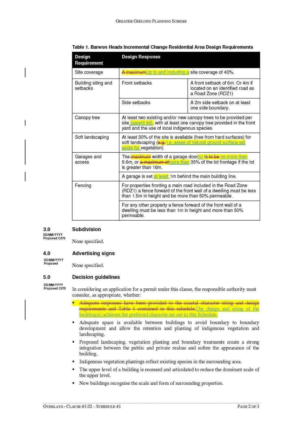
100 100
101 101
102 102
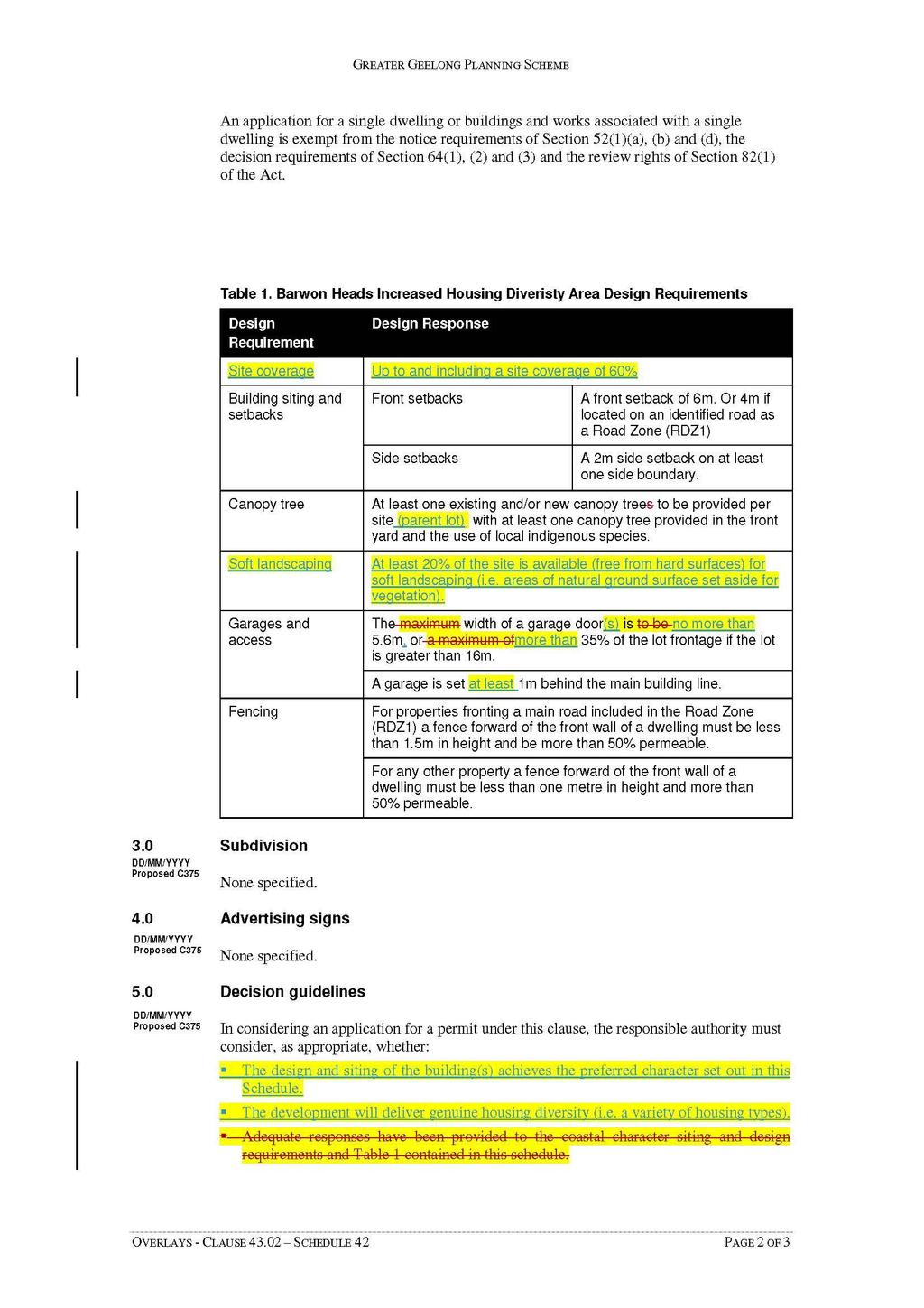
103 103
104 104

105 Appendix 5 - Residential Zone & Overlay Changes in Barwon Heads brochure 105
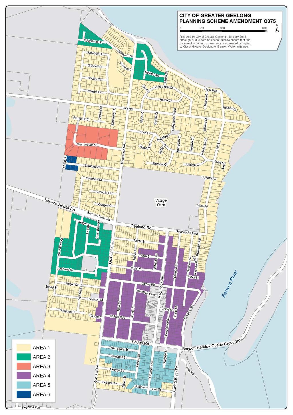
106 106
INCREMENTAL CHANGE AREA REVIEW March 2015 Page 1
 INCREMENTAL CHANGE AREA REVIEW March 2015 Page 1 Table of Contents Introduction... 3 Background to Review... 3 Comparison of the Schedules to the General Residential Zone... 7 Methodology... 7 Policy Context...
BELLARINE PENINSULA Draft Localised Planning Statement JUNE 2014
 BELLARINE PENINSULA Draft Localised Planning Statement JUNE 2014 BELLARINE PENINSULA Draft Localised Planning Statement JUNE 2014 The Bellarine Peninsula Draft Localised Planning Statement has been developed
APPENDIX 1 - OCEAN GROVE SIGNIFICANT TREE PROJECT SIGNIFICANT TREE AREA DEVELOPMENT PATTERNS 1960 S TO 2013
 APPENDIX 1 - OCEAN GROVE SIGNIFICANT TREE PROJECT SIGNIFICANT TREE AREA DEVELOPMENT PATTERNS 1960 S TO 2013 1966 1977 APPENDIX 1 - OCEAN GROVE SIGNIFICANT TREE PROJECT 1984 1990 APPENDIX 1 - OCEAN GROVE
Greater Geelong Planning Scheme Amendment C349 Ocean Grove Significant Tree Project
 Planning and Environment Act 1987 Panel Report Greater Geelong Planning Scheme Amendment C349 Ocean Grove Significant Tree Project 13 December 2017 Planning and Environment Act 1987 Panel Report pursuant
Mollers Lane, Leopold, Victoria Significant Landscape Overlay Re-assessment
 XURBAN Mollers Lane, Leopold, Victoria Significant Landscape Overlay Re-assessment For: TGM Group November 2016 Final Mollers Lane, Leopold, Victoria Significant Landscape Overlay Re-assessment Client
OCEAN GROVE STRUCTURE PLAN
 OCEAN GROVE STRUCTURE PLAN December 2015 1 WWW.GEELONGAUSTRALIA.COM.AU 2 Contents Part A Structure Plan 1 Introduction... 5 1.1 Purpose of the Structure Plan 5 1.2 How will this plan be used? 5 1.3 Plan
DAREBIN PLANNING SCHEME AMENDMENT C137
 Who is the planning authority? Planning and Environment Act 1987 DAREBIN PLANNING SCHEME AMENDMENT C137 EXPLANATORY REPORT This amendment has been prepared by the Darebin City Council, who is the planning
MINUTES ORDINARY MEETING OF COUNCIL TUESDAY 26 JUNE PM COUNCIL CONFERENCE AND RECEPTION CENTRE CITY HALL LITTLE MALOP STREET, GEELONG
 MINUTES ORDINARY MEETING OF COUNCIL TUESDAY 26 JUNE 2018 7.00PM COUNCIL CONFERENCE AND RECEPTION CENTRE CITY HALL LITTLE MALOP STREET, GEELONG COUNCIL: Cr B Harwood (Kardinia Ward) Mayor Cr S Asher (Bellarine
LEOPOLD LAND CAPABILITY AND BAY ACCESS REPORT
 LEOPOLD LAND CAPABILITY AND BAY ACCESS REPORT JULY 2015 Prepared by Spiire for City of Greater Geelong This report has been prepared by the office of Spiire Level 2 10 Moorabool Street PO Box 4032 Geelong
Appendix 1 Structure plan guidelines
 Appendix 1 Structure plan guidelines This appendix forms part of the regional policy statement [rps]. 1.1. Introduction Structure plans are an important method for establishing the pattern of land use
Tāhuhu whakaruruhau ā-taone The sheltering ridge pole
 B2. Tāhuhu whakaruruhau ā-taone - Urban growth and form B2.1. Issues Tāhuhu whakaruruhau ā-taone The sheltering ridge pole Auckland s growing population increases demand for housing, employment, business,
Plan Modification to Chapter B2 of the Auckland Unitary Plan(AUP) Operative in part (15 November 2016)
 Operative in part (15 November 2016)") UNITARY PLAN UPDATE REQUEST MEMORANDUM TO FROM Phill Reid Linley Wilkinson DATE 25 September 2018 SUBJECT Plan Modification to Chapter B2 of the Auckland Unitary Plan(AUP) Operative in part (15 November
UNITARY PLAN UPDATE REQUEST MEMORANDUM TO FROM Phill Reid Linley Wilkinson DATE 25 September 2018 SUBJECT Plan Modification to Chapter B2 of the Auckland Unitary Plan(AUP) Operative in part (15 November
RE: AMENDMENT C375 GEELONG PLANNING SCHEME 1900 BARWON HEADS ROAD, BARWON HEADS
 Reference: #V157080 14 August 2018 Barwon Heads Lifestyle Group Pty Ltd C/- Best Hooper Lawyers Level 9, 451 Little Bourke Street MELBOURNE VIC 3000 Attention: Mr. Edward Mahony (Lawyer) Dear Edward RE:
DRAFT PLANNING SCHEME AMENDMENT GC81
 Outline of changes proposes to the Melbourne and Port Phillip Planning Scheme Fishermans Bend Fishermans Bend is one of several priority precincts identified in Plan Melbourne and plays a central role
Planning Proposal Toronto Road, Booragul. Amendment to Lake Macquarie Local Environmental Plan (LMLEP) 2014
 2014") Planning Proposal Toronto Road, Booragul Amendment to Lake Macquarie Local Environmental Plan (LMLEP) 2014 Local Government Area: Name of Draft LEP: Subject Land: Land Owner: Applicant: Folder Number:
Planning Proposal Toronto Road, Booragul Amendment to Lake Macquarie Local Environmental Plan (LMLEP) 2014 Local Government Area: Name of Draft LEP: Subject Land: Land Owner: Applicant: Folder Number:
Planning Proposal Wangi Power Station Complex Administrative Amendment Lake Macquarie Local Environmental Plan 2014
 Planning Proposal Wangi Power Station Complex Administrative Amendment Lake Macquarie Local Environmental Plan 2014 (Post Exhibition Version) Local Government Area: Name of Draft LEP: Subject Land: Land
Planning Proposal Concurrent DA/LEP Amendment for Belmont North Pharmacy Amendment No. 24 to Lake Macquarie Local Environmental Plan (LMLEP) 2014
 2014") Planning Proposal Concurrent DA/LEP Amendment for Belmont North Pharmacy Amendment No. 24 to Lake Macquarie Local Environmental Plan (LMLEP) 2014 Local Government Area: Name of Draft LEP: Subject Land:
Planning Proposal Concurrent DA/LEP Amendment for Belmont North Pharmacy Amendment No. 24 to Lake Macquarie Local Environmental Plan (LMLEP) 2014 Local Government Area: Name of Draft LEP: Subject Land:
Town Planning Report. Combined Planning Permit and Planning Scheme Amendment Request under Section 96A of the Planning and Environment Act 1987
 Town Planning Report Combined Planning Permit and Planning Scheme Amendment Request under Section 96A of the Planning and Environment Act 1987 1 Henry Street, Belmont Prepared by Tract Consultants for
SECTION 2.4 URBAN DEVELOPMENT AND STRATEGIC URBAN DIRECTIONS
 SECTION 2.4 URBAN DEVELOPMENT AND STRATEGIC URBAN DIRECTIONS 2.4.1 INTRODUCTION In 1993/94 the Hastings District Council completed the Hastings Urban Development Strategy. The purpose of this study was:
Combined Planning Scheme Amendment Request and Planning Permit Application
 Combined Planning Scheme Amendment Request and Planning Permit Application Rezone land from the Farming Zone to the Commercial 1 Zone and develop a SubRegional Activity Centre Bellarine Gateway Plaza,
PART 02 HASTINGS POINT IN CONTEXT
 PART 02 HASTINGS POINT IN CONTEXT 2.1 Background 2.1.1 Demographic Information 2.1.2 Existing Locality Characteristics 2.2 The Planning Framework 2.2.1 The Far North Coast Regional Strategy 2006 2.2.2
A Growing Community Rural Settlement Areas
 Town of Huntsville Official Plan Review - POLICY BACKGROUND PAPER A Growing Community Rural Settlement Areas BACKGROUND: In addition to the fully municipally-serviced Urban Settlement Area and the Hidden
STATEMENT OF OBJECTION TO THE PROPOSED DEVELOPMENT OF LAND AT CHURCH CLIFF DRIVE FILEY
 STATEMENT OF OBJECTION TO THE PROPOSED DEVELOPMENT OF LAND AT CHURCH CLIFF DRIVE FILEY You will be aware that Scarborough borough council have adopted a new local plan that includes land at Church Cliff
Planning Proposal Charlestown Swim and Leisure Centre LEP Amendment
 Planning Proposal Charlestown Swim and Leisure Centre LEP Amendment Amendment No. 4 to Lake Macquarie Local Environmental Plan 2014 (PP_2014_LAKEM_005_00) Local Government Area: Name of Draft LEP: Lake
ELLIOTT HEADS STRUCTURE PLAN
 ELLIOTT HEADS STRUCTURE PLAN BACKGROUND This report has been prepared to provide an overview of the land that has been included in the Urban Footprint within the Wide Bay Burnett Regional Plan, September
PHASE ONE. A summary report: What the community told Alcoa during Phase One of the community engagement program for Point Henry 575.
 PHASE ONE A summary report: What the community told Alcoa during Phase One of the community engagement program for Point Henry 575. DECEMBER 2015 FEBRUARY 2016 INTRODUCTION In 2014 Alcoa closed its Point
CITY OF GREATER GEELONG
 CITY OF GREATER GEELONG AGENDA DEVELOPMENT HEARINGS PANEL MEETING NO 573 TO BE HELD AT BROUGHAM STREET OFFICE (GROUND FLOOR) 100 BROUGHAM STREET, GEELONG ON THURSDAY, 4 OCTOBER 2018 AT 5.00 P.M. 1. Committee
COMMUNITY ACTIONS for a SUSTAINABLE BARWON HEADS. February 2016
 COMMUNITY ACTIONS for a SUSTAINABLE BARWON HEADS February 2016 Acknowledgements Traditional Owners We acknowledge the traditional owners of this land and pay our respects to their elders past and present,
4 RESIDENTIAL ZONE. 4.1 Background
 4 RESIDENTIAL ZONE 4.1 Background The residential areas within the City are characterised by mainly lowrise dwellings sited on individual allotments. Past architectural styles, settlement patterns and
URBAN DEVELOPMENT QLDC PROPOSED DISTRICT PLAN [PART TWO] AUGUST 2015
![URBAN DEVELOPMENT QLDC PROPOSED DISTRICT PLAN [PART TWO] AUGUST 2015](/thumbs/80/81778199.jpg "URBAN DEVELOPMENT QLDC PROPOSED DISTRICT PLAN [PART TWO] AUGUST 2015") 4 URBAN VLOPMNT U R P QLC PROPO ITRICT PLAN [PART TWO] AUGUT 2015 4 ur b an de v elop ment QLC ITRICT PLAN [PART TWO] AUGUT 2015 4 urban development 4 2 4.1 Purpose The purpose of this Chapter is to set
4 URBAN VLOPMNT U R P QLC PROPO ITRICT PLAN [PART TWO] AUGUT 2015 4 ur b an de v elop ment QLC ITRICT PLAN [PART TWO] AUGUT 2015 4 urban development 4 2 4.1 Purpose The purpose of this Chapter is to set
Planning Proposal under section 55 of the EP&A Act
 FOR PUBLIC EXHIBITION [Brief description] Monday 10 October to Monday 27 October 2014 Planning Proposal under section 55 of the EP&A Act Port Macquarie-Hastings LEP 2011 (Amendment No 32) Mixed land zone
LEOPOLD STRUCTURE PLAN. Prepared by the City of Greater Geelong September 2011 (Amended Jan 2013)
") LEOPOLD STRUCTURE PLAN Prepared by the City of Greater Geelong September 2011 (Amended Jan 2013) Table of Contents PART A STRUCTURE PLAN 1.0 Introduction... 3 1.2 How will this plan be used?... 3 1.3 Plan
LEOPOLD STRUCTURE PLAN Prepared by the City of Greater Geelong September 2011 (Amended Jan 2013) Table of Contents PART A STRUCTURE PLAN 1.0 Introduction... 3 1.2 How will this plan be used?... 3 1.3 Plan
Guidelines for Planning Authorities and Part V of the Planning and Development Act 2000: December 2000
 Slide 1 Slide 2 Slide 3 Slide 4 As a planner in practice, whether within the Local Authority, private practice or An Bord Pleanala, due regard must be given to the guidance provided by the Department in
Vision Statement for Point Lonsdale
 TOWNSHIP BROCHURE This Township Brochure applies to all of Point Lonsdale (CoGG). Please see overleaf for precinct map and refer to the individual Precinct Brochure for your area. Vision Statement for
Draft Eastern District Plan
 Draft Eastern District Plan Submission_id: 31238 Date of Lodgment: 13 Dec 2017 Origin of Submission: Online Organisation name: Turrulla Gardens Pty Ltd C/- Mecone Organisation type: Industry First name:
Casey Planning Scheme Amendment C207 Part 2 Evan and Margaret Street Precinct, Berwick
 Planning and Environment Act 1987 Panel Report Casey Planning Scheme Amendment C207 Part 2 Evan and Margaret Street Precinct, Berwick 14 January 2019 Planning and Environment Act 1987 Panel Report pursuant
Legal implications of failing to
 Legal implications of failing to plan for sea level rise Gavin Leydon, Partner 30 April 2010 Outline Relevance to local l government & developers assessment & policy Developments in case law Climate change
Lake Macquarie City. A copy of the published amendment including the instrument and maps, is provided in Attachment 7 of this report.
 Planning Proposal Amendment No. 77 to Lake Macquarie Local Environmental Plan 2004 and proposed Amendment to Draft Lake Macquarie Local Environmental Plan 2013 Minor Zone Boundary Adjustment - Pasminco
Greater Geelong Planning Scheme Proposed Planning Scheme Amendment C and 5-19 Princes Highway, Norlane
 Greater Geelong Planning Scheme Proposed Planning Scheme Amendment C253 PLANNING SUBMISSION prepared for Bunnings Group Ltd by SJB Planning Pty Ltd Level 1, Building D 80 Dorcas Street SOUTHBANK VIC 3006
9 CITY OF VAUGHAN OFFICIAL PLAN AMENDMENT NO BOCA EAST INVESTMENTS LIMITED
 9 CITY OF VAUGHAN OFFICIAL PLAN AMENDMENT NO. 631 - BOCA EAST INVESTMENTS LIMITED The Planning and Economic Development Committee recommends the adoption of the recommendations contained in the following
Edward R. Sajecki Commissioner of Planning and Building
 Corporate Report Clerk s Files Originator s Files CD.03.POR DATE: TO: FROM: SUBJECT: Chair and Members of Planning and Development Committee Meeting Date: February 27, 2012 Edward R. Sajecki Commissioner
ROCHFORD LOCAL DEVELOPMENT FRAMEWORK: Sustainability Appraisal/ Strategic Environmental Assessment. Rochford Core Strategy Preferred Options Document
 ROCHFORD LOCAL DEVELOPMENT FRAMEWORK: Sustainability Appraisal/ Strategic Environmental Assessment Non Technical Summary Rochford Core Strategy Preferred Options Document October 2008 SUSTAINABILITY APPRAISAL
2A District-wide Policies
 2A Introduction This Chapter contains policies which are relevant to subdivision, use and development activities occurring across all zones and areas of the District. The policies in this Chapter implement
Urban Growth Boundaries
 Urban Growth Boundaries Discussion Document July 2008 Contents page Introduction... 3 What are urban growth boundaries?... 3 The need to manage growth... 3 Purpose of urban growth boundaries... 4 How will
CITY CLERK. Parkland Acquisition Strategic Directions Report (All Wards)
") CITY CLERK Clause embodied in Report No. 10 of the, as adopted by the Council of the City of Toronto at its meeting held on November 6, 7 and 8, 2001. 10 Parkland Acquisition Strategic Directions Report
CITY CLERK Clause embodied in Report No. 10 of the, as adopted by the Council of the City of Toronto at its meeting held on November 6, 7 and 8, 2001. 10 Parkland Acquisition Strategic Directions Report
Official Plan Review
 Official Plan Review Summary Report - The Built Environment August 2014 Part 1: Introduction Planning for a healthy, prosperous and sustainable community is an important goal for our municipality. From
RURAL ZONE - POLICY. Rural Zone Policy. Issue: Rural Environment. Ruapehu District Plan Page 1 of 8
 Rural Zone Policy RU2 RURAL ZONE - POLICY RU2.1 Introduction The natural resources of the rural environment in the Ruapehu District provide the basis for the existing and potential character, intensity
Northern Territory Compact Urban Growth Policy
 Northern Territory Compact Urban Growth Policy A Reference Policy Document to clause 2.7 (Reference to Policy) of the NT Planning Scheme May 2015 Table of Contents 1 Policy Setting... 3 1.1 Context for
PMP PRINTING SITE COMMUNITY ENGAGEMENT - PHASE 2
 PMP PRINTING SITE COMMUNITY ENGAGEMENT - PHASE 2 FEBRUARY 2019 0317-0511 - PMP Printng - M001 (8 -Floors) -Final date 14.11.2018 Vision: The PMP Printing site will be transformed into a contemporary mixed-use
TIDAPA Structure Plan
 TIDAPA Structure Plan Prepared by Tract Consultants 28 MARCH 2017 0217-0074 Table of Contents 01 STRATEGIC CONTEXT Executive Summary Regional Context Page 3 Page 4 02 LOCAL CONTEXT Aerial Photograph Local
Ipswich Issues and Options for the Ipswich Local Plan Review, August 2017, Public Consultation
 Ipswich Issues and Options for the Ipswich Local Plan Review, August 2017, Public Consultation Having reviewed the issues and options documents, the Society has made the following response: Part 1 Strategic
EAST VILLAGE STRATEGIC SITE NOVEMBER 2017
 EAST VILLAGE STRATEGIC SITE NOVEMBER 2017 East Village will be a sustainable, mixeduse precinct with a focus on innovative employment and education opportunities. Enhanced by green spaces and places for
OKEFORD FITZPAINE NEIGHBOURHOOD PLAN
 OKEFORD FITZPAINE NEIGHBOURHOOD PLAN Dear Parishioner, The Neighbourhood Plan Project Team have prepared this leaflet to summarise the full Neighbourhood Plan document. It provides a summary of the Vision,
LONGDEN VILLAGE DEVELOPMENT STATEMENT
 LONGDEN VILLAGE DEVELOPMENT STATEMENT 2017-2027 1 Longden Development Statement 2017-2027 15/01/18 1. Background 1.1 Longden Village Longden village is a very rural and traditional community first mentioned
Appendix A. Planning Processes. Introduction
 1 Planning Processes Introduction This appendix outlines a number of planning processes which are used in the Auckland Region to support the effective management of development in the region s rural and
Western Sydney Parklands Australia s Largest Urban Park
 Western Sydney Parklands Australia s Largest Urban Park 37 WLA 1 MAGAZINE 21 38 WESTERN SYDNEY PARKLANDS AUSTRALIA S LARGEST URBAN PARK Large urban parks have dual roles to play in meeting the demands
Draft Western District Plan
 Powered by TCPDF (www.tcpdf.org) Draft Western District Plan Submission_id: 31440 Date of Lodgment: 15 Dec 2017 Origin of Submission: Online Organisation name: Goodman Property Services Australia Pty Ltd
STRATEGIC DIRECTION. QLDC PROPOSED DISTRICT PLAN [PART TWO] DECISIONS VERSION 3 strategic direction
![STRATEGIC DIRECTION. QLDC PROPOSED DISTRICT PLAN [PART TWO] DECISIONS VERSION 3 strategic direction](/thumbs/79/79711764.jpg "STRATEGIC DIRECTION. QLDC PROPOSED DISTRICT PLAN [PART TWO] DECISIONS VERSION 3 strategic direction") 3 STRATEGIC DIRECTION QLDC PROPOSED DISTRICT PLAN [PART TWO] DECISIONS VERSION 3 strategic direction QLDC DISTRICT PLAN [PART TWO] AUGUST 2015 3 strategic direction 3.1 Purpose This chapter sets out the
3 STRATEGIC DIRECTION QLDC PROPOSED DISTRICT PLAN [PART TWO] DECISIONS VERSION 3 strategic direction QLDC DISTRICT PLAN [PART TWO] AUGUST 2015 3 strategic direction 3.1 Purpose This chapter sets out the
ONTARIO MUNICIPAL BOARD
 PL 120483 ONTARIO MUNICIPAL BOARD Applicant/Appellant: 2124123 Ontario Limited Subject: OPA, Rezoning and Draft Plan of Subdivision Municipal Address: 3940 Highway 7 East Municipality: City of Markham
Queensland Coastal Plan. Presented by John Lane Director Environment Planning
 Queensland Coastal Plan Presented by John Lane Director Environment Planning Queensland Coastal Plan - Status Released 7 April 2011, but NOT YET IN EFFECT Formatting & operational amendments required Yet
Applying the Heritage Overlay
 Practice Note 01 Revised September 2012 Applying the Heritage Overlay This practice note provides guidance about the use of the Heritage Overlay. What places should be included in the Heritage Overlay?
Schedule of Planning Applications Committee Date: 23 May Reference: 06/17/0726/F Parish: Hemsby Officer: Mr J Beck Expiry Date:
 Schedule of Planning Applications Committee Date: 23 May 2018 Reference: 06/17/0726/F Parish: Hemsby Officer: Mr J Beck Expiry Date: 22-05-2018 Applicant: Proposal: Site: Mr Gillett Change of use to the
Suffolk Coastal Local Plan Review Issues and Options, August 2017, Public Consultation
 Suffolk Coastal Local Plan Review Issues and Options, August 2017, Public Consultation Having reviewed the issues and options documents, the Society has made the following response: Part 1 - Strategic
Western City District What we heard
 What we heard Vision to 2056 and Priorities Governance and implementation Infrastructure and funding The protection of the natural landscape including biodiversity and the Metropolitan Rural Area for food
PLANNING AND ENVIRONMENT LIST. FORM B STATEMENT OF GROUNDS To be completed by Referral Authorities and objectors
 PLANNING AND ENVIRONMENT LIST FORM B STATEMENT OF GROUNDS To be completed by Referral Authorities and objectors To: The Principal Registrar Victorian Civil and Administrative Tribunal 55 King Street MELBOURNE
3. STATEMENTS OF DESIRED CHARACTER FOR PLANNING AREAS AND PRECINCTS
 3.30 Planning Area No. 30 Mary River Valley 3.30.1 Location and Role This Planning Area encompasses rural lands in the western part of the Shire. These lands are located within the catchment area of the
Construction of upgraded stormwater outfall at the Ozone Road Jetty
 Construction of upgraded stormwater outfall at the Ozone Road Jetty Background The City of Greater Geelong (CoGG) is responsible for stormwater management within Barwon Heads. There is an existing 750
Welcome to the Oakridge Centre Open House
 Welcome to the Oakridge Centre Open House Why is the City hosting this event? This open house is to inform you of a rezoning application submitted to the City of Vancouver to amend the existing CD-1 (Comprehensive
Settlement Boundaries Methodology North Northumberland Coast Neighbourhood Plan (August 2016)
") Introduction This background paper sets out a methodology for the definition of settlement boundaries in the North Northumberland Coast Neighbourhood Plan. The neighbourhood plan is planning positively
Introduction This background paper sets out a methodology for the definition of settlement boundaries in the North Northumberland Coast Neighbourhood Plan. The neighbourhood plan is planning positively
Proposed Plan Change 55: District Wide Rules. Hearing Report
 Proposed Plan Change 55: District Wide Rules Hearing Report Appendix 5 BEFORE THE HEARINGS PANEL In the Matter of: The Resource Management Act 1991 And Proposed Plan Change 55: Chapter 3 District Wide
Coastal hazard assessments in Victoria
 Coastal hazard assessments in Victoria Viktor Brenners viktor.brenners@delwp.vic.gov.au Future Coasts program 4 year program established in 2007. Outputs included: Coastal Digital Elevation Models Victorian
Oxford Green Belt Study. Summary of Final Report Prepared by LUC October 2015
 Oxford Green Belt Study Summary of Final Report Prepared by LUC October 2015 Project Title: Oxford Green Belt Study Client: Oxfordshire County Council Version Date Version Details Prepared by Checked by
The Proposed Auckland Unitary Plan (notified 30 September 2013)
") 3 Business zones Introduction There are 10 business zones in the Unitary Plan: City Centre Metropolitan Centre Town Centre Local Centre Neighbourhood Centre Mixed Use General Business Business Park Light
3 Business zones Introduction There are 10 business zones in the Unitary Plan: City Centre Metropolitan Centre Town Centre Local Centre Neighbourhood Centre Mixed Use General Business Business Park Light
Town of Cobourg Heritage Master Plan. Statutory Public Meeting
 Town of Cobourg Heritage Master Plan Statutory Public Meeting April 25 th 2016 Presentation Overview 1. Introduction 2. Project background and schedule overview 3. Review of strategic direction content
DRAFT GREATER SYDNEY REGION PLAN OBJECTIVES, STRATEGIES AND ACTIONS
 Greater Sydney Commission DRAFT GREATER SYDNEY REGION PLAN OBJECTIVES, STRATEGIES AND ACTIONS Issued: 26 OCTOBER 2017 Version: 1 Subject: Greater Sydney Region and District Plans This information note
SHORELINE, FLOOD AND COASTAL DEFENCE MANAGEMENT PLANS
 These plans may provide opportunities as well as concern for recreational boating. They are currently being revised and consulted on. This document explains how we can engage in the process. Shoreline,
DRAFT FOR YOUR FEEDBACK DRAFT LOGAN RESERVE PLAN
 DRAFT FOR YOUR FEEDBACK CONTENTS INTRODUCTION... BACKGROUND... State Government... Council... PLANNING LEGISLATION AND RULES... CONSULTATION PROCESS...... ENVIRONMENT AND CONSERVATION... HOUSING... Proposed
MAYFIELD WEST SECONDARY PLAN PHASE 2
 MAYFIELD WEST SECONDARY PLAN PHASE 2 Public Open House #3 February 25, 2010 Draft Preferred Land Use Scenario TOWN OF CALEDON PLANNING & DEVELOPMENT DEPARTMENT Open House Agenda TOWN OF CALEDON 1. Welcome
9 Pershore. Introduction. Pershore Abbey
 118 Introduction 9.1 The historic town of Pershore lies on the River Avon and has a population of 7,000 (2009 Mid-Term Population Estimates). The main areas of the town are centred on the Abbey, the bustling
WELCOME GYPSY LANE. Wider Site Location plan. Proposals for the development of LAND OFF FOXLYDIATE LANE WEBHEATH. Proposals for the development of
 WELCOME The developers are preparing an outline planning application for a residential led development and need the community s views in order to develop the proposals further WHAT IS PROPOSED? A high
GREEN BELTS, GREEN WEDGES OR DISPUTED GROUND
 GREEN BELTS, GREEN WEDGES OR DISPUTED GROUND John Ginivan Department of Planning and Community Development State Government of Victoria Melbourne Australia Greenbelts: Local Solutions for Global Challenges
CASEY PLANNING SCHEME AMENDMENT C188
 Who is the planning authority? Planning and Environment Act 1987 CASEY PLANNING SCHEME AMENDMENT C188 EXPLANATORY REPORT This amendment has been prepared by the Growth Areas Authority (now known as the
1.0 Purpose of a Secondary Plan for the Masonville Transit Village
 Report to Planning and Environment Committee To: Chair and Members Planning & Environment Committee From: John M. Fleming Managing Director, Planning and City Planner Subject: Masonville Transit Village
Integrated Urban Structuring in Australia An Overview of Principles and Practice
 ACNU08 Brisbane Integrated Urban Structuring in Australia An Overview of Principles and Practice Wendy Morris Ecologically Sustainable Design Pty Ltd Melbourne, Australia esdesign@netspace.net.au Ecologically
South of Eastern Strategic Direction Status Update
 STAFF REPORT ACTION REQUIRED South of Eastern Strategic Direction Status Update Date: July 10, 2014 To: From: Planning and Growth Management Committee Chief Planner and Executive Director, City Planning
TOWN OF BRUDERHEIM Report to the capital region board
 TOWN OF BRUDERHEIM Report to the capital region board Introduction to the Town of Bruderheim Municipal Development Plan amendment and Relation to the CRB Evaluation Criteria 02 march 2017 1 Introduction
5 TOWN OF MARKHAM OFFICIAL PLAN AMENDMENT NO. 144 MILLIKEN MAIN STREET SECONDARY PLAN
 5 TOWN OF MARKHAM OFFICIAL PLAN AMENDMENT NO. 144 MILLIKEN MAIN STREET SECONDARY PLAN The Planning and Economic Development Committee recommends the following: 1. The communication from Brendan O Callaghan,
Long Branch Neighbourhood Character Guidelines Final Report
 STAFF REPORT ACTION REQUIRED Long Branch Neighbourhood Character Guidelines Final Report Date: October 26, 2017 To: From: Wards: Reference Number: Etobicoke York Community Council Director, Community Planning,
2.0 Strategic Context 4
 2.0 Strategic Context 4 2.1 The Area Action Plan is a non-statutory plan, which forms a corporate policy document, expressing particular issues and areas of concern while also providing a vision for the
Parish of Repton NEIGHBOURHOOD DEVELOPMENT PLAN
 Parish of Repton NEIGHBOURHOOD DEVELOPMENT PLAN BASIC CONDITIONS STATEMENT December 2018 CEF 4 Legal Requirements This statement has been produced by the NDP Working Group on behalf of Repton Parish Council
PART 5 - NATURAL AND PHYSICAL ENVIRONMENT
 CONTENTS...PAGE 5.1 INTRODUCTION...3 5.2 NATURAL RESOURCES...4 5.3 PHYSICAL RESOURCES...4 5.4 COASTAL ENVIRONMENT...4 5.5 HERITAGE FEATURES...4 5.6 HAZARDS...4 5.7 SUMMARY...4 ISTHMUS SECTION - OPERATIVE
LAND USE AMENDMENT CORNERSTONE (WARD 3) 60 STREET NE AND COUNTRY HILLS BOULEVARD NE MAP 26NE BYLAW 22D2017
 60 STREET NE AND COUNTRY HILLS BOULEVARD NE MAP 26NE BYLAW 22D2017") Page 1 of 14 EXECUTIVE SUMMARY This Land Use Amendment application covers an area of 43.76 hectares ± (108.14 acres ±) located in northeast Calgary, bound by Country Hills Boulevard NE to the south and
Page 1 of 14 EXECUTIVE SUMMARY This Land Use Amendment application covers an area of 43.76 hectares ± (108.14 acres ±) located in northeast Calgary, bound by Country Hills Boulevard NE to the south and
13 THORNHILL YONGE STREET STUDY IMPLEMENTATION CITY OF VAUGHAN OPA 669 AND TOWN OF MARKHAM OPA 154
 13 THORNHILL YONGE STREET STUDY IMPLEMENTATION CITY OF VAUGHAN OPA 669 AND TOWN OF MARKHAM OPA 154 The Planning and Economic Development Committee recommends the adoption of the recommendations contained
CITY OF GREATER GEELONG DEVELOPMENT HEARINGS PANEL MINUTES OF THE MEETING HELD AT BROUGHAM STREET OFFICE, 100 BROUGHAM STREET, GEELONG
 CITY OF GREATER GEELONG DEVELOPMENT HEARINGS PANEL MINUTES OF THE MEETING HELD AT BROUGHAM STREET OFFICE, 100 BROUGHAM STREET, GEELONG ON THURSDAY 3 MAY 2018 Meeting opened at 5:00pm. 1. COMMITTEE MEMBERS
Variation No 1: Dundalk & Environs Development Plan Core Strategy
 Variation No 1: Dundalk & Environs Development Plan 2009-2015 Core Strategy Adopted on 29 th August 2011 CONTENTS Page Section 1 1.0 Synopsis 1 1.1 Background Document 1 1.2 Variation of Dundalk and Environs
I615. Westgate Precinct
 I615. Westgate Precinct I615.1. Precinct Description The Westgate Precinct is located approximately 18km west of the Auckland city centre. There are seven Sub-precincts in the Westgate Precinct: Sub-precinct
Planning Proposal. Rockdale Local Environmental Plan Two storey residential development in the R2 and R3 zones
 Planning Proposal Rockdale Local Environmental Plan 2011 Two storey residential development in the R2 and R3 zones 16 October 2014 Contents Part 1 Part 2 Part 3 Part 4 Part 5 A statement of the Objectives
THAT the attached Terms of Reference for the Thornhill Centre Street Study be approved.
 COMMITTEE OF THE WHOLE AUGUST 18, 2003 THORNHILL CENTRE STREET STUDY PLANNING FILE: 15.92 Recommendation The Commissioner of Planning recommends: THAT the attached Terms of Reference for the Thornhill
POLICY SRT/D4 STORMWATER MANAGEMENT
 POLICY SRT/D4 STORMWATER MANAGEMENT BACKGROUND Increasing population, decreasing rainfall and increasing community expectations regarding environmental issues have led to increasing recognition of the
CITY VIEW OBJECTIVES
 SECTION 2: CITY VIEW OBJECTIVES CONTENTS 2.1 Introduction 1 2.2 Strategic Direction 1 2.3 The City View Resource Management Issues for the City 1 2.4 The Goal 3 2.5 The City View Objectives 3 Palmerston