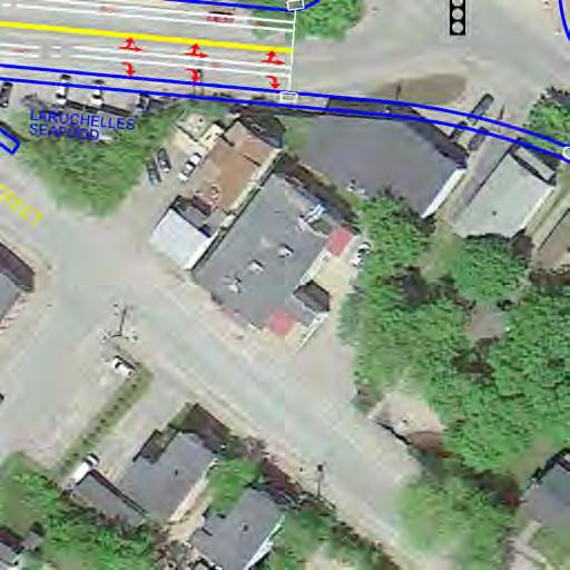
New Auburn Village Center Study Auburn, Maine
|
|
|
- Georgina Johnson
- 6 years ago
- Views:
Transcription
1 Auburn, Maine Option Review Summary Prepared for: Androscoggin Transportation Resource Center and City of Auburn Prepared by: T.Y. Lin International MRLD October 10, 2013
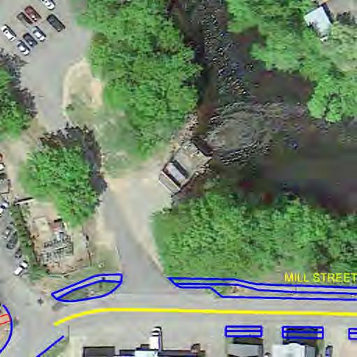
2 1. Introduction This memo summarizes the development and urban design implications of two of the nine options for New Auburn Village Center that were presented to the Steering Committee on August 15, 2013 and at a public meeting on September 3, It is the goal of the Study to develop one plan that provides the community with a practical path to revitalizing New Auburn Village as a vibrant neighborhood. The focus area for the two options is the land north of Mill Street running from the Riverside intersection to the South Main intersection. For the purposes of this analysis, buildings on the south side of Mill Street are included because the scale, placement and use of these structures will help define and integrate Mill Street into the urban fabric. The focus area is approximately 15 acres of which approximately nine acres are in the 100- year AE floodplain (the extent of the floodplain is noted on options). The floodplain is based on 2012 FEMA mapping. In general, the implications for developing in a floodplain include carrying proper insurance, utilizing flood proof construction methods and placing the first floor elevation or elevation of the basement one foot above the floodplain elevation. In the focus area the 100- year floodplain base flood elevation is 136. Existing Buildings: Total Number 30 (132,924 total SF) Information from assessing records Buildings by Number of Floors: 16 One Floor Buildings 8 Two Floor Buildings (six of eight two floor buildings have residential uses on second floor and commercial use on first floor) 6 Three Floor Buildings (all three floor buildings are residential only) Option Review Summary Page 2
3 Existing Parking: Public On- Street: Public Off- Street: Private Off- Street: Total Parking: 63 +/- 14 +/ / /- Focus Area General Uses / Required Parking: 67 Residential Units (including one single- family home) / 84 Spaces +/- Restaurants / 59 Spaces +/- Two Social / Recreation Uses / 196 Spaces +/- Mix of Commercial Uses / 147 Spaces +/- Required Parking by Ordinance: Parking Deficit: 482 Spaces +/- 149 Spaces +/- Although the above calculations note a parking deficit, it is not recommended to design the future of the area only to close this gap or to even achieve closing this gap. These calculations are based on the current zoning standards for different uses and do not reflect current trends in parking planning such as park once and walk, shared parking, future investments in public parking or less strict ratios. Recent studies have noted that historic downtowns like New Auburn Village Center have a parking ratio of 2.2 spaces to 1,000 SF of non- residential use. Using this ratio is in keeping with current research and reduces the required parking for a typical project. For example, a 1,800 SF retail use currently requires six spaces and the 2.2 ratio requires four spaces. At an average cost of $5, per surface parking space, this is a distinct cost savings and reduces impervious surface. A number of communities with mixed- use urban centers are now employing a shared parking policy as part of revitalization strategies. Studies have demonstrated that standard parking requirements can be reduced by 40-60% in a mixed- use environment, taking advantage of varying peak demand periods. Parking is also perception. Certain uses in New Auburn Village Center may push their available parking, but the area is not currently easy for vehicles and pedestrians to navigate. With improved access, safer connections to nearby streets, rerouting pass thru traffic as well as Option Review Summary Page 3
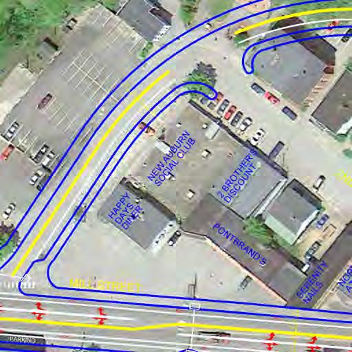
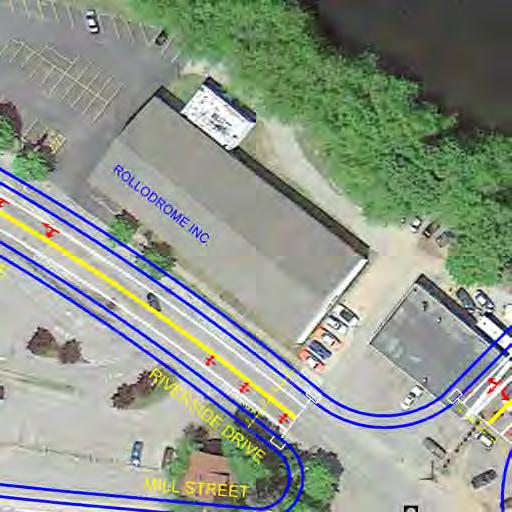
4 creating additional on- street parking, total parking counts may not have to increase in order to solve the parking / economic development puzzle. 2. Options Analysis Introduction: It is the intent of these options to create redevelopment opportunities by simultaneously addressing the street system, open space, patterns of development, parking and land use. These are concepts and it is important to note that certain properties and businesses are impacted by the layouts, but in doing so opportunities arise that benefit the entire area. As part of a planning effort, there must be a balance between property rights, the viability of existing business and residential uses and a vision for revitalizing New Auburn Village Center. Ultimately, the community will shape a vision of a future build- out for the area, weighing the benefits of different recommendations. The build-outs depicted in these options are not the only scenarios for the placement of potential buildings, the select preservation of existing buildings or the distribution of height of buildings and parking. Further refinement is required to development an ideal scheme in order to maximize the redevelopment potential of the study area. The market drives development. However, if the community makes informed decisions about the scale and character of development, the intensity of desired uses and transportation capacity and mobility options, a number of issues will be vetted in advance, creating a predictable and inviting environment that will encourage and streamline investment calibrated for New Auburn Village. Furthermore, if the community takes the lead on public infrastructure planning such as parks and street networks, a framework for redevelopment will be established just as the original grid for New Auburn created a framework for development. In addition to reviewing the general implications of the two schemes, a number of street cross- section studies have been prepared illustrating the interrelationship between the traffic infrastructure and the adjacent built environment. This memo does not review the implications regarding the level of service issues relating to transportation infrastructure. This information will be presented separately. The build- out and concept uses are based on input from the community, which has called for small businesses located in a safe and pedestrian- friendly environment. To maximize diversity and accommodate niche markets, two to three floor buildings with footprints ranging between 1,800 SF and 3,600 SF are utilized. To provide a comparison, the Rollodrome is 13,140 SF. The Fire House Grille has an approximate 1,229 SF footprint. A typical CVS or Rite Aid is 12,000 SF. Option Review Summary Page 4


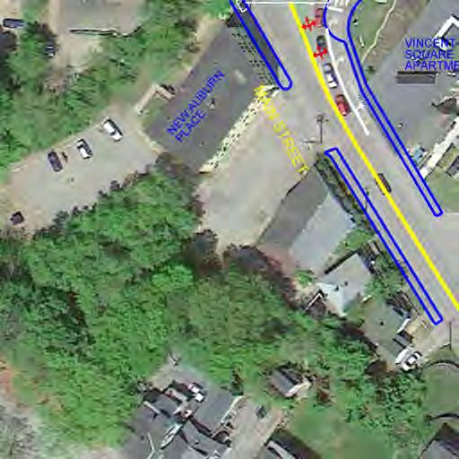
5 NEW AUBURN VILLAGE CENTER STUDY OPTION 1 CONCEPT 10 OCTOBER 2013 TY LIN INTERNATIONAL MRLD LANDSCAPE ARCHITECTURE + URBANISM KEY: 100-YEAR FLOODPLAIN: TWO FLOOR BUILDING THREE FLOOR BUILDING OVERLOOK EXISTING BUILDING 80 ING SPACES +/- 0' 25' 50' 100' 80 ING SPACES +/- 25 ING SPACES +/- 10 ING SPACES +/-
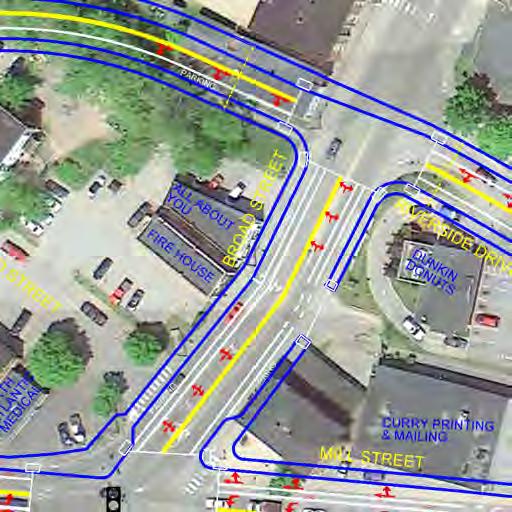
6 Option 1: The two major aspects of Option 1 include aligning a new bridge at the Riverside / Mill Street intersection and creating a new Riverway street alignment from the intersection of Riverside and Broad to where Second Street currently intersects with Mill Street. In this scheme, the major traffic volumes are carried on Mill Street and the parcels and streets north of Mill Street become part of a riverfront redevelopment area that is accessible to both vehicles and pedestrians. The riverfront is celebrated as a community asset. Between the new Riverway alignment and Broad and Mill is the potential for a two- acre +/- redevelopment area. This area is bisected by Second Street and includes a number of residences and businesses, thus any redevelopment plan would have to be flexible to accommodate uses or a master development scheme is required enabling the most efficient and equitable parceling of this land. This block allows for existing and new liner buildings along Broad, Mill and the Riverway with a central parking lot in the middle. A second redevelopment block is created between Riverside, Broad and Mill Streets. Again, there are existing businesses and residences in this area and any redeveloping planning efforts would have to be sensitive to these uses. However, In general, Option 1 creates large efficient development blocks in an organic continuation / reinterpretation of the historic grid. Buildings: Total Number: 34 New: 23 (including redeveloped buildings) Existing: 11 Buildings by Number of Floors: 3 One Floor Buildings (All existing) 21 Two Floor Buildings (Four are existing) 10 Three Floor Buildings (Four of the three floor buildings are existing and all residential in use) Option Review Summary Page 5
7 General Uses / Required Parking: New Commercial: 52,065 SF (all first floor) / 174 Spaces (or 114 spaces using a 2.2 to 1,000 SF ratio) Existing Commercial: 11,943 / 40 Spaces (or 26 spaces using a 2.2 to 1,000 SF ratio) New Residential: 82 / 123 Spaces Existing Residential: 49 / 57 Spaces Existing Restaurants (three): 59 Spaces New Restaurants: (assume three) 60 Spaces New Social: 6,000 SF / 60 Spaces Subtotal Required Parking: 573 Spaces 1/3 Shared Parking Efficiency: 189 Spaces Total Required Parking: 384 Spaces These calculations demonstrate that the study area can probably absorb more growth and in turn create streets with better-defined building walls. Further refinement of the plan can identify the ideal placement of buildings ranging in height and footprint. Parking: New Public On- Street: 167 +/- (this number can be increased 22 spaces if parking is placed on the northern side of the Riverway) Existing Public On- Street: 19 +/- Existing Public Off- Street: 14 +/- New Private Off- Street: 195 +/- Existing Private Off- Street: 104 +/- Total Parking: 499 Spaces +/- Option Review Summary Page 6
8 Streets In Option 1, streets are redesigned or are utilized: Mill Street, the Riverway and Riverside. Riverside becomes a local street, while Mill is designed to work with higher traffic volumes and turning movements. These streets vary in width, number of travel lanes, turnings lanes, on- street parking, bike lanes and relationship to the river. The cross- sections depict different building heights adjacent to the street, framing this space as a vital public realm. As a rule of thumb, to create a street that feels defined and inviting, an ideal is one foot of building height for every three feet of street width. Buildings that are too tall can create a canyon feeling and buildings that are too short do not help define the edges of the outdoor room, creating a more suburban than village or downtown setting. In the analysis of these different streets, it appears that two to three story buildings are the appropriate height for New Auburn Village Center. There are currently no buildings in the area besides Barker Arms that include more than three floors. Option Review Summary Page 7


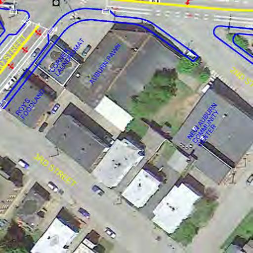
9 NEW AUBURN VILLAGE CENTER STUDY OPTION 2 CONCEPT 10 OCTOBER 2013 TY LIN INTERNATIONAL MRLD LANDSCAPE ARCHITECTURE + URBANISM KEY: 100-YEAR FLOODPLAIN: TWO FLOOR BUILDING THREE FLOOR BUILDING OVERLOOK EXISTING BUILDING 0' 25' 50' 100' 70 ING SPACES +/- 45 ING SPACES +/- 12 ING SPACES +/-
10 Option 2: In Option 2, the bridge remains in place or slightly downstream because eventually a new bridge will have to be built and it cannot be in the location of the existing bridge due to construction logistics. An intersection is created at Broad and Riverside, but instead of creating a curving Riverway, this street works more closely with the built environment and the existing alignment of Second Street. Local access is provided to the riverfront redevelopment area, however, major traffic volumes continue to make the movement from Broad to Mill to Main. The area north of Mill Street is not transformed as clearly as a new riverfront redevelopment in terms of creating larger redevelopment blocks or diverting traffic volumes along Mill Street, however fewer changes are required to the built environment. A new development block of approximately 70,000 SF is created between the realigned Second Street, Mill and Broad. Coming to New Auburn Village from the south, the Mill Street Riverside intersection is realigned to about mid block. This creates a new defined gateway intersection and consolidates land to the either side of this intersection for redevelopment opportunities. There is an opportunity to create more riverfront parkland along the back of the new Riverside Drive alignment. This can happen in both Options 1 and 2, depending on the amount of building and parking placed in this area. Buildings: Total Number: 30 New: 18 (including redeveloped buildings) Existing: 12 Buildings by Number of Floors: 3 One Floor Buildings (All existing) 19 Two Floor Buildings (Four are existing) 8 Three Floor Buildings (Five of the three floor buildings are existing and all residential in use) Option Review Summary Page 8
11 General Uses / Required Parking: New Commercial: 39,225 SF (all first floor) / 131 Spaces (or 86 spaces using a 2.2 to 1,000 SF ratio) Existing Commercial: 11,943 / 40 Spaces (or 26 spaces using a 2.2 to 1,000 SF ratio) New Residential: 54 / 81 Spaces Existing Residential: 55 / 66 Spaces Existing Restaurants (three): 59 Spaces New Restaurants: (assume three) 60 Spaces New Social: 6,000 SF / 60 Spaces Subtotal Required Parking: 497 Spaces 1/3 Shared Parking Efficiency: 164 Spaces Total Required Parking: 333 Spaces These calculations demonstrate that the study area can probably absorb more growth and in turn create streets with better-defined building walls. Further refinement of the plan can identify the ideal placement of buildings ranging in height and footprint. Parking: New Public On- Street: 114 +/- Existing Public On- Street: 11 +/- Existing Public Off- Street: 14 +/- New Private Off- Street: 127 +/- Existing Private Off- Street: 114 +/- Total Parking: 380 Spaces +/- Option Review Summary Page 9
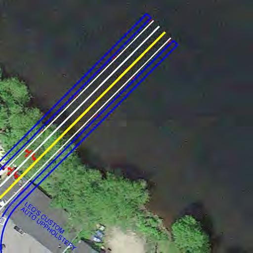
12 Raised Crosswalk 100-YEAR FLOOD PLAIN 3 STORY BUILDING ON STREET ING PROMENADE Riverfront Park RIVER Riverway 1 =16 FEET MRLD Landscape Architecture + Urbanism New Auburn Village Center Study Street Section Studies 30 September 2013
13 2 STORY BUILDING ON STREET ING ON STREET ING 2 STORY BUILDING Local Street with Two Story Buildings 1 =16 FEET MRLD Landscape Architecture + Urbanism New Auburn Village Center Study Street Section Studies 30 September 2013
14 3 STORY BUILDING ON STREET ING ON STREET ING 4 STORY BUILDING Local Street with Three and Four Story Buildings 1 =16 FEET MRLD Landscape Architecture + Urbanism New Auburn Village Center Study Street Section Studies 30 September 2013
15 4 STORY BUILDING ON STREET ING BIKE LANE TURNING LANE BIKE LANE ON STREET ING 3 STORY BUILDING Mill Street (on street parking) 1 =16 FEET MRLD Landscape Architecture + Urbanism New Auburn Village Center Study Street Section Studies 30 September 2013

16 4 STORY BUILDING BIKE LANE TURNING LANE BIKE LANE 3 STORY BUILDING Mill Street (four travel lanes) 1 =16 FEET MRLD Landscape Architecture + Urbanism New Auburn Village Center Study Street Section Studies 30 September 2013
City of Farmington. Downtown Plan. Amendment to the 1998 Master Plan Adopted October 11, 2004
 City of Farmington Amendment to the 1998 Master Plan Adopted October 11, 2004 Introduction Planning Background 1 Scope and Components of the Plan Amendment 2 Concept Introduction 3 Plan Concepts 3 Conceptual
TOWN COUNCIL / PLANNING COMMISSION
 Workshop #3 TOWN COUNCIL / PLANNING COMMISSION January 20, 2011 Consultant Team In Attendance Tonight BMS Design Group Nevada City and San Francisco Michael Smiley, AICP, ASLA Partner-in-Charge Nancy L.
This Review Is Divided Into Two Phases:
 Semiahmoo Town Centre Review The purpose of this review: To review the Semiahmoo Town Centre Concept Plan, originally approved in 1993, to ensure that this centre will continue to serve the needs of South
Hockessin Community Redevelopment Plan
 Hockessin Community Redevelopment Plan 3.1 Introduction The Community Redevelopment Plan for the Village of Hockessin is the result of the people s vision for a distinct village center that serves as the
VIRGINIA / LAKE HIGHLAND TRANSPORTATION AND LAND USE STUDY
 VIRGINIA / LAKE HIGHLAND TRANSPORTATION AND LAND USE STUDY COMMUNITY MEETING #2 - PRESENTATION OVERVIEW 1 INTRODUCTION 2 CONTEXT STUDIES 3 VISION FRAMEWORK 4 DEVELOPMENT SCENARIOS 2 1 INTRODUCTION Project
ARLINGTON COUNTY, VIRGINIA
 ARLINGTON COUNTY, VIRGINIA County Board Agenda Item Meeting October 15, 2005 DATE: September 28, 2005 SUBJECT: Request to Advertise the adoption of the 2005 Clarendon Sector Plan C. M. RECOMMENDATION:
Silver Line CPAM UPDATE. Transportation and Land Use Committee October 14, 2016
 Silver Line CPAM UPDATE Transportation and Land Use Committee October 14, 2016 Purpose Recap Project History and Map Changes Provide Overview of CPAM Components Discuss Transportation Impacts Discuss Fiscal
Existing Conditions. Planning and Design Principles
 penn s south bank enn s South Bank is located south of the Schuylkill River at the intersection of 4th Street and. This acre former heavy industrial site offers the opportunity to accommodate a variety
A. Background Summary of Existing Challenges and Potential Possibilities. 1. Summary of Existing Assets and Potential Opportunities
 A. Background 1 A Main Street Master Plan Study was performed and completed in October of 2007. The study was initiated to review current land uses and development patterns along Main Street, from Parrish
Town Center (part of the Comprehensive Plan)
") Town Center (part of the Comprehensive Plan) Mercer Island Town Center Looking North (2014) In 1994, a year-long process culminated in a set of design guidelines and code requirements for the Town Center
Town Center (part of the Comprehensive Plan) Mercer Island Town Center Looking North (2014) In 1994, a year-long process culminated in a set of design guidelines and code requirements for the Town Center
2040 LUP is a part of the Comprehensive Plan and carries the same legal authority. Economic Challenges
 1.1. Guiding Anchorage s Growth Where will new residents settle over the next two decades? Where will people work, shop, and play? Will there be enough room to grow? How will Anchorage look? Will growth
MAIN STREET ECONOMIC DEVELOPMENT STRATEGY
 MAIN STREET ECONOMIC DEVELOPMENT STRATEGY A PATHWAY TO A BETTER POUGHKEEPSIE DRAFT Working Paper #2: Planning Strategies Submitted December 1 st, 2015 to the City of Poughkeepsie LAND USE LAW CENTER PACE
Bourne Downtown Site Planning
 Prepared for: The Town of Bourne, MA In Cooperation with: Bourne Financial Development Corporation Prepared by:, Inc. June 24, 2009 Table of Contents Introduction and Summary... 1 Site Existing Conditions...
Planning Charlotte s Future. Transportation & Planning Committee March 14, 2016
 Planning Charlotte s Future Transportation & Planning Committee March 14, 2016 Charlotte s Vision Livable city Vibrant economy Thriving natural environment Diverse population Choices for housing, education,
Welcome! to Keller Town Hall
 Welcome! to Keller Town Hall Keller Town Center Planning a New Downtown What is Keller Town Center? A new, growing downtown district planned as an urban village A combination of retail and office spaces,
CHAPTER 3 VISION, GOALS, & PLANNING PRINCIPLES. City of Greensburg Comprehensive Plan. Introduction. Vision Statement. Growth Management Goals.
 CHAPTER 3 VISION, GOALS, & PLANNING PRINCIPLES Introduction The Greensburg Comprehensive Plan is intended as a working community document. A combination of long and short-term goals, this document is intended
Imperviousness & Runoff
 North Texas Alternative Futures Imperviousness & Runoff A key indicator for comparing alternative future scenarios This powerpoint presents: What is this key indicator? How do the alternative future scenarios
DOWNTOWN RESIDENTIAL DISTRICT DEVELOPMENT OPPORTUNITES
 DOWNTOWN RESIDENTIAL DISTRICT DEVELOPMENT OPPORTUNITES Out of all the areas in Downtown Painesville, this district provides the greatest opportunity for change with the vacation of Lake East Hospital.
North Downtown Specific Plan MEMORANDUM
 North Downtown Specific Plan MEMORANDUM MEETING DATE: November 13, 2017 TO: Members of the North Downtown Specific Plan Advisory Committee FROM: Jeanine Cavalli, Senior Planner SUBJECT: Materials for the
Land Use Amendment in Southwood (Ward 11) at and Elbow Drive SW, LOC
 at and Elbow Drive SW, LOC") 2018 November 15 Page 1 of 10 EXECUTIVE SUMMARY This land use amendment application was submitted by Rick Balbi Architect on 2017 August 31 on behalf of Sable Developments Ltd, and with authorization from
2018 November 15 Page 1 of 10 EXECUTIVE SUMMARY This land use amendment application was submitted by Rick Balbi Architect on 2017 August 31 on behalf of Sable Developments Ltd, and with authorization from
Bloor Street East Potential Ravine Portal Overlook and Access Passage to the Rosedale Valley and Don River Valley Ravine, Toronto, Canada
 TRANSFORMATIVE IDEA 2. GREAT STREETS Bloor Street Christie Pits Park Bloor St Spadina Ave Bathurst St Shaw St 1 Recognize the significant public realm improvements along Bloor Street and extend and enhance
RIVER ARTS DISTRICT TRANSPORTATION PROJECT
 RIVER ARTS DISTRICT TRANSPORTATION PROJECT A section of the Public Meeting #3 December 6, 2012 The RiverWay Plan The Wilma Dykeman RiverWay is a 17 mile corridor along the French Broad and Swannanoa Rivers.
McCowan Precinct Plan Study Background & Deliverables
 1 DRAFT & WITHOUT PREJUDICE McCowan Precinct Plan Study Background & Deliverables In September, 2011, City Planning (Scarborough District) began a study of an area within the Scarborough Centre, identified
MEMORANDUM. DATE: March 15, Chairman and Members Community Redevelopment Agency. Leif J. Ahnell, C.P.A., C.G.F.O. Executive Director
 MEMORANDUM DATE: March 15, 2019 TO: FROM: Chairman and Members Community Redevelopment Agency Leif J. Ahnell, C.P.A., C.G.F.O. Executive Director SUBJECT: Camino Square, IDA No. CRP-16-02, located at 171
Elliot Park 2. Neighborhood Master Plan. Historical Perspective
 Elliot Park 2 Neighborhood Master Plan Historical Perspective August 2002 Early History Development patterns and the growth of Minneapolis largely grew out of the city s historical response to its geography.
Secrest Short Cut and Monroe Expressway Small Area Plan AUGUST 29, 2018
 Secrest Short Cut and Monroe Expressway Small Area Plan AUGUST 29, 2018 Background and Process Monroe Expressway will be open by the end of 2018 Union County and Indian Trail identified a need to revisit
Review of Opportunity Area C Draft Comprehensive Plan and Draft BOS Follow-On Motions. Special Working Group Meeting March 4, 2015
 Review of Opportunity Area C Draft Comprehensive Plan and Draft BOS Follow-On Motions Special Working Group Meeting March 4, 2015 The slides that follow identify where the draft Comprehensive Plan has
The Mobile Peninsula Corridor Master Plan Dauphin Island Parkway I 10 to Dog River
 The Mobile Peninsula Corridor Master Plan Dauphin Island Parkway I 10 to Dog River Welcome and Introductions Alice Keel Co Founder Prayer Rev. Jim Langston Fulton Road Baptist Church Comments Stewart Hanley,
CITY OF COLWICH COMPREHENSIVE PLAN LAND USE LAND USE 1
 LAND USE LAND USE 1 WHAT YOU WILL FIND IN THIS CHAPTER: Discussion of today s conditions and tomorrow s projections Discussion of challenges and opportunities Discussion of the environmental quality goals,
Atlanta BeltLine Subarea 3 Master Plan Update
 Atlanta BeltLine Subarea 3 Master Plan Update April 14, 2018 Workshop Meeting 1 22 miles, connecting 45 neighborhoods 22 MILES of transit 46 MILES of streetscapes and complete streets 33 MILES of urban
LAND USE AMENDMENT DOWNTOWN COMMERCIAL CORE (WARD 7) MACLEOD TRAIL SE AND 5 AVENUE SE BYLAW 254D2017
 MACLEOD TRAIL SE AND 5 AVENUE SE BYLAW 254D2017") Page 1 of 10 EXECUTIVE SUMMARY This Land Use Amendment application seeks to redesignate a full downtown block (currently the YWCA site) from a Direct Control based on the CM-2 District (Land Use Bylaw
Page 1 of 10 EXECUTIVE SUMMARY This Land Use Amendment application seeks to redesignate a full downtown block (currently the YWCA site) from a Direct Control based on the CM-2 District (Land Use Bylaw
Westbound: A One-day Exploration of Growth
 Westbound: A One-day Exploration of Growth Frog Pond Area 2018 UGB Expansion Proposal June 13, 2018 Growing Out: UGB Asks Four cities submitted proposals to expand greater Portland s urban footprint by
Study Area. Capitol Way. Greening America s Capitals 11/13/2014. A Greening America s Capitals Project
 Olympia, WA: Greening Capitol Way Supporting Communities move towards sustainability is a priority for the federal government. A Greening America s Capitals Project Office of Sustainable Communities U.S.
Ivywild On The Creek PRELIMINARY CREEK DISTRICT MASTER PLAN
 Ivywild On The Creek PRELIMINARY CREEK DISTRICT MASTER PLAN Introduction: Rejuvenating an extraordinary Creekside neighborhood THE CREEKSIDE DISTRICT The Ivywild On The Creek Neighborhood District Master
PINE CURVE REZONING. Property does not meet criteria for open space preservation and is not a candidate for a park
 PINE CURVE REZONING BACKGROUND Purchased as two parcels in 2001 and 2002 Annexed and Zoned Greater Downtown District Historic Center September 25, 2002 and October 7, 2002 WHAT THE PROJECT IS AND IS NOT
3. STRATEGY FOR NEIGHBORHOOD SUSTAINABILITY
 3. STRATEGY FOR NEIGHBORHOOD SUSTAINABILITY This neighborhood plan focuses on assuring that Government Hill retains a high degree of sustainability, in that it conserves built resources that are part of
CITY OF WESTERVILLE, PLANNING AND DEVELOPMENT. BASSEM BITAR / (614) /
 /") Staff Report Meeting Date: September 21, 2016 Case #: PC 2016-17 WESTERVILLE PLANNING COMMISSION Request: Applicant: Staff Liaison: RECOMMEND TO CITY COUNCIL FOR ITS FURTHER ACTION THE IMAGINE WESTERVILLE
Staff Report Meeting Date: September 21, 2016 Case #: PC 2016-17 WESTERVILLE PLANNING COMMISSION Request: Applicant: Staff Liaison: RECOMMEND TO CITY COUNCIL FOR ITS FURTHER ACTION THE IMAGINE WESTERVILLE
Proposed Comprehensive Plan Strategies DRAFT for discussion June 28, 2017
 Proposed Comprehensive Plan Strategies DRAFT for discussion June 28, 2017 Land Use Rural Areas Refine the Farm and Forest area (FF) Update FF boundaries to account for existing lots less than five acres
East Central Area Plan
 East Central Area Plan Steering Committee Meeting March 8 th, 2018 CHUN Tears McFarlane House Vision Statement Development Opportunities Analysis Vision Elements 1. Equitable, Affordable and Inclusive
LAND USE MODEL UPDATE. Planning and Land Use Advisory Committee Meeting #2 September 4, 2014
 1 LAND USE MODEL UPDATE Planning and Land Use Advisory Committee Meeting #2 September 4, 2014 2 Presentation Outline Introduction and Recap Model Process Study Design Place Types Suitability Factors 3
V. Vision and Guiding Principles
 V. Vision and Guiding Principles The Master Plan for the Powers Ferry Corridor seeks a foundation in the desires of the community. At times, various elements of the community offered opposing viewpoints,
Tonight s Agenda. Summary Presentation Open House. Group Discussion Next Steps: online community wide survey
 Community Open House February 22, 2018 Tonight s Agenda Summary Presentation Open House Station 1: Project Overview and Community Input Station 2: Draft Vision and Guiding Principles Station 3: Western,
PINE CURVE REZONING. BACKGROUND Purchased as two parcels in 2001 and 2002
 BACKGROUND Purchased as two parcels in 2001 and 2002 WHAT THE PROJECT IS AND IS NOT A Rezoning establishes the land use standards for Annexed and Zoned Greater Downtown District Historic Center September
DRAFT. 10% Common Open Space
 % OF CHARLOTTE IS CATEGORIZED AS A. LAND USES : Placeholder map displaying location of Place Type GOALS: Accommodate XX% of future growth. Provide a concentration of primarily commercial and civic activity
MEMO 1. INTRODUCTION PURPOSE & PROCESS REQUEST
 MEMO Date: August 22, 2017 To: Board of Commissioners From: Jason Burdette, Planning Director Re: Davidson Commons East Hotel Stakeholder Feedback 1. INTRODUCTION PURPOSE & PROCESS This memorandum summarizes
5 Land Use Element49
 5 Land Use Element 49 City of Forney - Comprehensive Plan Land Use Introduction Forney s Comprehensive Plan is a guide for physical and economic development in the City of Forney over the next 20-years.
Small Area Plan. South Gateway
 Small Area Plan Adopted May 12, 2008 South Gateway Purpose. The South Gateway Small Area Plan defines the City s expectations for the future of the southern entrance to the City at Interstate 85 and Highway
MOUNT BAKER TOWN CENTER: THE 2014 REZONE AND TRANSIT ORIENTED DEVELOPMENT. By Talis Abolins
 MOUNT BAKER TOWN CENTER: THE 2014 REZONE AND TRANSIT ORIENTED DEVELOPMENT By Talis Abolins In 2014, the City of Seattle adopted Ordinance 124513, and created a transit oriented rezone over the area known
Lehigh Acres Land Development Regulations Community Planning Project
 Lehigh Acres Land Development Regulations Planning Effort Summary In July, 2010 Commissioner Frank Mann invited the Lehigh Acres community to start discussing how to achieve their recently adopted community
Subarea 4 Indian Creek. Vision The combination of park networks and transportation amenities make Subarea 4 the greenest hub in the Corridor.
 indian creek 180 extends south from 101st Street to I-435. The I-435 and Metcalf intersection is one of the primary intersections in the Kansas City Metro Area. The area includes several residential neighborhoods
The Five Components of the McLoughlin Area Plan
 The Five Components of the McLoughlin Area Plan This documents contains the complete language of the five components of the McLoughlin Area Plan: The Vision Statement The Values The Guiding Principles
Committee Meeting: Downtown Today & Concept Refinement September 11, 2017
 Committee Meeting: Downtown Today & Concept Refinement September 11, 2017 AGENDA 1. Brief Input Update 2. Comprehensive Plan Principles 3. Downtown Today 4. Concept Updates 5. Future Schedule What is a
Workshop 3. City of Burlington Waterfront Hotel Planning Study. September 14, The Planning Partnership
 Workshop 3 City of Burlington Waterfront Hotel Planning Study September 14, 2017 The Planning Partnership The Waterfront Hotel Planning Study 01 The Brant & Lakeshore Planning Study will establish a Strategic
WATERFORD Plan of Preservation, Conservation and Development Supplement Part 1 - Policy Element
 WATERFORD 2012 Plan of Preservation, Conservation and Development 2015 Supplement Part 1 - Policy Element Effective June 11, 2015 2015 Plan Update GOAL To respond to the evolving land use needs and continually
3 Vision and Goals. Vision and Goals. Blueprint for Bloomsburg. Vision. Town of Bloomsburg Comprehensive Plan,
 Vision and Goals 3 Vision and Goals Citizens of the Town of Bloomsburg clearly value their natural and cultural heritage, the walkable, mixed use pattern of downtown, the access to education, and the community
A BLUEPRINT FOR BROCKTON A CITY-WIDE COMPREHENSIVE PLAN
 A BLUEPRINT FOR BROCKTON A CITY-WIDE COMPREHENSIVE PLAN Public Meeting October 2016 1 Plan Summary and Discussion Public Meeting May 4 2017 City of Brockton Bill Carpenter, Mayor Department of Planning
Public Consultation Summary: Lakeview Place Making Workshop January 30, 2008.
 Page 1 of 11 Public Consultation Summary: Lakeview Place Making Workshop January 30, 2008. 1.0 Introduction: On January 30, 2008 the City of Mississauga, in conjunction with the consulting team of Brook
Table of Contents. Elm Avenue Improvement Plan City of Waco, Texas. Introduction 1. Existing Context 1 Figure 1 2.
 Table of Contents Introduction 1 Existing Context 1 Figure 1 2 Plan Guidelines 3 Future Urban Form 4 The West-End 4 Main Street 6 The East-End 7 Figure 2 9 Public Improvement Recommendations 7 General
PLAN ELEMENTS WORKSHOP. April 5, 2016
 PLAN ELEMENTS WORKSHOP April 5, 2016 needs more housing. But there is no one-size fits-all solution. Every neighborhood has its own character. In some places, density is not only appropriate it is badly
DOWNTOWN GEORGETOWN PLANNING STUDY
 DOWNTOWN GEORGETOWN PLANNING STUDY Community Workshop #3 Thursday, May 4, 08 The Planning Partnership OVERVIEW OF STUDY, PROCESS & MILESTONES We are here PURPOSE OF THE STUDY To develop a clear vision
Broken Arrow Comprehensive Plan Update Public Workshop Meeting #3 January 23,
 Broken Arrow Comprehensive Plan Update Public Workshop Meeting #3 January 23, September 25,2018 2018 26 April 2016 AGENDA 1. Status Presentation - Charrette Recap - Proposed Vision Framework - Preliminary
Status Report: MD 355 Project
 Status Report: MD 355 Project OCTOBER 2006 M-NCPPC MONTGOMERY COUNTY PLANNING DEPARTMENT Summary of Community Comments, and break to the Results of the MD 355 Participation Session Brookside Gardens -
The Vision. Photo provided by The Minervini Group. 46 Vision, Objectives & Strategies
 Vision, Objectives & Strategies The is the public framework and guide for future development of the Grand Traverse Commons. The establishes public polices for infrastructure, the preservation of natural
City Council Presentation November 6, 2017
 City Council Presentation November 6, 2017 Paul Jensen Recap Downtown Vision Key issues 3-D simulation exercise (CivicKnit - Breeze Kinsey) Planning Commissioner Larry Paul Elements of good design Next
chapter DESIGN GUIDELINES NEW RIVER MASTER PLAN REPORT
 chapter DESIGN GUIDELINES NEW RIVER MASTER PLAN REPORT .76 DESIGN GUIDELINES An Overview design guidelines NEW RIVER MASTER PLAN Design Guidelines can transform the image of a city. Specific, design-based
IMPLEMENTATION STRATEGIES. In This Chapter. Goals & Strategies 182 Project List 183 Future Land Use 186 CHAPTER 11 IMPLEMENTATION STRATEGIES
 In This Chapter Goals & Strategies 182 Project List 183 Future Land Use 186 11 IMPLEMENTATION STRATEGIES NORTH AUGUSTA, SC 2017 COMPREHENSIVE PLAN 179 Individual commitment to a group effort that is what
History: a Grand Urban Boulevard
 History: a Grand Urban Boulevard 1890 1910: At its peak, Euclid Avenue, "Millionaire's Row," was considered the second most beautiful urban street in the country next to Fifth Avenue in Manhattan. 1910-2030:
TEMPLE MEDICAL & EDUCATION DISTRICT
 City of Temple, Texas TEMPLE MEDICAL & EDUCATION DISTRICT 1 Description. The City of Temple joined in partnership with key public and private entities to jointly promote education and medical activities
Beaverton City Council: Work Session. SIDEDistrict. May 6, 2014
 BEAVERTON Beaverton City Council: CREEK Work Session SIDEDistrict May 6, 2014 Tonight s Agenda BEAVERTON CREEK SIDE Brief updates Creekside Vision Scenarios & discussion: Redevelopment & Parking Project
GAMMAGE SQUARE - RECOMMENDATIONS
 GAMMAGE SQUARE - RECOMMENDATIONS We envision an expanded cultural district surrounding the historic ASU Gammage. Creating a cultural district will enhance the existing historic landmark by activating the
AWH REPORT OF THE PLANNING AND DEVELOPMENT DEPARTMENT FOR APPLICATION FOR REZONING ORDINANCE TO PLANNED UNIT DEVELOPMENT
 AWH REPORT OF THE PLANNING AND DEVELOPMENT DEPARTMENT FOR APPLICATION FOR REZONING ORDINANCE TO PLANNED UNIT DEVELOPMENT MAY 8, 2014 The Planning and Development Department hereby forwards to the Planning
C. Westerly Creek Village & The Montview Corridor
 C. Westerly Creek Village & The VISION Community Vision When the goals of the city are achieved Westerly Creek Village, a distinctive community defined by Montview Boulevard and Westerly Creek, is a strong
Danvers High Street I-1 District Study
 Danvers High Street I-1 District Study Presentation of Final Recommendations Planning Board Presentation June 26 th, 2018 1 Introductions Metropolitan Area Planning Council Sam Cleaves AICP, Principal
Preliminary Plan Framework: Vision and Goals
 Preliminary Plan Framework: Vision and Goals Draft: May 2015 Introduction Since the Town of Milliken s comprehensive plan was last updated in 2010, the community was heavily impacted by the 2013 flood,
Special Joint Meeting. Emerald Isle Planning Board. Emerald Isle Board of Commissioners. January 18, 2017
 Special Joint Meeting Emerald Isle Planning Board Emerald Isle Board of Commissioners January 18, 2017 STEERING COMMITTEE: Jim Normile Town Commissioner Ken Sullivan Planning Board Larry Watson Retail
REVIEW AND EVALUATION OF REGIONAL LAND USE
 REVIEW AND EVALUATION OF REGIONAL LAND USE AND TRANSPORTATION SCENARIOS #220831 Environmental Justice Task Force October 7, 2014 VISION 2050 Process Development of Guiding Vision for Land Use and Transportation
Civic Center District
 Civic Center District The Civic Center district is the civic and social heart of Warrenville, containing such public buildings as the City Hall, Warrenville Public Library, Police Station, Park District
Summary of Public Input & Discussion of Alternatives
 Meeting #4 Summary of Public Input & Discussion of Alternatives May 6 th, 2009 City of Bellingham, Washington April 1 April 15 April 22 May 6 Introduction, Character and Boundary Study Areas Public Realm:
Lynn Waterfront Master Plan
 Lynn Waterfront Master Plan Public Meeting #2 December 10th, 2018 1 Project Schedule Update September 26, 2018 December 10, 2018 Development of the Master Harbor Plan Amendment and Revised Waterfront Master
Staff Report to the North Ogden City Planning Commission
 Staff Report to the North Ogden City Planning Commission SYNOPSIS / APPLICATION INFORMATION Application Request: Concept review on a legislative application to rezone land located at approximately 1750
Presentation of the Staff Draft. July 17, 2014 SSRVP Team, Area 3
 Presentation of the Staff Draft July 17, 2014 SSRVP Team, Area 3 Presentation Overview Introduction Plan Framework Plan Recommendations Implementation Next Steps and Request for Public Hearing on September
CHAPTER 7: VISION AND ACTION STATEMENTS. Noble 2025 Vision Statement
 CHAPTER 7: VISION AND ACTION STATEMENTS This chapter presents the vision, policy and action statements that transform the comprehensive planning study, an analysis of Noble s past, future trends and community
Gold Line Bus Rapid Transit Transit Oriented Development (BRTOD) Helmo Station Area Plan
 Helmo Station Area Plan") Appendix F Gold Line Bus Rapid Transit Transit Oriented Development (BRTOD) Helmo Station Area Plan Introduction and Purpose of the Plan The Gold Line Bus Rapid Transit facility is an eleven-mile dedicated
Appendix F Gold Line Bus Rapid Transit Transit Oriented Development (BRTOD) Helmo Station Area Plan Introduction and Purpose of the Plan The Gold Line Bus Rapid Transit facility is an eleven-mile dedicated
1.0 Purpose of a Secondary Plan for the Masonville Transit Village
 Report to Planning and Environment Committee To: Chair and Members Planning & Environment Committee From: John M. Fleming Managing Director, Planning and City Planner Subject: Masonville Transit Village
2. Form and Character. 2.1 Introduction. 2.2 The Downtown Addition Plan. 2.1 Introduction
 2.1 Introduction 2.1 Introduction This section of the Specific Plan describes and illustrates the desired form, character and uses of the Downtown Addition and explains the underlying design principles.
12 th Street Connector Alignment Study VISIONING PUBLIC WORKSHOP - JUNE 25, :00PM TO 8:00PM
 12 th Street Connector Alignment Study VISIONING PUBLIC WORKSHOP - JUNE 25, 2018 6:00PM TO 8:00PM Goals for Today s Workshop Agenda: Project Introduction, Purpose, and Goals Existing Conditions Traffic
4.1.3 LAND USE CATEGORIES
 4.1.3 LAND USE CATEGORIES a. City Center District The City Center District incorporates the existing character and mix of uses in downtown Belmont to encourage redevelopment and new development in keeping
Former Rockcliffe Airbase Community Design Plan Guiding Design Vision and Principles December 4, 2013
 APPENDIX 5 - Guiding Design Vision and Principles Former Rockcliffe Airbase Community Design Plan Guiding Design Vision and Principles December 4, 2013 Vision Statement The redevelopment of the former
DRAFT PLAN PRESENTATION
 DRAFT PLAN PRESENTATION 1.23.2018 AGENDA Process Project Schedule Results from Visioning Workshop Draft Plan Highlights Concept Plans Feedback Next Steps PROJECT SCHEDULE KICK-OFF WORKSHOP August 29 th
LITTLETON RIVER DISTRICT REDEVELOPMENT PROJECT A LEGACY OF LEADERSHIP & COMMUNITY INVOLVEMENT
 LITTLETON RIVER DISTRICT REDEVELOPMENT PROJECT A LEGACY OF LEADERSHIP & COMMUNITY INVOLVEMENT Background Information Littleton Saranac Street Design Charrette Sponsored by the Town of Littleton and Plan
Staff Report and Recommendation
 Community Planning and Development Planning Services 201 W. Colfax Ave., Dept. 205 Denver, CO 80202 p: 720.865.2915 f: 720.865.3052 www.denvergov.org/cpd TO: City Council Neighborhoods and Planning Committee
Downtown Subarea Plan
 Downtown Subarea Plan Downtown Subarea Plan Downtown is the historic heart of the. Charles community. Its traditional Main reet, the Fox River, and civic uses give it a unique prominence and character.
Industrial Corridor Modernization Little Village
 Industrial Corridor Modernization Little Village Rahm Emanuel, Mayor David Reifman, Commissioner Dept. of Planning and Development Working Group April 26, 2018 dpd@cityofchicago.org cityofchicago.org/dpd
LOS ANGELES MISSION COLLEGE MASTER PLAN Master Plan DESIGN & DEVELOPMENT PRINCIPLES
 LOS ANGELES MISSION COLLEGE MASTER PLAN DESIGN & DEVELOPMENT PRINCIPLES 34 Quality Learning Along the Arroyo PROGRAM SUMMARY BY PROJECT The following are program summaries for each of the projects planned
City of Tacoma Planning and Development Services
 Agenda Item E-1 City of Tacoma Planning and Development Services To: Planning Commission From: Elliott Barnett, Planning Services Division Subject: Tacoma Mall Regional Center Subarea Plan and EIS Meeting
Pittsfield Action Plan (West Branch of the Housatonic River)
") An initiative of the Massachusetts Executive Office of Energy and Environmental Affairs in partnership with the City of Pittsfield Pittsfield Action Plan (West Branch of the Housatonic River) The spring
An initiative of the Massachusetts Executive Office of Energy and Environmental Affairs in partnership with the City of Pittsfield Pittsfield Action Plan (West Branch of the Housatonic River) The spring
STAFF SUMMARY FOR S17-02 SPECIAL USE PERMIT APPLICATION
 APPLICATION SUMMARY Case Number: S17-02 Request: STAFF SUMMARY FOR S17-02 SPECIAL USE PERMIT APPLICATION SUP application in order to develop a convenience food store. Applicant: Property Owner(s): Cindee
Public Meeting March 10 th 2011
 Public Meeting March 10 th 2011 Agenda 6:00-6:15 6:15-7:00 7:00-8:00 8:00-8:30 8:30-9:00 9:00 Welcome and Introductions Presentation» Project Overview» Recap Existing Conditions / Issues & Opportunities»
Uptown Rideau Street Secondary Plan [Amendment #166, January 12, 2016]
![Uptown Rideau Street Secondary Plan [Amendment #166, January 12, 2016]](/thumbs/76/73760497.jpg "Uptown Rideau Street Secondary Plan [Amendment #166, January 12, 2016]") [Amendment #166, January 12, 2016] The policies of this Secondary Plan are in effect, save and except for the property at 560 Rideau Street, for which there remains a site specific appeal to this Secondary
[Amendment #166, January 12, 2016] The policies of this Secondary Plan are in effect, save and except for the property at 560 Rideau Street, for which there remains a site specific appeal to this Secondary
Lynn Waterfront Master Plan
 Lynn Waterfront Master Plan DECEMBER ALTERNATIVES PRESENTATION City of Lynn / EDIC ZHA / GEI Work Schedule June Kick-Off June September Site Analysis & Property Owner / Stakeholder Meetings September Analysis