St. Helens Waterfront Redevelopment Project Oregon Brownfield Forum May 2016
|
|
|
- Douglas Welch
- 5 years ago
- Views:
Transcription


1 St. Helens Waterfront Redevelopment Project Oregon Brownfield Forum May 2016

2 St. Helens Waterfront

3 St Helens Waterfront Veneer Site WWTP Lagoon White Paper Site Peninsula

4 St Helens Waterfront
5 Veneer Property 24 acre site adjacent to the City s downtown core and along the City waterfront Due Diligence Prospective Purchaser Agreement (PPA) DEQ No Further Action (NFA)
6 White Paper Mill 205 acre site adjacent to Port Property Waterfront Existing Infrastructure Operating Manufacturing Facility Rail Access Water Rights
7 WWTP Lagoon Site 50 acre site adjacent to White Paper and Veneer Properties Oversized facility Infrastructure offers repurposing options Barge, Rail and Truck access
8 Peninsula Property 80+ acre site at confluence of Scappoose Bay and Multnomah Channel Scenic natural area Potential mitigation site
9


10 SDAT Overview Grant program from the American Institute of Architects (AIA) May 12 th -14 th, 2014 SDAT members included professionals in: Architecture and landscape architecture Urban planning and urban design Environmental engineering Community economic development Over 200 community members participated

11 SDAT Outcomes
12 Integrated Planning Grant IPG Program Convene leadership group Confirm and refine vision and guiding principles Revisit market analysis 1. Convene leadership group 2. Confirm and refine vision and guiding principles 3. Revisit market analysis

13 Integrated Planning Grant

14 Integrated Planning Grant
15 Waterfront Uses Committee Uses Total #1 Responses (out of 17) Public Open Space 9 Water-Related RecreaBon Food and Beverage 0 Commercial Retail 3 Light Manufacturing Hotel/Hospitality 1 MulBfamily ResidenBal Office 1 Senior Living Community Uses Total #1 Responses (out of 174) Public Open Space 39 Water-Related RecreaBon Food and Beverage Commercial Retail 28 Light Manufacturing 12 Hotel/Hospitality 12 MulBfamily ResidenBal Office 6 Senior Living 4 6
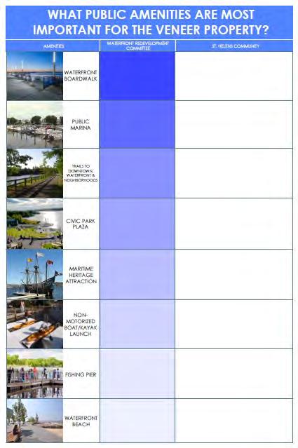
16 Public Amenities Committee Community Public AmeniBes Total #1 Responses (out of 17) Public AmeniBes Total #1 Responses (out of 169) Waterfront Boardwalk 5 Waterfront Boardwalk 61 Public Marina 1 Public Marina 4 Trails to Downtown, Waterfront & Neighborhoods 7 Trails to Downtown, Waterfront & Neighborhoods 36 Civic Park Plaza 2 Civic Park Plaza 16 MariBme Heritage AWracBon 0 MariBme Heritage AWracBon 9 Non-Motorized Boat/Kayak Launch 0 Non-Motorized Boat/Kayak Launch 13 Fishing Pier 2 Waterfront Beach 0 Fishing Pier 6 Waterfront Beach 24
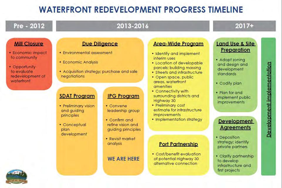
17 Master Planning Process Due Diligence Environmental Assessment Economic Analysis AcquisiKon strategy; purchase & sale negokakons SDAT Program Preliminary vision and guiding principles Conceptual Plan Development IPG Program Convene leadership group Confirm and refine vision and guiding principles Revisit market analysis Area-Wide Program IdenKfy and implement interim uses LocaKon of developable parcels; building massing Streets and infrastructure Open space, public areas, waterfront amenikes ConnecKvity with surrounding districts and Highway 30 Preliminary cost eskmate for infrastructure improvements ImplementaKon strategy Port Partnership Cost/benefit evaluakon of potenkal Hwy 30 alternakve conneckon Land Use & Site PreparaBon Adopt zoning and design and development standards Codify plan Plan for and implement public improvements Development Agreements DisposiKon strategy; idenkfy private partners Clarify partnership to develop infrastructure and first projects
18 Area-Wide Program Area-Wide Program IdenKfy and implement interim uses LocaKon of developable parcels; building massing Streets and infrastructure Open space, public areas, waterfront amenikes ConnecKvity with surrounding districts and Highway 30 Preliminary cost eskmate for infrastructure improvements ImplementaKon strategy 1. Gather public input through two community meetings and an Advisory Committee 2. Assess the existing conditions of the sites and Planning Area 3. Create a site-specific redevelopment assessment and framework plan 4. Create an area-wide implementation strategy to assist in cleanup and redevelopment

19 AWP Study Area
20 Area-Wide Framework Plan Objectives o Existing Conditions o Evaluate existing conditions of site o Interviews with developers and look at case studies o Redevelopment Assessment o Site-specific needs assessment o Scenario planning o Implementation o Create an implementation strategy for development o Finalized Framework Plan o Plan document with finalized scenarios with costs and funding options for the City

21 Timeline
22 Existing Conditions Report Topics included in analysis: Physical Conditions Environmental Assessment Utilities Transportation Land Use Demographics Market Conditions
23 Opportunities and Constraints Core Value OpportuniBes Constraints Public Access Natural and Cultural Heritage Sustainable Economic Development Existing Park Adjacent to Existing Street Grids View Corridors Trails Boardwalk Public Ownership Volcanic Views Community Support Historic and Cultural Education Proximity to the Columbia River PPA Willamette River Overlay District Bluff Development Public Ownership Distance from US 30 Connection to River Artificial Fill Historic Infrastructure 100-Year Floodplain Riparian Overlay Shallow Bedrock Heavy Industrial Zoning Restricted Areas Large Amounts of Fill

24 Opportunities and Constraints

25 Scenario Planning

26 Scenario Planning

27

28

29 Framework and Demonstration A

30 Framework and Demonstration B

31 Framework and Demonstration C

32 WWTP Lagoon Repurposing

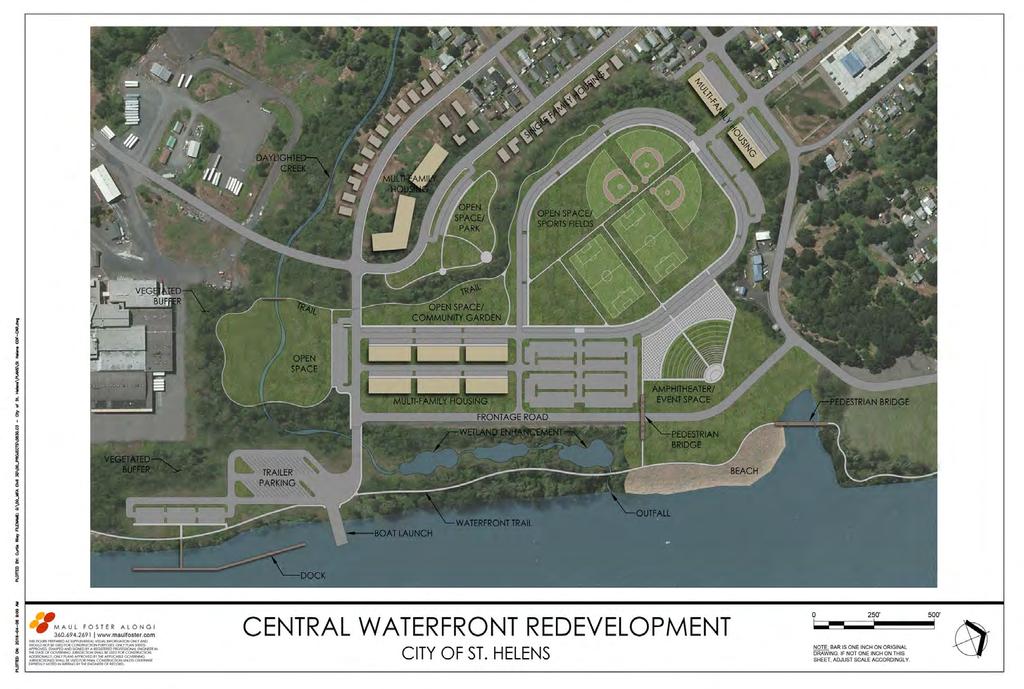
33 Central Waterfront Redevelopment Outcomes
34 Next Steps o Community Engagement o Review Scenarios with Advisory Committee o Present Scenarios to St Helens Community o Framework Plan o Refine Scenarios into 1 or 2 preferred alternatives o Identify preliminary cost estimates for site and area infrastructure improvements o Implementation o Funding Strategy o Marketing o Development Partnerships
35 St. Helens Waterfront Redevelopment Project Oregon Brownfield Forum May 2016
Planning Commission March 14, Presented by: City of Bellingham Port of Bellingham
 Planning Commission March 14, 2013 Presented by: City of Bellingham Port of Bellingham 1 Agenda Waterfront District Background Waterfront District Proposal Overview Sub-area Plan Development Regulations
WILLAMETTE FALLS LEGACY PROJECT
 OPPORTUNITIES & CONSTRAINTS There are here three falls on a line of rocks extending across the river, which forms the bed of the upper channel. The water is precipitated through deep abrazed gorges, and
Delaware River Waterfront Corporation
 Delaware River Waterfront Corporation Delaware River Waterfront Corporation Created in January 2009 to replace Penn s Landing Corporation o Open, accountable, effective leadership o New Board of Directors
Stockton Waterfront Master Plan. Waterfront Master Plan
 Stockton Waterfront Master Plan Presentation Objectives Process update Planning observations Planning Goals Planning Principles Review of planning activities Summary and next steps Planning Activities
CHAPTER ONE INTRODUCTION
 1.0 Introduction Bellingham s central waterfront is in a state of transition from its long history as an active industrial site to a new mixed-use neighborhood. Over the past several years, the Port of
Chapter 1.0 Introduction
 Chapter 1.0 Introduction 1.1 Background The North Metro commuter rail line is part of the RTD FasTracks regional transit system expansion program to build more than 100 miles of rail transit throughout
EXECUTIVE SUMMARY EXECUTIVE SUMMARY
 1 EXECUTIVE SUMMARY EXECUTIVE SUMMARY Penn s Landing is envisioned as a welcoming riverfront green space adjacent to a refurbished civic marina becoming the centerpiece for adjacent development. With a
Coastal Smart Growth Approaches for Working Waterfront Preservation, Implementing Locally-Based Strategies and Solutions
 Coastal Smart Growth Approaches for Working Waterfront Preservation, Implementing Locally-Based Strategies and Solutions National Working Waterfronts Symposium March 26, 2013 Presented by: Lydia Bennett
IMPLEMENTING SOMERSET COUNTY S INVESTMENT FRAMEWORK
 IMPLEMENTING SOMERSET COUNTY S INVESTMENT FRAMEWORK SMART CONSERVATION THROUGH SMART GROWTH NJ LAND CONSERVATION RALLY March 22, 2014 Laurette Kratina, PP, AICP, Supervising Planner Somerset County Planning
Welcome! to Keller Town Hall
 Welcome! to Keller Town Hall Keller Town Center Planning a New Downtown What is Keller Town Center? A new, growing downtown district planned as an urban village A combination of retail and office spaces,
Planning for Waterfront Communities
 Planning for Waterfront Communities Redevelopment Ready Communities Supplemental Training Program OFFICE OF THE GREAT LAKES Waterfront Community Best Practices and Guidelines New supplemental criteria
India Basin/Hunters Point Shoreline Community Workshop May 21, 2008
 India Basin/Hunters Point Shoreline Community Workshop May 21, 2008 Workshop Agenda Welcome Process Overview Context & Existing Conditions Presentation of Draft Concepts Land Use and Open Space Priorities
PORT OF VANCOUVER WATERFRONT DEVELOPMENT. Concept Development Plan City Center Redevelopment Authority April 20, 2017
 PORT OF VANCOUVER WATERFRONT DEVELOPMENT Concept Development Plan City Center Redevelopment Authority April 20, 2017 Port History PORT ESTABLISHED 1912 TERMINAL 1 ACQUIRED 1925 GWM SIGNS LEASE 1935 HARBOR
Scope of Services. River Oaks Boulevard (SH 183) Corridor Master Plan
 Corridor Master Plan") Scope of Services River Oaks Boulevard (SH 183) Corridor Master Plan PROJECT AREA The project area consists of the River Oaks Boulevard (SH 183) corridor bounded by SH 199 at the northern end and the Trinity
Scope of Services River Oaks Boulevard (SH 183) Corridor Master Plan PROJECT AREA The project area consists of the River Oaks Boulevard (SH 183) corridor bounded by SH 199 at the northern end and the Trinity
Port of Camas-Washougal Waterfront Trail Master Plan
 Port of Camas-Washougal Waterfront Trail Master Plan The Port s facilities are the products of its mission: To make strategic investments that enhance the community s quality of life by bringing jobs,
Riverfront Development Plan
 Planning Studies Project Overview: Continuity Developing Fort Myers underused riverfront was the final step in Downtown redevelopment. To mine all facets of the riverfront, the Plan had to be created cohesively
Phase I Redevelopment Plan. First Community Meeting
 Hoboken Terminal and Yard Phase I Redevelopment Plan First Community Meeting May 31, 2011 One Hudson Place Phase I Redevelopment Plan Redevelopment Plan First Community Meeting Agenda 1. Redevelopment
Waterfront Redevelopment. City Council Briefing May 15, 2006
 Waterfront Redevelopment City Council Briefing May 15, 2006 Topics Reason for this presentation Recap of recent waterfront events Marina/Park economic and feasibility evaluation Planned next steps Recap
Plan Overview. Manhattan Area 2035 Reflections and Progress. Chapter 1: Introduction. Background
 Plan Overview The Manhattan Urban Area Comprehensive Plan (the Comprehensive Plan) is a joint planning initiative of the City of Manhattan, Pottawatomie County, and Riley County. The 2014 Comprehensive
Waterfront Development Master Plan
 PORT of VANCOUVER USA Vancouver, WA Waterfront Development Master Plan DRAFT - FINAL CONCEPTUAL MASTER PLAN PROJECT TEAM NBBJ Heritage Research Associates JLA Kittelson Associates Leland Consulting Group
Atlanta BeltLine, Inc. Pathways to Urban Sustainability
 Atlanta BeltLine, Inc. Pathways to Urban Sustainability September 30, 2010 WHAT IS THE ATLANTA BELTLINE? Transit 22-mile loop Parks 1300 + new acres Trails 33 miles Jobs & Economic Development 20 areas,
City of Ashland. Attn: Laura Loucks; Sustainability Intern 601 Main Street West Ashland, WI
 City of Ashland REQUEST FOR PROPOSALS RFP #18-01 Artistic Solar Public Art Project April 4, 2018 The City of Ashland, Wisconsin will be receiving proposals for the above noted project until Friday, June
THE TOWN OF WASAGA BEACH
 THE TOWN OF WASAGA BEACH Downtown Development Master Plan Committee of the Whole Presentation January 26 th 2017 Uses within this designation should reflect a dependence on tourism as opposed to the permanent
Gold Line Bus Rapid Transit Transit Oriented Development (BRTOD) Helmo Station Area Plan
 Helmo Station Area Plan") Appendix F Gold Line Bus Rapid Transit Transit Oriented Development (BRTOD) Helmo Station Area Plan Introduction and Purpose of the Plan The Gold Line Bus Rapid Transit facility is an eleven-mile dedicated
Appendix F Gold Line Bus Rapid Transit Transit Oriented Development (BRTOD) Helmo Station Area Plan Introduction and Purpose of the Plan The Gold Line Bus Rapid Transit facility is an eleven-mile dedicated
City of Iowa City Department of Neighborhood and Development Services Department of Parks and Recreation Department of Public Works City Manager s
 RFP Pre-submittal meeting December 18, 2015 City of Iowa City Department of Neighborhood and Development Services Department of Parks and Recreation Department of Public Works City Manager s Office Background
Parks, Open Space and Trails
 Introduction Parks have often been referred as the lungs of our cities, cleansing the air of pollutants and particulate matter. Parks are also gathering places for families and community. They offer spaces
MALL REVITALIZATION CASE STUDIES
 MALL REVITALIZATION CASE STUDIES DECEMBER 9, 2012 MALL REVITALIZATION OVERVIEW Introduction Sample Case Studies prepared for Lacey Woodland District Steering Committee as it considers strategies to revitalize
Pier 70 Master Plan. Port of San Francisco
 Project Overview Develop a Preferred Master Plan for a 65-acre Brownfield site Adaptive reuse of historic structures and new development that reconciles numerous regulatory, economic, maritime, historic
DISCUSSION TOPIC: ST JOHNS RIVER & ITS TRIBUTARIES (BPII) 2030 COMPREHENSIVE PLAN POLICES AND REGULATORY FRAMEWORK
 2030 COMPREHENSIVE PLAN POLICES AND REGULATORY FRAMEWORK") DISCUSSION TOPIC: ST JOHNS RIVER & ITS TRIBUTARIES (BPII) 2030 COMPREHENSIVE PLAN POLICES AND REGULATORY FRAMEWORK St. John s River & Its Tributaries Issue Summary: The St. Johns River is an important
DISCUSSION TOPIC: ST JOHNS RIVER & ITS TRIBUTARIES (BPII) 2030 COMPREHENSIVE PLAN POLICES AND REGULATORY FRAMEWORK St. John s River & Its Tributaries Issue Summary: The St. Johns River is an important
UO North Campus Conditional Use Permit Project
 UO North Campus Conditional Use Permit Project Project Overview and Background November 2017 Campus Planning, CPFM Project Boundary Previous Conditional Use Permit: 1988 to 2012 Site History Statement
SUBJECT: Waterfront Hotel Planning Study Update TO: Planning and Development Committee FROM: Department of City Building. Recommendation: Purpose:
 Page 1 of Report PB-23-18 SUBJECT: Waterfront Hotel Planning Study Update TO: Planning and Development Committee FROM: Department of City Building Report Number: PB-23-18 Wards Affected: 2 File Numbers:
Las Colonias Park Master Plan
 2013 Las Colonias Park Master Plan City of Grand Junction June 2013 Introduction Las Colonias Park, a 101 acre parcel on the edge of the Colorado River south of downtown, was deeded to the City of Grand
Meeting Purpose & Agenda
 Meeting Purpose & Agenda Meeting Purpose: To provide a summary of the results of the Downtown Parks Site Assessment and Feasibility Study By recommendation, provide direction to staff on which City-owned
Isabel Neighborhood Plan: Alternatives
 Isabel Neighborhood Plan: Alternatives Presented by: Lori Parks, Associate Planner February 2, 2015 Agenda 1. Background on BART to Livermore 2. Isabel Neighborhood Plan 3. Alternative Scenarios 4. General
Naomi Weiss, Executive Director, DBPA Jason Jeffries, Project Manager, City of Daytona Beach
 Naomi Weiss, Executive Director, DBPA Jason Jeffries, Project Manager, City of Daytona Beach Nottingham Plan 2002 Adopted Redevelopment Plan 2002 Riverfront Action Plan 2004 Downtown Vision Plan 2007
Examples of Asset Based Approaches to Development. Economic and Community Development Suffield, CT
 Examples of Asset Based Approaches to Development Presented by: Patrick McMahon, Director of Economic and Community Development Suffield, CT Neighborhood Commercial Development Wilson, CT Issues Elevated
{Best Practices. Summary of Tools, Strategies and Best Practices from 11 Michigan Case Study Communities
 Case Studies Michigan Coastal Community Working Waterfronts { Summary of Tools, Strategies and from 11 Michigan Case Study Communities Table of Contents Zoning...2 Community and Stakeholder Collaboration
CITY OF BELLINGHAM PLANNING DEPARTMENT STAFF REPORT
 1 1 1 1 1 1 1 1 0 1 0 1 0 1 0 CITY OF BELLINGHAM PLANNING DEPARTMENT STAFF REPORT Agenda Topic: For: Staff Contact: I. Project Summary Review of the Waterfront District subarea plan and associated documents,
April 11, 2016 Park Board Chair and Commissioners General Manager Vancouver Board of Parks and Recreation New Brighton Salt Marsh - Preferred Concept
 TO: FROM: SUBJECT: April 11, 2016 Park Board Chair and Commissioners General Manager Vancouver Board of Parks and Recreation New Brighton Salt Marsh - Preferred Concept RECOMMENDATION A. THAT the Vancouver
Center for Towns Program. Strategic Planning Retreat December 2014
 Center for Towns Program Strategic Planning Retreat December 2014 Background Center for Towns ESLC Vision in 2050 is an Eastern Shore where: towns are vibrant and well defined 2010 2015 Strategic Plan
Public may provide comments on the GDP within the next two weeks (December 24)
") 25/70 General Development Plan (GDP) Public Meeting Wednesday, December 10, 2014 6:00 8:00 P.M. District 1 Police Station Community Room 1311 W 46th Ave, Denver, CO 80211 Council Woman Montero: This particular
25/70 General Development Plan (GDP) Public Meeting Wednesday, December 10, 2014 6:00 8:00 P.M. District 1 Police Station Community Room 1311 W 46th Ave, Denver, CO 80211 Council Woman Montero: This particular
What Pioneer Grove Will Look Like?
 The City of Deerfield Beach has embarked on a journey to create a new town center within the old heart of Deerfield Beach. The new town center is known as Pioneer Grove. Pioneer Grove will be Everybody
Title slide..poughkeepsie Planning Initiatives POUGHKEEPSIE PLANNING INITIATIVES
 Title slide..poughkeepsie Planning Initiatives Overview Revitalization Projects Waterfront Redevelopment Strategy Local Waterfront Revitalization Program Update Kaal Rock Connector Fallkill Creek Plan
Port Lavaca Future Land Use
 Port Lavaca Future Land Use Introduction The City of Port Lavaca is beginning to see sustained growth, after many years of relative stable population. New single family homes, apartments, and businesses
ARISE: The Rock Renaissance Area Redevelopment & Implementation Strategy
 2014 Professional Awards 1 ARISE: The Rock Renaissance Area Redevelopment & Implementation Strategy Janesville, WI Completed December 2014 Analysis & Planning Purpose of Project 2 The purpose of the Rock
MCCOYS CREEK RESTORATION 30% DESIGN
 MCCOYS CREEK RESTORATION 30% DESIGN THE MCCOYS CREEK RESTORATION PLAN The restoration plan aims to reduce flooding, restore ecosystem health, expand recreational opportunities along the creek, and connect
WELCOME TO THE CHOUTEAU GREENWAY DESIGN, DEVELOPMENT AND CONSTRUCTION WORKING GROUP!
 WELCOME TO THE CHOUTEAU GREENWAY DESIGN, DEVELOPMENT AND CONSTRUCTION WORKING GROUP! Chouteau Greenway Steering Committee and Working Groups Overview Overview January 9, 2019 Chouteau Greenway will transform
Atlanta BeltLine Corridor Environmental Study. Scoping Meeting August 2008
 Atlanta BeltLine Corridor Environmental Study Scoping Meeting August 2008 What Will We Be Discussing Today? Study Overview - How Did We Get Here? - What Is the Study About? - Who Is Involved? - Where Is
2011 ASLA Design Awards. Westside Creeks Restoration Plan Merit Award AECOM, Fort Collins. Planning & Urban Design
 2011 ASLA Design Awards Westside Creeks Restoration Plan Merit Award AECOM, Fort Collins Planning & Urban Design Project Fact Sheet Category of Entry: Rotating Specialty Award: 2011 2011 ASLA Colorado
1.1 WATERFRONT SEATTLE
 1.1 WATERFRONT SEATTLE Over the past few years, the City of has been actively re-imagining the future of its Central Waterfront. The imminent replacement of the Elliott Bay Seawall and removal of the Alaskan
ALMONO. Hazelwood, City of Pittsburgh. A riverfront investment opportunity combining residential, office and light industrial uses A L M O N O S I T E
 Tecumseh St. ALMONO Hazelwood, City of Pittsburgh A riverfront investment opportunity combining residential, office and light industrial uses Downtown Pittsburgh Oakland South Side Flats Birmingham Bridge
A larger version of this map is located on the last page of this PDF.
 MAP Committee Input McLoughlin Area Draft Vision Map A larger version of this map is located on the last page of this PDF. 1. The map above is intended to portray a vision for the McLoughlin area. It highlights
Preliminary Plan Framework: Vision and Goals
 Preliminary Plan Framework: Vision and Goals Draft: May 2015 Introduction Since the Town of Milliken s comprehensive plan was last updated in 2010, the community was heavily impacted by the 2013 flood,
Highland Falls Waterfront Redevelopment Feasibility Study Village Board Meeting March 20, 2017
 Village Board Meeting March 20, 2017 Agenda I. Public Meeting #1 Visioning Summary II. Public Meeting #2 Comment Summary III. IV. IV. Case Study: Milton Train Station Schematic Design Concepts Schedule/Next
Lynn Waterfront Master Plan
 Lynn Waterfront Master Plan Public Meeting #2 December 10th, 2018 1 Project Schedule Update September 26, 2018 December 10, 2018 Development of the Master Harbor Plan Amendment and Revised Waterfront Master
Ivywild On The Creek PRELIMINARY CREEK DISTRICT MASTER PLAN
 Ivywild On The Creek PRELIMINARY CREEK DISTRICT MASTER PLAN Introduction: Rejuvenating an extraordinary Creekside neighborhood THE CREEKSIDE DISTRICT The Ivywild On The Creek Neighborhood District Master
The City shall enhance and improve the accessibility of parks and recreational facilities while protecting their quality. by:
 GOALS, OBJECTIVES AND POLICIES GOAL 1: To provide open space and recreation as an essential element needed for the betterment of the City s character and quality of urban life. The City shall plan for
CONTEXT: the Highway, the River + the Railroads run through us.
 CONTEXT: the Highway, the River + the Railroads run through us. I-25 36 In the past they have divided us, now we have an opportunity to unite us. I-76 I-270 I-76 CSU I-25 LEGEND Cut + Cover River North
SAN RAFAEL GENERAL PLAN 2040 INTRODUCTION AND OVERVIEW
 SAN RAFAEL GENERAL PLAN 2040 INTRODUCTION AND OVERVIEW Steering Committee Presentation February 14, 2018 Purpose of General Plan Guide land use and development decisions Coordinate transportation, infrastructure,
Sustainability, Health, Safety, Recreation & Open Space Working Group August 3, 2017
 Sustainability, Health, Safety, Recreation & Open Space Working Group August 3, 2017 DOWNTOWN OAKLAND SPECIFIC PLAN WELCOME Sustainability, Health, Safety, Recreation & Open Space Working Group Social
City of Tacoma Planning and Development Services
 Agenda Item D-1 City of Tacoma Planning and Development Services To: Planning Commission From: Elliott Barnett, Planning Services Division Subject: Application #2014-08 Open Space Element Update Meeting
A. Selma Park, Davis Bay and Wilson Creek
 A. Selma Park, Davis Bay and Wilson Creek This waterfront neighbourhood consists of three separate community areas, linked by Highway 101, but with different character, land use patterns and future potential.
The Trinity River Corridor Project Update
 The Trinity River Corridor Project Update Councilmember Carolyn A. Davis Community Meeting October 14, 2008 The project covers 20 miles of the Trinity River, approx. 10,000 acres 2 Trinity River Corridor
WAC #7 3/14/14. Coachella General Plan Update
 WAC #7 3/14/14 Coachella General Plan Update Agenda 2 Introductions Public Draft General Plan Overview and Discussion of Next Steps Implementation and Evaluation Health Element Process Evaluation (discussion)
Sprawling urban development and auto-dominated streets
 Neighborhood-Scale Planning Tools to Create Active, Livable Communities Sprawling urban development and auto-dominated streets make it nearly impossible for people to integrate walking or bicycling into
SAFETY AND CONNECTIVITY IN A PLANNED COMMUNITY
 DALE CITY TLC SAFETY AND CONNECTIVITY IN A PLANNED COMMUNITY PROJECT KICKOFF MEETING MARCH 7, 2016 AGENDA 1. Introductions 2. Project Overview 3. Discussion 4. Site Visit PROJECT KICKOFF MEETING MARCH
FUNDING CORRIDOR REVITALIZATION
 FUNDING CORRIDOR REVITALIZATION Integrated corridor planning for the 21 st Century America Planning Association Annual Conference Atlanta, GA April 27, 2014 Mariia Zimmerman, MZ Strategies, LLC mariia@mzstrategies.com
CITY OF PUYALLUP. Background. Development Services
 CITY OF PUYALLUP Development Services 333 South Meridian Puyallup WA 98371 To: City Council From: Katie Baker, AICP, Planning Division Re: South Hill Neighborhood Plan Adoption Date: (Meeting date: February
SQUAMISH 2010 AND BEYOND COMMUNITY VISION
 Our plan has been imagined and created to be both pragmatic and visionary. At the core of the strategy is a consideration of the highway s role and its impact on the community. First and foremost in creating
Northwest Rail Corridor and US 36 BRT Development Oriented Transit Analysis 4.4 STATION AREA FINDINGS
 4.4 STATION AREA FINDINGS Each station is different, and each one requires a separate set of recommendations based on the vision for the site. This section outlines an initial TOD strategy and recommendations
JANUARY 19, 2011 CENTRAL AVENUE-METRO BLUE LINE TRANSIT-ORIENTED DEVELOPMENT IMPLEMENTATION PROJECT COMMUNITY FORUM
 CENTRAL AVENUE-METRO BLUE LINE TRANSIT-ORIENTED DEVELOPMENT IMPLEMENTATION PROJECT COMMUNITY FORUM JANUARY 19, 2011 THE MARYLAND-NATIONAL CAPITAL PARK AND PLANNING COMMISSION PRINCE GEORGE S COUNTY PLANNING
Town of Oakville Streetscape Strategy
 Town of Oakville Streetscape Strategy Endorsed by PDC on February 10, 2014 (PD-011-14) Town of Oakville Streetscape Strategy [endorsed by PDC February 10, 2014] 0 Town of Oakville Streetscape Strategy
Case Study Presentation of the Downtown Brampton Flood Protection Class EA
 Case Study Presentation of the Downtown Brampton Flood Protection Class EA Presented by: Kenneth M. Dion, Project Director Port Lands Integration, Waterfront Toronto (formerly Senior Manager, TRCA) At:
DRAFT PLAN PRESENTATION
 DRAFT PLAN PRESENTATION 1.23.2018 AGENDA Process Project Schedule Results from Visioning Workshop Draft Plan Highlights Concept Plans Feedback Next Steps PROJECT SCHEDULE KICK-OFF WORKSHOP August 29 th
Pine Street Waterfront Overlay CITY OF ROSEBURG PINE STREET WATERFRONT OVERLAY FEBRUARY City of Roseburg
 Pine Street Waterfront Overlay CITY OF ROSEBURG PINE STREET WATERFRONT OVERLAY FEBRUARY 2018 City of Roseburg Purpose of this project Create an overlay zone for Pine Street Retain the project area s historic
Lynn Waterfront Master Plan
 Lynn Waterfront Master Plan DECEMBER ALTERNATIVES PRESENTATION City of Lynn / EDIC ZHA / GEI Work Schedule June Kick-Off June September Site Analysis & Property Owner / Stakeholder Meetings September Analysis
DRAFT City of Titusville 2040 Comprehensive Plan Future Land Use, Housing, and Transportation Elements April 16, 2018
 DRAFT City of Titusville 2040 Comprehensive Plan Future Land Use, Housing, and Transportation Elements April 16, 2018 Prepared by Canin Associates for the City of Titusville About the Comprehensive Plan:
City Center Neighborhood Plan
 [1] City Center Neighborhood Plan As adopted by Ordinance No. 2014-09-049 and amended by Ordinance Nos. Formerly CBD Neighborhood as adopted by Ordinance No. 8868 and amended by Ordinance Nos. 8946, 9693,
PLAN ELEMENTS WORKSHOP. April 5, 2016
 PLAN ELEMENTS WORKSHOP April 5, 2016 needs more housing. But there is no one-size fits-all solution. Every neighborhood has its own character. In some places, density is not only appropriate it is badly
Natomas Vision Plan and PLNP
 Natomas Vision Plan 20030171 and PLNP2014-00172 Department of Community Development Planning and Environmental Review Leighann Moffitt Sub-Agenda 1. Staff Presentation Leighann Moffitt, County Planning
Welcome! Please sign-in and participate in the activities in the registration area before finding your seat. Thank you!
 Welcome! Please sign-in and participate in the activities in the registration area before finding your seat. Thank you! Planning Kickoff July 31, 2018 University of Baltimore Public Planning Kick-off Agenda
Beaverton City Council: Work Session. SIDEDistrict. May 6, 2014
 BEAVERTON Beaverton City Council: CREEK Work Session SIDEDistrict May 6, 2014 Tonight s Agenda BEAVERTON CREEK SIDE Brief updates Creekside Vision Scenarios & discussion: Redevelopment & Parking Project
SECTION ONE: INTRODUCTION. introduction
 introduction 1 INTRODUCTION Since it was first established in 1843 as a trading post for the Hudson s Bay Company, Victoria has evolved into a Provincial capital city that is recognized across Canada and
ANC 2A Presentation. November 9, 2006
 ANC 2A Presentation November 9, 2006 Introduction & Overview Applicants Boston Properties and KSI Services (project developers) The George Washington University (land owner) 2.66 acre site (former GW hospital
RECREATION AND OPEN SPACE ELEMENT GOALS, OBJECTIVES, AND POLICIES
 RECREATION AND OPEN SPACE ELEMENT GOALS, OBJECTIVES, AND POLICIES GOALS, OBJECTIVES AND POLICIES GOAL 1: TO PROVIDE A FULL RANGE OF RECREATIONAL ACTIVITIES THAT ARE ACCESSIBLE, COMPATIBLE AND CONTINUOUS
MEADOW RIVER RAIL TRAIL
 MEADOW RIVER RAIL TRAIL Nicholas, Fayette and Greenbrier Rail Line CSX Abandonment 2008 Greenbrier and Fayette County Partnership 2009 16.7 mile Purchased in July 2011. Trail Development Begins: Obama
Edward R. Sajecki Commissioner of Planning and Building
 Corporate Report Clerk s Files Originator s Files CD.03.POR DATE: TO: FROM: SUBJECT: Chair and Members of Planning and Development Committee Meeting Date: February 27, 2012 Edward R. Sajecki Commissioner
Albert Lea. Redevelopment Plan. 701 Xenia Avenue South, Suite 300 Minneapolis, MN Tel: (763) Fax: (763) wsbeng.
 Fax: (763) wsbeng.") Albert Lea Redevelopment Plan 701 Xenia Avenue South, Suite 300 Minneapolis, MN 55416 Tel: (763) 541-4800 Fax: (763) 541-1700 wsbeng.com Albert Lea Redevelopment Plan Table of Contents Composite Districts...
Albert Lea Redevelopment Plan 701 Xenia Avenue South, Suite 300 Minneapolis, MN 55416 Tel: (763) 541-4800 Fax: (763) 541-1700 wsbeng.com Albert Lea Redevelopment Plan Table of Contents Composite Districts...
Highest & Best Use Study Marina Park Lands
 Executive Summary of Report MARCH 2006 TABLE OF CONTENTS 1. Introduction...1 2. Study Process...2 3. Highest And Best Use Program...3 4. Concept Plan...8 5. Public Area Animation...9 6. Marina Park Implementation
Applicant Name Phone / Fax / Address City State Zip Code . Property Owner Phone / Fax / Address City State Zip Code
 Master Development Plan Application Community Development Department City of Redmond 411 SW 9 th Street Redmond, Oregon 97756 541-923-7721 541-548-0706 FAX Master Development Plan Fee $38,862.52 File Number
NORTH CLAYMONT AREA MASTER PLAN COMMUNITY WORKSHOP #1 FEBRUARY 3, 2016
 NORTH CLAYMONT AREA MASTER PLAN COMMUNITY WORKSHOP #1 FEBRUARY 3, 2016 1. Introduction To the team and to the Plan Planning Partners The Claymont Community WILMAPCO New Castle County Claymont Renaissance
Brian Peterson, AIA, LEED-AP, CNU-A Introduction: the Art of Urban Design
 URBAN DESIGN AND SUSTAINABLE DEVELOPMENT: MILWAUKEE INNER HARBOR Arch 645/845 UP 858 Spring 2013 Tuesdays, Fridays 1:30-5:20 Brian Peterson, AIA, LEED-AP, CNU-A Brianpeterson1981@gmail.com 608-320-6006
WELCOME and introduction
 1 WELCOME and introduction Mobility Hub Locations within Burlington STUDY OVERVIEW STUDY OBJECTIVES The City of Burlington is developing four Area Specific Plans, one for each of Burlington s Mobility
Grantsburg Community Design Team (CDT)
") Grantsburg Community Design Team (CDT) Summary Report Overview On April 10-13, 2014, a team of (19) volunteer planners, design professionals, and community development educators volunteered their time
Grantsburg Community Design Team (CDT) Summary Report Overview On April 10-13, 2014, a team of (19) volunteer planners, design professionals, and community development educators volunteered their time
Staff Report to the North Ogden City Planning Commission
 Staff Report to the North Ogden City Planning Commission SYNOPSIS / APPLICATION INFORMATION Application Request: Concept review on a legislative application to rezone land located at approximately 1750
NORTH SHORE LAND USE AND TRANSPORTATION STUDY
 NORTH SHORE LAND USE AND TRANSPORTATION STUDY Visioning Open Houses April 6 and 7, 2009 Port Richmond and Snug Harbor Project Sponsors New York City Economic Development Corporation New York City Department
GPA FALL 2017 CONFERENCE
 Change in Doraville Doraville at the beginning of a new era Design Doraville (Comp. Plan) adopted in 2016 Doraville Town Center Masterplan LCI (2005) Downtown Doraville Masterplan LCI (2010) 2014 Adoption
Hopkins. Development Guidelines May Overview. Sponsored by: Blake Road Corridor Collaborative City of Hopkins
 Hopkins Blake Road LRT Station Area Development Guidelines May 2015 Sponsored by: Blake Road Corridor Collaborative City of Hopkins Overview Hopkins is a dynamic community of over 17,000 residents located
Don Mills Crossing Study and Celestica Lands Development Application Community Meeting, Open House, and Breakout Discussions
 Consultation Summary Don Mills Crossing Study and Celestica Lands Development Application Community Meeting, Open House, and Breakout Discussions This report is not intended to provide a verbatim transcript
6 PORT SYDNEY SETTLEMENT AREA
 Section 6 Port Sydney Page 61 6 PORT SYDNEY SETTLEMENT AREA 6.1 Basis and Principles Village of Port Sydney Waterfront Community Existing Services 6.1.1 Port Sydney is an historic settlement that has developed