173 ACRES - RILEY COUNTY, KS
|
|
|
- Horace Griffith
- 5 years ago
- Views:
Transcription


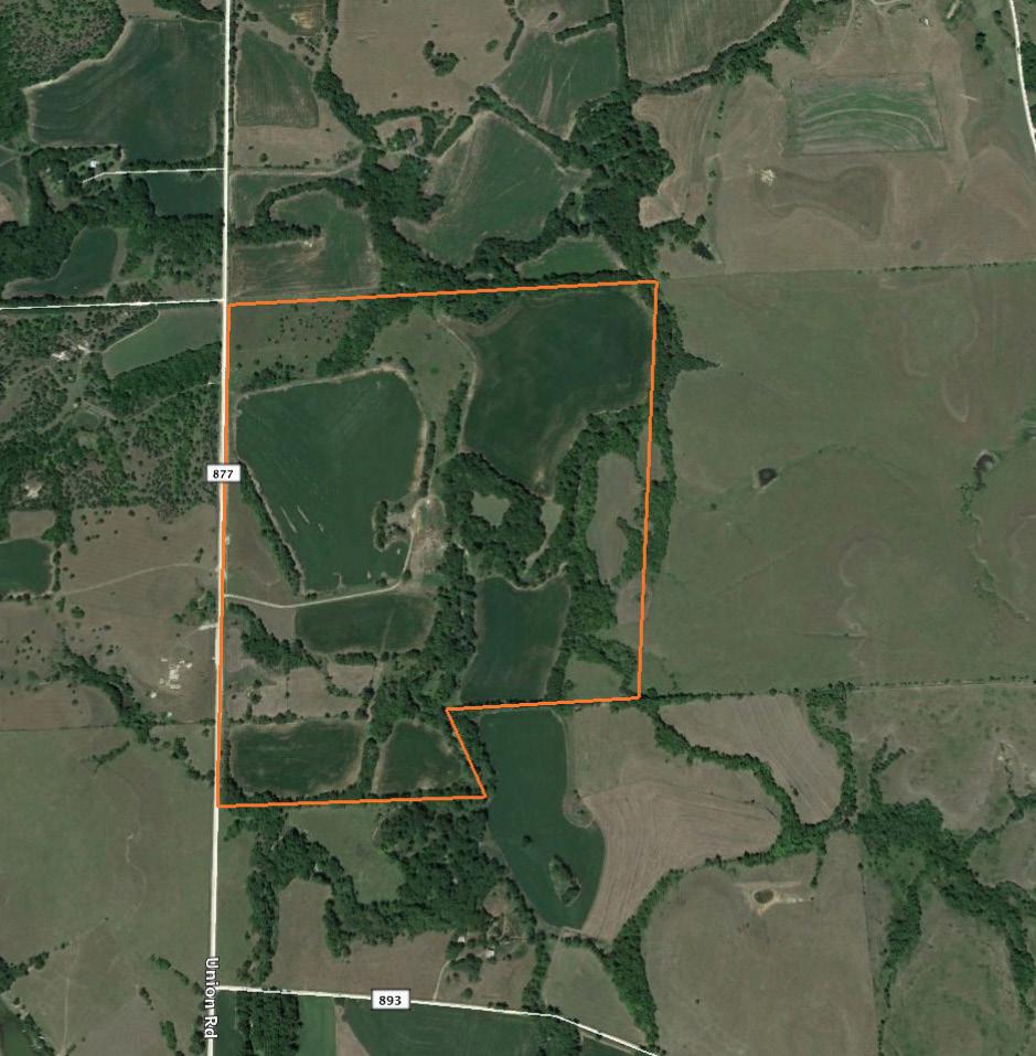
1 Buyers, Sellers & Land Connected PRICE: $690,000 ACRES: 173 COUNTY: RILEY STATE: KANSAS


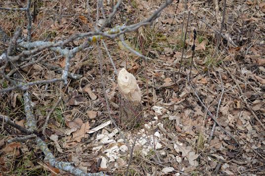
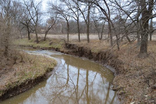
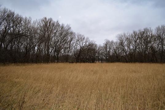
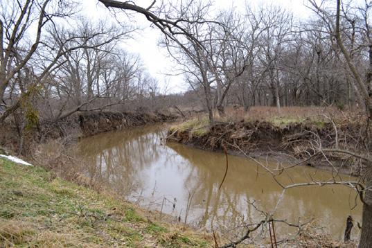
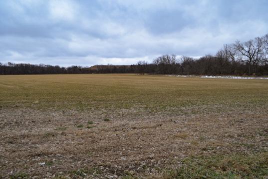
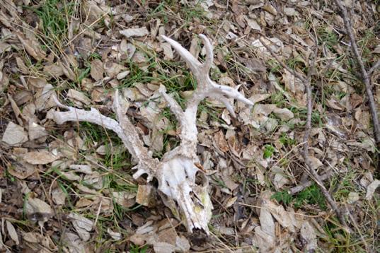
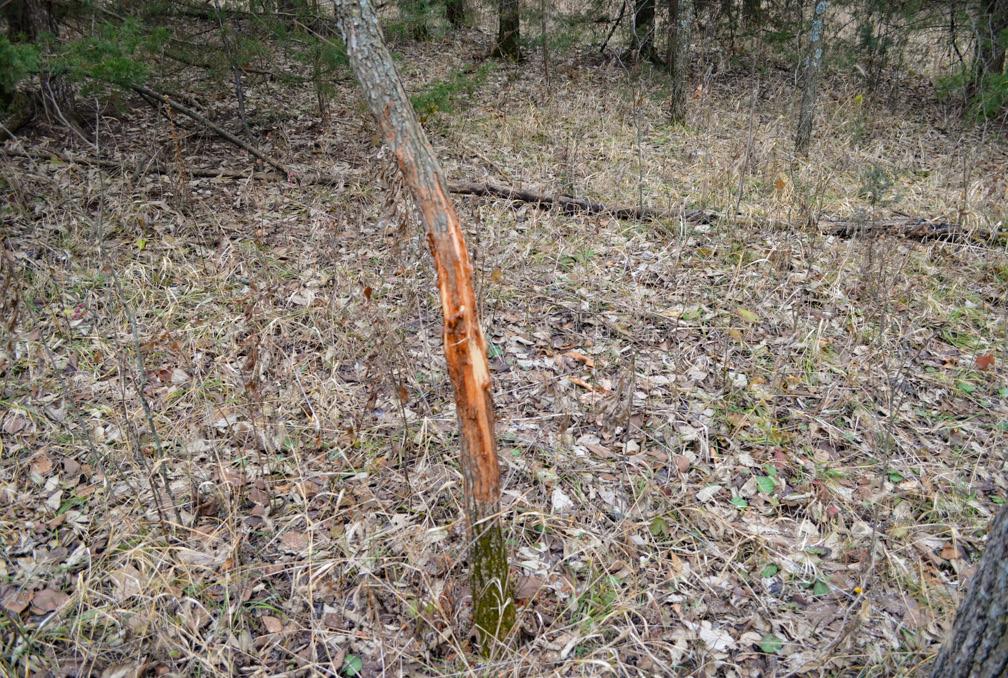
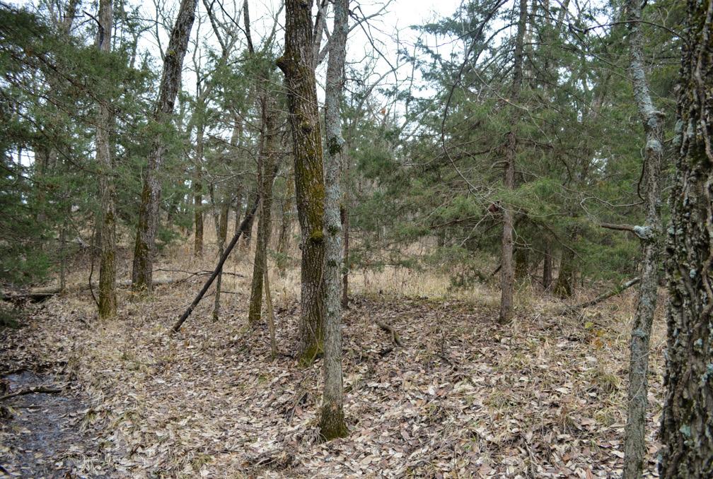
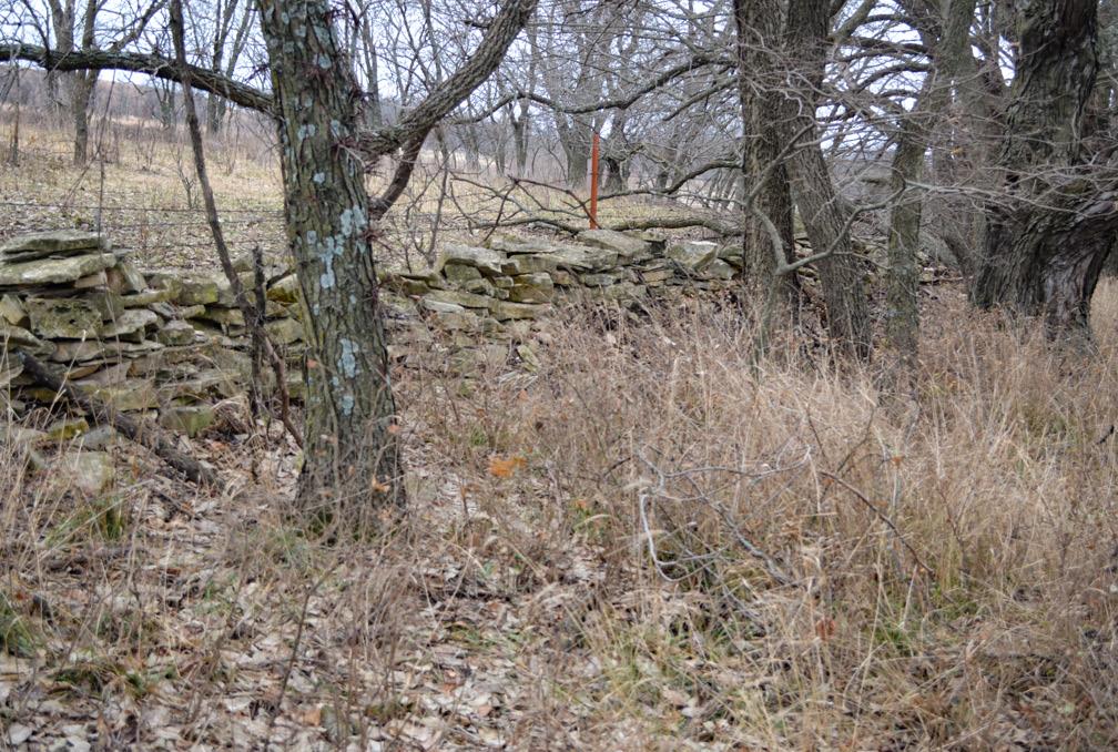
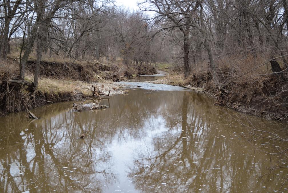
2 First Class Hunting with Outstanding Income Potential If you have ever dreamed of owning your very own piece of first class hunting property that pays the bills, here is your opportunity. This 173 acre tract has it all. 90 acres of this property are tillable that consist of class I Reading and class II Ivan on the East, and class IV Irwin on the West. 28 acres are currently planted to alfalfa and produced almost 400 bales from 5 cuttings this past year. The remainder of crop ground has been very well-maintained and has been terraced where need be. There are several pocket fields on this property that have been made easily accessible for large machinery but at the same time are very secluded for deer and elk to sense seclusion. Surrounding each field stands mature timber composed of hackberry, ash, and numerous walnut trees. Walnut Creek winds through the property flowing North. This creek has a rock bottom and continues to flow in the driest of times. The banks along the creek are very steep thus making it very easy to identify the few, very frequently used deer crossings. On the far east side of the property grows very lush native grasses lined with cedar trees proving ideal cover for wildlife. As you tour the property you will notice the old stone fences throughout the property that lead back to the original homestead that was once a thriving operation with the main home built with hand-stacked, cut stone, as well as several other buildings that were created at the time. There are several border and cross fences with gates that have been updated recently and are currently being used to winter a few head of cattle. This property also features an endless flowing water well to keep your livestock watered. Call Mike Myers to schedule your private showing today! 173 total acres 90 acres tillable Walnut creek runs through property Excellent fencing Functioning well Automatic cattle waterer Outstanding deer and turkey habitat Elk frequently roam the property Tree lined fields and creek with mature timber Old stone fence throughout Several stone buildings including original stone home Electricity on property Very secluded - neighboring properties do not have houses Heavily traveled deer paths Buck rubs throughout property


3 Buyers, Sellers & Land Connected


4 Buyers, Sellers & Land Connected
5

6 Aerial Map map center: 39 25' 1.41, ' ft 840ft 1680ft 30-7S-6E Riley County Kansas 11/28/2018 Field borders provided by Farm Service Agency as of 5/21/2008.


7 Soils Map State: Kansas County: Riley Location: 30-7S-6E Township: Jackson Acres: Date: 11/28/2018 Soils data provided by USDA and NRCS. Area Symbol: KS161, KS161, Soil Soil Area Area Version: Version: Code Soil Description Acres Percent of field Non Irr Class Legend Non Irr Class *c Irr Class *c *n NCCPI Overall *n NCCPI Corn *n NCCPI Small Grains *n NCCPI Soybeans 4674 Irwin silty clay loam, 3 to 7 percent slopes, eroded 4050 Ivan and Kennebec silt loams, occasionally flooded % IVe IVe % IIw IIw Reading silt loam, rarely flooded % Iw Iw Clime Sogn complex, 3 to 20 percent slopes 4630 Dwight Irwin complex, 1 to 3 percent slopes, eroded % VIe % IVe IVe Reading silt loam, 1 to 3 percent slopes % IIe IIe Wymore Kennebec complex, 0 to 17 percent slopes % IIIe Irwin silty clay loam, 3 to 7 percent slopes % IVe IVe Weighted Average *n 61.2 *n 55.6 *n 50.6 *n 58.5 *n: The aggregation method is "Weighted Average using major components" *c: Using Capabilities Class Dominant Condition Aggregation Method Soils data provided by USDA and NRCS.
FARMLAND AUCTION. FSA INFORMATION: Farmland: acres Cropland: acres Tillable: acres
 FARMLAND AUCTION January 22, 2019 at 10:30 am Keep an eye on BarnesRealty.com for possible blizzard date of 1/24/2019 Fisher Community Center, 201 E. Iowa St. Hiawatha, KS 66434 Here is a very productive
365.8 Acres +/- Brown County, KS February 28, 2019 at 10:30 am Community Building, 511 West Front Street, Fairview, KS
 Farmland Auction February 28, 2019 at 10:30 am Community Building, 511 West Front Street, Fairview, KS This excellent Brown County farm is just North of Fairview, KS and it will be selling in 3 tracts
LAND FOR SALE 30 ACRES M/L FLOYD COUNTY, IOWA LISTING # DOUGLAS R. YEGGE C: O:
 LAND FOR SALE LISTING #13886 30 ACRES M/L FLOYD COUNTY, IOWA DOUGLAS R. YEGGE C: 563-320-9900 O: 563-659-8185 Doug@PeoplesCompany.com ALAN MCNEIL C: 563-321-1125 O: 563-659-8185 Alan@PeoplesCompany.com
131 ACRES M/L VAN BUREN COUNTY, IOWA LISTING #458 JIM KEDLEY. C: O:
 131 ACRES M/L VAN BUREN COUNTY, IOWA LISTING #458 JIM KEDLEY C: 563-212-5401 O: 563-659-8185 Jimkedley@totalrealtyco.com CWC Holdings LLC, 131 Acres M/L, Van Buren County, IA TOTAL ACRES: 131 MOL PRICE:
80 ACRES M/L CEDAR COUNTY, IA LISTING #465 DOUGLAS R. YEGGE ALAN MCNEIL. C: O:
 80 ACRES M/L CEDAR COUNTY, IA LISTING #465 DOUGLAS R. YEGGE C: 563-320-9900 O: 563-659-8185 total@totalrealtyco.com ALAN MCNEIL C: 563-321-1125 O: 563-659-8185 alan@totalrealtyco.com Kroemer, 80 Acres
Demoss Farm & Home 118 Acres, M/L W. 209th Ave. Pattonsburg, Mo 64670
 118 Acres, M/L 39436 W. 209th Ave. Pattonsburg, Mo 64670 PRICE: $400,000.00 LAND USE: FSA shows approx. 118.32 farmland acres, ml, of which there were 36.47 acres of effective cropland with the remainder
State: Kansas County: Sherman Location: S-037W Township: Union Acres: Date: 12/19/2011. Maps provided by:
 Soils Map State: Kansas County: Sherman Location: 007-009S-037W Township: Union Acres: 147.8 Date: 12/19/2011 Fsa borders provided by the Farm Service Agency as of May 23, 2008. Soils data provided by
LAND FOR SALE 82 ACRES M/L CEDAR COUNTY, IOWA LISTING # DOUGLAS R. YEGGE C: O:
 LAND FOR SALE LISTING #13968 82 ACRES M/L CEDAR COUNTY, IOWA DOUGLAS R. YEGGE C: 563-320-9900 O: 563-659-8185 Doug@PeoplesCompany.com ALAN MCNEIL C: 563-321-1125 O: 563-659-8185 Alan@PeoplesCompany.com
280 ACRES - HOWELL COUNTY, MO
 PRICE: $434,700 ACRES: 280 COUNTY: HOWELL STATE: MISSOURI For more information contact: KYLE ORF, Land Agent 417.988.3333 KyleOrf@MidwestLandGroup.com MidwestLandGroup.com 100 280ACRES ACRES- -COUNTY,
LAND FOR SALE 314 ACRES M/L BERG, WORTH COUNTY, IOWA LISTING # DOUGLAS R. YEGGE C: O:
 LAND FOR SALE LISTING #13870 314 ACRES M/L BERG, WORTH COUNTY, IOWA DOUGLAS R. YEGGE C: 563-320-9900 O: 563-659-8185 Doug@PeoplesCompany.com ALAN MCNEIL C: 563-321-1125 O: 563-659-8185 Alan@PeoplesCompany.com
Auction Location Eagles Club 316 S. 2 nd Street, Aberdeen, SD
 Auction Location Eagles Club 316 S. 2 nd Street, Aberdeen, SD Welcome We would like to invite and welcome you to our public auction! This is an excellent opportunity to add Brown County cropland to your
Aerial Map. map center: 38 0' 55.53, ' S-4E Franklin County Illinois
 Aerial Map map center: 38 0' 55.53, -88 42' 58.78 0ft 594ft 1188ft 11/24/2016 Field borders provided by Farm Service Agency as of 5/21/2008. Soils data provided by University of at Champaign-Urbana. Topography
FOR SALE NEW PRICE HILL FAMILY FARM WATKINS CORNER, AR. Phillips County, Arkansas: 2,300+/- Acre Irrigated Grain Farm NEW PRICE/YIELD UPDATES:
 NEW PRICE FARMLAND ADVISORS FOR SALE HILL FAMILY FARM WATKINS CORNER, AR 2,300+/- Acres - Phillips County, Arkansas $10,950,000 Phillips County, Arkansas: 2,300+/- Acre Irrigated Grain Farm NEW PRICE/YIELD
Deuel County Dryland
 Deuel County Dryland Two parcels of dryland farm ground near Lewellen, NE Property Highlights List Price $852,474 $786,877 Location 12-15 miles south of Lewellen, Ne or the same distance from Big Springs,
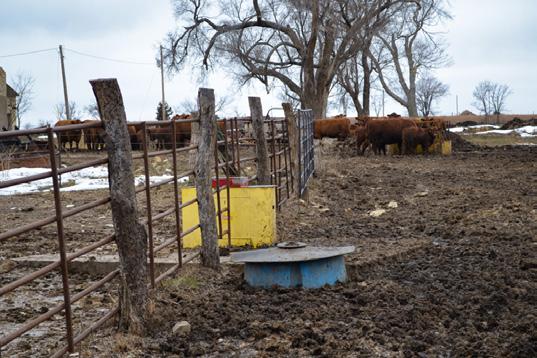
WALKER FEEDLOT Total taxable acres, part fenced. 4 homes & multiple nice/modern outbldgs hd feedyard with sprinklers a-shkd-0002
 ABILENE WALKER FEEDLOT 38.7 Total taxable acres, part fenced 4 homes & multiple nice/modern outbldgs 3500 hd feedyard with sprinklers a-shkd-0002 Center pivot irrigation from lagoons 999 hd feedlot A-SHDK-B020
Land Sales Specialists Setting the trend for how Real Estate is sold in the Midwest.
 Land Sales Specialists Setting the trend for how Real Estate is sold in the Midwest. www.barnesrealty.com 18156 Hwy 59 Mound City, MO 64470 (660) 442-3177 1711 Oregon Hiawatha, KS 66434 (785) 742-4580
FOR SALE HILL FAMILY FARM WATKINS CORNER, AR. Phillips County, Arkansas: 2,300+/- Acre Irrigated Grain Farm NEW PRICE/YIELD UPDATES:
 SOLD FARMLAND ADVISORS FOR SALE HILL FAMILY FARM WATKINS CORNER, AR 2,300+/- Acres - Phillips County, Arkansas $10,950,000 Phillips County, Arkansas: 2,300+/- Acre Irrigated Grain Farm NEW PRICE/YIELD
G T12 G J44 G J46 ST 2. Jerome. Martinstown. Numa. A Maryanna F. Wallin Estate Appanoose County, Iowa
 135th Ave 150th Ave 153rd Ave Elm St N 170th Ave 171st Ave 172nd St 175th Ave 51 0th St Highw ay 2 Highw ay 2 ST 2 Highw ay 2 G T12 135th Ave 522nd St 523rd St Jerome 140th Ave 524th St 1 2 G J44 3 160th
80 ACRES M/L BOONE COUNTY, IOWA LISTING # Pilot Mound, Iowa. I Avenue. 130th Street. Co Hwy P th Street
 Co Hwy P70 I Avenue 80 ACRES M/L BOONE COUNTY, IOWA CAPTION Pilot Mound, 130th Street 130th Street LISTING #12320 New Listing Price! $800,000 DESCRIPTION: High Quality Farm in Strong Farming Area and potential
+/- 60 AC LAND FOR SALE HARLEY ROAD, ELBURN, IL 60119
 Land For Sale OFFERING SUMMARY Sale Price: $660,000 Price / Acre: $11,000 PROPERTY OVERVIEW +/- 60 acres available for purchase on the west side of Harley Road, South of Rt. 38. This site has Harley Road
Farmland For Sale 3 Tracts /- acres Webster County, Iowa Section 31, T88N, R30W & Section 33, T88N, R29W
 Farmland For Sale 3 Tracts 316.02 +/- acres Webster County, Section 31, T88N, R30W & Section 33, T88N, R29W Contact Martin today! 309-242-7299 mthornton@hbtbank.com Martin G. Thornton, Broker 200 W. College
268 Acres m/l, Iowa County, IA. Offered in 2 Remaining Parcels. Parcel Ac. m/l Parcel 2-81 Ac. m/l Parcel 3-45 Ac. m/l - SOLD!
 LAND FOR SALE 268 Acres m/l, Iowa County, IA Offered in 2 Remaining Parcels Parcel 1-187 Ac. m/l Parcel 2-81 Ac. m/l Parcel 3-45 Ac. m/l - SOLD! Golden Grain Enterprises Good Iowa County Farms Located
Northeast Perkins County Pivots
 Northeast Perkins County Pivots 315.9± acres of center pivot irrigated farmland Southeast of Paxton, NE Email: Jordan@lashleyland.com Property Highlights List Price $1,550,000 Location Southeast of Paxton,
SW CORNER ROUTE 38 AND HARLEY ROAD SW CORNER ROUTE 38 & HARLEY ROAD, KANE COUNTY, IL 60119
 REDUCED: Land For Sale SW CORNER ROUTE 38 AND HARLEY ROAD REDUCED: 124 AC ON IL ROUTE 38 OFFERING SUMMARY Sale Price: $1,643,000 Price / Acre: $13,250/AC PROPERTY OVERVIEW This 124 AC parcel has approximately
PRICE: $441,000. Buyers, Sellers & Land Connected 210 ACRES - ST. CLAIR COUNTY, MO ACRES: 210 COUNTY: ST. CLAIR STATE: MISSOURI
 Buyers, Sellers & Land Connected 210 ACRES - ST. CLAIR COUNTY, MO PRICE: $441,000 ACRES: 210 COUNTY: ST. CLAIR STATE: MISSOURI A Life Time of Adventures Await Not far from where the Osage and Sac Rivers
Harding Real Estate Vacant Acres Thompson Rd., Woodstock, IL
 Harding Real Estate 325.31 Vacant Acres Thompson Rd., Woodstock, IL Randy Erwin, Broker Associate Natalie Torres, Broker Associate BHHS Starck Real Estate 1710 South Eastwood Dr. Woodstock, IL. 60098 Randy@RandyErwin.com
For Sale at $290,000.00
 We are pleased to present Stearns Property 77± Acres Forest Township, Rice County For Sale at $290,000.00 Listing Agent: Charles Wingert Office: 507-345-LAND (5263) Toll Free: 800-730-LAND (5263) Direct:
2016 Iowa FFA Soils Evaluation CDE Exam
 2016 Iowa FFA Soils Evaluation CDE Exam 1. Which of the following is true regarding soil horizons? a. A horizon is darker in color and has more organic matter b. B horizon is darker in color and has more
LAND FOR SALE. Beautiful Farmstead. Pifer s. Price: $1,250, /- Acres Green County, WI
 Beautiful Farmstead LAND FOR SALE 176 +/- Acres Green County, WI Price: $1,250,000 Auction & Realty - Robert Scott Pifer, Broker (#56685-90) RE Entity License #937110-91, Auction Company License #429-53
Tract 1. Tract 3. Tract 2. Tract 4. A Taylor Co., IA
 Newport Ave Sec. 7 Sec. 8 235th St Sec. 13 250 th St Sec. 18 Maryl and Ave Sec. 17 T68N R34W T68N R33W 250 th St Sec. 24 257t h St Sec. 19 2 Newp ort Way Sec. 20 Sec. 25 Latitude: 40.6872 N Longitude:
Pifer s. 1, /- Acres Clay County, MN. Written Bid. Land For Lease. WRITTEN BIDS DUE BEFORE: Friday, January 19, :00 p.m.
 1,666.53 +/- Acres Clay County, MN Written Bid Land For Lease WRITTEN BIDS DUE BEFORE: Friday, January 19, 2018 5:00 p.m. OWNER: Hogetvedt Family Rev Trust STOCK PHOTO General Information Land Lease Auction
Iowa FFA Soil Career Development Event 2008
 Iowa FFA Soil Career Development Event 2008 1. In Iowa, corn suitability ratings for soil mapping units specifies a. natural weather conditions b. surface and subsurface drainage installed where needed
2014 Iowa FFA Soil Judging CDE Exam
 2014 Iowa FFA Soil Judging CDE Exam 1. Landscape position is one aspect of evaluating the surface features of a certain tract of land. Identifying the correct landscape position will indicate: a. If the
LAND AUCTION. Open House: Saturday, August 6th and Saturday, August 20th From 9:00 AM to 11:00 AM at 1220 C Avenue, Scranton, Iowa
 L-1005 LAND AUCTION 1,235+/- Acres, Carroll and Greene Counties, Iowa Friday, August 2, 201 10:00 AM at the Saint Joseph s Parish Center 501 North Locust Street Jefferson, Iowa Highlight Features: Over
Rural Soils Career Development Event
 Rural Soils Career Development Event Effective August 1, 2014 Important Note: Please thoroughly read the Introduction and General Rules Section at the beginning of this handbook for complete rules and
Area 3 Envirothon Soils Questions Key
 Area 3 Envirothon Soils Questions Key 1. Soil aeration is the exchange of air in soil with air from the atmosphere. When a soil is well aerated, the air within the soil is very similar to the atmosphere
/- Acres Becker County, MN (see pgs 1-6) /- Acres Clay County, MN (see pgs 8-14) Pifer s Written Bid.
 /- Acres Clay County, MN (see pgs 8-14) Pifer s Written Bid.") 812.02 +/- Acres Becker County, MN (see pgs 1-6) 810.14 +/- Acres Clay County, MN (see pgs 8-14) Written Bid Land For Lease WRITTEN BIDS DUE BEFORE: Friday, December 8, 2017 5:00 p.m. OWNERS: Case Agricultural
812.02 +/- Acres Becker County, MN (see pgs 1-6) 810.14 +/- Acres Clay County, MN (see pgs 8-14) Written Bid Land For Lease WRITTEN BIDS DUE BEFORE: Friday, December 8, 2017 5:00 p.m. OWNERS: Case Agricultural
Farmland Classification Centre County, Pennsylvania (Student Farm Site) Web Soil Survey National Cooperative Soil Survey
 Web Soil Survey National Cooperative Soil Survey") 256300 256600 256900 257200 257500 257800 258100 77 51' 20'' W 77 53' 26'' W Farmland Classification Centre County, Pennsylvania 258400 258700 259000 40 49' 4'' N 4520600 4520900 4520900 4521200 4521200
256300 256600 256900 257200 257500 257800 258100 77 51' 20'' W 77 53' 26'' W Farmland Classification Centre County, Pennsylvania 258400 258700 259000 40 49' 4'' N 4520600 4520900 4520900 4521200 4521200
FOR SALE ± ACRES VALENTINES, VIRGINIA Price: $150,000
 LATITUDE & LONGITUDE 36.566924, -77.764781 Features STRONG RECREATIONAL INVESTMENT opportunity located south of Triplet with access from VSR 600 (Triplet Rd.) to the north. TRACT HAS BEEN RECENTLY CUTOVER
Sacramento River Farmland Anderson, California
 AG-LAND INVESTMENT BROKERS 275 Sale Lane / P. O. Box 896 Red Bluff, CA 96080 530.529.4400 office / 530.527.5042 fax Sacramento River Farmland Anderson, California Property: 43 +/- acres of farmland with
Everett Prune Farm Glenn County, California
 Everett Prune Farm Glenn County, California Proudly Offered By 707 Merchant Street, Suite 100, Vacaville, Ca 95688 (707) 455-4444 Office (707) 455-0455 Fax info@caoutdoorproperties.com www.californiaoutdoorproperties.com
2017 Iowa FFA Soil Judging CDE Exam
 2017 Iowa FFA Soil Judging CDE Exam 1. Landscape positions vary in soil composition and makeup. What landscape position would be characterized by having strata and lenses of different textures in the profile:
STATE TAX COMMISSION OF MISSOURI ASSESSOR MANUAL
 STATE TAX COMMISSION OF MISSOURI ASSESSOR MANUAL CHAPTER: REVISION DATE: 10/1/2008 Page 1 of 18 7.3 The purpose of this section of the Assessor s Manual is to supplement the State Tax Commission s published
Land Capability Classifications
 Land Capability Classifications Unit: Soil Science Problem Area: Basic Principles of Soil Science Student Learning Objectives. Instruction in this lesson should result in students achieving the following
Bull Canyon Ranch 2750 BULL CANYON ROAD, SANTA MARIA, CALIFORNIA PRESENTED FOR SALE BY: Rincon corporation
 Bull Canyon Ranch 2750 BULL CANYON ROAD, SANTA MARIA, CALIFORNIA PRESENTED FOR SALE BY: Rincon corporation THE FULL SERVICE REAL ESTATE COMPANY FOR THE AGRICULTURAL COMMUNITY Bull canyon ranch, santa maria
FARMLAND FOR SALE ± Acres 5 Tracts
 Now is your chance to acquire productive farmland in Greene County, Illinois. Greene County, IL FARMLAND FOR SALE 756.08± Acres 5 Tracts Highly productive riverbottom farms Heavily improved with tiling
Soils and Land Use Test
 SOIL PROPERTIES Total Score /50 1) List two of the five main functions of soil. (2 points) Habitat for organisms, Engineering medium, Filters and stores water, Anchor for plants, Cycles nutrients 2) Small
Urban Planning and Land Use
 Urban Planning and Land Use 701 North 7 th Street, Room 423 Phone: (913) 573-5750 Kansas City, Kansas 66101 Fax: (913) 573-5796 Email: planninginfo@wycokck.org www.wycokck.org/planning To: From: City Planning
Horner-McLaughlin Woods: Soil Types
 Horner-McLaughlin Woods: Soil Types Not present at HMW Adrian Muck Conover Loam 0-4% Slopes Houghton Muck Miami Loam 2-6% Slopes Miami Loam 6-12% Slopes Miami Loam 12-18% Slopes t 0 0.125 0.25 Miles Mary
Development. Within of 25% or greater. ridges anticipated that the. foundations. and walk out. Page 1 of 4
 Ridge Estates May 11, 2016 LAND SUITABILITY ANALYSIS REPORT 1. INTRODUCTION This report is provided in accordance with the submittal requirements of the Planned Development Plan (PPD). The report accompanies
Custom Soil Resource Report for Craighead County, Arkansas
 United States Department of Agriculture Natural Resources Conservation Service A product of the National Cooperative Soil Survey, a joint effort of the United States Department of Agriculture and other
Loam: About 40% sand, 40% silt, 20% clay. Mixture of pore sizes to balance water retention and aeration. Considered the best soil for growing crops.
 Soil Characteristics Soil is formed from a combination of two Primary sources: Weathering of Parent Rock ( ) = material introduced by plants, animals, and decomposers Minor sources: Nutrients incorporated
Development. Within of 25% or greater. ridges anticipated that the. foundations. and walk out. Page 1 of 4
 Ridge Estates May 11, 2016 LAND SUITABILITY ANALYSIS REPORT 1. INTRODUCTION This report is provided in accordance with the submittal requirements of the Planned Development Plan (PPD). The report accompanies
Soils and their Relationship with Agriculture
 Soils and their Relationship with Agriculture Presentation created by Thomas Gallagher Modified by Hank Bignell Capital Area Agriculture and Horticulture Program Cornell University Cooperative Extension
Richfield Prunes, Pistachios & Walnuts
 AG-LAND Investment Brokers 275 Sale Lane Red Bluff, CA 96080 530-529-4400 Fax 530-527-5042 Richfield Prunes, Pistachios & Walnuts 210 +/- acres 3 Parcels Corning, CA - Tehama County jsubject AG-LAND
IOWA FFA STATE SOILS CDE SATURDAY, OCTOBER 13, 2007 AMES, IOWA
 IOWA FFA STATE SOILS CDE SATURDAY, OCTOBER 13, 2007 AMES, IOWA 1. Moderately sloping has what percent slope: a. 9-14% b. 2-5% c. 5-9% d. over 14% 2. Which of the following horizons is the loose underlying
We are pleased to present Leonard Thorston Revocable Trust ± Acres Charleston Township, Redwood County
 We are pleased to present Leonard Thorston Revocable Trust 158.72 ± Acres Charleston Township, Redwood County PARCEL 1 PARCEL 2 This property to be sold by Sealed Bid Auction Owner: Leonard Thorston Family
SOIL SEPARATES. Soil Evaluator Day 2, Presentation 3-3/27/2018. Soil Texture, Page 1 TITLE 5 SOIL EVALUATOR CERTIFICATION TRAINING SOIL TEXTURE
 Soil Evaluator Day 2, Presentation 3-3/27/18 TITLE 5 SOIL EVALUATOR CERTIFICATION TRAINING SOIL TEXTURE Prepared for: Commonwealth of Massachusetts Department of Environmental Protection By L.A. Spokas,
Unit II Soil Management
 Unit II Soil Management Lesson 2: Using Soil Survey Manuals Soil survey manuals provide useful information for grassland management. Soil scientists evaluate the soil for chemical and physical properties,
Annual lease of the tillable acreage for crops (soybeans and/or corn).
.") FOR SALE $895,000.00 11201 Hill Road, Woodsboro, Maryland 21798 Crop Farm with Subdivision Potential PRESENTING Location: 11201 Hill Road, Woodsboro, MD 132.2064 acre crop farm with extraordinary views,
FOR SALE $895,000.00 11201 Hill Road, Woodsboro, Maryland 21798 Crop Farm with Subdivision Potential PRESENTING Location: 11201 Hill Road, Woodsboro, MD 132.2064 acre crop farm with extraordinary views,
 108 40' 29'' W Soil Map Mesa County Area, Colorado 108 36' 55'' W 39 10' 11'' N 39 6' 31'' N 4331700 4332500 4333300 4334100 4334900 4335700 4336500 4337300 4338100 701100 701900 702700 703500 704300 705100
INTRODUCTION Key Issues and Findings Goals, Objectives, and Policies - Natural Resources - Map M18 - Environmental Resources
 Natural, Environmental, Cu INTRODUCTION This Element provides policies related to the preservation and protection of the Centre Region s natural, environmental, cultural, and historic resources. This Element
Kansas State Agricultural College SWEET CLOVER.
 Kansas State Agricultural College EXPERIMENT STATION Circular No. 34. DEPARTMENT OF AGRONOMY L. E. Call, Agronomist in Charge SWEET CLOVER. By C. C. CUNNINGHAM. SWEET CLOVER is destined to occupy an important
Colusa County Almonds
 Morgan Houchin. 3430 Unicorn Road Bakersfield, CA 93308 mobile office efax 526.97 +/- Acres of Colusa County Almonds Cork McIsaac, Broker. Broker License No. 01216717 P.O. Box 1076 West Sacramento, CA
Darlington Pines 1,295. At a Glance: Property Features. Acreage: 622 +/- acres (Sub-dividable) Asking Price:
 Asking Price:") ONLY $ 1,95 PER ACRE Property Features Located in the fertile northern reaches of Holmes County, Florida, the 6-acre tract has been continuously owned by the Spann family for over 50 years, once serving
ONLY $ 1,95 PER ACRE Property Features Located in the fertile northern reaches of Holmes County, Florida, the 6-acre tract has been continuously owned by the Spann family for over 50 years, once serving
FOR SALE 280.5± ACRES SUSSEX COUNTY, VA Price: $430,000
 LATITUDE & LONGITUDE 37.5556, -79.2318 Winchester Front Royal 15 Leesburg 495 Washington 66 Chantilly Arlington Falls Church Fairfax Alexandria Springfield Manassas Warrenton 301 13 113 Dale City Waldorf
2018 Iowa FFA Soil Judging CDE Exam 1. Landscape positions characterizes the location of the soil on the landscape and identifies potential risks.
 2018 Iowa FFA Soil Judging CDE Exam 1. Landscape positions characterizes the location of the soil on the landscape and identifies potential risks. Which landscape position is considered the floodplain
Blue Fox Farm $1,795,000
 Offered Exclusively By: Blue Fox Farm 6105 Sulphur Well Road 117± acres Fayette County $1,795,000 Zach Davis Principal Broker +1.859.576.8195 www.kirkfarms.com zach@kirkfarms.com Hannah Davis Emig Agent
Custom Soil Resource Report Soil Map
 77 11' 22'' W Custom Soil Resource Report Soil Map 77 9' 43'' W 36 48' 13'' N 304700 304900 305100 305300 305500 305700 305900 306100 306300 306500 306700 306900 307100 36 48' 13'' N 36 47' 21'' N 4073800
Vegetating Disturbed Road & Stream Banks. By Mike Fournier NRCS Resource Conservationist
 Vegetating Disturbed Road & Stream Banks By Mike Fournier NRCS Resource Conservationist Clearly Identify The Problem Project Objectives Clearly Define Objectives Before Work Starts Determine Whether Project
Soil Interpretations Erosion and Sedimentation Control Planning and Design Workshop
 Soil Interpretations Erosion and Sedimentation Control Planning and Design Workshop Presented by Richard Brooks Presentation prepared by Kristin May Resource Soil Scientists USDA-Natural Resources Conservation
Effects of Erosion. Grades 6-8
 Effects of Erosion Grades 6-8 This activity was designed as a companion for the song Don t Treat Mother Earth Like Dirt. Background The song Don t Treat Mother Earth Like Dirt is all about respecting and
Custom Soil Resource Report for Kane County, Illinois
 United States Department of Agriculture Natural Resources Conservation Service A product of the National Cooperative Soil Survey, a joint effort of the United States Department of Agriculture and other
Chapter 15 Soil Resources
 Chapter 15 Soil Resources Overview of Chapter 15 What is Soil? Soil Horizons Nutrient Cycling Soil Properties and Major Soil Types Soil Problems Soil Conservation and Regeneration Soil Uppermost layer
TP73 4PTP101 TP45 TP9 TP74 TP46 TP47 TP115 TP48 TP32 TP5 TP31 TP22 TP49 V58 TP57 4F TP50 TP51 3PD 3PD TP80 TP28 TP55
 Figure 2.1-3 - Capability Assessment Map Part of Lots 18 and 19, Concession 3 Township of Russell sified unclas TP72 TP90 TP624P V18 3D TP35 TP73 4PTP101 3D TP45 TP9 TP74 TP89 TP117 V61 V34 TP19 TP20 TP100
Untbersrttp of &tt?ona. SUDAN GRASS IN ARIZONA By R. S. HAWKINS, Assistant Agronomist
 Untbersrttp of &tt?ona COLLEGE OF AGRICULTURE CIRCULAR NO. 35 MAY, 1921 Agricultural Experiment Station D. W. WORKING, DIRECTOR SUDAN GRASS IN ARIZONA By R. S. HAWKINS, Assistant Agronomist Sudan grass
Umatilla River $1,650,000
 Forth Ranch Umatilla River $1,650,000 The Whitney Land Company Robin Fletcher, Broker 101 S.E. Third, Pendleton, OR 97801 (541) 278-4444; farms@whitneylandcompany.com www.whitneylandcompany.com This property
Land for Sale. Baker County, Georgia. $4,960,000 1,984 Acres $2,500 per Acre
 Land for Sale Baker County, Georgia $4,960,000 1,984 Acres $2,500 per Acre 2 Contents Property Fact Sheet... 3 Regional Map... 4 Local Map... 5 Aerial Map... 6 Major Soil Types Map... 7 Soil Classification
CHECKLIST BMPs for FIELD NURSERIES REGULATIONS, SITE SELECTION, WATER MANAGEMENT
 CHECKLIST BMPs for FIELD NURSERIES REGULATIONS, SITE SELECTION, WATER MANAGEMENT Regulations For information on the Wetlands Protection Act or the Water Management Act, contact the Massachusetts Department
Hohokam Trade Expert (page 1 of 6)
") Hohokam Trade Expert (page 1 of 6) Your role is to be your community s expert at trading for valuable items. Trade was very important for getting items or materials that could not be made or found in Arizona.
Hohokam Trade Expert (page 1 of 6) Your role is to be your community s expert at trading for valuable items. Trade was very important for getting items or materials that could not be made or found in Arizona.
NYC Envirothon 2017 Soil Science Review. Richard K Shaw USDA-NRCS
 NYC Envirothon 2017 Soil Science Review Richard K Shaw USDA-NRCS Introduction Who Are We? U.S. Department of Agriculture (1862) Natural Resources Conservation Service (1935) What Do We Do? Provide leadership
2016 Area 3 Envirothon Muskingum County Soils Test ANSWER KEY
 2016 Area 3 Envirothon Muskingum County Soils Test ANSWER KEY 1. The majority of the bedrock in Muskingum County is. a. sedimentary bedrock b. glacial bedrock c. igneous bedrock d. metamorphic bedrock
12/7/2007. Christopher B. Burke Engineering West, Ltd Aux Sable Creek Watershed Plan Update 1
 The ABC s of BMP s Aux Sable Watershed Plan St. Charles, IL Why are BMP s Important Best Management Practices (BMPs) developed as a set of practices which help to achieve goals of the Clean Water Act and
Custom Soil Resource Report for Daviess County, Missouri
 United States Department of Agriculture Natural Resources Conservation Service A product of the National Cooperative Soil Survey, a joint effort of the United States Department of Agriculture and other
Soil Survey of San Luis Obispo County, California Paso Robles Area
 United States Department of Agriculture Soil Conservation Service In cooperation with University of California Agricultural Experiment Station Soil Survey of San Luis Obispo County, California Paso Robles
Soil characteristics that influence nitrogen and water management
 Section C Soil characteristics that influence nitrogen and water management Soil characteristics vary across the landscape Soils vary from one field to another, and often within the same field. Soil differences
Soil Resources. Soil Horizons
 Soil Resources Soil Uppermost layer of earth s crust that supports plants, animals and microbes Soil Forming Factors Parent Material Time Climate Organisms Topography Soil Composition Mineral Particles
1. Position (2 pts.) 2. Parent Material (2 pts.) 3. Slope Characteristics (2 pts.) 4. Surface Stoniness or Rockiness (2 pts.)
 2. Parent Material (2 pts.) 3. Slope Characteristics (2 pts.) 4. Surface Stoniness or Rockiness (2 pts.)") Maryland Envirothon SOILS Exam Guidance Information (revised 2017) Objective: To test students' knowledge and awareness of basic soil science and its application in wise land-use planning and therefore
Maryland Envirothon SOILS Exam Guidance Information (revised 2017) Objective: To test students' knowledge and awareness of basic soil science and its application in wise land-use planning and therefore
Yates Cattle & Conservation Ranch
 Yates Cattle & Conservation Ranch Yates Cattle and Conservation Ranch 385 +/- acres Hays & Travis Counties, Texas James King, Agent Office 432.426.2024 James@KingLandWater.com Location There is a property
Yields of Non-Irrigated Crops (Component): Soybeans (Bu) Edgecombe County, North Carolina, and Halifax... (SOYBEANS)
: Soybeans (Bu) Edgecombe County, North Carolina, and Halifax... (SOYBEANS)") 77 37' 52'' W Yields of Non-Irrigated Crops (Component): Soybeans (Bu) Edgecombe County, North Carolina, and Halifax... () 77 36' 28'' W 263300 263600 263900 264200 264500 264800 265100 36 6' 59'' N 36
77 37' 52'' W Yields of Non-Irrigated Crops (Component): Soybeans (Bu) Edgecombe County, North Carolina, and Halifax... () 77 36' 28'' W 263300 263600 263900 264200 264500 264800 265100 36 6' 59'' N 36
2011 Wisconsin Envirothon Soils and Land Use Exam
 2011 Wisconsin Envirothon Soils and Land Use Exam USE THE OCONTO COUNTY SOIL SURVEY TO ANSWER QUESTIONS 1-4 The Pensaukee River Wetland Complex is a mixture of state (Pensaukee Wildlife Area) and privately
Cedar Niles Future Park Site Wetland #1
 Date: October 20, 2014 Site: Landowner: Johnson County Parks Designer: Thomas R. Biebighauser Individuals Present: Thomas R. Biebighauser, Dr. Eliodora Chamberlain (US EPA), Jason Daniels (US EPA), Jeannette
CRESCENT GOLD 475± acres Putnam County, FL
 AGRIBUSINESS/RECREATION VALUE & APPEAL From an agricultural standpoint, this property offers 41 growing tunnels (in various sizes). These tunnels provide shade for growing beans, peppers, greens, tomatoes,
Custom Soil Resource Report for Fond du Lac County, Wisconsin
 United States Department of Agriculture Natural Resources Conservation Service A product of the National Cooperative Soil Survey, a joint effort of the United States Department of Agriculture and other
SOIL DATA: Avondale. in Allen, TX. This information was taken from NRCS web soil survey of Collin County, Texas.
 SOIL DATA: Avondale in Allen, TX This information was taken from NRCS web soil survey of Collin County, Texas. United States Department of Agriculture Soil Conservation Service in cooperation with Texas
Soil testing Page 1. Contrary to what is widely believed, the colour of the soil reveals very little about its fertility.
 Soil testing Page 1 Soil The Basics Soil is the uppermost surface of the earth, which has been slowly transformed by decomposition due to the effects of weather, vegetation and human activities. The parent
Custom Soil Resource Report for Clark County, Missouri
 United States Department of Agriculture Natural Resources Conservation Service A product of the National Cooperative Soil Survey, a joint effort of the United States Department of Agriculture and other
Using Land Capability Classifications
 Lesson C7 2 Using Land Capability Classifications Unit C. Plant and Soil Science Problem Area 7. Soil Erosion and Land Management Lesson 2. Using Land Capability Classifications New Mexico Content Standard:
New Bremen Reserve. TRACTS 1, 2, 3, 4 and 5. Total Tract Acres: Total Common Acres: New Bremen Road Right of Way Grant to County: 4.
 TRACTS 1, 2, 3, 4 and 5 Total Tract Acres: 482.12 Total Common Acres: 3.18 New Bremen Road Right of Way Grant to County: 4.14 TRACT 3 101.89 ACRES Total Acres: 489.44 TRACT 2 93.96 ACRES TRACT 4 93.59
ASTOUNDING as it may seem, a shovelful of soil
 The Nature of Soil ASTOUNDING as it may seem, a shovelful of soil holds more living things than all the humans that have ever been born. Living things are just one component of soil, a material undervalued