+/- 60 AC LAND FOR SALE HARLEY ROAD, ELBURN, IL 60119
|
|
|
- George McCoy
- 5 years ago
- Views:
Transcription


1 Land For Sale
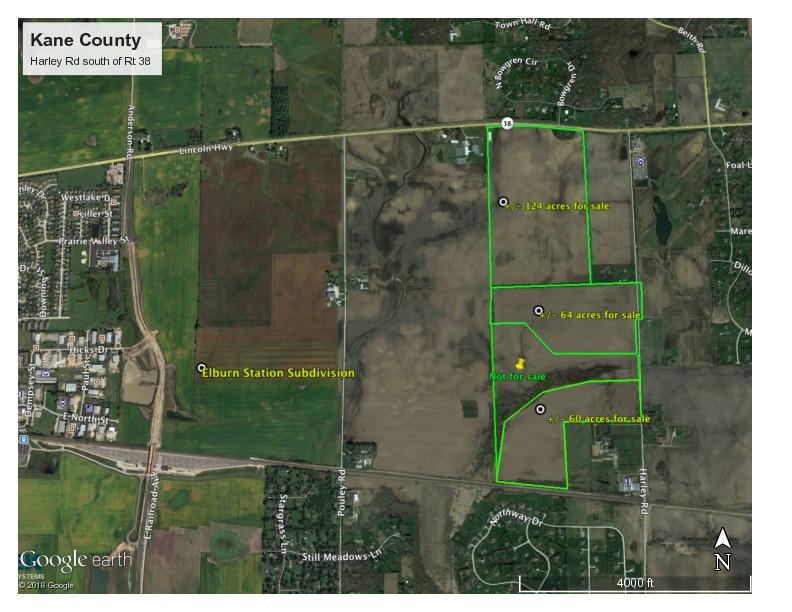
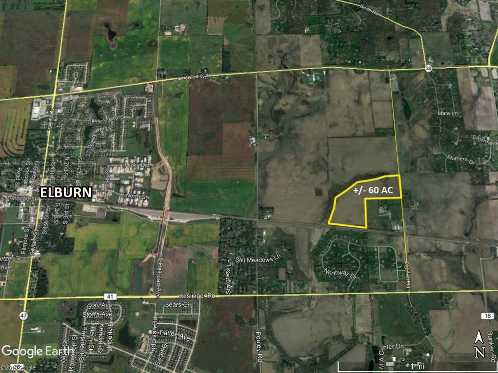
2 OFFERING SUMMARY Sale Price: $660,000 Price / Acre: $11,000 PROPERTY OVERVIEW +/- 60 acres available for purchase on the west side of Harley Road, South of Rt. 38. This site has Harley Road frontage. - Motivated seller - Residential development potential - Contiguous 124 AC Route 38 frontage parcel to the north also available from other seller - Future Development with less than 1 mile from Elburn Station Residential Subdivision that is under construction Lot Size: Zoning: 60.0 Acres Ag Adjacent parcels available - Contact Broker LOCATION OVERVIEW - Less than 1 mile from Elburn Station Residential Subdivision - Unincorporated Kane County - 5 minute drive west to Downtown Elburn
3

4 Aerial Map map center: 41 53' 30.17, ' 46 0ft 997ft 1995ft 3-39N-7E Kane County Illinois 2/19/2018 Field borders provided by Farm Service Agency as of 5/21/2008. Soils data provided by University of Illinois at Champaign-Urbana.


5 Soils Map State: County: Location: Township: Illinois Kane 3-39N-7E Blackberry Acres: Date: 2/19/2018 Soils data provided by USDA and NRCS. Area Symbol: IL089, Soil Area Version: 11 Code Soil Description Acres Percent of field **512B Danabrook silt loam, 2 to 5 percent slopes **656C2 Octagon silt loam, 4 to 6 percent slopes, eroded 152A Drummer silty clay loam, 0 to 2 percent slopes 154A Flanagan silt loam, 0 to 2 percent slopes 356A Elpaso silty clay loam, 0 to 2 percent slopes 198A Elburn silt loam, 0 to 2 percent slopes Il. State Productivity Index Legend Subsoil rooting a Corn Bu/A Soybeans Bu/A Wheat Bu/A Oats Crop productivity index for Bu/A b optimum management % FAV **185 **58 **72 **99 ** % FAV **151 **49 **61 **74 ** % FAV % FAV % FAV % FAV Weighted Average Table: Optimum Crop Productivity Ratings for Illinois Soil by K.R. Olson and J.M. Lang, Office of Research, ACES, University of Illinois at Champaign-Urbana. Version: 1/2/2012 Amended Table S2 B811 Crop yields and productivity indices for optimum management (B811) are maintained at the following NRES web site: ** Indexes adjusted for slope and erosion according to Bulletin 811 Table S3 a UNF = unfavorable; FAV = favorable b Soils in the southern region were not rated for oats and are shown with a zero "0". *c: Using Capabilities Class Dominant Condition Aggregation Method Soils data provided by USDA and NRCS. Soils data provided by University of Illinois at Champaign-Urbana.

6

7 POPULATION 1 MILE 5 MILES 10 MILES TOTAL POPULATION 1,448 39, ,952 MEDIAN AGE MEDIAN AGE (MALE) MEDIAN AGE (FEMALE) HOUSEHOLDS & INCOME 1 MILE 5 MILES 10 MILES TOTAL HOUSEHOLDS ,378 73,984 # OF PERSONS PER HH AVERAGE HH INCOME $140,856 $132,705 $111,030 AVERAGE HOUSE VALUE $314,062 $372,469 * Demographic data derived from 2010 US Census
SW CORNER ROUTE 38 AND HARLEY ROAD SW CORNER ROUTE 38 & HARLEY ROAD, KANE COUNTY, IL 60119
 REDUCED: Land For Sale SW CORNER ROUTE 38 AND HARLEY ROAD REDUCED: 124 AC ON IL ROUTE 38 OFFERING SUMMARY Sale Price: $1,643,000 Price / Acre: $13,250/AC PROPERTY OVERVIEW This 124 AC parcel has approximately
Aerial Map. map center: 38 0' 55.53, ' S-4E Franklin County Illinois
 Aerial Map map center: 38 0' 55.53, -88 42' 58.78 0ft 594ft 1188ft 11/24/2016 Field borders provided by Farm Service Agency as of 5/21/2008. Soils data provided by University of at Champaign-Urbana. Topography
Harding Real Estate Vacant Acres Thompson Rd., Woodstock, IL
 Harding Real Estate 325.31 Vacant Acres Thompson Rd., Woodstock, IL Randy Erwin, Broker Associate Natalie Torres, Broker Associate BHHS Starck Real Estate 1710 South Eastwood Dr. Woodstock, IL. 60098 Randy@RandyErwin.com
LAND FOR SALE 30 ACRES M/L FLOYD COUNTY, IOWA LISTING # DOUGLAS R. YEGGE C: O:
 LAND FOR SALE LISTING #13886 30 ACRES M/L FLOYD COUNTY, IOWA DOUGLAS R. YEGGE C: 563-320-9900 O: 563-659-8185 Doug@PeoplesCompany.com ALAN MCNEIL C: 563-321-1125 O: 563-659-8185 Alan@PeoplesCompany.com
173 ACRES - RILEY COUNTY, KS
 Buyers, Sellers & Land Connected PRICE: $690,000 ACRES: 173 COUNTY: RILEY STATE: KANSAS First Class Hunting with Outstanding Income Potential If you have ever dreamed of owning your very own piece of first
131 ACRES M/L VAN BUREN COUNTY, IOWA LISTING #458 JIM KEDLEY. C: O:
 131 ACRES M/L VAN BUREN COUNTY, IOWA LISTING #458 JIM KEDLEY C: 563-212-5401 O: 563-659-8185 Jimkedley@totalrealtyco.com CWC Holdings LLC, 131 Acres M/L, Van Buren County, IA TOTAL ACRES: 131 MOL PRICE:
80 ACRES M/L CEDAR COUNTY, IA LISTING #465 DOUGLAS R. YEGGE ALAN MCNEIL. C: O:
 80 ACRES M/L CEDAR COUNTY, IA LISTING #465 DOUGLAS R. YEGGE C: 563-320-9900 O: 563-659-8185 total@totalrealtyco.com ALAN MCNEIL C: 563-321-1125 O: 563-659-8185 alan@totalrealtyco.com Kroemer, 80 Acres
FARMLAND AUCTION. FSA INFORMATION: Farmland: acres Cropland: acres Tillable: acres
 FARMLAND AUCTION January 22, 2019 at 10:30 am Keep an eye on BarnesRealty.com for possible blizzard date of 1/24/2019 Fisher Community Center, 201 E. Iowa St. Hiawatha, KS 66434 Here is a very productive
LAND FOR SALE 314 ACRES M/L BERG, WORTH COUNTY, IOWA LISTING # DOUGLAS R. YEGGE C: O:
 LAND FOR SALE LISTING #13870 314 ACRES M/L BERG, WORTH COUNTY, IOWA DOUGLAS R. YEGGE C: 563-320-9900 O: 563-659-8185 Doug@PeoplesCompany.com ALAN MCNEIL C: 563-321-1125 O: 563-659-8185 Alan@PeoplesCompany.com
Farmland For Sale 3 Tracts /- acres Webster County, Iowa Section 31, T88N, R30W & Section 33, T88N, R29W
 Farmland For Sale 3 Tracts 316.02 +/- acres Webster County, Section 31, T88N, R30W & Section 33, T88N, R29W Contact Martin today! 309-242-7299 mthornton@hbtbank.com Martin G. Thornton, Broker 200 W. College
LAND FOR SALE 82 ACRES M/L CEDAR COUNTY, IOWA LISTING # DOUGLAS R. YEGGE C: O:
 LAND FOR SALE LISTING #13968 82 ACRES M/L CEDAR COUNTY, IOWA DOUGLAS R. YEGGE C: 563-320-9900 O: 563-659-8185 Doug@PeoplesCompany.com ALAN MCNEIL C: 563-321-1125 O: 563-659-8185 Alan@PeoplesCompany.com
Deuel County Dryland
 Deuel County Dryland Two parcels of dryland farm ground near Lewellen, NE Property Highlights List Price $852,474 $786,877 Location 12-15 miles south of Lewellen, Ne or the same distance from Big Springs,
365.8 Acres +/- Brown County, KS February 28, 2019 at 10:30 am Community Building, 511 West Front Street, Fairview, KS
 Farmland Auction February 28, 2019 at 10:30 am Community Building, 511 West Front Street, Fairview, KS This excellent Brown County farm is just North of Fairview, KS and it will be selling in 3 tracts
State: Kansas County: Sherman Location: S-037W Township: Union Acres: Date: 12/19/2011. Maps provided by:
 Soils Map State: Kansas County: Sherman Location: 007-009S-037W Township: Union Acres: 147.8 Date: 12/19/2011 Fsa borders provided by the Farm Service Agency as of May 23, 2008. Soils data provided by
80 ACRES M/L BOONE COUNTY, IOWA LISTING # Pilot Mound, Iowa. I Avenue. 130th Street. Co Hwy P th Street
 Co Hwy P70 I Avenue 80 ACRES M/L BOONE COUNTY, IOWA CAPTION Pilot Mound, 130th Street 130th Street LISTING #12320 New Listing Price! $800,000 DESCRIPTION: High Quality Farm in Strong Farming Area and potential
Land Sales Specialists Setting the trend for how Real Estate is sold in the Midwest.
 Land Sales Specialists Setting the trend for how Real Estate is sold in the Midwest. www.barnesrealty.com 18156 Hwy 59 Mound City, MO 64470 (660) 442-3177 1711 Oregon Hiawatha, KS 66434 (785) 742-4580
Auction Location Eagles Club 316 S. 2 nd Street, Aberdeen, SD
 Auction Location Eagles Club 316 S. 2 nd Street, Aberdeen, SD Welcome We would like to invite and welcome you to our public auction! This is an excellent opportunity to add Brown County cropland to your
Demoss Farm & Home 118 Acres, M/L W. 209th Ave. Pattonsburg, Mo 64670
 118 Acres, M/L 39436 W. 209th Ave. Pattonsburg, Mo 64670 PRICE: $400,000.00 LAND USE: FSA shows approx. 118.32 farmland acres, ml, of which there were 36.47 acres of effective cropland with the remainder
WALKER FEEDLOT Total taxable acres, part fenced. 4 homes & multiple nice/modern outbldgs hd feedyard with sprinklers a-shkd-0002
 ABILENE WALKER FEEDLOT 38.7 Total taxable acres, part fenced 4 homes & multiple nice/modern outbldgs 3500 hd feedyard with sprinklers a-shkd-0002 Center pivot irrigation from lagoons 999 hd feedlot A-SHDK-B020
280 ACRES - HOWELL COUNTY, MO
 PRICE: $434,700 ACRES: 280 COUNTY: HOWELL STATE: MISSOURI For more information contact: KYLE ORF, Land Agent 417.988.3333 KyleOrf@MidwestLandGroup.com MidwestLandGroup.com 100 280ACRES ACRES- -COUNTY,
FOR SALE HILL FAMILY FARM WATKINS CORNER, AR. Phillips County, Arkansas: 2,300+/- Acre Irrigated Grain Farm NEW PRICE/YIELD UPDATES:
 SOLD FARMLAND ADVISORS FOR SALE HILL FAMILY FARM WATKINS CORNER, AR 2,300+/- Acres - Phillips County, Arkansas $10,950,000 Phillips County, Arkansas: 2,300+/- Acre Irrigated Grain Farm NEW PRICE/YIELD
FOR SALE NEW PRICE HILL FAMILY FARM WATKINS CORNER, AR. Phillips County, Arkansas: 2,300+/- Acre Irrigated Grain Farm NEW PRICE/YIELD UPDATES:
 NEW PRICE FARMLAND ADVISORS FOR SALE HILL FAMILY FARM WATKINS CORNER, AR 2,300+/- Acres - Phillips County, Arkansas $10,950,000 Phillips County, Arkansas: 2,300+/- Acre Irrigated Grain Farm NEW PRICE/YIELD
Northeast Perkins County Pivots
 Northeast Perkins County Pivots 315.9± acres of center pivot irrigated farmland Southeast of Paxton, NE Email: Jordan@lashleyland.com Property Highlights List Price $1,550,000 Location Southeast of Paxton,
Yields of Non-Irrigated Crops (Component): Soybeans (Bu) Edgecombe County, North Carolina, and Halifax... (SOYBEANS)
: Soybeans (Bu) Edgecombe County, North Carolina, and Halifax... (SOYBEANS)") 77 37' 52'' W Yields of Non-Irrigated Crops (Component): Soybeans (Bu) Edgecombe County, North Carolina, and Halifax... () 77 36' 28'' W 263300 263600 263900 264200 264500 264800 265100 36 6' 59'' N 36
77 37' 52'' W Yields of Non-Irrigated Crops (Component): Soybeans (Bu) Edgecombe County, North Carolina, and Halifax... () 77 36' 28'' W 263300 263600 263900 264200 264500 264800 265100 36 6' 59'' N 36
FARMLAND FOR SALE ± Acres 5 Tracts
 Now is your chance to acquire productive farmland in Greene County, Illinois. Greene County, IL FARMLAND FOR SALE 756.08± Acres 5 Tracts Highly productive riverbottom farms Heavily improved with tiling
Colusa County Almonds
 Morgan Houchin. 3430 Unicorn Road Bakersfield, CA 93308 mobile office efax 526.97 +/- Acres of Colusa County Almonds Cork McIsaac, Broker. Broker License No. 01216717 P.O. Box 1076 West Sacramento, CA
For Sale at $290,000.00
 We are pleased to present Stearns Property 77± Acres Forest Township, Rice County For Sale at $290,000.00 Listing Agent: Charles Wingert Office: 507-345-LAND (5263) Toll Free: 800-730-LAND (5263) Direct:
2016 Iowa FFA Soils Evaluation CDE Exam
 2016 Iowa FFA Soils Evaluation CDE Exam 1. Which of the following is true regarding soil horizons? a. A horizon is darker in color and has more organic matter b. B horizon is darker in color and has more
268 Acres m/l, Iowa County, IA. Offered in 2 Remaining Parcels. Parcel Ac. m/l Parcel 2-81 Ac. m/l Parcel 3-45 Ac. m/l - SOLD!
 LAND FOR SALE 268 Acres m/l, Iowa County, IA Offered in 2 Remaining Parcels Parcel 1-187 Ac. m/l Parcel 2-81 Ac. m/l Parcel 3-45 Ac. m/l - SOLD! Golden Grain Enterprises Good Iowa County Farms Located
Farmland Classification Centre County, Pennsylvania (Student Farm Site) Web Soil Survey National Cooperative Soil Survey
 Web Soil Survey National Cooperative Soil Survey") 256300 256600 256900 257200 257500 257800 258100 77 51' 20'' W 77 53' 26'' W Farmland Classification Centre County, Pennsylvania 258400 258700 259000 40 49' 4'' N 4520600 4520900 4520900 4521200 4521200
256300 256600 256900 257200 257500 257800 258100 77 51' 20'' W 77 53' 26'' W Farmland Classification Centre County, Pennsylvania 258400 258700 259000 40 49' 4'' N 4520600 4520900 4520900 4521200 4521200
Custom Soil Resource Report for Kane County, Illinois
 United States Department of Agriculture Natural Resources Conservation Service A product of the National Cooperative Soil Survey, a joint effort of the United States Department of Agriculture and other
II We Fall-plow or Spring-plow
 II We Fall-plow or Spring-plow r,n Illinois? an JU L 11 R. S. SMITH, in Soil Physics and Soi' Survey., t lllii'vl\).. THE PROBLEM wl1'eth~ 0 f I-plow or to spring-plow IS an especially difficult one in
Publication 122 January 2012 Instructions for Farmland Assessments
 Illinois Department of Revenue Brian Hamer, Director Publication 122 January 2012 Instructions for Farmland Assessments The information in this publication is current as of the date of the publication.
Soils and their Relationship with Agriculture
 Soils and their Relationship with Agriculture Presentation created by Thomas Gallagher Modified by Hank Bignell Capital Area Agriculture and Horticulture Program Cornell University Cooperative Extension
1344 ROCKBRIDGE ROAD STONE MOUNTAIN, GA Jeff Hammond, MPA Director of Retail Services
 1344 ROCKBRIDGE ROAD STONE MOUNTAIN, GA 30087 Jeff Hammond, MPA Director of Retail Services 210.889.6819 jhammond@svn.com SVN CREVISTON REALTY, INC. 10929 CRABAPPLE ROAD, SUITE 201, ROSWELL, GA 30075 OFFERING
DOWNTOWN MOORESVILLE RETAIL
 DOWNTOWN MOORESVILLE RETAIL 156 N BROAD STREET MOORESVILLE, NC 28115 Paula Quickel Associate Advisor 704.746.5139 paula.quickel@svn.com Spencer Crigler Associate Advisor 704.892.5653 spencer.crigler@svn.com
Unit II Soil Management
 Unit II Soil Management Lesson 2: Using Soil Survey Manuals Soil survey manuals provide useful information for grassland management. Soil scientists evaluate the soil for chemical and physical properties,
STATE TAX COMMISSION OF MISSOURI ASSESSOR MANUAL
 STATE TAX COMMISSION OF MISSOURI ASSESSOR MANUAL CHAPTER: REVISION DATE: 10/1/2008 Page 1 of 18 7.3 The purpose of this section of the Assessor s Manual is to supplement the State Tax Commission s published
.33 AC AC RETAIL LAND FOR SALE OR BUILD TO SUIT ORCHARD ROAD & OAK STREET, NORTH AURORA, IL 60542
 Development Opportunity.33 AC - 6.74 AC RETAIL LAND FOR SALE OR BUILD TO SUIT ORCHARD ROAD & OAK STREET, NORTH AURORA, IL 60542 OFFERING SUMMARY Price / Acre: See Enclosed Pricing Summary Lot Size:.33
Alternative Crop Suitability Methodology
 Alternative Crop Suitability Methodology The Alternative Agriculture in Missouri Hub on Community Commons includes model-based ratings of natural suitability for selected alternative crops. These ratings
Iowa FFA Soil Career Development Event 2008
 Iowa FFA Soil Career Development Event 2008 1. In Iowa, corn suitability ratings for soil mapping units specifies a. natural weather conditions b. surface and subsurface drainage installed where needed
Sacramento River Farmland Anderson, California
 AG-LAND INVESTMENT BROKERS 275 Sale Lane / P. O. Box 896 Red Bluff, CA 96080 530.529.4400 office / 530.527.5042 fax Sacramento River Farmland Anderson, California Property: 43 +/- acres of farmland with
DO YOU KNOW YOUR SOILS? (Rev. 10/11)
") DO YOU KNOW YOUR SOILS? (Rev. 10/11) Circle all the correct answers. 1. What is the layer normally present on the surface of the soil in cropped fields? a. O c. Ap e. B g. R b. A d. E f. C 2. Available
DO YOU KNOW YOUR SOILS? (Rev. 10/11) Circle all the correct answers. 1. What is the layer normally present on the surface of the soil in cropped fields? a. O c. Ap e. B g. R b. A d. E f. C 2. Available
Bull Canyon Ranch 2750 BULL CANYON ROAD, SANTA MARIA, CALIFORNIA PRESENTED FOR SALE BY: Rincon corporation
 Bull Canyon Ranch 2750 BULL CANYON ROAD, SANTA MARIA, CALIFORNIA PRESENTED FOR SALE BY: Rincon corporation THE FULL SERVICE REAL ESTATE COMPANY FOR THE AGRICULTURAL COMMUNITY Bull canyon ranch, santa maria
Understanding Soil Variability to Utilize Variable Rate Fertilizer Technology
 Understanding Soil Variability to Utilize Variable Rate Fertilizer Technology Agronomy Update -2012 Red Deer, AB Jan 17 & 18, 2012 Ross H. McKenzie Research Scientist Agronomy Research & Innovation Div.
LAND FOR SALE. Beautiful Farmstead. Pifer s. Price: $1,250, /- Acres Green County, WI
 Beautiful Farmstead LAND FOR SALE 176 +/- Acres Green County, WI Price: $1,250,000 Auction & Realty - Robert Scott Pifer, Broker (#56685-90) RE Entity License #937110-91, Auction Company License #429-53
Custom Soil Resource Report for Craighead County, Arkansas
 United States Department of Agriculture Natural Resources Conservation Service A product of the National Cooperative Soil Survey, a joint effort of the United States Department of Agriculture and other
Mechanisms of Nutrient Uptake: Is Fertilization Enough?
 Mechanisms of Nutrient Uptake: Is Fertilization Enough? Fabián G. Fernández & Water Quality Specialist Department of Soil, Water, and Climate fabiangf@umn.edu Conference 09 Feb. 2016, Morton, MN Justice
COPLAY BOROUGH COMPREHENSIVE PLAN
 COPLAY BOROUGH COMPREHENSIVE PLAN Lehigh County, Pennsylvania Adopted by Coplay Borough Council on May 11, 2010 Urban Research and Development Corporation Bethlehem, PA with Keystone Consulting Engineers,
Soil Interpretations Erosion and Sedimentation Control Planning and Design Workshop
 Soil Interpretations Erosion and Sedimentation Control Planning and Design Workshop Presented by Richard Brooks Presentation prepared by Kristin May Resource Soil Scientists USDA-Natural Resources Conservation
Area 3 Envirothon Soils Questions Key
 Area 3 Envirothon Soils Questions Key 1. Soil aeration is the exchange of air in soil with air from the atmosphere. When a soil is well aerated, the air within the soil is very similar to the atmosphere
Custom Soil Resource Report for Orange County, Virginia
 United States Department of Agriculture Natural Resources Conservation Service A product of the National Cooperative Soil Survey, a joint effort of the United States Department of Agriculture and other
Soil characteristics that influence nitrogen and water management
 Section C Soil characteristics that influence nitrogen and water management Soil characteristics vary across the landscape Soils vary from one field to another, and often within the same field. Soil differences
Land Capability Classifications
 Land Capability Classifications Unit: Soil Science Problem Area: Basic Principles of Soil Science Student Learning Objectives. Instruction in this lesson should result in students achieving the following
 108 40' 29'' W Soil Map Mesa County Area, Colorado 108 36' 55'' W 39 10' 11'' N 39 6' 31'' N 4331700 4332500 4333300 4334100 4334900 4335700 4336500 4337300 4338100 701100 701900 702700 703500 704300 705100
SOIL DATA: Avondale. in Allen, TX. This information was taken from NRCS web soil survey of Collin County, Texas.
 SOIL DATA: Avondale in Allen, TX This information was taken from NRCS web soil survey of Collin County, Texas. United States Department of Agriculture Soil Conservation Service in cooperation with Texas
Loam: About 40% sand, 40% silt, 20% clay. Mixture of pore sizes to balance water retention and aeration. Considered the best soil for growing crops.
 Soil Characteristics Soil is formed from a combination of two Primary sources: Weathering of Parent Rock ( ) = material introduced by plants, animals, and decomposers Minor sources: Nutrients incorporated
RETAIL PAD FOR LAND LEASE
 0.5 Acre Lot Retail Pad for Land Lease Anchored by Westlake Ace Hardware and Aaron's Rental Just down the road from Bass Pro Shops Outdoor World Headquarters Recently redeveloped Under New Ownership rbmurray.com
Soil Survey of San Luis Obispo County, California Paso Robles Area
 United States Department of Agriculture Soil Conservation Service In cooperation with University of California Agricultural Experiment Station Soil Survey of San Luis Obispo County, California Paso Robles
Soil moisure, vol. % Precipitation, in. BSEN 4210 Irrigation HW 2 Daily Rainfall and Soil Moisture Ann Nunnelley 4 Sept. 2015
 BSEN 4210 Irrigation HW 2 Daily Rainfall and Ann Nunnelley 4 Sept. 2015 The following graphs and tables represent the precipitation and soil properties from the Princeton#1 SCAN site (site# 2005) located
2012 FINAL SOILS AREA 2 Envirothon Questions Answer KEY
 2012 FINAL SOILS AREA 2 Envirothon Questions Answer KEY Questions 1-6 to be answered at the soil pit: 1. Soil scientists categorize soils by drainage classes. What is the drainage class of the soil at
FOR SALE. Arvin Edison Vineyard & Open Land Gross Acres Kern County, CA
 Arvin Edison Vineyard & Open Land FOR SALE Property Highlights Arvin Edison Water Storage District Class I and II Soils Neighboring properties planted to almonds, vineyards, and citrus The information
Horner-McLaughlin Woods: Soil Types
 Horner-McLaughlin Woods: Soil Types Not present at HMW Adrian Muck Conover Loam 0-4% Slopes Houghton Muck Miami Loam 2-6% Slopes Miami Loam 6-12% Slopes Miami Loam 12-18% Slopes t 0 0.125 0.25 Miles Mary
ON LANDSCAPING, SOILS, SOIL AMENDMENTS AND PROPER SEED ESTABLISHMENT (BOTH GRASS LAWNS AND MEADOWS).
.") ON LANDSCAPING, SOILS, SOIL AMENDMENTS AND PROPER SEED ESTABLISHMENT (BOTH GRASS LAWNS AND MEADOWS). John D. Chibirka USDA-NRCS Resource Soil Scientist 1238 County Welfare Road, Suite 220 Leesport, PA
ON LANDSCAPING, SOILS, SOIL AMENDMENTS AND PROPER SEED ESTABLISHMENT (BOTH GRASS LAWNS AND MEADOWS). John D. Chibirka USDA-NRCS Resource Soil Scientist 1238 County Welfare Road, Suite 220 Leesport, PA
Richfield Prunes, Pistachios & Walnuts
 AG-LAND Investment Brokers 275 Sale Lane Red Bluff, CA 96080 530-529-4400 Fax 530-527-5042 Richfield Prunes, Pistachios & Walnuts 210 +/- acres 3 Parcels Corning, CA - Tehama County jsubject AG-LAND
NYC Envirothon 2017 Soil Science Review. Richard K Shaw USDA-NRCS
 NYC Envirothon 2017 Soil Science Review Richard K Shaw USDA-NRCS Introduction Who Are We? U.S. Department of Agriculture (1862) Natural Resources Conservation Service (1935) What Do We Do? Provide leadership
Erosion and the value of topsoil: The long view. Peter Scharf University of Missouri
 Erosion and the value of topsoil: The long view Peter Scharf University of Missouri We re a soybean state not much protection for the soil Missouri: one of the most erosive areas in the U.S. > 5 tons/acre/yr
Managing sprinkler irrigation systems
 Section L Managing sprinkler irrigation systems The circular irrigation pattern of the center pivot results is illustrated in Figure L-1. The system is a typical seven to eight span pivot with span widths
Soil Science Curriculum
 Soil Science Curriculum Content and lab derived from the USDA-NRCS Guides for Educators. Go to www.nrcs.usda.gov/soils for the Guides and additional pictures and diagrams. This lesson plan was adapted
report on PLANT DISEASE SOYBEAN SEED QUALITY AND FUNGICIDE SEED TREATMENT
 report on PLANT DISEASE RPD No. 506 March 1988 DEPARTMENT OF CROP SCIENCES UNIVERSITY OF ILLINOIS AT URBANA-CHAMPAIGN SOYBEAN SEED QUALITY AND FUNGICIDE SEED TREATMENT Planting high quality seed is important
Farmers need to develop an understanding
 Fact Sheet 782 Basics of Soil and Plant Fertility Farmers need to develop an understanding of the basics of soil physiology and the factors that affect plant fertility. Not only is this knowledge essential
Corn Irrigation and Water Use
 Corn Irrigation and Water Use Total corn water use in Missouri ranges from 20 35 inches depending on relative maturity of the hybrid, planting date, weather, and location. It is important to keep moisture
2014 Iowa FFA Soil Judging CDE Exam
 2014 Iowa FFA Soil Judging CDE Exam 1. Landscape position is one aspect of evaluating the surface features of a certain tract of land. Identifying the correct landscape position will indicate: a. If the
Salinity Management in Alfalfa Fields
 Salinity Management in Alfalfa Fields Michelle Leinfelder-Miles Delta Farm Advisor, San Joaquin County KAC Alfalfa and Forage Field Day September 12, 2014 Presentation outline Background salts, soils,
DOES YOUR SOIL dry out more slowly after a heavy rain than
 "c. -;> TILTH OF CORN-BE J[ SOILS Y f T-, Cannot Be Maintained ~ 0 I~ 0 Without Legumesuand IG ~.. By R. S. STAUFFER, Associate Professor of Soil Physics DOES YOUR SOIL dry out more slowly after a heavy
UNIVERSITY OF ILLINOIS LIBRARY AT URBANA-CHAMPAIGN B0CKSTACK3
 UNIVERSITY OF ILLINOIS LIBRARY AT URBANA-CHAMPAIGN B0CKSTACK3 i 6307 no4-b 1954 MACON COUNTY SOILS A Revision of Soil Report 45 By H. L. WASCHER and R. T. ODELL UNIVERSITY OF ILLINOIS AGRICULTURAL EXPERIMENT
FOR SALE ± ACRES VALENTINES, VIRGINIA Price: $150,000
 LATITUDE & LONGITUDE 36.566924, -77.764781 Features STRONG RECREATIONAL INVESTMENT opportunity located south of Triplet with access from VSR 600 (Triplet Rd.) to the north. TRACT HAS BEEN RECENTLY CUTOVER
$1,000 Signing Bonus For Leases Executed by the End of 2016
 CLASS A OFFICE SPACE $1,000 Signing Bonus For Leases Executed by the End of 2016 Property Highlights Lease Rate Range Suite # 200 $15.00/SF FSEJ 4,469 SF Sublease with negotiable term Lot Size 1.104 Acres
2011 Wisconsin Envirothon Soils and Land Use Exam
 2011 Wisconsin Envirothon Soils and Land Use Exam USE THE OCONTO COUNTY SOIL SURVEY TO ANSWER QUESTIONS 1-4 The Pensaukee River Wetland Complex is a mixture of state (Pensaukee Wildlife Area) and privately
The Village of Sugar Grove, in partnership with Kane County, the Illinois Department of Transportation, and the Illinois Tollway welcomes you to the
 The Village of Sugar Grove, in partnership with Kane County, the Illinois Department of Transportation, and the Illinois Tollway welcomes you to the first Public Meeting for the proposed interchange improvement
27/01/2017. This event is being run by SAC Consulting. What is Soil?
 This event is being run by SAC Consulting What is Soil? 1 Soil Texture It describes the physical composition of the soil % of sand, silt and clay Refers to the mineral fragments of the soil only water
12/7/2007. Christopher B. Burke Engineering West, Ltd Aux Sable Creek Watershed Plan Update 1
 The ABC s of BMP s Aux Sable Watershed Plan St. Charles, IL Why are BMP s Important Best Management Practices (BMPs) developed as a set of practices which help to achieve goals of the Clean Water Act and
RaC. RaD GlG. GlF. RaD GlE. CeA. RaE. RcD. GoF. GoF SkC. SkD. CfA. AdA. GoF. GoF. GoF. RcD. GgD. GoF. RaE GlE. RaE DbF. GoF. DbE. RaC.
 526300 527400 528500 529600 530700 531800 532900 534000 535100 4240200 4241300 4242400 4243500 4244600 4245700 ADRIAN DR FAIRWAY DR STATE FARM DR DOLORES DR HUDIS ST SANTA ALICIA DR Cotati PAGE ST ALTA
Custom Soil Resource Report for Yamhill Area, Oregon
 United States Department of Agriculture Natural Resources Conservation Service A product of the National Cooperative Soil Survey, a joint effort of the United States Department of Agriculture and other
G T12 G J44 G J46 ST 2. Jerome. Martinstown. Numa. A Maryanna F. Wallin Estate Appanoose County, Iowa
 135th Ave 150th Ave 153rd Ave Elm St N 170th Ave 171st Ave 172nd St 175th Ave 51 0th St Highw ay 2 Highw ay 2 ST 2 Highw ay 2 G T12 135th Ave 522nd St 523rd St Jerome 140th Ave 524th St 1 2 G J44 3 160th
USE OF PRECISION AGRICULTURE TECHNOLOGY TO EVALUATE SOIL COMPACTION
 USE OF PRECISION AGRICULTURE TECHNOLOGY TO EVALUATE SOIL COMPACTION R. Goodson R. Letlow, D. Rester, and J. Stevens AUTHORS:Louisiana CooperativeExtension Service, LSU AgCenter P.O. Box 25100, Baton Rouge,
HORT 102: Soil Properties. Cultivated Plants: Lecture 15. [Teresa Koenig] Slide #: 1 Slide Title: Intro Information Slide
![HORT 102: Soil Properties. Cultivated Plants: Lecture 15. [Teresa Koenig] Slide #: 1 Slide Title: Intro Information Slide](/thumbs/76/74082590.jpg "HORT 102: Soil Properties. Cultivated Plants: Lecture 15. [Teresa Koenig] Slide #: 1 Slide Title: Intro Information Slide") HORT 102: Soil Properties Cultivated Plants: Lecture 15 [Teresa Koenig] Slide #: 1 Slide Title: Intro Information Slide Title: Lecture 15 Soil Properties Speaker: Teresa Koenig Created by: Teresa Koenig,
HORT 102: Soil Properties Cultivated Plants: Lecture 15 [Teresa Koenig] Slide #: 1 Slide Title: Intro Information Slide Title: Lecture 15 Soil Properties Speaker: Teresa Koenig Created by: Teresa Koenig,
2016 Area 3 Envirothon Muskingum County Soils Test ANSWER KEY
 2016 Area 3 Envirothon Muskingum County Soils Test ANSWER KEY 1. The majority of the bedrock in Muskingum County is. a. sedimentary bedrock b. glacial bedrock c. igneous bedrock d. metamorphic bedrock
IOWA FFA STATE SOILS CDE SATURDAY, OCTOBER 13, 2007 AMES, IOWA
 IOWA FFA STATE SOILS CDE SATURDAY, OCTOBER 13, 2007 AMES, IOWA 1. Moderately sloping has what percent slope: a. 9-14% b. 2-5% c. 5-9% d. over 14% 2. Which of the following horizons is the loose underlying
AGRONOMY 375 EXAM III. December 12 and 13, points possible. a) The actual seeding rate for this row segment is.
 The actual seeding rate for this row segment is.") Name AGRONOMY 375 EXAM III December 12 and 13, 2006 100 points possible There are 15 questions plus a bonus question, each of which requires a short answer. Please be concise. Best wishes for your success!
Name AGRONOMY 375 EXAM III December 12 and 13, 2006 100 points possible There are 15 questions plus a bonus question, each of which requires a short answer. Please be concise. Best wishes for your success!
Tract 1. Tract 3. Tract 2. Tract 4. A Taylor Co., IA
 Newport Ave Sec. 7 Sec. 8 235th St Sec. 13 250 th St Sec. 18 Maryl and Ave Sec. 17 T68N R34W T68N R33W 250 th St Sec. 24 257t h St Sec. 19 2 Newp ort Way Sec. 20 Sec. 25 Latitude: 40.6872 N Longitude:
Pifer s. 1, /- Acres Clay County, MN. Written Bid. Land For Lease. WRITTEN BIDS DUE BEFORE: Friday, January 19, :00 p.m.
 1,666.53 +/- Acres Clay County, MN Written Bid Land For Lease WRITTEN BIDS DUE BEFORE: Friday, January 19, 2018 5:00 p.m. OWNER: Hogetvedt Family Rev Trust STOCK PHOTO General Information Land Lease Auction
Topoclimate Southland Soil Technical Data Sheet No Waiau
 This Technical Data Sheet describes the typical average properties of the specified soil. It is essentially a summary of information obtained from one or more profiles of this soil that were examined and
September 20, 2016 Soils Investigation for Agricultural Designation Windemere Place, Missoula County, Montana
 September 20, 201 Soils Investigation for Agricultural Designation Windemere Place, Missoula County, Montana The purpose of this report is to compare on-site soils of the proposed subdivision with the
Pipeline Reclamation at the Williston Research Extension Center - NDSU. Austin Link Agronomy Research Specialist
 Pipeline Reclamation at the Williston Research Extension Center - NDSU Austin Link Agronomy Research Specialist Reclaiming a 36 Pipeline with Crop Rotations Introduction May 15 th, 2015, installation of
Scheduling Irrigation for Horticultural Crops. Patrick Byers Regional Horticulture Specialist Greene County
 Scheduling Irrigation for Horticultural Crops Patrick Byers Regional Horticulture Specialist Greene County Outline Soil characteristics Soil water characteristics Basic watering facts Scheduling irrigation
Scheduling Irrigation for Horticultural Crops
 for Horticultural Crops Patrick Byers Regional Horticulture Specialist Greene County Outline Soil characteristics Soil water characteristics Basic watering facts Scheduling irrigation What is Soil? Soil
YWTG Grower Meetings 2011
 BENEFITS AND VALUE OF YWTG Grower Meetings 2011 Outline Value of spent lime to soil tilth Effects on other rotational crops Application methods Minnesota Pollution Control Agency (MPCA) policies & procedures
Master Gardeners Irrigation
 Master Gardeners Irrigation Today we ll learn about: Sources of irrigation water: culinary vs. secondary water Matching available water to soils and plants Determining when it s time to irrigate Methods
AGRONOMY NOTES. Vol. 29, No. 5, 1996
 AGRONOMY NOTES Vol. 29, No. 5, 1996 Differential Black Walnut Growth on a Recommended Soil Map Unit: Investigation of Related Soil Chemical and Physical Properties D.C. Ditsch, J. Stringer and D. McIntosh