Farmland For Sale 3 Tracts /- acres Webster County, Iowa Section 31, T88N, R30W & Section 33, T88N, R29W
|
|
|
- Gwenda Davidson
- 5 years ago
- Views:
Transcription


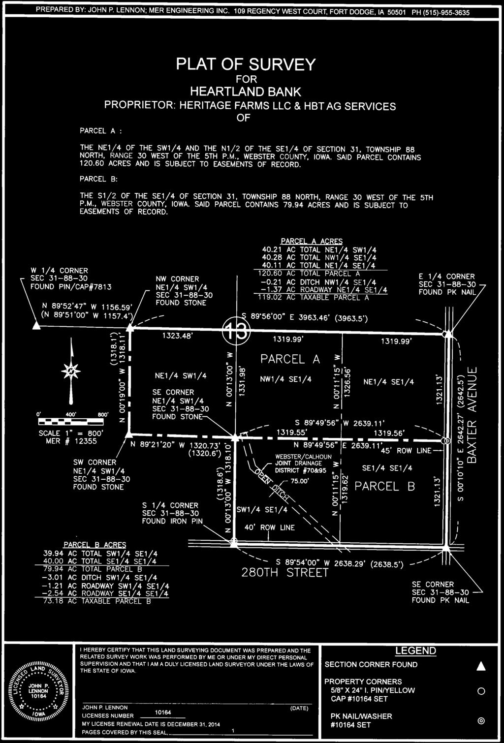
1 Farmland For Sale 3 Tracts /- acres Webster County, Section 31, T88N, R30W & Section 33, T88N, R29W Contact Martin today! mthornton@hbtbank.com Martin G. Thornton, Broker 200 W. College Ave. Normal, IL P: hbtagservices.com


2 Farmland For Sale Webster County, Acres 1 Price/Acre CSR2 3 Major Soil Types $ 10, Webster, Harps, Okoboji, Canesteao, Nicollet $ 10, Canisteo, Nicollet, Webster, Clarion, Okoboji /- $ 11, Canisteo, Marna, Nicollet, Brownton, Nicollet- Guckeen, Okoboji 5, 6 Sale Terms 6 : Terms 6 : Ten percent (10%) down payment will be required from Buyer at execution of the purchase contract. Balance will be due seller at closing. Closing will be scheduled within 30 days of the signing of the contract. Owner is retaining the 2014 crop. Buyer will reimburse Seller and farm Tenant for all fertilizer and tillage applied / performed for the 2015 crop. Title 6 : Seller will furnish Buyer a title policy in the amount of the purchase price subject to the usual and customary exceptions. Mineral rights if any will be conveyed with the land unless otherwise specified in the contract. Taxes 6 : 2014 Real estate taxes, due in 2015, shall be given as a credit to the Buyer at the time of closing. All subsequent year taxes shall be the responsibility of the Buyer. Possession 6 : Seller will give possession after closing and following harvest subject to the Tenant s 2014 lease. Agency 6 : Martin G. Thornton, Broker, is the designated agent with Heartland Bank and Trust Co., licensed Real Estate Broker Corp in Illinois and, represents the Seller of the subject property. Disclosure 6 : 6 While the information contained in the brochure is considered accurate; it is subject to the Buyer s own verification. The Seller, and Heartland Bank and Trust Co, assumes no liability for errors or omissions and reserves the right to alter terms of the listing. 1. Acres- Tracts 1& 2 are surveyed acres; Tract 3 acreage is taken from the tax information. PIN # s taken from property tax bills. 2. Locations are approximate 3. Soils data provided by USDA, NRCS and Surety Maps are approximate 4. Data provided by USDA, Webster County FSA 5. Property borders are approximate, and do NOT reflect actual surveyed boundary line 6. Disclosures Yield History*: Year Corn* SB* Average * All three tracts combined for yield information 2

3

4 Acres and boundaries are approximate Tract 1 "Parcel A" Tract 2 "Parcel B"


5 Soils Map-CSR2 State: County: Location: Township: Webster 31-88N-30W Fulton Acres: Date: 11/26/2014 Soils data provided by USDA and NRCS. Code Soil Description Acres Percent of field Non Irr Class Legend Non Irr Class CSR2** CSR 507 Canisteo clay loam, 0 to 2 percent slopes % IIw Webster clay loam, 0 to 2 percent slopes % IIw Nicollet clay loam, 1 to 3 percent slopes % I Harps clay loam, 0 to 2 percent slopes % IIw Okoboji silty clay loam, depressional, 0 to 1 percent slopes % IIIw B Clarion loam, 2 to 6 percent slopes % IIe Okoboji mucky silty clay loam, depressional, 0 to 1 percent slopes % IIIw Weighted Average **IA has updated the CSR values for each county to CSR2.

6 Aerial Map 31-88N-30W Webster County map center: 42 23' 15.89, 94 23' 8.37 scale: /26/2014


7 Soils Map-CSR2 State: County: Location: Township: Webster 31-88N-30W Fulton Acres: Date: 11/26/2014 Soils data provided by USDA and NRCS. Code Soil Description Acres Percent of field Non Irr Class Legend Non Irr Class CSR2** CSR 107 Webster clay loam, 0 to 2 percent slopes % IIw Harps clay loam, 0 to 2 percent slopes % IIw Okoboji silty clay loam, depressional, 0 to 1 percent slopes % IIIw Canisteo clay loam, 0 to 2 percent slopes % IIw Nicollet clay loam, 1 to 3 percent slopes % I B Clarion loam, 2 to 6 percent slopes % IIe Okoboji mucky silty clay loam, depressional, 0 to 1 percent slopes % IIIw Weighted Average **IA has updated the CSR values for each county to CSR2.

8 Aerial Map 31-88N-30W Webster County map center: 42 23' 10.35, 94 23' 7.44 scale: /26/2014

9 Soils Map-CSR2 State: County: Location: Township: Webster 31-88N-30W Fulton Acres: Date: 11/26/2014 Soils data provided by USDA and NRCS. Code Soil Description Acres Percent of field Non Irr Class Legend Non Irr Class CSR2** CSR 507 Canisteo clay loam, 0 to 2 percent slopes % IIw Nicollet clay loam, 1 to 3 percent slopes % I Webster clay loam, 0 to 2 percent slopes % IIw B Clarion loam, 2 to 6 percent slopes % IIe Okoboji silty clay loam, depressional, 0 to 1 percent slopes % IIIw Harps clay loam, 0 to 2 percent slopes % IIw Okoboji mucky silty clay loam, depressional, 0 to 1 percent slopes % IIIw Weighted Average **IA has updated the CSR values for each county to CSR2.

10 Aerial Map 33-88N-29W Webster County map center: 42 23' 10.52, 94 13' scale: /16/2014


11 Soils Map-CSR2 State: County: Location: Township: Webster 33-88N-29W Elkhorn Acres: Date: 12/16/2014 Soils data provided by USDA and NRCS. Code Soil Description Acres Percent of field Non Irr Class Legend Non Irr Class CSR2** CSR 507 Canisteo clay loam, 0 to 2 percent slopes % IIw Marna silty clay loam, 0 to 2 percent slopes % IIw Nicollet clay loam, 1 to 3 percent slopes % I Brownton silty clay loam, 0 to 2 percent slopes % IIw Nicollet Guckeen complex, 1 to 3 percent slopes % I Okoboji silty clay loam, depressional, 0 to 1 percent slopes % IIIw Weighted Average **IA has updated the CSR values for each county to CSR2.
80 ACRES M/L BOONE COUNTY, IOWA LISTING # Pilot Mound, Iowa. I Avenue. 130th Street. Co Hwy P th Street
 Co Hwy P70 I Avenue 80 ACRES M/L BOONE COUNTY, IOWA CAPTION Pilot Mound, 130th Street 130th Street LISTING #12320 New Listing Price! $800,000 DESCRIPTION: High Quality Farm in Strong Farming Area and potential
LAND FOR SALE 82 ACRES M/L CEDAR COUNTY, IOWA LISTING # DOUGLAS R. YEGGE C: O:
 LAND FOR SALE LISTING #13968 82 ACRES M/L CEDAR COUNTY, IOWA DOUGLAS R. YEGGE C: 563-320-9900 O: 563-659-8185 Doug@PeoplesCompany.com ALAN MCNEIL C: 563-321-1125 O: 563-659-8185 Alan@PeoplesCompany.com
365.8 Acres +/- Brown County, KS February 28, 2019 at 10:30 am Community Building, 511 West Front Street, Fairview, KS
 Farmland Auction February 28, 2019 at 10:30 am Community Building, 511 West Front Street, Fairview, KS This excellent Brown County farm is just North of Fairview, KS and it will be selling in 3 tracts
LAND FOR SALE 30 ACRES M/L FLOYD COUNTY, IOWA LISTING # DOUGLAS R. YEGGE C: O:
 LAND FOR SALE LISTING #13886 30 ACRES M/L FLOYD COUNTY, IOWA DOUGLAS R. YEGGE C: 563-320-9900 O: 563-659-8185 Doug@PeoplesCompany.com ALAN MCNEIL C: 563-321-1125 O: 563-659-8185 Alan@PeoplesCompany.com
LAND AUCTION. Open House: Saturday, August 6th and Saturday, August 20th From 9:00 AM to 11:00 AM at 1220 C Avenue, Scranton, Iowa
 L-1005 LAND AUCTION 1,235+/- Acres, Carroll and Greene Counties, Iowa Friday, August 2, 201 10:00 AM at the Saint Joseph s Parish Center 501 North Locust Street Jefferson, Iowa Highlight Features: Over
FARMLAND AUCTION. FSA INFORMATION: Farmland: acres Cropland: acres Tillable: acres
 FARMLAND AUCTION January 22, 2019 at 10:30 am Keep an eye on BarnesRealty.com for possible blizzard date of 1/24/2019 Fisher Community Center, 201 E. Iowa St. Hiawatha, KS 66434 Here is a very productive
Land Sales Specialists Setting the trend for how Real Estate is sold in the Midwest.
 Land Sales Specialists Setting the trend for how Real Estate is sold in the Midwest. www.barnesrealty.com 18156 Hwy 59 Mound City, MO 64470 (660) 442-3177 1711 Oregon Hiawatha, KS 66434 (785) 742-4580
LAND FOR SALE 314 ACRES M/L BERG, WORTH COUNTY, IOWA LISTING # DOUGLAS R. YEGGE C: O:
 LAND FOR SALE LISTING #13870 314 ACRES M/L BERG, WORTH COUNTY, IOWA DOUGLAS R. YEGGE C: 563-320-9900 O: 563-659-8185 Doug@PeoplesCompany.com ALAN MCNEIL C: 563-321-1125 O: 563-659-8185 Alan@PeoplesCompany.com
Auction Location Eagles Club 316 S. 2 nd Street, Aberdeen, SD
 Auction Location Eagles Club 316 S. 2 nd Street, Aberdeen, SD Welcome We would like to invite and welcome you to our public auction! This is an excellent opportunity to add Brown County cropland to your
80 ACRES M/L CEDAR COUNTY, IA LISTING #465 DOUGLAS R. YEGGE ALAN MCNEIL. C: O:
 80 ACRES M/L CEDAR COUNTY, IA LISTING #465 DOUGLAS R. YEGGE C: 563-320-9900 O: 563-659-8185 total@totalrealtyco.com ALAN MCNEIL C: 563-321-1125 O: 563-659-8185 alan@totalrealtyco.com Kroemer, 80 Acres
131 ACRES M/L VAN BUREN COUNTY, IOWA LISTING #458 JIM KEDLEY. C: O:
 131 ACRES M/L VAN BUREN COUNTY, IOWA LISTING #458 JIM KEDLEY C: 563-212-5401 O: 563-659-8185 Jimkedley@totalrealtyco.com CWC Holdings LLC, 131 Acres M/L, Van Buren County, IA TOTAL ACRES: 131 MOL PRICE:
268 Acres m/l, Iowa County, IA. Offered in 2 Remaining Parcels. Parcel Ac. m/l Parcel 2-81 Ac. m/l Parcel 3-45 Ac. m/l - SOLD!
 LAND FOR SALE 268 Acres m/l, Iowa County, IA Offered in 2 Remaining Parcels Parcel 1-187 Ac. m/l Parcel 2-81 Ac. m/l Parcel 3-45 Ac. m/l - SOLD! Golden Grain Enterprises Good Iowa County Farms Located
Demoss Farm & Home 118 Acres, M/L W. 209th Ave. Pattonsburg, Mo 64670
 118 Acres, M/L 39436 W. 209th Ave. Pattonsburg, Mo 64670 PRICE: $400,000.00 LAND USE: FSA shows approx. 118.32 farmland acres, ml, of which there were 36.47 acres of effective cropland with the remainder
FARMLAND FOR SALE ± Acres 5 Tracts
 Now is your chance to acquire productive farmland in Greene County, Illinois. Greene County, IL FARMLAND FOR SALE 756.08± Acres 5 Tracts Highly productive riverbottom farms Heavily improved with tiling
173 ACRES - RILEY COUNTY, KS
 Buyers, Sellers & Land Connected PRICE: $690,000 ACRES: 173 COUNTY: RILEY STATE: KANSAS First Class Hunting with Outstanding Income Potential If you have ever dreamed of owning your very own piece of first
+/- 60 AC LAND FOR SALE HARLEY ROAD, ELBURN, IL 60119
 Land For Sale OFFERING SUMMARY Sale Price: $660,000 Price / Acre: $11,000 PROPERTY OVERVIEW +/- 60 acres available for purchase on the west side of Harley Road, South of Rt. 38. This site has Harley Road
We are pleased to present Leonard Thorston Revocable Trust ± Acres Charleston Township, Redwood County
 We are pleased to present Leonard Thorston Revocable Trust 158.72 ± Acres Charleston Township, Redwood County PARCEL 1 PARCEL 2 This property to be sold by Sealed Bid Auction Owner: Leonard Thorston Family
Harding Real Estate Vacant Acres Thompson Rd., Woodstock, IL
 Harding Real Estate 325.31 Vacant Acres Thompson Rd., Woodstock, IL Randy Erwin, Broker Associate Natalie Torres, Broker Associate BHHS Starck Real Estate 1710 South Eastwood Dr. Woodstock, IL. 60098 Randy@RandyErwin.com
Aerial Map. map center: 38 0' 55.53, ' S-4E Franklin County Illinois
 Aerial Map map center: 38 0' 55.53, -88 42' 58.78 0ft 594ft 1188ft 11/24/2016 Field borders provided by Farm Service Agency as of 5/21/2008. Soils data provided by University of at Champaign-Urbana. Topography
Deuel County Dryland
 Deuel County Dryland Two parcels of dryland farm ground near Lewellen, NE Property Highlights List Price $852,474 $786,877 Location 12-15 miles south of Lewellen, Ne or the same distance from Big Springs,
State: Kansas County: Sherman Location: S-037W Township: Union Acres: Date: 12/19/2011. Maps provided by:
 Soils Map State: Kansas County: Sherman Location: 007-009S-037W Township: Union Acres: 147.8 Date: 12/19/2011 Fsa borders provided by the Farm Service Agency as of May 23, 2008. Soils data provided by
Northeast Perkins County Pivots
 Northeast Perkins County Pivots 315.9± acres of center pivot irrigated farmland Southeast of Paxton, NE Email: Jordan@lashleyland.com Property Highlights List Price $1,550,000 Location Southeast of Paxton,
SW CORNER ROUTE 38 AND HARLEY ROAD SW CORNER ROUTE 38 & HARLEY ROAD, KANE COUNTY, IL 60119
 REDUCED: Land For Sale SW CORNER ROUTE 38 AND HARLEY ROAD REDUCED: 124 AC ON IL ROUTE 38 OFFERING SUMMARY Sale Price: $1,643,000 Price / Acre: $13,250/AC PROPERTY OVERVIEW This 124 AC parcel has approximately
FOR SALE NEW PRICE HILL FAMILY FARM WATKINS CORNER, AR. Phillips County, Arkansas: 2,300+/- Acre Irrigated Grain Farm NEW PRICE/YIELD UPDATES:
 NEW PRICE FARMLAND ADVISORS FOR SALE HILL FAMILY FARM WATKINS CORNER, AR 2,300+/- Acres - Phillips County, Arkansas $10,950,000 Phillips County, Arkansas: 2,300+/- Acre Irrigated Grain Farm NEW PRICE/YIELD
G T12 G J44 G J46 ST 2. Jerome. Martinstown. Numa. A Maryanna F. Wallin Estate Appanoose County, Iowa
 135th Ave 150th Ave 153rd Ave Elm St N 170th Ave 171st Ave 172nd St 175th Ave 51 0th St Highw ay 2 Highw ay 2 ST 2 Highw ay 2 G T12 135th Ave 522nd St 523rd St Jerome 140th Ave 524th St 1 2 G J44 3 160th
FOR SALE HILL FAMILY FARM WATKINS CORNER, AR. Phillips County, Arkansas: 2,300+/- Acre Irrigated Grain Farm NEW PRICE/YIELD UPDATES:
 SOLD FARMLAND ADVISORS FOR SALE HILL FAMILY FARM WATKINS CORNER, AR 2,300+/- Acres - Phillips County, Arkansas $10,950,000 Phillips County, Arkansas: 2,300+/- Acre Irrigated Grain Farm NEW PRICE/YIELD
For Sale at $290,000.00
 We are pleased to present Stearns Property 77± Acres Forest Township, Rice County For Sale at $290,000.00 Listing Agent: Charles Wingert Office: 507-345-LAND (5263) Toll Free: 800-730-LAND (5263) Direct:
Sacramento River Farmland Anderson, California
 AG-LAND INVESTMENT BROKERS 275 Sale Lane / P. O. Box 896 Red Bluff, CA 96080 530.529.4400 office / 530.527.5042 fax Sacramento River Farmland Anderson, California Property: 43 +/- acres of farmland with
Pifer s. 1, /- Acres Clay County, MN. Written Bid. Land For Lease. WRITTEN BIDS DUE BEFORE: Friday, January 19, :00 p.m.
 1,666.53 +/- Acres Clay County, MN Written Bid Land For Lease WRITTEN BIDS DUE BEFORE: Friday, January 19, 2018 5:00 p.m. OWNER: Hogetvedt Family Rev Trust STOCK PHOTO General Information Land Lease Auction
Tract 1. Tract 3. Tract 2. Tract 4. A Taylor Co., IA
 Newport Ave Sec. 7 Sec. 8 235th St Sec. 13 250 th St Sec. 18 Maryl and Ave Sec. 17 T68N R34W T68N R33W 250 th St Sec. 24 257t h St Sec. 19 2 Newp ort Way Sec. 20 Sec. 25 Latitude: 40.6872 N Longitude:
280 ACRES - HOWELL COUNTY, MO
 PRICE: $434,700 ACRES: 280 COUNTY: HOWELL STATE: MISSOURI For more information contact: KYLE ORF, Land Agent 417.988.3333 KyleOrf@MidwestLandGroup.com MidwestLandGroup.com 100 280ACRES ACRES- -COUNTY,
Soils and their Relationship with Agriculture
 Soils and their Relationship with Agriculture Presentation created by Thomas Gallagher Modified by Hank Bignell Capital Area Agriculture and Horticulture Program Cornell University Cooperative Extension
LAND FOR SALE. Beautiful Farmstead. Pifer s. Price: $1,250, /- Acres Green County, WI
 Beautiful Farmstead LAND FOR SALE 176 +/- Acres Green County, WI Price: $1,250,000 Auction & Realty - Robert Scott Pifer, Broker (#56685-90) RE Entity License #937110-91, Auction Company License #429-53
WALKER FEEDLOT Total taxable acres, part fenced. 4 homes & multiple nice/modern outbldgs hd feedyard with sprinklers a-shkd-0002
 ABILENE WALKER FEEDLOT 38.7 Total taxable acres, part fenced 4 homes & multiple nice/modern outbldgs 3500 hd feedyard with sprinklers a-shkd-0002 Center pivot irrigation from lagoons 999 hd feedlot A-SHDK-B020
Colusa County Almonds
 Morgan Houchin. 3430 Unicorn Road Bakersfield, CA 93308 mobile office efax 526.97 +/- Acres of Colusa County Almonds Cork McIsaac, Broker. Broker License No. 01216717 P.O. Box 1076 West Sacramento, CA
/- Acres Becker County, MN (see pgs 1-6) /- Acres Clay County, MN (see pgs 8-14) Pifer s Written Bid.
 /- Acres Clay County, MN (see pgs 8-14) Pifer s Written Bid.") 812.02 +/- Acres Becker County, MN (see pgs 1-6) 810.14 +/- Acres Clay County, MN (see pgs 8-14) Written Bid Land For Lease WRITTEN BIDS DUE BEFORE: Friday, December 8, 2017 5:00 p.m. OWNERS: Case Agricultural
812.02 +/- Acres Becker County, MN (see pgs 1-6) 810.14 +/- Acres Clay County, MN (see pgs 8-14) Written Bid Land For Lease WRITTEN BIDS DUE BEFORE: Friday, December 8, 2017 5:00 p.m. OWNERS: Case Agricultural
1. Tree & Stand Growth Group Presentations 2. Lab Tues Evaluating communities for wildlife habitat 3. Take Home Test next Tuesday
 NREM 301 Forest Ecology & Soils Day 16 October 9, 2008 1. Tree & Stand Growth Group Presentations 2. Lab Tues Evaluating communities for wildlife habitat 3. Take Home Test next Tuesday Create a Diagram
Richfield Prunes, Pistachios & Walnuts
 AG-LAND Investment Brokers 275 Sale Lane Red Bluff, CA 96080 530-529-4400 Fax 530-527-5042 Richfield Prunes, Pistachios & Walnuts 210 +/- acres 3 Parcels Corning, CA - Tehama County jsubject AG-LAND
2016 Iowa FFA Soils Evaluation CDE Exam
 2016 Iowa FFA Soils Evaluation CDE Exam 1. Which of the following is true regarding soil horizons? a. A horizon is darker in color and has more organic matter b. B horizon is darker in color and has more
2014 Iowa FFA Soil Judging CDE Exam
 2014 Iowa FFA Soil Judging CDE Exam 1. Landscape position is one aspect of evaluating the surface features of a certain tract of land. Identifying the correct landscape position will indicate: a. If the
House & 3.21 Acres, Linn County, IA. 927 Linn Ridge Road, Mount Vernon, Iowa 52314
 ACREAGE FOR SALE House & 3.21 Acres, Linn County, IA 927 Linn Ridge Road, Mount Vernon, Iowa 52314 Property Information Location From Mount Vernon: Four miles north on Springville Road and one mile west
Darlington Pines 1,295. At a Glance: Property Features. Acreage: 622 +/- acres (Sub-dividable) Asking Price:
 Asking Price:") ONLY $ 1,95 PER ACRE Property Features Located in the fertile northern reaches of Holmes County, Florida, the 6-acre tract has been continuously owned by the Spann family for over 50 years, once serving
ONLY $ 1,95 PER ACRE Property Features Located in the fertile northern reaches of Holmes County, Florida, the 6-acre tract has been continuously owned by the Spann family for over 50 years, once serving
Farmland Classification Centre County, Pennsylvania (Student Farm Site) Web Soil Survey National Cooperative Soil Survey
 Web Soil Survey National Cooperative Soil Survey") 256300 256600 256900 257200 257500 257800 258100 77 51' 20'' W 77 53' 26'' W Farmland Classification Centre County, Pennsylvania 258400 258700 259000 40 49' 4'' N 4520600 4520900 4520900 4521200 4521200
256300 256600 256900 257200 257500 257800 258100 77 51' 20'' W 77 53' 26'' W Farmland Classification Centre County, Pennsylvania 258400 258700 259000 40 49' 4'' N 4520600 4520900 4520900 4521200 4521200
Rural Soils Career Development Event
 Rural Soils Career Development Event Effective August 1, 2014 Important Note: Please thoroughly read the Introduction and General Rules Section at the beginning of this handbook for complete rules and
FOR SALE ± ACRES VALENTINES, VIRGINIA Price: $150,000
 LATITUDE & LONGITUDE 36.566924, -77.764781 Features STRONG RECREATIONAL INVESTMENT opportunity located south of Triplet with access from VSR 600 (Triplet Rd.) to the north. TRACT HAS BEEN RECENTLY CUTOVER
Bull Canyon Ranch 2750 BULL CANYON ROAD, SANTA MARIA, CALIFORNIA PRESENTED FOR SALE BY: Rincon corporation
 Bull Canyon Ranch 2750 BULL CANYON ROAD, SANTA MARIA, CALIFORNIA PRESENTED FOR SALE BY: Rincon corporation THE FULL SERVICE REAL ESTATE COMPANY FOR THE AGRICULTURAL COMMUNITY Bull canyon ranch, santa maria
Land for Sale. Marion County, Georgia. $2,160,000 +/- 900 Acres $2,400 per Acre
 Land for Sale Marion County, Georgia 2 Contents Property Fact Sheet... 3 Regional Map... 4 Local Map... 5 Aerial Map... 6 Major Soil Types Map... 7 Soil Classification Map... 8 Soil Classification Table...
Quiz! Brief review of Tuesday s Lab Soil Bio- and Toposequences. Soil & Plant Water Please pick up next Tuesday s Lab Agricultural Ecosystems
 NREM 301 Day 10 Quiz! Brief review of Tuesday s Lab Soil Bio- and Toposequences Soil & Plant Water Please pick up next Tuesday s Lab Agricultural Ecosystems Coring is hard work! Finally got one! Sunshine
Newnham Court Farm NEWNHAM BRIDGE TENBURY WELLS WORCESTERSHIRE
 Newnham Court Farm NEWNHAM BRIDGE TENBURY WELLS WORCESTERSHIRE Newnham Court Farm NEWNHAM BRIDGE TENBURY WELLS WORCESTERSHIRE Tenbury Wells 5 miles Worcester 19 miles M5 (J5) 25 miles (All distances approximate)
Yields of Non-Irrigated Crops (Component): Soybeans (Bu) Edgecombe County, North Carolina, and Halifax... (SOYBEANS)
: Soybeans (Bu) Edgecombe County, North Carolina, and Halifax... (SOYBEANS)") 77 37' 52'' W Yields of Non-Irrigated Crops (Component): Soybeans (Bu) Edgecombe County, North Carolina, and Halifax... () 77 36' 28'' W 263300 263600 263900 264200 264500 264800 265100 36 6' 59'' N 36
77 37' 52'' W Yields of Non-Irrigated Crops (Component): Soybeans (Bu) Edgecombe County, North Carolina, and Halifax... () 77 36' 28'' W 263300 263600 263900 264200 264500 264800 265100 36 6' 59'' N 36
FOR SALE. Arvin Edison Vineyard & Open Land Gross Acres Kern County, CA
 Arvin Edison Vineyard & Open Land FOR SALE Property Highlights Arvin Edison Water Storage District Class I and II Soils Neighboring properties planted to almonds, vineyards, and citrus The information
Non-Metallic Mining Reclamation Checklist
 Eau Claire County DEPARTMENT OF PLANNING AND DEVELOPMENT Eau Claire County Courthouse, Rm. 1510 721 Oxford Avenue Eau Claire, Wisconsin 54703-5481 (715) 839-4741 f Housing & Community Development 839-6240
FOR SALE ± Acres Fresno County, California. CA BRE # Exclusively Presented By: Pearson Realty
 FOR SALE Orange Cove Citrus Ranch with Custom Home 127.33± Acres Fresno County, California Exclusively Presented By: Pearson Realty Variety of Citrus Plantings Frost Protection District and Well Water
Soil characteristics that influence nitrogen and water management
 Section C Soil characteristics that influence nitrogen and water management Soil characteristics vary across the landscape Soils vary from one field to another, and often within the same field. Soil differences
Referral Early Consultation
 DEPARTMENT OF PLANNING AND COMMUNITY DEVELOPMENT 1010 10 th Street, Suite 3400, Modesto, CA 95354 Phone: 209.525.6330 Fax: 209.525.5911 Date: February 14, 2017 Referral Early Consultation To: Distribution
FOR SALE. Reedley Apricot Ranch ± Acres Fresno County, California. CA BRE #
 FOR SALE Reedley Apricot Ranch 126.89± Acres Fresno County, California Exclusively Presented By: Pearson Realty Majority of soils are Grade 1 Seven apricot varieties Consolidated Irrigation District CALIFORNIA
Environmental Protection Ordinances (Performance Zoning) Bedminster Township, Bucks County
 Bedminster Township, Bucks County") Environmental Protection Ordinances (Performance Zoning) Bedminster Township, Bucks County ARTICLE VI. PERFORMANCE STANDARDS Section 600 Compliance All uses, activities, subdivisions and/or land developments
Environmental Protection Ordinances (Performance Zoning) Bedminster Township, Bucks County ARTICLE VI. PERFORMANCE STANDARDS Section 600 Compliance All uses, activities, subdivisions and/or land developments
 108 40' 29'' W Soil Map Mesa County Area, Colorado 108 36' 55'' W 39 10' 11'' N 39 6' 31'' N 4331700 4332500 4333300 4334100 4334900 4335700 4336500 4337300 4338100 701100 701900 702700 703500 704300 705100
Procedures IV. V. Rural Road Design Option
 i IV. Procedures A. All applicants required to prepare a Conservation Design Subdivision shall provide the Planning Board with a conceptual conventional subdivision design as well as a proposed layout
Northern Branch Corridor SDEIS March 2017
 Northern Branch Corridor SDEIS March 2017 15. 15.1. Chapter Overview 15.1.1. Introduction This chapter discusses changes to the Preferred Alternative resulting in the potential for project improvements
John R Trainor Park Bidwell Park Bidwell-Sacramento River SP SITE Lake Oroville State Rec Area Alpine Park
 FIGURES 1. Site Vicinity Map 2. Site Map Showing Compost Pad Layout and Facility Features 3. Wells Within One Mile of Facility and Groundwater Basin Contour Map 4. Geologic Map 5. Soils Map 6. Zoning Map
Information for File # MMW
 Information for File #07-0870-MMW Applicant: Menards (Tyler Edwards) Corps Contact: Mariah Weitzenkamp Address: 80 Fifth Street East, Suite 700, Saint Paul, MN 0-78 E-Mail: Mariah.M.Weitzenkamp@usace.army.mil
II We Fall-plow or Spring-plow
 II We Fall-plow or Spring-plow r,n Illinois? an JU L 11 R. S. SMITH, in Soil Physics and Soi' Survey., t lllii'vl\).. THE PROBLEM wl1'eth~ 0 f I-plow or to spring-plow IS an especially difficult one in
FOR SALE: LAND Military Road Cottage Grove, MN ACRES READY FOR DEVELOPMENT! 2 PARCELS FACTS & FEATURES
 FOR SALE: LAND FACTS & FEATURES List Price: $825,000 - Will Review All Offers Residential or Mixed-Use Development Possible Potentially Up to 34 Acres Available Total Acreage - 2 Parcels: 10.72 Acres Price
Referral Early Consultation
 DEPARTMENT OF PLANNING AND COMMUNITY DEVELOPMENT 1010 10 TH Street, Suite 3400, Modesto, CA 95354 Planning Phone: (209) 525-6330 Fax: (209) 525-5911 Building Phone: (209) 525-6557 Fax: (209) 525-7759 Date:
SECTION 1 Introduction...1. SECTION 2 Regional Context Criteria for Planning Districts Description of Planning District...
 Table of Contents SECTION 1 Introduction...1 SECTION 2 Regional Context...2 2.1 - Criteria for Planning Districts...2 2.2 - Description of Planning District...2 SECTION 3 Goals & Objectives...5 SECTION
Wallace Country Acreage
 Wallace Country Acreage A stunning brick home surrounded by beautiful landscaping and picturesque views of the Nebraska plains Email: Jordan@lashleyland.com Property Highlights List Price $500,000 Location
Ohio Department of Transportation Inter-Office Communication Central Office Office of Production
 Ohio Department of Transportation Inter-Office Communication Central Office Office of Production Date: August 8, 2005 To: *See Below From: William C. Ujvari, Administrator Subject: Right of Way Monument
Riverview Road Fort Washington, MD. 163 Waterfront Street, Suite #450 National Harbor, MD (301)
") Riverview Road Fort Washington, MD 163 Waterfront Street, Suite #450 National Harbor, MD 20745 (301) 750-7040 www.fleurdelisllc.com 1 Prepared by Monique Anderson Walker Principal +1 301-750-7040 Monique@FleurDeLisLLC.com
Riverview Road Fort Washington, MD 163 Waterfront Street, Suite #450 National Harbor, MD 20745 (301) 750-7040 www.fleurdelisllc.com 1 Prepared by Monique Anderson Walker Principal +1 301-750-7040 Monique@FleurDeLisLLC.com
Information for File #MVP DAS
 Information for File #MVP201702209DAS Applicant: HyVee, Inc. Corps Contact: David Studenski Address: 1114 South Oak Street, La Crescent, Minnesota 559471560 EMail: david.a.studenski@usace.army.mil Phone:
NYC Envirothon 2017 Soil Science Review. Richard K Shaw USDA-NRCS
 NYC Envirothon 2017 Soil Science Review Richard K Shaw USDA-NRCS Introduction Who Are We? U.S. Department of Agriculture (1862) Natural Resources Conservation Service (1935) What Do We Do? Provide leadership
GENERAL INFORMATION What is Stormwater? What is a stormwater utility? What is an impervious surface?
 GENERAL INFORMATION What is Stormwater? Stormwater is rain or snowmelt that falls on streets, parking areas, rooftops, and other developed land and either flows directly into nearby streams or travels
FOR SALE Kimberlina & Wallace Road Kern County, Ca
 Pistachio Orchard FOR SALE Kimberlina & Wallace Road Kern County, Ca The information contained herein may have been obtained from sources other than ASU Commercial. We have not verified such information
classification, available moisture, nematodes or pesticide residues) are to be measured.
 are to be measured.") SOIL SAMPLING PROCEDURES The intention of the following information is to aid you in properly taking soil samples under various conditions and for specific purposes. As it has been said many times, "A
SOIL SAMPLING PROCEDURES The intention of the following information is to aid you in properly taking soil samples under various conditions and for specific purposes. As it has been said many times, "A
Project Narrative For Fruita RV Resort Conditional Use Permit
 Project Narrative For Fruita RV Resort Conditional Use Permit Date: November 18, 2016 Prepared by: Robert W. Jones, II, P.E. Vortex Engineering & Architecture, Inc. 2394 Patterson Rd., Ste. 201 Grand Junction,
2012 FINAL SOILS AREA 2 Envirothon Questions Answer KEY
 2012 FINAL SOILS AREA 2 Envirothon Questions Answer KEY Questions 1-6 to be answered at the soil pit: 1. Soil scientists categorize soils by drainage classes. What is the drainage class of the soil at
FOR SALE OR LEASE ±12,600 SQ. FT. AUTO/TRUCK SERVICE FACILITY
 FOR SALE OR LEASE ±12,600 SQ. FT. AUTO/TRUCK SERVICE FACILITY FOR ADDITIONAL INFORMATION, CONTACT 2 TAYLOR AVENUE CITY OF POUGHKEEPSIE, NY James Martin Senior Vice President Exclusive Broker BUILDING:
Custom Soil Resource Report for Kane County, Illinois
 United States Department of Agriculture Natural Resources Conservation Service A product of the National Cooperative Soil Survey, a joint effort of the United States Department of Agriculture and other
CITY OF LOCKPORT FIRE SPRINKLER & FIRE ALARM SYSTEM INSTALLATION ASSISTANCE PROGRAM
 CITY OF LOCKPORT FIRE SPRINKLER & FIRE ALARM SYSTEM INSTALLATION ASSISTANCE PROGRAM The City of Lockport has implemented a Fire Sprinkler & Fire Alarm System Installation Assistance Program for eligible
HCI ENGINEERING. March 27, City of Thornton, Development Engineering 9500 Civic Center Drive Thornton, CO 80229
 HCI ENGINEERING A division of HABERER CARPENTRY INC. March 27, 2014 Attn: Heath Klein, P.E. City of Thornton, Development Engineering 9500 Civic Center Drive Thornton, CO 80229 Re: Drainage Letter for
We are pleased to present Delwyn Spronk Farm ± Acres Elmer Township, Pipestone County
 We are pleased to present Delwyn Spronk Farm 79.09 ± Acres Elmer Township, Pipestone County SUBJECT PROPERTY This property to be sold by Sealed Bid Auction Owner: Delwyn & Julie Spronk Owner s Attorney:
FOR SALE Temperance Ranch
 Temperance Ave. FOR SALE Temperance Ranch E. American Ave. 162.49± Acres Fresno County, California Exclusively Presented By: Pearson Realty New 13,000 S.F. aluminum solar panel pole barn Four pumps and
2017 Iowa FFA Soil Judging CDE Exam
 2017 Iowa FFA Soil Judging CDE Exam 1. Landscape positions vary in soil composition and makeup. What landscape position would be characterized by having strata and lenses of different textures in the profile:
HOW TO USE THE NITRATE QUICK TEST
 HOW TO USE THE NITRATE QUICK TEST Standard Operating Procedures prepared for the Grower-Shipper Association of Central California by Stefanie Kortman with the assistance of Marc Los Huertos Spanish Translation
Towne Park Estates Subdivision Phase II
 Towne Park Estates Subdivision Phase II ENVIRONMENTAL NARRATIVE October 21, 2014 Submitted to: Submitted by: Horner Environmental Professionals, Inc. 4252 Hay Road Lutz, Florida 33559 HEP TOWNE PARK ESTATES
Alternative Crop Suitability Methodology
 Alternative Crop Suitability Methodology The Alternative Agriculture in Missouri Hub on Community Commons includes model-based ratings of natural suitability for selected alternative crops. These ratings
Radish IPM Elements Revised March, 2012
 Radish IPM Elements Revised March, 2012 Edited by Jim Jasinski Contributing Authors: Celeste Welty (Entomology); Bob Precheur, Mark Bennett, Doug Doohan (Horticulture & Crop Science); Sally Miller (Plant
Referral Early Consultation
 DEPARTMENT OF PLANNING AND COMMUNITY DEVELOPMENT 1010 10 th Street, Suite 3400, Modesto, CA 95354 Phone: 209.525.6330 Fax: 209.525.5911 Date: April 29, 2016 Referral Early Consultation To: Distribution
NRCS Soil Survey Prime Agricultural Land *
 Prime Agricultural Soil cr en to ve r iv e r Sa am Ri Sa n a Jo qu in R Ol d Ri ve r NRCS Soil Survey Prime Agricultural Land * Map created 8/05/2015 This map or dataset was created by the Contra Costa
Managing sprinkler irrigation systems
 Section L Managing sprinkler irrigation systems The circular irrigation pattern of the center pivot results is illustrated in Figure L-1. The system is a typical seven to eight span pivot with span widths
SOIL DATA: Avondale. in Allen, TX. This information was taken from NRCS web soil survey of Collin County, Texas.
 SOIL DATA: Avondale in Allen, TX This information was taken from NRCS web soil survey of Collin County, Texas. United States Department of Agriculture Soil Conservation Service in cooperation with Texas
CIVIL ENGINEERING PERMIT APPLICATION
 CIVIL ENGINEERING PERMIT APPLICATION OFFICIAL USE ONLY Engineering Permit # Date: Received By: Staff Contact: FOR STAFF USE ONLY: OFD RSH LOTT Stormwater Planning Water Shop PLEASE SUBMIT TWO (2) SETS
Showing Instructions. List Date. List Price. Expiration Date. Selling Office Commission. Buy Broker Commission Sign Lockbox Lock Box Code.
 Status Agreement Type List Date Property Type Alternate Property Type Showing Instructions List Price Expiration Date Selling Office Commission Buy Broker Commission Sign Lockbox Lock Box Code Street Number
Custom Soil Resource Report for Craighead County, Arkansas
 United States Department of Agriculture Natural Resources Conservation Service A product of the National Cooperative Soil Survey, a joint effort of the United States Department of Agriculture and other
12/7/2007. Christopher B. Burke Engineering West, Ltd Aux Sable Creek Watershed Plan Update 1
 The ABC s of BMP s Aux Sable Watershed Plan St. Charles, IL Why are BMP s Important Best Management Practices (BMPs) developed as a set of practices which help to achieve goals of the Clean Water Act and
Smoke Alarm Requirements find the article at: "http://www.car.org/legal/disclosure-folder/smokealarmrequirements/"
 Smoke Alarm Requirements find the article at: "http://www.car.org/legal/disclosure-folder/smokealarmrequirements/" Member Legal Services Tel (213) 739-8282 Fax (213) 480-7724 Nov. 26, 2013 (revised) Introduction
WALNUT TREE FARM SWAN LANE LITTLE CHART ASHFORD KENT TN27 0PS
 WALNUT TREE FARM SWAN LANE LITTLE CHART ASHFORD KENT TN27 0PS WALNUT TREE FARM SWAN LANE LITTLE CHART ASHFORD KENT TN27 0PS Pluckley Charing Ashford Cranbrook Canterbury Gatwick Airport 1 mile 3 miles
CHECKLIST BMPs for FIELD NURSERIES REGULATIONS, SITE SELECTION, WATER MANAGEMENT
 CHECKLIST BMPs for FIELD NURSERIES REGULATIONS, SITE SELECTION, WATER MANAGEMENT Regulations For information on the Wetlands Protection Act or the Water Management Act, contact the Massachusetts Department
Horse Lovers Dream Facility. 351 Cactus Rio Drive ~ Weatherford, TX. Stephen Reich Mobile: Fax:
 ~ Weatherford, TX PROPERTY SUMMARY 6.230 Acres 8.490 Additional Acres Available Custom 4,080 sq ft Farm and Ranch home Location: Conveniently located in the Heart of the Cutting Capital. From Weatherford,
Electrolux Reseller FAQs
 Electrolux Reseller FAQs Why is Electrolux instituting a Reseller Authorization Program? Electrolux takes our brand and market position very seriously and desires to protect and promote our valued Authorized