WORKSHOP OVERVIEW WORKSHOP OBJECTIVES. Sea Level Rise Workshop #3 March 14, 2018 Venice Local Coastal Program WORKSHOP SUMMARY.
|
|
|
- Magdalen Taylor
- 5 years ago
- Views:
Transcription
1 Sea Level Rise Workshop #3 March 14, 2018 Venice Local Coastal Program WORKSHOP SUMMARY Contents WORKSHOP OVERVIEW... 1 WORKSHOP OBJECTIVES... 1 WHERE AND WHEN... 2 OUTREACH AND ATTENDENCE... 2 FORMAT AND ACTIVITIES... 2 INPUT THEMES... 4 APPENDICES WORKSHOP OVERVIEW The City of Los Angeles Department of City Planning has initiated preparation of the coastal hazard component of the Local Coastal Program (LCP) for Venice, focusing on hazard adaptation planning for sea level rise. Sharing critical information with the community and soliciting input are part of the planning process. In March 2018, the City conducted the third of four planned community workshops. This summary documents the workshop s objectives, format, activities, and major themes from collected community input. Input received during the workshop is documented in the appendices. The workshop was staffed by the City team for Venice and the consultant team supporting sea level rise planning for Venice including the following: Dudek, Moffat & Nichol, and Kearns & West. WORKSHOP OBJECTIVES The workshop focused on three objectives: Share conclusions of the vulnerability assessment and initial adaptation strategies. Provide opportunities for people to ask questions and get answers. Collect input and feedback.
2 WHERE AND WHEN Wednesday, March 14, 2018, 7:00-9:00 pm Westminster Avenue Elementary School 1010 Abbot Kinney Boulevard, Venice OUTREACH AND ATTENDENCE The City used multiple methods to inform community members about the workshop and encourage participation, as shown in the table below. Approximately 65 people attended. Notification Methods announcement in Spanish and English using Venice Local Coastal Planning Unit s contact database Announcement on Local Coastal Program Website ( Briefings with canal-area organizations Customized invitations to organizations with request to forward invitation to members and constituents Outreach via City s Public Affairs Office to local groups who have a presence on social media via the Planning Departments platforms (Planning4LA) postings in Spanish and English on Nextdoor platform targeting 10 Venice LCP subareas Distribution of flyers in Venice Canals zone to target sea level rise awareness Coordination with Geography and Urban Studies faculty at Santa Monica City College for student involvement FORMAT AND ACTIVITIES There were several different activities at the workshop so that people would have the opportunity to obtain information, ask questions, and share feedback in a way that was comfortable for them. The workshop consisted of three components: Registration and Orientation
3 Presentation Round Robin Discussion Groups A Spanish translator was present, offering translation through a headset and transmitter system. No attendees at this workshop required the use of the Spanish translation services. Descriptions of the workshop components follow below. Registration and Orientation Participants were welcomed at the registration table and provided information about the workshop format. Project team members staffed the orientation tables and provided the following background information: Orientation Table #1: Local Coastal Program Update Orientation Table #2: Recap of November 2016 Sea Level Rise Workshop Presentation All participants convened for a presentation focused on the results of the vulnerability assessment, which was delivered by the project team. It started with a brief explanation of sea level rise projections and the sources of projected flooding in Venice. Vulnerability assessment conclusions were presented in the following six categories of community assets: infrastructure, property, cultural, civic, coastal amenities, and ecological. Potential adaptation planning concepts were also presented for each category. The presentation also introduced potential social vulnerability issues related to projected sea level rise hazards. Please refer to Appendix A for the presentation slides. Round Robin Discussion Groups Discussion groups provided a chance for community members to ask questions and obtain answers in a small group setting about the vulnerability assessment conclusions and sea level rise. It was also an opportunity for the project team to solicit input and feedback. Each group participated in three 20-minute discussions facilitated by rotating pairs of project team members. The three rotations covered the following three categories of vulnerability assessment conclusions: 1) infrastructure and civic assets, 2) property assets, and 3) coastal amenities, cultural and ecological assets. All discussions groups engaged in conversation about all three categories. The following questions guided the discussion groups in all rotations: What questions do you have about this topic? What do you want to know more about? Regarding this topic, what conclusions from the vulnerability assessment stand out for you and why? Do you have input for the team to consider as they develop specific adaptation measures for these assets between now and the next workshop?
4 After completing the three rotations, the project team members asked the groups to discuss one final question: Of the social vulnerability issues related to sea level rise, what are you most concerned about? Notes of the discussions were recorded on flip charts (see Appendix B). Input Cards All attendees received an input card on which to write comments (Appendix C). The input card included the same questions asked in the discussion groups. Participants could submit them at the workshop or mail them in later. INPUT THEMES The themes below represent topics frequently raised during the round robin discussion groups and on input cards. Understanding the breadth and depth of the discussions requires reviewing all of the input (see Appendices B and C). The first three themes listed below were most prevalent in round robin discussion groups and input cards, and the last six were less common. Primary Themes Topics that frequently appear in input. Pumping Stations and Tide Gates Participants spoke often about stormwater pumping stations and tide gates. Some had questions about the locations and current functioning of the pumping stations and tide gates. Some expressed surprise at their vulnerability to sea level rise. Others expressed concern over the current state of this infrastructure, for instance, some stated that the tide gates at Washington Boulevard were leaking and needed repair. There was discussion about how sea level rise might affect the functioning of tide gates. Some participants suggested that the pump stations and tide gates should be upgraded now in anticipation of sea level rise. Flooding Dynamics and Implications Some people were surprised to learn that inland areas were susceptible to flooding. Mostly, people had questions about flooding. They asked about the definition of flooding and where flood waters came from. People asked questions about which areas would flood and what a person should do to prepare for flooding. Some asked if sea level rise would affect flood insurance and if federal assistance might be available for recovery after a flood. They asked questions about how it would affect emergency services, evacuation plans, power, and wastewater infrastructure.
5 Prospects for Development Regulation Modifications Many people had questions about how sea level rise might affect development in Venice. Some people asked questions about whether vulnerable areas would be off-limits to development or if building codes would be updated to ensure new buildings were better adapted to sea level rise. Others stated that they believed there should be no new development in vulnerable areas. Others suggested specific requirements to help buildings be more resilient to sea level rise. Secondary Themes Additional topics that were repeated in the input, but to a lesser extent. Canals as a cultural asset: Many people emphasized that the canals were a priority for protection. Some suggested digging the canals deeper to help reduce flooding. Others remarked that bringing back the original canals, which have since been covered, should be considered. Protection of historic assets: People wondered how the project team determined what qualified as a historic asset for the vulnerability assessment. They wondered if that categorization would have implications for how potential aid for adaptation measures would be prioritized. Others suggested structures or areas that should be considered as historical assets. People asked questions about what could be done to help historic buildings adapt to sea level rise. Beach management: Some people had concerns about the beach, and many saw it as an important public resource. Some questioned why the beach was being leveled, instead of being allowed to form dunes. Participants discussed the benefits of living coastlines. A few questions about the possibility of allowing the beach to migrate were raised. Vulnerability of homeless people: Some participants expressed concern that homeless people would be more vulnerable to displacement due to flooding from sea level rise and asked if plans existed to help the homeless. The potential for flooding of future homeless shelters sited in Venice was also raised. Displacement risk: Some discussions addressed the availability of affordable housing in Venice and potential displacement of low income residents from flooding. Related to displacement concerns were calls to preserve affordable housing. Green infrastructure solutions: A few participants said they would like to see more green infrastructure to store and clean water and provide habitat.
6 Appendix A Presentation Slides


7 Infrastructure Property Cultural Civic Coastal Amenities Ecological Public Workshop #3 Sea Level Rise Vulnerability Assessment Funded in part by CCC Grant LCP Introducing the Team:

8 Purpose of Today s Workshop: Share vulnerability assessment conclusions Provide opportunities for the community to ask questions and get answers Today s Workshop Format Presentation Vulnerability Assessment What it is, how it was conducted, and its conclusions Examples of adaptation concepts Round Robin Discussions Infrastructure and Civic Assets Property Assets Coastal Amenities, Cultural, and Ecological Assets Wrap Up Information on how to stay involved
9 November 2017 Workshop Recap Open House Stations Info about Venice Sea Level Rise Planning Small Group Discussions Input for Vulnerability Assessments November 2017 Workshop Recap Major Input Themes Canal Hazards and Beach Area Hazards Community Involvement Flooding Habitat in the Beach and Canal Areas Infrastructure Protect Housing Venice Community and Historic Character


10 Environmental Justice in the Coastal Act AB 2616 (Burke, 2016) Section (h) When acting on a coastal development permit, the issuing agency, or the commission on appeal, may consider environmental justice or the equitable distribution of environmental benefits throughout the state. Section Environmental justice means the fair treatment of people of all races, cultures, and incomes with respect to the development, adoption, implementation, and enforcement of environmental laws, regulations, and policies. 7 Social Vulnerability & Environmental Justice Social Vulnerability Socio economic implications of sea level rise hazards & adaptation strategies Environmental Justice AB 2616 amended Coastal Act (2016) Fair treatment of people of all races, cultures, and incomes Equitable distribution of environmental benefits All asset vulnerabilities & adaptation options have socio economic implications Venice Vulnerability Assessment 8


11 Social Vulnerability Index 2016 Social Vulnerability Index (SVI) based on census data 32 variables: education, housing, income, demography, etc.. SVI indicates socially vulnerable areas have lower physical exposure to SLR hazards. SVI data from Agency for Toxic Substances & Disease Registry But, SLR hazards could impact services & resources they depend on. Venice Vulnerability Assessment 9 Guiding Questions for Planning Process How do the dynamic issues of gentrification, rent displacement and population growth affect Venice s vulnerability to sea level rise? How might tide gate failure, flood insurance, storm related coastal flooding or other sea level rise issues affect displacement or community makeup? How will vulnerable populations be impacted by hazards and potential adaptation strategies? Venice Vulnerability Assessment 10

12 Presentation Topics: Sea Level Rise & Projections Coastal Hazard Overview Vulnerability Assessment What is it? Methodology Asset/Resource evaluations Venice Vulnerability Assessment 11 Venice Vulnerability Assessment 12
 6 3 0 Venice Vulnerability Assessment 13 Sea Level Rise Projections Vary Greatly, The most recent State")
 2080 2150+ 3.3 feet (100 cm) 2060 2100+ 1.")
13 Existing Range of Water Levels Santa Monica, CA (El Niño) Venice Canals / Southeast Venice (elevation ranges from 3 7 ft) Venice Vulnerability Assessment 13 Sea Level Rise Projections Vary Greatly, The most recent State guidance suggests: Sea level Rise (above baseline) When would it occur? 6.6 feet (200 cm) feet (150 cm) feet (100 cm) feet (50 cm) feet Today Venice Vulnerability Assessment 14

 from an extreme event combined")


14 Venice Vulnerability Assessment 15 Coastal Storm Hazards CoSMoS 3.0 (Phase 2) used to represent coastal hazards (erosion wave runup & flooding) from an extreme event combined with multiple sea level rise scenarios County lifeguard headquarters 1983 El Niño Victor Decolongon/Getty Images 1983 El Niño discussion/82454 photo trip el nino january 1983 santa monica venicebeaches.html Venice Vulnerability Assessment 16

, consistent with ESA s approach to")

 Extreme")
 1983 Flooding in")
15 Inland Flood Hazards Inland flood potential mapping considers a tide gate malfunction during a monthly high water level (6.5 feet), consistent with ESA s approach to assessing low lying areas in the AdaptLA study. veniceupdate.com Multiple potential flood sources: Tidal flooding (tide gate malfunction) Extreme rainfall event coincides with high tide Coastal flooding (wave overtopping) 1983 Flooding in Venice Beach (Fred Barthel) 17 Lower Higher Venice Vulnerability Assessment 18


16 Dual Tide Gate System Wet Season Dry Season Venice Vulnerability Assessment 19 Wet Season Dry Season Venice Vulnerability Assessment 20
17 Vulnerability Assessment What is this? The Vulnerability Assessment identifies the physical exposure to resources and assesses vulnerability by looking at the sensitivity and adaptive capacity of each resource. The Vulnerability Assessment informs the Local Coastal Plan Update by determining potential consequences and sea level rise thresholds for the Venice Community. The Local Coastal Plan Update will include adaptation strategies to help mitigate potential consequences. Venice Vulnerability Assessment 21 Vulnerability Assessment Methodology 1) Establish inventory of coastal resources communities, property, habitat, infrastructure 2) Assess physical exposure to sea level rise sea level rise + coastal hazards 3) Analyze Vulnerability exposure / sensitivity / adaptive capacity Venice Vulnerability Assessment 22
 Venice Vulnerability Assessment 23 +1.")
18 Current Sea Level +0.0 ft Inland flood potential in Venice Canals and low lying areas (Southeast Venice) Venice Vulnerability Assessment ft ( ) Inland flood potential expands north across Venice Blvd into North Venice Venice Vulnerability Assessment 24
19 +3.3 ft (2060 to 2100+) Inland flood potential expands along Abbot Kinney Blvd / into Oxford Triangle Coastal flooding of Boardwalk and Venice Rec. Center during extreme event Venice Vulnerability Assessment ft (2080 to 2150+) Inland flood potential expands across Abbot Kinney Blvd & Oxford Triangle Coastal erosion & flooding threaten lifeguard HQ and Venice Rec. Center Venice Vulnerability Assessment 26

 Venice Vulnerability Assessment 27")

 Coastal protection")
20 +6.6 ft (2090 to 2150+) Inland flooding extends into Oakwood and Milwood communities Coastal flooding expands to inland area (for any storm) Venice Vulnerability Assessment 27 Infrastructure Property Cultural Civic Coastal Amenities Ecological Assets evaluated: Tide gates Wastewater Stormwater Transportation Utilities (water & power) Coastal protection Infrastructure

 35+ miles (+6.6 ft SLR) ~6 miles of bikeways could be flooded.")
21 Stormwater Pump Plants Critical for flood protection. Service areas and pump stations could flood with +1.6 ft SLR during tide gate failure. Maintenance issues exacerbated by SLR affects on beach outfalls. Tide Gates Critical for flood protection. Prevent flooding at high tides / drain stormwater during low tides Tide gate operations sensitive to SLR VPP/ VAPP Critical wastewater facility / large service area Venice Pumping Plant at risk to flooding from tide gate failure +1.6 ft SLR Transportation Length streets flooded: 8+ miles (no SLR) 35+ miles (+6.6 ft SLR) ~6 miles of bikeways could be flooded. Venice Vulnerability Assessment 29 Infrastructure Property Cultural Civic Coastal Amenities Ecological Exposure: High exposure for infrastructure within inland low lying areas Sensitivity: physical vs functional Physical damage resulting from flooding, erosion or wave impact Example: Coastal protection sensitive to physical damage, leads to functional impact Functional service or operation provided by asset is impaired Example: Tide gates function/operation highly sensitive to SLR Adaptive Capacity: limited / improvements needed to build in added capacity Adaptation Strategies: Pump station to service Canals area? Flood protection vs Habitat trade off Improve redundancy & resiliency
22 Venice Pumping Plant (~7.5 ft) Washington tide gates (~6.7 ft) 8 miles of roadway (< 6.5 ft) Venice Vulnerability Assessment 31 Infrastructure Property Cultural Civic Coastal Amenities Ecological Exposure High for inland low lying areas flood potential exists today Lower for coastal storm flooding / 6.6 ft SLR ( ) Sensitivity Highly sensitive to flooding / cost of damage / disruption to community Adaptive capacity Temporary flood proofing (sand bags/elevate valuables): flooding <1 ft deep Limited adaptive capacity for flooding > 1 ft Adaptation Strategies: Infrastructure upgrades Raise finish floors Emergency plan Resiliency Property


 East Southeast Venice Oxford Triangle Milwood Oakwood Area affected (acres) 600 500 400")

23 Infrastructure Property Cultural Civic Coastal Amenities Ecological Summary Description Parcel Analysis # of Parcels Affected Inland Flooding Coastal 100yr Flooding SLR ft Residential Commerical Industrial Civic/Open Space # of Parcels Affected for +6.6 feet Inland Flooding North Venice Venice Canals Marina Peninsula Ballona Lagoon West Silver Strand Ballona Lagoon (Grand Canal) East Southeast Venice Oxford Triangle Milwood Oakwood Area affected (acres) Inland Flooding Coastal 100yr Flooding SLR ft Residential Commerical Industrial Civic/Open Space Infrastructure Property Cultural Civic Coastal Amenities Ecological Cultural Assets evaluated: Venice Canal Historic District Kinney Tabor House Venice Branch Library Venice Division Police Station Sturdevant Bungalow Venice City Hall Venice of America House Venice West Café Warren Wilson Beach House Venice Arcades


24 Abbot Kinney & Venice Blvd Historic Monuments Monuments such as Venice of America House could be flooded with tide gate failure and +1.6 ft SLR Others within potential flood zone with higher SLR increments Venice Canals Historic District Potential for flooding today if tide gates were to fail. Tide gate operations may raise average water level in the district changing aesthetic quality. Water quality impacts from reduced flushing. Coastal Historic Monuments Less vulnerable than inland monuments Venice West Café borders modeled 100yr flood of CoSMoS +3.3 ft SLR ( ) Potential for temporary flooding of first floors during 100 year coastal storm +6.6 ft SLR ( ) Venice Vulnerability Assessment 35 Infrastructure Property Cultural Civic Coastal Amenities Ecological Exposure High for Canals district & resources near Abbot Kinney & Venice Blvd Lower for coastal storm flooding / 3.3 ft SLR ( ) Sensitivity Highly sensitive to flooding / cost of damage / restoration Adaptive capacity Temporary flood proofing (sand bags/elevate valuables): flooding <1 ft deep Limited options to preserve historic character Cultural Adaptation Strategies: Infrastructure upgrades (Protect) Flood proofing Resiliency


25 Infrastructure Property Cultural Civic Coastal Amenities Ecological Civic Assets evaluated: Bus Lines Parking Lots Lifeguard HQ & Towers Low Lying Schools: Coeur d Alene Westminster Westside Global Awareness Magnet LAPD Venice Substaton LA Fire Station #63 Lifeguard HQ Beach often narrowest in front of Lifeguard HQ Damaged in storms Increased potential for wave and storm related damage with SLR Low lying Elementary Schools Tide gate failure could flood portions of Westminster and Westside Global Magnet elementary schools. Fire and Police Stations With +4.9 ft SLR, Fire Station 63 could have reduced access due to flooding from tide gate failure Access to LAPD Substation at Venice Beach could be impacted by 6.6ft 100 yr storm. Bus lines / Parking Several bus lines including Metro 33/733 could be temporarily interrupted by flooding from tide gate failure City and County parking lots at risk of temporary flooding with +1.6 ft SLR Venice Vulnerability Assessment 38
26 Infrastructure Property Cultural Civic Coastal Amenities Ecological Exposure High exposure to inland flooding for parking lots, bus lines, and Westminster Elementary Sustained coastal or inland flooding could affect service areas. Sensitivity Emergency services highly sensitive to loss of access Schools considered highly sensitive resource Adaptive capacity Lifeguard towers highly mobile Civic centers such as schools have limited resources to adapt Civic Adaptation Strategies: Emergency planning Infrastructure upgrades (Protect) Relocation Infrastructure Property Cultural Civic Coastal Amenities Ecological Assets evaluated: Venice Beach Recreation Center Oakwood Recreation Center Venice Beach Boardwalk Venice Fishing Pier Beach Recreation Coastal Amenities


27 Venice Boardwalk Boardwalk could temporarily flood during 100yr storm +3.3ft Potential for storm related damages. Impacts to tourism economy, vendors and retailers Venice Recreation Center Low lying portions of recreation center could flood during 100yr storm +3.3 ft SLR ( ) Reduced effect of breakwater could alter beach width & shoreline configuration Venice Fishing Pier Pier damaged by storms in the 80s SLR increases potential damage from large wave events Beach Recreation Erosion of beach due to SLR could have major economic impacts on tourism & visitor serving commercial industries SLR increases potential loss of beaches & amenities during large storms Venice Vulnerability Assessment 41 Infrastructure Property Cultural Civic Coastal Amenities Ecological Exposure Beachfront amenities could experiences damage from extreme storms (>3.3ft+ of sea level rise / ) Beach Recreation could be affected by erosion of 50ft (short term) to 300ft (long term) Sensitivity Beach recreation sensitive to storm frequency and chronic erosion Recreation Centers important resource for Venice and LA Region, therefore sensitive to loss of capacity or damage Adaptive capacity Repairs and nourishment may be expensive but can restore full functionality Coastal Amenities Adaptation Strategies: Resiliency Living Shoreline Relocation


28 Infrastructure Property Cultural Civic Coastal Amenities Ecological Assets evaluated: Sandy Beach Habitat Ballona Lagoon Marsh Preserve Canals Habitat Area Coastal Rocky Nesting Habitat Ecological Sandy Beach Habitat Beach erosion could range from ft with +1.6ft and ft with +6.6 ft. Includes protected species ( Snowy Plover, Least Tern, Grunion) Ballona Lagoon Marsh Preserve Sensitive to changes in salinity from tide gate operations Vulnerable to coastal squeeze Loss of vital intertidal habitat Canals Ecological Sensitive Habitat Less intertidal habitat than Ballona Lagoon, relatively more mudflat Potential effects on Water Quality from reduced flushing Increase in subtidal habitat Coastal Rocky Nesting Habitat Recovering CA Brown Pelican Nesting Area (CNDBB) Loss of habitat with SLR Potential for relocation to Marina jetties Venice Vulnerability Assessment 44
29 Infrastructure Property Cultural Civic Coastal Amenities Ecological Exposure Erosion of 50 feet (short term) to 300 feet (long term) of beach Water quality and tidal flow of canals likely affected by tide gates Sensitivity Endangered Species such CA Snowy Plover at critically low habitat for nesting Plant species within canals area limited migration area causing loss of habitat (Coastal Squeeze) Adaptive capacity Habitat can be restored Large beach allows for increase in future restored/protected habitat Ecological Adaptation Strategies: Restoration Relocation of protected beach areas Discussion Groups 1. Find the table corresponding to the number on your nametag 2. The facilitator will guide the discussion and take notes, and the project team member will answer questions 3. A new facilitator and subject matter expert will rotate to your table until your group has discussed all three topics Infrastructure and Civic Assets Property Assets Coastal Amenities, Cultural and Ecological Assets
30 Tips for Productive Discussions Let one person speak at a time Help to make sure everyone gets equal time to give input Keep your input concise so others have time to participate Actively listen to others and seek to understand their perspectives Offer ideas to address questions and concerns raised by others 47 Next Steps THANK YOU ONLINE INPUT FORM FINALIZE VULNERABILITY ASSESSMENT NEXT WORKSHOP on ADAPTATION VISIT: VENICELCP.ORG 48
31 Appendix B Input from Discussion Groups
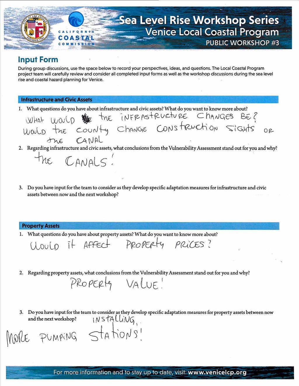
32 Infrastructure and Civic Assets Table 1 What can be done with Oceanfront Walk? CCC wants to provide access to the beach Issue of timing/ aging with structures in relation to sea level rise Mitigation measures o Development requirements (elevated structures) Why are permits being issued at all for residential/commercial development? o City might need to adopt phased approach based on sea level rise o City should provide financing to save Venice Venice more exposed than other coastal communities in LA Basin o Biggest storms come from the west What if we add quakes and tsunamis to sea level rise analysis. o Tsunami would raise water level significantly o Quakes could cause liquefaction Table 2 Where could the public go in case of flooding? o Meeting points might be a type of adaptation strategy. What can City do today to improve/strengthen infrastructure before sea level rises? o City has list of required improvements/cost but no timeline yet o Coordination between County (Harbor and beaches) and City City has Tech. Advisory Committee (various Depts) to analyze and coordinate efforts on sea level rise in Venice Is City prepared to assist the homeless population in Venice? o Flooding would be dynamic (based on tides) and presumably homeless population would be able to get away What can be done to prevent flooding from oceanfront? earth berms Table 3 Concerns: Tide Gates, Winward Circle, Flood in 2017 o Canal leakage (Priority), Cument BOE study update Question: Groundwater impact with Sea Level Rise? o USGS doesn t include groundwater o Basin is currently not pumped Concern: Maintenance Bldg City/County has funding from County to upgrade o Parks, Boardwalk are on higher ground o We should look at how coastal infrastructure is maintained 2008 study on as SLR from NOAA Methane Zone today in ULCD area o How does SLR affect it? Weight of development on ground and SLR? *Pump station malfunction and inundation How can protect hist.? o SLR rising first floor Staging and Adaptation: Parlor Loop
33 o Consider immersing, SLR storage with new development o Road diets vs. emerging evacuation routes o Tsunami studies? Tsunami and SLR? o Tunnels How has sea level changed in the past 50 years o 8 inches over the past decades Suggestion: Illustrations throughout community might be important to show where water level will be in the next decades Breakwater Table 4 How does the tidal at marina work vis a vis tides Rumor pump station at Kinney Circle, has salt water Del and Venice? Or sea water? Will plumbing wastewater be resilient to salt water? Will all this impact property value? o Think it will go down, banks may not lend due to SLR Do something about the canals to protect What adaptation strategies are we Will VAAP move more water? How does the pump system work today? How will soils be impacted by groundwater subsidence? How will the soil change? How will the methane buffer zone be impacted by SLR? How are we vulnerable to methane? Research/rebate incentives for swales and other ways to absorb water Surprise to learn about the tide gate reliance and over all vulnerable How are other cities dealing with this issue? Bldg code Major (Non-incremental) improvements Introduce water into the system so it takes stress of the system Keep charm and choose mechanical to keep what we know Human error on the canal, will property values increase if we introduce water More to do with runoff, perm pav etc. Table 5 If tide gates are working what level of SLR would it overtop? Tide gates history: Current 1ft/day leak in Washington Gate. (Not functional currently). 1.6 ft SLR over Washington Gate Currently have disaster conditions Can/Should people be able to build it? Access for emergency ingress/egress o o Flood limiting end access Flood limiting access and electricity, people with limited access and have special needs What is the definition of flooding? o What s the water level/flood depth o Predicted impacts to wastewater infrastructure
34 What happens to Impact of SLR/Flooding on power (communication assistance) Look at parking lots/beach parking (visitor serving (ccc conflict/dune restoration) Mitigation for property and infrastructure, make it less likely to flood o Protect what s there, remove the threat, lessen the impact No development in haz zone Decentralize infrastructure: waste water power Considerations of buoyancy, air bubbles and things popping up Methane zone: What happens to the house as it wasn t designed to be held down o Infrastructure/housing could float Table 6 Where is Venice pumping plant? Green infrastructure trees/plants to suck up water and help ecological habitat Community solar (redundancy for infrastructure systems) back up infrastructure Does Winward have a back up? Do many approaches Rain water catchment systems (larger scale) Decentralize infrastructure o How to ensure the progression of projects What if things get worse, stay ahead of things. How to adapt to changing predictions Changing predictions Trigger based planning New Development/building requirements stilts/grad? Raised porches in Oakwood to adapt to local Storm drain system (40 s) was supposed to empty in beach but in sand- bacteria issues on beach: testing today Height limits will need to respond to new development standards. No minimum number of units? Why not? Policy and zoning tied to mitigation and SLR Dig the old canals that we filled o Multiple benefits Pump station currently floods Should people be allowed to build in flood prone areas? Align incentives with goals (goals can be in conflict) re: infrastructure Who pays for adaptation? Loss of thatcher maintenance yard Percent of perm surfaces require o Arid lands institute groundwater mapping? Property Assets Table 1 What are property assets? Is the flooding due to flood gates?
35 Why aren t tide gates automatic? o Would this matter with sea level rise? How much have we studied groundwater? Long-term and short term-flood gates Has there been restrictions on developing in vulnerable areas? Pumping Save us! Groundwater mitigation Vulnerable o Distribute vulnerable populations throughout city so they don t experience it worse systemic issues o Disadvantaged community is getting booted out Homeless o Are there global examples? Look at the Netherlands o Animal shelters Explain property assets better If the city has a dense area of property assets, does the city take it more seriously Washington and Wilson apartments had to sump pump before construction How effective are the pumps that we have? Table 2 Are the canals the only entry point for flooding? Could we see an animation of how flood water moves through? Does it make sense to look only at Venice or for regional considerations? Does elevation have impact on water flow? What should a person in low lying areas do? How is flood insurance and flood plain mapping changing? How will this study address these SLR changes? Are there any financial incentives for people to relocate /reuse due to risk unsustainability? Table 3 Will there be a priority of one asset over another? What is the current infrastructure in place to prevent first flooded? The Washington Gate is leaking, repairs have not been made. Water flowing up from Windward traffic circle What entity do we work for? Where would the flood peak? What are we doing about Washington? What will we do to pump water out? Could digging the canals deeper reduce flooding? Are there any cities we are using as a template? o Why not? Where do we pump the water to? Do tunnels still exist next to Windward? bar Will there be restrictions on future building?
36 Will new buildings be based on adaptive measures? Table 4 How will the bldg. code and zoning code change to adjust and protect home? o Infrastructure and private property discussions overlap o Turn a negative to a positive re: SLR o Property value will decrease if we do nothing We love our community, hold onto it forever. Preserve original community o Ocean Park Villa We don t want to get flooded and will do what is necessary to protect. Local/ Pool for insurance for Venice VA Emergency planning for SLR o Hold town hall meeting Drain to canals, water quantity Brooks drain to ocean Water quality: second outlet for canal Look at previous studies for canal water in the 1980s Table 5 Need to think about inland flooding with adaption strategies. How long has the tide gate system been in place? What is the max SLR? Will the tide gate fail? Based on current zoning, max built, what effect will that have on urban run and flooding with SLR? More analysis of salt water intrusion on groundwater Table 6 How will they help with rebuilding after flooding? How will help with historic property, save the resource. I live in flood area; shocking how bad things Green infrastructure o Help existing eco-system Raise streets Increase pump station/gates capacity Sunny -day floor pump station inverse; cleans traps Storm drain maintaining program Community solar as a back up system for pump stations Fear; is this certain Conflict/relationship between adaptation and causation Large development is impacting infrastructure Tie zoning and infrastructure to SLR and adaptation Where are emer
37 Coastal Amenities, Cultural, and Ecological Assets Table 1 Is the city considering the tourism and economic assets? Where will the City get the money to pay for adaptations? What does it mean to be historic? Does it mean more money? You ve already designated areas to be preserved! Or how will it be prioritized? Adaptation measures should recognize climate change and not contribute to it. City should coordinate. Table 2 What are the adaptation strategies you are considering for the canals? Can we even just get pumps upgraded now? Maybe there can be a task force that addresses structures. Get systems to function at double or triple capacity now. Could floodgates be reinforced The problem is not keeping water out, it s getting rid of it when it gets in. LA is slow when it comes to public works projects Has anyone talked about introducing more water into Venice as it used to have? Where will funding come from? How good are the predictions? Studies keep showing previous predictions were optimistic. Table 3 What commitment is there to the Old Lifeguard Tower? Why is the County leveling the Beach, instead of letting it gain its own rhythm? Will the Canals increase in salinity? The State plan did not show canal flooding as yours does. Are you looking at breakwater pumping? City needs to repair gates Would like more information on your data and studies Table 4 Historical in Oakwood preserved as a historic community, consideration, Ocean tract Villa ID areas but no incentives to consider in adaptation strategies Ecological: least tern also found in canal area to be considered Coastal Amenities: Living shorelines, beach nourishment as a resource/strategy o Possible solutions Tax breaks as an incentive for historic structures Mitigation for pumping station in adaptation strategies Table 5 What questions do you have coastal amenities and cultural and eco assets? What more do you want to know? o SLR adaptations will apply the same way o Please include the potential historical cont. as cultural resources o The first priority is the canals 2 residents
38 o To also consider walkstreets, dwnt, beaches, to treat all areas the same. o The pacific electric red car bridge o Specific mitigation measures, what adaptation strategies are there? To consider before/after *Follow up on nesting Least tern Table 6 What questions do you have about coastal amenities, cultural and eco assets? o What we should be doing to plan? o Is there a strategy on what to do? o What criteria is being used for historic? o Beach is an important resource, how to prepare? o Fallout is a concern, not just sea level rise Are we looking at storm surge in the assessment? What funding is going to be allocated? o Adaptation strategies, Policy funding #2 Question o Concern where ecological assets least tern, snowy o Solutions for historical structures? o Green infrastructure, would like to see more of this #3 Question speedway, pay attention to this area o Is beach allowed to migrate? Social Vulnerability Table 1 Schools People who don t speak English or are handicapped Senior homes Homes for disabled Clinics and hospitals Evacuation system prioritization Incorporate SLR and flooding into earthquake safety Table 2 It seems the most vulnerable to sea level rise are the highest income. Best to talk about how to prevent It s more about tradeoffs and prioritization after it happens, who do you help? The homeless shelters must prepare now Table 3 Homeless population who tend to gather near the canals vulnerable Building a homeless shelter in the Venice Blvd median doesn t make sense because of the sea level rise exposure shown on the maps. This median for an open space/flood storage/wetland type of use would be preferred. Table 4
39 Use public access station Preserve affordable housing Venice Listerv Preserve the Mello Act Table 5 Are there nursing homes? The disruption of community to include those who do not have resources to (get back on their feet) disruption of work in event of disaster. What about the homeless what is the strategic plan? Federal flood insurance in preparation of maps need to be broader, not as specific. Table 6 Homeless, lack of affordable housing Displacement, no other place to go High cost of utilities Schools work to bring community together o Could make more/stronger ties, both physically and social Economic pressure: Pace program ex. That pushed people out o When space becomes more limited, people will be pushed Affordable housing trust fund Code enforcement violation fees for retrofit funds that will keep social diversity
40 Appendix C Completed Input Cards
41
42

43

44

45
46

47

48

49

50

51

52
53

54
Public Workshop #3. Sea Level Rise Vulnerability Assessment. Infrastructure Property Cultural Civic Coastal Amenities Ecological
 Infrastructure Property Cultural Civic Coastal Amenities Ecological Public Workshop #3 Sea Level Rise Vulnerability Assessment Funded in part by CCC Grant LCP-14-09 Introducing the Team: Purpose of Today
Sea Level Rise Workshop #4 May 22, 2018 Venice Local Coastal Program SUMMARY
 Sea Level Rise Workshop #4 May 22, 2018 Venice Local Coastal Program SUMMARY CONTENTS WORKSHOP OVERVIEW... 1 WORKSHOP OBJECTIVES... 2 WHERE AND WHEN... 2 OUTREACH AND ATTENDENCE... 2 FORMAT AND ACTIVITIES...
Venice Pumping Plant Dual Force Main Project Draft EIR
 City of Los Angeles 5.9 LAND USE PLANS 5.9.1 Environmental Setting Venice Pumping Plant Dual Force Main Project Draft EIR The Project lies within the bounds of Los Angeles County and the City of Los Angeles.
Empowering Local Action for Coastal Resilience in Massachusetts. Bruce K. Carlisle MA Office of Coastal Zone Management
 Empowering Local Action for Coastal Resilience in Massachusetts Bruce K. Carlisle MA Office of Coastal Zone Management Context Coastal communities continue to face both chronic and acute storm surge, erosion,
SAN RAFAEL GENERAL PLAN 2040 INTRODUCTION AND OVERVIEW
 SAN RAFAEL GENERAL PLAN 2040 INTRODUCTION AND OVERVIEW Steering Committee Presentation February 14, 2018 Purpose of General Plan Guide land use and development decisions Coordinate transportation, infrastructure,
Virginia Beach and Sea Level Rise: Where Do We Go From Here?
 Virginia Beach and Sea Level Rise: Where Do We Go From Here? Clay Bernick City of Virginia Beach Environment & Sustainability Office Bayfront Advisory Committee Presentation July 19, 2012 Five Items to
Building Ecological Solutions to Coastal Community Hazards: Guidance and NJ Coastal Community Assistance
 Building Ecological Solutions to Coastal Community Hazards: Guidance and NJ Coastal Community Assistance Stacy Small-Lorenz National Wildlife Federation Restore America s Estuaries Summit New Orleans,
Planning Commission Report
 Planning Commission Report To: From: Subject: Planning Commission Meeting: January 6, 2016 Agenda Item: 8-B Planning Commission David Martin, Planning & Community Development Director Introduction to the
EXHIBIT A CITY OF FORT WALTON BEACH, FLORIDA COASTAL MANAGEMENT & CONSERVATION
 EXHIBIT A CITY OF FORT WALTON BEACH, FLORIDA INTRODUCTION The Coastal Management and the Conservation Elements required by Chapter 9J-5.012 and 5.013, F.A.C., respectively, have been combined into one
Adaptation and Resilience at the City of Fort Lauderdale
 Adaptation and Resilience at the City of Fort Lauderdale Carlos Acosta, P.E. Assistant City Engineer City of Fort Lauderdale Overview Climate challenges and limitations Sea Level Rise Projections King
COASTAL MANAGEMENT ELEMENT. Last amended December 6, 2016 as part of the 2016 EAR
 COASTAL MANAGEMENT ELEMENT Last amended December 6, 2016 as part of the 2016 EAR Table of Contents Objective Page 7.1 Development and redevelopment of waterfront properties...7-1 7.2 Agency coordination
RESILIENCY, ADAPTATION, & SUSTAINABILITY AT THE CITY OF ST. AUGUSTINE
 RESILIENCY, ADAPTATION, & SUSTAINABILITY AT THE CITY OF ST. AUGUSTINE PROGRAM UPDATE JANUARY 14, 2019 MICHAEL G. CULLUM, P.E. DIRECTOR, PUBLIC WORKS PROGRESSION OF PLANNING FOR RESILIENCY / ADAPTATION
Mitigation + Adaptation Strategies for Historic Structures and Sites
 Mitigation + Adaptation Strategies for Historic Structures and Sites Adrienne Burke, Esq., MSAS, LEED AP+ Executive Director, Riverside Avondale Preservation, Jacksonville, FL Cultural Resources, Disaster
MUNICIPAL RESILIENCE PLANNING ASSISTANCE PROJECT
 MUNICIPAL RESILIENCE PLANNING ASSISTANCE PROJECT William R. Rath, Esq. Legal Research Fellow Center for Energy & Environmental law University of Connecticut School of Law 860-570-5058 William.Rath@ UConn.edu
Land Use Amendment in Southwood (Ward 11) at and Elbow Drive SW, LOC
 at and Elbow Drive SW, LOC") 2018 November 15 Page 1 of 10 EXECUTIVE SUMMARY This land use amendment application was submitted by Rick Balbi Architect on 2017 August 31 on behalf of Sable Developments Ltd, and with authorization from
2018 November 15 Page 1 of 10 EXECUTIVE SUMMARY This land use amendment application was submitted by Rick Balbi Architect on 2017 August 31 on behalf of Sable Developments Ltd, and with authorization from
Envision Concord Public Event Part 3. October 21, :30 AM 12:00 PM Concord-Carlisle High School Cafeteria
 Envision Concord Public Event October 21, 2017 9:30 AM 12:00 PM Concord-Carlisle High School Cafeteria Survey Responses + Emerging Priority Areas Summary from Spring Kick-Off Event Envision Concord Survey
Billing Code: DEPARTMENT OF HOUSING AND URBAN DEVELOPMENT [Docket No. FR-6072-N-01]
![Billing Code: DEPARTMENT OF HOUSING AND URBAN DEVELOPMENT [Docket No. FR-6072-N-01]](/thumbs/91/107309814.jpg "Billing Code: DEPARTMENT OF HOUSING AND URBAN DEVELOPMENT [Docket No. FR-6072-N-01]") This document is scheduled to be published in the Federal Register on 12/18/2017 and available online at https://federalregister.gov/d/2017-27194, and on FDsys.gov Billing Code: 4210-67 DEPARTMENT OF HOUSING
This document is scheduled to be published in the Federal Register on 12/18/2017 and available online at https://federalregister.gov/d/2017-27194, and on FDsys.gov Billing Code: 4210-67 DEPARTMENT OF HOUSING
East Central Area Plan
 East Central Area Plan Steering Committee Meeting January 10 th, 2019 Tears-McFarlane House Community Room East Central Area Plan Steering Committee Meeting January 10 th, 2019 CHUN Tears-McFarlane House
2015 Request for Proposals Session Guidelines
 2015 Request for Proposals Session Guidelines The Rocky Mountain Land Use Institute at the University of Denver Sturm College of Law is announcing the Request for Proposals for the 2015 Annual Land Use
Introduction. Chapter 1. Purpose of the Comprehensive Plan Plan Organization Planning Process & Community Input 1-1
 Chapter 1 Introduction Lakewood 2025: Moving Forward Together Purpose of the Comprehensive Plan Plan Organization Planning Process & Community Input 1-1 Purpose of the Comprehensive Plan The Comprehensive
NJ Department of Environmental Protection
 NJ Department of Environmental Protection COASTAL AND LAND USE PLANNING New Jersey Coastal Management Program Covers NJ coastal waters to limit of tidal influence including 239 municipalities in 19 counties,
Coastal hazard assessments in Victoria
 Coastal hazard assessments in Victoria Viktor Brenners viktor.brenners@delwp.vic.gov.au Future Coasts program 4 year program established in 2007. Outputs included: Coastal Digital Elevation Models Victorian
Preliminary Sea Level Rise Case Study: Navarre Beach, FL
 Preliminary Sea Level Rise Case Study: Navarre Beach, FL This publication was funded in part, through a grant agreement from the Florida Department of Environmental Protection, Florida Coastal Management
Support the implementation of Cape Coral's Comprehensive Plan. Protect and utilize the unique natural resources in the City.
 7.0 OVERVIEW - RECOMMENDATIONS Chapter 7 The preparation of the Cape Coral Parks and Recreation Master Plan spanned a period of approximately 12 months. Plan preparation included the input of a wide range
PRE-DESIGN CONCEPT REPORT GRAND CANAL RESTORATION
 PRE-DESIGN CONCEPT REPORT GRAND CANAL RESTORATION Project Background November 19, 2007 Executive Summary The Grand Canal is an important tidal waterway in the Venice community of Los Angeles, California,
Appendix to Amicus Curiae Brief: Selected Provisions of the South Carolina Beachfront Management Act
 Loyola Marymount University and Loyola Law School Digital Commons at Loyola Marymount University and Loyola Law School Loyola of Los Angeles Law Review Law Reviews 6-1-1992 Appendix to Amicus Curiae Brief:
The Louisiana 2017 Coastal Master Plan: Climate Change and Sea Level Rise Planning in the International Context
 The Louisiana 2017 Coastal Master Plan: Climate Change and Sea Level Rise Planning in the International Context Dr. Michael K. Orbach Professor Emeritus of Marine Affairs and Policy Nicholas School of
Rocky Areas Project Guidance HABITAT
 Rocky Areas Project Guidance HABITAT Introduction Rocky habitats are surface areas dominated by exposed rock, such as mountain peaks, inland cliffs, buttes and rocky outcrops. In many cases, rocky areas
Port Lavaca Future Land Use
 Port Lavaca Future Land Use Introduction The City of Port Lavaca is beginning to see sustained growth, after many years of relative stable population. New single family homes, apartments, and businesses
Special Joint Meeting. Emerald Isle Planning Board. Emerald Isle Board of Commissioners. January 18, 2017
 Special Joint Meeting Emerald Isle Planning Board Emerald Isle Board of Commissioners January 18, 2017 STEERING COMMITTEE: Jim Normile Town Commissioner Ken Sullivan Planning Board Larry Watson Retail
Agincourt Mall Planning Framework Review Public Open House #2 Consultation Summary
 Agincourt Mall Planning Framework Review Public Open House #2 Consultation Summary This summary provides a high level summary of participant feedback. It is not intended to provide a verbatim transcript
[FWS R8 R 2015 N087; FXRS282108E8PD0 156 F ] South Bay Salt Pond Restoration Project, Phase 2; Don Edwards National Wildlife
![[FWS R8 R 2015 N087; FXRS282108E8PD0 156 F ] South Bay Salt Pond Restoration Project, Phase 2; Don Edwards National Wildlife](/thumbs/84/90602803.jpg "[FWS R8 R 2015 N087; FXRS282108E8PD0 156 F ] South Bay Salt Pond Restoration Project, Phase 2; Don Edwards National Wildlife") Surname Billing Code: 4310 55 Deputy RD ARD Refuges DEPARTMENT OF THE INTERIOR Fish and Wildlife Service Solicitor Refuge Supervisor Asst. Refuge Supervisor Ch. Natural Resources Project Leader [FWS R8
Surname Billing Code: 4310 55 Deputy RD ARD Refuges DEPARTMENT OF THE INTERIOR Fish and Wildlife Service Solicitor Refuge Supervisor Asst. Refuge Supervisor Ch. Natural Resources Project Leader [FWS R8
Planned Development Review Revisions (Project No. PLNPCM )
") Planned Development Review Revisions (Project No. PLNPCM2014-00139) Standard residential development Planned Development Example: Smaller lot sizes than what is allowed to create open space amenity. What
Planned Development Review Revisions (Project No. PLNPCM2014-00139) Standard residential development Planned Development Example: Smaller lot sizes than what is allowed to create open space amenity. What
Preparing Hudson River Waterfronts for an Era of Rapid Sea Level Rise
 Preparing Hudson River Waterfronts for an Era of Rapid Sea Level Rise CITY OF KINGSTON TIDAL WATERFRONT FLOODING TASK FORCE Gregg Swanzey Director, Office of Economic Development & Strategic Partnerships,
City of Hermosa Beach Administrative Policy #
 City of Hermosa Beach Administrative Policy # SUBJECT: Living Streets Policy Date: Approved by: City Council Authority: Public Works Department & Community Development Department Mayor, PURPOSE The City
Rhode Island Shoreline Change Special Area Management Plan
 Rhode Island Shoreline Change Special Area Management Plan Draft Document Outline REVISED 10/12/2017 VOLUME 1 Executive Summary & How to Use this Document (Draft by Dec 2017) 1. Introduction (Revised draft
TASK FORCE MEETING #10 SUMMARY
 TASK FORCE MEETING #10 SUMMARY CITY OF REDWOOD CITY INNER HARBOR SPECIFIC PLAN Tuesday, April 8, 2014 7:00 P.M. 9:30 P.M. Seaport Conference Center, 459 Seaport Court, Redwood City, CA 94063 TASK FORCE
Floodplain Management Plan 2016 Progress Report
 PREPARED FOR: Borough of Point Pleasant Beach 416 New Jersey Ave. Point Pleasant Beach, NJ 08742 (732) 892-1118 http://www.pointpleasantbeach.org/ PREPARED BY: T&M Associates 11 Tindall Road Middletown,
Venice Pumping Plant Dual Force Main Project Draft EIR 5.11 PUBLIC FACILITIES AND SERVICES
 5.11 PUBLIC FACILITIES AND SERVICES RECREATIONAL FACILITIES AND PUBLIC RESOURCES This section of the EIR includes a description of the existing recreational facilities and public resources in the proposed
What We Heard Report: Westmount Architectural Heritage Area Rezoning Drop-in Workshop
 What We Heard Report: Westmount Architectural Heritage Area Rezoning Drop-in Workshop August 2018 What We Heard Report: Westmount Architectural Heritage Area Rezoning Drop-in Workshop Executive Summary
A. INTRODUCTION B. CUMULATIVE EFFECTS ANALYSIS
 Chapter 4: Cumulative Effects A. INTRODUCTION The New York City Department of Parks and Recreation plans to reconstruct the Rockaway Beach Boardwalk in the borough of Queens, New York City, which Hurricane
Port of San Diego Sea Level Rise Ad Hoc Committee Meeting 1 of 3.. September 18, 2018
 Port of San Diego Sea Level Rise Ad Hoc Committee Meeting 1 of 3. September 18, 2018 Agenda Welcome Introductions Rules of the Ad-Hoc Presentation Background Vulnerability Assessment Results Non-Agenda
Urban Planning and Land Use
 Urban Planning and Land Use 701 North 7 th Street, Room 423 Phone: (913) 573-5750 Kansas City, Kansas 66101 Fax: (913) 573-5796 Email: planninginfo@wycokck.org www.wycokck.org/planning To: From: City Planning
The Salt Marsh Advancement Zone Assessment of Connecticut
 The Salt Marsh Advancement Zone Assessment of Connecticut Front cover image: Salt marsh advancement zones in Stratford, CT from the Comprehensive Map Book of Stratford, CT. Table of Contents Introduction...
What Planners Do. Heather Wade, Coastal Planning Specialist Texas Sea Grant
 What Planners Do Heather Wade, Coastal Planning Specialist Texas Sea Grant What Planners Do Seminar Series Department of Landscape Architecture and Urban Planning College of Architecture ABOUT ME B.S.
4- PA - LD - LIVELY DOWNTOWN. LD - Background
 4- PA - LD - LIVELY DOWNTOWN LD - Background The downtown has been the service centre for the community since the city s inception and the area continues to supply people with their personal services,
Figure 1. Park Ave. Portsmouth
 Aquidneck Island Resilience Strategy Issue Paper 2 Issue: TRANSPORTATION Description of Concern: Aquidneck Island encompasses a 38 square mile area, including three municipalities, all supported by an
2. AGENCY COORDINATION AND PUBLIC INVOLVMENT
 2. AGENCY COORDINATION AND PUBLIC INVOLVMENT This chapter discusses the process carried out for conducting agency coordination and public involvement activities. TECHNICAL ADVISORY COMMITTEE A Technical
greenprint midtown SUSTAINABILITY ACTION PLAN 2012
 greenprint midtown SUSTAINABILITY ACTION PLAN 2012 MIDTOWN ALLIANCE SOUTHFACE ENERGY INSTITUTE RENAISSANCE PLANNING GROUP SUSTAINABLE ATLANTA PERKINS+WILL 2 GREENPRINT MIDTOWN 1. Introduction Sustainability
Coastal Climate Change Vulnerability and Flexible Adaptation Planning: the Cockburn Sound Coastal Alliance Experience
 Coastal Climate Change Vulnerability and Flexible Adaptation Planning: the Cockburn Sound Coastal Alliance Experience Presentation to Climate Change Forum by Doug Vickery Manager Infrastructure Services,
Comprehensive Plan ADOPTED APRIL 2014
 Comprehensive Plan ADOPTED APRIL 2014 8 8. Outstanding Recreational & Cultural Opportunities We are proud of our community s parks and recreation system. Our community will ensure that the legacy of our
Scope of Services. River Oaks Boulevard (SH 183) Corridor Master Plan
 Corridor Master Plan") Scope of Services River Oaks Boulevard (SH 183) Corridor Master Plan PROJECT AREA The project area consists of the River Oaks Boulevard (SH 183) corridor bounded by SH 199 at the northern end and the Trinity
Scope of Services River Oaks Boulevard (SH 183) Corridor Master Plan PROJECT AREA The project area consists of the River Oaks Boulevard (SH 183) corridor bounded by SH 199 at the northern end and the Trinity
Design Fort Ord. welcome why we are here what happened this week design guidelines: ideas so far 2/12/2015. Regional Urban Design Guidelines (RUDG)
") Design Fort Ord Regional Urban Design Guidelines (RUDG) Welcome Back! Strategic Economics Alta Planning + Design National Charrette Institute Helix Environmental Planning Jeff Speck & Peter Katz Civitas
Design Fort Ord Regional Urban Design Guidelines (RUDG) Welcome Back! Strategic Economics Alta Planning + Design National Charrette Institute Helix Environmental Planning Jeff Speck & Peter Katz Civitas
Route 1 Corridor Study
 Route 1 Corridor Study Westbrook, Connecticut A Vision for the Connecticut Shoreline Public Informational Meeting July 28, 2015 Lower Connecticut River Valley Council of Governments Fitzgerald & Halliday,
Indonesia: Towards Habitat III and the New Urban Agenda
 MINISTRY OF PUBLIC WORKS AND HOUSING REPUBLIC OF INDONESIA Indonesia: Towards Habitat III and the New Urban Agenda Bangkok, 27-28 January 2016 Habitat Indonesia National Secretariat Outline Towards Habitat
Public Open House. Overview of the Downtown Plan Official Plan Amendment April 23, 2018
 Public Open House Overview of the Downtown Plan Official Plan Amendment April 23, 2018 1 A 25-Year Plan for Downtown To ensure growth contributes positively to Toronto s Downtown as a great place to live,
IDENTIFICATION TO IMPLEMENTATION THE JOURNEY OF CITY RESILIENCE
 IDENTIFICATION TO IMPLEMENTATION THE JOURNEY OF CITY RESILIENCE Cities are dynamic, living and growing entities. They are centers of art, heritage and cultural pride and their vibrancy attracts visitors,
Zoning and Development Considerations in the Boothbay Harbor Maritime/Water Dependent District
 Zoning and Development Considerations in the Boothbay Harbor Maritime/Water Dependent District Bob Faunce Lincoln County Planner Lincoln County Regional Planning Commission Board of Selectmen and Planning
S A C R A M E N T O C O U N T Y JACKSON HIGHWAY & GRANT LINE EAST VISIONING STUDY
 JACKSON HIGHWAY & GRANT LINE EAST S A C R A M E N T O C O U N T Y P L A N N I N G D E P A R T M E N T SUMMARY AND WORKBOOK November 19, 2008 History of the Visioning Study Sacramento County has two growth
HOUSING ELEMENT GOALS, OBJECTIVES, AND POLICIES
 HOUSING ELEMENT GOALS, OBJECTIVES, AND POLICIES Goal 6 Maintain and enhance the supply of decent, safe, energy efficient and affordable housing and maximize viable options and opportunities for present
1.0 Purpose of a Secondary Plan for the Masonville Transit Village
 Report to Planning and Environment Committee To: Chair and Members Planning & Environment Committee From: John M. Fleming Managing Director, Planning and City Planner Subject: Masonville Transit Village
This Review Is Divided Into Two Phases:
 Semiahmoo Town Centre Review The purpose of this review: To review the Semiahmoo Town Centre Concept Plan, originally approved in 1993, to ensure that this centre will continue to serve the needs of South
Arkansas River Corridor
 Planning for Access Welcome to the Access Project. This project is a recreational planning effort in response to an interest by regional communities along the Arkansas River corridor. The project plan
Lawrencetown Beach & Rainbow Haven Beach
 Lawrencetown Beach & Rainbow Haven Beach Public Engagement Session Wednesday, September 27 th, 2017 6:00pm 8:00pm Cole Harbour Place 51 Forest Hills Pkwy, Dartmouth Agenda Welcome & Introductions Overview
NORTH KINGSTOWN PILOT PROJECT May 9, 2016 North Kingstown Town Council
 Engaging RI Local Governments in Hazard Mitigation and Coastal Resilience NORTH KINGSTOWN PILOT PROJECT May 9, 2016 North Kingstown Town Council Teresa A. Crean, AICP University of Rhode Island Coastal
TRANSPORTATION ELEMENT GOALS, OBJECTIVES, AND POLICIES
 TRANSPORTATION ELEMENT GOALS, OBJECTIVES, AND POLICIES GOAL 2 The City shall provide a safe, convenient, effective, and energy efficient multimodal transportation system which is coordinated with the Future
Section 4: Goals, Objectives, and Strategies
 99 Section 4: Goals, Objectives, and Strategies Goal 1 Resource Protection, Maintenance, Preservation, and Enhancement Protect, preserve, maintain, and enhance the natural, recreational, archaeological,
Final Master Plan and Development Control Regulations
 1. INTRODUCTION CHECK LIST a. Introduction b. Table of contents c. Definitions. d. scope of works. 2. FINAL OVERALL MASTER PLAN a. SITE ANALYSIS and OVERVIEW: i. Existing and Proposed Site Plan Levels.
Official Plan Review
 Official Plan Review Summary Report - The Built Environment August 2014 Part 1: Introduction Planning for a healthy, prosperous and sustainable community is an important goal for our municipality. From
NEW YORK AND CONNECTICUT SUSTAINABLE COMMUNITIES. Fair Housing & Equity Assessment & Regional Planning Enhancement
 NEW YORK AND CONNECTICUT SUSTAINABLE COMMUNITIES Fair Housing & Equity Assessment & Regional Planning Enhancement November 12, 2013 Yonkers Public Library Federal grant to improve regional planning to
CITY OF LANGLEY OFFICIAL COMMUNITY PLAN BYLAW, 2005, NO APPENDIX II - REGIONAL CONTEXT MAP
 CITY OF LANGLEY OFFICIAL COMMUNITY PLAN BYLAW, 2005, NO. 2600 APPENDIX II - REGIONAL CONTEXT MAP ± Legend Agricultural Mixed Employment Industrial Conservation & Recreation Regional City Centre Urban Containment
April 11, 2016 Park Board Chair and Commissioners General Manager Vancouver Board of Parks and Recreation New Brighton Salt Marsh - Preferred Concept
 TO: FROM: SUBJECT: April 11, 2016 Park Board Chair and Commissioners General Manager Vancouver Board of Parks and Recreation New Brighton Salt Marsh - Preferred Concept RECOMMENDATION A. THAT the Vancouver
Memorandum Planning. Thursday, January 8, 2015
 Memorandum Planning Thursday, January 8, 2015 7.A. To: Coastal Advisory Committee From John Ciampa, Associate Planner Subject: Review Draft Local Coastal Program Copies: James Pechous, City Planner Purpose
A CONCEPTUAL PROPOSAL BY THE UMDLOTI FORUM Representing the Umdloti Ratepayers and Residents Association and the emdloti UIP
 A CONCEPTUAL PROPOSAL BY THE UMDLOTI FORUM Representing the Umdloti Ratepayers and Residents Association and the emdloti UIP PRESENTATION STRUCTURE 1.0 Overview of Umdloti 2.0 Current challenges in Umdloti
Sustainably Repositioning Greyfield Sites. Greyfield Sites Anywhere
 Sustainably Repositioning Greyfield Sites Jim Constantine Looney Ricks Kiss Architects Todd Poole 4ward Planning Greyfield Sites Anywhere Pennsylvania Chapter American Planning Association Conference 2009
WEATHER IT TOGETHER. The Annapolis Model for Cultural Resource Adaptation Planning. Cultural Resources, Disaster Resilience, and Climate Uncertainty
 WEATHER IT TOGETHER The Annapolis Model for Cultural Resource Adaptation Planning Cultural Resources, Disaster Resilience, and Climate Uncertainty Historic Annapolis A Colonial Capital: National Landmark
DRAFT FOR PUBLIC REVIEW. Game Plan for a Healthy City
 DRAFT FOR PUBLIC REVIEW 2018 Game Plan for a Healthy City 2 Denveright. Parks & Recreation Game Plan Draft for Public Review Draft for Public Review Executive Summary Game Plan Overview Executive Summary
CHAPTER 7: Transportation, Mobility and Circulation
 AGLE AREA COMMUNITY Plan CHAPTER 7 CHAPTER 7: Transportation, Mobility and Circulation Transportation, Mobility and Circulation The purpose of the Transportation, Mobility and Circulation Chapter is to
CITY OF HOLLY SPRINGS STORMWATER UTILITY FREQUENTLY ASKED QUESTIONS
 CITY OF HOLLY SPRINGS STORMWATER UTILITY FREQUENTLY ASKED QUESTIONS GENERAL What is a Stormwater Utility and why is it needed in Holly Springs? A Stormwater Utility is an entity responsible for the daily
CHAPTER 2: PLANNING PRINCIPLES
 CHAPTER 2: PLANNING PRINCIPLES 2 Comprehensive Principles The following overarching Principles provide the basis for the goals and policies included in the Mendocino County General Plan. These Principles
An Integrated Approach for Water Management Examples from The Netherlands. Addressing Climate Change and Sea Level Rise
 An Integrated Approach for Water Management Examples from The Netherlands Addressing Climate Change and Sea Level Rise Superstorm Sandy Forum College of Staten Island March 8 2013 Water: a challenge and
Sierra Club Comments on ACOE Public Notice NAE Re: Proposed Town Neck Beach Project at Sandwich, Massachusetts
 August 27, 2015 US Army Corps of Engineers New England District 696 Virginia Road Concord, MA 01742-2751 Attn: Phillip W. Nimeskern Dear Mr. Nimeskern, Sierra Club Comments on ACOE Public Notice NAE-2014-259
NASSAU COUNTY TOWN HALL NEW YORK & CONNECTICUT SUSTAINABLE COMMUNITIES. A Unique Bi-State Partnership to Improve Jobs, Housing and Transportation
 NASSAU COUNTY TOWN HALL NEW YORK & CONNECTICUT SUSTAINABLE COMMUNITIES A Unique Bi-State Partnership to Improve Jobs, Housing and Transportation Police Headquarters Auditorium Mineola, NY December 9 th,
Vaughan Metropolitan Centre (VMC) Black Creek Renewal CLASS ENVIRONMENTAL ASSESSMENT
 Black Creek Renewal CLASS ENVIRONMENTAL ASSESSMENT") PUBLIC INFORMATION CENTRE Vaughan Metropolitan Centre (VMC) Black Creek Renewal Wednesday, May 10, 2017 6:00 p.m. to 8:00 p.m. Add photo Project Management, Environmental Assessment, Stormwater Management
PUBLIC INFORMATION CENTRE Vaughan Metropolitan Centre (VMC) Black Creek Renewal Wednesday, May 10, 2017 6:00 p.m. to 8:00 p.m. Add photo Project Management, Environmental Assessment, Stormwater Management
Town of Peru Comprehensive Plan Executive Summary
 Town of Peru Comprehensive Plan Executive Communities that plan grow by choice, not by chance. A plan makes growth thoughtful, understandable, and predictable. A plan shows that a community is managing
Smart Growth Development Checklist
 2004 Smart Growth Development Checklist Smart Growth Development Checklist Corporation of the City of New Westminster Guide and manage growth in a manner which is consistent with the principles of sustainable
Kevin M. Rampe, President -- Lower Manhattan Development Corporation
 For Internal Use Only: Date Received: WRP no. DOS no. NEW YORK CITY WATERFRONT REVITALIZATION PROGRAM Consistency Assessment Form Proposed actions that are subject to CEQR, ULURP or other local, state
Planning for Historic/Cultural Resources Coastal Resiliency in Connecticut. Presented to CAFM s 3 rd Annual Conference
 Planning for Historic/Cultural Resources Coastal Resiliency in Connecticut Presented to CAFM s 3 rd Annual Conference October 25, 2016 Agenda Introduction and Project Overview Background Historic and Cultural
Libby Zemaitis October 18, 2017 Climate Outreach Specialist, NYS DEC Hudson River Estuary Program
 1 Supporting Hudson Riverfront communities as Climate-Adaptive Leaders Libby Zemaitis October 18, 2017 Climate Outreach Specialist, NYS DEC Hudson River Estuary Program The Hudson River Estuary Program
Neighborhood Districts
 NEIGHBORHOOD DISTRICTS SEVEN MAIN DISTRICTS Neighborhood Districts While the Development Plan provides a broad-scale overview of the neighborhood, this section focuses on uses and relationships at the
WASHINGTON COUNTY OREGON
 WASHINGTON COUNTY OREGON LONG RANGE PLANNING DIVISION North Bethany Subarea Stream Corridors: Existing Regulations In Oregon, there is a distinct difference between the land use rules that apply in rural
Green Line North Centre City Alignment
 Project overview The Green Line will be an important piece of Calgary's transit network, adding 40 kilometres of track to the existing 59 kilometre LRT system. End-to-end, the line will connect North Pointe
Waterfront Redevelopment. City Council Briefing May 15, 2006
 Waterfront Redevelopment City Council Briefing May 15, 2006 Topics Reason for this presentation Recap of recent waterfront events Marina/Park economic and feasibility evaluation Planned next steps Recap
One said, without a clear understanding of what will be annexed, this is an exercise in futility.
 Stakeholder Focus Groups: Summary of Meetings Stakeholder Focus Group meetings were held on at the Pinellas County Planning Department conference room. Focus Group meetings will be held during each of
City of Elmhurst. City of Elmhurst. Storm Sewer System Workshop November 22, 2010
 City of Elmhurst City of Elmhurst Storm Sewer System Workshop November 22, 2010 1 City of Elmhurst Watershed divide (green dashed line) through Elmhurst Area east of divide drains to Addison Creek Area
WEATHER IT TOGETHER Building Resilience. The Annapolis Model for Cultural Resource Hazard Mitigation Planning
 WEATHER IT TOGETHER Building Resilience The Annapolis Model for Cultural Resource Hazard Mitigation Planning Weather It Together A Public / Private Partnership Weather It Together is the Annapolis model
Northern Branch Corridor SDEIS March Table of Contents
 Table of Contents Executive Summary... ES-1 ES.1 Introduction... ES-1 ES.2 Project Background... ES-1 ES.3 Purpose and Need... ES-5 ES.4 Alternatives... ES-6 ES.5 Operating Plan... ES-11 ES.6 Cost Analysis...
Welcome! HORSESHOE BAY PARK. Welcome!
 Welcome! HORSESHOE BAY PARK Welcome! Where are we in the process? Today we would like your input on how Horseshoe Bay Park can be upgraded to serve the community s needs better. CONSULT STAKEHOLDERS TAKE
2040 LUP is a part of the Comprehensive Plan and carries the same legal authority. Economic Challenges
 1.1. Guiding Anchorage s Growth Where will new residents settle over the next two decades? Where will people work, shop, and play? Will there be enough room to grow? How will Anchorage look? Will growth
Introducing Green Infrastructure for Coastal Resilience
 Introducing Green Infrastructure for Coastal Resilience National Oceanic and Atmospheric Administration (NOAA) Office for Coastal Management Gloucester, MA Office of Travel Courtesy, Tim Grafft What Is