CITYSCAPES. Public transit may not be a doorstep to door step service. Shorter trips could be made by non motorized transport ECO MOBILITY
|
|
|
- Donald Berry
- 5 years ago
- Views:
Transcription


1 Delhi occupied by ROAD AND VEHICLES 2011 Remaining Area CITYSCAPES. 21% 9% 18% Roads Vehicles - 66 lakh till 30 April origin parking Vehicles - parking at different destinations MAKING OUR CITIES BETTER PRESENTATION BY : AKASH HINGORANI, OASIS DESIGNS INC FOR THE IUT-ITDP TRAINING PROGRAM ON NMT TH MAY 2012 NEW DELHI 52% No. of vehicles per 1000 ppl. DELHI VISION 2021 THERE IS A NEED FOR MULTIMODAL INTEGRATION Public transit may not be a doorstep to door step service. Shorter trips could be made by non motorized transport ECO MOBILITY THUS,The first and last mile connectivity become critical. TOTAL AREA 1483 sq.km.(appx) Source :DDA 2021 Masterplan


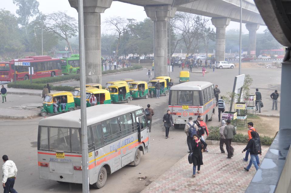
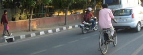
2 The walking & cycling linkages from the public transits should be prioritized over other facilities like parking etc. Seamless intermodal connections to other modes of public transport should also be integrated at public transits. Option to select different modes to make travel trip cheaper, faster and more comfortable With auto-rickshaws, gramin seva, vendors being pushed on to the main carriageway along with the pedestrians and cyclists the metro station has only provided for a car park for private vehicles to be parked there day-long. Pedestrians and cyclists made to risk their lives due to lack of proper infrastructure connecting to the Metro Station The dangerous conditions that exist as approach to the metro stations


Modes")


3 MODAL CHOICES ORIGIN First Mile Connectivity - Morning DESTINATION Last Mile Connectivity - Evening Private car Cab/Cab on call Auto Rickshaw METRO /BRTS/ PUBLIC TRANSPORT Private car Cab on call Auto Rickshaw Walking Walking Cycling Cycling City Bus Cycle Rickshaw Cycle Rickshaw City Bus Metro bus Metro bus Shuttle Van /Tempo Shuttle Van /Tempo Delhi has a mix of public transport systems including circular rail, BRTS, Bus network, Metro, proposed LRT etc the need is really to integrate these systems of long distance connectivity to local short distance sub-systems Modes used for integrated multi-modal public transport system. Motorized Modes Public Transport Modes Non Motorized (NMT)Modes Present conditions Chaotic Unsafe Unmanaged Pedestrian unfriendly Stressful to visit Can be transformed to: Well managed Organized Pedestrian-friendly Destination space Public plaza City Buses/Metro Buses ShuttleAuto Rickshaws/Tempo 1 st Class Experience. Well Connected. BRTS Pedestrian Cycling Taxi /Cabs on call METRO Cycle Rickshaw


4 Present Modes being promoted to connect to public transport system. Private Motorized Modes Public Transport Modes Private Motorized Modes 1 st Class Experience. Well Connected. BRTS MULTI-MODAL INTEGRATAION IMPROVING PEDESTRIAN ACCESS INCORPORATING NMT MOBILITY INTEGRATING PARA TRANSIT AND FEEDER SERVICES INTEGRATING WITH BUS-SERVICES MORE AND MORE CARS METRO PRIVATE VEHICLES Airport Option 04 METRO BUS Vasant kunj Malviya Nagar Mahipalpur Vasant kunj Kishangarh Mehrauli Saket Vasant kunj Qutub Farmhouses Chattarpur Chattarpur Sultanpur LINKAGES - INTERMODAL integrating different modes of transport buses, para transit, taxis etc. around metro stations Ghitorani Farmhouses Farmhouses Chattarpur Metro Station attracts most of the people from surrounding areas extending upto 7 kms on either side.


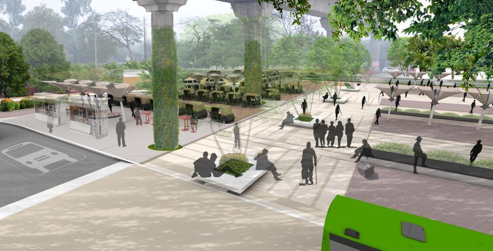
5 Proposal CONCEPT Creating the main pedestrian concourse for people to move seamlessly to and for. The main axis also emphasis the main entry to the metro station. On the left side all the para transit facilities, pick up drop off are placed, off the main movement. On the right side public plaza is created for people who want to sit and while off some time eating and enjoying PEOPLE COMMUTING EITHER BY NMT OR PARA TRANSIT OR DTC Existing Condition Activity Mapping of PEDESTRIANS Proposal Pedestrian Movement and DTC Bus Movement ISSUES: All thedtc buses going towards Vasant Kunj, donot have a bus stop so they pick up and drop off right onto the road. Para transit and private vehicles take a free right and stop on the road for pick up and drop off, adds to the chaos and confusion Inspite of large area available activities are concentrated at one point. Pelican Crossing Raised Crossing PROPOSAL: All the para transit facilities happen on the one side, feeding into the pedestrian concourse. People crossing the road requires a proper raised crossing and a pelican signal as the junction is very critical. Creating a good plaza for people who want to spend some time at the station. Bus Bus Stand Metro Bus Auto Rickshaw Gramin Seva Hawkers Pedestrian Raised Crossing 18 All OASIS the DESIGNS activities INC are concentrated to few points whereas the rest of area is underutilized. MAY 2012


6 Proposal Para Transit Mode of Transportation Proposal The free right has been designed properly as all the para transit coming to metro station use it to avoid the waiting time at the signal ahead. Provided a proper drop off and pick up facility for all para transits. There are two bays for auto rickshaw line up which can accommodate around 30 autos. Provision for five grammin seva line up on the other side of road. Feeder bus Metro bus has a separate pick up drop off covered bay where around three buses can stand at a time. Provision for 20 cycle rickshaw stand. Pedestrian Network DTC Bus Stop Drop off n Pick up Provision for cycle stand having Auto Stand capacity of 60 cycles and a cycle Cycle Repair Shop Grammin Seva Stand repair shop. Metro Bus Stand Cycle Rickshaw Stand Cycle Stand 23 Proposal Plaza and Amenities Before Metro line Public plaza on the right hand side is landscaped for people to leisure around. Provision for hawker zones help in organizing the space better. There are many covered canopy for people to relax under a shaded environment. Hawking Zone Covered Plaza 24

7 After 26 28

8 Proposal in accordance with UTTIPEC MRTS GUIDELINES 50 mts Bus stop & Cycle Rental Services 100 mts Cycle & two wheeler parking 150 mts Auto Rickshaw stand location BEYOND 250 mts Private Parking Component 1 Street Design UTTIPEC Street design Standards 10-point checklist 2 Signalized Crossings Stations abutting any Street Type other than above-80 M Expressways. Stations abutting R/Ws above 80 M width i.e. Expressways. 3 Modal Interchange Locations & Parking Bus Stop Location Cycle-Rental Service Location Cycle and Validated two-wheeler Parking Stand (Entry) location Auto-rickshaw Stand location Private Car/ Taxi/ Auto-Rickshaw "Drop-off" location Private Valiated Car Parking location Pairing of Origin-Destination (O-D) Nodes Sub- Component UTTIPEC MRTS Checklist 4 Universal Accessibility Universal Accessibility is required for all sidewalks, crossings,parks, public spaces and amenities. INTERMODALITY Creating Transport Hubs, linked with public plazas, parking 5 Location and Quality of Facilities OUTSIDE Station premises. On-street Cycle, Cycle-rickshaw, auto-rickshaw and taxi parking Hawker Zones Public Toilets Lighting 6 Building Entry Locations Location of Pedestrian and cyclist entry to buildings/ complexes. 7 Public Transport (Primary, Demand ~ Supply Evaluation for various Modes Secondary)


9 BHAIRON MARG - INTERVENTION BHAIRON PLAZA Place making PRAGATI MAIDAN GATE NO-2 NATIONAL SCIENCE CENTER PRAGATI MAIDAN MAIN PRAGATI MAIDAN PARKING PRAGATI BUS TERMINAL PROBLEMS 3 lane road on either sides-lane width of 3.5 meters each, which adds to REGULAR TRAFFIC CONGESTION. 4 lane Service road on a small stretch of Bhairon marg catering to the main Pragati maidan parking. Huge tar area left for Pragati maidan bus stop and bus parking, which increases URBAN HEAT ISLAND EFFECT. DESIGN INCLUDES: TOILETS VENDOR AREAS DEFINED & PEDESTRIAN SUBWAY UNDERPASS SEATING AREAS PROPER LIGHTING STORM WATER DRAINAGE BHAIRON MANDIR PARKING AREA BHAIRON MARG - INTERVENTION BHAIRON PLAZA Retro-fitting of spaces INTERVENTIONS 3 lane road on either sides-lane width of 3.5 meters each, which divides TO AND FRO TRAFFIC reducing traffic congestion. NEW ROUND ABOUT created to encourage traffic calming, which also accommodates Pragati Bus Terminal and large green spaces. Parking area modified to encourage STORM WATER DRAINAGE. Accessibility given from round about to parking. 2 wheeler parking added.


10 BHAIRON PLAZA Retro-fitting of spaces MOBILITY MOBILITY FOR PEOPLE NOT VEHICLES EQUITIBLE ALLOCATION OF ROAD SPACE WALKING IN THE CITY CYCLING IN THE CITY EQUITABLE DISTRIBUTION OF ROAD SPACE Continuous, Segregated & Safe - Walking & Cycling Space on roads.


11 EXISTING STREET SECTION STANDARDS FOR FOOTPATH AND CYCLING TRACKS FOR UTTIPEC TREE PLANTING AREA SERVICE DUCT/ PATHWAY 4 LANE CARRIAGE WAY with NO MEDIAN SERVICE DUCT/ PATHWAY TREE PLANTING AREA PROPOSED STREET SECTION PEDESTRIAN AREA, with vendor space, seating areas etc. CYCLE TRACK BUFFER GREEN MEDIAN 2 LANE CARRIAGE WAY 2 LANE CARRIAGE WAY PATHWAY SERVICE ROAD PARALLEL CAR PARKING BUFFER GREEN RING ROAD ALONG MILLENNIUM PARK PEOPLE FRIENDLY STREETS - Cycle tracks & Pathways on road side, multimodal spaces at Entry points and Junctions.


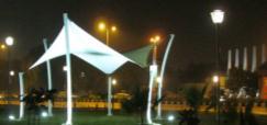
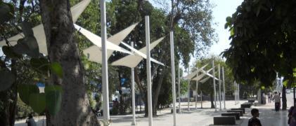
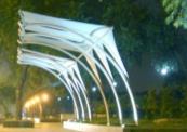
12 RING ROAD ALONG MILLENNIUM PARK INDRAPRASTHA MARG IP marg houses important governmental offices including the Police Headquarters,PWD,DDA apart from the institutions like the SPA,ITO etc -leading to a huge number of pedestrians. The streetscape design for this area focuses on creating spaces for pedestrians to be able to access the public transit systems like the metro and the BRT,both of which are very close to this road. The streetscape of IP marg has a unique footpath cum plaza feel with inbuilt stone seaters dotting the whole stretch of the road. The existing green strips along road and boundary walls are retained and enhanced to form continuous buffers. MILLENNIUM PARK SIDE STREETSCAPE THE PLAZA IN FRONT OF THE MILLENNIUM PARK T-POINT The streetscape design for this stretch is front of the Millennium park aims at creating a park edge experience -with plaza garden stretches along the sidewalk & NMT Corridor. The plaza in front of the Millennium park T point is also designed as a pedestrian space integrated with the under flyover plaza. The entire junction is designed as a bus interchange facility with all bus stops relocated near the junction of pedestrian crossings to enable people to change over from the different buses in different directions.the sculptural tensile structures add to the visual place making of the junction.


13 PEDESTRIAN CROSSING FACILITIES Kerb radii to slow turns and shorten crossings SAFETY & UNIVERSAL ACCESSIBILITY MOBILITY FOR PEOPLE NOT VEHICLES CREATING SAFE JUNCTIONS TRAFFIC CALMED ROUND ABOUTS BARRIER-FREE ENVIRONMENT PEDESTRIAN CROSSING FACILITIES Crosswalk treatments Crosswalk markings Pedestrian signal timing Supplementary treatments IMPROVING ACCESSIBILITY - Creating Barrier free Environment. Traffic and parking restrictions for pedestrian safety Reduce pedestrian crossing distances


14 Universal Accessibility is required for all sidewalks, crossings, parks, public spaces and amenities for people using wheelchairs, strollers, walkers, crutches, handcarts, bicycles, aged people, visually or hearing impaired, and pedestrians with temporary mobility impairment or injury. SAFE JUNCTIONS - creating pedestrian facilities at Junctions JUNCTION DESIGN- Accommodating pedestrian facilities Marked crosswalks Kerb ramps Turn radii to slow vehicles RAISED CROSS OVERS Curb extensions Pedestrian islands Street trees Site furnishings Accessible transit stops Pedestrian lighting


15 IP Marg Traffic Island INTERVENTION CONTINUOUS PATHWAY PROPER PEDESTRIAN CROSSING FACILITY STREAMLINING VEHICULAR TRAFFIC - Round-about Junction LG ROUND ABOUT, GNIDA - INTERVENTION NH-24 T-junction NO CONTINUOUS PEDESTRIAN MOVEMENT TURNING RADII AND THE ROUND ABOUT SIZE CAUSE MORE ACCIDENTS IN THIS JUNCTION CONFLICT POINTS


16 ADDING VITALITY TO PUBLIC SPACES - Creating Plazas, Vendor spaces. NEAR MAHARANI BAGH FOB The plaza near the Maharani bagh bus stop and foot over bridge is designed as an over-spill for the people waiting at the bus stop. This increases the capacity of the area as the bus stops do not provide for seating for all. PLACE-MAKING CREATING A ENJOYABLE PUBLIC REALM All the space which forms the part of the ROW of the road has been freed of all encroachment even governmental encroachment like PWD site offices etc. This newly reclaimed space has then been integrated with the street functions to help make the street perform better. This particular set of photographs of the before and after at one location demonstrates clearly the transformation of the encroached space into a happening well-designed overspill space which becomes the extension of bus-stop. People waiting for a bus, or waiting for a friend, or family or just wanting to sit and watch can use this space without hampering the other users wanting to use the street these small plaza spaces actually add a lot of value to the overall street experience


17 ITO UNDER FLYOVER CREATING PEDESTRIAN ZONES PEDESTRIANIZATION ADDING VITALITY TO PUBLIC SPACES - Creating Plazas, Vendor spaces.


18 ASHRAM JUNCTION The photographs of how the streets used to perform earlier and how the same street has now been transformed with proper planning, road realignment. New public conveniences have been introduced along the entire sidewalk facility on either side in addition to periodic locations for vendors plazas etc


19 ASHRAM FLYOVER NEAR ISBT, SARAI KALE KHAN All the space under the flyovers which used to be inaccessible and unutilized earlier has now been freed up and made accessible for people, pedestrians to use. These new plaza spaces under the flyover have also been planned to connect to newly located bus-stops planned near the junctions and in this way they work as a overspill of the bus-stops so are used by all travelling on public transportation. The design of the new under flyover plazas also discourages misuse of the space by squatters and beggars and is well lit at night to ensure safety. Additional functionality like vendor spaces and public art galleries with changing display are planned to keep these plazas busy as active urban landscape public spaces in the city Small plaza spaces have been carved out of low lying swampy ground on the edge of the street to house newly built vendor plazas near the ISBT Sarai Kale Khan and the Nizamuddin Railway Station. This is a very busy intersection and the urban landscape design for this space provides for large conglomeration of people to become a part of the urban experience offered by the city. NEAR MAHARANI BAGH FOB ENTRY TO MILLENNIUM PARK All left over, underperforming, wasted space on the streets has been transformed into useable, functional, safe spaces that make the experience of the user more dignified and enjoyable. Though green, the area in front of Millennium park Entry lacks in term of connectivity. The new landscape design intervention helps make this into an arrival plaza with cycle track & pathway on either side of the entry.


20 RING ALONG NEAR STUPA RING ROAD-OPPOSITE MILLENNIUM PARK The area in front of the Stupa at the Millennium Park used to be used for unauthorized parking and the parked cars would occupy the entire sidewalk space for the road. The new streetscape has managed to reclaim all the space being earlier used for parking to create a park extension that allows the parkedge to merge with the new pedestrian plazas to create a pleasant urban landscape experience for the users Ring road near Ash pond area didn t have proper pathway and buffer green area for safer walking & cycling. The area is now transformed into a usable multi modal track with lush green area along side. RING ROAD ALONG MILLENNIUM PARK NEAR IP METRO STATION The unutilized, derelict landscape that used to characterize the streets before the Streetscape Design Make-over now is transformed into a landscape that works, that catches, filters and helps the storm water infiltrate into the ground. This ecological landscape helps the public green areas in the city become more useful ecologically, while making them look neat and safe. Also seen in the picture the special lighting that has been put up only dedicated to the cycling and walking tracks on the road, so that they remain safe and usable at night also just as well-lit as the motor-able carriageway on the road The plaza in front of the Indraprastha Metro Station has been redesigned as a multi-modal interchange with connections to a bus-stop, taxi-stand, scooter rickshaw stand, cycle stand allowing the users to be able to optimize their journey in terms of cost and time. The new Streetscape design also incorporates tensile fabric shading structures with large number of built-in seater walls as part of the overall street-furniture vocabulary. Traffic management, road-realignment transforms this space into a usable pedestrian hub, with proper allocation of vendor spaces and public art displays


21 NEAR IP METRO STATION NEAR IP POWER STATION This set of before and after photographs of a stretch of the ring road near the IP Metro Station shows how a new bridge has been constructed over an existing open storm water drain to create a new pedestrian access to the Metro Station Plaza this was needed to achieve the continuity for the cycling and walking tracks on the road. The urban landscape design also incorporated structural interventions to create a seamless, uninterrupted and connected sidewalk facility The area around all the bus-stops have been redesigned as intermodal interchange plazas with provisions of a taxi stand, scooter stand, cycle stand etc. The new streetscape design also ensures that all the bus-stop locations have suitable pedestrian crossings to reach the other side of the ring road. NEAR IP POWER STATION NEAR IP POWER STATION What earlier used to be a death trap has now been transformed into a pleasurable walking experience with help of the Streetscape Design interventions. The open drains, unkempt sidewalks existing earlier have now been transformed into beautiful boulevard walks with fragrant planting to create the new emphasis on walking and cycling activities on the road, as these benefit the majority of road users who use the public transportation.


22 NEAR IP POWER STATION NEAR WHO BUILDING The open drains, unkempt sidewalks existing earlier have now been transformed into beautiful boulevard - with the landscape design cataloguing all the unavoidable parts of the city's infrastructure that earlier used to stick out in the center of the pavements. Pavement areas are redesigned with proper cycle track & pathway, which are separated from carriage way with green buffer. NEAR IP POWER STATION BHAIRON PLAZA New Pavements have been created instead of dangerous open drains, to enable people to walk safely to bus stops Existing pedestrian subway properly integrated in the landscape plan


23 IP MARG The streets as they existed before, were more of a series of obstacles that the user was supposed to negotiate but have now been transformed into people friendly spaces with space for cyclists, wheelchairs, prams, pedestrians and other NMT users ITO UNDER FLYOVER CASE FOR WALKING


24 WHO WALKS?! WHERE & HOW WHO WALKS?! WHO WALKS?! WHERE & HOW CASE FOR CYCLING


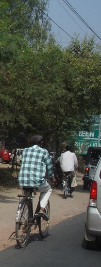
25 HOW AND WHERE DO PEOPLE CYCLE Lack of proper cycle tracks leads the non-motorized transport users to share the road space with vehicular traffic. This is a safety hazard and leads to road accidents and fatalities WHO CYCLES?! BICYCLES AS URBAN TRANSPORTATION WHO CYCLES?! BICYCLES A URBAN GOODS SERVICE CASE FOR CYCLE- RICKSHAWS


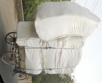
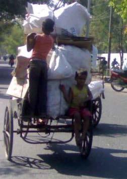
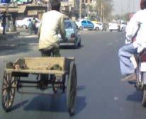


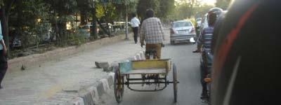


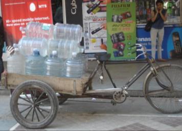


26 CYCLE RICKSHAWS for short trips CYCLE RICKSHAWS A URBAN SERVICE HOME DELIVERY GOODS CYCLE RICKSHAWS A URBAN SERVICE HOME DELIVERY GOODS, COLLECTION OF TRASH CYCLE RICKSHAWS & PUSH CARTS A URBAN SERVICE HOME DELIVERY OF FRUITS, VEGETABLES


27 STORMWATER MANAGEMENT RETROFIT WHAT WE NEED IS DEDICATED NMT TRACKS AND GOOD FOOTPATHS ON ALLOUR ROADS!


28 Existing drainage system in the city Source : CSE Dry zone map, Delhi oasis designs inc. Delhi has separate storm & sewer channel, that connect to nala & then to river. Hindustan Times, 21/02/12 Sustainable storm water management One pipe leading to Another DEMAND WATER SUPPLY With the help of sustainable storm water management the harvested water can be used for non-potable water uses. DRINKING FROM YAMUNA STORM WATER MANGEMENT FLUSHING RAIN WATER HARVESTING WASHING STORAGE TANKS IRRIGATION All the stormwater falls on road and it is diverted towards the closest nala or drain. oasis designs inc.


29 Now it s time to STOP & RETHINK. Storm Water Retrofit designs are required to overcome these situations and achieve successful ground water recharge. What s a storm water retrofit? The installation of a new facility to recharge & treat storm water from existing impervious area. Storm Water Management Strategy disconnecting the system RAIN WATER FALLS ON Roads Parking lots Open land ROOF TOPS GOALS: Retrofit the existing system to achieve sustainable storm water management. Use site design techniques that filter, convey, detain, retain, infiltrate and store runoff. New strategy for disconnecting from the conventional pipe system and using all possible alternate areas for recharge. Storm water disconnects from drain & enters green area GROUND WATER RECHARGE OVERFLOW GOES BACK TO DRAIN DRAIN OVERFLOW GOES TO RIVER


30 ROAD SECTION - CONVENTIONAL Storm water facilities that can be put on Road ROAD SECTION - PROPOSED oasis designs inc. PART ROAD SECTION - CONVENTIONAL If there is less space on road side, Water can be taken through drain channel to nearby large green area or other conveyance system / harvesting system. PART ROAD SECTION - PROPOSED Median only collects the rain water falling on its own surface area, as the road camber is towards the side greens. Run off from entire road enters the side greens.


31 Design Strategies for sustainable SWM Conventional Kerb Examples to Avoid MANAGE STORM WATER IN A CITY BY ADOPTING FOLLOWING MEASURES FILTRATION CONVEYANCE DETENTION RETENTION INFILTRATION SLOW SPREAD SOAK EXISTING EXISTING STREET IS DESIGNED IN SUCH A WAY, WHERE THE RAIN WATER ENTERS FROM THE BELL MOUTH TO THE DRAINAGE PIPE & THEN TO NEARBY NALLAH. oasis designs inc.


32 PROPOSED STORM WATER MANAGEMENT CHART FILTRATION GRAVEL FILTER CHAMBER GRAVEL FILTER STRIP VEGETATED FILTER RIPARIAN BUFFER CONVEYANCE BIO SWALE PLANTERS STORM WATER ENTERS THE ADJACENT GREEN AREA THROUGH KERB CUTS. THE GREEN AREA LVL IS ALWAYS LOWER THAN ROAD LVL. oasis designs inc. SWM DETENTION RETENTION INFILTRATION DETENTION POND RETENTION POND INFILTRATION TRENCH DRY SWALE CONSTRUCTED WETLAND INFILTRATION BASIN UNDERGROUND STORAGE TANK PERVIOUS PAVING RAIN WATER HARVESTING RAIN GARDEN Conventional kerb stone used on road F I L T R A T I O N Continuous Gravel Filter along road NEW kerb stone for Storm water management GREEN IS HIGHER THAN ROAD LVL oasis designs inc. DEEPER KERB STONE SHOULD BE USED TO ACHIVE LOWER GREEN AREAS.
 ENTERING THE STORM WATER CHANNEL & WATER BODIES.")


33 Existing Drain systems on road EXISTING FILTRATION NEEDS TO STOP ALL THE DIRT & POLLUTANTS (OIL & GREASE ) ENTERING THE STORM WATER CHANNEL & WATER BODIES. oasis designs inc. INSERT SWALE or PLANTER HERE oasis designs inc. F I L T R A T I O N Gravel Filter some intervals How to control impurities from going in to the green area RETROFIT OPTION IMPURITIES SETTLE DOWN ON THE GRAVEL BED. THESE CAN BE REMOVED PERIODICALLY BY THE MAINTNANCE TEAM FILTERED WATER GOES INTO SWALE FOR GROUND WATER RECHARGE. EXTRA WATER GOES TO NEAR BY DRAIN THROUGH UNDERLAY PIPE. oasis designs inc. OVERFLOW PIPE FOR GRAVEL BED GRAVEL BED HAS TO BE REGULAR INTERVALS FOR STORMWATER RECHARGE oasis designs inc.


34 EXISTING I N F I L T R A T I O N Rain garden Rain gardens in Round about oasis designs inc. Rain gardens retain storm water, thereby reducing flow rate and overall volume. They can also allow for infiltration, depending on the capacity of the native soil. Rain gardens are shallow landscape areas that can collect, slow, filter and absorb large volumes of water, delaying discharge into the watershed system. PROPOSED Round About Proposal, Greater Noida RAIN GARDEN oasis designs inc. oasis designs inc. THE PLANTERS ARE CONNECTED THROUGH PIPE BELOW THE RAMP.


35 Conventional Parking Types SWM CHECKLIST FOR ROADS WITH LONGITUDINAL GREEN AREAS OF FOLLOWING WIDTH EITHER BETWEEN ROAD & PATHWAY OR BETWEEN PATHWAY & BOUNDARY WALL PARKING LOT, THEN WIDTH of green areas FILTRATION CONVEYANCE DETENTION RETENTION INFILTRATION < 1.5m GRAVEL FILTER CHAMBER STORM WATER PIPES FLOW THROUGH PLANTERS BHAIRON MARG 3 5m GRAVEL FILTER STRIP SWALE FLOW THROUGH PLANTERS DRY SWALE UNDER GROUND STORAGE TANK INFILTRATION TRENCH PROPOSED PARKING LOT FOR CWG GAMES 5 10m GRAVEL FILTER STRIP VEGETATED FILTER SWALE FLOW THROUGH PLANTERS UNDER GROUND STORAGE TANK DETENTION POND RETENTION POND (PARTIAL) INFILTRATION TRENCH BHAIRON PARKING, NOW CWG GAMES > 10m VEGETATED FILTER SWALE UNDER GROUND STORAGE TANK DETENTION POND RETENTION POND CONSTRUCTE D WETLAND RAIN GARDEN INFILTRATION BASIN Parking Options CONVENTIONAL WAY OF PARKING SECTIONS THIS HAS LOT OF HARD AREA AND ADDS TO HEAT ISLAND EFFECT. NEW WAY OF PARKING DESIGN WHERE GREEN AREA INTRODUCED WITH IN SAME SIZE OF PARKING. THIS SYSTEM REDUCES HEAT ISLAND EFFECT AND HELPS IN STORM WATER MANAGEMENT. ECO-MOBILITY OPTIONS NATURAL HERITAGE CONNECTED GREENS


36 EXISTING CONDITION OF THE DRAINS SOUTH DELHI GREENWAY eco-mobility and ecology The dirty view and horrible stench of these urban drains has become a shameful problem The South Delhi drain is one such drain catering to just 3% of the total flow in Yamuna. The non-monsoon flow in the drain is foul smelling waste-water generated by various slum colonies situated upstream.


37 Non-motorized Transportation Corridor shall use Streetscapes Drainage channels Green strips and parks THE TRANSFORMATION THE PARK CONNECTOR to create a continuous matrix of connected trail network Main Objectives: Inter-modal connectivity for seamless travel Last-mile connectivity Provide time-saving short-cuts Kids going to school People travelling a short distance to markets etc. Street bazaars, vendors shall make this a happening place - and safe realm ECOLOGICAL LANDSCAPE SOUTH DELHI GREENWAY MASTERPLAN AREA: 700 ACRES INTER-CHANGE FACILITIES Needed between the proposed mass transit systems such Metro, BRT and with other feeder services like auto-rickshaws, buses, taxis and non-motorized transport This will also include approach roads to stations, adequate parking areas for various modes like the new Soleckshaw and other NMV like cycles etc. MULTI-MODAL INTEGRATION


38 AREA#1: THE BARAPULLAH AREA INCREASED PED-SHED OF THE JANGPURA METRO STATION WITH HELP OF NEW NMT CORRIDOR NIZAMUDDIN STATION JANGPURA METRO STN ISBT SARAI KALE KHAN JANGPURA METRO STATION NIZAMUDIN WEST NIZAMUDIN EAST BHOGAL JANGPUR A 5 MINS. LAJPAT 10MINS. NAGAR 1 SARAI KALE KHAN SIDHART H EXTN. DEFENCE COLONY RING RAILWAY BRT CORRIDOR ELEVATED ROAD OVER BARAPULLAH BRT CORRIDOR CONNECTION OF THE NIZAMUDDIN STATION & ISBT TO THE NEAREST JANGPURA METRO STATION WITH HELP OF NEW NMT CORRIDOR NIZAMUDDI N STATION ISBT SARAI KALE KHAN WASTEWATER TREATMENT ISSUES 2.0 KMS JANGPURA METRO STATION 3.5 KMS BRT CORRIDOR


39 CASE STUDY OSHO PARK, PUNE Nature paradise IMAGE SOURCE - OASIS DESIGNS INC Peaceful respite No smell No mosquitoes Beautiful landscape Moving water Fish in the channel Waterfalls Birds Butterflies DELHI WHICH FORMS JUST 2% OF THE CATCHMENT AREA OF THE RIVER YAMUNA CONTIBUTES NEARLY 80% OF ITS POLLUTION IMAGE SOURCE - OASIS DESIGNS INC IMAGE SOURCE - OASIS DESIGNS INC Complete natural eco-system CASE STUDY OSHO PARK AT PUNE PLAN OF THE WATER TREATMENT FACILITY: STOP THE POLLUTION AT THE SOURCE Better to catch and treat the pollution at source rather than treating the entire polluted waterbody


40 Overview of treatment plant components Raw Wastewater Influent SCREENS PRELIMINARY( removal of Solids) Grit chamber A Preliminary Residuals (i.e., grit, rags, etc.) PRIMARY (removal of SS) Primary Settling Tank IMAGE SOURCE - OASIS DESIGNS INC For Disposal B Primary Sludge Biological Treatment System SECONDARY (Attached-growth System e.g. Trickling Filter) TERTIARY Wetland Clarifier (Constructed Wetland.) DISINFECTION (selectively) Treated Wastewater Effluent Discharge to Receiving Waters THE SOUTH DELHI GREENWAY MASTERPLAN IMAGE SOURCE - OASIS DESIGNS INC


41 THE DANGER OF THESE ECO-CORRIDORS BEING LOST IMAGE SOURCE - OASIS DESIGNS INC GROUND WATER RECHARGE: ZERO RUN-OFF RAINWATER HARVESTING: IMAGE SOURCE - OASIS DESIGNS INC CREATING INFILTRATION TOPOGRAPHY OR MAKING THE CITY MORE IMPERVIOUS ZERO RECHARGE CREATING ZERO RUN- OFF OR ZERO RECHARGE IMAGE SOURCE - OASIS DESIGNS INC


42 Case study IMAGE SOURCE - OASIS DESIGNS INC URBAN HEAT ISLAND EFFECT: INCREASING GREEN COVER OR MAKING CONCRETE SLABS OVER NATURAL DRAINS COVER STORY 15 th May, 2006 ISSUE OF TIME CASE STUDY SEOUL, KOREA MAGAZINE THANK YOU THE DRAIN COVERING STATUS
MULTI-MODAL INTEGRATION
 MULTI-MODAL INTEGRATION INTER-CHANGE FACILITIES Needed between the proposed mass transit systems such Metro, BRT and with other feeder services like auto-rickshaws, buses, taxis and non-motorized transport
Implementation and Systemic Change with UTTIPEC Street Design Guidelines
 Implementation and Systemic Change with UTTIPEC Street Design Guidelines Presented by: Ashok Bhattacharjee, Director - Urban Transport Planner, United Traffic & Transportation Infrastructure (Planning
COMPLETE GREEN STREET CHECKLIST
 COMPLETE GREEN STREET CHECKLIST This document was developed to dissect the structure of an urban street and explore opportunities to make our streets more complete while also integrating green street strategies.
Transportation. Strategies for Action
 Transportation A major priority for the Overlake Neighborhood is to develop a multimodal transportation system. To achieve this system, a balance has to be found among travel, circulation and access needs;
VEHICULAR AND PEDESTRIAN CIRCULATION
 This perspective sketch communicates the intended character and quality of a proposed streetscape design. Locate benches near a major intersection where people tend to gather. Seating and lighting provide
MPD 2021 Review TOD Policy
 MPD 2021 Review TOD Policy CURRENT CITY PATTERN: Population Density evenly distributed all over city. Large Travel distances & pollution due to segregated land use and vehicular dependency. Rohtak Road
Green Infrastructure and Low-Impact Development Technologies
 Green Infrastructure and Low-Impact Development Technologies The guiding principles of these technologies is to manage stormwater at their sources using natural means, and establish conditions so that
The open space system should provide connective elements, relate to natural resources, and enhance the suburban character of the landscape..
 The open space system should provide connective elements, relate to natural resources, and enhance the suburban character of the landscape.. Mixed-use and infill development should maintain or enhance
Toronto Complete Streets Guidelines
 Toronto Complete Streets Guidelines 108 110 7.1 Green Infrastructure Design Principles 112 7.2 Context-Sensitive Green Streets 114 7.3 Key Green Street Elements Green infrastructure refers to natural and
LOUISIANA STATE UNIVERSITY COMPREHENSIVE & STRATEGIC CAMPUS MASTER PLAN. APPENDIX G - Stormwater Study Findings & Stormwater Solutions
 LOUISIANA STATE UNIVERSITY COMPREHENSIVE & STRATEGIC CAMPUS MASTER PLAN APPENDIX G - Stormwater Study Findings & Stormwater Solutions LSU: MP Narrative July 2017 3.5 Open Space Existing Conditions The
Appendix D - Technical Design Criteria for BMPs
 Appendix D - Technical Design Criteria for BMPs City of Wayzata Page 3 On-site infiltration features Definitions and Scope: Infiltration facilities are constructed basins or depressions located in permeable
Appendix E: Illustrative Green Infrastructure Examples
 Appendix E: Illustrative Green Infrastructure Examples Integrating LID into San Francisco s Urban Landscape Figure E. High-density Residential Figure E. Low-density Residential Figure E. Mixed Use 7 Figure
Integrated Multi Modal Public Transit Hub
 Leaders Programme in Urban Transport Planning and Management Integrated Multi Modal Public Transit Hub at Central Business District- Ahmedabad Neela Munshi (Senior Town Planner) Deepa Dave (AM Urban Planner)
Potential Green Infrastructure Strategies May 6, 2015 Workshop
 Potential Green Infrastructure Strategies May 6, 2015 Workshop Background The City of Cortland is developing the Tioughnioga Urban Headwaters Green Infrastructure Action Plan with funding from the National
UBC URBAN STUDIO, FALL 2002 PEDESTRIAN ORIENTED
 SECTION B PEDESTRIAN ORIENTED PATTERN: CITY OF VANCOUVER B.1 Vision Overview Regional Framework Energy 50% of all energy used within the Region to be produced by the Region. Energy production methods to
Urban Stormwater: Best Practice Environmental Management Guidelines. CSIRO This electronic edition published by CSIRO PUBLISHING, 2006.
 Urban Stormwater: Best Practice Environmental Management Guidelines. Chapter 5 Water Sensitive Urban Design Key references Department of Planning, 1993, Better Drainage: Guidelines for the Multiple Use
This Review Is Divided Into Two Phases:
 Semiahmoo Town Centre Review The purpose of this review: To review the Semiahmoo Town Centre Concept Plan, originally approved in 1993, to ensure that this centre will continue to serve the needs of South
DRAFT. 10% Common Open Space
 % OF CHARLOTTE IS CATEGORIZED AS A. LAND USES : Placeholder map displaying location of Place Type GOALS: Accommodate XX% of future growth. Provide a concentration of primarily commercial and civic activity
Post Construction BMPs
 Post Construction BMPs Why are Post Construction BMPs important? With increased development brings the increase of impervious cover Parking lots, rooftops, driveways Storm water runoff volume increases
Appendices: Glossary. General Terms. Specific Terms. Low Impact Development Approaches Handbook
 67 67 General Terms Specific Terms 66 Low Impact Development Approaches Handbook The vocabulary of low impact development is evolving, and many terms are used interchangeably and to describe the same or
2
 1 2 3 The water used for watering landscapes accounts for a significant percentage of total water demand. Every year, Aurora citizens use about 40% of their potable water for irrigating lawns and gardens.
SANDPOINT/LAURELHURST. <Study Area>
 SANDPOINT/LAURELHURST Team Leaders: Kari Olson, Jason Morse Student Team Leaders: Tim Shuck, Terry Shaver. Team Members: Lynda Betts, Thomas Hargrave, Lolly Kunkler, Diana Kincaid, Edith Sze
1 Adapted from the Statewide Transit-Oriented Development Study by CalTrans, 2006
 APPENDIX C: LAND USE PLANNING FOR ENHANCED RAIL SERVICE 72 BACKGROUND One of the consistent themes heard from localities in the Route 29 corridor Planning Forums was the need for expanding rail service
LAST MILE CONNECTIVITY & MULTI-MODAL INTEGRATION PROPOSED ACTION PLAN - PROJECTS & PROGRAMME
 LAST MILE CONNECTIVITY & MULTI-MODAL INTEGRATION PROPOSED ACTION PLAN - PROJECTS & PROGRAMME UTTIPEC / JULY 2012 The Background 6 Mandates 1. Multi-modal integration plan for Metro Stations 2. Pedestrian
Paseo Civico Metropolitano Alameda Providencia Corridor
 Groundlab est. 2008 Jose Alfredo Ramirez London, UK New York, U.S. Paseo Civico Metropolitano Alameda Providencia Corridor Category: parks / plazas Location: Santiago, Chile Surface: N/A Project Year:
Public Meeting May 20, 2014
 Public Meeting May 20, 2014 Overview Study Purpose Study Area Overview Strategies Potential Opportunities Implementation and Discussion Skeo Solutions Raleigh Walkable Watershed Pilot 2 Purpose Develop
Introduction to Low Impact Development. Fred Milch. East Central Florida Regional Planning Council
 Introduction to Low Impact Development Fred Milch East Central Florida Regional Planning Council Low Impact Development (LID) Low impact development (LID) is a term used to describe a land planning and
GUIDELINES FOR ECOLOGICAL PERFORMANCE
 3 Landscape........................................... 3.2 Stormwater Management................................... 3.3 Hardscape........................................... 3.4 Streetscape..........................................
2012 Saginaw Bay Watershed Conference
 2012 Saginaw Bay Watershed Conference March 16, 2012 Russ Beaubien, P.E., CFM Low Impact Development Fundamentals Summary LID overview Education on LID Fundamentals of LID Examples of LID practices Other
Green Infrastructure Overview
 Green Infrastructure Overview Christopher C. Obropta, Ph.D., P.E. obropta@envsci.rutgers.edu Jeremiah Bergstrom, LLA, ASLA jbergstrom@envsci.rutgers.edu February 26, 2016 Water Resources Program NJDEP
include playgrounds, sports fields, community gardens and picnic areas.
 DEVELOPMENT PLAN OPEN SPACE SYSTEM OPEN SPACE SYSTEM The neighborhood provides for a range of open space types. The Village Square is an important open space in the neighborhood. It serves as a gathering
The West Vaughan Employment Area Secondary Plan Policies
 Part 2: The West Vaughan Employment Area Secondary Plan Policies 2.1 General Policies It is the policy of Council: 2.1.1. That the West Vaughan Employment Area (the WVEA), identified on Schedule 1, will
SUSTAINABLE TRANSPORT & INTEGRATED LAND USE PLANNING
 SUSTAINABLE TRANSPORT & INTEGRATED LAND USE PLANNING UNESCAP Capacity Building Workshop, Colombo Integrated Land use and Urban Transport Planning : Principles and Practices 31st October 2017 ACTIVE TRANSPORTATION
Low Impact Development. Charlene LeBleu Auburn University Landscape Architecture (334)
") Low Impact Development Charlene LeBleu Auburn University Landscape Architecture leblecm@auburn.edu (334) 844-0192 What is Low Impact Development? Infiltrate Filter Store Evaporate Detain An innovative
Low Impact Development Charlene LeBleu Auburn University Landscape Architecture leblecm@auburn.edu (334) 844-0192 What is Low Impact Development? Infiltrate Filter Store Evaporate Detain An innovative
City of Hermosa Beach Administrative Policy #
 City of Hermosa Beach Administrative Policy # SUBJECT: Living Streets Policy Date: Approved by: City Council Authority: Public Works Department & Community Development Department Mayor, PURPOSE The City
Green Infrastructure & Low Impact Development
 Green Infrastructure & Low Impact Development CITY OF COVINGTON STORMWATER MANAGEMENT WHAT IS GREEN INFRASTRUCTURE? Green infrastructure uses vegetation, soils and natural processes to manage water and
Maplewood Avenue Downtown Complete Street Project
 Maplewood Avenue Downtown Complete Street Project Second Public Meeting January 24, 2018 Welcome and Introduction of Project Team City Planning and Public Works Staff City of Portsmouth Juliet Walker Planning
Stakeholders Advisory Working Groups (SAWGs) Smart Growth and TOD Land Use (#11) SAWG Meeting
 Smart Growth and TOD Land Use (#11) SAWG Meeting") Presentation - Part II Tappan Zee Bridge/I-287 Corridor Project July 21, 2010 Slide 1. David Kooris (Regional Plan Association) welcomed members of the Land Use Stakeholders Advisory Working Groups (SAWGs)
Presentation - Part II Tappan Zee Bridge/I-287 Corridor Project July 21, 2010 Slide 1. David Kooris (Regional Plan Association) welcomed members of the Land Use Stakeholders Advisory Working Groups (SAWGs)
CHAPTER 8. Mrs. Zimman s Class - Central Elementary
 SUSTAINABILITY CHAPTER 8 Mrs. Zimman s Class - Central Elementary 8.1 OVERVIEW Green infrastructure also known as low impact development (LID) and environmental or sustainable site design is an environmentally
Appendix H: Easement cross sections
 Appendix H: Easement cross sections SHARED PATH 1.5m FOOTPATH NATURE STRIP 7.3m CARRIAGEWAY 2.7m NATURE STRIP EXISTING PIPELINE 150mm DIA 5.0m (approx.) LOCAL ACCESS ROAD EXISTING PIPELINE 500mm DIA 2.7m
SQUAMISH 2010 AND BEYOND COMMUNITY VISION
 Our plan has been imagined and created to be both pragmatic and visionary. At the core of the strategy is a consideration of the highway s role and its impact on the community. First and foremost in creating
Dogpatch/22nd Street Greening
 TEAM MEMBERS Prepared for: GreenTrustSF Central Waterfront www.gtsfcw.org Prepared by: Fletcher Studio San Francisco, CA www.fletcherstudio.com Landscape Architecture Urban Design Environmental Planning
Chapter 6. Green Streets
 Chapter 6. Green Streets Description Green streets are designed in a holistic manner that minimizes impervious surfaces, emphasizes landscaped elements, includes measures for enhancing water quality, while
STORMWATER MANAGEMENT CODES ANALYSIS RICHLAND COUNTY, SC SITE PLANNING ROUNDTABLE
 STORMWATER MANAGEMENT CODES ANALYSIS RICHLAND COUNTY, SC SITE PLANNING ROUNDTABLE Codes analyses for each subcommittee were completed to assist participants of the Richland County Site Planning Roundtable.
COMMUNITY DEVELOPMENT DEPARTMENT POLICY DRAINAGE FOR RESIDENTIAL PROJECTS WITH ONE OR TWO UNITS REVISED JANUARY 4, 2018
 COMMUNITY DEVELOPMENT DEPARTMENT POLICY DRAINAGE FOR RESIDENTIAL PROJECTS WITH ONE OR TWO UNITS REVISED JANUARY 4, 2018 A. California Residential Code Requirement - Construction plans shall indicate how
Landscape and Streetscape Design 2.5
 Landscape and Streetscape Design 2.5 2.5.1 Goals 2.5.2 Planting 2.5.3 Sidewalks and Pavement 2.5.4 Furnishings 2.5.5 Walls 2.5.6 Lighting 2.5.7 Stormwater 2.5.8 Street Cross Sections 2.5 LANDSCAPE AND
6.3 Elyria-Swansea. Basin Snapshot
 6.3 Elyria-Swansea The Elyria-Swansea Map Unit is comprised of the I-70 & Colorado Blvd basin (0060-01) and the I-70 & York basin (0060-02) from the Denver Storm Drainage Master Plan (SDMP) and has a total
5. LOW IMPACT DEVELOPMENT DESIGN STANDARDS
 5. LOW IMPACT DEVELOPMENT DESIGN STANDARDS Low Impact Development (LID) requires a shift in stormwater management away from conveying runoff to a small number of downstream points through hydraulically
Environmental Activity Nodes
 Chinese here 环保 Design Eco-Programming and Eco-Programming & Design Environmental Activity Nodes ENVIRONMENTAL EDUCATION WATER CLEANSING +URBAN DESIGN MARKETPLACE FOR LOCAL PRODUCTS Case Studies Xochimilco
PROPOSED REDEVELOPMENT OF THE GLEN ABBEY GOLF CLUB. STREETSCAPE DESIGN STUDY (excerpt from the Urban Design Brief) TOWN OF OAKVILLE.
 TOWN OF OAKVILLE.") PROPOSED REDEVELOPMENT OF THE GLEN ABBEY GOLF CLUB STREETSCAPE DESIGN STUDY (excerpt from the Urban Design Brief) TOWN OF OAKVILLE OCTOBER, 2016 for 2.4.2 STREETS Streets are the single largest component
PROPOSED REDEVELOPMENT OF THE GLEN ABBEY GOLF CLUB STREETSCAPE DESIGN STUDY (excerpt from the Urban Design Brief) TOWN OF OAKVILLE OCTOBER, 2016 for 2.4.2 STREETS Streets are the single largest component
Public Meeting #3 May 9, 2009 MVVA Team
 Public Meeting #3 May 9, 2009 MVVA Team Welcome to the third Public Meeting for the Lower Don Lands Municipal Class Environmental Assessment (EA) Infrastructure Master Plan and Keating Channel Precinct
Purpose of Open House #3
 Public Meeting #3 May 9, 2009 MVVA Team Purpose of Open House #3 The main purpose of this Open House is to present and seek input on the: Evaluation of transportation and infrastructure design alternatives
understanding Green Infrastructure In Zoning
 understanding Green Infrastructure In Zoning Purpose Measurable standards can be adopted within municipal zoning codes, and subdivision and stormwater regulations, to promote a comprehensive approach to
Jenifer Street Reconstruction Neighborhood Engagement Meeting November 4, 2015
 Jenifer Street Reconstruction Neighborhood Engagement Meeting November 4, 2015 Hosted by the Marquette Neighborhood Association Facilitated by Urban Assets Funded in part by the City of Madison Neighborhood
ROCHESTER INSTITUTE OF TECHNOLOGY Active Transportation Improvements 2010
 ROCHESTER INSTITUTE OF TECHNOLOGY Active Transportation Improvements 2010 In 2008, the Rochester Institute of Technology (RIT) completed a Comprehensive Parking and Transportation Study. Recommendations
Low Impact Development Ideas and Effects in the Built Environment
 Low Impact Development Ideas and Effects in the Built Environment Joe Sewards UF/IFAS Extension, Volusia county Urban Horticulture agent and Master gardener coordinator Presentation Outline Predevelopment
Street Flooding Mitigation Plan KYOVA Interstate Planning Commission. Presented to AMPO National Conference October 18, 2017
 Street Flooding Mitigation Plan KYOVA Interstate Planning Commission Presented to AMPO National Conference October 18, 2017 Saleem Salameh, Ph.D., P.E., M.ASCE Chet Parsons, AICP CTP Agenda: Background
CHAPTER 11 SITE DESIGN AND LOW IMPACT DEVELOPMENT
 CHAPTER 11 SITE DESIGN AND LOW IMPACT DEVELOPMENT Source: City of Bend Chapter Organization 11.1 Purpose... 11-1 11.2 Applicability... 11-1 11.3 Low Impact Development Overview... 11-2 11.3.1 Key Strategies...
Establish a network of streetscaped vehicle and pedestrian routes that connect within and outside the Plan area.
 This Plan s urban design goals are to create an urban scale, walkable community with connections to transit, parks, and services and with amenities and facilities for residents and employees. The 1992
Gas Stations ottawa.ca
 Urban Design Guidelines for Gas Stations ottawa.ca Ce document est disponible en français sur ottawa.ca. This document is available in French on ottawa.ca. Approved by City Council May 24, 2006 City of
Design Standards. Green Development. Shadow Studies. Standards. July 2010 Updated October 2014
 Urban Design Design Standards Urban Standards July 2010 Updated October 2014 Green Development Shadow Studies Standards Table of Contents 1 Introduction 1.1 Purpose. 6 1.2 Preface.. 7 2 LID Stormwater
Local Stormwater Retrofit Case Studies. Westmoreland County Conservation District Updated 11/2011
 Local Stormwater Retrofit Case Studies Westmoreland County Conservation District Updated 11/2011 WCD 2010 Why we do Sustainable Stormwater Management Retrofits To reduce flooding events and combined sewer
Stormwater Management Techniques WMPF LAND USE TRAINING INSTITUTE MARCH 14, 2018
 Stormwater Management Techniques WMPF LAND USE TRAINING INSTITUTE MARCH 14, 2018 Potential Impacts of New Development Urban development can significantly increase stormwater runoff Water quality considerations
Hamilton Road Corridor Streetscape Master Plan. Open House October 4 th, 2017
 Hamilton Road Corridor Streetscape Master Plan Open House October 4 th, 2017 Agenda 1. Introductions Agenda Overview 2. Project Background 3. Existing Conditions 4. Strengths, Weaknesses, Opportunities
4. CONCEPT PLAN DEVELOPMENT
 4. CONCEPT PLAN DEVELOPMENT Concept Plan Step 1: Identify Site Constraints and Opportunities Review the existing site to identify constraints and opportunities for GI Practices to meet the RRv. Constraints
Silverdale Regional Center
 Silverdale Regional Center Vision for Silverdale Regional Center The Silverdale Regional Center Plan (Plan) will guide the evolution of the Silverdale Regional Center from a collection of strip malls and
Green Infrastructure Recommendations For Parks and Public Spaces
 Green Infrastructure Recommendations For Parks and Public Spaces Issued by the Jersey Water Works Green Infrastructure Committee And Prepared by Meliora Design This document recommends ways to integrate
Planning Board Briefing
 Planning Board Briefing Why Now? The Sector Plan Implementation Chapter States: Before Stage 1 begins, the following must occur: Approval of the Sectional Map Amendment. Approval of the Greater Lyttonsville
FRUITVALE TRANSIT VILLAGE (Phase 2) Residential Project
 Residential Project") FRUITVALE TRANSIT VILLAGE (Phase 2) Residential Project DEVELOPER: SIGNATURE PROPERTIES ARCHITECT: HKIT ARCHITECTS April 23, 2010 TABLE OF CONTENTS 3 Vision 4 Description of Site 5 Guiding Concepts 6
FRUITVALE TRANSIT VILLAGE (Phase 2) Residential Project DEVELOPER: SIGNATURE PROPERTIES ARCHITECT: HKIT ARCHITECTS April 23, 2010 TABLE OF CONTENTS 3 Vision 4 Description of Site 5 Guiding Concepts 6
Alma Road Rain Gardens, London
 Alma Road Rain Gardens, London SuDS used Rain gardens Permeable paving Tree planting Benefits 1. Location Reduction in flooding from intense rainfall. Reduced surface water pollution to receiving water
SEATTLE PUBLIC UTILITIES Drainage Design Options for street right of ways.
 SEATTLE PUBLIC UTILITIES Drainage Design Options for street right of ways. Numerous ecosystem-based functional stormwater quantity and quality design alternatives are possible within the street ROW. Several
APPENDIX G: TOWN ORDINANCE REVIEW
 APPENDIX G: TOWN ORDINANCE REVIEW TYLin (225740) Woodard & Curran SWMP January 2013 Stormwater LID strategies, ranked for Zoning Bylaw and Site Plan Review Standards Dimensional Requirements Permit the
Design for Health Comprehensive Plan Review Checklists. Design for Health,
 Comprehensive Plan Review Checklists, 2007 info@designforhealth.net These Comprehensive Plan Review Checklists summarize the key points of the (DFH) background and health impact assessment (HIA) materials.
St. Clair Avenue West Area Transportation Master Plan
 1 (Between Keele Street and Old Weston Road) Public Information Centre 1 December 2, 2015 2 Welcome Welcome to the first Public Information Centre for the St. Clair Avenue West Area. The panels will present
What is stormwater runoff? Why is it a problem? Available Financial Incentives for Stormwater BMP s Downspout Disconnection - up to $20
 What is stormwater runoff? Stormwater is any form of natural precipitation (including ice and snow melt) that flows across undeveloped or developed land. In a natural setting, a majority of the water seeps
Figure 3-1: Public Realm Plan
 3 Public Realm Figure 3-1: Public Realm Plan 3.1 Public Realm Concept The public realm concept for the Little Mountain site integrates a clear and accessible movement network with public spaces for social
DEALING WITH STORM WATER MANAGEMENT
 December 2012 DEALING WITH STORM WATER MANAGEMENT This fact sheet provides information on the guiding principles of storm water management practices, explains the difference between structural and non-structural
2. reimagine kings way undercroft as a community space
 2. reimagine kings way undercroft as a community space CLARENDON STREET CLARKE STREET QUEENS BRIDGE STREET MORAY STREET CITY ROAD BALSTON STREET BOYD KINGS WAY POWER STREET KAVANAGH WEST GATE FREEWAY Figure
F. Driveways. Driveways which provide access to off-street parking or loading from public streets shall comply with the following:
 Section 20.945.040 General Design Standards for Surface Parking Areas. A. Review Authority. Parking lot design and drainage shall be subject to review and approval of the City Transportation Manager. B.
Structural Stormwater Best Management Practices
 Structural Stormwater Best Management Practices for Small Commercial and Residential Applications Timothy Bruno Watershed Manager PA Department of Environmental Protection What are STRUCTURAL BMPs? Physical
WELCOME and introduction
 1 WELCOME and introduction Mobility Hub Locations within Burlington STUDY OVERVIEW STUDY OBJECTIVES The City of Burlington is developing four Area Specific Plans, one for each of Burlington s Mobility
Courthouse Square Planning & Urban Design Study. Courthouse Square Working Group #13 October 15, 2014
 Courthouse Square Planning & Urban Design Study Courthouse Square Working Group #13 October 15, 2014 1 Courthouse Square Process Working Group Community Courthouse Square Advisory Groups & Civic Associations
West Virginia Stormwater Management Manual: Methods.
 West Virginia Stormwater Management Manual: Methods Created to deliver targeted training on new tools and practices to improve the quality of stormwater runoff. www.cbstp.org www.chesapeakestormwater.net
Subregion 4 Central Avenue-Metro Blue Line Corridor Transit-Oriented Development (TOD) Implementation Project. Community Meeting April 27, 2011
 Implementation Project. Community Meeting April 27, 2011") Subregion 4 Central Avenue-Metro Blue Line Corridor Transit-Oriented Development (TOD) Implementation Project Community Meeting April 27, 2011 Overview Introduction to Subregion 4 TOD Implementation Program
Subregion 4 Central Avenue-Metro Blue Line Corridor Transit-Oriented Development (TOD) Implementation Project Community Meeting April 27, 2011 Overview Introduction to Subregion 4 TOD Implementation Program
Route 347. New York State Department of Transportation Region 10, Long Island. THE GREENING of ROUTE 347
 The GREENING of Route 347 The Greening of Route 347 The Greening of Route 347: History 3 The Greening of Route 347 4 The Greening of Route 347 5 The Greening of Route 347 Smith Haven Mall 6 The Greening
Neighborhood Districts
 NEIGHBORHOOD DISTRICTS SEVEN MAIN DISTRICTS Neighborhood Districts While the Development Plan provides a broad-scale overview of the neighborhood, this section focuses on uses and relationships at the
RIVERSIDE, Newton MA June 9, 2011
 June 9, 2011 TONIGHT S AGENDA: 1.Project Update (5 min.) 2.Master Plan Update (10 min.) 3.Environmental Update (5 min.) 4.Traffic Plan Update (25 min.) Questions PROJECT STATUS UPDATE Responding / Clarifying
Executive Summary. NY 7 / NY 2 Corridor
 Executive Summary NY 7 / NY 2 Corridor Transportation and Land Use Study December 2005 Prepared for: Town of Colonie Capital District Transportation Committee Prepared by: Introduction: Land use decisions
Pipeline Trail Master Plan Preliminary Concept Design. O Connor Mokrycke Consultants May 14, 2015 meeting
 Pipeline Trail Master Plan Preliminary Concept Design O Connor Mokrycke Consultants May 14, 2015 meeting 1 Purpose of the Meeting: - Share information regarding traffic studies - Present ideas arising
Cit of Kitchener Ur 6 an Design Manual PARTA. Desi n for _--::
 Cit of Kitchener Ur 6 an Design Manual Date PARTA Year ) Desi n for k Nodes Corridors _--:: Section Page 01 of 12 2 INTRODUCTION Purpose & Application Nodes and Corridors have been identified as key intensification
USF System Campus Master Plan Updates Goals, Objectives and Policies
 2015-2025 USF System Campus Master Plan Updates Goals, Objectives and Policies Tampa Goals, Objectives, and Policies Table of Contents Executive Summary 2015 2025 USF Campus Master Plan Update Introduction
GREENVALE CENTRAL PRECINCT STRUCTURE PLAN
 76 Conservation area boundary. Low Fence to exclude vehicles but allow pedestrian access Front boundary of allotment 5.0m MINIMUM SETBACK Path providing public access to dwellings fronting Conservation
Glenn Highway MP DSR. Landscape Narrative
 Glenn Highway MP 34-42 DSR Landscape Narrative Project Landscape Goals The Glenn Highway MP 34-42 Project extends through a variety of landscape types typical to the Matanuska-Susitna Valley. In general,
VISION AND GUIDING DESIGN PRINCIPLES
 pleasure point commercial corridor VISION AND GUIDING DESIGN PRINCIPLES Public Draft November 26, 2018 County of Santa Cruz with assistance from MIG CONTENTS PART I: INTRODUCTION AND VISION... 3 Community
Butchers Hill. Greening Feasibility FINAL REPORT MAY 2009 N PORT ST N WOLFE ST S MADEIRA ST. Submitted To: Submitted By:
 S WOLFE ST N CASTLE ST N WASHINGTON ST S WASHINGTON ST S CHAPEL ST S DURHAM ST S DUNCAN ST N MADEIRA ST N MONTFORD AVE Butchers Hill Greening Feasibility N DUNCAN ST MULLIKIN ST N PORT ST N WOLFE ST E
Stormwater Low Impact Development - A Natural Solution
 Stormwater Low Impact Development - A Natural Solution Sarah U Ren Program Director The Watershed Center of Grand Traverse Bay 231-935-1514, suren@gtbay.org Our Mission: The Watershed Center advocates
4.5 City of Indianapolis Stormwater Green Infrastructure Guidance: Bioretention (rain gardens) Bioretention Fact Sheet Bioretention Technical Design
 Bioretention Fact Sheet Bioretention Technical Design") 4.5 City of Indianapolis Stormwater Green Infrastructure Guidance: Bioretention (rain gardens) Bioretention Fact Sheet Bioretention Technical Design Specification Bioretention O & M Manual Draft Green
4.5 City of Indianapolis Stormwater Green Infrastructure Guidance: Bioretention (rain gardens) Bioretention Fact Sheet Bioretention Technical Design Specification Bioretention O & M Manual Draft Green
Stormwater Regulations & Considerations Morse Study Area. Pam Fortun, P.E. CFM Senior Stormwater Treatment Engineer Engineering Services Division
 Stormwater Regulations & Considerations Morse Study Area Pam Fortun, P.E. CFM Senior Stormwater Treatment Engineer Engineering Services Division Stormwater Regulations Development Considerations Floodplain
38 Queen s University Campus Master Plan Part 1
 38 Queen s University Campus Master Plan Part 1 46 The Campus at the City Scale Chapter 4 The Campus at the City Scale 39 Queen s is an urban University centrally located in Kingston. Decisions made by
WESTERN ILLINOIS UNIVERSITY
 WESTERN ILLINOIS UNIVERSITY Quad Cities Riverfront Campus Master Plan March 1, 2006 Preliminary Master Plan Total Site Build Out Western Illinois University Quad Cities Municipal Park Mississippi River