Community Development
|
|
|
- Scot Hancock
- 5 years ago
- Views:
Transcription
 586-0715 Phone (907) 586-4529 Fax From: Thru: To: Eric Feldt, Planner II, CFM Community Development Department Hal Hart, Director Community Development Department")
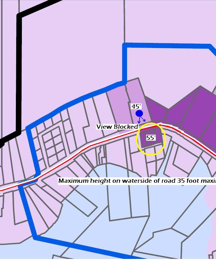
1 Community Development City & Borough of Juneau Community Development 155 S. Seward Street Juneau, AK (907) Phone (907) Fax From: Thru: To: Eric Feldt, Planner II, CFM Community Development Department Hal Hart, Director Community Development Department Planning Commission File No.: AME Date: January 5, 2015 Re: Auke Bay Area Plan Attachments Attachment A CBJ Lands & Resources Comments Attachment B DOT/ PF Comments Attachment C Revised Implementation Table This memo addresses comments from the December 16, 2014 Planning Commission meeting. The most current Draft Auke Bay Plan can be found at the following CBJ website: Comments received from various groups Attachment A: CBJ Lands & Resources: Addressed in this memorandum. o In summary, there are two main issues: Issue 1) A small property along the shoreline (Auke Bay Post Office property) is allowed to be (re)built higher (55 feet) than the land-based property behind it (45 feet) and therefore may block views of Auke Bay. How can this blockage be minimized? The Post Office property is within a designated view shed and therefore, the policies in this Plan will encourage future development to be designed in a way to lessen impacts to view sheds. Example: Orient the
2 Planning Commission File No.: AME January 8, 2015 Page 2 of 3 building perpendicularly to the shoreline or have only partial blockage of views. Issue 2) There are conceptual parking areas identified on the Community Charrette Map that are on CBJ owned land which are designated for disposal to the private markets. The Plan s parking designations might prevent or conflict with this designation. The parking designations are conceptual in nature and may change over time. Although this map provides a guide for future infrastructure and development, it is not binding. Supplying parking does not necessarily prevent market uses on the same lot. Attachment B: DOT/ PF: Addressed in the on-line Draft Auke Bay Plan copy. CBJ Docks & Harbors: Addressed in the on-line Draft Auke Bay Plan copy. This is not attached because it was already provided during the 12/16/14 meeting. Auke Bay Steering Committee: Addressed in the on-line Draft Auke Bay Plan copy. This is not attached as it was already provided during the 12/16/14 meeting. The Planning Commission asked CDD staff to incorporate specific re-zone ideas and action items in the Implementation chapter to further boost the Plan s policies into real improvements. As noted in that chapter, the Plan will be referenced in the Comprehensive Plan and Title 49. The Auke Bay Area Plan is aspirational in nature but does provide critical stepping blocks for specific changes, such as recommending zoning changes, examine maximum building height and parking ratios, etc. Some of these are too specific for the Plan and staff has not been discussed these issues in detail with the Auke Bay Steering Committee or stakeholders in the area. This effort is expected to occur within the following year, as noted in Attachment C. This attached provides a general timeline of action items. Besides rezone changes, the Commission also requested staff to make the following changes/ address specific items of the Plan. These have been addressed in the Plan. How does the Auke Bay Area Plan address slowing of traffic? Add goals to the Introduction Chapter. Add the Community Charrette Map to the Introduction Chapter to quickly show the reader the planning efforts of this project. Staff made many minor edits to the Plan to correct any grammatical errors or to improve the writing quality. These specific edits are not listed in this memorandum. Also, staff split the map containing both zoning districts and Comprehensive Plan designations into two separate maps for easier viewing.
3 Planning Commission File No.: AME January 8, 2015 Page 3 of 3 Findings The Draft Auke Bay Area Plan is consistent with the 2013 CBJ Comprehensive Plan policies of Auke Bay. The Plan seeks to solve many problems in and take advantage of many opportunities of Auke Bay as derived from many public and stakeholder meetings. Recommendation Staff recommends the Planning Commission forward the Draft the Auke Bay Area Plan to the Assembly with a recommendation of adoption.
4 Holly Kveum From: Sent: To: Subject: Follow Up Flag: Flag Status: Greg Chaney Friday, December 26, :45 AM Holly Kveum FW: Auke Bay Follow up Completed From: Greg Chaney Sent: Friday, December 19, :04 PM To: Brenwynne Grigg Cc: Jessica Beck; Dan Bleidorn Subject: RE: Auke Bay Hi Brenwynne, Thank you for the opportunity to comment on this draft document. In general it looks like a significant step forward in planning for Auke Bay s future. As a significant land holder in this region, CBJ Lands and Resources welcomes the adoption of a plan that will enhance the future development pattern in this valuable region. Lands primary comment is that the maximum height map allows a property on the waterside of the road to have 55 maximum height. This property is directly across the road from CBJ s property. CBJ s lot is limited to 45 so the property owner closer to the water could build a development that would block a significant portion of CBJ s property from having a water view. It seems more appropriate that the property on the waterside of the road should have a maximum height of 35 feet to allow the lots on the other side of the road the opportunity to have water view developments. Below is a diagram to help illustrate this point. This concept is supported on Page 8 of the plan in the discussion of View Sheds. We are also concerned that page 51 (Appendix B) identifies that City Land (Sites 1,2 &3) will be used for additional offstreet parking. Based on our review of the draft document, the location of Sites 1,2 &3 were not immediately evident. However the primary directive for CBJ property is for it to be used for fair market value developments unless a specific use is identified by the Assembly. Dedicating CBJ property for parking severely restricts CBJ Land s mission of developing properties in one of the highest value locations. We request that this policy be modified or eliminated. Once again we would like to commend the Auke Bay planning committee s work on this plan. Thank you for the opportunity to comment. Greg Chaney CBJ Lands and Resources Manager 1
5 2
6 From: Brenwynne Grigg Sent: Thursday, December 18, :42 PM To: Greg Chaney Subject: Auke Bay Below is the link to the Auke Bay Plan! Maps are towards the end. Brenwynne W. Grigg, Administrative Officer Community Development Department office: I cell: brenwynne.grigg@juneau.org 3
7
8
9 Holly Kveum From: Sent: To: Cc: Subject: Carroll, Lawrence P (DOT) <pat.carroll@alaska.gov> Wednesday, December 10, :53 PM Hal Hart; Eric Feldt Lockwood, Gregory K (DOT) Auke Bay plan doc comments Hal Eric, Here are a few mostly editorial comments to the draft Auke Bay plan document. Page 9 Figure Awnings which protrude into the state ROW will require a ROW encroachment permit from AKDOT (discussed at meeting on 12/3) Page 10 Street Furniture, Banners, and plantings Advertising is not allowable within the State Right of Way per state law (discussed at meeting on 12/3) Page 14 Goal 9 and throughout the entire document within the Auke bay plan. Suggest change to within the Auke bay center. The plan is not an area, this comment pertains in many places within the doc. An effort should be undertaken to review the entire document to ensure consistent and appropriate use of the terms/ areas : planning boundary area, hub, and core as defined on page x of the doc. Page 14 Policy 9.1 Typo in (WFC) should be (WCF) Page 14 Policy above ground transportation companies? Was above ground utility companies intended here. Page 20 Policy 2.1/2.2 This is really one policy. It appears that the column break split the policy and gave it a new number (2.2) at the top of the Rt hand column Page 33 Existing conditions DOT project names are incorrect. Correct names are: Glacier Highway & Back Loop Road Intersection Safety Improvements (AKA: the Roundabout project) and Glacier Highway Reconstruction Fritz Cove Road to Seaview Avenue Page 34 Graphic Legend Suggest addition of the route name Glacier Highway to the top two items (Blue and Dark Red lines) For the Orange Line I think this is intended to indicate the Back Loop Road Route from??university Way maybe?? to Glacier Highway 1

10 BLUE: Glacier Highway: Fritz Cove to Back Loop DARK RED: Glacier Highway: Auke Nu Drive to Back Loop Orange: Back Loop Road:??University Way?? to Glacier Highway Page 34 2 nd column, last paragraph: Their preferred option would see the current ferry service replaced with a road to North to Katzehin which then connected to a new day ferry service. Suggested edit: Their preferred option would see the current ferry service replaced with a road North to a new ferry terminal near the Katzehin River delta which then connects to a new day ferry service. Page 35, Link to ABCOR doc at lower Rt Please change the ADEC weblink to the following link from the ADOT ABCOR webpage: Page 39 partial paragraph at top of rt hand column correct date for ABCOR is 2004 Page 39 1 nd bullet, Rt hand column suggest rewording the paragraph additional intersection for auke bay school assume this is intending the new connection from Auke Bay school to back loop road but this is not stated. Improve intersections with major Auke Bay roads is pretty vague. Page 39 4 th bullet, Rt hand column suggest rewording of paragraph Transit service connections to Auke Bay Ferry terminal should be provided, and (?? connections to??) the rest of Juneau should be maintained or improved. Page 45 Policy 5.2, last sentence. suggest disabled access be changed to ADA accessibility Page 51, Parking On street parking on Glacier Hwy. from Loop Rd. to Fisherman's Bend. AKDOT will not support this proposed project unless a bypass is in place and Glacier Hwy. from Loop Rd. to Fisherman's Bend has been transferred to the CBJ for maintenance and operation. 2
11 On street parking on Loop Rd. from Glacier Hwy. to UAS (re establish). Same comment as above, I also question why Not a Priority projects are even included in this list. Page 52, Pedestrian/Trails Pedestrian activated beacon at elementary school and other crossing locations on Glacier Highway. Suggest less specific recommendation such as Improve safety of pedestrian crossings at elementary school and other locations on Glacier Highway A pedestrian activated beacon is very specific and is most likely not the best solution for every situation/location. Thanks L. Pat Carroll, P.E. Preconstruction Engineer pat.carroll@alaska.gov Phone: (907) Fax: (907)
12 Action Items: Problem Solved/ Opportunity Enhanced Change Zoning Districts within Center planning Create a new Town Center design standards plan Establish cohesive zoning district(s) to achieve the goals of a new Small Town Center Too many existing districts results in a separated mixture of land use development Owners have little certainty of future neighboring developments New design plan will help achieve the aesthetics of buildings, streetscapes, etc. Without a design plan, current/ future zoning districts cannot influence the form and fuction of streetscapes, buildings, and other spaces. A design plan can enhance aspects of space/ buildings, such as landscaping, parking lots, walkways, building facades, etc. Action Items: Problem Solved/ Opportunity Enhanced Create new Gateways Plan routes a future seawalk Establish gateways along the main corridors into Auke Bay that providings a 'welcoming' aspect to the area. Creates a sense of place for Auke Bay Coordinate routes with shoreline properties. Routes should connect to future pedestrian pathways to ensure highest level of connectivity within Center planning area. Plan routes for future grid streets in the Center planning area Establish a new parking management plan By planning routes, the Small Town Center can better plan for future development Coordinate with property owners to ensure future development doesn't prevent street route planning A parking plan will ensure parking will be efficiently planning in the Center planning area. This will provide a better understanding of where and when peak parking demand is needed. Without a parking plan, parking may not be effectively laid out or designed to meet the goals of the Small Town Center. Establish a new park in the Center planning area Add Pedestrian level lighting along streets in Center planning area Explore CBJ Sewer renovations to accommodate growth in Auke Bay A park in the Center planning area can provide a wonderful place to enjoy and relax outside. A park can be an economic driver as it provide spaces for markets, concerts, art fairs, etc. A park can add value to adjacent residential and commercial properties. Pedestrian level lighting illuminates more walking surfaces for safer walking conditions and feels safer. Without this level of lighting, pedestrians may feel less safe and may be less inclined to walk. Early coordination and planning about the demands on existing sewer capacity must occur with expected development of the new Town Center
13 Action Items: Problem Solved/ Opportunity Enhanced Construct seawalk Construct future streets within the Center planning area Analyze parking at Spaulding Meadow trailhead. Analyze and construct a parking structure within the Small Town Center A seawalk provides a unique place to enjoy views of the water. A seawalk will provide a fun place to stroll, jog, and recreate A seawalk can connect to existing pedestrian routes between water and upland developments The new street grid will increase development potential. The new streets will create value in future business frontage. The streets will provide pedestrian connections throughout the future Small Town Center. This popular trailhead parking lot is undersized and needs to be re examined Vehicles sometimes park too close to the road. Providing a central parking structure will lessen the parking demands of each use within the Town Center This will reduce the amount of individual parking lots throughout the Town Center. A parking structure will increase the land use efficiency by allowing more flexibility in future developments. Construct bicycle stations Bicycle stations can reduce vehicular parking. Bicycle stations provide appropriate places to park bicycles instead of around street lights/ power poles. These will encourage recreational and healthy transportation choices. Connect pathways around Auke Lake A circular pedestrian route around the lake will provide more recreational choices. This will allow more people to enjoy the lake. This will allow pedestrians to reach the lake from their residence or work. Construct a separated pathway from the Auke Bay Ferry Terminal to the Center planning area Design wayfinding signage Explore a new CBJ Capital transit hub CBJ Sewer upgrades to serve increase development in Auke Bay No pedestrian connections Wayfinding signage directs people to destinations, i.e. harbors, parks, trails, etc. Signage creates a sense of place. A hub in the Auke Bay Center planning area will enable transportation options Allow residents to reach Auke Bay without using private automobiles Help strengthen the UAS campus Provides an economic value to Auke Bay Exising sewer service to Auke Bay cannot serve proposed large development increases expected to create the Small Town Center Action Items: 2036 and Beyond Problem Solved/ Opportunity Enhanced Design a by pass highway around Auke Bay Alleviates existing high traffic volume. Allows Glacier Highway to be converted to a traditional 'Main Street' within the Central planning area Will allow a reduce in traffic speeds.
Auke Bay Area Plan. Complete List of Goals and Policies for the Auke Bay Area Plan
 Auke Bay Area Plan Complete List of Goals and for the Auke Bay Area Plan Recreation Goals & Pedestrian Access Goal 1: Link the Auke Bay area with an accessible system for recreation and transportation.
PUBLIC PARKS AND FACILITIES, SERVING NEIGHBORHOOD RECREATIONAL AND COMMUNITY EVENTS BUILDINGS BUILT TO THE LINE AND ORIENTED TOWARD THE STREET
 BUILDINGS BUILT TO THE LINE AND ORIENTED TOWARD THE STREET PUBLIC PARKS AND FACILITIES, SERVING NEIGHBORHOOD RECREATIONAL AND COMMUNITY EVENTS CONNECTED & COMPLETE STREETS AND STREET GRID VIEW SHEDS GROUND
Recommended changes to the Comprehensive Plan Land Use designation
 Recommended changes to the Comprehensive Plan Land Use designation Purpose of Comprehensive Plan land use designations The designation provides a long term vision of the use/ density/ intensity of neighborhoods
THE COMMUNITY-DRIVEN DESIGN PROCESS
 THE COMMUNITY-DRIVEN DESIGN PROCESS A PUBLIC DRIVEN PROCESS STEERING COMMITEE THE COMPREHENSIVE PLAN OPPORTUNITIES AND CONSTRAINTS THE COMMUNITY DRIVEN DESIGN PROCESS A Public Driven Process Beginning
Scope of Services. River Oaks Boulevard (SH 183) Corridor Master Plan
 Corridor Master Plan") Scope of Services River Oaks Boulevard (SH 183) Corridor Master Plan PROJECT AREA The project area consists of the River Oaks Boulevard (SH 183) corridor bounded by SH 199 at the northern end and the Trinity
Scope of Services River Oaks Boulevard (SH 183) Corridor Master Plan PROJECT AREA The project area consists of the River Oaks Boulevard (SH 183) corridor bounded by SH 199 at the northern end and the Trinity
Old Town Neighborhoods Plan. Choices Event Wednesday, December 9, 2015
 Old Town Neighborhoods Plan Choices Event Wednesday, December 9, 2015 Agenda 6:00 6:10 p.m. Welcome + Sign In 6:10 6:30 p.m. Presentation 6:30 8:00 p.m. Workshop + Open House Seeking your input on: Neighborhood
Dyersville Downtown Plan. Open House October 24, 2017
 Dyersville Downtown Plan Open House October 24, 2017 What is a Comprehensive Plan? - Vision - Guidance for decisions - Basis for regulations What is a Downtown Plan? - Understand priorities - Identify
UCSF Parnassus Heights Re-Envisioning Process
 UCSF Parnassus Heights Re-Envisioning Process Community Working Group Meeting #5 February 27, 2019 Agenda Welcome, Introductions, Agenda Overview, and Review of Last Meeting Summary of Community Ideas
38 Queen s University Campus Master Plan Part 1
 38 Queen s University Campus Master Plan Part 1 46 The Campus at the City Scale Chapter 4 The Campus at the City Scale 39 Queen s is an urban University centrally located in Kingston. Decisions made by
University of the District of Columbia Van Ness Campus Master Plan Community Open House 3. December 8, 2010
 University of the District of Columbia Van Ness Campus Master Plan Open House 3 December 8, 2010 Introductions Sequence of Work: Campus Master Plan BEGIN: INTRODUCE AND START WORK Project Initiation Team
BUILDING SCALE AND SETBACKS 5 ELEMENTS:... 5 FAÇADES (COMMERCIAL/RESIDENTIAL) 5
 5") VISION STATEMENT 3 UTILIZATION OF THE GUIDELINES 3 IMPLEMENTATION 3 PROCEDURES FOR DESIGN REVIEW 3 LAND USE AND ZONING 4 LAND USE 4 ELEMENTS:... 4 ZONING 4 ELEMENTS:... 4 BUILDING SCALE AND SETBACKS 5
VISION STATEMENT 3 UTILIZATION OF THE GUIDELINES 3 IMPLEMENTATION 3 PROCEDURES FOR DESIGN REVIEW 3 LAND USE AND ZONING 4 LAND USE 4 ELEMENTS:... 4 ZONING 4 ELEMENTS:... 4 BUILDING SCALE AND SETBACKS 5
Town Center (part of the Comprehensive Plan)
") Town Center (part of the Comprehensive Plan) Mercer Island Town Center Looking North (2014) In 1994, a year-long process culminated in a set of design guidelines and code requirements for the Town Center
Town Center (part of the Comprehensive Plan) Mercer Island Town Center Looking North (2014) In 1994, a year-long process culminated in a set of design guidelines and code requirements for the Town Center
Phase 1 : Understanding the Campus Context. Phase 2 : APPROACHES - Alternates & Preferred Plan
 Introduction MASTER PLAN PURPOSE WHY A CAMPUS MASTER PLAN? The purpose of the Master Plan at the University of Illinois at Chicago is to translate UIC s strategic goals and objectives into a compelling
John M. Fleming Managing Director, Planning and City Planner. Old East Village Dundas Street Corridor Secondary Plan Draft Terms of Reference
 Report to Planning and Environment Committee To: From: Subject: Chair and Members Planning & Environment Committee John M. Fleming Managing Director, Planning and City Planner Old East Village Dundas Street
Public may provide comments on the GDP within the next two weeks (December 24)
") 25/70 General Development Plan (GDP) Public Meeting Wednesday, December 10, 2014 6:00 8:00 P.M. District 1 Police Station Community Room 1311 W 46th Ave, Denver, CO 80211 Council Woman Montero: This particular
25/70 General Development Plan (GDP) Public Meeting Wednesday, December 10, 2014 6:00 8:00 P.M. District 1 Police Station Community Room 1311 W 46th Ave, Denver, CO 80211 Council Woman Montero: This particular
implementation r expression in landscape
 6 ubc okanagan implementation campus plan r expression in landscape 68 6 implementation campus plan sections The Campus Plan supports the academic mission, values and commitments of the University by providing
Honorable Mayor and Members of the City Council. Submitted by: Eric Angstadt, Director, Planning and Development
 Office of the City Manager ACTION CALENDAR January 29, 2013 To: From: Honorable Mayor and Members of the City Council Christine Daniel, City Manager Submitted by: Eric Angstadt, Director, Planning and
Urban Planning and Land Use
 Urban Planning and Land Use 701 North 7 th Street, Room 423 Phone: (913) 573-5750 Kansas City, Kansas 66101 Fax: (913) 573-5796 Email: planninginfo@wycokck.org www.wycokck.org/planning To: From: City Planning
PLAN ELEMENTS WORKSHOP. April 5, 2016
 PLAN ELEMENTS WORKSHOP April 5, 2016 needs more housing. But there is no one-size fits-all solution. Every neighborhood has its own character. In some places, density is not only appropriate it is badly
UAA School of Engineering Parking Garage Master Plan Amendment. 1. Purpose
 UAA School of Engineering Parking Garage Master Plan Amendment 1. Purpose Since the UAA campus master plan was drafted in 2003, adopted in 2004, and amended in 2009 a number of significant changes regarding
Guiding Principles. People dance, and to share culture. Place consistency and internal connections. Management community for years to come
 3. The Campus Concept This chapter presents an overview of the Campus Concept from the formulations of its guiding principals through general recommendations to facilitate the triple urban design plan
EXISTING COMPREHENSIVE PLAN
 EXISTING COMPREHENSIVE PLAN Town Center Land Use Element: V. LAND USE POLICIES Town Center Mercer Island's business district vision as described in "Your Mercer Island Citizen-Designed Downtown" was an
North Fair Oaks Community Plan Summary and Information
 North Fair Oaks Community Plan Summary and Information WHAT IS THE NORTH FAIR OAKS COMMUNITY PLAN? The North Fair Oaks Community Plan is part of the San Mateo County General Plan, and establishes policies
The transportation system in a community is an
 7 TRANSPORTATION The transportation system in a community is an important factor contributing to the quality of life of the residents. Without a sound transportation system to bring both goods and patrons
LAND USE AMENDMENT DOWNTOWN COMMERCIAL CORE (WARD 7) MACLEOD TRAIL SE AND 5 AVENUE SE BYLAW 254D2017
 MACLEOD TRAIL SE AND 5 AVENUE SE BYLAW 254D2017") Page 1 of 10 EXECUTIVE SUMMARY This Land Use Amendment application seeks to redesignate a full downtown block (currently the YWCA site) from a Direct Control based on the CM-2 District (Land Use Bylaw
Page 1 of 10 EXECUTIVE SUMMARY This Land Use Amendment application seeks to redesignate a full downtown block (currently the YWCA site) from a Direct Control based on the CM-2 District (Land Use Bylaw
Citizen Comment Staff Response Staff Recommended Revision Planning Committee
 Citizen Comment Staff Response Staff Recommended Revision Planning Committee Area No. 1: Owner desires retail land uses. Area No. 1a: Owner of two small parcels adjacent to Area No. 1 desires retail land
Executive Summary. NY 7 / NY 2 Corridor
 Executive Summary NY 7 / NY 2 Corridor Transportation and Land Use Study December 2005 Prepared for: Town of Colonie Capital District Transportation Committee Prepared by: Introduction: Land use decisions
This Review Is Divided Into Two Phases:
 Semiahmoo Town Centre Review The purpose of this review: To review the Semiahmoo Town Centre Concept Plan, originally approved in 1993, to ensure that this centre will continue to serve the needs of South
Downtown Streetscape Manual & Built Form Standards
 City of Guelph Downtown Streetscape Manual & Built Form Standards July 2014 Prepared by Brook McIlroy Inc. in association with Unterman McPhail Associates and McCormick Rankin Inc. City of Guelph Downtown
McCowan Precinct Plan Study Background & Deliverables
 1 DRAFT & WITHOUT PREJUDICE McCowan Precinct Plan Study Background & Deliverables In September, 2011, City Planning (Scarborough District) began a study of an area within the Scarborough Centre, identified
Policies and Code Intent Sections Related to Town Center
 Policies and Code Intent Sections Related to Town Center The Town Center Vision is scattered throughout the Comprehensive Plan, development code and the 1994 Town Center Plan. What follows are sections
ARTICLE 6: Special and Planned Development Districts
 ARTICLE 6: Special and Planned Development Districts 6-10 Traditional Neighborhood Development (TND) District 6-10.10 Purpose and Intent The Traditional Neighborhood Development (TND) District provides
Small Area Plan. South Gateway
 Small Area Plan Adopted May 12, 2008 South Gateway Purpose. The South Gateway Small Area Plan defines the City s expectations for the future of the southern entrance to the City at Interstate 85 and Highway
appendix and street interface guidelines
 appendix five: building and street interface guidelines appendix 5 building and street interface guidelines BOULEVARDS Boulevards are generally characterized by higher levels of traffic movement at higher
This is the East Carolina University Comprehensive Facilities Master Plan Final Draft Plan Review. This workbook reviews the campus draft master plan
 This is the East Carolina University Comprehensive Facilities Master Plan Final Draft Plan Review. This workbook reviews the campus draft master plan first presented on campus on June 29 and June 30, 2011.
ESTABLISH AN EFFICIENT TOWN CENTER
 ESTABLISH AN EFFICIENT TOWN CENTER 4 Overview Lisbon residents are proud of the history of Newent and at the same time recognize its current importance as a centralized location for a variety of municipal
CHAPTER 7: Transportation, Mobility and Circulation
 AGLE AREA COMMUNITY Plan CHAPTER 7 CHAPTER 7: Transportation, Mobility and Circulation Transportation, Mobility and Circulation The purpose of the Transportation, Mobility and Circulation Chapter is to
FLORIN ROAD CORRIDOR Site Plan and Design Review Guidelines Checklist
 FLORIN ROAD CORRIDOR Site Plan and Design Review Guidelines Checklist Applicant s Name: Project Address: Phone: Email: Applicant shall fill out the design guidelines checklist for all guidelines applicable
Request Alternative Compliance to the prescribed criteria of the Oceanfront Resort District Form-Based Code. Staff Recommendation Approval
 Applicant & Property Owner Public Hearing February 8, 2017 City Council Election District Beach Agenda Item D1 Request Alternative Compliance to the prescribed criteria of the Oceanfront Resort District
Welcome. Walk Around. Talk to Us. Write Down Your Comments
 Welcome This is an information meeting introducing the applications for proposed redevelopment of the Yorkdale Shopping Centre site at 3401 Dufferin Street and 1 Yorkdale Road over the next 20+ years,
BROOKHILL NEIGHBORHOOD MODEL ZONING MAP AMENDMENT PREFACE TO APPLICATION
 BROOKHILL NEIGHBORHOOD MODEL ZONING MAP AMENDMENT PREFACE TO APPLICATION June 15, 2015 Revised: August 1, 2016 I. VISION Brookhill is a proposed community based upon the principles of Albemarle County
CITY OF UNION CITY MINUTES GENERAL PLAN ADVISORY COMMITTEE
 CITY OF UNION CITY MINUTES GENERAL PLAN ADVISORY COMMITTEE WEDNESDAY, MARCH 4, 2015, 6:30 P.M. IN THE CITY COUNCIL CONFERENCE ROOM OF CITY HALL 34009 ALVARADO-NILES BLVD., UNION CITY, CALIFORNIA Attachment
Grantsburg Community Design Team (CDT)
") Grantsburg Community Design Team (CDT) Summary Report Overview On April 10-13, 2014, a team of (19) volunteer planners, design professionals, and community development educators volunteered their time
Grantsburg Community Design Team (CDT) Summary Report Overview On April 10-13, 2014, a team of (19) volunteer planners, design professionals, and community development educators volunteered their time
Chapter 7: Streetscape & Design Elements
 OVERVIEW Chapter 7: Streetscape & Design Elements During the public input phase of The Dixie Fix, the area of streetscape generated much interest. While safety and traffic flow are primary objectives of
STAFF REPORT NATIONAL MEDAL OF HONOR MUSEUM
 STAFF REPORT NATIONAL MEDAL OF HONOR MUSEUM For reference, the Zoning Code and Land Development Regulations are available online. AGENDA ITEM: 5.b. Case #: Request: Location: Type of Request: Public Hearing:
Area Plans. September 18, 2012
 Area Plans September 18, 2012 Transfer ratio for existing development up to 1:6 depending on sending parcel sensitivity and distance from community centers and/or transit routes. Within Town Center and
CITY OF CHARLOTTESVILLE, VIRGINIA CITY COUNCIL AGENDA
 CITY OF CHARLOTTESVILLE, VIRGINIA CITY COUNCIL AGENDA Agenda Date: December 16, 2013 Action Required: Adoption of Resolution Presenter: Staff Contacts: Title: James E. Tolbert, AICP, Director of NDS James
VILLAGE & TOWN OF BERGEN: COMPREHENSIVE PLAN
 VILLAGE & TOWN OF BERGEN: COMPREHENSIVE PLAN CPC Public Hearing April 21, 2016 History 1996 Comprehensive Plan Comprehensive Plan Update Committee Consultant (LaBella Associates): December 2014 Residents
Comprehensive Plan. Faribault, Minnesota. Hoisington Koegler Group Inc. Claybaugh Preservation Architecture Inc. Howard R. Green Company Bonz/REA
 Comprehensive Plan Faribault, Minnesota Adopted by the Faribault City Council July 8, 2003 prepared for: prepared by: Hoisington Koegler Group Inc. Claybaugh Preservation Architecture Inc. Howard R. Green
Sherri Ferguson. President/CEO Portland Chamber of Commerce. Tennessee Certified Economic Developer Capstone Project
 Sherri Ferguson President/CEO Portland Chamber of Commerce Tennessee Certified Economic Developer Capstone Project Strategic Plan Development for the North Gateway of Portland, Tennessee The New Gateway
Cover Design Glen Fairchild. Cover Photography Dave Klein KleinDesigns & Pat McGonagel Didjuneau Fine Art Photography
 Cover Design Glen Fairchild Cover Photography Dave Klein KleinDesigns & Pat McGonagel Didjuneau Fine Art Photography Auke Bay Area Plan Adopted (Month, Date, Year) Assembly Ordinance 20XX XX City and Borough
Portage Parkway Environmental Assessment Public Information Centre No. 1
 City of Vaughan Portage Parkway Environmental Assessment Public Information Centre No. 1 November 25, 2015 Welcome to the Public Information Centre This first Public Information Centre (PIC) introduces
Joe Zehnder, Chief Planner and Eric Engstrom, Principal Planner. Consolidated Revisions and Corrections to the Portland Plan Recommended Draft
 MEMO DATE: April 25, 2012 TO: FROM: CC: SUBJECT: Mayor Sam Adams and City Council Susan Anderson, Director Joe Zehnder, Chief Planner and Eric Engstrom, Principal Planner Consolidated Revisions and Corrections
East Bench Master Plan Update
 Community & Economic Development Office of the Director East Bench Master Plan Update To: From: Planning Commission Wayne Mills, Senior Planner Date: November 18, 2015 CC: Re: Nora Shepard, City Planning
New York Avenue Streetscape and Trail Project Public Meeting #1 Summary
 New York Avenue Streetscape and Trail Project Public Meeting #1 Summary I. King Jordan Student Academic Center (SAC) Gallaudet University, Washington, DC February 23, 2017 Table of Contents 1.0 Introduction...
DRAFT PLAN PRESENTATION
 DRAFT PLAN PRESENTATION 1.23.2018 AGENDA Process Project Schedule Results from Visioning Workshop Draft Plan Highlights Concept Plans Feedback Next Steps PROJECT SCHEDULE KICK-OFF WORKSHOP August 29 th
SUBJECT: Waterfront Hotel Planning Study Update TO: Planning and Development Committee FROM: Department of City Building. Recommendation: Purpose:
 Page 1 of Report PB-23-18 SUBJECT: Waterfront Hotel Planning Study Update TO: Planning and Development Committee FROM: Department of City Building Report Number: PB-23-18 Wards Affected: 2 File Numbers:
SAN FRANCISCO MUNICIPAL TRANSPORTATION AGENCY
 THIS PRINT COVERS CALENDAR ITEM NO. : 10.3 DIVISION: Sustainable Streets BRIEF DESCRIPTION: SAN FRANCISCO MUNICIPAL TRANSPORTATION AGENCY Approving the removal of Municipal Railway bus zones at various
MEMO 1. INTRODUCTION PURPOSE & PROCESS REQUEST
 MEMO Date: August 22, 2017 To: Board of Commissioners From: Jason Burdette, Planning Director Re: Davidson Commons East Hotel Stakeholder Feedback 1. INTRODUCTION PURPOSE & PROCESS This memorandum summarizes
CAMPUS MASTER PLAN DRAFT PLAN UPDATE JANUARY
 NEW MEXICO HIGHLANDS UNIVERSITY CAMPUS MASTER PLAN DRAFT PLAN UPDATE JANUARY 27 2010 MASTER PLANNING GOALS TO BALANCE THE STRATEGIC GOALS OF THE UNIVERSITY WITH THE PHYSICAL CAMPUS through the assessment
hermitage town center
 hermitage town center A Community Vision prepared by Strada for The City of Hermitage and The Mercer County Regional Planning Commission January 2007 table of contents introduction 3 design principles
CHAPTER 7: VISION AND ACTION STATEMENTS. Noble 2025 Vision Statement
 CHAPTER 7: VISION AND ACTION STATEMENTS This chapter presents the vision, policy and action statements that transform the comprehensive planning study, an analysis of Noble s past, future trends and community
Making Transit Oriented Development Work For Boonton, NJ
 Making Transit Oriented Development Work For Boonton, NJ Bloustein School of Planning and Public Policy Studio Dan Burton Loannie Dao Webster Slater Brandon Williams Ian Watson Maria Laham Nicola Mammes
4 Park Planning and Design
 4 Park Planning and Design Park Constellations Elliot Gateway/Mills Loring North Loop Commons Twins Minneapolis Park & Recreation Board Downtown Service Area Master Plan 4-1 PROJECT APPROACH REFERENCE
SECTION TWO: Urban Design Concepts
 SECTION TWO: Urban Design Concepts The Gardnerville Plan for Prosperity shapes economic opportunities presented by regional growth. The Urban Design Concepts provide policies and concepts for land use,
Illustration of Eastlake Farmer s Cooperative Grain Elevator. Chapter 5: implementation 5-1
 Illustration of Eastlake Farmer s Cooperative Grain Elevator Chapter 5: implementation 5-1 chapter 5: implementation Introduction The Eastlake Subarea Plan includes a wide range of recommendations intended
Capital Projects in and near Odenton Town Center
 Capital Projects in and near Odenton Town Center Map ID Anne Arundel County Department of Public Works This project provides for the design, right of way acquisition, and construction of approximately
Public input has been an important part of the plan development process.
 Lakewood s Comprehensive Plan recognizes that transportation helps shape the community, and that the way the community provides for the safe and efficient movement of people affects the character of the
Design Considerations
 Essential to the development of a successful Master Plan for the Park Complex is input from the community that the park will serve. The community outreach component of the planning process included numerous
Request Alternative Compliance to the prescribed criteria of the Oceanfront Resort District Form- Based Code. Staff Recommendation Approval
 Applicant Property Owner Steven H. Murden Public Hearing June 14, 2017 City Council Election District Beach Agenda Item 8 Request Alternative Compliance to the prescribed criteria of the Oceanfront Resort
Midtown Corridor Alternatives Analysis. Appendix A - Initially Considered Alternatives Screening
 Midtown Corridor Alternatives Analysis Appendix A - Initially Considered Alternatives Screening Arterial BRT on Lake Street - Overall Rating: RATING Metropolitan Council recommendations stated in the Transportation
1.0 VISION STATEMENT. December 6, PRINCIPLES
 Vision Statement Lincoln Regional Airport 1.0 VISION STATEMENT 1.1 City LOCATION of AND OVERVIEW The Easton Lincoln Place Land Use Master Plan identifies the principles, goals, policies, and standards
City of Hermosa Beach Administrative Policy #
 City of Hermosa Beach Administrative Policy # SUBJECT: Living Streets Policy Date: Approved by: City Council Authority: Public Works Department & Community Development Department Mayor, PURPOSE The City
California Environmental Quality Act (CEQA) Environmental Review Process
 Environmental Review Process") California Environmental Quality Act (CEQA) Environmental Review Process Los Angeles Union Station Forecourt and Esplanade Improvements constitute a Project Los Angeles County Metropolitan Transportation
California Environmental Quality Act (CEQA) Environmental Review Process Los Angeles Union Station Forecourt and Esplanade Improvements constitute a Project Los Angeles County Metropolitan Transportation
Attachment 1 TOWN OF NEW TECUMSETH. Manual for the Preparation of an Urban Design Report
 Attachment 1 TOWN OF NEW TECUMSETH Manual for the Preparation of an Urban Design Report July 2010 TABLE OF CONTENTS Background, Policy Framework and the Preparation of Urban Design Reports 1. Introduction
TEAM INPUT SUMMARY. Postcard Image?
 DOWNTOWN MAULDIN TEAM PUBLIC INPUT TEAM INPUT SUMMARY Postcard Image? A nice neighborhood The main city center with government buildings Mauldin entry sign, high school, Cultural Center, Sunset Park, Hall
2 January 13, 2010 Public Hearing APPLICANT: AUTOBELL CAR WASH, INC
 REQUEST: Conditional Use Permit (car wash) 2 January 13, 2010 Public Hearing APPLICANT: AUTOBELL CAR WASH, INC PROPERTY OWNER: MESSER 1060 INDEPENDENCE BOULEVARD STAFF PLANNER: Carolyn A.K. Smith ADDRESS
Please read the entire document
 projects impacting the waterfront revitalization area. The waterfront revitalization area of the town will have to subareas to the west and east of the village. Page 6 of 6 Wayfinding master plan create
Route 1 Corridor Study
 Route 1 Corridor Study Westbrook, Connecticut A Vision for the Connecticut Shoreline Public Informational Meeting July 28, 2015 Lower Connecticut River Valley Council of Governments Fitzgerald & Halliday,
NORTH HARBOR INITIATIVE
 Indiana Harbor, East Chicago, Indiana NORTH HARBOR INITIATIVE Community Reinvestment Public Shoreline Connection Strong Leadership The City of East Chicago and are leading the revitalization of Indiana
A. WHAT IS A GENERAL PLAN?
 I. Introduction A. WHAT IS A GENERAL PLAN? A general plan is the planning guideline for the future of a city. It contains goals and policies which regulate urban development, the protection of the natural
ORDINANCE WHEREAS, this Ordinance is consistent with the City of Winter Garden Comprehensive Plan; and
 ORDINANCE 17-06 AN ORDINANCE OF THE CITY COMMISSION OF THE CITY OF WINTER GARDEN, FLORIDA, CREATING ARTICLE XIV OF CHAPTER 118 OF THE CITY OF WINTER GARDEN CODE OF ORDINANCES PROVIDING FOR THE EAST PLANT
HISTORIC TOWN CENTER MASTER PLAN CITY COUNCIL PRESENTATION APRIL 3, 2012
 HISTORIC TOWN CENTER MASTER PLAN CITY COUNCIL PRESENTATION APRIL 3, 2012 REQUESTED CITY COUNCIL ACTIONS Certification of the Final Program Environmental Impact Report (PEIR); and, Approval of General Plan
Cover Design Glen Fairchild. Cover Photography Dave Klein KleinDesigns & Pat McGonagel Didjuneau Fine Art Photography
 Cover Design Glen Fairchild Cover Photography Dave Klein KleinDesigns & Pat McGonagel Didjuneau Fine Art Photography Auke Bay Area Plan Adopted (Month, Date, Year) Assembly Ordinance 20XX XX City and Borough
Cover Design Glen Fairchild. Cover Photography Dave Klein KleinDesigns & Pat McGonagel Didjuneau Fine Art Photography
 Cover Design Glen Fairchild Cover Photography Dave Klein KleinDesigns & Pat McGonagel Didjuneau Fine Art Photography Auke Bay Area Plan Adopted March 16, 2015 Assembly Ordinance 2015-13 City and Borough
REQUEST FOR COUNCIL ACTION 6A AGENDA ITEM ORIGINATING DEPT. AGENDA ITEM CITY ADMINISTRATOR APPROVAL
 DATE REQUEST FOR COUNCIL ACTION 6A AGENDA ITEM ORIGINATING DEPT. AGENDA ITEM CITY ADMINISTRATOR APPROVAL Community Development Territorial Greens PUD Concept Plan Development Stage Plan Subdivision (Preliminary
Public Meeting March 10 th 2011
 Public Meeting March 10 th 2011 Agenda 6:00-6:15 6:15-7:00 7:00-8:00 8:00-8:30 8:30-9:00 9:00 Welcome and Introductions Presentation» Project Overview» Recap Existing Conditions / Issues & Opportunities»
CHAPTER 6: Community Design and Appearance
 AGLE AREA COMMUNITY Plan CHAPTER 6 CHAPTER 6: Community Design and Appearance Community Design and Appearance How a community is designed and what a community looks like are attributes fundamental to the
Future Land Use SAMPLE RECOMMENDATIONS
 SAMPLE RECOMMENDATIONS Future Land Use The Future Land Use Chapter of the Master Plan builds upon prior chapters examining the existing conditions in their respective topic areas to present a comprehensive
REPORT TO BOARD ON PREFERENCES tbp/architecture CCSF Facilities Master Plan, October 23, 2016
 PURPOSE The purpose of this report is to update the Board on the Facilities Master Plan initiative. PROCESS The Board conducted a Study Session about Phase 1 Needs on August 18, 2016. Since that time,
Osceola County Board of County Commissioners 1 Courthouse Square, Suite 1100 Kissimmee, FL
 1/10/11 Item Number DRI08-0006 Osceola County Board of County Commissioners 1 Courthouse Square, Suite 1100 Kissimmee, FL 34741 407-742-0200 Applicant & Owner Center Lake Properties, LLLP and Formally
REGIONAL ACTIVITY CENTER
 DRAFT REGIONAL ACTIVITY CENTER 70 EAST BENCH MASTER PLAN DRAFT 06 Introduction The East Bench Regional Activity center is comprised of large educational, research, medical, and employment centers. These
VICTORIA DOWNTOWN DEVELOPMENT PLANNING
 VICTORIA DOWNTOWN DEVELOPMENT PLANNING A Vision & Guide for the Future Downtown Victoria thrives as a center for the community, offering a great mix of entertainment, culture, business, and recreational
3. VISION AND GOALS. Vision Statement. Goals, Objectives and Policies
 Vision Statement Queen Creek s interconnected network of parks, trails, open spaces and recreation opportunities provide safe and diverse activities and programs that sustain its unique, small town, equestrian
Northwest Rail Corridor and US 36 BRT Development Oriented Transit Analysis 4.4 STATION AREA FINDINGS
 4.4 STATION AREA FINDINGS Each station is different, and each one requires a separate set of recommendations based on the vision for the site. This section outlines an initial TOD strategy and recommendations
WEST BLACKHALL STREET PUBLIC REALM + TOWN CENTRE CONNECTIONS Public Exhibition 28 th June 2018
 WEST BLACKHALL STREET PUBLIC REALM + TOWN CENTRE CONNECTIONS Public Exhibition 28 th June 2018 Welcome Introduction Design Your Involvement Thank you for coming Engagement We would like to gather to this
1.0 Purpose of a Secondary Plan for the Masonville Transit Village
 Report to Planning and Environment Committee To: Chair and Members Planning & Environment Committee From: John M. Fleming Managing Director, Planning and City Planner Subject: Masonville Transit Village
(DC1) Direct Development Control Provision DC1 Area 4
 Direct Development Control Provision DC1 Area 4") . General Purpose (DC) Direct Development Control Provision DC Area 4 The purpose of this Provision is to provide for an area of commercial office employment and residential development in support of the
. General Purpose (DC) Direct Development Control Provision DC Area 4 The purpose of this Provision is to provide for an area of commercial office employment and residential development in support of the
New-Cast Mixed-use Development Proposal King Street West, Newcastle, Ontario
 URBAN DESIGN BRIEF New-Cast Mixed-use Development Proposal King Street West, Newcastle, Ontario TABLE OF CONTENTS: 1.0 Executive Summary 2.0 Creating Vibrant and Sustainable Urban Places: Excerpts from
NORTH COLLEGE PARK. Residential Neighborhood and Neighborhood Center OBJECTIVES EXISTING SITUATION AND ISSUES CONCEPT
 Greenbelt Metro Area Sector Plan - Subarea Design Policies and Guidelines - North College Park 119 NORTH COLLEGE PARK Residential Neighborhood and Neighborhood Center CONCEPT North College Park is envisioned