2135 Dundas Street West, Oakville, ON. Ruth Victor & Associates PLANNING JUSTIFICATION REPORT. Prepared by
|
|
|
- Geraldine Simmons
- 5 years ago
- Views:
Transcription

1 2135 Dundas Street West, Oakville, ON PLANNING JUSTIFICATION REPORT Prepared by Ruth Victor & Associates 481 North Service Road West, Unit A-33 Oakville, ON L6M 2V6 November 16, 2017
2 1 ITEMIZATION OF CONTENT SECTION PAGE 1.0 Introduction Purpose of this Report Required Approvals Context Site Description Surrounding Area Development Proposal Description of Proposal Policy Framework Provincial Policy Statement Growth Plan for the Greater Golden Horseshoe Region of Halton Official Plan North Oakville West Secondary Plan Employment Area Design Guidelines Land Uses Generally Permitted Town of Oakville Zoning By-law Supporting Studies Conclusion Appendix A (Halton Region Comments) Appendix B (Draft Zoning By-Law Amendment)
3 2 1.0 INTRODUCTION Ruth Victor and Associates have been retained by All Seniors Care to provide a Planning Justification Report in support of a Zoning By-Law Amendment for a 4 & 6-storey senior assisted living and care facility on the property municipally known as 2135 Dundas Street West, herein referred to as the subject lands or subject site. This project, (herein referred to as the proposed development ), represents high-quality medicalfocused employment opportunities in a transit-accessible location that is supported by the Provincial Policy Statement, the Growth Plan for the Greater Golden Horseshoe, the Region of Halton Official Plan, and the North Oakville West Secondary Plan. The design of the proposed building incorporates and implements the principles of the North Oakville Urban Design & Open Space Guidelines. The proposed development will contribute to fostering an active streetscape and achieves the preferred land uses for this important Medical-Node of the North Oakville area. This Planning Justification Report is a requirement for a complete application as identified during the Pre-Consultation meeting held at Oakville s Town Hall on March 8, A list of required studies was provided by the Town, and in addition to this Project Justification Report, the following required studies are provided in support of the application: Site Servicing/Grading Plan Traffic Impact Study (TIS) o Vehicle Turning & Pedestrian Circulation Plan Waste Management Plan Urban Design Brief Noise Feasibility Study Phase 1 Environmental Site Assessment (ESA) Functional Servicing Report (FSR) Environmental Implementation Report (EIR) Stormwater Management Study Archaeological Assessment Tree Canopy Cover & Landscape Plan Sun/Shadow Study Draft Zoning By-Law 2.0 PURPOSE OF THE REPORT The purpose of this report is to provide the planning justification for the proposed development and the proposed amendments to the Oakville Zoning By-Law The report is organized as follows: Site and surrounding area description; Proposal description; Proposed approvals required; Planning policy framework and analysis; Overview of the supporting studies; and Conclusion. 2.1 Required Approvals A Zoning By-Law Amendment is required to permit the proposed use (as the subject lands are currently zoned as ED - Existing Development), as well as site-specific zoning provisions to permit a certain
4 3 height, front and flankage yard setbacks, and vehicle parking standard exemptions. A copy of the Draft Zoning By-Law is attached (Appendix B ). A Zoning By-Law Amendment is required for the following reasons: To rezone the subject lands to I (Institutional) in order to permit the proposed seniors assisted living and care facility, whereas the subject lands are currently zoned ED under By-Law ; To permit an increased height of m, whereas Section of Zoning By-Law permits a maximum height of 16.00m; To permit an increased Maximum Front Yard setback of m, whereas Section of Zoning By-Law stipulates a maximum Front Yard Setback of 6.00 m; To permit an increased Maximum Flankage Yard of 8.00 m, whereas Section of Zoning By-Law requires a 6.00m maximum flankage yard; and, To permit a reduced parking standard of 0.46 vehicle parking spaces per unit, whereas Section 5.1A of Zoning By-Law requires a minimum of 0.50 vehicle spaces per unit. The Zoning By-Law Amendments are to permit a proposal that conforms to the Provincial, Regional, and Local Policies. See Appendix B for the Draft Zoning By-Law Amendment. 3.0 CONTEXT 3.1 Site Description The subject lands are municipally known as 2135 Dundas Street West and are located on the north side of Dundas Street West in North Oakville. The site is located adjacent (west) of the Oakville Trafalgar Memorial Hospital. The site consists of an area of 12,264 sqm (3.03 acres), and is currently occupied by a vacant residential brick dwelling and several outbuildings (see Figures & 3.1.2). The site was subject to a road widening allowance on Dundas Street to the southern side to permit the addition of a lay-by and bus stop as well as an extra lane of vehicular traffic in both directions. This road widening is illustrated on the survey that is included in this submission package.


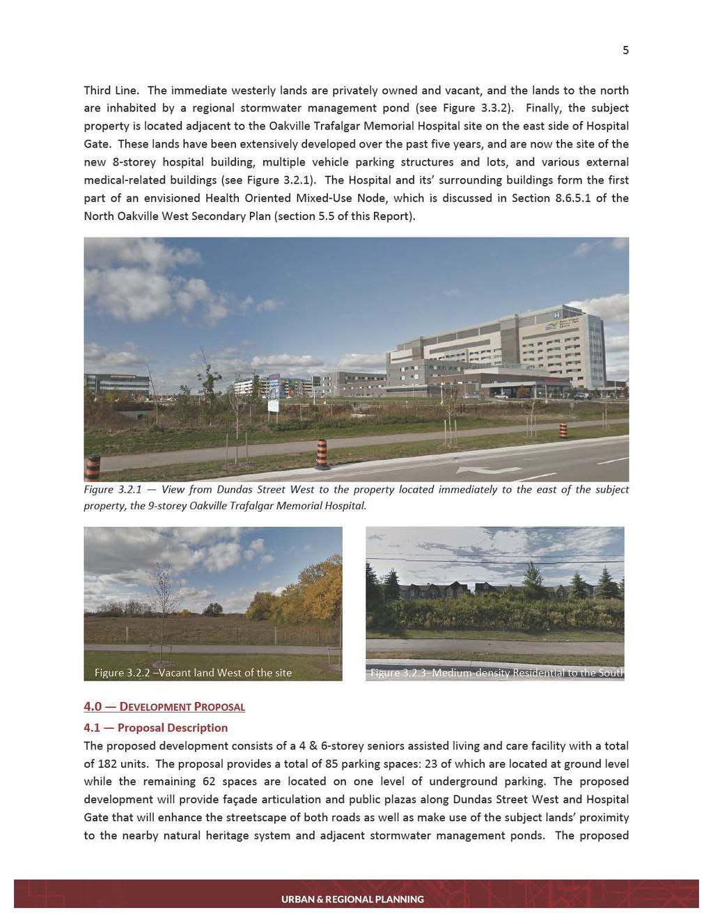
5 4 Figure 3.1 Aerial view of 2135 Dundas Street West with the general boundary of the property outlined in red. Figure 3.2 The subject lands as seen looking north from Dundas Street West. 3.2 Surrounding Area The subject lands are located in the North Oakville West area of the Town of Oakville. Medium-density residential townhouse dwellings are located on the opposite side of a landscaped berm along the south side of Dundas Street that form part of Oakville s Westoak Trails neighbourhood (see Figure 3.2.3), while commercial land uses are located on the south-west and south-east intersections of Dundas Street and
6

7 6 building itself has been designed to address its important location at the intersection of two transportation corridors that acts as a gateway to the adjacent Medical Campus. The proposed building has been designed with high-quality materials and addresses the streets it fronts onto as well as framing the driveway that is located at the rear of the proposed building. It will create an employment opportunity while providing a modern, architecturally-interesting building that contributes to the vision set out in both the Regional and Local Official Plans. The proposed building is divided into two distinct east and west wings. These wings are reflected in both their day-to-day operation and care type as well as their physical appearance and built form (this is discussed in-depth in the Urban Design Report included in this submission package). The Care Wing (west) patients would receive daily supervision and professional care. The Care wings are broken into blocks of 21 units to create a smaller, intimate congregate environment. Each block is self-contained, but able to connect to the main Assisted Living amenities. Each block is carefully designed to allow staff to easily supervise patients, to provide the patients with sufficient visual cues to manage their daily functions and contains its own living, dining, servery, interactive kitchen, and support services. The Assisted Living Wing (east) patients would receive supportive and care services. The Assisted Living units will be comprised of 1 bedroom and 2 bedroom units designed to a Group B3 occupancy code standard, which provides higher levels of life safety and barrier-free design requirements. The Assisted Living portion includes common amenities on the ground floor such as dining room, movie theatre, lounge, games room, fitness/spa, swimming pool, beauty salon, administrative offices and support services. The Assisted Living units do not have full kitchens, as patients would eat the majority of their meals in the common dining room located on the ground floor. Figure 4.1 Site Plan Drawing
8 7 The building is positioned at the southeast corner of the subject lands (the corner of Dundas Street and Hospital Gate) the building is positioned 3.26 m from the property line (measured diagonally) from the corner of Dundas Street and Hospital Gate, with the flankage yard along Hospital Gate being 7.50 m. However, the proposed building is two-stepped in its façade design for articulation and massing reasons; so much so that the proposed front yard setback increases from 3.26 m at the intersection (eastern-most point of the subject lands) to m at the western-most end of the building along Dundas Street West. This two-wing building design is to provide a visually interesting exterior that enhances the pedestrian-oriented streetscape with a strong focal design feature at the intersection of Dundas and Hospital Gate. Visually, the distinct wings also help break-up the massing of the building in both frontage and height while providing high-quality architectural style and materials and subsequently enhancing the rhythm of both Dundas Street and Hospital Gates streetscapes. 5.0 POLICY FRAMEWORK This section will lay out how the proposed development conforms to the various Provincial, Regional, and Local Plans and Zoning By-Law that are applicable to the subject site. 5.1 Provincial Policy Statement The Provincial Policy Statement ( PPS ) sets out the policy foundation for land use planning. The key objectives of the PPS include building strong communities, wise use and management of resources, and protecting public health and safety. Regional and local plans are required to be consistent with the PPS. The PPS focuses growth within settlement areas and protects significant or sensitive resources areas. The PPS recognizes that land use must be carefully managed to accommodate appropriate development to meet the full range of current and future needs, while achieving efficient development patterns. Efficient development patterns optimize the use of land, resources and public investment in infrastructure and public service facilities Settlement Areas The subject lands are located within the designated Settlement Area, which is to be the focus of growth and development that supports increased density and a mix of land uses (Section ). Land use patterns within the Settlement Areas are to support active transportation, efficiently use the infrastructure and public service facilities that are planned or available, and promote energy efficiency. The proposed development is located on a Major Transit Corridor (Dundas Street), which has been identified for a proposed Bus Rapid Transit system (BRT) along it, as well as an Avenue/Transit Corridor (Hospital Gate), which provides bus services to and from the adjacent Oakville Trafalgar Memorial Hospital. The aforementioned bus station located at the corner of Dundas Street and Hospital Gate makes the subject site easily accessible via public transport, and uses existing infrastructure as is directed in the PPS. With regard to energy efficiency, the L-shaped siting of the building towards the southeast corner of the site allows for effective use of the adjacent stormwater management pond to the north. The elevation difference between the street level and the internal courtyards is resolved with the basement level at pedestrian entrance level, which contains programmed interior spaces and parking, and has a barrier-free pedestrian entrance at street level (see Figure ). In addition, there

9 8 are 11 bicycle parking spaces offered (6 of them secure), which encourages active transportation to and from the site. The proposed development is supported by the Settlement Area policies of the PPS. Figure North-South Building Section Employment The PPS permits employment land uses within the designated Settlement Areas, instructing Planning authorities to promote economic development and competitiveness by providing a mix and range of employment and institutional uses that diversify economic activities and encourage compact, mixed-use development (Section 1.3.1b). It also states the importance of encouraging compact, mixed-use development that incorporates compatible employment uses to support livable and resilient communities (Section 1.3.1c). The proposed development provides medical-related employment land uses that will diversify the economic activities while enhancing the range of employment opportunities in Oakville. The subject site is located in close proximity (walking distance) to nearby commercial and residential land uses to the east and south. The subject site is located on a major transportation corridor and is situated adjacent to the Oakville Trafalgar Memorial Hospital both of which contribute to an appropriate location in terms of existing and planned infrastructure while maximizing the surrounding public services that exist. In addition, a bus stop located immediately outside the pedestrian access entrance on Dundas Street West will facilitate easy access to the building for both employees and visitors via public transit and walking. It also makes good use of planned bicycle lanes along Dundas Street East and Hospital Gate by providing the aforementioned bicycle parking spaces, thus encouraging active transportation to and from the proposed building. Section directs new development on lands adjacent to existing or planned corridors and to be designed to avoid, mitigate, or minimize negative impacts on and from the corridor and transportation facilities. The subject proposal is located on a transit corridor, however the building has been designed so as to not impact the corridor or any existing or planned transportation facilities and will in fact make use of said infrastructure in order to encourage its use. The subject proposal conforms and implements the policies of the Provincial Policy Statement.

10 9 5.2 Growth Plan for the Greater Golden Horseshoe The Growth Plan for the Greater Golden Horseshoe ( Growth Plan ) was prepared under the Places to Grow Act (2005) and provides a framework for implementing the Government of Ontario s vision for building strong, prosperous communities by better managing growth in the region. It sets out the ways in which our cities, suburbs, towns and villages will grow over the long term. The Growth Plan guides decisions on a wide range of issues including transportation, infrastructure planning, land-use planning, urban form, housing, natural heritage and resource protection. Directions for where and how to grow, the provision of infrastructure to support growth, protecting natural systems and cultivating a culture of conservation are matters of provincial importance and are identified in the Growth Plan. Regional and local plans are required to conform to the Growth Plan. Schedule 3 of the Growth Plan sets out the population and employment forecasts to The Region of Halton was initially forecasted to reach a population of 780,000 persons and 390,000 jobs, however, Amendment 2 to the Growth Plan updated the forecast for the Region of Halton for 2031 to a population of 820,000 and 390,000 jobs and the 2041 forecast to 1,000,000 persons and 470,000 jobs. Figure Schedule 4 of the Places to Grow Act showing the approximate location of the subject lands (circled) within the designated Designated Greenfield Area (Conceptual). The subject land is located within the designated Designated Greenfield Area (see Figure 5.2.1). The purpose of the Designated Greenfield Areas ( DGA ) is to encourage developments that support the achievement of complete communities, active transportation, and the integration and sustained vision
11 10 of transit services. The minimum density target to be achieved for lands designated as Employment Areas within the DGA is 60 residents and jobs combined per hectare (Section biii). As aforementioned previously in this Report, the proposed development encourages active and public transportation, and its employment land use helps contribute to achieving both complete communities and the job density target for DGA s. Section of the Plan discusses how development will be directed to settlement areas, and that it will be in the form of complete communities that feature a mix of diverse land uses, including residential and employment uses, with convenient access to local stores, services, and public service facilities. As set out in Section 2.2.2, population and employment growth will be accommodated through a number of means including the following: Directing a significant portion of growth to built-up areas; Directing development to settlement areas; and ensuring the availability of sufficient employment uses to accommodate the forecasted growth and planning and investing for a balance of jobs and housing. The proposed development is located within the settlement area, and represents high-quality employment intensification in the DGA that supports the immediate and surrounding area. It is located within an area specifically identified in the Local Official Plan (Section 5.5 of this Report) as being a Health- Oriented Node, to which the proposed development has been designed directly to conform to and to help achieve. Section of the Growth Plan states the importance of maintaining economic development and competitiveness through making more efficient use of vacant and underutilized employment lands and increasing employment densities. The proposed development will bring 117 new positions, thus assisting with increasing the employment densities of Oakville and the Region of Halton in both the public service and medical sectors. Section 2.2.5(4) states that development within the Employment Areas will be supportive of active transportation networks and transit-supportive built form be facilitated. As aforementioned, the subject lands are located immediately adjacent to an existing Bus Stop, which provides easy access for both employees and visitors. In addition, there are multiple entrances to the building through numerous split-level terraces with frontage onto both Dundas Street West and Hospital Gate. The subject lands are currently underutilized and not being realized to the best of their potential, and the proposal will encourage high-quality development that maximizes the entirety of the lands. In addition, the existing land uses to the east that are discussed in Section 5.5 of this Report are both supportive of neighbouring employment land uses, to which the proposed development answers. This section also specifies that major transit stations and intensification corridors be planned to achieve increased employment densities that support and ensure viability of each urban growth center. The subject lands are located along Dundas Street in-between two urban growth centers; Palermo Village (west) and Uptown Oakville (east), and thus development of this type is supported. The proposed development is consistent with the Growth Plan s objective of targeting employment growth in order to create diverse, compatible, mixed land-uses that support vibrant neighbourhoods and are sustained by public transit and alternative transportation modes. The proposed development conforms to and implements the policies of the Growth Plan for the Greater Golden Horseshoe.

12 Region of Halton Official Plan The Region of Halton Official Plan outlines a long-term vision for Halton s physical form and community character. It sets forth goals and objectives for accommodating urban growth and states the policies to be followed to solidify decisions taken in the past and to give clear direction as to how physical development should take place in the Region to meet the current and future needs of its people. In order to do this, it sets forth goals and objectives, describes an urban structure for accommodating growth, and states the policies to be followed. As per Map 1A of the ROP (see Figure 5.3.1), the subject lands are located within the Urban Area and included it in the Employment Area overlay: Figure Map 1 (Regional Structure) of the Region of Halton Official Plan with the location of the subject lands circled. As shown, 2135 Dundas Street West are located within both the Urban Area and Employment Area designations. The ROP discusses the growth that is expected to take place throughout the Region of Halton, and a portion of which, the Town of Oakville is to absorb. The ROP sets out the following growth and employment targets for Oakville (Figure & 5.3.3):
13
14 13 assists in facilitating the desired increase in employment density within the urban area. The proposed development adheres to the urban area policies of the ROP. Employment Area As per Section 77 of the ROP, the objective of the Employment Area is to provide opportunities for a fully diversified economic base that maintains a range and choice of suitable sites for employment uses. Specifically, Section 77(5f) encourages density of employment (and residential) lands that contribute to creating healthy communities through urban design, a diversity of land uses, strengthening live-work relationship through a proper balance of residential and employment land uses, and promoting active transportation and public transit use. The subject proposal provides a unique combination of offering assisted and total care for senior patients while providing employment opportunities in the medical field in a location immediately adjacent to the Oakville Trafalgar Memorial Hospital site. The subject site is located in close proximity to neighbouring residential areas, and is easily accessible via both public and active transportation. The proposed development is further supported by the Region s objective to develop a desirable mix of land uses and community design features that promote integration of the community and accessibility by residents to services within and outside the community (Section 77(2.4)). Sections encourage development within the Region to increase the innovative capacity of Halton s knowledge base and skill level while strengthening the economic base. The proposed development represents a first-of-its-kind employment land use within an area of North West Oakville that has not yet been fully developed. The proposed building promotes high-quality jobs to assist in expanding the knowledge base of the Region while having the potential to attract health specialists, employees, and patients from both the local and wider-reaching community. In addition, Section 169(10) promotes economic activities that provide diverse, high-quality employment opportunities as well as a greater match by type between employment and residential growth. The entirety of the North Oakville West Area (as will be discussed in Section 5.5 of this report) is a designated Employment Area, and thus is supportive this type of development. Further to this point, employment land uses are encouraged and will assist with the Region s desire to balance residential and employment growth. The proposed development conforms to the objectives of the Region of Halton Official Plan and provides medically related employment opportunities within proximity to both an existing medical employment area and residential area. It will provide 117 new jobs, is located along a planner high order public transit corridor, and represents compact form that helps establish an urban community that is pedestrian friendly and transit supportive. The proposal conforms to the Region of Halton Official Plan. Discussion have been held with Region of Halton Senior Planner, Laurielle Brooks, regarding this proposal for which they are supportive of both the proposed land use and job forecasts. (Please see Appendix A for a copy of this correspondence dated February 14 th, 2017). The proposed development encourages and implements the employment-related policies of the ROP.
.")
15 North Oakville West Secondary Plan There are two Official Plans operating concurrently in Oakville: Livable Oakville (covering the lands south of Dundas and north of Highway 407); and the North Oakville Master Plan (lands north of Dundas and south of the Highway 407). The latter of the two is further broken down into two Secondary Plans: the North Oakville West Secondary Plan, which covers lands north of Dundas and west of Sixteen Mile Creek; and the North Oakville East Secondary Plan, which is comprised of lands north of Dundas Street and east of Sixteen Mile Creek. The subject lands are covered by the North Oakville West Secondary Plan. The purpose of the North Oakville West Secondary Plan ( NOWSP ) is to establish a detailed planning framework for the future urban development of the North Oakville West Planning Area (also referred to in this Secondary Plan as the Plan Area, and as North Oakville West). The Planning Area is comprised of the 407 West and Sixteen Hollow industrial districts / employment lands / located as identified on Figure G, Community Organization to the Official Plan. The NOWSP provides policies to manage the physical evolution of the City through the social, economic, cultural, and natural environment. The lands that are subject to the policies of the North Oakville West Secondary Plan are shown in Figure with the location of the subject lands circled: Figure Schedule B of the North Oakville West Secondary Plan with the location of the subject lands circled within the designated Employment Lands area.
16 NOWSP Background North Oakville s development as an urban community shall reflect Oakville s distinct historical roots and small-town heritage and Trafalgar Township s village rural heritage, with nodal development, prestige industry, and green together with North Oakville East, will generally reflect the Transect 1, a system of classification of human habitats from the most rural which is reflected in the natural heritage and open space system, to the most urban conditions, which is reflected in urban core areas. The goal of the transect-based system is to make it possible for North Oakville West, together with North Oakville East, to sustain a complete palette of neighbourhoods and employment opportunities. The subject lands are located within the Employment District (see Figure ). Figure Figure NOW2 of the NOWSP showing the subject lands (circled) within the designated Employment District and abutting the Health-Oriented Mixed Use Node (*) Policies Employment The NOWSP supports development that creates employment opportunities for both the immediate and surrounding area. Section signifies the importance of creating employment districts which provide for a wide range of employment opportunities with access to major freeways, arterial roads, and transit systems as well as promoting higher order employment densities that maximize employment opportunities, particularly in areas where higher order/frequent transit service is planned. Section highlights the importance of accommodating development of predominantly employment generating uses, while Section speaks to Employment Targets, stating that the NOWSP is to achieve a balance in both type and quantity between local employment opportunities and the resident labour force. The
17 16 subject lands are located adjacent to the site of the Oakville Trafalgar Memorial Hospital, which is a major medical node and thus highly compatible in terms of existing employment type and services that are offered. Finally, Section states that the primary focus for the Employment District in which the proposed development is located is to protect for, and establish, a range of development opportunities for employment while encouraging medical-related employment uses on lands included in the Health Oriented Mixed-Use Node on the north side of Dundas Street at Third Line. This Node includes the existing hospital, and encourages research and development as well as clinics, supportive housing, longterm care facilities, and other similar commercial facilities related to the permitted uses. The proposed development will help achieve the required employment densities laid out by the Region, in an area specifically designated for medical-related employment land uses. The proposal conforms to the policies of the NOWSP by providing employment opportunities for a range of professionals and businesses in an area specifically designated for said land uses. The proposed development thus conforms directly to the policies of the NOWSP regarding the employment district and is directly supported by the goals of the health oriented mixed-use node located on the adjacent lands. Design Guidelines The NOWSP provides general design guidelines for new development on lands over which it governs. While the Urban Design Policies are assessed in detail separately in the Urban Design Brief prepared by Ruth Victor & Associates and IBI Group, Section (General Design Direction) mandates that all development in the Employment Areas shall be designed to be compact, pedestrian and transit-friendly in form while striking a balance between civic, institutional, and commercial land uses. The subject proposal will exhibit high standards of urban design that will result in a vibrant and memorable urban place. In addition, the subject proposal is a care facility that is not yet offered in the immediate area while supporting the health-oriented land uses that are located nearby. The subject proposal is located at the corner of two important roads (Dundas Street West and Hospital Gate) and thus acts as a gateway and focal point for the North Oakville West community. Section speaks to streetscape, highlighting that frontages onto both Arterial & Avenue/Transit Corridors (Dundas Street and Hospital Gate) will receive a higher level of design than local streets through the extended use of tree and feature planting, paving, lighting, and signage detail, and this is addressed in detail on the accompanied Landscape Plan included with this submission package. Section states that buildings, structures, and landscaping shall be designed to provide visual interest to pedestrians, as well as a sense of enclosure to the street. The proposed development will offer landscaped areas on both Dundas Street and Hospital Gate frontages, as well as public plazas and the incorporation of street furniture to articulate the public realm on both streets. In addition, the wide pedestrian paths, planting, appropriate paving, and generous openness are all spaces to be furnished with seating to promote social interaction and pedestrian comfort. With regards to the proposed building, the two-storey podium is articulated with a pedestrian-scale-appropriate masonry colonnade, generous glazing, and canopies to activate the urban corner. With regard to building location, the proposed building has been designed to provide a strong presence at the corner of Dundas Street and Hospital Gate due to its important gateway location to the adjacent medical campus. Further to that
18 17 point, the massing of the building has been designed such that it respects both the adjacent hospital building and land uses as well as not overpowering the medium-density residential on the other side of Dundas Street and the abutting stormwater management pond system located directly to the north of the subject lands. Section addresses off-street parking, stipulating that it shall be designed to reduce their visual impact on both the adjoining streetscapes and on people using the facility through locating the parking lot to the side or rear of the main building. The subject proposal provides 73% of its parking spaces on one level of underground parking, while the remaining 27% is located at surface level at the rear of the building. The proposed surface parking spaces are not visible from Dundas Street West and only partially viewable from Hospital Gate (travelling south towards Dundas Street). Land Uses Generally Permitted The NOWSP lays out policies for the permitted land uses within North Oakville West. The primary focus of the Employment District designation is to protect for and establish a range of development opportunities for employment generating industrial, office, and service employment uses. It will also include a Health Oriented Mixed-Use Node on the north side of Dundas Street at Third Line. Where applicable, the range and scale of uses are to be designed to be sensitive to the adjacency and compatibility with development in the Health Oriented Mixed-Use Node, or to reflect a visible location on and exposure to highway corridors and major roads. The subject lands are located within the vicinity of the designated Health Oriented Mixed-Use Node area, and thus the proposed development is highly compatible with both its Official Plan designation and the envisioned general character of the surrounding area. The Health Oriented node is to be a medical-focused area north of Dundas Street that provides a wide variety of health-related services, operations, and businesses. The parcel of land located to the east of the existing Oakville Trafalgar Memorial Hospital is to be a Life Sciences & Technology District, while the northern and western portion of the Hospital lands are comprised of various buildings that facilitate medical and treatment operations. Thus, the proposal is in direct conformity with the directions of the NOWSP regarding employment land use and the types of developments and built form in the immediate surrounding area. Section (Land Use Policies) stipulates that buildings will be designed and located to assist in the creation of an attractive street edge and that there be a balance between the areas of the lot occupied by the building and the service and parking areas. The subject proposal is oriented towards both Dundas Street West and Hospital Gate in order to provide an increased streetscape and pedestrian experience, and the surface parking areas are located at the rear of the building and is subsequently not visible from either arterial corridor. The building has been designed in two distinct wings both of which are different in terms of height, façade treatment, and unit type this distinction helps break the building up in terms of its total massing when viewed from the public realm as well as Dundas Street and Hospital Gate.
19 Oakville Zoning By-Law The current zoning category is ED Existing Development (see Figure 5.6.1). This zoning category has been applied to all lands within the North Oakville West Planning Area prior to their envisioned redevelopment. It is the understanding that all lands will be rezoned according to their development proposal prior to Site Plan Approval. Figure Schedule 12(2) of Zoning By-Law showing the subject lands (circled) zoned ED. The Zoning By-Law Amendment is to rezone the subject lands from ED to I (Institutional) in order to permit the proposed use, as well as site-specific exemptions to permit an increased height, front yard and flankage yard setbacks, and a reduced parking standard. These Zoning By-Law Amendments would facilitate the successful implementation of the proposed development Land Use Designation The proposed Zoning By-Law Amendment regarding rezoning of the subject lands from ED to I is to permit the proposed development to take place. All lands north of Dundas Street and south of Highway 407 were rezoned to ED (Existing Development) under Zoning By-Law and it is the intention for any redevelopment within said area to undergo the rezoning of the lands to an appropriate zone for the proposed land use. In this case, the zoning provisions for ED do not permit the type of land use directed by both Provincial and Local policy framework, which envisions it to develop as part of the medical-related health-oriented hub to the east. The rezoning of the subject lands to I (Institutional) permits the proposed seniors assisted living facility that helps assist achieving the job density as laid out in the Halton Region Official Plan (see Section 5.3 of this Report).
20 19 The I designation is under the Institutional and Park Zone, which permits a range of land uses that would help facilitate the employment land use envisioned in both the North Oakville West Secondary Plan and ROP. The rezoning [see Draft Zoning By-Law Amendment (Appendix B )] of the subject lands is supported by the NOWSP, ROP, and Provincial Policy, and would be subject to a number of sitespecific exemptions to permit the proposed building. These exemptions are as follows: Building Height The proposed Zoning By-Law Amendment regarding height is to permit an increased building height of m, whereas Section of By-Law permit a maximum height of 16.00m. As aforementioned, the subject lands are located within a designated Employment Area in the North Oakville West Secondary Plan and within the Settlement Area of the Halton Region Official Plan. Both policies direct growth to take place on said lands. The proposed development is located immediately adjacent to the existing Oakville Trafalgar Memorial Hospital which is 10-storeys in height and of much larger physical scope. By contrast, the proposed building is a modest 4-6-storey stepped-façade building designed to reduce its and overall height on Dundas Street while providing a modern vernacular which is appropriate for the character of the surrounding area. Subtle variation in the architectural style and expression helps to achieve the Town s vision of contemporary vocabulary and architectural diversity. Finally, the North Oakville Sustainability & Urban Design Guidelines instruct developments on major intersections to address their important gateway location appropriately through massing, articulation, and modern building architecture that enhance the streetscape while defining the entrance to the neighbouring medical campus to the north and east (Section 3.3.1). Increased height in this location is supported by both Regional and Local policy Front Yard & Flankage Yard Setbacks The proposed Zoning By-Law Amendment regarding the front yard setback is to permit a Maximum Front Yard Setback of 16.00m, whereas Section of By-Law permits a maximum setback of 6.00m. The proposed Zoning By-Law Amendment regarding flankage yard setback is to permit a maximum flankage yard setback of 8.00m, whereas Section of By-Law permits a maximum setback of 6.00m. Section of the aforementioned North Oakville Sustainability & Urban Design Guidelines lay out the policies for the relationship of new buildings to one another and the pedestrian realm, stating that buildings located at gateways should be designed to reflect their prominent location with articulated building massing, increased height, and other architectural details that emphasize the focal nature of the building. The Guidelines also encourage minimal buildings setbacks to define a more consistent and urban street edge design. The building has been designed with consideration to its frontages onto both Dundas Street West and Hospital Gate. The street edge building faces on both Dundas Street and Hospital Gate have been placed further back from the property line to allow the development of an Urban Plaza at the intersection of two roads. This increased setback provides sufficient space for landscaping features and pedestrian-orientated street furniture. The highly visible programmed spaces of the two-storey podium will animate this important street corner and enhance the transit-oriented pedestrian experience for both visitors and those working around the Medical Campus. The proposed
21 20 development is located at the intersection of two important roadways, and has been designed to directly address this location. The entire building is oriented with strong building faces on both Dundas Street and Hospital Gate in a general L-shape. In addition, the greater front yard setback enables the building's corner to be formed as a clearly pronounced tower element that acts as a community beacon and defines a pedestrian orientated street entrance at its base. This is designed in accordance with Sections 8.2.1, which encourages buildings located on street corners to emphasize their focal point. This increased setback to the property line allows for an architecturally strong right-angled corner tower element focused towards the intersection Parking Standards The proposed Zoning By-Law Amendment regarding the parking standard is for a reduction to 0.46 parking spaces per unit, whereas Section 5.1A of By-Law requires a minimum parking standard of 0.50 vehicle spaces per unit. As has been mentioned previously in this report, this is for a number of reasons, including the location of the proposed development in relation to surrounding land uses, public transportation infrastructure, as well as the proposed use of the building. The subject lands are located in close proximity (walking distance) to the existing Oakville Trafalgar Hospital and related medical buildings to the east as well as the residential neighbourhood to the south of Dundas Street West. In addition, the subject lands are well serviced by public transit and Dundas Street is planned for higherorder transit; increasing mobility and reliability of public transit access to the site. Finally, the proposed building is to facilitate the care of patients. There are 182 proposed units in total, however due to the nature of the type of building, dependency on motor vehicle trips for each of the units is not expected. Rather, it is predicted that there will be 117 new jobs associated with this development, and so parking standards is better based on this number in addition to visitor parking for those visitors of the buildings patients. The proposed variances for increased height, front and flankage yard setback, and a reduce parking standard are supported by both Regional and Local planning policies. The proposed development is in conformity with land use, urban design, and employment growth management policies. 6.0 Supporting Studies 6.1 Site Servicing & Grading Plan A Site Servicing & Grading Plan has been prepared by Trafalgar Engineering. 6.3 Waste Management Plan A Waste Management Plan has been prepared by IBI Group. 6.4 Urban Design Brief An Urban Design Brief has been prepared by Ruth Victor & Associates, IBI Group, and Adesso Design Inc. The report concludes that the proposed development conforms to the North Oakville Sustainability &
22 21 Urban Design Guidelines as well as related Local, Regional, and Provincial urban design policies and directions. 6.5 Noise Feasibility Study A Noise Feasibility Study has been prepared by HGC Engineering to assess predicted sound levels for various locations on the building as well as the outdoor amenity areas. The report concludes that the proposed development is feasible, and that although future road traffic sounds levels in some areas will exceed MOECC s guidelines, there exists means to reduce the impact to within acceptable limits. The study recommends upgrading building construction materials required for the south façade facing Dundas Street West and double-glazing window construction meeting the minimum requirements of the OBC will provide adequate sound insulation for the remaining building façade dwelling units as well as warning clauses to inform future occupants and the owner of the building of the traffic noise and presence of adjacent commercial and institutional uses. 6.6 Environmental Site Assessment A Phase 1 Environmental Site Assessment has been prepared by Landtek Limited. The report concludes that: There was no evidence of Underground Storage Tanks (UST); that one Aboveground Storage Tank (AST) was observed but there was no evidence of staining or spillage; that Hazardous materials such as ACM s (Asbestos Containing Materials) were not identified at the time of visual assessment; and, that subsequently there is no need to undertake further environmental evaluation of the site. 6.7 Functional Servicing Report A Functional Servicing Report has been prepared by Trafalgar Engineering. 6.8 Environmental Implementation Report An Environmental Implementation Report has been prepared by Beacon Environmental. 6.9 Transportation Impact Analysis A Traffic Impact analysis has been prepared by Paradigm Transportation Solutions Limited (PTSL). The report concludes that the proposed development is forecast to generate 83 trips during the AM peak hour and 98 trips during the PM peak hour, but that the existing transportation networks will be able to accommodate this proposal and subsequently no improvements are required at the study area intersections. In addition, the report concludes that the proposed parking standard reduction of 0.46 spaces per unit should adequately accommodate the parking demands of the proposed development. Both vehicle turning and pedestrian circulation plans were also included in this report, which identified the appropriate respective paths Archaeological Assessment
23
24 Appendix A Correspondence with Laurielle Brooks (Region of Halton) regarding the Employment Land Use for 2135 Dundas Street West: From: "Brooks, Laurielle" Laurielle.Brooks@halton.ca Date: Tuesday, February 14, 2017 at 1:47 PM To: Ruth Victor <ruth@rvassociates.ca> Cc: David Nelson <david@rvassociates.ca> Subject: RE: Oakville - Staffing requirements - Jan xlsx Hi Ruth, My apologies for not getting back to you sooner. Regional staff have considered this proposal out of an abundance of caution. Staff wanted to ensure we had a full understanding of how the Town was considering this proposal. We had some initial concern given the proposed use looks and feels like a residential use. We wanted to understand whether allowing the introduction of the use has the potential to undermine the integrity of the Regional Employment Land designation. The Town has confirmed that they are only considering this type of use for this location given the existing supportive policies of the NOWSP that contemplate these types of uses in proximity to the HOMUN. We also understand that the Town has sufficient local controls to prevent any future conversion of the building/use. Given the above we have no concern from an employment land conversion perspective. Should the proposal change, Regional staff would be happy to discuss. Sincerely, Laurielle Brooks
25 THE CORPORATION OF THE TOWN OF OAKVILLE BY-LAW NUMBER 2017-XXX A by-law to amend the Town of Oakville Zoning By-law , as amended, to permit the Use of lands described as Part of Lot 27, Concession 1 Trafalgar NDS, Part 1 20R18562, save & except Part 2 on EXP, Easement over Part 1 on EXP Plan HR Dundas Street West (All Seniors Care) File No. XXX COUNCIL ENACTS AS FOLLOWS: 1. Map 12(2) of By-law , as amended, is further amended by rezoning the lands shown on Schedule B to this By-Law from ED (Existing Development) to I-*** (Institutional-Special Provision XXX). 2. This by-law comes into force in accordance with Section 34 of the Planning Act, R.S.O. 1990, c. P.13, as amended. PASSED this xx day of mm, 2017 Rob Burton Mayor Vicki Tytanek Town Clerk

26 SCHEDULE A To By-law 2017-XXX Rob Burton Mayor Vicki Tytanek Town Clerk
27 Schedule B To By-law 2017-XXX Rob Burton Mayor Vicki Tytanek Town Clerk
28 Appendix A To By-law 2017-XXX Explanation of the Purpose and Effect of the By-law To permit the redevelopment of the property for a 4 & 6-storey seniors assisted living and care facility. This By-law amends the zoning of the property outlined on the attached Schedule "A" from "(ED) to "(Exemption I-***) "(Exemption I-***)" permits the 6-storey seniors assisted living and care facility. Maximum Front Yard Dundas Street m Maximum Flankage Yard Hospital Gate 8.00 m Maximum Height 26.50m Minimum Parking Standard 0.46 vehicle parking spaces per unit Location of Lands Affected Municipally known as 2135 Dundas Street West, in the Town of Oakville, as shown on the attached Map designated as Schedule "A". Further information regarding this By-law may be obtained from of the Town Planning and Building Department at ext..
2136 & 2148 Trafalgar Road Town of Oakville Region of Halton
 PLANNING JUSTIFICATION REPORT 2136 & 2148 Trafalgar Road Town of Oakville Region of Halton Zoning By-Law Amendment Application 2500674 Ontario Inc. November 2016 Table of Contents Page 1.0 Location/Summary
2135 DUNDAS STREET WEST, OAKVILLE, ON
 2135 DUNDAS STREET WEST, OAKVILLE, ON URBAN DESIGN BRIEF Prepared by Ruth Victor & Associates & IBI Group Architects 481 North Service Road West, Unit A-33 Oakville, ON L6M 2V6 November 21, 2017 2 1 INTRODUCTION...
URBAN DESIGN BRIEF. 2136&2148 Trafalgar Road. Town of Oakville
 URBAN DESIGN BRIEF 2136&2148 Trafalgar Road Town of Oakville Prepared By: METROPOLITAN CONSULTING INC For 2500674 Ontario Inc November 2016 TABLE OF CONTENTS Page No. 1.0 Introduction/Description of Subject
Trafalgar Road Corridor Planning Study Open House
 Trafalgar Road Corridor Planning Study Open House June 24, 2013 6:30-8:30 p.m. Oakville & Trafalgar Rooms Overview The Livable Oakville Plan identifies the lands along Trafalgar Road, between the QEW and
Figure 1- Site Plan Concept
 Figure 1- Site Plan Concept Parking will be provided underground on three levels at rate of 1.0 space/ unit; this rate includes all visitors parking. MMM Group has prepared a parking assessment (April,
K. SMART ASSOCIATES LIMITED
 Planning Justification Report Zoning By-Law Amendment 185 King Street North Waterloo, Ontario April 7th, 2017 Project Reference Number 16-245 K. SMART ASSOCIATES LIMITED CONSULTING ENGINEERS AND PLANNERS
Table of Contents 1.0 Introduction
 Table of Contents 1.0 Introduction..1 2.0 Site Description and Surrounding Land Uses 1 3.0 Redevelopment Proposal..3 4.0 Provincial, Regional and Municipal Policy Context... 10 4.1 The Provincial Policy
Bressa Developments Limited. Planning Justification Report. Revised Draft Plan of Subdivision and Zoning By-Law Amendment
 Bressa Developments Limited Revised Draft Plan of Subdivision and Zoning By-Law Amendment Planning Justification Report Part of Lots 7 & 8 Concession 1, North of Dundas Street Town of Oakville September,
Employment and Commercial Review Analysis of Policy Directions
 Employment and Commercial Review Analysis of Policy Directions Appendix A The following analysis is town staff s response to the policy directions provided by the consultants who prepared the Employment
URBAN DESIGN BRIEF 181 Burloak Drive, Oakville
 URBAN DESIGN BRIEF 181 Burloak Drive, Oakville February 2017 Our File: 1730B 230-7050 WESTON ROAD / WOODBRIDGE / ONTARIO / L4L 8G7 / T: 905 761 5588/ F: 905 761 5589/WWW.MHBCPLAN.COM TABLE OF CONTENTS
Mark-up of the effect of the proposed Bronte Village Growth Area OPA No.18 on the text of section 24, Bronte Village, of the Livable Oakville Plan
 Mark-up of the effect of the proposed Bronte Village Growth Area OPA No.18 on the text of section 24, Bronte Village, of the Livable Oakville Plan Notes: This document is provided for information purposes
URBAN DESIGN BRIEF URBAN DESIGN BRIEF 721 FRANKLIN BLVD, CAMBRIDGE August 2018
 URBAN DESIGN BRIEF URBAN DESIGN BRIEF 721 FRANKLIN BLVD, CAMBRIDGE August 2018 DESIGN BRIEF CONTENTS PART A 1.0 INTRODUCTION 2.0 DESCRIPTION & ANALYSIS OF SITE CONTEXT 3.0 DESIGN CONSTRAINTS AND OPPORTUNITIES
Derry Green Corporate Business Park
 Town of Milton Derry Green Corporate Business Park Urban Design Guidelines BMI/Pace - June 2010 Draft 3 Prepared by: Brook McIlroy Planning + Urban Design / Pace Architects Suite 300-51 Camden Street Toronto,
DRAFT Northeast Quadrant of Kipling Avenue and Highway 7 DRAFT AUGUST 29, Goals Land Use. The goals of this Plan are to:
 AUGUST 29, 2017 12.15 Northeast Quadrant of Kipling Avenue and Highway 7 12.15.1 Goals 12.15.2 Land Use The goals of this Plan are to: 12.15.2.1 General Provisions: a) Ensure the development of a compact
PLANNING JUSTIFICATION REPORT
 PLANNING JUSTIFICATION REPORT 55 DELHI STREET CITY OF GUELPH PREPARED FOR: VESTERRA PROPERTY MANAGEMENT PREPARED BY: LABRECHE PATTERSON & ASSOCIATES INC. SCOTT PATTERSON, BA, CPT, MCIP, RPP PRINCIPAL,
ELMVALE ACRES SHOPPING CENTRE MASTER PLAN
 ELMVALE ACRES SHOPPING CENTRE MASTER PLAN Contents 1.0 INTRODUCTION... 2 2.0 LOCATION... 2 3.0 EXISTING CONTEXT... 2 4.0 VISION & GUIDING PRINCIPLES... 2 5.0 LAND USE AND BUILT FORM... 4 5.1 St. Laurent
1005 Dundas Street East & 3033 Eighth Line, Oakville
 1005 Dundas Street East & 3033 Eighth Line, Oakville Urban Design Brief Prepared for Oakville Urban Core Development Inc. by IBI Group August, 2016 IBI Group Table of Contents» Introduction... 2» Design
New-Cast Mixed-use Development Proposal King Street West, Newcastle, Ontario
 URBAN DESIGN BRIEF New-Cast Mixed-use Development Proposal King Street West, Newcastle, Ontario TABLE OF CONTENTS: 1.0 Executive Summary 2.0 Creating Vibrant and Sustainable Urban Places: Excerpts from
1071 King Street West Zoning Amendment Application - Preliminary Report
 STAFF REPORT ACTION REQUIRED 1071 King Street West Zoning Amendment Application - Preliminary Report Date: August 9, 2012 To: From: Wards: Reference Number: Toronto and East York Community Council Director,
Regency Developments. Urban Design Brief. Holyrood DC2 Rezoning
 Regency Developments Urban Design Brief Holyrood DC2 Rezoning Stantec Consulting Ltd. 7-31-2017 1. Overview Regency Developments intends to rezone the lands located at 8510 and 8511 93 Avenue, within the
Official Plan Review
 Official Plan Review Summary Report - The Built Environment August 2014 Part 1: Introduction Planning for a healthy, prosperous and sustainable community is an important goal for our municipality. From
Midtown Oakville will be a vibrant, transit-supportive, mixed use urban community and employment area.
 Livable Oakville Part E: Growth Areas, Special Policy Areas and Exceptions 20. MIDTOWN OAKVILLE 20.1 Goal The interchange of Trafalgar Road and the QEW and the Oakville GO Station are major entry points
YONGE STEELES CORRIDOR SECONDARY PLAN. Young + Wright / IBI Group Architects Dillon Consulting Ltd. GHK International (Canada) Ltd.
 Ltd.") PART A: PREAMBLE 1.0 PURPOSE The purpose of this Secondary Plan is to provide a development framework for intensification of the Yonge/ Steeles corridor including the north side of Steeles Avenue West
PART A: PREAMBLE 1.0 PURPOSE The purpose of this Secondary Plan is to provide a development framework for intensification of the Yonge/ Steeles corridor including the north side of Steeles Avenue West
URBAN DESIGN BRIEF New Street Burlington, ON
 3225-3237 New Street Burlington, ON MARCH 2017 Prepared for: Royal Living Development Group Inc. Prepared by: adesso design inc. 218 Locke Street South, 2nd Floor Hamilton, ON L8P 4B4 t. 905.526.8876 3225-3237
SCHEDULE 'A' TO BY-LAW as Amended by AMENDMENT NO. 90 TO THE WHITBY OFFICIAL PLAN
 SCHEDULE 'A' TO BY-LAW 6413-10 as Amended by 6553-11 AMENDMENT NO. 90 TO THE WHITBY OFFICIAL PLAN SECTION A: GROWTH PLAN CONFORMITY PURPOSE: LOCATION: BASIS: The purpose of this Amendment is to: conform
THE CORPORATION OF THE TOWN OF OAKVILLE BY-LAW NUMBER
 THE CORPORATION OF THE TOWN OF OAKVILLE BY-LAW NUMBER 2017-120 A by-law to adopt an amendment to the Livable Oakville Plan, Official Plan Amendment Number 20 (Downtown Oakville Growth Area) WHEREAS the
Commercial Development Proposal Tenth Line Road. Planning Rationale Report. Minto Developments Inc.
 Commercial Development Proposal 2168 Tenth Line Road Report September 2015 Prepared for Minto Developments Inc. Paquette Planning Associates Ltd. 56 Hutchison Avenue Ottawa, Ontario K1Y 4A3 PH: 613-722-7217
178 Carruthers Properties Inc.
 178 Carruthers Properties Inc. Planning Rationale for 178 Carruthers Avenue Site Plan Control Application June 2014 Table of Contents 1.0 Introduction 2.0 Overview of Subject Property 3.0 Current Zoning
ONTARIO MUNICIPAL BOARD
 PL 120483 ONTARIO MUNICIPAL BOARD Applicant/Appellant: 2124123 Ontario Limited Subject: OPA, Rezoning and Draft Plan of Subdivision Municipal Address: 3940 Highway 7 East Municipality: City of Markham
The Corporation of the TOWN OF MILTON
 Report to: From: Chair & Members of the Administration & Planning Standing Committee W.F. Mann, Director of Planning and Development Date: April 16, 2012 PD 022-12 (Z19/11) Subject: Technical Report Proposed
Official Plan Review: Draft Built Form Policies
 PG.30.1 REPORT FOR ACTION Official Plan Review: Draft Built Form Policies Date: May 15, 2018 To: Planning and Growth Management Committee From: Chief Planner and Executive Director, City Planning Division
and Richmond Street West - Official Plan Amendment Application - Preliminary Report
 STAFF REPORT ACTION REQUIRED 822-838 and 860-862 Richmond Street West - Official Plan Amendment Application - Preliminary Report Date: August 14, 2017 To: From: Wards: Reference Number: Toronto and East
The Corporation of the Town of Milton
 Report To: From: Council Barbara Koopmans, Commissioner, Planning and Development Date: May 7, 2018 Report No: Subject: Making it Possible Positioning the Town s Strategy for Growth and Economic Development
Urban Design Brief. Watson Parkway North & Watson Road North Guelph, Ontario. Prepared by Coletara Development
 Urban Design Brief Watson Parkway North & Watson Road North Guelph, Ontario Prepared by Coletara Development December, 2013 Urban Design Brief, Coletara Development 1 Introduction This Urban Design Brief
[PLANNING RATIONALE] For Site Plan Control and Lifting of Holding Zone By-Law 101 Champagne Avenue. May 23, 2014
![[PLANNING RATIONALE] For Site Plan Control and Lifting of Holding Zone By-Law 101 Champagne Avenue. May 23, 2014](/thumbs/75/71599615.jpg "[PLANNING RATIONALE] For Site Plan Control and Lifting of Holding Zone By-Law 101 Champagne Avenue. May 23, 2014") [PLANNING RATIONALE] For Site Plan Control and Lifting of Holding Zone By-Law 101 Champagne Avenue May 23, 2014 Contents 1.0 Introduction... 2 2.0 Site Context... 2 2.1 Adjacent Uses... 2 Figure 1: Site
[PLANNING RATIONALE] For Site Plan Control and Lifting of Holding Zone By-Law 101 Champagne Avenue May 23, 2014 Contents 1.0 Introduction... 2 2.0 Site Context... 2 2.1 Adjacent Uses... 2 Figure 1: Site
THE CITY OF VAUGHAN BY-LAW BY-LAW NUMBER A By-law to adopt Amendment Number 1 to the Official Plan of the Vaughan Planning Area.
 THE CITY OF VAUGHAN BY-LAW BY-LAW NUMBER 015-2014 A By-law to adopt Amendment Number 1 to the Official Plan of the Vaughan Planning Area. NOW THEREFORE the Council of the Corporation of the City of Vaughan
7437, 7439 and 7441 Kingston Road - Zoning By-law Amendment and Site Plan Control Applications - Preliminary Report
 STAFF REPORT ACTION REQUIRED 7437, 7439 and 7441 Kingston Road - Zoning By-law Amendment and Site Plan Control Applications - Preliminary Report Date: August 13, 2015 To: From: Wards: Reference Number:
Urban Design Manual PLANNING AROUND RAPID TRANSIT STATIONS (PARTS) Introduction. Station Study Areas
 Introduction. Station Study Areas") 111111 PLANNING AROUND RAPID TRANSIT STATIONS (PARTS) Introduction The ION rapid transit system will link Waterloo, Kitchener and Cambridge through a central transit corridor (CTC). There are a number
111111 PLANNING AROUND RAPID TRANSIT STATIONS (PARTS) Introduction The ION rapid transit system will link Waterloo, Kitchener and Cambridge through a central transit corridor (CTC). There are a number
PORT WHITBY COMMUNITY
 PORT WHITBY COMMUNITY SECONDARY PLAN UPDATE COMMUNITY IMPROVEMENT PLAN URBAN DESIGN GUIDELINES September 2015 DRAFT PROPOSED AMENDMENT NUMBER # to the Whitby Official Plan PURPOSE: The intent of this Amendment
CONTENTS 8.0 LAND USE 8.1 GENERAL LAND USE 8.2 RESIDENTIAL 8.3 MIXED USE 8.4 COMMERCIAL 8.5 EMPLOYMENT LANDS
 8-2 Land Use 8.0 LAND USE CONTENTS 8.1 GENERAL LAND USE 8.1.1 Uses provided for in all Land Use Designations 8.1.2 Uses prohibited in Hazardous Lands, Hazardous Sites and Special Policy Areas 8.1.3 Uses
THE CORPORATION OF THE TOWN OF OAKVILLE BY-LAW NUMBER
 THE CORPORATION OF THE TOWN OF OAKVILLE BY-LAW NUMBER 20012-08530 A by-law to adopt an amendment to the Official Plan of the Oakville Planning Area (Official Plan Amendment 198) Land North of Dundas Street.
Policies and Code Intent Sections Related to Town Center
 Policies and Code Intent Sections Related to Town Center The Town Center Vision is scattered throughout the Comprehensive Plan, development code and the 1994 Town Center Plan. What follows are sections
Tel: (705) Fax: (705)
 Fax: (705)") 521 and 525 Essa Road City of Barrie Tel: (705) 812-3281 Fax: (705) 812-3438 Email: INFO@IPSCONSULTINGINC.com 1 5 0 D U N L O P S T R E E T E A S T, S U I T E 2 0 1, B A R R I E O N T A R I O L 4 M 1 B
521 and 525 Essa Road City of Barrie Tel: (705) 812-3281 Fax: (705) 812-3438 Email: INFO@IPSCONSULTINGINC.com 1 5 0 D U N L O P S T R E E T E A S T, S U I T E 2 0 1, B A R R I E O N T A R I O L 4 M 1 B
599 Kennedy Road - Official Plan Amendment and Zoning Amendment Application - Preliminary Report
 STAFF REPORT ACTION REQUIRED 599 Kennedy Road - Official Plan Amendment and Zoning Amendment Application - Preliminary Report Date: March 7, 2017 To: From: Wards: Reference Number: Scarborough Community
5 TOWN OF MARKHAM OFFICIAL PLAN AMENDMENT NO. 144 MILLIKEN MAIN STREET SECONDARY PLAN
 5 TOWN OF MARKHAM OFFICIAL PLAN AMENDMENT NO. 144 MILLIKEN MAIN STREET SECONDARY PLAN The Planning and Economic Development Committee recommends the following: 1. The communication from Brendan O Callaghan,
3 TOWN OF WHITCHURCH-STOUFFVILLE OFFICIAL PLAN AMENDMENT NOS. 116 & 117
 3 TOWN OF WHITCHURCH-STOUFFVILLE OFFICIAL PLAN AMENDMENT NOS. 116 & 117 The Planning and Economic Development Committee recommends the adoption of the recommendations contained in the following report,
*** DRAFT 2 FOR PUBLIC REVIEW ***
 6.7 The area is generally bounded by the Red Hill Valley Parkway to the west, Lake Avenue to the east, the Queen Elizabeth Way (QEW) to the north, and by the properties just south of Queenston Road to
URBAN DESIGN BRIEF NORTHVIEW FUNERAL HOME HIGHBURY AVE N, LONDON, ON
 URBAN DESIGN BRIEF NORTHVIEW FUNERAL HOME - 1490 HIGHBURY AVE N, LONDON, ON 1.1Purpose The intent of the following report is to identify an opportunity for redevelopment of two residential properties within
Complete Neighbourhood Guidelines Review Tool
 Complete Neighbourhood Guidelines Review Tool Prepared By: City of Regina Planning Department October 2014 Page 1 of 14 Community Development Review Checklist for Secondary Plans and Concept Plans The
Sustainable Growth. Sustainable Growth
 2 Sustainable Growth Sustainable Growth SUSTAINABLE GROWTH 2.1 COMMUNITY VISION... 2-5 2.2 THE CITY SYSTEM... 2-7 2.2.1 AREAS... 2-7 2.2.2 CITY-WIDE SYSTEMS... 2-8 2.2.3 PROVINCIAL PLAN BOUNDARIES AND
1296 Kennedy Road - Zoning Amendment Application - Preliminary Report
 STAFF REPORT ACTION REQUIRED 1296 Kennedy Road - Zoning Amendment Application - Preliminary Report Date: January 15, 2016 To: From: Wards: Reference Number: Scarborough Community Council Acting Director,
523, 525 and 525A Adelaide Street West - Zoning Amendment Application - Preliminary Report
 STAFF REPORT ACTION REQUIRED 523, 525 and 525A Adelaide Street West - Zoning Amendment Application - Preliminary Report Date: May 12, 2012 To: From: Wards: Reference Number: Toronto and East York Community
WITNESS STATEMENT Of. Ronald Blake. On behalf of the Intervenor The Corporation of the City of Markham
 Filed: 2013-06028 EB-2012-0451 Exhibit L.EGD.COM.2 Page 1 of 7 WITNESS STATEMENT Of Ronald Blake On behalf of the Intervenor The Corporation of the City of Markham In the matter of an application by Enbridge
Planning Justification Brief
 Planning Justification Brief Proposed Re-Zoning Halton Catholic District School Board 302, 312, 324, 332 Rebecca Street Lots 4, 5, 6, & 7 and Blocks A & B Registered Plan 552 May 2017 Introduction Strategy
Clairtrell Area Context Plan
 Clairtrell Area Context Plan March 2005 Urban Development Services City Planning Contents 1. Introduction... 4 2. Development Structure... 6 2.1 Streets... 7 2.1.1 Sheppard Avenue and Bayview Avenue...
burlington mobility hubs study Downtown Burlington Mobility Hub
 burlington mobility hubs study Downtown Burlington Mobility Hub Draft Precinct Plan Workbook PIC #3, September 7, 2017 downtown mobility hub objectives City staff and their consultants are proposing an
URBAN DESIGN BRIEF Gordon Street City of Guelph. Prepared on behalf of Ontario Inc. March 25, Project No. 1507
 URBAN DESIGN BRIEF 1131 Gordon Street City of Guelph Prepared on behalf of 1876698 Ontario Inc. March 25, 2016 Project No. 1507 423 Woolwich Street, Suite 201, Guelph, Ontario, N1H 3X3 Phone (519) 836-7526
Westwind Developments Ltd. PIONEER LANDS AREA STRUCTURE PLAN - PROPOSED AMENDMENT
 FEBRUARY 2013 TABLE OF CONTENTS 1.0 BACKGROUND... 1 1.1 Amendment... 1 2.0 LOCATION & CONTEXT... 2 2.1 Land Ownership... 2 3.0 POLICY CONTEXT... 3 3.1 Municipal Development Plan... 3 3.2 Capital Region
Attachment 1 TOWN OF NEW TECUMSETH. Manual for the Preparation of an Urban Design Report
 Attachment 1 TOWN OF NEW TECUMSETH Manual for the Preparation of an Urban Design Report July 2010 TABLE OF CONTENTS Background, Policy Framework and the Preparation of Urban Design Reports 1. Introduction
PLANNING JUSTIFICATION REPORT
 PLANNING JUSTIFICATION REPORT PREPARED FOR: CAMBRIDGE HINDU SOCIETY BOXWOOD DRIVE, CHERRY BLOSSOM AND ROYAL OAK ROAD, CAMBRIDGE PREPARED BY: HANS MADAN, MPA, MCIP, RPP 330 F TRILLIUM DRIVE KITCHENER, ONTARIO
Courtice Main Street Study Community Vision Workshop PLANNING SERVICES DEPARTMENT
 Courtice Main Street Study Community Vision Workshop PLANNING SERVICES DEPARTMENT July 22, 2009 Tonight s Meeting 7:00 pm Introduction David Crome, Director of Planning 7:05 Presentation Stasia Bogdan,
6 Growth Management Challenges and Opportunities
 6 Growth Management Challenges and Opportunities The Town has established a goal of attaining a 50% participation rate with respect to employment opportunities versus residential population. The Town s
WELCOME and introduction
 1 WELCOME and introduction Mobility Hub Locations within Burlington STUDY OVERVIEW STUDY OBJECTIVES The City of Burlington is developing four Area Specific Plans, one for each of Burlington s Mobility
240 and 242 Finch Avenue West Zoning By-law Amendment Application Preliminary Report
 REPORT FOR ACTION 240 and 242 Finch Avenue West Zoning By-law Amendment Application Preliminary Report Date: March 1, 2019 To: North York Community Council From: Director, Community Planning, North York
Bloor St. W. Rezoning - Preliminary Report
 STAFF REPORT ACTION REQUIRED 1638-1644 Bloor St. W. Rezoning - Preliminary Report Date: April 1, 2008 To: From: Wards: Reference Number: Toronto and East York Community Council Acting Director, Community
The West Vaughan Employment Area Secondary Plan Policies
 Part 2: The West Vaughan Employment Area Secondary Plan Policies 2.1 General Policies It is the policy of Council: 2.1.1. That the West Vaughan Employment Area (the WVEA), identified on Schedule 1, will
9 CITY OF VAUGHAN OFFICIAL PLAN AMENDMENT NO BOCA EAST INVESTMENTS LIMITED
 9 CITY OF VAUGHAN OFFICIAL PLAN AMENDMENT NO. 631 - BOCA EAST INVESTMENTS LIMITED The Planning and Economic Development Committee recommends the adoption of the recommendations contained in the following
1120 Haist Street - Pelham Arena Community Co-Design Recommendation Report Haist Street - Pelham Arena Community Co-Design Recommendation Report
 1120 Haist Street - Pelham Arena Community Co-Design Executive Summary: In May, 2017 the Town retained the services of The Planning Partnership to undertake a community design charrette process to determine
Proposed High-Density Apartment Building
 Planning Justification Report 1287 Costigan Road, Milton Proposed High-Density Apartment Building by IBI Group July 6, 2016 Table of Contents 1 Introduction... 1 2 Site and Area Details... 1 2.1 Neighbourhood
Trafalgar Road Corridor Planning Study FINAL REPORT
 Trafalgar Road Corridor Planning Study FINAL REPORT February 2014 Table of Contents Executive Summary... 1 SECTION I Introduction... 2 What is a corridor?... 2 Why are corridors important?... 2 Why study
13 THORNHILL YONGE STREET STUDY IMPLEMENTATION CITY OF VAUGHAN OPA 669 AND TOWN OF MARKHAM OPA 154
 13 THORNHILL YONGE STREET STUDY IMPLEMENTATION CITY OF VAUGHAN OPA 669 AND TOWN OF MARKHAM OPA 154 The Planning and Economic Development Committee recommends the adoption of the recommendations contained
4.1.3 LAND USE CATEGORIES
 4.1.3 LAND USE CATEGORIES a. City Center District The City Center District incorporates the existing character and mix of uses in downtown Belmont to encourage redevelopment and new development in keeping
COMMUNITY DESIGN. GOAL: Create livable and attractive communities. Intent
 COMMUNITY DESIGN Intent An attractive, well-designed County will attract quality development, instill civic pride, improve the visual character of the community, and create a strong, positive image for
PUBLIC OPEN HOUSE HURONTARIO-MAIN CORRIDOR SECONDARY PLAN
 PUBLIC OPEN HOUSE HURONTARIO-MAIN CORRIDOR SECONDARY PLAN Tuesday, February 28, 2012 6pm 9pm 1 st Floor Atrium, City Hall 2 Wellington Street West, Brampton 1 POLICY FRAMEWORK The 2006 Provincial Growth
Urban Design Brief December 23, 2015 Southside Construction Group Official Plan & Zoning By-Law Amendment
 Urban Design Brief Proposed Official Plan & Zoning By-Law Amendment 3244, 3263 and 3274 Wonderland Road South Southside Group December 23, 2015 TABLE OF CONTENTS Page No. INTRODUCTION... 1 SECTION 1 LAND
10 COPE DRIVE. May 08, 2018 Planning Rationale and Design Brief. Site Plan Control
 10 COPE DRIVE May 08, 2018 Planning Rationale and Design Brief Site Plan Control Prepared for: Taggart Realty Management 225 Metcalfe Street, Suite 708 Ottawa, ON K2P 1P9 taggart.ca Prepared by: Fotenn
Report Regarding Site Plan Control for 55 Wellspring Way (File No. SP-06-16)
") Report Regarding Site Plan Control for 55 Wellspring Way (File No. SP-06-16) Executive Summary: The purpose of this report is to provide Council with information regarding site plan control under Section
Report Regarding Site Plan Control for 55 Wellspring Way (File No. SP-06-16) Executive Summary: The purpose of this report is to provide Council with information regarding site plan control under Section
2418 KHALSA GATE, OAKVILLE URBAN DESIGN BRIEF APPLICATION FOR ZONING BY-LAW AMENDMENT. Prepared for: Golden Arch Tech Investment Corporation
 APPLICATION FOR ZONING BY-LAW AMENDMENT Prepared for: Golden Arch Tech Investment Corporation NOVEMBER 2015 I TABLE OF CONTENTS INTRODUCTION... 1 SECTION 1... 2 Contextual Analysis... 2 Oakville Official
280 Manse Road - Official Plan Amendment, Zoning Amendment, Draft Plan of Subdivision Applications - Preliminary Report
 STAFF REPORT ACTION REQUIRED 280 Manse Road - Official Plan Amendment, Zoning Amendment, Draft Plan of Subdivision Applications - Preliminary Report Date: March 11, 2014 To: From: Wards: Reference Number:
770 Don Mills Road and 805 Don Mills Road - Official Plan Amendment and Zoning By-law Amendment Application Preliminary Report
 REPORT FOR ACTION 770 Don Mills Road and 805 Don Mills Road - Official Plan Amendment and Zoning By-law Amendment Application Preliminary Report Date: To: From: Wards: June 22, 2018 North York Community
Town of Oakville Name of public meeting/open house etc. Info. Session. Palermo Village Growth Area Review
 Town of Oakville Name of public meeting/open house etc. Info. Session Palermo Village Growth Area Review Town of Oakville Name Official of Plan public Review meeting/open house etc. What is an Official
The lands identified as Residential Areas on Schedule A1, Urban Structure, represent the areas that provide for stable residential communities.
 Livable Oakville Part D: Land Use Designations and Policies 11. RESIDENTIAL 11.1 General The lands identified as Residential Areas on Schedule A1, Urban Structure, represent the areas that provide for
Welcome. Walk Around. Talk to Us. Write Down Your Comments
 Welcome This is an information meeting introducing the applications for proposed redevelopment of the Yorkdale Shopping Centre site at 3401 Dufferin Street and 1 Yorkdale Road over the next 20+ years,
This Review Is Divided Into Two Phases:
 Semiahmoo Town Centre Review The purpose of this review: To review the Semiahmoo Town Centre Concept Plan, originally approved in 1993, to ensure that this centre will continue to serve the needs of South
The transportation system in a community is an
 7 TRANSPORTATION The transportation system in a community is an important factor contributing to the quality of life of the residents. Without a sound transportation system to bring both goods and patrons
WELLINGTON STREET WEST COMMUNITY DESIGN PLAN
 36 3.CDP POLICIES 37 Wellington Street West CDP Vision Statement 38 3.1 Introduction 3.1.1 Purpose The development of buildings and public spaces is influenced by a variety of factors over time. City of
Urban Design Brief Proposed Residential Development 5219 Upper Middle Road City of Burlington
 Urban Design Brief Proposed Residential Development 5219 Upper Middle Road City of Burlington Prepared by Weston Consulting Prepared for BLOOMFIELD DEVELOPMENT INC. Date: March 2017 Table of Contents 1.
PLANNING JUSTIFICATION REPORT
 PLANNING JUSTIFICATION REPORT Application for Official Plan and Zoning By-law Amendments 374 Martha Street Burlington, Ontario Prepared For: ADI Developments September 2014 14.543 Planning Justification
AMENDMENT NO.XX TO THE CLARINGTON OFFICIAL PLAN
 AMENDMENT NO.XX TO THE CLARINGTON OFFICIAL PLAN PURPOSE: The purpose of this Amendment is to create a planning framework that will facilitate the development of a transit supportive, pedestrian friendly,
MAYFIELD WEST SECONDARY PLAN PHASE 2
 MAYFIELD WEST SECONDARY PLAN PHASE 2 Council Information Workshop February 16, 2010 Draft Preferred Land Use Plan TOWN OF CALEDON PLANNING & DEVELOPMENT DEPARTMENT Workshop Agenda TOWN OF CALEDON 1. Welcome
TABLE OF CONTENTS 1.0 INTRODUCTION... 3
 TABLE OF CONTENTS 1.0 INTRODUCTION... 3 1.1. BACKGROUND... 3 1.2. THE PROPOSAL... 5 2.0 EXISTING POLICY FRAMEWORK... 5 2.1. PROVINCIAL POLICY STATEMENT (PPS)... 5 2.2. CITY OF LONDON OFFICIAL PLAN (OP)...
Hockessin Community Redevelopment Plan
 Hockessin Community Redevelopment Plan 3.1 Introduction The Community Redevelopment Plan for the Village of Hockessin is the result of the people s vision for a distinct village center that serves as the
V. Vision and Guiding Principles
 V. Vision and Guiding Principles The Master Plan for the Powers Ferry Corridor seeks a foundation in the desires of the community. At times, various elements of the community offered opposing viewpoints,
DOWNTOWN GEORGETOWN PLANNING STUDY
 DOWNTOWN GEORGETOWN PLANNING STUDY Community Workshop #3 Thursday, May 4, 08 The Planning Partnership OVERVIEW OF STUDY, PROCESS & MILESTONES We are here PURPOSE OF THE STUDY To develop a clear vision
776 and 784 St. Laurent Boulevard City of Ottawa
 Engineering Land / Site Development Municipal Infrastructure Environmental / Water Resources Traffic / Transportation Structural Recreational 776 and 784 St. Laurent Boulevard City of Ottawa Planning Rationale
MOUNT PLEASANT SECONDARY PLAN & VILLAGE BLOCK PLAN. Wednesday, March 5, 2008 Informal Public Open House
 MOUNT PLEASANT SECONDARY PLAN & VILLAGE BLOCK PLAN Wednesday, March 5, 2008 Informal Public Open House 1. Welcome & Introductions 2. Highlights of Provincial Growth Plan 3. Overview and Status Update -
Speers Road Corridor Study. Livable Oakville (Official Plan) Council Sub Committee March 20, 2017
 Council Sub Committee March 20, 2017") Speers Road Corridor Study Livable Oakville (Official Plan) Council Sub Committee March 20, 2017 Overview 1) Study Purpose & Background 2) Study Area 3) Policy Context and Plan Review 4) Speers Road Corridor
Speers Road Corridor Study Livable Oakville (Official Plan) Council Sub Committee March 20, 2017 Overview 1) Study Purpose & Background 2) Study Area 3) Policy Context and Plan Review 4) Speers Road Corridor
SUBJECT: Proposed Downtown Mobility Hub Precinct Plan and Proposed Official Plan Policies
 Page 1 of Report PB-81-17 SUBJECT: Proposed Downtown Mobility Hub Precinct Plan and Proposed Official Plan Policies TO: FROM: Committee of the Whole Planning and Building Department Report Number: PB-81-17
5959 Yonge Street Rezoning Application - Preliminary Report
 STAFF REPORT ACTION REQUIRED 5959 Yonge Street Rezoning Application - Preliminary Report Date: February 23, 2011 To: From: Wards: Reference Number: North York Community Council Director, Community Planning,
Planning Justification Report for 1888 Gordon Street Guelph, Ontario
 Planning Justification Report for 1888 Gordon Street Guelph, Ontario 161401285 Prepared for: The City of Guelph on behalf of Tricar Developments Inc. 3800 Colonel Talbot Road London ON N6P 1H5 Prepared