A Region Transformed The Fourth Regional Plan
|
|
|
- Willis Murphy
- 5 years ago
- Views:
Transcription
1 A Region Transformed The Fourth Regional Plan November 30, 2016 Presentation to the Building Congress

2 Since 1922, Regional Plan Association has prepared long range plans for the tri-state metropolitan region


3 3 states 31 counties 782 towns & cities 23 million residents


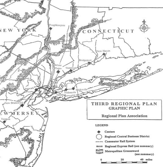
4 First Regional Plan Second Regional Plan Third Regional Plan
5
6 Job growth has been much weaker in smaller cities and the suburbs than in New York City.
7 Median incomes have dropped since 1990 for more than threequarters of the region s households


8 2.2 million people in the region will be at high risk of flooding by 2050 and 2.2 million people in the region today will be at high risk of flooding by 2050 Lower Manhattan Secaucus, New Jersey Milford, Connecticut

9 The number of governmental jurisdictions creates inefficiencies and make it difficult to reach decisions 1 Region 3 States 31 Counties 783 Municipalities 703 School districts 175 Housing authorities 459 Fire districts 157 Business improvement districts 36 Sewer districts (data not available for NYS)
10 Shaping a vision for the region s future To expand prosperity and opportunity To improve affordability To foster a healthy and livable region To become a more resilient region

11 How much growth should we plan for? 2015 Jobs: 11.6 M 2015 Population: 22.9 M

12 Where to Grow? Place Typologies
13 Vision scenario Best growth path for meeting plan goals
14 Objectives Create walkable, affordable neighborhoods in the urban core Revitalize struggling cities and neighborhoods Reinvent the suburbs Transform public transportation Modernize streets & roadways Connect the region to other cities Reduce the region's vulnerability to climate change Reduce our carbon footprint Protect and enhance the region's natural environment


15 Increase housing affordability in the urban core Encourage effective density Lift Manhattan FAR caps Encourage smaller units Legalize accessory units Multi-family in more areas Encourage higher occupancy FAR ~30.0 FAR Photo: Jorbasa Fotografie Photo: City Realty


16 Increase housing affordability in the urban core Increase Affordability everywhere Expand inclusionary zoning Targeted tax exemptions
17 Objectives Increase housing affordability in the urban core Revitalize struggling cities and neighborhoods Reinvent the suburbs Transform public transportation Modernize streets & roadways Connect the region to other cities Reduce the region's vulnerability to climate change Reduce our carbon footprint Protect and enhance the region's natural environment

18 Revitalize struggling cities and neighborhoods Reform property taxes Regional school taxes Shared services Split rate taxation
19 Objectives Increase housing affordability in the urban core Revitalize struggling cities and neighborhoods Reinvent the suburbs Transform public transportation Modernize streets & roadways Connect the region to other cities Reduce the region's vulnerability to climate change Reduce our carbon footprint Protect and enhance the region's natural environment

20 Reinvent the suburbs Provide incentives for mixed-income, walkable communities Require affordable housing plans Statewide inclusionary zoning Technical assistance to municipalities Reimburse school costs Expedited permitting Preference in discretionary funding
21 Objectives Increase housing affordability in the urban core Revitalize struggling cities and neighborhoods Reinvent the suburbs Transform public transportation Modernize streets & roadways Connect the region to other cities Reduce the region's vulnerability to climate change Reduce our carbon footprint Protect and enhance the region's natural environment


22 Transform public transportation Build a comprehensive, multi-modal and customer-oriented public transportation system Restructure transit authorities to value long-term financial impact of investments


23 Transform public transportation RPA s CBTC Rollout Plan Modernize and extend subway service CBTC system-wide New fare technology Line extensions Upgraded stations Customer service
24 Objectives Increase housing affordability in the urban core Revitalize struggling cities and neighborhoods Reinvent the suburbs Transform public transportation Modernize streets & roadways Connect the region to other cities Reduce the region's vulnerability to climate change Reduce our carbon footprint Protect and enhance the region's natural environment

25 Modernize streets & roadways Manage traffic through pricing Mileage-based user fees HOT lanes Cordon tolling Interstate tolls
26 Objectives Increase housing affordability in the urban core Revitalize struggling cities and neighborhoods Reinvent the suburbs Transform public transportation Modernize streets & roadways Connect the region to other cities Reduce the region's vulnerability to climate change Reduce our carbon footprint Protect and enhance the region's natural environment

27 Connect the region to other cities World Class Airports Air traffic technology Modern terminals Ground access Outlying airports New runways
28 Objectives Increase housing affordability in the urban core Revitalize struggling cities and neighborhoods Reinvent the suburbs Transform public transportation Modernize streets & roadways Connect the region to other cities Reduce the region's vulnerability to climate change Reduce our carbon footprint Protect and enhance the region's natural environment

29 Reduce the region s vulnerability to climate change Regional Resilience Commission Coordinated and consistent land use decisions Flood hazard reduction program Resilience trust fund FEMA 100-year flood zone: 1,313 square miles
30 Objectives Increase housing affordability in the urban core Revitalize struggling cities and neighborhoods Reinvent the suburbs Transform public transportation Modernize streets & roadways Connect the region to other cities Reduce the region's vulnerability to climate change Reduce our carbon footprint Protect and enhance the region's natural environment

31 Reduce our carbon footprint Transform urban energy generation Allow more power transmission from outside the region Decommission outmoded power plants Remediate former power plant sites
32 Objectives Increase housing affordability in the urban core Revitalize struggling cities and neighborhoods Reinvent the suburbs Transform public transportation Modernize streets & roadways Connect the region to other cities Reduce the region's vulnerability to climate change Reduce our carbon footprint Protect and enhance the region's natural environment

33 Protect and enhance the region s natural environment Complete a regional trail network Connecting communities and open spaces Protecting rights of way Creative trail-making

34


35 Learn more about regional_plan Support our vision at Or contact Rossana Ivanova at
Planning Roles. Responsibilities
 Lesson 3 Planning Roles & Responsibilities 3-1 Learning Outcomes Identify and describe transportation and land use planning processes Describe the relationships among these processes and how they can be
NEW YORK AND CONNECTICUT SUSTAINABLE COMMUNITIES. Fair Housing & Equity Assessment & Regional Planning Enhancement
 NEW YORK AND CONNECTICUT SUSTAINABLE COMMUNITIES Fair Housing & Equity Assessment & Regional Planning Enhancement November 12, 2013 Yonkers Public Library Federal grant to improve regional planning to
TOD 101 CREATING LIVABLE COMMUNITIES WITH TRANSIT
 1 CREATING LIVABLE COMMUNITIES WITH TRANSIT What are transit Centered Communities? Benefits of Partnerships to Support and Implement What You Will Learn Portland s Pearl District Your Trainers Today Catherine
City Council and Planning & Zoning Commission Workshop March 20, 2018
 City Council and Planning & Zoning Commission Workshop March 20, 2018 Completed July 27, 2017 Kick-Off Sept 13 Built Environment Nov 8 Natural Environment Jan 10, 2018 Economic Environment Feb 7 Social
2040 LUP is a part of the Comprehensive Plan and carries the same legal authority. Economic Challenges
 1.1. Guiding Anchorage s Growth Where will new residents settle over the next two decades? Where will people work, shop, and play? Will there be enough room to grow? How will Anchorage look? Will growth
Robbinsdale LRT Station. CDI Development Guidelines. August Overview
 Robbinsdale LRT Station August 2018 Overview The City of Robbinsdale may have the coolest opportunity site along the 13 mile stretch of the Bottineau LRT corridor / Blue Line extension. Located a block
BRONX TOWN HALL NEW YORK & CONNECTICUT SUSTAINABLE COMMUNITIES. A Unique Bi-State Partnership to Improve Jobs, Housing and Transportation
 BRONX TOWN HALL NEW YORK & CONNECTICUT SUSTAINABLE COMMUNITIES A Unique Bi-State Partnership to Improve Jobs, Housing and Transportation Fordham University Bronx, NY January 23, 2012 PARTNERSHIP FOR SUSTAINABLE
Introducing the Main Street Strategic Toolbox
 Ulster County Main Streets: A Regional Approach Ulster County Planning Department, 244 Fair Street, Kingston NY 12401 Why do we take a regional approach to Main Streets? There are many different approaches
TREASURE COAST REGIONAL PLANNING COUNCIL M E M O R A N D U M. To: Council Members AGENDA ITEM 5H
 TREASURE COAST REGIONAL PLANNING COUNCIL M E M O R A N D U M To: Council Members AGENDA ITEM 5H From: Date: Subject: Staff October 17, 2008 Council Meeting Local Government Comprehensive Plan Review Draft
NASSAU COUNTY TOWN HALL NEW YORK & CONNECTICUT SUSTAINABLE COMMUNITIES. A Unique Bi-State Partnership to Improve Jobs, Housing and Transportation
 NASSAU COUNTY TOWN HALL NEW YORK & CONNECTICUT SUSTAINABLE COMMUNITIES A Unique Bi-State Partnership to Improve Jobs, Housing and Transportation Police Headquarters Auditorium Mineola, NY December 9 th,
Somers Point Master Plan
 Somers Point Master Plan Progress Report and Public Meeting August 20, 2014 Master Plan Reexamination Municipal Land Use Law require that all municipalities reexamine their master plan every ten years.
City of Lake Mary, Florida. Evolution of a Historic Downtown with Transit Oriented Development Strategies
 City of Lake Mary, Florida Evolution of a Historic Downtown with Transit Oriented Development Strategies What is Transit Oriented Development? Walkable villages located at and around transit stations in
Transportation Land Use Integration & Regional Planning. Don Kostelec, AICP Senior Planner, Louis Berger Group February 1, 2010
 Transportation Land Use Integration & Regional Planning Don Kostelec, AICP Senior Planner, Louis Berger Group February 1, 2010 Transportation Land Use Integration DOT-HUD-EPA Sustainable Communities Initiative
The Community and Transportation Linkage Planning Program
 The Community and Transportation Linkage Planning Program Sandy Misiewicz, AICP Capital District Transportation Committee Senior Transportation Planner II CSS National Dialog 2 October 1, 2013 Capital
CHAPTER 7: Transportation, Mobility and Circulation
 AGLE AREA COMMUNITY Plan CHAPTER 7 CHAPTER 7: Transportation, Mobility and Circulation Transportation, Mobility and Circulation The purpose of the Transportation, Mobility and Circulation Chapter is to
Implementation Guide Comprehensive Plan City of Allen
 Implementation Guide 2030 Comprehensive Plan City of Allen DRAFT 2015 Implementation Guide Allen 2030 Comprehensive Plan INTRODUCTION The Comprehensive Plan serves as a guide for the growth and development
Lesson 6. Corridor Planning
 Lesson 6 Corridor Planning 1 Learning Outcomes Identify land use strategies and solutions that can be incorporated into multimodal transportation corridor plans Identify land use stakeholders and describe
Public Open House. Overview of the Downtown Plan Official Plan Amendment April 23, 2018
 Public Open House Overview of the Downtown Plan Official Plan Amendment April 23, 2018 1 A 25-Year Plan for Downtown To ensure growth contributes positively to Toronto s Downtown as a great place to live,
Integrated Urban Development. April Reflections from the NZPI Study Tour of Portland, Seattle and Vancouver
 Integrated Urban Development April 2009 Reflections from the NZPI Study Tour of Portland, Seattle and Vancouver Integrated Urban Development Urban Growth Management Transportation Transit Orientated Mixed
Silverdale Regional Center
 Silverdale Regional Center Vision for Silverdale Regional Center The Silverdale Regional Center Plan (Plan) will guide the evolution of the Silverdale Regional Center from a collection of strip malls and
North District What we heard
 What we heard Vision to 2056 and Priorities Governance and implementation Infrastructure and funding The vision for a metropolis of three cities, and the 30 minute city. Feedback emphasised: That for the
Land Use 2025:Rhode Island State Land Use Policies and Plan
 Land Use 2025:Rhode Island State Land Use Policies and Plan State Guide Plan Element 152 The Power of Place Summit May 12, 2006 R.I. Statewide Planning Program 05-12-06 The Bay & Beaches R.I. Statewide
4-Town Comprehensive Plan DRAFT 7/30/07
 4-Town Comprehensive Plan DRAFT 7/30/07 Acknowledgements ning Committee Town of Harrisburg Norman Roof Randy Nicol Town of Martinsburg Terry Thisse Paul Kelly Town of Montague Jan Bagdanowicz Wendy Perry
ROBBINSDALE LRT STATION CDI DEVELOPMENT GUIDELINES
 August 2018 OVERVIEW The City of Robbinsdale has a prime-opportunity site in the middle of the 13 mile stretch of the Bottineau LRT corridor / Blue Line extension. Robbinsdale offers a prominent, vital,
Cumberland Region Tomorrow is a private, non-profit, citizen based regional organization working with Greater Nashville Regional Council
 Cumberland Region Tomorrow is a private, non-profit, citizen based regional organization working with Greater Nashville Regional Council and others in the public and private sectors, dedicated to planning
IMPLEMENTING SOMERSET COUNTY S INVESTMENT FRAMEWORK
 IMPLEMENTING SOMERSET COUNTY S INVESTMENT FRAMEWORK SMART CONSERVATION THROUGH SMART GROWTH NJ LAND CONSERVATION RALLY March 22, 2014 Laurette Kratina, PP, AICP, Supervising Planner Somerset County Planning
Municipal Plan*Assessment
 Municipal Plan*Assessment This tool was developed to assist in reviewing municipal master plans and in determining if these plans are consistent with smart growth principles, neighboring municipal plans,
Status Report: MD 355 Project
 Status Report: MD 355 Project OCTOBER 2006 M-NCPPC MONTGOMERY COUNTY PLANNING DEPARTMENT Summary of Community Comments, and break to the Results of the MD 355 Participation Session Brookside Gardens -
2018 Northampton Township Comprehensive Plan
 2018 BUCKS COUNTY, PENNSYLVANIA What is a? A comprehensive plan is a municipality s main policy document that details the collective vision for the future, the historic, environmental, and cultural facilities
CHAPTER 7: VISION AND ACTION STATEMENTS. Noble 2025 Vision Statement
 CHAPTER 7: VISION AND ACTION STATEMENTS This chapter presents the vision, policy and action statements that transform the comprehensive planning study, an analysis of Noble s past, future trends and community
Western City District What we heard
 What we heard Vision to 2056 and Priorities Governance and implementation Infrastructure and funding The protection of the natural landscape including biodiversity and the Metropolitan Rural Area for food
CHAPTER 3 VISION, GOALS, & PLANNING PRINCIPLES. City of Greensburg Comprehensive Plan. Introduction. Vision Statement. Growth Management Goals.
 CHAPTER 3 VISION, GOALS, & PLANNING PRINCIPLES Introduction The Greensburg Comprehensive Plan is intended as a working community document. A combination of long and short-term goals, this document is intended
TRANSIT ORIENTED DEVELOPMENT PINELLAS COUNTY MPO LIVABLE COMMUNITIES INITIATIVE PINELLAS COUNTY COMPREHENSIVE PLAN AMENDMENTS
 PINELLAS COUNTY MPO LIVABLE COMMUNITIES INITIATIVE MODEL LAND DEVELOPMENT CODE TRANSIT ORIENTED DEVELOPMENT PINELLAS COUNTY COMPREHENSIVE PLAN AMENDMENTS MPO Livable Communities Initiative Goal: Improve
Central City District What we heard
 What we heard Vision to 2056 and Priorities Governance and implementation Infrastructure and funding The vision for a metropolis of three cities, and the 30 minute city. Feedback requested: Clearer communication
CHAPTER 1. Ms. Guajardo s Class - Central Elementary CH 1 1
 INTRODUCTION CHAPTER 1 Ms. Guajardo s Class - Central Elementary CH 1 1 1.1 SETTING South Centre City is a linear corridor south of Downtown Escondido paralleling Centre City Parkway and South Escondido
A BLUEPRINT FOR BROCKTON A CITY-WIDE COMPREHENSIVE PLAN
 A BLUEPRINT FOR BROCKTON A CITY-WIDE COMPREHENSIVE PLAN Public Meeting October 2016 1 Plan Summary and Discussion Public Meeting May 4 2017 City of Brockton Bill Carpenter, Mayor Department of Planning
Reshaping The City: New Visions for Urban Transport. Trent Lethco, Associate Principal Allison Davis, Senior Planner Vicent Risica, Planner Arup
 Reshaping The City: New Visions for Urban Transport Trent Lethco, Associate Principal Allison Davis, Senior Planner Vicent Risica, Planner Arup Agenda Where are we now? Rethinking infrastructure? Cities
A community driven catalyst for an equitable, healthy, (economically viable and environmentally) sustainable corridor
 sustainable corridor") Economy Environment Equity Building Sustainability Supporting neighborhoods Preserving municipal resources A community driven catalyst for an equitable, healthy, (economically viable and environmentally)
Economy Environment Equity Building Sustainability Supporting neighborhoods Preserving municipal resources A community driven catalyst for an equitable, healthy, (economically viable and environmentally)
CHAPTER 12 IMPLEMENTATION
 CHAPTER 12 IMPLEMENTATION The 2010 Town of Denton Comprehensive Plan is intended to capture a vision of the future of Denton. As such, it provides a basis for a wide variety of public and private actions
The Floyds Fork Area Study A Framework for Growth
 The Floyds Fork Area Study A Framework for Growth 2 21 st Century Parks Master Plan: The Fork 3 Neighborhood Development Area Policy Recommendations 1. Create incentives to promote infill of existing development
Land Use & Transportation Primer
 Land Use & Transportation Primer Presented By Smitha Vijayan Center for Urban Transportation Studies University of Wisconsin-Milwaukee Role of Local Government Land use decision-making power mostly given
Burlington s Strategic Plan
 Burlington s Strategic Plan 2015 2040 DRAFT FOR CONSULTATION burlington.ca/strategicplan Welcome to Burlington s 2015 2040 Strategic Plan The City of Burlington s 2015-2040 Strategic Plan is the result
PLAN ON A PAGE SUMMARY
 Questions? Please Call - 423-989-5518. PLAN ON A PAGE SUMMARY The Plan on a Page is a tool for the City of Bristol to engage Bristol s neighborhoods, community organizations, and interest groups to organize
Secrest Short Cut and Monroe Expressway Small Area Plan AUGUST 29, 2018
 Secrest Short Cut and Monroe Expressway Small Area Plan AUGUST 29, 2018 Background and Process Monroe Expressway will be open by the end of 2018 Union County and Indian Trail identified a need to revisit
Asset-Based Development Scenario
 Asset-Based Development Scenario The Asset-Based development scenario emphasizes existing regional assets, concentrating future development around these assets. Regional assets include sports arenas, higher
EXISTING COMPREHENSIVE PLAN
 EXISTING COMPREHENSIVE PLAN Town Center Land Use Element: V. LAND USE POLICIES Town Center Mercer Island's business district vision as described in "Your Mercer Island Citizen-Designed Downtown" was an
FUNDING CORRIDOR REVITALIZATION
 FUNDING CORRIDOR REVITALIZATION Integrated corridor planning for the 21 st Century America Planning Association Annual Conference Atlanta, GA April 27, 2014 Mariia Zimmerman, MZ Strategies, LLC mariia@mzstrategies.com
Rail~Volution October 2008
 Rail~Volution October 2008 1 Where is Tysons Corner? 2 Tysons Corner, Virginia The original edge city Equivalent of 12 th largest US downtown Sprawl on steroids 46m sq ft development 120,000 jobs Additional
South Central Connecticut Region Plan of Conservation & Development 2018 Update. Municipal Planners
 South Central Connecticut Region Plan of Conservation & Development 2018 Update Municipal Planners July 28th, 2017 1 Introductions 2 Purpose of Today s Meeting Supplement data analysis with qualitative
New Partners for Smart Growth Conference February 5, 2010
 Dan Stroh, Planning Director City of Bellevue Planning and Community Development Bellevue, WA New Partners for Smart Growth Conference February 5, 2010 Summary of Project Long-range plan update for Bel-Red
3.9 Systems Interrelationships
 191 Sustainability Building Blocks: The Comprehensive Plan Systems Community Form Economy Social Transportation Natural Resources Housing and Neighborhoods Utilities and Infrastructure Institutions.9 Systems
Joint Meeting City Council and the Plan Commission. September 1st, 2015
 Joint Meeting City Council and the Plan Commission September 1st, 2015 1 The City Plan Commission shall recommend a City Plan for the physical development of the City Article IX Section 2 of the City of
7Page 1 CLEMMONS COMMUNITY COMPASS 1 PLAN OVERVIEW
 1 Plan Overview WHAT IS I THE CLEMMONS COMMUNITY COMPASS? The Clemmons Community Compass is our community s comprehensive plan. It serves as our blueprint and provides direction for the future of the Village
CHAPTER 4: RECOMMENDATIONS FOR TOMORROW S PLACES
 CHAPTER 4: RECOMMENDATIONS FOR TOMORROW S PLACES INTRODUCTION With a strong understanding of the County s foundations, Allegheny Places presents a desired future and describes the way to get there. This
Chapter 3: Land Use and Local Planning
 3.1 Chapter 3: Land Use and Local Planning 2040 3.2 Chapter 3: Land Use and Local Planning CONTENTS Introduction 3.3 Coordinating Thrive MSP 2040 and Transportation Policy Plan 3.6 Coordination of Regional
CITY OF LANGLEY OFFICIAL COMMUNITY PLAN BYLAW, 2005, NO APPENDIX II - REGIONAL CONTEXT MAP
 CITY OF LANGLEY OFFICIAL COMMUNITY PLAN BYLAW, 2005, NO. 2600 APPENDIX II - REGIONAL CONTEXT MAP ± Legend Agricultural Mixed Employment Industrial Conservation & Recreation Regional City Centre Urban Containment
Tysons Circulator Study: Process and Preliminary Results Summary. March 2012
 Tysons Circulator Study: Process and Preliminary Results Summary March 2012 Background: 1. The Comprehensive Plan for the Tysons Corner Urban Center calls for a System of Circulators in Tysons Corner to:
1 Introduction. Chapter. In this chapter:
 Chapter 1 Introduction In this chapter: 1.1 A Snapshot of the Region 1.2 Towards a Sustainable Region 1.3 The Provincial Context 1.4 Purpose and Organization The Regional Municipality of York Official
Chapter 1: Introduction
 Chapter 1: Introduction The Penn Avenue Community Works Corridor Vision and Implementation Framework presents an integrated communitybased vision and a coordinated, long-term implementation framework for
ALTERNATIVES WHAT ELSE IS POSSIBLE?
 ALTERNATIVES WHAT ELSE IS POSSIBLE? VISION STATEMENT Rather than make a ±$250 million investment that will lock in place and exacerbate the current dysfunctional system for at least 5 more decades Let
Phase 4 Project Fact Sheet
 Phase 4 Project Fact Sheet Project Title City of Niagara Falls, Highland Brownfield Opportunities Area (Phase 2) Project Project Acronym NF-BOA Involved City/Region CITY: City of Niagara Falls; REGION:
NACCED/NACo CONFERENCE JULY 10, 2015
 NACCED/NACo CONFERENCE JULY 10, 2015 Regional Growth Framework 2 Regional Growth Framework Regional Priorities Preferred Growth Concept Tools to Support Local Governments 3 Top Priorities for the CONNECT
Visioning Statement and Guiding Principles
 Visioning Statement and Guiding Principles Planning for the Future The General Plan The General Plan represents Woodland's shared vision of the future and defines a path to lead the community toward its
Transit-Oriented Development
 Transit-Oriented Development Path to Sustainability West Windsor February 22, 2007 George S. Hawkins Context for Presentation NJ Future is a non-partisan, 501(c)3 non-profit organization. Offer perspective,
ITEM #8. Regional Smart Growth Program. Regional Smart Growth Program. Presentation Overview. Coast Highway Vision and Stategic Plan.
 Regional Smart Growth Program Economic Development Commission What is Smart Growth? Adopted as part of the Regional Comprehensive Plan (RCP) RCP provides vision for region based on Smart Growth and sustainability
Remi Mendoza City Planning Academy March 13, 2017
 Remi Mendoza City Planning Academy March 13, 2017 1 What is the General Plan? The 2030 General Plan 5-Year Update (2035 General Plan) Questions and Answers 2 Guidebook for development and growth Required
EXHIBIT A. Tax Increment Reinvestment Zone No. 1 (Town Center) First Amended Project Plan 1
 First Amended Project Plan 1") EXHIBIT A Tax Increment Reinvestment Zone No. 1 (Town Center) First Amended Project Plan 1 1 As amended by Resolution No. 2008-02-001(TR1R) of the Tax Increment Reinvestment Zone No.1, and approved to
EXHIBIT A Tax Increment Reinvestment Zone No. 1 (Town Center) First Amended Project Plan 1 1 As amended by Resolution No. 2008-02-001(TR1R) of the Tax Increment Reinvestment Zone No.1, and approved to
495/MetroWest Development Compact Plan Citizen Planner Training Collaborative Conference. March 17, 2012
 495/MetroWest Development Compact Plan Citizen Planner Training Collaborative Conference March 17, 2012 Project Process Local and Regional Priority Areas Growth Scenarios Transportation Investment Categories
3.0 PROJECT DESCRIPTION
 3.0 PROJECT DESCRIPTION 3.1 BACKGROUND Under California law (Government Code Section 65300 et seq.), every city and county is required to have a general plan. The general plan is to be comprehensive and
Plano Tomorrow Vision and Policies
 Plano Tomorrow Vision and Policies PLANO TOMORROW PILLARS The Built Environment The Social Environment The Natural Environment The Economic Environment Land Use and Urban Design Transportation Housing
Blueprint Denver A BLUEPRINT FOR AN INCLUSIVE CITY. Executive Summary
 Blueprint Denver A BLUEPRINT FOR AN INCLUSIVE CITY Executive Summary PUBLIC REVIEW DRAFT 2 1/7/2019 DENVERIGHT BLUEPRINTDENVER Blueprint Denver: A Blueprint for an Inclusive City An Equitable City Planning
Potential Annexation Areas And Annexation
 Exhibit A to Ordinance No. - Proposed Amendments to the Pierce County Countywide Planning Policies Addressing Potential Annexation Areas And Annexation 1 0 1 0 1 COUNTYWIDE PLANNING POLICY ON URBAN GROWTH
Prepared for the Citizens of Forsyth County by the City-County Planning Board
 Prepared for the Citizens of Forsyth County by the City-County Planning Board Bryce A. Stuart Municipal Building 100 East First Street, Winston-Salem, NC 27101 336.727.8000 www.cityofws.org/planning www.legacy2030.com
Economic Development & Housing Council Committee Comprehensive Plan Update September 20, 2005
 1 Economic Development & Housing Council Committee Comprehensive Plan Update September 20, 2005 Purpose To update the Committee on the ForwardDallas! Plan, including: Status Anticipated Products Public
Good Neighbor Plan Dallas Love Field Airport Transportation and Environment Committee
 June 25, 2012 Good Neighbor Plan Dallas Love Field Airport Transportation and Environment Committee Overview Vision for Dallas Love Field Downtown Dallas 360 Plan Targeted Improvement Zones Lemmon Avenue
Official Plan Review
 Official Plan Review Summary Report - The Built Environment August 2014 Part 1: Introduction Planning for a healthy, prosperous and sustainable community is an important goal for our municipality. From
Downtown Dubuque...it s a great time.
 Downtown Dubuque...it s a great time. Your timing could not be better to invest in Downtown. With hundreds of millions in public and private investment occurring on the City s downtown waterfront, millions
Ten Mile Creek Planning Area
 PLANNING AREA POLICIES TEN MILE CREEK Ten Mile Creek Planning Area Location and Context The Ten Mile Creek Planning Area ( Ten Mile Creek area ) is located south of the current Boise AOCI, generally south
NJ s Land Use and Transit Policies
 1 NJ s Land Use and Transit Policies NJ TRANSIT created in 1979 to reverse decline of public transportation State Development & Redevelopment Plan adopted (1986) encourages growth in areas where population,
Sustaining Places & The Scales of Planning
 Sustaining Places & The Scales of Planning Source: UN World Urban Forum, Medellin, 2014 2065? 10.4 billion global population @ 67% urban = 7.0 billion global urban population or 3.7 billion more people
LEED-ND 101: Practical Strategies for Achieving Sustainability Goals. Travis Parker Lakewood Planning Director
 LEED-ND 101: Practical Strategies for Achieving Sustainability Goals Travis Parker Lakewood Planning Director Metro Vision Idea Exchange Oct 11, 2012 West Corridor Stations West Corridor Overview West
Cambie Corridor Planning Program Phase One. Standing Committee on Transportation and Traffic January 19, 2010
 Cambie Corridor Planning Program Phase One Standing Committee on Transportation and Traffic January 19, 2010 Work Program Terms of Reference approved July 2009 Land Use Transportation Energy Cambie Corridor
City of St. Thomas New Official Plan
 City of St. Thomas New Official Plan Sustainable & Healthy Community Workshop Ann Joyner and Paddy Kennedy Dillon Consulting Limited Work Shop Outline Introduction Presentation Exercise 1 (individual)
HELPING SMALL TOWNS AND RURAL AREAS THRIVE
 EPA Office of Sustainable Communities HELPING SMALL TOWNS AND RURAL AREAS THRIVE Village of Vinton, Texas May 30, 2013 Katharine Ange, AICP Renaissance Planning Group Overview of Workshop Discussion of
Conceptual Level Demonstration Project LARRY MCAULIFFE MANAGER, RESEARCH AND EDUCATION NEW YORK METROPOLITAN TRANSPORTATION COUNCIL
 Conceptual Level Demonstration Project LARRY MCAULIFFE MANAGER, RESEARCH AND EDUCATION NEW YORK METROPOLITAN TRANSPORTATION COUNCIL Shared Cost Initiative Transit Supportive Development Transit Supportive
The transportation system in a community is an
 7 TRANSPORTATION The transportation system in a community is an important factor contributing to the quality of life of the residents. Without a sound transportation system to bring both goods and patrons
Silver Line CPAM UPDATE. Transportation and Land Use Committee October 14, 2016
 Silver Line CPAM UPDATE Transportation and Land Use Committee October 14, 2016 Purpose Recap Project History and Map Changes Provide Overview of CPAM Components Discuss Transportation Impacts Discuss Fiscal
Richard H. Bradley Board of Directors Meeting April 25, A 21st Century Sustainability Framework
 Richard H. Bradley Board of Directors Meeting April 25, 2011 A 21st Century Sustainability Framework October 18, 2011 What is the DowntownDC BID? BID History Established in 1998 as Washington DC came out
3. ELEMENTS OF THE METRO VISION 2035 PLAN
 3. ELEMENTS OF THE METRO VISION 2035 PLAN What is Metro Vision and why does it matter? For more than 50 years, DRCOG has championed a regional perspective on key issues facing the metropolitan area and
A. WHAT IS A GENERAL PLAN?
 I. Introduction A. WHAT IS A GENERAL PLAN? A general plan is the planning guideline for the future of a city. It contains goals and policies which regulate urban development, the protection of the natural
DRAFT City of Titusville 2040 Comprehensive Plan Future Land Use, Housing, and Transportation Elements April 16, 2018
 DRAFT City of Titusville 2040 Comprehensive Plan Future Land Use, Housing, and Transportation Elements April 16, 2018 Prepared by Canin Associates for the City of Titusville About the Comprehensive Plan:
Corridor Vision. 1Pursue Minnehaha-Hiawatha Community Works Project. Mission of Hennepin County Community Works Program
 1Pursue Minnehaha-Hiawatha Community Works Project Minnehaha-Hiawatha Community Works is a project within the Hennepin Community Works (HCW) program. The mission of the HCW program is to enhance how the
Concord Community Reuse Project Goals and Guiding Principles. Overarching Goals (OG)
") Concord Community Reuse Project Goals and Guiding Principles Overarching Goals (OG) No priority is implied by the order of presentation of the goals and guiding principles. Overarching goals for the Concord
Concord Community Reuse Project Goals and Guiding Principles Overarching Goals (OG) No priority is implied by the order of presentation of the goals and guiding principles. Overarching goals for the Concord
CITYWIDE PLANNING DIVISION
 2014-2019 CITYWIDE PLANNING DIVISION a five-year work program for long-range planning November 2016 TODAY S PRESENTATION 1. Overview 2. Planning Priorities 3. Topics/Focus Areas 5. Essential Practices
D-O LRT Zoning Discussion. Chapel Hill Boards & Commissions October 16, 2017
 D-O LRT Zoning Discussion Chapel Hill Boards & Commissions October 16, 2017 Update on Overall D-O LRT Station Area Initiative Objectives Design and educate on principles of Good Transit-Oriented Development
The Five Components of the McLoughlin Area Plan
 The Five Components of the McLoughlin Area Plan This documents contains the complete language of the five components of the McLoughlin Area Plan: The Vision Statement The Values The Guiding Principles
Welcome. Comprehensive Plan & Transportation Plan Open House November 7, 2012
 Welcome Comprehensive Plan & Transportation Plan Open House November 7, 2012 Agenda Proposed future land use plan Comprehensive Plan strategies Traffic forecasts Future traffic operations Possible future
From Growth Controls, to Comprehensive Planning, to Smart Growth: Planning s Emerging Fourth Wave
 From Growth Controls, to Comprehensive Planning, to Smart Growth: Planning s Emerging Fourth Wave Dr. Tim Chapin Department of Urban & Regional Planning Florida State University Presentation at the APA
Executive Summary. NY 7 / NY 2 Corridor
 Executive Summary NY 7 / NY 2 Corridor Transportation and Land Use Study December 2005 Prepared for: Town of Colonie Capital District Transportation Committee Prepared by: Introduction: Land use decisions
Peoria Avenue BRT Land Use Framework
 Planning Urban Design Landscape Architecture Historic Preservation Community Engagement Peoria Avenue BRT Land Use Framework Public Workshop Presentation Central Center Partners: Duncan Associates CLUE