Planning Commission Workshop. November 29, 2018
|
|
|
- Erik Evans
- 5 years ago
- Views:
Transcription

1 Planning Commission Workshop November 29, 2018
2 Composition of Committee Steven Neeves, Chair Marvin Heyd, Vice-Chair Joe Burch Pam Creech Ruth Anne Ellis Rick Elliott Christy Everett Chris Hennigan Kimberly Hardee Bo Ives Sammy Johnson Al Jordan Josh Kay Eric Sanford Established in December 2017
3 The Role of the Comprehensive Plan Required by SC Code of Laws, Article 3, Chapter 29, Title 6 as a prerequisite to have zoning, land development and subdivision regulations. Serves as a guiding document for County decision-making in regards to land use, facilities, services, and capital improvements. Required update every 5 years and rewrite every 10 years. Minimally has to look 10 years into the future. County looking out to 2040 to be consistent with other major planning efforts.

4 SC Comprehensive Plan Requirements
5 Timeline January February Countywide Survey 850+ respondents 4 Community Open Houses May Community Land Use Workshop June Community Open House Future Land Use Map January August 10 Committee Meetings, Drafting of Plan August October Plan Editing October 4 and 25 Introduction to Planning Commission October 25 November Day Public Comment Period December 6 th - Public Hearing and Planning Commission Consideration for approval. After which, review by Infrastructure and Regulation Committee and County Council Written Comments

6 Public Input Guiding Plan Press Releases December 21, 2017 January 17, 2018 June 7, 2018 October 19, 2018 November 27, Quarterly Enewsletters Postcards 400 to religious institutions Flyers Libraries, Recreation, and Senior Centers Mailers 200+ initially and another 200+ for Public Comment and Hearing Notice Facebook Posts 70+ posts Listserv 167 opted in, plus 200 more added 30 day Public Hearing and Comment Period Notice
7 Vision and Goals Horry County will sustain and enhance the quality of life for our residents and visitors by fostering healthy and safe communities, preserving our natural assets and rural heritage, encouraging business growth and economic diversification, and providing services and public facilities that will protect and strengthen our future. Community Character Rural Preservation Revitalization, Redevelopment, and Infill Healthy Livable Communities Safe Communities Community Facilities and Services Mobility and Transportation Environmental Sustainability Economic Growth Community Engagement

8 Land Use Map & Definitions


9 Developing the Future Land Use Map
10 Future Land Use Map and Definitions Represents the Vision of the Future. Required to be revisited at least every 5 years. May be amended through Planning Commission and County Council. Is not a zoning map or change existing zoning. Does not take away existing development rights granted through zoning or vested rights. Does not constitute a takings.


11 Scenic & Conservation Area Definition Environmentally sensitive and scenic areas, such as Carolina Bays, estuarine and forested wetlands, undeveloped beachfront, forestlands, floodplains, agricultural lands, and natural recreational and open spaces. Limited development. If developed, design should use low impact designs principles to support environmental preservation and avoid natural hazards. Subdivision into less than 5 acres is discouraged. Should be considered for Open Space in Urban and Suburban areas.


12 Scenic & Conservation Area Definition Primary Land Uses: Open space, nature-based recreation, timberland, agriculture and agricultural/forestry support uses. Secondary Land Uses: Permanent and temporary educational and research facilities, eco-tourism and agritourism operations. Conditional Uses: Mining, outdoor shooting ranges, campgrounds.

13 Scenic & Conservation Area Definition Written Comments
14 Scenic & Conservation Area Policy Guidance To Be Considered 6. In cases where more site specific information, such as wetland delineations and soil data, is available to show that a property or a portion of a property is not environmentally constrained, that information may be presented to the Planning Commission to be considered for uses other than those defined within the recommended land use list or described development pattern. The proposed development would need to be consistent with character of the community and not adversely impact the surrounding landscape. Development would need to address natural hazards, stormwater, public safety, access management, and wildlife through design, mitigation measures, capital improvements, or other necessary tools. Written Comments
15 Scenic & Conservation Area Policy Guidance Minor Change 7. If development is deemed appropriate, it should incorporate best management practices for protecting environmentally sensitive areas and water quality, in addition to avoiding natural hazards and addressing public safety issues. Written Comments
16 Environmental Constraint Analysis Written Comments
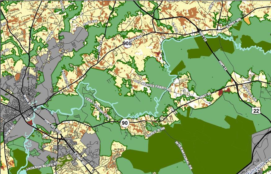
17 IMAGINE 2040 Scenic & Conservation Future Land Use Written Comments
18 Preserved Open Space (Dark Green) Written Comments


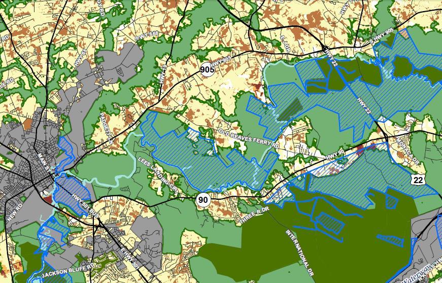
19 ENVISION 2025 Scenic & Conservation Future Land Use (blue) Written Comments
20 Changes to Plan Land Use Chapter - further explanation of how the Future Land Use Map and definitions were developed. Transportation Chapter - additions to Project Needs list Priority Investment Chapter - updates to include most recent CIP requests for FY Goals and Strategies - clarification of strategies and a few additional strategies. Fact verification Grammatical edits and minor rearrangement of content
21 Transportation Project Additions Hwy 22 Raise Hwy 22 from Hwy 905 to Hwy 905 Hwy 501 Raise Hwy 501 near Lake Busbee and the Waccamaw River Hwy 501 Capacity improvements between Hwy 31 and 544 Hwy 378 Widening Hwy 701 N Widening from Hwy 22 to Loris Hwy 9 Completion of widening project to Countyline Hwy 905 Widening Hwy 319 Extension South to International Drive and Hwy 90. Initiate feasibility study. Gardner Lacy Extension Extension of Gardner Lacy to International Dr Middle Ridge Extension Southern extension from Legends Drive Waccamaw Drive Upgrade Waccamaw Drive from Melody Ln to Atlantic Avenue to Complete Streets Model Chestnut and Kings Road Intersection Realignment Hwy 31/International/Robert Grissom Signalization and turn lane improvements 17 Bypass/International/Robert Grissom Ramp and merge improvements Hwy 544 and Myrtle Ridge Turn lane improvements Tournament Blvd Widening with bicycle and pedestrian improvements McDowell Shortcut Widening with bicycle and pedestrian improvements Cultra Road Widening Hwy 31/Hwy 111 Interchange at new Carolina Bays Parkway extension and Hwy 111 Hwy 111 Safety and capacity improvements Rural Road Improvements Shoulder widening, safety improvements, and resurfacing 163
22 Priority Investment Chapter Updated based off of most recent capital improvement requests, as the FY 20 CIP process has already commenced.
23 Goals and Strategies Rural Preservation Healthy, Livable Communities Safe Communities Revise roadside stand language within the Zoning Ordinance to support local agricultural activities and maintain the character of Horry County. [mid-term] Revise the Traditional Neighborhood Development (TND) District to make if feasible to utilize for Amend the Zoning Ordinance to encourage traditional neighborhood design components for both major developments and infill development, especially within Suburban, Mixed Use and Community Activity Centers as designated on the Future Land Use Map. [mid-term] Encourage multi-family infill and redevelopment in urban areas by providing a mechanism to reduce or eliminate parking requirements, especially when public parking, transit options, and bicycle and pedestrian networks are available. [mid-term] Incorporate art and exhibit display space into new County buildings that are open to the public. [continuously] Ensure that festival and event organizers are aware of County and municipal accommodation tax opportunities. [continuously] Add a 5 th Fire Rescue Battalion to accommodate future growth. [mid-to-long term] Ensure that new development has an interconnected road network, both internal and external, to allow for faster public safety response. [continuously] Develop and implement a Flood Resiliency Plan. [short-to-long term] Update the Stormwater Ordinance and Design Manual. [mid-to-long term]
24 Goals and Strategies Mobility and Transportation Environmental Sustainability Economic Growth Require complete streets within unincorporated donut holes within municipalities when development and redevelopment is pursued. [continuously] Update major subdivision regulations to ensure that drainage on the periphery of a subdivision is platted as common area and prohibited from being located within residential parcels. [short-term] Preserve areas of the County, as identified on the Future Land Use Map, for development of new and expansion of existing industrial, manufacturing, and distribution centers and uses. [continuously] Explore the creation of local cultural food or history offerings to expand tourism offerings, similar to the Barbeque Trail, Pecan Trails and Tobacco Trails. [mid-term]

25 Announcements Public Hearing December 6th Public Comments through November 29 1
26 For More Information: IMAGINE 2040 Webpage Leigh Kane, AICP - Principal Planner Comments: IMAGINE2040@horrycounty.org
Planning Commission Special Workshop. October 25, 2018
 Planning Commission Special Workshop October 25, 2018 Composition of Committee Steven Neeves, Chair Marvin Heyd, Vice-Chair Joe Burch Pam Creech Ruth Anne Ellis Rick Elliott Christy Everett Chris Hennigan
process of the Land Development Code to assure regional parks are available County-wide.
 GOAL 9.0. It is the goal of the Broward County Board of County Commissioners to provide safe and adequate recreation sites and facilities, including cultural art facilities, and open space to satisfy the
DOMINION BOULEVARD CORRIDOR STUDY AND ECONOMIC DEVELOPMENT STRATEGIC PLAN A MODEL FOR CHESAPEAKE S FUTURE
 DOMINION BOULEVARD CORRIDOR STUDY AND ECONOMIC DEVELOPMENT STRATEGIC PLAN A MODEL FOR CHESAPEAKE S FUTURE Overview I. Draft Plan Process II. Draft Plan Overview a. Market Analysis b. Master Land Use Plan
implementation10 Village of Greendale Comprehensive Plan: Greendale, Wisconsin. Revisiting a Greenbelt Community
 implementation10 Village of Greendale Comprehensive Plan: 2010 - Village of Greendale Comprehensive Plan: 2010 - Implementation The recommendations of this Plan must be implemented by the Village of Greendale,
Whitemarsh Comprehensive Plan Update: Housing & Land Use. Public Workshop #3: September 20, 2018
 Whitemarsh Comprehensive Plan Update: Housing & Land Use Public Workshop #3: September 20, 2018 Agenda Welcome Process Recap What We ve Heard The Plan Framework Review of Recommended Actions Land Use Housing
Implementation Guide Comprehensive Plan City of Allen
 Implementation Guide 2030 Comprehensive Plan City of Allen DRAFT 2015 Implementation Guide Allen 2030 Comprehensive Plan INTRODUCTION The Comprehensive Plan serves as a guide for the growth and development
CHAPTER 7: VISION AND ACTION STATEMENTS. Noble 2025 Vision Statement
 CHAPTER 7: VISION AND ACTION STATEMENTS This chapter presents the vision, policy and action statements that transform the comprehensive planning study, an analysis of Noble s past, future trends and community
OVERARCHING GOALS OF PLAN
 11.27.2018 Draft VISION STATEMENT Horry County will sustain and enhance the quality of life for our residents and visitors by fostering healthy and safe communities, preserving our natural assets and rural
IMPLEMENTATION STRATEGIES. In This Chapter. Goals & Strategies 182 Project List 183 Future Land Use 186 CHAPTER 11 IMPLEMENTATION STRATEGIES
 In This Chapter Goals & Strategies 182 Project List 183 Future Land Use 186 11 IMPLEMENTATION STRATEGIES NORTH AUGUSTA, SC 2017 COMPREHENSIVE PLAN 179 Individual commitment to a group effort that is what
A BLUEPRINT FOR BROCKTON A CITY-WIDE COMPREHENSIVE PLAN
 A BLUEPRINT FOR BROCKTON A CITY-WIDE COMPREHENSIVE PLAN Public Meeting October 2016 1 Plan Summary and Discussion Public Meeting May 4 2017 City of Brockton Bill Carpenter, Mayor Department of Planning
Proposed Comprehensive Plan Strategies DRAFT for discussion June 28, 2017
 Proposed Comprehensive Plan Strategies DRAFT for discussion June 28, 2017 Land Use Rural Areas Refine the Farm and Forest area (FF) Update FF boundaries to account for existing lots less than five acres
The transportation system in a community is an
 7 TRANSPORTATION The transportation system in a community is an important factor contributing to the quality of life of the residents. Without a sound transportation system to bring both goods and patrons
Laberge Group. Town of Coeymans. Draft Comprehensive Plan. Overview of Planning Process
 Draft : Presentation of Goals & Strategies Laberge Group Benjamin H. Syden, A.I.C.P., E.D.P Director in Charge Nicole Allen, A.I.C.P. Senior Planner Anjali Malhotra Planner Presentation Outline Introductions
North Fair Oaks Community Plan Summary and Information
 North Fair Oaks Community Plan Summary and Information WHAT IS THE NORTH FAIR OAKS COMMUNITY PLAN? The North Fair Oaks Community Plan is part of the San Mateo County General Plan, and establishes policies
Stafford County Strategic Plans
 Stafford County Strategic s Strategic Department Description Date Adopted Board of Supervisors Priorities Fiscal Responsibility Education Public Safety Infrastructure Economic Development Service Excellence
SECTION II SECTION II STATEMENT OF GOALS, OBJECTIVES, PRINCIPLES, ASSUMPTIONS, POLICIES AND STANDARDS
 STATEMENT OF GOALS, OBJECTIVES, PRINCIPLES, ASSUMPTIONS, POLICIES AND STANDARDS 1 2 STATEMENT OF GOALS, OBJECTIVES, PRINCIPLES, ASSUMPTIONS, POLICIES AND STANDARDS INTRODUCTION The New Jersey Municipal
Introduction. Chapter 1. Purpose of the Comprehensive Plan Plan Organization Planning Process & Community Input 1-1
 Chapter 1 Introduction Lakewood 2025: Moving Forward Together Purpose of the Comprehensive Plan Plan Organization Planning Process & Community Input 1-1 Purpose of the Comprehensive Plan The Comprehensive
Descriptive Summary of the Comprehensive Plan Amendment
 Applicant City of Virginia Beach Public Hearing October 12, 2016 2016 Comprehensive Plan Amendment Establishing the Historic Seatack & Vicinity Suburban Focus Area (SFA) in Chapter 1, Section 1.3 Agenda
Official Plan Review
 Official Plan Review Summary Report - The Built Environment August 2014 Part 1: Introduction Planning for a healthy, prosperous and sustainable community is an important goal for our municipality. From
DRAFT MAP AMENDMENT FLU 04-4
 DRAFT MAP AMENDMENT FLU 04-4 SW 24 TH AVENUE ROADWAY CORRIDOR The University of Florida participates with the Metropolitan Transportation Planning Organization (MTPO) in its responsibilities for the continuing,
CHAPTER 1 Introduction
 CHAPTER 1 Introduction From sea to summit, Lane County covers almost 4,800 square miles of diverse Oregon landscape. Stretching from the Pacific Ocean through the Coastal Range, the Willamette Valley to
A. WHAT IS A GENERAL PLAN?
 I. Introduction A. WHAT IS A GENERAL PLAN? A general plan is the planning guideline for the future of a city. It contains goals and policies which regulate urban development, the protection of the natural
Welcome to the Oakridge Centre Open House
 Welcome to the Oakridge Centre Open House Why is the City hosting this event? This open house is to inform you of a rezoning application submitted to the City of Vancouver to amend the existing CD-1 (Comprehensive
4-Town Comprehensive Plan DRAFT 7/30/07
 4-Town Comprehensive Plan DRAFT 7/30/07 Acknowledgements ning Committee Town of Harrisburg Norman Roof Randy Nicol Town of Martinsburg Terry Thisse Paul Kelly Town of Montague Jan Bagdanowicz Wendy Perry
EXECUTIVE SUMMARY DRAFT CHAPTER 1 INTRODUCTION EXECUTIVE SUMMARY
 CHAPTER 1 EXECUTIVE SUMMARY INTRODUCTION Through the joint efforts of the City of Tulsa planning staff and the Land Services division of Indian Nations Council of Governments (INCOG), the Berryhill Land
WATERFORD Plan of Preservation, Conservation and Development Supplement Part 1 - Policy Element
 WATERFORD 2012 Plan of Preservation, Conservation and Development 2015 Supplement Part 1 - Policy Element Effective June 11, 2015 2015 Plan Update GOAL To respond to the evolving land use needs and continually
Secrest Short Cut and Monroe Expressway Small Area Plan AUGUST 29, 2018
 Secrest Short Cut and Monroe Expressway Small Area Plan AUGUST 29, 2018 Background and Process Monroe Expressway will be open by the end of 2018 Union County and Indian Trail identified a need to revisit
S A C R A M E N T O C O U N T Y JACKSON HIGHWAY & GRANT LINE EAST VISIONING STUDY
 JACKSON HIGHWAY & GRANT LINE EAST S A C R A M E N T O C O U N T Y P L A N N I N G D E P A R T M E N T SUMMARY AND WORKBOOK November 19, 2008 History of the Visioning Study Sacramento County has two growth
REVIEW AND EVALUATION OF REGIONAL LAND USE
 REVIEW AND EVALUATION OF REGIONAL LAND USE AND TRANSPORTATION SCENARIOS #220831 Environmental Justice Task Force October 7, 2014 VISION 2050 Process Development of Guiding Vision for Land Use and Transportation
38 Queen s University Campus Master Plan Part 1
 38 Queen s University Campus Master Plan Part 1 46 The Campus at the City Scale Chapter 4 The Campus at the City Scale 39 Queen s is an urban University centrally located in Kingston. Decisions made by
City of Westbrook. 2 York Street Westbrook, Maine (207) Fax:
 Fax:") City of Westbrook DEPARTMENT OF PLANNING & CODE ENFORCEMENT 2 York Street Westbrook, Maine 04092 (207) 854-0638 Fax: 1-866-559-0642 WESTBROOK PLANNING BOARD TUESDAY, JANUARY 2, 2018, 7:00 P.M. WESTBROOK
City of Westbrook DEPARTMENT OF PLANNING & CODE ENFORCEMENT 2 York Street Westbrook, Maine 04092 (207) 854-0638 Fax: 1-866-559-0642 WESTBROOK PLANNING BOARD TUESDAY, JANUARY 2, 2018, 7:00 P.M. WESTBROOK
9 th Street Sub Area Plan
 9 th Street Sub Area Plan In the 1990 s, when the Township prepared the last Master Plan, the 9 th Street corridor was studied as part of a larger 9 th Street Focus Area that included the West Main Street
2040 LUP is a part of the Comprehensive Plan and carries the same legal authority. Economic Challenges
 1.1. Guiding Anchorage s Growth Where will new residents settle over the next two decades? Where will people work, shop, and play? Will there be enough room to grow? How will Anchorage look? Will growth
City of Brookfield 2035 Comprehensive Plan. DRAFT #2 October 6, 2009
 City of Brookfield 2035 Comprehensive Plan DRAFT #2 October 6, 2009 Public Hearing Presentation: December 1, 2009 Process Overview Phase I: Community Visioning (2008) - Developed long-term vision to direct
South Davis County COMMUNITY SPOTLIGHT
 South Davis County COMMUNITY SPOTLIGHT Davis/SLC Community Connector Bus Rapid Transit line connecting SLC & Davis County RTP Phase 1 Project Generate 3,100 average weekday riders Relieve congestion on
PSRC REVIEW REPORT & CERTIFICATION RECOMMENDATION
 PSRC REVIEW REPORT & CERTIFICATION RECOMMENDATION KITSAP COUNTY COUNTYWIDE PLANNING POLICIES July 2, 2012 BACKGROUND A major emphasis of the Washington State Growth Management Act (GMA) is the need to
Planning & Zoning Commission Staff Report
 Planning & Zoning Commission Staff Report Meeting Date: May 26, 2015 Drafted by: Katherine Harrison-Rogers CASE # Z2886 PROJECT NAME: APPLICANT/ REPRESENTATIVE: Shawna Runyan PROPERTY OWNER: 1840 (previously
ADOPTION OF THE REVISED OPEN SPACE AND CONSERVATION ELEMENT OF THE GENERAL PLAN
 TO: FROM: SUBJECT: Honorable Mayor and City Council Planning Department ADOPTION OF THE REVISED OPEN SPACE AND CONSERVATION ELEMENT OF THE GENERAL PLAN RECOMMENDATION: It is recommended that the City Council:
2 August 14, 2013 Public Hearing APPLICANT: CRESCENT COMMUNITY CENTER CORP. PROPERTY OWNER: S. L. ETHERIDGE, LLC
 2 August 14, 2013 Public Hearing APPLICANT: CRESCENT COMMUNITY CENTER CORP. PROPERTY OWNER: S. L. ETHERIDGE, LLC REQUEST: Conditional Use Permit (religious use) STAFF PLANNER: Karen Prochilo ADDRESS /
AWH REPORT OF THE PLANNING AND DEVELOPMENT DEPARTMENT FOR APPLICATION FOR REZONING ORDINANCE TO PLANNED UNIT DEVELOPMENT
 AWH REPORT OF THE PLANNING AND DEVELOPMENT DEPARTMENT FOR APPLICATION FOR REZONING ORDINANCE TO PLANNED UNIT DEVELOPMENT MAY 8, 2014 The Planning and Development Department hereby forwards to the Planning
MEMORANDUM. Town Plan Review Committee. Eric Vorwald, AICP Senior Planner. City of Montpelier Master Plan Update. DATE: April 10, 2018
 MEMORANDUM TO: FROM: RE: Town Plan Review Committee Eric Vorwald, AICP Senior Planner City of Montpelier Master Plan Update DATE: On March 5, 2018, the Central Vermont Regional Planning Commission (CVRPC)
TABLE OF CONTENTS PAGE
 1989 BROWARD COUNTY LAND USE PLAN Original adoption March 1, 1989 Text amendments adopted as of March 10, 2015, are incorporated herein. BROWARD COUNTY BOARD OF COUNTY COMMISSIONERS BROWARD COUNTY PLANNING
Preliminary Plan Framework: Vision and Goals
 Preliminary Plan Framework: Vision and Goals Draft: May 2015 Introduction Since the Town of Milliken s comprehensive plan was last updated in 2010, the community was heavily impacted by the 2013 flood,
Plan Overview. Manhattan Area 2035 Reflections and Progress. Chapter 1: Introduction. Background
 Plan Overview The Manhattan Urban Area Comprehensive Plan (the Comprehensive Plan) is a joint planning initiative of the City of Manhattan, Pottawatomie County, and Riley County. The 2014 Comprehensive
Living in Albemarle County s Urban Places
 Living in Albemarle County s Urban Places ALBEMARLE COUNTY, VIRGINIA A Closer Look at Albemarle s Approach to Managing Growth and Creating Quality Urban Environments www.albemarle.org Page 2 Living in
Joint Public Hearing. Preliminary Subregion 5 Master Plan and Proposed Sectional Map Amendment
 Preliminary Subregion 5 Master Plan and Proposed Sectional Map Amendment Joint Public Hearing April 11, 2013 Council Hearing Room Upper Marlboro 7:00 pm His Lordship s Kindness (Clinton) Presentation Overview
7 May 9, 2012 Public Hearing APPLICANT AND PROPERTY OWNER: COASTAL ENTERPRISES, LLC
 7 May 9, 2012 Public Hearing APPLICANT AND PROPERTY OWNER: COASTAL ENTERPRISES, LLC REQUEST: Variance to Section 5B of the Site Plan Ordinance (Floodplain Regulations) ADDRESS / DESCRIPTION: 601 Sandbridge
City of Royalton Comprehensive Land Use Plan 2005 to Revision February 8, 2011
 City of Royalton Comprehensive Land Use Plan 2005 to 2015 2011 Revision February 8, 2011 PART ONE: INTRODUCTION TO THE COMPREHENSIVE PLAN 1.0 Purpose and Introduction The Comprehensive Land Use Plan provides
Coliseum Station Area Area Redevelopment Plan. Public Engagement #1 June 12, 2017
 Coliseum Station Area Area Redevelopment Plan Public Engagement #1 June 12, 2017 Welcome Engagement Purpose Introduce the project Share information Gather input Project Updates & Newsletter edmonton.ca/coliseumplan
ITA and Vicinity Master Plan Update
 1 ITA and Vicinity Master Plan Update PHASE 3 SEPTEMBER 27, 2017 Three Phase Process 2 Phase 1 - Understanding October 13th Public Meeting Phase 2A - Exploring Ideas November 17th Public Meeting Phase
At Your Disposal CUP Amendment, Lot 20, Village Service Commercial, at 128 Bastille Dr. (PLN17-208)
") MEMORANDUM Archuleta County Development Services Planning Department 1122 HWY 84 P. O. Box 1507 Pagosa Springs, Colorado 81147 970-264-1390 Fax 970-264-3338 TO: Archuleta County Planning Commission FROM:
MEMORANDUM Archuleta County Development Services Planning Department 1122 HWY 84 P. O. Box 1507 Pagosa Springs, Colorado 81147 970-264-1390 Fax 970-264-3338 TO: Archuleta County Planning Commission FROM:
City Council Special Meeting AGENDA ITEM NO. C.
 City Council Special Meeting AGENDA ITEM NO. C. DATE: 01/04/2019 TO: Honorable Mayor and City Council Members SUBJECT: Transit Villages Specific Plan project Study Session (Development Services Director
BROOKHILL NEIGHBORHOOD MODEL ZONING MAP AMENDMENT PREFACE TO APPLICATION
 BROOKHILL NEIGHBORHOOD MODEL ZONING MAP AMENDMENT PREFACE TO APPLICATION June 15, 2015 Revised: August 1, 2016 I. VISION Brookhill is a proposed community based upon the principles of Albemarle County
CITY OF PUYALLUP. Background. Development Services
 CITY OF PUYALLUP Development Services 333 South Meridian Puyallup WA 98371 To: City Council From: Katie Baker, AICP, Planning Division Re: South Hill Neighborhood Plan Adoption Date: (Meeting date: February
3. VISION AND GOALS. Vision Statement. Goals, Objectives and Policies
 Vision Statement Queen Creek s interconnected network of parks, trails, open spaces and recreation opportunities provide safe and diverse activities and programs that sustain its unique, small town, equestrian
EAST SELKIRK SECONDARY PLAN
 EAST SELKIRK SECONDARY PLAN The Regional Planning Context West St. Paul St. François Xavier Headingly Cartier Rockwood Stonewall Rosser Winnipeg St. Andrews St. Clements Selkirk Springfield Taché East
Danvers High Street I-1 District Study
 Danvers High Street I-1 District Study Presentation of Final Recommendations Planning Board Presentation June 26 th, 2018 1 Introductions Metropolitan Area Planning Council Sam Cleaves AICP, Principal
Master Environmental Servicing Plan & Secondary Plan
 1 East Side Lands Stage 2 Master Environmental Servicing Plan & Secondary Plan Public Consultation Centre #4 March 20, 2018 Welcome! Today s Agenda Please sign in at the registration table. 6:00 pm 6:30
Sewanee Village + Request for Builder/Developer Proposals
 Sewanee Village + Request for Builder/Developer Proposals Contact: Frank X. Gladu Special Assistant to the Vice Chancellor University of the South 735 University Ave Version 3 Sewanee TN 37383 Released:
SUBJECT: GO Station Mobility Hubs Preferred Concepts: Aldershot GO, Burlington GO and Appleby GO. Planning and Development Committee - Public Meeting
 Page 1 of Report PB-76-17 SUBJECT: GO Station Mobility Hubs Preferred Concepts: Aldershot GO, Burlington GO and Appleby GO TO: FROM: Planning and Development Committee - Public Meeting Planning and Building
This page intentionally blank.
 This page intentionally blank. Parks, Recreation, and Open Space Chapter Relationship to Vision Vision Parks, Recreation and Open Space Chapter Concepts County Government. County government that is accountable
Town of Blooming Grove Comprehensive Plan. Public Meeting October 13, 2004
 Town of Blooming Grove Comprehensive Plan Public Meeting October 13, 2004 Overview of Presentation Process Plan Vision Recommendations Next Steps Process: Listening to the Public Monthly meetings with
Further input invited as Colchester Growth Strategy nears final phase
 IUE 3 / NOVEMBER 2015 Further input invited as Colchester Growth trategy nears final phase trathcona County is seeking public feedback as it enters the final phase of work on a Growth Management trategy
Quality Public Realm & Streetscapes
 1 Quality Public Realm & Streetscapes Lambeth Community Association/Business Association 1.1 Install decoration and/or decorative lighting on London Hydro poles along Main Street from Campbell Street to
Planning Districts INTRODUCTION
 INTRODUCTION To facilitate detailed examination of development prospects for all areas of the community, Delano has been divided into 14 planning districts. The location of these planning districts is
Town of Washington Master Plan & Regulatory Audit: Interim Results
 Town of Washington Master Plan & Regulatory Audit: Interim Results May 20, 2008 Presented by: 30 Bank Street Lebanon, NH 03766 www.uvlsrpc.org Introduction & Purpose Compare the Master Plan to the regulations
NORTH KINGSTOWN PILOT PROJECT May 9, 2016 North Kingstown Town Council
 Engaging RI Local Governments in Hazard Mitigation and Coastal Resilience NORTH KINGSTOWN PILOT PROJECT May 9, 2016 North Kingstown Town Council Teresa A. Crean, AICP University of Rhode Island Coastal
At first Work Session on October 22, At second Work Session on November 19, At third Work Session on December 3, 2015
 At first Work Session on October 22, 2015 Staff Reviewed Infrastructure: Transportation Capacity School Capacity Willett Branch Proposed Staging Language At second Work Session on November 19, 2015 Land
Date: April 10, 2017 City Council Work Session April 24, 2017: Status Report on the Comprehensive Plan Update and Transportation Master Plan
 AGENDA REPORT To: From: By: Honorable Mayor and City Council Members Warren Hutmacher, City Manager Sharon Ebert, Director Community Development Date: April 10, 2017 Agenda: City Council Work Session April
A Growing Community Rural Settlement Areas
 Town of Huntsville Official Plan Review - POLICY BACKGROUND PAPER A Growing Community Rural Settlement Areas BACKGROUND: In addition to the fully municipally-serviced Urban Settlement Area and the Hidden
Staff will be providing an overview of the project need, purpose and intent for consideration as part of the Amendment cycle.
 Agenda Item D-2 City of Tacoma Planning and Development Services To: Planning Commission From: Stephen Atkinson, Planning Services Division Subject: Open Space Corridors Project Meeting Date: March 1,
University Parkway Corridor Plan. Public Workshop Sept. 18, 2017
 University Parkway Corridor Plan Public Workshop Sept. 18, 2017 AGENDA 1. Overview of Process 2. Study Area 3. Components of the Plan 4. What We Know 5. What We Have Heard 6. Tonight s Input 7. Next Steps
Section 4 BUILDING THE MASTER PLAN
 The Master Plan 33 Section 4 BUILDING THE MASTER PLAN Figure 4:1. A collaborative effort characterized the two design workshops sponsored by DISC to create hypothetical Master Plans for the Towers Property
Special Joint Meeting. Emerald Isle Planning Board. Emerald Isle Board of Commissioners. January 18, 2017
 Special Joint Meeting Emerald Isle Planning Board Emerald Isle Board of Commissioners January 18, 2017 STEERING COMMITTEE: Jim Normile Town Commissioner Ken Sullivan Planning Board Larry Watson Retail
Zoning and Development Considerations in the Boothbay Harbor Maritime/Water Dependent District
 Zoning and Development Considerations in the Boothbay Harbor Maritime/Water Dependent District Bob Faunce Lincoln County Planner Lincoln County Regional Planning Commission Board of Selectmen and Planning
G. RECREATION AND OPEN SPACE ELEMENT. The following summarizes the Recreation and Open Space Element:
 G. RECREATION AND OPEN SPACE ELEMENT The purpose of the Element is to provide the framework and direction for a comprehensive system of public and private sites for recreation, including, but not limited
Today s Agenda. Introduction to Camiros. Introduction to Zoning. Overview of Project Process Current understandings What we ve heard so far
 Today s Agenda Introduction to Camiros Introduction to Zoning Overview of Project Process Current understandings What we ve heard so far Public Comment Camiros Key Personnel Arista Strungys, AICP, PP Principal
Community Open House March 26 th, 2018
 Community Open House March 26 th, 2018 Open House Agenda 1. Overview of Planning Process What we heard 2. Future Land Use Policy 3. Priority Growth Areas 4. Plan Elements Making it happen What is a Comprehensive
Chapter 10 IMPLEMENTATION RECOMMENDATIONS
 Chapter 10 IMPLEMENTATION RECOMMENDATIONS The recommended land use plan presented in the previous chapter provides a design for the attainment of the urban and rural development and open space preservation
Implementation Vision
 Introduction The implementation chapter is the how to portion of the plan. It describes the actions necessary to realize the visions presented in this document through the goals, objectives, and policies
RECREATION, OPEN SPACE AND GREENWAYS ELEMENT GOALS, OBJECTIVES, AND POLICIES
 RECREATION, OPEN SPACE AND GREENWAYS ELEMENT GOALS, OBJECTIVES, AND POLICIES GOAL R-1: DEVELOP A RECREATION, OPEN SPACE AND GREENWAYS SYSTEM AS AN INTEGRAL COMPONENT OF AN OVERALL, COUNTY-WIDE ECONOMIC
Westport Master Plan. Town of Westport. Master Plan Master Plan Update Committee. Westport, Massachusetts
 Town of Westport Master Plan 2004 Master Plan Update Committee Westport, Massachusetts Open Space and Recreation 5-1 Table of Contents Table of Contents... i List of Tables... ix List of Figures... ix
2016 Sustainable Comprehensive Plan Public Hearing
 2016 Sustainable Comprehensive Plan Public Hearing March 15, 2016 Draft Vision Statement The Town of Cortlandt s identity is strongly linked to its historical roots and the Hudson River. The Town wishes
Planning Proposal Toronto Road, Booragul. Amendment to Lake Macquarie Local Environmental Plan (LMLEP) 2014
 2014") Planning Proposal Toronto Road, Booragul Amendment to Lake Macquarie Local Environmental Plan (LMLEP) 2014 Local Government Area: Name of Draft LEP: Subject Land: Land Owner: Applicant: Folder Number:
Planning Proposal Toronto Road, Booragul Amendment to Lake Macquarie Local Environmental Plan (LMLEP) 2014 Local Government Area: Name of Draft LEP: Subject Land: Land Owner: Applicant: Folder Number:
Sustainable Growth. Sustainable Growth
 2 Sustainable Growth Sustainable Growth SUSTAINABLE GROWTH 2.1 COMMUNITY VISION... 2-5 2.2 THE CITY SYSTEM... 2-7 2.2.1 AREAS... 2-7 2.2.2 CITY-WIDE SYSTEMS... 2-8 2.2.3 PROVINCIAL PLAN BOUNDARIES AND
Dyersville Downtown Plan. Open House October 24, 2017
 Dyersville Downtown Plan Open House October 24, 2017 What is a Comprehensive Plan? - Vision - Guidance for decisions - Basis for regulations What is a Downtown Plan? - Understand priorities - Identify
Welcome. Walk Around. Talk to Us. Write Down Your Comments
 Welcome This is an information meeting introducing the applications for proposed redevelopment of the Yorkdale Shopping Centre site at 3401 Dufferin Street and 1 Yorkdale Road over the next 20+ years,
Harlem Avenue Corridor Plan: Corridor Planning Across Municipal Boundaries
 Harlem Avenue Corridor Plan: Corridor Planning Across Municipal Boundaries Heather Tabbert, Manager, Local Planning and Programs Division Regional Transportation Authority (RTA) Jen McNeil Dhadwal, Principal
open public hearing and allow public comment request to continue LPA public hearing to January 16, 2014 at 10:30 am
 TODAY S AGENDA Work Session LPA Transmittal Public Hearing open public hearing and allow public comment request to continue LPA public hearing to January 16, 2014 at 10:30 am staff will issue a recommendation
Source: Albemarle County Community Development 2010
 Source: Albemarle County Community Development 2010 GROWTH MANAGEMENT GOAL: Albemarle County s Development Areas will be attractive, vibrant areas for residents and businesses, supported by services, facilities,
Listening Sessions: Guiding Principles and Unified Development Code New Castle County, Delaware
 Listening Sessions: Guiding Principles and Unified Development Code New Castle County, Delaware March 2015 AGENDA Introduction: Who We Are Work Program and Schedule Guiding Principles Discussion Project
Selected Area Study. Vision Plan Draft
 East Polk County Selected Area Study Draft 10.30.08 Contents Guiding Principles...4 Context Conclusions...5 Current Context...8 Scenarios...9 Scenario: Status Quo...10 Scenario: Connected & Directed Growth...12
DRAFT PLAN PRESENTATION
 DRAFT PLAN PRESENTATION 1.23.2018 AGENDA Process Project Schedule Results from Visioning Workshop Draft Plan Highlights Concept Plans Feedback Next Steps PROJECT SCHEDULE KICK-OFF WORKSHOP August 29 th
master plan of highways bus rapid transit amendment
 Scope of Work master plan of highways bus rapid transit amendment September 2011 Montgomery County Planning Department M-NCPPC MontgomeryPlanning.org 1 Scope of Work master plan of highways bus rapid transit
Town of Peru Comprehensive Plan Executive Summary
 Town of Peru Comprehensive Plan Executive Communities that plan grow by choice, not by chance. A plan makes growth thoughtful, understandable, and predictable. A plan shows that a community is managing
ARGENTA TRAIL (CSAH 28/63) REALIGNMENT SOUTH PROJECT (CP 63-25)
 REALIGNMENT SOUTH PROJECT (CP 63-25)") ARGENTA TRAIL (CSAH 28/63) REALIGNMENT SOUTH PROJECT (CP 63-25) Preliminary Design Report February 2015 Prepared For: City of Inver Grove Heights Dakota County Prepared By: Kimley-Horn and Associates,
ARGENTA TRAIL (CSAH 28/63) REALIGNMENT SOUTH PROJECT (CP 63-25) Preliminary Design Report February 2015 Prepared For: City of Inver Grove Heights Dakota County Prepared By: Kimley-Horn and Associates,
TRANSPORTATION AND LAND USE
 CHAPTER 10 TRANSPORTATION AND LAND USE Transportation and land use are intimately linked. The expansion of a highway typically spurs housing, employment growth and land development in the communities that
Staff Report and Recommendation
 Community Planning and Development Planning Services 201 W. Colfax Ave., Dept. 205 Denver, CO 80202 p: 720.865.2915 f: 720.865.3052 www.denvergov.org/cpd TO: City Council Neighborhoods and Planning Committee
LAND USE ELEMENT. Purpose. General Goals & Policies
 LAND USE ELEMENT Purpose This Land Use Element contains the goals and policies necessary to support the City s responsibility for managing land resources and guiding development through implementing regulations,
ELK GROVE GENERAL PLAN VISION
 2-1 CHAPTER 2: 2-2 CREATING OUR The Community Vision for Elk Grove, expressed through a Vision Statement and a series of Supporting Principles, is a declaration of the kind of community that Elk Grove