E.M. Easterly moved approval of the February 20, 2017 minutes. Ron Jaymot 2 nd, motion CARRIES unanimously
|
|
|
- Lewis Malone
- 5 years ago
- Views:
Transcription
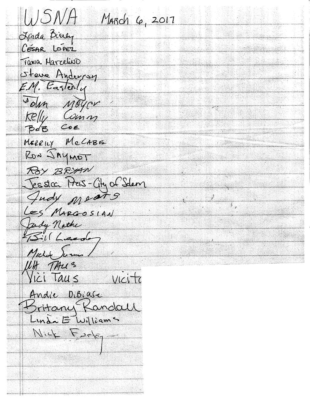
1 West Salem Neighborhood Association March 6, 2017 In Attendance: attendance sheet is attached Meeting is called to order at 7:00 pm Pledge of allegiance Introductions Approval of Minutes from February 20, 2017 E.M. Easterly moved approval of the February 20, 2017 minutes. Ron Jaymot 2 nd, motion CARRIES unanimously Salem Police Officer Report Officer Michael Sommers explained that the new police facility will be up for a vote on May 6. Before then, he will provide more information so voters may make an informed decision. Officer Sommers answered questions from the neighbors. The non- emergency police number is Non-emergency complaints may also be made on line police@cityofsalem.net This phone number and web address is for non-emergency only. For emergencies, call 911. To contact Neighbor to Neighbor to resolve neighborhood issues, call Contact Officer Sommers: (503) msommers@cityofsalem.net Committee Reports Announcements from Co-Chairs Steve Anderson announced front page press coverage in the West Side Newspaper about the West Salem Neighborhood Association by Merrily McCabe and Robert Coe. Page 6 of the publication featured the Edgewater Report. Steve announced that SKATS (Salem Keizer Salem- Keizer Area Transportation Study) will attend the March 20 WSNA meeting to discuss 1
2 transportation funding for the next 6 years. Property at 1890 Eola Drive NW will be surplused by the City. There is no access to the property. The Co-Chairs plan to request the opportunity to keep part of this property for public use. Steve announced an open house at the Broadway commons on March 7, 2017 from 4:00 pm until 7:00 pm about bicycle and pedestrian pathways in Salem. He also announced an art contest for middle school students offered by the Oregon Health Authority. The Salem Strategic Plan is due soon from the Salem City Council. Communities and connectivity is one of the focuses advanced to the City Council by WSNA Co- Chairs. Community Safety and Preparedness: for information S-J.com/prepared Edgewater Report: Jessica Preis, the City of Salem Neighborhood Partnership Program Coordinator for the Edgewater Neighborhood announced some of the activities of the Edgewater Partnership. They focus on their Facebook page, an information hub Urban Grange offers information about Edgewater Neighborhood activities, and a West Salem news column. Currently, they are working on placing an information kiosk in West Salem Park. The Edgewater group meets on the 3 rd Tuesday at 1:00 PM at the West Salem Boys and Girls Club, 925 Gerth St. NW. All are welcome. The next Edgewater Walk is March 12 at 1:00 PM beginning at the Urban Grange. For more information contact Dwayne Hilty or Dwayne@SalemLF.org Glenn and Gibson Creeks Watershed Council: E.M. Easterly reports: meets Tuesday, March 21, 5:30 pm at Salemtowne in the Breezeway Room. The GGCWSC is currently developing work plan and strategic plan for the next two years. Land Use: Kathleen Dewoina, Chair - Kathleen presented the committee s comments and report on the Whispering Heights Traffic Impact Study. E.M. Easterly moved and Robert Coe 2 nd to adopt the report. Motion CARRIES unanimously. The report is included in these minutes as an attachment. Land Use concerns and comments to Kathleen Dewoina, Land Use Chair, dewoina@aol.com 2
3 Salem-Keizer School District: Candidates Forum for the School Board position to represent West Salem will be held at the April 3, 2017 WSNA meeting. Traffic Nick Fortey will check into Level of Service for Wallace Road intersections Glen Creek Road and Orchard Heights. Old Business: Update on Wallace Road Bike Crossing Project Herb Shaw presented his project for a bicycle/pedestrian bridge beside Highway 22 over Wallace Road NW at the Edgewater intersection to the West Salem Redevelopment Advisory Board on March 1. Co-Chair Steve Anderson attended the Grant NA meeting to ask for their support for the project. Update on City of Salem Base Flood Level Map revision task force membership Co-Chair Steve Anderson has met with the City of Salem Public Works Department and has secured West Salem membership on this task force. He will try for two positions so that both the WSNA and the Glenn and Gibson Creeks WSC may be represented. New Business Andie DiBiase, Willamette University presented a survey as part of a study she is doing about Women s Access to urban Parks in Salem and the Impacts on Mental Health. Ms. DiBiase distributed her survey and asked neighbors to respond. Britany Randall, Land Use Planner for the Project Delivery Group presented information about a 6 lot residential development in the area of Doaks Ferry / Glenn Creek Road NW Urban Renewal efforts in West Salem Steve Anderson and Kathleen Dewoina met with Brian Colborne and Tory Banford, City of Salem Urban Development staff, to discuss WSNA concerns and priorities for West Salem redevelopment. Key issues were: 3
4 Zoning that supports the Salem Comprehensive and the West Salem Neighborhood Plans The need to protect the dike that is 2 nd Street NW so the Edgewater neighborhood is not put at risk either of flooding or of having insurance rates raised prohibitively. The need for a grade separated bike and pedestrian crossing over Wallace Road Preserving the historic and pedestrian friendly character of the Edgewater Neighborhood, including the need to properly buffer residential from industrial zones Compare the cost of overcrossing of Wallace Road with undercrossing The Urban Renewal staff will present at the April 3 WSNA meeting SKATs traffic study and WSNA response SKATS traffic study and changes to West Salem transportation system is at MWVCOG.org Comments on the plan are due April 11, SKATS staff will present at the WSNA March 20 meeting. Land Use Committee will prepare recommendations for action at the April 3, 2017 meeting. Co-Chair Steve Anderson reminded the audience that the Edgewater Plan and the West Salem Neighborhood Plan were attached to the March 6, 2017 agenda. He urged neighbors to review and become familiar with the plans to be able to discuss West Salem redevelopment as it proceeds. The meeting is adjourned at 9:00 pm Respectfully submitted, Linda Bierly, Secretary 4
5 Contacts: co-chairs: Steve Anderson Evan Sorce City Councilor Ward 1 Cara Kaser ckaser@cityofsalem.net City Councilor Ward 8 Jim Lewis jlewis@cityofsalem.net Attachment: WSNA Land Use Committee Report on Whispering Heights subdivision TIA adopted by the WSNA on March 6,
6
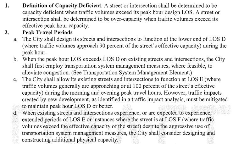
7 WSNA Land Use Committee March 2, 2017 Whispering Heights Traffic Impact Study The West Salem Neighborhood Land Use Committee reviewed the Traffic Impact Analysis prepared by Lancaster Engineering for the Whispering Heights subdivision. The committee noted that the allocation of traffic counts among Michigan City Lane 40%, Rogers Lane 35%, and Conner Street 25% was by assumption. The assumption is not supported by any apparent reasoning. The route to Conner Street is long and circuitous involving many residential street intersections. Michigan City Lane is short and direct. Until Christina is fully developed as a collector, 25% of the trips via Conner could be significantly overstated. At 40%, Michigan City Lane reaches Level of Service E at evening peak hours. If most trips ( 60% -80%) into and from the subdivision were via Michigan City Lane, the most direct route to Wallace Road, could Level of Service F be reached? Level of Service F indicates a significant amount of congestion and delay. What operational mitigation would be deemed necessary at Level of Service F at Michigan City Lane and Wallace Road? The Traffic Impact Study does not address impacts on Wallace Road. The West Salem Neighborhood Association and its Land Use Committee have repeatedly heard that new development along Wallace Road and even redevelopment in the West Salem Urban Renewal Area is constrained by the Oregon Department of Transportation until actions to mitigate Wallace Road Congestion are taken. Traffic Impact Analyses that do not address traffic impact on Wallace Road must be deemed deficient. The Whispering Heights Subdivision is not an isolated case. Land at Linwood and Orchard Heights recently rezoned from RM1 to RM2, Trinity Estates Subdivision, proposed redevelopment at 9 th and Glen Creek, redevelopment in West Salem s Urban Renewal areas, are projects that will add to the traffic load in the Wallace Road corridor. Additional developments currently adding to the load include Nature s View, Wallace Hills, Bella Rosa Villa, Brush College Estates, Brush College Hills, Dream Valley Estates, West Meadows Estates, Cascade Overview, Kingwood Heights and Eagle View Phase IV, to name a few. In a letter to the Planning Commission from the Director of Public Works, dated March 18, 2014, the City s Policy on Level of Service was clearly stated:
8
9 Although the proximal impact of the Whispering Heights subdivision is at Michigan City Lane at Wallace Road and Rogers Lane at Wallace Road, with some contribution at Brush College and Wallace Road, increasing congestion on Wallace Road brings awareness to Glen Creek and Orchard Heights intersections with Wallace Road. The committee suggested Level of Service Analyses at these intersections would help define the challenges in the Wallace Road Corridor. Systemic mitigation efforts on the Wallace Road corridor should be implemented to accommodate the currently planned single family and multi-family subdivisions and redevelopment projects. Traffic congestion mitigation projects include but may not be limited to: Acquisition of Right of Way and development of Marine Drive from Harritt to 5 th Street as a local access collector with Bike Ped Boulevard. Murlark Patterson Edgewater circuit. Improvements to Rosemont/Eola interchange. Improvements to Doaks Ferry Hwy 22 interchange. Improvements to signaling to enhance traffic flow. Improvements to bridge ramps to enhance traffic flow. Grade separation of bicycle pedestrian facilities for safety and enhanced traffic flow. Few recent developments appear to have met the threshold for Traffic Impact Analyses. Nevertheless, the cumulative impacts on the West Salem transportation system structure are apparent and significant. The committee respectfully requests Traffic Impact Studies with new development reasonably address impact on the Wallace Road Corridor. Respectfully submitted, Kathleen Dewoina West Salem Neighborhood Association Land Use Committee
Issues Requiring Future Study
 Issues Requiring Future Study Transportation planning is an ongoing process that tends to identify new issues as it finds solutions for others. Some issues are so complex that a solution to one problem
Design Alternatives Workshop. Hilfiker Park Master Plan Workshop #2
 Design Alternatives Workshop Hilfiker Park Master Plan Workshop #2 Agenda for Tonight Staff Presentation (40 min) Introduction Master Plan Process Planning Context What We ve Heard So Far Design Alternatives
PROCEEDINGS OF THE ST. CLOUD PLANNING COMMISSION. A meeting of the St. Cloud Planning Commission was held on June 12, 2012, at 6:00 p.m.
 PROCEEDINGS OF THE ST. CLOUD PLANNING COMMISSION A meeting of the St. Cloud Planning Commission was held on June 12, 2012, at 6:00 p.m. in the City Hall Council Chambers. Members present were Anderson,
CITY OF CHARLOTTESVILLE, VIRGINIA CITY COUNCIL AGENDA
 CITY OF CHARLOTTESVILLE, VIRGINIA CITY COUNCIL AGENDA Agenda Date: December 16, 2013 Action Required: Adoption of Resolution Presenter: Staff Contacts: Title: James E. Tolbert, AICP, Director of NDS James
CITY OF LARKSPUR Staff Report. August 21, 2013 Council Meeting UPDATE ON TRANSPORTATION AUTHORITY OF MARIN (TAM) GREENBRAE CORRIDOR WORKING GROUP
 GREENBRAE CORRIDOR WORKING GROUP") AGENDA ITEM 7.1 CITY OF LARKSPUR Staff Report August 21, 2013 Council Meeting DATE: August 16, 2013 TO: FROM: SUBJECT: Honorable Mayor Hillmer and Members of the City Council Dan Schwarz, City Manager
AGENDA ITEM 7.1 CITY OF LARKSPUR Staff Report August 21, 2013 Council Meeting DATE: August 16, 2013 TO: FROM: SUBJECT: Honorable Mayor Hillmer and Members of the City Council Dan Schwarz, City Manager
City Avenue Official Map Workshop Meeting Notes
 City Avenue Official Map Workshop Meeting Notes Saturday, January 28, 2012 10:00 12:00 p.m. GSB Building 1 Belmont Avenue (City Ave & Belmont Ave), 12 th Floor Bala Cynwyd, PA The City Avenue Official
CHAPTER 7: Transportation, Mobility and Circulation
 AGLE AREA COMMUNITY Plan CHAPTER 7 CHAPTER 7: Transportation, Mobility and Circulation Transportation, Mobility and Circulation The purpose of the Transportation, Mobility and Circulation Chapter is to
ARLINGTON COUNTY, VIRGINIA. County Board Agenda Item Meeting of January 28, 2017 SUPPLEMENTAL REPORT
 ARLINGTON COUNTY, VIRGINIA County Board Agenda Item Meeting of January 28, 2017 SUPPLEMENTAL REPORT DATE: January 26, 2017 SUBJECT: The Virginia Department of Transportation s Transform I-66 Inside the
Executive Summary. NY 7 / NY 2 Corridor
 Executive Summary NY 7 / NY 2 Corridor Transportation and Land Use Study December 2005 Prepared for: Town of Colonie Capital District Transportation Committee Prepared by: Introduction: Land use decisions
ARLINGTON COUNTY, VIRGINIA. County Board Agenda Item Meeting of January 28, 2017 SUPPLEMENTAL REPORT-2
 ARLINGTON COUNTY, VIRGINIA County Board Agenda Item Meeting of January 28, 2017 SUPPLEMENTAL REPORT-2 DATE: January 27, 2017 SUBJECT: The Virginia Department of Transportation s Transform I-66 Inside the
1.0 Introduction. Purpose and Basis for Updating the TMP. Introduction 1
 1.0 Introduction The Town of Castle Rock is situated between the metropolitan areas of Denver and Colorado Springs, amidst a unique terrain of rolling hills, mesas, ravines, and waterways. Like many Front
Introduction. Chapter 1. Purpose of the Comprehensive Plan Plan Organization Planning Process & Community Input 1-1
 Chapter 1 Introduction Lakewood 2025: Moving Forward Together Purpose of the Comprehensive Plan Plan Organization Planning Process & Community Input 1-1 Purpose of the Comprehensive Plan The Comprehensive
STAFF REPORT SAUSALITO CITY COUNCIL
 STAFF REPORT SAUSALITO CITY COUNCIL MEETING DATE: January 8, 2019 AGENDA TITLE: LEAD DEPARTMENT: Southern Marin Fire District Lessons Learned Update Report Southern Marin Fire District, Fire Chief Chris
City of Westbrook PLANNING BOARD MINUTES 2 York Street Westbrook, Maine (207) Fax: (207)
 Fax: (207)") February 7, 2006 City of Westbrook PLANNING BOARD MINUTES 2 York Street Westbrook, Maine 04092 (207)854-0638 Fax: (207)854-0627 WESTBROOK PLANNING BOARD TUESDAY, February 7, 2006 7:00 P.M. WESTBROOK HIGH
February 7, 2006 City of Westbrook PLANNING BOARD MINUTES 2 York Street Westbrook, Maine 04092 (207)854-0638 Fax: (207)854-0627 WESTBROOK PLANNING BOARD TUESDAY, February 7, 2006 7:00 P.M. WESTBROOK HIGH
Project Overview. Get Involved. Public Information Meeting. Contact Information
 Get Involved VDOT representatives will review and evaluate information received as a result of this meeting. Please fill out the comment sheet provided in this brochure if you have any comments or questions.
STAFF SUMMARY FOR S17-02 SPECIAL USE PERMIT APPLICATION
 APPLICATION SUMMARY Case Number: S17-02 Request: STAFF SUMMARY FOR S17-02 SPECIAL USE PERMIT APPLICATION SUP application in order to develop a convenience food store. Applicant: Property Owner(s): Cindee
Trail Feasibility and Planning Project for Northern Dutchess County, New York
 for Northern Dutchess County, New York Funded in Part by Grants from the Hudson River Valley Greenway, Land Trust Alliance Conservation Partnership Program and the Thomas Thompson Trust 1 STEERING COMMITTEE
City of Royalton Comprehensive Land Use Plan 2005 to Revision February 8, 2011
 City of Royalton Comprehensive Land Use Plan 2005 to 2015 2011 Revision February 8, 2011 PART ONE: INTRODUCTION TO THE COMPREHENSIVE PLAN 1.0 Purpose and Introduction The Comprehensive Land Use Plan provides
Date: April 10, 2017 City Council Work Session April 24, 2017: Status Report on the Comprehensive Plan Update and Transportation Master Plan
 AGENDA REPORT To: From: By: Honorable Mayor and City Council Members Warren Hutmacher, City Manager Sharon Ebert, Director Community Development Date: April 10, 2017 Agenda: City Council Work Session April
Community Open House March 26 th, 2018
 Community Open House March 26 th, 2018 Open House Agenda 1. Overview of Planning Process What we heard 2. Future Land Use Policy 3. Priority Growth Areas 4. Plan Elements Making it happen What is a Comprehensive
MAYFIELD WEST SECONDARY PLAN PHASE 2
 MAYFIELD WEST SECONDARY PLAN PHASE 2 Public Open House #3 February 25, 2010 Draft Preferred Land Use Scenario TOWN OF CALEDON PLANNING & DEVELOPMENT DEPARTMENT Open House Agenda TOWN OF CALEDON 1. Welcome
10 Implementation. Implementation. Responsibility for Implementation. Blueprint for Bloomsburg. Town of Bloomsburg Comprehensive Plan 10-1
 Implementation 10 Implementation This chapter overviews how to use the comprehensive plan as a land use and programming tool for the Town of Bloomsburg and recommends annual review of the plan by the Town
Roosevelt Corridor. R e i n v e s t m e n t P l a n. Public Meeting Gilbert Elementary School May 12, :00 pm
 Roosevelt Corridor R e i n v e s t m e n t P l a n Public Meeting Gilbert Elementary School May 12, 2009 6:00 pm Agenda 6:00 6:10 6:25 6:40 6:55 7:00 Opening Comments Councilwoman Jennifer V. Ramos District
Green Oak Charter Township. Planning Commission Regular Meeting Minutes August 4, 2016
 1 2 3 4 5 6 7 8 9 10 11 12 13 14 15 16 17 18 19 20 21 22 23 24 25 26 27 28 29 30 31 32 33 34 35 36 37 38 39 40 41 42 43 44 45 46 47 48 49 Planning Commission Regular Meeting Minutes August 4, 2016 The
OTHERS Alex Jaegerman, Director of Planning & Development Wendy L. Simmons, Administrative Assistant, Recording Secretary
 YARMOUTH PLANNING BOARD MINUTES REGULAR MEETING March 27, 2019 I. CALL TO ORDER Tom Federle called the meeting to order at 7:00 PM. II. ROLL CALL OF MEMBERS PRESENT ABSENT Tom Federle, Chair Judy Colby
REGIONAL TRANSPORTATION COMMISSION OF SOUTHERN NEVADA AGENDA ITEM
 REGIONAL TRANSPORTATION COMMISSION OF SOUTHERN NEVADA AGENDA ITEM Metropolitan Planning Organization [ X ] Transit [ ] Administration and Finance [ ] SUBJECT: PROJECT SELECTION PROCESS FOR TRANSPORTATION
SECTION 4(f) DE MINIMIS DOCUMENTATION
 DE MINIMIS DOCUMENTATION") SECTION 4(f) DE MINIMIS DOCUMENTATION Illinois Route 60/83 IL 176 to the intersection of IL 60 (Townline Road) Lake County P-91-084-07 Mundelein Park and Recreation District Project Limit SECTION 4(f)
SECTION 4(f) DE MINIMIS DOCUMENTATION Illinois Route 60/83 IL 176 to the intersection of IL 60 (Townline Road) Lake County P-91-084-07 Mundelein Park and Recreation District Project Limit SECTION 4(f)
MALLETTS BAY INITIATIVE
 MALLETTS BAY INITIATIVE Stormwater Management & Transportation Scoping Study January 19, 2017 Project Team Bryan Osborne Director of Public Works Sarah Hadd Director of Planning & Zoning Marshall Distel
M E M O R A N D U M July 27, 2018
 M E M O R A N D U M July 27, 2018 To: Southlake 2035 Corridor Planning Committee From: Kenneth Baker, Sr. Director of Planning and Development Services Subject: Item #6 First National Bank Purpose Review,
Rapid City Planning Commission Rezoning Project Report
 Rapid City Planning Commission Rezoning Project Report April 5, 2018 Item # 4 Applicant Request(s) Case # 18RZ008 Rezoning request from General Agricultural District to Low Density Residential District
Welcome. Northern Segment of Hwy 100 I-90 to South of Madison Street Meeting Goals:
 Welcome Northern Segment of Hwy 100 I-90 to South of Madison Street Meeting Goals: - Review Environmental Assessment - Share Preferred Alternative -Receive Public Comments 2003 EA Preferred Alternative
Urban Planning and Land Use
 Urban Planning and Land Use 701 North 7 th Street, Room 423 Phone: (913) 573-5750 Kansas City, Kansas 66101 Fax: (913) 573-5796 Email: planninginfo@wycokck.org www.wycokck.org/planning To: From: City Planning
Independence Boulevard Area Plan Planning Committee Public Comment May 18, 2010
 Independence Boulevard Area Plan Planning Committee Public Comment May 18, 2010 Presentation Outline Focus on Key Recommendations within Draft Plan Plan Purpose and Development Process Draft Plan Policies
VILLAGE & TOWN OF BERGEN: COMPREHENSIVE PLAN
 VILLAGE & TOWN OF BERGEN: COMPREHENSIVE PLAN CPC Public Hearing April 21, 2016 History 1996 Comprehensive Plan Comprehensive Plan Update Committee Consultant (LaBella Associates): December 2014 Residents
Planning & Zoning Commission Staff Report
 Planning & Zoning Commission Staff Report Meeting Date: May 26, 2015 Drafted by: Katherine Harrison-Rogers CASE # Z2886 PROJECT NAME: APPLICANT/ REPRESENTATIVE: Shawna Runyan PROPERTY OWNER: 1840 (previously
Rezoning Issues Setting a Foundation for Zoning Decisions
 Rezoning Issues Setting a Foundation for Zoning Decisions City Council Workshop May 2, 2016 Agenda Goal Need actionable items and sequence of steps Foundation for Zoning Decisions Council Workshop Discussion
Town of Malta Planning Board 2540 Route 9 Malta, NY (518) Fax: (518)
 Fax: (518)") William Smith - Chairman Dave Bowman Kyle Kordich Roger Laime Jean Loewenstein John Viola David Wallingford Joseph Lopez (Alt) Town of Malta Planning Board 2540 Route 9 Malta, NY 12020 (518) 899-2685 Fax:
William Smith - Chairman Dave Bowman Kyle Kordich Roger Laime Jean Loewenstein John Viola David Wallingford Joseph Lopez (Alt) Town of Malta Planning Board 2540 Route 9 Malta, NY 12020 (518) 899-2685 Fax:
CAC OVERVIEW. CAC Roles and Responsibilities CAC Operations CAC Membership CAC DAC Relations
 CAC OVERVIEW CAC Roles and Responsibilities CAC Operations CAC Membership CAC DAC Relations 1 Purpose of This Overview To increase the level of awareness of CAC members so that they know what is expected
Application Number: SD Project Name: Walton Farms Preliminary Subdivision (acting as Master Plan)
") STAFF REPORT Town of Clayton Planning Department 111 E. Second Street, Clayton, NC 27520 P.O. Box 879, Clayton, NC 27528 Phone: 919-553-5002 Fax: 919-553-1720 Planning Board May 22, 2017 Application Number:
STAFF REPORT Town of Clayton Planning Department 111 E. Second Street, Clayton, NC 27520 P.O. Box 879, Clayton, NC 27528 Phone: 919-553-5002 Fax: 919-553-1720 Planning Board May 22, 2017 Application Number:
The Illinois Department of Transportation and Lake County Division of Transportation. Route 173, including the Millburn Bypass
 The Illinois Department of Transportation and Lake County Division of Transportation welcome you to this Public Hearing for U.S. Route 45 from Illinois Route 132 to Illinois Route 173, including the Millburn
Making TOD Work in the Heart of Suburban Sprawl
 Making TOD Work in the Heart of Suburban Sprawl Rocky Mountain Land Use Institute March 6, 2009 Speakers Ben Herman, FAICP, Principal Clarion Associates Darcie White, AICP, Principal Clarion Associates
SBCAG STAFF REPORT. MEETING DATE: March 17, 2016 AGENDA ITEM: 5I
 SBCAG STAFF REPORT SUBJECT: Cabrillo-UPRR Bridge Project MEETING DATE: March 17, 2016 AGENDA ITEM: 5I STAFF CONTACT: Fred Luna RECOMMENDATION: Authorize the chair to sign a Memorandum of Understanding
Access Management: An Overview
 Figures 1-5 Below Evolution of development along a highway. In the early stages, land along the road is used for farming with little traffic generated. As time passes, the highway corridor becomes a de
Volume 2: Implementation Plan
 Volume 2: Implementation Plan February 25 th 2002 Implementation Introduction This document outlines the steps that should be taken to implement the Washington Heights Neighborhood Plan. The City Council
IH35 Corridor Plan Amendment to the Comprehensive Plan
 IH35 Corridor Plan Amendment to the Comprehensive Plan Background The corridor plan for the IH35 corridor is an amendment to the Burleson comprehensive plan. Generally, the purpose of a corridor plan is
Isabel Neighborhood Plan: Alternatives
 Isabel Neighborhood Plan: Alternatives Presented by: Lori Parks, Associate Planner February 2, 2015 Agenda 1. Background on BART to Livermore 2. Isabel Neighborhood Plan 3. Alternative Scenarios 4. General
PLANNING ADVISORY BOARD AGENDA OCTOBER
 ! City of Langley PLANNING ADVISORY BOARD AGENDA OCTOBER 1, 2014 3-5pm LANGLEY CITY HALL - 112 2 nd Street, Langley WA 1) Call to Order and Roll Call 2) Approval of the Minutes September 10, 2014 3) Public
Rye City Planning Commission Minutes April 19, 2011
 Rye City Planning Commission Minutes MEETING ATTENDANCE: Planning Commission Members: Nick Everett, Chair Martha Monserrate, Vice-Chair Carolyn Cunningham Barbara Cummings Hugh Greechan Peter Larr Other:
INDEPENDENCE BOULEVARD AREA PLAN. Economic Development Committee Overview May 25, 2010
 INDEPENDENCE BOULEVARD AREA PLAN Economic Development Committee Overview May 25, 2010 Presentation Outline Plan Purpose and Development Process Draft Plan Policies and Implementation Strategies Request
PLANNING COORDINATING COMMITTEE
 PLANNING COORDINATING COMMITTEE Fall Meeting/Luncheon Welcome! October 16, 2009 PLANNING COORDINATING COMMITTEE Fall Meeting/Luncheon WELCOME! WELCOME! October 16, 2009 October 16, 2009 Agenda I. Lunch/Socialize
Approved: CITY OF ARDEN HILLS, MINNESOTA PLANNING COMMISSION WEDNESDAY, AUGUST 5, :30 P.M. - ARDEN HILLS CITY HALL
 Approved: CITY OF ARDEN HILLS, MINNESOTA PLANNING COMMISSION WEDNESDAY, AUGUST 5, 2015 6:30 P.M. - ARDEN HILLS CITY HALL PLANNING CASES A. Planning Case 15-016; Final Planned Unit Development Arden Plaza;
Route 1 Corridor Study
 Route 1 Corridor Study Westbrook, Connecticut A Vision for the Connecticut Shoreline Public Informational Meeting July 28, 2015 Lower Connecticut River Valley Council of Governments Fitzgerald & Halliday,
SOUTHWEST TRANSITWAY (STAGE 2) PUBLIC OPEN HOUSE
 PUBLIC OPEN HOUSE") WELCOME! SOUTHWEST TRANSITWAY (STAGE 2) PUBLIC OPEN HOUSE Monday, November 18, 2013 3:30 to 5:30PM and 7:00 to 9:00PM Tuesday, November 19, 2013 3:30 to 5:30PM and 7:00 to 9:00PM Welcome to the Southwest
WELCOME! SOUTHWEST TRANSITWAY (STAGE 2) PUBLIC OPEN HOUSE Monday, November 18, 2013 3:30 to 5:30PM and 7:00 to 9:00PM Tuesday, November 19, 2013 3:30 to 5:30PM and 7:00 to 9:00PM Welcome to the Southwest
Municipality of Anchorage. Community Council Survey Capital Projects Needs Ranking Survey (ALPHABETICAL) Airport Heights
 Airport Heights") ANCHORAGE PARKS & RECREATION Nichols Park Design and improve neighborhood park 2008 Challenge Grant applicant. 2008 $500K State Grant for Neighborhood Parks. Tikishla Park Lighting, paved parking, hockey
ANCHORAGE PARKS & RECREATION Nichols Park Design and improve neighborhood park 2008 Challenge Grant applicant. 2008 $500K State Grant for Neighborhood Parks. Tikishla Park Lighting, paved parking, hockey
TIRZ 17/Redevelopment Authority Capital Improvements Plan Projects
 Gessner Widening: T-1701 What: Widen the road from a six-lane divided boulevard to an eight-lane divided boulevard street section, increase turn lanes, update traffic signal system, improve drainage by
PD&E STUDY SR 9/I-95 FROM SOUTH OF SR 870/COMMERCIAL BOULEVARD TO NORTH OF CYPRESS CREEK ROAD FM # ETDM 14222
 PD&E STUDY SR 870/COMMERCIAL BOULEVARD TO NORTH OF CYPRESS CREEK ROAD FM # 435808-1-22-02 ETDM 14222 WELCOME TO THE KICK-OFF MEETING May 24, 2016 1 1 2 3 4 5 6 PLANNING PROJECT DEVELOPMENT AND ENVIRONMENT
TRANSPORTATION ELEMENT GOALS, OBJECTIVES, AND POLICIES
 TRANSPORTATION ELEMENT GOALS, OBJECTIVES, AND POLICIES GOAL 2 The City shall provide a safe, convenient, effective, and energy efficient multimodal transportation system which is coordinated with the Future
HE VISION. Building a Better Connected Place
 HE VISION Building a Better Connected Place WALK INTO THE FUTURE. Life in Cranberry, 2030 Here s what our residents told us they wanted to see in their community by 2030: The Cranberry of 2030 is a place
FANSHAWE PARK ROAD/RICHMOND STREET INTERSECTION IMPROVEMENTS. PUBLIC INFORMATION CENTRE 2 June 16, 2016
 FANSHAWE PARK ROAD/RICHMOND STREET INTERSECTION IMPROVEMENTS Municipal Class Environmental Assessment PUBLIC INFORMATION CENTRE 2 June 16, 2016 ACCESSIBILITY Under the Accessibility Standards 2015 for
CAMPUS MASTER PLAN Appendix C Neighborhood Traffic and Parking Task Force
 CAMPUS MASTER PLAN 2004-2015 Appendix C Neighborhood Traffic and Parking Task Force Neighborhood Traffic and Parking Task Force Background The City, OSU, and the neighborhood associations in the vicinity
CAPE COD COMMISSION MAIN STREET P.O. BOX226 BARNSTABLE, MA (508) FAX (508)
 FAX (508)") CAPE COD COMMISSION 3225 MAIN STREET P.O. BOX226 BARNSTABLE, MA 02630 (508) 362-3828 FAX (508) 362-3136 E-mail: frontdesk@capecodcommission.org Date: April21, 1998 Re: Applicant: Project: Project Number:
CAPE COD COMMISSION 3225 MAIN STREET P.O. BOX226 BARNSTABLE, MA 02630 (508) 362-3828 FAX (508) 362-3136 E-mail: frontdesk@capecodcommission.org Date: April21, 1998 Re: Applicant: Project: Project Number:
Air Pollution Control Commission Minutes Tuesday February 9, 2016, 6:00 P.M. Juanita Helms Administration Center Assembly Chambers
 Air Pollution Control Commission Minutes Tuesday February 9, 2016, 6:00 P.M. Juanita Helms Administration Center Assembly Chambers APCC Commissioners Present Kathleen Hook Chair Mark Sherman Vice Chair
PLANNING COMMISSION. Agenda Item # 3.
 PLANNING COMMISSION Agenda Item # 3. CASE SUMMARY Conditional District Rezoning Planning Commission February 4, 2015 CD-9-215 Jeff Walton, 341-3260, jeff.walton@wilmingtonnc.gov Staff recommendation CONDITIONAL
Welcome. Walk Around. Talk to Us. Write Down Your Comments
 Welcome This is an information meeting introducing the applications for proposed redevelopment of the Yorkdale Shopping Centre site at 3401 Dufferin Street and 1 Yorkdale Road over the next 20+ years,
2017 General Obligation Bond
 2017 General Obligation Bond Presentation of Public and Council Projects to the Transportation & Mobility Stakeholder Committee April 13, 2017 Agenda Deferred Maintenance Project Development Process Projects
CLACKAMAS COUNTY BOARD OF COMMISSIONERS 2051 Kaen Road, Oregon City BCC Hearing Room - 4th Floor. LAND USE HEARING October 3, :30 AM
 CLACKAMAS COUNTY PLANNING AND ZONING DIVISION DEPARTMENT OF TRANSPORTATION AND DEVELOPMENT DEVELOPMENT SERVICES BUILDING 150 BEAVERCREEK ROAD OREGON CITY, OR 97045 503-742-4500 ZONINGINFO@CLACKAMAS.US
GVPAC Endorsement of Draft Plan
 GVPAC Endorsement of Draft Plan Tuesday, July 5, 2011 at 6:00PM Call to Order Pledge of Allegiance and Roll Call Public Comment Period Administrative Announcements and Staff Updates Action Minutes from
COLVER ROAD INDUSTRIAL CONCEPT PLAN
 COLVER ROAD INDUSTRIAL CONCEPT PLAN A CONCEPTUAL LAND USE AND TRANSPORTATION PLAN FOR TA-4 AN URBAN RESERVE AREA OF THE CITY TALENT City of Talent Adopted by City Council Resolution No., June, 2015 PART
Secrest Short Cut and Monroe Expressway Small Area Plan AUGUST 29, 2018
 Secrest Short Cut and Monroe Expressway Small Area Plan AUGUST 29, 2018 Background and Process Monroe Expressway will be open by the end of 2018 Union County and Indian Trail identified a need to revisit
AGENDA MEETING OF THE TOWN OF ALLEGANY PLANNING BOARD. Monday, November 9, 2015 at 7:00 p.m. Allegany Town Hall 52 W. Main Street, Allegany, NY
 AGENDA MEETING OF THE TOWN OF ALLEGANY PLANNING BOARD Monday, November 9, 2015 at 7:00 p.m. Allegany Town Hall 52 W. Main Street, Allegany, NY Salute to the Flag Minutes October 5, 2015 Old Business Michael
PLAN ELEMENTS WORKSHOP. April 5, 2016
 PLAN ELEMENTS WORKSHOP April 5, 2016 needs more housing. But there is no one-size fits-all solution. Every neighborhood has its own character. In some places, density is not only appropriate it is badly
A larger version of this map is located on the last page of this PDF.
 MAP Committee Input McLoughlin Area Draft Vision Map A larger version of this map is located on the last page of this PDF. 1. The map above is intended to portray a vision for the McLoughlin area. It highlights
CAMPUS MASTER PLAN UPATE
 19 MAY 2016 CAMPUS MASTER PLAN UPATE Metropolitan Planning Organization AGENDA Introductions Planning Scope Observation & Analysis: Mobility Systems Campus Development Plan Mobility Planning Scenarios
CASE NUMBER: 16SN0565 (AMENDED) APPLICANT: C.A.H. Investments, LLC
 APPLICANT: C.A.H. Investments, LLC") CASE NUMBER: 16SN0565 (AMENDED) APPLICANT: C.A.H. Investments, LLC STAFF S ANALYSIS AND RECOMMENDATION Board of Supervisors (BOS) Public Hearing Date: JUNE 22, 2016 BOS Time Remaining: 365 DAYS Applicant
CASE NUMBER: 16SN0565 (AMENDED) APPLICANT: C.A.H. Investments, LLC STAFF S ANALYSIS AND RECOMMENDATION Board of Supervisors (BOS) Public Hearing Date: JUNE 22, 2016 BOS Time Remaining: 365 DAYS Applicant
Building Great Neighbourhoods. Strathcona
 Building Great Neighbourhoods Strathcona March 21, 2018 Becky Redford Project Manager, Planning & Design Building Great Neighbourhoods Integrated Infrastructure Services Welcome and Purpose To provide
The GATEWAYS Sub Area Master Plan. City of Walker
 The GATEWAYS Sub Area Master Plan City of Walker Introduction: The Walker City Commission and Planning Commission decided in 2011 to create a sub-area master plan for the Remembrance Road and Wilson Avenue
Joint Public Hearing. Preliminary Subregion 5 Master Plan and Proposed Sectional Map Amendment
 Preliminary Subregion 5 Master Plan and Proposed Sectional Map Amendment Joint Public Hearing April 11, 2013 Council Hearing Room Upper Marlboro 7:00 pm His Lordship s Kindness (Clinton) Presentation Overview
IH35 Corridor Plan Amendment to the Comprehensive Plan
 IH35 Corridor Plan Amendment to the Comprehensive Plan Background The corridor plan for the IH35 corridor is an amendment to the Burleson comprehensive plan. Generally, the purpose of a corridor plan is
Street Flooding Mitigation Plan KYOVA Interstate Planning Commission. Presented to AMPO National Conference October 18, 2017
 Street Flooding Mitigation Plan KYOVA Interstate Planning Commission Presented to AMPO National Conference October 18, 2017 Saleem Salameh, Ph.D., P.E., M.ASCE Chet Parsons, AICP CTP Agenda: Background
NORTH, NORTH REDWOOD BOULEVARD CORRIDOR STUDY
 BOULEVARD CORRIDOR STUDY Southern Central Northern STUDY AREA OPPORTUNITIES AND CONSTRAINTS BOULEVARD CORRIDOR WORKSHOP Constraints Wetlands For illustrative purposes only BINFORD RD RUSH LANDING RD BOULEVARD
TRANSPORTATION ELEMENT
 TRANSPORTATION ELEMENT GOAL I: To create and maintain a safe, efficient and aesthetic transportation system that encourages multi-modal transportation and promotes the mobility strategies of the Ocala
City of Lake Elmo Planning Commission Meeting Minutes of August 10, 2015
 City of Lake Elmo Planning Commission Meeting Minutes of August 10, 2015 Chairman Dodson called to order the meeting of the Lake Elmo Planning Commission at 7:00 p.m. COMMISSIONERS PRESENT: Dodson, Dorschner,
SHEFFIELD PARK Paulding County, GA DRI #588
 SHEFFIELD PARK Paulding County, GA DRI #588 Supplemental Information for RDC s DRI (Form 2) Review August 16, 2004 Prepared for: Mr. David Howerin Coosa Valley RDC 1 Jackson Hill Drive Rome, GA 30161 P.O.
Creating Complete Roadway Corridors:
 Creating Complete Roadway Corridors: The AASHTO Guide to Transportation Landscape Architecture and Environmental Design NCHRP Project 15-33 Status Report AASHTO Standing Committee on Design Technical Committee
WURZBACH PARKWAY WURZBACH PARKWAY
 WURZBACH PARKWAY WURZBACH PARKWAY From Lockhill-Selma Rd to NW Military Hwy Open NW Military HouseHwy/Lockhill-Selma Open House Barshop Jewish Community Center December Barshop Jewish 14, 2017 Community
East Central Area Plan
 East Central Area Plan Steering Committee Meeting January 10 th, 2019 Tears-McFarlane House Community Room East Central Area Plan Steering Committee Meeting January 10 th, 2019 CHUN Tears-McFarlane House
PART 1: PROJECT SUMMARY. The application is Attachment A. The site plan is Attachment B.
 Belleterre Subdivision Sketch Plan Town Board 8.7.17 Belleterre Subdivision Sketch Plan PART 1: PROJECT SUMMARY Applicant: Bowman Development Project Size: +/- 20.85 acres Parcel Number: 01115104 and 01115121
DESIGN REVIEW COMMISSION AGENDA COEUR D ALENE PUBLIC LIBRARY LOWER LEVEL, COMMUNITY ROOM 702 E. MULLAN THURSDAY JANUARY 25, :00 pm
 DESIGN REVIEW COMMISSION AGENDA COEUR D ALENE PUBLIC LIBRARY LOWER LEVEL, COMMUNITY ROOM 702 E. MULLAN THURSDAY JANUARY 25, 2018 12:00 pm 12:00 P.M. CALL TO ORDER: ROLL CALL: Ives, Ingalls, Lemmon, Messina,
Presiding: Vice Chair Chris Berbert
 The following are the minutes of the Planning Commission Meeting held on Thursday, June 7, 2018 at 6:00 p.m. in the Herriman City Community Center, 5355 W. Herriman Main Street (12090 South), Herriman,
WASHINGTON COUNTY OREGON
 WASHINGTON COUNTY OREGON LONG RANGE PLANNING DIVISION North Bethany Subarea Stream Corridors: Existing Regulations In Oregon, there is a distinct difference between the land use rules that apply in rural
CASE NUMBER: 15SN0594 APPLICANT: Racetrack Petroleum, Inc.
 CASE NUMBER: 15SN0594 APPLICANT: Racetrack Petroleum, Inc. STAFF S ANALYSIS AND RECOMMENDATION Board of Supervisors (BOS) Public Hearing Date: DECEMBER 10, 2014 BOS Time Remaining: 365 DAYS Applicant s
Northwest LRT Downtown to. Northwest Edmonton Study. Public Workshops
 Northwest LRT Downtown to Northwest Edmonton Study Public Workshops March 23 & 24, 2010 Welcome Thank you all for attending Welcome Introductions Welcome Our Team s Commitment to You for Tonight To provide
Asbury Chapel Subdivision Sketch Plan
 Asbury Chapel Subdivision Sketch Plan PART 1: PROJECT SUMMARY Applicant: NVR Inc. Project Size: +/- 76.13 acres Parcel Numbers: 02101112,02116101,02116112, 02116113 Current Zoning: Transitional Residential
Blueprint Denver Task Force Meeting #
 Blueprint Denver Task Force Meeting #1 6.23.16 1. Welcome and Introductions Your name and affiliation Name 1 thing you love about Denver Name 1 thing you d change about Denver All in 30 seconds! Ready,
A BLUEPRINT FOR BROCKTON A CITY-WIDE COMPREHENSIVE PLAN
 A BLUEPRINT FOR BROCKTON A CITY-WIDE COMPREHENSIVE PLAN Public Meeting October 2016 1 Plan Summary and Discussion Public Meeting May 4 2017 City of Brockton Bill Carpenter, Mayor Department of Planning
DRAFT Civic Center Station Area Plan. Executive Summary
 DRAFT Civic Center Station Area Plan Executive Summary This project is funded in part through the Metropolitan Transportation Commission s Station Area Planning Program. The preparation of this report
City Of Sparks Planning Commission Item
 Page 1 of 12 City Of Sparks Planning Commission Item Meeting Date: May17, 2012 Subject: PCN12009, Public Hearing, Consideration and possible action on a Master Plan Amendment and Rezoning request to change
ROAD CLOSURE AND LAND USE AMENDMENT SILVER SPRINGS (WARD 1) NORTHEAST OF NOSEHILL DRIVE NW AND SILVER SPRINGS ROAD NW BYLAWS 2C2018 AND 29D2018
 NORTHEAST OF NOSEHILL DRIVE NW AND SILVER SPRINGS ROAD NW BYLAWS 2C2018 AND 29D2018") Page 1 of 19 EXECUTIVE SUMMARY This application proposes redesignating two parcels in the community of Silver Springs from Special Purpose Future Urban Development (S-FUD) District and undesignated road
Page 1 of 19 EXECUTIVE SUMMARY This application proposes redesignating two parcels in the community of Silver Springs from Special Purpose Future Urban Development (S-FUD) District and undesignated road
MAYFIELD WEST SECONDARY PLAN PHASE 2
 MAYFIELD WEST SECONDARY PLAN PHASE 2 Council Information Workshop February 16, 2010 Draft Preferred Land Use Plan TOWN OF CALEDON PLANNING & DEVELOPMENT DEPARTMENT Workshop Agenda TOWN OF CALEDON 1. Welcome
ESTABLISH AN EFFICIENT TOWN CENTER
 ESTABLISH AN EFFICIENT TOWN CENTER 4 Overview Lisbon residents are proud of the history of Newent and at the same time recognize its current importance as a centralized location for a variety of municipal