REGIONAL TRANSPORTATION COMMISSION OF SOUTHERN NEVADA AGENDA ITEM
|
|
|
- Gwen Reeves
- 5 years ago
- Views:
Transcription
1 REGIONAL TRANSPORTATION COMMISSION OF SOUTHERN NEVADA AGENDA ITEM Metropolitan Planning Organization [ X ] Transit [ ] Administration and Finance [ ] SUBJECT: PROJECT SELECTION PROCESS FOR TRANSPORTATION ALTERNATIVES PROGRAM FUNDING PETITIONER: TINA QUIGLEY, GENERAL MANAGER REGIONAL TRANSPORTATION COMMISSION OF SOUTHERN NEVADA RECOMMENDATION BY PETITIONER: THAT THE METROPOLITAN PLANNING SUBCOMMITTEE RECEIVE INFORMATION ON THE DRAFT PROJECT SELECTION PROCESS FOR FEDERAL TRANSPORTATION ALTERNATIVES PROGRAM FUNDING (FOR POSSIBLE ACTION) GOAL: DEVELOP FULLY INTEGRATED MODAL OPTIONS FISCAL IMPACT: None by this action BACKGROUND: Under new federal legislation, the RTC receives direct allocations of Transportation Alternatives Program (TAP) funding. TAP funds can be used to fund various non-motorized, safe routes to school, community improvement, and environmental projects. RTC staff developed the project selection process for the Southern Nevada TAP through three meetings with various local agencies. Input received during these meetings was incorporated into the project selection process and application form. RTC staff will provide information on the project selection process, application form and timeline. Respectfully submitted, MARTYN JAMES Director of Planning Services pb MPS Item #5 May 14, 2013 Non-Consent
2
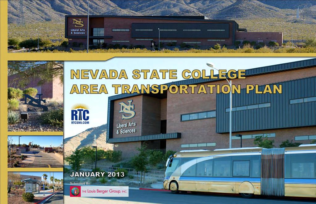
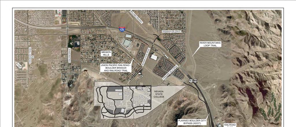
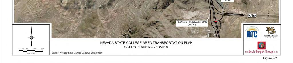
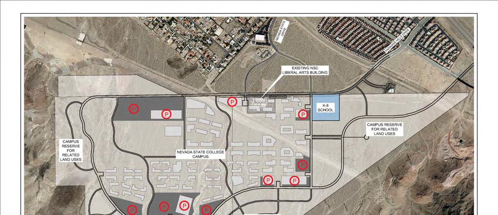
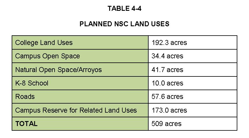
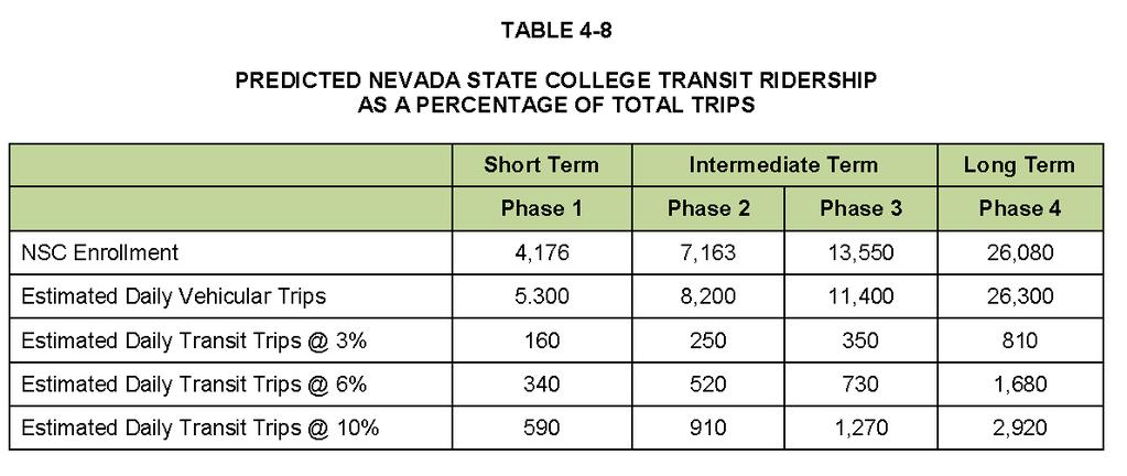
3 REGIONAL TRANSPORTATION COMMISSION OF SOUTHERN NEVADA AGENDA ITEM Metropolitan Planning Organization [X] Transit [ ] Administration and Finance [ ] SUBJECT: NEVADA STATE COLLEGE AREA TRANSPORTATION PLAN PETITIONER: TINA QUIGLEY, GENERAL MANAGER REGIONAL TRANSPORTATION COMMISSION OF SOUTHERN NEVADA RECOMMENDATION BY PETITIONER: THAT THE METROPOLITAN PLANNING SUBCOMMITTEE RECEIVE A REPORT ON THE NEVADA STATE COLLEGE AREA TRANSPORTATION PLAN (FOR POSSIBLE ACTION) GOAL: IMPLEMENT TRANSPORTATION SYSTEMS THAT IMPROVE AIR QUALITY IN SOUTHERN NEVADA FISCAL IMPACT: None by this action BACKGROUND: The Fiscal Year 2012 Unified Planning Work Program for the Regional Transportation Commission of Southern Nevada included a study to evaluate the transportation network in the area supporting the Nevada State College campus in the City of Henderson. The study includes development of a comprehensive multimodal transportation plan to address the projected future transportation demands of the community surrounding the campus. The study area includes the I-515/Wagonwheel Drive interchange and the corridor surrounding Nevada State Drive south of I-515 leading to the campus development site south of Paradise Hills Drive. The study recommends multimodal transportation improvement options for the area surrounding the Nevada State College campus. This study is nearly complete, pending final comments. Staff will briefly report on the main findings of the study. A copy of the presentation is included in the agenda backup. Respectfully submitted, MARTYN JAMES Director of Planning Services mfg MPS Item #6 May 14, 2013 Non-Consent
4
5
6
7
8
9
10
11

12
13
14
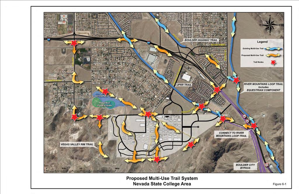
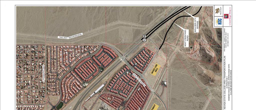
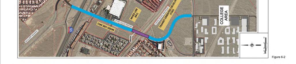
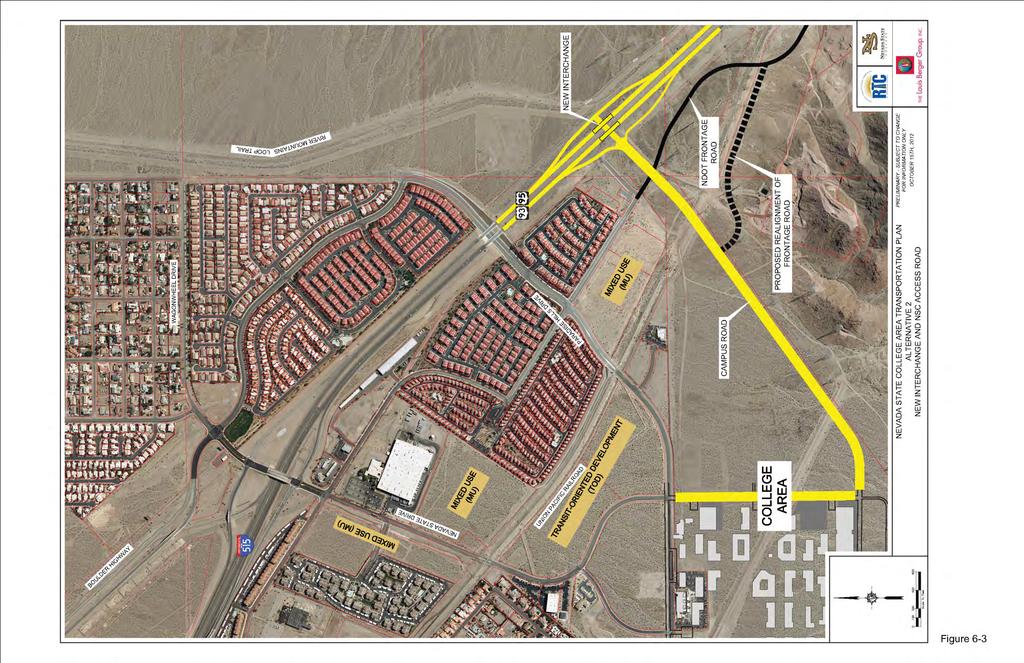
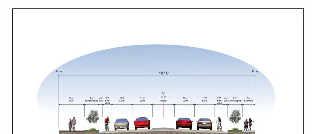
15 Recommended Short Term Actions: Plan to construct Nevada State Drive as a four lane roadway, incorporating bicycle lanes, landscaping, & wide pedestrian paths. Construct a pedestrian bridge over the Boulder City Bypass (US 93/US 95) to link the UPRR & River Mountains Loop Trails.
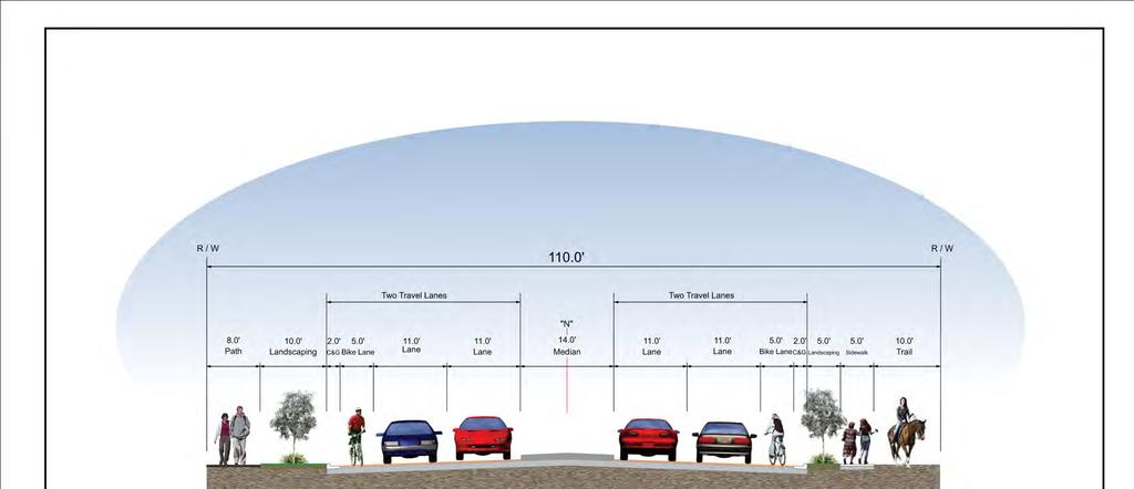
16 Recommended Intermediate Term Actions: Reconstruct (downsize) Paradise Hills Drive to four lanes with bicycle lanes, landscaping, & wide pedestrian paths. Develop the Vegas Valley Rim Trail & trail connections to neighborhoods west of the NSC campus. Consider adding an equestrian trail on Paradise Hills Drive linking the proposed Vegas Valley Rim Trail to the River Mountains Loop Trail.
17 Recommended Intermediate Term Actions: Improve the Nevada State Drive/ Wagonwheel Drive Interchange to accommodate intermediate growth of traffic to & from the NSC campus. Increase frequency of service on the Henderson/Downtown Express (HDX) transit route.
18 Recommended Long Term Actions: Provide additional access to the NSC campus from the I 515/Boulder City Bypass freeway. Add transit routes providing faster, more direct service from areas of the Valley not conveniently served by the Boulder Highway Express.

19 Thank You! Thank You!
20
21 REGIONAL TRANSPORTATION COMMISSION OF SOUTHERN NEVADA AGENDA ITEM Metropolitan Planning Organization [X] Transit [ ] Administration and Finance [ ] SUBJECT: TRANSIT NODE IMPROVEMENTS STUDY PETITIONER: TINA QUIGLEY, GENERAL MANAGER REGIONAL TRANSPORTATION COMMISSION OF SOUTHERN NEVADA RECOMMENDATION BY PETITIONER: THAT THE METROPOLITAN PLANNING SUBCOMMITTEE RECEIVE A REPORT ON THE TRANSIT NODE IMPROVEMENTS STUDY (FOR POSSIBLE ACTION) GOAL: IMPLEMENT TRANSPORTATION SYSTEMS THAT IMPROVE AIR QUALITY IN SOUTHERN NEVADA FISCAL IMPACT: None by this action BACKGROUND: The Fiscal Year 2012 Unified Planning Work Program for the Regional Transportation Commission of Southern Nevada included a study of how to improve bicycle connectivity to the regional transit system. The study developed a conceptual framework for integrating improvements to the bicycle network with enhanced provision for bicycles at selected transit nodes. This conceptual framework was then tested in relation to the existing street and transit network in the western part of the city of Las Vegas to show what types of improvements might be possible in that area. This study is now complete and staff will briefly report on the main findings. Respectfully submitted, MARTYN JAMES Director of Planning Services mr MPS Item #7 May 14, 2013 Non-Consent
22
23 REGIONAL TRANSPORTATION COMMISSION OF SOUTHERN NEVADA AGENDA ITEM Metropolitan Planning Organization [X] Transit [ ] Administration and Finance [ ] SUBJECT: TRANSIT BEFORE AND AFTER STUDIES PETITIONER: TINA QUIGLEY, GENERAL MANAGER REGIONAL TRANSPORTATION COMMISSION OF SOUTHERN NEVADA RECOMMENDATION BY PETITIONER: THAT THE METROPOLITAN PLANNING SUBCOMMITTEE RECEIVE A REPORT ON THE TRANSIT BEFORE AND AFTER STUDIES (FOR POSSIBLE ACTION) GOAL: IMPLEMENT TRANSPORTATION SYSTEMS THAT IMPROVE AIR QUALITY IN SOUTHERN NEVADA FISCAL IMPACT: None by this action BACKGROUND: The Fiscal Year 2011 Unified Planning Work Program for the Regional Transportation Commission of Southern Nevada included a study to evaluate the effect on transit use and travel conditions before and after the implementation of improved transit service along Boulder Highway and Sahara Avenue. Data on transit ridership and other travel indicators was obtained in 2011 prior to start of construction and again in late 2012 following implementation of the new services. This study is now complete and staff will report on the main findings. Respectfully submitted, MARTYN JAMES Director of Planning Services bx MPS Item #8 May 14, 2013 Non-Consent
24
25 REGIONAL TRANSPORTATION COMMISSION OF SOUTHERN NEVADA AGENDA ITEM Metropolitan Planning Organization [x ] Transit [ ] Administration and Finance [ ] SUBJECT: REGIONAL STAFF UPDATES PETITIONER: TINA QUIGLEY, GENERAL MANAGER REGIONAL TRANSPORTATION COMMISSION OF SOUTHERN NEVADA RECOMMENDATION BY PETITIONER: THAT THE METROPOLITAN PLANNING SUBCOMMITTEE RECEIVE REGIONAL STAFF UPDATES GOAL: DEVELOP FULLY INTEGRATED MODAL OPTIONS FISCAL IMPACT: None by this action BACKGROUND: In 2003, the Metropolitan Planning Subcommittee (MPS) requested that a standing item be established to receive information, in an informal manner, from staff about regional activities in Southern Nevada. This item covers the following areas of interest: 1) Regional Transportation Planning Regional Transportation Commission of Southern Nevada; 2) Regional Land Use Planning and coordination with the Southern Nevada Regional Planning Coalition; 3) Air Quality Clark County Department of Air Quality, and; 4) Regional bicycle, pedestrian, transportation safety and complete streets planning. In addition, all members of the Subcommittee may share information on matters of common interest. While no action may be taken on the subjects discussed, this item provides opportunity for the exchange of information and may serve as the forum to recommend future MPS agenda items. Respectfully submitted MARTYN JAMES Director of Planning Services mj MPS Item #9 May 14, 2013 Non-Consent
26
APPENDIX P MASTER STREETS AND HIGHWAYS PLAN ACCESS2040 APPENDIX P (MASTER STREETS AND HIGHWAYS PLAN)
") APPENDIX P MASTER STREETS AND HIGHWAYS PLAN ACCESS2040 APPENDIX P (MASTER STREETS AND HIGHWAYS PLAN) Introduction This element of the Access2040 Regional Transportation Plan provides the Southern Nevada
APPENDIX P MASTER STREETS AND HIGHWAYS PLAN ACCESS2040 APPENDIX P (MASTER STREETS AND HIGHWAYS PLAN) Introduction This element of the Access2040 Regional Transportation Plan provides the Southern Nevada
SH 199 Corridor Master Plan. Community Meeting No. 2 May 31, 2017
 Community Meeting No. 2 May 31, 2017 Transportation Projects On or Near SH 199 SH 199 from 0.3 miles south of FM 1886 to south end of Lake Worth bridge Construct freeway mainlanes and frontage roads 10-Year
CITY OF LARKSPUR Staff Report. August 21, 2013 Council Meeting UPDATE ON TRANSPORTATION AUTHORITY OF MARIN (TAM) GREENBRAE CORRIDOR WORKING GROUP
 GREENBRAE CORRIDOR WORKING GROUP") AGENDA ITEM 7.1 CITY OF LARKSPUR Staff Report August 21, 2013 Council Meeting DATE: August 16, 2013 TO: FROM: SUBJECT: Honorable Mayor Hillmer and Members of the City Council Dan Schwarz, City Manager
AGENDA ITEM 7.1 CITY OF LARKSPUR Staff Report August 21, 2013 Council Meeting DATE: August 16, 2013 TO: FROM: SUBJECT: Honorable Mayor Hillmer and Members of the City Council Dan Schwarz, City Manager
NORTH-SOUTH CORRIDOR STUDY EXECUTIVE SUMMARY. Executive Summary
 Executive Summary Background As congestion continues to affect mobility in the region, the Ozarks Transportation Organization (OTO) is particularly concerned with traffic movement. The North-South Corridor
Making TOD Work in the Heart of Suburban Sprawl
 Making TOD Work in the Heart of Suburban Sprawl Rocky Mountain Land Use Institute March 6, 2009 Speakers Ben Herman, FAICP, Principal Clarion Associates Darcie White, AICP, Principal Clarion Associates
Request for Proposal
 Request for Proposal 10 th Street Corridor Master Plan Department of Planning and Zoning 500 Quartermaster Court Suite 200 Jeffersonville, IN 47130 April 18, 2017 For further information contact: Chad
Atlanta BeltLine Corridor Environmental Study. Scoping Meeting August 2008
 Atlanta BeltLine Corridor Environmental Study Scoping Meeting August 2008 What Will We Be Discussing Today? Study Overview - How Did We Get Here? - What Is the Study About? - Who Is Involved? - Where Is
Isabel Neighborhood Plan: Alternatives
 Isabel Neighborhood Plan: Alternatives Presented by: Lori Parks, Associate Planner February 2, 2015 Agenda 1. Background on BART to Livermore 2. Isabel Neighborhood Plan 3. Alternative Scenarios 4. General
Project Overview. Get Involved. Public Information Meeting. Contact Information
 Get Involved VDOT representatives will review and evaluate information received as a result of this meeting. Please fill out the comment sheet provided in this brochure if you have any comments or questions.
Fort Ord Regional Trails Planning
 Fort Ord Regional Trails Planning FORA Board July 11, 2014 Josh Metz, Associate Planner Overview Base Reuse Plan (BRP) trails planning context Trails planning in FORA jurisdictions and related entities
2017 General Obligation Bond
 2017 General Obligation Bond Presentation of Public and Council Projects to the Transportation & Mobility Stakeholder Committee April 13, 2017 Agenda Deferred Maintenance Project Development Process Projects
The Village of Sugar Grove, in partnership with Kane County, the Illinois Department of Transportation, and the Illinois Tollway welcomes you to the
 The Village of Sugar Grove, in partnership with Kane County, the Illinois Department of Transportation, and the Illinois Tollway welcomes you to the first Public Meeting for the proposed interchange improvement
Executive Summary. NY 7 / NY 2 Corridor
 Executive Summary NY 7 / NY 2 Corridor Transportation and Land Use Study December 2005 Prepared for: Town of Colonie Capital District Transportation Committee Prepared by: Introduction: Land use decisions
State Highway 121 Southwest Parkway. Fort Worth s Transportation Success Story in Design and Cooperation
 State Highway 121 Southwest Parkway Fort Worth s Transportation Success Story in Design and Cooperation Greater Fort Worth Association of Realtors October 24, 2007 Presented by: Dan Lamers, P.E. North
Transportation Committee
 Transportation Committee Business Item No. 2013-286SW Meeting date: October 14, 2013 For the Metropolitan Council meeting of October 16, 2013 Subject: Southwest Light Rail Transit (Green Line Extension):
11.0 TRANSPORTATION ELEMENT
 11.0 TRANSPORTATION ELEMENT Transit, Circulation and Parking Sub-Element: For all campuses, FIU's goal is to increase multimodal access. In combination with other measures - such as the development of
1.0 Circulation Element
 5/9/18 1.0 Circulation Element 1.1 Introduction As growth and development occur in Apache County, enhancements to its circulation system will be necessary. With time, more roads will be paved and air and
CHAPTER 7: Transportation, Mobility and Circulation
 AGLE AREA COMMUNITY Plan CHAPTER 7 CHAPTER 7: Transportation, Mobility and Circulation Transportation, Mobility and Circulation The purpose of the Transportation, Mobility and Circulation Chapter is to
Southern Gateway Project and Public Green
 Southern Gateway Project and Public Green Transportation and Trinity River Project Committee May 23, 2016 Purpose of Presentation Provide the history and an overview of the Southern Gateway Project (SGP)
US 95 Phase 2B/5 Open House
 US 95 Phase 2B/5 Open House www.us95nw.com Wednesday, Mountain Crest Community Center 4701 N Durango Drive Las Vegas, NV 89129 Brian Sandoval Governor Rudy Malfabon Director Nevada Department of Transportation
PROJECT BACKGROUND. Preliminary Design Scope and Tasks
 PROJECT BACKGROUND Preliminary Design Scope and Tasks The purpose of this Study is the development of preliminary designs for intersection improvements for Trunk Highway (TH) 36 at the intersections of
Gary & Regional Investment Project. October 27, Creating Tomorrow Today Comprehensive Regional Plan - NIRPC
 Creating Tomorrow Today 2040 Comprehensive Regional Plan Gary & Regional Investment Project October 27, 2010 Creating Tomorrow Today - 2040 Comprehensive Regional Plan - NIRPC What is NIRPC? - Northwestern
Inform you of the purpose and scope of the study for PTH 100 and a proposed future St. Norbert Bypass;
 WELCOME The intent of today s Open House is to: Inform you of the purpose and scope of the study for PTH 100 and a proposed future St. Norbert Bypass; Review highway crossing locations, future access closures
5.0 IMPLEMENTATION STRATEGIES
 5.0 IMPLEMENTATION STRATEGIES 5.1 Recommended Alternative This chapter discusses the anticipated steps needed to move each project from recommendation to construction. Since full funding for these alternatives
Honorable Mayor and Members of the City Council. Submitted by: Eric Angstadt, Director, Planning and Development
 Office of the City Manager ACTION CALENDAR January 29, 2013 To: From: Honorable Mayor and Members of the City Council Christine Daniel, City Manager Submitted by: Eric Angstadt, Director, Planning and
STAFF REPORT. To: Planning Commission Meeting Date: April 12, City of North Las Vegas
 STAFF REPORT #3) AMP-02-17 AMENDMENT TO THE COMPREHENSIVE MASTER PLAN PUBLIC HEARING To: Planning Commission Meeting Date: April 12, 2017 Item: AMP-02-17 Prepared By: Johanna Murphy GENERAL INFORMATION:
Planning Roles. Responsibilities
 Lesson 3 Planning Roles & Responsibilities 3-1 Learning Outcomes Identify and describe transportation and land use planning processes Describe the relationships among these processes and how they can be
Potential Green Infrastructure Strategies May 6, 2015 Workshop
 Potential Green Infrastructure Strategies May 6, 2015 Workshop Background The City of Cortland is developing the Tioughnioga Urban Headwaters Green Infrastructure Action Plan with funding from the National
Capital Projects in and near Odenton Town Center
 Capital Projects in and near Odenton Town Center Map ID Anne Arundel County Department of Public Works This project provides for the design, right of way acquisition, and construction of approximately
CONNECTING CAMPUS AND COMMUNITY
 CONNECTING CAMPUS AND COMMUNITY Comprehensive Transportation Planning at OSU 2016 Central Ohio Planning and Zoning Workshop // May 20 th Beth Snoke, Director, Transportation and Traffic Management // The
Public Hearing April 12, Information as of April 12, 2018
 Public Hearing April 12, 2018 Meeting Agenda California Environmental Quality Arts District Act (CEQA) Project Area Overview Project Background & Description Draft Environmental Impact Report (DEIR) Next
Community Open House March 26 th, 2018
 Community Open House March 26 th, 2018 Open House Agenda 1. Overview of Planning Process What we heard 2. Future Land Use Policy 3. Priority Growth Areas 4. Plan Elements Making it happen What is a Comprehensive
County Transportation Plan Workshop
 Poughkeepsie Dutchess County Transportation Council County Transportation Plan Workshop Harlem Valley Area July 20, 2011 1 Moving Dutchess Harlem Valley Area 2 1. Introductions 2. PDCTC Overview (15 min.)
Preliminary Assessment of Transportation Issues Related to Proposed Casino at Gateway South
 Preliminary Assessment of Transportation Issues Related to Proposed Casino at Gateway South DRAFT - 9/16/09 This memorandum summarizes the perspective of the City of Baltimore, Department of Transportation
PROJECT STATEMENT LOCATION/DESIGN PUBLIC HEARING. 19 th AVENUE NORTH EXTENSION PROJECT FROM SPRINGDALE DRIVE TO NORTH 2 ND STREET/U.S.
 PROJECT STATEMENT LOCATION/DESIGN PUBLIC HEARING 19 th AVENUE NORTH EXTENSION PROJECT FROM SPRINGDALE DRIVE TO NORTH 2 ND STREET/U.S. 67 HEARING LOCATION: ERICKSEN COMMUNITY CENTER 1401 11 TH AVENUE NORTH
Por favor, levanten la mano si necesita traduccion en espanol Please raise your hand if you need Spanish translation
 FEDERAL BOULEVARD CORRIDOR WIDE STUDY PUBLIC MEETING #1 APRIL 27, 2016 Por favor, levanten la mano si necesita traduccion en espanol Please raise your hand if you need Spanish translation HDR DESIGN WORKSHOP
The Floyds Fork Area Study A Framework for Growth
 The Floyds Fork Area Study A Framework for Growth 2 21 st Century Parks Master Plan: The Fork 3 Neighborhood Development Area Policy Recommendations 1. Create incentives to promote infill of existing development
Clay Street Bridge Replacement Project
 Clay Street Bridge Replacement Project Frequently Asked Questions (FAQs) No. 2 April 4, 2018 The project is located in downtown Placerville on Clay Street between US Highway 50 and Main Street and Cedar
Memorandum CITY OF DALLAS
 Memorandum DATE September 23, 2016 CITY OF DALLAS TO The Honorable Members of the Transportation and Trinity River Project Committee: Lee M. Kleinman (Chair), Deputy Mayor Pro Tem Erik Wilson (Vice-Chair),
I-70 Corridor Enhancement Plan
 i - Table of Contents Table of Contents Chapter I Overview Chapter II Bridge and Roadway Improvements Chapter III Landscape Enhancements Chapter IV Riparian Corridors Chapter V Showcase Missouri Plan Chapter
CITY OF CHARLOTTESVILLE, VIRGINIA CITY COUNCIL AGENDA
 CITY OF CHARLOTTESVILLE, VIRGINIA CITY COUNCIL AGENDA Agenda Date: December 16, 2013 Action Required: Adoption of Resolution Presenter: Staff Contacts: Title: James E. Tolbert, AICP, Director of NDS James
AASHTO Board of Directors. Standing Committees (Functional Areas): Finance and Administration. Highway Traffic Safety. Performance.
: Finance and Administration. Highway Traffic Safety. Performance.") AASHTO Board of Directors Executive Committee Standing Committees (Modal): Aviation Standing Committees (Functional Areas): Environment Special Committees: Intermodal and Economic Expansion Highways Finance
AASHTO Board of Directors Executive Committee Standing Committees (Modal): Aviation Standing Committees (Functional Areas): Environment Special Committees: Intermodal and Economic Expansion Highways Finance
Henderson County Project Prioritization Discussion
 French Broad River MPO Henderson County Project Prioritization Discussion A discussion on projects considered for MPO Local Input Points in the tier for P 5.0 French Broad River MPO 8-8-2018 INTRODUCTION
Existing Transportation System 5-1
 5-1 The Jackson County transportation system is served by several modes of transportation including streets and highways, multi-modal, non-motorized, rail, and aviation. While the focus of the transportation
Route 1 Corridor Study
 Route 1 Corridor Study Westbrook, Connecticut A Vision for the Connecticut Shoreline Public Informational Meeting July 28, 2015 Lower Connecticut River Valley Council of Governments Fitzgerald & Halliday,
4.1 Build Alternative 1 Construction Phasing
 SECTION 4 Implementation Plan This section discusses potential segmentation of the build alternatives into multiple projects for implementation of improvements to the NSH from Rabbit Creek Road to 36th
Corridor Vision. 1Pursue Minnehaha-Hiawatha Community Works Project. Mission of Hennepin County Community Works Program
 1Pursue Minnehaha-Hiawatha Community Works Project Minnehaha-Hiawatha Community Works is a project within the Hennepin Community Works (HCW) program. The mission of the HCW program is to enhance how the
City of Charlottesville
 City of Charlottesville MEMORANDUM To: Charlottesville Planning Commission From: Ebony Walden, Neighborhood Planner and Missy Creasy, Planning Manager Date: November 15, 2012 Re: Comprehensive Plan Fall
Inventing The Future 2005 Planning Retreat
 Presentations (PLI) Public Lands Institute 2005 Inventing The Future 2005 Planning Retreat Public Lands Institute Follow this and additional works at: https://digitalscholarship.unlv.edu/pli_presentations
Ashland BRT Environmental Assessment: logos of CTA, CDOT, Chicago Department of Housing and Economic Development
 Ashland BRT Environmental Assessment: logos of CTA, CDOT, Chicago Department of Housing and Economic Development Overview The Chicago Transit Authority (CTA), in partnership with the Chicago Department
Honorable Members of the Mobility Solutions, Infrastructure and Sustainability Committee
 Memorandum DATE January 23, 2019 CITY OF DALLAS TO Honorable Members of the Mobility Solutions, Infrastructure and Sustainability Committee SUBJECT I-30 East Project Update On Monday, January 28, 2019,
CHAPTER 20: NEIGHBORHOOD J
 CHAPTER 20: NEIGHBORHOOD J INTERSTATE 43 & RACINE QUARRIES Revisions approved by Council 11/15/16 via Ordinance #2579 PLANNING CONTEXT The Highway Interstate 43 & Racine Avenue interchange offers numerous
UNIVERSITY OF NEVADA, LAS VEGAS
 UNIVERSITY OF NEVADA, LAS VEGAS NORTH LAS VEGAS LAND OPPORTUNITY North Campus Background Information November 2009 Regional Context 6 7 18 Small Arms Range Site Context Guiding Principles You cannot depend
1.0 PROJECT PURPOSE AND NEED
 1.0 PROJECT PURPOSE AND NEED The FasTracks Plan includes the extension of the Central Corridor from its current terminus at 30th/Downing to a connection to the East Corridor commuter rail service planned
Oconee Rivers Greenway Project. TSPLOST 2018 Project # 5 Project Concept Sub-projects 7, 8, 9, 10, & 11. Mayor & Commission Work Session
 Oconee Rivers Greenway Project Project # 5 Project Concept Sub-projects 7, 8, 9, 10, & 11 Mayor & Commission Work Session February 13, 2018 North Oconee River Greenway 1 Project # 05 - Oconee Rivers Greenway
Welcome. Northern Segment of Hwy 100 I-90 to South of Madison Street Meeting Goals:
 Welcome Northern Segment of Hwy 100 I-90 to South of Madison Street Meeting Goals: - Review Environmental Assessment - Share Preferred Alternative -Receive Public Comments 2003 EA Preferred Alternative
East Corridor Final Environmental Impact Statement
 East Corridor Final Environmental Impact Statement Alternatives Considered Operating Plan The requirements for opening day operations versus year 2030 are based on ridership and operations. Opening day
Community Development Rezoning Report REZ14-006
 Community Development Rezoning Report REZ14-006 Planning Commission Board of Supervisors March 4, 2014 March 26, 2014 Applicant M & N Real Estate, LLC Tax Map Id 125-(A)- L20E,125-(A)- L20E1, portion of
Public Meeting & Workshop 1 April 26,2016
 Public Meeting & Workshop 1 April 26,2016 Northeast Ohio Areawide Coordinating Agency City of Cleveland ODOT Bike Cleveland Downtown Cleveland Alliance Ohio City Incorporated Warehouse District Agenda
Attachment 1 PFAC Resolution #394 of December 4, 2014
 Attachment 1 PFAC Resolution #394 of December 4, 2014 Sections of Plan 2040 updated to reflect current status of the Nassau Hub study (revisions attached): Chapter 1, page 1 8 Chapter 1, page 1 19 Chapter
(APN: );
;") Gardnerville Town Board AGENDA ACTION SHEET 1. For Possible Action: Discussion to approve, approve with modifications or deny a project review application for Chase Bank located South of Lampe Drive, East
Gardnerville Town Board AGENDA ACTION SHEET 1. For Possible Action: Discussion to approve, approve with modifications or deny a project review application for Chase Bank located South of Lampe Drive, East
Highway 100 / The Grandview Green Feasibility Study
 Highway 100 / The Grandview Green Feasibility Study Request for Funding Support January 26, 2016 Executive Summary The City of Edina requests support to investigate the feasibility of constructing a public
LAND USE AMENDMENT DOWNTOWN COMMERCIAL CORE (WARD 7) MACLEOD TRAIL SE AND 5 AVENUE SE BYLAW 254D2017
 MACLEOD TRAIL SE AND 5 AVENUE SE BYLAW 254D2017") Page 1 of 10 EXECUTIVE SUMMARY This Land Use Amendment application seeks to redesignate a full downtown block (currently the YWCA site) from a Direct Control based on the CM-2 District (Land Use Bylaw
Page 1 of 10 EXECUTIVE SUMMARY This Land Use Amendment application seeks to redesignate a full downtown block (currently the YWCA site) from a Direct Control based on the CM-2 District (Land Use Bylaw
#3) DA AMENDMENT TO DEVELOPMENT AGREEMENT PARK HIGHLANDS - WEST PUBLIC HEARING
 DA AMENDMENT TO DEVELOPMENT AGREEMENT PARK HIGHLANDS - WEST PUBLIC HEARING") #3) DA-03-16 AMENDMENT TO DEVELOPMENT AGREEMENT PARK HIGHLANDS - WEST PUBLIC HEARING STAFF REPORT To: Planning Commission Meeting date: May 11, 2016 Item: DA-03-16 Prepared by: Robert Eastman GENERAL INFORMATION:
#3) DA-03-16 AMENDMENT TO DEVELOPMENT AGREEMENT PARK HIGHLANDS - WEST PUBLIC HEARING STAFF REPORT To: Planning Commission Meeting date: May 11, 2016 Item: DA-03-16 Prepared by: Robert Eastman GENERAL INFORMATION:
DOMINION BOULEVARD CORRIDOR STUDY AND ECONOMIC DEVELOPMENT STRATEGIC PLAN A MODEL FOR CHESAPEAKE S FUTURE
 DOMINION BOULEVARD CORRIDOR STUDY AND ECONOMIC DEVELOPMENT STRATEGIC PLAN A MODEL FOR CHESAPEAKE S FUTURE Overview I. Draft Plan Process II. Draft Plan Overview a. Market Analysis b. Master Land Use Plan
Transportation Improvements
 Transportation Improvements 0 0 Volume II of the Final EIS for the DHS Headquarters consolidation at St. Elizabeths includes analysis to transportation improvements for the DHS Headquarters Consolidation
The transportation system in a community is an
 7 TRANSPORTATION The transportation system in a community is an important factor contributing to the quality of life of the residents. Without a sound transportation system to bring both goods and patrons
Congestion Management Safety Plan. Michael Corbett State Program Administrator September 2017
 Congestion Management Safety Plan Michael Corbett State Program Administrator September 2017 Agenda Topic 1 What is the Congestion Management Safety Plan (CMSP)? 2 Relevance to Congestion Investments 3
Exhibit A. SH 161 RTC Work Program of New Projects. Collin County
 Exhibit A SH 161 RTC Work Program of New Projects Collin County 0918-24-969 N/A 0918-24-970 N/A 0918-24-973 N/A 2351-01-020 N/A 2679-03-010 N/A On Exchange Parkway from US 75 to Allen Heights On Country
Glenn Highway MP DSR. Landscape Narrative
 Glenn Highway MP 34-42 DSR Landscape Narrative Project Landscape Goals The Glenn Highway MP 34-42 Project extends through a variety of landscape types typical to the Matanuska-Susitna Valley. In general,
Seneca Meadows. Block 4 Locate office, technology, and medical development adjacent to I Screen views of garage structures from I-270.
 Seneca Meadows Seneca Meadows has an industrial park in its southern end and a mixed-use employment area planned for the north end. The district benefits from extensive I-270 visibility, stream valley
TENNESSEE STATE ROUTE 109 CORRIDOR MANAGEMENT AGREEMENT MEMORANDUM OF UNDERSTANDING CORRIDOR MANAGEMENT ALONG STATE ROUTE 109
 TENNESSEE STATE ROUTE 109 CORRIDOR MANAGEMENT AGREEMENT MEMORANDUM OF UNDERSTANDING CORRIDOR MANAGEMENT ALONG STATE ROUTE 109 I. Purpose The purpose of this Agreement is to provide a framework for the
City of Hermosa Beach Administrative Policy #
 City of Hermosa Beach Administrative Policy # SUBJECT: Living Streets Policy Date: Approved by: City Council Authority: Public Works Department & Community Development Department Mayor, PURPOSE The City
PD&E STUDY SR 9/I-95 FROM SOUTH OF SR 870/COMMERCIAL BOULEVARD TO NORTH OF CYPRESS CREEK ROAD FM # ETDM 14222
 PD&E STUDY SR 870/COMMERCIAL BOULEVARD TO NORTH OF CYPRESS CREEK ROAD FM # 435808-1-22-02 ETDM 14222 WELCOME TO THE KICK-OFF MEETING May 24, 2016 1 1 2 3 4 5 6 PLANNING PROJECT DEVELOPMENT AND ENVIRONMENT
Knoxville Area Transit (KAT) Transit Development Plan Corridor Analysis
 Transit Development Plan Corridor Analysis") Knoxville Area Transit (KAT) Transit Development Plan Submitted to: Knoxville-Knox County Metropolitan Planning Commission Submitted by: PB Americas, Inc. Under contract to: The Corradino Group, Inc. October
Knoxville Area Transit (KAT) Transit Development Plan Submitted to: Knoxville-Knox County Metropolitan Planning Commission Submitted by: PB Americas, Inc. Under contract to: The Corradino Group, Inc. October
Mississippi Skyway Preliminary Engineering Report
 EXECUTIVE SUMMARY Mississippi Skyway Preliminary Engineering Report CITY OF RAMSEY, MINNESOTA DECEMBER 2014 City of RAMSEY EXECUTIVE SUMMARY Project Need and Intent The Mississippi Skyway pedestrian bridge
1.0 Introduction. Purpose and Basis for Updating the TMP. Introduction 1
 1.0 Introduction The Town of Castle Rock is situated between the metropolitan areas of Denver and Colorado Springs, amidst a unique terrain of rolling hills, mesas, ravines, and waterways. Like many Front
CHAPTER 1. Ms. Guajardo s Class - Central Elementary CH 1 1
 INTRODUCTION CHAPTER 1 Ms. Guajardo s Class - Central Elementary CH 1 1 1.1 SETTING South Centre City is a linear corridor south of Downtown Escondido paralleling Centre City Parkway and South Escondido
Elderberry, Pioneer, Junction
 February 15, 2018 Pioneer Road Pioneer Mineral Point Road Elderberry Pleasant View Road Junction Junction Road Agenda Recap of Background Information, Open House #1 Draft Neighborhood Development Plan
SPECIAL COMMITTEE OF THE WHOLE DECEMBER 9, 2002 BLOCK 57/58 WEST BLOCK PLAN BLOCK PLAN FILE BL.57/58W.99 HUNTINGTON BUSINESS PARK LAND OWNERS
 SPECIAL COMMITTEE OF THE WHOLE DECEMBER 9, 2002 BLOCK 57/58 WEST BLOCK PLAN BLOCK PLAN FILE BL.57/58W.99 HUNTINGTON BUSINESS PARK LAND OWNERS Recommendation The Commissioner of Planning recommends: THAT
Sacramento Public Library Authority
 Sacramento Public Library Authority February 25, 2016 Agenda Item 3.0: Architecture Plan for New Orangevale Library: Concept Presentation by Group 4 Architecture TO: FROM: RE: Sacramento Public Library
Workshop. Valley Vision Stanislaus. Our Schedule. Help Shape Our Region s Future! The Scenarios. Who is StanCOG? How Do I Select a Scenario?
 Valley Vision Stanislaus Workshop Help Shape Our Region s Future! Valley Vision Stanislaus is a long-range planning process that will link future land use with a framework for investment in roads, freeways,
RESOLUTION NO. R Refining the route, profile and stations for the Downtown Redmond Link Extension
 RESOLUTION NO. R2018-32 Refining the route, profile and stations for the Downtown Redmond Link Extension MEETING: DATE: TYPE OF ACTION: STAFF CONTACT: Capital Committee Board PROPOSED ACTION 09/13/2018
Ann Arbor Intermodal Station Environmental Review
 Ann Arbor Intermodal Station Environmental Review Park Advisory Commission September 19, 2017 AGENDA 1. Project Update 2. Draft Environmental Assessment 3. Draft Preferred Alternative 4. Next Steps 5.
Meeting Display Boards for Public Hearing on the Wilson Transfer Station Project held Tuesday, February 18, 2014.
 Meeting Display Boards for Public Hearing on the Wilson Transfer Station Project held Tuesday, February 18, 2014. Board 1: Welcome Welcome to the Wilson Transfer Station Project Public Hearing. The purpose
TORONTO COMPLETE STREETS GUIDELINES
 TORONTO COMPLETE STREETS GUIDELINES Presentation by Fiona Chapman, Manager, Pedestrian Projects Public Realm Section, Transportation Services, City of Toronto June 2017 PURPOSE OF THE PROJECT To develop
Portage Parkway Environmental Assessment Public Information Centre No. 1
 City of Vaughan Portage Parkway Environmental Assessment Public Information Centre No. 1 November 25, 2015 Welcome to the Public Information Centre This first Public Information Centre (PIC) introduces
Regional Mobility & the US 380 Bypass Concept. Informational Meeting February 9, 2017
 Regional Mobility & the US 380 Bypass Concept Informational Meeting February 9, 2017 Purpose and Agenda Purpose: Regional Mobility Issues, Priorities, and Pressures US 380 as a Limited Access Facility
Project Overview. Fairfax County Parkway Widening Fairfax County. Get Involved. Public Information Meeting. Contact Information
 Get Involved VDOT representatives will review and evaluate information received as a result of this meeting. Please fill out the comment sheet provided in this brochure if you have any comments or questions.
HILLSBOROUGH COUNTY Greenways and Trails Plan Update. Executive Summary. Date
 HILLSBOROUGH COUNTY Greenways and Trails Plan Update Executive Summary Date PURPOSE AND PROJECT OVERVIEW The Hillsborough County Greenways Master Plan (1995) and the City of Tampa s Greenways and Trails
Subject: City of Richfield Cedar Avenue Corridor Plan Comprehensive Plan Amendment, Review File No
 Committee Report Business Item No. 2017-21 Community Development Committee For the Metropolitan Council meeting of January 25, 2017 Subject: City of Richfield Cedar Avenue Corridor Plan Comprehensive Plan
MODEL ACCESS MANAGEMENT PLAN MINNESOTA TRUNK HIGHWAY 7 COMPREHENSIVE PLAN AMENDMENT (HUTCHINSON SEGMENT)
") MODEL ACCESS MANAGEMENT PLAN MINNESOTA TRUNK HIGHWAY 7 (HUTCHINSON SEGMENT) COMPREHENSIVE PLAN AMENDMENT INTRODUCTION. The purpose of this plan is to provide consistent access management in the Trunk
MODEL ACCESS MANAGEMENT PLAN MINNESOTA TRUNK HIGHWAY 7 (HUTCHINSON SEGMENT) COMPREHENSIVE PLAN AMENDMENT INTRODUCTION. The purpose of this plan is to provide consistent access management in the Trunk
Onondaga County Sustainable Streets Project. Onondaga County Planning Federation June 7, Onondaga County Sustainable Streets Project 1
 Onondaga County Sustainable Streets Project Onondaga County Planning Federation June 7, 2012 Onondaga County Sustainable Streets Project 1 Sustainable Streets 1. Introduction to the SMTC 2. Sustainable
CONSENT CALENDAR September 27, 2005
 Office of the Executive Officer September 27, 2005 To: From: Submitted By: Subject: Honorable Chairperson and Members of the Redevelopment Agency Phil Kamlarz, Executive Officer Dan Marks, Director, Planning
Illustration of Eastlake Farmer s Cooperative Grain Elevator. Chapter 5: implementation 5-1
 Illustration of Eastlake Farmer s Cooperative Grain Elevator Chapter 5: implementation 5-1 chapter 5: implementation Introduction The Eastlake Subarea Plan includes a wide range of recommendations intended
Public input has been an important part of the plan development process.
 Lakewood s Comprehensive Plan recognizes that transportation helps shape the community, and that the way the community provides for the safe and efficient movement of people affects the character of the
2. AGENCY COORDINATION AND PUBLIC INVOLVMENT
 2. AGENCY COORDINATION AND PUBLIC INVOLVMENT This chapter discusses the process carried out for conducting agency coordination and public involvement activities. TECHNICAL ADVISORY COMMITTEE A Technical
Creating a Supportive Organizational and Policy Framework Luisa Paiewonsky. John D. Pagini, AICP USDOT CCAPA PDO
 Creating a Supportive Organizational and Policy Framework Luisa Paiewonsky USDOT John D. Pagini, AICP CCAPA PDO Provides guidelines for the planning, design, and construction of: State Highways Local roads
A RESOLUTION SETTING FORTH CATS S COMMITTMENT TO COMPLETE STREETS
 A RESOLUTION SETTING FORTH CATS S COMMITTMENT TO COMPLETE STREETS WHEREAS, the University of Illinois, the City of Champaign, the City of Urbana, and the Champaign-Urbana Mass Transit District have formed
Grand Rounds History
 Grand Rounds History 1883 Plan for Minneapolis Park System prepared by Landscape Architect Horace W. S. Cleveland. The system of connecting parks and parkways was first called the Grand Rounds by William