County Transportation Plan Workshop
|
|
|
- Claud Booth
- 5 years ago
- Views:
Transcription
1 Poughkeepsie Dutchess County Transportation Council County Transportation Plan Workshop Harlem Valley Area July 20,

2 Moving Dutchess Harlem Valley Area 2
3 1. Introductions 2. PDCTC Overview (15 min.) 3. Transportation Plan Overview (25 min.) - Organization - Data Review (Maps) 4. Review Transportation Needs (30 min.) - Add unidentified needs 5. Prioritize Needs (20 min.) - Participant exercise 6. Next Steps Workshop Agenda 3
4 Who We Are: Poughkeepsie Dutchess County Transportation Council Designated Metropolitan Planning Organization (MPO) for Dutchess County Established in 1982 Required by the federal government for Urbanized Areas of 50,000+ population Forum for establishing transportation policies, planning, and decision making Part of the larger Mid Hudson Valley Transportation Management Area (TMA) 4

5 New York State MPOs 5

6 Mid Hudson Valley Transportation Management Area 6
7 Air Quality Conformity Federal legislation requires that transportation plans conform to state air quality plans National Ambient Air Quality Standards (NAAQS) limit pollution levels Poughkeepsie ozone non attainment area - Dutchess County (PDCTC) - Orange County (OCTC) - Putnam County (NYMTC) 7
8 Organization Poughkeepsie Dutchess County Transportation Council EXECUTIVE COMMITTEE Final Decision-Making Authority TECHNICAL COMMITTEE STAFF Dutchess County Region 8 MPO Unit Technical Review & Recommendations Technical Analysis & Support 8
9 PDCTC Voting Membership Permanent Members Dutchess County Executive, Permanent Chairperson NYSDOT Commissioner Metropolitan Transportation Authority Executive Director City of Beacon Mayor City of Poughkeepsie Mayor Town of East Fishkill Supervisor Town of Fishkill Supervisor Town of Hyde Park Supervisor Town of Poughkeepsie Supervisor Town of Wappinger Supervisor Partially Urbanized Towns (Rotating) Town of Beekman Supervisor* Town of LaGrange Supervisor* Town of Pleasant Valley Supervisor Non Urban Towns (Nominated) Town of Amenia Supervisor Town of Clinton Supervisor Urbanized Villages (Rotating) Village of Fishkill Mayor* Village of Wappingers Falls Mayor 9
10 Safe, Accountable, Flexible, Efficient Transportation Equity Act (SAFETEA) Signed into law August 10, 2005 Preceded by two transportation acts: - Intermodal Surface Transportation Efficiency Act (1991) - Transportation Equity Act for the 21 st Century (1997) Provided $244 billion in transportation funding Requires four year update cycle for Plan & TIP Continued previous funding programs Expired September 30, 2009 Sustained under Continuing Resolutions 10
11 Poughkeepsie Dutchess County Transportation Council Core Products Metropolitan Transportation Plan (Moving Dutchess) Transportation Improvement Program (TIP) Unified Planning Work Program (UPWP) 11
")
12 Metropolitan Transportation Plan Describes long range and short range transportation strategies and policies year planning horizon Updated every four years in non attainment areas Air Quality Conformity required Fiscally constrained 30 day public comment period Eight planning factors (SAFETEA) 12
13 SAFETEA Planning Factors 1. Support economic vitality 2. Improve transportation safety 3. Improve transportation security (new) 4. Increase accessibility and mobility 5. Protect and enhance the environment 6. Enhance intermodal connectivity 7. Promote efficient system management 8. Preserve existing system 13
 Air quality conformity determination 30 day public comment period Statewide Transportation Improvement Program (STIP)")
14 Transportation Improvement Program (TIP) Multi modal capital program outlining transportation projects over a five year period Includes schedules, funding sources, & project sponsor Five year program Updated every two years (Federal Fiscal Year) Air quality conformity determination 30 day public comment period Statewide Transportation Improvement Program (STIP) 14
 Developed in")


15 Transportation Improvement Program (TIP) Developed in cooperation with: NYS Department of Transportation Dutchess County MTA/Metro North Railroad NYS Bridge Authority Local municipalities Local transit operators 15
16 Transportation Improvement Program (TIP) Major Funding Sources Federal Highway Administration (FHWA) - Surface Transportation Program (STP) - Highway Bridge Rehabilitation & Replacement (HBRR) - Congestion Management and Air Quality (CMAQ) program Federal Transit Administration (FTA) - Section 5307 Program Other federal sources State funds Local matching funds 16
 - Federal Transit Administration (FTA) Prepared annually (State Fiscal Year) 30 day public comment period 17")
17 Unified Planning Work Program (UPWP) Required by US Department of Transportation (USDOT) Describes planning activities for the upcoming year Forms basis for federal planning funds: - Federal Highway Administration (FHWA) - Federal Transit Administration (FTA) Prepared annually (State Fiscal Year) 30 day public comment period 17


18 Community Planning Projects Requested by communities Programmed in UPWP Federal planning funds PDCTC Planning Department collaboration Consultant support as needed Land use and transportation connection 18


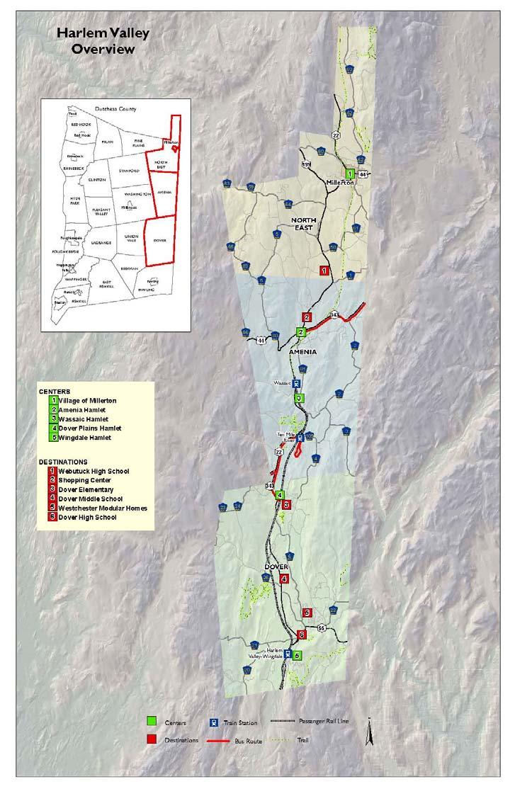
19 Planning Project Examples Hopewell Hamlet Pedestrian Plan Unity Plaza access road Route 9 Land Use & Transportation Study Pedestrian underpass at Marist College Transit Development Plan New LOOP routes and schedules Village of Rhinebeck Sidewalk Study Inventory and improvement strategy CR 93 Corridor Management Plan Traffic analysis and recommendations 19
20 Moving Dutchess Questions about the PDCTC? 20
21 Moving Dutchess Transportation Plan Overview 21
22 Moving Dutchess Mission Statement Provide the resources (funding) and tools (planning) necessary to build and maintain a transportation system that promotes the safe and efficient movement of people and goods in a sustainable manner. 22
23 Moving Dutchess 5 th Long range Transportation Plan for Dutchess County 2040 planning horizon (30 years) Financially constrained Air quality conformity determination statement Public outreach: Summer 2011 (6 meetings) 30 day public comment period: Oct Nov 2011 Council approval: mid Nov
24 Moving Dutchess Guiding Principles 1. Relevant: meet federal and state planning requirements and be relevant to the public, local communities, and decision makers. 2. Sustainable: establish an environmentally and fiscally sustainable way to meet future transportation challenges. 3. Targeted: identify plans and projects to improve the safety, efficiency, and effectiveness of our transportation system. 4. Inclusive: seek input from a wide range of stakeholders and interest groups. 24
25 Moving Dutchess Goals 1. Maintain highways and bridges in a state of good repair. 2. Reduce traffic congestion and increase travel time reliability. 3. Maintain the transit system in a state of good of repair; increase ridership. 4. Increase carpooling and vanpooling. 5. Increase bicycling and walking. 6. Improve safety; reduce transportation related fatalities, injuries, and property damage. 7. Reduce transportation related impacts to the environment. 8. Increase public participation. 9. Improve delivery of federally funded transportation projects. 10. Improve transportation security. 25

26 Moving Dutchess Chapters 1. Introduction 2. Federal, State, and local guidance 3. Regional perspective 4. Demographic overview 5. Transportation & natural resources 6. Planning area overviews 7. Performance monitoring 8. Recommendations & Financial Plan 26
 486-3600 Email: pdctc@co.dutchess.ny.us Internet: http://www.co.dutchess.ny.us/ pdctc.")
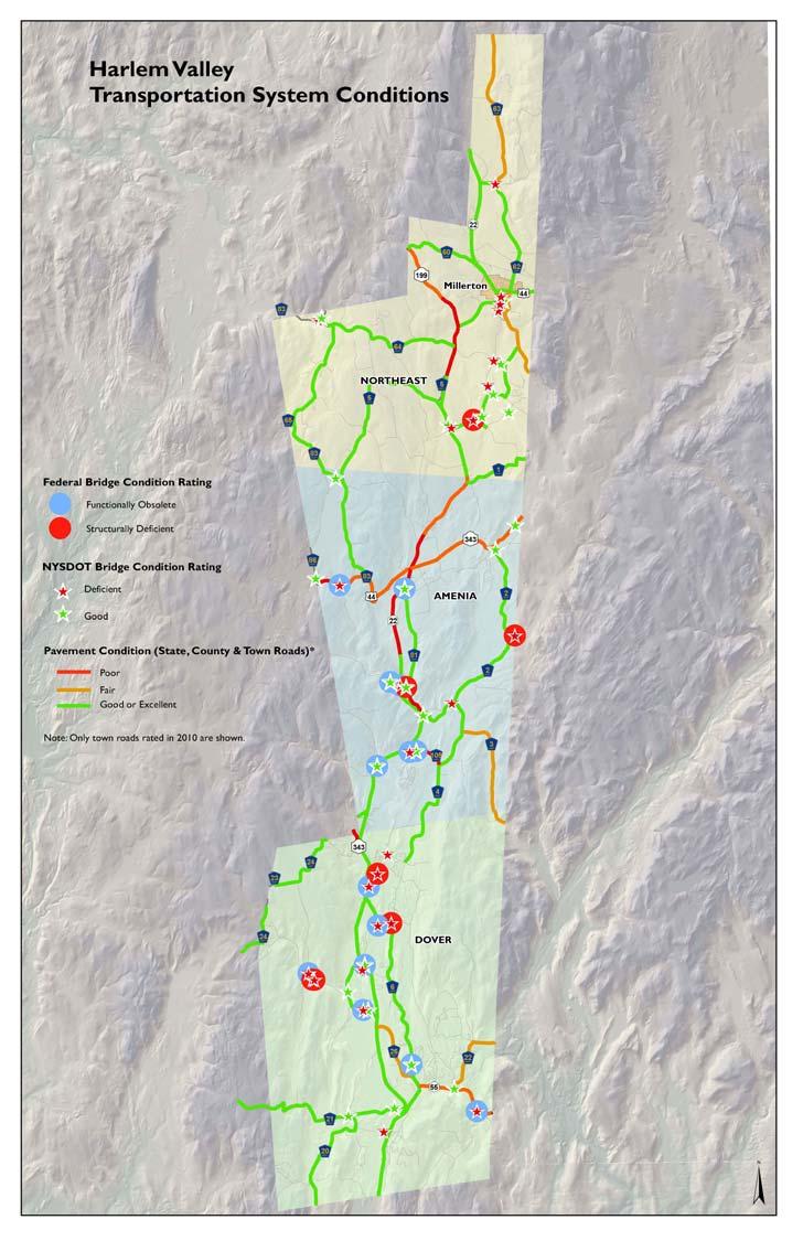
27 Poughkeepsie-Dutchess County Transportation Council 27 High Street, 2nd Floor Poughkeepsie, NY (845) Internet: pdctc.htm 27


28 Moving Dutchess Literature Review Federal Guidance State Guidance PDCTC Studies County Plans Local Comprehensive Plans Transportation Priorities Data Review Demographics System Conditions Natural Resources Outreach Stakeholders Public 28
29 Moving Dutchess County Population & Vehicle Registrations ( ) 300,000 Total Population Registered Vehicles 250, , , ,000 50,
30 Moving Dutchess Harlem Valley Population ( ) Population Percent Change Town of Amenia 4,048 4, Town of Dover 8,565 8, Town of North East 2,077 2, Village of Millerton
31 Environmental Justice (2010) Above Average Minority Populations Above Average Hispanic Populations 31
32 Moving Dutchess Harlem Valley Housing ( ) Housing Units Percent Change Town of Amenia 1,814 2, Town of Dover 3,266 3, Town of North East 1,366 1, Village of Millerton
33 Harlem Valley Major Projects Moving Dutchess Depot Hill Farm, located in Amenia: 122 residential units on Old Route 22. Silo Ridge in Amenia: 669 residential units and hotel and golf course on Route 22. Cricket Valley Energy Power Generation Facility in Dover: 158,000 square feet on Route 22. Knolls at Dover in Dover: 1,376 residential units and 239,000 square feet retail on Route
34 34
35 Moving Dutchess County Unemployment Rate ( )
36 Moving Dutchess Travel Behavior 87% of all trips made by personal vehicle 92% of work trips made by personal vehicle 8½% of all trips made by walking 97% of households have access to a vehicle 68% 69% of workers work in Dutchess County Westchester, NYC, Putnam, Orange, & Ulster areas most popular out of county work destinations 36
37 Moving Dutchess Commuting Patterns (Harlem Valley) Percent of Out of County Workers Town of Amenia Town of Dover Town of North East Village of Millerton 9 19% 23 33% 5 15% 1 17% Source: year American Community Survey Estimate 37
 354 bridges Moving Dutchess")
")
 Multi Use Paths and Trails")
38 County Transportation System Roads & Bridges 2,400 road miles (69% local) 354 bridges Moving Dutchess Transit Service Local Bus (LOOP & Poughkeepsie) Regional Bus Passenger Rail (Amtrak & Metro North) Passenger Ferry Non Motorized Facilities Pedestrian Zones (Cities & Villages) Multi Use Paths and Trails Bicycle Networks 38
39 Road Inventory (County wide) Moving Dutchess NYSDOT Dutchess County Local Other Highway Mileage , Percent of Total Mileage % of State roads in poor condition 2% of County roads in poor condition 39
40 Moving Dutchess Bridge Inventory (County wide) NYSDOT Dutchess County Local NYSBA NPS Other Number of Bridges Percent of Total Number Rated Deficient Percent Deficient Average age of 54 years; 38% built prior to % of all bridges rated as deficient 40
41 County Transit (LOOP Bus) Moving Dutchess Fixed Routes Route A Route B Route C Route D Route E Route F Poughkeepsie Wappingers Falls Fishkill Poughkeepsie Wappingers Falls Beacon Poughkeepsie Hyde Park Rhinebeck Tivoli Poughkeepsie Millbrook Wassaic Dover LaGrange Union Vale Beekman Pawling Beacon Fishkill Hopewell Junction Over 412,000 passengers served in 2010 Dial a Ride and Flex Service Programs (Demand Response) 41
42 Moving Dutchess Transportation Safety (County wide) year Average Fatal/Injury Crashes 2,258 2,118 2,083 2,153 Non Injury Crashes 4,497 4,517 4,558 4,524 Total 6,755 6,635 6,641 6,677 Fatalities crash rate of 0.9 per mile (1.2 statewide) 42% of all crashes occurred between noon 6:00 p.m. 42
43 Moving Dutchess Transportation Safety (Harlem Valley) 2007 Total Fatal & Injury Crashes Year Average Town of Amenia Town of Dover Town of North East Village of Millerton
44 Moving Dutchess Transportation Safety (Harlem Valley) Crash Rate Per Mile Year Average Town of Amenia Town of Dover Town of North East Village of Millerton


45 Moving Dutchess Sidewalks & Trails 435 miles of sidewalks in Dutchess Co. - 25% in City of Poughkeepsie - 21% in Town of Poughkeepsie - 13% in City of Beacon 300 miles of trails (walking, hiking, bicycle) - Dutchess Rail Trail - Harlem Valley Rail Trail - Walkway Over the Hudson 45


46 Moving Dutchess Other Transportation Facilities & Programs Park and Ride lots Newburgh Beacon Ferry Human service agencies Hudson River docks Airports 46
47 Moving Dutchess Natural & Historic Resources Hudson River Wetlands (30,000 acres) Floodplains (50,000 acres) Air quality (ozone) Agricultural Districts (175,000 acres) Highlands & Steep Slopes (Fishkill and Taconic Ridges) Critical Environmental Areas (CEAs) National Register of Historic Places & Districts 47
48 Moving Dutchess Transportation Needs & Priorities 48
49 Identify Transportation Needs Moving Dutchess Highway & Bridge Maintenance Highway Capacity Access Management Traffic Operations Safety Transit Sidewalks/Pedestrian Facilities Multi use Trails Travel Demand Management Planning Studies Short range ( ) Mid range ( ) Long range ( ) 49
50 Scenario 1 Funding Decreases Moving Dutchess Financially Constrained Plan Scenario 2 Funding Constant Scenario 3 Funding Increases Strategic Disinvestment Maintain System Improve System Short range: What can we live without or delay? Mid range: State of Good Repair Long range: Quality of Life 50
51 Moving Dutchess Transportation Needs Review 51
52 Moving Dutchess Review Needs (poster boards) Add unidentified needs (those not listed) 52
53 Moving Dutchess Transportation Priority Exercise 53
54 Moving Dutchess Prioritize Needs (poster boards) Short range ( ) Mid range ( ) Long range ( ) Strategic Disinvestment 54
55 Next Steps 1. Complete public outreach (Jul 2011) 2. Review information (Jul Aug 2011) 3. Complete draft recommendations and financial plan (Aug Sep 2011) 4. Complete Final Draft (Sep 2011) day Public Comment Period (Oct 2011) 6. Council approval (Nov 2011) 55
56 Contact Info Poughkeepsie-Dutchess County Transportation Council 27 High Street, 2nd Floor Poughkeepsie, NY (845) Internet: 56
Moving Dutchess The 2040 Metropolitan Transportation Plan for Dutchess County. Poughkeepsie Dutchess County Transportation Council
 The 2040 Metropolitan Transportation Plan for Dutchess County Poughkeepsie Dutchess County Transportation Council 2012 The 2040 Metropolitan Transportation Plan for Dutchess County, New York Effective
NEW Connections CD TSP CD 199 CD 308 CD 82 CD 376 CD 22 CD 216 CD 292 CD 55 CD 52B CD 9D
 Chapter 3 Transportation users, regardless of mode or Transportation System location, see just one system. Discussions about the transportation system tend to talk in terms of jurisdiction and function,
1.0 INTRODUCTION 1.1 TH 14 WEST STUDY AREA Project Description Functional Classification Purpose of the Project
 1.0 INTRODUCTION 1.1 TH 14 WEST STUDY AREA 1.1.1 Project Description The Trunk Highway (TH) 14 West Corridor is a two-lane roadway approximately 22 miles in length. Located in Nicollet County, the corridor
Executive Summary. NY 7 / NY 2 Corridor
 Executive Summary NY 7 / NY 2 Corridor Transportation and Land Use Study December 2005 Prepared for: Town of Colonie Capital District Transportation Committee Prepared by: Introduction: Land use decisions
Trail Feasibility and Planning Project for Northern Dutchess County, New York
 for Northern Dutchess County, New York Funded in Part by Grants from the Hudson River Valley Greenway, Land Trust Alliance Conservation Partnership Program and the Thomas Thompson Trust 1 STEERING COMMITTEE
South Davis County COMMUNITY SPOTLIGHT
 South Davis County COMMUNITY SPOTLIGHT Davis/SLC Community Connector Bus Rapid Transit line connecting SLC & Davis County RTP Phase 1 Project Generate 3,100 average weekday riders Relieve congestion on
Transportation Projects Quarterly Report. Morrisville Planning Department May 22, 2018
 Transportation Projects Quarterly Report Morrisville Planning Department May 22, 2018 Transportation Improvements Most Common Ways the Town secures transportation improvements: 1. Development 2. Grant
Atlanta BeltLine Corridor Environmental Study. Scoping Meeting August 2008
 Atlanta BeltLine Corridor Environmental Study Scoping Meeting August 2008 What Will We Be Discussing Today? Study Overview - How Did We Get Here? - What Is the Study About? - Who Is Involved? - Where Is
Route 1 Corridor Study
 Route 1 Corridor Study Westbrook, Connecticut A Vision for the Connecticut Shoreline Public Informational Meeting July 28, 2015 Lower Connecticut River Valley Council of Governments Fitzgerald & Halliday,
495/MetroWest Development Compact Plan Citizen Planner Training Collaborative Conference. March 17, 2012
 495/MetroWest Development Compact Plan Citizen Planner Training Collaborative Conference March 17, 2012 Project Process Local and Regional Priority Areas Growth Scenarios Transportation Investment Categories
TOWN OF NEW CASTLE - Master Plan Update
 Our Presentation Today (1) Recap the Master Planning Process To Date (2) Present the Outline of the Master Planning Work Plan (3) Present the Calendar for the Master Plan (4) Outline the scope of a Downtown
Hillsborough County MPO Transit Study. Citizens Team Workshop Wednesday, February 28 th, 2006 Hillsborough Community College - Brandon
 Hillsborough County MPO Transit Study Citizens Team Workshop Wednesday, February 28 th, 2006 Hillsborough Community College - Brandon What is the MPO Transit Study? An effort to look at the full range
Denver Moves: Transit Task Force
 Insert transit picture Denver Moves: Transit Task Force Meeting #8 October 5, 2017 1. Welcome & Introductions Opening remarks and housekeeping Task Force and audience introductions Upcoming events and
CITY OF BEACON NOTICE TO LANDSCAPE ARCHITECTS GENERAL INFORMATION AND REQUEST FOR PROPOSALS
 CITY OF BEACON NOTICE TO LANDSCAPE ARCHITECTS GENERAL INFORMATION AND REQUEST FOR PROPOSALS The City of Beacon (the CITY) is issuing this Request for Proposals (RFP) for the selection of a landscape architect
1.0 Introduction. Purpose and Basis for Updating the TMP. Introduction 1
 1.0 Introduction The Town of Castle Rock is situated between the metropolitan areas of Denver and Colorado Springs, amidst a unique terrain of rolling hills, mesas, ravines, and waterways. Like many Front
List of Priority Projects
 List of Priority Projects Fiscal Years 2019-20 to 2023-24 June 25, 2018 Amended December 17, 2018 Metropolitan Transportation Planning Organization for the Gainesville Urbanized Area List of Priority
The Greenway Compact. is entirely voluntary; respects home rule; and relies on incentives and guidelines, not any state or county requirements.
 The Greenway Compact is entirely voluntary; respects home rule; and relies on incentives and guidelines, not any state or county requirements. GREENWAY GUIDE A5 Protecting the Countryside RURAL ROADS For
DRAFT Subject to modifications
 TREASURE COAST REGIONAL PLANNING COUNCIL DRAFT M E M O R A N D U M To: Council Members AGENDA ITEM 7C From: Date: Subject: Staff September 17, 2010 Council Meeting Commuter Rail Update Resolution of Support
NORTH-SOUTH CORRIDOR STUDY EXECUTIVE SUMMARY. Executive Summary
 Executive Summary Background As congestion continues to affect mobility in the region, the Ozarks Transportation Organization (OTO) is particularly concerned with traffic movement. The North-South Corridor
Conceptual Level Demonstration Project LARRY MCAULIFFE MANAGER, RESEARCH AND EDUCATION NEW YORK METROPOLITAN TRANSPORTATION COUNCIL
 Conceptual Level Demonstration Project LARRY MCAULIFFE MANAGER, RESEARCH AND EDUCATION NEW YORK METROPOLITAN TRANSPORTATION COUNCIL Shared Cost Initiative Transit Supportive Development Transit Supportive
Rappahannock- Rapidan Regional Commission
 Rappahannock- Rapidan Regional Commission Last Updated July 2008 RAPPAHANNOCK-RAPIDAN REGIONAL TRANSPORTATION PLAN The Virginia Department of Transportation (VDOT) and the Rappahannock-Rapidan are partnering
CHAPTER 7: Transportation, Mobility and Circulation
 AGLE AREA COMMUNITY Plan CHAPTER 7 CHAPTER 7: Transportation, Mobility and Circulation Transportation, Mobility and Circulation The purpose of the Transportation, Mobility and Circulation Chapter is to
12/9/2013. HOLLYWOOD/PINES CORRIDOR PROJECT AMPO 2013 Annual Conference October 24, Our Perspective. Broward.
 HOLLYWOOD/PINES CORRIDOR PROJECT AMPO 2013 Annual Conference October 24, 2013 Our Perspective Broward Fort Lauderdale 1 Broward Metropolitan Planning Organization Fort Lauderdale Fort Lauderdale Skyline
REGIONAL TRANSPORTATION COMMISSION OF SOUTHERN NEVADA AGENDA ITEM
 REGIONAL TRANSPORTATION COMMISSION OF SOUTHERN NEVADA AGENDA ITEM Metropolitan Planning Organization [ X ] Transit [ ] Administration and Finance [ ] SUBJECT: PROJECT SELECTION PROCESS FOR TRANSPORTATION
Scaling Up Stormwater Green Infrastructure in the Hudson Valley
 1 Scaling Up Stormwater Green Infrastructure in the Hudson Valley Emily Vail Hudson River Estuary Program, NYS Department of Environmental Conservation NYS Water Resources Institute at Cornell University
BeltLine Corridor Environmental Study
 BeltLine Corridor Environmental Study Citywide Conversation on Transit and Trails April 2, 2009 Agenda & Introductions Introductions Environmental Study Process Overview of the BeltLine Project BeltLine
Planning Roles. Responsibilities
 Lesson 3 Planning Roles & Responsibilities 3-1 Learning Outcomes Identify and describe transportation and land use planning processes Describe the relationships among these processes and how they can be
4-Town Comprehensive Plan DRAFT 7/30/07
 4-Town Comprehensive Plan DRAFT 7/30/07 Acknowledgements ning Committee Town of Harrisburg Norman Roof Randy Nicol Town of Martinsburg Terry Thisse Paul Kelly Town of Montague Jan Bagdanowicz Wendy Perry
Onondaga County Sustainable Streets Project. Onondaga County Planning Federation June 7, Onondaga County Sustainable Streets Project 1
 Onondaga County Sustainable Streets Project Onondaga County Planning Federation June 7, 2012 Onondaga County Sustainable Streets Project 1 Sustainable Streets 1. Introduction to the SMTC 2. Sustainable
Seattle Transit Master Plan
 Seattle Transit Master Plan Seattle City Council Transportation Committee Briefing May 10, 2011 Seattle Department of Transportation Presentation Outline Review of project schedule and goals Review of
Overview of Southwestern Pennsylvania Commission s (SPC) 2040 Long Range Transportation Plan (LRTP)
 2040 Long Range Transportation Plan (LRTP)") Overview of Southwestern Pennsylvania Commission s (SPC) 2040 Long Range Transportation Plan (LRTP) Presented to Pennsylvania Agency Coordination Meeting May 27, 2015 Doug Smith & Ryan Gordon 1 Southwestern
Overview of Southwestern Pennsylvania Commission s (SPC) 2040 Long Range Transportation Plan (LRTP) Presented to Pennsylvania Agency Coordination Meeting May 27, 2015 Doug Smith & Ryan Gordon 1 Southwestern
2. AGENCY COORDINATION AND PUBLIC INVOLVMENT
 2. AGENCY COORDINATION AND PUBLIC INVOLVMENT This chapter discusses the process carried out for conducting agency coordination and public involvement activities. TECHNICAL ADVISORY COMMITTEE A Technical
The Dresden Sustainable Urban Mobility Plan (SUMP)
") The Dresden Sustainable Urban Mobility Plan (SUMP) photo: Frank Fiedler UN-Habitat III Regional Meeting Side-event Sustain and clean mobility for the New Urban Agenda Prague, 16.03.2016 Dipl.-Ing. Frank
The Dresden Sustainable Urban Mobility Plan (SUMP) photo: Frank Fiedler UN-Habitat III Regional Meeting Side-event Sustain and clean mobility for the New Urban Agenda Prague, 16.03.2016 Dipl.-Ing. Frank
Point A Point B Point C Point D. City of Hapeville Public Meeting July 25, 2017
 City of Hapeville Public Meeting July 25, 2017 Fulton County Transit Master Plan Overview Following last year s ¾-cent TSPLOST effort, the Mayors of the 14 Cities outside of Atlanta and the Fulton County
Street Flooding Mitigation Plan KYOVA Interstate Planning Commission. Presented to AMPO National Conference October 18, 2017
 Street Flooding Mitigation Plan KYOVA Interstate Planning Commission Presented to AMPO National Conference October 18, 2017 Saleem Salameh, Ph.D., P.E., M.ASCE Chet Parsons, AICP CTP Agenda: Background
Joint Meeting City Council and the Plan Commission. September 1st, 2015
 Joint Meeting City Council and the Plan Commission September 1st, 2015 1 The City Plan Commission shall recommend a City Plan for the physical development of the City Article IX Section 2 of the City of
AASHTO Board of Directors. Standing Committees (Functional Areas): Finance and Administration. Highway Traffic Safety. Performance.
: Finance and Administration. Highway Traffic Safety. Performance.") AASHTO Board of Directors Executive Committee Standing Committees (Modal): Aviation Standing Committees (Functional Areas): Environment Special Committees: Intermodal and Economic Expansion Highways Finance
AASHTO Board of Directors Executive Committee Standing Committees (Modal): Aviation Standing Committees (Functional Areas): Environment Special Committees: Intermodal and Economic Expansion Highways Finance
Harlem Avenue Corridor Plan: Corridor Planning Across Municipal Boundaries
 Harlem Avenue Corridor Plan: Corridor Planning Across Municipal Boundaries Heather Tabbert, Manager, Local Planning and Programs Division Regional Transportation Authority (RTA) Jen McNeil Dhadwal, Principal
Draft Plan Recommendations
 Draft Plan Recommendations Sponsored by Henry County and the Atlanta Regional Commission T S W TEAM Tunnell-Spangler-Walsh & Associates URS Corporation Marketek Study Area 1,300 acres Includes parts of
North Somerset Council Local Development Framework
 North Somerset Council Local Development Framework Sites and Policies Development Plan Document Evidence Paper Re-opening Portishead Railway Line and Options for the Location of Portishead Railway Station
Sustainability, Health, Safety, Recreation & Open Space Working Group August 3, 2017
 Sustainability, Health, Safety, Recreation & Open Space Working Group August 3, 2017 DOWNTOWN OAKLAND SPECIFIC PLAN WELCOME Sustainability, Health, Safety, Recreation & Open Space Working Group Social
I-84 Hartford Project Open Planning Studio #12. April 25, 2017
 I-84 Hartford Project Open Planning Studio #12 April 25, 2017 Meeting Agenda 1. I-84 Hartford Project alternatives update 2. Multimodal station area planning 3. I-84 / I-91 Interchange Study coordination
Sacramento Area Council of Governments (SACOG)
") Sacramento Area Council of Governments (SACOG) The Blueprint Vision The SACOG Board of Directors adopted the Preferred Blueprint Scenario in December 2004, a bold vision for growth that promotes compact,
Sacramento Area Council of Governments (SACOG) The Blueprint Vision The SACOG Board of Directors adopted the Preferred Blueprint Scenario in December 2004, a bold vision for growth that promotes compact,
1.0 PROJECT PURPOSE AND NEED
 1.0 PROJECT PURPOSE AND NEED The FasTracks Plan includes the extension of the Central Corridor from its current terminus at 30th/Downing to a connection to the East Corridor commuter rail service planned
RESOLUTION NO. R Refining the route, profile and stations for the Downtown Redmond Link Extension
 RESOLUTION NO. R2018-32 Refining the route, profile and stations for the Downtown Redmond Link Extension MEETING: DATE: TYPE OF ACTION: STAFF CONTACT: Capital Committee Board PROPOSED ACTION 09/13/2018
Town of Peru Comprehensive Plan Executive Summary
 Town of Peru Comprehensive Plan Executive Communities that plan grow by choice, not by chance. A plan makes growth thoughtful, understandable, and predictable. A plan shows that a community is managing
Green Infrastructure Codes and Ordinances
 1 Green Infrastructure Codes and Ordinances Emily Vail Hudson River Estuary Program NYS Department of Environmental Conservation New York State Water Resources Institute at Cornell University March 19,
Green Infrastructure Basics
 1 Green Infrastructure Basics Emily Vail Hudson River Estuary Program NYS Department of Environmental Conservation New York State Water Resources Institute at Cornell University December 8, 2016 2 Presentation
Climate Smart Communities Green Infrastructure Case Studies
 New York State Water Resources Institute Climate Smart Communities Green Infrastructure Case Studies Emily Vail Hudson River Estuary Program NYS Department of Environmental Conservation Cornell University
Transportation. Strategies for Action
 Transportation A major priority for the Overlake Neighborhood is to develop a multimodal transportation system. To achieve this system, a balance has to be found among travel, circulation and access needs;
Congestion Management Safety Plan. Michael Corbett State Program Administrator September 2017
 Congestion Management Safety Plan Michael Corbett State Program Administrator September 2017 Agenda Topic 1 What is the Congestion Management Safety Plan (CMSP)? 2 Relevance to Congestion Investments 3
1.0 Circulation Element
 5/9/18 1.0 Circulation Element 1.1 Introduction As growth and development occur in Apache County, enhancements to its circulation system will be necessary. With time, more roads will be paved and air and
TRANSPORTATION ELEMENT GOALS, OBJECTIVES, AND POLICIES
 TRANSPORTATION ELEMENT GOALS, OBJECTIVES, AND POLICIES GOAL 2 The City shall provide a safe, convenient, effective, and energy efficient multimodal transportation system which is coordinated with the Future
CITY COUNCIL AGENDA REPORT
 CITY COUNCIL AGENDA REPORT Subject: COUNCIL MOTION LRT ALIGNMENT REMOVAL FROM THE TRANSPORTATION MASTER PLAN On February 10, 2016 Councillor Hughes provided notice in accordance with Section 23 of Procedure
PD&E STUDY SR 9/I-95 FROM SOUTH OF SR 870/COMMERCIAL BOULEVARD TO NORTH OF CYPRESS CREEK ROAD FM # ETDM 14222
 PD&E STUDY SR 870/COMMERCIAL BOULEVARD TO NORTH OF CYPRESS CREEK ROAD FM # 435808-1-22-02 ETDM 14222 WELCOME TO THE KICK-OFF MEETING May 24, 2016 1 1 2 3 4 5 6 PLANNING PROJECT DEVELOPMENT AND ENVIRONMENT
Robbinsdale LRT Station. CDI Development Guidelines. August Overview
 Robbinsdale LRT Station August 2018 Overview The City of Robbinsdale may have the coolest opportunity site along the 13 mile stretch of the Bottineau LRT corridor / Blue Line extension. Located a block
1.0 INTRODUCTION. EIS for Improved Station Access and Additional Parking at the North White Plains Station Final Scoping Information Document
 EIS for Improved Station Access and Additional Parking at the North White Plains Station 1.0 INTRODUCTION 1.1 Summary The FTA, in cooperation with the Metropolitan Transportation Authority (MTA) Metro-North
CHAPTER 1 Introduction
 CHAPTER 1 Introduction From sea to summit, Lane County covers almost 4,800 square miles of diverse Oregon landscape. Stretching from the Pacific Ocean through the Coastal Range, the Willamette Valley to
MORRISVILLE TRANSPORTATION PLAN TOWN COUNCIL PRESENTATION AUGUST 22, 2017
 TOWN COUNCIL PRESENTATION AUGUST 22, 2017 SCENARIO PLANNING CORRIDORS Town Hall Drive Baseline + 2 McCrimmon Parkway Baseline + 2 NC 54 Baseline + 2 7 subregion model runs determining carrying capacity
12 AMENDMENT NO. 149, TOWN OF MARKHAM HIGHWAY 404 NORTH SECONDARY PLAN
 12 AMENDMENT NO. 149, TOWN OF MARKHAM HIGHWAY 404 NORTH SECONDARY PLAN The Planning and Economic Development Committee recommends the adoption of the recommendation contained in the following report August
Northwest commuter rail station US 36 BRT. Westminster Station
 Northwest commuter rail station Westminster Station US 36 BRT Westminster Center US 36 & Church Ranch Broomfield Flatiron/96 th St. US 36 & McCaslin Table Mesa Boulder Junction 13-month effort that will
Ann Arbor Intermodal Station Environmental Review
 Ann Arbor Intermodal Station Environmental Review Park Advisory Commission September 19, 2017 AGENDA 1. Project Update 2. Draft Environmental Assessment 3. Draft Preferred Alternative 4. Next Steps 5.
TOD 101 CREATING LIVABLE COMMUNITIES WITH TRANSIT
 1 CREATING LIVABLE COMMUNITIES WITH TRANSIT What are transit Centered Communities? Benefits of Partnerships to Support and Implement What You Will Learn Portland s Pearl District Your Trainers Today Catherine
Route 110 Alternatives Analysis
 Route 110 Alternatives Analysis Public Meeting #1 December 15, 2014 Source: Town of Babylon Agenda Welcome/Introduction Hon. Antonio A. Martinez Deputy Supervisor, Town of Babylon Update on East Farmingdale
Comprehensive Plan & Station Area Zoning
 Village of Tarrytown Comprehensive Plan & Station Area Zoning Public Workshop November 5, 2017 Warner Library WXY architecture + urban design Pace University - Land Use Law Center George M. Janes & Associates
PREPARED FOR: PLATTEVIEW ROAD CORRIDOR STUDY EXECUTIVE SUMMARY
 PREPARED FOR: PLATTEVIEW ROAD CORRIDOR STUDY EXECUTIVE SUMMARY SEPTEMBER 2016 Introduction The Platteview Road Corridor Study was led by the Metropolitan Area Planning Agency (MAPA) with assistance from
Laberge Group. Town of Coeymans. Draft Comprehensive Plan. Overview of Planning Process
 Draft : Presentation of Goals & Strategies Laberge Group Benjamin H. Syden, A.I.C.P., E.D.P Director in Charge Nicole Allen, A.I.C.P. Senior Planner Anjali Malhotra Planner Presentation Outline Introductions
MassDOT Highway ACEC State Markets Conference April 4, Jonathan Gulliver, Highway Administrator
 MassDOT Highway ACEC State Markets Conference April 4, 2019 Jonathan Gulliver, Highway Administrator About MassDOT Highway 9,561 Lane Miles of Interstate, Numbered Routes, and Toll Roads 60% of all trips
Southeast Extension to RidgeGate Parkway Scoping Booklet
 Southeast Extension to RidgeGate Parkway Scoping Booklet PUBLIC SCOPING MEETING SCHEDULE Public Scoping Meeting Wednesday, November 2, 2011 6:00pm to 7:30pm City of Lone Tree Recreation Center Willow Room
County - New York Resource & Relocation Guide
 Dutchess County - New York 2018-2019 Resource & Relocation Guide Published By: In association with Sales Coordinator: Dean Zehr Ad Designer: Teri Burkitt Book Designer: Linda Swindler www.skylinepub.net
SW Ecodistrict A VISION PLAN FOR A MORE SUSTAINABLE FUTURE June 25, 2013
 Urban Land Institute The Past, Present and Future of Sustainable Urbanism in Southwest DC SW Ecodistrict A VISION PLAN FOR A MORE SUSTAINABLE FUTURE June 25, 2013 Study Area The National Mall DOE FAA FAA
REVIEW AND EVALUATION OF REGIONAL LAND USE
 REVIEW AND EVALUATION OF REGIONAL LAND USE AND TRANSPORTATION SCENARIOS #220831 Environmental Justice Task Force October 7, 2014 VISION 2050 Process Development of Guiding Vision for Land Use and Transportation
The Village of Sugar Grove, in partnership with Kane County, the Illinois Department of Transportation, and the Illinois Tollway welcomes you to the
 The Village of Sugar Grove, in partnership with Kane County, the Illinois Department of Transportation, and the Illinois Tollway welcomes you to the first Public Meeting for the proposed interchange improvement
A New Plan For The Calgary Region June calgary.ca call 3-1-1
 A New Plan For The Calgary Region June 2009 calgary.ca call 3-1-1 Introduction Since January 2006, The City of Calgary has been actively participating with the member municipalities of the Calgary Regional
BeltLine Corridor Environmental Study
 BeltLine Corridor Environmental Study Joint TAC and SAC Meeting December 8, 2008 What We Will Discuss Today Outreach and Agency Coordination Scoping Results Existing Conditions Historical and Archeological
Longmeadow Parkway Fox River Bridge Corridor. August 6, 2015
 Longmeadow Parkway Fox River Bridge Corridor August 6, 2015 Longmeadow Parkway Bridge Corridor 5.6 miles from Huntley Road to IL 62 Unique municipal/county/state/federal partnership Links Randall Road
Worcester Regional Mobility Study Technical Committee Meeting 2 August 26, 2008
 Worcester Regional Mobility Study Technical Committee Meeting 2 August 26, 2008 1 TechnicalCommittee Meeting2 Framework/StudyArea Refinement August 26, 2008 10:00 AM 12:00 PM Central Massachusetts Regional
New Westminster Downtown Parking Strategy Public Open House #1 September 13, 2012
 New Westminster Downtown Parking Strategy Public Open House #1 September 13, 2012 The City is preparing a strategy for parking in Downtown New Westminster. The study team and a group of key stakeholders
Streets, Connectivity & Built Environment Working Group August 2, 2017
 Streets, Connectivity & Built Environment Working Group August 2, 2017 DOWNTOWN OAKLAND SPECIFIC PLAN WELCOME Streets, Connectivity & Built Environment Working Group Social Equity Meeting August 2, 2017
Port Credit Local Advisory Panel October 20 th Meeting
 Port Credit Local Advisory Panel October 20 th Meeting Focus Of This Evening s Meeting: 1. Hurontario Main Street Higher Order Transit Study 2. Port Credit Mobility Hub & GO Station Parking Structure Study
City of Poughkeepsie Waterfront Redevelopment Strategy. Poughkeepsie Waterfront Redevelopment Strategy
 City of Poughkeepsie Waterfront Redevelopment Strategy Poughkeepsie Waterfront Redevelopment Strategy City of Poughkeepsie Prime Assets: Major Waterfront Advantages: - Central City of the Hudson River
ROBBINSDALE LRT STATION CDI DEVELOPMENT GUIDELINES
 August 2018 OVERVIEW The City of Robbinsdale has a prime-opportunity site in the middle of the 13 mile stretch of the Bottineau LRT corridor / Blue Line extension. Robbinsdale offers a prominent, vital,
ITS Concept Development Activity Descriptions
 ITS Concept Development Activity Descriptions October 2015 Procedures are subject to change without notice. Check the NJDOT website to ensure this is the current version. Table of Contents Concept Development
6. Consistency with Local Plans
 6. Consistency with Local Plans 6.1. Chapter Overview 6.1.1. Introduction This section presents the goals, objectives and policies of municipal, county and state planning entities, as well as known development/redevelopment
Gary & Regional Investment Project. October 27, Creating Tomorrow Today Comprehensive Regional Plan - NIRPC
 Creating Tomorrow Today 2040 Comprehensive Regional Plan Gary & Regional Investment Project October 27, 2010 Creating Tomorrow Today - 2040 Comprehensive Regional Plan - NIRPC What is NIRPC? - Northwestern
Rt 29 Solutions Hydraulic Planning Advisory Panel. September 28, 2017
 Hydraulic Planning Advisory Panel September 28, 2017 Agenda Item 1: Introductions Hydraulic Planning Advisory Panel members Technical Team members 2 Agenda item 2: Public Interaction and Feedback Live
Green Infrastructure The Indianapolis Greenways Connection
 Green Infrastructure The Indianapolis Greenways Connection Fewer things in the transportation industry today make better since than combining the needs for pedestrian and bike trails with the need to locate,
SAN RAFAEL GENERAL PLAN 2040 INTRODUCTION AND OVERVIEW
 SAN RAFAEL GENERAL PLAN 2040 INTRODUCTION AND OVERVIEW Steering Committee Presentation February 14, 2018 Purpose of General Plan Guide land use and development decisions Coordinate transportation, infrastructure,
CITY OF CHARLOTTESVILLE, VIRGINIA CITY COUNCIL AGENDA
 CITY OF CHARLOTTESVILLE, VIRGINIA CITY COUNCIL AGENDA Agenda Date: December 16, 2013 Action Required: Adoption of Resolution Presenter: Staff Contacts: Title: James E. Tolbert, AICP, Director of NDS James
Regional Freshwater Issues: Stormwater Management and Green Infrastructure April 16, 2011
 Regional Freshwater Issues: Stormwater Management and Green Infrastructure April 16, 2011 New York State Water Resources Institute Emily Vail Hudson River Estuary Program New York State Department of Environmental
S A C R A M E N T O C O U N T Y JACKSON HIGHWAY & GRANT LINE EAST VISIONING STUDY
 JACKSON HIGHWAY & GRANT LINE EAST S A C R A M E N T O C O U N T Y P L A N N I N G D E P A R T M E N T SUMMARY AND WORKBOOK November 19, 2008 History of the Visioning Study Sacramento County has two growth
Seneca Meadows. Block 4 Locate office, technology, and medical development adjacent to I Screen views of garage structures from I-270.
 Seneca Meadows Seneca Meadows has an industrial park in its southern end and a mixed-use employment area planned for the north end. The district benefits from extensive I-270 visibility, stream valley
Secrest Short Cut and Monroe Expressway Small Area Plan AUGUST 29, 2018
 Secrest Short Cut and Monroe Expressway Small Area Plan AUGUST 29, 2018 Background and Process Monroe Expressway will be open by the end of 2018 Union County and Indian Trail identified a need to revisit
Attachment 1 PFAC Resolution #394 of December 4, 2014
 Attachment 1 PFAC Resolution #394 of December 4, 2014 Sections of Plan 2040 updated to reflect current status of the Nassau Hub study (revisions attached): Chapter 1, page 1 8 Chapter 1, page 1 19 Chapter
TOWN COUNCIL / PLANNING COMMISSION
 Workshop #3 TOWN COUNCIL / PLANNING COMMISSION January 20, 2011 Consultant Team In Attendance Tonight BMS Design Group Nevada City and San Francisco Michael Smiley, AICP, ASLA Partner-in-Charge Nancy L.
Introducing the Main Street Strategic Toolbox
 Ulster County Main Streets: A Regional Approach Ulster County Planning Department, 244 Fair Street, Kingston NY 12401 Why do we take a regional approach to Main Streets? There are many different approaches
The Illinois Department of Transportation and Lake County Division of Transportation. Route 173, including the Millburn Bypass
 The Illinois Department of Transportation and Lake County Division of Transportation welcome you to this Public Hearing for U.S. Route 45 from Illinois Route 132 to Illinois Route 173, including the Millburn
2035 General Plan Update and Belmont Village Specific Plan. Joint Study Session with the City Council and Planning Commission April 12, 2016
 2035 General Plan Update and Belmont Village Specific Plan Joint Study with the City Council and Planning Commission April 12, 2016 Agenda 1. Welcome and Introductions 2. General Plan Update Status of
Planning & Zoning Board Meeting. DRAFT Comprehensive Transportation Plan Update, February 23, 2018 version
 Planning & Zoning Board Meeting DRAFT Comprehensive Transportation Plan Update, February 23, 2018 version May 10, 2018 Overview Overview of Agency Comments Overview of proposed modifications to the Draft
Ryoko Iizuka Finance, Economics and Urban Department
 THE WORLD BANK www.worldbank.org/eco2 Eco 2 Cities Guide Ryoko Iizuka Finance, Economics and Urban Department 09.12.2011 1 Challenge: How? The 350 page Eco 2 Book elaborates on the principles, methods