RESOLUTION OF THE PLANNING BOARD OF THE TOWNSHIP OF SOUTH BRUNSWICK 2007 MASTER PLAN REEXAMINATION
|
|
|
- Harry Dean
- 5 years ago
- Views:
Transcription


1 MASTER PLAN REEXAMINATION REPORT 2007 PREPARED BY SOUTH BRUNSWICK DEPARTMENT OF PLANNING
2 RESOLUTION OF THE PLANNING BOARD OF THE TOWNSHIP OF SOUTH BRUNSWICK 2007 MASTER PLAN REEXAMINATION WHEREAS, in compliance with N.J.S.A. 40:55D-89, the Planning Board has held a public meeting to obtain comments for its 2007 Master Plan Reexamination Report; and WHEREAS, these comments have been considered by the Planning Board and included in a report, adopted November 8,2007; and WHEREAS, this report includes recommendations for changes to the Master Plan, and to the development regulations and administrative procedures of the Township of South Brunswick; and WHEREAS, the public hearing was held on November 8, 2007 for the purpose of adopting said 2007 Master Plan Reexamination Report; NOW, THEREFORE, BE IT RESOLVED by the Planning Board of the Township of South Brunswick on this 28 th day of November, 2007, that the Board does hereby approve the aforementioned 2007 Master Plan Reexamination Report, and hereby authorize the Director of Planning to forward copies to the Township Council, Township Manager, Township Clerk and the Planning Department of the County of Middlesex. This is to certify that the foregoing is a true copy of a Resolution adopted by the South Brunswick Township Planning Board at a regular meeting held on November 28, Master Plan Reso.doc
3 2007 MASTER PLAN REEXAMINATION Township of South Brunswick Middlesex County, New Jersey Public Hearing November 8, 2008 Resolution Adopted November 28, 2007 Prepared by The Township of South Brunswick Planning Board With assistance from 2007 Master Plan Subcommittee South Brunswick Planning Department Township Officials Frank Gambatese, Mayor Carol Barrett, Deputy Mayor Joe Camarota, Councilman Charles Carley, Councilman Chris Killmurray, Councilman Matthew U. Watkins, Township Manager Donald Sears, Director of Law David Samuel, Township Engineer Barbara Nyitrai, Municipal Clerk Linda Dougherty, Deputy Clerk Planning Board Robert Southwick, Chairman* Jo Hochman, Vice Chair * Charlotte Camarota Charles Carley, Councilman Honorable Frank Gambatese, Mayor* William Grober Barry Nathanson Paul Prodromo Debbie Roedel* Mahesh Shah (1) Elizabeth Meyers (2) (1,2 Alternate Members) * - Member of 2007 Master Plan Subcommittee Benjamin S. Bucca, Jr., Esq., Board Attorney
4 f Planning Department Staff Craig Marshall, Director of Planning Bryan Bidlack, Assistant Planner Elena Boundina, GIS Specialist Joseph Pawlak, Zoning Officer Brian Sullivan, Planning Assistant Betty Selingo, Administrative Secretary Tammy Scimone, Secretary II The original of this report was signed and sealed in accordance ~rr04t. Craig T. arshall, AICP; P.P. #4110
5 INTRODUCTION Incorporated herein is the Master Plan Reexamination Report for the Township of South Brunswick as required and defined by the New Jersey Municipal Land Use Law (N.J.S.A. 40:55D-89). This section of the Municipal Land Use Law (M.L.U.L.) requires municipalities to review and evaluate their master plan and development regulations every six (6) years. The Township of South Brunswick adopted a comprehensive Master Plan in December of Section A of this report outlines the goals and objectives that were established in the 2001 Master Plan. Section B and C review changes that have occurred in the Township and the State since the adoption of the 2001 Master Plan. Section D includes the recommended amendments to the Master Plan and Zoning Ordinance changes. PERIODIC REEXAMINATION REQUIREMENTS The New Jersey Municipal Land Use Law specifically states that the Reexamination Report contain the following. The major problems and objectives relating to land development in the municipality at the time of the last reexamination report. The extent to which such problems and objectives have been reduced or have increased subsequent to such date. The extent to which there have been significant changes in the assumptions, policies and objectives forming the basis for the master plan or development regulations as last revised, with particular regard to the density and distribution of population and land uses, housing conditions, circulation, conservation of natural resources, energy conservation, collection, disposition and recycling of designated recyclable materials and changes in State, county and municipal policies and objectives. The specific changes recommended for the master plan or development regulations, if any, including underlying objectives, policies standards, or whether a new plan or regulations should be prepared. The recommendations of the planning board, concerning the incorporation of redevelopment plans adopted pursuant to the Local Redevelopment and Housing Law P.L.1992,c. 79(C.40A:12A-1 et al.) into the land use plan element of the municipal master plan, and recommended changes, if any, in the local development regulations necessary to effectuate the redevelopment plans of the municipality. 1
6 A. THE MAJOR PROBLEMS AND OBJECTIVES RELATED TO LAND DEVELOPMENT IN THE TOWNSHIP OF SOUTH BRUNSWICK AT THE TIME OF THE ADOPTION OF THE LAST MASTER PLAN. The 2001 Master Plan listed the following goals and objectives, which formed the basis for the plans, policies, statements and proposals of the Master Plan. The 2001 Master Plan was adopted by the South Brunswick Township Planning Board on December 5, I. Land Use Plan Element A. Residential GOAL: Protect and enhance the residential character of the Township. Avoid conflicting land uses and create buffers between residential and nonresidential uses. Continue and augment land use policies that reduce residential densities in appropriate areas and preserve open space and critical environmental features. OBJECTIVES: 1. Incompatible land uses that have existed in residential areas should be eliminated or adequately buffered and separated from residential uses. 2. Residential uses should be separated from roads that carry primarily non-residential traffic loads. 3. In wooded areas, residential uses should be clustered in order to preserve woodlands and enhance residential development; rural residential areas should be developed under conventional zoning. 4. Residential density concentrations should be based on adequate consideration of facilities, utilities and transportation. 5. Continued recognition of the existing villages of Kendall Park, Franklin Park, Kingston, Monmouth Junction, and Dayton and the existing hamlets of Little Rocky Hill, Cottageville, Fresh Ponds and Deans. 6. Improvement and maintenance of the existing housing stock in the Township, as per the Property Maintenance Code. 7. Cluster development policy should be clarified, and if deemed appropriate, should be encouraged to preserve open space and where feasible, farmland; preserve environmentally sensitive areas, specially woodlands and stream corridors; and create village and hamlet scale development. 8. Exclude future residential uses along Route 1 to avoid a built-up appearance and to shield residential uses from the impact of high traffic arterial roads. 2
7 9. Buffering and screening requirements must be provided between residential and non-residential uses with particular attention paid to screening noise and lighting. Buffering requirements must be increased between Route 1 vacant and non-residential lands and the Brunswick Acres area; and between the Route 27 vacant commercial Land and Brunswick Acres area. 10. Buffering and screening requirements must be provided between residential areas and major transportation routes (i.e. New Jersey Turnpike, Routes 27, 1, 130, 522, Northumberland Way, Arterial Way, Deans-Rhode Hall Road and railroads). To the extent possible, new or expanded roadways shall not be constructed through residential areas. The distance of dwellings from the road, however, should be varied according to the function of the roadway. Any future residential development should not be bisected by a major road. The location of common facilities (i.e. recreation complex) should be done in a manner so as not to lead to a potential conflict between pedestrians and vehicles. 11. Provisions are required to provide greater measures of safety and to reduce potential for loss of life and property adjacent to utility corridors (i.e. pipelines, PSE&G, JCPL). This applies to residential and public facilities especially. 12. The Zoning Board of Adjustment reports have raised issues yet to be addressed: the Route 27 corridor should be reexamined in light of the many non-residential uses that exist as non-conforming uses (1987); the home/business occupation policy needs clarification (1988, 1989). 13. Residential densities should be reduced Township-wide. 14. Encourage additional farmland preservation, especially in the agricultural development areas. B. Villages GOAL: Preserve and enhance the character and sense of place of individual villages and hamlets. Provide protection by using sensitive planning practices. OBJECTIVES: 1. Village character should be enhanced. 2. Architectural design standards are needed to maintain scale and historic character. 3. Sidewalks should be provided to villages from outlying residential areas, and within the village itself. 4. Commercial uses should be permitted along Main Street, Kingston only. 5. Little Rocky Hill and Franklin Park should be identified as hamlets. 6. A Main Street aspect of all villages should be enhanced. Encourage 3
8 mixed uses including commercial, residential, employment, day care, etc. 7. Make the uniqueness of each village or hamlet enhance the totality of South Brunswick. 8. Establish appropriate centers and environs for the villages and hamlets. C. Commercial OBJECTIVES: 1. A variety of commercial complexes and uses should be planned to meet varying needs, i.e. neighborhood, retail, highway and local service professional. 2. The various commercial uses should not conflict with industrial and residential uses, but be compatible with them. 3. Commercial uses should not be scattered, but located in consolidated places, so circulation and public transportation can be effectively provided. 4. Commercial and office uses along Route 27 in Kendall Park and Franklin Park areas are appropriate, but buffering and screening to adjacent residential areas must be provided as required. 5. Commercial and office uses along Route 1 are appropriate, but buffering and screening to adjacent residential areas must be provided as required. 6. Some zoning recommendations adopted in the 1988 and 1991 Master Plan amendments have not been implemented (i.e. Kingston Flower Shop, Fresh Ponds Executive Apartments, affordable housing site on Route 27 between Gateway Boulevard and Alston Road). 7. Encourage reuse of vacant non-residential space. D. Employment (Industrial) OBJECTIVES: 1. Major arterial roads and railroads should be directly available to industrial sites. 2. Utilities, such as sewer, water and electric should be available. 3. Sufficient land should be provided to allow for expansion of industrial sites. 4. Residential uses opposite or near these uses should be buffered and screened as per the existing ordinance. 5. Consideration should be given to environmentally sensitive areas when designing developments in Employment Center areas. The environment should not be impaired by the development of ratables. 6. Discourage industry that could pollute the environment. 7. Industries which have low water use should be encouraged. 4
9 II. Housing Plan Element GOAL: Provide for a variety of housing choices through the implementation of South Brunswick s affordable housing obligation as follows: OBJECTIVES: 1. Modification of standards in the development regulations ordinance which inhibit the production of lower cost housing, while retaining all those standards necessary for the protection of the public health, safety and welfare. 2. Encourage the production of subsidized housing and least cost housing, in accordance with the adopted housing plan. 3. Encourage the construction of affordable housing in or near built areas and as convenient as possible to public transportation, employment, shopping and community facilities. 4. Encourage the preservation of existing housing, particularly giving attention to the older established neighborhoods. 5. Encourage the development of assisted care, congregate care, nursing home usage and provision for same in Township. 6. Encourage adequate affordable housing for low and moderate income families (including senior citizens) in conformance with the approved housing plan. III. Circulation Plan Element GOAL: Encourage the development of a safe, practical and efficient circulation system throughout the Township. OBJECTIVES: 1. Provision should be made for inter- and intra-township traffic movement. 2. Local traffic should be separated, as much as possible, from through traffic. 3. Provision for better access to the various land use elements should be made. 4. Safety and efficiency for traffic should be a constant parameter for circulation design. 5. Provision should be made for a variety of modes of transportation, including pedestrian, vehicular, equestrian, cycling and public transportation(bus). 6. Adequate separation and linkages between various transportation modes should be made. 7. Roadways should be carefully designed to handle necessary volumes; however, they should not be over-designed. 8. Sidewalks should be installed along roads to link residential areas to 5
10 recreational facilities, schools and commercial locations. Where this cannot be done through the development review requirements, it should be done as a capital project, particularly to provide access to schools. 9. Improvement is needed at the Ridge and New Road, and Ridge and Stouts Lane intersections in Monmouth Junction. 10. Improvement plans for Route 1 crossings should include provisions for pedestrian and bike traffic. 11. Georges Road should be a light traffic street to discourage truck traffic. 12. If the need for a train station develops in the future, the Planning Board will, after a thorough impact study, reevaluate the issue. 13. Pedestrian crossings should be provided on Route 27 at Heathcote Brook Road. 14. Any future Exit 8B on the New Jersey Turnpike should not be located at Davidsons Mill Road. 15. Route 1 should be widened and include circulation to all east-west roads. 16. Sand Hills Road should not be widened. 17. Bike paths should be designed into all projects. They should be built as soon as possible with the private development, or as capital projects. 18. Establish bikeways as both recreational facilities and transportation routes. 19. Density bonuses for infrastructure are not recommended, and new methods of funding infrastructure such as capital programs and DOT funding should be considered. 20. Arterial and collector roadways should not bisect residential development, but where unavoidable, community facilities/recreation areas should be located on both sides of the roadway. Also, greater building setbacks and mitigation of impacts should be required. 21. Access of major crossroads to Route 1 should provide good design for vehicular connections. IV. Utilities Plan Element GOAL: Allow the improvement and expansion of the Township s utilities infrastructure to ensure adequate service for present and future development in accordance with the Master Plan land use policy. OBJECTIVES: 1. Drainage problems created by development must be avoided. 2. Public water service should be provided to all properties in South Brunswick Township. Priority should be given to those areas with failing private systems and in other areas of potential pollution problems. 3. Rationing use of water should be avoided. 4. The wastewater management plan should be amended to conform to 6
11 this Master Plan and the State Development and Redevelopment Plan. V. Community Facilities Element GOAL: Plan for future community facilities in order to accommodate anticipated population growth and to serve the Township s residents as follows: OBJECTIVES: 1. Facilities should be convenient to serve the residents of the Township. 2. Facilities should provide a full range of services to persons of all socioeconomic backgrounds. 3. For the residents of the Township, facilities should promote the health, safety and welfare for the municipality. 4. Land should be purchased now for future municipal use. VI. Park, Open Space and Recreation Element GOAL: Provide for adequate parks, open space and recreational facilities for present and future population through a comprehensive recreation plan that includes the following: OBJECTIVES: 1. Recommended capital improvement program for each existing park facility to serve the recreational needs of the Township through 2001 and the future population growth through Encourage the acquisition of additional park and open space land. Additional acquisitions may either be new sites or sites adjacent to parks, schools or presently owned Township, County or State property. Promote the creation of green links which connect public lands to enhance recreational quality and user enjoyment. 3. Strive to design, construct and maintain year-round quality recreation and cultural facilities at existing or future park sites that better serve an increasing Township population. Sound site planning with respect for wet areas and woodlands will aid in good parkland utilization and eliminate the cost of relocating facilities. 4. Combine open space in proposed residential development with those on adjacent properties, with the homeowners association responsible for the maintenance of areas in their development. The Township may accept ownership where the land connects to Township parks, schools, open space or linear connections, unique features or is of significant value to the community. 5. Establish a sense of pride in the park and cultural facilities through community involvement via league sports, clubs, neighborhood-adopta-park programs, and cultural events. Clean, well-maintained parks, nature trails and picnic groves will foster citizen support and community pride. 7
12 6. Continue to improve the quality of recreation and cultural facilities on parklands while establishing a sense of park identity in the eyes of Township residents. The goal can be achieved in part through the use of new park signs, wood fencing, bollards, and landscaping as well as new playground equipment and park structures. All these can improve visual aesthetics and citizen recognition of their neighborhood or community parks. 7. Encourage continued cooperation with the Board of Education in the use of school buildings, play fields and tennis courts to expand programmed activities and serve a great number of Township residents. 8. Establish both service and police access to all existing and future parks, trails and open space lands. 9. Control public access with wood bollards, fences and gates to reduce damage by trail bikes and autos. 10. Review development applications to ensure adequate recreation facilities are constructed to serve the new populations being created. 11. Promote sound engineering and architectural design standards for all improvements including storm water detention basins and landscaping to ensure proper layout and construction of recreation facilities of high quality and lasting value. 12. Increase recreation facility use by all age groups through the construction of rest rooms, improved vehicular access with parking, facilities designed with the wide age span (from tots to seniors) of the residents in mind. 13. Establish linear parks along stream corridors, on abandoned rail lines and along utility easements for the creation of hiking paths or bikeways which connect parks and schools to population and employment centers. Bikeways should serve as both recreational facilities and transportation routes. 14. A public pool (indoor or outdoor), and golf course/driving range are desirable recreation facilities. 15. Facilities for tots and younger children should be neighborhood oriented. 16. Parks should be designed with safety in mind. 17. Reichler Park should have access from Kingston Lane assuming this goal may be achieved without traversing wetlands or the library parking lot. 18. Standards are needed for type and size of recreation facilities in private developments. VII. Conservation Plan Element GOAL: Preserve and protect environmentally sensitive lands and natural resources through the Conservation Plan by the following methods: 8
13 OBJECTIVES: 1. Linkages, including but not limited to bikeways, pedestrians paths and greenways should be established between parks. 2. School facilities should be nearby parks wherever possible, but should not encroach on or cut down on park acreage. 3. The natural environment should be maintained and enhanced. 4. Future acquisition should preserve areas of natural resources and functions. 5. More open space and conservation areas are needed, and a comprehensive conservation element should be prepared. 6. Pathways and open space should be provided along stream corridors. 7. Paths and bikeways should be provided along utility corridors which lend themselves to such use. 8. The farmland preservation program should be encouraged through public meetings and adequate funding. 9. Pigeon Swamp should be developed for access and passive uses only. 10. A bikeway/walkway link between Monmouth Junction and Kingston should have priority. 11. A linear park should be established adjacent to the Cook Preserve, along Carter Brook, Heathcote Brook to Woodlot Park. 12. Bikeways should link villages, outlying residential areas and green areas. 13. Preservation of trees is vital. 14. Private or public land conservancies should be contacted for interest in owning or managing open space areas to reduce municipal liability and maintenance responsibilities. 15. A critical areas ordinance utilizing the concept of minimum improvable area without environmental or legal constraints (i.e. easements, slopes, wetlands, etc.) should be explored. 16. Aquifer area needs specific protective land development standards. 17. Environmental investigation areas should be considered in Master Plan. 18. Preserve critical areas, stream corridors and prime agricultural soils by the purchase of these lands through fee simple and easements or from donations by private individuals and developers. Property acquired shall remain consistent with the Land Use Plan and Land Use Ordinance of South Brunswick Township. VIII. Economic Plan Element GOAL: Maintain the economic vitality of the community by encouraging continued light industrial and commercial development in appropriate areas as designated on the Land Use Plan. 9
14 OBJECTIVES: 1. Retain and coordinate existing, varied industrial and office professional zones where feasible. 2. Economic development has been prioritized through the Industrial and Commerce Commission. Business retention is a vital policy and requires continued emphasis and resource. IX. Historic Plan Element GOAL: An historic preservation ordinance should be established to preserve and protect significant historic resources listed in the 2001 resource inventory and as may be updated in the future. This ordinance should be drafted in accordance with the requirements of the Certified Local Government (CLG) Program, which is intended to promote historic preservation on the municipal level by providing financial and technical assistance for historic preservation efforts. OBJECTIVES: 1. An historic sites inventory should be maintained. 2. An in-depth evaluation of historic resources should be done to ascertain whether any warrant for a petition to be placed to the State and National Registers. 3. The Township should apply for CLG status in order to benefit from the Program. 4. Measures should be taken to protect sites when outside of an historic area or village. X. Recycling Plan Element GOAL: Reduce the Township s solid waste stream by using a variety of recycling procedures. The plan seeks to recycle at least 25 percent of each preceding year s solid waste stream. OBJECTIVES: 1. Continue the implementation of the South Brunswick Recycling Ordinance requiring the source separation and collection of recyclable materials. 2. Provide site plan and subdivision review procedures that require the collection, disposition and recycling of recyclable materials within any development proposal for the construction of 50 or more units of single-family housing, six or more units of multifamily housing and any nonresidential use. 3. To expand and improve the procedures and requirements of the Township Recycling Program, including the materials to be recycled, whenever said expansion or improvement is consistent with the 10
15 statewide Recycling Act, Middlesex County Solid Waste Management Plan and the findings of the D.E.P. XI. XII. General Element OBJECTIVES: 1. Identity as municipality (South Brunswick Township) should be encouraged. 2. Capital improvements programming by Planning Board or at least with Planning Board input is useful to better coincide with private investment. Improved communication and coordination between municipal departments is also necessary. 3. Financial wherewithal of developers needs to be scrutinized, to the extent legally possible. 4. Capital money for park expansion needed. Process and Procedures OBJECTIVES: 1. To continue to provide an ongoing flow of information to the public. 2. Zoning enforcement must be increased and pursued in a forthright and timely manner and violations should be vigorously pursued in Municipal Court. 3. The Township should prepare brochures and news articles regarding rules and regulations, Master Plan, ordinances, etc. 4. Establish meetings with adjoining communities regarding master plan and zoning. 5. Continue in service education programs for Planning and Zoning Board Members. XIII. Ordinance Amendments OBJECTIVES: 1. The entire Land Use Ordinance (Chapter 175) should be reorganized and rewritten for consistency with current practices and standards. 2. Signage ordinance needs to be reviewed. 3. A comprehensive landscaping ordinance is needed, addressing design requirements, general maintenance requirements, specific planting standards, and performance guarantees. 4. Property maintenance codes, both for residential and non-residential uses, are needed. 5. Current provisions in the Land Use Ordinance for transition lots need to be eliminated, as they could result in development entirely inconsistent with this Master Plan. 6. Unauthorized development activity such as site disturbance, filling or regrading areas without site plan review should be regulated. 11
16 7. Industrial/warehouse/non-residential development needs higher aesthetic standards: building design, landscaping, maintenance of building and grounds. 8. Development regulations: a. Mandate completion of improvements in phases on court-by-court basis prior to occupancy; b. Lighting standards needed in parking lots and in common areas for safety of residents. 9. Standards for location and design of fast food restaurants have been developed. 10. Sight triangles for private roads and driveways should be defined. 12
17 B. THE EXTENT TO WHICH SUCH GOALS AND OBJECTIVES AS OUTLINED IN THE 2001 MASTER PLAN HAVE BEEN REDUCED OR HAVE INCREASED. I. Land Use Plan Element A. Residential 1. Incompatible land uses still exist. Additional buffering requirements have been enacted. 2. Efforts have been made to eliminate or upgrade dilapidated housing stock. 3. Down zoning has taken place Township wide to reduce residential densities. 4. The Township continues to meet with owners of farmland to encourage farmland preservation. Several properties have enrolled in the farmland preservation program. B. Villages 1. Recent changes in village commercial zoning further restrict permitted uses and encourage the uses compatible with village character. 2. Connection to villages and outlying areas remain a concern. Improved pedestrian and bikeway linkages between villages and outlying residential areas need to be implemented. II. Housing Plan Element 1. New housing programs called for in the housing Master Plan and in recent zoning initiatives provide additional housing opportunities for the diverse population within the Township. III. Circulation Plan Element 1. Congestion of arterial and collector roadways in the Township has increased. The Township is developing alternative modes of transportation via Township programs and participating in regional initiatives. IV. Utilities Plan Element 1. The Township utilities infrastructure has experienced problems meeting demand for water services within the Township. A new Water and Sewer Master Plan is recommended in order to plan and meet 13
18 future utility demands. The Township is currently undertaking steps to develop a new Water and Sewer Master Plan. VI. Park, Open Space and Recreation Element 1. Several parks including passive and active recreation have been developed since adoption of the 2001 Master Plan. IX. Historic Plan Element 1. A historic preservation district has been implemented for the Kingston section of the Township. A commission has been established and achieved CLG status. Oversight of other historic sites in town should continue with the commission. MASTER PLAN IMPLEMENTATION The following actions have been enacted by the Planning Board and Township Council in order to implement the 2001 Master Plan recommendations and/or meet the goals and objectives. 1. A soil placement and removal ordinance was adopted to regulate soil disturbance and filling. 2. A Public Lands zoning district was created and public owned lands have been so designated. 3. The LI-4/RR and LI-4 zones have been consolidated to one zone LI The R-3 zone on the west side of Haypress Road has been rezoned to I The American Legion property was rezoned from AH to R The LI-3 and LI-2 zones have been consolidated to one zone LI A Historical Preservation Commission was established and a Historical District (Kingston) was designated. LAND USE ZONING AMENDMENTS In addition to the Master Plan Implementation discussed above the following major zoning amendments have been enacted since the adoption of the 2001 Master Plan. 1. An OC (Office Corporate) zone has been established in the southwest section of the Township between Route 1, Ridge and Mapleton Roads (Former Princeton Nurseries site). 2. A Growth Share Ordinance has been adopted pursuant to COAH regulations to permit the Township to comply with COAH Round III obligations. 14
19 3. The Mindel Tract between Northumberland Way, Major Road and Route 522 has been rezoned from AH to R An ARRC (Age Restricted Residential Communities) zone was established in order for the Township to provide diverse housing for the age restricted market. To date three areas have been rezoned to ARRC. The PARC zone North of Route 522 (Block 84, Lots 4.01, 6 and 24) has been rezoned to ARRC. The Spilatore tract behind Burger King (Block 86, Lots 63, 65 and 67 through 71) has been rezoned from R-3 to ARRC. The Brunswick Square at South Brunswick tract on Beekman Road (Block 94.02, Lot 38) has been rezoned from R-2.1 to ARRC. 5. A new storm water management ordinance has been enacted. The regulations adopted model those proposed by NJDEP. 15
20 C. THE EXTENT TO WHICH THERE HAVE BEEN SIGNIFICANT CHANGES IN THE ASSUMPTIONS, POLICIES AND OBJECTIVES FORMING THE BASIS FOR THE MASTER PLAN OR DEVELOPMENT REGULATIONS AS LAST REVISED, WITH PARTICULAR REGARD TO THE DENSITY AND DISTRIBUTION OF POPULATION AND LAND USES, HOUSING CONDITIONS, CIRCULATION, CONSERVATION OF NATURAL RESOURCES, ENERGY CONSERVATION, COLLECTION, DISPOSITION AND RECYCLING OF DESIGNATED RECYCLABLE MATERIALS AND CHANGES IN STATE, COUNTY AND MUNICIPAL POLICIES AND OBJECTIVES. Cross Acceptance III of the State Development and Redevelopment Plan The Township has participated in Cross Acceptance III and filed several reports beginning May 21, The sum of the Township reports were incorporated into the Middlesex County Cross Acceptance III report dated November 9, The Township continues to participate in the State planning process. Council on Affordable Housing (COAH) The South Brunswick Township Housing Element and Fair Share Plan was adopted by the Planning Board on November 2, The plan is pending certification from COAH. Residential Site Improvement Standards (RSIS) The RSIS regulations were adopted in January 1997 in order to provide uniform standards throughout the State of New Jersey with regard to Residential development. These rules supersede municipal ordinances with regard to design regulations. The development regulations should continue to be monitored for consistency with the RSIS. Changes in 2001 Master Plan Goals and Objectives. Goals and Objectives No Longer Valid or Achieved Through Previous Actions. (C Complete, NV No longer valid) I. Land Use Plan Element A. Residential 3. In wooded areas, residential uses should be clustered in order to preserve woodlands and enhance residential development; rural residential areas should be developed under conventional zoning. NV 16
21 7. Cluster development policy should be clarified, and if deemed appropriate, should be encouraged to preserve open space and where feasible, farmland; preserve environmentally sensitive areas, especially woodlands and stream corridors; and create village and hamlet scale development. NV 12. The Zoning Board of Adjustment reports have raised issues yet to be addressed: the Route 27 corridor should be reexamined in light of the many non-residential uses that exist as non-conforming uses (1987); the home/business occupation policy needs clarification (1988, 1989). NV C. Commercial 6. Some zoning recommendations adopted in the 1988 and 1991 Master Plan amendments have not been implemented (i.e. Kingston Flower Shop, Fresh Ponds Executive Apartments, affordable housing site on Route 27 between Gateway Boulevard and Alston Road). NV IX. Historic Plan Element An historic preservation ordinance should be established to preserve and protect significant historic resources listed in the 2001 resource inventory and as may be updated in the future. This ordinance should be drafted in accordance with the requirements of the Certified Local Government (CLG) Program, which is intended to promote historic preservation on the municipal level by providing financial and technical assistance for historic preservation efforts. C 1. An historic sites inventory should be maintained. C 2. An in-depth evaluation of historic resources should be done to ascertain whether any warrant for a petition to be placed to the State and National Registers. C 3. The Township should apply for CLG status in order to benefit from the Program. C 4. Measures should be taken to protect sites when outside of an historic area or village. C X. Recycling Plan Element 2. Provide site plan and subdivision review procedures that require the collection, disposition and recycling of recyclable materials within any development proposal for the construction of 50 or more units of single family housing, six or more units of multifamily housing and any nonresidential use. C 17
22 XI. General Element 3. Financial wherewithal of developers needs to be scrutinized, to the extent legally possible. NV 4. Capital money for park expansion needed. NV XIII. Ordinance Amendments 4. Property maintenance codes, both for residential and nonresidential uses, are needed. C 6. Unauthorized development activity such as site disturbance, filling or regrading areas without site plan review should be regulated. C 8. Development regulations: a. Mandate completion of improvements in phases on court-by-court basis prior to occupancy. C 9. Standards for location and design of fast food restaurants have been developed. C Goals and Objectives That Are Reworded and Remain Valid I. Land Use Plan Element A. Residential 10. Buffering and screening requirements must be provided between residential areas and major transportation routes (i.e. New Jersey Turnpike, Routes 27, 1, 130, 522, Northumberland Way, Deans- Rhode Hall Road and railroads). To the extent possible, new or expanded roadways shall not be constructed through residential areas. The distance of dwellings from the road, however, should be varied according to the function of the roadway. Any future residential development should not be bisected by a major road. The location of common facilities (i.e. recreation complex) should be done in a manner so as not to lead to a potential conflict between pedestrians and vehicles. B. Villages 5. Little Rocky Hill should be identified as a hamlet. II. Housing Plan Element 1. Encourage the production of lower cost housing, while retaining all those standards necessary for the protection of the public health, safety and welfare. 18
23 III. IV. VI. Circulation Plan Element 5. Provision should be made for a variety of modes of transportation, including pedestrian, vehicular, equestrian, cycling and public transportation (bus, bus rapid transit and intra Township public transit). Utilities Plan Element 4. The wastewater and water management plans should be updated to conform to this Master Plan, the State Development and Redevelopment Plan and NJDEP requirements. Park, Open Space and Recreation Element 1. Recommended capital improvement program for each existing park facility to serve the recreational needs of the Township and the future population growth through Reichler Park should have access from Kingston Lane. VII. XII. XIII. Conservation Plan Element 13. Preservation of trees is vital and should be encouraged. Process and Procedures 2. Zoning enforcement must be pursued in a forthright and timely manner, and violations should be vigorously pursued in Municipal Court. Ordinance Amendments 1. The entire Land Use Ordinance (Chapter 62) should be reorganized and rewritten for consistency with current practices and standards. Additional Goals and Objectives I. Land Use Plan Element A. Residential 15. Participate in the State Plan and pursue Plan Endorsement. B. Villages 9. Streetscape enhancements to village core areas and environs are needed. New standards addressing street furniture, lighting and landscaping should be developed. Traffic calming, crosswalks, curb style, sidewalks and street texture should also be included. III. Circulation Plan Element 22. The Township should continue to work for the removal of Route 27 from the New Jersey Access Network, a route designated by the 19
24 New Jersey Department of Transportation for 102-inch wide trucks and double-trailer truck combinations. VI. IX. Park, Open Space and Recreation Element 19. Proposed Route 92 has been defunded by NJ Turnpike Authority. Local efforts to acquire public owned lands within the Route 92 right-of-way should continue. Historical Plan Element A Historic Preservation Plan is intended to guide community s efforts to protect and enhance historic resources in Township of South Brunswick encouraging wide appreciation of its cultural heritage. The overall mission of the plan is to achieve supportive public policy and sustainable funding for historic preservation, to increase public awareness of the value and importance of the town s archaeological and historic resources. To meet these needs Historic Preservation Plan establishes the following goals: 1. Integrate historic preservation into the broader planning and decision-making. 2. Promote historic preservation as a successful economic development tool to maintain, enhance, and revitalize communities including expansion of the historic districts. 3. Seek funding to assist with preservation of historic properties. 4. Maintain an historic sites inventory. 5. The Historic Preservation Commission should work to insure recognition of the Crossroads of the American Revolution National Heritage Area in the Township. Policy, planning, and stewardship, successfully combined, can preserve our past for future generations. 20
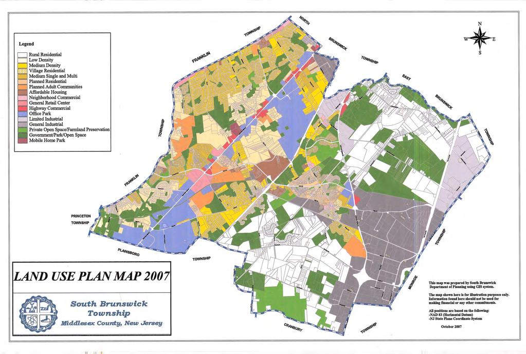
25 D. SPECIFIC CHANGES RECOMMENDED FOR THE MASTER PLAN AND DEVELOPMENT REGULATIONS. General Land Use Recommendations Land Use Plan The Land Use Plan illustrates the basic elements of the Master Plan recommendations with respect to land use. A total of 17 land use classifications are present in the Land Use Plan. Several changes to zoning have been enacted by Council in the last several years. While these were in large part supported by the Planning Board, concomitant changes to the Land Use Plan were not done in anticipation of this Master Plan Reexamination. The following changes in the Land Use Plan are therefore needed to bring the Land Use Plan into consistency with rezoning that has taken place: 1. Block 18, Lot Currently zoned I-3. The current Land Use Plan designation is Office. The Land Use Plan designation is to be changed to General Industrial. This property is on Fresh Ponds Road east of Route Block 29.01, Lot Currently zoned C-3. The current Land Use Plan designation is Rural Residential. The Land Use Plan designation is to be changed to Highway Commercial. This property is on Georges Road east of Route Block 86, Lots 63, 65, 67, 68, 69, 70 and 71 Currently zoned ARRC. The current Land Use Plan designation is Low Density Residential. The Land Use Plan designation is to be changed to Planned Adult Communities. This property is on Major Road behind the Burger King. 4. Block 85, Lots 2.11, 10, 11, 12, 13, 14, 15.16, 16, 37.03, 38, and Block 85.04, Lot Currently zoned R-1. The current Land Use Plan designation is Affordable Housing. The Land Use Plan designation is to be changed to Low Density Residential. This land is located between New Road and Major Road east of Route Block 348, part of Lot Currently zoned R-3. The current Land Use Plan designation is General Retail Center. The Land Use Plan designation is to be changed to Medium Density Residential. This affects the rear of the property containing the Kendall Park Shopping Center. 21
26 6. Block 6, Lot 14.01: Block 11, Lot 13.01, 16 and 18 Currently zoned RR. The current Land Use Plan designation is General Industrial. The Land Use Plan designation is to be changed to Rural Residential. These properties abut Friendship Road. The next change in the Land Use Plan designates recently enrolled properties in the farmland preservation program. The land use plan designation is modified to indicate this, but the underlying zoning does not change. 7. Block 28, Lots 7.04 and 8 Currently zoned RR. The current Land Use Plan designation is Rural Residential. The Land Use Plan designation is to be changed to Private Open Space/Farmland Preservation. These properties are located on Davidson s Mill Road. Block 41, part of Lot Currently zoned RM-3 and I-3. The current Land Use Plan designation is Medium Density Single and Multifamily Residential and General Industrial. The Land Use Plan designation is to be changed to Private Open Space/Farmland Preservation. These properties are located on Ridge Road. Many of the following changes in the Land Use Plan result from proposed changes to infrastructure, recent open space purchases by the State, County or Town, or errors in the 2001 Land Use Plan. Concomitant changes to zoning will be recommended to the Township Council and are also noted here: 8. Block 84.04, Lot 1.013, part of Lot 2.02, 22.01, and part of Lot Currently zoned I-3 and PARC. The current Land Use Plan designation is General Industrial and Planned Adult Communities. The Land Use Plan designation is to be changed to General Retail Center. The recommended zoning is C-2. This will include all lands in the area impacted by the realignment of Stouts Lane between the rails to trails bike path and Route 522. Block 84, Lot is also recommended for C-2 zoning. 9. Block 21, Lots 22.02, 22.05, Currently zoned RR. The current Land Use Plan designation is Rural Residential. The Land Use Plan designation is to be changed to Government/Park/Open Space. The recommended zoning is PL. These are lots owned by NJ DEP and are part of the Pigeon Swamp complex. 10. Part of Block 52, Lot 20 Currently zoned R-4. The current Land Use Plan designation is Village Residential. The Land Use Plan designation is to be changed to Rural Residential. The recommended zoning is RR. This was an error on the zoning map and in the 2001 Land Use Plan. 22
27 11. Block 104, Lot Currently zoned R-1. The current Land Use Plan designation is Rural Residential. The Land Use Plan designation is to be changed to Low Density Residential. This property contains the Woodwinds Flower Shop on Route 27. Item 11 requires Land Use Plan modifications and calls for rezoning in some instances: 12. Block 1, Lots 6.052, and 16.01; Block 40, Lot 7 Currently zoned RR. The current Land Use Plan designation is Rural Residential. The Land Use Plan designation is to be changed to Private Open Space/Farmland Preservation. The zoning will not be impacted. These are preserved farmlands. Block 2, Lots 1 and 2.041; Block 3, Lots and 1.013; Block 4, Lot 1.01; Block 6, Lots 22, 23.01, 23.02, 24, 25, 26, 27 and 28 Currently zoned PL. The current Land Use Plan designation is Rural Residential. The Land Use Plan designation is to be changed to Government/Park/Open Space. The zoning will not be impacted. These are lands which have been purchased by Middlesex County. Block 2, Lot 2.042; Block 37, Lot 18.04; Block 38, Lots 2.02 and 3 Currently zoned RR. The current Land Use Plan designation is Rural Residential. The Land Use Plan designation is to be changed to Government/Park/Open Space. The recommended zoning is PL. These are lands which have been purchased by South Brunswick and Middlesex County. Block 37, Lot 1 - Currently zoned RR. The current Land Use Plan designation is Government/Park/Open Space. The recommended zoning is PL. This is a parcel containing open space which has been dedicated to the Township by a developer. 13. Block 18, Lot Currently zoned RR. The current Land Use Plan designation is Rural Residential and Government/Park/Open Space. The Land Use Plan designation is to be changed to Government/Park/Open Space. The recommended zoning is PL. These lands are owned by NJDEP and are a part of the Pigeon Swamp complex. 14. Block 96.07, Lot Currently zoned R-1. The current Land Use Plan designation is Low Density Residential. The Land Use Plan designation is to be changed to Government/Park/Open Space. The recommended zoning is PL. This is the Township Environmental Center on Old Road. 15. Block 53, Lots 1.01, 1.32, 8.11; Block 53.08, Lots 1 and 2; Block 79, Lots 5.21 and 5.22; Block 79.02, Lot 1 - Currently zoned R-2. The current Land Use Plan designation is Medium Density Residential. The Land Use Plan designation is to be changed to Government/Park/Open Space. The recommended zoning is 23
28 PL. These are parcels containing open space and detention basins which have been dedicated to the Township by developers. Block 53, Lot 6.53 is also recommended for PL zoning. 16. Block 96, Lot Currently zoned R-1 and R-3. The current Land Use Plan designation is Low Density Residential and PARC. The Land Use Plan designation is to be changed to Government/Park/Open Space. The recommended zoning is PL. This is land adjacent to Kendall Park and near Princeton Gate that was purchased by the Township. The following properties under Item 16 are in the Princeton Nurseries/Heathcote Brook area: 17. Block 98, Lot 10.02; Block 99, Lots 3.111, 3.113, 3.212, 10.12, part of 10.13; Block 100, part of Lot 3.08, 5; Block 102 part of Lot 1.011, 2.05; Block 260, Lots and 5.012; - Currently zoned R-1 The current Land Use Plan designation is Low Density Residential. The Land Use Plan designation is to be changed to Government/Park/Open Space. The recommended zoning is PL. Block 100, part of Lot 3.08; Block , Lot 1; Block 102, part of Lot 1.011; Block 261, part of Lot Currently zoned R-4. The current Land Use Plan designation is Village Residential. The Land Use Plan designation is to be changed to Government/Park/Open Space. The recommended zoning is PL. Block 81, Lot 10.01; Block 98, Lots and 2.02; Block 99, part of Lot 10.13; Block 260, Lots 5.02 and Currently zoned OR. The current Land Use Plan designation is Office Park. The Land Use Plan designation is to be changed to Government/Park/Open Space. The recommended zoning is PL. 18. Block 51, Lots and 18 - Currently zoned R-2. The current Land Use Plan designation is Medium Density Residential. The Land Use Plan designation is to be changed to Government/Park/Open Space. The recommended zoning is PL. These parcels are part of the main Municipal Complex on Kingston Lane and Route Block 94.02, Lot 38 The current Land Use Plan designation is Medium Density Residential. The Land Use Plan designation is to be changed to Planned Adult Communities. The existing zoning is ARRC. This parcel is located on Beekman Road near Route Block 24, Lot 34.05, Block 26, Lot 12, Block 29.03, Lot Currently zoned RR. The current Land Use Plan designation is Rural Residential. The Land Use Plan designation is to be changed to Government/Park/Open Space. The recommended zoning is PL. These parcels are located on Deans Rhode Hall Road, Riva Avenue, and Davidson s Mill Road and owned by Middlesex County. 24
29 21. Block 18, Lot Currently zoned RR. The current Land Use Plan designation is Rural Residential. The Land Use Plan designation is to be changed to Government/Park/Open Space. The recommended zoning is PL. This parcel is located on Fresh Ponds Road. It is owned by NJ DEP. 22. Block 54.01, Lots15 and 17 Currently zoned C-1. The current Land Use Plan designation is Neighborhood Commercial. The Land Use Plan designation is to be changed to Government/Park/Open Space. The recommended zoning is PL. These parcels are located on Ridge Road behind the Monmouth Junction Post Office and will be owned by South Brunswick. 23. Block 86, Lots 59.04, 59.05, and 64 Currently zoned R-2. The current Land Use Plan designation is Low Density Residential. The Land Use Plan designation is to be changed to Government/Park/Open Space. The recommended zoning is PL. These parcels are located off of Major Road. They are owned by the Township. Rezoning Recommendations The following inconsistencies exist between the Land Use Plan and the Zoning Map. The zoning is recommended to be modified to be consistent with the Land Use Plan designation. 1. Block 18.02, part of Lot Adjust zoning boundary to cover an additional portion of the lot with OR designation. Current zoning for a small piece is R-3. Master Plan designation is Office Park. This is a part on the Dayton Auto complex on Route Block 85.01, part of Lot Adjust zoning boundary to cover entire lot with AH designation. Current zoning for a small piece is R-3. Master Plan designation is Affordable Housing. This is part of Southridge Hills. 3. Block 29.03, Lot This lot is owned by the Township. Recommend rezoning from LI-2 to PL. Master Plan designation is Government/Park Open Space. This is a pump station on Route Block 30.17, Lot This lot is owned by the Board of Education. Recommend rezoning from R-3 to PL. Master Plan designation is Government/Park Open Space. It is on Southbound Route 130 south of Deans Rhode Hall Road. 5. Block 95, Lot This lot is owned by the Township. Recommend rezoning from R-1 to PL. Master Plan designation is Government/Park Open 25
30 Space. This property is between Sand Forest Drive and Zev Court, off Sand Hill Road. 6. Block 93.08, Lots 138, 139, 140 These lots are owned by the Township. Recommend rezoning from R-2.1 to PL. Master Plan designation is Government/Park Open Space. These lots were dedicated by a developer. The project is on Beekman Road. 7. Block 96, Lot This lot is owned by the Township. Recommend rezoning from R-1 to PL. Master Plan designation is Government/Park Open Space. This property is on Gateway Boulevard. 8. Block 171, part of Lot 16 - Recommend rezoning from R-4 to C-1. Master Plan designation is Neighborhood Commercial. This property is on Ridge Road in Monmouth Junction. Zoning Ordinance Design Standard Recommendations The Zoning Board of Adjustment Annual Report for has two minor recommendations. It is important to note since there are no major trends noticed in the tabular analysis in the report, the zoning we have in place is proper and doing a good job at regulating land use. The first concern raised is with cell tower collocations. An exemption for these is recommended if the only noticeable addition to a cell site is a new antenna array and line down the pole into an existing (shared) unmanned equipment building. If any other equipment aside from the array and cable is visible, a use variance would be required. The second concern is the recommendation to change the zoning for Jefferson Plaza from OR to OP. This is not supported by staff or the Master Plan Reexamination Subcommittee. It is rather recommended the OR zone language to be modified as follows: Section Uses Permitted The following uses are permitted in the OR office/research/conference district: (1) Executive and corporate o Office center. This change will allow existing and future professional offices in the OR zone to be conforming. 26
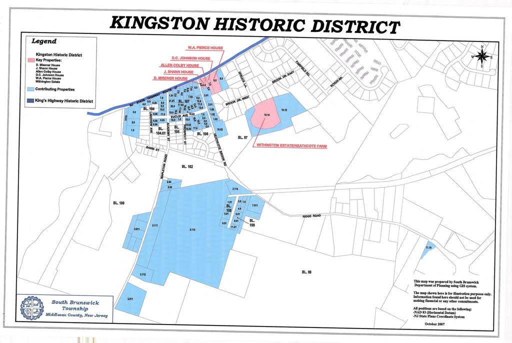
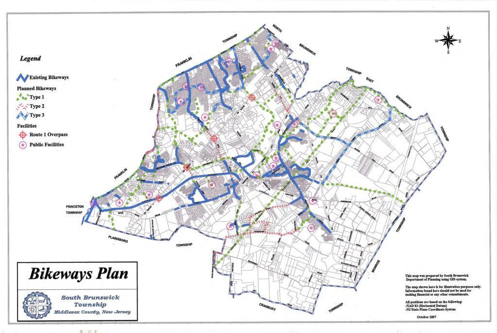
31 Historic Preservation The Township Council adopted Ordinance on August 3, 2004 which established the Historic Preservation Commission and the Kingston Historic District. The 2001 Master Plan acknowledged the foundation work done by the Historic Preservation Ordinance Advisory Task Force. The Task Force recommended a historic preservation ordinance to be developed and enacted, a historic preservation commission be established, and for the commission to obtain Certified Local Government status. Ordinance enacted the historic preservation ordinance, established the first District (in Kingston) and established the Commission. The Commission gained Certified Local Government status in This reexamination report supplements the 2001 Master Plan Historic Preservation Plan Element by including the Kingston Historic District established by Ordinance and supplemented by Ordinances 05-05, 07-06, and A map of the Kingston District is included in this report. Key and contributing properties are noted. Key properties would individually qualify for historic site status due to their significance. Contributing properties are integral to the historic district either they date from a time period for which the district is significant; or they represent an architectural type, period or method for which the district is significant, but which individually would not qualify for historic site status. Under the Ordinance much more stringent rules apply to key properties than to contributing properties. The 2001 Master Plan noted efforts by the Township to be included in a proposed Crossroads of the American Revolution National Heritage Area. In 2006 the National Heritage Area was established by Congress with South Brunswick included. Historic Resources should be recognized, including the Crossroads of American Revolution routes and sites, especially George Washington's march through South Brunswick to the Battle of Monmouth. Recreation and Open Space - Bikeways The Open Space Committee established a Bike and Pedestrian Subcommittee to review the existing Bikeway Master Plan and existing facilities in order to develop recommendations for additional paths in the Township. The goal was to recommend paths which would provide linkages to schools, parks and shopping. In addition, a new emphasis was placed on supplementing the plan to service commuters and long distance riders. The Bikeways Plan is modified to allow for the following paths: A path along the high tension power line reaching from Plainsboro to East Brunswick. This path will provide connections from the 27
32 Deans and Dayton areas to the Plainsboro Preserve, Davidson s Mill Pond Park and the Ireland Brook Park. Extension of an existing path on the southern end of Georges Road to Spring Drive. A new path along New Road between Wheeler Road and Route 1, parallel to Route 1 to the South Brunswick Square Mall. The need for this path has been noticed by many, who see pedestrians walking on New Road to access the shopping center. The realignment of the Route 522 path in Dayton between Kingston Lane and Georges Road. Route 522 can no longer sustain a path in this area due to the creation of sound walls. The path is now routed on Kingston Lane, Stanley Avenue, and Georges Road. Various minor extensions for access to connecting paths and recreational facilities. This plan and previous bikeways plans reflect the need for grade separated overpasses on Route 1. Bikeway surface crossings are not endorsed by this plan. 28
33 E. RECOMMENDATIONS OF THE PLANNING BOARD CONCERNING THE INCORPORATION OF REDEVELOPMENT PLANS INTO THE LAND USE ELEMENT OF THE MASTER PLAN. The Township has not designated an area in need of redevelopment as defined in N.J.S.A. 40A:12A-1 et seq. 29
34
35
36
INTRODUCTION. b. The extent to which such problems and objectives have been reduced or have increased subsequent to such date.
 INTRODUCTION INTRODUCTION The Municipal Land Use Law directs a Planning Board to prepare a Periodic Reexamination Report every six years that identifies and describes the following: a. The major problems
SECTION II SECTION II STATEMENT OF GOALS, OBJECTIVES, PRINCIPLES, ASSUMPTIONS, POLICIES AND STANDARDS
 STATEMENT OF GOALS, OBJECTIVES, PRINCIPLES, ASSUMPTIONS, POLICIES AND STANDARDS 1 2 STATEMENT OF GOALS, OBJECTIVES, PRINCIPLES, ASSUMPTIONS, POLICIES AND STANDARDS INTRODUCTION The New Jersey Municipal
RECREATION AND OPEN SPACE ELEMENT GOALS, OBJECTIVES, AND POLICIES
 RECREATION AND OPEN SPACE ELEMENT GOALS, OBJECTIVES, AND POLICIES Goal 7 To provide park facilities, recreation programs, and open space resources that are safe, adequate, and accessible to all City residents,
The transportation system in a community is an
 7 TRANSPORTATION The transportation system in a community is an important factor contributing to the quality of life of the residents. Without a sound transportation system to bring both goods and patrons
AWH REPORT OF THE PLANNING AND DEVELOPMENT DEPARTMENT FOR APPLICATION FOR REZONING ORDINANCE TO PLANNED UNIT DEVELOPMENT
 AWH REPORT OF THE PLANNING AND DEVELOPMENT DEPARTMENT FOR APPLICATION FOR REZONING ORDINANCE TO PLANNED UNIT DEVELOPMENT MAY 8, 2014 The Planning and Development Department hereby forwards to the Planning
General Reexamination of the Master Plan
 General Reexamination of the Master Plan Remington & Vernick Engineers, Inc. 232 Kings Highway East Haddonfield, New Jersey 08033 March 17, 2004 Adopted by Harrison Township Planning Board on April 7,
3. VISION AND GOALS. Vision Statement. Goals, Objectives and Policies
 Vision Statement Queen Creek s interconnected network of parks, trails, open spaces and recreation opportunities provide safe and diverse activities and programs that sustain its unique, small town, equestrian
Planning Districts INTRODUCTION
 INTRODUCTION To facilitate detailed examination of development prospects for all areas of the community, Delano has been divided into 14 planning districts. The location of these planning districts is
Town of Peru Comprehensive Plan Executive Summary
 Town of Peru Comprehensive Plan Executive Communities that plan grow by choice, not by chance. A plan makes growth thoughtful, understandable, and predictable. A plan shows that a community is managing
4-Town Comprehensive Plan DRAFT 7/30/07
 4-Town Comprehensive Plan DRAFT 7/30/07 Acknowledgements ning Committee Town of Harrisburg Norman Roof Randy Nicol Town of Martinsburg Terry Thisse Paul Kelly Town of Montague Jan Bagdanowicz Wendy Perry
COMMUNITY DESIGN. GOAL: Create livable and attractive communities. Intent
 COMMUNITY DESIGN Intent An attractive, well-designed County will attract quality development, instill civic pride, improve the visual character of the community, and create a strong, positive image for
SECTION 1 Introduction...1. SECTION 2 Regional Context Criteria for Planning Districts Description of Planning District...
 Table of Contents SECTION 1 Introduction...1 SECTION 2 Regional Context...2 2.1 - Criteria for Planning Districts...2 2.2 - Description of Planning District...2 SECTION 3 Goals & Objectives...5 SECTION
Major Subdivision Sketch Plan Checklist
 This checklist provides specific requirements that are apart of the Sketch process. The entire process is described by the Huntersville Subdivision Review Process which details all the submittal and resubmittal
TABLE OF CONTENTS INTRODUCTION PLAN CONCEPT... 3
 TABLE OF CONTENTS BY-LAW NO. Z-1 INTRODUCTION... 1 1.0 PLAN CONCEPT... 3 1.1 Mission... 3 1.2 A Future Vision for Fredericton... 3 1.3 Growth Strategy Goals... 5 National Context... 5 Provincial Context...
TOWNSHIP OF MONTGOMERY MASTER PLAN MASTER PLAN AND DEVELOPMENT REGULATIONS PERIODIC REEXAMINATION REPORT December 5, 2008
 TOWNSHIP OF MONTGOMERY MASTER PLAN MASTER PLAN AND DEVELOPMENT REGULATIONS PERIODIC REEXAMINATION REPORT December 5, 2008 INTRODUCTION The Township of Montgomery is situated in the southeastern corner
DAVENPORT VILLAGE SECONDARY PLAN
 27 DAVENPORT VILLAGE SECONDARY PLAN 27. DAVENPORT VILLAGE SECONDARY PLAN 1. VISION FOR THE DAVENPORT VILLAGE SECONDARY PLAN Davenport Village, municipally known as 830, 940, 980 and 1100 Lansdowne Avenue,
VILLAGE OF CLEMMONS PLANNING BOARD DRAFT STAFF REPORT
 VILLAGE OF CLEMMONS PLANNING BOARD DRAFT STAFF REPORT PETITION INFORMATION Docket # C-226 Staff Megan Ledbetter Petitioner(s) JBJH Properties, LLC Owner(s) JBJH Properties, LLC Subject Property 5892-49-1766
Laberge Group. Town of Coeymans. Draft Comprehensive Plan. Overview of Planning Process
 Draft : Presentation of Goals & Strategies Laberge Group Benjamin H. Syden, A.I.C.P., E.D.P Director in Charge Nicole Allen, A.I.C.P. Senior Planner Anjali Malhotra Planner Presentation Outline Introductions
Gloucester County s Comprehensive Plan. The Community Connection
 Gloucester County s Comprehensive Plan The Community Connection Current Comp Plan Adopted in 1991 with a 20 year planning horizon Updated in 1995 with Part V- Implementation Recommendations and Appendix
The West Vaughan Employment Area Secondary Plan Policies
 Part 2: The West Vaughan Employment Area Secondary Plan Policies 2.1 General Policies It is the policy of Council: 2.1.1. That the West Vaughan Employment Area (the WVEA), identified on Schedule 1, will
WEST WESTFIELD AVENUE REDEVELOPMENT PLAN I BOROUGH OF ROSELLE PARK
 Prepared For: DRAFT Borough of Roselle Park 110 East Westfield Avenue Roselle Park, New Jersey 07204 2016 WEST WESTFIELD AVENUE REDEVELOPMENT PLAN I BOROUGH OF ROSELLE PARK Prepared By: Neglia Engineering
LOS ANGELES CITY PLANNING DEPARTMENT STAFF REPORT
 LOS ANGELES CITY PLANNING DEPARTMENT STAFF REPORT LOS ANGELES CITY PLANNING COMMISSION CASE NO: CPC 2006-9374 CRA CEQA: Exempt DATE: December 21, 2006 Location: Valley Plaza and Laurel Plaza TIME: after
Gold Line Bus Rapid Transit Transit Oriented Development (BRTOD) Helmo Station Area Plan
 Helmo Station Area Plan") Appendix F Gold Line Bus Rapid Transit Transit Oriented Development (BRTOD) Helmo Station Area Plan Introduction and Purpose of the Plan The Gold Line Bus Rapid Transit facility is an eleven-mile dedicated
Appendix F Gold Line Bus Rapid Transit Transit Oriented Development (BRTOD) Helmo Station Area Plan Introduction and Purpose of the Plan The Gold Line Bus Rapid Transit facility is an eleven-mile dedicated
THE CITY OF VAUGHAN BY-LAW BY-LAW NUMBER
 THE CITY OF VAUGHAN BY-LAW BY-LAW NUMBER 123-2013 A By-law to designate the whole of the City of Vaughan as a Site Plan Control Area, and to adopt site development guidelines and rules of procedure for
Welcome. Comprehensive Plan & Transportation Plan Open House November 7, 2012
 Welcome Comprehensive Plan & Transportation Plan Open House November 7, 2012 Agenda Proposed future land use plan Comprehensive Plan strategies Traffic forecasts Future traffic operations Possible future
Asbury Chapel Subdivision Sketch Plan
 Asbury Chapel Subdivision Sketch Plan PART 1: PROJECT SUMMARY Applicant: NVR Inc. Project Size: +/- 76.13 acres Parcel Numbers: 02101112,02116101,02116112, 02116113 Current Zoning: Transitional Residential
EXISTING COMPREHENSIVE PLAN
 EXISTING COMPREHENSIVE PLAN Town Center Land Use Element: V. LAND USE POLICIES Town Center Mercer Island's business district vision as described in "Your Mercer Island Citizen-Designed Downtown" was an
Access Management: An Overview
 Figures 1-5 Below Evolution of development along a highway. In the early stages, land along the road is used for farming with little traffic generated. As time passes, the highway corridor becomes a de
E. RURAL COMMERCIAL/INDUSTRIAL PARK MODEL
 E. RURAL COMMERCIAL/INDUSTRIAL PARK MODEL 1. PURPOSE The purpose of the Rural Commerce/Industrial Park Model is to provide parameters within which a grouping of business buildings with parking, loading
ARTICLE 6: Special and Planned Development Districts
 ARTICLE 6: Special and Planned Development Districts 6-10 Traditional Neighborhood Development (TND) District 6-10.10 Purpose and Intent The Traditional Neighborhood Development (TND) District provides
OPEN SPACE CHAPTER 7: OVERVIEW. Preserve open space to protect natural resources, enhance character and provide passive recreation opportunities
 CHAPTER 7: OPEN SPACE OVERVIEW Ridgefield has made tremendous progress permanently preserving areas of town as open space. Open space preservation can serve many important purposes, including: protect
IV. Development in the Rural Overlay District
 Intracoastal Waterway Route 17 Route 168 Great Dismal Swamp VIRGINIA NORTH CAROLINA IV. Development in the Rural Overlay District IV-1 Route 17 in Chesapeake s Rural Overlay District affords distant views
VILLAGE & TOWN OF BERGEN: COMPREHENSIVE PLAN
 VILLAGE & TOWN OF BERGEN: COMPREHENSIVE PLAN CPC Public Hearing April 21, 2016 History 1996 Comprehensive Plan Comprehensive Plan Update Committee Consultant (LaBella Associates): December 2014 Residents
Town of Washington Master Plan & Regulatory Audit: Interim Results
 Town of Washington Master Plan & Regulatory Audit: Interim Results May 20, 2008 Presented by: 30 Bank Street Lebanon, NH 03766 www.uvlsrpc.org Introduction & Purpose Compare the Master Plan to the regulations
PORT WHITBY COMMUNITY
 PORT WHITBY COMMUNITY SECONDARY PLAN UPDATE COMMUNITY IMPROVEMENT PLAN URBAN DESIGN GUIDELINES September 2015 DRAFT PROPOSED AMENDMENT NUMBER # to the Whitby Official Plan PURPOSE: The intent of this Amendment
CHAPTER 12 IMPLEMENTATION
 CHAPTER 12 IMPLEMENTATION The 2010 Town of Denton Comprehensive Plan is intended to capture a vision of the future of Denton. As such, it provides a basis for a wide variety of public and private actions
EXHIBIT A. Tax Increment Reinvestment Zone No. 1 (Town Center) First Amended Project Plan 1
 First Amended Project Plan 1") EXHIBIT A Tax Increment Reinvestment Zone No. 1 (Town Center) First Amended Project Plan 1 1 As amended by Resolution No. 2008-02-001(TR1R) of the Tax Increment Reinvestment Zone No.1, and approved to
EXHIBIT A Tax Increment Reinvestment Zone No. 1 (Town Center) First Amended Project Plan 1 1 As amended by Resolution No. 2008-02-001(TR1R) of the Tax Increment Reinvestment Zone No.1, and approved to
4.1.3 LAND USE CATEGORIES
 4.1.3 LAND USE CATEGORIES a. City Center District The City Center District incorporates the existing character and mix of uses in downtown Belmont to encourage redevelopment and new development in keeping
Baumgarten MPUD. Exhibit 3 Evaluation Criteria
 Pursuant to LDC subsections 10.02.13 B, 10.02.08 F and Chapter 3 G. of the Administrative Code, staff s analysis and recommendation to the Planning Commission, and the Planning Commission s recommendation
RANDOLPH M A S T E R P L A N. Township of W H E R E L I F E I S W O R T H L I V I N G. Morris County, New Jersey
 Township of RANDOLPH Morris County, New Jersey 2 0 0 6 M A S T E R P L A N Prepared for: Randolph Township Planning Board 502 Millbrook Avenue, Randolph, NJ 07869 W H E R E L I F E I S W O R T H L I V
LAND USE ELEMENT. Purpose. General Goals & Policies
 LAND USE ELEMENT Purpose This Land Use Element contains the goals and policies necessary to support the City s responsibility for managing land resources and guiding development through implementing regulations,
Vision Statement for the Town of Flower Mound Master Plan The Town of Flower Mound Master Plan furthers the established community based vision to:
 Vision Statement for the The furthers the established community based vision to: Preserve the country atmosphere and natural environment that makes Flower Mound a unique and desirable community; Mitigate
3 Vision and Goals. Vision and Goals. Blueprint for Bloomsburg. Vision. Town of Bloomsburg Comprehensive Plan,
 Vision and Goals 3 Vision and Goals Citizens of the Town of Bloomsburg clearly value their natural and cultural heritage, the walkable, mixed use pattern of downtown, the access to education, and the community
Land Use Amendment in Southwood (Ward 11) at and Elbow Drive SW, LOC
 at and Elbow Drive SW, LOC") 2018 November 15 Page 1 of 10 EXECUTIVE SUMMARY This land use amendment application was submitted by Rick Balbi Architect on 2017 August 31 on behalf of Sable Developments Ltd, and with authorization from
2018 November 15 Page 1 of 10 EXECUTIVE SUMMARY This land use amendment application was submitted by Rick Balbi Architect on 2017 August 31 on behalf of Sable Developments Ltd, and with authorization from
Parks, Trails, and Open space Element
 Parks, Trails, and Open space Element Parks, Trails, and Open Space element Parks, Recreation, and Open Space are important components of the quality of life desired by the residents of Elk Grove. This
Chapter IV: Development Pattern
 Chapter IV: Development Pattern Introduction The 2002 Prince George s County Approved General Plan designates three growth policy tiers Developed, Developing, and Rural as well as three center designations
Staff Report and Recommendation
 Community Planning and Development Planning Services 201 W. Colfax Ave., Dept. 205 Denver, CO 80202 p: 720.865.2915 f: 720.865.3052 www.denvergov.org/cpd TO: City Council Neighborhoods and Planning Committee
Re: Application Type: Proposed Highlands Redevelopment Area Designation
 CHRIS CHRISTIE Governor KIM GUADAGNO Lt. Governor State of New Jersey Highlands Water Protection and Planning Council 100 North Road (Route 513) Chester, New Jersey 07930-2322 (908) 879-6737 (908) 879-4205
North Oakville East Parks Facilities Distribution Plan. November, 2009
 North Oakville East November, 2009 POLICY CONTEXT 1) Purpose a) The purpose of this document is to be a guide for the location, configuration, design and development of the parks system for the North Oakville
TRANSPORTATION ELEMENT GOALS, OBJECTIVES, AND POLICIES
 TRANSPORTATION ELEMENT GOALS, OBJECTIVES, AND POLICIES GOAL 2 The City shall provide a safe, convenient, effective, and energy efficient multimodal transportation system which is coordinated with the Future
Chapter 10 IMPLEMENTATION RECOMMENDATIONS
 Chapter 10 IMPLEMENTATION RECOMMENDATIONS The recommended land use plan presented in the previous chapter provides a design for the attainment of the urban and rural development and open space preservation
BROOKHILL NEIGHBORHOOD MODEL ZONING MAP AMENDMENT PREFACE TO APPLICATION
 BROOKHILL NEIGHBORHOOD MODEL ZONING MAP AMENDMENT PREFACE TO APPLICATION June 15, 2015 Revised: August 1, 2016 I. VISION Brookhill is a proposed community based upon the principles of Albemarle County
Washington Township Mercer County. Periodic Reexamination of Master Plan Pursuant to N.J.S.A. 40:55D 89 & Land Use Element Amendment
 Washington Township Mercer County Periodic Reexamination of Master Plan Pursuant to N.J.S.A. 40:55D 89 & Land Use Element Amendment MARCH 21, 2007 Periodic Reexamination of Master Plan and Land Use Element
Transportation. Strategies for Action
 Transportation A major priority for the Overlake Neighborhood is to develop a multimodal transportation system. To achieve this system, a balance has to be found among travel, circulation and access needs;
Municipal Development Plan. Summer Village of ROCHON SANDS. Bylaw #241-18
 Municipal Development Plan Summer Village of ROCHON SANDS Bylaw #241-18 TABLE OF CONTENTS PART ONE: BACKGROUND AND PURPOSE 3 SECTION 1: BACKGROUND 3 SECTION 2: GOALS AND POLICIES 3 PART TWO: PHYSICAL ENVIRONMENT
Section 9 NEIGHBORHOOD DESIGN
 Section 9 NEIGHBORHOOD DESIGN City of Lancaster Comprehensive Plan D u n k i n, S e f k o & A s s o c i a t e s, I n c. NEIGHBORHOOD DESIGN INTRODUCTION There are many ways in which a neighborhood can
SUMMERSIDE / MT. CARMEL REINVESTMENT CORRIDOR COMMUNITY DEVELOPMENT STRATEGY
 SUMMERSIDE / MT. CARMEL REINVESTMENT CORRIDOR COMMUNITY DEVELOPMENT STRATEGY FEBRUARY 2013 I. Location of the Summerside/Mt. Carmel Reinvestment Corridor The Summerside/Mt. Carmel Reinvestment Corridor
CHAPTER 7: VISION AND ACTION STATEMENTS. Noble 2025 Vision Statement
 CHAPTER 7: VISION AND ACTION STATEMENTS This chapter presents the vision, policy and action statements that transform the comprehensive planning study, an analysis of Noble s past, future trends and community
OFFICE CONSOLIDATION SECONDARY PLAN AREA 22 THE BRAMALEA SOUTH INDUSTRIAL SECONDARY PLAN
 OFFICE CONSOLIDATION SECONDARY PLAN AREA 22 THE BRAMALEA SOUTH INDUSTRIAL SECONDARY PLAN November 2010 EXPLANATORY NOTES (Secondary Plan Area 22) General (pertaining to all secondary plan office consolidations)
11.4 Highway 400 North Employment Lands Secondary Plan APPROVED BY THE ONTARIO MUNICIPAL BOARD ON NOVEMBER 21, 2011
 11.4 Highway 400 North Employment Lands Secondary Plan APPROVED BY THE ONTARIO MUNICIPAL BOARD ON NOVEMBER 21, 2011 11.4.1 General 11.4.1.1. as approved by the Ontario Municipal Board on November 21, 2011,
Implementation Guide Comprehensive Plan City of Allen
 Implementation Guide 2030 Comprehensive Plan City of Allen DRAFT 2015 Implementation Guide Allen 2030 Comprehensive Plan INTRODUCTION The Comprehensive Plan serves as a guide for the growth and development
implementation10 Village of Greendale Comprehensive Plan: Greendale, Wisconsin. Revisiting a Greenbelt Community
 implementation10 Village of Greendale Comprehensive Plan: 2010 - Village of Greendale Comprehensive Plan: 2010 - Implementation The recommendations of this Plan must be implemented by the Village of Greendale,
ORDINANCE WHEREAS, this Ordinance is consistent with the City of Winter Garden Comprehensive Plan; and
 ORDINANCE 17-06 AN ORDINANCE OF THE CITY COMMISSION OF THE CITY OF WINTER GARDEN, FLORIDA, CREATING ARTICLE XIV OF CHAPTER 118 OF THE CITY OF WINTER GARDEN CODE OF ORDINANCES PROVIDING FOR THE EAST PLANT
CONSENT CALENDAR CITY PLANNING COMMISSION AGENDA ITEM NO: A.1, A.2 STAFF: LARRY LARSEN
 Page 8 CONSENT CALENDAR CITY PLANNING COMMISSION AGENDA ITEM NO: A.1, A.2 STAFF: LARRY LARSEN FILE NO: CPC PUZ 14-00013 - QUASI-JUDICIAL FILE NO: CPC PUD 14-00014 QUASI-JUDICIAL PROJECT: APPLICANT: OWNER:
Section XI RELATIONSHIP TO OTHER PLANS
 Section XI RELATIONSHIP TO OTHER PLANS INTRODUCTION The land development plans 1 for the municipalities bordering West Windsor were reviewed to determine their relative compatibility to the planning policies
Proposed Comprehensive Plan Strategies DRAFT for discussion June 28, 2017
 Proposed Comprehensive Plan Strategies DRAFT for discussion June 28, 2017 Land Use Rural Areas Refine the Farm and Forest area (FF) Update FF boundaries to account for existing lots less than five acres
WATERFORD Plan of Preservation, Conservation and Development Supplement Part 1 - Policy Element
 WATERFORD 2012 Plan of Preservation, Conservation and Development 2015 Supplement Part 1 - Policy Element Effective June 11, 2015 2015 Plan Update GOAL To respond to the evolving land use needs and continually
PUBLIC SERVICES ELEMENT GOALS / POLICIES / MEASURES
 PUBLIC SERVICES ELEMENT GOALS / POLICIES GOALS / POLICIES / MEASURES Authority The Public Services Element addresses provision of municipal services to City residents. The following paragraphs provide
ESTABLISH AN EFFICIENT TOWN CENTER
 ESTABLISH AN EFFICIENT TOWN CENTER 4 Overview Lisbon residents are proud of the history of Newent and at the same time recognize its current importance as a centralized location for a variety of municipal
A. WHAT IS A GENERAL PLAN?
 I. Introduction A. WHAT IS A GENERAL PLAN? A general plan is the planning guideline for the future of a city. It contains goals and policies which regulate urban development, the protection of the natural
TABLE OF CONTENTS. Transportation Chapter 1 - Introduction and Purpose of Planning to 1-3. Utilities
 Chapter 1 - Introduction and Purpose of Planning... 1-1 to 1-3 Pennsylvania Municipalities Planning Code (Act 247)...1-1 Previous County Planning Activities...1-1 Objectives of the Plan...1-2 Elements
TOWNSHIP OF LOGAN SOIL & FILL IMPORTATION AND PLACEMENT APPLICATION SUBMITTAL CHECKLIST
 TOWNSHIP OF LOGAN SOIL & FILL IMPORTATION AND PLACEMENT APPLICATION SUBMITTAL CHECKLIST Applications: 5 copies of application - Applicant will reproduce the copies at his/her costs. The Township Clerk
and services The protection and conservation of environmentally significant and sensitive natural heritage features and functions.
 6. Land Use 6.0 Preamble A healthy and livable city is one in which people can enjoy a vibrant economy and a sustainable healthy environment in safe, caring and diverse neighbourhoods. In order to ensure
Improve Neighborhood Design and Reduce Non Point Source Water Pollution
 HOW TO Planning Guide Improve Neighborhood Design and Reduce Non Point Source Water Pollution This document was funded by a grant from the New Hampshire Coastal Program with funding from the National Oceanic
THE CORPORATION OF THE TOWN OF OAKVILLE BY-LAW NUMBER
 THE CORPORATION OF THE TOWN OF OAKVILLE BY-LAW NUMBER 2017-120 A by-law to adopt an amendment to the Livable Oakville Plan, Official Plan Amendment Number 20 (Downtown Oakville Growth Area) WHEREAS the
Hockessin Community Redevelopment Plan
 Hockessin Community Redevelopment Plan 3.1 Introduction The Community Redevelopment Plan for the Village of Hockessin is the result of the people s vision for a distinct village center that serves as the
8 Oak Street - Official Plan and Zoning By-law Amendment Application - Preliminary Report
 STAFF REPORT ACTION REQUIRED 8 Oak Street - Official Plan and Zoning By-law Amendment Application - Preliminary Report Date: March 17, 2014 To: From: Wards: Reference Number: Planning and Growth Management
CHARLES PUTMAN CHARLES PUTMAN AND ASSOCIATES, INC
 MEMORANDUM CHARLES PUTMAN & ASSOCIATES, INC. LAND DEVELOPMENT CONSULTANTS PLANNING ZONING PERMITTING 4722 NW Boca Raton Boulevard, Suite C-106 Boca Raton, Florida 33431 Phone: 561/994-6411 FAX: 561/994-0447
Watertown City Council
 City of Watertown Watertown City Council April 14 th, 2015 Agenda Item: City Comment on Sun Share CUP Application Request for Action: Motion to Approve City Comments regarding CUP Application Department:
1. Parks & Recreation Neighborhood Parks Community Parks Special Use Sites 2. Open Space 3. Trails
 Appendix A: Park Classifications The intent of parks and recreation classifications is to aid in making acquisition and design decisions for park sites, facilities and the organization of recreation space
Planned Development Review Revisions (Project No. PLNPCM )
") Planned Development Review Revisions (Project No. PLNPCM2014-00139) Standard residential development Planned Development Example: Smaller lot sizes than what is allowed to create open space amenity. What
Planned Development Review Revisions (Project No. PLNPCM2014-00139) Standard residential development Planned Development Example: Smaller lot sizes than what is allowed to create open space amenity. What
FORMER CANADIAN FORCES BASE (CFB) ROCKCLIFFE SECONDARY PLAN. Official Plan Amendment XX to the Official Plan for the City of Ottawa
 ROCKCLIFFE SECONDARY PLAN. Official Plan Amendment XX to the Official Plan for the City of Ottawa") FORMER CANADIAN FORCES BASE (CFB) ROCKCLIFFE SECONDARY PLAN Official Plan Amendment XX to the Official Plan for the City of Ottawa 1 INDEX THE STATEMENT OF COMPONENTS PART A THE PREAMBLE PAGE Purpose...
FORMER CANADIAN FORCES BASE (CFB) ROCKCLIFFE SECONDARY PLAN Official Plan Amendment XX to the Official Plan for the City of Ottawa 1 INDEX THE STATEMENT OF COMPONENTS PART A THE PREAMBLE PAGE Purpose...
Executive Summary. NY 7 / NY 2 Corridor
 Executive Summary NY 7 / NY 2 Corridor Transportation and Land Use Study December 2005 Prepared for: Town of Colonie Capital District Transportation Committee Prepared by: Introduction: Land use decisions
CHAPTER 7: Transportation, Mobility and Circulation
 AGLE AREA COMMUNITY Plan CHAPTER 7 CHAPTER 7: Transportation, Mobility and Circulation Transportation, Mobility and Circulation The purpose of the Transportation, Mobility and Circulation Chapter is to
5.0 VILLAGE AREAS. February 2008 Municipality of West Elgin ~ Official Plan 5-1
 5.0 VILLAGE AREAS This section of the Official Plan deals with the villages of Rodney and West Lorne being the two largest and only fully serviced settlement areas in West Elgin and the most logical and
Hibbing. Land Use. Hibbing Comprehensive Plan 8.1. Land Use
 Hibbing 8.1 Introduction 8.3 Information and Assessment 8.5-8.14 Recommendations 8.15-8.17 Implementation 8.18-8.19 8.2 Introduction Although land use was not identified as a discrete goal during the community
6. Consistency with Local Plans
 6. Consistency with Local Plans 6.1. Chapter Overview 6.1.1. Introduction This section presents the goals, objectives and policies of municipal, county and state planning entities, as well as known development/redevelopment
4.11 Town Centre Secondary Plan (Former City of Cumberland)
") 4.11 Town Centre Secondary Plan (Former City of Cumberland) 4.11.1 Town Centre Objectives 4.11.1.1 Introduction The reason for the preparation of this Secondary Plan for the Town Centre is as follows:
4.11 Town Centre Secondary Plan (Former City of Cumberland) 4.11.1 Town Centre Objectives 4.11.1.1 Introduction The reason for the preparation of this Secondary Plan for the Town Centre is as follows:
Chapter 13: Implementation Plan
 Implementation A. Introduction The Implementation Plan, in table form on the following pages, provides a summary of all the Action Items recommended in Chapters 2 through 12. The table also indicates which
ARTICLE V PLANNED UNIT DEVELOPMENT DISTRICT
 ARTICLE V PLANNED UNIT DEVELOPMENT DISTRICT A. Purpose and Objective The Planned Unit Development (PUD) procedure provides a flexible land use and design regulation through the use of performance criteria
PART 1: PROJECT SUMMARY. Proposed Land Use: 120 single-family lots. The application is Attachment A. The site plan is Attachment B.
 PART 1: PROJECT SUMMARY Applicant: JBH Development, LLC and Hopper Communities, INC Project Size: +/- 80.48 acres Parcel Number: 01513107, 01513108, 01513109, 01513113, 01513120, 01513121, 01513122, 01513124,
CHAPTER 22 Rural Open Space Community Developments
 CHAPTER 22 Rural Open Space Community Developments Section 22.1 Description and Purpose The intent of this Chapter is to offer property owners an alternative to traditional zoning requirements for rural
1120 Haist Street - Pelham Arena Community Co-Design Recommendation Report Haist Street - Pelham Arena Community Co-Design Recommendation Report
 1120 Haist Street - Pelham Arena Community Co-Design Executive Summary: In May, 2017 the Town retained the services of The Planning Partnership to undertake a community design charrette process to determine
A BILL FOR AN ORDINANCE TO AMEND CHAPTER 9, KAUAI COUNTY CODE 1987, RELATING TO STREET REQUIRE:MENTS FOR SUBDIVISIONS
 ORDINANCE NO. BILL NO. { vy"yj1j A BILL FOR AN ORDINANCE TO AMEND CHAPTER 9, KAUAI COUNTY CODE 1987, RELATING TO STREET REQUIRE:MENTS FOR SUBDIVISIONS BE IT ORDAINED BY THE COUNCIL OF THE COUNTY OF KAUA'I,
Exhibit A. 8:9 Scuffletown Rural Conservation District
 Exhibit A 8:9 Scuffletown Rural Conservation District 8:9.1 Intent and Purpose The Scuffletown Rural Conservation (SRC) District is intended to provide for residential development that supports the development
Parks, Trails, and Open Space Element
 P arks, Recreation, and Open Space are important components of the quality of life desired by the residents of Elk Grove. This Element of the General Plan addresses the City s goals, policies, and actions
REQUEST Current Zoning: O-15(CD) (office) Proposed Zoning: TOD-M(CD) (transit oriented development mixed-use, conditional)
 (office) Proposed Zoning: TOD-M(CD) (transit oriented development mixed-use, conditional)") Rezoning Petition 2016-117 Zoning Committee Recommendation January 4, 2017 REQUEST Current Zoning: O-15(CD) (office) Proposed Zoning: TOD-M(CD) (transit oriented development mixed-use, conditional) LOCATION
Rezoning Petition 2016-117 Zoning Committee Recommendation January 4, 2017 REQUEST Current Zoning: O-15(CD) (office) Proposed Zoning: TOD-M(CD) (transit oriented development mixed-use, conditional) LOCATION
17.11 Establishment of Land Use Districts
 17.11 Establishment of Land Use Districts 17.11.010 Purpose. To promote the health, safety, and general welfare of City residents and those who come to South Salt Lake to work, exchange commerce and recreate.
Planning Department. Director of Planning. Manager of Planning. Planning Technician/ Sustainability Coordinator. Planner II/ Heritage Coordinator
 Department Director of Manager of Policy Planner Planner II (2) Planner II/ Heritage Coordinator Technician/ Sustainability Coordinator Technician Administrative Clerk March 2017 Department 2018 Business
Description of Preferred Alternative
 Chapter 2 Description of Preferred Alternative 2.1 Introduction This chapter of the programmatic Sammamish Town Center Sub-area Plan Final EIS provides a more detailed description of the Preferred Alternative