PUBLIC HEARING: August 11, 2015 Planning and Land Development Regulation Commission (PLDRC)
|
|
|
- Evangeline Cannon
- 5 years ago
- Views:
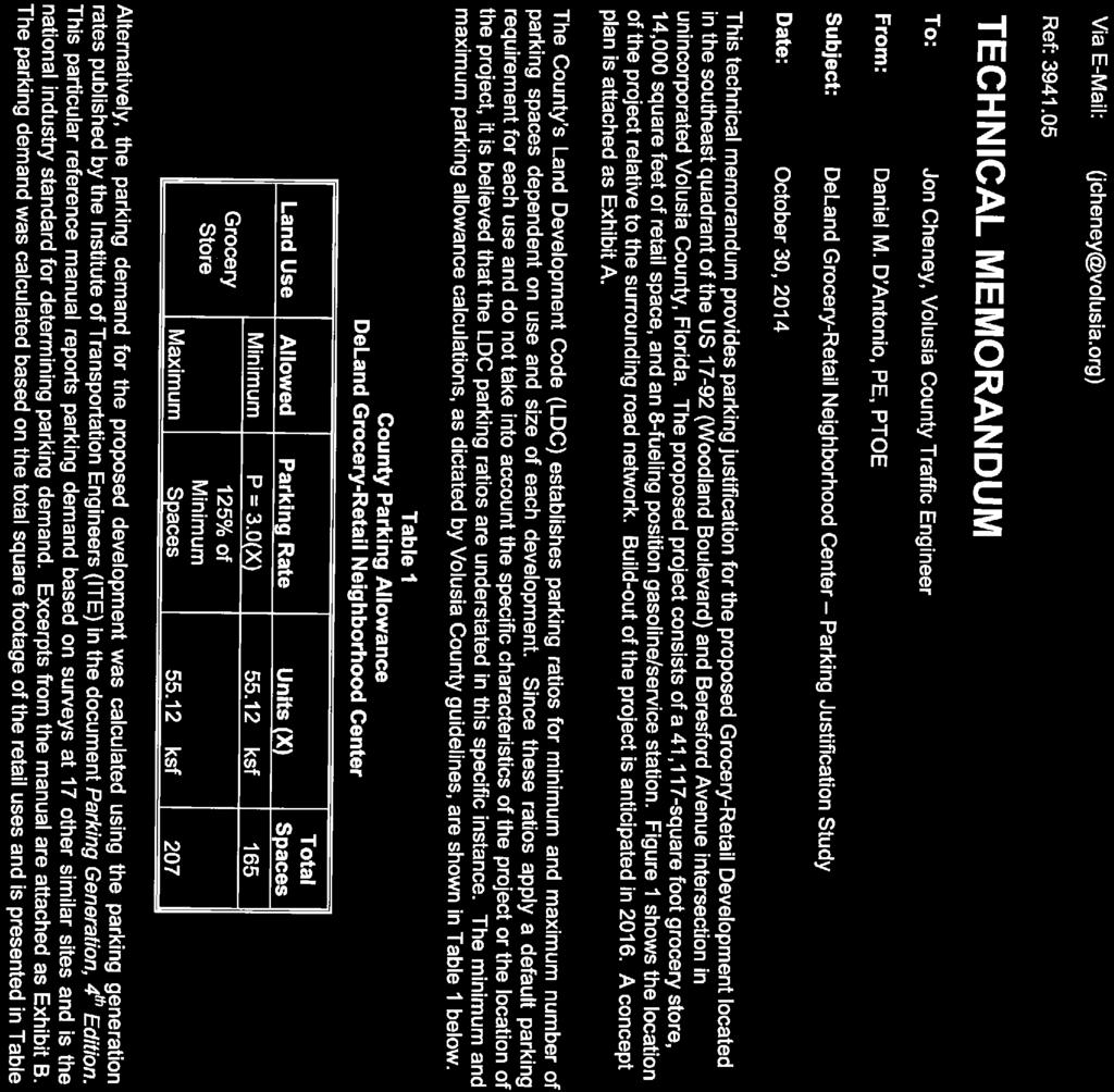
Transcription
1 Page 1 of 52 GROWTH AND RESOURCE MANAGEMENT DEPARTMENT PLANNING AND DEVELOPMENT SERVICES DIVISION CURRENT PLANNING ACTIVITY 123 W. Indiana Avenue, DeLand, FL (386) PUBLIC HEARING: August 11, 2015 Planning and Land Development Regulation Commission (PLDRC) CASE NO: SUBJECT: LOCATION: APPLICANT: OWNER: STAFF: V Variance to the maximum off-street parking requirement on Heavy Commercial with Thoroughfare Overlay Zone (B-5C) and Heavy Commercial (B-5) zoned property. South of the intersection of Woodland Boulevard and Beresford Avenue F.A. (Alex) Ford, Jr. Esquire F.A. Ford et al, Levi Swallows, Charles and Tricia Kitchen, and George and Jane Demattio Carol McFarlane, AICP, Planner II I. SUMMARY OF REQUEST The applicant is requesting a variance to the maximum amount of off-street parking spaces allowed for a shopping center development. A portion of the property is currently used for a weekend flea market, used furniture store, auto salvage yard and woodland area, and the applicant is seeking site plan approval for a shopping center including a 41,117 square foot grocery store, 14,000 square-foot retail building, and a 754 gas station with 12 gas pumps. Specifically, the applicant is requesting the following variances: A variance to Section (6), Maximum off-street parking, from the maximum allowed of 125% of the minimum required (or 190 parking spaces) to 178% of the minimum required (or 223 parking spaces) for a proposed shopping center on Heavy Commercial/ Thoroughfare Overlay Zone (B-5C) and Heavy Commercial (B-5) zoned property. Staff recommendation: Denial, as the application does not meet the five criteria required for the granting of a variance.


2 Page 2 of 52 II. SITE INFORMATION 1. Location: The property is located at the southeast corner of Woodland Boulevard and Beresford Avenue and bounded by Amelia Avenue, in the DeLand area. 2. Parcel No(s): , , , and Property Size: ± acres 4. Council District: 1 5. Zoning: B-5C and B-5 6. Future Land Use: Commercial 7. ECO Overlay: No 8. NRMA Overlay: No 9. Adjacent Zoning and Land Use: DIRECTION ZONING FUTURE LAND USE CURRENT USE North City: C-2AC, City: Mixed Bank and City Retention R-1B Commercial, Low Pond East South West 10. Location Maps: City: R-12 and R-1 City: C-2 and C-2AC County: B-5C City: C-2AC Density Residential City: Low Density Residential and Medium Density Residential County: Commercial City: Redevelopment County: Commercial City: Redevelopment Single-Family Residential County: Service Shop and FDOT Retention Pond City: Mini-Warehouses County: Mobile Home Park City: Retails Shops and Church AERIAL MAP ZONING MAP
3 Page 3 of 52 III. BACKGROUND AND PREVIOUS ACTIONS Variance Site Plan The subject property is comprised of four parcels totaling acres in size. The four parcels are currently used as vacant land, a furniture store, a junkyard, and a flea market. The owners of these properties have submitted a final site plan application for a proposed shopping center on the combined properties. The proposed shopping center consists of a 41,117 square-foot grocery store, with a separate 14,000 square-foot retail building and a 754 square-foot gas station with 12 fuel pumps. Access will be provided on both Woodland Boulevard (US Hwy 17-92) via a proposed left turn lane in the southbound lane and East Beresford Avenue. A stormwater retention pond will be in the rear of the building, facing Amelia Avenue. The submitted site plan does not meet Section (6) of the zoning code, which states: The maximum number of parking spaces may not exceed 125 percent of the minimum spaces required by this section, except for a single-family residential dwelling unit, and as otherwise modified in accordance with subsection (5). Per the county s off-street parking requirements, this shopping center project requires a minimum of 152 parking spaces, and therefore a maximum of 190 parking spaces is allowed based on the following calculations: County Parking Calculations: A shopping center requires 2.5 parking spaces per 1,000 square feet (55,117/1,000 * 2.5 = 137.7, rounds up to 138); and the gas station kiosk requires 2 spaces per 1,000 square feet of gross floor area (754/1,000 * 2 = 1.5, rounds up to 2), plus one parking space per pump (12), for a total of 152 parking spaces. Therefore, the maximum is 190 (152 * 1.25 = 190) parking spaces. The applicant has submitted a parking justification study along with this application for review. The study demonstrates that based on the Institute of Transportation Engineers, Parking Generation, 4 th Edition, shopping centers have a range of parking demand from 1.89 to 7.59 vehicles per 1,000 square feet of gross floor area. The study states that based on demand for the 85 th percentile, (5.05 parking spaces per 1,000 square feet) the total parking demand for this project is 278 parking spaces, which is well above the county s code requirement of 190 parking spaces. Volusia County Traffic Engineering staff has determined that as long as the internal capture rate of 21%, which was applied to the site s trip generation calculation is used, instead of a total parking demand of 278, the rate would decrease to 220 parking spaces. Notwithstanding the applicant s parking information, the county council approved the maximum parking requirement for non-residential developments as part of a major code amendment in Further, the council adopted a code amendment that reduced minimum parking requirements and applied the maximum parking standard to all development in 2012 as a Smart Growth strategy. The purpose of these regulations is to reduce excessive imperious surface areas with the goal of minimizing impacts to the
4 Page 4 of 52 environment and neighborhood aesthetics. A lower amount of parking should result in a reduction of land clearing, stormwater system designs, and the preservation of more existing on-site vegetation plus decrease the need for irrigation. IV. REVIEW CRITERIA AND ANAYLSIS Final Site Plan Review At this time, the final site plan application has not received approval from the Development Review Committee (DRC). The DRC cannot take action on the site plan application until this variance request is resolved, and the county council votes on removal of one or two historic trees. There are also a number of county staff comments that must be addressed before a development order can be issued. The last set of staff comments dating June 10, 2015, has been attached to this staff report for review. Typically, staff comments can be resolved during the site plan review process. However, since this proposal is before the PLDRC prior to the DRC, this variance application must be addressed prior to resolving site functionality issues. More specifically, the most pressing design issue with the site is the project s impact on the local transportation network. The proposed project requires improvements to Beresford Avenue that are not shown on the latest site plan and have not been coordinated with county engineers. On Woodland Boulevard, the plans show a southbound left turn lane going into the project, and (according to the county s traffic engineering staff) the turn lane shown is substandard and design safety concerns have not been coordinated or addressed with FDOT staff. FDOT approval is required to ensure that traffic coming from Woodland Boulevard will have safe turning maneuvers into the site. Access from Beresford Avenue is also problematic. During previous design meetings with the applicant, the county had expressed the need for a westbound left-in turn lane off Beresford Avenue. There are stacking issues westbound on Beresford due to the proximity of the traffic signal on Woodland Boulevard, and this project would create additional impact to the road segment that would require additional turn lanes. However, the potential for additional right-of-way on Beresford Avenue is limited because the applicant does not own all of the property at the southeast corner of the intersection. The applicant submitted an application for historic tree removal on July 10, Historic tree removals are approved by the county council, and the hearing for the tree removal has not yet been scheduled as of the time of writing this staff report. The historic tree in question is located where the retail building is proposed. It is county staff s opinion (see Environmental Permitting staff review comments) that if the project layout could be redesigned and the number of parking spaces reduced, then the historic tree on the site could be saved. County staff is concerned about approving a variance to parking standards prior to the county council approving removal of the historic tree. Section (1) a. 4 Variances of the zoning code contains five applicable criteria by which the PLDRC may grant a variance. Staff bases its evaluation on these criteria:
5 Page 5 of 52 i. Special conditions and circumstances exist which are peculiar to the land, structure, sign, or building involved and which are not applicable to other lands, structures, signs, or buildings in the same zoning classification. The county maximum parking requirements are applicable to all other projects that develop within the unincorporated county, except for a single-family residential unit. Staff finds that the variance request does not meet this criterion. ii. The special conditions and circumstances do not result from the actions of the applicant. Since staff could not find a special condition in the above criterion, this criterion cannot be met. Staff finds that the variance request does not meet this criterion. iii. Literal interpretation of the provisions of this ordinance would deprive the applicant of rights commonly enjoyed by other properties in the same zoning classification, under the terms of the ordinance, and would work an unnecessary and undue hardship on the applicant. Literal interpretation of the zoning code would require that the proposed shopping center be redesigned to either reduce the amount of the proposed off-street parking or the size of the retail building and/or gas station. Another option for development would be for the properties to annex into the City of DeLand. As noted by the applicant s written petition, this property abuts the city limits of DeLand, and the property will likely be annexed by the city in the future. The city code will allow the requested amount of parking as their regulations do not mandate a maximum parking. Therefore, a variance is not necessary if the property would be annexed. Staff finds that the variance request does not meet this criterion. iv. The variance granted is the minimum variance that will make possible the reasonable use of the land, building, structure, or sign. The attached memo from the county s traffic engineering staff states that they can support an increase to 220 parking spaces based on the general parking justification study provided by the applicant (based on the demand for 278 parking spaces, and reducing that number by 21%, which is the internal trip capture that has been stated in previously submitted traffic studies). However, shopping center developments generally consists of vast parking areas that do not reach their capacity except for a few days of the year. Therefore, the variance is not the minimum necessary for the reasonable use of the land, but based on the wants of the applicant.
6 Page 6 of 52 Staff finds that the variance request does not meet this criterion v. The grant of the variance will be in harmony with the general intent and purpose of this ordinance and the Volusia County Comprehensive Plan Ordinance No , as amended, and that such variance will not be injurious to the area involved. The county has adopted a maximum parking standard in an effort to preserve community aesthetic qualities and to protect the environment. Allowing too much parking is contrary to Smart Growth principles in that it can be unsightly and difficult for pedestrians to traverse. Additionally, designing parking lots based on a higher demand than the average demand can lead to the development of impervious surface coverage that may not be necessary, and could be better used for environmental resource protection, such as stormwater drainage or tree protection. Staff finds that the variance request does not meet this criterion. V. STAFF RECOMMENDATION Staff finds that the application does not meet the five criteria for approval of a variance, and therefore recommends denial of a variance to Section (6), Maximum off-street parking, from the maximum allowed of 125% of the minimum required (or 190 parking spaces) to 178% of the minimum required (or 223 parking spaces) for a proposed shopping center on Heavy Commercial/Thoroughfare Overlay Zone (B-5C) and Heavy Commercial (B-5) zoned property. However, if the PLDRC finds that the requested variance application does meet all five of the criteria to grant a variance, staff has provided the following conditions for consideration: 1. Approval of this variance is limited to a maximum 220 off-street parking spaces for the project depicted on a site plan dated 9/17/14, prepared by CPH Inc., attached hereto, which shall be revised as modified by this condition and/or modified by further county review and/or other permitting requirements. 2. Approved and implementation of the requested variance shall be subject to county site plan approval of the proposed shopping center project. VI. ATTACHMENTS Written Petition Variance Site Plan Parking Justification Study County Staff Comments June 10, 2015 Reviewer Comments Site Photographs Map Exhibits
7 Page 7 of 52 VII. AUTHORITY AND PROCEDURE The commission may, except as otherwise provided in Section of the zoning code, authorize, after due public notice upon application on a form prescribed by the zoning enforcement official, such variance or variances from the terms of this ordinance as will not be contrary to the public interest when, owing to special conditions, a literal enforcement of the provision of this ordinance would result in unnecessary and undue hardship. Said variance application shall be heard only if it is presented by the person owning 51 percent or more of the specific area of land involved or upon an administrative application by the county council. Any new information to be presented at the planning and land development regulation commission meeting for any application will be grounds to continue an application to the next planning and land development regulation commission meeting. Applicants shall inform and provide staff with the new information prior to the planning and land development regulation commission meeting.


8 Page 8 of 52


9 Page 9 of 52

10 Page 10 of 52
. REFER TO ARCH. PLANS FOR EXACT DETAILS. COMPACTOR PAD W/ CMU SCREEN WALL. REFER TO ARCH. PLANS FOR EXACT DETAILS AND SPECIFICATIONS.")
11 Page 11 of 52 A B C D N REDBOX MOVIE RENTAL STATION & VENDING MACHINE. REFER TO ARCH. PLANS FOR SPECIFICATIONS. RAMPED PAVEMENT TO BE FLUSH WITH TOP OF SIDEWALK (20:1 MAX. SLOPE). REFER TO ARCH. PLANS FOR EXACT DETAILS. COMPACTOR PAD W/ CMU SCREEN WALL. REFER TO ARCH. PLANS FOR EXACT DETAILS AND SPECIFICATIONS. INTEGRAL CURB ALONG SIDEWALK. REFER TO ARCH. PLANS FOR SPECIFICATIONS. DSD DOOR LOCATION. REFER TO ARCH. PLANS FOR EXACT LOCATIONS AND DETAILS. CONCRETE SIDEWALK. REFER TO ARCH. PLANS FOR SPECIFICATIONS AND DETAILS (TYP.). PALLET / BALE RECYCLE AREA & DUMPSTERS FOR ORGANICS DISPOSAL ENCLOSURE. REFER TO ARCH. PLANS FOR SPECIFICATIONS. PORCH, RAMP PAVEMENT TO TOP OF STOOP (20:1 MAX. SLOPE). REFER TO ARCH. PLANS FOR EXACT LOCATIONS AND DETAILS PROPOSED LEGEND 3' WIDE DETECTABLE WARNING SURFACE W-BEAM GUARD RAIL PER FDOT INDEX NO ' HIGH CHAIN LINK FENCING RETAINING WALL. REFER TO RETAINING WALL PLANS 8' WIDE GATE OPENING W/ (2) SWING GATES PROPOSED "DROP CURB" PER FDOT INDEX NO " WIDE WHITE THERMOPLASTIC STOP BAR 30' LONG HEAVY DUTY CONCRETE PAVEMENT AREA IN FRONT OF COMPACTOR BENCH SEAT. REFER TO ARCH. PLANS FOR SPECIFICATIONS. NO PARKING FIRE LANE SIGN 14 9 VENDING MACHINE, TYP. OF 3. REFER TO ARCH. PLANS FOR SPECIFICATIONS. PEDESTRIAN CROSSING SIGN STOP SIGN (30" x 30") (R1-1) CONCRETE PAD AT PHARMACY DRIVE-THRU. REFER TO ARCH. PLANS FOR SPECIFICATIONS. (F) STOP SIGN (36" x 36") (R1-1) LANDSCAPE PLANTER. REFER TO ARCH. PLANS FOR PLANTER DESIGN AND LANDSCAPE PLAN SHEETS FOR PROPOSED PLANT MATERIAL INFORMATION. (P) (S) DO NOT ENTER SIGN MONUMENT SIGN. REFER TO RETAIL STORE ARCH. PLANS FOR SPECIFICATIONS. (S1) PROPOSED KEYNOTE LEGEND 13 FLAG POLE W/ FOOTER FOUNDATION. REFER TO ARCH. PLANS FOR SPECIFICATIONS. (DN) FIRE DEPARTMENT CONNECTION SIGN PER VOLUSIA COUNTY REQUIREMENTS VARIANCE SITE PLAN 14 NEATLY SAW-CUT, REMOVE & MATCH EXISTING CURB WITH A SMOOTH TRANSITION. (FDC) TRUCK ENTRANCE SIGN DELIVERY TRAFFIC ONLY SIGN ( IN FEET ) SITE DATA 15 LINE OF OVERHEAD CANOPY AT VESTIBULE ENTRANCE. REFER TO ARCH. PLANS. (DT) ZONING DISTRICT: PROPOSED USE: IMPERVIOUS AREA GROCERY TRACT: RETAIL TRACT: TOTAL: SITE AREA GROCERY TRACT: RETAIL TRACT: TOTAL: 216,840 S.F.± (4.98 AC±) = 56.03% 84,020 S.F.± (1.93 AC±) = 52.28% 300,860 S.F.± (6.91 AC±) = 54.93% 170,174 S.F.± (3.91 AC±) = 43.97% (BLDG & PVMT.) 76,690 S.F.± (1.76 AC±) = 47.72% (BLDG & PVMT.) 246,869 S.F.± (5.67 AC±) = 45.07% (BLDG & PVMT.) 387,014 S.F. (8.88 AC.±) 160,710 S.F. (3.69 AC.±) 547,724 S.F. (12.57 AC.±) BUILDING INFORMATION GROCERY/GAS BUILDING AREA: SHOPPING CTR BUILDING AREA: 75.0' 10.0' 10.0' 30.0' BUILDING SETBACKS: REQUIRED FRONT (WEST) SIDE (NORTH) SIDE (SOUTH) REAR (EAST) 83.07' ' 53.89' 56.88' PROVIDED SIPHONIC BREAK MANHOLE WITH 6' X 6' HEAVY DUTY CONCRETE APRON CENTERED ON MANHOLE LOCATION. CONTRACTOR SHALL ALSO INSTALL A NO PARKING ZONE 6' x 6' STRIPED AREA PAINTED SYSL/4" AT 45 AT 1.5' O.C. AND BOUND BY SYSL/4". CONCRETE JOINTING AND FILLERS TO BE COMPLETED PER DETAIL, SHEET C-13A, TYPICAL OF ALL EXTERIOR CONCRETE EXCLUSIVE OF ARCHITECTURAL CONCRETE. CONCRETE TRANSFORMER PAD W/ PIPE BOLLARD PROTECTION (TYP. OF 4). CONTRACTOR TO COORDINATE WITH POWER COMPANY FOR REQUIREMENTS AND SPECIFICATIONS PRIOR TO INSTALLATION. CONCRETE RODENT BARRIER SHALL BE INSTALLED AT ALL LOCATIONS WHERE LANDSCAPE AREAS ABUT BUILDING WALL. REFER TO ARCH PLANS. (NT) (T5) (T4) LANE CONTROL SIGN NO TRUCKS SIGN TRUCK EXIT SIGN (ARROW LEFT) TRUCK EXIT SIGN (ARROW RIGHT) 41,117 S.F S.F. (F.A.R. = 10.82%) 14,000 S.F. (F.A.R. = 8.71%) PERVIOUS AREA GROCERY TRACT: RETAIL TRACT: TOTAL: LAND COVERAGE SUMMARY HEAVY COMMERCIAL / THOROUGHFARE OVERLAY ZONE (B-5C) COMMERCIAL 1 inch = 50 ft. ZONING INFORMATION 16 GREASE INTERCEPTOR. REFER TO ARCH./MEP PLANS FOR SPECIFICATIONS. (T1) MAXIMUM ALLOWABLE BUILDING HEIGHT: 35' -0" NUMBER OF STORIES: 1 PARKING INFORMATION: COMBINED PROVIDED FAR: (55,871 SF. / SF.) = 10.20% FAR 22 HC ACCESSIBLE PARKING SPACE AND PAINTED ACCESSIBLE PAVEMENT MARKING W/ ACCESSIBLE PARKING SIGN (LC) CONCRETE PAD FOR DDCV/BFP, PER CITY DETAIL ON SEE SHEET C-. STANDARD 18" CONCRETE CURB AND GUTTER. 24 BUILDING LANDSCAPE AREA. REFER TO LANDSCAPE PLAN SHEETS FOR PROPOSED PLANT MATERIAL " WHITE REFLECTIVE PAINT STOP BAR (ON-SITE ONLY) & 24" WHITE THERMOPLASTIC STOP BAR AT ROW ACCESS SWSL/4" SINGLE WHITE SOLID LINE / 6" WIDE DOUBLE YELLOW SOLID LINE / 6" WIDE SINGLE WHITE SOLID LINE / 4" WIDE SINGLE YELLOW SOLID LINE / 4" WIDE SINGLE CART CORRAL (6 TOTAL) DYSL/6" ASSOCIATE PARKING SPACES - SYSL/4" BACK OF CURB PATRON PARKING SPACES - SWSL/4" EDGE OF PAVEMENT 10 (BOC) HEAVY DUTY ASPHALT OR HEAVY DUTY CONCRETE PARKING SPACES SHOWN WITH THIS HATCH ARE 20' IN LENGTH. ALL OTHER PARKING SPACES ARE 19' IN LENGTH (EOP) 10 SWSL/6" SYSL/4" PEDESTRIAN CROSSWALK WITH 6" WIDE WHITE REFLECTIVE PAINT STRIPING PARALLEL TO DIRECTION OF TRAFFIC AT 2' O.C BOUND BY 8" WHITE REFLECTIVE PAINT STRIPE. UNLESS NOTED OTHERWISE, SEE PLAN VIEW FOR LENGTH. "ONLY" PAVEMENT MESSAGE SHALL BE PAINTED WHITE (TYP.) CROSS WALK STRIPING, 8' WIDE W/ 24" WHITE REFLECTIVE PAINT. BOUND BY 12" WHITE REFLECTIVE PAINT STRIPE, ON-SITE ONLY. 27 "YIELD" PAVEMENT MESSAGE SHALL BE PAINTED WHITE (TYP.). 4" WIDE X 130' LONG YELLOW TRUCK ALIGNMENT STRIPING (TYP.). STRIPES SHALL BE SPACED 10' O.C. CENTERED ON DOCK DOORS AND PAINTED WITH SYSL/4" ALKYD PETROLEUM BASED PAINT (2 COATS) ' X 15' STRIPED AREA PAINTED SYSL/4" AT 45 AT 2' O.C. AT JIB CRANE LOCATION. REFER TO ARCH. PLANS FOR DETAILS. "STOP" PAVEMENT MESSAGE SHALL BE PAINTED WHITE (TYP.). 31 DRIVE LANE CENTER LINE STRIPE, 6' LONG STRIPE WITH 18' GAPS (SYSL/4") PROPOSED PARKING PROVIDED: SHOPPING CTR: 64 SPACES SHOPPING CTR PARKING RATIO: 4.57 SPACES PER 1,000 S.F. GROCERY/GAS: 159 SPACES (6 SP. FOR CARTS EXCLUDED) GROCERY/GAS PARKING RATIO: 3.80 SPACES PER 1,000 S.F. TOTAL PROVIDED PARKING SPACES = 223 TOTAL PARKING RATIO: 3.99 SPACES PER 1,000 S.F. GROCERY/GAS HANDICAP PARKING: PARKING LOT SPACES = 8 HANDICAP SPACES SHOPPING CTR HANDICAP PARKING: PARKING LOT SPACES = 4 HANDICAP SPACES 32 BICYCLE RACK (2 RACKS, 6 BICYCLES PER RACK). REFER TO ARCH. PLANS FOR SPECIFICATIONS. STANDARD DUTY ASPHALT OR Architects Engineers Environmental Landscape Architects M/E/P Planners Structural Surveyors Traffic / Transportation Offices in: Florida Puerto Rico Connecticut Maryland Texas HOWARD L. WRAY, JR., P.E. FL. P.E. NO HLW By 1 24" WIDE WHITE THERMOPLASTIC STOP BAR 35 DIRECTIONAL ARROWS SHALL BE WHITE THERMOPLASTIC PER FDOT INDEX NO WITHIN ACCESS DRIVES CONNECTING TO RIGHT-OF-WAY ON-SITE 5' WIDE CONCRETE SIDEWALK. J.A.B. CURB & GUTTER LANDSCAPE ISLAND (TYP.). 37 6" DIA. PIPE BOLLARD. REFER TO DETAIL, SHEET C-12. Approved by: ACCESSIBLE CURB RAMP PER COUNTY SPECIFICATIONS. ALL CURB RAMPS SHALL BE INSTALLED WITH 3' WIDE DETECTABLE WARNING SURFACE. REFER TO DETAIL. RECEIVED BY CURRENT PLANNING 5 E F 39 15' WIDE HEAVY DUTY CONCRETE PAVEMENT AREA IN FRONT OF BALE / PALLET & ORGANIC DUMPSTER AREA OFF-STREET LOADING SPACES J.A.B. SUBMIT TO VOLUSIA COUNTY FSP Revision Licenses: Eng. C.O.A. No Survey L.B. No Arch. Lic. No. AA Lndscp. Lic. No. LC Sheet No Scale: 2 10/21/14 Date: Checked by: Drawn by: W9402 Job WOODLAND BLVD. (US HWY ) AND BERESFORD AVE Date: C. McFarlane 6 CPH, Inc. KMU/RB GROCERY STORE, GAS STATION AND RETAIL G 7 Designed by: 09/17/14 No. Date DELAND, FLORIDA J.A.B. SITE DIMENSION PLAN H I J K J:\W9402\Civil\DWG\Design\W C-5 SDP.dwg Jun 26, :22pm rbutcher


12 Page 12 of 52


13 Page 13 of 52

14 Page 14 of 52


15 Page 15 of 52
16 Page 16 of 52


17 Page 17 of 52
18 Page 18 of 52 STAFF REVIEW COMMENTS Staff Meeting Date: June 10, 2015 Grocery Store, Gas Station and Woodland Blvd., DeLand 2014-F-FSP-0219, RSN Keith D. Riger, P.E., Public Services Director * * * * * * CITY OF DELAND - UTILITY Grocery Store, Gas Station and Woodland Blvd., DeLand 2014-F-FSP-0219 Staff has reviewed the requested submittal and provides the following comments: 1. Repeat Comment: Provide the City of DeLand Water & Wastewater Details. Revised plans did not include utility details. 2. Repeat Comment: No Lift Station details or calculations were provided. Revise Sanitary Sewer Schedule I to read, Proposed lift station in accordance with the City of Deland requirements. Not provided. 3. Repeat Comment: Reclaimed line extension is required from Amelia and Beresford or Alabama Ave. No reclaimed lines are shown on the revised plans. 4. Repeat Comment: Utility Keynote Legend, #13, proposes conduits for power and monitoring for lift station from building if privately owned. Utility Keynote Legend # 13 could not be located in the revised plans. 5. Repeat Comment: Provide easement for lift station and/or all utilities to be dedicated to the City of DeLand. Not provided. 6. Repeat Comment: Provide water and wastewater demand calculations. Not provided. 7. Repeat Comment: Provide hydraulic water modeling for both fire and potable water demand to make sure there is enough pressure and capacity in the system for this development. Not provided. * * * * * * 1
19 Page 19 of 52 CURRENT PLANNING Carol McFarlane, AICP, Planner II Grocery Store, Gas Station and Woodland Blvd., DeLand 2014-F-FSP-0219 Staff has reviewed the requested submittal and provides the following comments: 1. This project is almost wholly surrounded by the City of DeLand and is eligible for annexation. The location is an important part of the city s gateway to their downtown area. County staff maintains that the best scenario for this project would be to annex into the City of DeLand so that the project is reviewed and permitted through the City. 2. This project still has an incomplete application for a planned unit development (PUD ) on hold. The applicant, Alex Ford, must submit in writing to cmcfarlane@volusia.org stating whether the PUD application will be withdrawn. 3. Your transmittal letter states that a variance to the maximum parking standards is requested. Such a variance requires a separate application for consideration in front of the Planning and Land Development Regulation Commission (PLDRC). Please contact Sara Payne at , extension 12735, to schedule a pre-application meeting with a planner. 4. There is what appears to be a parcel delineation line between the grocery store and the retail building. Is this showing where a future subdivision may be? Clearly indicate on the plans if this project is to be subdivided. Comment #4 was amended on June 8, 2015, to add the following: This would change our comments as a 10-foot wide landscape buffer would be required along property boundaries, plus cross access easements and other design issues would need to be addressed. 5. Revise the parking calculations on sheet C-5 to use the county s minimum and maximum parking calculations. If a variance is granted, the amount of parking granted shall also be referenced on the plans. 6. Per previous comments, the proposed amount of off-street parking spaces exceeds the maximum allowed by code. The development is a shopping center as defined under Article I, Chapter 72 Code of Ordinances. The zoning code requires a parking ratio of the following: 2.5 spaces per 1,000 square feet for a 55,117-square foot shopping center (total of 138 spaces), and 2 spaces per 1,000 GFA for the gas station kiosk plus one space per pump (total of 14 spaces, assuming there are 12 pumps). The plan must provide a minimum of 152 spaces and cannot exceed 125% of the minimum (which in this case is 190 spaces). The plan contains 220 parking spaces, which does not comply with Section (6) of Article II Zoning, Chapter 72 Code of Ordinances (ZC). The applicant shall submit a revised 2
20 Page 20 of 52 development plan depicting the allowable number of parking spaces or shall make application for a variance to the applicable maximum amount of parking (see comment #3). Comment #6 was amended on June 8, 2015, to add the following: The plan states 223 parking spaces are provide, not Provide a typical detail for the handicap parking spaces. 8. Revise sheet C-13 so that the sign for the handicap parking spaces indicate there is a $250 fine for illegal parking. 9. On the plans, indicate the number of gas pumping stations. Staff counted 12 spaces and used that number for parking calculations. 10. Section (11) of the ZC requires six (6) bicycle parking spaces plus one (1) for each 20 automobile parking spaces over 100, provided that the maximum number of required bicycle spaces shall not exceed 20. Revise the plans to show the required bicycle parking and include the number of bicycle spaces in the parking calculations. 11. Per Section (9) of the ZC, the grocery store requires three off-street loading spaces. Clearly identify the individual spaces on the plan. The retail building requires two off-street loading spaces. Revise sheet C-5 to show two loading spaces for the retail building. 12. County staff is concerned about the excessive amount of parking spaces provided in front of the building, in plain view of the travelling public along the gateway into Downtown DeLand. Staff s first suggestion would be to redesign the layout so that the parking is in the rear or sides of the buildings. 13. Revise sheet L-1 to provide a callout box for the landscape buffer requirements on the eastern property boundary and the boundary of the property abutting the church. 14. On sheet L-1, the callouts for the landscape buffers abutting the gas station and the church are incorrectly labeled: what should be 110 LF is labeled as 65 LF and vice versa. 15. Per Section (3) of the ZC, a minimum of 35 square feet of landscaping for each parking space shall be provided within the interior of an off-street parking area. Revise sheet L-1 so that the calculations for the internal landscaping is demonstrated. 16. On sheet L-1, the landscape buffer along Beresford Avenue consists of 14 crepe myrtles (type B) and three Sabal palmettos (type A). Yet the table states there are 10 type A and 10 type B trees. Revise the plan to meet the requirements stated in the table. Trees planted outside of the 20-foot buffer do not count towards the requirement. 17. Per Section (1)b of the ZC, revise sheet L-1 so that the height of all shrubs is 24 inches, instead of 18 inches. 18. Revise the plans to include details on the solid waste dumpster enclosure area per Section (8) of the ZC. 3
21 Page 21 of Per previous comments, the applicant is required to submit a landscape irrigation plan for review and approval. However, an irrigation plan has not been provided. Further, the plan must meet the standards of the county's Water Wise Ordinance as administered by the health department (Section of the ZC). 20. Staff suggests using Bahia sod or another drought tolerant sod instead of Saint Augustine grass as indicated on sheet L-1. This would be in keeping with the county s Water Wise Ordinance as required in Section of the ZC. 21. Additionally, many plan details cannot be verified, as architectural plans were not submitted for staff review. Therefore, new staff comments and responses may be provided upon review of more detailed plans. 22. On sheet C-5, label the underground gas tanks clearly. 23. Revise sheet C-11 by adding a note that all lights will be shielded and pointed down to reduce glare to adjacent property owners and the traveling public. 24. A separate sign permit must be issued for any signs located on the property. Sign permits for this project will be reviewed by both city of DeLand and county staff. 25. Per Section (2)d and (9) of the ZC, if the project is to be subdivided, then the sign on Beresford Avenue cannot advertise for the grocery store, and the sign on cannot advertise the retail store. 26. County staff suggests that communication with VOTRAN be maintained throughout the design process to discuss options for bringing multi-modal transportation to the site. Comment #26 was amended on June 8, 2015, to add the following: Staff also suggests that a pedestrian walkway be provided for more direct access from the VOTRAN stop to the south to the grocery store. Joe Spiller, Civil Engineer II * * * * * * DEVELOPMENT ENGINEERING Grocery Store, Gas Station and Woodland Blvd., DeLand 2014-F-FSP-0219 Staff has reviewed the requested submittal and provides the following comments: 1. The existing parcels need to be combined into one unified building site. 2. The portion of S. Woodland Boulevard abutting the proposed project is classified as a State maintained thoroughfare arterial roadway. The site falls within an Urban Land Use category and is less than 1 mile of a school. 4
22 Page 22 of 52 a. The proposed access to the site from S. Woodland Boulevard does not appear to meet the State minimum standards for design. The understanding of this office is that the design as presented to the county has not been coordinated with the FDOT. Review of the proposed improvements in the State right-of-ways cannot be completed at this time. b. The access from S. Woodland Boulevard may need to be constructed as a major driveway requiring a minimum of 100 foot of separation from the right-of-way line to any interior drive or parking space per Section (e)(2)c of Article III Land Development, Chapter 72 Code of Ordinances (LDC). 3. The portion of Beresford Avenue abutting the proposed project is classified as a county maintained thoroughfare collector roadway. The site falls within an Urban Land Use category and is less than 1 mile of a school. a. The plans do not include Traffic Engineering requirements for a bi-directional turn lane previously provided to the engineer of record. Review of the proposed improvements in the county right-of-ways cannot be completed at this time. b. Plan Sheet C-9 indicates that the applicant proposes to core drill into the sanitary manhole located within the Beresford Avenue paved roadway section. The applicant is requested to confirm that open cutting of the county roadway is not proposed. c. Additional detail needs to be provided on the plans for the proposed construction entrance. 4. The driveway profiles shown on Sections A-A and B-B on Sheet C-7 need to be revised for consistency with FDOT Standard Index 515, Sheet The Placement of Guard Rail Detail on Sheet C-6 indicates that the applicant proposes to construct the face of the guardrail at the curb face. A four foot level area at the back of curb is recommended with the guardrail face set out of the typical clear zone offset, a minimum of 1 ½ feet back from the curb face. 6. A minimum 4 foot level area at back of curb is recommended for all perimeter areas of the proposed parking lot. There should be no raised obstruction nor backslope dropoff within the level area. Dimensions need to be provided on the plans demonstrating that the recommendation has been provided for the site. The alternative is to provide greater detail in the plans to review the locations of fences, pond embankments, retaining walls, back slopes, etc. 7. Section D-D on Sheet C-7 has a callout note referencing retaining wall plans. Where are the retaining wall plans? As discussed above, there is a lack of detail in the plans for review. Scaling of the section detail indicates that the engineering proposes to construct a retaining wall, fence, guardrail, and two foot wide curb all within an area of slightly over 4 foot in width. Furthermore, the section does not include the five (5)-foot wide sidewalk which would obviously not fit within the four (4)-foot width shown in the section view. 5
23 Page 23 of Per Section (a)(3)c of the LDC, the minimum distance from a driveway to a structure or property line shall be five feet. The five (5)-foot minimum offset needs to also consider separation of the drive aisle from all above ground obstructions such as the exterior doorways, fences, bollards, etc. 9. A raised curb needs to be provided along the north side of the grocery building to provide the 5 foot separation between the drive aisle curb face and the building wall. Raised curbs at the pharmacy drive-up window service will need to be provided. The offset from the face of curb to any raised obstruction at the drive-up service area shall be at least 1 ½ feet. 10. For closed basins and per Section (a)(3)c of the LDC, the discharge hydrograph produced for the developed or redeveloped site shall not exceed, in terms of peak flow and total volume, the hydrograph produced by conditions existing before any development occurred on site for a 24-hour, 100-year frequency storm. Offsite discharge of any differential volume is not acceptable. a. As stated above, the pre-development condition in the stormwater calculations shall be based upon undeveloped conditions. The CN values need to be revised to delete the existing impervious coverages. In addition, the CN values need to consider the existing soils and HSG. b. Per Section (a)(1)f of the LDC, runoff from higher adjacent lands shall be considered and provisions for conveyance of such runoff shall be included in the drainage plan. The Pre Basin Map in the Stormwater Management Report identifies 4 offsite areas that have not been included in the analysis. Site review indicates that Area 1 sheet flows to the existing onsite depression Area A. Areas 2 through 4 appear to overflow from the existing inlet culvert system at Oakleigh Drive to the existing onsite depression Area A. c. The remnant portion of the onsite depression (Post Depr A) in the post-development condition is interconnected to proposed ponds 1 and 2. Although the storage volume was not considered in the calculation of pollution abatement, Post Depr A is not separate from the proposed stormwater infrastructure and attenuates runoff in the proposed design. Based upon the design as proposed, a minimum of one foot of freeboard needs to be provided between the peak 100YR/24HR stage and lowest elevation of the adjacent private properties. d. Provide 100YR/24HR pre development and post development hydrograph output results that identify the total pre development volume and post development volume. If the pre vs post differential volume is greater than the pollution abatement volume, the greater volume must be retained within the system. The above comments may result in a lower pre development 100YR/24HR runoff volume and peak stage which would require revisions to the post development design. The applicant may wish to consider replacing the equalizer pipe connecting the remnant depression to the Ponds 1 and 2 with a weir set at the 100YR/24HR DHW which would act as an emergency overflow. Regardless, review of the stormwater calculations indicate that the ponds will most likely need to be increased in size. 6
24 Page 24 of The existing inlet within the Beresford Avenue right-of-way and the location of the proposed driveway will need to be replaced with a manhole structure and the inlet relocated outside of the driveway section. 12. A County Use Permit and Stormwater Permits are required for the proposed development. 13. Additional comments may be required once revised a Final Site Plan with revised stormwater calculations have been provided for review. * * * * * * ENVIRONMENTAL PERMITTING Danielle Dangleman, Environmental Specialist III Grocery Store, Gas Station and Woodland Blvd., DeLand 2014-F-FSP-0219 Staff has reviewed the requested submittal and provides the following comments: 1. The plans show the 44 DBH historic live oak is to be removed due to the proposed retail store location. Environmental Permitting (EP) commented from the September 2014 FSP submittal that this tree cannot be removed without county council approval and discussed verbally several times that we would like to see if other designs could be done in order to save the tree. The applicant response in writing was that O After multiple design iterations, it was determined to be impossible to save the historic tree O. EP has not seen these multiple design iterations. The only layout we have seen is the one submitted. Eliminating the retail building, moving it, redesigning it, decreasing its size or reducing parking may help save the historic tree. Provide the multiple designs to staff. Comment #1 was amended on June 8, 2015, to correct the DBH of the historic tree as follows:...45 inches at DBH historic live oak is to be removed3 For the applicant s information, the following excerpt from the LDC must be done in order to consider the removal of a historic tree: Section Historic and specimen trees. (a) Historic trees shall only be removed or relocated upon approval of a permit granted by the county council. However, if said trees are deteriorated, dying, or considered to be a hazard, the county forester upon prior review, may grant approval for removal under terms of subsection (c) of this article. (1) For historic tree removal, a tree permit application shall be filed, processed and reviewed in accordance with section of this article. For historic tree relocation, a permit application shall be filed, processed and reviewed in accordance with section and section of this article. (2) The county forester shall send a report and recommendation on the application to the land development division within 15 working days of receipt of the application from the land development division. 7
25 Page 25 of 52 (3) The land development manager shall prepare and submit a report on the application, including the county forester's recommendation, to the county manager's office for inclusion on the next available county council agenda. (4) The county council shall consider the report and shall approve, approve with conditions, or deny the application. The report of the county council action shall be transmitted back to the land development division, stating any reasons for denial or conditions. (5) Upon receipt of the county council actions the land development division shall immediately act concerning issuance of the permit. 2. The applicant has submitted a submittal letter with request to deviate from the LDC. One is the historic tree mentioned in number 1. The second is the specimen tree (ST) requirement, Section of the LDC. The letter states they are saving 19 ST and that they are only required to save 22. The last submittal the applicant was told that the project requires 26 STs to be retained within the project to comply with this code. This number was determined by using the acreage of the project, which with the previous submittal was acres. Now, the project has expanded to acres increasing the ST count required to 28. The applicant came up with a smaller ST count required by breaking down the ST per parcel, not per the project area. ST calculations are typically done per the project area. Using the calculation methodology by parcel has not been discussed with EP staff to this point. Staff is willing to discuss the calculation methodology regarding the ST count with the applicant to come up with an agreed upon method. Modifications will need to be made to the site plan and the submittal letter if this is not discussed and a different methodology approved by EP. EP would not support a waiver of this code based on the information provided. Also staff will not support it at this time because we have asked verbally several times to please show different alternatives to the site to possibly save more STs. This has not been seen. The only layout we have seen is the one submitted. Eliminating the retail building, moving it, redesigning it, decreasing its size or eliminating parking may help save additional STs. 3. The ST count differs on the submittal letter with request to deviate from the LDC and the plan set. The plans state 44 ST are within the project area and the letter states 41. It appears from reviewing the plan set and the tree table, there are 44 ST. Historic trees are counted as STs. This needs to be rectified. One issue may be that on the site plan it shows tree # 2279b as a ST, it is not. Also, the tree chart on TR-2 shows tree # 2621 as being saved, but sheet TR-1 shows it as removed. This needs to be clarified. 4. Per Section of the LDC, fifteen (15) percent of the total site shall be designated for the protection of existing trees. The tree preservation areas displayed on the plan set does not show the preservation of many existing trees. The county forester considers standards under Section a(1) of the LDC states, Oapplicant has made every reasonable effort to incorporate existing trees into the projecto. This is a repeat statement from the prior submittal in September EP staff still does not feel this has been done. Especially since we have not seen any other site layouts. 5. The rear of parcel ID has been cleared without tree removal permits. This situation needs to be rectified. The fact that DeLand Retail Investment, LLC did not own the property at the time of the clearing is not relative in this matter. The tree violation will need to be taken care of by the current property owner. EP staff will be happy to sit down and discuss how to rectify this. It is understood that the property was cleared between 2004 and 2005 without a Volusia County Tree permit. 8
26 Page 26 of 52 Informational: 1. Tree protection must be installed properly and inspected by EP staff prior to releasing the tree clearing permit. The tree clearing permit will not be issued until the Final Site Plan has been approved. Michael Garrett, Fire Safety Inspector * * * * * * FIRE SAFETY Grocery Store, Gas Station and Woodland Blvd., DeLand 2014-F-FSP-0219 Staff has reviewed the requested submittal and has no comments. Revisions to plans are acceptable. James McRae, Environmental Supervisor DOH/Volusia County Public Health Unit * * * * * * HEALTH Grocery Store, Gas Station and Woodland Blvd., DeLand 2014-F-FSP-0219 Staff has reviewed the requested submittal and provides the following comments: 1. Potable water to be supplied by City of DeLand Utility. 2. Sewage disposal to be supplied by City of DeLand Utility. 3. Obtain Lawn irrigation permit from Health Department prior to construction of irrigation system. * * * * * * 9
27 Page 27 of 52 LAND DEVELOPMENT John G. Thomson, AICP, Land Development Manager Grocery Store, Gas Station and Woodland Blvd., DeLand 2014-F-FSP-0219 Staff has reviewed the requested submittal and provides the following comments: 1. As noted with the previous submittal, Parcels and were created prior to 1978 per the 1978 tax rolls. The subject parcels have legal standing status under the county s subdivision regulations. Parcel included a parcel per the 1978 tax rolls that is now within the City of DeLand. Therefore, this parcel also has legal standing status. 2. An additional Parcel is now incorporated into the revised site plan submittal, and this parcel also has legal standing status. 3. Our previous comment noted that the site plan excludes a portion of Parcel , which is currently used as an auto salvage yard. If this portion of is to be retained in ownership by the current owner, subdivision review will be required. If this is the case, the same comment applies that the applicant has the option of submitting a subdivision exemption application or a plat for the division. 4. The applicant is further proposing to subdivide the remainder of the site into two lots, excluding the remnant for the salvage yard, as indicated above. The applicant has the option to submit a subdivision exemption application or a plat for the divisions pursuant to Division 2, of the LDC. Each parcel must stand on its own under the B-5 zoning classification including lot size and width, setbacks, and buffers. In addition, easements or tracts will need to be provided for the shared parking and infrastructure serving the site, including the stormwater management system and utilities. The entity responsible for maintaining the shared infrastructure and landscaping will need to be identified. A plat is preferred for creating the easements and tracts, rather than by separate instrument using the subdivision exemption process. * * * * * * 10
28 Page 28 of 52 Scott Martin, P.E., Engineering Section Manager PUBLIC WORKS ROAD IMPACT Grocery Store, Gas Station and Woodland Blvd., DeLand 2014-F-FSP-0219 Staff has reviewed the requested submittal and provides the following comments: 1. We support Volusia County Traffic Engineering's and Development Engineering's comments 2. Beresford Ave. is classified as an urban collector road. Eighty (80)-foot of right-of-way is required (Section Table II of the LDC). The existing right of way varies at this parcel. Comment #2 was amended on June 9, 2015, to clarify the right-of-way as follows: A minimum of eighty (80)-foot of right-of-way is required3 * * * * * * PUBLIC WORKS NPDES REVIEW Robert Loveless, Senior Engineering Inspector Grocery Store, Gas Station and Woodland Blvd., DeLand 2014-F-FSP-0219 Staff has reviewed the requested submittal and provides the following comments: 1. Include 2010 FDOT Design Standard, Index number 106 for Soil Tracking Prevention Device, Type A. 2. Provide the following notes on the Use Permit plans: Notify Volusia County Development Engineering Division at hours prior to the start of construction. Volusia County Traffic Engineering is not a member of Sunshine One Call. All traffic signal locates shall be requested from Traffic Engineering at Driving and/or staging of construction vehicles is not permitted on any sidewalks in the right-of-way. Any damage to sidewalks will be repaired and/or replaced in like kind by the contractor. Any sidewalk, lane or road closure (including flagging operations) requires review and approval in advance and a seven (7) day minimum notice to Volusia County Traffic Operations ( ). All existing sidewalks within county rights-of-way shall remain open or provision of a temporary walkway shall be provided in accordance with the current version of the Florida Department of Transportation Standard Index #660 Mid Block Closure with Temporary Walkway unless otherwise approved by the County Traffic Engineer. Please note that Index #660 must be shown on the Use Permit plans. 3. As specified in Section of the LDC, provide a Maintenance of Traffic (MOT) detail for the proposed work on based on the location of the work proposed and its relationship to the roadway. Please note that the MOT must be shown on the Use Permit plans. * * * * * * 11
29 Page 29 of 52 SURVEY Mark McClain, Engineering Assistant Grocery Store, Gas Station and Woodland Blvd., DeLand 2014-F-FSP-0219 Staff has reviewed the requested submittal and provides the following comments: 1. The previous comments have been addressed. 2. The revised boundary survey submitted to this office is not signed and sealed and shall be submitted prior to issuance of the Development Order. Stephanie McClain, Engineering Assistant * * * * * * TRAFFIC Grocery Store, Gas Station and Woodland Blvd., DeLand 2014-F-FSP-0219 Staff has reviewed the requested submittal and provides the following comments: 1. The southbound left directional access on US 17/92 does not appear to be standard, and we are aware that FDOT has concerns. According to our correspondence from FDOT, we understand that access has not been coordinated with FDOT since mid-march and is therefore not approved. Please coordinate FDOT driveway permitting with Thomas Russ, (386) , prior to submitting a revised site plan. Due to the lack of coordination thus far, we strongly recommend scheduling a meeting with the City of DeLand, Volusia County, FDOT and the Engineer to discuss the outstanding issues that could be delaying the project. 2. Please show dimensions on the plans for parking bays, turn out radius returns, sidewalks, lane widths, drive aisle offsets from buildings, etc. 3. Please show complete pavement and striping detail on the plans. 4. The sidewalk on East Beresford Avenue, moving westerly from the entrance, needs to extend to the property line. 5. The sidewalk along the west side of the entrance off of East Beresford Avenue is not reflected on the cross section on sheet C-7 section D. 6. What happened to the bi-directional turn lane design on Beresford Avenue between US 17/92 and Alabama Avenue? This was shown and discussed several months ago with the previous submittal. 12
30 Page 30 of Please demonstrate vehicular circulation within the site for deliveries. Utilize design vehicle WB-62 for delivery movement detail from East Beresford Avenue to the proposed locations at the back of the proposed grocery store for delivery and then returning back to the exit onto East Beresford Avenue. 8. The application did not include a complete Traffic Input Analysis (TIA), TIA PDF, TIA checklist, or TIA computer input files. We cannot start our TIA review without a complete package. The resubmittal will need to include this information since this may influence/require additional offsite improvements. Please note that we contacted the project traffic engineer to coordinate receiving the complete TIA in an effort to keep the review moving forward even though comments cannot be provided at this time. 9. Based on the site plan submitted, according to Table VI of the LDC, the northbound right turn lane length shall be a total of 255 feet, which includes the turn lane, taper, and queue storage for the proposed driveway on US 17/ Additional comments may be required once a revised Final Site Plan, with complete TIA and FDOT coordination is provided for review. Scott Mays, P.E., Utilities Engineer * * * * * * UTILITIES Grocery Store, Gas Station and Woodland Blvd., DeLand 2014-F-FSP-0219 Staff has reviewed the requested submittal. The proposed development is located within the City of DeLand's Utility Service Area, with central water and wastewater service to be provided by the City. Therefore, this office has no comments. * * * * * * 13
31 Page 31 of 52 Inter-Office Memorandum TO: Carol McFarlane, Planner II DATE: August 3, 2015 FROM: Danielle Dangleman, Environmental Specialist III SUBJECT: Planning & Land Development Regulation Commission meeting for Date: August 11, 2015 Parcel #: , , , and Case #: V Environmental Permitting (EP) has reviewed the variance application and conducted a site visit. The applicant is in the Final Site Plan process for a grocery store, retail store and gas station. At the time of this memo, the applicant s FSP does not meet the Specimen Tree standards and is requesting the removal of a historic live oak through the County Council. The request for the removal of this historic tree is on the County Council agenda for August 20 th. This tree is on parcel , which is the only wooded parcel within the project. The applicant provided different iterations of site plans showing they tried to save the historic tree, but cannot. The iterations provided with the tree removal permit showed the retail store in approximately the same place, on top of the historic tree. EP feels that this is not a sufficient effort to save the tree. However, reducing the number of parking spaces versus increasing them would provide the applicant with more room within the project area to save the historic tree and possibly even other protected trees. Increasing the number of parking spaces is not recommended by EP.

32 Page 32 of 52
33 Page 33 of 52
34 Page 34 of 52
35 Page 35 of 52
36 Page 36 of 52
37 Page 37 of 52

38 Page 38 of 52
39 Page 39 of 52

40 Page 40 of 52
41 (7/17/2015) Carol McFarlane - RE: Grocery Store and the corner of Beresford Page 41 of 52 Page 1 From: To: CC: Date: Subject: Attachments: Belinda Williams-Collins <Collinsb@deland.org> Carol McFarlane <cmcfarlane@volusia.org> Mike Holmes <Holmesm@deland.org>, Joanie Keeler <Keelerj@deland.org> 7/10/2015 9:36 AM RE: Grocery Store and the corner of Beresford Ave. and Woodland Blvd. Parking calc.docx Carol, These are the numbers we provided in November: RETAIL GENERAL: 3 spaces/300 square feet of net floor area and 1 space/every additional 250 sq. ft. 41,117 Grocery store = 3 spaces 40,817 / 250 = 163 spaces 166 spaces 14,000 Retail building 224 spaces total = 3 spaces 13,700 / 250 = 55 spaces 58 spaces -----Original Message----- From: Carol McFarlane [mailto:cmcfarlane@volusia.org] Sent: Thursday, July 09, :24 PM To: Belinda Williams-Collins; Joanie Keeler Subject: Fwd: Grocery Store and the corner of Beresford Ave. and Woodland Blvd. Joanie or Belinda: I sent this to Mike and apparently he is on vacation. Can someone please help with this? Thank you, Carol McFarlane, AICP, Planner II County of Volusia, Growth and Resource Management 123 W. Indiana Ave., Room 202 DeLand, FL office: ext fax: cmcfarlane@volusia.org >>> Carol McFarlane 7/9/2015 2:10 PM >>> Mike: Would you (or your staff) be able to me clearly stating the parking requirements for the attached plan would be if it developed in the City? They have submitted for a variance to parking requirements and are stating that the city would let them do more parking than in the county. This will be going to planning board in August, and I would like to get a written statement from you
42 (7/17/2015) Carol McFarlane - RE: Grocery Store and the corner of Beresford Page 42 of 52 Page 2 sometime next week if that is at all possible (by July the 17th). Please feel free to call or me if you have any additional questions. Thank you, Carol McFarlane, AICP, Planner II County of Volusia, Growth and Resource Management 123 W. Indiana Ave., Room 202 DeLand, FL office: ext fax: cmcfarlane@volusia.org
43 Page 43 of 52
44 Page 44 of 52 Street View Photos V July 17, 2015 View of Woodland Boulevard, looking south. The furniture store at 911 W. Woodland Boulevard is on the left. View of Woodland Boulevard, looking south. The area where the flea market operates is on the left. On the right, there is a historic tree in the median on the FDOT right-of-way. View of Woodland Boulevard, looking north. The area where the flea market operates is on the right side of the right-of-way.
45 Page 45 of 52 Street View Photos V July 17, 2015 View of Beresford Avenue, looking east. The church at 106 Beresford Avenue is on the right. View of Beresford Avenue, looking west. The subject property is vacant and wooded. View of Amelia Avenue, looking south. The junkyard at 1030 Amelia Avenue is on the right side of the road.


46 Page 46 of 52 Street View Photos V July 17, 2015 View of Woodland Boulevard, looking south. The furniture store at 911 W. Woodland Boulevard is on the left. View of Woodland Boulevard, looking south. The area where the flea market operates is on the left. On the right, there is a historic tree in the median on the FDOT right-of-way. View of Woodland Boulevard, looking north. The area where the flea market operates is on the right side of the right-of-way.


47 Page 47 of 52 Street View Photos V July 17, 2015 View of Beresford Avenue, looking east. The church at 106 Beresford Avenue is on the right. View of Beresford Avenue, looking west. The subject property is vacant and wooded. View of Amelia Avenue, looking south. The junkyard at 1030 Amelia Avenue is on the right side of the road.
PLANNED UNIT DEVELOPMENT & SUBDIVISION STAFF REPORT Date: May 18, 2017
 & PUD-0000102-2017 PLANNED UNIT DEVELOPMENT & SUBDIVISION STAFF REPORT Date: May 18, 2017 NAME SUBDIVISION NAME Dauphin Creek Estates Subdivision Dauphin Creek Estates Subdivision LOCATION CITY COUNCIL
SITE PLAN REVIEW ITEMS - REFERENCE CHECKLIST
 City of Seminole 9199 113 th Street N. Seminole, FL 33772 Ph: (727) 392-1966 Fx: (727) 319-6583 SITE PLAN REVIEW ITEMS - REFERENCE CHECKLIST Note: This checklist is designed to aid designers in the review
SITE PLAN REVIEW APPLICATION AND CHECKLIST
 SITE PLAN REVIEW APPLICATION AND CHECKLIST PROJECT SUMMARY: Project Name: City/ETA Location: City ETA (Application fee & number of copies needed are based on location) Property Location (Legal Description
Application for Site Plan Review
 Application for Site Plan Review City of Pontiac Office of Land Use and Strategic Planning 47450 Woodward Ave, Pontiac, MI 48342 T: 248.758.2800 F: 248.758.2827 Property/Project Address: Sidwell Number:
CITY PLANNING COMMISSION AGENDA. ITEM NO(s): C.1 C.3 STAFF: STEVE TUCK
: C.1 C.3 STAFF: STEVE TUCK") Page 34 CITY PLANNING COMMISSION AGENDA ITEM NO(s): C.1 C.3 STAFF: STEVE TUCK FILE NOS: CPC ZC 12-00035 QUASI-JUDICIAL CPC NV 12-00036 QUASI-JUDICIAL AR DP 12-00039 QUASI-JUDICIAL PROJECT: APPLICANT: OWNER:
Page 34 CITY PLANNING COMMISSION AGENDA ITEM NO(s): C.1 C.3 STAFF: STEVE TUCK FILE NOS: CPC ZC 12-00035 QUASI-JUDICIAL CPC NV 12-00036 QUASI-JUDICIAL AR DP 12-00039 QUASI-JUDICIAL PROJECT: APPLICANT: OWNER:
CITY PLANNING COMMISSION AGENDA ITEM: C STAFF: ROBERT TEGLER FILE NO: CPC PUD QUASI-JUDICIAL
 CPC AGENDA June 8, 2006 Page 37 CITY PLANNING COMMISSION AGENDA ITEM: C STAFF: ROBERT TEGLER FILE NO: CPC PUD 05-294 - QUASI-JUDICIAL PROJECT: APPLICANT: OWNER: PARKWOOD AT WOLF RANCH NASS DESIGN ASSOCIATES
PLANNED UNIT DEVELOPMENT & SUBDIVISION STAFF REPORT Date: March 15, 2012
 PLANNED UNIT DEVELOPMENT & SUBDIVISION STAFF REPORT Date: March 15, 2012 DEVELOPMENT NAME SUBDIVISION NAME LOCATION OSR Subdivision OSR Subdivision 5559 Old Shell Road (South side of Old Shell Road, 570
Mayor Leon Skip Beeler and Members of the City Commission. Anthony Caravella, AICP, Director of Development Services
 CITY COMMISSION BRIEFING & Planning Board Report For Meeting Scheduled for June 7, 2012 Inner Room Cabaret Site Plan/Architectural Review Downtown Overlay District/Primary Downtown Area Site Plan Consent
4 January 11, 2012 Public Hearing APPLICANT:
 . 4 January 11, 2012 Public Hearing APPLICANT: MID-ATLANTIC AUTO PROPERTY OWNER: DZR, LLC STAFF PLANNER: Leslie Bonilla REQUEST: Conditional Use Permit (truck rental, automobile service, and automotive/bulk
SUBMITTAL REQUIREMENTS
 WHEN PROCESS TYPE III IS USED References to Process Type III applications are found in several places in the Milton Municipal Code (MMC), indicating that the development, activity, or use, is permitted
City of Mt. Juliet Planning & Zoning Department. Site Plan Checklist. Site plan cklist v1.18
 City of Mt. Juliet Planning & Zoning Department Site Plan Checklist Site Plan approval is required for all specified community facilities, all commercial, industrial, and multi-family residential activities
D1 September 11, 2013 Public Hearing APPLICANT:
 D1 September 11, 2013 Public Hearing APPLICANT: BEACH MUNICIPAL FEDERAL CREDIT UNION PROPERTY OWNER: SISTERS II, LLC STAFF PLANNER: Karen Prochilo REQUEST: Conditional Change of Zoning (AG-2 Agriculture
Checklists. Project Name: Location: File Number: Date of Submittal: Reviewer: Date: Applicant: Contact Name: Phone Number:
 Applicant: Contact Name: Phone Number: Email: Project Name: Location: File Number: Date of Submittal: Reviewer: Date: Concept Plan Requirements: I. General Project Information 1. Address or parcel number
Project phasing plan (if applicable) 12 copies of site plan
 12 copies of site plan") SITE PLAN REVIEW PERMIT APPLICATION City of Grand Haven, 11 N. Sixth Street, Grand Haven, MI 49417 Phone: (616) 847-3490 Fax: (616) 844-2051 Website: www.grandhaven.org 1. Project Information Address/location
SITE PLAN REVIEW PERMIT APPLICATION City of Grand Haven, 11 N. Sixth Street, Grand Haven, MI 49417 Phone: (616) 847-3490 Fax: (616) 844-2051 Website: www.grandhaven.org 1. Project Information Address/location
Wake County Parcel Identification Number (PIN) (10-digit) Total Area 0.48
 (10-digit) Total Area 0.48") STAFF REPORT Town Council, September 3, 2015 Mom's Auto Care Site Plan 14-SP-035 (PL16-019) Conduct public hearing and consider action on proposed site plan request. Speaker: Douglas Loveland From: Jeff
STAFF REPORT Town Council, September 3, 2015 Mom's Auto Care Site Plan 14-SP-035 (PL16-019) Conduct public hearing and consider action on proposed site plan request. Speaker: Douglas Loveland From: Jeff
Request Alternative Compliance to the prescribed criteria of the Oceanfront Resort District Form-Based Code. Staff Planner Kristine Gay
 Applicant/Owner Ocean Rental Properties, LLC Public Hearing April 13, 2016 City Council Election District Beach Agenda Item 1 Request Alternative Compliance to the prescribed criteria of the Oceanfront
Request Change in Nonconformity. Staff Recommendation Approval. Staff Planner Jonathan Sanders
 Applicant & Owner Public Hearing April 11, 2018 City Council Election District Beach Agenda Item 5 Request Change in Nonconformity Staff Recommendation Approval Staff Planner Jonathan Sanders Location
PART 1: PROJECT SUMMARY. Proposed Land Use: 120 single-family lots. The application is Attachment A. The site plan is Attachment B.
 PART 1: PROJECT SUMMARY Applicant: JBH Development, LLC and Hopper Communities, INC Project Size: +/- 80.48 acres Parcel Number: 01513107, 01513108, 01513109, 01513113, 01513120, 01513121, 01513122, 01513124,
THE CITY OF MOBILE, ALABAMA
 THE CITY OF MOBILE, ALABAMA LETTER OF DECISION Ark of Safety, Inc. Mobile, AL 36617 Re: (Northwest corner of Main Street and First Avenue, extending to the Southwest corner of Esau Avenue and Main Street.)
PLANNED UNIT DEVELOPMENT Date: April 5, 2018
 PLANNED UNIT DEVELOPMENT Date: April 5, 2018 DEVELOPMENT NAME SUBDIVISION NAME LOCATION Robert Myers Robert Myers 2955 and 2989 Dauphin Street (Southeast corner of Dauphin Street and Sage Avenue) CITY
PLANNED UNIT DEVELOPMENT STAFF REPORT Date: June 2, 2016
 # 9 ZON2016-01032 PLANNED UNIT DEVELOPMENT STAFF REPORT Date: June 2, 2016 DEVELOPMENT NAME JJT Properties LLC LOCATION 1147 & 1151 East I-65 Service Road South and 1180 Sledge Drive (Southeast corner
CITY OF KEIZER MASTER PLAN APPLICATION & INFORMATION SHEET
 CITY OF KEIZER MASTER PLAN APPLICATION & INFORMATION SHEET PRE-APPLICATION CONFERENCE Prior to the actual filing of a Master Plan application, it is strongly recommended that the applicant contact Planning
PLANNED UNIT DEVELOPMENT APPLICATION
 PLANNED UNIT DEVELOPMENT APPLICATION CITY OF THE DALLES Community Development Department 313 Court Street The Dalles, OR 97058 (541) 296-5481, ext. 1125 Fax (541) 298-5490 www.ci.the-dalles.or.us Date
R E S O L U T I O N. Single-Family Residence/ Church. 2,488 sq. ft. 2,488 sq. ft. Area Parking Required: Church
 R E S O L U T I O N WHEREAS, the Prince George s County Planning Board is charged with the approval of Detailed Site Plans pursuant to Part 3, Division 9 of the Zoning Ordinance of the Prince George s
Baumgarten MPUD. Exhibit 3 Evaluation Criteria
 Pursuant to LDC subsections 10.02.13 B, 10.02.08 F and Chapter 3 G. of the Administrative Code, staff s analysis and recommendation to the Planning Commission, and the Planning Commission s recommendation
5.1.1 The streetscape along US Highway 64 (Brevard Road); and, The built environment within new residential developments; and,
; and, The built environment within new residential developments; and,") Article 5. Landscaping 5.1 Purpose The Town of Laurel Park s landscape standards are designed to create a beautiful, aesthetically pleasing built environment that will complement and enhance community
Article 5. Landscaping 5.1 Purpose The Town of Laurel Park s landscape standards are designed to create a beautiful, aesthetically pleasing built environment that will complement and enhance community
PLANNING APPROVAL & PLANNED UNIT DEVELOPMENT Date: November 2, 2017
 PLANNING APPROVAL & PLANNED UNIT DEVELOPMENT Date: November 2, 2017 DEVELOPMENT NAME LOCATION Mobile Christian School 5900 Cottage Hill Road (North side of Cottage Hill Road, 230 ± West of Freemont Drive
CITY PLANNING COMMISSION AGENDA. ITEM NO: 6.a 6.b STAFF: LONNA THELEN
 Page 156 CITY PLANNING COMMISSION AGENDA ITEM NO: 6.a 6.b STAFF: LONNA THELEN FILE NO(S): A. - CPC ZC 08-00069 QUASI-JUDICIAL B. - CPC CU 08-00070 QUASI-JUDICIAL PROJECT: APPLICANT: OWNER: PHIL LONG VALUCAR
PLANNING APPROVAL & SIDEWALK WAIVER STAFF REPORT Date: December 1, 2016
 PLANNING APPROVAL & SIDEWALK WAIVER STAFF REPORT Date: December 1, 2016 NAME Dennis P. Wilkins LOCATION. CITY COUNCIL DISTRICT District 6 7078 Bruns Drive (Northeast corner of Bruns Drive and Cody Road)
CITY OF ZEELAND PLANNING COMMISSION
 APPLICATION FOR SITE PLAN REVIEW AND SPECIAL LAND USE Date City Official App. Filing Fee Rec'd ($350) NOTE TO APPLICANT: Please submit this application for Site Plan Review along with twenty (20) copies
DEPARTMENT OF PLANNING JEFFERSON PARISH, LOUISIANA
 DEPARTMENT OF PLANNING JEFFERSON PARISH, LOUISIANA DESIGN REVIEW REPORT DOCKET NO: : : : Paul D. Johnston AT LARGE: A: Christopher L. Roberts B: Cynthia Lee-Sheng ADVERTISING DATES: PAB PUBLIC HEARING:
SITE PLAN REVIEW APPLICATION
 SITE PLAN REVIEW APPLICATION CITY OF THE DALLES Community Development Department 313 Court Street The Dalles, OR 97058 (541) 296-5481, ext. 1125 Fax (541) 298-5490 www.ci.the-dalles.or.us Date Filed File#
GENERAL INFORMATIONaaaaaaaaaaaaaaaaaaaaaaaaaaaaaaaa
 To: Planning and Zoning Commission From: City Staff Date: November 15, 2016 Re: Case #16026 Raymore Activity Center Site Plan GENERAL INFORMATIONaaaaaaaaaaaaaaaaaaaaaaaaaaaaaaaa Applicant/ Property Owner:
CITY OF DEERFIELD BEACH Request for City Commission Agenda
 Item: CITY OF DEERFIELD BEACH Request for City Commission Agenda Agenda Date Requested: April 2, 2013 Contact Person: Gerald R. Ferguson, Director of Planning & Development Services Description: 3317,
Agenda Item # 1. Meeting Date September 21, Prepared By. Approved By
 Agenda Item # 1 Work Session Meeting Date September 21, 2015 Prepared By Approved By Erkin Ozberk, Senior Planner Suzanne R. Ludlow City Manager Discussion Item Background Discussion of Site Plan Application
Request Alternative Compliance to the prescribed criteria of the Oceanfront Resort District Form- Based Code. Staff Recommendation Approval
 Applicant Property Owner Steven H. Murden Public Hearing June 14, 2017 City Council Election District Beach Agenda Item 8 Request Alternative Compliance to the prescribed criteria of the Oceanfront Resort
Landscaping Standards
 CHAPTER 29 ARTICLE 403 29.403 Landscaping Standards Purpose: The purpose of this section is to protect and promote the public health, safety and general welfare by requiring landscaping in relation to
REQUEST Current Zoning: O-15(CD) (office) Proposed Zoning: TOD-M(CD) (transit oriented development mixed-use, conditional)
 (office) Proposed Zoning: TOD-M(CD) (transit oriented development mixed-use, conditional)") Rezoning Petition 2016-117 Zoning Committee Recommendation January 4, 2017 REQUEST Current Zoning: O-15(CD) (office) Proposed Zoning: TOD-M(CD) (transit oriented development mixed-use, conditional) LOCATION
Rezoning Petition 2016-117 Zoning Committee Recommendation January 4, 2017 REQUEST Current Zoning: O-15(CD) (office) Proposed Zoning: TOD-M(CD) (transit oriented development mixed-use, conditional) LOCATION
8 February 9, 2011 Public Hearing APPLICANT: 7-ELEVEN, INC.
 . 8 February 9, 2011 Public Hearing APPLICANT: REQUEST: Conditional Use Permit for an automobile service station with a convenience store ADDRESS / DESCRIPTION: 2448 Nimmo Parkway PROPERTY OWNER: COURTHOUSE
Urban Planning and Land Use
 Urban Planning and Land Use 701 North 7 th Street, Room 423 Phone: (913) 573-5750 Kansas City, Kansas 66101 Fax: (913) 573-5796 Email: planninginfo@wycokck.org www.wycokck.org/planning To: From: City Planning
Planning Commission Staff Report June 5, 2008
 Owner/Applicant Taylor Village Sacramento Investments Partners, LP c/o Kim Whitney 1792 Tribute Road #270 Sacramento, CA 95815 Staff Recommendation Planning Commission Staff Report Project: File: Request:
TOP TEN LIST OF COMMUNITY CONCERNS REGARDING PROPOSED AMENDMENTS TO CHAPTER 42
 TOP TEN LIST OF COMMUNITY CONCERNS REGARDING PROPOSED AMENDMENTS TO CHAPTER 42 1. Extend the urban area to Beltway 8 in stages, over say a three-year period, prioritizing development in transit and declining
V-5 TREE PROTECTION AND LANDSCAPING REQUIREMENTS
 V-5 TREE PROTECTION AND LANDSCAPING REQUIREMENTS V-5.1 General A. Intent: It is the intent of this section to establish protective regulations for trees within the City of Milton, in order to better control
PRELIMINARY CONDITIONAL USE SUBMITTAL CHECKLIST REQUIREMENTS
 This checklist must accompany your submittal as the cover page. CONDITIONAL USE Application Submittal Checklist for PRELIMINARY AND FINAL APPROVAL Per Winter Park Land Development Code Sec. 58-90 PRELIMINARY
STAFF REPORT. To: Planning Commission Meeting date: February 10, Approval of a waiver to reduce the landscaping and parking requirements
 # 12 ) WAV-01-16 COLEMAN AIRPARK II & III WAIVER PUBLIC HEARING STAFF REPORT To: Planning Commission Meeting date: February 10, 2016 Item: WAV-01-16 Prepared By: Marc Jordan GENERAL INFORMATION: Applicant:
PUBLIC WORKS - COMMUNITY DEVELOPMENT. Staff Report. Site Plan Review. SP July 5, 2018
 PUBLIC WORKS - COMMUNITY DEVELOPMENT 333 Broadalbin Street SW, PO Box 49, Albany, Oregon 97321-144 BUILDING 541-917-7553 PLANNING 541-917-755 Staff Report Site Plan Review SP-2-17 July 5, 218 Summary This
STATUS OF REVIEW: ENGINEER WILL COMPLY
 OCTOBER 8, 2013 PROJECT NAME: UHAUL SELF-STORAGE @ S HWY 441 - MAJOR SITE PLAN PROJECT NUMBER: 1999007762 APPLICATION: #11903 Met with staff 10/24/13, DRC on 11/4/13 1. DEPARTMENT: ENGDRN - STORMWATER
CONCEPT PLAN APPLICATION
 CONCEPT PLAN APPLICATION TOWN OF CHAPEL HILL Planning Department 405 Martin Luther King Jr. Blvd phone (919) 968-2728 fa (919) 969-2014 www.townofchapelhill.org Parcel Identifier Number (PIN): 9880267455
DEPARTMENT OF PLANNING JEFFERSON PARISH, LOUISIANA
 DEPARTMENT OF PLANNING JEFFERSON PARISH, LOUISIANA DESIGN REVIEW REPORT : SUMMAR NO.: 4469 (S) Paul Johnston AT LARGE: A Chris Roberts B Cynthia Lee-Sheng ADVERTISING DATES: PAB PUBLIC HEARING: HEARING:
Agenda Item. Applicant Logan Virginia Properties, LLC Property Owners Byler Azalea, LLC & Gateway Free Will Baptist Chuch
 Applicant Property Owners Byler Azalea, LLC & Gateway Free Will Baptist Chuch Public Hearing March 14, 2018 City Council Election District Kempsville Agenda Item 6 Request Conditional Rezoning (B-2 Community
Major Subdivision Sketch Plan Checklist
 This checklist provides specific requirements that are apart of the Sketch process. The entire process is described by the Huntersville Subdivision Review Process which details all the submittal and resubmittal
Watertown City Council
 City of Watertown Watertown City Council April 14 th, 2015 Agenda Item: City Comment on Sun Share CUP Application Request for Action: Motion to Approve City Comments regarding CUP Application Department:
14 October 10, 2012 Public Hearing APPLICANT: MPB, INC
 14 October 10, 2012 Public Hearing APPLICANT: MPB, INC PROPERTY OWNER: MUNDEN & ASSOCIATES, LP STAFF PLANNER: Karen Prochilo REQUEST: Conditional Change of Zoning (AG-1 & AG-2 to Conditional O-2) ADDRESS
ARTICLE VI: SITE PLAN REVIEW
 Section 6.01 - Site Plan Review (All Districts) ARTICLE VI: SITE PLAN REVIEW Site plans give the Planning commission an opportunity to review development proposals in a concise and consistent manner. The
CITY OF DEERFIELD BEACH Request for City Commission Agenda
 Item: CITY OF DEERFIELD BEACH Request for City Commission Agenda Agenda Date Requested: February 7, 2012 Contact Person: Gerald R. Ferguson - Director of Planning & Development Services Description: 3901
DEPARTMENT OF PLANNING JEFFERSON PARISH, LOUISIANA
 DEPARTMENT OF PLANNING JEFFERSON PARISH, LOUISIANA DESIGN REVIEW REPORT : CPZ-3-1 : (S) Cynthia Lee-Sheng AT LARGE: A Chris Roberts B Elton M. Lagasse ADVERTISING DATES: 06/03/1 06/10/1 06/17/1 PAB PUBLIC
DESIGN CRITERIA PACKAGE
 RFQ: 17-C-00003 DESIGN-BUILD SERVICES FOR THE DESIGN CRITERIA PACKAGE PREPARED BY: JAMES E. JACKSON, JR. AIA CITY ARCHITECT CONTRACT ADMINISTRATION DEPARTMENT and INTERFLOW ENGINEERING, L.L.C DESIGN CRITERIA
Request Modification of Proffers Approved by City Council on May 8, 2012 Modification of Conditions (Mini- Warehouse) Staff Recommendation Approval
 Staff Recommendation Approval") Applicant & Property Owner Salem Lakes Storage, LLC, a VA Limited Liability Company Public Hearing February 8, 2017 City Council Election District Centerville Agenda Item 4 Request Modification of Proffers
Applicant & Property Owner Salem Lakes Storage, LLC, a VA Limited Liability Company Public Hearing February 8, 2017 City Council Election District Centerville Agenda Item 4 Request Modification of Proffers
CITY COUNCIL STUDY SESSION MEMORANDUM
 City and County of Broomfield, Colorado CITY COUNCIL STUDY SESSION MEMORANDUM To: From: Prepared by: Mayor and City Council Charles Ozaki, City and County Manager Kevin Standbridge, Deputy City and County
Request Conditional Use Permit (Automobile Repair Garage) Staff Planner Kevin Kemp
 Staff Planner Kevin Kemp") Request Conditional Use Permit (Automobile Repair Garage) Staff Planner Kevin Kemp Location 845 Lynnhaven Parkway GPIN 14963473030000 Election District Rose Hall Site Size 0.40 acre portion of a 6.35 acre
Request Conditional Use Permit (Automobile Repair Garage) Staff Planner Kevin Kemp Location 845 Lynnhaven Parkway GPIN 14963473030000 Election District Rose Hall Site Size 0.40 acre portion of a 6.35 acre
CRESCENT RESOURCES INC.
 CRESCENT RESOURCES INC. Due Diligence Checklist Project Name: Client: Project No. Date: 1 Survey Review survey for compliance with Crescent Resources, Inc. s Instructions to Surveyors (see below): All
City of Yelm. Tahoma Terra Final Master Plan Development Guidelines. Table of Contents
 City of Yelm Tahoma Terra Final Master Plan Development Guidelines Table of Contents Table of Contents... 1 Purpose... 2 Low Density Residential (R4-6)... 3 Moderate Density Residential (R6-10)... 5 Neighborhood
Urban Planning and Land Use
 Urban Planning and Land Use 701 North 7 th Street, Room 423 Phone: (913) 573-5750 Kansas City, Kansas 66101 Fax: (913) 573-5796 Email: planninginfo@wycokck.org www.wycokck.org/planning To: From: City Planning
The petition proposes the development of five townhomes on a vacant parcel between Charlotte Latin School and Providence Presbyterian Church.
 Rezoning Petition 2017-202 Final Staff Analysis June 18, 2018 REQUEST LOCATION Current Zoning: R-3 (single family residential) Proposed Zoning: UR-2(CD) (urban residential, conditional) with five-year
SUBDIVISION, PLANNED UNIT DEVELOPMENT, PLANNING APPROVAL, REZONING & SIDEWALK WAIVER STAFF REPORT Date: February 7, 2013
 SUBDIVISION, PLANNED UNIT DEVELOPMENT, PLANNING APPROVAL, REZONING & SIDEWALK WAIVER STAFF REPORT Date: February 7, 2013 APPLICANT NAME SUBDIVISION NAME DEVELOPMENT NAME LOCATION S. E. Cemeteries of AL
ROLL CALL Member Anthony, Member Avdoulos, Member Greco, Member Lynch, Member Maday, Chair Pehrson
 CALL TO ORDER The meeting was called to order at 7:00 PM. PLANNING COMMISSION ACTION SUMMARY CITY OF NOVI Regular Meeting July 11, 2018 7:00 PM Council Chambers Novi Civic Center 45175 W. Ten Mile (248)
Kingfisher Planned Development (PLNSUB ) and Special Exception (PLNPCM ) Planned Development and Special Exception
 and Special Exception (PLNPCM ) Planned Development and Special Exception") Staff Report PLANNING DIVISION COMMUNITY & ECONOMIC DEVELOPMENT To: From: Salt Lake City Planning Commission Maryann Pickering, Principal Planner (801) 535-7660 Date: October 22, 2014 Re: Kingfisher Planned
Staff Report PLANNING DIVISION COMMUNITY & ECONOMIC DEVELOPMENT To: From: Salt Lake City Planning Commission Maryann Pickering, Principal Planner (801) 535-7660 Date: October 22, 2014 Re: Kingfisher Planned
Request Modification of Conditions (Automobile Service Station) Staff Recommendation Approval. Staff Planner Jimmy McNamara
 Staff Recommendation Approval. Staff Planner Jimmy McNamara") Applicant Larae Tucker Property Owner Doswell Ventures, LLC Public Hearing May 10, 2017 City Council Election District Princess Anne Agenda Item 3 Request Modification of Conditions (Automobile Service
Applicant Larae Tucker Property Owner Doswell Ventures, LLC Public Hearing May 10, 2017 City Council Election District Princess Anne Agenda Item 3 Request Modification of Conditions (Automobile Service
Request Alternative Compliance to the prescribed criteria of the Oceanfront Resort District Form-Based Code. Staff Recommendation Approval
 Applicant & Property Owner Public Hearing February 8, 2017 City Council Election District Beach Agenda Item D1 Request Alternative Compliance to the prescribed criteria of the Oceanfront Resort District
The Town Board of the Town of Vienna, County of Dane, State of Wisconsin, does ordain and adopt as follows.
 ORDINANCE DRIVEWAYS AND CULVERTS NO. 6-5-06 ORDINANCE CONCERNING DRIVEWAY AND CULVERT REQUIREMENTS 1-1-1 Driveway Permits; Culvert Requirements 1-1-2 Driveway and Culvert Location, Design and Construction
Sanford/Lee County Technical Review Committee (TRC) DEADLINES & MEETING DATES
 DEADLINES & MEETING DATES") Sanford/Lee County Technical Review Committee (TRC) DEADLINES & MEETING DATES The following 2019 information is based on the information available to staff at the time of creation. Dates & time may change
Sanford/Lee County Technical Review Committee (TRC) DEADLINES & MEETING DATES The following 2019 information is based on the information available to staff at the time of creation. Dates & time may change
Design Review Application *Please call prior to submittal meeting to determine applicable fees*
 CITY OF EAGLE 660 E. Civic Lane, Eagle, ID 83616 Phone#: (208) 939-0227 Fax: (208) 938-3854 Design Review Application *Please call prior to submittal meeting to determine applicable fees* FILE NO.: CROSS
F. Driveways. Driveways which provide access to off-street parking or loading from public streets shall comply with the following:
 Section 20.945.040 General Design Standards for Surface Parking Areas. A. Review Authority. Parking lot design and drainage shall be subject to review and approval of the City Transportation Manager. B.
Location and Field Inspection: History: Master Plan Recommendation:
 R E S O L U T I O N WHEREAS, the Prince George s County Planning Board has reviewed Special Permit Application No. SP-130008, Sudsville Laundry, requesting a special permit to construct an addition and
Master Land Use Plan Application
 Development Review Division Development Services Department CITY OF OVIEDO 400 Alexandria Boulevard Oviedo, Florida 32765 Application No. Date Received Phone: (407) 971-5775 Fax: (407) 971-5819 www.cityofoviedo.net
CASE NUMBER: 16SN0701 APPLICANT: Hanky, LLC
 STAFF S ANALYSIS AND RECOMMENDATION Planning Commission (CPC) Public Hearing Date: MAY 17, 2016 CPC Time Remaining: 100 DAYS Applicant s Agent: DANIEL L. CASKIE (804-569-7060) Applicant s Contact: MICHAEL
STORMWATER MANAGEMENT CODES ANALYSIS RICHLAND COUNTY, SC SITE PLANNING ROUNDTABLE
 STORMWATER MANAGEMENT CODES ANALYSIS RICHLAND COUNTY, SC SITE PLANNING ROUNDTABLE Codes analyses for each subcommittee were completed to assist participants of the Richland County Site Planning Roundtable.
4 September 14, 2011 Public Hearing APPLICANT:
 4 September 14, 2011 Public Hearing APPLICANT: MID-ATLANTIC AUTO PROPERTY OWNER: KHJ, LLC STAFF PLANNER: Leslie Bonilla REQUEST: Conditional Use Permit (motor vehicle rental, automotive service, and automotive/bulk
Gadsden County Planning Commission Agenda Request
 Date of Meeting: November 16, 2017 To: From: Through: Subject: Gadsden County Planning Commission Agenda Request Honorable Chairperson and Members of the Board Jill A. Jeglie, AICP, Senior Planner Clyde
Rezoning Petition Post-Hearing Staff Analysis February 5, 2019
 Rezoning Petition 2018-053 Post-Hearing Staff Analysis February 5, 2019 REQUEST Current Zoning: R-5 (single family), B-1 (neighborhood business), I-1 (light industrial), and I-2 (general industrial) Proposed
McDonald s Restaurant - Purcellville Town of Purcellville Special Use Permit Statement of Justification July 24, 2014
 Introduction / Written Statement McDonald s Restaurant - Purcellville McDonald s Corporation is proposing to redevelop the existing McDonald s eating establishment with a drive-through located at 121 N
Mitchell Ranch South MPUD Application for Master Planned Unit Development Approval Project Narrative. Introduction
 Mitchell Ranch South MPUD Application for Master Planned Unit Development Approval Project Narrative Introduction Mitchell Ranch South is a proposed single family (detached) residential development on
A BILL FOR AN ORDINANCE TO AMEND CHAPTER 9, KAUAI COUNTY CODE 1987, RELATING TO STREET REQUIRE:MENTS FOR SUBDIVISIONS
 ORDINANCE NO. BILL NO. { vy"yj1j A BILL FOR AN ORDINANCE TO AMEND CHAPTER 9, KAUAI COUNTY CODE 1987, RELATING TO STREET REQUIRE:MENTS FOR SUBDIVISIONS BE IT ORDAINED BY THE COUNCIL OF THE COUNTY OF KAUA'I,
VILLAGE OF CLEMMONS PLANNING BOARD DRAFT STAFF REPORT
 VILLAGE OF CLEMMONS PLANNING BOARD DRAFT STAFF REPORT PETITION INFORMATION Docket # C-226 Staff Megan Ledbetter Petitioner(s) JBJH Properties, LLC Owner(s) JBJH Properties, LLC Subject Property 5892-49-1766
Note: Staff reports can be accessed at Special Permit Application No.
 The Maryland-National Capital Park and Planning Commission Prince George's County Planning Department Development Review Division 301-952-3530 Note: Staff reports can be accessed at www.mncppc.org/pgco/planning/plan.htm.
12 January 12, 2011 Public Hearing APPLICANT: TAILWIND DEVELOPMENT GROUP,LLC PROPERTY OWNER: CITY OF VIRGINIA BEACH
 12 January 12, 2011 Public Hearing APPLICANT: TAILWIND DEVELOPMENT GROUP,LLC PROPERTY OWNER: CITY OF VIRGINIA BEACH STAFF PLANNER: Faith Christie REQUEST: Conditional Change of Zoning (from PD-H1 Planned
Asbury Chapel Subdivision Sketch Plan
 Asbury Chapel Subdivision Sketch Plan PART 1: PROJECT SUMMARY Applicant: NVR Inc. Project Size: +/- 76.13 acres Parcel Numbers: 02101112,02116101,02116112, 02116113 Current Zoning: Transitional Residential
PLANNED DEVELOPMENT (MASTER PLAN & UNIT PLAN)
") Central Permit Center 555 Santa Clara Street Vallejo CA 94590 Business License Building Fire Prevention Planning Public Works 707.648.4310 707.648.4374 707.648.4565 707.648.4326 707.651.7151 PLANNED DEVELOPMENT
Central Permit Center 555 Santa Clara Street Vallejo CA 94590 Business License Building Fire Prevention Planning Public Works 707.648.4310 707.648.4374 707.648.4565 707.648.4326 707.651.7151 PLANNED DEVELOPMENT
Downtown / Ballough Road Redevelopment Board
 Agenda Item 5 CONDITIONAL USE DEV2014-095 Pai in the Sky Downtown / Ballough Road Redevelopment Board Staff Report TO: Downtown / Ballough Road Board Members FROM: Jason Jeffries, Project Manager DATE:
6 November 13, 2013 Public Hearing APPLICANT: CAH HOLDINGS, LLC
 6 November 13, 2013 Public Hearing APPLICANT:, LLC PROPERTY OWNER: LC REALTY, LLC STAFF PLANNER: Kevin Kemp REQUEST: Conditional Use Permit (Automated Car Wash) ADDRESS / DESCRIPTION: 3565 Holland Road
Rezoning Petition Pre-Hearing Staff Analysis March 19, 2018
 Rezoning Petition 2017-171 Pre-Hearing Staff Analysis March 19, 2018 REQUEST Current Zoning: R-3 (single family residential) Proposed Zoning: MX-2 (INNOV) (mixed used, innovative) with five-year vested
Request Conditional Rezoning (R-15 Residential to Conditional A-24 Apartment) Staff Recommendation Approval. Staff Planner Jimmy McNamara
 Staff Recommendation Approval. Staff Planner Jimmy McNamara") Applicant Franklin Johnston Group Management & Development, LLC Property Owner Virginia Wesleyan College Public Hearing July 12, 2017 City Council Election District Bayside Agenda Item 3 Request Conditional
Applicant Franklin Johnston Group Management & Development, LLC Property Owner Virginia Wesleyan College Public Hearing July 12, 2017 City Council Election District Bayside Agenda Item 3 Request Conditional
Neo-Traditional Overlay Application
 MAYOR AND CITY COUNCIL OF LAUREL DEPARTMENT OF ECONOMIC AND COMMUNITY DEVELOPMENT 8103 Sandy Spring Road Laurel, Maryland 20707 (301) 725-5300 Internet Address http://www.cityoflaurel.org E-mail: ecd@laurel.md.us
CITY OF MOBILE MOBILE CITY PLANNING COMMISSION LETTER OF DECISION. November 5, 2012
 SAMUEL L. JONES MAYOR CITY OF MOBILE LETTER OF DECISION OFFICE OF THE CITYCOUNCIL COUNCIL MEMBERS REGGIE COPELAND, SR. PRESIDENT-DISTRICT 5 FREDRICK D. RICHARDSON, JR. VICE PRESIDENT-DISTRICT 1 WILLIAM
Harmony Technology Park Third Filing, Second Replat Custom Blending, Project Development Plan/Final Development Plan - FDP #130021
 ITEM NO FDP #130021 MEETING DATE July 23, 2013 STAFF Pete Wray ADMINISTRATIVE TYPE I HEARING STAFF REPORT PROJECT: APPLICANT: OWNER: Harmony Technology Park Third Filing, Second Replat Custom Blending,
PRELIMINARY PLAT DESIGN REQUIREMENTS Updated 4/8/2016
 PRELIMINARY PLAT DESIGN REQUIREMENTS Updated 4/8/2016 The following items are required for the preliminary plat. Numbers correspond with those on the example preliminary plat. RENO COUNTY SUBDIVISION REQUIREMENTS
PLANNED UNIT DEVELOPMENT Date: May 4, 2017
 PLANNED UNIT DEVELOPMENT Date: May 4, 2017 DEVELOPMENT NAME LOCATION Sarah & Michael Stashak 2165 & 2167 Old Shell Road (South side of Old Shell Road, at the Southern terminus of Frazier Court) CITY COUNCIL
6 July 9, 2014 Public Hearing
 6 July 9, 2014 Public Hearing APPLICANT: CAMERON JUSTIN MUNDEN PROPERTY OWNER: GRANTED WISH, L.L.C. STAFF PLANNER: Kevin Kemp REQUEST: Conditional Use Permit (Bulk Storage Yard) ADDRESS / DESCRIPTION:
CITY-COUNTY PLANNING BOARD DRAFT STAFF REPORT
 CITY-COUNTY PLANNING BOARD DRAFT STAFF REPORT PETITION INFORMATION Docket # W-3174 Staff Aaron King Petitioner(s) O Reilly Auto Parts Owner(s) Glenn Crossing Associates, LLC Subject Property Portion of
Rezoning Petition Zoning Committee Recommendation August 1, 2017
 Rezoning Petition 2017-090 Zoning Committee Recommendation August 1, 2017 REQUEST LOCATION SUMMARY OF PETITION PROPERTY OWNER PETITIONER AGENT/REPRESENTATIVE COMMUNITY MEETING STATEMENT OF CONSISTENCY