Tisbury and West Tisbury Neighbourhood Plan. Site Assessment
|
|
|
- Randolf Lester
- 5 years ago
- Views:
Transcription

1 Tisbury and West Tisbury Neighbourhood Plan Site Assessment 16 th June 2017
2 This page is intentionally blank.
3 Quality information Project Role Name Position Actions Summary Signature Date Researcher and report writer Project Manager Nick Chisholm Batten QA Daniel Ellis Consultant Undertook site assessment compiled draft report Una McGaughrin Principal Consultant Principal Consultant Undertook site assessment and updated draft report By By QA of draft for comment By Qualifying Body Janet Amos Tisbury and West Tisbury Neighbourhood Plan Steering Group Co-ordinated group inputs and comments By Project Coordinator Mary Kurcharska Senior Consultant Review ed final report Revision History Revision Revision date Details Authorized Name Position Updated version Nick Chisholm- Batten Principal Consultant Front cover photograph courtesy of Jonathan Amos. Photograph taken from land north of Vicarage Road / Hatch Lane looking east into Tisbury.
4 Prepared for: Tisbury and West Tisbury Neighbourhood Plan Steering Group Prepared by: Infrastructure & Environment UK Limited Plumer House Tailyour Road Plymouth PL6 5DH T: +44 (1752) aecom.com Infrastructure & Environment UK Limited ( ) has prepared this Report for the sole use of Tisbury Parish Council and West Tisbury Parish Council ( Client ) in accordance with the Agreement under which our services were performed. No other warranty, expressed or implied, is made as to the professional advice included in this Report or any other services provided by. Where the conclusions and recommendations contained in this Report are based upon information provided by others it is upon the assumption that all relevant information has been provided by those parties from whom it has been requested and that such information is accurate. Information obtained by has not been independently verified by, unless otherwise stated in the Report. The methodology adopted and the sources of information used by in providing its services are outlined in this Report. The work described in this Report was undertaken in the period September 2016 to November 2016 and is based on the conditions encountered and the information available during the said period of time. The scope of this Report and the services are accordingly factually limited by these circumstances. Where assessments of works or costs identified in this Report are made, such assessments are based upon the information available at the time and where appropriate are subject to further investigations or information which may become available. disclaim any undertaking or obligation to advise any person of any change in any matter affecting the Report, which may come or be brought to s attention after the date of the Report. Certain statements made in the Report that are not historical facts may constitute estimates, projections or other forward-looking statements and even though they are based on reasonable assumptions as of the date of the Report, such forward-looking statements by their nature involve risks and uncertainties that could cause actual results to differ materially from the results predicted. specifically does not guarantee or warrant any estimate or projections contained in this Report. Where field investigations are carried out, these have been restricted to a level of detail required to meet the stated objectives of the services. The results of any measurements taken may vary spatially or with time and further confirmatory measurements should be made after any significant delay in issuing this Report. Copyright This Report is the copyright of Infrastructure & Environment UK Limited. Any unauthorised reproduction or usage by any person other than the addressee is strictly prohibited.
5 Table of Contents Executive Summary Introduction Background The Local Plan context for the Neighbourhood Plan Sites considered through the site appraisal Methodology for the site appraisal Introduction Task 1: Development of site appraisal pro-forma Task 2: Initial desk study Task 3: Site visit Task 4: Consolidation of results Indicative housing capacities Summary of site appraisals Site 1: St. Modwen (Land at the Station Works) Site 2: Sacred Heart Church allotments Site 3: Nadders Close Car Park Site 4: Magistrates Court and Old Police Station Site 5: Land opposite the Avenue Site 6: Land at the Old Sports Centre Site 7: Weaveland Road (Land on Churchill Estate) Site 8: Lush s Field (Land north of Vicarage Road) Site 9: Tuckingstones (Land adjacent to Tuckingstones, Tisbury) Site 10: Old Quarry at Hatch Lane (land and disused quarry at Tuckingmill) Site 11: Old Council Yard (Land at Tuckingmill Highways Depot) Site 12: St. Johns Close Redevelopment Conclusions Housing sites to take forward for the purposes of the Tisbury and Tisbury West Neighbourhood Plan Next steps...27 Appendix A Completed site appraisal pro-forma...28
6 Abbreviations used in the report Abbreviation AONB BAP DCLG Ha NPPF SHLAA SSSI TPO Area of Outstanding Natural Beauty Biodiversity Action Plan Department of Communities and Local Government Hectare National Planning Policy Framework Strategic Housing Land Availability Assessment Site of Special Scientific Interest Tree Protection Order
7 Executive Summary Executive Summary Background has been commissioned to undertake an independent site appraisal for the Tisbury and West Tisbury Neighbourhood Plan on behalf of the Tisbury and West Tisbury Neighbourhood Plan Steering Group. The Neighbourhood Plan is being prepared in the context of the adopted Wiltshire Core Strategy 1. The Neighbourhood Plan, when adopted, will include allocations for housing. Tisbury and West Tisbury Neighbourhood Plan Steering Group has made good progress in preparing the Neighbourhood Plan, and it is now looking to ensure that key aspects of its proposals will be robust and defensible. In this context, the Steering Group have asked to undertake an independent and objective assessment of the sites that are available for housing for inclusion in the Neighbourhood Plan. The Wiltshire Core Strategy was adopted in January The Core Strategy, which covers the period up to 2026, provides a framework for how future development across Wiltshire will be planned and delivered. The Core Strategy sets out an allocation of 420 new homes for the wider Tisbury Community Area (which includes 16 parishes) between 2006 and 2026, with 200 allocated for Tisbury itself. Whilst this allocation has now almost been met in Tisbury, the Tisbury Neighbourhood Plan Steering Group wish to help ensure that community benefits are secured through Tisbury and West Tisbury Neighbourhood Plan through encouraging a degree of development which recognises the potential for more development that is required for Tisbury by the recently adopted Core Strategy. Sites appraised This site appraisal has considered 12 sites in Tisbury and West Tisbury parishes. Following the completion of the site appraisal, it is considered that two sites are most appropriate for shortlisting by the Neighbourhood Steering Group for taking forward as allocations for housing in the Tisbury and West Tisbury Neighbourhood Plan. This is due to their suitability, their availability, and the opportunities offered at the sites. The two sites are as follows: Site 1: St. Modwen (Land at the Station Works); Site 7: Weaveland Road (Land on Churchill Estate); In addition to these sites, five further sites that are potentially suitable for taking forward for the purposes of the Neighbourhood Plan, however in a number of cases their availability needs to be determined prior to allocation. These sites are: Site 2: Sacred Heart Church allotments Site 4: Magistrates Court and Old Police Station (operational requirements of the Fire Service would also need to be overcome prior to allocating); Site 6: Land at the Old Sports Centre; Site 11: Old Council Yard (Land at Tuckingmill Highways Depot); and Site 12: St. Johns Close Redevelopment. Table ES1 summarises the suitability of the sites for allocation in the Neighbourhood Plan. 1 Wiltshire Council (January 2015) Wiltshire Core Strategy E1
8 Executive Summary Table ES1. Suitability of sites for taking forward for the purposes of the Tisbury and West Tisbury Neighbourhood Plan Site No. Site Name Appropriate for taking forward for the purposes of the Neighbourhood Plan? 1 St. Modwen (Land at the Station Works) 2 Sacred Heart Church allotments 3 Nadders Close Car Park 4 Magistrates Court and Old Police Station 5 Land opposite the Avenue 6 Land at the Old Sports Centre 7 Weaveland Road (Land on Churchill Estate) 8 Lush s Field (Land north of Vicarage Road) 9 Tuckingstones (Land adjacent to Tuckingstones, Tisbury) 10 Old Quarry at Hatch Lane (land and disused quarry at Tuckingmill) Yes development at this location would involve the redevelopment of a brownfield site of poor visual quality. This has significant opportunities for enhancing the quality of the public realm at this location and offers significant scope for improving the landscape and townscape setting of this part of Tisbury. Development should ensure that three key conditions are met: safe vehicle and pedestrian access is put in place across the railway line to provide enhanced access into Tisbury village centre; some employment land should be retained in the development of the site; and where necessary, space is included within the site for the potential dualling of the railway line. There is also the need for a detailed assessment on the extent to which the site is contaminated due to its history as a gas works, and for remedial action to be taken. Potentially The site could support in the region of 8 dwellings at a location accessible to village centre facilities. Development at this location however has the potential to impact on the setting of the conservation area and adjacent buildings of local importance. No Despite the development potential of the site, the importance of the car park for the vitality of the village centre is considered to be a key issue. Potentially the redevelopment of a brownfield site in the centre of Tisbury offers a number of opportunities. However there are a number of issues that would need to be overcome prior to allocating, in particular relating to the availability of the site and the operational requirements of the Fire Service. No Development is considered to have significant impacts on the setting of this part of Tisbury, and is likely to have adverse effects on the integrity of the AONB and Tisbury Conservation Area. Potentially The site consists of previously developed land with no significant environmental, landscape or heritage constraints. However the availability of the land for development is unclear, including relating to planning conditions. This would need confirming prior to allocation. The land is also outside of the housing policy boundary and has been recommended to be set aside for future extension of the primary school. Yes The site currently consists of informal open space within a residential area. The site has few constraints to development; and thus considered suitable for allocation. Development would need to incorporate the TPO on the boundary of the site. It is also only a very small site and it forms a useful pedestrian access into the community field so may be better suited for allocation as Local Green Space. No The site has no suitable access, and it is not considered that access could be readily provided. Development would impact on the setting of the Tisbury Conservation Area and the AONB, and the site has a number of ecological constraints. No Development of the site is likely to significantly impact on the views from surrounding properties and on the setting of historic environment assets in this location. In addition, the land provides an important landscape gap between Tisbury and Tuckingmill which would be lost with development at this location. No Part of the site is designated as a County Wildlife Site and therefore has potential to support protected species; development would therefore see a loss of an important local ecological resource. E2
9 Executive Summary Site No. Site Name Appropriate for taking forward for the purposes of the Neighbourhood Plan? 11 Old Council Yard (Land at Tuckingmill Highways Depot) Potentially Development at this location would involve the redevelopment of a brownfield site, adjacent to existing residential properties. Development would need to ensure potential effects on the adjacent County Wildlife Site are avoided and mitigated. 12 St. Johns Close Redevelopment Potentially The site currently consists of low density housing that is located close to the centre of Tisbury centre. The site has few constraints to development and redevelopment could provide a higher density of housing than currently. However, the availability of the land for development is unclear and this will need confirming prior to allocation and there will be a likely need to relocate existing residents. Next steps Sites to be taken forward for the purposes of the Neighbourhood Plan will be considered and chosen by the Tisbury and West Tisbury Neighbourhood Plan Steering Group on the basis of: The findings of this site appraisal; Information on site availability; Responses received during consultation on proposed sites; The scope for the sites to meet identified infrastructure needs of the community, including through Community Infrastructure Levy contributions; and The extent to which the sites support the Vision and Objectives for the Neighbourhood Plan. This process will be incorporated within the next stages of development for the Neighbourhood Plan in conjunction with engagement with landowners, the public, Wiltshire Council and other stakeholders. E3
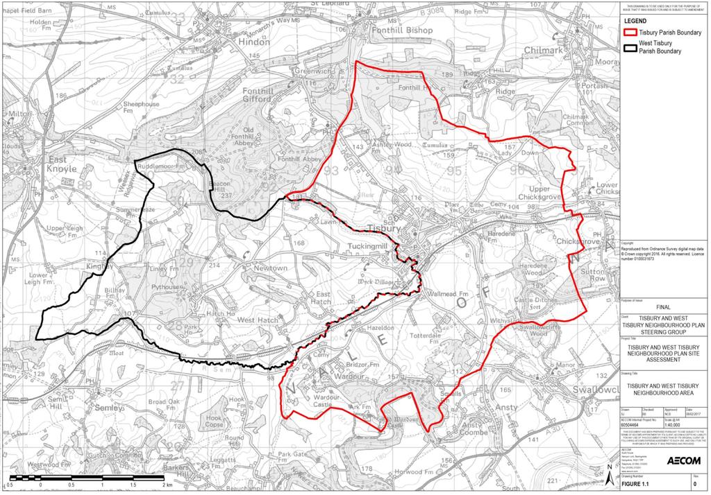
10 1. Introduction 1.1 Background has been commissioned to undertake an independent site appraisal for the Tisbury and West Tisbury Neighbourhood Plan on behalf of Tisbury and West Tisbury Neighbourhood Plan Steering Group. The work undertaken was agreed with the Steering Group and the Department for Communities and Local Government (DCLG) in September Figure 1.1 provides a map of the Tisbury and West Tisbury Neighbourhood Plan area, which covers the parishes of Tisbury and West Tisbury. The Neighbourhood Plan is being prepared in the context of the adopted Wiltshire Core Strategy 1. The Neighbourhood Plan, when adopted, will include allocations for housing. The Tisbury and West Tisbury Neighbourhood Plan Steering Group has made good progress in preparing the Neighbourhood Plan, and it is now looking to ensure that key aspects of its proposals will be robust and defensible. In this context, the Steering Group have asked to undertake an independent and objective assessment of the sites that are available for housing for inclusion in the Neighbourhood Plan. The purpose of the site appraisal is therefore to produce a clear assessment as to whether the identified sites are suitable and available. In this context it is anticipated that the site selection process will be robust enough to meet the Basic Conditions considered by the Independent Examiner, as well as any potential legal challenges by developers and other interested parties. 1.2 The Local Plan context for the Neighbourhood Plan The Neighbourhood Plan is being prepared in the context of the Wiltshire Core Strategy, which was adopted in January The Core Strategy, which covers the period up to 2026, provides a framework for how future development across Wiltshire will be planned and delivered. Neighbourhood Plans will form part of the development plan for Wiltshire, alongside, but not as a replacement for the Core Strategy. The Core Strategy states that it seeks to give communities a solid framework within which appropriate community-led planning policy documents, including neighbourhood plans, can be brought forward. Neighbourhood plans are required to be in conformity with the Core Strategy and can develop policies and proposals to address local place-based issues. In this way it is intended for the Core Strategy to provide a clear overall strategic direction for development in Wiltshire, whilst enabling finer detail to be determined through the neighbourhood planning process where appropriate. In relation to the wider Tisbury Community Area, the Core Strategy states that: The strategy for Tisbury Community Area is to provide for modest growth of both housing and employment to ensure development is balanced, thus helping to minimise out-commuting and also to provide support for local services and communities. Identifying suitable non-strategic allocations will include working closely with existing employers to ensure they have the potential to meet their future needs. The strategy will respond to the Community Area s location (in full or part) within a nationally designated landscape. In the Tisbury Community Area this includes the Cranborne Chase & West Wiltshire Downs Area of Outstanding Natural Beauty. It will deliver, within the overall objective of conserving the designated landscape, a modest and sustainable level of development. Tisbury village has been designated through the Core Strategy Settlement Strategy as a Local Service Centre. 2 Wiltshire Council (January 2015) Wiltshire Core Strategy 1
11 2
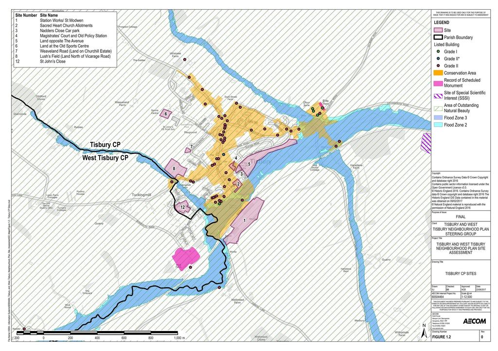
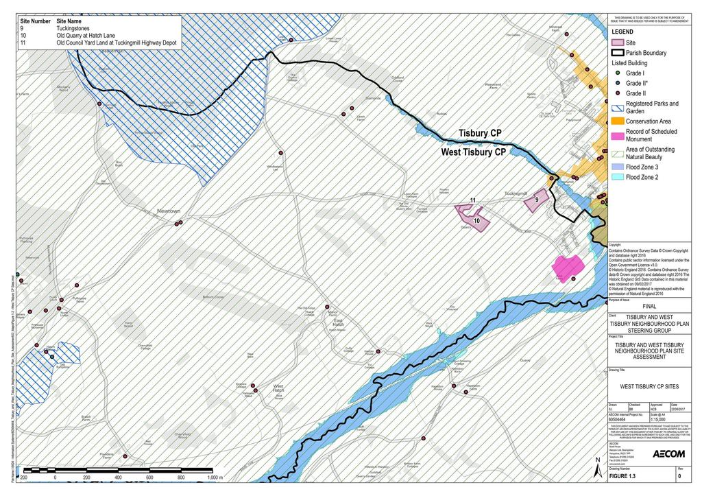
12 The Core Strategy sets out an allocation of 420 new homes for the wider Tisbury Community Area (which includes 16 parishes) between 2006 and 2026, with 200 allocated for Tisbury itself. Whilst this allocation has now almost been met in Tisbury, the Core Strategy seeks to stress that the indicative figures also allow a flexible approach which will allow the council including through the preparation of the Sites Allocation Development Plan Documents and local communities preparing neighbourhood plans to respond positively to opportunities without being inhibited by an overly prescriptive, rigid approach which might otherwise prevent sustainable development proposals that can contribute to maintaining a deliverable five year housing land supply and delivering the strategic objectives of the plan. Neighbourhood Plans should not be constrained by the specific housing requirements within the Core Strategy and additional growth may be appropriate and consistent with the Settlement Strategy. In this context the Tisbury and West Tisbury Neighbourhood Plan Steering Group wish to help ensure that community benefits are secured through Tisbury and West Tisbury Neighbourhood Plan through facilitating a degree of development which supports the Neighbourhood Plan objectives, including through supporting the vitality of the Neighbourhood Plan area. 1.3 Sites considered through the site appraisal Sites to be considered through the site appraisal have been selected via the following methods: Review of Wiltshire Council s Strategic Housing Land Availability Assessment (SHLAA) 3 ; Review of known free land in the Neighbourhood Plan Area; and A call for sites by the Neighbourhood Plan Steering Group. This process resulted in 12 sites being taken forward for the purposes of the site appraisal process. These 12 sites are presented in Table 1.1. Nine of these sites are located in Tisbury Civil Parish (CP) and three sites are located within West Tisbury CP. The location of the sites are presented in Figure 1.2 (Tisbury CP) and Figure 1.3 (West Tisbury CP). Table 1.1. Sites considered through the site appraisal Site Number Site Name Size (ha) 1 Station Works/ St. Modw en Sacred Heart Church allotments Nadders Close Car Park Magistrate s Court and Old Police Station Land opposite the Avenue Land at the Old Sports Centre Weaveland Road (Land on Churchill Estate) Lush s Field (Land north of Vicarage Road) Tuckingstones Old Quarry at Hatch Lane Old Council Yard (Land at Tuckingmill Highw ays Depot) St. Johns Close Redevelopment Wiltshire Council (February 2014) Strategic housi ng land availability assessment - Output report 3
13 4
14 5
15 2. Methodology for the site appraisal 2.1 Introduction Site selection and allocations is one of the most contentious aspects of planning, raising strong feelings amongst local people, landowners, builders and businesses. It is important that any selection process carried out is transparent, fair, robust and defensible and that the same criteria and thought process is applied to each potential site. Equally important is the way in which the work is recorded and communicated to interested parties so the approach is transparent and defensible. The approach undertaken to the site appraisal is based primarily on the Government s National Planning Practice Guidance (Assessment of Land Availability) published in 2014 with ongoing updates, which contains guidance on the assessment of land availability and the production of a Strategic Housing Land Availability Assessment (SHLAA) as part of a local authority s evidence base for a Local Plan. Although a Neighbourhood Plan is at a smaller scale than a Local Plan, the criteria for assessing the suitability of sites for housing are still appropriate. This includes an assessment of whether a site is suitable, available and achievable. In this context, the methodology for carrying out the site appraisal is presented below. 2.2 Task 1: Development of site appraisal pro-forma Prior to carrying out the appraisal, site appraisal pro-forma were developed. The purpose of the proforma is to enable a consistent evaluation of each site through the consideration of an established set of parameters against which each site can be then appraised. The pro-forma utilised for the assessment enables a range of information to be recorded, including the following: Background information: Site location and use; Site context and planning history; Suitability: Site characteristics; Environmental considerations; Heritage considerations; Community facilities and services; Other key considerations (e.g. flood risk, agricultural land, tree preservation orders); and Availability. 2.3 Task 2: Initial desk study The next task was to conduct an initial desk study for each of the sites. In addition to gaining preliminary information relating to each site, the purpose of this stage was to highlight areas which should be examined in more detail during the subsequent site visit. 2.4 Task 3: Site visit After the completion of the initial desk study, a site visit to the Neighbourhood Plan area was undertaken by two members of the Neighbourhood Planning team. The purpose of the site visit was to evaluate the sites on the ground to support the site appraisal. It was also an opportunity to gain an opportunity to better understand the context and nature of the Neighbourhood Plan area. 6
16 2.5 Task 4: Consolidation of results Following the site visit, further desk-based work was carried out. This was to validate and augment the findings of the site visit and to enable the results of the site appraisal to be consolidated. Section 4 presents a summary of the findings of the site appraisal. The completed pro-forma for each site are subsequently provided in Appendix Indicative housing capacities Where sites were previously included in Wiltshire Council s Strategic Housing Land Availability Assessment (SHLAA) 4 the indicative housing capacity listed in this document has been used. For sites not included within the SHLAA, the indicative housing capacity for each of the sites has been calculated utilising the methodology outlined below. In terms of housing density, the methodology assumes a density of 30 dwellings per hectare (dph) for all sites. This figure does not necessarily equate to the amount of land that is suitable for development, as, for larger sites, land needs to be allocated for non-housing uses, for example community facilities and open space (the net development area). To address this, the methodology provides ratios to calculate the net housing density based on the size of sites. The approach is based on the notion that: the bigger the site, the more land that needs to be put over for non-housing uses. The ratios are provided in Table 3.1. Table 3.1. Net housing density Area Gross to net ratio standards Net Housing Density: Up to 0.4ha 90% to 2ha 80% 30 2ha to 10 ha 75% 30 Over 10 ha 50% 30 The indicative number of dwellings for each site is shown in Table 3.2. Those sites calculated by using the above methodology are noted with an asterisk (*). It should be noted that these densities are for comparative purpose. For a number of the sites, a higher density is likely to be achievable. Where this is the case, this is indicated in the site appraisal summaries below. It is viewed that the above approach reflects the provisions of the Wiltshire SHLAA Methodology, which states that In light of the consultation responses and the revision to PPS3 removing the minimum density requirement, it is considered appropriate to apply a single density assumption of 30dph across the board 5 4 Wiltshire Council (2014) SHLAA 2012 Output Report, February Wiltshire Council (2011) SHLAA Methodology, September
17 Table 3.2 Indicative number of dwellings Site Number Site name Size (ha) Indicative Number of Dwellings 1 St. Modw en (Land at the Station Works) Sacred Heart Church allotments * 3 Nadders Close Car Park * 4 Magistrates Court and Old Police Station * 5 Land opposite the Avenue Land at the Old Sports Centre * 7 Weaveland Road (Land on Churchill Estate) 0.1 3* 8 Lush s Field (Land north of Vicarage Road) Tuckingstones (Land adjacent to Tuckingstones, Tisbury) Old Quarry at Hatch Lane (land and disused quarry at Tuckingmill) 11 Old Council Yard (Land at Tuckingmill Highw ays Depot) St. Johns Close Redevelopment * * Site capacity calculated by methodology presented above 8

 The site is located to the south of Tisbury Railway Station.")
18 4. Summary of site appraisals The following sections provide a summary of the findings linked the evaluation of the 21 sites considered through the site appraisal for the Tisbury and West Tisbury Neighbourhood Plan. These summaries should be read alongside the completed pro-forma presented in Appendix Site 1: St. Modwen (Land at the Station Works) The site is located to the south of Tisbury Railway Station. It comprises a series of warehouses currently used for commercial use. The site has a total size of 4.00ha and could accommodate 89 houses. 9
19 4.1.1 Site Development Potential Development on this site has the capacity to deliver 89 houses on a brownfield site and is understood to be available as well as deliverable within 0-5 years. Redevelopment of the site would result in the regeneration of a run-down site on the edge of Tisbury. Development has the potential to lead to significant enhancements in the quality of the public realm at this location and provides opportunities to enhance views from Tisbury village, as well as the landscape setting of this part of the village. The site has reasonable access to community services and facilities Key Constraints Redevelopment of the site for residential use would result in a loss of employment land; and in 2002 and 2004 planning applications for the redevelopment of the site for mixed use, consisting of residential and employment use, as well as alterations to site access was refused by Wiltshire Council. The site has a number of constraints, principally vehicle access, flood risk, contamination and restraints on the developable area. In addition, the site is outside of the settlement boundary of Tisbury, as defined by Wiltshire Council (Policy CP1 Settlement Framework of the Wiltshire Core Strategy). Currently no vehicle access is available directly into Tisbury village centre, with traffic having to access the site from Jobber s Lane. A pedestrian crossing exists across the rail line (see photograph above). However, this is not considered suitable in the event the site is developed for residential use. In regards to restraints on the developable area, the southern part of the site has a steep embankment up to higher level that would restrict development on this area of the site; furthermore, it is understood to be necessary to leave space for the dualling of the railway line that is adjacent to the site. The site may have the potential for contamination based on current and previous land uses; in particular it is known that a gas holder was located on the eastern part of the site, as well as the centre. In regards to flood risk, the access road onto site is at risk of fluvial (Flood Zone 2) and surface water flooding (low to medium flood risk); furthermore, Jobbers Lane is within fluvial flood zone 2 and 3, and at high risk of surface water flooding Recommendations The site has a number of constraints that would need to be managed as part of the redevelopment of the site. However, it is considered that redevelopment of an underused brownfield site, which has the potential to deliver a large number of homes close to the centre of Tisbury, would bring a range of benefits to the community in terms of landscape and visual effects. In this regards, the site is appropriate for allocation in the Neighbourhood Plan with a number of key conditions: safe vehicle and pedestrian access is put in place across the railway line to provide direct access into Tisbury village centre; some employment land should be retained in the curtilage of the site; and where necessary, space is included within the site for the potential dualling of the railway line. There is also the need for a detailed assessment on the extent to which the site is contaminated due to its history as a gas works, and for remedial action to be taken. 10

20 4.2 Site 2: Sacred Heart Church allotments The site is located in the centre of Tisbury village on the High Street. The site is located within the grounds of the Sacred Heart Church and adjacent vicarage, part of which is currently used for private allotments. The site has a total size of 0.29 ha and could accommodate 8 houses Site Development Potential The site is located in Tisbury village centre, with excellent access to community services and fac ilities, including the adjacent recreation ground. Development would relate well to its surroundings which includes residential use if designed appropriately. It is considered that development would only affect short views from surrounding viewpoints. The site is not currently accessible, however the site includes land to the south of the vicarage that would provide space for vehicular access to the site from the High Street Key Constraints There are a number of heritage constraints on the site; the site is at the eastern boundary of Tisbury Conservation Area and close to The Clock House, a Grade II listed building approximately 50m to the north-west of site; in addition the Sacred Heart Church and Trellis House are buildings of local importance. Development of the site is therefore likely to affect the conservation area and setting of the adjacent Sacred Heart Church and Trellis House, through removal of trees (one of which is considered to be of importance) and changes to the character and presence of the conservation area. Development at this location would lead to the loss of allotments, a key community facility. The site has flood constraints on part of the site. The southern boundary of the site is located in fluvial flood zone 2, while the north eastern section of site is at low risk of surface water flooding. 11

21 4.2.3 Recommendations The site is well located with excellent links to community facilities and services; however the s ite could only provide a limited number of houses. Given the open perspective of the site, development has the potential to impact on the setting of the conservation area and adjacent buildings of local importance. However, there is a precedent for high quality design in this location; adjacent areas have recently been redeveloped for residential uses of a design sensitive to the setting of the location. For these reasons the site is potentially appropriate for allocation within the Neighbourhood Plan, if appropriate design and layout is incorporated within new development. 4.3 Site 3: Nadders Close Car Park The site is located within Nadders Close Car Park, the main car park for the village centre. The site has a total size of 0.14 ha and could accommodate four houses Site Development Potential The site is adjacent to the village centre, so has excellent links to community services and facilities. The site is a brownfield site and it is also located adjacent to residential development, and has good access. The site could accommodate in the region of five houses. Development would only affect short views from existing residential areas, and as such development is considered to relate to its surroundings well Key Constraints While the site is not at flood risk, Nadders Close, adjacent to site, is at low risk of surface water flooding. In addition the site is adjacent to the Tisbury Conservation Area, and development would affect views out to the east from the village centre to the east across the Nadder Valley; though this is not listed as being a key view in the Tisbury Conservation Area Appraisal and Management Plan. 12


22 Development on the land would result in the loss of Nadders Close Car Park, the main car park for the village centre. This will significant reduce car parking available in the area, with the potential to affect the vitality of the village centre Recommendations Despite the development potential of the site, the importance of the car park for the vitality of the village centre is considered to be a significant issue. For this reason the site is not considered appropriate for allocating within the Neighbourhood Plan. 4.4 Site 4: Magistrates Court and Old Police Station The site is located on land previously occupied by the Magistrates Court and the Police Station. The buildings associated with these remain, however are not in use. The site is adjacent to the Fire Station. The site has a total size of 0.14 ha and could accommodate four houses. 13
23 4.4.1 Site Development Potential The site benefits from being located on brownfield land currently not utilised, in the village centre with good access to community facilities and services. The site is also within the settlement boundary of Tisbury (Wiltshire Core Strategy Policy CP1). Development is considered to fit in well with the site s surroundings, which include residential development. The site is within flood zone Key Constraints The site is within the Tisbury Conservation Area. However development would not necessarily have significant effects on the conservation area, as it is an infill site, which would not affect views into or out of the Conservation Area. There are also a number of listed buildings and buildings of local importance located in close proximity to the site. Current vehicular access is provided from The Avenue in front of the Fire Station, however this is shared with the Fire Station, and outside the boundary of the site. For operational reasons the Fire Station would need their own access so a new access would be required for the development. The site is steeped up from the road, making access difficult. Parking may need to be provided in parking bays at a lower level than the houses themselves. It is not known if the site is available, and in addition, part of the site leased to the Fire Service; as such development would need to be sensitive to the operational requirements of Fire Service in regards to access, training, and parking Recommendations The site has the capacity to deliver four homes, on an unused brownfield site in the centre of Tisbury. There are some constraints, in particular availability and the operational requirements of the Fire Service that would need to be overcome. Therefore the site is considered to be potentially suitable for taking forward for the purposes of the Neighbourhood Plan. 14

24 4.5 Site 5: Land opposite the Avenue The site is a linear strip of agricultural land, currently used for grazing cattle. The site is located along the southern edge of The Avenue, and north of the River Nadder. The site has a total size of 2.47 ha and could accommodate 51 houses Site Development Potential The site has the potential to deliver a large number of houses in a location close to Tisbury village centre, and therefore has good access to community services and facilities. The site is located on Grade 3 agricultural land and it is considered that development would relate well to surroundings, with residential development to the north and east. While the site is not at risk of fluvial flooding, the site is directly adjacent to the boundary of an area at risk of flooding (flood zones 2 and 3); as well as an area at high risk of surface water flooding. Only a small part of the site is at low risk of surface water flooding, which in itself is not a significant constraint. Furthermore, the site is available for development (0-5 years) and in single ownership Key Constraints The site has a number of environmental, landscape and heritage constraints. The site is located close to the River Nadder, which is designated as a County Wildlife Site, with water voles and otters known to use the area. There are no barriers between the County Wildlife Site and the site, and as such, the site could therefore be used for protected species. The site is also within the SSSI impact risk zone for the River Avon System SSSI, and as such development could have impacts on this, if not mitigated. Development on the site would have a significant impact on long distance views of the Nadder Valley from the village centre, as well as impacting on the landscape through the redevelopment of a greenfield site in a river valley to residential land use. Furthermore, the site is also adjacent to the 15

25 Tisbury Conservation Area, which borders the site to the north east and north west. The Tisbury Conservation Area Management Plan mentions that the Nadder Valley can be best seen from the Avenue, through the line of trees. Development therefore has the potential to have significant effects on the setting of the conservation area and the AONB Recommendations The site has the potential to deliver a large number of houses in a location close to Tisbury village centre; however the likely impact of development on the AONB and Tisbury Conservation Area are considered to be significant. For these reasons the site is not considered appropriate for taking forward for the purposes of the Neighbourhood Plan. 4.6 Site 6: Land at the Old Sports Centre The site is located on land previously used as a sports centre; however the building is now vacant following the development of the Nadder Centre on an adjacent site. The site has a total size of 0.35 ha and could accommodate nine houses Site Development Potential The site is a brownfield site that has the potential to deliver in the region of nine houses. It is in a location adjacent to a school and community and sports centre; as well as being located in an area adjacent to residential housing. The site is also with a reasonable walking distance of Tisbury village centre. The site is not at risk of fluvial or surface water flooding, nor are there considered to be any other environmental or heritage constraints. It is considered that there are only short views in to the site from the adjacent community and sports centre, primary school and residential area to the east of site. Development is also not considered to have a significant effect on the views or landscape, and thus the integrity of the AONB. 16

26 4.6.2 Key Constraints The land is understood to be available for development, however there are two potential constraints for development. Firstly, it is understood that the land was donated to Wiltshire Council by the Fonthill Estate for educational use, there could therefore be a covenant on the land restricting residential development. Secondly, the land is also subject to an existing planning permission that would see the demolition of the building and landscaping of the site as a wildflower meadow. The site is outside the settlement boundary for Tisbury (Wiltshire Core Strategy Policy CP1) Recommendations The land is considered appropriate for residential development, due to its location and lack of environmental, landscape or heritage constraints. However the availability of the land for development is unclear; this will need confirming prior to allocation within the Neighbourhood Plan. The land is also outside of the housing policy boundary and has been recommended to be set aside for future extension of the primary school. The site is therefore considered to be potentially suitable for taking forward for the purposes of the Neighbourhood Plan. 4.7 Site 7: Weaveland Road (Land on Churchill Estate) The site is located to the west of Tisbury village centre, on the Churchill Estate. The site is currently open space within the housing estate, with no formal use. The site has a total size of 0.1 ha and could accommodate 3 houses Site Development Potential The site has the potential to accommodate a number of houses in a location that is adjacent to an existing residential area, as well as being located relatively close to the village centre, and thereby 17

27 close to community services and facilitates. The site has no environmental or heritage constraints; and the site is within the settlement boundary of Tisbury. The site is well screened from open countryside and is not considered to affect long distance views and thus the AONB Key Constraints The site contains a TPO(/s) on the boundary, and development of the site would see the loss of a small plot of grassland that is currently available for use for recreational purposes by surrounding residents. It forms a useful pedestrian access into the adjacent community field. However, as the land is not designated for recreation use, and recreation space is available locally this should not prohibit the development of the site. The development would affect short distance views from the neighbouring properties Recommendations The site currently consists of open space within a residential area that has no formal designation. The site has few constraints to development; and thus considered suitable for allocation. It is however only a very small site and it forms a useful pedestrian access into the community field. As such, the site may be better suited for allocation as Local Green Space. 4.8 Site 8: Lush s Field (Land north of Vicarage Road) Agricultural land located to the west of Tisbury, to the north of Vicarage Road and Tuckingmill Farm. The site has a total size of 1.29 ha and could accommodate 30 houses. 18

28 4.8.1 Site Development Potential The site has the potential to accommodate a large number of houses in a location that is relatively close to Tisbury village centre, and within a reasonable walking distance of other community services and facilitates. The site is part surrounded by residential development. While the site is not at risk of fluvial flooding, the site is directly adjacent to the boundary of an area at risk of flooding (flood zone 3); as well as an area at high risk of surface water flooding. Furthermore, the site is available for development (0-5 years) Key Constraints The site is located on greenfield agricultural land that is outside the settlement boundary of Tisbury (Wiltshire Core Strategy Policy CP1). Construction of houses as well as access to the site would be difficult, as the site falls steeply to the south west down to the watercourse (Oddford Brook) and Vicarage Road. It is not easily conceivable how access could be provided to the site from Vicarage Road. In regards to environmental constraints, the site is adjacent to a County Wildlife Site to the west, which also consists of deciduous woodland, a Biodiversity Action Plan (BAP) Priority Habitat; as a result the site could support protected species. In regards to the historic environment, the site is adjacent to Tisbury Conservation Area to the south along Vicarage Road. The Tisbury Conservation Area Management Plan notes that the cohesion of the hamlet around Tuckingmill Farm is formed around the stream and the enclosing form of the buildings to the lane, and that the dwellings are a cohesive and intimate group. It is therefore possible that development on the site would affect the conservation area. The western boundary of the site may be at risk of surface water flooding. The site has long distance views to the south east, and development could affect views to and from the AONB. 19

29 4.8.3 Recommendations The site has the potential to deliver a large number of houses, however it is not considered that access can be readily provided to the site. Furthermore, development could have an adverse effect on Tisbury Conservation Area, the AONB, as well as on ecological constraints. For these reasons, the site is not considered suitable for allocation in the Neighbourhood Plan. 4.9 Site 9: Tuckingstones (Land adjacent to Tuckingstones, Tisbury) Agricultural and residential land located in Tuckingmill, to the south of Vicarage Road. The site has a total size of 1.04 ha and could accommodate 24 houses Site Development Potential The site has the potential to accommodate a large number of houses in a location that is within a reasonable walking distance to Tisbury village centre, however, other community services and facilitates are further away. The site is in part surrounded by residential development. The site is not at risk of fluvial or surface water flooding and it is flat as well as accessible, with access easily provided from Mount Pleasant, where the current farm access gate is located Key Constraints The site is predominantly greenfield land, however two residential properties are located on it. The site is overlooked by adjacent residential properties, as well as from the surrounding landscape, particularly from the north-east and east. It is therefore considered that development would affect the long distance views from properties on Mount Pleasant; and shorter distance views from other properties adjacent to the site. In addition, the site forms the only gap between Tisbury and Tuckingstones. In regards to the historic environment the site is located adjacent to a number of features, including the Tisbury Conservation Area, listed buildings and an area of archaeological potential. Development on the site, which is largely open, could therefore affect the setting of these. In particular, development could alter the cohesion of the hamlet around Tuckingmill Farm, which is reported in the Tisbury 20

30 Conservation Area Management Plan as a cohesive and intimate group of dwellings. Development at this location would also lead to the merging of Tisbury and Tuckingmill as distinctive settlements. The SHLAA also reports that the site is not currently considered available, as the site is within multiple or unknown ownership. However it is reported as deliverable in 6-10 years Recommendations Development of the site could potentially significantly impact on the views from surrounding properties and on heritage receptors. In addition, the land provides the only break between development Tisbury and Tuckingmill. For these reasons, the site is not considered suitable for allocation in the Neighbourhood Plan Site 10: Old Quarry at Hatch Lane (land and disused quarry at Tuckingmill) The site comprises land located on the western boundary of Tuckingmill, to the south of Hatch Lane. The site has a total size of 1.28 ha and could accommodate 31 houses. The site, which was previously a quarry, has been designated as a County Wildlife Site Site Development Potential The site has the potential to accommodate a large number of houses on the boundary of Tuckingmill. The site has no heritage constraints and is not at risk of fluvial flooding Key Constraints The site is a County Wildlife Site, and has potential to support protected species; development would therefore see a loss of an important local ecological resource. There are a number of other constraints to development including: the distance from Tisbury village centre and associated community services and facilities; the effect development would have on the 21

31 views from surrounding residential properties; overhead electricity lines traversing part of the site; and a risk of surface water flooding on the south-eastern tip of the site. Furthermore, the site is outside the settlement boundary and is of uncertain ownership Recommendations Due to the significant constraints present at the site, principally the ecological constraints associated with the County Wildlife site designation, the site is not considered suitable for allocation of residential development through the Neighbourhood Plan Site 11: Old Council Yard (Land at Tuckingmill Highways Depot) The site comprises previously developed land located on the west of Tuckingmill, to the south of Hatch Lane. The site has a total size of 0.28 ha and could accommodate eight houses. The site is currently unused; however it was previously the Council s Highway Depot Site Development Potential The site has the potential to accommodate a number of houses on the boundary of Tuckingmill; development would fit in with the linear nature of development in this area. The site is a brownfield site that is currently not in use. Development would not affect the views from existing residential properties, due to the screening afforded by the trees on the boundary of the site. The site has no heritage constraints and is not at risk of fluvial or surface water flooding Key Constraints The site is adjacent to a County Wildlife Site that is located to the south eastern part of the site. A number of mature trees are present on the site boundary. As such, the site has ecological potential. The site is located outside of the settlement boundary (Wiltshire Core Strategy Policy CP1), and not within immediate proximity to Tisbury village centre and associated community services and facilities; 22

32 with the village centre approximately 1 km to the east and St. Johns Church of England Primary School 1.3km away Recommendations The site has the capacity to deliver a small number of houses on a brownfield site adjacent to existing residential properties. Development at this location would need to ensure effects on the adjacent County Wildlife Site are avoided, and potential biodiversity assets on the site (including trees) are retained. It is therefore concluded that the site is potentially suitable for the allocation of residential development through the Neighbourhood Plan Site 12: St. Johns Close Redevelopment The site is located to the south west of Tisbury. The site currently consists of approximately 16 sheltered houses, managed by Wiltshire Council. The site has a total size of 0.66 ha and could accommodate a significant number of houses if densities are increased Site Development Potential The site has the potential to accommodate a larger number of houses than at present in a location that is close to Tisbury village centre, and within a reasonable walking distance of community services and facilitates. The site is surrounded by residential development and is within the settlement boundary of Tisbury (Wiltshire Core Strategy Policy CP1). 23
HAYLE NEIGHBOURHOOD PLAN FUTURE HOUSING EXPANSION VISION DOCUMENT. Prepared for Hayle Neighbourhood Plan Steering Group by AECOM
 HAYLE NEIGHBOURHOOD PLAN FUTURE HOUSING EXPANSION VISION DOCUMENT Prepared for Hayle Neighbourhood Plan Steering Group by AECOM December 2015 1. Introduction Context Hayle is a linear town situated in
ROCHFORD LOCAL DEVELOPMENT FRAMEWORK: Sustainability Appraisal/ Strategic Environmental Assessment. Rochford Core Strategy Preferred Options Document
 ROCHFORD LOCAL DEVELOPMENT FRAMEWORK: Sustainability Appraisal/ Strategic Environmental Assessment Non Technical Summary Rochford Core Strategy Preferred Options Document October 2008 SUSTAINABILITY APPRAISAL
Blandford Forum Town Council, Blandford St Mary Parish Council and Bryanston Parish Council
 Blandford Forum Town Council, Blandford St Mary Parish Council and Bryanston Parish Council Blandford + Neighbourhood Plan 2 Pre-Submission Plan Consultation (November 2018) Representations submitted on
Plumpton Neighbourhood Development Plan Revised Pre Submission Document - Regulation 14 Consultation
 REPRESENTATIONS... Plumpton Parish Council Plumpton Neighbourhood Development Plan Revised Pre Submission Document - Regulation 14 Consultation Representations submitted on behalf of: Cala Homes (South
OKEFORD FITZPAINE NEIGHBOURHOOD PLAN
 OKEFORD FITZPAINE NEIGHBOURHOOD PLAN Dear Parishioner, The Neighbourhood Plan Project Team have prepared this leaflet to summarise the full Neighbourhood Plan document. It provides a summary of the Vision,
Wallingford Neighbourhood Plan
 Wallingford Neighbourhood Plan Introduction What is neighbourhood planning? Neighbourhood planning was introduced by the Localism Act 2011 to give local people more influence over how development comes
Site Assessment Technical Document Appendix A: Glossary
 Central Bedfordshire Council www.centralbedfordshire.gov.uk Site Assessment Technical Document Appendix A: Glossary July 2017 1.1.11-1 - ii Appendix A: Glossary Term Agricultural Land Classification AONB
Oxford Green Belt Study. Summary of Final Report Prepared by LUC October 2015
 Oxford Green Belt Study Summary of Final Report Prepared by LUC October 2015 Project Title: Oxford Green Belt Study Client: Oxfordshire County Council Version Date Version Details Prepared by Checked by
Newcourt Masterplan. November Exeter Local Development Framework
 Newcourt Masterplan November 2010 Exeter Local Development Framework Background The Exeter Core Strategy Proposed Submission sets out the vision, objectives and strategy for the development of Exeter up
Settlement Boundaries Methodology North Northumberland Coast Neighbourhood Plan (August 2016)
") Introduction This background paper sets out a methodology for the definition of settlement boundaries in the North Northumberland Coast Neighbourhood Plan. The neighbourhood plan is planning positively
Introduction This background paper sets out a methodology for the definition of settlement boundaries in the North Northumberland Coast Neighbourhood Plan. The neighbourhood plan is planning positively
Neighbourhood Planning Site Assessment Pro-forma and Guide Version 2
 Neighbourhood Planning Site Assessment Pro-forma and Guide Version 2 September 2014 Site HNP 006 Land East of Stanbridge Road and North of Lower Road 1. Background information Site location and use Site
DUNSFOLD NEIGHBOURHOOD PLAN Site Selection Policies
 DUNSFOLD NEIGHBOURHOOD PLAN Site Selection Policies The criteria for assessing sites for future housing and business development in Dunsfold are set out below. (Development criteria, covering what it is
Briefing Document of CNP. June 2017
 Cholsey Parish Council Cholsey Neighbourhood Plan Briefing Document of CNP June 2017 Cholsey Neighbourhood Plan Page! 1 of! 8 Cholsey Plan Briefing v1.4 Page Left Intentionally Blank Cholsey Neighbourhood
Babergh and Mid Suffolk Joint Draft Local Plan Consultation, August 2017, Public Consultation
 Babergh and Mid Suffolk Joint Draft Local Plan Consultation, August 2017, Public Consultation Having reviewed the documents, the Society has made the following response: Housing Delivery Q 7. Do you agree
Great Easton Neighbourhood Plan Statement of Basic Conditions
 Great Easton Neighbourhood Plan 2017-2031 Statement of Basic Conditions OCTOBER 2016 GREAT EASTON PARISH COUNCIL Contents 1.0 Introduction....Page 2 2.0 Summary of Submission Documents and Supporting Evidence..
Parish of Repton NEIGHBOURHOOD DEVELOPMENT PLAN
 Parish of Repton NEIGHBOURHOOD DEVELOPMENT PLAN BASIC CONDITIONS STATEMENT December 2018 CEF 4 Legal Requirements This statement has been produced by the NDP Working Group on behalf of Repton Parish Council
Neighbourhood Planning Local Green Spaces
 Neighbourhood Planning Local Green Spaces Introduction... 2 1. Why green space is important... 4 2. Neighbourhood plans and green space... 6 3. Evidence... 8 Statutory designations... 9 Green space audit...
Neighbourhood Plan Representation
 Date: 10 th November 2017 Neighbourhood Plan Representation Land to the east of Callow Hill Road, Alvechurch Introduction This representation has been prepared by RPS Planning and Development on behalf
Dunsfold Neighbourhood Plan. Site Assessment Report
 Dunsfold Neighbourhood Plan Site Report vember 2018 Quality information Prepared by Checked by Approved by Lachlan Anderson-Frank Planner Una McGaughrin Associate Una McGaughrin Associate Revision History
Replacement Golf Course Facilities and Residential Development, Churston. Environmental Statement Non-Technical Summary
 Replacement Golf Course Facilities and Residential Development, Churston Environmental Statement Non-Technical Summary July 2011 Reproduced from the Ordnance Survey s map with the permission of the Controller
WELCOME GYPSY LANE. Wider Site Location plan. Proposals for the development of LAND OFF FOXLYDIATE LANE WEBHEATH. Proposals for the development of
 WELCOME The developers are preparing an outline planning application for a residential led development and need the community s views in order to develop the proposals further WHAT IS PROPOSED? A high
SITE ASSESSMENT CHECKLIST
 1. Site Details a. What is the site s name/reference? SITE ASSESSMENT CHECKLIST CR3NPWHY 3007 Gasometer Site Godstone Road CR3 0EG b. Where is the site located? Wyhteleafe; Godstone Road. Urban category1
Rochford District Council Allocations Development Plan Document: Discussion and Consultation Document Sustainability Appraisal
 Option SWH1 Balanced Communities Option SWH1 1 To ensure the delivery of high quality sustainable communities where people want to live and work Will it ensure the phasing of infrastructure, including
SOUTH EAST LINCOLNSHIRE LOCAL PLAN: HOUSING PAPER DONINGTON (JUNE 2016)
") SOUTH EAST LINCOLNSHIRE LOCAL PLAN: HOUSING PAPER DONINGTON (JUNE 2016) 1 DONINGTON S PLACE IN THE SPATIAL STRATEGY 1.1 Policy 2 of the South East Lincolnshire Local Plan 2011-2036 Draft for Public Consultation
SOUTH EAST LINCOLNSHIRE LOCAL PLAN: HOUSING PAPER DONINGTON (JUNE 2016) 1 DONINGTON S PLACE IN THE SPATIAL STRATEGY 1.1 Policy 2 of the South East Lincolnshire Local Plan 2011-2036 Draft for Public Consultation
Suffolk Coastal Local Plan Review Issues and Options, August 2017, Public Consultation
 Suffolk Coastal Local Plan Review Issues and Options, August 2017, Public Consultation Having reviewed the issues and options documents, the Society has made the following response: Part 1 - Strategic
WHITELEY TOWN COUNCIL NORTH WHITELEY DEVELOPMENT SEPTEMBER 2014
 WHITELEY TOWN COUNCIL NORTH WHITELEY DEVELOPMENT SEPTEMBER 2014 Dear Resident This Special Edition of the Whiteley Voice which has been prepared in conjunction with the North Whiteley Consortium is to
3. Neighbourhood Plans and Strategic Environmental Assessment
 1. Introduction This report sets out a draft Screening Determination for the Preston Parish Council s Neighbourhood Plan and has been prepared by rth Hertfordshire District Council. The purpose of the
Effingham Neighbourhood Plan 1. Basic Conditions Statement
 Effingham Neighbourhood Plan 1 Basic Conditions Statement Effingham Neighbourhood Plan 2016: Basic Conditions Statement 2 Contents This statement has been prepared by Effingham Parish Council to accompany
Kibworth Harcourt. Introduction. Introduction
 Introduction Introduction Welcome to this public exhibition on the proposals for the delivery of new homes on land at The Kibworths. The purpose of today s exhibition is to give you the opportunity to
DEVELOPMENT MANAGEMENT REPORT
 ITEM A08-1 DEVELOPMENT MANAGEMENT REPORT TO: BY: DATE: DEVELOPMENT: SITE: WARD: APPLICATION: APPLICANT: Development Management Committee Development Manager Proposed live/work unit in connection with existing
SITE ASSESSMENT CHECKLIST
 1. Site Details a. What is the site s name/reference? CR3 FORUM NEIGHBOURHOOD PLAN SITE ASSESSMENT CHECKLIST CR3NPCOH3016 Douglas Brunton Centre Park Rd b. Where is the site located? Caterham Hill urban
Bradleys Both Parish Council
 Bradleys Both Parish Council Bradleys Both Housing Site Assessments April 2015 Contents 1.0 Introduction... 2 2.0 BR001 Health Lea and Land to Rear, Skipton Road... 2 3.0 BR002 Holly Tree House and Land
WINCHESTER TOWN 3.1 LOCATION, CHARACTERISTICS & SETTING
 WINCHESTER TOWN 3.1 LOCATION, CHARACTERISTICS & SETTING 3.1.1 The area referred to by the City Council, as Winchester Town, consists of the Winchester Wards plus the adjoining built up areas of Badger
Schedule of Planning Applications Committee Date: 23 May Reference: 06/17/0726/F Parish: Hemsby Officer: Mr J Beck Expiry Date:
 Schedule of Planning Applications Committee Date: 23 May 2018 Reference: 06/17/0726/F Parish: Hemsby Officer: Mr J Beck Expiry Date: 22-05-2018 Applicant: Proposal: Site: Mr Gillett Change of use to the
Everton s Neighbourhood Plan. Site Allocation - Assessment Criteria
 Everton s Neighbourhood Plan Site llocation - ssessment Criteria Introduction 1.1 This report assesses all the sites identified through the emerging Neighbourhood Plan for Everton and their potential for
Plumpton Neighbourhood Plan Site Assessment Report
 Plumpton Neighbourhood Plan Site Assessment Report May 2016 1 Contents 1. Introduction 3 2. Methodology 4 2.1 Identification of Potential Sites 4 2.2 Assessment Process 5 2.3 Assessment Criteria 6 2.4
DEVELOPMENT MANAGEMENT REPORT
 ITEM A07-1 DEVELOPMENT MANAGEMENT REPORT TO: BY: Development Management Committee (South) Development Manager DATE: 21 June 2016 DEVELOPMENT: SITE: WARD: APPLICATION: APPLICANT: Outline application for
Sustainability Statement. Whitby Business Park Area Action Plan
 Sustainability Statement Whitby Business Park Area Action Plan November 2014 Contents Page 1. Introduction 1 2. Scoping 3 3. Sustainability Appraisal of Options 6 4. Assessment of Draft Area Action Plan
Draft Hailey Neighbourhood Plan
 Persimmon Homes (Wessex) Draft Hailey Neighbourhood Plan Representations to West Oxfordshire District Council s Regulation 16 Consultation December 2018 2 Copyright 2018 Persimmon Homes Ltd. All rights
Longbridge Town Centre Phase 2 Planning Application
 Longbridge Town Centre Phase 2 Planning Application Non-Technical Summary of the Environmental Statement December 2013 Introduction A full application for Planning Permission has been submitted to Birmingham
A Growing Community Rural Settlement Areas
 Town of Huntsville Official Plan Review - POLICY BACKGROUND PAPER A Growing Community Rural Settlement Areas BACKGROUND: In addition to the fully municipally-serviced Urban Settlement Area and the Hidden
Response by The Dartington Hall Trust
 Consultation Response by The Dartington Hall Trust Site Reference: SH_39_02_08/13 Contents Introduction 1 Site Description 2 Development Proposal and Context 3 Site Technical Assessment 4 Planning Policy
INTRODUCTION NORTH HEYBRIDGE GARDEN SUBURB
 INTRODUCTION This event is being hosted by the promoters of the proposed North Heybridge Garden Suburb who are working with Maldon District Council and other key stakeholders on the preparation of a comprehensive
Longhorsley Neighbourhood Plan
 Site Assessment 1. The availability of the site 1.1 Is the land owner willing for their site to be made available for development? 1.2 If yes, do you have any written evidence to back this up? Planning
WELCOME. Land North of STEVENAGE. We would like to thank you for attending our public exhibition today.
 WELCOME We would like to thank you for attending our public exhibition today. The purpose of this event is to share our proposals and hear your thoughts on our ideas. Members of the project team are on
Test Valley Borough Council. Strategic Housing Land Availability Assessment (SHLAA)
") Test Valley Borough Council Strategic Land Assessment (SHLAA) Appendix 2 Southern Test Valley Sites Where a Change in Policy is Required for Residential Development Final Version as at 1 st April 2014
Test Valley Borough Council Strategic Land Assessment (SHLAA) Appendix 2 Southern Test Valley Sites Where a Change in Policy is Required for Residential Development Final Version as at 1 st April 2014
Site ref: AS06 Site Name or Address: Murreys Court, Agates Lane
 Site ref: AS06 Site Name or Address: Murreys Court, Agates Lane Proposed Land Use: Total Site Area (Ha): Housing 1.85 Ha Description: It is understood that the owner has no plans to dispose of the site
Welcome to our exhibition
 Welcome to our exhibition The Homes & Communities Agency (HCA) welcomes you to this public exhibition explaining our proposals for the redevelopment of the former Lea Castle Hospital site. About the Homes
BRIDGE OF DON MASTERPLAN & PLANNING SUMMARY
 BRIDGE OF DON MASTERPLAN & PLANNING SUMMARY SITE LOCATION The site of the existing AECC lies in an area of predominately residential and business use in Bridge of Don and extends approximately 50 acres.
Land at Fiddington Hill Nursery, Market Lavington
 Land at Fiddington Hill Nursery, Market Lavington Briefing Report for Market Lavington Parish Council Persimmon Homes (Wessex) April 2016 Background This brief report has been prepared following the Market
Land at Rampton Road. Cottenham
 Land at Rampton Road Cottenham Introduction TEP is preparing an outline planning application for 54 dwellings on 6.9 hectares of land adjacent to Rampton Road, Cottenham on behalf of the owners Cambridgeshire
Wildlife and Planning Guidance: Neighbourhood Plans
 Wildlife and Planning Guidance: Neighbourhood Plans This Leaflet is one of a series of 4 Wildlife and Planning Guidance Leaflets and is intended to provide useful information to assist you to campaign
Built Up Area Boundary (BUAB)
") Parish Boundary Built Up Area Boundary (BUAB) Potential Sites Map not to scale DWELLING SIZE POLICY Residential developments must provide a mix of dwelling sizes (market and affordable) that reflect the
Parish Boundary Built Up Area Boundary (BUAB) Potential Sites Map not to scale DWELLING SIZE POLICY Residential developments must provide a mix of dwelling sizes (market and affordable) that reflect the
Assessing the Significance of the key characteristics of Historic Landscape Character Areas: a Discussion Paper
 Assessing the Significance of the key characteristics of Historic Landscape Character Areas: a Discussion Paper Background The 11 distinct Historic Landscape Types in the East Devon AONB have been used
LONGDEN VILLAGE DEVELOPMENT STATEMENT
 LONGDEN VILLAGE DEVELOPMENT STATEMENT 2017-2027 1 Longden Development Statement 2017-2027 15/01/18 1. Background 1.1 Longden Village Longden village is a very rural and traditional community first mentioned
Cottenham Civil Parish. Neighbourhood Development Plan to 2031
 Cottenham Civil Parish Neighbourhood Development Plan 2017 to 2031 Cottenham Parish Council Basic Conditions Statement December 2018 In 2031 Cottenham will still be an attractive safe rural village, proud
PHASE III: Reserved Matters Submission
 Statement of Compliance with the outline approval for the proposed residential development of land at: BURGES LANE, WIVELISCOMBE PHASE III: Reserved Matters Submission Foreword Contents: This Statement
Derry City and Strabane District Council Planning Committee Report
 Derry City and Strabane District Council Planning Committee Report COMMITTEE DATE: 23 rd March 2016 APPLICATION No: APPLICATION TYPE: PROPOSAL: LOCATION: APPLICANT: LA11/2015/0395/F Residential Development
Stantonbury Neighbourhood Plan
 Stantonbury Neighbourhood Plan 2018-2031 Basic Conditions Statement October 2018 Intentionally blank 1.0 Basic Conditions Statement Introduction 1.1 This statement has been prepared by Stantonbury Parish
Appendix 1 Structure plan guidelines
 Appendix 1 Structure plan guidelines This appendix forms part of the regional policy statement [rps]. 1.1. Introduction Structure plans are an important method for establishing the pattern of land use
Neighbourhood Planning Guidance Local Green Spaces
 Neighbourhood Planning Guidance Local Green Spaces Introduction This guidance note has been produced for communities preparing neighbourhood plans in North Dorset to help them to identify, assess and designate
DESIGN & ACCESS STATEMENT
 DESIGN & ACCESS STATEMENT January 2016 Contents Introduction section 1 Section 1 - Introduction Section 2 - Assessment Section 3 - Involvement Section 4 - Evaluation Section 5 - Design Section 6 - Layout
Public Consultation. Land at Monks Farm, North Grove. Welcome
 Welcome Welcome to our public exhibition for development on Land at Monks Farm, orth Grove. Gallagher Estates and Gleeson Strategic Land are preparing an outline planning application for new homes, open
LEEDS SITE ALLOCATIONS PLAN MATTER 3 GREEN BELT KCS DEVELOPMENT AUGUST 2017
 LEEDS SITE ALLOCATIONS PLAN MATTER 3 GREEN BELT KCS DEVELOPMENT AUGUST 2017 Smith Limited Suite 9C Joseph s Well Hanover Walk Leeds LS3 1AB T: 0113 2431919 F: 0113 2422198 E: planning@peacockandsmith.co.uk
EVALUATION OF MASTER PLAN ALTERNATIVES
 7 The Environmental Report is required to identify, describe and evaluate reasonable alternatives, taking into account the objectives and geographical scope of the Master Plan 2008. Three plan alternatives
Interim Advice Note 76 / 06 ASSESSMENT PART 1 AIMS AND OBJECTIVES OF ENVIRONMENTAL ASSESSMENT. Contents
 Interim Advice Note 76 / 06 VOLUME 11 SECTION 1: ENVIRONMENTAL ASSESSMENT INTRODUCTION PART 1 AIMS AND OBJECTIVES OF ENVIRONMENTAL ASSESSMENT Contents 1. Introduction and Application 2. Aims and Objectives
Cookham Parish Council s Response to The Draft Local Borough Plan
 Cookham Parish Council s Response to The Draft Local Borough Plan As Agreed at the Planning Committee Meeting on 10 th January 2017. Designation of Poundfield as a Local Green Space The Parish Council
Droitwich Spa 6. Reasoned Justification
 87 Droitwich Spa 6 Reasoned Justification 6.1 Droitwich Spa is identified in the settlement hierarchy (Policy SWDP1) as a main town being the largest settlement in Wychavon District with an estimated population
Evesham 7. Reasoned Justification
 95 Reasoned Justification 7.1 Evesham is situated within the Vale of Evesham and has an estimated population of 22,800 (2009 Mid-Term Population Estimates). As a main town it provides a wide range of services
4 RESIDENTIAL ZONE. 4.1 Background
 4 RESIDENTIAL ZONE 4.1 Background The residential areas within the City are characterised by mainly lowrise dwellings sited on individual allotments. Past architectural styles, settlement patterns and
Cotswolds AONB Landscape Strategy and Guidelines. June 2016
 Cotswolds AONB Landscape Strategy and Guidelines June 2016 Cotswolds AONB Landscape Strategy and Guidelines Introduction The evolution of the landscape of the Cotswolds AONB is a result of the interaction
Linby Neighbourhood Plan Masterplan Safeguarded Land Top Wighay Farm March Linby Neighbourhood Development Plan Masterplan 1
 Linby Neighbourhood Plan Masterplan Safeguarded Land Top Wighay Farm March 2017 Linby Neighbourhood Development Plan Masterplan 1 Linby Neighbourhood Development Plan Masterplan 2 Contents: Section 1:
1. Objectives of this consultation
 1. Objectives of this consultation Provide an update on the results of the December 2014 consultation Provide a summary of the Pre-Submission Plan which is now out for formal consultation To ask for your
Ebbsfleet Development Corporation
 Title of Paper Planning and Housing Delivery Report September 2018 Presented by Sub-Committee Mark Pullin, Chief Planning Officer Planning Committee Purpose of Paper and Executive Summary This paper provides
9 Pershore. Introduction. Pershore Abbey
 118 Introduction 9.1 The historic town of Pershore lies on the River Avon and has a population of 7,000 (2009 Mid-Term Population Estimates). The main areas of the town are centred on the Abbey, the bustling
Ipswich Issues and Options for the Ipswich Local Plan Review, August 2017, Public Consultation
 Ipswich Issues and Options for the Ipswich Local Plan Review, August 2017, Public Consultation Having reviewed the issues and options documents, the Society has made the following response: Part 1 Strategic
WILMCOTE NEIGHBOURHOOD PLAN
 WILMCOTE NEIGHBOURHOOD PLAN 1. Introduction. 1.1 David Holmes Planning Ltd has been instructed to advise Wilmcote Parish Council, who wish to prepare a Neighbourhood Plan. In particular we are asked to
About 10% of the Borough's population lives in the seven rural parishes. Population figures from the 1991 census are given below:-
 8. THE DISTRICT VILLAGES 8.1 Population About 10% of the Borough's population lives in the seven rural parishes. Population figures from the 1991 census are given below:- Village No. of Persons Cottingham
Perth and Kinross Council Development Management Committee 8 June Pre-Application Report by Development Quality Manager
 Perth and Kinross Council Development Management Committee 8 June 2016 5(3)(i) 16/259 Pre-Application Report by Development Quality Manager Residential development at St Martins Road, Land 120 metres West
Reserved Matters application for a site that straddles the boundary between CBC and BBC
 BBC APPLICATION 15/02682/MAR NUMBER CBC APPLICATION CB/15/04294/RM NUMBER LOCATION Wixams Land at former storage depot, Bedford Road, Wilstead Bedfordshire PROPOSAL Reserved Matters Application for Strategic
LOGGERHEADS NEIGHBOURHOOD PLAN LOCAL GREEN SPACE DESIGNATION OCTOBER 2016
 DRAFT LOGGERHEADS NEIGHBOURHOOD PLAN LOCAL GREEN SPACE DESIGNATION OCTOBER 2016 1. Introduction For many local communities, green infrastructure in and around their neighbourhood is an important issue,
Joint Core Strategy Rushden Sustainable Urban Extension
 Date Page 1 of 18 Report Originator Title Planning Manager Joint Core Strategy Rushden Sustainable Urban Extension 1. PURPOSE OF REPORT 1.1 To consider representations received on the emerging Joint Core
Welford-on-Avon Neighbourhood Plan Consultation Event Sunday, 6 April Your name Your address
 Welford-on-Avon Neighbourhood Plan Consultation Event Sunday, 6 April 2014 Your name Your email address Please either: - complete this feedback form and put it in the box before leaving the Memorial Hall
BLETCHLEY PARK AREA - DEVELOPMENT FRAMEWORK
 ANNEX A To Item 9 REVISED TEXT: additions shown bold and underlined, deletions in (brackets and in italics). BLETCHLEY PARK AREA - DEVELOPMENT FRAMEWORK This framework sets out the key objectives and requirements
Tāhuhu whakaruruhau ā-taone The sheltering ridge pole
 B2. Tāhuhu whakaruruhau ā-taone - Urban growth and form B2.1. Issues Tāhuhu whakaruruhau ā-taone The sheltering ridge pole Auckland s growing population increases demand for housing, employment, business,
Proposed Sheffield City Region Combined Green Belt Review A Common Approach August 2014
 Proposed Sheffield City Region Combined Green Belt Review A Common Approach August 2014 1.1 Purpose To achieve the principles of Duty to Cooperate, it is beneficial for all Local Authorities within the
Chapter 2: OUTLINE PLANNING APPLICATION PROPOSALS. A New Garden Neighbourhood Matford Barton 17
 Chapter 2: OUTLINE PLANNING APPLICATION PROPOSALS A New Garden Neighbourhood Matford Barton 17 2.1. SUMMARY AND STATUS OF THE PROPOSALS 2.1.1. The parameter plans and associated wording in this chapter
1.0 INTRODUCTION. Brantham Industrial Area Regeneration - Factory Lane - Brantham
 1.0 INTRODUCTION Welcome to this exhibition of our proposals for the regeneration of the Brantham Industrial Area located off Factory Lane in Brantham. This presentation will give you an opportunity to
8.0 Design and Form of Development 43/
 42/ 8.0 Design and Form of Development 43/ Rothwells Farm, Golborne/ Development Statement Figure 7. Site Constraints Key 44/ Site Boundary 360 Bus Route/Stops Existing Trees Underground Water Pipe Sensitive
LETTER OF OBJECTION LAND TO THE SOUTH WEST OF FORGE GARAGE, HIGH STREET, PENSHURST, KENT, TN11 8BU
 Senior Planning Officer Andrew Byrne Sevenoaks District Council Community & Planning Services PO Box 183 Argyle Road Sevenoaks Kent TN13 1GN 04 November 2011 Your Ref: 11/02258/FUL For the attention of
South Worcestershire Development Plan. South Worcestershire Design Guide Supplementary Planning Document
 South Worcestershire Development Plan South Worcestershire Design Guide Supplementary Planning Document Statement of Consultation: Early Engagement Scoping Paper February 2017 1. Introduction 1.1 This
BEDFORD BOROUGH COUNCIL PLAN IMPLEMENTATION MONITORING REPORT
 BEDFORD BOROUGH COUNCIL PLAN IMPLEMENTATION MONITORING REPORT 2017-18 Summary 1 Progress on local development documents 1 Local development documents adopted in the monitoring period 1st April 2017 31st
Derry City and Strabane District Council Planning Committee Report. Amended layout from approval A/2004/0462/F with reduction from 166 units
 Derry City and Strabane District Council Planning Committee Report COMMITTEE DATE: 1 st February 2017 APPLICATION No: APPLICATION TYPE: PROPOSAL: LOCATION: APPLICANT: AGENT: Full Planning application Amended
Former North Works, Lickey Road, Longbridge, Birmingham
 Committee Date: 14/11/2013 Application Number: 2013/06431/PA Accepted: 27/08/2013 Application Type: Full Planning Target Date: 26/11/2013 Ward: Longbridge Former North Works, Lickey Road, Longbridge, Birmingham
University Park, Worcester Non Technical Summary December 2011
 University Park, Worcester Non Technical Summary December 2011 Introduction UW Wrenbridge LLP, a Joint Venture Company of the University of Worcester and Wrenbridge Land Ltd (the Applicants ) intend to
Rochford District Council. Adopted 16 December Local Development Framework. Development Management Plan LDF.
 Rochford District Council Adopted 16 December 2014 Local Development Framework Development Management LDF www.rochford.gov.uk Contents Page 1 Introduction... 3 The Role of the Development Management...
Welford-on-Avon. Neighbourhood Development Plan Welford-on-Avon Parish Council
 Welford-on-Avon Neighbourhood Development Plan 2011-2031 Welford-on-Avon Parish Council Parish Consultation: Summary Version December 2014 January 2015 Foreword This is the latest version of the Welford
Strategic Environmental Assessment Screening Report. Dublin Port Masterplan Review 2017
 Strategic Environmental Assessment Screening Report Dublin Port Masterplan Review 2017 Table of Contents 1 Introduction... 1 2 Purpose of the Masterplan... 2 3 Task 1.1 Pre-Screening Check... 5 4 Task
Barvills Solar Farm Environmental Statement Non-Technical Summary
 Barvills Solar Farm Environmental Statement Non-Technical Summary 13 March 2015 Produced for Prepared by St John s House Queen Street, Manchester M2 5JB Contents Contents... 2 1 Introduction... 3 1.1 Development
12 TH ANNUAL CHILTERNS AONB PLANNING CONFERENCE ENGLISH HERITAGE: HISTORIC ENVIRONMENT GOOD PRACTICE ADVICE
 12 TH ANNUAL CHILTERNS AONB PLANNING CONFERENCE ENGLISH HERITAGE: HISTORIC ENVIRONMENT GOOD PRACTICE ADVICE MARTIN SMALL HISTORIC ENVIRONMENT PLANNING ADVISER ENGLISH HERITAGE Policy ENGLISH HERITAGE GOOD