LOCATION ANALYSIS SHATANA IS A SMALL SETTLEMENT IN JORDAN THAT SEEMS TO BE ISOLATED FROM THE WORLD, IN THIS PLACE I LUCAS DI PASCUALE ARGENTINE.
|
|
|
- Eugenia Douglas
- 5 years ago
- Views:
Transcription


1 SITE ANALYSIS 1
2 SHATANA IS A SMALL SETTLEMENT IN JORDAN THAT SEEMS TO BE ISOLATED FROM THE WORLD, IN THIS PLACE I WAS HAPPY LEARNING TO WORK WITH THE WIND. LUCAS DI PASCUALE ARGENTINE. LOCATION ANALYSIS 2


3 I. SITE AND NEIGHBORHOOD LOCATION LOCATION OF IRBID IN JORDAN LOCATION OF SHATANA IN IRBID LOCATION OF THE SITE IN SHATANA S NEIGHBORHOOD PROPOSED SITE SURROUNDED LANDS SURROUNDED ROADS TRAVELING IN A WESTERN DIRECTION FROM HOSON YOU PASS THROUGH A VAST AND DEEP QUARRY, COVERING A LARGE AND EXPANSIVE HILLY AREA. THE ROAD RISES FROM THIS ROCKY MOONSCAPE INTO A VERY PLEASANT, PASTORAL LANDSCAPE. SUDDENLY YOU FIND YOURSELF IN THE SMALL, PICTURESQUE, PEACEFUL VILLAGE OF SHATANA, SURROUNDED BY OLIVE GROVES. SET IN HISTORIC STONE HOUSES AND CHURCHES, SHATANA WITH A POPULATION OF APPROXIMATELY 150, IS A BOUT 70 KILOMETERS FROM THE CAPITAL AMMAN. 3


4 II. MAIN ROAD ARTERIALS THE MAIN ROAD ARTERIALS ARE JORDAN STREET/ TAREEG ALBAGA A_JERASH_IRBID 70 KILOMETER. 4


5 III. ZONING AND NEIGHBORHOOD 5

6 III. ZONING AND NEIGHBORHOOD SITE LOCATION IN NEIGHBORHOOD 6

7 V. SIZE AND ZONING SITE BOUNDARIES AND DIMENSIONS SITE DIMENSIONS PERIMETER : AREA : M2 7
8 IT S THE ENVIRONMENT THAT ENCOMPASSES ALL LIVING AND NON-LIVING THINGS OCCURRING NATURALLY ON EARTH OR SOME REGION THEREOF. THE NATURAL ENVIRONMENT INCLUDES THE LAND AREA, ELEVATIONS, NATURAL DRAINAGE BASINS, FLOOD PLAINS AND SLOPES, WATER FEATURES, SOIL, VEGETATION, ENVIRONMENTALLY SENSITIVE AREAS, ETC. NATURAL PHYSICAL ENVIRONMENT ANALYSIS 8


9 I.TOPOGRAPHY MAJOR GEOGRAPHIC POINT HIGH POINT VALLEY RELATIVELY FLAT AREA STEEP TOPOLOGY STEAC 9


10 II.LAND TOPOGRAPHY CONTOUR LINES CONTOUR INTERVAL : 5 METERS 10


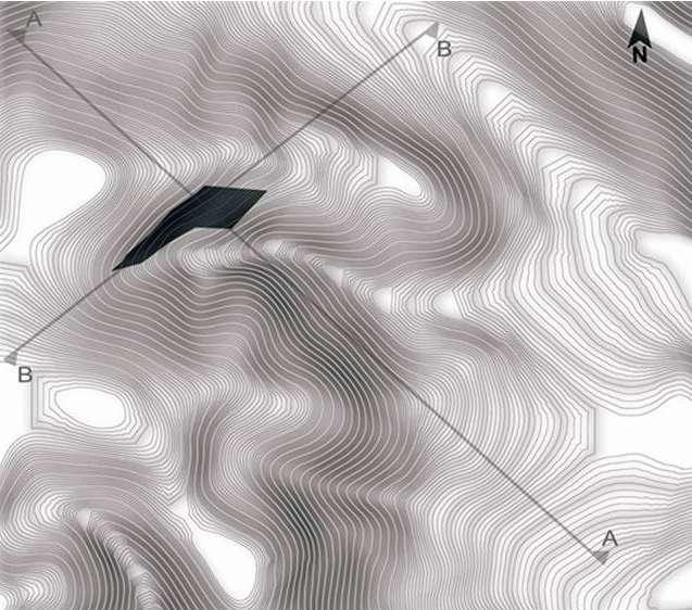
11 II.LAND TOPOGRAPHY SITE SECTION SECTION A-A SECTION B-B 11


12 III. CLIMATIC ANALYSIS SUN, WIND AND NOISE ANALYSIS MID DAY MID DAY JUNE 21 SUMMER SOLSTICE MID DAY MARCH 21 & SEPTEMBER 21 EQUINOX DECEMBER 21 WINTER SOLSTICE AZIMUTH AT SUNSET 122 DEGREES AZIMUTH AT SUNRISE 56 DEGREES NOISE CONCENTRATION PREVAILING WIND FLOW SUNMOVEMENT PATH PROPOSED SITE 12


13 III. CLIMATIC ANALYSIS SHADE AND SHADOW DIAGRAM W I N T E R S U M M E R 13


14 IV. WATER AND DRAINAGE DRAINAGE PATTERNS IN AREA SURROUNDING THE PROPOSED SITE, LEADING THE WATER FROM TWO HIGH GROUNDS TO A LOW GROUND VALLEY-LIKE STRIP. DAYS WITH PRECIPITATION DRAINAGE DIRECTION WITHIN THE PROPOSED SITE. PRECIPITATION LEVELS INDICATE A FAIR AMOUNT OF RAINFALL, SPECIFICALLY THROUGHOUT WINTER AND SPRING. WATER DRAINAGE AND GATHERING MAKE AN IMPORTANT ISSUE TO ADDRESS, ESPECIALLY WHEN THE BUILDING SITE IS LOCATED ON A SLOPING LAND WITH A 25% SLOPING PERCENTAGE. PRECIPITATION (MM) 14


15 TRITICUM FICUS CARICA HORDEUM QUERCUS CALLIPRINOS OLEA EUROPAEA PUNICA GRANATUM VITIS VINIFERA V. ECOLOGY ANALYSIS EXISTING VEGETATION POMEGRANATE GRAPE PALESTINIAN LIVE OAK OLIVE TREE BARLEY WHEAT COMMON FIG 15


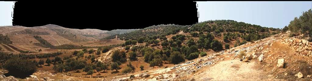

16 VI. SENSORY QUALITIES PANORAMA VIEWS


17 VI. SENSORY QUALITIES PANORAMA VIEWS


18 VI. SENSORY QUALITIES VIEWS TO AND FROM THE PROPOSED SITE VIEWS TO THE SITE VIEWS FROM THE SITE 18


19 VI. SENSORY QUALITIES SHATANA SKYLINE QANDAH RESIDENTIAL CULTURE CATHOLIC CHURCH LATIN CHURCH FAMILY SOCIAL MAJOR ROAD ASSOCIATION INTERSECTION MOKBEL STREET LEADING TO AL HOSON 19


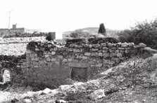
20 VI. SENSORY QUALITIES SHATANA SKYLINE ENTRANCE OLD HOUSE REMAINS DATING RESIDENTIAL ORTHODOXMAJOR ROAD CATHOLIC TO SHATANA BACK TO THE EARLIER PHASE CULTURE CHURCH INTERSECTION CHURCH 20
21 THE TECHNO-PHYSICAL ENVIRONMENT HERE REFERS TO THE EXISTING MAN-MADE ENVIRONMENT; THAT INCLUDES PHYSICAL STRUCTURES, PUBLIC INFRASTRUCTURE, PARKS, MINES AND ROCK QUARRIES. THIS SECTION EXAMINES SOME OF THE KEY FEATURES OF THE PHYSICAL ENVIRONMENT OF SHATANA AS A WHOLE. TECHNO PHYSICAL ENVIRONMENT ANALYSIS 21


22 I. NEIGHBORHOOD CONTEXT ` GOVERNMENT LANDS AL KASSARAT RUINS SPOTS EXISTING FOREST 22


23 II. SOLD-VOID AND LAND USE ` SOLD AND VOID LAND USE RESIDENTIAL PUBLIC GARDEN RELIGOUS HEALTH CENTER ADMINISTRATIVE CENTER PROPOSED SITE 23

24 III.CIRCULATION STREETS WITHIN THE BUILT AREA OF THE VILLAGE ` 24


25 IV. APPROACH AND ACCESSIBILITY HOSON STREET: THE MOST USED, IT S 7 KM NORTH. FROM AL -NAIMEH: IT S USED LESS THAN AL-HOSON STREET, BUT MORE THAN AL- KHANOQ STREET, IT S 5 KM EAST. AL KHANOOG STREET : THE WESTERN ROAD, THE LEAST FREQUENTLY USED, IT S ALMOST IMPOSSIBLE FOR. 25


26 III.CIRCULATION RING ROAD ANDNETWORK ` RING ROAD SURROUNDING SHATANA DEAD END ROADS CIRCULATION ROADS MAIN ROAD INTERSECTIONS 26


27 IV. BUILDING TYPOLOGY FIGURE - GROUND RELATIONSHIP ` THE VILLAGE HOUSES SCATTERED WITHOUT ANY PARTICULAR ORDER WITH HIGHEST DENSITY IS PRESENT IN THE SURROUNDING OF THE ORTHODOX CHURCH. THE HOUSES HAVE IRREGULAR FORM DUE TO CONTINUOUS EXTENSION IN ORDER TO ACCOMMODATE EXPANDING FAMILIES. 27

28 IV. BUILDING TYPOLOGY LAND TYPOLOGY ` BUILDING HEIGHTS TWO FLOORS ONE FLOOR 28


29 IV. BUILDING TYPOLOGY EARLY PHASE LATEST PHASE MIDDLE PHASE MIDDLE PHASE EARLY PHASE MIDDLE PHASE ` 29


30 IV. BUILDING TYPOLOGY ` 30


31 IV. BUILDING TYPOLOGY ` MIDDLE PHASE HOUSE AND THE NOTICEABLE CHANGE IN MATERIALS SHOWS THE DIFFERENT BUILDING STAGE. LATEST PHASE HOUSE, WE CAN SEE SOME ART WORK ON ITS WALLS. THE SECOND CHURCH BUILT IN THE MIDDLE PHASE, ACTS AS A CENTER OF THE VILLAGE DIVIDING THE VILLAGE INTO TWO SIDES WITH ITS LOCATION ON THE VILLAGES MAIN INTERSECTION. EARLY PHASE HOUSE RUINS. LATEST PHASE HOUSE, AND ANOTHER ART WORK APPEARS ON THE WALL. 31

32 IV. BUILDING TYPOLOGY MATERIALS IN THE EARLY STAGES BASIC MATERIALS WERE USED FOR BUILDING, SUCH AS ROUGH STONE AND MUD, THE CEILING WAS COVERED WITH BAMBOO STEMS, MUD, RUBBLE AND WATER. IN THE MIDDLE STAGES SMOOTHER STONE AND MUD WERE USED IN THE EXTERIOR WALLS. WHITE SAND WAS INTRODUCED AS A NEW MATERIAL FOR COLORING THE INNER WALLS. WELL FINISHED HOUSES APPEARED IN LATER STAGES. A VARIETY OF MATERIALS IS USED IN BUILDING. SMOOTHER STONE PATTERNS ARE MOST COMMONLY USED IN EXTERIOR WALLS. ` EARLY PHASE MIDDLE PHASE LATEST PHASE


33 IV. BUILDING TYPOLOGY DOORS THE DOORS WERE BASICALLY ARCH SHAPED MADE OUT OFF A ROUGH STONE FRAME AND BASIC MATERIALS AS WOOD FOR THE DOOR. THE ARCH USUALLY CONSISTED OF 5 OR 7 BLOCKS. THE MIDDLE STONE IS CALLED THE KEY STONE. BOTH ARCH AND RECTANGULAR DOORS WERE USED, STONE WAS SMOOTHER THAN THE ONE USED IN THE EARLIER STAGE. WOOD AND STEEL DOORS AND WELL CUT STONE. LARGE VARIETY OF DOORS MATERIALS AND SHAPES ARE NOW USED. LESS OPENINGS ARE MADE. ` EARLY PHASE MIDDLE PHASE LATEST PHASE


34 IV. BUILDING TYPOLOGY WINDOWS IN THE EARLY PHASE WINDOWS WERE SMALL IN SIZE FRAMED WITH WOOD OR ROUGH STONE. LATER ON LARGER SIZED OPENINGS BECAME PRESENT BECAUSE OF THE RELATIVELY ADVANCED INSULATION TECHNIQUES USED SECURITY ISSUES IN THE LATEST STAGES WERE TAKEN INTO CONSIDERATION AS WE CAN SEE THE WINDOW STEEL RODS ARE BECOMING A BASIC ELEMENT IN THE WINDOWS. ` EARLY PHASE MIDDLE PHASE LATEST PHASE

35 IV. BUILDING TYPOLOGY ROOFING AND COURTYARDS ROOFING TECHNIQUES COURTYARDS EXISTENCE ` 35


36 IV. BUILDING TYPOLOGY VEHICULAR ANDPEDESTRIAN PATH ` AS WE CAN SEE THE PEDESTRIANS AND VEHICULAR SHARE THE SAME PATH. THE HOUSES FENCES DEFINE THE STREET THE PAVEMENT. 36
37 THE SOCIO-CULTURAL DIMENSIONS OF THE ENVIRONMENT CONSIST OF CUSTOMS, LIFESTYLES, AND VALUES THAT CHARACTERIZE THE SOCIETY. SOCIO-CULTURAL COMPONENTS OF THE ENVIRONMENT INFLUENCE THE ABILITY OF OUR DESIGN TO FUNCTION WITHIN THE SOCIETY. POPULATION DEMOGRAPHICS, RISING EDUCATIONAL LEVELS, NORMS AND VALUES, AND ATTITUDES TOWARD SOCIAL RESPONSIBILITY ARE EXAMPLES OF SOCIO-CULTURAL VARIABLES. SOCIO CULTURAL ENVIRONMENT ANALYSIS 37


38 I.SENSORY QUALITIES SITE ELEMENTS AND FORCES SOME FORCES RESULT FROM NEIGHBORING DYNAMIC NODES, AND OTHER FORCES RESULT FREQUENTLY FROM FOCAL POINTS WITHIN THE VILLAGE ITSELF. MAIN ELEMENTS WITHIN THE VILLAGE AFFECTING THE LIFE OF VILLAGERS ON DAILY BASIS, VARYING IN DESCRIPTION: EDUCATIONAL, RELIGIOUS, COMMERCIAL, AND SOCIAL. MAJOR FORCES WITHIN THE VILLAGE PARAMETER DAILY VISITED SPOTS LARGE SCALE FORCES FROM NEARBY AREAS SITE FORCES SOCIAL GATHERING SPOTS COMMERCIAL RELIGIOUS (CHURCHES) EDUCATIONAL (SCHOOL) SITE ELEMENTS 38
 ROMANS- GREEK NO ARCHITECTURA L EVIDENCE FROM THIS ERA LIVING IN SMALL VILLAGES CHANGE IN THE WEATHER POTTERY- MAKING INCREASING OF MIGRATION PATTERNS IN THE MIDDLE EAST IRBID EMERGED AS A")
39 II.PAST AND FUTURE HISTORY AND VISIBLE TRACES OF THE SITE PALEOLITHIC PERIOD ( BC) NEOLITHIC PERIOD ( BC) BRONZE AGE (5000 BC) DEMOTE AND AMMONITE ( BC) HELLENISTS (64BC- 636AD) ROMANS- GREEK NO ARCHITECTURA L EVIDENCE FROM THIS ERA LIVING IN SMALL VILLAGES CHANGE IN THE WEATHER POTTERY- MAKING INCREASING OF MIGRATION PATTERNS IN THE MIDDLE EAST IRBID EMERGED AS A SIGNIFICANT CITY DECAPOLIS CHRISTIANS (200 AD) ISLAMIC OPENINGS (634 AD) THE MUKLUKS OTTOMAN EMPIRE (1600 AD) THE HASHEMITS (1921-PRESENT) GHASSANIDS RASHIDUN EMPIRE UAYYAD EMPIRE ABBASID EMPIRE THE WEATHER POTTERY- MAKING STRATEGIC AREA INTERMEDIATE AREA SERVING PILGRIMS COMING FROM THE NORTH ITS AREA WAS LESS THAN 0.1 KM AREA INCREASED BECAUSE IRBID BECAME A PART OF AJLOUN CITY 1950 AREA INCREASED WITH THE PALESTINIAN REFUGEES 39


40 II.PAST AND FUTURE CHURCHES 1. ORTHODOX CHURCH 2. CATHOLIC CHURCH 3. LATIN CHURCH 40


41 III. RESIDENT AND USING POPULATION NUMBER, COMPOSITION AND PATTERNS OF CHANGE BUILT OUPO AREA; 176 BUILDINGS DENSITY PATTERN OF CHANGE THERE ARE 278 PERSON LIVING IN SHATANA. 115 MALES, 163 FEMALES THE MAJORITY OF SHATANA S POPULATION IS OVER THE AGE OF SIXTY SINCE THE YOUTH ARE MOVING OUT TO MORE DEVELOPED CITY FOR WORK AND EDUCATION. ALMOST ALL OF SHATANA S FAMILIES ARE EXTENDED FAMILIES. 41


42 III. RESIDENT AND USING POPULATION EDUCATION, ECONOMICAL STATUS AND EMPLOYMENT PATTERNS APPARENTLY SHATANA S MAIN PROBLEM IS TRANSPORTATION; SPECIALLY FOR THE FACT THAT SHATANA IS VERY MUCH INTEGRATED WITH NEARBY CITIES; MOST IMPORTANTLY HOSON THERE IS NO PUBLIC TRANSPORTATION AND MOST PEOPLE USE THEIR PRIVATE CARS. SHATANA HAS A HIGH LEVEL OF EDUCATION THE MAJORITY OF PEOPLE FINISHED HIGH SCHOOL. SHATANA S MAIN INCOME ID FROM AGRICULTURE, OLIVE OIL PRODUCE APPROXIMATELY 100,000 JD YEAR, PLENTY OF PEOPLE WORK IN JOBS OUTSIDE OF SHATANA, MOST LIKELY HOSON OR IRBID. 42


43 III. RESIDENT AND USING POPULATION HERITAGE RESOURCES IRBID GOVERNORATER IS CHARACTERIZED BY: ITS STRATEGIC SITE, ITS HISTORICAL AND ARCHAEOLOGICAL SIGNIFICANCE, ITS ECONOMICAL ROLE IT PLAYS, ITS FERTILE AGRICULTURAL LANDS. SHATANA AT THE TOP O THE JORDANIAN A AGRICULTURAL REGIONS SPECIALLY IN THE PRODUCTION OF OLIVES AND WHEAT. THOUGH NOT USUALLY A MAJOR TOURIST DESTINATION ITSELF, IRBID S STRATEGIC LOCATION IN NORTHERN JORDAN MAKES IT A CONVENIENT STARTING POINT FOR TOURIST INTERESTED IN SEEING THE NORTHERN JORDAN VALLEY. 43

44 IV. SITE VALUE AND RESTRAINS LANDOWNER SHIP 44

45 IV. SITE VALUE AND RESTRAINS LANDOWNER SHIP 45

46 IV. SITE VALUE AND RESTRAINS SHATANA HAPPENS TO BE A VERY QUIET PLACE, VEHICULAR MOVEMENTS IS VERY LITTLE, NO MAJOR GATHERING SPOTS WITHIN THE VILLAGER PRESENT TO GENERATE ANY NOISE. WORTH MENTIONING,NEARBY LARGE SCALE AREAS GENERATORS OF NOISE, YET DUE TO THE GREEN LANDS AND THE LANDSCAPE THE NOISES INTERRUPTED. FORMAL GATHERING INFORMAL GATHERING 46
Lancaster Conservation Area Appraisal. Character Area 8. Cathedral
 Lancaster Conservation Area Appraisal Character Area 8. Cathedral March 2013 118 3.8 Character Area 8. Cathedral 3.8.1. Definition of Special Interest "This character area is distinctive for the fine group
NATIONAL REGISTER OF HISTORIC PLACES MULTIPLE PROPERTY DOCUMENTATION FORM CONTINUATION SHEET ASSOCIATED PROPERTY TYPES
 Section F, Page 1 ASSOCIATED PROPERTY TYPES Six common property types are identified with the 48 cemeteries surveyed in the Town of Southampton. These six property types are identified as being associated
North Oakville East Parks Facilities Distribution Plan. November, 2009
 North Oakville East November, 2009 POLICY CONTEXT 1) Purpose a) The purpose of this document is to be a guide for the location, configuration, design and development of the parks system for the North Oakville
Piazza Filippo Brunelleschi and the Humanities Entrance at Florence University
 Piazza Filippo Brunelleschi and the Humanities Entrance at Florence University Table of Contents History and Nearby Piazzas Climate - Wind, Temperature and Humidity Lighting - Natural and Artificial Circulation
Digital Terrestrial Television Infrastructure Rollout
 Digital Terrestrial Television Infrastructure Rollout Environmental Impact Assessment - Ruacana - ENVIRONMENTAL IMPACT ASSESSMENT: RUACANA 1 INTRODUCTION Ruacana is a town in the Omusati Region, in northern
Design Specifications & Requirements Manual
 11 PARKS & OPEN SPACES 11.1 DEFINITIONS... 1 11.1.1 Neighbourhood Parks... 1 11.1.2 District Parks... 1 11.1.3. Sport Parks... 1 11.1.4 Urban Parks... 1 11.1.5 Civic Spaces... 1 11.1.6 Open Space System...
Design Specifications & Requirements Manual
 11 PARKS & OPEN SPACES 11.1 DEFINITIONS... 1 11.1.1 Neighbourhood Parks... 1 11.1.2 District Parks... 1 11.1.3. Sport Parks... 1 11.1.4 Urban Parks... 1 11.1.5 Civic Spaces... 1 11.1.6 Open Space System...
Site ref: AS06 Site Name or Address: Murreys Court, Agates Lane
 Site ref: AS06 Site Name or Address: Murreys Court, Agates Lane Proposed Land Use: Total Site Area (Ha): Housing 1.85 Ha Description: It is understood that the owner has no plans to dispose of the site
Ten Mile Creek Planning Area
 PLANNING AREA POLICIES TEN MILE CREEK Ten Mile Creek Planning Area Location and Context The Ten Mile Creek Planning Area ( Ten Mile Creek area ) is located south of the current Boise AOCI, generally south
BORRISOKANE SETTLEMENT PLAN
 BORRISOKANE SETTLEMENT PLAN 1.0 General Introduction and Development Context Location Borrisokane is located 15km north of Nenagh on the N52. While the town is primarily residential, it acts as a market
Institutional Master Plan The Arnold Arboretum of Harvard University
 Institutional Master Plan The Arnold Arboretum of Harvard University Submitted to: Boston Redevelopment Authority One City Hall Square Boston, MA 02201 Submitted by: The Arnold Arboretum of Harvard University
ARLINGTON COUNTY, VIRGINIA
 ARLINGTON COUNTY, VIRGINIA County Board Agenda Item Meeting October 15, 2005 DATE: September 28, 2005 SUBJECT: Request to Advertise the adoption of the 2005 Clarendon Sector Plan C. M. RECOMMENDATION:
Faculty of Design and Art. Course Description for The Bachelor of Product Design
 Faculty of Design and Art Course Description for The Bachelor of Product Design Technique Etching and Pry 2 Folklore 3 Multimedia Technology 4 Exploration Graphic 5 Batik Design 6 Prototype Design And
Traditional Dwellings: An Architectural Anthropological Study from the Walled City of Lahore
 Traditional Dwellings: An Architectural Anthropological Study from the Walled City of Lahore S. Gulzar Abstract Traditional dwellings were planned in response to ecological, cultural and economic factors
Planning Commission Staff Report March 15, 2007
 Planning Commission Staff Report Project: Request: Madeira East Tentative Subdivision Map, Design Review for Subdivision Layout & Abandonment of Easements Location: Phase IV of the Laguna Ridge Specific
Project Site. Kyle Jacobson
 Project 2.002 - Site Kyle Jacobson The culmination of the semester s analysis in the Marigny concluded with a site proposal for an open space within the neighborhood. The site design focused on the relationship
WILLAMETTE FALLS LEGACY PROJECT
 OPPORTUNITIES & CONSTRAINTS There are here three falls on a line of rocks extending across the river, which forms the bed of the upper channel. The water is precipitated through deep abrazed gorges, and
Application of Ecological Architecture Concept in Student Dormitory in Yogyakarta Case Study University Student Dormitory in Yogyakarta
 Application of Ecological Architecture Concept in Student Dormitory in Yogyakarta Case Study University Student Dormitory in Yogyakarta Jarwa Prasetya Sih Handoko, ST, M.Sc. Abstract Ecological architecture
4.3 Dudley Area Plan. Introduction. History and Existing Character. Desired Future Character for Dudley
 4.3 Dudley Area Plan Introduction The suburb of Dudley has developed as a result of various circumstances including its topography, history and mineral resources. Dudley development has been identified
The purpose of the requirements in this Article is to provide for landscaping and screening of parking and other outdoor areas that will:
 XIII. LANDSCAPING & SCREENING A. Purpose The purpose of the requirements in this Article is to provide for landscaping and screening of parking and other outdoor areas that will: 1. Protect residential
Community Design Guidelines. Port Wallace DRAFT
 Community Design Guidelines Port Wallace DRAFT Energy 1 2 3 Nature Movement Connections Built Form DRAFT Layout Energy 1 Nature Community Design Guidelines GREAT COMMUNITIES PROTECT, CELEBRATE, AND CONSERVE
PEDESTRIAN ROUTE. Fig 202. Route to entrance of building
 PEDESTRIAN ROUTE The prospect of a pedestrian entrance directly from the north, from the public transport node, was also considered. However, it was decided that this configuration was too conventional
ARTICLE IX SPECIAL PERMIT USES
 ARTICLE IX SPECIAL PERMIT USES All special permit uses cited in Article IX and Attachment A of this Ordinance or any other Section of this Ordinance shall be subject to Site Plan Review. The procedures
Design Considerations
 Essential to the development of a successful Master Plan for the Park Complex is input from the community that the park will serve. The community outreach component of the planning process included numerous
Glenborough at Easton Land Use Master Plan
 Vision Statement Sunrise Blvd. Hazel Ave. Prairie City Rd. Gencorp Property Lincoln Regional Airport 1.0 VISION STATEMENT The identifies City of the principles, goals, policies, and standards Lincoln that
RE-INVENTED ENCLAVE. restaurants reducing travel and making the enclaves
 RE-INVENTED ENCLAVE 1 This project takes as its inspiration the many enclaves of walk-up slab buildings that blanket Jinan and much of China. As we learned from our study of Dong-Cang and other enclaves
Chapter 2: OUTLINE PLANNING APPLICATION PROPOSALS. A New Garden Neighbourhood Matford Barton 17
 Chapter 2: OUTLINE PLANNING APPLICATION PROPOSALS A New Garden Neighbourhood Matford Barton 17 2.1. SUMMARY AND STATUS OF THE PROPOSALS 2.1.1. The parameter plans and associated wording in this chapter
Town Center Design Guidelines
 Adopted by City Council on September 18, 2018 Design Theme The Draper Town Center Design Theme is defined as encompassing those architectural design styles that were prevalent in the construction of civic
HUDSON VALLEY REGIONAL COUNCIL 3 Washington Center, Newburgh NY
 PROJECT AREA: HYDE PARK HUDSON VALLEY REGIONAL COUNCIL 3 Washington Center, Newburgh NY 12550 http://www.hudsonvalleyregionalcouncil Insert aerial site photo with streets labeled GREEN INFRASTRUCTURE CONCEPT
APPENDIX A - Block and Draft Plan
 Built Environment - Compact Development B&D 1 Persons & Jobs per hectare Note: Each municipality defines density ranges by land use types within the Official Plan and the Secondary Plans Places to Grow
Catalina Magnet High School Project
 Catalina Magnet High School Project Lunch Patio Design Phase 1 existing trees existing shrubs proposed phase 1 trees (3) proposed phase 1 tables (4) 2011 proposed phase 1 shrubs (20) proposed flagstone
4 January 11, 2012 Public Hearing APPLICANT:
 . 4 January 11, 2012 Public Hearing APPLICANT: MID-ATLANTIC AUTO PROPERTY OWNER: DZR, LLC STAFF PLANNER: Leslie Bonilla REQUEST: Conditional Use Permit (truck rental, automobile service, and automotive/bulk
APPENDIX C. Architectural and Environmental Design Standards. Environmentally sensitive areas should be protected.
 APPENDIX C Architectural and Environmental Design Standards Environmentally Sensitive Areas Goal A. Environmentally sensitive areas should be protected. Development, such as roads, houses, and other structures,
6. REGIONAL AND COMMUNITY FACILITIES DESIGNATIONS 6.1. OBJECTIVES FOR REGIONAL AND COMMUNITY FACILITIES LAND USE DESIGNATIONS
 6. REGIONAL AND COMMUNITY FACILITIES DESIGNATIONS INTRODUCTION The Regional and land use designations provide the primary locations for uses which satisfy the health, education and other service needs
ARTICLE VI: SITE PLAN REVIEW
 Section 6.01 - Site Plan Review (All Districts) ARTICLE VI: SITE PLAN REVIEW Site plans give the Planning commission an opportunity to review development proposals in a concise and consistent manner. The
Description of Preferred Alternative
 Chapter 2 Description of Preferred Alternative 2.1 Introduction This chapter of the programmatic Sammamish Town Center Sub-area Plan Final EIS provides a more detailed description of the Preferred Alternative
Gather information from online resources covering the following topics:
 Assignment #1: Regional Analysis Project Site Location: Greater Boston Area What comprises a region? The many elements within a region comprise the region as a whole. Natural as well as manmade environmental
edge of gas line corridor setback edge of gas line corridor aligned with Schlumberger building 37.0 m AOD 33.0 m AOD max
 7. Heights and Street Frontage: In accordance with the approved heights parameters, heights to along Western Access Road must respond to the existing low density character in this location. Heights are
14.5 HOPEFIELD: (REFER PLAN 39 AND PLAN 40)
") URBAN DYNAMICS WESTERN CAPE INC. 248 14.5 HOPEFIELD: (REFER PLAN 39 AND PLAN 40) FIGURE 83: LOCALITY - HOPEFIELD Within the context of the Saldanha Bay Municipal area, Hopefield, an historical agricultural
URBAN DYNAMICS WESTERN CAPE INC. 248 14.5 HOPEFIELD: (REFER PLAN 39 AND PLAN 40) FIGURE 83: LOCALITY - HOPEFIELD Within the context of the Saldanha Bay Municipal area, Hopefield, an historical agricultural
Access Management: An Overview
 Figures 1-5 Below Evolution of development along a highway. In the early stages, land along the road is used for farming with little traffic generated. As time passes, the highway corridor becomes a de
APPENDIX A SIMPLIFIED APPROACH TO STORMWATER MANAGEMENT FOR SMALL PROJECTS. In West Sadsbury Township, Chester County, Pennsylvania
 APPENDIX A SIMPLIFIED APPROACH TO STORMWATER MANAGEMENT FOR SMALL PROJECTS In West Sadsbury Township, Chester County, Pennsylvania TABLE OF CONTENTS I. Introduction 3 II. Importance of Stormwater Management
Neighbourhood Planning Site Assessment Pro-forma and Guide Version 2
 Neighbourhood Planning Site Assessment Pro-forma and Guide Version 2 September 2014 Site HNP 006 Land East of Stanbridge Road and North of Lower Road 1. Background information Site location and use Site
QUARRY REHABILITATION PLANS Specifications (version 1.3)
") For all our quarries, a rehabilitation plan must be developed from the outset. It is an integral part of the quarrying plan and provides for progressive and co-ordinated rehabilitation whenever possible.
For all our quarries, a rehabilitation plan must be developed from the outset. It is an integral part of the quarrying plan and provides for progressive and co-ordinated rehabilitation whenever possible.
3.13. Development Guidelines
 3.3 Landscaping Elements Landscaping should be used to frame and soften structures, define site functions, enhance the quality of the environment, and screen undesirable views. Safety, environmental impacts,
Urban Development and Upgrading of Unplanned Districts of Jeddah, Saudi Arabia. Bani-Malek East Al-Boughdadiyah. 10th October 2012
 Urban Development and Upgrading of Unplanned Districts of Jeddah, Saudi Arabia Bani-Malek East Al-Boughdadiyah 10th October 2012 Presentation Overview Introduction Effat Team Principle of Sustainable urbanism
Land Use Amendment in Southwood (Ward 11) at and Elbow Drive SW, LOC
 at and Elbow Drive SW, LOC") 2018 November 15 Page 1 of 10 EXECUTIVE SUMMARY This land use amendment application was submitted by Rick Balbi Architect on 2017 August 31 on behalf of Sable Developments Ltd, and with authorization from
2018 November 15 Page 1 of 10 EXECUTIVE SUMMARY This land use amendment application was submitted by Rick Balbi Architect on 2017 August 31 on behalf of Sable Developments Ltd, and with authorization from
PROTOTYPE DESIGN/INTRODUCTION
 PART III: PROTOTYPE DESIGN These concepts and guidelines described earlier were used to develop a prototype design for an emerging suburban area located west of the City of Milwaukee. This was done to
Research Article Urban Planning Response to Population Growth in Jordanian Cities (Irbid City as Case Study)
") Research Journal of Applied Sciences, Engineering and Technology 7(20): 4275-4280, 2014 DOI:10.19026/rjaset.7.799 ISSN: 2040-7459; e-issn: 2040-7467 2014 Maxwell Scientific Publication Corp. Submitted:
Research Journal of Applied Sciences, Engineering and Technology 7(20): 4275-4280, 2014 DOI:10.19026/rjaset.7.799 ISSN: 2040-7459; e-issn: 2040-7467 2014 Maxwell Scientific Publication Corp. Submitted:
Complete Neighbourhood Guidelines Review Tool
 Complete Neighbourhood Guidelines Review Tool Prepared By: City of Regina Planning Department October 2014 Page 1 of 14 Community Development Review Checklist for Secondary Plans and Concept Plans The
THE INFLUENCE OF CLIMATE IN THE FORMATION OF TRADITIONAL TURKISH HOUSES
 THE INFLUENCE OF CLIMATE IN THE FORMATION OF TRADITIONAL TURKISH HOUSES A. Er Akan, F. Z. Cakici Department of Architecture, Middle East Technical University, Ankara, 06531 E-mail: erasli@arch.metu.edu.tr
Gruene River Place PDD CONCEPT PLAN AND DEVELOPMENT STANDARDS
 Gruene River Place PDD CONCEPT PLAN AND DEVELOPMENT STANDARDS GRUENE RIVER PLACE PLANNED DEVELOPMENT DISTRICT As per Section 3.5, Chapter 144 of the City s Zoning Ordinance To: The Planning & Zoning Commission
East Central Area Plan
 East Central Area Plan Steering Committee Meeting March 8 th, 2018 CHUN Tears McFarlane House Vision Statement Development Opportunities Analysis Vision Elements 1. Equitable, Affordable and Inclusive
Mitchell Ranch South MPUD Application for Master Planned Unit Development Approval Project Narrative. Introduction
 Mitchell Ranch South MPUD Application for Master Planned Unit Development Approval Project Narrative Introduction Mitchell Ranch South is a proposed single family (detached) residential development on
Welcome. Site/11/04. Site/11/03. Proposed Site. 11,400 new homes needed in east Cambs
 Welcome Welcome to our consultation on our proposals for new homes on land north east of Soham Road, Fordham. Members of the project team are available to answer any questions you have and listen to feedback.
Project: Developer/Designer: Reviewer: I. Narrative: 1. Project Description: Describes the nature and purpose of the land disturbing activity.
 City of Charlottesville, Virginia Erosion and Sediment Control Plan Review Checklist 610 East Market Street, Charlottesville, VA 22902 Telephone 434-970-3182; Fax 434-970-3359 Project: Developer/Designer:
THE TENNESSEE VEGETABLE GARDEN
 THE BACKYARD SERIES BACKYARD VEGETABLES W 346-A THE TENNESSEE VEGETABLE GARDEN SITE SELECTION AND SOIL TESTING Natalie Bumgarner, Assistant Professor and UT Extension Residential and Consumer Horticulture
Tazewell Pike. Neighborhood Conservation Overlay District Design Guidelines
 Tazewell Pike Neighborhood Conservation Overlay District Design Guidelines Knoxville Knox County Metropolitan Planning Commission November 2, 2000 These design guidelines were: Adopted by the Knoxville
1.0 VISION STATEMENT. December 6, PRINCIPLES
 Vision Statement Lincoln Regional Airport 1.0 VISION STATEMENT 1.1 City LOCATION of AND OVERVIEW The Easton Lincoln Place Land Use Master Plan identifies the principles, goals, policies, and standards
Welcome! Far Northeast Area Plan Meeting #3 Council District 11 Town Hall Meeting Resource Fair. Jan. 30, 2018
 Welcome! Far Northeast Area Plan Meeting #3 Council District 11 Town Hall Meeting Resource Fair Jan. 30, 2018 Tonight s Agenda 6:15- Welcome and Councilmember Remarks 6:25- Presentation 6:45- Activities
URBAN DESIGN BRIEF NORTHVIEW FUNERAL HOME HIGHBURY AVE N, LONDON, ON
 URBAN DESIGN BRIEF NORTHVIEW FUNERAL HOME - 1490 HIGHBURY AVE N, LONDON, ON 1.1Purpose The intent of the following report is to identify an opportunity for redevelopment of two residential properties within
Brine Generation Study
 DOE/WIPP 00-2000 Brine Generation Study April 2000 Waste Isolation Pilot Plant Carlsbad, New Mexico Processing and final preparation of this report was performed by the Waste Isolation Pilot Plant Management
Overview of the Plan. The Building Blocks of Centers, Neighborhoods and Network INTERNAL DRAFT
 Overview of the Plan 4 East Davidson Ramah Church Rd June Washam Rd Bradford District Park Bradford Shearer Rd Campus District NC 73 Davidson-Concord North Rocky River This Master Plan projects an approximate
The 3 Common Landscape Challenges. & How to Transform them into Features
 The 3 Common Landscape Challenges & How to Transform them into Features Think That Your Landscape is Doomed Because of its Limited Size, Slope, or Drainage Issue? There are many common issues that homeowners
The urban block as a potential for sustainable urban design
 The Sustainable City X 69 The urban block as a potential for sustainable urban design M. Oikonomou Department of Urban Planning and Regional Development, Aristotle University of Thessaloniki, Greece Abstract
12.2 CONCEPT DEVELOPMENT
 12 12.0 Final Concept Plan & Development Scenarios 12-1 12.1. Introduction 12-1 12.2. Concept Development 12-1 12.3. Concept Evaluation 12-2 12.4. Development Scenarios 12-2 12.1 INTRODUCTION Though the
Glenborough at Easton Land Use Master Plan
 Public Facilities 102 7.0 PUBLIC FACILITIES 7.1 OVERVIEW This chapter describes the public facilities that will provide high-quality services in the Glenborough at Easton community, to include three schools,
FRUITVALE TRANSIT VILLAGE (Phase 2) Residential Project
 Residential Project") FRUITVALE TRANSIT VILLAGE (Phase 2) Residential Project DEVELOPER: SIGNATURE PROPERTIES ARCHITECT: HKIT ARCHITECTS April 23, 2010 TABLE OF CONTENTS 3 Vision 4 Description of Site 5 Guiding Concepts 6
FRUITVALE TRANSIT VILLAGE (Phase 2) Residential Project DEVELOPER: SIGNATURE PROPERTIES ARCHITECT: HKIT ARCHITECTS April 23, 2010 TABLE OF CONTENTS 3 Vision 4 Description of Site 5 Guiding Concepts 6
Define, Experience, Spatialize and Sistematize
 Define, Experience, Spatialize and Sistematize Define : Diagram + Plan Arcadia Street Republic Street New High Street North Main Street La Plaza del Pueblo, ubicated in the heart of Los Angeles, is a large
Master Environmental Servicing Plan & Secondary Plan
 1 East Side Lands Stage 2 Master Environmental Servicing Plan & Secondary Plan Public Consultation Centre #4 March 20, 2018 Welcome! Today s Agenda Please sign in at the registration table. 6:00 pm 6:30
The Village of Sugar Grove, in partnership with Kane County, the Illinois Department of Transportation, and the Illinois Tollway welcomes you to the
 The Village of Sugar Grove, in partnership with Kane County, the Illinois Department of Transportation, and the Illinois Tollway welcomes you to the first Public Meeting for the proposed interchange improvement
DRAFT. 10% Common Open Space
 % OF CHARLOTTE IS CATEGORIZED AS A. LAND USES : Placeholder map displaying location of Place Type GOALS: Accommodate XX% of future growth. Provide a concentration of primarily commercial and civic activity
CLOUGHJORDAN SETTLEMENT PLAN
 CLOUGHJORDAN SETTLEMENT PLAN 1.0 General Introduction and Development Context Location The market town of Cloughjordan lies close to the border with Offaly at the junction of the R490 and R491 Regional
178 Carruthers Properties Inc.
 178 Carruthers Properties Inc. Planning Rationale for 178 Carruthers Avenue Site Plan Control Application June 2014 Table of Contents 1.0 Introduction 2.0 Overview of Subject Property 3.0 Current Zoning
Commercial Development Permit Area
 City of Kamloops KAMPLAN Commercial Development Permit Area PURPOSE The purpose of this Development Permit Area (DPA) is to establish objectives and provide guidelines for the form and character of commercial
2.0 Hi s t o r y & Existing Co n d i t i o n s
 2.0 Hi s t o r y & Existing Co n d i t i o n s 2.1 Plan Area History The Lincoln East Specific Plan (Specific Plan) area is a significant part of the history of Sutter County. A 48,000 acre land grant
TIDAPA Structure Plan
 TIDAPA Structure Plan Prepared by Tract Consultants 28 MARCH 2017 0217-0074 Table of Contents 01 STRATEGIC CONTEXT Executive Summary Regional Context Page 3 Page 4 02 LOCAL CONTEXT Aerial Photograph Local
With the promotions and publicity of green. Moving Towards Sustainable Campus Design. Deciphering Green Architecture
 Deciphering Green Architecture Moving Towards Sustainable Campus Design Projects: NIIT University Campus, Neemrana and Indian Institute of Technology, Gandhinagar Architects: Space Design Consultants,
ELMVALE ACRES SHOPPING CENTRE MASTER PLAN
 ELMVALE ACRES SHOPPING CENTRE MASTER PLAN Contents 1.0 INTRODUCTION... 2 2.0 LOCATION... 2 3.0 EXISTING CONTEXT... 2 4.0 VISION & GUIDING PRINCIPLES... 2 5.0 LAND USE AND BUILT FORM... 4 5.1 St. Laurent
WELCOME GYPSY LANE. Wider Site Location plan. Proposals for the development of LAND OFF FOXLYDIATE LANE WEBHEATH. Proposals for the development of
 WELCOME The developers are preparing an outline planning application for a residential led development and need the community s views in order to develop the proposals further WHAT IS PROPOSED? A high
Infill Residential Design Guidelines
 Infill Residential Design Guidelines Adopted March 23, 2004 Amended September 10, 2013 City of Orange Community Development Department Planning Division Phone: (714) 744-7220 Fax: (714) 744-7222 www.cityoforange.org
Heart of Neolithic Orkney World Heritage Site: Statement of Outstanding Universal Value
 Heart of Neolithic Orkney World Heritage Site: Statement of Outstanding Universal Value Adopted by UNESCO World Heritage Committee Thirty-seventh session, Phnom Penh, Cambodia, June 2013 http://whc.unesco.org/en/list/514
Landscape Design The Design Process
 Landscape purposes Landscape Design The Design Process Utilitarian Aesthetic Psychological Carol Brouwer, Ph.D. Design Process Design Process Phases Series of problemsolving and creative steps to develop
Author: Christine Hawley of Christine Hawley Architects Research Output 2: Pangyo Housing Competition
 Author: Christine Hawley of Christine Hawley Architects Research Output 2: Pangyo Housing Competition Co-Author: Andrew Porter Output Type: Design Competition Design Entry for Building: Pangyo Housing
Urban Design Brief Woodland Cemetery Funeral Home 493 Springbank Drive
 Urban Design Brief Woodland Cemetery Funeral Home The Incorporated Synod of the Diocese of Huron April 15, 2016 Urban Design Brief April 15, 2016 TABLE OF CONTENTS Page No. INTRODUCTION... 1 SECTION 1
6: 2417 Fourth Line, Sixteen Hollow, Lion Valley Park
 1. Description of Property 6: 2417 Fourth Line, Sixteen Hollow, Lion Valley Park Municipal Address 2417 Fourth Line ame (if applicable) Sixteen Hollow, Lion Valley Park Legal Description CO 1 SDS PT LOTS
WELCOME. Olney Road, Lavendon INTRODUCTION. The Site. The Application. The Need for Housing. A Sustainable Location LAVENDON TURVEY OLNEY ROAD
 0 WELCOME INTRODUCTION Gladman Developments Ltd have successfully invested in communities throughout the UK over the past 0 years, developing high quality and sustainable residential, commercial and industrial
Comprehensive Development Guide
 INDUSTRIAL ELEMENT Comprehensive Development Guide 1 Industrial Element 7.1 Hardin County Industrial Overview BG PKWY Fort Knox Industrial Corridor Comprised of 11 parcels totaling 720 acres of land 68
Inform you of the purpose and scope of the study for PTH 100 and a proposed future St. Norbert Bypass;
 WELCOME The intent of today s Open House is to: Inform you of the purpose and scope of the study for PTH 100 and a proposed future St. Norbert Bypass; Review highway crossing locations, future access closures
Town Center. Block 5 Existing multifamily residential units are expected to remain.
 Area Guidelines Germantown s districts should be developed as distinct communities with unique features that are supported through the guidelines. The guidelines not only help distinguish these districts
IV. ENVIRONMENTAL IMPACT ANALYSIS B. AESTHETICS 1. VIEWS
 IV. ENVIRONMENTAL IMPACT ANALYSIS B. AESTHETICS 1. VIEWS ENVIRONMENTAL SETTING Existing Visual Character Project Site The project site is located at 10250 Wilshire Boulevard in the Westwood community of
SOCIO-ECONOMIC MOVEMENT ENVIRONMENT INFRASTRUCTURE TOWN PLANNING
 Table 7: SWOT Analysis SWOT ANALYSIS SOCIO-ECONOMIC MOVEMENT ENVIRONMENT INFRASTRUCTURE TOWN PLANNING STRENGTHS HIGH COMMUTER POPULATION DENSITY MAJORITY OF POPULATION BETWEEN AGE OF 15 & 34 LARGE AVAILABLE
The Effects of Climatic Factors on Urban Context and Vernacular Architecture of Cold and Temperate Regions of Iran
 The Effects of Climatic Factors on Urban Context and Vernacular Architecture of Cold and Temperate Regions of Iran Amir Ghahramanpouri, Sepideh Sedaghat Nia Department of Urban Design, Faculty Built Environment,
Murphy Crossing Site Redevelopment Community Engagement Meeting September 19, 2016
 Murphy Crossing Site Redevelopment Community Engagement Meeting September 19, 2016 SUMMARY 1 EXECUTIVE SUMMARY STATEMENT OF PURPOSE ABI has conducted a detailed study of 1. Market potential 2. Building
Core Strategy Settlement Classification. 0.61ha. For sale
 Coleford NDP site assessment 15 1 4 MARSHES LORDS HILL SITE ASSESSMENT FORM A: BASELINE INFORMATION Settlement Name Coleford Core Strategy Settlement Classification Town Site Name / Address Gross area
Advanced Site Inventory Activity
 9-12 ACTIVITY Advanced Site Inventory Activity 9-12 ACTIVITY Summary: Students investigate various elements of their Schoolyard Habitats site, including climate, land use, and human impact. Grade Level:
BROOKHILL NEIGHBORHOOD MODEL ZONING MAP AMENDMENT PREFACE TO APPLICATION
 BROOKHILL NEIGHBORHOOD MODEL ZONING MAP AMENDMENT PREFACE TO APPLICATION June 15, 2015 Revised: August 1, 2016 I. VISION Brookhill is a proposed community based upon the principles of Albemarle County
Welcome to our exhibition
 Welcome to our exhibition The Homes & Communities Agency (HCA) welcomes you to this public exhibition explaining our proposals for the redevelopment of the former Lea Castle Hospital site. About the Homes
KEY MAP DEVELOPMENT PERMIT AREA MAP. Sunnymede North Sub-Area Plan
 Richmond Official Community Plan BROADMOOR AREA SUNNYMEDE NORTH SUB-AREA PLAN Bylaw 7100 Schedule 2.6C SUNNYMEDE NORTH SUB-AREA PLAN SUNNYMEDE NORTH SUB-AREA PLAN SUNNYMEDE NORTH SUB-AREA PLAN KEY MAP
Working together, you ll write up your short story, which will be shared with the rest of the class at the end of the class session.
 Amarna Workers Village The Egyptian city of Amarna was the pet building project of the pharaoh Akhenaten, who oversaw construction of his new capital between 1346 and 1341 BCE. The city was largely abandoned
Brampton. Secondary Plan. Review. Bram West. A New Direction in Planning & Public Consultation
 Brampton Bram West Secondary Plan Review A New Direction in Planning & Public Consultation Introduction The Bram West Secondary Plan Review offers an important opportunity for the community to define a