Concept Development Plan Bryn Mawr Medical District
|
|
|
- Darrell Arnold
- 5 years ago
- Views:
Transcription
1 Lower Merion Township Montgomery County, Pennsylvania Date: November 1, 2005 Prepared for: Main Line Health Real Estate, LP c/o Devon Cheshire Trammell Crow Services, Inc. 300 Conshohocken State Road Suite #250 West Conshohocken, PA Prepared by: Glackin Thomas Panzak, Inc. Gresham Smith and Partners Paoli Executive Green 1, Suite South Sixth Street, Suite Leopard Road Richmond, VA Paoli, PA Chester Valley Engineers F. Tavani and Associates, Inc. 83 Chestnut Road 1720 Valley Lane Paoli, PA Chester Springs, PA
2 Table of Contents Executive Summary Introduction Site Plan Overview... 1 Design Standards and Streetscape Amenities....4 Infrastructure and Utilities Stormwater Management Impacts on Abutting Properties.. 8 Parking Analysis...9 Traffic Analysis.. 9 Exhibits: EXHIBIT A EXHIBIT B EXHIBIT C Area and Bulk Requirements EXHIBIT D Parking Summary Count EXHIBIT E Letter of Water Availability from Aqua Pennsylvania
3 Executive Summary This report accompanies the Tentative Sketch Plan submissions for proposed development activities in the (BMMD.) Presented herein are narrative descriptions of development activities proposed to occur throughout the, and discussions about potential future development that might take place in the balance of the District. Pursuant to of the Lower Merion Township Zoning Ordinance, this report demonstrates that the current proposed development of the District properly anticipates the future development with respect to land use, traffic movement, parking, building placement, required infrastructure, and impact on abutting properties. The report asserts that land uses proposed for development in this District are compatible with overall community objectives, and shows that they are consistent with uses currently permitted by the Township Zoning Ordinance in the surrounding neighborhood. The traffic report shows that impacts on the road system in and around the development area are well understood, and can be managed accordingly. The parking analysis demonstrates that the currently proposed development can be adequately served by parking facilities on-site; it also describes how parking needs will change as development occurs, and recognizes the challenges that future development will encounter as demand increases for parking facilities. The report explains how the overall placement of buildings and the relationships between architectural and streetscape elements creates a pedestrian-scaled neighborhood environment, and shows how design techniques will be used to blend the new development into the existing community. Future infrastructure and stormwater management needs are anticipated, and appropriate engineering solutions are proposed and explained. Overall, the report demonstrates that the Applicant understands the dynamic nature of the proposed development, and is providing for the logical, orderly, and appropriate expansion of health care facilities in a manner that is responsive to the needs of the Community.
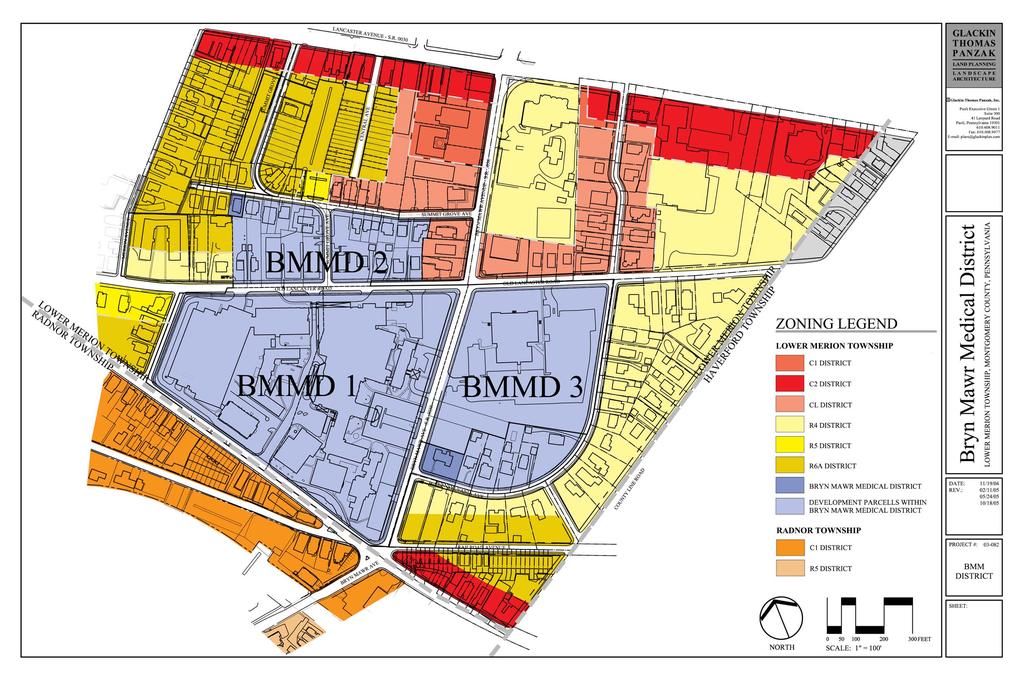
4 Introduction A recent ordinance amending the Code of the Township of Lower Merion, Chapters 135 and 155, established the, comprised of three (3) development districts identified in the ordinance as Bryn Mawr Medical District 1 (BMMD-1), 2 (BMMD-2), and Bryn Mawr Medical District 3 (BMMD-3). The ordinance provides guidelines in these districts regulating signage, canopies, building uses, building setbacks, building height and number of stories, parking, landscape buffers, architectural design standards and landscape requirements. On the tentative sketch plan submissions and other materials describing the proposed development, each District is comprised of tax parcel blocks : Block A is situated in BMMD-1, Block C and Block D are situated in BMMD-2, and Block B is situated in BMMD-3. The applicant is required to include a as part of the tentative sketch plan submission process for any development occurring in the. The purpose of this report is to anticipate the potential future known development impacts with respect to land use, traffic movements, parking, building placement, required infrastructure, and abutting properties. The following text describes the development currently being proposed as part of the tentative sketch plan applications in Blocks B, C, and D and the manner in which each Block, including Block A, might be fully developed in the future. The form of any anticipated development described herein is conceptual in nature, and would be subject to change based on the needs of the applicant. Furthermore, only those anticipated developments that are understood at this time have been included in the. The final report section entitled Exhibits presents graphics and site data details about the overall development concept, summarizing this information in the following plans and tables: EXHIBIT A Identification of Bryn Mawr Development Districts & Blocks EXHIBIT B EXHIBIT C Area and Bulk Requirements EXHIBIT D Parking Summary Count EXHIBIT E Letter of Water Availability from Aqua Pennsylvania Site Plan Overview BMMD-1/BLOCK A This District comprises the existing hospital buildings, medical office buildings, and parking garage. Also known as Block A, it is bound to the west by Mondella Avenue; to the north by Old Lancaster Road; to the east by Bryn Mawr
5 November 1, 2005 Avenue; and to the South by County Line Road. The District is bisected by Lindsay Avenue, which provides access to the Emergency Department. Currently, there are no development plans for this District; however, in the future it is anticipated that the Emergency Department entrance will be moved from its current position on Lindsay Avenue on the west side of the Hospital building to the east side of the Hospital building. The relocated emergency department entrance would include a one-story building addition, with access provided along Bryn Mawr Avenue. Ambulance access will be separated from the main pedestrian entry to the Emergency Department, for efficiency and safety purposes. This development would represent a slight increase in both building coverage and impervious coverage on the site. During zoning deliberations Bryn Mawr Hospital shared its ultimate possible vision for the hospital on its main trapezoid campus (Block A). This vision included a bed tower replacing the existing Clothier and MOB-South buildings while orienting the hospital entrance to County Line Road. While this remains a long term hope for the hospital, it is dependent upon significant and successful fund raising and therefore is not expected to occur during the 3-5 year period of redevelopment and subsequent occupancy of space proposed in this. BMMD-2/BLOCK C and BLOCK D This District is bound to the west by residential land uses, zoned R6A and R4; to the north by the section of Summit Grove Road that runs east-west; to the east by other commercial uses including medical and law offices, zoned CL; and to the south by Old Lancaster Road. The section of Summit Grove Avenue that runs north-south divides the district into two sites, identified as Block C (east side of Summit Grove Avenue) and Block D (west side of Summit Grove Avenue.) As currently proposed, initial development will occur on Block D in the form of a fourstory medical office building consisting of approximately 147,000 square feet. Functions proposed for the building will be a Special Medical Treatment Facility (i.e., an ambulatory surgery center), support functions for this use and offices for medical practices. These uses are permitted under B of the Zoning Ordinance. The building will be placed within the site external parameters specified in of the Ordinance, as illustrated on the Tentative Sketch Plan. The medical office building will be limited to a maximum height of sixty (60) feet, not including parapets or modest mechanical equipment screening, as established by the Ordinance. Block C will initially serve as a surface parking facility, primarily to support the medical office building located on Block D. This lot will contain 148 parking spaces for cars, as well as spaces for bicycle parking. Primary pedestrian access to the building will be located at the corner of Summit Grove Avenue and Old Lancaster Road. A patient drop-off area will be Glackin Thomas Panzak 2
6 November 1, 2005 located on Summit Grove Avenue, and building service and a patient pick-up area will be accessed from Old Lancaster Road. An elevated pedestrian connector, permitted by the Ordinance in C, is presently planned to connect the existing parking structure/medical office building located in BMMD- 1/BLOCK A along Old Lancaster Road to the new medical office building. This connector will provide convenient and safe access to the new building from the existing parking structure for patients, physicians and staff. There is no additional future development anticipated on Block D. Future development on Block C is anticipated to take the form of a four-story medical office building of approximately 157,700 square feet. Pedestrian access to the building will be located in two places: at the corner of Old Lancaster Road and Summit Grove Avenue, and at the corner of Summit Grove Avenue (north-south section) and Summit Grove Avenue (east-west section.) The building will accommodate medical and related uses as permitted in the Ordinance; residential uses are also permitted in upper stories of buildings in this District, and the applicant intends to reserve this option. If developed, any such residential uses would occupy the upper stories in the northern portion of the building, situated along Summit Grove Avenue. The definitive schedule of the future development of Block C is unknown at this time. BMMD- 3/BLOCK B BMMD-3 consists of a group of parcels also known as Block B, and is bound to the north by Old Lancaster Road, to the west by Bryn Mawr Avenue and to the east and south by Pennsylvania Avenue. As currently proposed, initial development occurring on Block B will consist of a four-story medical office building of approximately 110,000 square feet, a parking structure that will accommodate approximately 930 cars, and 28 residential townhouse units to be situated along Pennsylvania Avenue. Primary site access for the commercial uses will be from Bryn Mawr Avenue and Old Lancaster Road. The townhouses will function as a transitional use, while screening the proposed parking garage from the existing, lower density residential uses along Pennsylvania Avenue. These building types are permitted in this District per the Ordinance C, and will be sited within the site external parameters specified in The medical office building will be limited to a maximum height of sixty (60) feet, not including parapets or modest mechanical equipment screening, as established by the Ordinance. The parking structure will be limited to a maximum height of fifty (50) feet to the top, horizontal parking deck. The residential units (townhouses) will be constructed within the maximum height requirements of the Ordinance, which is fifty (50) feet. Glackin Thomas Panzak 3
7 November 1, 2005 Future development on Block B is anticipated to consist of a medical technology dock, which will be a designated location for Magnetic Resonance Imaging (MRI) diagnostic equipment, occupying a footprint of approximately 750 square feet located along the eastern side of the existing bank building. As many as seven (7) surface parking spaces would be temporarily displaced during periods of use; however, the total number of parking spaces provided in the overall parking scheme would remain in excess of the amount required by the Zoning Ordinance. Design Standards and Streetscape Amenities In addition to establishing specific buffer and setback requirements, the Ordinance includes design standards for proposed structures within the limits of the new Districts. Structures proposed for development in the District will be in accordance with all applicable design standards. Architectural and streetscape elements will be designed to promote compatibility with the surrounding neighborhood. Development amenities will be pedestrian-oriented and sensitive to streetscape aesthetics. Pedestrian entrances will be clearly identifiable from the higher street classification. Building facades will be pedestrian in scale, and articulated in a manner that will be compatible with the existing structures in BMMD-1 and adjacent neighborhoods. The massing of the buildings will be deemphasized using various architectural techniques such as masonry detailing, fenestration and mullion articulation, building recesses and projections, and through the use of an articulating line between ground and upper floors. Traditional materials such as glass, stucco, stone and masonry compatible with adjacent buildings will be used. Windows and clear glass openings will be developed in accordance with the Ordinance. Any rooftop equipment will be screened in accordance with the Ordinance. The pedestrian-scaled streetscape design will emphasize the Districts interconnectedness with the surrounding neighborhoods, proximity to transit opportunities, and convenience afforded by easy access to the town center and nearby businesses and services. Sidewalks will be six feet wide, with a transition zone along the street edge consisting of either pavers (in Blocks C & D) or grass (Block B.) The streetscape will harmoniously integrate street trees and other plantings, traffic signs, decorative streetlights, and infrastructure elements to create a safe, pedestrian-friendly environment. Entrances to proposed buildings will be oriented towards the streets, sidewalks, and public access ways, in conformance with the Township Zoning Ordinance. Glackin Thomas Panzak 4
8 November 1, 2005 Open space areas will be strategically placed for maximum visual appeal and usability. A neighborhood-oriented pocket park will be located on Summit Grove Avenue at the northwestern corner of Block D, providing recreational opportunities for local residents. In addition, each proposed development will feature comfortable outdoor spaces for use by patients, visitors, and employees. Block D will provide an open space located on Summit Grove Avenue on the north side of the medical office building; Block B will feature a plaza between the medical office building and the parking structure; and the future building on Block C will contain an internal courtyard that will serve to break up the overall mass of the building, admit light and air to the interior of the structure, and provide a sheltered place where people can relax outdoors. Infrastructure and Utilities Sanitary Sewage Flows and Sewer Infrastructure Consultants for the Applicant have researched the potential sanitary sewage flows for development proposed on Blocks A, B, C, and D located in the. Field surveys and sewer system maps provided by Lower Merion Township provided the basis for these investigations. It has been determined that all sewage generated on Blocks C & D drains to Lower Merion Township sewers located in Old Lancaster Road, then west to a sewer located in County Line Road. Sewage from Block B drains to sewers located in Bryn Mawr Avenue and Pennsylvania Avenue, which then drain south and west to a sewer located in County Line Road and eventually joins with the sewer in Old Lancaster Road. The County Line Road sewer drains west to Roberts Avenue, where the sewer turns north and follows Mill Creek for eventual discharge into City of Philadelphia sewer system. Thus, all sewage from the BMMD District is collected and conveyed across Lower Merion Township for discharge to and treatment at City of Philadelphia facilities. The Applicant anticipates that new sewage flows from the project will be processed and treated in the same manner. The Applicant has estimated that sewage flows from new construction in Block C (future proposed) and Block D (currently proposed) will not exceed 27,500 gallons per day (GPD) each, resulting in a total flow rate at build-out of 55,000 GPD. The Applicant estimates that the new construction proposed for Block B (consisting of a medical office building and 28 townhouse dwelling units) will generate no more than 28,000 GPD. These flow estimates are in addition to current flow from the existing Block B use (a three-story building with a footprint of 25,610 square feet, totaling 76,829 square feet in gross floor area) which will remain following redevelopment of Block B. Sewage flows from the 44 existing homes within BMMD District and immediate vicinity proposed for demolition as part of the project have not been eliminated from these estimates. Thus, the total Glackin Thomas Panzak 5
9 November 1, 2005 new flow rates (at 55,500 GPD for the current proposal, and 83,000 GPD at the time of the future build-out of Block C) are conservative estimates; the actual net impact on existing conveyance and treatment facilities will likely be less pronounced. The Applicant has discussed sewage disposal for the project with the Lower Merion Township engineer who has advised that one or more portions of the local conveyance system may not accommodate net sewage flow increase from the project. Applicant will explore with the Township whether there are any such restrictions, and if so, will address such conveyance demand via one of the following methods: (1) make reasonable local infrastructure improvements; (2) construct additional sewers; or (3) consider an alternative conveyance route, with consideration of the project s location at the upstream nexus of three watersheds. Other Utilities Public streets containing other utilities, specifically water infrastructure and overhead electric and telephone lines, surround the project area. Aqua Pennsylvania is the local water purveyor, and has indicated their ability and willingness to serve the project (see the attached EXHIBIT E, Letter of Water Availability, dated 10/13/05). Applications will be made for electric and telephone service accordingly, following the development of detailed site designs for the project. Stormwater Management Watersheds Overview According to field surveys and topographic mapping developed by Lower Merion Township and the United States Geological Survey (USGS), the project area is located at the upstream juncture of three watersheds that comprise the drainage areas for Cobbs Creek, Darby Creek, and Mill Creek in southeastern Pennsylvania. Each block of the exhibits unique stormwater drainage characteristics based on their locations relative to each watershed area. Most of Block A is situated in the Darby Creek watershed, and drains towards the south and west into Radnor Township, eventually into the Delaware River. The easternmost portion of Block A and all of Blocks B and C are situated in the Cobbs Creek watershed, which drains towards the south and east into Haverford Township to Darby Creek, and eventually into the Delaware River. Block D is situated entirely in the Mill Creek watershed, which drains into the Schuylkill River. Presently, stormwater runoff from Block D drains to inlets located on Summit Grove Avenue north of Block D, or via overland flow to inlets located on Merion Avenue. Stormwater collected by the Summit Grove Avenue Glackin Thomas Panzak 6
10 November 1, 2005 inlets eventually drains to the inlets located on Merion Avenue, where it then drains west and north through Lower Merion Township and into Mill Creek. Stormwater runoff in Lower Merion Township is regulated by Ordinance No (approved 11/17/1999), and is based on the findings of watershed-wide stormwater management studies for each drainage area performed under the Pennsylvania Act 167 program. The Ordinance divides the Township into subwatershed districts based on stormwater runoff release rates, and establishes maximum allowable rates of runoff for proposed development projects based on their location within each release rate district. Additionally, the Ordinance requires groundwater recharge of the difference in pre and post development site runoff volume during a 24-hour, 25-year storm event (where P 24 = 5.8 inches). The calculations of existing site runoff rates and groundwater recharge volumes are based on actual ground surface land use and land cover conditions. Proposed Stormwater Control Facilities For all development proposed for Blocks A, B, C, and D, the Applicant intends both to control runoff rates and to recharge the required runoff volumes using underground stormwater management facilities. These facilities will consist of clean, coarse aggregate materials in conjunction with perforated pipes, contained within a filter fabric-wrapped envelope. Runoff from the largest portion of impervious surfaces practicable will be collected and conveyed to these facilities via inlets and storm drains. Inlets receiving surface runoff will be provided both with inlet filters and sumps to capture grit, solids, debris and oil, and to assist with the proper management of such substances. These underground control facilities will be located on-site, either under lawn areas or under parking lots and driveways. Stormwater runoff that exceeds the capture capacity of the proposed facilities will be discharged through outlet control devices into storm drains located on adjacent streets. Outlet control devices will be designed to meter stormwater outflows at rates prescribed in the Ordinance. The Applicant has completed preliminary design calculations and performed geotechnical investigations. Based on findings from these studies, it is our opinion that the proposed stormwater management approach presented herein is feasible. As detailed designs are developed, the Applicant will consult with appropriate geotechnical experts to select locations for these facilities that are suitable for their effective operation. Due consideration shall be given to protecting other newly constructed facilities and adjacent private property and public roads, as well as to the safety of project patrons and the public overall. To accommodate the future building anticipated for Block C, underground stormwater control facilities will be provided in open areas (beneath the driveway and lawn) located at the northeast corner of the site, and within the service area Glackin Thomas Panzak 7
11 November 1, 2005 situated on the north side of the building. A combination of groundwater recharge (as described above) and filtration will be employed to accomplish water quality objectives as established and regulated by the Lower Merion Township code. However, grade constraints and the configuration of existing buildings on the site preclude constructing such facilities at the present time to accommodate stormwater management needs for the future building envisioned for Block C. In the meantime, a temporary stormwater management system will be constructed to handle runoff from the surface parking lot proposed for this location. This system would be removed and replaced with the facilities described above at the time of future build-out for Block C. Impacts on Abutting Properties Future development for the District is generally consistent with the uses permitted by zoning on adjacent properties, and hence, would not present significant impacts. The relocation of the Emergency Department on Block A would entail the slight reconfiguration of an existing parking area and two existing access drives located along Bryn Mawr Avenue. The impacts from this change would affect traffic and circulation patterns in this area, but would be limited by relatively minor scope of the development. The location of one of the access points might shift slightly to the north or south. Appropriate signage and landscaping will be provided along the streetscape to ensure efficient and safe ingress and egress of ambulance and pedestrian traffic through this portion of the site. On Block B, the addition of the pad for the mobile medical technology facility would result in minor visual impacts along Old Lancaster Road when the mobile unit is in place, with views of the proposed development being filtered by existing buildings and landscaping. The future medical office building proposed for Block C is consistent with surrounding uses and those permitted in the Commercial District to the north and east of the site. Architectural and streetscape features will be designed to ensure compatibility with surrounding structures and uses, and appropriate landscape screening will be provided along the eastern side of the development between the proposed patient pickup area and the existing commercial uses along Bryn Mawr Avenue, Old Lancaster Road, and Summit Grove Avenue. Glackin Thomas Panzak 8
12 November 1, 2005 Parking Analysis Parking needs are accommodated on-site for all development proposed in the Tentative Sketch Plan submissions, either using facilities located on each development block or in shared facilities located within the development. When future development eventually occurs on Block C, it will provide 5 new parking spaces, but will displace the 148 parking spaces located in the original temporary surface parking facility serving the medical office building currently proposed for Block D. The applicant understands that the building would not be able to be constructed on Block C until such time as required parking needs can be satisfied offsite, i.e., by a municipal parking authority or in a shared parking arrangement with some other public or private entity as encouraged in D of the Township Code. Traffic Analysis A traffic impact study was conducted to determine the impacts of the proposed redevelopment as indicated in the Tentative Sketch Plans on surrounding roadways and intersections in Lower Merion Township. The traffic in the redevelopment area approaches and departs the various buildings and parking areas via multiple paths as afforded by the many alternate routes available to motorists in the study area. The availability of these many alternate routes will provide traffic the opportunity to diffuse itself over a number of roadways which will reduce the affect of the new traffic along any one roadway or at any one intersection. Regardless, the new traffic added to the road network by the proposed Tentative Sketch Plan redevelopment result in the need for the following recommended improvements: Proposed Tentative Sketch Plan Development of Blocks B & D. Eliminate all on-street parallel parking along Bryn Mawr Avenue between Lancaster Avenue and County Line Road; Re-stripe Bryn Mawr Avenue to provide a continuous center left-turn lane between Lancaster Avenue and County Line Road; Eliminate on-street parallel parking along Old Lancaster Road just east of Bryn Mawr Avenue but not beyond Pennsylvania Avenue; and Restripe Old Lancaster Road to provide left-turn lanes on both Old Lancaster Road approaches to Bryn Mawr Avenue. Glackin Thomas Panzak 9
13 November 1, 2005 Future Construction of Block C Office Building & Block A Emergency Department Relocation Widen Bryn Mawr Avenue as needed to provide a new exclusive right-turn lane on the southbound approach to County Line Road at the five points intersection. Furthermore, minor signal timing adjustments can be made at various signalized intersections in the study area to improve efficiency and mitigate the impact of site traffic. The proposed roadway improvements depicted will mitigate the impact of the new traffic generated at the sites resulting in levels of service comparable to or better than existing conditions. Glackin Thomas Panzak 10
14

15
16 Area and Bulk Requirements Required Existing Total Proposed Block A Site Area AC AC Building Area 60% Max. 47.2% +2,768 sf 48.4% Impervious Coverage 80% Max. 71.3% +10,245 sf 74.4% FAR 2.2 Max ,768 sf 1.44 Required Tentative Sketch Plan Total Proposed Block B Site Area AC AC Building Area 75% Max. 40.4% No Change 40.4% FAR 0.85 Max No Change 0.58 Block C Site Area AC AC Building Area 75% 0% +39,440 sf 56.3% Block D Site Area AC AC Building Area 75% 48.4% No Change 48.4% Block B,C & D Aggregate Imp. Coverage 85% 68.9% + 4,491 sf 69.8% Block C & D Aggregate Building Area 75% 26.2% + 39,440 sf 52.1% Aggregate FAR ,706 sf 2.00 EXHIBIT C Area and Bulk Requirements
17 Parking Summary Count Tentative Sketch Plan Existing Required Provided Required Provided Existing Block B Surface Lot Block D Surface Lot Tentative Sketch Plans Block B Existing MOB (Founders Building) Block B Proposed MOB (110,000 1/300 sf) Block B Proposed Parking Structure Block C Proposed Surface Lot Block D Proposed MOB (147,000 1/300 sf) Block A Future Emergency Dept. Lot-Presently Block A Emergency Dept. Lot - Future Block C Future MOB ( 157,706 1/300 sf) TOTAL EXHIBIT D Parking Summary Count
18
SPECIFIC PLAN Requirements
 CITY OF LANCASTER PLANNING DEPARTMENT 44933 Fern Avenue, Lancaster, California 93534 (661) 723-6100 SPECIFIC PLAN Requirements Purpose The purpose of a specific plan is to provide for the logical development
DRAFT Northeast Quadrant of Kipling Avenue and Highway 7 DRAFT AUGUST 29, Goals Land Use. The goals of this Plan are to:
 AUGUST 29, 2017 12.15 Northeast Quadrant of Kipling Avenue and Highway 7 12.15.1 Goals 12.15.2 Land Use The goals of this Plan are to: 12.15.2.1 General Provisions: a) Ensure the development of a compact
Lower Merion Commercial Districts Issues and Characteristics Handbook November 2013
 Lower Merion Commercial Districts Issues and Characteristics Handbook November 2013 DRAFT TOWNSHIP-WIDE VISION: To maintain and enhance commercial areas to complement the surrounding high-quality residential
BRYN MAWR. Tier 2 Characteristics: Location: Lancaster Avenue from Old Lancaster Road on the east to Norwood Avenue on the west
 BRYN MAWR Tier 2 Characteristics: Transit-oriented Mixed use Along Lancaster Avenue Serve township-wide needs Civic space Employment centers Location: Lancaster Avenue from Old Lancaster Road on the east
REQUEST Current Zoning: O-15(CD) (office) Proposed Zoning: TOD-M(CD) (transit oriented development mixed-use, conditional)
 (office) Proposed Zoning: TOD-M(CD) (transit oriented development mixed-use, conditional)") Rezoning Petition 2016-117 Zoning Committee Recommendation January 4, 2017 REQUEST Current Zoning: O-15(CD) (office) Proposed Zoning: TOD-M(CD) (transit oriented development mixed-use, conditional) LOCATION
Rezoning Petition 2016-117 Zoning Committee Recommendation January 4, 2017 REQUEST Current Zoning: O-15(CD) (office) Proposed Zoning: TOD-M(CD) (transit oriented development mixed-use, conditional) LOCATION
AMEND DMENT H HOSPITAL
 AMEND DMENT TO LAND USE PLAN ELEMENT VILLAGE OF RIDGEWOOD MASTER PLAN H HOSPITAL ZONE DISTRICT Village of Ridgewood Planning Board February 28, 2014with technical revisions from June 9, 2014 Planning Board
MIDTOWN MIXED-USE VILLAGE. TECHNICAL DATA SHEET COMPONENT C-1 FOR PUBLIC HEARING - PETITION NUMBER Project No RZ1.1. Issued.
 N MIDTOWN MIXED-USE VILLAGE TECHNICAL DATA SHEET COMPONENT C- FOR PUBLIC HEARING - PETITION NUMBER 04-00 Project No. 496 Issued Revised SCALE: " = 0' N 0 0 0 40 RZ. c GENERAL PROVISIONS: a. SITE LOCATION.
MONTGOMERY COUNTY PLANNING DEPARTMENT THE MARYLAND-NATIONAL CAPITAL PARK AND PLANNING COMMISSION
 MONTGOMERY COUNTY PLANNING DEPARTMENT THE MARYLAND-NATIONAL CAPITAL PARK AND PLANNING COMMISSION MCPB Item No. Date: 1/26/12 Hanover Shady Grove, Sketch Plan 320120020 Joshua Sloan, Coordinator, Joshua.Sloan@MontgomeryPlanning.org,
KEIZER STATION PLAN INTRODUCTION
 KEIZER STATION PLAN INTRODUCTION Planning for this area began in 1987 when the Keizer Comprehensive Plan established the Chemawa Activity Center and McNary Activity Center. The first Chemawa Activity Center
Gold Line Bus Rapid Transit Transit Oriented Development (BRTOD) Helmo Station Area Plan
 Helmo Station Area Plan") Appendix F Gold Line Bus Rapid Transit Transit Oriented Development (BRTOD) Helmo Station Area Plan Introduction and Purpose of the Plan The Gold Line Bus Rapid Transit facility is an eleven-mile dedicated
Appendix F Gold Line Bus Rapid Transit Transit Oriented Development (BRTOD) Helmo Station Area Plan Introduction and Purpose of the Plan The Gold Line Bus Rapid Transit facility is an eleven-mile dedicated
Regency Developments. Urban Design Brief. Holyrood DC2 Rezoning
 Regency Developments Urban Design Brief Holyrood DC2 Rezoning Stantec Consulting Ltd. 7-31-2017 1. Overview Regency Developments intends to rezone the lands located at 8510 and 8511 93 Avenue, within the
Urban Design Brief December 23, 2015 Southside Construction Group Official Plan & Zoning By-Law Amendment
 Urban Design Brief Proposed Official Plan & Zoning By-Law Amendment 3244, 3263 and 3274 Wonderland Road South Southside Group December 23, 2015 TABLE OF CONTENTS Page No. INTRODUCTION... 1 SECTION 1 LAND
Town of Portola Valley General Plan. Nathhorst Triangle Area Plan
 Town of Portola Valley General Plan Amended December 10, 1997 Table of Contents Introduction... 1 Planning Area... 1 Objectives... 2 Principles... 2 Standards... 4 Description... 4 Community Commercial...
BRYN MAWR. Tier 2 Characteristics: Location: Lancaster Avenue from Old Lancaster Road on the east to Norwood Avenue on the west
 BRYN MAWR Tier 2 Characteristics: Transit-oriented Mixed use Along Lancaster Avenue Serve township-wide needs Civic space Employment centers Location: Lancaster Avenue from Old Lancaster Road on the east
URBAN DESIGN BRIEF URBAN DESIGN BRIEF 721 FRANKLIN BLVD, CAMBRIDGE August 2018
 URBAN DESIGN BRIEF URBAN DESIGN BRIEF 721 FRANKLIN BLVD, CAMBRIDGE August 2018 DESIGN BRIEF CONTENTS PART A 1.0 INTRODUCTION 2.0 DESCRIPTION & ANALYSIS OF SITE CONTEXT 3.0 DESIGN CONSTRAINTS AND OPPORTUNITIES
9 th Street Sub Area Plan
 9 th Street Sub Area Plan In the 1990 s, when the Township prepared the last Master Plan, the 9 th Street corridor was studied as part of a larger 9 th Street Focus Area that included the West Main Street
MIXED-USE VILLAGE OVERLAY FLOATING DISTRICT
 MIXED-USE VILLAGE OVERLAY FLOATING DISTRICT Zoning regulations developed by committee to the Planning Board for the Town of DeWitt, NY Issue date: 13 July 2017 revised 3/12/2018, revised 4/26/2018, 5/9/2018
Advance Engineering & Surveying PLLC
 Advance Engineering & Surveying, PLLC Consulting in: Civil & Environmental Engineering Land Surveying Land Development 11 Herbert Drive Phone: (518) 698-3772 Latham, N.Y. 12110 Email:ncostape@gmail.com
EXHIBIT B PROJECT NARRATIVE POULSBO MEADOWS
 EXHIBIT B PROJECT NARRATIVE POULSBO MEADOWS Name of Project: Poulsbo Meadows; A Planned Residential Development (PRD)/Plat Applicants Name: PBH Group LLC/Byron Harris PO Box 1010 Silverdale, WA 98038 Description
The transportation system in a community is an
 7 TRANSPORTATION The transportation system in a community is an important factor contributing to the quality of life of the residents. Without a sound transportation system to bring both goods and patrons
ARTICLE 6: Special and Planned Development Districts
 ARTICLE 6: Special and Planned Development Districts 6-10 Traditional Neighborhood Development (TND) District 6-10.10 Purpose and Intent The Traditional Neighborhood Development (TND) District provides
WAYNE GLEN (also known as the Richter Property) A model Low Impact Development (LID) community.
 A model Low Impact Development (LID) community.") WAYNE GLEN (also known as the Richter Property) A model Low Impact Development (LID) community. Sketch Plan Submission Tredyffrin Planning Commission i Meeting January 17, 2013 114 Forrest Avenue, Suite
WAYNE GLEN (also known as the Richter Property) A model Low Impact Development (LID) community. Sketch Plan Submission Tredyffrin Planning Commission i Meeting January 17, 2013 114 Forrest Avenue, Suite
Application for Site Plan Review
 Application for Site Plan Review City of Pontiac Office of Land Use and Strategic Planning 47450 Woodward Ave, Pontiac, MI 48342 T: 248.758.2800 F: 248.758.2827 Property/Project Address: Sidwell Number:
Gruene River Place PDD CONCEPT PLAN AND DEVELOPMENT STANDARDS
 Gruene River Place PDD CONCEPT PLAN AND DEVELOPMENT STANDARDS GRUENE RIVER PLACE PLANNED DEVELOPMENT DISTRICT As per Section 3.5, Chapter 144 of the City s Zoning Ordinance To: The Planning & Zoning Commission
City of Yelm. Tahoma Terra Final Master Plan Development Guidelines. Table of Contents
 City of Yelm Tahoma Terra Final Master Plan Development Guidelines Table of Contents Table of Contents... 1 Purpose... 2 Low Density Residential (R4-6)... 3 Moderate Density Residential (R6-10)... 5 Neighborhood
Supplemental Design Guidelines
 Supplemental Design Guidelines 65 SUPPLEMENTAL DESIGN GUIDELINES As a supplemental reference to the project, the following diagrams are included to illustrate the site planning approaches that were followed
Policies and Code Intent Sections Related to Town Center
 Policies and Code Intent Sections Related to Town Center The Town Center Vision is scattered throughout the Comprehensive Plan, development code and the 1994 Town Center Plan. What follows are sections
B L A C K D I A M O N D D E S I G N G U I D E L I N E S for Multi-family Development
 B L A C K D I A M O N D D E S I G N G U I D E L I N E S for Multi-family Development Adopted June 18, 2009 This section of the Design and focuses on site planning and design guidance for new multi-family
DESIGN CRITERIA PACKAGE
 RFQ: 17-C-00003 DESIGN-BUILD SERVICES FOR THE DESIGN CRITERIA PACKAGE PREPARED BY: JAMES E. JACKSON, JR. AIA CITY ARCHITECT CONTRACT ADMINISTRATION DEPARTMENT and INTERFLOW ENGINEERING, L.L.C DESIGN CRITERIA
Scope of Services. River Oaks Boulevard (SH 183) Corridor Master Plan
 Corridor Master Plan") Scope of Services River Oaks Boulevard (SH 183) Corridor Master Plan PROJECT AREA The project area consists of the River Oaks Boulevard (SH 183) corridor bounded by SH 199 at the northern end and the Trinity
Scope of Services River Oaks Boulevard (SH 183) Corridor Master Plan PROJECT AREA The project area consists of the River Oaks Boulevard (SH 183) corridor bounded by SH 199 at the northern end and the Trinity
The Village. Chapter 3. Mixed Use Development Plan SPECIFIC PLAN
 The Village SPECIFIC PLAN Chapter 3 3.1 INTRODUCTION 3.1.1 Purpose This Chapter describes the development regulations applicable to the Mixed-Use and Transit Center Planning Areas. These form-based regulations
East Whiteland Township Current Land Development Projects
 Current Land Development Projects A. Lincoln Court (Lancaster Avenue / Malin Road) Demolish existing 2 story brick and stucco structure Build onto existing 1 story masonry shopping center to add 8 new
The petition proposes the development of five townhomes on a vacant parcel between Charlotte Latin School and Providence Presbyterian Church.
 Rezoning Petition 2017-202 Final Staff Analysis June 18, 2018 REQUEST LOCATION Current Zoning: R-3 (single family residential) Proposed Zoning: UR-2(CD) (urban residential, conditional) with five-year
MONTGOMERY COUNTY PLANNING DEPARTMENT THE MARYLAND-NATIONAL CAPITAL PARK AND PLANNING COMMISSION
 MONTGOMERY COUNTY PLANNING DEPARTMENT THE MARYLAND-NATIONAL CAPITAL PARK AND PLANNING COMMISSION MCPB Item No. Date: 3.10.2016 Site Plan 820160040 Nora School Parker Smith, Planning Technician, Area 1,
Mitchell Ranch South MPUD Application for Master Planned Unit Development Approval Project Narrative. Introduction
 Mitchell Ranch South MPUD Application for Master Planned Unit Development Approval Project Narrative Introduction Mitchell Ranch South is a proposed single family (detached) residential development on
City of Farmington. Downtown Plan. Amendment to the 1998 Master Plan Adopted October 11, 2004
 City of Farmington Amendment to the 1998 Master Plan Adopted October 11, 2004 Introduction Planning Background 1 Scope and Components of the Plan Amendment 2 Concept Introduction 3 Plan Concepts 3 Conceptual
5.1 Site Plan Guidelines
 5. Community Core Guidelines Development of the Community Core will take place by plan of subdivision and site plan approval. It will occur in a phased manner that will reflect the timing of residential
HEALTH SCIENCES BUILDING REDEVELOPMENT PROJECT
 INTRODUCTION In recent years, the University of Cincinnati (University) has demonstrated a commitment to identifying and implementing sustainable goals and objectives throughout University s Uptown Campuses.
Developer s Program. The Station at East 54
 Developer s Program The Station at East 54 Existing Conditions The Station at East 54 is proposed for a 1.12 acre site at the northeast corner of Hamilton Road and Prestwick Road, tucked between the East
4. INDUSTRIAL 53 CASTLE ROCK DESIGN
 4. INDUSTRIAL 53 CASTLE ROCK DESIGN CASTLE ROCK DESIGN 54 4. INDUSTRIAL Overview Well-designed and attractive industrial centers are the product of blending economic realities with both functional and
8 October 14, 2015 Public Hearing
 8 October 14, 2015 Public Hearing APPLICANT & PROPERTY OWNER: PRICE S HOLDINGS, LLC STAFF PLANNER: Karen Lasley REQUEST: A. Conditional Use Permit (Automobile Repair Garage) B. Change in Nonconforming
Section 9 NEIGHBORHOOD DESIGN
 Section 9 NEIGHBORHOOD DESIGN City of Lancaster Comprehensive Plan D u n k i n, S e f k o & A s s o c i a t e s, I n c. NEIGHBORHOOD DESIGN INTRODUCTION There are many ways in which a neighborhood can
Hockessin Community Redevelopment Plan
 Hockessin Community Redevelopment Plan 3.1 Introduction The Community Redevelopment Plan for the Village of Hockessin is the result of the people s vision for a distinct village center that serves as the
Rezoning Petition Final Staff Analysis June 18, 2018
 Rezoning Petition 2018-028 Final Staff Analysis June 18, 2018 REQUEST Current Zoning: MX-1 LLWPA (mixed use district, Lower Lake Wylie Protected Area), R-3 LLWPA (single family residential, Lower Lake
City of Grande Prairie Development Services Department KENNEDY DEVELOPMENTS LTD. OUTLINE PLAN OP-09-01
 City of Grande Prairie Development Services Department KENNEDY DEVELOPMENTS LTD. OUTLINE PLAN OP-09-01 July 27, 2009 TABLE OF CONTENTS 1.0 Introduction... 1 1.1 Plan Area Location & Context... 1 1.2 Ownership
Major Subdivision Sketch Plan Checklist
 This checklist provides specific requirements that are apart of the Sketch process. The entire process is described by the Huntersville Subdivision Review Process which details all the submittal and resubmittal
Uptown Rideau Street Secondary Plan [Amendment #166, January 12, 2016]
![Uptown Rideau Street Secondary Plan [Amendment #166, January 12, 2016]](/thumbs/76/73760497.jpg "Uptown Rideau Street Secondary Plan [Amendment #166, January 12, 2016]") [Amendment #166, January 12, 2016] The policies of this Secondary Plan are in effect, save and except for the property at 560 Rideau Street, for which there remains a site specific appeal to this Secondary
[Amendment #166, January 12, 2016] The policies of this Secondary Plan are in effect, save and except for the property at 560 Rideau Street, for which there remains a site specific appeal to this Secondary
Rezoning Petition Pre-Hearing Staff Analysis May 21, 2018
 Rezoning Petition 2018-028 Pre-Hearing Staff Analysis May 21, 2018 REQUEST Current Zoning: MX-1 LLWPA (mixed use district, Lower Lake Wylie Protected Area), R-3 LLWPA (single family residential, Lower
VILLAGE OF SKOKIE Design Guidelines for Mixed-Use Districts NX Neighborhood Mixed-Use TX Transit Mixed-Use CX Core Mixed-Use
 VILLAGE OF SKOKIE Design Guidelines for Mixed-Use Districts NX Neighborhood Mixed-Use TX Transit Mixed-Use CX Core Mixed-Use TABLE OF CONTENTS CHAPTER 1 SITE DESIGN Purpose 1 CHAPTER 2 SITE DESIGN Streetscape
SECTION UNIFIED DEVELOPMENT ORDINANCE SECTION Part 1 Ordinance. ARTICLE 1 Zoning Districts
 SECTION 1-100 UNIFIED DEVELOPMENT ORDINANCE SECTION 1-300 Part 1 Ordinance SECTION 1-100. Introduction. ARTICLE 1 Zoning Districts Crystal Lake strives to maintain a balance of various land uses for a
Bel-Air Lexus Automobile Service Station
 Bel-Air Lexus Automobile Service Station Design Brief 443-447 McArthur Avenue Ottawa April 30, 2015 14-1299-MCA Site Details Application: Site Plan Control Legal Description and Municipal Addresses: 443
APPLICATION BRIEFING Prepared For: Submitted by: Date: Subject:
 Planning & Development APPLICATION BRIEFING Prepared For: Submitted by: Date: Subject: Planning Advisory Committee Jason Fox, Director of Planning & Development Development Agreement application by Godfrey
Design Guidelines and Development Standards for Southwood Ranch. Prepared February, 2016 by
 Design Guidelines and Development Standards for Southwood Ranch D e s i g n D i s t r i c t Prepared February, 2016 by Table of Contents Introduction 2 District Overlay Map. 3 Development Standards. 4
URBAN DESIGN BRIEF 181 Burloak Drive, Oakville
 URBAN DESIGN BRIEF 181 Burloak Drive, Oakville February 2017 Our File: 1730B 230-7050 WESTON ROAD / WOODBRIDGE / ONTARIO / L4L 8G7 / T: 905 761 5588/ F: 905 761 5589/WWW.MHBCPLAN.COM TABLE OF CONTENTS
2014 PSPE Philadelphia Chapter Outstanding Engineering Achievement Award Nomination
 2014 PSPE Philadelphia Chapter Outstanding Engineering Achievement Award Nomination Route 29 Roadway Improvement Project SR 0029, Section AL2 Charlestown Township, Chester County, PA Nomination Form Route
City of Fairfax, Virginia City Council Work Session
 City of Fairfax, Virginia City Council Work Session Agenda Item # WS 2 City Council Meeting 7/5/2016 TO: FROM: SUBJECT: Honorable Mayor and Members of City Council Robert Sisson, City Manager Request of
3.0 URBAN DESIGN. December 6, OVERVIEW
 Urban Design 3.0 URBAN DESIGN December 6, 2007 3.1 OVERVIEW The highly urban character of Easton Place is defined by the overall design of the community. The following sections provide an overview of the
IV. Development Standards
 IV. Development Standards Seattle Children s proposes development standards to govern physical development within the MIO boundaries. As a supplement to the proposed development standards, Children s proposes
RESIDENTIAL PLANNED UNIT DEVELOPMENT / SUBDIVISION AND REZONING CONCEPT AND DEVELOPMENT STAGE PLAN SUBMITTAL NARRATIVE
 RESIDENTIAL PLANNED UNIT DEVELOPMENT / SUBDIVISION AND REZONING CONCEPT AND DEVELOPMENT STAGE PLAN SUBMITTAL NARRATIVE DEVELOPMENT TEAM DONEGAL SOUTH Maple Grove, Minnesota March 27, 2017 Applicant/Developer/Builder:
Leduc Industrial Outline Plan SE W4
 Leduc Industrial Outline Plan SE 1-50-25-W4 Within the North Leduc Industrial ASP Prepared for: Leduc Energy Park Ltd. Prepared by: Stantec Consulting Ltd. File No. 1161 104655 V5 Table of Contents 1.0
City Avenue Official Map Workshop Meeting Notes
 City Avenue Official Map Workshop Meeting Notes Saturday, January 28, 2012 10:00 12:00 p.m. GSB Building 1 Belmont Avenue (City Ave & Belmont Ave), 12 th Floor Bala Cynwyd, PA The City Avenue Official
2 January 13, 2010 Public Hearing APPLICANT: AUTOBELL CAR WASH, INC
 REQUEST: Conditional Use Permit (car wash) 2 January 13, 2010 Public Hearing APPLICANT: AUTOBELL CAR WASH, INC PROPERTY OWNER: MESSER 1060 INDEPENDENCE BOULEVARD STAFF PLANNER: Carolyn A.K. Smith ADDRESS
EXISTING COMPREHENSIVE PLAN
 EXISTING COMPREHENSIVE PLAN Town Center Land Use Element: V. LAND USE POLICIES Town Center Mercer Island's business district vision as described in "Your Mercer Island Citizen-Designed Downtown" was an
The principal elements of the NTC Strategic Vision plan are as follows.
 The proposed project would improve the NTC site plan, circulation, visitor amenities, and landscaping, and would include construction of two new stadiums to replace the existing Louis Armstrong Stadium
Importance of townhouse design
 Importance of townhouse design Townhouses in the past Townhouses in the past Montco2040 Goals Townhouse Trends in Montco Attached and multifamily housing have become the dominant form of built housing,
DEVELOPMENT CONTROLS MEDICAL DISTRICT
 6.01. GENERAL DESIGN GUIDELINES A. Site Planning B. Architectural Design C. Medical Facility Signage & Lighting D. Exhibit 48. ARCHITECTURAL DESIGN CONCEPTS 6.02. MEDICAL FACILITY STANDARDS & GUIDELINES
Review Zone Application for D&R Canal Commission Decision
 Review Zone Application for D&R Canal Commission Decision MEETING DATE: July 20, 2016 DRCC #: 16-4803 Latest Submission Received: June 13, 2016 Applicant: Robert McCarthy, PE PSE&G 4000 Hadley Road, 2
DEPARTURE FROM DESIGN STANDARDS DDS-586
 The Maryland-National Capital Park and Planning Commission Prince George s County Planning Department Development Review Division 301-952-3530 Note: Staff reports can be accessed at www.mncppc.org/pgco/planning/plan.htm.
A. Background Summary of Existing Challenges and Potential Possibilities. 1. Summary of Existing Assets and Potential Opportunities
 A. Background 1 A Main Street Master Plan Study was performed and completed in October of 2007. The study was initiated to review current land uses and development patterns along Main Street, from Parrish
ALBEMARLE COUNTY CODE CHAPTER 18 ZONING SECTION 20A NEIGHBORHOOD MODEL - NMD
 CHAPTER 18 ZONING SECTION 20A NEIGHBORHOOD MODEL - NMD Sections: 20A.1 PURPOSE AND INTENT 20A.2 STATUS AS A PLANNED DEVELOPMENT DISTRICT 20A.5 CODES OF DEVELOPMENT 20A.6 PERMITTED USES 20A.7 RESIDENTIAL
Downtown Lead Revitalization Project Final Recommendations. Three Proposed Options for the Revitalization of Downtown Lead
 Downtown Lead Revitalization Project Final Recommendations Three Proposed Options for the Revitalization of Downtown Lead November 1, 2011 Three Proposed Options for the Revitalization of Downtown Lead
This is the East Carolina University Comprehensive Facilities Master Plan Final Draft Plan Review. This workbook reviews the campus draft master plan
 This is the East Carolina University Comprehensive Facilities Master Plan Final Draft Plan Review. This workbook reviews the campus draft master plan first presented on campus on June 29 and June 30, 2011.
WINDSOR GLEN DESIGN GUIDELINES
 WINDSOR GLEN DESIGN GUIDELINES Adopted by Council, 2006 WINDSOR GLEN REDEVELOPMENT DESIGN GUIDELINES August 2006 1.0 Master Plan Organization For this area of the Coquitlam Town Centre, a mix of high,
Design Guidelines for the Route 30 Corridor Master Plan: Subdivision and Land Development Elements
 Design Guidelines for the Route 30 Corridor Master Plan: Subdivision and Land Development Elements East Whiteland Township- Chester County, PA Prepared by: Draft: May 7, 2018 Design Guidelines for the
ORDINANCE AN ORDINANCE TO ADD A NEW SECTION 4.N. IN THE ZONING CODE FOR THE TOWN OF MIDDLETOWN, RELATING TO MIXED-USE DEVELOPMENT
 Introduced: November 5, 2018 Approved: ORDINANCE 18-11-01 AN ORDINANCE TO ADD A NEW SECTION 4.N. IN THE ZONING CODE FOR THE TOWN OF MIDDLETOWN, RELATING TO MIXED-USE DEVELOPMENT BE IT ENACTED BY THE MAYOR
MONTGOMERY COUNTY PLANNING DEPARTMENT
 MONTGOMERY COUNTY PLANNING DEPARTMENT THE MARYLAND-NATIONAL CAPITAL PARK AND PLANNING COMMISSION MCPB Item No.: Date: 5-03-18 Pike and Rose, Phase I: Site Plan Amendment No. 82012002D Rhoda Hersson-Ringskog,
Colerain Township report to. Hamilton County Regional Planning Commission. December 2, 2010, 1:00PM. t a f f r e p o r t
 Colerain Township report to Hamilton County Regional Planning Commission December 2, 2010, 1:00PM Preliminary Plan: Case No.: ZA2001-04, Forevergreen Prepared By: Amy Bancroft, Land Use Planner t a f f
COMMERCIAL DESIGN REVIEW APPLICATION
 CITY OF LACEY Community Development Department 420 College Street Lacey, WA 98503 (360) 491-5642 COMMERCIAL DESIGN REVIEW APPLICATION OFFICIAL USE ONLY Case Number: Date Received: By: Related Case Numbers:
The subject site plan amendment proposes the following revisions to the approved site plan:
 PROPOSED AMENDMENT The subject site plan amendment proposes the following revisions to the approved site plan: 1. The building footprint was modified to accommodate the revised architectural design. 2.
M E M O R A N D U M July 27, 2018
 M E M O R A N D U M July 27, 2018 To: Southlake 2035 Corridor Planning Committee From: Kenneth Baker, Sr. Director of Planning and Development Services Subject: Item #6 First National Bank Purpose Review,
FRUITVALE TRANSIT VILLAGE (Phase 2) Residential Project
 Residential Project") FRUITVALE TRANSIT VILLAGE (Phase 2) Residential Project DEVELOPER: SIGNATURE PROPERTIES ARCHITECT: HKIT ARCHITECTS April 23, 2010 TABLE OF CONTENTS 3 Vision 4 Description of Site 5 Guiding Concepts 6
FRUITVALE TRANSIT VILLAGE (Phase 2) Residential Project DEVELOPER: SIGNATURE PROPERTIES ARCHITECT: HKIT ARCHITECTS April 23, 2010 TABLE OF CONTENTS 3 Vision 4 Description of Site 5 Guiding Concepts 6
Urban Design Brief Proposed Residential Development 5219 Upper Middle Road City of Burlington
 Urban Design Brief Proposed Residential Development 5219 Upper Middle Road City of Burlington Prepared by Weston Consulting Prepared for BLOOMFIELD DEVELOPMENT INC. Date: March 2017 Table of Contents 1.
I. Introduction. Prior Approvals
 Statement of Justification First National Bank 19790 Crystal Rock Drive, Germantown, Maryland Application for Site Plan and Limited Preliminary Plan Amendment I. Introduction DPH Architecture, for First
Buildings may be set back to create small plazas provided that these setbacks do not substantially disrupt the street wall s continuity.
 6-22 Community Design Street Walls and Street-front Setbacks The siting of buildings will play a critical role in establishing the character and sense of place for the District. Siting buildings at the
Approved: CITY OF ARDEN HILLS, MINNESOTA PLANNING COMMISSION WEDNESDAY, AUGUST 5, :30 P.M. - ARDEN HILLS CITY HALL
 Approved: CITY OF ARDEN HILLS, MINNESOTA PLANNING COMMISSION WEDNESDAY, AUGUST 5, 2015 6:30 P.M. - ARDEN HILLS CITY HALL PLANNING CASES A. Planning Case 15-016; Final Planned Unit Development Arden Plaza;
Planning & Development. Background. Subject Lands
 Planning & Development APPLICATION BRIEFING Prepared For: Planning Advisory Committee Submitted by: Jason Fox, Director of Planning & Development Date: Subject: Development Agreement Application by Brentwood
PDR /21/15 Noah Beals 1/7/15 xx
 PDR150001 1/21/15 Noah Beals 1/7/15 xx 01.07.15 HTP Harmony Frontage Infrastructure Preliminary Design Review Project Narrative a) What are you proposing/use? The HTP Harmony Frontage Infrastructure project
ATTACHMENT A. SILVERDALE DESIGN STANDARDS Amendments to the Waaga Way Town Center Chapter
 ATTACHMENT A SILVERDALE DESIGN STANDARDS Amendments to the Waaga Way Town Center Chapter Chapter 10. Waaga Way Town Center 10.1 Physical Identity Elements & Opportunities The Waaga Way Town Center includes
14 October 10, 2012 Public Hearing APPLICANT: MPB, INC
 14 October 10, 2012 Public Hearing APPLICANT: MPB, INC PROPERTY OWNER: MUNDEN & ASSOCIATES, LP STAFF PLANNER: Karen Prochilo REQUEST: Conditional Change of Zoning (AG-1 & AG-2 to Conditional O-2) ADDRESS
599 Kennedy Road - Official Plan Amendment and Zoning Amendment Application - Preliminary Report
 STAFF REPORT ACTION REQUIRED 599 Kennedy Road - Official Plan Amendment and Zoning Amendment Application - Preliminary Report Date: March 7, 2017 To: From: Wards: Reference Number: Scarborough Community
EXHIBIT A. Tax Increment Reinvestment Zone No. 1 (Town Center) First Amended Project Plan 1
 First Amended Project Plan 1") EXHIBIT A Tax Increment Reinvestment Zone No. 1 (Town Center) First Amended Project Plan 1 1 As amended by Resolution No. 2008-02-001(TR1R) of the Tax Increment Reinvestment Zone No.1, and approved to
EXHIBIT A Tax Increment Reinvestment Zone No. 1 (Town Center) First Amended Project Plan 1 1 As amended by Resolution No. 2008-02-001(TR1R) of the Tax Increment Reinvestment Zone No.1, and approved to
Westwind Developments Ltd. PIONEER LANDS AREA STRUCTURE PLAN - PROPOSED AMENDMENT
 FEBRUARY 2013 TABLE OF CONTENTS 1.0 BACKGROUND... 1 1.1 Amendment... 1 2.0 LOCATION & CONTEXT... 2 2.1 Land Ownership... 2 3.0 POLICY CONTEXT... 3 3.1 Municipal Development Plan... 3 3.2 Capital Region
Planning Commission Staff Report June 5, 2008
 Owner/Applicant Taylor Village Sacramento Investments Partners, LP c/o Kim Whitney 1792 Tribute Road #270 Sacramento, CA 95815 Staff Recommendation Planning Commission Staff Report Project: File: Request:
MONTGOMERY COUNTY PLANNING DEPARTMENT THE MARYLAND-NATIONAL CAPITAL PARK AND PLANNING COMMISSION
 MONTGOMERY COUNTY PLANNING DEPARTMENT THE MARYLAND-NATIONAL CAPITAL PARK AND PLANNING COMMISSION MCPB Item No. 8 Date: 12-15-16 Montgomery Village Center Sketch Plan No. 320170020 TL Troy Leftwich, Senior
COMMUNITY DESIGN. GOAL: Create livable and attractive communities. Intent
 COMMUNITY DESIGN Intent An attractive, well-designed County will attract quality development, instill civic pride, improve the visual character of the community, and create a strong, positive image for
ELMVALE ACRES SHOPPING CENTRE MASTER PLAN
 ELMVALE ACRES SHOPPING CENTRE MASTER PLAN Contents 1.0 INTRODUCTION... 2 2.0 LOCATION... 2 3.0 EXISTING CONTEXT... 2 4.0 VISION & GUIDING PRINCIPLES... 2 5.0 LAND USE AND BUILT FORM... 4 5.1 St. Laurent
SITE PLAN REVIEW APPLICATION AND CHECKLIST
 SITE PLAN REVIEW APPLICATION AND CHECKLIST PROJECT SUMMARY: Project Name: City/ETA Location: City ETA (Application fee & number of copies needed are based on location) Property Location (Legal Description
ZONING ORDINANCE FOR THE ZONED UNINCORPORATED AREAS ARTICLE 1150 OF PUTNAM COUNTY, WEST VIRGINIA Page 95 ARTICLE 1150 SITE PLAN REVIEW
 OF PUTNAM COUNTY, WEST VIRGINIA Page 95 1150.01 PURPOSE 1150.02 APPLICABILITY 1150.03 APPLICATION PROCESS 1150.04 REVIEW PROCESS 1150.05 REVIEW CRITERIA 1150.06 SITE PLAN GUIDELINES 1150.01 PURPOSE ARTICLE
Appendix I. Checklists
 Appendix I Checklists Town of Greenwich Drainage Manual Department of Public Works - Engineering Division Town Hall - 101 Field Point Road, Greenwich, CT 06836-2540 Phone 203-622-7767 - Fax 203-622-7747
EXHIBIT A. Chapter 2.7 SPECIAL PLANNED DISTRICTS. Article XVIII 15th Street School Master Planned Development
 EXHIBIT A Chapter 2.7 SPECIAL PLANNED DISTRICTS Article XVIII 15th Street School Master Planned Development Sections: 2.7.3600 15 th Street School Master Planned Development 2.7.3610 Purpose 2.7.3620 Definitions